Embed Size (px)
Citation preview

Protected Waters
lakes, rivers, inlets and estuaries except
Lake Argyle
0-2 Nautical
Miles from the mainland
shore
2-5 Nautical
Miles from the mainland
shore
Over 5 Nautical
Miles from the mainland
shore
Recreational Skipper’s TicketThe skipper of a recreational vessel, powered by a motor greater than 6hp (4.5kwp) must hold an RST.
✓ ✓ ✓ ✓Bilge Pump/BailerAll vessels must carry a bilge pump. Vessels under 7 metres may carry a bailer in lieu of a bilge pump.
✓ ✓ ✓ ✓Fire ExtinguisherVessels with an inboard engine or carrying hydrocarbon heating or cooling appliances must carry an approved fire extinguisher.
✓ ✓ ✓ ✓
Anchor and LineAn efficient anchor and line must be carried. − ✓ ✓ ✓LifejacketA lifejacket bearing the label Level 100 (or higher) with the Australian Standard AS 1512, AS 4758 or ISO 12402 must be carried for every person onboard.
− ✓ ✓ ✓Red and Orange Flares (in date)At least two hand held red flares and two hand held orange flares must be carried. Two parachute flares may be carried in lieu of the two hand held red flares and a smoke canister may be carried in lieu of the smoke flares.
− ✓ ✓ ✓
EPIRB
EPIRB (in date)A 406 MHz EPIRB registered with AMSA bearing the standard AS/NZS 4280.1 must be carried if proceeding more than 2 miles from the mainland shore or more than 400 metres from an island located more than 2 miles from the mainland shore.
− − ✓ ✓
Parachute Flares (in date)A minimum of two parachute flares must be carried if operating more than 5 miles from the mainland shore or more than 1 mile from an island located more than 5 miles from the mainland shore.
− − − ✓
Marine RadioA marine radio must be carried if operating more than 5 miles from the mainland shore or more than 1 mile from an island located more than 5 miles from the mainland shore. The radio can be 27 MHz, VHF or HF.
− − − ✓RSE-0317
SafetyEquipment
The information contained in this publication is provided in good faith and
believed to be accurate at time of publication. The State shall in no way be
liable for any loss sustained or incurred by anyone relying on the information.
Join us at facebook.com/MarineSafetyWA
For further information go to www.transport.wa.gov.au/boatingguides or scan the QR Code
Department of Transport
March 2017
Boating Guide North Metropolitan Marine Safety
22
)4691(somiklA
M3 m8 s6 G )2(lF
M7 m24 uB F
M7 m95 uB F
046°
01'
NAIDNI
NAECO
notnilgE (2)
ShoalalemaP
eiggatS
Reef
Quinns
Rocks
099° 58'
Three
eliM
Reef
SKCOR SNNIUQ
ANCHORAGE
Burns
Rocks(2.5)
ILUKALow
Cliffs
FEER NAECO
llaftuO
Cautio
n - H
eavy
Swell
(see n
ote)
feeR naecOruobraH taoB
M3 m7 s3 G lF
MARM
ION
AVENUE
TAPPING
WAY
MINDARIE
DRIVEROAD
QUINNS
DRIVE
OCEA
N
ROTH
ESAY
HEIGHTS
DRIVE
KINSA
LE
DRIVE
BURNSBEACH
ROAD
DRIVE
SILVER SANDS
AVENUE
OCEA
N
ROAD
REEF
MINDARIE
SHENTON
8 Knots
Dunes
Covered
Sand
Scrub
)2581(notnilgE
)4091( ecnerefnoC
"W"
"H"
"N"
"SF"
"C"
"E"
"S"
HCAEB SNRUB
Marm
ion
Marine
Park
Visibility
Arc
ofVi
sibilit
y
of
noimraM eniraM kraP
8 Knots
syeK eiradniManiraM
37’ 37’
38’ 38’
39’ 39’
40’ 40’
41’ 41’
42’31°S
42'31°S
43' 43'
44' 44'
45' 45'
46' 46'
36'
36'
37'
37'
38'
38'
39'
39'
40'115° E
40'115° E
41'
41'
42'
42'
43'
43'
44'
44'
QUINNS ROCKS
QUINNS ROCKS
WA
WA
986
986
SEE RELATED PUBLICATIONS: Notice to Mariners (http://www.dpi.wa.gov.au/imarine/coastaldata/), Symbols, Abbreviationsand Terms (INT 1), Tide Tables, Sailing Directions. For surveys beyond this chart refer to RAN Charts AUS 334 and AUS 754.
Notices to Mariners METRES
DEPTHS
IN
IN
DEPTHS
METRES
31° 46' 48" S
115°
35'
24"
E
31° 36' 06" S
115°
44'
00"
E
N=
6484
000
N=
6484
000
N=
6488
000
N=
6488
000
N=
6492
000
N=
6492
000
N=
6496
000
N=
6496
000
N=
6500
000
N=
6500
000
E= 3 68 000
E= 3 68 000
E= 3 72 000
E= 3 72 000
E= 3 76 000
E= 3 76 000
E= 3 80 000
E= 3 80 000
2 00
01
000
01
000
MET
RES
3 00
04
000
5 00
0 M
ETR
ES
2 0001 000
01 000 M
ETRES
3 0004 000
5 000 METR
ES
042°2
8'
NOITUACllews etaredom gniruD
seas may break overdepths of about 6m.
.
somiklA
Rocks
Centaur (1874)
llaftuO
HALE ROAD
HIGHW
AYC
OAST
SCARBOROUGH BEACH ROAD
WEST
KARRINYUPROAD
MA
RM
I ON
AV
EN
UE
NORTH BEACH
ROAD
AVENUE
ROAD
BEACH
MARM
ION
CLONTARF STREET
HEPBURNAVENUE
DRAVELUOBEHT
M01 m31 s2 osI
Marina
Arc
of
Visibiity
Arc
of
M3s51lFL+)6(Q
M3s51)9(Q
M2s01lFLM21s6)2(lF
M5s01)3(Q
elttiL
099° 58'
M7s51lFL+)6(Q
M2s21R)4(lF
M3s21G)4(lF
3 M01m1Q
M3 m7 s3 G lF
M3s3GlF
otnerroS
Foam
rohcnA
elahW
hcaeB
W
E
S
M
H
M3Q
M5m42
uBF
6 5s+( M21lFL)Q
042°
28'
Arc
ofV i
s ibi
lity
Arc
of
Visibility
SYRALLIH
HCAEBHTRON
GGIRT
HGUOROBRACS
HCAEBYTIC
syralliHruobraHtaoB
feeRnaecOt ruobraH aoB
kcoRdroftihW
kcoRkcerW
Lump
The
Lumps
Three
eliM
Reef
TNIOPOORANNIP
dnalsIelttiL
ReefWanneroo
skcoRwoC
Horseshoe
Reef
CentaurReef
Marmion Beach
Watermans Beach
North Beach
ggirThtuoSBeach
Scarborough Beach
NAIDNI
NAECO
R E E F
L a lB a n k
North
NOIMRAM
OTNERROS
OORALLAK
OOLALLUM
FEERNAECO
hcaeBnothgirB
dnalsIggirT
hcaeBsdroftihW
oolalluM
Beach
Floreat Beach
yrotaromuesuM)54(knaTretaW
mroftalPgnihsiF
CF6HV.C.A.A.M
rewoT.C.S.L.S
Water Tow
er
(conspic) (82)
0.8km
Water Tower
(conspic) (82)
0.6km
hcaeBnoinneB
Mettams Pool
looPyelsremaH
hcaeBotnerroS
Trigg Beach
)37(gnidliuB)cipsnoc(
obaniyoB atReef
M A R M
I O N
Pref
erre
d ro
ute
for
deep
er d
raug
ht v
esse
ls
8 Knots8 Knots
8 Knots
Marm
ion Marine Park
kraPeniraMnoimraM
8 Kn
ots
,gniliasaraPdnaikSretaW
aerACWP
CAUTION - Submarine Cable
CAUTION - H
eavy
Swell
0 0.1 0.2 0.3 0.4 0.5
0 0.2 0.4 0.6 0.8 1
Nautical Miles
Kilometres
400 Meters
400 Meters
400 Meters
400 Meters
400 Meters
400 Meters
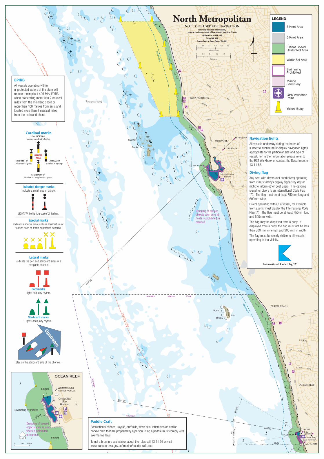
North MetropolitanNOT TO BE USED FOR NAVIGATION
For more detailed information, refer to the Department of Transport's Nautical Charts
Quinns Rocks WA 986Trigg WA 957
Ocean Reef to Cape Peron WA 001
2 nautical miles
2 nautical miles
2 nautical miles
2 nautical miles
0 100 200m
200m
5 knots
Swimming Prohibited
8 knots
OCEAN REEF
Ocean ReefBoat
Harbour
Whitfords SeaRescue VJ6LQ
Navigation lightsAll vessels underway during the hours of sunset to sunrise must display navigation ligths appropriate to the particular size and type of vessel. For further information please refer to the RST Workbook or contact the Department on 13 11 56.
Diving flag Any boat with divers (not snorkellers) operating from it must always display signals by day or night to inform other boat users. The daytime signal for divers is an International Code Flag “A”. The flag must be at least 750mm long and 600mm wide.
Divers operating without a vessel, for example from a jetty, must display the International Code Flag “A”. The flag must be at least 750mm long and 600mm wide.
The flag may be displayed from a buoy. If displayed from a buoy, the flag must not be less than 300 mm in length and 200 mm in width.
The flag must be clearly visible to all vessels operating in the vicinity.
International Code Flag “A”
Dropping of buoyed objects such as crab floats is prohibited in marinas
Dropping of buoyed objects such as crab floats is prohibited in marinas
5 Knot Area
6 Knot Area
8 Knot Speed Restricted Area
Water Ski Area
Swimming Prohibited
Marine Sanctuary
GPS Validation Point
Yellow Buoy
LEGEND
Cardinal marksKeep NORTH of
uninterrupted quick �ashes
Keep EAST of3 �ashes in a group
Keep SOUTH of6 �ashes + 1 long �ash in a group
Keep WEST of9 �ashes in a group
DANGER AREA
Isloated danger marksindicate a small area of danger.
Special marksindicate a special area such as aquaculture or
feature such as traffic separation scheme.
LIGHT: White light, group of 2 flashes.
Lateral marksindicate the port and starboard sides of a
navigable channel.
Port marksLight: Red, any rhythm.
Starboard marksLight: Green, any rhythm.
Stay on the starboard side of the channel.
EPIRBAll vessels operating within unprotected waters of the state will require a compliant 406 MHz EPIRB when proceeding more than 2 nautical miles from the mainland shore or more than 400 metres from an island located more than 2 nautical miles from the mainland shore.
Paddle CraftRecreational canoes, kayaks, surf skis, wave skis, inflatables or similar paddle craft that are propelled by a person using a paddle must comply with WA marine laws.
To get a brochure and sticker about the rules call 13 11 56 or visit www.transport.wa.gov.au/imarine/paddle-safe.asp
Contact detailsDepartment of TransportEmail: [email protected] Website: www.transport.wa.gov.au/imarine Marine Safety Hotline: 13 11 56
Hillarys Boat Harbour (weekdays only):Boat registration, charts sales, and pen bookings: 9448 7544
Department of Fisheries Lancelin: 9655 1111 Hillarys: 9203 0111 Fishwatch: 1800 815 507 Website: www.fish.wa.gov.au
Mindarie Keys Marina 9305 1057
Two Rocks Marina 9561 1100
Department of Parks and Wildlife 9334 0339
WA Police ServiceJoondalup: 9400 0888
Water Police: 9442 8600
Ambulance000 (or 112 mobile)
Joondalup Health Campus9400 9400
Volunteer Marine Rescue ServicesEmergency contact VHF 16 and 27.88 Whitfords (VJ6LQ): 9401 3757, VHF 73 and 27.90 Two Rocks (VMR677): 9561 5777, VHF 73 and 27.91
Boating Weather ForecastsBoating weather: 1900 955 350 Website: www.bom.gov.au
Hillarys Boat HarbourUnless special permission is obtained from Hillarys Boat Harbour management the following is prohibited:
• exceeding the 6 knot speed limit the harbour limits;
• swimming or diving within the harbour and harbour entranceexcept within the designated boating prohibited area on the easternshoreline;
• paddling canoes, kayaks and surf skis under jetties or buildings orwithin the boating prohibited areas;
Note: Due to high demand on the limited waterway, club or groupactivities must be booked through the Department of Transport(DoT). Conditions of operation will apply.
• windsurfers, hard surfboards, personal water craft (PWC) freestyling, towing skiers or other buoyant equipment;
• cleaning fish and dumping offal or rubbish into the harbour;
Marine
Park
Marine Sanctuary
8 Knots
8 Knots
6 Knots6 Knots
8 Knots
8 Knots
WHIT F O R D S
AV E NU E
H E P B U R N
A V E N U E
WE S T
C O AS T
D R IV E
S T . H E L IE RD R IV E
Fl(2) G 6s 2M
Fl R 3s 3M
Fl(4) G 12s 3M
Fl(2) 6s 24m 12M
Fl(4) R 12s 2M
Obsc u redA rc
Visibility
of
Q(9) 15s 4M
AQWA
Breakwater
Boyinaboat Reef
CowRocks
(1.5)
(0.5)
Boat Lifter
Northern
Dept. of Transport Harbour O�ce
Apartments
Fisheries Research and
Community Education Centre
Tower
Breakwater
Ferry
Draw Bridge
Lighthouse
Southern
Hillarys Yacht Club
HILLARYSBOAT HARBOUR
Caution : Divers
Fl G 3s 5m 3M
Closed Waters All Vessels
Closed Waters All Vessels
Q(6)+LFl 15s 2M
METRES
50 0 100 200
LEGEND6 Knot Area
8 Knot Area
Closed waters -All vessels
Marine Sanctuary
Swimming Prohibited
GPS validation marker
Northside Drive
Southside DriveService Wharf
Sorrento Beach
Hillarys Beach
SorrentoQuay
• fuelling vessels anywhere other than at the designated fuelling jetty;
• placing fishing nets, pots, lines or floats within the harbour orentrance channel;
• anchoring a vessel anywhere within the harbour or entrancechannel unless broken down or in distress; and
• use of the service wharf (except for penholders for the purpose ofloading/unloading passengers and cargo).
Moorings and pensShort term boat pen hire is available (subject to availability) for stopovers of one night or more.
Bookings can be made through the DOT’s harbour office on weekdays only. Bookings should be made in advance on 9448 7544.
Boat pen systems may only be accessed by authorised key holders.
Boat launching ramp courtesy • Plan your day and organise equipment, motors and mooring lines
before leaving home.
• Utilise designated rigging and de-rigging areas to avoid impedingothers launching and retrieving their vessels.
• Follow the directions indicated by signage and or painted on theroadway.
• Utilise the correct lanes for launch and retrieval.
• Move quickly to the end of the jetty making room for other peopleto launch and recover.
• Have patience with less experienced boaters.
Caution ferries • Large commercial passenger carrying vessels operate from
Hillarys Boat Harbour. In some weather conditions these vesselsmay be restricted in their ability to manoeuvre within the confinesof narrow channels.
• Children should never be allowed to operate dinghies withinthe main navigation channel and without direct onboard adultsupervision.
• Small vessels should be aware of their obligations not to impedethe safe passage of these larger vessels and that they may notbe clearly visible.
• Sailing vessels unable to navigate on the starboard side of thechannel should engage mechanical propulsion.
Reduce wash Damage to vessels and floating pen jetties can be caused by a vessel’s wash. Look behind occasionally to make sure that your boat is not creating too much wash. Please slow down if your wash is affecting other boats and property.
Ocean Reef Boat Harbour • The 5 knot speed limit extends to the outer port hand mark.
• Swimming is prohibited within the harbour and across theentrance channel.
• The entrance channel is subject to siltation, navigate with caution.
• Responsibility for the harbour is vested with the City of Joondalup(9400 4000).
Dropping of buoyed objects such as crab floats is prohibited in marinas
Protected Waters
lakes, rivers, inlets and estuaries except
Lake Argyle
0-2 Nautical
Miles from the mainland
shore
2-5 Nautical
Miles from the mainland
shore
Over 5 Nautical
Miles from the mainland
shore
Recreational Skipper’s TicketThe skipper of a recreational vessel, powered by a motor greater than 6hp (4.5kwp) must hold an RST.
✓ ✓ ✓ ✓Bilge Pump/BailerAll vessels must carry a bilge pump. Vessels under 7 metres may carry a bailer in lieu of a bilge pump.
✓ ✓ ✓ ✓Fire ExtinguisherVessels with an inboard engine or carrying hydrocarbon heating or cooling appliances must carry an approved fire extinguisher.
✓ ✓ ✓ ✓
Anchor and LineAn efficient anchor and line must be carried. − ✓ ✓ ✓LifejacketA lifejacket bearing the label Level 100 (or higher) with the Australian Standard AS 1512, AS 4758 or ISO 12402 must be carried for every person onboard.
− ✓ ✓ ✓Red and Orange Flares (in date)At least two hand held red flares and two hand held orange flares must be carried. Two parachute flares may be carried in lieu of the two hand held red flares and a smoke canister may be carried in lieu of the smoke flares.
− ✓ ✓ ✓
EPIRB
EPIRB (in date)A 406 MHz EPIRB registered with AMSA bearing the standard AS/NZS 4280.1 must be carried if proceeding more than 2 miles from the mainland shore or more than 400 metres from an island located more than 2 miles from the mainland shore.
− − ✓ ✓
Parachute Flares (in date)A minimum of two parachute flares must be carried if operating more than 5 miles from the mainland shore or more than 1 mile from an island located more than 5 miles from the mainland shore.
− − − ✓
Marine RadioA marine radio must be carried if operating more than 5 miles from the mainland shore or more than 1 mile from an island located more than 5 miles from the mainland shore. The radio can be 27 MHz, VHF or HF.
− − − ✓RSE-0317
SafetyEquipment
The information contained in this publication is provided in good faith and
believed to be accurate at time of publication. The State shall in no way be
liable for any loss sustained or incurred by anyone relying on the information.
Join us at facebook.com/MarineSafetyWA
For further information go to www.transport.wa.gov.au/boatingguides or scan the QR Code
Department of Transport
March 2017
Boating Guide North Metropolitan Marine Safety
22
)4691( somiklA
M3 m8 s6 G )2(lF
M7 m24 uB F
M7 m95 uB F
046°
01'
N A I D N I
N A E C O
notnilgE (2)
ShoalalemaP
eiggatS
Reef
Quinns
Rocks
099° 58'
Three
eliM
Reef
SKCOR SNNIUQ
ANCHORAGE
Burns
Rocks(2.5)
ILUKALow
Cliffs
FEER NAECO
llaftuO
Cautio
n - H
eavy
Swell
(see n
ote)
feeR naecOruobraH taoB
M3 m7 s3 G lF
MARM
ION
AVENUE
TAPPING
WAY
MINDARIE
DRIVEROAD
QUINNS
DRIVE
OCEA
N
ROTH
ESAY
HEIGHTS
DRIVE
KINSA
LE
DRIVE
BURNSBEACH
ROAD
DRIVE
SILVER SANDS
AVENUE
OCEA
N
ROAD
REEF
MINDARIE
SHENTON
8 Knots
Dunes
Covered
Sand
Scrub
)2581( notnilgE
)4091( ecnerefnoC
"W"
"H"
"N"
"SF"
"C"
"E"
"S"
HCAEB SNRUB
Marm
ion
Marine
Park
Visibility
Arc
ofVi
sibilit
y
of
noimraM eniraM kraP
8 Knots
syeK eiradniManiraM
37’ 37’
38’ 38’
39’ 39’
40’ 40’
41’ 41’
42’31°S
42'31°S
43' 43'
44' 44'
45' 45'
46' 46'
36'
36'
37'
37'
38'
38'
39'
39'
40'115° E
40'115° E
41'
41'
42'
42'
43'
43'
44'
44'
QUINNS ROCKS
QUINNS ROCKS
WA
WA
986
986
SEE RELATED PUBLICATIONS: Notice to Mariners (http://www.dpi.wa.gov.au/imarine/coastaldata/), Symbols, Abbreviationsand Terms (INT 1), Tide Tables, Sailing Directions. For surveys beyond this chart refer to RAN Charts AUS 334 and AUS 754.
Notices to Mariners METRES
DEPTHS
IN
IN
DEPTHS
METRES
31° 46' 48" S
115°
35'
24"
E
31° 36' 06" S
115°
44'
00"
E
N=
6484
000
N=
6484
000
N=
6488
000
N=
6488
000
N=
6492
000
N=
6492
000
N=
6496
000
N=
6496
000
N=
6500
000
N=
6500
000
E= 3 68 000
E= 3 68 000
E= 3 72 000
E= 3 72 000
E= 3 76 000
E= 3 76 000
E= 3 80 000
E= 3 80 000
2 00
01
000
01
000
MET
RES
3 00
04
000
5 00
0 M
ETR
ES
2 0001 000
01 000 M
ETRES
3 0004 000
5 000 METR
ES
042°2
8'
NOITUACllews etaredom gniruD
seas may break overdepths of about 6m.
.
somiklA
Rocks
Centaur (1874)
llaftuO
HALE ROAD
HIGHW
AYC
OAST
SCARBOROUGH BEACH ROAD
WEST
KARRINYUPROAD
MA
RM
I ON
AV
EN
UE
NORTH BEACH
ROAD
AVENUE
ROAD
BEACH
MARM
ION
CLONTARF STREET
HEPBURNAVENUE
DRAVELUOB EHT
M01 m31 s2 osI
Marina
Arc
of
Visibiity
Arc
of
M3 s51 lFL + )6(Q
M3 s51 )9(Q
M2 s01 lFLM21 s6 )2(lF
M5 s01 )3(Q
elttiL
099° 58'
M7 s51 lFL + )6(Q
M2 s21 R )4(lF
M3 s21 G )4(lF
3 M01m1Q
M3 m7 s3 G lF
M3 s3 G lF
otnerroS
Foam
rohcnA
elahW
hcaeB
W
E
S
M
H
M3 Q
M5m42
uBF
6 5s+( M21lFL)Q
042°
28'
Arc
ofV i
s ibi
lity
Arc
of
Visibility
SYRALLIH
HCAEB HTRON
GGIRT
HGUOROBRACS
HCAEB YTIC
syralliHruobraH taoB
feeRnaecOt ruobraH aoB
kcoR droftihW
kcoR kcerW
Lump
The
Lumps
Three
eliM
Reef
TNIOP OORANNIP
dnalsI elttiL
ReefWanneroo
skcoR woC
Horseshoe
Reef
CentaurReef
Marmion Beach
Watermans Beach
North Beach
ggirT htuoSBeach
Scarborough Beach
N A I D N I
N A E C O
R E E F
L a lB a n k
North
NOIMRAM
OTNERROS
OORALLAK
OOLALLUM
FEER NAECO
hcaeB nothgirB
dnalsI ggirT
hcaeB sdroftihW
oolalluM
Beach
Floreat Beach
yrotaromuesuM )54( knaT retaW
mroftalP gnihsiF
CF6HV .C.A.A.M
rewoT .C.S.L.S
Water Tow
er
(conspic) (82)
0.8km
Water Tower
(conspic) (82)
0.6km
hcaeB noinneB
Mettams Pool
looP yelsremaH
hcaeB otnerroS
Trigg Beach
)37( gnidliuB)cipsnoc(
obaniyoB atReef
M A R M
I O N
Pref
erre
d ro
ute
for
deep
er d
raug
ht v
esse
ls
8 Knots8 Knots
8 Knots
Marm
ion Marine Park
kraP eniraM noimraM
8 Kn
ots
,gniliasaraPdna ikS retaW
aerA CWP
CAUTION - Submarine Cable
CAUTION - H
eavy
Swell
0 0.1 0.2 0.3 0.4 0.5
0 0.2 0.4 0.6 0.8 1
Nautical Miles
Kilometres
400 Meters
400 Meters
400 Meters
400 Meters
400 Meters
400 Meters
North MetropolitanNOT TO BE USED FOR NAVIGATION
For more detailed information, refer to the Department of Transport's Nautical Charts
Quinns Rocks WA 986Trigg WA 957
Ocean Reef to Cape Peron WA 001
2 nautical miles
2 nautical miles
2 nautical miles
2 nautical miles
0 100 200m
200m
5 knots
Swimming Prohibited
8 knots
OCEAN REEF
Ocean ReefBoat
Harbour
Whitfords SeaRescue VJ6LQ
Navigation lightsAll vessels underway during the hours of sunset to sunrise must display navigation ligths appropriate to the particular size and type of vessel. For further information please refer to the RST Workbook or contact the Department on 13 11 56.
Diving flag Any boat with divers (not snorkellers) operating from it must always display signals by day or night to inform other boat users. The daytime signal for divers is an International Code Flag “A”. The flag must be at least 750mm long and 600mm wide.
Divers operating without a vessel, for example from a jetty, must display the International Code Flag “A”. The flag must be at least 750mm long and 600mm wide.
The flag may be displayed from a buoy. If displayed from a buoy, the flag must not be less than 300 mm in length and 200 mm in width.
The flag must be clearly visible to all vessels operating in the vicinity.
International Code Flag “A”
Dropping of buoyed objects such as crab floats is prohibited in marinas
Dropping of buoyed objects such as crab floats is prohibited in marinas
5 Knot Area
6 Knot Area
8 Knot Speed Restricted Area
Water Ski Area
Swimming Prohibited
Marine Sanctuary
GPS Validation Point
Yellow Buoy
LEGEND
Cardinal marksKeep NORTH of
uninterrupted quick �ashes
Keep EAST of3 �ashes in a group
Keep SOUTH of6 �ashes + 1 long �ash in a group
Keep WEST of9 �ashes in a group
DANGER AREA
Isloated danger marksindicate a small area of danger.
Special marksindicate a special area such as aquaculture or
feature such as traffic separation scheme.
LIGHT: White light, group of 2 flashes.
Lateral marksindicate the port and starboard sides of a
navigable channel.
Port marksLight: Red, any rhythm.
Starboard marksLight: Green, any rhythm.
Stay on the starboard side of the channel.
EPIRBAll vessels operating within unprotected waters of the state will require a compliant 406 MHz EPIRB when proceeding more than 2 nautical miles from the mainland shore or more than 400 metres from an island located more than 2 nautical miles from the mainland shore.
Paddle CraftRecreational canoes, kayaks, surf skis, wave skis, inflatables or similar paddle craft that are propelled by a person using a paddle must comply with WA marine laws.
To get a brochure and sticker about the rules call 13 11 56 or visit www.transport.wa.gov.au/imarine/paddle-safe.asp
Contact detailsDepartment of TransportEmail: [email protected] Website: www.transport.wa.gov.au/imarine Marine Safety Hotline: 13 11 56
Hillarys Boat Harbour (weekdays only):Boat registration, charts sales, and pen bookings: 9448 7544
Department of Fisheries Lancelin: 9655 1111 Hillarys: 9203 0111 Fishwatch: 1800 815 507 Website: www.fish.wa.gov.au
Mindarie Keys Marina 9305 1057
Two Rocks Marina 9561 1100
Department of Parks and Wildlife 9334 0339
WA Police ServiceJoondalup: 9400 0888
Water Police: 9442 8600
Ambulance000 (or 112 mobile)
Joondalup Health Campus9400 9400
Volunteer Marine Rescue ServicesEmergency contact VHF 16 and 27.88 Whitfords (VJ6LQ): 9401 3757, VHF 73 and 27.90 Two Rocks (VMR677): 9561 5777, VHF 73 and 27.91
Boating Weather ForecastsBoating weather: 1900 955 350 Website: www.bom.gov.au
Hillarys Boat HarbourUnless special permission is obtained from Hillarys Boat Harbour management the following is prohibited:
• exceeding the 6 knot speed limit the harbour limits;
• swimming or diving within the harbour and harbour entrance except within the designated boating prohibited area on the eastern shoreline;
• paddling canoes, kayaks and surf skis under jetties or buildings or within the boating prohibited areas;
Note: Due to high demand on the limited waterway, club or group activities must be booked through the Department of Transport (DoT). Conditions of operation will apply.
• windsurfers, hard surfboards, personal water craft (PWC) freestyling, towing skiers or other buoyant equipment;
• cleaning fish and dumping offal or rubbish into the harbour;
Marine
Park
Marine Sanctuary
8 Knots
8 Knots
6 Knots6 Knots
8 Knots
8 Knots
WHIT F O R D S
AV E NU E
H E P B U R N
A V E N U E
WE S T
C O AS T
D R IV E
S T . H E L IE RD R IV E
Fl(2) G 6s 2M
Fl R 3s 3M
Fl(4) G 12s 3M
Fl(2) 6s 24m 12M
Fl(4) R 12s 2M
Obsc u redA rc
Visibility
of
Q(9) 15s 4M
AQWA
Breakwater
Boyinaboat Reef
CowRocks
(1.5)
(0.5)
Boat Lifter
Northern
Dept. of Transport Harbour O�ce
Apartments
Fisheries Research and
Community Education Centre
Tower
Breakwater
Ferry
Draw Bridge
Lighthouse
Southern
Hillarys Yacht Club
HILLARYSBOAT HARBOUR
Caution : Divers
Fl G 3s 5m 3M
Closed Waters All Vessels
Closed Waters All Vessels
Q(6)+LFl 15s 2M
METRES
50 0 100 200
LEGEND6 Knot Area
8 Knot Area
Closed waters -All vessels
Marine Sanctuary
Swimming Prohibited
GPS validation marker
Northside Drive
Southside DriveService Wharf
Sorrento Beach
Hillarys Beach
SorrentoQuay
• fuelling vessels anywhere other than at the designated fuelling jetty;
• placing fishing nets, pots, lines or floats within the harbour or entrance channel;
• anchoring a vessel anywhere within the harbour or entrance channel unless broken down or in distress; and
• use of the service wharf (except for penholders for the purpose of loading/unloading passengers and cargo).
Moorings and pensShort term boat pen hire is available (subject to availability) for stopovers of one night or more.
Bookings can be made through the DOT’s harbour office on weekdays only. Bookings should be made in advance on 9448 7544.
Boat pen systems may only be accessed by authorised key holders.
Boat launching ramp courtesy • Plan your day and organise equipment, motors and mooring lines
before leaving home.
• Utilise designated rigging and de-rigging areas to avoid impeding others launching and retrieving their vessels.
• Follow the directions indicated by signage and or painted on the roadway.
• Utilise the correct lanes for launch and retrieval.
• Move quickly to the end of the jetty making room for other people to launch and recover.
• Have patience with less experienced boaters.
Caution ferries • Large commercial passenger carrying vessels operate from
Hillarys Boat Harbour. In some weather conditions these vessels may be restricted in their ability to manoeuvre within the confines of narrow channels.
• Children should never be allowed to operate dinghies within the main navigation channel and without direct onboard adult supervision.
• Small vessels should be aware of their obligations not to impede the safe passage of these larger vessels and that they may not be clearly visible.
• Sailing vessels unable to navigate on the starboard side of the channel should engage mechanical propulsion.
Reduce wash Damage to vessels and floating pen jetties can be caused by a vessel’s wash. Look behind occasionally to make sure that your boat is not creating too much wash. Please slow down if your wash is affecting other boats and property.
Ocean Reef Boat Harbour • The 5 knot speed limit extends to the outer port hand mark.
• Swimming is prohibited within the harbour and across the entrance channel.
• The entrance channel is subject to siltation, navigate with caution.
• Responsibility for the harbour is vested with the City of Joondalup (9400 4000).
Dropping of buoyed objects such as crab floats is prohibited in marinas
2 nautical miles
2 nautical miles
2 nautical miles
400 Meters
400 Meters
400 Meters
400 Meters
Centaur (1874)
llaftuO
HALE ROAD
HIG
HW
AY
CO
AST
SCARBOROUGH BEACH ROAD
WEST
KARRINYUPROAD
MA
RM
I ON
AV
EN
UE
NORTH BEACH
ROAD
AVENUE
ROAD
BEACH
MARM
ION
CLONTARF STREET
HEPBURNAVENUE
DRAVELUOB EHT
M01m31s2osI
Marina
Arc
of
Visibiity
Arc
of
M3 s51 lFL + )6(Q
M3 s51 )9(Q
M21 s6 )2(lF
M5 s01 )3(Q
elttiL
099° 58'
M7 s51 lFL + )6(Q
M2 s21 R )4(lF
M3 s21 G )4(lF
M01m31Q
M3 m7 s3 G lF
M3 s3 G lF
otnerroS
Foam
rohcnA
elahW
hcaeB
W
E
S
M
H
M3 Q
M5 m42 uB F
M2s51lFL+)6(Q
042°
28'
Arc
ofV i
s ibi
lity
Arc
of
Visibility
SYRALLIH
HCAEB HTRON
GGIRT
HGUOROBRACS
HCAEB YTIC
syralliHruobraH taoB
feeR naecOruobraH taoB
kcoR droftihW
kcoR kcerW
Lump
The
Lumps
Three
eliM
Reef
TNIOPOORANNIP
dnalsI elttiL
ReefWanneroo
skcoRwoC
Horseshoe
Reef
CentaurReef
Marmion Beach
Watermans Beach
North Beach
ggirT htuoSBeach
Scarborough Beach
N A I D N I
N A E C O
R E E FL a l
B a n k
North
NOIMRAM
OTNERROS
OORALLAK
OOLALLUM
FEER NAECO
hcaeB nothgirB
dnalsI ggirT
hcaeBsdroftihW
oolalluM
Beach
Whitfords Volunteer Sea Rescue Group
Floreat Beach
yrotaromuesuM )54( knaT retaW
mroftalP gnihsiF
CF6HV .C.A.A.M
rewoT .C.S.L.S
Water Tower
(conspic) (82)
0.8km
Water Tower(conspic) (82)
0.6km
hcaeB noinneB
Mettams Pool
looP yelsremaH
hcaeB otnerroS
Trigg Beach
)37( gnidliuB)cipsnoc(
obaniyoB atReef
46’ 46’
47’ 47’
48’ 48’
49’ 49’
50’31°S
50'31°S
51' 51'
52' 52'
53' 53'
54' 54'
55' 55'
56' 56'
38'
38'
39'
39'
40'
40'
41'
41'
42'115° E
42'115° E
43'
43'
44'
44'
45'
45'
46'
46'
WA
WA
957
957
SEE RELATED PUBLICATIONS: Notice to Mariners (http://www.dpi.wa.gov.au/imarine/coastaldata/), Symbols, Abbreviationsand Terms (INT 1), Tide Tables, Sailing Directions. For surveys beyond this chart refer to RAN Charts AUS 112 and AUS 754.
Notices to Mariners
2 00
01
000
01
000
MET
RES
3 00
04
000
5 00
0 M
ETR
ES
2 0001 000
01 000 M
ETRES
3 0004 000
5 000 METR
ES
31° 56' 12" S
115°
37'
30"
E
31° 45' 30" S
115°
46'
06"
E
N=
6468
000
N=
6468
000
N=
6472
000
N=
6472
000
N=
6476
000
N=
6476
000
N=
6480
000
N=
6480
000
N=
6484
000
N=
6484
000
E= 3 72 000
E= 3 72 000
E= 3 76 000
E= 3 76 000
E= 3 80 000
E= 3 80 000
TRIGG
TRIGGC
.ailartsuA nretseW ,IPD ,secivreS cihpargotraC emitiraM yb decudorP.2002 .A.W ,erutcurtsarfnI dna gninnalP rof tnemtrapeD DEVRESER THGIRYPOC NWORC
.3 noitidE ,7002 yraunaJ
M A R M
I O N
North MetropolitanNOT TO BE USED FOR NAVIGATION
For more detailed information, refer to the Department of Transport's Nautical Charts
Quinns Rocks WA 986Trigg WA 957
Ocean Reef to Cape Peron WA 001
0 0.1 0.2 0.3 0.4 0.5
0 0.2 0.4 0.6 0.8 1
Nautical Miles
Kilometres
Pref
erre
d ro
ute
for
deep
er d
raug
ht v
esse
ls
8 Knots
8 Kn
ots
8 Knots
8 Knots
Marm
ion Marine Park
Marm
ion Marine Park
kraP eniraM noimraM
8 Kn
ots
CAUTION - Submarine Cable
CAUTION - H
eavy
Swell
METRESINDEPTHS
Direction of Ski
Water ski take o� and landing area
Speed restriction areasGeneral 8 knots rulesAn 8 knot water speed applies to all vessels unless otherwise indicated:• within 200 metres of shore from Port Beach to the northern boundary
of the Marmion Marine Park (north of Burns Rocks);• within 50 metres of the shore elsewhere;• within 50 metres of a person in the water (this includes surfers);• within 50 metres of an anchored or moored vessel;• Within 15 metres of a vessel underway.
Obstruction of channels and leading lines Drop nets, fishing nets, marker buoys or other buoyed objects can not be placed or allowed to remain in any channel or fairway in any port or harbour, or in any channel, fairway or passage in any navigable waters except by permission of DoT.
You also can’t anchor or moor a vessel in any channel or fairway, unless the vessel is in distress.
Kite and windsurfingKite and windsurfers operating more than 400 metres from shore are now required to carry safety equipment.
To get a sticker about the rules visit, www.transport.wa.gov.au/kitesafe or call 13 11 56.
Caution With the onset of the sea breeze windsurfers and kitesurfers congregate at many popular locations such as Mullaloo and Scarborough. In certain conditions these small, fast moving sailing vessels may be difficult to see and persons navigating along the north metropolitan coast need to maintain a proper lookout at all times and take appropriate action to avoid collisions.
Prevention of collision
All windsurfers and kitesurfers have a duty of care to ensure their activities are conducted with regard to the prevailing conditions and circumstances and take appropriate action to avoid collisions.
Personal water craft (PWC)Age limits - To operate a PWC at a speed greater than 8 knots you must be at least 16 years of age and hold a RST.
Safety equipment Every person on board a PWC must wear a lifejacket at all times:
• within 400 metres of the shore – either Level 150, 100 or 50/50s; • between 400 metres and 2 nm from shore – Level 100 or 150 only and
carry an inshore distress flare kit;• between 2 and 5 nm – Level 100 or 150 only and an in date inshore
distress flare kit and EPIRB;• vessels of less than 3.75 metres in length are not permitted to operate
more than 5 nm from the shore.Freestyling and wake jumping is prohibited in the north metropolitan area: • within any speed restricted area; • within 30 metres of another PWC;• within 50 metres of another vessel or person in the water.
Water ski areas - PWC may operate when towing a water skier. When towing a water skier all vessels are required to carry an observer of at least 14 years of age. Observers must also wear a lifejacket.
PWC not engaged in water skiing must at all times remain well clear of the take-off and landing area and any vessels engaged in water skiing.
Remember toLOG ON
LOG OFF!Everytrip
VHF Ch 16 ......................................Distress & callingRadio Ch 67 ........................................Safety & emergency 72, 73, 77 ......................... * Recreational & working
VHF Repeaters 21, 22, 80, 81, 82 ..... * Recreational & working
27 MHz Ch 88 ......................................Distress & callingRadio Ch 86 ........................................Safety & emergency 90, 91, 94, 96 ............... * Recreational & working
* Contact VMR groups for local information.www.dfes.wa.gov.au/contactus/pages/volunteermarinerescueservices.aspx
1
2
Boating prohibited areasBoyinaboat Reef Dive TrailLocated on the seaward side of Hillarys Boat Harbour adjacent to the Southern Breakwater and out to a distance of 240 metres offshore. This area was created for the safety of shore based snorkel and SCUBA divers. It incorporates a Marine Park Sanctuary Zone and is marked by spar buoys. All vessels are prohibited from entering or transiting through this area.
Hillarys Boat Harbour BeachA line of markers clearly delineates this part of the eastern shoreline. All vessels, including those propelled by paddles and oars are prohibited from entering this area.
1
2
Dropping of buoyed objects such as crab floats is prohibited in marinas
5 Knot Area
6 Knot Area
8 Knot Speed Restricted Area
Closed Waters - All vessels
Water Ski Area
Swimming Prohibited
Marine Sanctuary
GPS Validation Point
Yellow Buoy
LEGENDCardinal marks
Keep NORTH ofuninterrupted quick �ashes
Keep EAST of3 �ashes in a group
Keep SOUTH of6 �ashes + 1 long �ash in a group
Keep WEST of9 �ashes in a group
DANGER AREA
Isloated danger marksindicate a small area of danger.
Special marksindicate a special area such as aquaculture or
feature such as traffic separation scheme.
LIGHT: White light, group of 2 flashes.
Lateral marksindicate the port and starboard sides of a
navigable channel.
Port marksLight: Red, any rhythm.
Starboard marksLight: Green, any rhythm.
Stay on the starboard side of the channel.
Vessel OvertakingAnother
Every overtaking vesselgives way (this includes
sailing vessels)
Each vessel alterscourse to starboard
Power Vessels Meeting Head On
Vessel having theother to starboard gives right of way
Power Vessels Meeting
Power gives way to sailexcept when sailing vessel is overtaking
Power MeetingSailing Vessel
Basic rules of the waterways
EPIRBAll vessels operating within unprotected waters of the state will require a compliant 406 MHz EPIRB when proceeding more than 2 nautical miles from the mainland shore or more than 400 metres from an island located more than 2 nautical miles from the mainland shore.
Recreational Skipper’s TicketThe person in charge of a recreational vessel with a motor of 6hp (4.5 kilowatts) or less is not required to hold a Recreational Skippers Ticket (RST).
A person in charge of a recreational vessel with a motor greater than 6hp (4.5 kilowatts) is required to hold a RST.
You are required to carry your RST card when boating.
Age restrictionsA person under 10 years may not drive a motor boat.
RST holders over 14 but under 16 years of age are restricted to operating during daylight hours at a speed less than 8 knots.
Paddle CraftRecreational canoes, kayaks, surf skis, wave skis, inflatables or similar paddle craft that are propelled by a person using a paddle must comply with WA marine laws.
To get a brochure and sticker about the rules call 13 11 56 or visit www.transport.wa.gov.au/imarine/paddle-safe.asp