Embed Size (px)
Citation preview

BASIN MANAGEMENT ACTION PLAN
for the Implementation of the Nutrient Total Maximum Daily Load
by the Florida Department of Environmental Protection in the
Jackson Blue Spring and Merritts Mill Pond Basin
prepared by the Division of Environmental Assessment and Restoration
Water Quality Restoration Program Florida Department of Environmental Protection
in coordination with the Jackson Blue Spring and Merritts Mill Pond Basin Stakeholders
May 2016
2600 Blair Stone Rd. Tallahassee, FL 32399

Jackson Blue Spring and Merritts Mill Pond Basin Management Action Plan –May 2016
Page 2 of 60
ACKNOWLEDGMENTS
The Florida Department of Environmental Protection adopted the Jackson Blue Spring and Merritts Mill
Pond Basin Management Action Plan by Secretarial Order as part of its statewide watershed
management approach to restore and protect Florida's water quality. The plan was developed in
coordination with the Jackson Blue Spring and Merritts Mill Pond Basin stakeholders, identified below,
with participation from affected local, regional, and state governmental interests; elected officials and
citizens; and private interests.
FLORIDA DEPARTMENT OF ENVIRONMENTAL PROTECTION Jon Steverson, Secretary
Jackson Blue Spring and Merritts Mill Pond Basin participants
Responsible Stakeholders Responsible Agencies Other Interested Stakeholders Agricultural producers
Jackson County Town of Bascom
Town of Greenwood Town of Malone
Florida Department of Agriculture and Consumer Services Florida Department of
Environmental Protection Florida Department of Health
Florida Department of Transportation – District 3 Northwest Florida Water
Management District
Citizens Florida Farm Bureau
University of Florida Institute of Food and Agricultural Sciences –
Jackson County Extension Service

Jackson Blue Spring and Merritts Mill Pond Basin Management Action Plan –May 2016
Page 3 of 60
For additional information on total maximum daily loads and the watershed management approach in
the Jackson Blue Spring and Merritts Mill Pond Basin, contact:
Terry Hansen, P.G., Basin Coordinator Florida Department of Environmental Protection Water Quality Restoration Program, Watershed Planning and Coordination Section 2600 Blair Stone Road, Mail Station 3565 Tallahassee, FL 32399-2400 Email: [email protected] Phone: (850) 245–8561 Fax: (850) 245–8434

Jackson Blue Spring and Merritts Mill Pond Basin Management Action Plan –May 2016
Page 4 of 60
TABLE OF CONTENTS
ACKNOWLEDGMENTS .........................................................................................................................2 CHAPTER 1 : CONTEXT, PURPOSE, AND SCOPE OF THE PLAN ............................................13
1.1 Water Quality Standards and TMDLs ..............................................................................13 1.2 TMDL Implementation .......................................................................................................14 1.3 Jackson Blue Spring and Merritts Mill Pond BMAP .......................................................15
1.3.1 Plan Purpose and Scope .........................................................................................15 1.3.2 Stakeholder Involvement .......................................................................................17 1.3.3 BMAP Approach ...................................................................................................18 1.3.4 On-Site Sewage Treatment and Disposal Systems ................................................19 1.3.5 Pollutant Reduction and Discharge Allocations ....................................................19 1.3.6 Jackson Blue Spring and Merritts Mill Pond TMDL.............................................20
1.4 Assumptions and Considerations Regarding TMDL Implementation ...........................21 1.4.1 Assumptions ...........................................................................................................21 1.4.2 Considerations........................................................................................................21
1.5 Future Growth in the Watershed .......................................................................................23 CHAPTER 2 : JACKSON BLUE SPRING AND MERRITTS MILL POND BASIN SETTING ..24
2.1 Land Use Coverage ..............................................................................................................24 2.2 Water Quality Trends..........................................................................................................26
CHAPTER 3 : POLLUTANT SOURCES AND ANTICIPATED OUTCOMES ..............................28 3.1 NSILT ..................................................................................................................................28
3.1.1 NSILT Process .......................................................................................................30 3.2 Anticipated Outcomes of BMAP Implementation ............................................................31
CHAPTER 4 : MANAGEMENT STRATEGIES .................................................................................32 4.1 Management Strategies .......................................................................................................32
4.1.1 Agricultural Fertilizer and Livestock Loads to Ground Water ..............................35 4.1.2 OSTDS (Septic Tanks) Loads to Ground Water....................................................35 4.1.3 Urban Fertilizer Loads to Ground Water ...............................................................35
4.2 Agricultural BMP Implementation ....................................................................................41 4.2.1 Agricultural BMPs .................................................................................................45 4.2.2 BMP Enrollment ....................................................................................................47 4.2.3 Agricultural BMP Load Reduction Estimates .......................................................49 4.2.4 FDACS OAWP Role in BMP Implementation and Follow-Up ............................50 4.2.5 OAWP Implementation Assurance (IA) Program .................................................50
CHAPTER 5 : ASSESSING PROGRESS AND MAKING CHANGES ............................................52 5.1 Tracking Implementation ...................................................................................................52 5.2 Adaptive Management Measures .......................................................................................53 5.3 Water Quality Monitoring ..................................................................................................54
5.3.1 Monitoring Objectives ...........................................................................................54 5.3.2 Water Quality Monitoring Parameters, Frequency, and Network .........................54

Jackson Blue Spring and Merritts Mill Pond Basin Management Action Plan –May 2016
Page 5 of 60
5.3.3 Biological Monitoring ............................................................................................56 5.3.4 Data Management and Assessment .......................................................................58 5.3.5 QA/QC ...................................................................................................................58
5.4 Commitment to Plan Implementation ...............................................................................59 APPENDICES ..........................................................................................................................................60
Appendix A: Bibliography of Key References and Websites ......................................................60
LIST OF FIGURES
Figure ES-1: Jackson Blue Spring and Merritts Mill Pond Basin contributing area .................................9 Figure 1: Jackson Blue Spring and Merritts Mill Pond Basin contributing area .....................................16 Figure 2: 2009 land use in the Jackson Blue Spring and Merritts Mill Pond contributing area ..............25 Figure 3: Nitrate and TN trends For Jackson Blue Spring, 1960–2011 ...................................................26 Figure 4: Nitrate and TN trends for Merritts Mill Pond, 1981–2011 .......................................................27 Figure 5: Merritts Mill Pond corridor and Jackson Blue Spring contributing areas ...............................29 Figure 6: Summary of estimated TN loading to ground water in the Jackson Blue BMAP area ..............30 Figure 7: NSILT-estimated nitrogen load to ground water for the Jackson Blue springshed ..................33 Figure 8: NSILT-estimated nitrogen load to ground water in the Merritts Mill Pond area .....................34 Figure 9: Composite NSILT-estimated nitrogen load to ground water in the Jackson Blue BMAP
area ...........................................................................................................................................34 Figure 10: Agricultural lands in the Jackson Blue Springs BMAP Basin (2009 NWFWMD land
use) ............................................................................................................................................43 Figure 11: DEP composite agricultural lands in the Jackson Blue Springs BMAP Basin .......................44 Figure 12: BMP enrollment in the Jackson Blue Springs Basin as of December 31, 2015 ......................48 Figure 13: SUNA locations in the Jackson BMAP area ............................................................................55 Figure 14: Monitoring network for Jackson Blue Spring and Merritts Mill Pond ...................................57

Jackson Blue Spring and Merritts Mill Pond Basin Management Action Plan –May 2016
Page 6 of 60
LIST OF TABLES
Jackson Blue Spring and Merritts Mill Pond Basin participants ................................................................2 Table ES-1: Jackson Blue Spring and Merritts Mill Pond TMDL .............................................................10 Table 1: Designated use attainment categories for Florida surface waters .............................................14 Table 2: Jackson Blue Spring and Merritts Mill Pond TMDL ..................................................................21 Table 3: 2009 land use categories in the Jackson Blue Spring and Merritts Mill Pond contributing
area ...........................................................................................................................................24 Table 4: Jackson Blue Springs management strategies .............................................................................36 Table 5: Projects funded with Florida Springs funding ............................................................................38 Table 6: Projects funded with EPA funding ..............................................................................................40 Table 7: Projects funded with other funding sources ................................................................................40 Table 8: Agricultural land uses in the Jackson Blue Springs Basin (2009 NWFWMD land use) .............42 Table 9: Agricultural land uses in the Jackson Blue Springs Basin (DEP composite land use) ...............42 Table 10: Key management and structural BMPs adopted by FDACS OAWP .........................................46 Table 11: Agricultural acreage and BMP enrollment for the Jackson Blue Springs BMAP area as
of December 31, 2015 ...............................................................................................................49 Table 12: Water quality monitoring parameters .......................................................................................54 Table 13: BMAP water quality and flow monitoring network ...................................................................56 Table 14: Biological monitoring ................................................................................................................58 Table A-1: Local and regional stormwater and water quality protection websites ..................................60 Table A-2: State stormwater and water quality protection websites .........................................................60 Table A-3: National stormwater and water quality protection websites ...................................................60

Jackson Blue Spring and Merritts Mill Pond Basin Management Action Plan –May 2016
Page 7 of 60
LIST OF ACRONYMS AND ABBREVIATIONS BMAP Basin Management Action Plan BMP Best Management Practice DEP Florida Department of Environmental Protection EPA U.S. Environmental Protection Agency F.A.C. Florida Administrative Code FAR Florida Administrative Register FDACS Florida Department of Agriculture and Consumer Services FDOH Florida Department of Health FGS Florida Geological Survey F.S. Florida Statutes FSAID Florida Statewide Agricultural Irrigation Demand FWRA Florida Watershed Restoration Act FY Fiscal Year GIS Geographic Information System IA Implementation Assurance lbs/yr Pounds Per Year LiDAR Light Detection and Ranging mg/L Milligrams Per Liter MIL Mobile Irrigation Lab MS4 Municipal Separate Storm Sewer System NELAC National Environmental Laboratory Accreditation Conference NELAP National Environmental Laboratory Accreditation Program NPDES National Pollutant Discharge Elimination System NRCS Natural Resources Conservation Service NWFWMD Northwest Florida Water Management District NSILT Nitrogen Source Inventory and Loading Tool OAWP Office of Agricultural Water Policy OFW Outstanding Florida Water OSTDS On-Site Treatment and Disposal System PFA Priority Focus Area QA/QC Quality Assurance/Quality Control RC&D Resource Conservation and Development RFA Restoration Focus Area RPS Rapid Periphyton Survey SBIO Statewide Biological (Database) SOP Standard Operating Procedure STORET Storage and Retrieval (Database) SUNA Submersible Ultraviolet Nitrate Analyzer SWIM Surface Water Improvement and Management TMDL Total Maximum Daily Load TN Total Nitrogen UF–IFAS University of Florida–Institute of Food and Agricultural Sciences USDA U.S. Department of Agriculture USGS U.S. Geological Survey WBID Waterbody Identification (Number) WWTF Wastewater Treatment Facility

Jackson Blue Spring and Merritts Mill Pond Basin Management Action Plan –May 2016
Page 8 of 60
SUMMARY
JACKSON BLUE SPRING AND MERRITTS MILL POND BASIN The 154-square-mile Jackson Blue Spring and Merritts Mill Pond contributing area is located in Jackson
County, Florida (92%), and Houston County, Alabama (8%). Figure ES-1 shows the Florida portion of
the contributing area. Jackson Blue Spring forms the headwaters of the 270-acre Merritts Mill Pond,
which was once the upper portion of a free-flowing spring run (Spring Creek) prior to 1860. The
impounded Merritts Mill Pond now forms the headwaters of Spring Creek, a tributary to the Chipola
River, which is designated as an Outstanding Florida Water (OFW).
Jackson Blue Spring and Merritts Mill Pond support a complex aquatic ecosystem and together are an
important cultural and economic resource for the state. Jackson Blue Spring contributes 69% of the total
flow of Merritts Mill Pond, as measured at the pond outfall. There are also 7 minor springs, which
contribute 14% of the flow to the pond. The remaining 17% of the flow is from other unmeasured
sources.
Within the Jackson Blue Spring and Merritts Mill Pond Basin, a Priority Focus Area (PFA) will be
identified to focus management strategies when the BMAP is updated. This PFA will represent the areas
in the basin where the aquifer is most vulnerable to inputs and where there are the most connections
between ground water and Jackson Blue Spring and Merritts Mill Pond.

Jackson Blue Spring and Merritts Mill Pond Basin Management Action Plan –May 2016
Page 9 of 60
Figure ES-1: Jackson Blue Spring and Merritts Mill Pond Basin contributing area

Jackson Blue Spring and Merritts Mill Pond Basin Management Action Plan –May 2016
Page 10 of 60
TOTAL MAXIMUM DAILY LOADS (TMDLS) TMDLs are water quality targets based on state water quality standards for specific pollutants, such as
excessive nitrate. The Florida Department of Environmental Protection (DEP) determined that the
Jackson Blue Spring segment with waterbody identification (WBID) number 180Z and Merritts Mill
Pond, WBID 180A, were impaired by nitrate as nitrogen, using data from January 1, 2000, through June
30, 2007. This determination was made based on biological assessments and photographic evidence
showing algal smothering in the spring and pond. The algal smothering was linked to elevated nitrate
concentrations from anthropogenic sources. Table ES-1 lists the TMDL and pollutant load allocation
adopted by rule for the Jackson Blue Spring and Merritts Mill Pond WBIDs.
Table ES-1: Jackson Blue Spring and Merritts Mill Pond TMDL 1 There are no National Pollutant Discharge Elimination System (NPDES) wastewater or stormwater facilities that discharge directly into Jackson Blue Spring or Merritts Mill Pond. mg/L = Milligrams per liter N/A = Not applicable
WBID Parameter TMDL (mg/L)
TMDL % Reduction
Wasteload Allocation for Wastewater1
Wasteload Allocation for
NPDES Stormwater
(% Reduction)1 Load Allocation (% Reduction)
Jackson Blue Spring
(WBID 180Z), Merritts Mill Pond
(WBID 180A)
Nitrate, as monthly average
0.35 90% N/A N/A 90%
JACKSON BLUE SPRING AND MERRITT MILL POND BMAP Paragraph 403.067(7)(a)1, Florida Statutes (F.S.), authorizes DEP to adopt BMAPs that provide for the
phased implementation of the strategies necessary to ultimately achieve the associated TMDLs. This
approach allows stakeholders to establish management strategies and incrementally plan, budget, and
execute projects, while simultaneously monitoring and conducting studies to better understand the water
quality dynamics (sources and response variables) in the basin. This BMAP is the first iteration for the
Jackson Blue Spring and Merritts Mill Pond Basin, and it covers a five-year period. The plan will be
updated by July 1, 2018, to include a more detailed schedule of management actions to meet the TMDL
within 20 years, as required by statute.
Using information on sources in the basin, stakeholders were asked to submit management strategies to
reduce nitrate loading from sources they are responsible for managing. DEP then compared the
strategies provided with the sources in the contributing area to evaluate whether each of the existing

Jackson Blue Spring and Merritts Mill Pond Basin Management Action Plan –May 2016
Page 11 of 60
sources was sufficiently addressed in the BMAP list of management actions and whether strategies were
in place or would be put into place to reduce nitrate sources.
To ensure sufficiency for addressing onsite sewage treatment and disposal systems (OSTDS) around
Merritts Mill Pond, DEP is working in cooperation with the Florida Department of Health (FDOH),
Jackson County, and other parties. The objective of this effort is to identify and implement effective,
financially feasible strategies to reduce nutrient loads from OSTDS sources. DEP and stakeholders will
identify options for addressing OSTDS loading, identify effective strategies for the Jackson Blue
Springs and Merritts Mill Pond Basin, establish education and outreach programs, determine
responsibilities, and identify funding sources and an implementation schedule for the management
strategies.
The requirements of this BMAP are enforceable by DEP. For urban stormwater sources, the BMAP
requirements and TMDL reductions are enforceable under Section 403.067, F.S. An agricultural
nonpoint source discharger included in a BMAP must demonstrate compliance with required reductions
by either implementing the appropriate best management practices (BMPs) or conducting water quality
monitoring prescribed by DEP or the Northwest Florida Water Management District (NWFWMD) that
demonstrates compliance with state water quality standards.
ANTICIPATED OUTCOMES OF BMAP IMPLEMENTATION Through the implementation of management strategies and additional source assessment in this BMAP,
stakeholders expect the following outcomes:
Improvement in the water quality conditions in Jackson Blue Spring and Merritts Mill
Pond.
Decreased loading of the target pollutant (nitrate).
Increased coordination among state and local governments and within divisions of local
governments in problem solving for water quality restoration.
Determination of effective management strategies through the stakeholder decision-
making and priority-setting processes.
Enhanced public awareness of pollutant sources, pollutant impacts on water quality, and
corresponding corrective actions.

Jackson Blue Spring and Merritts Mill Pond Basin Management Action Plan –May 2016
Page 12 of 60
Enhanced understanding of basin hydrology, water quality, and pollutant sources.
BMAP COST Costs were provided for many of the management strategies identified in the BMAP. For these
strategies, the estimated total cost is more than $10 million. Funding sources range from local
contributions to legislative appropriations. Stakeholders will continue to explore new opportunities for
funding assistance to ensure that the strategies listed in this BMAP can be carried out at the necessary
level of effort.
BMAP FOLLOW UP AND COMMITMENT TO IMPLEMENTATION DEP will work with stakeholders to organize the monitoring data and to track the implementation of
management strategies. DEP intends to update the BMAP by July 1, 2018, to include additional details
on management actions and to establish milestones for meeting the TMDL. The results of these efforts
will be used to evaluate whether the BMAP is effective in reducing nitrate concentrations and loads in
the basin. The Jackson Blue Spring and Merritts Mill Pond stakeholders will meet approximately every
12 months after BMAP adoption to follow up on plan implementation, share new information, and
continue to coordinate on TMDL-related issues. The stakeholders have committed to implementing the
management strategies included in this BMAP and working together to attain the TMDL.

Jackson Blue Spring and Merritts Mill Pond Basin Management Action Plan –May 2016
Page 13 of 60
Chapter 1: CONTEXT, PURPOSE, AND SCOPE OF THE PLAN
Jackson Blue Spring and Merritts Mill Pond are located in Jackson County, Florida, where Jackson Blue
Spring forms the headwaters of Merritts Mill Pond, which in turn forms the headwaters of Spring Creek,
a tributary to the Chipola River, an Outstanding Florida Water (OFW). Jackson Blue Spring and Merritts
Mill Pond support a complex aquatic ecosystem and together are an important cultural and economic
resource for the state.
These waterbodies have been affected by nitrate loading from anthropogenic sources in the basin. To
address nitrate impacts to the aquatic biological community in these impaired waters, the Florida
Department of Environmental Protection (DEP) adopted a total maximum daily load (TMDL) to reduce
nitrate inputs to the spring and pond.
This basin management action plan (BMAP) represents the joint efforts of multiple stakeholders to
prepare strategies for water quality restoration for Jackson Blue Spring and Merritts Mill Pond to work
towards achieving the adopted TMDL. The BMAP includes management strategies to reduce nitrate
concentrations in the river and pond, targeted at restoring the natural aquatic biological community,
along with a monitoring plan to guide effective long-term restoration efforts.
Stakeholder involvement is critical to develop, gain support for, and secure commitments in a BMAP.
DEP invited all interested stakeholders to participate in the development of the Jackson Blue Spring and
Merritts Mill Pond BMAP and facilitated participation to ensure that all voices were heard and opinions
considered. This approach resulted in the use of a phased implementation process to achieve the TMDL
target. The first five-year BMAP iteration is expected to achieve discernible results through the actions
outlined in this document.
This chapter describes the TMDL Program, stakeholder involvement in BMAP development, BMAP
purpose and scope, BMAP approach, TMDL addressed, assumptions and considerations identified
during BMAP development, and future growth in the basin.
1.1 WATER QUALITY STANDARDS AND TMDLS Florida's water quality standards are designed to ensure that surface waters can be used for their
designated purposes, such as drinking water, recreation, wildlife, habitat, and agriculture. Currently,
most surface waters in Florida, including those in the Jackson Blue Spring and Merritts Mill Pond Basin,
are categorized as Class III waters, which means they must be suitable for recreation and must support

Jackson Blue Spring and Merritts Mill Pond Basin Management Action Plan –May 2016
Page 14 of 60
the propagation and maintenance of a healthy, well-balanced population of fish and wildlife. Table 1
shows all designated use categories.
Table 1: Designated use attainment categories for Florida surface waters * Class I and II waters include the uses of the classifications listed below them. ** Surface water classification for waters in the Jackson Blue Spring and Merritts Mill Pond Basin.
Category Description Class I* Potable water supplies Class II* Shellfish propagation or harvesting
Class III** Recreation, propagation and maintenance of a healthy, well-balanced population of fish and wildlife
Class III-Limited
Fish consumption, recreation or limited recreation, and/or propagation and maintenance of a limited population of fish and wildlife
Class IV Agricultural water supplies Class V Navigation, utility, and industrial use (no current Class V designations)
The water quality evaluation and decision-making processes for listing impaired waters and establishing
TMDLs are authorized by Section 403.067, Florida Statutes (F.S.), known as the Florida Watershed
Restoration Act (FWRA), and contained in Florida's Identification of Impaired Surface Waters Rule
(IWR) (Chapter 62-303, Florida Administrative Code [F.A.C.]). The impaired waterbodies addressed in
this BMAP, Jackson Blue Spring and Merritts Mill Pond, are Class III waters. The TMDL for Jackson
Blue Spring and Merritts Mill Pond has been established and addresses the nitrate concentration target
required for this waterbody to maintain a healthy aquatic biological community per the Class III
designated use.
1.2 TMDL IMPLEMENTATION Rule-adopted TMDLs may be implemented through BMAPs, which contain strategies to reduce and
prevent pollutant discharges into impaired waterbodies through various cost-effective means.
Stakeholder involvement is critical to the success of the TMDL Program and varies with each phase of
implementation to achieve different purposes. The BMAP development process is structured to achieve
cooperation and consensus among a broad range of interested parties. As indicated in the statute, DEP
invites stakeholders to participate in the BMAP development process and encourages public
participation and consensus to the greatest practicable extent.

Jackson Blue Spring and Merritts Mill Pond Basin Management Action Plan –May 2016
Page 15 of 60
1.3 JACKSON BLUE SPRING AND MERRITTS MILL POND BMAP 1.3.1 Plan Purpose and Scope
The purpose of this BMAP is to develop a schedule setting 5-, 10-, and 15-year targets to implement
nitrate reductions, with the goal of achieving the Jackson Blue Spring and Merritts Mill Pond TMDL
within 20 years of BMAP adoption. This plan outlines management strategies that have provided or will
provide nitrate reductions and a schedule for implementation for the first five-year BMAP iteration. The
BMAP also details a monitoring approach to measure progress towards the nitrate target concentration
and improvement in the river's biological community. Stakeholders will meet approximately annually to
review progress made towards achieving the TMDL. The plan will also be updated with further details
by July 1, 2018.
In 2013, DEP adopted a nitrate TMDL for Jackson Blue Spring and Merritts Mill Pond, which are
segments with waterbody identification (WBID) numbers 180Z and 180A, respectively. The
contributing area is located in portions of southern Alabama (8%) and Jackson County (92%) in Florida.
The Jackson Blue Spring and Merritts Mill Pond BMAP focuses on the portion of the contributing area
located in Florida (see Figure 1). The BMAP basin encompasses an area of 141 square miles.

Jackson Blue Spring and Merritts Mill Pond Basin Management Action Plan –May 2016
Page 16 of 60
Figure 1: Jackson Blue Spring and Merritts Mill Pond Basin contributing area

Jackson Blue Spring and Merritts Mill Pond Basin Management Action Plan –May 2016
Page 17 of 60
1.3.2 Stakeholder Involvement
The BMAP process engages local stakeholders and promotes coordination and collaboration to address
the nitrate reductions to achieve the Jackson Blue Spring and Merritts Mill Pond TMDL. The following
entities and stakeholders are responsible for load reductions and monitoring:
Agricultural producers.
Florida Department of Agriculture and Consumer Services (FDACS).
Florida Department of Environmental Protection (DEP).
Florida Department of Health (FDOH).
Jackson County.
Town of Bascom.
Town of Greenwood.
Town of Malone.
Northwest Florida Water Management District (NWFWMD).
Citizens.
Florida Farm Bureau.
University of Florida Institute of Food and Agricultural Sciences (UF–IFAS) – Jackson
County Extension.
In April 2014, DEP initiated the BMAP development process and held a series of technical meetings
involving stakeholders and the general public. The purpose of these meetings was to consult with
stakeholders to gather information about the contributing area and identify specific management
strategies that would reduce nitrate loading. Technical meetings were held to gather information,
identify potential sources, define management strategies currently under way or planned, and develop
the BMAP contents and actions to reduce nitrate loading, with the ultimate goal of achieving the TMDL.
All technical meetings were open to the public and noticed in the Florida Administrative Register
(FAR). Technical meetings were held regularly throughout the BMAP development process on the
following dates:

Jackson Blue Spring and Merritts Mill Pond Basin Management Action Plan –May 2016
Page 18 of 60
April 21, 2014.
July 28, 2014.
September 30, 2014.
June 23, 2015.
March 23, 2016.
In addition to technical meetings, DEP met with responsible stakeholders in one-on-one meetings to
discuss different aspects of the BMAP, such as management strategies. Stakeholders were also
encouraged to contact DEP staff via phone and email to participate in forming the plan. A public
workshop on the BMAP was also held on May 12, 2016. The public workshop was noticed in the
Jackson County Floridan.
Except as specifically noted in subsequent sections, this BMAP document reflects DEP's approach to
achieving the TMDL based on research and input from stakeholders, along with public input from
workshops and meetings held to discuss key aspects of the TMDL and BMAP development.
1.3.3 BMAP Approach
The BMAP provides for phased implementation under Paragraph 403.067(7)(a)1, F.S. The management
actions and adaptive management approach described in the BMAP will address nitrate reductions, and
the process will continue until the TMDL target is attained. The phased BMAP approach allows for the
implementation of management strategies designed to achieve incremental reductions, while
simultaneously monitoring and conducting studies to better understand the water quality dynamics in the
basin. The total reductions to achieve the Jackson Blue Spring and Merritts Mill Pond TMDL will be
addressed in five-year increments.
Using information on sources in the basin (see Section 3.1), stakeholders were asked to submit
management strategies to reduce nitrate loading from the sources they are responsible for managing.
DEP compared the strategies provided with the sources to evaluate whether each of the existing sources
was sufficiently addressed for BMAP adoption and whether strategies were in place or would be put into
place to reduce future nitrate sources.
The management strategies included in this BMAP describe the first 5 years of management actions to
address nitrate loading in the Jackson Blue Spring and Merritts Mill Pond contributing area. These

Jackson Blue Spring and Merritts Mill Pond Basin Management Action Plan –May 2016
Page 19 of 60
strategies are described in Chapter 4 and are expected to make progress towards meeting the TMDL.
This BMAP will be revised at the end of the first 5-year phase to include additional management
strategies as well as an assessment of progress in meeting the TMDL. The overall objective of this
BMAP and its subsequent updates is to meet the TMDL within 20 years of BMAP adoption.
1.3.4 On-Site Sewage Treatment and Disposal Systems (OSTDS)
OSTDS are a major source of nitrate loading to Merritts Mill Pond. DEP understands that the selection
of management strategies to meet OSTDS reduction requires sufficient time for stakeholders to consult
with local decision makers, plan implementation timelines, consider funding sources, and budget
available funds. To help address this source of loading in the future, DEP—along with FDOH, Jackson
County, and other parties—will continue to develop nitrogen-reducing projects that focus on OSTDS
sources.
The objective of this effort is to identify effective, financially feasible strategies to reduce nutrient loads
from OSTDS sources. DEP and stakeholders will identify options for addressing OSTDS loading,
identify effective strategies for the Jackson Blue Spring and Merritts Mill Pond Basin, establish
education and outreach programs, determine responsibilities, and identify funding sources and an
implementation schedule for the management strategies.
1.3.5 Pollutant Reduction and Discharge Allocations
1.3.5.1 Categories for Rule Allocations The rules adopting TMDLs must establish reasonable and equitable allocations that will alone, or in
conjunction with other management and restoration activities, attain the TMDLs. Allocations may be to
individual sources, source categories, or basins that discharge to the impaired waterbody. The
allocations in rule identify either how much pollutant discharge each source designation may continue to
contribute (discharge allocation), or the load or percentage of its loading the source designation must
reduce (reduction allocation). The TMDL allocation categories are as follows:
Wasteload Allocation is the allocation to point sources permitted under the National
Pollutant Discharge Elimination System (NPDES) Program. It includes the following:
o Wastewater Allocation is the discharge allocation to industrial and domestic
wastewater treatment facilities (WWTFs).

Jackson Blue Spring and Merritts Mill Pond Basin Management Action Plan –May 2016
Page 20 of 60
o NPDES Stormwater Allocation is the allocation to NPDES stormwater permittees that
operate municipal separate storm sewer systems (MS4s). These permittees are treated
as point sources under the TMDL Program.
Load Allocation is the allocation to nonpoint sources, including agricultural runoff and
stormwater from areas that are not included in an MS4 permit.
The TMDL did not specify wasteload allocations to NPDES WWTFs or MS4s because there are no
WWTFs and MS4s with discharges into Jackson Blue Spring or Merritts Mill Pond (DEP 2013).
1.3.5.2 Allocations Implemented by the BMAP The FWRA (Section 403.067, F.S.) states that the BMAP must equitably allocate pollutant reductions to
individual basins, as a whole to all basins, or to each identified point source or category of nonpoint
sources, as appropriate. Allocations are determined based on a number of factors listed in the FWRA,
including cost-benefits, technical and environmental feasibility, implementation time frames, and others.
The adopted TMDL (see Section 1.3.6) sets the allocations, as a percent reduction, to the nonpoint
source category (load allocation) to achieve the target concentration of 0.35 milligrams per liter (mg/L)
of nitrate in Jackson Blue Spring and Merritts Mill Pond. This BMAP implements the TMDL allocations
for the nonpoint sources, assigning the TMDL target as a whole to all basins. More detailed allocations
may be developed, if needed, as this BMAP is updated.
1.3.6 Jackson Blue Spring and Merritts Mill Pond TMDL
DEP adopted the Nutrient TMDL for Jackson Blue Spring and Merritts Mill Pond (WBIDs 180Z and
180A) in January 2013. DEP determined that Jackson Blue Spring and Merritts Mill Pond were impaired
by nitrate based on biological assessments and photographic evidence showing algal smothering in the
spring and pond. The algal smothering was linked to elevated nitrate concentrations from anthropogenic
sources (DEP 2013). Table 2 lists the TMDL and pollutant load allocations adopted by rule for Jackson
Blue Spring and Merritts Mill Pond.

Jackson Blue Spring and Merritts Mill Pond Basin Management Action Plan –May 2016
Page 21 of 60
Table 2: Jackson Blue Spring and Merritts Mill Pond TMDL 1 There are no NPDES wastewater or stormwater facilities that discharge directly into Jackson Blue Spring or Merritts Mill Pond.
WBID Parameter TMDL (mg/L)
TMDL % Reduction
Wasteload Allocation for Wastewater1
Wasteload Allocation for NPDES
Stormwater (% Reduction)1
Load Allocation (% Reduction)
Jackson Blue Spring
(WBID 180Z); Merritts Mill Pond
(WBID 180A)
Nitrate, as monthly average
0.35 90% N/A N/A 90%
1.4 ASSUMPTIONS AND CONSIDERATIONS REGARDING TMDL IMPLEMENTATION The water quality impacts of BMAP implementation are based on several fundamental assumptions
about the pollutant targeted by the TMDL, waterbody response, and natural processes. In addition, there
are important considerations about the nature of the BMAP and its long-term implementation. These
assumptions and considerations are discussed below.
1.4.1 Assumptions
The following assumptions were used during the BMAP process:
Reductions in nitrate concentrations in Jackson Blue Spring and Merritts Mill Pond will
result in improved biological communities, including a reduction in the amount of algae
present in the river.
The largest source of nitrate loading to Merritts Mill Pond is through Jackson Blue
Spring. Therefore, management strategies that reduce nitrate loading to ground water
were the priority for this BMAP iteration.
The Nitrogen Source Inventory Loading Tool (NSILT) identifies potential source
categories and their estimated load to ground water. This information will be used in
determining potential load reductions associated with nutrient reduction projects.
1.4.2 Considerations
This BMAP requires that all stakeholders in the basin implement the management strategies set forth
here within the first five-year BMAP cycle. However, the full attainment of the TMDL target will be a
long-term process. While many of the projects and activities contained in the BMAP are recently
completed or currently ongoing, there are projects that will require time to design, secure funding, and
construct. Funding limitations do not impact the requirement that each entity must implement the

Jackson Blue Spring and Merritts Mill Pond Basin Management Action Plan –May 2016
Page 22 of 60
activities committed to in this BMAP. However, funding was considered, to the extent practicable, when
determining the schedule for meeting BMAP requirements. Although funding strategies can be
problematic, funding limitations do not affect the requirement that each entity must implement the
management strategies listed in the BMAP to cumulatively achieve water quality standards.
This BMAP will be updated by July 2018 to include additional milestones and an overall approach to
reducing nitrate loads to ground water to meet the TMDL within a 20-year timeframe. It is understood
that waterbodies can respond differently to the reduced concentrations and loading. Regular follow up
and continued coordination and communication by stakeholders will be essential to ensure the
implementation of management strategies and the assessment of effects. Additional management
strategies required to achieve the TMDL will be developed. During the BMAP process, several items
were identified that could be addressed in future BMAP updates to ensure that future BMAPs use the
most accurate information:
Water Quality Standards –The BMAP monitoring plan (see Section 5.3) was designed
to collect the data necessary to measure progress towards the TMDL. The TMDL
represents a site-specific interpretation of the water quality criteria and therefore future
assessments will be based on meeting the TMDL and, for Merritts Mill Pond, the balance
of flora and fauna in the surface water. For surface waters, if the nutrient target has been
achieved but the biological community is not responding, Merritts Mill Pond would still
be considered impaired. DEP would then have to determine if the TMDL target should be
modified or if another factor is causing the impairment.
Contributing Area Boundary – The BMAP contributing area boundary was determined
using potentiometric surface maps, as well as both instrument survey and light detection
and ranging (LiDAR) elevation models (DEP 2013). In future iterations of the BMAP,
the contributing area may be modified based on new evidence and better science.
OSTDS – OSTDS are a major contributor of nitrate to Merritts Mill Pond. The results of
the recent FDOH study will help to guide OSTDS management strategies in the basin. In
the meantime, DEP will work with the responsible local stakeholders and FDOH (see
Section 1.3.4) to identify appropriate management strategies and funding sources to
address OSTDS loading.

Jackson Blue Spring and Merritts Mill Pond Basin Management Action Plan –May 2016
Page 23 of 60
Management Strategy Implementation – DEP will consider the management strategies
listed in this BMAP and the associated nitrogen reductions in the next BMAP iteration
when identifying what additional load reductions are required to meet the TMDL and
which sources should implement strategies to achieve the necessary reductions.
1.5 FUTURE GROWTH IN THE WATERSHED The FWRA requires that BMAPs "identify the mechanisms by which potential future increases in
pollutant loading will be addressed." Since the TMDL reductions are based on decreasing loads from
past development, it is important that loads from new development are well controlled. Although future
development may be meeting state and local standards, development may still add a nutrient load to the
Jackson Blue Spring and Merritts Mill Pond Basin. To ensure that future growth does not add to the
degradation of these waterbodies, local governments must be proactive in controlling loads from future
growth.

Jackson Blue Spring and Merritts Mill Pond Basin Management Action Plan –May 2016
Page 24 of 60
Chapter 2: JACKSON BLUE SPRING AND MERRITTS MILL POND BASIN SETTING
2.1 LAND USE COVERAGE Land uses in the Jackson Blue Spring and Merritts Mill Pond contributing area were aggregated using
the simplified Level 1/Level 3 codes from the 2009 NWFWMD land use coverage shown in Table 3
(DEP 2013). Agriculture was the predominant land use category in the contributing area (42.78%),
followed closely by forestry/rural open (42%). Urban land uses comprise only 10% of the contributing
area (DEP 2013). Figure 2 shows the distribution of land uses in the Jackson Blue Spring and Merritts
Mill Pond contributing area.
Table 3: 2009 land use categories in the Jackson Blue Spring and Merritts Mill Pond
contributing area Level 1
Land Use Code Land Cover Description Acres % Total 1100 Low-Density Residential 4,250.27 4.72% 1200 Medium-Density Residential 1,405.18 1.56% 1300 High-Density Residential 52.79 0.06% 1400 Commercial 147.83 0.16% 1500 Light Industrial 3.86 0.00% 1600 Extractive/Quarries/Mines 186.20 0.21% 1700 Institutional 80.19 0.09% 1800 Recreational (Golf Courses, Parks, Marinas, etc.) 159.71 0.18% 1900 Open Land 42.98 0.05% 2000 Agriculture 38,488.82 42.78%
3000 + 7000 Rangeland 3,883.56 4.32% 4000 Forest/Rural Open 37,793.76 42.00% 5000 Water 468.64 0.52% 6000 Wetlands 2,600.54 2.89% 8000 Communication and Transportation 412.71 0.46%
TOTAL 89,977.04 100.00%

Jackson Blue Spring and Merritts Mill Pond Basin Management Action Plan –May 2016
Page 25 of 60
Figure 2: 2009 land use in the Jackson Blue Spring and Merritts Mill Pond contributing area

Jackson Blue Spring and Merritts Mill Pond Basin Management Action Plan –May 2016
Page 26 of 60
2.2 WATER QUALITY TRENDS The predominant form of nitrogen in the samples from Jackson Blue Spring and Merritts Mill Pond is
nitrate. The nitrate concentrations measured at Jackson Blue Spring have increased from 0.34 mg/L in
the 1960s to greater than 3 mg/L more recently.
Figure 4 shows the total nitrogen (TN) and nitrate data for Jackson Blue Spring and Merritts Mill Pond
for the period from 1981 through 2011. The nitrate concentrations from Jackson Blue Spring are
consistently higher than the concentrations found in the samples from Merritts Mill Pond, which include
surface water samples from Merritts Mill Pond and samples from the springs that discharge into the
pond (DEP 2013).
Over the monitoring period, median nitrate concentrations in Jackson Blue Spring have ranged from 3.1
to 3.4 mg/L (see Figure 3). Over the most recent 10-year period of record used for TMDL development,
the median nitrate concentration in Jackson Blue Spring was 3.3 mg/L. Over the same monitoring
period, the median nitrate concentrations in the samples representing Merritts Mill Pond (mainly from
the springs) ranged from 1.85 to 2.9 mg/L. Over the recent 10-year period, the median nitrate
concentration for Merritts Mill Pond was 2.2 mg/L (DEP 2013).
Figure 3: Nitrate and TN trends For Jackson Blue Spring, 1960–2011

Jackson Blue Spring and Merritts Mill Pond Basin Management Action Plan –May 2016
Page 27 of 60
Figure 4: Nitrate and TN trends for Merritts Mill Pond, 1981–2011

Jackson Blue Spring and Merritts Mill Pond Basin Management Action Plan –May 2016
Page 28 of 60
Chapter 3: POLLUTANT SOURCES AND ANTICIPATED OUTCOMES
Typical nutrient sources in the Jackson Blue Springs and Merritts Mill Pond Basin are nonpoint sources
dispersed throughout the contributing area. Nutrients applied over a broad area at or just below the land
surface infiltrate through the soil to the aquifer. Unlike a surface water system, it is difficult to determine
where pollutant sources originate in a ground water system. This chapter discusses the potential sources
in the basin, and the NSILT developed to estimate the contribution from nutrient sources applied at the
land surface.
3.1 NSILT The NSILT is a geographic information system (GIS) and spreadsheet-based tool that provides estimates
of the relative contribution of nitrogen from various sources, including the following:
Atmospheric deposition.
Septic tanks.
Golf courses.
Urban fertilizer.
Farm fertilizer.
Livestock.
DEP developed the NSILT as a resource to identify areas where nitrogen source reduction efforts could
be focused to achieve the most beneficial and cost-effective effect on water quality. The general
approach for the NSILT was to characterize ground water recharge, identify categories of land use that
are potential nitrogen sources, estimate nitrogen input at the land surface, and calculate the estimated
nitrogen load to the ground water. The NSILT for Jackson Blue BMAP generated nitrogen loads to
ground water for two distinct areas, Merritts Mill Pond Corridor and the Jackson Blue Spring area
(Figure 5). The source inventories for these two areas were then combined to generate a nitrogen load to
the ground water for the entire BMAP area.

Jackson Blue Spring and Merritts Mill Pond Basin Management Action Plan –May 2016
Page 29 of 60
Figure 5: Merritts Mill Pond corridor and Jackson Blue Spring contributing areas

Jackson Blue Spring and Merritts Mill Pond Basin Management Action Plan –May 2016
Page 30 of 60
3.1.1 NSILT Process
The first step in the NSILT process was to estimate the nitrogen load to the land surface for each of the
land use categories in the basin. Attenuation factors were then applied to the load based on the various
environmental processes that could transform nitrogen in the subsurface, such as denitrification, the
nitrification of ammonia, uptake by vegetation, and the mineralization of organic nitrogen. The final step
to estimate nitrogen inputs was to apply an areal weighting factor based on the rate of recharge to
ground water, resulting in the estimated nitrogen loads to ground water.
The TMDL and NSILT includes estimates of loading in the contributing area from atmospheric
deposition, farm fertilizer and livestock, OSTDS, urban fertilizer, golf courses, and stormwater.
Atmospheric deposition is considered an uncontrollable source; therefore, the TMDL did not require
reductions from this source. Therefore, the BMAP focuses on addressing loading from the other sources.
Figure 6 shows the estimated percent of the nitrogen load to ground water from each source category in
the BMAP area.
Figure 6: Summary of estimated TN loading to ground water in the Jackson Blue BMAP area

Jackson Blue Spring and Merritts Mill Pond Basin Management Action Plan –May 2016
Page 31 of 60
3.2 ANTICIPATED OUTCOMES OF BMAP IMPLEMENTATION With the implementation of the management strategies outlined in this BMAP, reductions in the nutrient
loads to the Jackson Blue Spring and Merritts Mill Pond Basin are expected to decrease the contribution
of nitrate to the river and springs. The following outcomes are expected from BMAP implementation:
Continued improvement in water quality conditions in Jackson Blue Spring and Merritts
Mill Pond.
Decreased loading of the target pollutant (nitrate).
Increased coordination, such as through the OSTDS Initiative and annual meetings,
among state and local governments and within divisions of local governments in problem
solving for water quality restoration.
Determination of effective management strategies through the stakeholder decision-
making and priority-setting processes.
Enhanced public awareness of pollutant sources, pollutant impacts on water quality, and
corresponding corrective actions.
Enhanced understanding of basin hydrology, water quality, and pollutant sources.

Jackson Blue Spring and Merritts Mill Pond Basin Management Action Plan –May 2016
Page 32 of 60
Chapter 4: MANAGEMENT STRATEGIES
"Management strategies" refer to the suite of activities that the responsible Jackson Blue Spring and
Merritts Mill Pond BMAP entities will be conducting to achieve nitrate reductions. These strategies
include structural and nonstructural activities. Under Paragraph 403.067(7)(a), F.S., a BMAP is required
to integrate the appropriate management strategies available to the state through existing water quality
protection programs to achieve the TMDLs. In the case of this BMAP, management strategies include
an evaluation of the previously identified source categories in the NSILT and a discussion of potential
nutrient-reducing actions for these sources.
The stakeholders submitted strategies that were completed since January 1, 2004, and planned within the
first five-year BMAP iteration. January 1, 2004, was selected as a starting point for the BMAP strategies
because it is the mid-point of the verified period used to determine the impairment in the Jackson Blue
Spring and Merritts Mill Pond TMDL. Since the Jackson Blue Spring and Merritts Mill Pond Basin is a
ground water–driven system, DEP reasoned that because of the delay between reduction strategies and
the detection of the results, the full benefits of the management strategies completed during the TMDL
verified period were not seen in the water quality data. Therefore, these projects have provided
additional benefits during the latter portion of the verified period and should be listed in the BMAP.
Management strategies are submitted to provide reasonable assurance to DEP that each responsible
entity has a plan on how to reduce nitrate concentrations. The following sections discuss the NSILT
source categories and potential nutrient-reducing activities.
4.1 MANAGEMENT STRATEGIES Table 4 lists the existing management strategies to reduce nitrate concentrations in the contributing area.
The nitrate load reduction strategies outlined in the project tables, including the activities highlighted
below, are expected to reduce nitrate concentrations and improve water quality in Jackson Blue Spring
and Merritts Mill Pond. As water quality improves as a result of these strategies and more data are
collected to show the nitrate concentrations and health of the biological community in Jackson Blue
Spring and Merritts Mill Pond, future BMAP iterations may recommend different or additional
strategies.
Each nutrient source category identified in the NSILT also has nutrient-reducing management strategies
associated with it that will need to be implemented or, if already existing, strengthened. This BMAP
relies on the existing management strategies and these NSILT-identified strategies to reduce nitrate
Jackson Blue Spring and Merritts Mill Pond Basin Management Action Plan –May 2016
Page 33 of 60
concentrations and make substantial progress towards meeting the TMDL target. The NSILT nutrient-
reducing strategies are described in more detail in the following section.
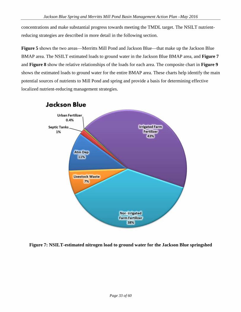
Figure 5 shows the two areas—Merritts Mill Pond and Jackson Blue—that make up the Jackson Blue
BMAP area. The NSILT estimated loads to ground water in the Jackson Blue BMAP area, and Figure 7
and Figure 8 show the relative relationships of the loads for each area. The composite chart in Figure 9
shows the estimated loads to ground water for the entire BMAP area. These charts help identify the main
potential sources of nutrients to Mill Pond and spring and provide a basis for determining effective
localized nutrient-reducing management strategies.
Figure 7: NSILT-estimated nitrogen load to ground water for the Jackson Blue springshed

Jackson Blue Spring and Merritts Mill Pond Basin Management Action Plan –May 2016
Page 34 of 60
Figure 8: NSILT-estimated nitrogen load to ground water in the Merritts Mill Pond area
Figure 9: Composite NSILT-estimated nitrogen load to ground water in the Jackson Blue BMAP area

Jackson Blue Spring and Merritts Mill Pond Basin Management Action Plan –May 2016
Page 35 of 60
4.1.1 Agricultural Fertilizer and Livestock Loads to Ground Water
The estimated nitrogen loads to ground water for irrigated and nonirrigated applied fertilizer and
livestock waste comprise 86% of the total load in the Jackson Blue area. Implementation of agricultural
best management practices (BMPs) is estimated to achieve the maximum initial load reductions required
for the springshed. The actions being taken are detailed in Section 4.2.
4.1.2 OSTDS (Septic Tanks) Loads to Ground Water
The estimated nitrogen loading to ground water for septic tanks is greatest in the Mill Pond area (22%).
In this area DEP, FDOH, NWFWMD, Jackson County, and other interested parties will work together to
identify effective management strategies, determine funding sources, and develop implementation plans
for these strategies. Current activities include the replacement of existing septic tanks with sewer
connections in the Indian Springs subdivision.
Certain solutions developed for the Mill Pond area will also help with septic tank loading reductions in
the remainder of the BMAP area where the estimated OSTDS load is 2%. Load reductions associated
with the management actions can be estimated through the application of the appropriate model.
4.1.3 Urban Fertilizer Loads to Ground Water
The estimated nitrogen load to ground water for urban fertilizer is greatest in the Mill Pond Area, where
it comprises 6% of the total load. In the entire BMAP area, the load is estimated at 1%. Jackson County
is required to develop and pass an urban fertilizer ordinance, and the implementation of this ordinance is
estimated to achieve the reductions necessary for this nutrient source.
Table 4 summarizes the management strategies provided by each stakeholder. The projects funded by
several funding sources are grouped by funding source in Table 5, Table 6, and Table 7. For future
management strategies, stakeholders are identifying feasible funding strategies to implement the
activities identified in the tables below. Appendix B outlines other funding strategies.

Jackson Blue Spring and Merritts Mill Pond Basin Management Action Plan –May 2016
Page 36 of 60
Table 4: Jackson Blue Springs management strategies * The estimated reductions are based on the amount of TN applied to the land surface and do not represent the nitrate loading to ground water.
Proj
ect N
umbe
r
Proj
ect N
ame
Lea
d E
ntity
Proj
ect T
ype
Proj
ect
Des
crip
tion
Acr
es T
reat
ed
Cos
t
Ann
ual O
&M
C
ost
Fund
ing
Sour
ce
Con
trac
t A
gree
men
t N
umbe
r
Proj
ect S
tatu
s
Com
plet
ion
Yea
r
TN
Red
uctio
n*
(lbs/
yr)
JC-1
Indian Springs Sewer
Extension Phase I
Jackson County
Septic to Sewer
Connection
Extend central sewer to Lower Indian Springs Subdivision, serving 125 homes, install
onsite grinders for each home, and abandon septic systems to
reduce nitrate levels in Merritts Mill Pond and Jackson Blue Springs.
$1,950,000 Springs
FY 15–16 DEP contract
executed; county
contract executed
NWF-1
Claiborne Aquifer
Water Supply NWFWMD Agricultural
or Ag-Related
Initiates Claiborne Aquifer testing in Jackson Blue Spring contributing area. Determine
aquifer's viability as alternative water source to offset demand on Floridan
aquifer.
$440,000 Springs In progress
NWF-2
Jackson Blue Spring
Agricultural BMP
Producer Cost-Share
Grant Program
NWFWMD Agricultural or Ag-Related
Cost-share funding for agricultural BMPs in Jackson Blue Spring contributing area
to improve water use efficiency and reduce nutrient loading. Also supports mobile
irrigation lab (MIL).
$1,121,754 Springs Ongoing
NWF-3
Blue Springs Plantation, Inc. Land
Acquisition
NWFWMD Land Acquisition
Fee-simple acquisition and protection of 394 acres
adjacent to Jackson Blue Spring.
$2,100,000 Springs FY 15–16
DEP contract executed
NWF-4
Lakeshore Farms II,
LLC Land Acquisition
NWFWMD Land Acquisition
Fee-simple and/or less-than-fee acquisition and protection
of 598 agricultural acres in Jackson Blue ground water
contributing area.
$2,686,568 Springs
FY 15–16 contract
executed; conservation easement in development

Jackson Blue Spring and Merritts Mill Pond Basin Management Action Plan –May 2016
Page 37 of 60
Proj
ect N
umbe
r
Proj
ect N
ame
Lea
d E
ntity
Proj
ect T
ype
Proj
ect
Des
crip
tion
Acr
es T
reat
ed
Cos
t
Ann
ual O
&M
C
ost
Fund
ing
Sour
ce
Con
trac
t A
gree
men
t N
umbe
r
Proj
ect S
tatu
s
Com
plet
ion
Yea
r
TN
Red
uctio
n*
(lbs/
yr)
NWF-5
Sod-Based Crop Rotation Pilot Project
NWFWMD/UF–IFAS
Agricultural or Ag-Related
Demonstration project (to include subsidies) for up to four sod farms in Jackson County to improve water quality and quantity in
Jackson Blue Spring over 4-year period. Project to be
implemented in partnership with UF–IFAS. Match includes $256,000 from
NWFWMD, $70,000 from producers.
$806,032
U.S. Environ-mental Protec-
tion Agency (EPA)
319
DEP/EPA FY 14–15
Application Complete; awaiting approval
NWF-6
NWF Mobile Irrigation
Laboratory NWFWMD Agricultural
or ag-related
Annual contract with West Florida Resource
Conservation & Development (RC&D) to support water quantity evaluations and
retrofits with largely agricultural producers in
Jackson County, but across panhandle, in partnership with
FDACS and Natural Resources Conservation
Service (NRCS). Totals show funding since program began in 2004; NWFWMD annual
funding amount currently $71,125 and overall program
costs $207,211.
$673,938 In progress;
renewed annually
NWF-7
IFAS Sod-based Crop
Rotation
NWFWMD/UF–IFAS
Agricultural or ag-related
Annual contract with UF–IFAS to provide education
and outreach across NWFWMD. Annual funding
amount currently $40,000, but will increase if EPA 319
project awarded.
$415,000 In progress;
renewed annually

Jackson Blue Spring and Merritts Mill Pond Basin Management Action Plan –May 2016
Page 38 of 60
Table 5: Projects funded with Florida Springs funding Fiscal Year (FY) Project Cooperator
State Funding Match Total Spring County Status Project Type Description
14-15 Claiborne Aquifer Water Supply NWFWMD $440,000 $0 $440,000 Jackson
Blue Jackson In progress Agricultural or
agriculture related
Initiates Claiborne aquifer testing in
Jackson Blue Spring contributing area.
Determine aquifer's viability as alternative water source to offset demand on Floridan
aquifer.
13-14
Jackson Blue Spring
Agricultural BMP Producer Cost-
Share Grant Program
NWFWMD $752,000 $484,169 $1,236,169 Jackson Blue Jackson Complete
Agricultural or agriculture
related
Cost-share funding for agricultural BMPs in Jackson Blue Spring contributing area to improve water use
efficiency and reduce nutrient loading. Also
supports MIL.
14-15
Jackson Blue Spring
Agricultural BMP Producer Cost-
Share Grant Program
NWFWMD $487,500 $308,260 $795,760 Jackson Blue Jackson In progress
Agricultural or agriculture
related
Cost-share funding for agricultural BMPs in Jackson Blue Spring contributing area to improve water use
efficiency and reduce nutrient loading.
15-16
Jackson Blue Spring
Agricultural BMP Producer Cost-
Share Grant Program
NWFWMD $1,000,000 $333,333 $1,333,333 Jackson Blue Jackson
FY 15–16 DEP contract
executed; BMP
application cycle closed
3/25/16
Agricultural or agriculture
related
Continue to implement
agricultural cost-share program. Assist 32
producers in Jackson Blue Spring Basin
with retrofits to improve water quality and quantity. Previous efforts have funded 33
producers.

Jackson Blue Spring and Merritts Mill Pond Basin Management Action Plan –May 2016
Page 39 of 60
Fiscal Year (FY) Project Cooperator
State Funding Match Total Spring County Status Project Type Description
15-16 Blue Springs
Plantation, Inc. Land Acquisition
NWFWMD $2,100,000 $0 $2,100,000 Jackson Blue Jackson
FY 15–16 DEP contract
executed
Land acquisition
Fee-simple acquisition and protection of 394
acres adjacent to Jackson Blue Spring.
15-16 Lakeshore Farms
II, LLC Land Acquisition
NWFWMD $2,686,568 $0 $2,686,568 Jackson Blue Jackson
FY 15–16 contract
executed; conservation easement in development
Land acquisition
Fee-simple and/or less-than-fee
acquisition and protection of 598
agricultural acres in Jackson Blue ground
water contributing area.
15-16 Indian Springs
Sewer Extension Phase I
Jackson County $1,450,000 $500,000 $1,950,000 Jackson
Blue Jackson
FY 15–16 DEP contract
executed; county
contract executed
Septic to sewer connection
Extend central sewer to lower Indian
Springs subdivision, serving 125 homes,
install on-site grinders for each home, and
abandon septic systems, reducing
nitrate levels in Merritts Mill Pond and Jackson Blue
Springs. Total $8,916,068 $1,625,762 $10,541,830

Jackson Blue Spring and Merritts Mill Pond Basin Management Action Plan –May 2016
Page 40 of 60
Table 6: Projects funded with EPA funding
FY Project Cooperator State
Funding Match Total Spring County Status Project Type Description
14-15 Sod-Based Crop
Rotation Pilot Project
NWFWMD/ UF–IFAS $480,032 $326,000 $806,032 Jackson
Blue Jackson
DEP/EPA FY 14–15
Application complete; awaiting approval
Agricultural or
agriculture related
Demonstration project (to include subsidies) for up to 4 sod farms in Jackson County to improve water
quality and quantity in Jackson Blue Spring over 4-year period. Project to be implemented in partnership with UF–IFAS. Match includes $256,000
from NWFWMD, $70,000 from producers.
Total $480,032 $326,000 $806,032
Table 7: Projects funded with other funding sources
FY Project Cooperator State
Funding Match Total Spring County/ Region Status
Project Type Description
Multiple Years NWF MIL NWFWMD/
FDACS $673,938 $673,938 N/A NWFWMD In progress;
renewed annually
Agricultural or
agriculture related
Annual contract with West Florida RC&D to support water quantity
evaluations and retrofits with largely agricultural producers in
Jackson County, but across panhandle, in partnership with
FDACS and NRCS. Totals show funding since program began in
2004; district annual funding amount currently $71,125 and
overall program costs $207,211.
Multiple Years
UF–IFAS Sod-Based Crop
Rotation
NWFWMD/ UF–IFAS $415,000 $0 $415,000 N/A NWFWMD
In progress; renewed annually
Agricultural or
agriculture related
Annual contract with UF–IFAS to provide education and outreach
across NWFWM D, annual funding amount currently $40,000, but will increase if EPA 319 project funding
is awarded. Total $1,783,938 $0 $1,783,938

Jackson Blue Spring and Merritts Mill Pond Basin Management Action Plan –May 2016
Page 41 of 60
4.2 AGRICULTURAL BMP IMPLEMENTATION
Agricultural nonpoint sources in a BMAP area are required by state law (Subsection 403.067[7], F.S.)
either to implement FDACS-adopted BMPs or to conduct water quality monitoring prescribed by DEP
or the NWFWMD, to demonstrate compliance with water quality standards. Failure to either implement
BMPs or conduct monitoring may bring enforcement action by DEP or the NWFWMD. The
implementation of FDACS-adopted, DEP-verified BMPs in accordance with FDACS rule provides a
presumption of compliance with state water quality standards.
Pursuant to Paragraph 403.067(7)(c), F.S., the implementation of FDACS-adopted, DEP-verified BMPs
in accordance with FDACS rule provides a presumption of compliance with state water quality
standards. Growers who implement BMPs may be eligible for cost-share from FDACS, the NWFWMD,
or others. Through the Office of Agricultural Water Policy (OAWP), the Florida Forest Service, and
Division of Aquaculture, FDACS develops, adopts, and assists producers in implementing agricultural
BMPs to improve water quality and water conservation.
The breakdown of agricultural land uses in the Jackson Blue Springs BMAP area, according to 2009
NWFWMD land use data, is shown in Table 8. Table 9 shows the composite land use as compiled by
DEP from various data sources, including Cropscape (data from the United States Department of
Agriculture [USDA]), Farm Service Agency aerial data, property appraiser data, NWFWMD 2012 data,
and Florida Statewide Agricultural Irrigation Demand (FSAID) data (a geodatabase collected and
maintained by FDACS OAWP) for irrigated lands. The composite land use was used to develop the
NSILT. These two tables illustrate the differences in land use based on differing data sources.
DEP and FDACS will work together during BMAP implementation to identify actual acreages that are
eligible for enrollment in FDACS BMP Program. Figure 10 shows the approximate location of these
agricultural lands based on 2009 NWFWMD land use, and Figure 11 shows the approximate location of
these agricultural lands based on the composite land use data from DEP. Based on the 2009 NWFWMD
land use, the primary agricultural land use in the Jackson Blue Springs basin is pasture.

Jackson Blue Spring and Merritts Mill Pond Basin Management Action Plan –May 2016
Page 42 of 60
Table 8: Agricultural land uses in the Jackson Blue Springs Basin (2009 NWFWMD land use)
Land Use Code Code Description Total Acres 2100 Cropland and Pastureland 36,982.6 2200 Tree Crops 103.5 2300 Feeding Operations 7.3 2400 Nurseries and Vineyards 9.5 2600 Other Open Lands – Rural 855.4 3300 Mixed Rangeland 1,178.9
Total 39,137.2
Table 9: Agricultural land uses in the Jackson Blue Springs Basin (DEP composite land use)
Composite Land Use Description Total Acres Pasture 12,270.7
Row Crops 21,971.9 Field Crops 8,198.1
Orchards/Ornamentals 7.1 Other Agriculture 278.8
Total Acres 42,726.7 Land use data are helpful as a starting point for estimating agricultural acreage and developing BMP
implementation strategies; however, there are inherent limitations. The time of year when land use data
are collected (through aerial photography) affects the accuracy of photo interpretation, can result in
inappropriate analysis of the data, and can hinder decision making.
Another limitation is that the specific agricultural activity being conducted is not always apparent. For
example, some acreage under the improved pasture classification may be used for cattle grazing, some
may consist of forage grass that is periodically harvested and sold for hay, or some may comprise a
fallow vegetable field awaiting planting. Operations that may fall into this land use category fertilize at
different rates; for example, hay operations and some other commodities typically fertilize at or below
rates recommended by UF–IFAS.
It is therefore meaningful for the purposes of evaluating potential nutrient impacts to identify specific
land uses on a property, rather than assuming that operations and present conditions are uniform across a
specific land use. Because of error in the collection and characterization of land use data and changes in
land use over time, land use acreage estimates are subject to adjustment, as discussed later in this
section.

Jackson Blue Spring and Merritts Mill Pond Basin Management Action Plan –May 2016
Page 43 of 60
Figure 10: Agricultural lands in the Jackson Blue Springs BMAP Basin (2009 NWFWMD land
use)

Jackson Blue Spring and Merritts Mill Pond Basin Management Action Plan –May 2016
Page 44 of 60
Figure 11: DEP composite agricultural lands in the Jackson Blue Springs BMAP Basin

Jackson Blue Spring and Merritts Mill Pond Basin Management Action Plan –May 2016
Page 45 of 60
4.2.1 Agricultural BMPs
BMPs are individual or combined practices determined through research, field testing, and expert review
to be the most effective and practicable means for improving water quality, taking into account
economic and technological considerations. FDACS has authority for establishing agricultural BMPs
through the Florida Forest Service (Silviculture BMP Program), Division of Aquaculture (Aquaculture
Certification Program), and OAWP (all other agricultural BMP programs). As of March 2016, the
OAWP has adopted manuals for cow/calf, statewide citrus, vegetable and agronomic crops, nurseries,
equine operations, specialty fruit and nut, sod, and dairy operations. Manual development is under way
for poultry operations, and adoption is expected in late 2016.
The OAWP BMPs fall into two categories-structural and management. Structural BMPs (e.g., water-
control structures, fencing, and tailwater recovery systems) involve the installation of structures or
changes to the land and are usually costlier than management BMPs. Management BMPs, such as
nutrient and irrigation management, comprise the majority of the practices and often are not readily
observable. Nutrient management addresses fertilizer type, amount, placement, and application timing,
and includes practices such as soil and tissue testing, application methods, correct fertilizer formulations,
and setbacks from water resources. Irrigation management includes maintenance, scheduling, and other
measures that improve the overall efficiency rating of irrigation systems. In most areas of the state,
FDACS-funded MILs are available to evaluate irrigation system efficiency and provide
recommendations to producers to improve efficiency. The implementation of these recommendations
results in billions of gallons of water saved throughout the state and helps reduce nutrient runoff and
leaching.
Table 10 identifies key management and structural BMPs that would be applicable to agricultural
operations in the basin. By definition, BMPs are developed to be technically and economically feasible.
However, FDACS BMP manuals do contain some BMPs that may be affordable only with financial
assistance through cost-share programs. The BMP checklists allow producers to indicate whether
implementing a BMP requires financial assistance. Through cost-share programs, FDACS works with
producers to implement applicable key BMPs that otherwise are not affordable.
For assistance with enrolling in the OAWP BMP Program or with obtaining cost-share funds, interested
producers should contact OAWP staff. Information on BMP manuals and field-staff contact information
is available online. Printed BMP manuals can be obtained from local extension offices at county
agricultural extension centers, USDA NRCS offices, or by contacting OAWP field staff.

Jackson Blue Spring and Merritts Mill Pond Basin Management Action Plan –May 2016
Page 46 of 60
Table 10: Key management and structural BMPs adopted by FDACS OAWP
BMP Category BMP Description
Nutrient Need Determination Soil and Tissue Testing
Used to base fertilizer applications on plant needs and available nutrients in soil; helps prevent overapplication of
fertilizer.
Nutrient Need Determination Nutrient Budgeting
Adjustment of fertilizer regime to account for other nutrient sources, such as biosolids, legumes, manure, and
nutrient-laden irrigation water; helps prevent overapplication of fertilizer.
Nutrient Application Management
Precision Application of Nutrients
Use of specialized equipment for precise placement of nutrients on targeted areas at specified rates; reduces total
amount used and prevents stray applications. Nutrient Application
Management Equipment
Calibration/Maintenance Ensures proper functioning of equipment; prevents
misapplication or overapplication of fertilizer materials.
Nutrient Application Management Split Fertilizer Applications
Multiple applications timed with optimal growth stages; allows plants to assimilate nutrients more efficiently;
reduces nutrient loss in leaching and runoff. Nutrient Application
Management Controlled-Release
Fertilizer Use of fertilizer formulations with controlled nutrient-
release curve; reduces nutrient loss to leaching and runoff.
Nutrient Application Management
Fertilizer Application Setbacks from Waterbodies
(e.g., wetlands, watercourses, sinks, springs,
etc.)
Establishes zone where no fertilizer will be applied; reduces nutrient loadings to waterbodies.
Irrigation Management Irrigation Scheduling Planning when to irrigate to reduce water and nutrient
losses, based on available soil moisture content, evapotranspiration levels, recent rainfall, and time of day.
Irrigation Management Soil-Moisture and Water-Table Monitoring
Use of devices that measure water table level and amount of water in soil; is a key component of proper irrigation
scheduling.
Irrigation Management Tailwater Recovery Use of downgradient catchment ponds to trap irrigation
tailwater to be reused on cropland; reduces off-site transport of nutrients and conserves water.
Treatment and Erosion Control Filter Strips
Vegetated strips of land designed to reduce nutrients and sediments in surface water runoff from fields, pastures,
and livestock high-intensity areas before it reaches downstream waterbodies.
Treatment and Erosion Control Vegetative Buffers
Establishment of riparian and/or wetland buffers to attenuate and assimilate nutrient- or sediment-laden surface flows coming from cropped/grazed areas.
Treatment and Erosion Control
Ditch Maintenance and Retrofits
Use of riprap, sediment traps, staging structures, and permanent vegetative bank cover to minimize erosion and
transport of nutrient-laden sediments. Livestock Management (Applicable to Cow/Calf and Equine Operations)
Manure Management Appropriate storage and disposal of animal waste.
Livestock Management (Applicable to Cow/Calf and Equine Operations)
Alternative Water Sources Use of upland livestock watering ponds and/or water troughs; minimizes manure deposition in waterbodies.
Livestock Management (Applicable to Cow/Calf and Equine Operations)
Rotational Grazing Movement of cattle to different grazing areas on planned
basis; prevents concentrated waste accumulations and denuding of pasture areas. May involve fencing.
Livestock Management (Applicable to Cow/Calf and Equine Operations)
High-Intensity Areas Location
Siting of cowpens, supplemental feed areas, etc., away from waterbodies to minimize nutrient loadings.

Jackson Blue Spring and Merritts Mill Pond Basin Management Action Plan –May 2016
Page 47 of 60
BMP Category BMP Description
Operations Management Fertilizer Storage Proper location/storage of bulk fertilizer products to prevent nutrient loadings.
Operations Management Fertilizer Mix/Load Use of appropriate dedicated or temporary mix/load areas
located away from waterbodies to prevent nutrient loading.
Operations Management Employee Training Training provided to farmworkers on how to implement BMPs.
Operations Management Record Keeping Proper record keeping provides accountability in
implementation of BMPs, and assists producers in making nutrient and irrigation management decisions.
4.2.2 BMP Enrollment
Table 11 summarizes the land use data figures for agriculture in the BMAP area, the acreages associated
with commodity types addressed by OAWP BMP manuals, and the acres enrolled in BMP programs.
Figure 12 shows the acres enrolled in BMPs as of December 31, 2015.
Not all of the acreage listed as agriculture in Table 11 is included in enrollment figures, because the
notices of intent (NOIs) document only the estimated total number of acres on which applicable BMPs
are implemented, not the entire land use acreage mapped as agriculture. Land use data can contain
nonproduction acres (such as buildings, parking lots, and fallow acres) that will not be counted on the
NOIs submitted to OAWP. There also may be acreage that is not appropriate for enrollment in OAWP
BMPs, such as lands not in commercial production (defined as operations conducted as a business).
As of December 31, 2015, there are 68 NOIs covering 19,677.9 acres in the Jackson Blue Springs
watershed. No producers are conducting water quality monitoring in lieu of implementing BMPs at this
time.

Jackson Blue Spring and Merritts Mill Pond Basin Management Action Plan –May 2016
Page 48 of 60
Figure 12: BMP enrollment in the Jackson Blue Springs Basin as of December 31, 2015

Jackson Blue Spring and Merritts Mill Pond Basin Management Action Plan –May 2016
Page 49 of 60
Table 11: Agricultural acreage and BMP enrollment for the Jackson Blue Springs BMAP area
as of December 31, 2015 N/A = Not applicable. 1 Enrollment numbers will depend on the ability of field staff to identify and locate producers and whether producers choose to implement BMPs or monitor their water quality. Also, specific agricultural land uses and number of agricultural operations may change from year to year. Progress on enrollment, based on best available information, will be included in the BMAP Annual Progress Report. 2 Acreage in the hayfields category is likely an overestimate, as the aerial imagery is collected in the winter when producers are growing winter forage. FDACS staff will review the most recent aerial imagery to determine if any of the acreage identified as hayfields should actually be in the row/field/mixed crop category. 3 No poultry feeding operations currently exist in the BMAP basin.
2009 NWFWMD Land Use 2009 Acres Related FDACS BMP Programs Acreage
Enrolled1 Related NOIs
Pasture and Rangeland 14,093.62 Cow/Calf 3,000.89 23 Row/Field/Mixed Crops 9,655.17 Vegetable/Agronomic Crops 16,631.87 44
Hayfields2 14,412.68 Vegetable/Agronomic Crops N/A N/A Fallow Cropland 833.6 No Enrollment Needed 45.16 1
Other Groves 103.47 Specialty Fruit and Nut N/A N/A
Tree Nurseries 7.74 Statewide Nursery 0.0 N/A
Ornamentals 1.74 Statewide Nursery 0.0 N/A
Poultry Feeding Operations3 7.28 Conservation Plan Rule/ Future Poultry Manual 0.0 N/A
Other Open Lands – Rural 21.77 No Enrollment Needed N/A N/A Total 39,137.07 N/A 19,677.92 68
4.2.3 Agricultural BMP Load Reduction Estimates
Due to inaccuracies in 2009 land use data and changes in land use since 2009, agricultural loadings may
be less than perceived. However, there are no detailed allocations in this BMAP, so the total estimated
load or required reductions for agriculture are not defined. Consequently, an estimated average load
reduction percentage was derived for agriculture in this basin, based on an averaged range of expected
reductions for agricultural BMPs in Florida. Percentages represent the relative amount of nitrogen
reduction expected for "typical" agricultural BMP implementation, which includes nutrient
management, stormwater retention, limited wetland retention/restoration, and rotational livestock
grazing practices, as applicable to the commodity and operation. A BMP average efficiency of 30% is
applied to the entire Jackson Blue Springs BMAP area. This efficiency comes from an OAWP-funded
analysis of the BMP treatment efficiencies in the Suwannee Basin area. Agricultural BMP
implementation in the Jackson Blue Springs BMAP area is anticipated to reduce agricultural loadings of
nitrogen on the applicable agricultural operations.
If DEP plans to develop an estimate of agricultural loadings in the future, the development of a basin-
and commodity-specific agricultural loading/reduction model should be considered.

Jackson Blue Spring and Merritts Mill Pond Basin Management Action Plan –May 2016
Page 50 of 60
4.2.4 FDACS OAWP Role in BMP Implementation and Follow-Up
The OAWP works with producers to submit NOIs to implement the BMPs applicable to their operations,
provides technical assistance to growers, and distributes cost-share, as available, to eligible producers
for selected practices. The OAWP follows up with growers through written surveys and site visits, to
evaluate the level of BMP implementation and record keeping, identify areas for improvement, if any,
and discuss cost-share opportunities, among other things.
When DEP adopts a BMAP that includes agriculture, it is the agricultural producer's responsibility to
implement BMPs adopted by FDACS to help achieve load reductions. If land use acreage corrections
and BMP implementation do not fully account for the current agricultural load reduction allocation, it
may be necessary to develop and implement cost-assisted field- and/or regional-level treatment options
that remove nutrients from farms and other nonpoint sources. In that case, FDACS will work with DEP
and the NWFWMD to identify appropriate options for achieving further agricultural load reductions.
The FWRA requires that, where water quality problems are demonstrated despite the proper
implementation of adopted agricultural BMPs, FDACS must reevaluate the practices, in consultation
with DEP, and modify them if necessary. Continuing water quality problems will be detected through
the BMAP monitoring component and other DEP and NWFWMD activities. If a reevaluation of the
BMPs is needed, FDACS will also include the NWFWMD and other partners in the process.
4.2.5 OAWP Implementation Assurance (IA) Program
The OAWP formally established its Implementation Assurance (IA) Program in 2005 in the Suwannee
River Basin as part of the multi-agency/local stakeholder Suwannee River Partnership. In 2007, the
OAWP initiated the IA Program in the Lake Okeechobee Watershed and launched a standardized
follow-up program for the remaining areas of the state in 2013, beginning with the Ridge Citrus and
Indian River Citrus BMPs. Because of program-specific needs, the follow-up process for each of these
three components was different. In early 2014, the OAWP began to streamline the IA Program to
ensure consistency statewide and across commodities and BMP manuals. This effort resulted in a single
IA site-visit form, currently used by OAWP staff.
The current IA Program consists of two key components—mail-out surveys and site visits. OAWP staff
develop the surveys in conjunction with commodity experts. This component of the IA Program was
born out of the recognition that OAWP staff resources are limited; therefore, visits to each of the

Jackson Blue Spring and Merritts Mill Pond Basin Management Action Plan –May 2016
Page 51 of 60
enrolled producers across the state were not possible within a short/contemporary time frame. All
enrolled producers are mailed these surveys and are asked to fill them out and return them to OAWP
staff.
Site visits, the second component, are conducted by OAWP field staff and technicians as workload
allows. For the visits, field staff and technicians use a standard form (not BMP manual specific) that
was developed in 2014. This site-visit form focuses on nutrient-management, irrigation-management,
and water-resource protection BMPs common to all of the adopted BMP manuals. The paper forms are
submitted to OAWP staff and compiled into a spreadsheet, and the data are reported annually. From
2007 to 2015, the OAWP conducted 1,936 site visits. However, it is difficult to compare data collected
prior to the implementation of the single IA site-visit form developed in 2014 because of regional
differences (e.g., different forms and information asked) in administration of the IA Program.
According to the OAWP database, the OAWP conducted four site visits in 2015 in the Jackson Blue
BMAP Basin. As enrollment in the FDACS BMP Program increases as a result of the adoption of this
BMAP, the number of site visits associated with the IA Program in the BMAP area will also increase.
In late 2014, the OAWP commenced efforts to revise and restructure its current IA Program, and these
efforts are ongoing as a result of 2016 legislation (2016–1, Laws of Florida).

Jackson Blue Spring and Merritts Mill Pond Basin Management Action Plan –May 2016
Page 52 of 60
Chapter 5: ASSESSING PROGRESS AND MAKING CHANGES
Successful BMAP implementation requires commitment and follow-up. In the commitment to plan
implementation (see Section 5.4), stakeholders have expressed their intention to carry out the plan,
monitor its effects, and continue to coordinate within and across jurisdictions to achieve water quality
targets. Stakeholders have committed and are required to implement the assigned projects and activities
within the first five-year phase of this BMAP. The FWRA requires that an assessment be conducted
every five years to determine whether there is reasonable progress in achieving pollutant load
reductions. This chapter contains the water quality monitoring component sufficient to make this
evaluation.
5.1 TRACKING IMPLEMENTATION DEP will work with stakeholders to track project implementation and organize the monitoring data
collected each year. The project and monitoring information will be presented in an annual report. In
addition to ongoing OSTDS activities, Jackson Blue Spring and Merritts Mill Pond stakeholders have
agreed to meet approximately annually after the adoption of the BMAP to follow up on plan
implementation, share new information, and continue to coordinate on TMDL-related issues. The
following types of activities may occur at annual meetings:
Implementation Data and Reporting –
o Collect project implementation information from stakeholders and from FDACS on
agricultural BMP enrollment, and compare with the BMAP schedule.
o Discuss the data collection process, including any concerns and possible improvements
to the process.
o Review the monitoring plan implementation, as detailed in Section 5.3.
Sharing New Information –
o Report on results from water quality and biological monitoring and trend information.
o Provide updates on new management strategies in the basin that will help reduce
nutrient loading.
o Identify and review new scientific developments on addressing nutrient loads and
incorporate any new information into annual Progress Reports.
Coordinating TMDL-Related Issues –

Jackson Blue Spring and Merritts Mill Pond Basin Management Action Plan –May 2016
Page 53 of 60
o Provide updates from DEP on the basin cycle and activities related to any impairments,
TMDLs, and BMAP.
o Obtain reports from other basins where tools or other information may be applicable to
the Jackson Blue Spring and Merritts Mill Pond TMDL.
5.2 ADAPTIVE MANAGEMENT MEASURES Adaptive management involves setting up a mechanism for making adjustments in the BMAP when
circumstances change or feedback indicates the need for a more effective strategy. Adaptive
management measures include the following:
Procedures to determine whether additional cooperative strategies are needed.
Criteria/processes for determining whether and when plan components need revision due
to changes in costs, environmental impacts, social effects, watershed conditions, or other
factors.
Descriptions of stakeholders' roles after BMAP completion.
Key components of adaptive management to share information and expertise are tracking plan
implementation, monitoring water quality and pollutant loads, and holding periodic meetings. BMAP
execution will be a long-term process, and some projects will extend beyond the first BMAP phase. For
example, during the first iteration, the OSTDS Initiative will be implemented to identify what strategies
are most applicable to the basin to reduce nitrate loading, determine a timeline for future strategies, and
identify which stakeholders are responsible for implementing the necessary strategies in the next BMAP
iteration.
DEP and stakeholders will track implementation efforts and monitor water quality to measure
effectiveness and ensure BMAP compliance. Stakeholders will meet approximately annually to discuss
implementation issues, consider new information, and, if the basin is not projected to meet the TMDL,
determine additional corrective actions. Information on the implementation of management strategies
will be collected annually from the participating entities and organized into reports. Stakeholders will
review these reports to assess progress towards meeting the BMAP goals.

Jackson Blue Spring and Merritts Mill Pond Basin Management Action Plan –May 2016
Page 54 of 60
5.3 WATER QUALITY MONITORING 5.3.1 Monitoring Objectives
Focused objectives are critical for a monitoring strategy to provide the information needed to evaluate
implementation success. The primary objectives of the monitoring strategy for the Jackson Blue Spring
and Merritts Mill Pond Basin are as follows, and will be used to evaluate the success of the BMAP:
Track trends in nitrate concentrations and loads in Jackson Blue Spring and Merritts Mill
Pond.
Track trends in the biological communities for a balance of flora and fauna in Merritts
Mill Pond.
5.3.2 Water Quality Monitoring Parameters, Frequency, and Network
To achieve the first objective above, the monitoring strategy focuses on collecting the suggested
parameters listed in Table 12. The core parameters are directly related to the impairment in Jackson
Blue Spring and Merritts Mill Pond. Supplemental parameters and field parameters are monitored
primarily to support the interpretation of core water quality parameters. At a minimum, the core
parameters will be tracked to determine progress towards meeting the TMDL.
Table 12: Water quality monitoring parameters
Core Parameters Supplemental Parameters Field Parameters Nitrate + Nitrite (as N)
Ammonia (as N) Kjeldahl Nitrogen
Chlorophyll-a Total Organic Carbon
Total Phosphorus Chloride Sulfate
Fluoride Calcium
Magnesium Sodium
Potassium Alkalinity Hardness
Turbidity (lab) Specific Conductance (lab)
Color (true) Total Suspended Solids Total Dissolved Solids
Water Temperature pH
Specific Conductance Dissolved Oxygen
Sample Depth Secchi Depth

Jackson Blue Spring and Merritts Mill Pond Basin Management Action Plan –May 2016
Page 55 of 60
Water quality monitoring in the Jackson Blue BMAP area will consist of ground water and surface water
sampling. The NWFWMD is in the process of installing monitoring wells in the springshed to provide
information on ground water concentrations. In addition, two submersible ultraviolet nitrate analyzers
(SUNA) continuously record nitrate measurements from Jackson Blue Spring and from the Mill Pond
outfall (Figure 13). DEP also currently monitors at three locations (Table 10) in the Mill Pond area.
Figure 13: SUNA locations in the Jackson BMAP area

Jackson Blue Spring and Merritts Mill Pond Basin Management Action Plan –May 2016
Page 56 of 60
Table 13: BMAP water quality and flow monitoring network Sampling
Entity Station ID Station Name Station Type Frequency
Site Established
Start date
DEP 21FLWQA G2WA007
Merritts Mill Pond 600 meters
downstream of Jackson Blue Spring
Water Quality Quarterly 2015 7/21/2015
DEP 21FLWQA G2WA008
Merritts Mill Pond mid under power
lines
Water Quality Quarterly 2015 7/21/2015
DEP 21FLWQA G2WA009
Merritts Mill Pond 500 meters upstream
of dam
Water Quality Quarterly 2015 7/21/2015
5.3.3 Biological Monitoring
To meet the second monitoring plan objective, two types of biological monitoring will occur to assess
the health of Jackson Blue Spring and Merritts Mill Pond. Biological monitoring in Merritts Mill Pond
will consist of algal and plant surveys conducted by DEP. Algal surveys are conducted annually at each
station. The algal surveys are performed by conducting the Rapid Periphyton Survey (RPS), which is
used to quantify the extent (coverage) and abundance (thickness) of attached algae (periphyton). Plant
surveys are conducted biennially for the waterbody. When biological monitoring samples are collected,
field measurements and water quality samples are also collected.
Table 11 summarizes the biological monitoring, and Figure 8 shows the sampling locations.

Jackson Blue Spring and Merritts Mill Pond Basin Management Action Plan –May 2016
Page 57 of 60
Figure 14: Monitoring network for Jackson Blue Spring and Merritts Mill Pond

Jackson Blue Spring and Merritts Mill Pond Basin Management Action Plan –May 2016
Page 58 of 60
Table 14: Biological monitoring Sampling
Entity Station
Identification Station Name Station Type Frequency Site
Established Start Date
DEP 21FLWQA G2WA007
Merritts Mill Pond 600 meters
downstream of Jackson Blue Spring
Algal Survey Annually 2015 7/21/2015
DEP 21FLWQA G2WA008
Merritts Mill Pond mid under power
lines Algal Survey Annually 2015 7/21/2015
DEP 21FLWQA G2WA009
Merritts Mill Pond 500 meters upstream
of dam Algal Survey Annually 2015 7/21/2015
DEP 21FLWQA G2WA008
Merritts Mill Pond mid under power
lines Plant Survey Biennially 2016 6/15/2016
5.3.4 Data Management and Assessment
The Florida Storage and Retrieval (STORET) Database serves as the primary repository of ambient
water quality data for the state. DEP pulls water quality data used for impaired waters evaluations and
TMDL development directly from this database. Ambient water quality data collected as part of the
BMAP will be uploaded into STORET for long-term storage and availability. Water quality data will be
uploaded to STORET at least once every six months, upon completion of the appropriate quality
assurance/quality control (QA/QC) checks.
The biological data will be stored in DEP's Statewide Biological (SBIO) Database. The biological data
will be uploaded at least once every six months, after the appropriate QA/QC checks.
The water quality and biological data will be analyzed during BMAP implementation to determine
trends in water quality and the health of the biological community. A wide variety of statistical methods
is available for the water quality trend analyses. The selection of an appropriate data analysis method
depends on the frequency, spatial distribution, and period of record available from existing data.
Specific statistical analyses were not identified during BMAP development; however, commonly
accepted methods of data analysis will be used that are consistent with the TMDL model.
5.3.5 QA/QC
Stakeholders participating in the monitoring plan must collect water quality data in a manner consistent
with DEP's standard operating procedures (SOPs) for QA/QC. The most current version of these
procedures is available online. For BMAP-related data analyses, entities should use National
Environmental Laboratory Accreditation Conference (NELAC) and National Environmental Laboratory

Jackson Blue Spring and Merritts Mill Pond Basin Management Action Plan –May 2016
Page 59 of 60
Accreditation Program (NELAP)–certified laboratories or other labs that meet the certification and other
requirements outlined in the SOPs.
5.4 COMMITMENT TO PLAN IMPLEMENTATION Subsection 403.067(7), F.S., lays out the mechanisms for BMAP implementation. While the BMAP is
linked by statute to permitting and other enforcement processes that target individual entities, successful
implementation mandates that local stakeholders willingly and consistently work together to attain
adopted TMDLs. This collaboration fosters the sharing of ideas, information, and resources. The
stakeholders have demonstrated their willingness to confer with and support each other in their efforts.

Jackson Blue Spring and Merritts Mill Pond Basin Management Action Plan –May 2016
Page 60 of 60
APPENDICES
APPENDIX A: BIBLIOGRAPHY OF KEY REFERENCES AND WEBSITES
KEY REFERENCES Barrios, K. June 2011. Nitrate sources of springs discharging to Merritts Mill Pond, Jackson County,
Florida. Technical File Report 2011-01. Northwest Florida Water Management District.
Florida Department of Environmental Protection. 2002. Basin status report: Apalachicola-Chipola.
Tallahassee, FL: Division of Water Resource Management.
——— 2013. Nutrient TMDL for Jackson Blue Spring and Merritts Mill Pond (WBIDs 180Z and 180A).
Tallahassee, FL: Ground Water Management Section.
STORMWATER AND WATER QUALITY PROTECTION WEBSITES Table A-1: Local and regional stormwater and water quality protection websites
NWFWMD
Table A-2: State stormwater and water quality protection websites General Portal for Florida
DEP Watershed Management
TMDL Program BMPs, Public Information
NPDES Stormwater Program Nonpoint Source Funding Assistance
Surface Water Quality Standards Identification of Impaired Surface Waters Rule
STORET Program Criteria for Surface Water Quality Classifications
FDACS OAWP Jackson County Comprehensive Plan
Table A-3: National stormwater and water quality protection websites EPA Office of Water
EPA Region 4 (Southeast U.S.) Clean Water Act History USGS: Florida Waters