Embed Size (px)
Citation preview

BLANCO COUNTY, TEXAS
DEVELOPMENT RULES
AND
REGULATIONS
APPROVED in Commissioners’ Court on May 28, 2019
2
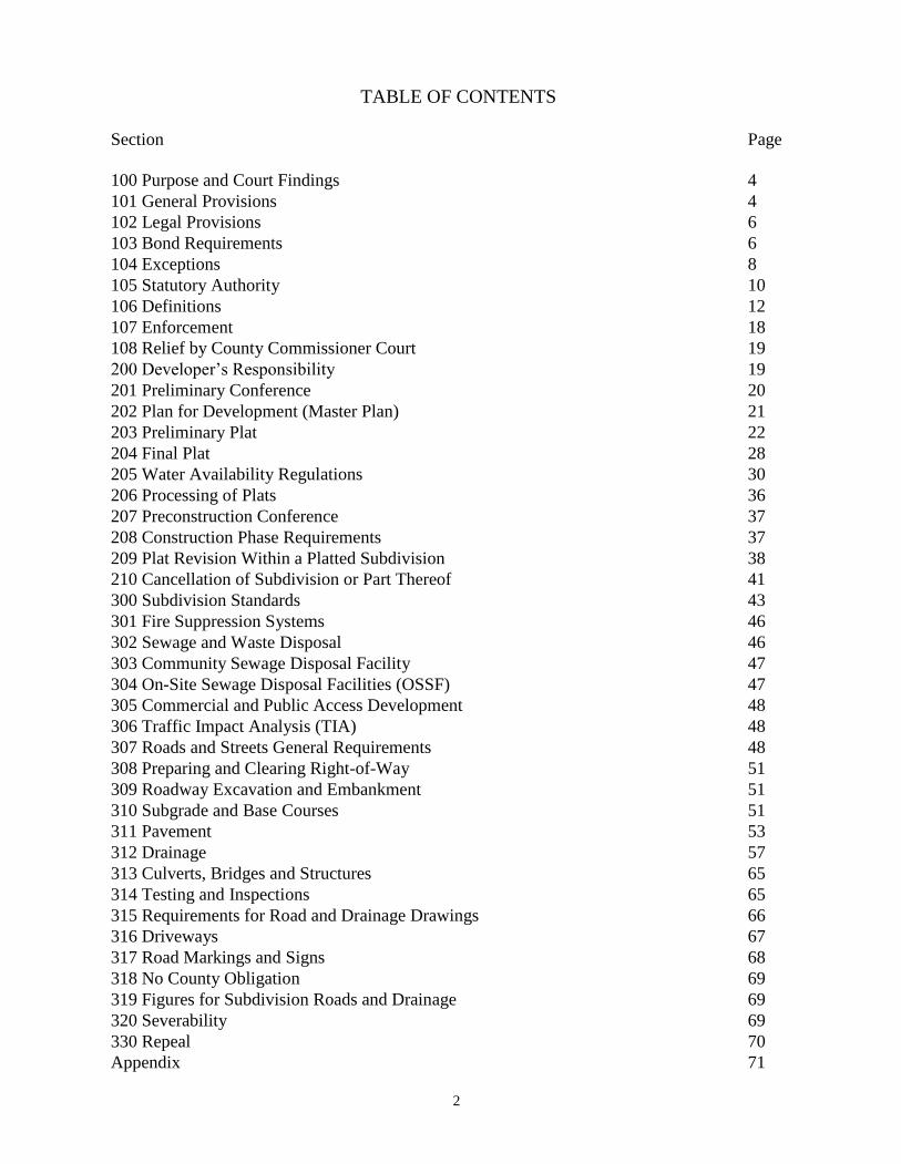
TABLE OF CONTENTS
Section Page
100 Purpose and Court Findings 4
101 General Provisions 4
102 Legal Provisions 6
103 Bond Requirements 6
104 Exceptions 8
105 Statutory Authority 10
106 Definitions 12
107 Enforcement 18
108 Relief by County Commissioner Court 19
200 Developer’s Responsibility 19
201 Preliminary Conference 20
202 Plan for Development (Master Plan) 21
203 Preliminary Plat 22
204 Final Plat 28
205 Water Availability Regulations 30
206 Processing of Plats 36
207 Preconstruction Conference 37
208 Construction Phase Requirements 37
209 Plat Revision Within a Platted Subdivision 38
210 Cancellation of Subdivision or Part Thereof 41
300 Subdivision Standards 43
301 Fire Suppression Systems 46
302 Sewage and Waste Disposal 46
303 Community Sewage Disposal Facility 47
304 On-Site Sewage Disposal Facilities (OSSF) 47
305 Commercial and Public Access Development 48
306 Traffic Impact Analysis (TIA) 48
307 Roads and Streets General Requirements 48
308 Preparing and Clearing Right-of-Way 51
309 Roadway Excavation and Embankment 51
310 Subgrade and Base Courses 51
311 Pavement 53
312 Drainage 57
313 Culverts, Bridges and Structures 65
314 Testing and Inspections 65
315 Requirements for Road and Drainage Drawings 66
316 Driveways 67
317 Road Markings and Signs 68
318 No County Obligation 69
319 Figures for Subdivision Roads and Drainage 69
320 Severability 69
330 Repeal 70
Appendix 71
3
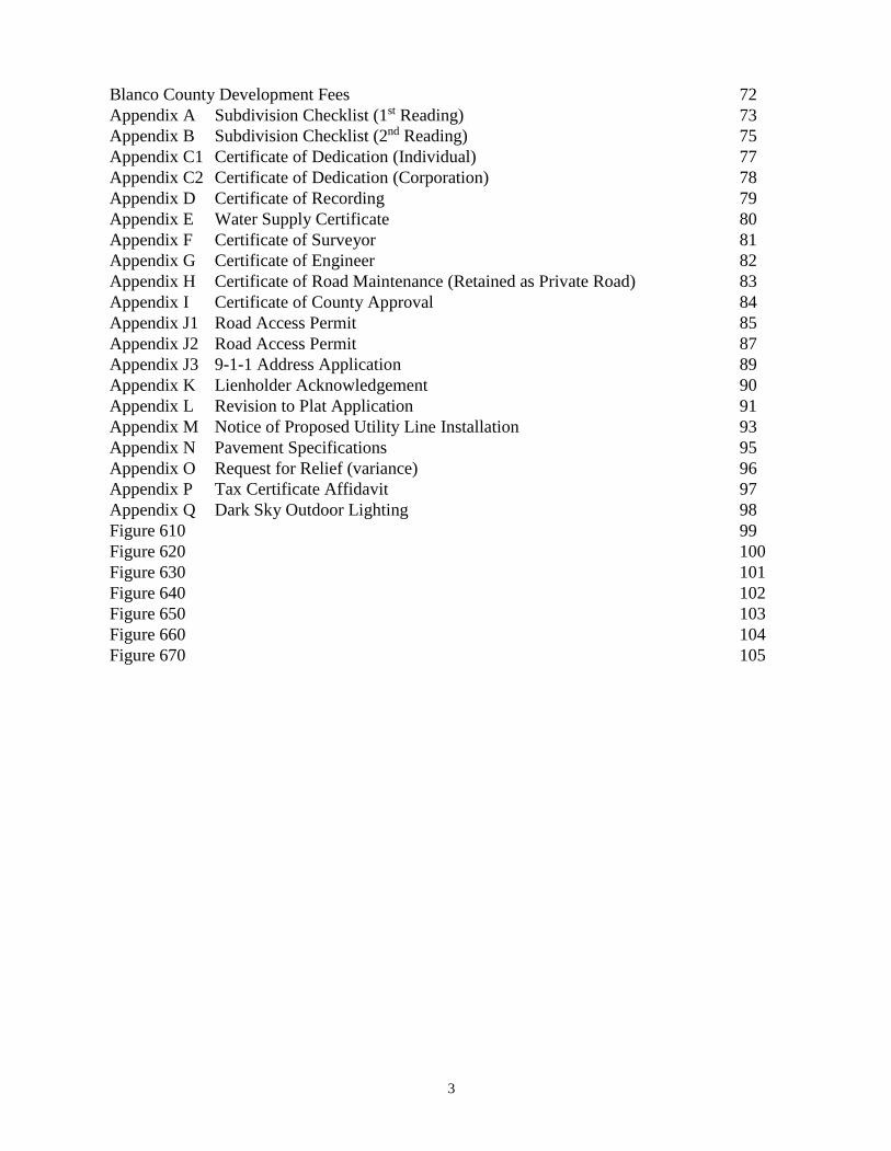
Blanco County Development Fees 72
Appendix A Subdivision Checklist (1st Reading) 73
Appendix B Subdivision Checklist (2nd Reading) 75
Appendix C1 Certificate of Dedication (Individual) 77
Appendix C2 Certificate of Dedication (Corporation) 78
Appendix D Certificate of Recording 79
Appendix E Water Supply Certificate 80
Appendix F Certificate of Surveyor 81
Appendix G Certificate of Engineer 82
Appendix H Certificate of Road Maintenance (Retained as Private Road) 83
Appendix I Certificate of County Approval 84
Appendix J1 Road Access Permit 85
Appendix J2 Road Access Permit 87
Appendix J3 9-1-1 Address Application 89
Appendix K Lienholder Acknowledgement 90
Appendix L Revision to Plat Application 91
Appendix M Notice of Proposed Utility Line Installation 93
Appendix N Pavement Specifications 95
Appendix O Request for Relief (variance) 96
Appendix P Tax Certificate Affidavit 97
Appendix Q Dark Sky Outdoor Lighting 98
Figure 610 99
Figure 620 100
Figure 630 101
Figure 640 102
Figure 650 103
Figure 660 104
Figure 670 105
4
BLANCO COUNTY, TEXAS
SUBDIVISION REGULATIONS
100 REGULATING THE FILING FOR RECORD OF SUBDIVISION PLATS AND OTHER
REQUIREMENTS PERTINENT THERETO AND ESTABLISHING CONSTRUCTION
STANDARDS FOR ALL SUBDIVISIONS SITUATED OUTSIDE THE BOUNDARIES OF
ANY INCORPORATED CITY IN BLANCO COUNTY, TEXAS.
101 THE STATE OF TEXAS, COUNTY OF BLANCO IN COMMISSIONERS’ COURT OF
BLANCO COUNTY, TEXAS May 30, 2019,
102 WHEREAS: Blanco County has established standards and specifications for construction of
roads and drainage, private sewage facilities and development within the floodplain, and
103 WHEREAS: Chapters 232 and 233, Texas Local Government Code, empower the County to
enact subdivision rules and regulations and to provide for their administration, enforcement, and
amendment, and
104 WHEREAS: The County Commissioners’ Court is empowered with the authority to formulate
such rules and regulations by Chapter 232, and the Commissioners’ Court having favorably
received and voted on these rules, recommends that these regulations be adopted,
105 NOW, THEREFORE, BE IT ORDERED BY THE COMMISSIONERS’ COURT OF BLANCO
COUNTY, TEXAS, AS FOLLOWS:
106 101.000 GENERAL PROVISIONS
101.100 The owner of a tract of land, located outside the corporate limits of any city in Blanco County
must have a plat of the subdivision prepared if the owner divides the tract into two or more parts
to lay out a subdivision of the tract, including an addition, lots, or streets, alleys, squares, parks,
or other parts of the tract intended to be dedicated to public use or for the use of purchasers or
owners of lots fronting on or adjacent to the streets, alleys, squares, parks, or other parts.
101.110 A division of a tract includes a division regardless of whether it is made by using a metes and
bounds description in a deed of conveyance or in a contract for a deed, by using a contract of sale
or other executory contract to convey, or by using any other method.
101.120 In accordance with the procedures set out in these Rules and Regulations, the plat must be
submitted to the Commissioners Court for approval. The Commissioners’ Court may refuse to
approve a plat that does not meet the requirements prescribed by these Rules and Regulations.
101.130 Following final approval by the Commissioners’ Court, the plat shall be filed and recorded with
the County Clerk.
101.140 The Rules and Regulations to which a particular development must comply are those in effect on
the date the preliminary plat application for the development is submitted to the County, provided
the applicant timely submits required documents and information in accordance with section
206.000.
5
101.150 The limitations and restrictions prescribed in these Rules and Regulations concerning lot size,
minimum road frontage and building set back lines shall not apply to platted lots in subdivisions
recorded and in existence prior to the effective date of these Rules and Regulations. However,
any future alterations of the boundaries of such lots, whether through division or combination,
shall be subject to the procedures set out in these Rules and Regulations.
101.160 Water Availability Regulations apply to all applications for plat approval for a subdivision wholly
or partially within Blanco County, Texas except when platting is exempt from the subdivision
regulations (see excluded transactions)
101.170 In areas within the City Limits and Extraterritorial Jurisdiction (ETJ) of the Cities of Blanco
County, the provisions are as follows:
a. property located 100% within the City Limits and/or ETJ of an incorporated city are
under exclusive jurisdiction of that city. in accordance with interlocal agreements
signed with Blanco County.
b. property located both within the City Limits and/or ETJ of an incorporated city and also
located in Blanco County, are subject to separate Regulations; the property located in
the ETJ is under jurisdiction of the City and the property located in the County is under
jurisdiction of the County.
c. property located in the City and/or ETJ of the Town of Round Mountain is
subject to the most stringent subdivision regulations of the Town of Round Mountain
or Blanco County.
101.180 In the event that the proposed subdivision is a revision of a recorded plat, the Subdivider
will be required to meet the requirements of these Regulations for revisions, as well as these
specifications. An existing subdivision plat may be vacated by the owners thereof in
conformance with these Regulations and Section 232.008 or 232.0085 of the Texas Local
Government Code and upon approval by the Commissioners’ Court.
101.190 With the inception of these Regulations, no permit shall be issued by Blanco County for the
installation of septic systems on any lot in a subdivision for which a final plat has not been
approved and filed for record, or on any lot in a subdivision in which the standards contained
herein or referred to herein have not been complied with in full.
101.200 Blanco County shall not repair, maintain, install, or provide any streets or roads in any
subdivision for which a final plat has not been approved and filed for record, nor in which the
standards contained herein or referred to herein have not been complied with in full, nor shall
Blanco County repair, maintain, or install any streets or roads until such time as the roads or
streets have been accepted by the Commissioners’ Court.
6
102.000 LEGAL PROVISIONS
102.100 The Commissioners’ Court of Blanco County shall have the authority to refuse to approve or
authorize any map or plat of any such subdivisions, unless such map or plat meets the full
requirements as set forth in these Subdivision Regulations and applicable state law and
regulations; and there is submitted at the time of approval of such map or plat financial security
as may be required by these Regulations. No lot in any subdivision shall be sold or transferred
until the final plat is approved and recorded, and all the standards, specifications or requirements
contained or referred to herein have been complied with in full. On behalf of Blanco County,
the County Attorney or other attorney may, when directed by the Commissioners’ Court or upon
receiving a public complaint, institute appropriate action in a court of competent jurisdiction to
enforce the provisions of this Order or the standards referred to herein with respect to any
violation thereon which occurs within Blanco County’s jurisdiction.
102.110 Conflicting Regulation. If any other County Rule or Regulation is in conflict with these rules
and regulations, the most stringent rules will apply. Nothing will be permitted under the
provisions of this Order that is in violation with another valid Order of the County.
102.120 Severability Clause. If any provisions of this Order or the application thereof, to any person
or circumstance is held invalid, the remainder of the Order and the application of such provision
to their persons or circumstances shall not be affected thereby.
102.130 Documents Subject to County Review. The Commissioners’ Court of Blanco County may
cause a qualified employee of the Court or any other person or persons it so designates to review
periodically those deeds or sales contracts being recorded in the County Clerk’s Office to see
that any subdivisions affected thereby shall comply with requirements of Chapters 232 and 233
of the Texas Local Government Code.
102.140 If deeds, contracts of sale, transfers of title, or other transactions do not comply with the plat
requirements as set forth in this Order and in the State Statutes, the Commissioners’ Court of
Blanco County or its’ representative may notify the party selling or transferring title in whole
or in part to comply with the said requirements.
102.150 In the event the notified party refuses to comply with the requirements of this Order or the State
Statutes, the Commissioners’ Court can take appropriate action to obtain compliance. Any party
violating any provisions of this Order or current Statute may be subject to criminal prosecution.
Each act of the violation shall constitute a separate offense.
103.000 Bond Requirements
103.100 Security Bond: The proposed plat shall not be approved or recorded unless the subdivider has
filed with the Commissioners’ Court a bond or other surety executed by a surety company
holding a license to do business in the State of Texas, made payable to the County Judge of
Blanco County, Texas, or their successor in office. To be acceptable to the County, the Bond
must be in an amount equal to the cost of the roads and drainage improvements and other
7
improvements required by these Regulations as estimated by the design Engineer and approved
by the County, conditioned that the sub divider will complete such improvements within one
year after approval of such plat and payable for eighteen (18) months. Should there be any
deficiency or variance from the requirements herein or should the work not be completed within
the stated time, the County will notify the sub divider of such departure by certified mail. Should
the condition not be corrected within thirty (30) days following receipt of notice, the County
may declare the surety forfeited and order construction operations suspended. The County
reserves the right to complete the work by means most advantageous to its organization and
citizens, utilizing such portion of the surety as may be necessary to accomplish such completion.
In the event progress and final inspections indicate no departure from the requirements herein,
the designated representative of the County will certify completion in accordance with the
requirements of the Commissioners’ Court and the Court will consider release of the surety.
The surety bond shall remain in effect until all roads, drainage improvements and other
applicable improvements have been approved by the Commissioners’ Court, and the bond has
been released by order of the Commissioners’ Court. It is the responsibility of the sub divider
to advise the court of the status of construction prior to expiration of the one (1) year
construction period as is stated above.
103.110 Maintenance Bond: Before release of the security bond, and to insure the roads, drainage
improvements and other applicable improvements are maintained to the satisfaction of the
County, the sub divider shall furnish the County a maintenance bond, executed by a surety
company holding a license to do business in the State of Texas, made payable to the County
Judge of Blanco County, Texas, or their successor in office, such bond being payable for twenty-
four (24) months and to be approved by the Commissioners’ Court, in an amount equal to
twenty-five (25) percent of the actual cost of the roads, drainage improvements and other
applicable improvements required to be constructed in said subdivision and approved by the
County. The Maintenance Bond shall be conditioned upon completion and approval of by the
Commissioners’ Court, and that the sub divider will maintain the streets, drainage
improvements, etc., in good condition at their expense for a period of at least two (2) years after
date of approval of the completed construction by the Commissioners’ Court and until final
approval thereof by the Commissioners’ Court. The Commissioners’ Court shall not accept
such roads and improvements on behalf of the County for a period of at least two (2) years after
such proper completion, and not then unless and until the Precinct Commissioner again certifies
that they have been maintained in good condition for said period of two (2) years and are in
good condition at such time. The County shall approve such roads and drainage improvements
only upon motion duly passed at a regular or legally called special meeting of the
Commissioners’ Court, and the sub divider or successor shall remain responsible for the
maintenance of such improvements until legally accepted by the County. Maintenance of roads
shall include such items as drainage by others, spilled concrete, mud and debris on roads,
damage from unknown springs, pumping, unraveling, etc. Maintenance of the drainage
improvements shall include removing debris, re-sodding eroded areas and the installation of
additional concrete riprap where designated by the County to permanently prevent erosion.
103.120 Security Bond Extension: Where good cause exists, the County may extend the period of time
for completion for an additional period of time not to exceed six (6) months if the sub divider
has not completed the required improvements or completed such improvements in compliance
with these Regulations. No such extension shall be granted unless the sub divider provides
additional security to cover the extended period of time.
8
103.130 Irrevocable Letter of Credit (in lieu of Bond): An Irrevocable Letter of Credit may be
submitted in lieu of bonds for the purpose of insuring a sub divider’s obligation to construct and
maintain the roads, drainage improvements and other applicable improvements in a subdivision.
Irrevocable Letters of Credit In lieu of Bonds are required under the same conditions as Security
and Maintenance Bonds.
103.140 Other Security: Any type of security for construction and maintenance other than Bonds and
Irrevocable Letters of Credit shall be by written request to Blanco County, and must first be
approved by Commissioners’ Court.
104.000 EXCEPTIONS
104.100 The following divisions of real property are not subject to the requirement that a plat be submitted
to Commissioners’ Court for approval:
104.110 AGRICULTURAL, FARM, RANCH, WILDLIFE, TIMBER PRODUCTION The owner does
not lay out a part of the tract described by Section 232.001 Local Government Code; and
(l) the land is to be used primarily for agricultural use, as defined by Section
1 -d, Article VIII, Texas Constitution; or
(2) for farm, ranch, wildlife management, or timber production use within the meaning of
Section 1 Article VIII, Texas Constitution.
If the tract ceases to be used primarily for agricultural use or for farm, ranch, wildlife
management, or timber production use, the platting requirements apply.
104.120 FAMILY DIVISION
The owner divides the tract into four or fewer parts; and
(1) does not lay out a pan of the tract described by Section 232.001(a)(3), Local Government
Code; and
(2) each of the lots is to be sold, given, or otherwise transferred to an individual who is related
to the owner within the third degree by consanguinity or affinity as determined under Chapter
573, Government Code.
If any lot is sold, given, or otherwise transferred to an individual who is not related to the owner
within the third degree by consanguinity or affinity, the platting requirements apply.
104.130 LOTS LARGER THAN 10 ACRES
The owner divides the tract into two or more parts; and
(1) does not lay out a part of the tract described by Section 232.001(a)(3), Local
Government Code;
(2) all of the lots of the subdivision are more than 10 acres in area; and
(3) each lot has at least 250 feet of fee simple road frontage on a state highway, county road
or a road constructed to county specifications.
104.140 VETERANS' LAND BOARD PROGRAM
The owner divides the tract into two or more parts; and
9
(l) does not lay out a part of the tract described by Section 232.001(a)(3) Local Government
Code; and
(2) all the lots are sold to veterans through the Veterans' Land Board Program. If any lot is
sold, given, or otherwise transferred to an individual who is not a veteran, the platting
requirements apply.
104.150 STATE, STATE AGENCY BOARD OR COMMISSION
The platting requirements do not apply to a subdivision of any tract of land belonging to the
state or any state agency, board, or commission, or owned by the permanent school fund or
any other dedicated funds of the state, unless the subdivision lays out a part of the tract
described by Section 232.001 (a)(3), Local Government Code. If any part of the subdivision
is sold, given, or otherwise transferred to an entity that is not the state, a state agency, board,
or commission, the platting requirements apply.
104.160 FLOODPLAIN
The owner divides the tract into two or more parts and:
(l) the owner of the land is a political subdivision of the state; and
(2) the land is situated in a floodplain; and
(3) the lots are sold to adjoining landowners.
104.170 FURTHER DIVISION
The owner divides the tract into two parts and;
(l) the owner does not lay out a part of the tract described by Section
232.001 Local Government Code; and
(2) one new part is to be retained by the owner; and
(3) the other new part is to be transferred to another person who will further subdivide the
tract subject to the plat approval requirements.
104.180 UNDIVIDED INTEREST
The owner divides the tract into two or more parts; and
(l) the owner does not lay out a part of the tract described by Section
232.001 (a)(3), Local Government Code; and
(2) all parts are transferred to persons who owned an undivided interest in the original tract; and
(3) a plat is filed before any further development of any part of the tract occurs.
104.190 DIVISION REQUIRED BY LENDER
The owner of a tract of land with a total contiguous area of at least 12 acres with 250 ft of road
frontage divides the tract into no more than two parts in order to obtain a loan and comply
with requirements of the lender; and
(l) the smaller part consists of at least five acres; and
(2) each part has a minimum of 60 feet of fee simple road frontage on a state highway, county
road or a road constructed to county specifications; and
(3) no part is conveyed to a third party.
If any part is sold, given, or otherwise transferred to a third party, the platting requirements
apply.
10
104.200 AFFIDAVIT OF LAND LOCATION
In all instances in which a division of property is exempt from the requirement that the plat
be approved by the Commissioners’ Court, the owner shall prepare and submit to the County
Judge’s Office an affidavit of fact establishing that the division complies with the
requirements of one of the exceptions. The affidavit is also required in order to comply with
Blanco County Geographic Information System, rural addressing, 911 emergency response
requirements, and ad valorem taxing provisions. The affidavit shall comply with requirements
established by the Commissioners’ Court, and following approval by the designated
representative as set out in the County Order, shall be filed for record in the County Clerk's
Office. (Refer to County Order on Affidavit of Land Location.)
105.000 STATUTORY AUTHORITY
105.100 These Rules and Regulations have been adopted by the Commissioners’ Court after notice and
public hearing in accordance with applicable law to promote the health, safety, morals or
general welfare of Blanco County and to promote the safe, orderly, and healthful development
of the unincorporated area of the County. In addition, these Rules and Regulations have been
adopted based on authority granted to the Commissioners’ Court by the following:
(l) The Commissioners’ Court has the authority to regulate the subdivision process pursuant to
Local Government Code, Chapter 232, Subchapters A and E, including the authority to adopt
rules and regulations governing plats and subdivisions of land within the unincorporated area
of the County to promote the health, safety, morals, or general welfare of the County and the
safe, orderly, and healthful development of the unincorporated area of the County pursuant
to Section 232.101. Local Government Code.
(2) The Commissioner Court has been designated by the Texas Commission on Environmental
Quality (TCEQ) as the authorized agent for the licensing and regulation of on-site sewage
disposal systems within Blanco County and these Rules and Regulations are a necessary and
reasonable exercise of the authority granted in the Health and Safety Code, Chapter 366.
(3) Blanco County has been designated by the Texas Water Development Board as a county
within a Priority Groundwater Management Area and the Commissioners’ Court has
determined pursuant to Water Code, Section 35.019 that these Rules and Regulations are
necessary to prevent current or projected water use in the County from exceeding the safe
sustainable yield of the County's water supply; (NOTE: The Blanco-Pedernales
Groundwater Conservation District (BPGCD) has the authority pursuant to chapter 36,
Texas Water Code, to make and enforce rules limiting groundwater production based on
tract size or the spacing of wells, by requiring water wells to be spaced a certain distance
from property lines or adjoining wells, by limiting the amount of water produced based on
acreage or tract size, and imposing other limitations. These Rules and Regulations are
consistent with the rules adopted by BPGCD and are noted in the Water Availability Study.
(4) The Commissioners’ Court has been granted the authority and has the responsibility under
the Federal Emergency Management Act to administer floodplain development
regulations in Blanco County and has the authority pursuant to Water Code, Section
11
16.315 to take all necessary and reasonable actions to comply with the requirements and
criteria of the National Flood Insurance Program including, but not limited to, making
appropriate land use adjustments to restrict development of land which is exposed to flood
damage and minimize damage caused by flood losses and to adopt comprehensive
floodplain management rules that the Commissioners’ Court determines are necessary for
planning and appropriate to protect public health and safety.
(5) The Commissioners’ Court has the authority and responsibility pursuant to the
Transportation Code, Chapters 251, 252, 253, 254, 255 and 256 to exercise general control
over the roads, bridges and related drainage facilities in the County, including the authority
to exercise general control over all roads, bridges, and highways in the County pursuant
to Section 251.016, Transportation Code and to adopt uniform standards for naming public
roads and for assigning addresses to property located in the unincorporated areas of the
County pursuant to Section 251.013, Transportation Code.
(6) As authorized by Section 232.0095, Local Government Code, Blanco County adopts the
provisions in Sections 212.013, 212.014, 212.015, and 212.016, Local Government Code,
governing plat vacations, and replatting and plat amendments.
(7) Pursuant to Section 232.106, Local Government Code, Blanco County imposes the
requirements of Sections 232.029 and 232.0291, Local Government Code, concerning
utility connections.
(8) Pursuant to Section 232.108, Local Government Code, the Commissioners’ Court imposes
the requirements prescribed by Section 232.023, Local Government Code, including the
requirement that plats include or have attached a statement in English of the water and
sewer facilities that will be constructed or installed to serve the subdivision, a statement
specifying the date the facilities will be fully operable, and a statement by an engineer
certifying that the water and sewer facilities proposed are in accordance with the model
rules adopted under Section 16.343, Water Code.
(9) Pursuant to Sections 17.43 and 17.48, Business and Commerce Code (Deceptive Trade
Practices - Consumer Protection Act), Blanco County has the authority to regulate and
prohibit deceptive trade practices, including any representations that goods (including real
property) have characteristics that they do not have and the failure to disclose information
concerning goods (including real property) offered for sale.
(10) Section 12.002, Texas Property Code, prohibits the County Clerk from recording a
subdivision plat or replat unless it is approved by the proper authority. A person may not
file for record or have recorded in the County Clerk's Office a plat or replat of a subdivision
unless it is approved by the proper authority and has attachments required by law. A person
who subdivides real property may not use the subdivision's description in a deed of
conveyance, a contract for deed or other executory contract to convey that is delivered to
a purchaser unless the plat or replat of the subdivision is approved as required by law and
recorded with the County Clerk. A person may not file for recording a subdivision plat or
replat without having attached to it an original tax certificate indicating that no delinquent
ad valorem taxes are owed on the property.

12
(11) Chapter 245, Local Government Code establishes criteria for the approval, disapproval,
or conditional approval of an application for a permit, including a plat application. Chapter
245 also authorizes the County to provide that a permit application expires on or after the
45th day after the date the application is filed if the applicant fails to provide documents
or other information requested by the County and permits the County to place an
expiration date on permits and projects.
(12) In addition, the Commissioners’ Court has authority to regulate and enforce its orders and
applicable law pursuant to the following statues:
(a) Health and Safety Code, Chapters 121 and 122 (authority to enforce laws and
appropriate funds necessary to protect the public health); Chapters 341 and 343
(nuisance abatement, including authority over disposal of human excreta, ensuring safe
drinking water and sanitation of public facilities); Chapters 361, 363, 364, 365 and 368
(handling and disposal of waste and litter abatement);
(b) Local Government Code, Section 233.061 et seq. (authority to adopt and enforce a fire
code); Chapter 242 (authority to regulate subdivisions in the extraterritorial jurisdiction
of a municipality); and
(c) Property Code, Chapters 81 and 82 (authority to adopt regulations concerning
condominiums); and
(d) Water Code, Chapter 26 (authority to regulate water quality); and
(e) powers granted to Counties and to the Commissioners’ Court by the Constitution and
general laws of the State of Texas
NOTE: Rules and Regulations adopted solely pursuant to the authority granted to the
County by Chapter 232, Subchapter E, Local Government Code are not intended
and should not be interpreted to regulate the use of any building or property for
business, industrial, residential or other purposes; the bulk, height, or number of
buildings constructed on a particular tract of land, including without limitation,
any restriction on the ratio of building floor space to the land square footage; or
the number of residential units that can be built on a lot or per acre of land.
106.000 DEFINITIONS
106.100 For the purpose of these Rules and Regulations, the following terms, phrases, words, and their
derivations shall have the meaning ascribed to them in this section:
Affidavit of land location: A document depicting a survey of subdivided property prepared for
recording, not requiring approval by the Commissioners’ Court but that must be submitted to
the County Judge’s Office in compliance with requirements established by the Commissioners’
Court. (Refer to County Order on Affidavit of Land Location.)
13
Alley: An alternate access to property, commercial or residential buildings, usually to the rear
of the property, intended for restricted access by property owners, and/or for commercial
deliveries and/or trash pick-up, etc.
Blanco-Pedernales Groundwater Conservation District (BPGCD): District with the
authority and responsibility to regulate groundwater production in Blanco County.
Building set back line: A line located within a lot or tract of land defining the required minimum
horizontal distance between a building or other structure and an adjacent road or street or
property boundary. Such setbacks can be front, side, or rear. Front set back lines shall be
measured from the roadway right of way line. Rear and side set back lines shall be measured
from the property line.
Business Days: Exclusive of all weekends and legal holidays.
Calendar Days: Consecutive Gregorian calendar days inclusive of weekends and all legal
holidays.
City: An incorporated municipality of the State of Texas.
Commercial: Engaged in activity intended to make a profit.
Commercial development: Any lot; parcel, or tract of land intended to be used, and/or used for
commercial or business activities and not intended to be used and/or not being used for
residential, recreational or open space purposes.
County: Blanco County, Texas.
County road: A public road that has been accepted by the County for maintenance.
Cul-de-sac: A street having a minimum length so as to allow for lot frontages in multiples of
250 feet and having but one outlet to another street and terminated on the opposite end by a
vehicular turnaround. (See Figure 650 for Standard Cul-De-Sac).
Cul-de-sac corner: Enlargement of a 900 street intersection by a 50-foot radius from the
intersection of the centerlines of the two streets. (See Figure 660.)
Dead-end street: A street with only one outlet and no vehicular turnaround.
Deed restrictions: A restrictive covenant contained in a contract between the buyer and the seller
of real property that imposes duties on the buyer or restricts the buyer's use of the land. These
restrictions may be set out in the deed conveying the property or may be contained in a separate
document filed for record with the County Clerk.
Detention: The temporary storage of storm-water runoff, with controlled peak discharge rates.
14
Detention time: The amount of time a body of water is actually present in a storm-water
detention facility.
Developer (sub divider): Any person or entity, including the owner of real property, who divides
a tract of land into two or more parts.
Development: Any man-made change to improved and unimproved real-estate, including but
not limited to buildings or other structures, mining, dredging, filling, grading, paving,
excavation or drilling operations or storage of equipment or material.
Driveway: An entrance to property from a road or street intended for motor vehicular ingress
and egress to the property and further defined as follows:
Commercial: An entrance to, and/or, an exit from any commercial, business, or similar
type establishment to a road or street.
Private: An entrance to, and/or, an exit from private property to a road or street for the
exclusive use and benefit of the owner of the property.
Public access: An entrance to, and/or, an exit from schools, churches, cemeteries, and
other public places or buildings of a like character to a road or street for the use of the
public generally.
Easement: A grant of one or more property rights by the property owner to and/or for the use
by a specific person, persons, or the public generally. An easement may be granted in a
document executed by the owner of the property or may result through operation of law. Types
of easements include the following:
Drainage easement: The right for the passage of water drainage across private land,
together with the right to enter thereon for the purpose of maintaining drainage
structures and the free flow of drainage.
Ingress and egress easement: The right to enter upon and proceed across real property
in order to enter or exit real property that is owned, leased, or otherwise under the
control of the person, persons or entity granted the easement (such easements may be
described by metes and bounds or by general reference and may be recorded or
unrecorded).
Non-access easement: An easement dedicated to the county prohibiting any access.
Roadway easement: See roadway right-of-way.
Sanitary control easement: An easement located around a water well to prevent
activities that could result in the contamination of the well or the underlying aquifer.
Utility easement: An easement intended for and/or used for the location of utilities, including
the right of access, to, over, and/or enter the property with machinery and other vehicles
necessary for the installation and maintenance of utilities.
15
Engineer: A person duly authorized and properly licensed under the provisions of the Texas
Engineering Practice Act, to practice the profession of engineering.
Equivalent single-family connection (ESFC): Potable water usage of a typical single-family
dwelling using an average of 360 gallons of water per day.
Floodplain: Any land area (normally dry) susceptible to being inundated by water from any
source, including both the usual and unusual accumulation or run-off of storm water.
FIRM: Flood Insurance Rate Map.
GIS: Geographic Information System.
GPS: Global Positioning System.
Groundwater: Any water that is located beneath the surface of the ground.
Highway: A public road maintained by the Texas Department of Transportation.
Improvements: Roads, streets, curbs, sidewalks, drainage structures, water systems, sewage
disposal systems, etc., the construction of which may be required by the County; but may also
include structures not required by the County such as houses, barns, garages, etc.
Lot: An undivided tract or parcel of real property that is designated as a distinct and separate
tract, and which is usually identified by a tract, or lot number or symbol in a subdivision plat.
Low-water crossing: A roadway crossing of a dry or intermittent flowing creek, drainage
easement or other low-lying area that may or may not have a bridge, culvert, or culverts, and
which may be inundated by water during storm events.
Manufactured home: A portable building, usually designed and constructed to be towed on its
own chassis by a motor vehicle, that may consist of one or more units which can be towed
separately but that are designed to be joined into one integral unit.
Manufactured home rental community: Any facility or area developed or used as a rental site
for two or more manufactured homes. (Also includes any real property where two or more
manufactured homes, trailers, motor homes or any other type of movable housing is located and
used by someone other than the owner of the real property as a dwelling, whether or not
monetary compensation is exchanged between the parties, and whether or not occupancy is
temporary or of longer duration.) (Refer to County Order on Manufactured Home Rental
Community.)
Master plan (Plan for Development): A conceptual plan for development of all of the real
property to be included in a proposed subdivision that may be completed in different units or
phases over time. (See section 202 for requirements.)
16
Multi-family housing: A duplex, triplex, quadraplex, apartments, or condominiums, as those
structures are commonly defined, and which are used or intended to be used to provide housing
for more than one family in one or more buildings
Other parts: As used in Local Government Code, Section 232.001(a)(3) and referred to in
section 102 of these Rules and Regulations, any improvement or area of a tract of land, including
an easement, intended to be dedicated to the public or for the use of owners of property fronting
on or adjacent to such improvement, area, or easement, including a part of the tract that provides
less than 60 feet of fee simple road frontage for each lot or tract on a state highway, county road
or a road constructed to county specifications.
Owner: The person or persons possessing fee simple title to real property.
On-Site Sewage Facility (OSSF): Sometimes referred to as a "septic system", a sewage
treatment and disposal system, designed and constructed in accordance with applicable law and
regulations that is intended and used to treat and safely dispose of wastewater and sewage
generated only on the site where the system is located.
Owner's representative: Any person or entity, including a surveyor, engineer, lawyer, architect,
or planner who has been given authority to represent the owner.
Pavement width: The portion of a road or street that is paved and available for use by vehicular
traffic including shoulders. For roads and streets where curbs are laid, it is the portion of the
roadway located between the face of the curbs.
Plat, amended: A plat that is prepared and submitted to correct inaccuracies in a recorded plat
in order to correctly reflect existing conditions or that is prepared and submitted in order to
make minor changes to the subject subdivision such as the relocation of one or more lot lines.
An amended plat shall not change the character of the subdivision. (See section 209.)
Plat, final: A plat that is prepared and submitted in accordance with the requirements contained
in these Rules and Regulations for the division of a tract of real property subject to final approval
by the Commissioners’ Court. (See section
Plat, preliminary: A plat that is prepared and submitted in accordance with the requirements
contained in these Rules and Regulations for the proposed division of a tract of real property
subject to preliminary approval by the Commissioners’ Court. (See section 203.)
Plat, revised: A plat prepared and submitted in order to incorporate revisions or make
substantive changes to the subject subdivision, including changes that increase the number of
lots in the subdivision. (See section 209.)
Private (gated) subdivision: A limited-access subdivision with privately maintained
infrastructure.
Private road (or street): A road located on private property or in a private (gated) subdivision
and maintained by some entity other than the County).
17
Public road (or street): A road that has been dedicated for public use or to which the public has
obtained the right of use under applicable law, but which is not maintained by the County.
Recreational Vehicle (RV): A vehicle built on a single chassis, designed and constructed to be
self-propelled or to be towed on it own chassis by a motor vehicle, not intended for use as a
permanent dwelling, but sometimes used for that purpose.
Roadway right-of-way: Real property over which a roadway is intended to be located 01' is
located, including necessary drainage areas, storm sewers, and culverts, that may also be used
for the placement of utilities such as electricity, water, sanitary sewer, telecommunications. etc.
(Also known as a roadway easement or easement for roadway purposes.)
Road frontage: That part of a tract of real property that is adjacent to and has access to a street
or road. When a minimum road frontage is required in these Rules and Regulations, no part of
the lot or tract contiguous to the road frontage shall be less than 60 feet in width.
Road or street: Any public or private way for the passage of vehicles and people.
Sanitary control easement: (See easements above)
Shall, will, may: The words "shall" and "will" are mandatory and not permissive. The word
"may" is permissive and not mandatory.
Single-family residence: A single structure or building intended to be occupied and /or occupied
by one family.
Street, collector: A road or street designed and constructed with the primary function of
collecting and distributing traffic between residential streets and county roads and State
highways.
Street, residential: A road or street designed and constructed for the purpose of providing access
to real property located within a residential subdivision and not intended for through traffic.
Subdivide: The act of dividing a tract of land into two or more parts.
Sub divider: The person or entity that subdivides or seeks to subdivide real property; may be
the owner of the property and may also be called the developer. In these Rules and Regulations,
the terms developer or sub divider may be used interchangeably.
Subdivision: The result of subdividing a tract of land into two or more parts.
Surveyor: A Licensed State Land Surveyor or Registered Professional Land Surveyor
authorized by applicable law to practice the profession of surveying in Texas.
TCEQ: The Texas Commission on Environmental Quality.
Traffic Impact Analysis (TIA): An analysis of projected vehicular traffic resulting from a
proposed subdivision that is based on data and procedures approved by the Texas Department
18
of Transportation and is prepared by a registered engineer who is qualified to perform such
analysis. (See section 304.)
TXDOT: The Texas Department of Transportation.
TXDOT specifications: The standard specifications for construction and maintenance of
highways, streets, and bridges adopted by TxDOT.
Utility (utilities): Electricity, gas, water, telephone service, sewage treatment service and other
similar services transmitted over lines or through piping located on or in utility easements; may
also refer to the entities that provide such services.
WAR: Water Availability Report. See section 205.
Zero lot line: The location of a building on a lot or tract of land in such a manner that one or
more of the building's exterior walls rests directly on or immediately adjacent to the lot line.
106.110 Definitions not expressly prescribed herein shall be construed in accordance with customary
usage in subdivision planning and engineering practices.
107.000 ENFORCEMENT
107.1000 CIVIL REMEDIES. At the request of the Commissioners’ Court, the County Attorney or
other attorney representing the County, may file an action in court of competent jurisdiction
to:
(l) Enjoin the violation or threatened violation of these Rules and Regulations;
(2) Recover damages in an amount adequate for the County to undertake any construction or
other activity to bring about compliance with these Rules and Regulations.
107.110 PENALTIES. A violation of these Rules and Regulations may result in civil penalties, criminal
penalties, or both.
107.120 OTHER SANCTIONS.
(1) The Commissioners’ Court may refuse to approve the plat of any subdivision unless such
plat complies with all applicable provisions of these Rules and Regulations and approved
financial security is provided in a timely manner to the County by the developer.
(2) No lot in a subdivision may be sold or otherwise conveyed or transferred until the final
plat of the subdivision is approved and recorded in compliance with these Rules and
Regulations.
(3) Unless exempted by Section 232.029, Local Government Code, a utility may not serve or
connect any subdivided land with electricity or gas unless the entity receives a
determination from the Commissioners’ Court that adequate provisions have been made
for water and sewer services in the subdivision.
19
(4) Until improvements in a subdivision have been completed in accordance with the final
plat and these Rules and Regulations, the Commissioners’ Court shall not accept the
improvements for county maintenance or release any financial security posted to ensure
timely and proper completion of such improvements. In the event the improvements are
not completed in accordance with the final plat and these Rules and Regulations and the
financial security is expiring, the Commissioners’ Court may take action pursuant to
section 103.000 to collect the financial security.
108.000 RELIEF BY COUNTY COMMISSIONERS’ COURT
108.100 The Commissioners’ Court may grant relief from provisions in these Rules and Regulations in
accordance with the following requirements.
108.110 No relief shall be granted unless the Commissioners’ Court finds:
(1) that there are special circumstances or conditions affecting the real property involved such
that the strict application of the provisions of these Rules and Regulations would deprive
the applicant of the reasonable use of their property; and
(2) that the relief is necessary for the preservation and enjoyment of a substantial property
right of the applicant; and
(3) that the granting of the relief will not be detrimental to the public, health, safety, morals
or general welfare; or injurious to other property in the area; and
(4) that the granting of the relief will not have the effect of preventing the safe, orderly and
healthful development of the real property in accordance with the remaining provisions
of these Rules and Regulations.
108.120 Financial hardship alone shall not be a basis for the Commissioners’ Court granting relief from
these Rules and Regulations.
108.130 The owner/sub divider/developer (or agent representing the owner/developer) shall submit a
written request for relief form (available at the County Judge’s Office) prior to or at the same
time that the preliminary plat and/or plan for development for the proposed subdivision is
submitted.
108.140 No request for relief for submission of a WAR or from any of the requirements concerning a
WAR shall be granted unless prior approval is granted by BPGCD.
200.000 DEVELOPER'S RESPONSIBILITIES
200.100 The responsibility for all costs required by these Rules and Regulations shall be borne by the
developer.
200.110 In order to obtain approval by the Commissioners’ Court of a plat, the developer shall take the
following actions as appropriate:
20
Attend preliminary conference with County representatives. (See section 201)
(2) Submit a request for the subdivision name and all proposed street names. (Include a location
map of the proposed subdivision — see paragraph 203.130(1) and 203.130(7).)
(3) Submit a ground water availability report. (Must be submitted prior to or with the
preliminary plat - see section 205)
(4) Submit traffic impact analysis. (See section 306)
(5) Submit preliminary plat and data. (See section 203)
(6) Obtain approval of preliminary plat by Commissioners’ Court.
(7) Prepare FEMA submittal (as required).
(8) Obtain and submit permits as required by any federal, state or local agency and/or evidence
of compliance with any applicable federal, state or local laws, regulations or orders.
(9) Submit final plat and data; pay all applicable fees. (See section 204 and Appendix.)
(10) Provide Bond, Irrevocable letter of credit or other financial guarantee insuring
completion of required site improvements roads and drainage. (See section 205.)
(l l) Obtain approval of final plat.
(12) Record final plat. (See paragraph 204.1200(14).)
(13) Attend preconstruction conference with County representatives. (See section 207)
(14) Construct required site improvements as approved.
(15) Obtain approval and/or acceptance of site improvements by Commissioners’
Court.
(16) If applicable, provide maintenance bond for improvements.
200.120 The exact procedure to be followed and the specific actions required by the developer will
depend on the size, nature, and complexity of the proposed development.
201.000 PRELIMINARY CONFERENCE
Prior to presentation of a preliminary plat to the County, the developer shall contact the
County Commissioner for the precinct in which the proposed plat lies. A meeting between
the developer, the engineer or surveyor representing the developer, and other interested
parties will be scheduled with the respective precinct Commissioner, BPGCD and if
necessary, the County Attorney, to discuss procedures, specifications, and standards
required by Blanco County for the subdivision of land.
21
202.000 PLAN FOR DEVELOPMENT (MASTER PLAN)
202.100 Blanco County does require submission of a Plan for Development (hereinafter in this
section "Master Plan"). Any developer who desires to submit a Master Plan of a proposed
subdivision may do so in accordance with the following requirements:
202.110 Prior to presentation of a Master Plan to the County, the developer shall contact the County
Commissioner for the precinct in which the proposed plat lies. A meeting between the
developer, the engineer or surveyor representing the developer, and other interested parties
will be scheduled with the respective precinct Commissioner, BPGCD, and if necessary,
the County Attorney, to discuss procedures, specifications, and standards required by
Blanco County for the subdivision of land.
202.120 The Master Plan shall be submitted prior to, or at the same time that the preliminary plat
of the proposed subdivision or any unit or phase of the subdivision is submitted.
202.130 Ten (10) black or blue line copies of the Master Plan shown at a scale of not more than 400
feet per inch and on a sheet, or sheets, no larger than 24" x 36" of Mylar, or equivalent shall
be submitted to the County Judge’s Office. When more than one sheet is required to show
the entire proposed subdivision, a separate index sheet showing the entire proposed
subdivision at an appropriate scale with the sheet numbers on it shall accompany the Master
Plan. The following information shall be indicated on the Master Plan:
(1) The proposed name of the subdivision — refer to paragraph 203.130(1) for specific
requirements concerning proposed subdivision names.
(2) The names of contiguous subdivisions and/or a note that contiguous properties are not
platted.
(3) Subdivision boundary lines shall be indicated by heavy lines and described accurately
by metes and bounds or by bearings and distances with respect to an original corner of
the original survey of which the proposed subdivision is a part. The approximate
acreage of the subdivision shall be indicated to the nearest one-tenth (0.1) acre. The
total number of proposed lots and the proposed density (total number of acres in the
proposed subdivision divided by the total number of proposed lots) shall be indicated.
(4) Each phase or unit of the proposed subdivision shall be identified by boundaries or
color coding, shall be numbered or named, and contain a note indicating whether the
proposed use is residential or commercial. Although individual lots do not have to be
shown, the proposed density (total number of acres divided by number of proposed
lots) shall be shown for each phase or unit.
(5) The proposed access to the subdivision from a State highway, county road, or a road
constructed to county specifications shall be shown on the Master Plan. Proposed roads
within the subdivision may be shown or postponed until a preliminary plat of a phase
or unit is submitted.
22
(6) The location of school district boundaries and, if applicable, county lines and/or city
limits and/or boundaries of the extra-territorial jurisdiction of any city located within
the boundaries of the proposed subdivision shall be shown.
(7) If any part of the proposed subdivision is subject to flooding, such area shall be
indicated. (Refer to section 203 for specific requirements concerning areas located in
the 100-year floodplain.)
(8) Existing facilities shall be shown in accordance with section 203.
(9) The date of preparation of the Master Plan shall be indicated, North direction shall be
indicated by an arrow either at the top or on the right side of the Master Plan, the names
and addresses of the developer, and name of the engineer, surveyor or firm preparing
the Master plan shall be indicated with a current address and telephone contact number.
(10) A note on the Master Plan shall indicate the proposed source of potable water and the
proposed method of disposal of sewage and wastewater for the subdivision. The names
of the utility companies to provide electricity, telephone service, and if applicable,
potable water, sewage disposal, natural gas, and solid waste disposal to the proposed
subdivision shall be shown.
202.140 The following documents shall be submitted with the Master Plan:
(1) Proof of ownership of real property located in the proposed subdivision in accordance
with section 203.
(2) A traffic impact analysis shall be prepared in accordance with section 306 and
submitted with the Master Plan.
(3) A WAR shall be prepared in accordance with section 205 and submitted with the
Master Plan.
202.150 Approval of a Master Plan by the Commissioners’ Court shall be effective for five (5) years
from the date of filing. If no progress has been made toward completion of the project within
five (5) years of the filing of the Master Plan, the Master Plan shall expire and any fees paid
to Blanco County shall be forfeited to the County.
202.160 Approval of the Master Plan shall not constitute or imply approval of the preliminary plat,
final plat or any permit required for completion of the project.
203.000 PRELIMINARY PLAT
203.100 The developer shall submit 10 black or blue-line copies of the preliminary plat to the County
Judge’s Office. The preliminary plat shall comply with the following requirements:
203.110 The required documentation and all documentation shall be in accordance with standards
regulated and enforced by the Texas Board of Professional Land Surveying. The plat shall
23
be prepared with ink on sheets 18 inches wide and 24 inches long, with margins of not less
than 3/8 inch on the sides. The plat shall be drawn to a scale of not more than 200 feet per
inch and preferably to a scale of 100 feet to the inch. When more than one sheet is required
to accommodate the entire area, a separate index sheet showing the entire subdivision at an
appropriate scale shall accompany the
203.120 Upon submitting the preliminary plat, the developer shall pay all applicable fees based on
the fee schedule in effect at the time of filing of the plat.
203.130 The following information shall be indicated in the preliminary plat:
(l) Proposed name of the subdivision (Note: The name of the subdivision shall not have the
same spelling as, or be pronounced similar to the name of any other subdivision located
in the County, any incorporated city located wholly or partially in the County or located
in the same postal zip code.).
(2) Names of contiguous subdivisions and/or a note that contiguous properties are not
platted.
(3) Subdivision boundaries indicated by heavy lines and described accurately by metes and
bounds or by bearings and distances with respect to an original corner of the original
survey of which the proposed subdivision is a part.
(4) The approximate acreage of the subdivision to the nearest one-tenth (0.1) acre.
(5) Blocks, lots, monuments and other sites within the proposed subdivision; a number to
identify each block and each lot or site (Note: Lot and block numbers shall be
systematic.); the total number of proposed lots and the proposed density (number of
total acres in the subdivision divided by the number of proposed lots); the area of each
lot or tract to the nearest one — tenth (0.1) acre; the road frontage of each lot to the
nearest foot; and all building and set-back lines.
(6) The location and dimensions of all proposed streets and/or roads, alleys, parks, other
public areas, drainage structures, reservations, easements, or other rights-of way, the
lineal feet of proposed streets and/or roads; and area of each street and/or road right-of-
way and other public use areas to the nearest one-tenth (0. l) acre; with accurate
dimensions bearing or deflecting angles and length of all curves where appropriate.
(7) Proposed streets and/or roads in the subdivisions shall be named on the plat. (Note: In
some instances, alleys, ingress and egress easements. and driveways may be named for
rural addressing, 911 and emergency response purposes subject to Commissioners’
Court Order.) Names of streets. and/or roads, (and if applicable, alleys, driveways, and
easements) must be approved by the Commissioners’ Court. subject to the following
requirements and restrictions:
24
(a) No name shall be similar in spelling or pronunciation to another street, road, alley,
driveway or easement in the county and surrounding areas; and
(b) Only one street/road name can be used from a point of origin of another street/road;
and
(c) East, West, North, or South designations shall not be used in street, road, alley, and
driveway and/or easement names unless the use is approved by Commissioners’
Court.
(8) Existing facilities as follows:
(a) The location, dimensions, name and description of all existing or recorded streets,
roads, alleys, reservations, easements, or other public rights-of-way within the
subdivision, intersecting, or contiguous with its boundaries or forming such
boundaries; and
(b) The location, description, dimensions and names (if applicable) of all existing or
recorded residential lots, parks, public areas, and other sites within the subdivision;
and
(c) The location of any man-made structures of any type; and
(d) Location of existing water wells with well number assigned by BPGCD.
(9) The date of preparation and date revised, if applicable; North direction by an arrow
either at the top or on the right side; the scale, original survey lines and sanitary control
easements, if any.
(10) The name(s) and address(es) of the developer, record owner of the property and
engineer or surveyor with a contact telephone number for the engineer or surveyor and
e-mail address, if any, of the engineer or surveyor.
(l l) Topographical information including contour lines to a contour interval of two (2) feet
for slopes five percent (5%) or less, or ten (10) feet for slopes over five percent (5%)
and extending 100 feet into the area adjacent to the subdivision. Elevations must be
based on NAVD 88 datum and provide a conversion factor to NGVD 1929 datum.
(12) Location map at a scale of not more than 2,000 feet to an inch, which shall show
existing adjacent subdivisions and major streets. Where adjacent subdivisions have
dead-end streets adjoining the boundaries of the proposed subdivision and traffic
circulation through the existing subdivision is being proposed, a note to this effect shall
be included on the plat.
(13) Areas subject to flooding in accordance with the Federal Flood Insurance Program or
there shall be a statement that there is no such area. (Note: FEMA maps may not show
all special flood areas in the community.) All special flood hazards, to include those
areas identified through the current drainage analysis. (Note: If all or part of the
25
subdivision is located in the 100-year floodplain, the floodplain as shown on a FIRM
or as verified by the floodplain study shall be shown.) Cross sections with Base Flood
Elevations shall be shown with one or more cross sections per lot. Location and
elevation of a benchmark (monument) shall be described in a note. For all lots located
wholly or partially in the floodplain, the net acreage of the area, if any, outside of the
flood plain shall be indicated to the nearest one-tenth (0. l) acre
(14) Caption setting forth the original grantee, survey number, and abstract number and a
deed reference to the parent tract.
(15) A note on the plat shall indicate the planned source of potable water and the planned
method of sewage disposal. The note shall include, if applicable, a statement describing
the potable water and sewage disposal facilities that will be constructed or installed to
serve the subdivision, a statement certifying the date the facilities will be fully
operable, and a statement by a qualified person (engineer or hydrologist) certifying
that the proposed water supply and sewage disposal facilities proposed for the
subdivision are in compliance with the Model Rules adopted under Section 16.643,
Texas Water Code. If a water supply system and/or sewage disposal is to be
constructed or developed within the subdivision, the proposed location of the site for
the facilities, including, if applicable, water wells, storage tanks, and other facilities
shall be indicated and proposed alternate site(s), if any, shall be shown.
(16) A note on the plat shall indicate the providers of electrical power, telephone and any
other utility services.
(17) A note on the plat shall indicate whether or not commercial waste collection and
disposal services are available to the subdivision.
203.140 The following shall be submitted with the preliminary plat:
(1) Proof of ownership of the real property where the proposed subdivision will be located
as follows:
(a) Individual(s) - copy of recorded deed.
(b) Partnership copy of recorded deed and copy of Partnership Agreement.
(c) Corporation - copy of recorded deed, certificate of good standing or certificate to do
business in the State of Texas and letter from corporation authorizing individual to
act on behalf of corporation.
(2) The general drainage plan, showing existing water courses, existing and proposed
drainage structures for the proposed subdivision at not more than 1"- 400' scale and
indicating the one-hundred-year floodplain limits for all proposed drainage courses with
more than a 100-acre drainage area. (Note: Submittals in the appropriate FEMA format
must be prepared for any changes to latest Flood Insurance Rate Map.)
26
(3) A drainage study, which shall provide the following information for both existing (pre-
development) and fully developed conditions for the entire watershed drainage area
upstream of the lowest point(s) in the subdivision:
(a) The entire watershed drainage area(s) depicted on a 7.5-minute series U.S.G.S. map.
(b) The drainage area(s) within the subdivision depicted on a topographic map with two-
foot (2 ft.) contours on a scale of one inch (l equals 200 feet).
(c) Composite runoff coefficients.
(d) One-hundred-year-storm event flow rates with the floodplain limits for the existing
and fully developed conditions shown on the preliminary plat.
(e) Proposed location of storm sewers and/or culverts.
(f) Proposed routing of drainage ways.
(g) Calculations to determine the volume of the detention pond(s) if required. (See page
57, Section 312.)
(4) Draft copy of subdivision deed restrictions, if any are proposed by the developer. (Note:
Any provision in the deed restrictions concerning further division of lots or the
combining of lots should include the requirement to comply with these Rules and
Regulations.)
(5) If applicable, a letter of agency authorization from the owner of the affected property
authorizing another person to represent the owner before the Commissioners’ Court.
(6) Letter from the developer's engineer stating that the engineer has been retained by the
developer to design roads, drainage and, when applicable, sewage disposal, water
systems, and other infrastructure for the proposed subdivision.
(7) If all or part of the subdivision is in the ETJ of a city and the interlocal agreement
between the County and such city provides that the County will be responsible for
subdivision platting, but requires approval of certain items by the subject city a
document indicating the city's approval of such items shall be submitted.
(8) If the subdivision has a proposed entrance from, or if lots in the proposed subdivision
front on a U.S. or state highway, a letter of authorization or an access permit from the
appropriate highway official shall be submitted.
(9) If a proposed subdivision drainage system joins or connects to the Texas Highway
System, a permit issued by the authorized representative of TxDOT shall be submitted.
(10) If the proposed subdivision lies wholly or in part within the 100-year floodplain, a
separate and detailed 100-year floodplain study prepared by a licensed professional
engineer for all water courses with 100 acres or more drainage shall be submitted to
provide theoretical verification of the maximum floodwater elevations that may be
27
expected so that the potential effect on subdivision lots may be evaluated. This study
shall also be submitted to FEMA.
Note: Land located within special flood hazard areas is designated as
floodplain. Since the floodplain is an extremely hazardous area due to the
velocity of floodwaters, which carry debris, potential projectiles and
erosion potential, the following provisions shall apply in the floodplain:
(a) Encroachments are prohibited, including fill, new construction, substantial
improvements, and other developments, unless certification by a licensed
professional engineer is provided demonstrating that encroachments shall
not result in any increase in flood levels during occurrence of base flood
discharge.
(b) If subparagraph (a) above is satisfied, all new construction and substantial
improvements shall comply with all applicable flood hazard reduction
provisions of this section.
(1l) If the subdivision is to be served by public water and/or wastewater treatment system,
letters from the appropriate city, district or regulatory agency having jurisdiction shall
be submitted containing the information required by sections 300, 301 and 303. In
addition, certification as required by sections 301 and 303 shall be submitted.
(12) An Affidavit of Ad Valorem Tax Payment with Tax Certificates from each affected
taxing entity showing that all ad valorem taxes have been paid on all land included in
the subdivision.
(13) Unless an exception is granted by the Commissioner Court, a Traffic Impact Analysis
(TIA) to determine the impact on proposed, existing and connecting roads and streets
based on current and future average daily traffic (ADT) shall be prepared by a qualified
engineer and submitted to the County Judge’s Office in accordance with section 305.
(14) If applicable, a WAR shall be submitted in accordance with section 205.
203.150 A preliminary plat that does not comply with these Rules and Regulations shall be
considered administratively incomplete and will not be presented to Commissioners’
Court until it is determined by the County Judge’s Office to be administratively complete.
(Note: If the developer wants to seek relief from any of the requirements set out herein,
a written request for relief shall be submitted in accordance with section 106. (See form
in APPENDIX.)
203.160 When the County Judge’s Office determines that a preliminary plat is administratively
complete, the respective commissioner shall place consideration of the preliminary plat on
the agenda of the next regular meeting of the Commissioners’ Court. (See section 206 for
time requirement.)
28
203.170 If the Commissioners’ Court disapproves the preliminary plat, or conditionally approves
the preliminary plat with directed modifications, the County Judge’s Office shall inform
the developer, in writing, of such action and any action required by the developer.
203.180 Approval of a preliminary plat by the Commissioners’ Court shall be deemed approval to
proceed with the preparation of the final plat. Conditional approval by the Court of a
preliminary plat shall not constitute approval to proceed with preparation of the final plat.
203.190 Approval of a preliminary plat by the Commissioners’ Court shall be effective for two (2)
years from the date of approval. If no progress has been made toward completion of the
project within two (2) years of approval of the preliminary plat, approval of the preliminary
plat shall expire and any fees paid to Blanco County shall be forfeited to the County.
203.200 Approval of the preliminary plat shall not constitute or imply approval of the final plat, nor
shall approval of the preliminary plat constitute permission to record the final plat or initiate
any site preparation work. Site preparation may be initiated by the developer only after the
Commissioners’ Court has approved the final plat. If developer begins work prior to
approval of any Plat, developer does so at its own risk. Approval of the Preliminary Plat
does not give any development rights to developer and is not a guarantee that the Final
Plat will be approved. (See section 105.)
204.000 FINAL PLAT
204.100 The developer shall submit 10 black or blue line copies plus1 Mylar of the final plat, 1
Mylar of the Master Plan and accompanying site improvement data to the County Judge’s
Office.
204.110 Form and content of Final Plat: The final plat shall be in the same form and contain the
same information as the preliminary plat with the following additional requirements:
(1) The final plat shall incorporate any changes required by the Commissioners’ Court as
a condition of approval of the preliminary plat.
(2) The final plat shall contain an appropriate statement of dedication of easements for
utilities and be supported by a letter of approval by affected utility companies.
204.120 The following documents shall be submitted with the final plat:
Note: If items have been previously submitted with the preliminary plat, such do not
have to be submitted with the final plat unless there have been changes or alterations.
(1) Site improvement data with all drawings and calculations bearing the seal of a licensed
professional engineer.

29
(2) Certification required by any federal, state, district, or local entity concerning protection
of the environment or preservation of historical or cultural areas.
(3) If applicable, letters of approval of wastewater treatment systems and/or of public water
systems from the appropriate regulatory agencies having jurisdiction and certification
as required by sections 205 and 303.
(4) If applicable, letter of approval from the appropriate district or city if the area is within
a district, or is to be connected to a city system for disposal of sewage and certification
as required by sections 205 and 303.
(5) If applicable, approval of the location of fire hydrants on the water distribution lines
(including hose connections) by a fire professional authorized by Blanco County. (See
section 301).
(6) If applicable, a Certificate of Convenience and Necessity issued by the appropriate
regulatory agency.
(7) If required, letter of approval from the Texas State Department of Health or from any
other federal, state, or local regulatory agency
(8) If applicable, one copy of all plans as approved by the appropriate regulatory agency
for public water or public sewage disposal systems.
(9) Two copies of finished, checked, ready for construction plans and profiles of all streets
and drainage improvements with construction specifications including general and
special conditions.
(10) If required, a copy of the submittal to FEMA (See section 203.)
(11) For control of drainage, the following information shall be submitted:
(12) A general location map showing exact relation of the subdivision to the entire
watershed (U.S.G.S. quadrangle 1:24,000 is satisfactory).
(13) Two copies of the storm drainage plan, prepared to a scale of 200 feet to an inch and
with the same contours and lot sizes as shown on the plat which shall comply with the
following requirements:
(a) All street widths and grades shall be indicated, and runoff figures shall be indicated at
the inlet side of all drainage ditches and storm sewers, and all points in the streets at
changes of grade or where the water enters another street or storm sewer or drainage
ditch.
(b) Drainage easements shall be indicated.
(c) Construction details shall be shown for drainage ditches, channels, or storm sewer.
30
(d) Hydraulic calculations based on anticipated storm water flow from consideration of
rainfall intensity, watershed area, percent runoff, time of concentration, and nature of
terrain and cover shall be submitted for each storm sewer, drainage ditch, culvert, or
bridge.
(e) Culvert center-line profiles shall accompany the hydraulic calculations to verify the
length of culvert needed for the height of fill and width of right-of-way (See subsection
315.000).
(f) If a "French Drain System" is proposed, a statement as to the need must be furnished
by the developer/ sub divider's engineer, together with two (2) copies of construction
drawings.
(14) A letter signed by the subdivision developer authorizing the plat to be filed for record
by the County and a check payable to the County Clerk in the amount required for
recording the plat. In addition, the Developer shall provide 2 copies of the subdivision
digital drawing file. The format of the digital drawing file shall be the DWG file
submitted on compact disc (CD). The digital file shall be projected to fit within the
parameters of the Projected Coordinate System NAD 1983 Stateplane Texas South
Central, in survey feet. A minimum of two GPS ground control point coordinates of
said points shall be identified in the digital file. Additional information may be required
by the GIS Manager/9-l-1 Coordinator. (Note: The Developer will submit the final plat
to the County Clerk for recording.
(15) If applicable, a final version of Deed Restrictions to be recorded by the developer
following approval of the final plat by the Commissioners’ Court.
(16) For subdivisions where potable water is to be supplied by a public water supply system,
evidence of the satisfactory quality of the water must be furnished in the form of a
bacteriological analysis of the water, approved by TCEQ. The entity providing water
must certify that the quantity of water available is adequate to supply the number of
customers that the system will serve and other requirements as set out in section 205.
204.130 Approval of a final plat expires one (1) year from the date of approval if no progress has
been made towards completion of the project. In such event, all fees paid to the County,
including any financial guarantee, shall be forfeited to the County.
205.000 Blanco County Water Availability Regulations
205.100 Provisions.
These regulations are adopted pursuant to Section 35.019 of the Texas Water Code and
Section 232.0031 of the Local Government Code, Vernon’s Annotated Statutes.
31
The Blanco County Commissioners’ Court has determined that the adoption of Water
Availability Regulations are necessary to prevent current and/or projected water use in
Blanco County from exceeding the safe sustainable yield of the County water supply.
THE BLANCO COUNTY COMMISSIONERS’ COURT MAKES NO
REPRESENTATION OR WARRANTY, EITHER EXPRESS OR IMPLIED, THAT
SUBDIVISIONS THAT COMPLY WITH THESE WATER AVAILABILITY
REGULATIONS WILL MEET THE CURRENT AND/OR FUTURE WATER NEEDS
OF PURCHASERS OF PROPERTY WITHIN THE SUBDIVISION.
205.101 Definitions.
The following words and terms, when used in these Regulations, shall have the following
meanings. Words defined in the main body of the Blanco County Subdivision Regulations,
and not defined here, shall have the meanings provided therein.
1. “Full build-out” - means the final expected number of residences, business or
dwellings in the proposed subdivision;
2. “Groundwater” - has the meaning assigned to it by the regulations of the Texas
Commission on Environmental Quality (TCEQ);
3. “Public water supply system” - has the meaning assigned to it by the regulations of
the Texas Commission on Environmental Quality (TCEQ);
4. “Qualified expert” - means a registered professional engineer, or a registered
professional geoscientist;
5. “Surface water” - has the meaning assigned to it by the regulations of the Texas
Commission on Environmental Quality (TCEQ);
6. “TCEQ” - means the Texas Commission on Environmental Quality;
7. “TWDB” - means the Texas Water Development Board.
205.102 Applicability.
These Water Availability Regulations apply to all applications for approval of a plat for a
Subdivision wholly or partially within Blanco County, Texas, pursuant to the Blanco
County Subdivision Regulations, except as exempted hereafter.
Exemptions to Water Availability Regulations:
a. Subdivision of property where platting is not required by the Blanco County
Subdivision Regulations Section 104.000;
32
A Water Availability Report shall be presented to the Commissioners’ upon submission of the
Preliminary Plat.
Blanco County shall have the Water Availability Report reviewed by a qualified expert
on behalf of Blanco County.
205.103 Requirements for Subdivisions to be served by Private Water Wells
The Preliminary Plat submission to the Commissioners’ Court for a proposed subdivision
whose water supply will be private water wells shall include a Water Availability Report.
This Water Availability Report shall include pump test data from a minimum of two wells
(one test well and one monitor well). There shall be one (1) set of Test-Monitor wells for
each 100 acres or part thereof. The use of existing wells is permitted if the existing wells
comply with these regulations.
The following Water Availability data is required in the Report:
1. Map(s) of the proposed subdivision prepared by a qualified expert identifying:
a. surface geological formations, faults, topography, and adjacent properties;
b. location of test and monitor wells by longitude and latitude;
c. the location and any available information on other wells identified in the
files of the Blanco-Pedernales Groundwater Conservation District, Texas
Water Development Board, TCEQ and/or otherwise known to applicant
that exist within the proposed subdivision or within 500 feet of the
boundaries of the proposed subdivision. Such information includes but is
not limited to the Water Well Driller State Well Report, geophysical well
logs, well depth information, current depth to water and any available
historical water level records, status of the well (operational, inactive,
abandoned, deteriorated, plugged, etc.) and the known or estimated
pumping capability.
2. For any well located within the subdivision where the water level in the well is
accessible, the static water levels to the nearest 0.1 foot and equated to mean sea
level elevation.
3. Data resulting from the performance of an aquifer pump test utilizing proven
methods recommended by TWDB and TCEQ of the karst aquifer systems of the
Texas Hill Country. The pump test shall be supervised by a qualified expert and
shall be performed prior to any acidization or other flow capacity treatment of the
well. The duration of the pump test shall be for a period of 24 hours or until the
water level has stabilized with no more than a 0.5-foot fluctuation in the test well
for a minimum of at least two hours.
4. Statements by a qualified expert based on the pump test regarding the following:
33
a. the estimated total annual groundwater production of wells proposed for the
subdivision at full build-out;
b. a determination of transmissivity of the water-bearing formation or strata
from which the groundwater will be withdrawn;
c. a determination of drawdown of each test well and monitor well for the
pumping rate in use during the test;
d. a determination of the projected drawdown of the water table at the
boundaries of the subdivision based on the estimated total annual
groundwater production at full build-out;
e. a water quality analysis of a water sample taken from the test well conducted
by a qualified laboratory, such as those operated by the Lower Colorado
River Authority, Texas Department of Health, or other laboratory acceptable
to either the Blanco County Commissioners’ Court or the Blanco-Pedernales
Groundwater Conservation District. When a subdivision requires multiple
pump tests, one water sample and analysis must be conducted for every three
pump tests.
5. Certification by a qualified expert that an adequate supply of groundwater of
sufficient quantity and quality exists to supply the subdivision at full build-out based
on number of connections. Formula: number of connections x 3.5 persons per
connection x 100 gallons per person per day x 365 days.
The following statement shall appear on the final plat for the approved subdivision: “This
subdivision will be served by individual groundwater wells. Information on the available
supply of groundwater and its quality is available to prospective purchasers of lots in this
subdivision in the office of the County Clerk of Blanco County, Texas or the Blanco-Pedernales
Groundwater Conservation District in Johnson City, Texas.”
205.104 Requirements for Subdivisions to be served by Existing Public Water Supply System
The Preliminary Plat submission to the Commissioners’ Court for a proposed subdivision
whose water supply will be an Existing Public Water Supply System shall include the following
information:
1. Map of the service area of the Existing Public Water Supply System, showing the
location of the proposed subdivision in relationship to the service area of the
Existing Public Water Supply System and the infrastructure that will connect the
proposed subdivision with the Existing Public Water Supply System;
2. Name, address, phone number, and email of the authorized agent and primary
responsible party and TCEQ facility number of the Existing Public Water Supply
System;
3. Certification by a qualified expert that an adequate supply of groundwater of
sufficient quantity and quality exists to supply the subdivision at full build-out based
on public water supply standards recognized by TCEQ and that any wells are duly
permitted under the Rules of the Blanco-Pedernales Groundwater Conservation
District.
34
The following statement shall appear on the final plat for an approved subdivision and shall
also be included in the deed restrictions:
“The water needs of this subdivision will be provided by Name and address of Existing Public
Water Supply System. Information on the Existing Public Water Supply System is available to
prospective purchasers of lots in this subdivision in the office of the County Clerk of Blanco
County, Texas and/or the office of the TCEQ. In order to protect the groundwater supply of the
proposed subdivision, the Rules of the Blanco-Pedernales Groundwater Conservation District
generally prohibit the drilling of privately-owned wells within the service area of any Public
Water Supply System.”
205.105 Requirements for Subdivisions to be served by a New Public Water Supply System that
proposes to rely wholly or partially on groundwater:
A. The Preliminary Plat submission to the Commissioners’ Court for a proposed subdivision
whose water supply will be a New Public Water Supply System relying wholly or partially
on groundwater shall include a Water Availability Report. This Water Availability Report
shall include data from a minimum of two wells (one test well and one monitor well). At a
minimum, there shall be 1 (one) set of Test-Monitor wells for each 300 proposed
connections or portions thereof. If the initial aquifer testing does not produce water of a
quantity or quality sufficient to meet TCEQ public water supply standards, then additional
sets of Test-Monitor wells shall be drilled and tested until TCEQ standards are met or
exceeded. The use of existing wells is permitted if the existing wells comply with these
Regulations.
The following Water Availability data is required in the Report:
1. Map of the proposed subdivision prepared by a qualified expert identifying:
a. surface geological formations, faults, topography, and adjacent properties;
b. location of test and monitor wells by longitude and latitude;
c. the location and any available information on wells identified in the files of
the Blanco-Pedernales Groundwater Conservation District, Texas Water
Development Board, TCEQ, and/or otherwise known to applicant that exist
within the proposed subdivision or within 500 feet outside the boundaries of
the proposed subdivision. Such information includes but is not limited to the
Water Well Driller State Well Report, geophysical well logs, well depth
information, current depth to water (and any available historical water level
records), status of the well (operational, inactive, abandoned, deteriorated,
plugged, etc.) and the known or estimated pumping capability.
2. For any well located within the subdivision where the water level in the well is
accessible, the static water level to the nearest 0.1 foot and equated to mean sea level
elevation.
3. Data resulting from the performance of an aquifer pump test utilizing proven
methods recommended by TWDB and TCEQ of the karst aquifer systems of the
Texas Hill Country. The pump test shall be supervised by a qualified expert and
shall be performed prior to any acidization or other flow capacity treatment of the
35
well. The testing procedures and duration of the pump test shall be conducted in
such a manner that will meet the current TCEQ testing requirement for public water
supply wells and provide any additional information required by these Blanco
County Water Availability Regulations.
4. Statements by a qualified expert based on the pump test:
a. estimated yield of wells proposed for the subdivision;
b. determination of transmissivity of the water-bearing formation or strata from
which the groundwater will be withdrawn;
c. a determination of drawdown of each test well and monitor well for the
pumping rate in use during the test;
d. a determination of the projected drawdown of the water table at the
boundaries of the subdivision based on the estimated total annual
groundwater production at full build-out;
e. water samples shall be taken from each pumping well and tested in
accordance with the public water supply standards required by the TCEQ.
5. Evidence that the applicant has satisfied all the public water supply system well
drilling, completion, testing, and permitting requirements of the TCEQ and the
Blanco-Pedernales Groundwater Conservation District.
205.106 Requirements for Subdivisions to be served by a New Public Water Supply System that
proposes to rely wholly on surface water, or combination of surface water and groundwater:
A. For New Public Water Supply Systems that propose to use surface water for all or part
of the water supply needs of the proposed subdivision following Water Availability data
is required in the Report:
The Preliminary Plat submission to the Commissioners’ Court for such a proposed
subdivision shall include the following information:
1. Map of the service area of the proposed New Public Water Supply System, showing
the location of the proposed subdivision service area and the proposed infrastructure
that will provide a surface water supply for all or part of the water required by the
proposed subdivision;
2. Location and source(s) of surface water supply, documentation that sufficient
quantity of surface water is available to meet full build-out, and proof that
withdrawal of surface water complies with all pertinent federal, state, and local laws;
3. If surface water is intended to partially meet the demand of full build-out, the
quantity of available surface water and proof of availability shall be provided as
required under section B-2. In addition, if the remainder of water required for full
build-out is to be provided by groundwater water, a Water Availability Report in
accordance with Section 205.103 shall be conducted and provided.
36
4. Name, address, phone number, and email of the authorized agent and primary
responsible party and TCEQ facility number of the New Public Water Supply
System.
B. Certification by a qualified expert that an adequate supply of any combination of surface
water and groundwater of sufficient quantity and quality exists to supply the subdivision
at full build-out based on public water supply standards recognized by TCEQ and that
any wells are duly permitted under the Rules of the Blanco-Pedernales Groundwater
Conservation District.
The following statement shall appear on the final plat for an approved subdivision and shall
also be included in the deed restrictions:
“This subdivision will be served by Name and address of New Public Water Supply System.
Information on the New Public Water Supply System is available to prospective purchasers of
lots in this subdivision in the office of the County Clerk of Blanco County, Texas and/or the
office of the TCEQ. In order to protect the groundwater supply of the proposed subdivision,
the Rules of the Blanco-Pedernales Groundwater Conservation District generally prohibit the
drilling of privately-owned wells within the service area of any Public Water Supply System.”
206.000 PROCESSING OF PLATS
206.100 Within ten (10) business days of the date that a plat or plat revision is submitted to the
County for approval by the Commissioners’ Court, the County Judge’s Office will notify
the applicant of any missing documents or other information. The applicant will be allowed
45 days to submit the missing documents or other information. The plat application will
expire at 5:00 p.m. on the 45th day after the notice of the deficiency is filed if the applicant
fails to provide documents or other information required by these Rules and Regulations.
In such event, the plat application fee paid to the County shall be forfeited to the County.
206.110 An application shall be considered administratively complete when all requirements of these
Rules and Regulations are satisfied.
206.120 Receipt by the County of a plat application determined by the County Judge’s Office to be
administratively complete does not imply and should not be construed as approval of the
plat by the Commissioners’ Court.
206.130 Upon receipt of the administratively complete plat application, the respective commissioner
may place consideration of the plat application on the agenda of the next regularly
scheduled meeting of the Commissioners’ Court, provided that sufficient time exists to
complete review of the plat application and comply with requirements of the County Judge's
Office for submission of items to be placed on the agenda (ten calendar days prior to the
scheduled court meeting). Otherwise, consideration of the plat application will be placed
on the agenda for a subsequent meeting of the Commissioners’ Court. In any event, final
action by the Commissioners’ Court on the plat application shall be taken within sixty (60)
37
calendar days of the date that the administratively complete plat application is received by
the County.
206.140 If the Commissioners’ Court disapproves a plat application, the County Judge’s Office shall
provide the applicant with written notification of the Court's decision with a list of the
reasons for the disapproval.
206.150 The sixty (60) days period for the Court to take final action on a plat application may only
be extended in compliance with Section 232.0025, Local Government Code.
206.160 In the event the Commissioners’ Court fails to take timely final action on a plat application
in accordance with this section:
(1) the plat application is granted by operation of law; and
(2) the applicant may seek additional relief in accordance with Section 232.0025 Local
Government Code.
207.000 PRECONSTRUCTION CONFERENCE
207.100 Subsequent to approval of a final plat and prior to initiation of construction, the developer
and/or his engineer and/or contractor(s) shall request a preconstruction conference with
the respective Commissioner. The developer, engineer, and contractor(s) shall attend the
conference with the Precinct Commissioner and a representative of BPGCD may also
attend.
207.110 The purpose of the conference is to establish lines of communication during construction
for visits to the site and observation of construction, clarifications and interpretations,
inspections and tests, and construction sequence. At the conference, the contractor shall
provide the county with an estimated completion date of the project.
208.000 CONSTRUCTION PHASE REQUIREMENTS
208.100 After construction of infrastructure commences, any deviation from the final plat as
approved by the Commissioners’ Court, including the plans, drawings and specifications
for construction of roads, drainage, and other improvements must be reapproved by the
engineering firm with documentation of the change. The engineer of record for the
developer must request, in writing, Commissioner approval of any changes. The County
Commissioner will timely evaluate the request and decide whether or not to approve the
changes. The Commissioner shall notify the engineer for the developer of his decision in
writing.
208.110 Upon completion of construction of the roads and drainage in a subdivision, the engineer
of record for the developer shall send a letter to the County Judge’s Office stating that the
roads and drainage have been completed in accordance with the final plat and the
38
construction plans, drawings and specifications and any relief items granted by
Commissioners’ Court, and either.
208.120 The County Commissioner for the precinct will conduct an inspection of the
improvements and provide the engineer of record for the developer with notice of
approval or a punch list of items to be completed or corrected if necessary.
208.130 A condition of approval by the County of road and drainage infrastructure is the receipt by
the County of two sets of "Record Drawings” showing the improvements as actually
constructed. The drawings shall be stamped, or designated "Record Drawings.
208.140 A condition of acceptance by the County of road and drainage infrastructure is the transfer
of all vendor warranties from the contractor to the County. (Note: This condition is not
applicable to roads and drainage infrastructure that are to be privately maintained.)
208.150 Before the County will release the financial guarantee required under section 103, and to
ensure that the roads and drainage improvements are maintained to the satisfaction of the
County, the developer shall provide the County with a maintenance bond, executed by a
surety company holding a license to do business in the State of Texas, made payable to the
County Judge, or their successor in office, and acceptable to the County, in an amount equal
to fifteen percent (15%) of the total cost of the roads and drainage improvements
constructed in the subdivision, as estimated by the design engineer, conditioned that upon
completion of the improvements and approval of the improvements by the Commissioners’
Court, the developer will maintain the streets and drainage improvements in good condition
at the developer's expense for a period of at least one (l ) year after the date of approval of
the improvements by the Commissioners’ Court.
209.000 PLAT REVISION WITHIN A PLATTED SUBDIVISION
209.100 This section shall apply to all proposed revisions to platted subdivisions located in the
unincorporated areas of the County.
209.110 The proposed plat revision shall be prepared with ink on Mylar or equivalent on sheets 18
inches wide and 24 inches long, with margins of not less than 3/8 inch on the sides. The
plat shall be drawn to a scale of not more than 200 feet per inch and preferably to a scale of
100 feet to the inch. When more than one sheet is required to accommodate the entire area,
a separate index sheet showing the entire subdivision at an appropriate scale shall
accompany the plat.
209.120 The proposed plat revision shall comply with the requirements set out in Subsections 203.110
and 203.130 for a preliminary plat.
209.130 The developer or his surveyor or engineer as appropriate shall submit ten (10) copies of the
proposed plat revision to the County Judge's Office.
209.140 If the affected subdivision has recorded deed restrictions, then the more stringent restrictions
will apply; those of the deed restrictions or those contained in these Rules and Regulations.
39
209.150 The following procedure shall be accomplished as appropriate prior to a plat revision being
considered for approval. Approval by the County is required before a revised plat may be
filed with the County Clerk's Office.
209.160 VACATING PLAT: (Note: Applies when 100% of the owners of the property located in the
plat apply to vacate the plat.) The owners of a tract covered by a plat may vacate the plat at
any time before any lot in the plat is sold. The plat is vacated when a signed, acknowledged
instrument declaring the plat vacated is approved by the Commissioners’ Court and
recorded in the manner prescribed for the original plat.
209.170 If lots in the platted subdivision have been sold, the plat, or any part of the plat, may be
vacated on the application of all the owners of lots in the platted subdivision with approval
of the Commissioners’ Court obtained in the manner prescribed for the original plat.
209.180 After approval by the Commissioners’ Court, the County Clerk shall write legibly on the
vacated plat (the original plat previously filed for record) the word "Vacated" and shall
enter on the plat a reference to the volume and page at which the vacating instrument is
recorded.
209.190 On the execution and recording of the vacating instrument, the vacated plat has no effect.
209.200 REPLATTING WITHOUT VACATING PRECEDING PLAT
A replat of a subdivision or part of a subdivision may be recorded and is controlling over
the preceding plat without vacation of that plat if the replat:
(1) is signed and acknowledged by only the owners of the property being replatted; and
(2) is approved, after a public hearing on the matter at which parties in interest and citizens
have an opportunity to be heard, by the Commissioners’ Court; and
(3) does not attempt to amend or remove any covenants or restrictions of record.
209.220 ADDITIONAL REQUIREMENTS FOR CERTAIN REPLATS
In addition to compliance with subsection 209.200, a replat without vacation of the
preceding plat must conform to the requirements of this section if any lot in the preceding
plat was limited by deed restrictions to residential use.
209.230 Notice of the hearing required under paragraph 209.200(2) shall be given at least 15 days
before the date of the hearing by publication in an official newspaper or a newspaper of
general circulation in the County; and by written notice (with a copy of paragraphs 209.240
and 209.250 below attached) to the owners of lots that are within 200 feet of the lots to be
replatted as indicated on the most recently approved county tax roll of the property upon
which the replat is requested. The written notice may be delivered by depositing the notice
properly addressed with postage prepaid, in a post office or postal depository within the
boundaries of the County.
40
209.240 If the proposed replat requires a variance and is protested in accordance with this section,
the proposed replat must receive, in order to be approved, the affirmative vote of at least
three-fourths of the members of the Commissioners’ Court present and voting.
209.250 For a legal protest, written instruments signed by the owners of at least 20 percent of the
area of the lots or land immediately adjoining the area covered by the proposed replat and
extending 200 feet from that area, but within the original subdivision, must be filed with
the County Judge’s Office, prior to the close of the public hearing. In computing the
percentage of land area, the area of streets and alleys shall be included.
209.260 Compliance with subsection 209.220 is not required for approval of a replat of part of a
preceding plat if the area to be replatted was designated or reserved for other than single or
duplex family residential use by notation on the last legally recorded plat or in the legally
recorded restrictions applicable to the
209.270 AMENDING PLAT: The Commissioners’ Court may approve an amending plat, which
may be recorded and is controlling over the preceding plat without vacation of that plat, if
the amending plat is signed by the applicants only and is solely for one or more of the
following purposes:
(l) To correct an error in a course or distance shown on the preceding plat; and
(2) To add a course or distance that was omitted on the preceding plat; and
(3) To correct an error in a real property description shown on the preceding plat; and
(4) To indicate monuments set after the death, disability, or retirement from practice of the
engineer or surveyor responsible for setting monuments; and
(5) To show the location or character of a monument that has been changed in location or
character or that is shown incorrectly as to location or character on the preceding plat; and
(6) To correct any other type of scrivener or clerical error or omission previously approved,
including lot numbers, acreage, street names, and identification of adjacent recorded plats;
and
(7) To correct an error in courses and distances of lot lines between two adjacent lots if:
(a) both lot owners join in the application for amending the plat; and
(b) neither lot is abolished; and
(c) the amendment does not attempt to remove recorded covenants or restrictions; and
(d) the amendment does not have a material adverse effect on the property rights of the other
owners in the plat; and
41
(8) To relocate a lot line to eliminate an inadvertent encroachment of a building or other
improvement on a lot line or easement; and
(9) To relocate one or more lot lines between one or more adjacent lots if:
(a) the owners of all those lots join in the application for amending the plat; and
(b) the amendment does not attempt to remove recorded covenants or restrictions; and
(c) the amendment does not increase the number of lots; and
(a) the owners of all those lots join in the application for amending the plat; and
(b) the amendment does not attempt to remove recorded covenants or restrictions; and
(c) the amendment does not increase the number of lots; and
(d) the amendment does not create or require the creation of a new street or make
necessary the extension of county facilities.
209.280 Notice, a hearing and the approval of other lot owners are not required for the approval and
issuance of an amending plat.
210.0 CANCELLATION OF SUBDIVISION OR PART THEREOF
210.100 A person owning real property in Blanco County that has been subdivided may apply to the
Commissioners’ Court for permission to cancel all or part of the subdivision, including a
dedicated easement or roadway, to reestablish the property as acreage tracts as it existed
before the subdivision.
210.110 If only part of the subdivision is cancelled, the following provisions apply:
210.120 A plat of the subdivision shall be prepared by the applicant showing the subdivision as it
exists before cancellation of any part and showing the subdivision with the cancelled part
removed. The plat shall be prepared in accordance with the following requirements:
(1) The plat shall be prepared with ink on Mylar or equivalent on sheets 18 inches wide and
24 inches long, with margins of not less than 3/8 inch on the sides.
(2) The plat shall be drawn to a scale of not more than 200 feet per inch and preferably to a
scale of 100 feet to the inch.
(3) When more than one sheet is required to accommodate the entire area, a separate index
sheet showing the entire subdivision at an appropriate scale shall accompany the plat.
210.130 The proposed plat of cancellation shall comply with the requirements set out in subsection
203.110 and subsection 203.130 for a preliminary plat.
42
210.140 The developer or his surveyor or engineer as appropriate shall submit six (6) copies of the
proposed plat of cancellation to the County Judge’s office.
210.150 The following provisions apply to all applications for cancellation of all or part
of a subdivision.
210.160 The Commissioners’ Court shall publish notice of the application for cancellation. The
notice must be published in a newspaper, published in the English language, in the County
once each week for at least three weeks before the date on which action is taken on the
application. The published notice will direct any person who is interested in the property in
the subdivision where the cancellation is proposed and who wishes to protest the proposed
cancellation to appear at the time specified in the notice.
210.170 If, at the public hearing on the application for cancellation, it is shown that the cancellation
of all or part of the subdivision does not interfere with the established rights of any person
who owns any part of the subdivision or it is shown that all persons who own any part of
the subdivision agree to the cancellation, the Commissioners’ Court will authorize the
owner of the subdivision to file an instrument canceling the subdivision in whole or in part.
The instrument must describe the subdivision or the part of it that is canceled. The Court
will enter the order in its minutes. (Note: For cancellation of an entire subdivision, the
instrument is the Court's order. For cancellation of a part of the subdivision, the instrument
is the revised plat prepared in compliance with subsection 210.110.)
210.180 The Commissioners’ Court may deny a cancellation under this section if the
Commissioners’ Court determines the cancellation will prevent the proposed
interconnection of infrastructure to pending or existing development.
210.190 On application for cancellation of a subdivision or any phase or identifiable part of a
subdivision, including a dedicated easement or roadway, by the owners of 75 percent of the
property included in the subdivision, phase, or identifiable part, the Commissioners’ Court
by order will authorize the cancellation in the manner and after notice and a hearing as
provided herein. However, if the owners of at least 10 percent of the property affected by
the proposed cancellation file written objections to the cancellation with the
Commissioners’ Court prior to the public hearing required herein, the grant of an order of
cancellation is at the discretion of the Commissioners’ Court.
210.220 To maintain an action to enjoin the cancellation or closing of a roadway or easement in a
subdivision, a person must own a lot or part of the subdivision that:
(l) abuts directly on the part of the roadway or easement to be canceled or closed; or
(2) is connected by the part of the roadway or easement to be canceled or closed, by the
most direct feasible route, to:
(a) the nearest remaining public highway, county road, or access road to the public
highway or county road; or
43
(b) any uncanceled common amenity of the subdivision.
210.240 After approval of cancellation of an entire subdivision by the Commissioners’ Court, the
County Clerk shall write legibly on the cancelled plat (the original recorded plat) the word
"Cancelled'" and enter on the plat a reference to the volume and page at which the instrument
of cancellation is recorded.
210.250 After the cancellation instrument is filed and recorded in the official records of the County,
of the County Tax Assessor Collector shall assess the property that is no longer a subdivision
or a part a subdivision as if it had never been subdivided
210.260 If the application for cancellation is granted and delinquent taxes are owed on the subdivided
tract affected by the cancellation for any preceding year, the owner of the affected tract may
pay the delinquent taxes on an acreage basis as if the tract had not been subdivided. For the
purpose of assessing taxes on the tract affected by the cancellation for a preceding year, the
County Tax Assessor Collector shall assess taxes on the affected tract on an acreage basis.
300.000 SUBDIVISION STANDARDS
300.100 GENERAL PROVISIONS:
300.110 The entrances and/or exits to a subdivision shall be by state highway, county road, or a road
or street constructed to county specifications. Each lot in the subdivision shall front on a
state highway, county road, or a road or street constructed to county specifications. Each lot
or tract of land shall normally be allowed one entrance to a state highway, county road or a
road constructed to county specifications (driveway entrance). The location and number of
entrances to a county road is subject to approval by the County Commissioner or his/her
designated representative. The location and number of driveway entrances to a state highway
is subject to approval by TxDOT.
300.120 When a proposed subdivision fronts on a county road, the developer shall dedicate for public
use an appropriate width on the developer's side(s) of the center line of such road to allow
for future improvements to the county road.
300.130 There shall be no reserve (or spite) strips controlling the only access to land adjacent to roads
dedicated or intended to be dedicated for public use.
300.140 All streets and roads to be owned and maintained by a homeowners' association or similar
organization, and all roads or streets located in subdivisions and dedicated to public use shall
be constructed in accordance with county standards and inspected during construction by an
authorized representative of the Commissioners’ Court and at intervals as directed by the
Commissioners’ Court. The expense of these inspections will be the responsibility of the
sub divider.
44
300.150 Developers of proposed subdivisions with no direct access to a state highway may be
required to enter into an agreement with the County providing that the developer will pay
all or a part of the cost to improve and/or expand the county road that provides access from
the subdivision to a state highway.
300.160 Unless part of a plan for development (Master Plan), development of a subdivision using the
roads of an existing subdivision is prohibited unless a Traffic Impact Analysis (TIA)
prepared at the cost of the developer indicates, in the opinion of the Engineer, that such
development will not adversely impact the health, safety or general welfare of the occupants
of the existing subdivision and provided further that the developer of the proposed
subdivision agrees to restore roads in the existing subdivision to the same condition as such
existed prior to construction of improvements in the proposed subdivision. The County will
not approve improvements in the proposed subdivision and the financial guarantee posted
by the developer of the proposed subdivision will not be released until the developer satisfies
this requirement.
300.170 LOT SIZE/ ROAD FRONTAGE/ DENSITY/ SET BACKS
300.180 Individual lots served by a water well and an individual on-site sewage facility (OSSF) shall
have a minimum lot size of five (5) acres. Flag lots must have a minimum of five (5) acres
excluding the “flag pole”. Lots must have a minimum road frontage of 250 feet on a state
highway, county road or a road constructed to county specifications. The total number of
lots in the subdivision shall not be more than the total number of acres in the subdivision
divided by six (6) (See Table 300.240). NOTE: Owners of lots served by individual water
well must comply with the rules of the Blanco-Pedernales Groundwater Conservation
District (BPGCD) requirements to obtain a well permit. (See Note #1.).
300.190 Subdivisions served by a TCEQ approved public water system using groundwater but using
individual OSSF shall contain no lots smaller than three (3) acre. Each lot shall have
minimum road frontage of 150 feet on a state highway, county road, or a road constructed
to county specifications. The total number of lots in such subdivision shall not be more than
the total number of acres in the subdivision divided by four (4) (See Table 300.240).
Infrastructure (roads, drainage and other public improvements) in such subdivisions shall be
maintained by an entity other than Blanco County. (See Note # l)
300.200 If the sub divider selects to use a TCEQ approved public ground water or surface water
system and/or a TCEQ approved sewage system, all infrastructure costs shall be the sole
responsibility of the sub divider, and shall be included in the guarantee of performance bond
to be posted with the County Judge.
300.210 The minimum road frontage for lots on the turnaround of a cul-de-sac or cul-de-sac corner
shall be 55 feet chord length at the right-of-way on a county road or a road constructed to
county specifications.
300.220 For vehicular traffic and pedestrian safety purposes, all building sites fronting on a state
highway, county road or other roads subject to regulation by the Commissioners’ Court shall
45
have a minimum front building set back line of fifty (50) feet. For fire prevention, protection
and fire-fighting purposes, all residential building sites shall have side and rear building set
back lines of not less than ten (10) feet. (A developer may impose larger set back through
restrictive covenants. If larger setbacks are imposed, they shall be shown on the plat.)
300.230 At all intersections, there shall be a sufficient sight distance setback to insure proper stopping
distance at the posted speed limit.
300.240 Maximum density and corresponding lot sizes and road frontage depending on the source/type
of water and sewage disposal system is summarized in the following table:
Source of Water and Type of Waste Disposal
Minimum Lot
Size (Acres) (outside of
Flood Plain)
Minimal
Road
Frontage
(feet)
Maximum
Density
Ratio of
Total Acres
to number
of lots
Individual Water Well
and On-Site Sewage
Facility (OSSF) 5.0 250 6.0
Public Water (PW) System (ground water) and
OSSF 3.0 150 4.0
PW (ground water) and Wastewater Treatment System
100 4.0
PW (surface water) and Wastewater Treatment
System 100 3.0
PW (surface water) or rainwater catchments
and Wastewater Treatment Systems
100 3.0
NOTES FOR SECTION 300:
NOTE #1: Subdivisions using groundwater as a source of potable water to any degree, whether
provided by individual wells or private or public water systems, shall comply with all
applicable rules of the BPGCD, including, but not limited to, rules related to permits for the
drilling, equipping or completing of wells; rules related to fees; rules related to the spacing of
wells from property lines or adjoining wells; and rules related to limiting groundwater
production based on acreage or tract size. Developers of such subdivisions shall provide
documentation evidencing approval from BPGCD and the entity providing water (if any) and
any other appropriate regulatory agency that adequate water is available to serve the residents
of the proposed subdivision at full build out in a safe and healthful manner and without adverse
impact on the groundwater resources of Blanco County. (See section 205 for minimum potable
water requirements.)
NOTE #2: Subdivisions served by a wastewater treatment system shall provide certification
from the provider of wastewater treatment services and any appropriate regulatory agency that
adequate capacity is or will be available to serve the residents of the proposed subdivision at
full build out without any adverse impact on the health, safety or general welfare of the citizens
of the County.
46
301.000 FIRE SUPPRESSION SYSTEMS
301.100 Developments with TCEQ approved public water systems shall be equipped with fire
hydrants to comply with NFPA 1.
301.110 DEVELOPMENTS WITH FIRE HYDRANTS. The developer shall obtain approval of fire
hydrants from a state licensed fire specialist. Fire hydrants shall conform to AWWA
specifications.
301.1200 WATER WELL, STORAGE TANK & FITTING REQUIREMENTS:
301.130 In developments that are not served by fire hydrants and with less than fifty (50) lots, one
well for fire protection shall be maintained and kept operational and accessible by the
developer, the homeowners' association or a designated property owner. At least a 2,500 gallon
or larger storage tank shall be provided near this well. In developments consisting of more
than fifty (50) lots that are not served by fire hydrants and have no centralized water system,
one or more wells for fire protection, shall be maintained by the developer, the homeowners'
association or a designated property owner. At least a 5,000-gallon storage tank shall be
provided near this well or wells.
301.140 Each storage tank shall be fitted with a four-inch (4") discharge connection from the tank
connected to four-inch (4") piping terminating into a four-inch (4") riser with four feet (4')
NST fire department connection. This connection shall have a cap on it to protect the threads
when not in use. A quarter turn valve shall be located at the base of the riser to control the
flow of water to this connection. If the riser is located within twenty feet (20') or less of the
tank, the valve may be located on the tank.
301.150 Access to the well and tank shall be by a dedicated roadway easement or road shown on the
recorded plat of the development. The access shall be easily accessible year-round with an all-
weather road or pad capable of supporting heavy fire-fighting equipment. The riser shall be
located within eight feet (8') or less of the road or pad. Fire departments shall have access to
the well and tank for training and/or fire-fighting purposes at any time. The County, County
Fire Departments and Blanco-Pedernales Groundwater Conservation District shall have access
to the well for monitoring and regulation purposes at any time. However, none of these entities
is responsible for the maintenance, upkeep or readiness of the storage system.
302.000 SEWAGE AND WASTE WATER DISPOSAL
302.100 GENERAL PROVISIONS:
47
302.110 Every tract of land in the County that has a residential dwelling or any activity that generates
any sewage or wastewater shall have an adequate system for treating and disposing of sewage
and wastewater either by: (l) Connection to an approved community sewage disposal system;
or (2) A properly located, designed, approved, and operating OSSF.
302.120 Connection to a community sewage disposal facility and system is preferred and shall be
required where possible.
303.000 COMMUNITY SEWAGE DISPOSAL FACILITIES:
303.110 Community sewage disposal facilities (wastewater treatment systems) shall conform to the
rules and regulations of TCEQ as to design, materials, and construction. The developer of a
subdivision or development shall present documentation in a form acceptable to the County
indicating approval by TCEQ of the facility and wastewater discharge permit and that of any
other agency responsible for regulation of sewage disposal facilities prior to approval of the
final plat.
303.120 If a new community sewage disposal facility (wastewater treatment system) is proposed for
the subdivision or development, the plans for such facility and a wastewater discharge permit
must be approved by TCEQ any other appropriate regulatory agency prior to approval of the
final plat by the County.
303.130 If it is proposed that sewage and wastewater from the development be treated and disposed
of by an existing community sewage disposal system, documentation acceptable to the County
must be submitted by the developer prior to approval of the final plat: (l) confirming that the
sewage disposal system has previously received required approval by TCEQ or any other
agency with jurisdiction; (2) confirming that the proposed facility has sufficient available
capacity to adequately handle the sewage and wastewater from the proposed development at
full build out; and (3) certification by an engineer that operation of the facility is in accordance
with the model rules adopted under Section 16.343, Texas Water Code.
304.000 ON-SITE SEWAGE DISPOSAL FACILITIES (OSSF):
304.100 If individual OSSFs are proposed to dispose of sewage and wastewater in a subdivision, the
developer shall prominently indicate by note on both the preliminary and final plat that
purchasers of lots in the subdivision are responsible for obtaining approval from the County
and constructing an OSSF on the lots prior to occupancy.
304.110 Blanco County has been designated by TCEQ as the authorized agent for the licensing and
regulation of OSSF's. Before any person begins construction of an OSSF, a permit must be
obtained from the Blanco County Inspector’s Office.
48
304.120 Any OSSF installed on any lot or parcel of land in Blanco County must comply with the
provisions of Chapter 285, Title 30, Texas Administrative Code, On-Site Sewage Facilities
and the Blanco County Order concerning OSSF's.
305.000 COMMERCIAL AND PUBLIC ACCESS DEVELOPMENT
305.100 Commercial developments which include developments for the location of facilities for
the sale or rental of goods and services as well as public access developments such as schools,
churches, and other public places or buildings of a like character shall comply with these Rules
and Regulations unless specifically addressed otherwise.
305.110 For public health, safety, and welfare purposes, building set-backs for commercial and
public access developments shall be at least 50 feet from the front, sides and rear of the subject
property.
305.120 Refer to subsection 312.160 for possible onsite storm water detention requirements.
305.130 Refer to section 316.000, Driveways, for driveway requirements.
306.000 TRAFFIC IMPACT ANALYSIS (TIA)
306.100 A traffic impact analysis, when required by these Rules and Regulations, shall be conducted
by a qualified engineer in accordance with procedures and requirements of TxDOT. The TIA
shall be submitted to the County Judge’s Office for review and is subject to approval by the
County Commissioner Court, both as to form and content. A decision as to whether the traffic
resulting from a proposed subdivision will have an adverse impact on the health, safety, or
general welfare of residents of the County, or will adversely affect county and state roads shall
be made by the County Commissioner Court.
307.000 ROADS AND STREETS - GENERAL REQUIREMENTS (NOTE: The words "street" and "road" are used interchangeably in these Rules and Regulations, with "street" usually being located in urban developments and "road" usually being located in a rural area.)
307.100 Newly constructed roads in the County shall satisfy the requirements and specifications
contained in these Rules and Regulations and shall be classified as first-class roads upon
approval and/or acceptance by the Commissioners’ Court.
307.110 Right-of-way requirements:
(l) Minimum right-of-way for new roads is defined in table 400.
(2) Right-of-way width shall be such that there is a minimum of five (5) feet beyond the toe
of slope or top of cut.
307.120 All roads shall be paved and constructed in compliance with the specifications set out in
these Rules and Regulations. (See Figure 610 for Standard Street Sections).
49
307.130 No obstructions, including mailboxes, will be allowed within clear zone of the road
causeway. Cluster mailboxes approved by the U.S. Postal Service are preferred and, in some
situations, will be required. Cluster mailboxes shall be located on easements dedicated by the
owner or developer of the subdivision or in areas designated by the County, subject to approval
by the Postal Service. Individual mailboxes, when allowed, shall be mounted on a break-a-
way support or wooden post and shall be offset from the edge of pavement. If the right-of-way
for a street or road is not wide enough for individual mailboxes to be located outside of clear
zone, cluster mailboxes may be required.
307.140 Dead-end streets shall be prohibited except when stubs are approved or required by the
County Commissioner Court in order to permit future development. No lot shall front on the
dead-end of an expansion street.
307.150 Streets intended to be continued in a future subdivision or continued in an expansion of an
existing subdivision shall end in a cul-de-sac unless a stub is approved or required pursuant to
subsection 307.140.
307.160 Cul-de-sacs shall have a turnaround right-of-way of not less than 132 feet in diameter with
a paved area not less than 100 feet in diameter (See Figure 650 for Standard Cul-De-Sac). The
minimum length of a road with a cul-de-sac is 250 feet from the beginning of the road or the
point of intersection with another road to the beginning of the turnaround.
307.170 Street jogs with centerline offsets of less than 150 feet are prohibited.
307.180 No squares, “islands," or other obstructions to traffic shall be constructed within the right-
of-way of a road unless the road will be maintained by some entity other than the County.
307.190 A divided road will not be permitted unless the road will be maintained by some entity other
than the County.
307.200 The installation of security gates or guard stations is permissible only in private gated
subdivisions. Provisions shall be made by the developer of such subdivisions for entry into the
subdivision by County, school district, law enforcement, emergency and other public service
vehicles. Security gates shall be set back 40 ft behind the right-of-way of any county road.
307.210 Curbs, where installed, shall conform to Figure 640. Curbs may be machine laid, and shall
be reinforced with #4 reinforcing steel bar. Curbs shall be backfilled on the back side with
tamped topsoil prior to placement of the HMACP.
307.220 All crossing roads should intersect at 90 0 angles. Where this is not possible, the right-of-
way area located on the acute angle side of the intersection shall be cleared of all trees, brush
and other obstructions for a distance of at least 25 feet from both intersecting roadways. The
fillet between intersecting roads shall be paved to a minimum radius of 35 feet.
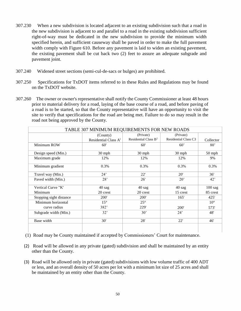
50
307.230 When a new subdivision is located adjacent to an existing subdivision such that a road in
the new subdivision is adjacent to and parallel to a road in the existing subdivision sufficient
right-of-way must be dedicated in the new subdivision to provide the minimum width
specified herein, and sufficient causeway shall be paved in order to make the full pavement
width comply with Figure 610. Before any pavement is laid to widen an existing pavement,
the existing pavement shall be cut back two (2) feet to assure an adequate subgrade and
pavement joint.
307.240 Widened street sections (semi-cul-de-sacs or bulges) are prohibited.
307.250 Specifications for TxDOT items referred to in these Rules and Regulations may be found on the TxDOT website.
307.260 The owner or owner's representative shall notify the County Commissioner at least 48 hours prior to material delivery for a road, laying of the base course of a road, and before paving of a road is to be started, so that the County representative will have an opportunity to visit the site to verify that specifications for the road are being met. Failure to do so may result in the road not being approved by the County.
(1) Road may be County maintained if accepted by Commissioners’ Court for maintenance.
(2) Road will be allowed in any private (gated) subdivision and shall be maintained by an entity other than the County.
(3) Road will be allowed only in private (gated) subdivisions with low volume traffic of 400 ADT or less, and an overall density of 50 acres per lot with a minimum lot size of 25 acres and shall be maintained by an entity other than the County.
TABLE 307 MINIMUM REQUIREMENTS FOR NEW ROADS (County)
Residential Class Al
(Private)
Residential Class B2 (Private)
Residential Class C3 Collector
Minimum ROW 60' 60' 60’ 80’
Design speed (Min.) 30 mph 30 mph 30 mph 50 mph
Maximum grade 12% 12% 12% 9%
Minimum gradient 0.3% 0.3% 0.3% 0.3%
Travel way (Min.) 24’ 22' 20' 36'
Paved width (Min.) 28’ 26' 20’ 42’
Vertical Curve "K'
Minimum
40 sag
20 crest
40 sag
20 crest
40 sag
15 crest
100 sag
85 crest
Stopping sight distance 200' 200' 165' 425'
Minimum horizontal
curve radius
15°
382’
25°
229' 200'
10°
573'
Subgrade width (Min.) 32’ 30’ 24’ 48'
Base width 30' 28' 22' 46'
51
308.000 PREPARING AND CLEARING RIGHT-OF-WAY
308.100 The developer shall clear the right-of-way for construction operations by removing and disposing of all obstructions within the required horizontal clearance for obstructions per the TxDOT Roadway Design Manual, latest edition. However, pursuant to Section 251.016, Transportation Code, the County may remove or order removal of objects in any County road right-of-way that create a safety hazard to the public.
308.110 Trees located on private property that interfere with a clear right-of-way by encroachment or over hanging branches may be removed, pruned or trimmed as necessary in order to provide adequate clearance for vehicular traffic. Whenever a tree susceptible to oak wilt is trimmed, pruned or otherwise cut or damaged, the person responsible for the cut or damage shall immediately dress the cut or damaged area with paint or compound to protect the tree and adjacent trees against oak wilt.
308.120 All unstable subgrade or objectionable material in the roadway shall be removed and replaced
with material acceptable to the County.
309.000 ROADWAY EXCAVATION AND EMBANKMENT
309.100 Any roadway excavation necessary to attain conformance with proposed road grades and
typical cross sections shall be done in conformity with Item 110 of TxDOT's specifications.
309.110 When the proposed road grades and cross sections require the placing of fill material to
raise the roadway, such embankment fill shall be constructed in conformity with Item 132 of
TxDOT's specifications. Completed side slopes shall not be steeper than three-to-one (3-to-l).
309.120 Completed cuts shall have side slopes no steeper than three-to-one (3-to-l) unless a different
slope is approved by the County Commissioner Court consistent with the provisions of
subsection 309.130.
309.130 Requirements for slopes in cuts and on fills may be modified if the developer presents plans
designed, signed and sealed by a licensed engineer demonstrating that cuts are in a material of
adequate stability to permit a different slope, or using retaining walls to stabilize the slope or
fill.
309.140 If blasting is required, TxDOT current specifications, Item 7.10 shall be followed.
310.000 SUBGRADE AND BASE COURSES
310.100 The embankment, subgrade, and base-course materials shall be compacted by suitable type
rollers in all cases to consolidate fill materials or to attain adequate stability of subgrade
materials and base courses. "Density control" method of compaction shall be used to attain 90
percent compaction of subgrade and 95 percent compaction of base courses.
52
310.110 Rolling equipment and construction methods shall conform to TxDOT's current
specifications, Items 210 and 216.
310.120 Pavement shall be full width, including shoulders.
310.130 Prior to placing the base course, the roadbed shall be shaped to conform to the subgrade
section (See Figure 610, Standard Street Section) and shall be tested (See paragraph 314.210).
The roadbed shall be to the line and grade specified in the drawings and shall be free of holes,
ruts and depressions.
310.140 Materials used for the base course shall meet the requirements specified in subsection 310.160.
Samples for testing the materials shall be taken with the frequency specified in section
314.000.
310.150 Testing tolerances: Subgrade and base material will be acceptable provided not more than
two (2) out often (10) consecutive gradation tests performed are outside the specified limit on
any individual or combination of sieves by more than five (5) percent and where no two (2)
consecutive tests are outside the specified limit. Subgrade and base material will be acceptable
provided not more than two (2) out of ten (10) consecutive plasticity index samples tested are
outside the specified limit by no more than two (2) points and where no two (2) consecutive
tests are outside the specified limit.
310.160 Base materials used for roads shall conform to the requirements of Item 247 of TxDOT's
specifications for Flexible Base materials, Type A, Grade 2 (crushed stone or broken
aggregate, excluding gravel aggregate). Pit run base materials and caliche are not allowed.
310.170 Before placing any material, the contractor shall provide the County Commissioner with
reports of analysis of the proposed materials made by an approved laboratory. Preliminary
approval of a source does not guarantee acceptability or evidence of conformity with these
specifications.
310.180 At least 48 hours before placing the base material, the subgrade shall be checked as to
conformity with grade and section (See Figure 610 Standard Street Section) and shall be tested
for density in accordance with section 314.000. It shall be the responsibility of the contractor
to provide the required amount of specified material. Material deposited upon the subgrade
shall be spread and shaped the same day unless otherwise directed by the County
Commissioner. In the event inclement weather or other unforeseen circumstances render
impractical the spreading of the material during the first 24-hour period, the material shall be
scarified and spread as directed by the Commissioner or their designee. The material shall be
sprinkled, if directed, and shall then be bladed, dragged and shaped to conform to typical
sections as shown on the drawings. All areas and "nests" of segregated course or fine materials
shall be corrected or removed and replaced with well graded material, as directed by the
Commissioner or their designee. Such binder material shall be carefully and evenly
incorporated with the material in place by scarifying, harrowing, brooming or by other
approved methods.
53
310.190 The base course shall be placed, mixed, blended, and compacted by the contractor in two
(2), four (4)-inch lifts, unless otherwise authorized by the Commissioner. Total compacted
base material placed shall be not less than eight (8) inches in thickness, unless a different
thickness is supported by a total road section design by a licensed geotechnical engineer and
approved by the County Commissioner.
310.200 The course shall be sprinkled as required and compacted to the extent necessary to provide
not less than the 95 percent density specified and within moisture content limits defined in the
geotechnical report. In addition to the requirements specified for density, the full depth of
flexible base shown on the drawings shall be compacted to the extent necessary to remain film
and stable under loading by construction equipment. (Note: Construction equipment shall be
limited to units not exceeding legal loads.) If the base material fails to meet the density
requirements, it shall be reworked as necessary to meet these requirements. Throughout this
entire operation, the shape of the base course shall be maintained by blading, and the surface
upon completion shall be smooth and in conformity with the typical sections shown on the
drawings and to the established lines and grades. In the area on which pavement is to be placed,
any deviation in excess of one-quarter ( 1/4) inch in cross section and in length of 16 feet
measured longitudinally shall be connected by loosening, adding or removing material,
reshaping and recompacting by sprinkling and rolling. All irregularities, depressions or weak
spots which develop shall be corrected immediately by scarifying the areas adding suitable
material as required, reshaping and recompacting by sprinkling and rolling. Should the base
course, due to any reason or cause, lose the required density and moisture content or finish
before the surfacing is complete, it shall be recompacted refinished and tested at the sole
expense of the contractor. Prime oil shall be applied seven days from date of testing. Fine
blading shall be completed during that seven-day period. Oil shall be applied at the rate of
0.20 gallons per square yard.
310.210 Stabilized Subgrade Requirements for Concrete Pavement:
A licensed geotechnical engineer shall provide subgrade treatment recommendations,
including the type of stabilizer and anticipated application rate (lb/yd 2), to develop a modulus
of subgrade reaction of no less than 200 pci.
311.000 PAVEMENT
311.100 Where a road section (without curbs) is constructed, the flexible base shall be as shown on
"Standard Street Section" (See Figure 610). The pavement shall be a "Two Course Surface
Treatment" or a minimum of one and one-half (1 h) inches of Hot Mix Asphaltic Concrete
Pavement (HMACP) compacted with a prime coat or Portland cement concrete under the
HMACP. The prime coat shall be applied at the rate of 0.20 gallons per square yard.
311.110 The Two Course Surface Treatment shall conform to TxDOT's specification, Item 316.
311.120 No surface treatment shall be applied when the air temperature is below 60 0 F and falling,
or when the roadway surface temperature is below 600 F. Surface treatment may be applied
when the air temperature is above 500 F and rising provided the roadway surface temperature
is 60 0 F or above.
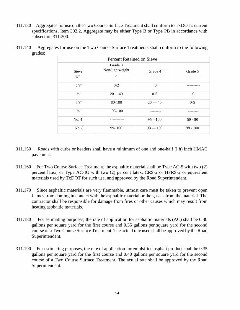
54
311.130 Aggregates for use on the Two Course Surface Treatment shall conform to TxDOT's current
specifications, Item 302.2. Aggregate may be either Type B or Type PB in accordance with
subsection 311.200.
311.140 Aggregates for use on the Two Course Surface Treatments shall conform to the following
grades:
Percent Retained on Sieve
Sieve
Grade 3
Non-lightweight Grade 4 Grade 5
¾” 0 ------- ----------
5/8” 0-2 0 ----------
½” 20 —40 0-5 0
3/8” 80-100 20 — 40 0-5
¼” 95-100 -------- --------
No. 4 ----------- 95 – 100 50 - 80
No. 8 99- 100 98 — 100 98 - 100
311.150 Roads with curbs or headers shall have a minimum of one and one-half (l h) inch HMAC
pavement.
311.160 For Two Course Surface Treatment, the asphaltic material shall be Type AC-5 with two (2)
percent latex, or Type AC-IO with two (2) percent latex, CRS-2 or HFRS-2 or equivalent
materials used by TxDOT for such use, and approved by the Road Superintendent.
311.170 Since asphaltic materials are very flammable, utmost care must be taken to prevent open
flames from coming in contact with the asphaltic material or the gasses from the material. The
contractor shall be responsible for damage from fires or other causes which may result from
heating asphaltic materials.
311.180 For estimating purposes, the rate of application for asphaltic materials (AC) shall be 0.30
gallons per square yard for the first course and 0.35 gallons per square yard for the second
course of a Two Course Surface Treatment. The actual rate used shall be approved by the Road
Superintendent.
311.190 For estimating purposes, the rate of application for emulsified asphalt product shall be 0.35
gallons per square yard for the first course and 0.40 gallons per square yard for the second
course of a Two Course Surface Treatment. The actual rate shall be approved by the Road
Superintendent.

55
311.200 For Two Course Surface Treatment, the aggregate for the first course may be Grade 3 or 4,
Type B; the second course aggregate may be Grade 4 or 5, Type PB, or Type B with a fog
seal, TxDOT Item 315.
311.210 Aggregate rock will be applied at the rate of one (1) cubic yard per 90 square yards for the
first course, and at the rate of one (l) cubic yard per 100 square yards for the second course.
Rolling is required to achieve a uniform embedment. The contractor shall broom-off loose
aggregate. If bleeding occurs, the contractor shall apply sand or Grade 5 material to the
finished surface for whatever period is required to absorb the excess asphalt.
311.220 Compacted HMACP shall conform to TxDOT's current specifications, Item 340.4 for Hot
Mix, Type D (Fine Surface) and the percent aggregate passing by weight or volume shall be
as follows:
SIEVE SIZE PERCENT PASSING
English
½” 98-100
3/8” 85-100
No. 4 50-70
No. 8 35-46
No. 30 15-29
No. 50 7-20
No. 200 2-7
Design VMA Percent Minimum 15
311.230 The asphaltic material shall be from 3.5 to 6.5 percent of the mixture by weight, or from 8
to 15 percent of the mixture by volume.
311.240 The asphaltic materials for the tack coat, or prime coat, shall be cut back asphalt MC-30,
or equal, used by TxDOT for that purpose with the approval of the County Commissioner.
311.250 The HMACP material shall be discharged from a mixer at a temperature not to exceed
375 0 F and applied to the roadway at a temperature of not less than 275 0 F.
311.260 MC-30 should be applied within a temperature range of 70 0 F to 150 0 F, and the maximum
allowable temperature for application shall be 175 0 F.
311.270 Construction methods used to produce, transport, place and compact HMACP materials
shall correspond to Item 340.4 of TxDOT's specifications.
311.280 Concrete pavement thickness requirements:
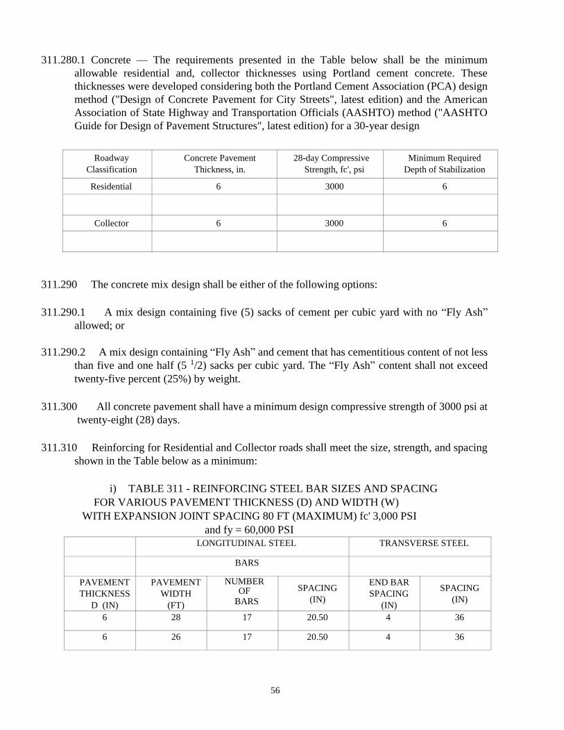
56
311.280.1 Concrete — The requirements presented in the Table below shall be the minimum
allowable residential and, collector thicknesses using Portland cement concrete. These
thicknesses were developed considering both the Portland Cement Association (PCA) design
method ("Design of Concrete Pavement for City Streets", latest edition) and the American
Association of State Highway and Transportation Officials (AASHTO) method ("AASHTO
Guide for Design of Pavement Structures", latest edition) for a 30-year design
Roadway
Classification
Concrete Pavement
Thickness, in.
28-day Compressive
Strength, fc', psi
Minimum Required
Depth of Stabilization
Residential 6 3000 6
Collector 6 3000 6
311.290 The concrete mix design shall be either of the following options:
311.290.1 A mix design containing five (5) sacks of cement per cubic yard with no “Fly Ash”
allowed; or
311.290.2 A mix design containing “Fly Ash” and cement that has cementitious content of not less
than five and one half (5 1/2) sacks per cubic yard. The “Fly Ash” content shall not exceed
twenty-five percent (25%) by weight.
311.300 All concrete pavement shall have a minimum design compressive strength of 3000 psi at
twenty-eight (28) days.
311.310 Reinforcing for Residential and Collector roads shall meet the size, strength, and spacing
shown in the Table below as a minimum:
i) TABLE 311 - REINFORCING STEEL BAR SIZES AND SPACING
FOR VARIOUS PAVEMENT THICKNESS (D) AND WIDTH (W)
WITH EXPANSION JOINT SPACING 80 FT (MAXIMUM) fc' 3,000 PSI
and fy = 60,000 PSI
LONGITUDINAL STEEL TRANSVERSE STEEL
BARS
PAVEMENT
THICKNESS
D (IN)
PAVEMENT
WIDTH
(FT)
NUMBER OF
BARS
SPACING
(IN)
END BAR
SPACING
(IN)
SPACING
(IN)
6 28 17 20.50 4 36
6 26 17 20.50 4 36
57
311.310.1 Minimum lap length for #4 reinforcing steel shall be twenty-two inches (22"). For all cold
construction joints, use four foot (4'), Grade 40 L-bars spaced at 24-inch centers through the
deformed metal strip.
311.310.2 Expansion joints in cul-de-sacs and cul-de-sac corners shall be placed as shown in Figure
670.
312.000 DRAINAGE
312.100 Runoff calculations shall be based on rainfall intensity, drainage area, time of concentration
and nature of terrain. Drainage structures shall be designed on the basis of a ten (10) year rainfall
frequency for bridges and culverts and storm sewers, and on a five (5) year rainfall frequency
for roadside ditches and roads using design methods as outlined in subsections 312.110 and
312.120. For drainage areas 20 acres or less, the minimum Time of Concentration shall be 5
minutes and maximum Time of Concentration shall be 20 minutes for overland flow. Overland
flow usually becomes shallow concentrated flow after 300 feet.
312.110 Design discharge for hydraulic facilities should be calculated for natural rural areas in excess
of six hundred forty (640) acres (but not for urban areas, areas
with significant hydraulic controls, nor for major river main stream locations), based on the
regression equation for Texas Region 5, or by a computer program such as HEC-HMS or other
programs incorporating a unit hydrograph method similar to the Natural Resource Conservation
Services
Regional Regression Equations for Natural Basins
The following equation applies to rural, uncontrolled watersheds. The following figure presents
the geographic extents of each region. Blanco County is in Region 5. Generally, use this equation
to compare with the results of other methods, check existing structures, or where it is not
practicable to use any other method, keeping in mind the importance of the facility being
designed.
Equation 5-38: QT = aA bSH C SLd
where:
QT T-year discharge (cfs).
A = contributing drainage are (sq. mi.).
SH basin-shape factor defined as the ratio of main channel length square to contributing
drainage area (sq. mil/sq. mi.).
mean channel slope defined as the ratio of headwater elevation of longest channel minus main
channel elevation at site to main channel length (ft./mi.). Note: This differs from previous rural
regression equations in which slope was defined between points 10 and 85 percent of the
distance along the main channel from the outfall to the basin divide.
a, b, c, d multiple linear regression coefficients dependent on region number and frequency.
Region 5 has two set of coefficients. For this region, if the drainage area is between 10 and 100
sq. mi., determine a weighted discharge (Qw) as shown in the following equation.
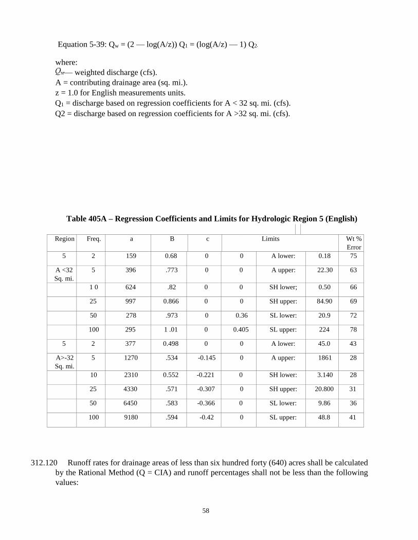
58
Equation 5-39: Qw = (2 — log(A/z)) Q1 = (log(A/z) — 1) Q2
where:
— weighted discharge (cfs).
A = contributing drainage area (sq. mi.).
z = 1.0 for English measurements units.
Q1 = discharge based on regression coefficients for A < 32 sq. mi. (cfs).
Q2 = discharge based on regression coefficients for A >32 sq. mi. (cfs).
Table 405A – Regression Coefficients and Limits for Hydrologic Region 5 (English)
Region Freq. a B c Limits Wt %
Error
5 2 159 0.68 0 0 A lower: 0.18 75
A <32
Sq. mi.
5 396 .773 0 0 A upper: 22.30 63
1 0 624 .82 0 0 SH lower; 0.50 66
25 997 0.866 0 0 SH upper: 84.90 69
50 278 .973 0 0.36 SL lower: 20.9 72
100 295 1 .01 0 0.405 SL upper: 224 78
5 2 377 0.498 0 0 A lower: 45.0 43
A>-32
Sq. mi.
5 1270 .534 -0.145 0 A upper: 1861 28
10 2310 0.552 -0.221 0 SH lower: 3.140 28
25 4330 .571 -0.307 0 SH upper: 20.800 31
50 6450 .583 -0.366 0 SL lower: 9.86 36
100 9180 .594 -0.42 0 SL upper: 48.8 41
312.120 Runoff rates for drainage areas of less than six hundred forty (640) acres shall be calculated
by the Rational Method (Q = CIA) and runoff percentages shall not be less than the following
values:
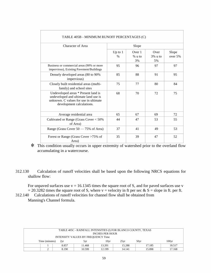
59
TABLE 405B - MINIMUM RUNOFF PERCENTAGES (C)
Character of Area Slope
Up to 1
%
Over 1
% u to
3%
Over
3% u to
5%
Slope
over 5%
Business or commercial areas (90% or more
impervious), Existing Pavement/Buildings 95 96 97 97
Densely developed areas (80 to 90%
impervious)
85 88 91 95
Closely built residential areas (mufti-
family) and school sites
75 77 80 84
Undeveloped areas * Present land is undeveloped and ultimate land use is unknown. C values for use in ultimate
development calculations.
68 70 72 75
Average residential area 65 67 69 72
Cultivated or Range (Grass Cover < 50%
of Area)
44 47 53 55
Range (Grass Cover 50 — 75% of Area) 37 41 49 53
Forest or Range (Grass Cover >75% of
Area)
35 39 47 52
This condition usually occurs in upper extremity of watershed prior to the overland flow
accumulating in a watercourse.
312.130 Calculation of runoff velocities shall be based upon the following NRCS equations for
shallow flow:
For unpaved surfaces use v = 16.1345 times the square root of S, and for paved surfaces use v = 20.3282 times the square root of S, where v = velocity in ft per sec & S = slope in ft. per ft.
312.140 Calculations of runoff velocities for channel flow shall be obtained from
Manning's Channel formula.
TABLE 405C - RAINFALL INTENSITIES (l) FOR BLANCO COUNTY, TEXAS
INCHES PER HOUR
INTENSITY VALUES BY FREQUENCY Time
Time (minutes) 2yr 5yr 10yr 25yr 50yr 100yr
1 8.857 11.468 13.201 15.288 17.185 18.517
2 8.190 10.599 12.199 14.141 15.898 17.168
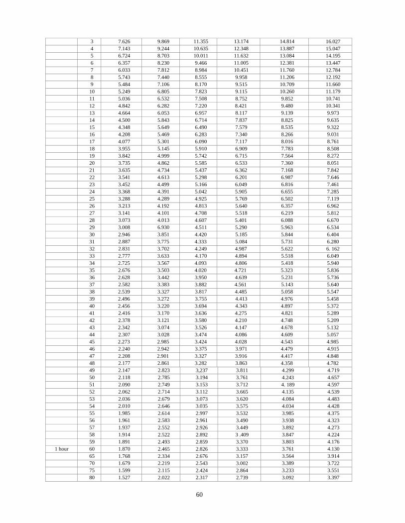
60
3 7.626 9.869 11.355 13.174 14.814 16.027
4 7.143 9.244 10.635 12.348 13.887 15.047
5 6.724 8.703 10.011 11.632 13.084 14.195
6 6.357 8.230 9.466 11.005 12.381 13.447
7 6.033 7.812 8.984 10.451 11.760 12.784
8 5.743 7.440 8.555 9.958 11.206 12.192
9 5.484 7.106 8.170 9.515 10.709 11.660
10 5.249 6.805 7.823 9.115 10.260 11.179
11 5.036 6.532 7.508 8.752 9.852 10.741
12 4.842 6.282 7.220 8.421 9.480 10.341
13 4.664 6.053 6.957 8.117
11
9.139 9.973
14 4.500 5.843 6.714 7.837 8.825 9.635
15 4.348 5.649 6.490 7.579 8.535 9.322
16 4.208 5.469 6.283 7.340 8.266 9.031
17 4.077 5.301 6.090 7.117 8.016 8.761
18 3.955 5.145 5.910 6.909 7.783 8.508
19 3.842 4.999 5.742 6.715 7.564 8.272
20 3.735 4.862 5.585 6.533 7.360 8.051
21 3.635 4.734 5.437 6.362 7.168 7.842
22 3.541 4.613 5.298 6.201 6.987 7.646
23 3.452 4.499 5.166 6.049 6.816 7.461
24 3.368 4.391 5.042 5.905 6.655 7.285
25 3.288 4.289 4.925 5.769 6.502 7.119
26 3.213 4.192 4.813 5.640 6.357 6.962
27 3.141 4.101 4.708 5.518 6.219 5.812
28 3.073 4.013 4.607 5.401 6.088 6.670
29 3.008 6.930 4.511 5.290 5.963 6.534
30 2.946 3.851 4.420 5.185 5.844 6.404
31 2.887 3.775 4.333 5.084 5.731 6.280
32 2.831 3.702 4.249 4.987 5.622 6. 162
33 2.777 3.633 4.170 4.894 5.518 6.049
34 2.725 3.567 4.093 4.806 5.418 5.940
35 2.676 3.503 4.020 4.721 5.323 5.836
36 2.628 3.442 3.950 4.639 5.231 5.736
37 2.582 3.383 3.882 4.561 5.143 5.640
38 2.539 3.327 3.817 4.485 5.058 5.547
39 2.496 3.272 3.755 4.413 4.976 5.458
40 2.456 3.220 3.694 4.343 4.897 5.372
41 2.416 3.170 3.636 4.275 4.821 5.289
42 2.378 3.121 3.580 4.210 4.748 5.209
43 2.342 3.074 3.526 4.147 4.678 5.132
44 2.307 3.028 3.474 4.086 4.609 5.057
45 2.273 2.985 3.424 4.028 4.543 4.985
46 2.240 2.942 3.375 3.971 4.479 4.915
47 2.208 2.901 3.327 3.916 4.417 4.848
48 2.177 2.861 3.282 3.863 4.358 4.782
49 2.147 2.823 3,237 3.811 4.299 4.719
50 2.118 2.785 3.194 3.761 4.243 4.657
51 2.090 2.749 3.153 3.712 4. 189 4.597
52 2.062 2.714 3.112 3.665 4.135 4.539
53 2.036 2.679 3.073 3.620 4.084 4.483
54 2.010 2.646 3.035 3.575 4.034 4.428
55 1.985 2.614 2.997 3.532 3.985 4.375
56 1.961 2.583 2.961 3.490 3.938 4.323
57 1.937 2.552 2.926 3.449 3.892 4.273
58 1.914 2.522 2.892 3 .409 3.847 4.224
59 1.891 2.493 2.859 3.370 3.803 4.176
1 hour 60 1.870 2.465 2.826 3.333 3.761 4.130
65 1.768 2.334 2.676 3.157 3.564 3.914
70 1.679 2.219 2.543 3.002 3.389 3.722
75 1.599 2.115 2.424 2.864 3.233 3.551
80 1.527 2.022 2.317 2.739 3.092 3.397
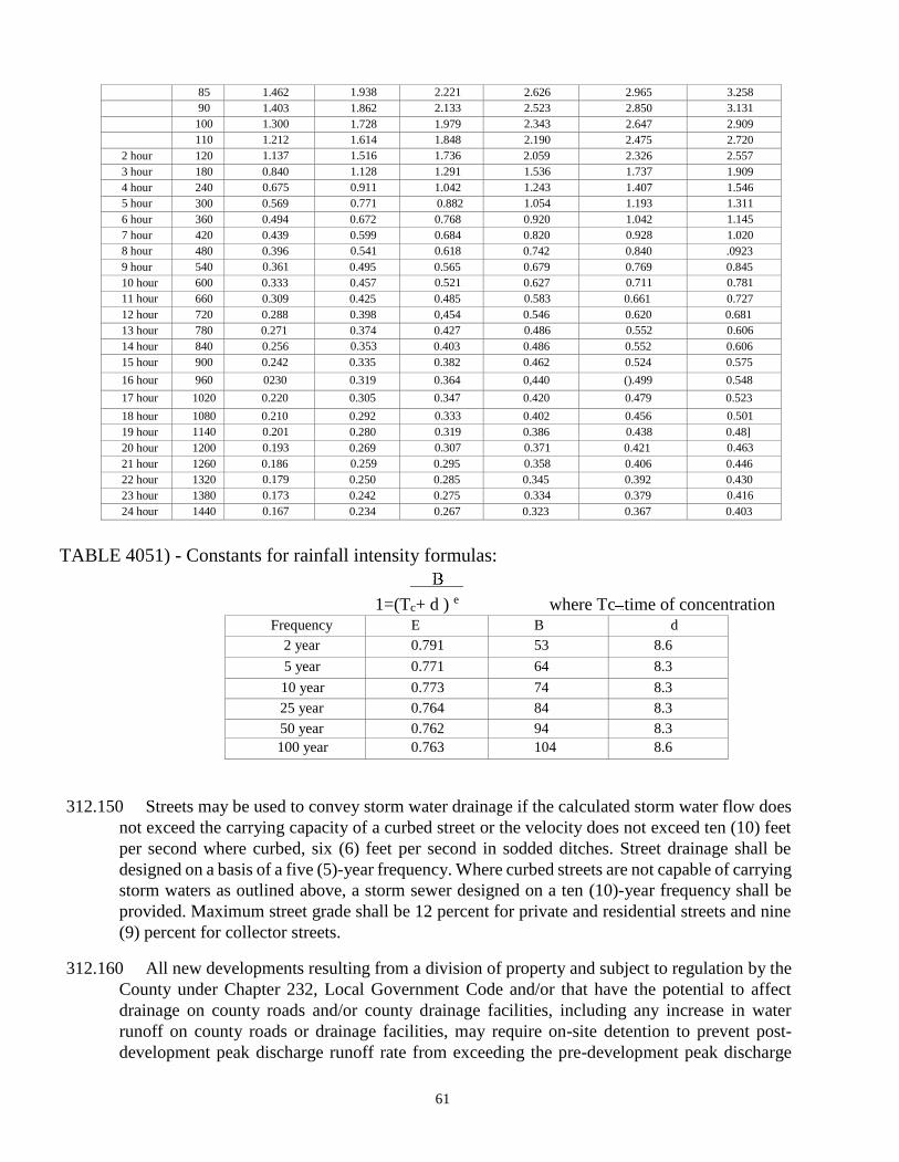
61
85 1.462 1.938 2.221 2.626 2.965 3.258
90 1.403 1.862 2.133 2.523 2.850 3.131
100 1.300 1.728 1.979 2.343 2.647 2.909
110 1.212 1.614 1.848 2.190 2.475 2.720
2 hour 120 1.137 1.516 1.736 2.059 2.326 2.557
3 hour 180 0.840 1.128 1.291 1.536 1.737 1.909
4 hour 240 0.675 0.911 1.042 1.243 1.407 1.546
5 hour 300 0.569 0.771 0.882 1.054 1.193 1.311
6 hour 360 0.494 0.672 0.768 0.920 1.042 1.145
7 hour 420 0.439 0.599 0.684 0.820 0.928 1.020
8 hour 480 0.396 0.541 0.618 0.742 0.840 .0923
9 hour 540 0.361 0.495 0.565 0.679 0.769 0.845
10 hour 600 0.333 0.457 0.521 0.627 0.711 0.781
11 hour 660 0.309 0.425 0.485 0.583 0.661 0.727
12 hour 720 0.288 0.398 0,454 0.546 0.620 0.681
13 hour 780 0.271 0.374 0.427 0.486 0.552 0.606
14 hour 840 0.256 0.353 0.403 0.486 0.552 0.606
15 hour 900 0.242 0.335 0.382 0.462 0.524 0.575
16 hour 960 0230 0.319 0.364 0,440 ().499 0.548
17 hour 1020 0.220 0.305 0.347 0.420 0.479 0.523
18 hour 1080 0.210 0.292 0.333 0.402 0.456 0.501
19 hour 1140 0.201 0.280 0.319 0.386 0.438 0.48]
20 hour 1200 0.193 0.269 0.307 0.371 0.421 0.463
21 hour 1260 0.186 0.259 0.295 0.358 0.406 0.446
22 hour 1320 0.179 0.250 0.285 0.345 0.392 0.430
23 hour 1380 0.173 0.242 0.275 0.334 0.379 0.416
24 hour 1440 0.167 0.234 0.267 0.323 0.367 0.403
TABLE 4051) - Constants for rainfall intensity formulas:
1=(Tc+ d ) e where Tc time of concentration Frequency E B d
2 year 0.791 53 8.6
5 year 0.771 64 8.3
10 year 0.773 74 8.3
25 year 0.764 84 8.3
50 year 0.762 94 8.3
100 year 0.763 104 8.6
312.150 Streets may be used to convey storm water drainage if the calculated storm water flow does
not exceed the carrying capacity of a curbed street or the velocity does not exceed ten (10) feet
per second where curbed, six (6) feet per second in sodded ditches. Street drainage shall be
designed on a basis of a five (5)-year frequency. Where curbed streets are not capable of carrying
storm waters as outlined above, a storm sewer designed on a ten (10)-year frequency shall be
provided. Maximum street grade shall be 12 percent for private and residential streets and nine
(9) percent for collector streets.
312.160 All new developments resulting from a division of property and subject to regulation by the
County under Chapter 232, Local Government Code and/or that have the potential to affect
drainage on county roads and/or county drainage facilities, including any increase in water
runoff on county roads or drainage facilities, may require on-site detention to prevent post-
development peak discharge runoff rate from exceeding the pre-development peak discharge
62
runoff rate for the 2-, 5-, 10-, 25-, 50-, 100-year event. If detention is required, the developer
shall provide design documentation by a licensed professional engineer as part of the County's
development permitting process. If the engineer determines for a commercial development that
the difference between the peak discharge runoff rate is 0.85 cubic feet per second or less for
the 100year event, then detention is not required. If the engineer determines for a residential
development that the post-development peak discharge rate {Or the 2-, 5-, 10-, 25-, 50-, and
100-year events exceeds the pre-development peak discharge rate, he must design the drainage
system in the development to mitigate the excess peak discharge flow rate to the satisfaction of
the County Commissioner. If a detention pond is required, drawings and specifications shall be
submitted by the engineer of record to the County Commissioner or his designee for review and
approval. Upon completion of construction of the detention pond, the engineer of record shall
direct correspondence to the County Commissioner or his designee stating that the detention
pond has been completed in accordance with these Rules and Regulations and in accordance
with the engineer's drawings and specifications and request that that the County Commissioner
or his designee conduct a final inspection of the detention pond. On-site detention will be
discussed at the preliminary conference required in section 201 of these regulations.
312.170 The design of concrete-lined channels or ditches shall be based on a five (5) year frequency.
The following requirements are subject to the approval of the County Commissioner or his
designee:
312.170.1 The concrete lining shall extend at least 6 inches above the height of the design flow depth
of the channel or ditch. From the top of the concrete lining to the top of the ditch, a side slope,
not steeper than three (3) horizontal to one (l ) vertical with mulch sodding will be allowed. See
section 600 for additional right-of-way requirements. Vertical walls will not be permissible in
depths exceeding two (2) feet unless properly fenced or enclosed.
312.170.2 Easements for channels shall extend a minimum of two (2) feet on one side and 15 feet on
the opposite side of the extreme limits of the channel, when such channel does not abut a
roadway. When such channels abut a roadway, the easement shall extend a minimum of two (2)
feet on both sides of the extreme limits of the channel.
312.180 The design of earth-sodded channels or ditches shall be based on a five (5) year frequency,
and shall comply with the following general requirements:
312.180.1 Mulch sodding shall be placed and established as growing over the entire surface area of
the channel bottom and side slopes, or ditch side slopes.
312.180.2 The side slopes shall be not steeper than three (3) horizontal to one (l) vertical.
312.180.3 Easements shall be as stated in paragraph 312.170.2.
312.190 Culverts and bridges shall be designed to pass the total calculated flow. Low-water crossings
are prohibited on constantly flowing creeks. Dip sections (swales), when authorized, must have
a calculated design-flow depth not to exceed six (6) inches at a velocity not to exceed six (6)
feet per second based on a five (5)-year frequency flow rate. The roadway section will be Class
B concrete riprap reinforced with six-inch by six-inch (6"x 6") No. 6 wire fabric, or equal, and
will extend along the roadway for 25 feet beyond the limits of the calculated depth of flow and
63
for a width of ten (10) feet beyond the edge of pavement on each side. Where flow across the
road or street is allowed, low-water crossing signs and a depth gauge shall be provided by the
developer.
312.200 At locations where a proposed drainage ditch or channel has a gradient equal to or exceeding
five (5) percent or with flow velocities that equal or exceed four (4) feet per second, the drainage
ditch or channel shall be concrete lined to prevent erosion. Class B concrete may be used for
channel lining and for stabilized dip sections and shall be placed not less than four (4) inches in
thickness in ditches or channels and not less than eight (8) inches in thickness in roadway
sections. Approved erosion control blankets may be used in lieu of concrete lining. The County
Commissioner has a list of approved erosion control blankets.
312.210 Retards constructed in roadway ditches shall be Class B concrete, with a rough wood float
finish. They shall be of a length to extend 12 inches into the embankment on each side of the
ditch and shall rest on a compacted base three (3) inches below the flow-line of the ditch. The
height of the trapezoidal section shall be determined by the County Commissioner. Base width
normally shall be eight (8) inches. Retards normally will be placed at right angles to the flow-
line of the roadway ditch. Grass retards are recommended to be placed across the full width of
earthen ditches.
312.220 Open Channels — Channel design involves the determination of the channel cross-section
required to accommodate a given design discharge based on the Manning Formula:
𝑄 =1.486
𝑛 A R2/3 - S1/2
where
Q= Discharge, cfs
A= Cross-sectional area of flow, sq. ft.
R= Hydraulic Radius (area/wetted perimeter)
S= Slope of water surface, usually assumed to be parallel to the stream bed slope (feet/foot) n=
Manning's Roughness Coefficient
Open channel hydraulic calculations may be performed by a computer program such as HEC-2
or HEC-RAS.
TABLE 405E - TYPICAL MANNING'S ROUGHNESS COEFFICIENTS
I. Minor Streams
A. Fairly regular section Min. Max. 1.
Some grass and weeds; little or no brush. . . . . . . . . . . . . .0.030 0.035
2. Dense growth of weeds. depth of flow materially greater than
64
weed height. . . . . . . . . . 0.035 0.050
Some weeds, light brush on banks.. . . . . . . . . . . . . . . . . . . . . . . . . . . 0.035 0.050
4. Some weeds, heavy brush on banks... . . . 0.050 0.070
5. Some weeds, dense willows on banks. . . . . . . . . . . . . . . . 0.060 0.080
6. For trees within channels with branches submerged at high stage,
increase all values above by. . . . . 0.010 0.020
II Floodplain (adjacent to natural streams)
A. Pasture, no brush
l. Short grass 0.030 0.035
2. Tall grass 0.035 0.050
B. Cultivated areas
1. No crop 0.030 0.040
2. Mature row crops 0.035 0.045
3. Mature fields crops 0.040 0.050
C. Heavy weeds, scattered brush 0.050 0.070
D. Wooded 0.075 0.150
III. Major Streams
The roughness coefficient for major streams is usually less than for minor streams of similar
description on account of less effective resistance offered by irregular banks or vegetation on
banks. Values of "n" for larger streams of mostly regular sections, with no boulders or brush
may be in the range of 0.028 to 0.033.
LINED CHANNELS MIN MAX
1. Concrete riprap 0.012 0.018
2. Concrete Rubble 0.017 0.030
GRASS-COVERED SODDED CHANNELS, SHALLOW DEPTH
1. No Rank Growth 0.035 0.045
2. Rank Growth 0.040 0.050
UNLINED CHANNELS
1. Earth, Straight and Uniform 0.017 0.025
2. Dredged 0.025 0.033
3. Winding and sluggish 0.022 0.030
4. Stony beds, weeds on bank 0.025 0.040
5. Earth bottom, rubble sides 0.028 0.035
6. Rock cuts, smooth and uniform 0.025 0.035

65
313.000 CULVERTS, BRIDGES AND STRUCTURES
313.100 Unless noted otherwise, concrete required in these regulations shall be Class A concrete as
defined in Item 421 of TxDOT's specifications, except for machine-laid curb, which shall be
Class C concrete. Concrete materials, placement methods, placement temperatures, curing, etc.,
shall be in accordance with Items 420 and 421 of TxDOT's specifications.
313.200 Drainage culverts shall be of corrugated metal pipe or reinforced concrete pipe and shall
conform to Items 460, 461, 462, or 464 of TxDOT's specifications.
313.300 Manholes and inlets shall conform to Item 465, and frames, grates, rings and covers shall
conform to Item 471 of TxDOT's specifications.
313.400 When concrete box culverts are constructed, materials and installation shall be in accordance
with Item 462 of TxDOT's specifications. Headwalls and wing walls shall conform to Item 466,
and Safety End Treatments where required shall conform to Item 467 of TxDOT's specifications
respectively.
313.500 Where metal or concrete pipe culverts are installed in roadways, concrete headwalls shall be
built at the inlet and outlet, and shall conform to the drawing entitled, "Headwalls for Culverts"
(See Figure 630). Headwalls shall have a slope corresponding to the embankment, but not
exceeding a 3-to-l slope. Minimum pipe culvert size shall be 18 inches. For specifications for
driveway culverts, see subsection 316.400.
313.600 In high embankments, structures need not be carried to toe of slope if wing walls and adequate
parapet headwalls are provided with an adequate apron. For outlet velocities exceeding 8 feet
per second, an energy dissipater must be installed. Designs of wing walls and parapets must be
submitted for approval and bear signature and seal of the designing engineer, and the date signed.
313.700 The County Commissioner shall be advised at least 48 hours before culverts are placed or
concrete headwalls or wing walls are poured so that necessary inspections may be made by the
County.
314.000 TESTING AND INSPECTIONS
314.100 The developer is responsible for coordinating and paying for all inspections, on-site sample
collections and delivery of samples to an authorized laboratory, and for on-site and off-site
testing done by the laboratory. Nuclear testing methods acceptable to TxDOT are acceptable to
the County. The cost for retesting of failed tests are to be borne by the developer.
314.200 Street, road and structures testing by an authorized laboratory is required as follows:
66
314.210 Street subgrade — Proctor determination required on each class of soil to be encountered.
Density test — (l) each per 500 feet of street with retest as necessary (minimum of three (3)
tests).
314.220 Base course — Proctor test shall be required to establish quality and moisture density
relationship. Density test: One (1) each per 500 feet of street or road, with retest as necessary
(minimum of three (3) tests).
314.230 Concrete structures — Inspection by County prior to concrete placement. Class A concrete
compressive strength (minimum of three (3) tests per structure) shall be 3000 PSI. Class B
concrete compressive strength shall be 2000 PSI. Testing will not be required for Class C
concrete curbs.
314.240 HMACP — Proctor determination shall be required to verify 96 percent Proctor density per
207-F and 227-F of TxDOT's specifications.
314.250 Road section — Prior to substantial completion, borings every 500 feet shall be taken to
verify depths of pavement and base.
314.260 The developer shall provide the County with a minimum of 24-hours’ notice prior to any
inspection that the County is to perform. Laboratory testing companies to be used by the
developer must be approved by the County.
315.000 REQUIREMENTS FOR ROAD AND DRAINAGE DRAWINGS
315.100 The following drawings shall be submitted by the developer's engineer of record to the
County Judge’s Office for review and approved by the Court.
315.200 For each of the different types of roads in a subdivision, typical cross sections showing the
proposed pavement width, type, thickness, and crown; the proposed curb type (if any); the
proposed sidewalk (if any), and the relationship to curbs, edge of pavement and property lines.
315.200 Construction details for all drainage structures, showing all dimensions, reinforcing, and
components (such as grates, manhole covers, etc.). The alignment of each road and drainage
easement, showing a beginning and ending station, each deflection angle of the centerline, and
the station of the point of intersection, the station of the point of curvature, and the point of
tangency of each curve, the station and angle of each intersection of a road with another road or
drainage easement, the station and radius of each curb return, the location of adjacent right-of-
way lines, the location and limits of sidewalks and curbs of each road, and the location of each
drainage structure.
315.300 The location and size of all storm sewers. The location, description, and elevation of
permanent Bench Marks, the top of curb grade at each curb return, the center line grade at each
end and at grade changes along drainage ditches, the gradient of each tangent grade, and the
location and length of each vertical curve, the direction of storm drainage flow at each
intersection, and the flow line elevation of each storm sewer at each point of change of grade, at
each end, and the intervening gradients.
67
315.400 The profile of roads and drainage ditches shall show the natural ground at adjacent property
lines and the proposed centerline.
315.500 All drawings shall show the scale, north arrow and date prepared. Plan and profile shall be
drawn to scales of one (l) inch equals 50 feet (1' 50') horizontally and one (l ) inch equals five
(5) feet ( l ' 5') vertically. North shall be up or to the right on all drawings.
315.600 All street plans and profiles shall bear the signature and seal of a licensed professional engineer
and the date signed.
316.000 DRIVEWAYS
316.100 No obstructions or obstacles in the form of decorative rock, concrete, metal or wood facings,
fences, gates or other such structures shall be located within the roadway right-of-way at the
entrances of driveways to highways, roads or streets. (Note: Existing facings, fences and/or gates
will be permitted to remain unless such facings, fences, or gates pose a threat to vehicular or
pedestrian traffic or interfere with county maintenance.)
316.200 Prior to constructing a private, public access, or commercial driveway entering a County
road, the property owner shall obtain a permit from the County Commissioner’s Office. The
portion of the driveway within the right-of-way shall be constructed in accordance with the
instructions contained in the permit. Maintenance of any portion of a private, public access, or
commercial driveway in the roadway right-of-way shall be the responsibility of the owner of the
driveway or access route.
316.300 When a property owner obtains a permit from the County Commissioners’ Office for a
driveway location, if no address has been previously assigned to the location, the property owner
shall also be assigned an address for the location. In order to comply with GIS and 91 1
requirements, and to protect the health, safety and welfare of the residents of the County, all
property owners shall prominently display the address for their property at a location within ten
feet (10') of the driveway entrance to the roadway, facing the roadway, in reflectorized block
letters at least four (4") in height, so that the address can be easily read by law enforcement, fire-
fighting, emergency services and other public service personnel. Failure to prominently display
the address for property may result in delay of provision of law enforcement, fire-fighting, EMS,
or other services.
316.310 Prior to issuance of a 911 address, the county GIS office must have a copy of the access
permit.
316.400 If driveway culverts are used in construction of driveways, they shall meet the following
minimum specifications:
316.410 Size of the culverts shall be determined by the developer's or owner's engineer subject to
approval by the County Commissioner. Minimum culvert size is 15 inches for private driveways
and eighteen (18) inches for public access and commercial driveways. Concrete headwalls shall
be installed (See Figure 630)
68
316.420 Material shall be either corrugated galvanized metal pipe or reinforced concrete pipe for
private driveways. Commercial or public access driveways may use these materials or concrete
box culvert(s).
316.500 Driveway width at the right-of-way for a private driveway shall be 10 feet minimum to 24
feet maximum. Driveway width at the right-of-way for commercial and public access driveways
shall be 30 feet minimum to 45 feet maximum. A minimum 5-foot radius shall be used to connect
the driveway to the edge of the roadway. (For example, a 10-foot driveway would be 20 feet
wide at the roadway with the minimum radius required on each side of the driveway entrance to
the roadway.)
316.550 A forty (40) foot setback from the County right-of-way for all entrances, gates, etc. is
required.
316.600 The angle of the driveway at the intersection with the roadway shall be from 60 0 to 90 0 with
900 being preferred. Circular driveways with two entrances to the roadway may be allowed if
approved by the County Commissioner.
316.700 The location of driveway access to the roadway shall be selected so as to provide maximum
safety for roadway traffic and for users of the driveway.
317.000 ROAD MARKINGS AND SIGNS
317.100 All roads and streets shall be provided with a double centerline marking, using yellow paint,
and shall have edge-line markings with white paint. The above paint shall be Type 2
reflectorized pavement markings per Item 666 of TXDOT's specifications.
317.200 All roads shall have standard road safety and directional signs as required by the County
Commissioner. Signs shall be of aluminum, of one-piece construction, and shall conform to Item
636 of TXDOT's specifications.
317.300 Street name signs shall be installed by the developer at all intersections within the
subdivision. Signs shall be of aluminum, of one-piece construction, and shall be of uniform six
(6)-inch height. Signs shall be mounted on two (2) inch galvanized pipe, seven (7) feet above
pavement to the bottom of sign, and shall be placed in a uniform manner in accordance with
state standards and the Manual on Uniform Traffic Control Devices. Naming of streets shall
comply with paragraph 203.130(7).
317.400 Street name signs shall have white letters on green background for county roads and state
highways and have white letters on brown background for private roads.
317.500 Reflectorized yellow object markers shall be placed by the developer on each side of all
hazards at the location designated by the County Commissioner, and shall conform to Item 658
of TxDOT's specifications.
69
317.600 Markings, barricades and safety devices: All subdivision streets and drainage structures shall
be marked and protected in accordance with the provisions of the Manual on Uniform Traffic
Control Devices as published by TxDOT.
317.700 All signs for street names and for vehicular traffic safety and pedestrian safety shall be in
place upon completion of construction of the roads and prior to approval and/or acceptance of
the roads by the County.
318.000 NO COUNTY OBLIGATION
318.100 Notwithstanding any other provision in these regulations, in no event is the County
required to complete the work proposed by a developer and approved by the County or to
otherwise assume any obligation of the developer.
319.000 FIGURES FOR SUBDIVISION ROADS AND DRAINAGE
319.100 Following are figures for subdivision roads and drainage:
(l ) Figure 610 - Standard Road Section
(2) Figure 620 — Collector Street Section and Optional Curbed Section
(3) Figure 630 - Headwalls for Culverts (Note: In cases where the culvert with typical headwalls
would extend outside the normal right-of-way, the developer shall either:
a. dedicate such additional drainage easement as necessary to provide normal access and egress
for drainage flow; or
b. propose vertical headwalls and wing walls sut2iect to approval by the County
Engineer.)
(4) Figure 640 - Standard Curb Section
(5) Figure 650 - Standard Cul-De-Sac
(6) Figure 660 Cul-De-Sac Corner
(7) Figure 670 Joint Detail for Cul-De-Sac Corner and for Typical Cul-De-Sac
320.000 SEVERABILITY
320.100 The provisions of these Rules and Regulations are separable, in accordance with the
following:
(l) If any part of these Rules and Regulations is declared invalid, unenforceable, or
unconstitutional, for any cause or reason, such invalidity, unenforceability, or
unconstitutionality shall not affect, invalidate, or impair the validity, force, or effect of any other
part of these Rules and Regulations.
70
(2) If any court of competent jurisdiction shall judge invalid the application of any provision
of these Rules and Regulations to a particular property, such judgment shall not affect the
application of said provision to any other property not specifically included in said judgment.
330.00 REPEAL
330.100 All prior orders adopted by the Commissioners’ Court of Blanco County,
Texas that are in conflict with this Order are hereby repealed.
Approved by the Blanco County Commissioners’’ Court on May 28, 2019.
___________________________________
Brett Bray
Blanco County Judge
Attest:
_________________________________
Laura Walla
County Clerk

71
APPENDIX
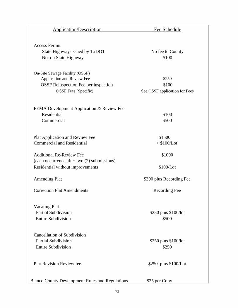
72
Application/Description Fee Schedule
Access Permit
State Highway-Issued by TxDOT No fee to County
Not on State Highway $100
On-Site Sewage Facility (OSSF)
Application and Review Fee $250
OSSF Reinspection Fee per inspection $100
OSSF Fees (Specific) See OSSF application for Fees
FEMA Development Application & Review Fee
Residential $100
Commercial $500
Plat Application and Review Fee $1500
Commercial and Residential + $100/Lot
Additional Re-Review Fee $1000
(each occurrence after two (2) submissions)
Residential without improvements $100/Lot
Amending Plat $300 plus Recording Fee
Correction Plat Amendments Recording Fee
Vacating Plat
Partial Subdivision $250 plus $100/lot
Entire Subdivision $500
Cancellation of Subdivision
Partial Subdivision $250 plus $100/lot
Entire Subdivision $250
Plat Revision Review fee $250. plus $100/Lot
Blanco County Development Rules and Regulations $25 per Copy
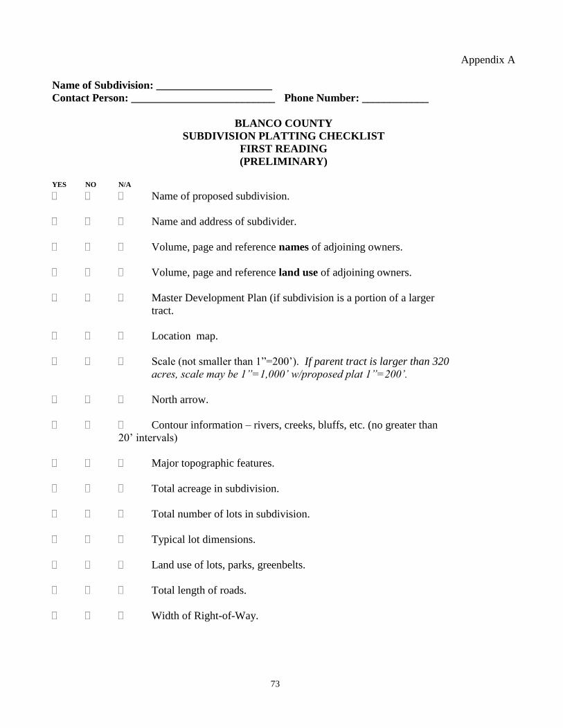
73
Appendix A
Name of Subdivision: _____________________
Contact Person: __________________________ Phone Number: ____________
BLANCO COUNTY
SUBDIVISION PLATTING CHECKLIST
FIRST READING
(PRELIMINARY)
YES NO N/A
Name of proposed subdivision.
Name and address of subdivider.
Volume, page and reference names of adjoining owners.
Volume, page and reference land use of adjoining owners.
Master Development Plan (if subdivision is a portion of a larger
tract.
Location map.
Scale (not smaller than 1”=200’). If parent tract is larger than 320
acres, scale may be 1”=1,000’ w/proposed plat 1”=200’.
North arrow.
Contour information – rivers, creeks, bluffs, etc. (no greater than
20’ intervals)
Major topographic features.
Total acreage in subdivision.
Total number of lots in subdivision.
Typical lot dimensions.
Land use of lots, parks, greenbelts.
Total length of roads.
Width of Right-of-Way.
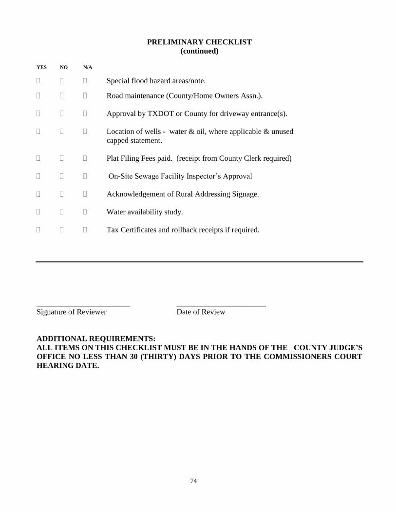
74
PRELIMINARY CHECKLIST
(continued)
YES NO N/A
Special flood hazard areas/note.
Road maintenance (County/Home Owners Assn.).
Approval by TXDOT or County for driveway entrance(s).
Location of wells - water & oil, where applicable & unused
capped statement.
Plat Filing Fees paid. (receipt from County Clerk required)
On-Site Sewage Facility Inspector’s Approval
Acknowledgement of Rural Addressing Signage.
Water availability study.
Tax Certificates and rollback receipts if required.
________________________ _______________________
Signature of Reviewer Date of Review
ADDITIONAL REQUIREMENTS:
ALL ITEMS ON THIS CHECKLIST MUST BE IN THE HANDS OF THE COUNTY JUDGE’S
OFFICE NO LESS THAN 30 (THIRTY) DAYS PRIOR TO THE COMMISSIONERS COURT
HEARING DATE.
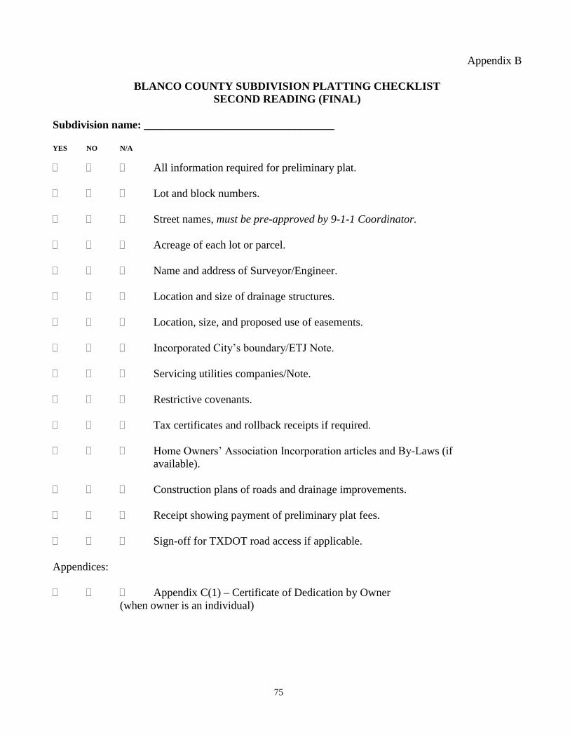
75
Appendix B
BLANCO COUNTY SUBDIVISION PLATTING CHECKLIST
SECOND READING (FINAL)
Subdivision name: __________________________________
YES NO N/A
All information required for preliminary plat.
Lot and block numbers.
Street names, must be pre-approved by 9-1-1 Coordinator.
Acreage of each lot or parcel.
Name and address of Surveyor/Engineer.
Location and size of drainage structures.
Location, size, and proposed use of easements.
Incorporated City’s boundary/ETJ Note.
Servicing utilities companies/Note.
Restrictive covenants.
Tax certificates and rollback receipts if required.
Home Owners’ Association Incorporation articles and By-Laws (if
available).
Construction plans of roads and drainage improvements.
Receipt showing payment of preliminary plat fees.
Sign-off for TXDOT road access if applicable.
Appendices:
Appendix C(1) – Certificate of Dedication by Owner
(when owner is an individual)
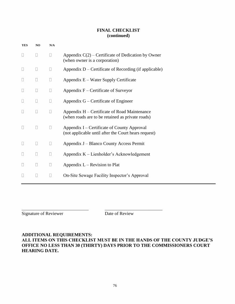
76
FINAL CHECKLIST
(continued)
YES NO N/A
Appendix C(2) – Certificate of Dedication by Owner
(when owner is a corporation)
Appendix D – Certificate of Recording (if applicable)
Appendix E – Water Supply Certificate
Appendix F – Certificate of Surveyor
Appendix G – Certificate of Engineer
Appendix H – Certificate of Road Maintenance
(when roads are to be retained as private roads)
Appendix I – Certificate of County Approval
(not applicable until after the Court hears request)
Appendix J – Blanco County Access Permit
Appendix K – Lienholder’s Acknowledgement
Appendix L – Revision to Plat
On-Site Sewage Facility Inspector’s Approval
_____________________________ _________________________
Signature of Reviewer Date of Review
ADDITIONAL REQUIREMENTS:
ALL ITEMS ON THIS CHECKLIST MUST BE IN THE HANDS OF THE COUNTY JUDGE’S
OFFICE NO LESS THAN 30 (THIRTY) DAYS PRIOR TO THE COMMISSIONERS COURT
HEARING DATE.
77
Appendix C (1)
CERTIFICATE OF DEDICATION BY OWNER
(When Owner is an Individual)
STATE OF TEXAS
COUNTY OF BLANCO
KNOW ALL MEN BY THESE PRESENT, that I,_______________________, owner of
__________ acres of land out of the ______________________ Survey, Blanco County, Texas as
conveyed to me by deed dated ____________________, and recorded in Volume _______, Page
_______, Blanco County Deed Records, DO HEREBY SUBDIVIDE ______ acres of land out of the
___________________ Survey,
(note: if the subdivision lies in more than one survey, determine an acreage in each survey and
repeat for each original survey within the subdivision)
to be known as the ____________________________ Subdivision, in accordance with the plat shown
hereon, subject to any and all easements or restrictions heretofore granted, and do hereby dedicate to the
public (or “owners of the property shown hereon” for private streets) the use of the streets and easements
shown hereon.
WITNESS MY HAND, this the _______ day of ________________, A.D., 2_____.
________________________________________ (Owner’s name)
STATE OF TEXAS
COUNTY OF BLANCO
BEFORE ME, the undersigned authority, on this day personally appeared
_________________________________, known to me to be the person whose name is subscribed to the
foregoing instrument and acknowledged to me that he executed the same for the purposes and
consideration of therein stated.
GIVEN UNDER MY HAND AND SEAL OF OFFICE this the _______ day of
___________________, A.D., 2_______.
_________________________________________________
NOTARY PUBLIC IN AND FOR THE STATE OF TEXAS
78
Appendix C (2)
CERTIFICATE OF DEDICATION BY OWNER
(When Owner is a Corporation)
STATE OF TEXAS
COUNTY OF BLANCO
KNOW ALL MEN BY THESE PRESENT, that ________________________, a corporation
organized and existing under the laws of the State of Texas, with its home address at
_____________________________________________________________ and owners of _________
acres of land out of the _____________________________ Survey, in Blanco County, Texas, as
conveyed to it by deed dated ________________ and recorded in Volume _______, Page _______,
Blanco County Deed Records, DOES HEREBY SUBDIVIDE _______ acres of land out of the
_____________________ Survey,
(Note: if the subdivision lies in more than one survey, determine the acreage in each survey and
repeat for each original survey within the subdivision)
to be known as the ___________________________ Subdivision, in accordance with the plat shown
hereon, subject to any and all easements or restrictions heretofore granted, and does hereby dedicate to
the public (or “owners of the property shown hereon” for private streets) the use of the streets and
easements shown hereon.
IN WITNESS WHEREOF the said ___________________________ has caused these present
to be executed by its _____________________________, thereunto duly authorized, this the _______
day of _______________, A.D., 2______.
________________________________ ATTEST: _________________________
(Name, Title) (Name, Title)
STATE OF TEXAS
COUNTY OF BLANCO
BEFORE ME, the undersigned authority, on this day personally appeared
____________________________ known to me to be the person whose name is subscribed to the
foregoing instrument as ____________________________ of ______________________________ and
acknowledged to me that he executed the same in such capacity as the act and deed of said corporation
for the purposes and considerations therein stated.
GIVEN UNDER MY HAND AND SEAL OF OFFICE this the _______ day of
___________________, A.D., 2_______.
_________________________________________________
NOTARY PUBLIC IN AND FOR THE STATE OF TEXAS
79
Appendix D
CERTIFICATE OF RECORDING
STATE OF TEXAS
COUNTY OF BLANCO
I, Laura Walla, County Clerk of Blanco County, Texas, do hereby certify that the foregoing instrument
of writing with its certificate of authentication was filed for record in my office on the _______ day of
_______________, 2______, at __________ o’clock _____m., and duly recorded on the _______ day
of _______________, A.D., 2______, at _________ o’clock _____m., in the Plat Records of Blanco
County, Texas in Book _______, Page _______.
WITNESS MY HAND AND SEAL OF OFFICE this the _______ day of _______________,
A.D., 2______.
___________________________________
LAURA WALLA, COUNTY CLERK
BLANCO COUNTY, TEXAS
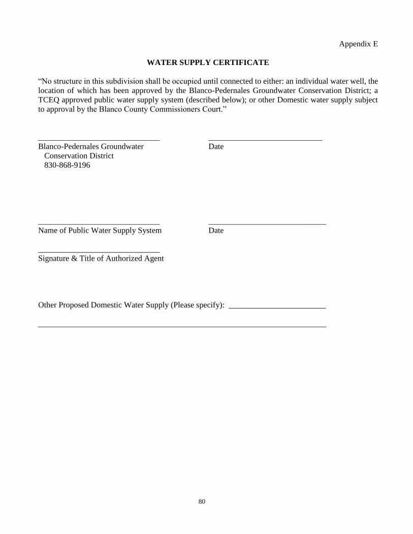
80
Appendix E
WATER SUPPLY CERTIFICATE
“No structure in this subdivision shall be occupied until connected to either: an individual water well, the
location of which has been approved by the Blanco-Pedernales Groundwater Conservation District; a
TCEQ approved public water supply system (described below); or other Domestic water supply subject
to approval by the Blanco County Commissioners Court.”
______________________________ ____________________________
Blanco-Pedernales Groundwater Date
Conservation District
830-868-9196
______________________________ _____________________________
Name of Public Water Supply System Date
______________________________
Signature & Title of Authorized Agent
Other Proposed Domestic Water Supply (Please specify): ________________________
_______________________________________________________________________
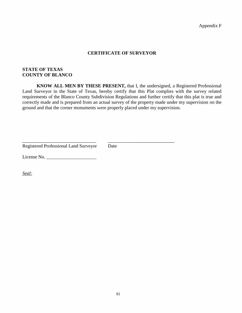
81
Appendix F
CERTIFICATE OF SURVEYOR
STATE OF TEXAS
COUNTY OF BLANCO
KNOW ALL MEN BY THESE PRESENT, that I, the undersigned, a Registered Professional
Land Surveyor in the State of Texas, hereby certify that this Plat complies with the survey related
requirements of the Blanco County Subdivision Regulations and further certify that this plat is true and
correctly made and is prepared from an actual survey of the property made under my supervision on the
ground and that the corner monuments were properly placed under my supervision.
_______________________________ ____________________________
Registered Professional Land Surveyor Date
License No. _____________________
Seal:
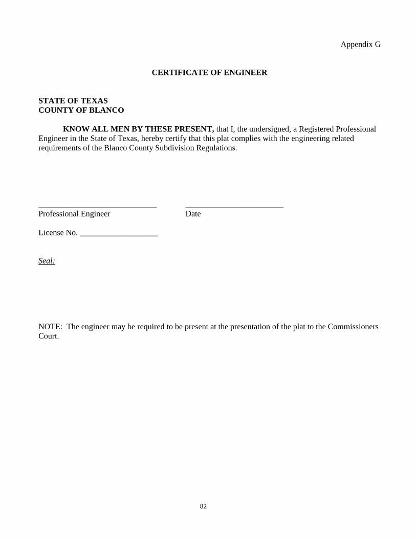
82
Appendix G
CERTIFICATE OF ENGINEER
STATE OF TEXAS
COUNTY OF BLANCO
KNOW ALL MEN BY THESE PRESENT, that I, the undersigned, a Registered Professional
Engineer in the State of Texas, hereby certify that this plat complies with the engineering related
requirements of the Blanco County Subdivision Regulations.
_____________________________ ________________________
Professional Engineer Date
License No. ___________________
Seal:
NOTE: The engineer may be required to be present at the presentation of the plat to the Commissioners
Court.
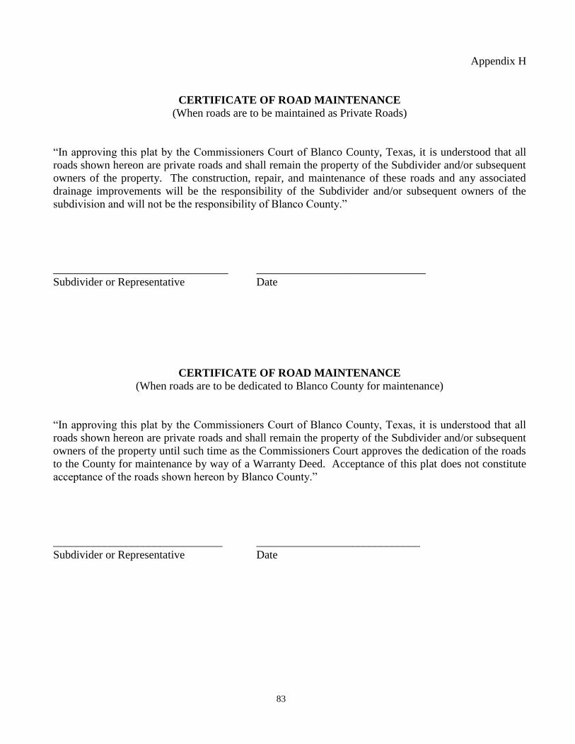
83
Appendix H
CERTIFICATE OF ROAD MAINTENANCE
(When roads are to be maintained as Private Roads)
“In approving this plat by the Commissioners Court of Blanco County, Texas, it is understood that all
roads shown hereon are private roads and shall remain the property of the Subdivider and/or subsequent
owners of the property. The construction, repair, and maintenance of these roads and any associated
drainage improvements will be the responsibility of the Subdivider and/or subsequent owners of the
subdivision and will not be the responsibility of Blanco County.”
_______________________________ ______________________________
Subdivider or Representative Date
CERTIFICATE OF ROAD MAINTENANCE
(When roads are to be dedicated to Blanco County for maintenance)
“In approving this plat by the Commissioners Court of Blanco County, Texas, it is understood that all
roads shown hereon are private roads and shall remain the property of the Subdivider and/or subsequent
owners of the property until such time as the Commissioners Court approves the dedication of the roads
to the County for maintenance by way of a Warranty Deed. Acceptance of this plat does not constitute
acceptance of the roads shown hereon by Blanco County.”
______________________________ _____________________________
Subdivider or Representative Date
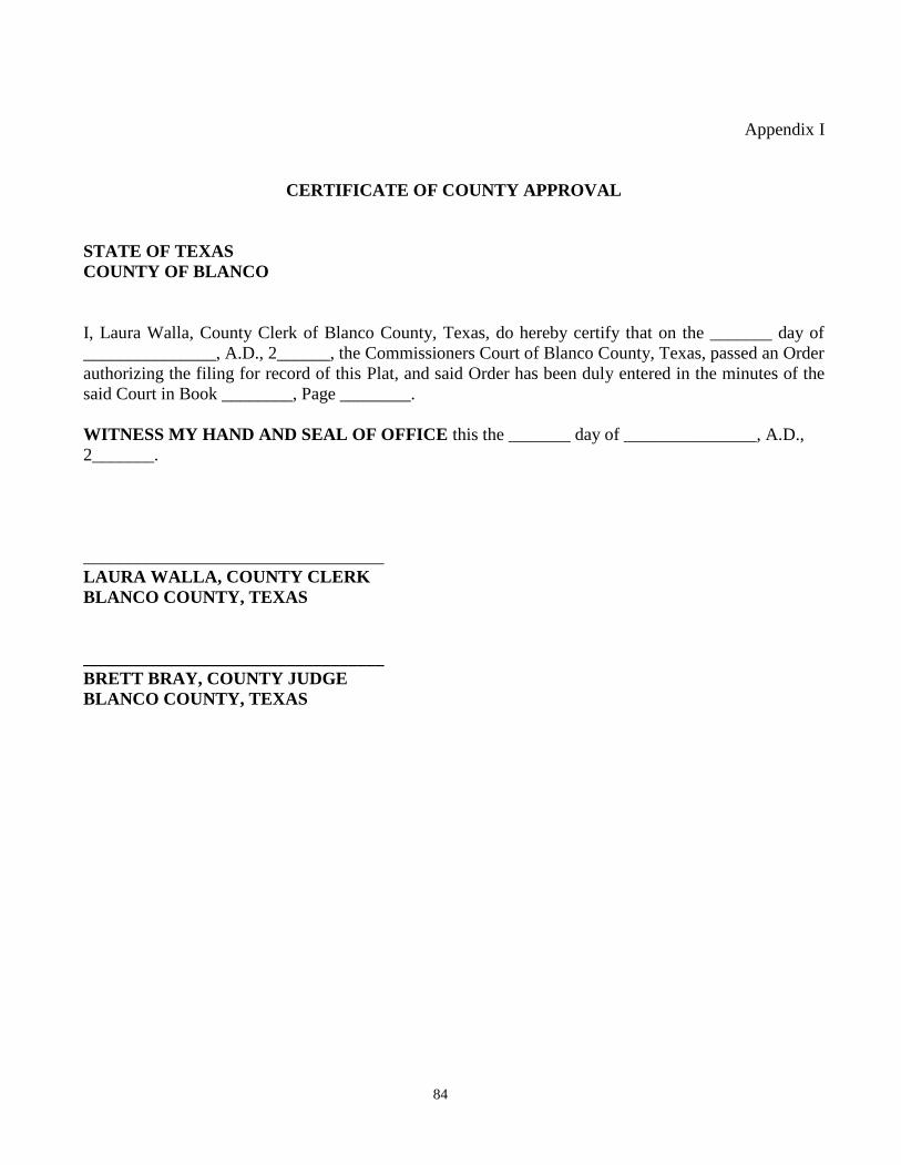
84
Appendix I
CERTIFICATE OF COUNTY APPROVAL
STATE OF TEXAS
COUNTY OF BLANCO
I, Laura Walla, County Clerk of Blanco County, Texas, do hereby certify that on the _______ day of
_______________, A.D., 2______, the Commissioners Court of Blanco County, Texas, passed an Order
authorizing the filing for record of this Plat, and said Order has been duly entered in the minutes of the
said Court in Book ________, Page ________.
WITNESS MY HAND AND SEAL OF OFFICE this the _______ day of _______________, A.D.,
2_______.
__________________________________
LAURA WALLA, COUNTY CLERK
BLANCO COUNTY, TEXAS
__________________________________
BRETT BRAY, COUNTY JUDGE
BLANCO COUNTY, TEXAS
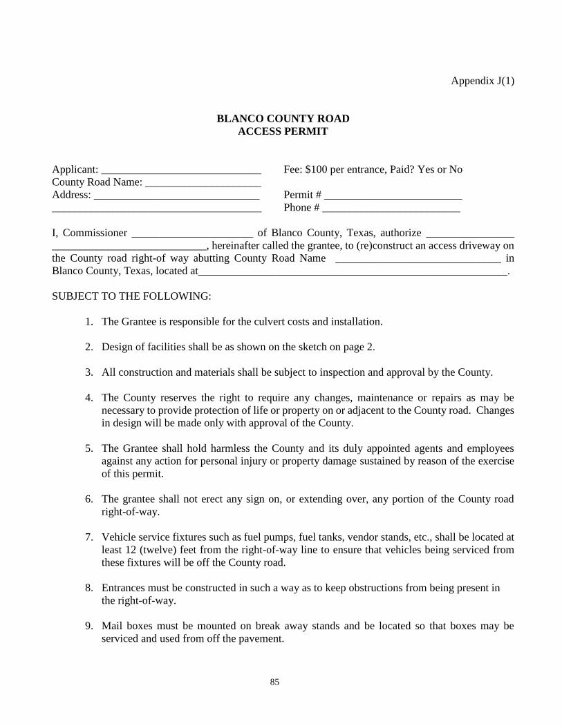
85
Appendix J(1)
BLANCO COUNTY ROAD
ACCESS PERMIT
Applicant: _____________________________ Fee: $100 per entrance, Paid? Yes or No
County Road Name: _____________________
Address: ______________________________ Permit # _________________________
______________________________________ Phone # _________________________
I, Commissioner ______________________ of Blanco County, Texas, authorize ________________
____________________________, hereinafter called the grantee, to (re)construct an access driveway on
the County road right-of way abutting County Road Name ______________________________ in
Blanco County, Texas, located at________________________________________________________.
SUBJECT TO THE FOLLOWING:
1. The Grantee is responsible for the culvert costs and installation.
2. Design of facilities shall be as shown on the sketch on page 2.
3. All construction and materials shall be subject to inspection and approval by the County.
4. The County reserves the right to require any changes, maintenance or repairs as may be
necessary to provide protection of life or property on or adjacent to the County road. Changes
in design will be made only with approval of the County.
5. The Grantee shall hold harmless the County and its duly appointed agents and employees
against any action for personal injury or property damage sustained by reason of the exercise
of this permit.
6. The grantee shall not erect any sign on, or extending over, any portion of the County road
right-of-way.
7. Vehicle service fixtures such as fuel pumps, fuel tanks, vendor stands, etc., shall be located at
least 12 (twelve) feet from the right-of-way line to ensure that vehicles being serviced from
these fixtures will be off the County road.
8. Entrances must be constructed in such a way as to keep obstructions from being present in
the right-of-way.
9. Mail boxes must be mounted on break away stands and be located so that boxes may be
serviced and used from off the pavement.
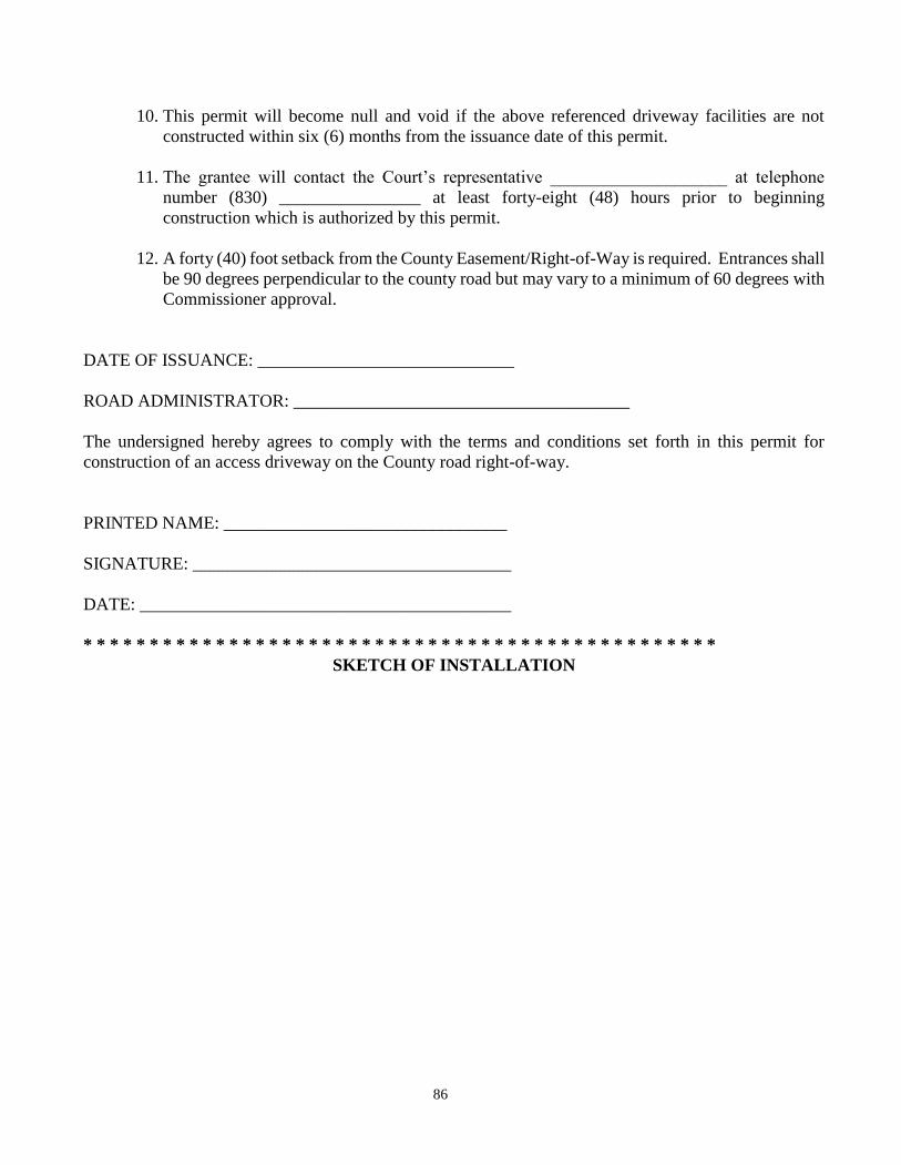
86
10. This permit will become null and void if the above referenced driveway facilities are not
constructed within six (6) months from the issuance date of this permit.
11. The grantee will contact the Court’s representative ____________________ at telephone
number (830) ________________ at least forty-eight (48) hours prior to beginning
construction which is authorized by this permit.
12. A forty (40) foot setback from the County Easement/Right-of-Way is required. Entrances shall
be 90 degrees perpendicular to the county road but may vary to a minimum of 60 degrees with
Commissioner approval.
DATE OF ISSUANCE: _____________________________
ROAD ADMINISTRATOR: ______________________________________
The undersigned hereby agrees to comply with the terms and conditions set forth in this permit for
construction of an access driveway on the County road right-of-way.
PRINTED NAME: ________________________________
SIGNATURE: ____________________________________
DATE: __________________________________________
* * * * * * * * * * * * * * * * * * * * * * * * * * * * * * * * * * * * * * * * * * * * * * * *
SKETCH OF INSTALLATION
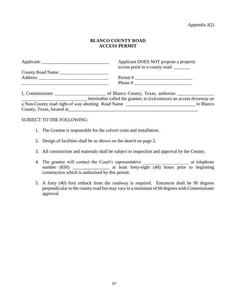
87
Appendix J(2)
BLANCO COUNTY ROAD
ACCESS PERMIT
Applicant: _____________________________ Applicant DOES NOT propose a property
access point to a county road: _______
County Road Name: _____________________
Address: ______________________________ Permit # _________________________
______________________________________ Phone # _________________________
I, Commissioner ______________________ of Blanco County, Texas, authorize ________________
____________________________, hereinafter called the grantee, to (re)construct an access driveway on
a Non-County road right-of way abutting Road Name ______________________________ in Blanco
County, Texas, located at________________________________________________________.
SUBJECT TO THE FOLLOWING:
1. The Grantee is responsible for the culvert costs and installation.
2. Design of facilities shall be as shown on the sketch on page 2.
3. All construction and materials shall be subject to inspection and approval by the County.
4. The grantee will contact the Court’s representative ____________________ at telephone
number (830) ________________ at least forty-eight (48) hours prior to beginning
construction which is authorized by this permit.
5. A forty (40) foot setback from the roadway is required. Entrances shall be 90 degrees
perpendicular to the county road but may vary to a minimum of 60 degrees with Commissioner
approval.
88
DATE OF ISSUANCE: _____________________________
ROAD ADMINISTRATOR: ______________________________________
The undersigned hereby agrees to comply with the terms and conditions set forth in this permit for
construction of an access driveway on the County road right-of-way.
PRINTED NAME: ________________________________
SIGNATURE: ____________________________________
DATE: __________________________________________
* * * * * * * * * * * * * * * * * * * * * * * * * * * * * * * * * * * * * * * * * * * * * * * *
SKETCH OF INSTALLATION
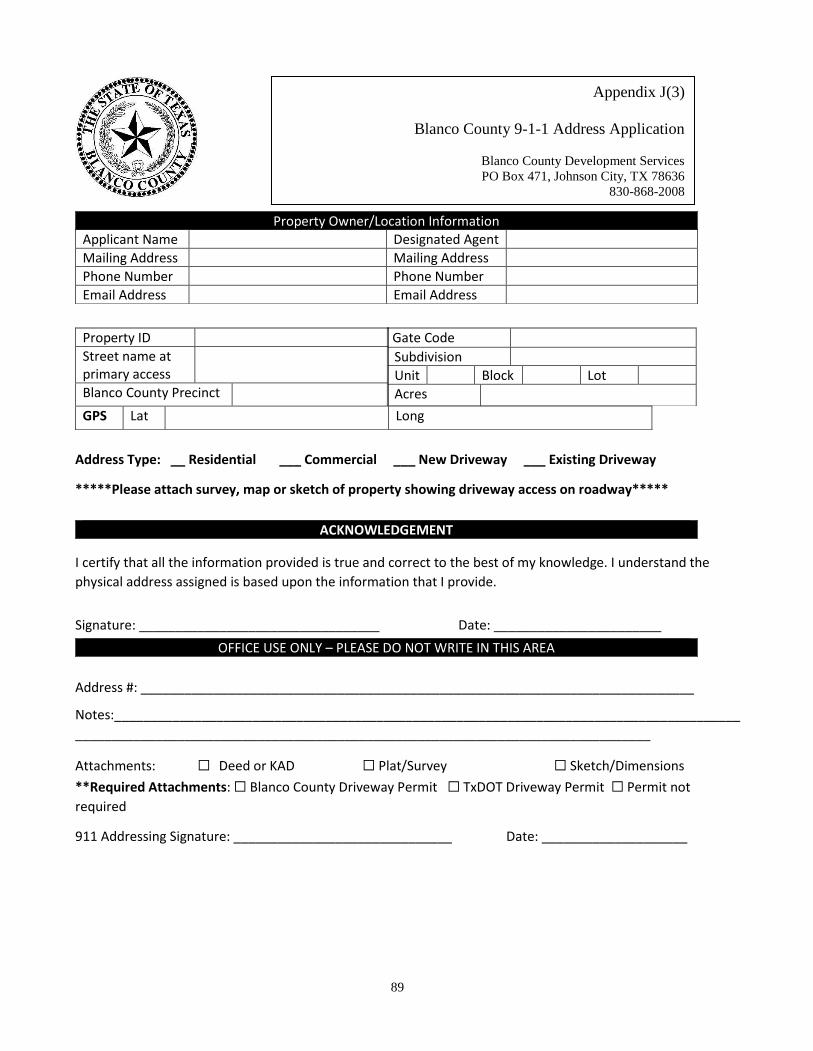
89
Address Type: __ Residential ___ Commercial ___ New Driveway ___ Existing Driveway
*****Please attach survey, map or sketch of property showing driveway access on roadway*****
I certify that all the information provided is true and correct to the best of my knowledge. I understand the
physical address assigned is based upon the information that I provide.
Signature: _________________________________ Date: _______________________
Address #: ____________________________________________________________________________
Notes:______________________________________________________________________________________
_______________________________________________________________________________
Attachments: ☐ Deed or KAD ☐ Plat/Survey ☐ Sketch/Dimensions
**Required Attachments: ☐ Blanco County Driveway Permit ☐ TxDOT Driveway Permit ☐ Permit not
required
911 Addressing Signature: ______________________________ Date: ____________________
Applicant Name Designated Agent
Mailing Address Mailing Address
Phone Number Phone Number
Email Address Email Address
Property Owner/Location Information
Property ID
Street name at primary access
Blanco County Precinct
GPS Lat Long
Gate Code
Subdivision
Unit Block Lot
Acres
ACKNOWLEDGEMENT
OFFICE USE ONLY – PLEASE DO NOT WRITE IN THIS AREA
Appendix J(3)
Blanco County 9-1-1 Address Application
Blanco County Development Services
PO Box 471, Johnson City, TX 78636
830-868-2008
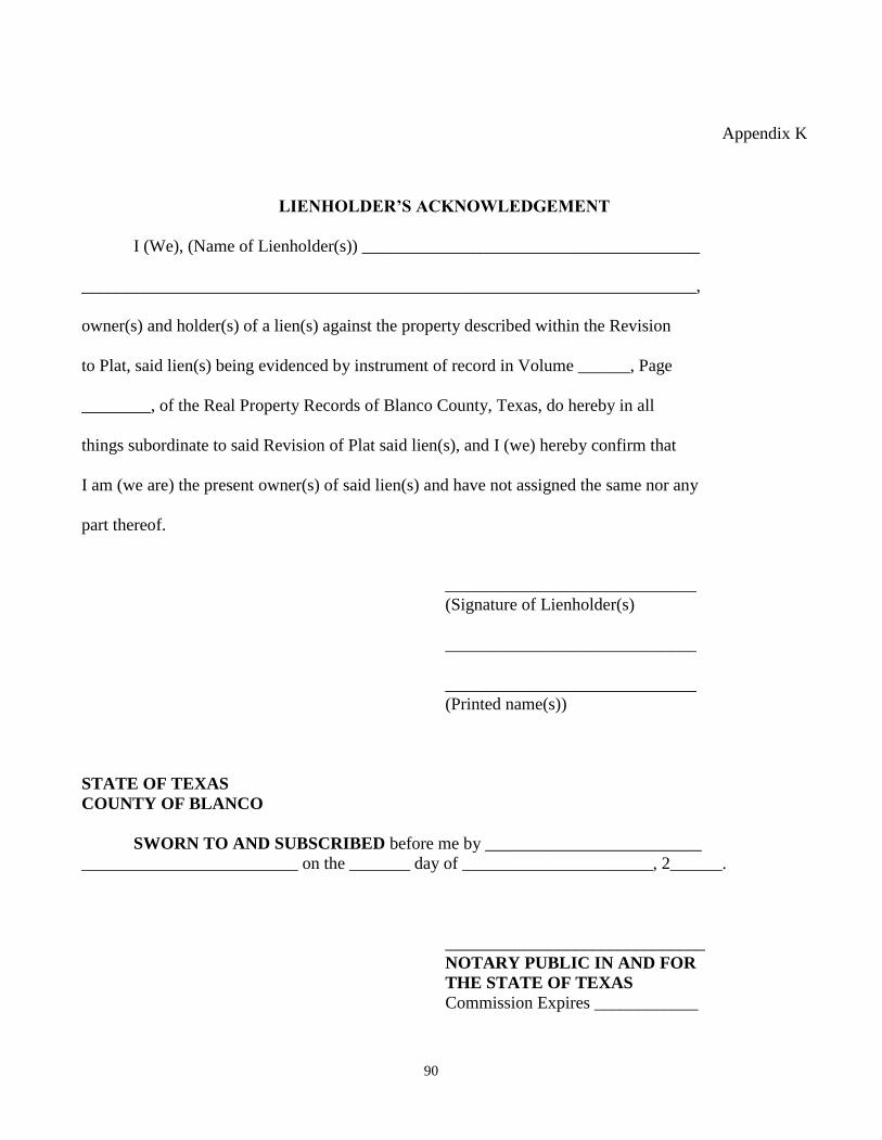
90
Appendix K
LIENHOLDER’S ACKNOWLEDGEMENT
I (We), (Name of Lienholder(s)) _______________________________________
_______________________________________________________________________,
owner(s) and holder(s) of a lien(s) against the property described within the Revision
to Plat, said lien(s) being evidenced by instrument of record in Volume ______, Page
________, of the Real Property Records of Blanco County, Texas, do hereby in all
things subordinate to said Revision of Plat said lien(s), and I (we) hereby confirm that
I am (we are) the present owner(s) of said lien(s) and have not assigned the same nor any
part thereof.
_____________________________
(Signature of Lienholder(s)
_____________________________
_____________________________
(Printed name(s))
STATE OF TEXAS
COUNTY OF BLANCO
SWORN TO AND SUBSCRIBED before me by _________________________
_________________________ on the _______ day of ______________________, 2______.
______________________________
NOTARY PUBLIC IN AND FOR
THE STATE OF TEXAS
Commission Expires ____________
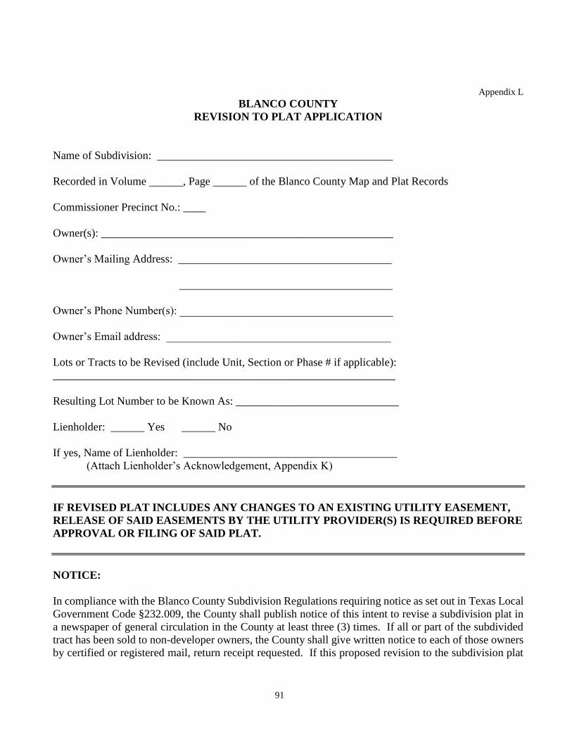
91
Appendix L
BLANCO COUNTY
REVISION TO PLAT APPLICATION
Name of Subdivision: __________________________________________
Recorded in Volume ______, Page ______ of the Blanco County Map and Plat Records
Commissioner Precinct No.: ____
Owner(s): ____________________________________________________
Owner’s Mailing Address: ______________________________________
______________________________________
Owner’s Phone Number(s): ______________________________________
Owner’s Email address: ________________________________________
Lots or Tracts to be Revised (include Unit, Section or Phase # if applicable):
_____________________________________________________________
Resulting Lot Number to be Known As: _____________________________
Lienholder: ______ Yes ______ No
If yes, Name of Lienholder: ______________________________________
(Attach Lienholder’s Acknowledgement, Appendix K)
IF REVISED PLAT INCLUDES ANY CHANGES TO AN EXISTING UTILITY EASEMENT,
RELEASE OF SAID EASEMENTS BY THE UTILITY PROVIDER(S) IS REQUIRED BEFORE
APPROVAL OR FILING OF SAID PLAT.
NOTICE:
In compliance with the Blanco County Subdivision Regulations requiring notice as set out in Texas Local
Government Code §232.009, the County shall publish notice of this intent to revise a subdivision plat in
a newspaper of general circulation in the County at least three (3) times. If all or part of the subdivided
tract has been sold to non-developer owners, the County shall give written notice to each of those owners
by certified or registered mail, return receipt requested. If this proposed revision to the subdivision plat
92
does not affect a public interest as described in Local Government Code §232.009(c-1)(1), the County
shall be required to provide written notice of the application to the owners of only the lots that are within
200 feet of the proposed plat revision. The County is not required to give notice by mail if the plat revision
only combines lots. The County will impose a fee to the applicant for the cost of processing the
application including the publishing of newspaper and mail notices. This processing fee will be separate
from the filling fee and shall be paid prior to the filing of the plat revision.
By affixing my signature below, I certify that I am the owner of the described property and I hereby
request to revise the plat of the described property. I further certify that any and all lienholders have
acknowledged this revision as per the attached Lienholder’s Acknowledgement. I agree to pay any and
all processing fees as described in the notice on page one of the application.
By initialing this box f I certify that I am requesting this revision to only combine existing lots
without interfering with the rights of any other property owner.
_____________________________________________________
(Owner’s Signature)
______________________________________________________
(Printed name)
STATE OF TEXAS
COUNTY OF BLANCO
SWORN TO AND SUBSCRIBED before me by __________________
__________________________ on the _______ day of _______________, 2_____.
______________________________
NOTARY PUBLIC
APPROVED BY COMMISSIONERS COURT ON THE _______ DAY OF __________________,
20____.
_______________________________ ATTEST: _________________________
BLANCO COUNTY JUDGE BLANCO COUNTY CLERK
93
Appendix M
NOTICE OF PROPOSED UTILITY LINE INSTALLATION
BLANCO COUNTY RIGHT OF WAY AND PERMIT
TO: Commissioner ___________________________
Precinct No. ___________________________
________________________________________
Address
Formal Notice is hereby given that ______________________________ proposes to place a
__________line within the right of way of County Road ____________as follows: (list location, length,
general design, etc.)
Installation will begin on or after the _____ day of ______________________, 20____.
The line will be constructed and maintained on the road right-of-way as directed by Blanco County
Commissioner Precinct No. _______.
The location and description of the proposed line is more fully shown on the attached drawings.
Applicant will insure that traffic control measures complying with applicable portions of the Texas
Manual of Uniform Traffic Control Devices will be installed and maintained during the installation.
If the proposed installation is a parallel installation, the installation shall be located ______ feet within
the edge of the right-of-way and at least _________ feet in depth, unless otherwise approved by the
County.
_______The installation shall not damage any portion of the road and adequate provisions must be made
to cause minimum inconvenience to traffic and adjacent property owners during installation.
OR
_______The installation shall damage a portion of the road. Applicant will return the road to its pre-
installation condition at Applicant’s expense within _____ days of installation. During installation
adequate provisions must be made to cause minimum inconvenience to traffic and adjacent property
owners during installation.
Applicant agrees that any damages sustained to the line installed under this proposal as a result of road
construction and/or maintenance, including but not limited to mowing, ditch cleaning, culvert repair or
94
replacement, roadway excavation, and base work shall be the sole burden and expense of the owner of the
utility line.
Applicant agrees to give Blanco County Commissioner Precinct No. days prior notice of any
routine or periodic maintenance which requires interruption of traffic and pruning of trees within the road
right-of way. County may provide specifications for the extent and methods governing trimming,
cropping, tree balance, type of cuts, painting cuts, and clean up.
Applicant agrees that Blanco County does not purport to grant any right, claim, title or easement in or
upon this road and Applicant further agrees that Blanco County may require owner to relocate line, subject
to provisions of governing laws, upon the giving of _____ days written notice.
In the event Applicant fails to comply with any of the requirements as set forth above, Blanco County
may take such action as it deems appropriate to compel compliance
Additional Special Provisions:
By signing the above, I certify that I am authorized to represent Applicant and that Applicant agrees to be
bound by the provisions of the Notice and Permit.
APPLICANT:
Name: ______________________________
Authorized agent: _____________________
Address_____________________________
Phone ______________________________
BLANCO COUNTY:
Commissioner_______________________
Precinct No. ________________________
Address____________________________
Phone______________________________
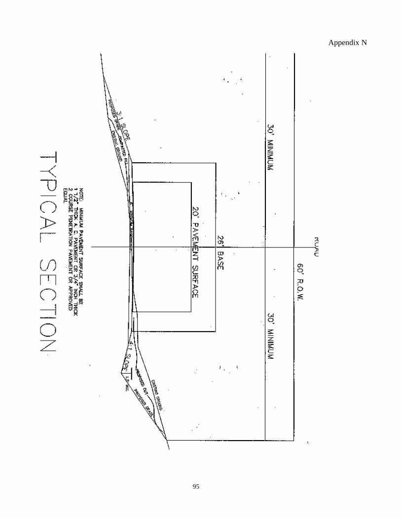
95
Appendix N
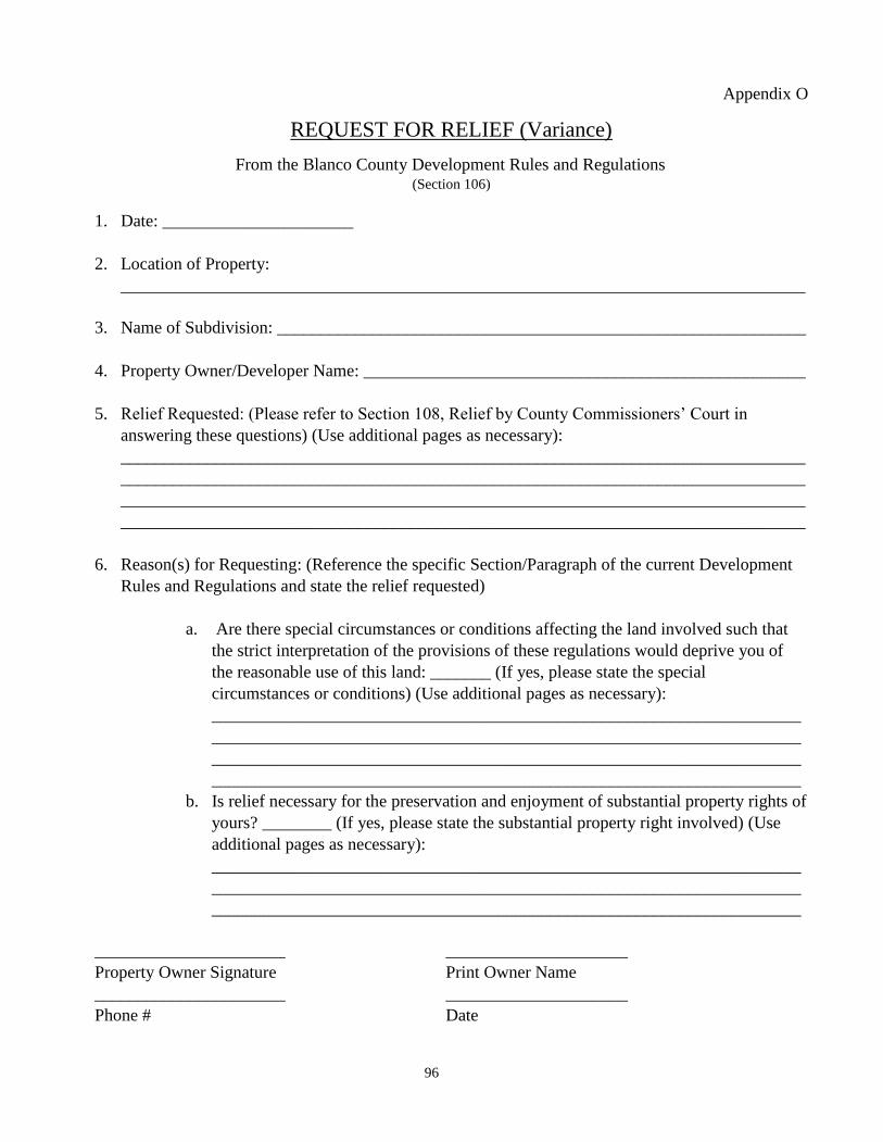
96
Appendix O
REQUEST FOR RELIEF (Variance)
From the Blanco County Development Rules and Regulations (Section 106)
1. Date: ______________________
2. Location of Property:
_______________________________________________________________________________
3. Name of Subdivision: _____________________________________________________________
4. Property Owner/Developer Name: ___________________________________________________
5. Relief Requested: (Please refer to Section 108, Relief by County Commissioners’ Court in
answering these questions) (Use additional pages as necessary):
_______________________________________________________________________________
_______________________________________________________________________________
_______________________________________________________________________________
_______________________________________________________________________________
6. Reason(s) for Requesting: (Reference the specific Section/Paragraph of the current Development
Rules and Regulations and state the relief requested)
a. Are there special circumstances or conditions affecting the land involved such that
the strict interpretation of the provisions of these regulations would deprive you of
the reasonable use of this land: _______ (If yes, please state the special
circumstances or conditions) (Use additional pages as necessary):
____________________________________________________________________
____________________________________________________________________
____________________________________________________________________
____________________________________________________________________
b. Is relief necessary for the preservation and enjoyment of substantial property rights of
yours? ________ (If yes, please state the substantial property right involved) (Use
additional pages as necessary):
____________________________________________________________________
____________________________________________________________________
____________________________________________________________________
______________________ _____________________
Property Owner Signature Print Owner Name
______________________ _____________________
Phone # Date
97
Appendix P
TAX CERTIFICATE AFFIDAVIT OF
Ad Valorem Tax Payment
(ii) THE STATE OF TEXAS
COUNTY OF BLANCO
BEFORE ME, the undersigned authority, on this day personally appeared:
____________________________ and __________________________
who being duly sworn, deposes and says:
I certify that all Ad Valorem Taxes due on the following: (describe real property)
have been paid as evidenced by the attached Tax Certificates from all taxing entities having jurisdiction
over the property.
I further attest that the above information is true and correct.
____________________________ _____________________________
Owner Name Owner Name
____________________________ _____________________________
Signature Signature
____________________________ _____________________________
Owner Name Owner Name
____________________________ _____________________________
Signature Signature
SUBSCRIBED AND SWORN to before me this _________ day of ______________, 20_____
____________________________
Notary Public (Seal)
98
Appendix Q
“DARK SKY” OUTDOOR LIGHTING
Per Blanco County Resolution supporting efforts to preserve night skies of July 12, 2016, Developers are
encouraged to adopt “Dark Sky” rules for outdoor lighting for subdivisions, residences and
commercial projects.
DARK SKY WORDING FOR HOA AND/OR DEED RESTRICTIONS
Any light fixture used for exterior illumination must be fully shielded, pointed downward, and placed in a
manner so that the light source is not directly visible from any other properties or public roadways. In order
to reduce glare and light trespass into neighboring lands and to reduce negative impacts to wildlife, exterior
illumination shall be restricted to light sources with a Correlated Color Temperature of 2,700K or less. As
used herein, “Fully Shielded” means no direct uplight (i.e., no light emitted above the horizontal
plane running through the lowest point on the fixture where light is emitted). The use of streetlights should
be held to a minimum. The use of reflective surfaces should always be considered as an alternative
to streetlights.
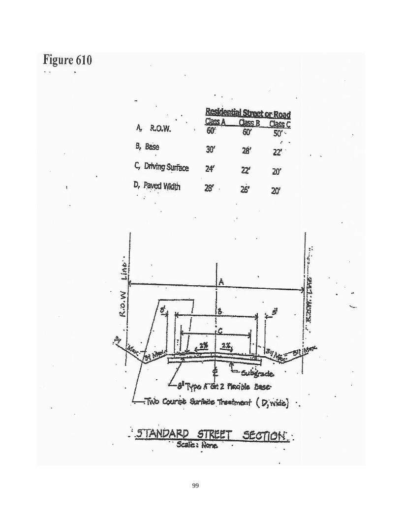
99
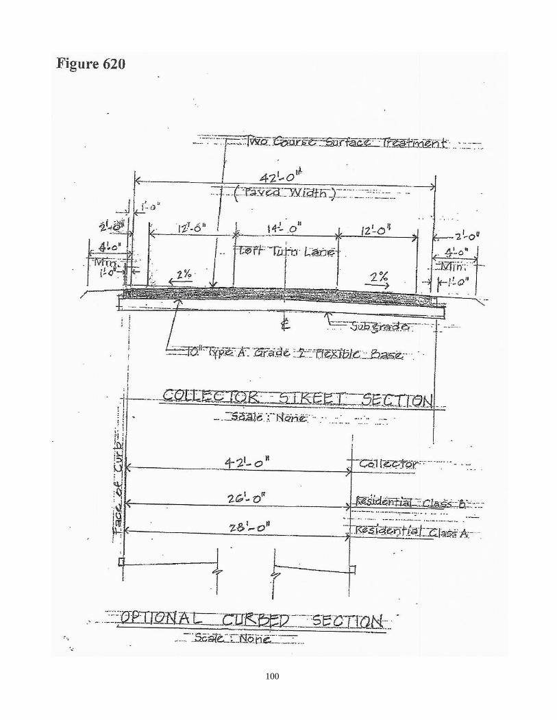
100
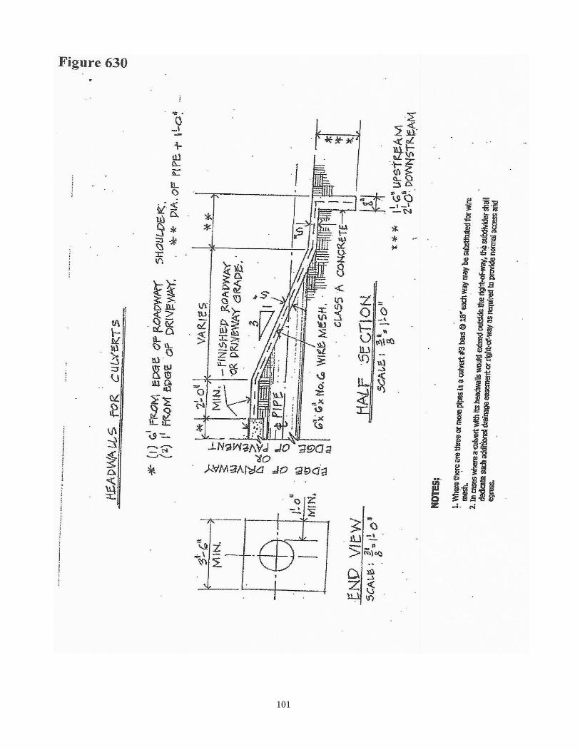
101

102
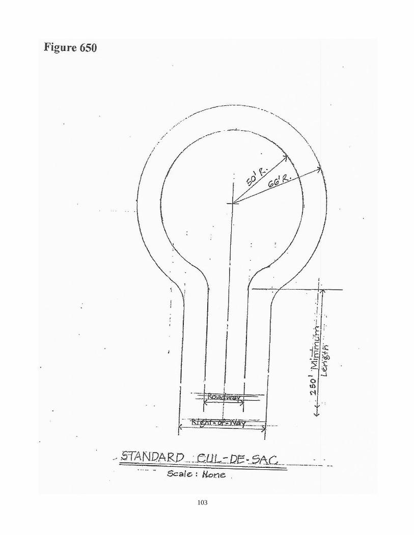
103
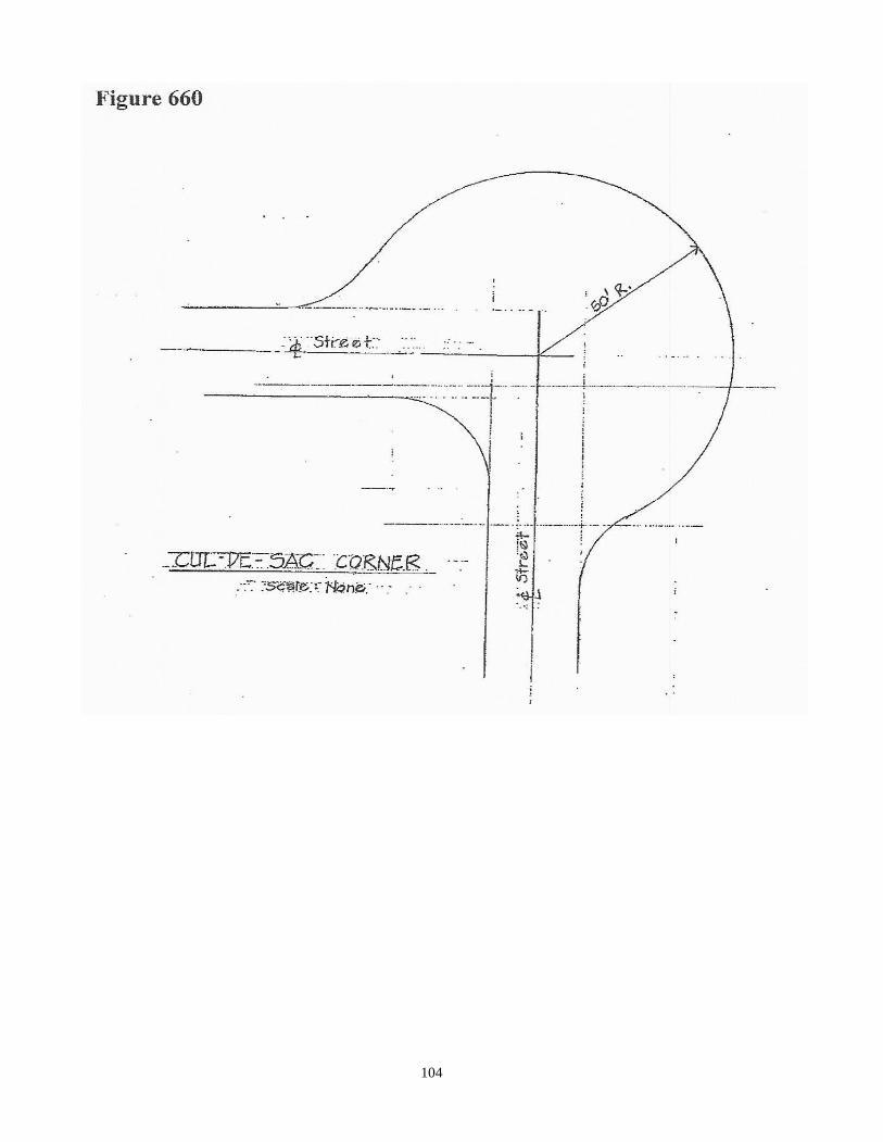
104
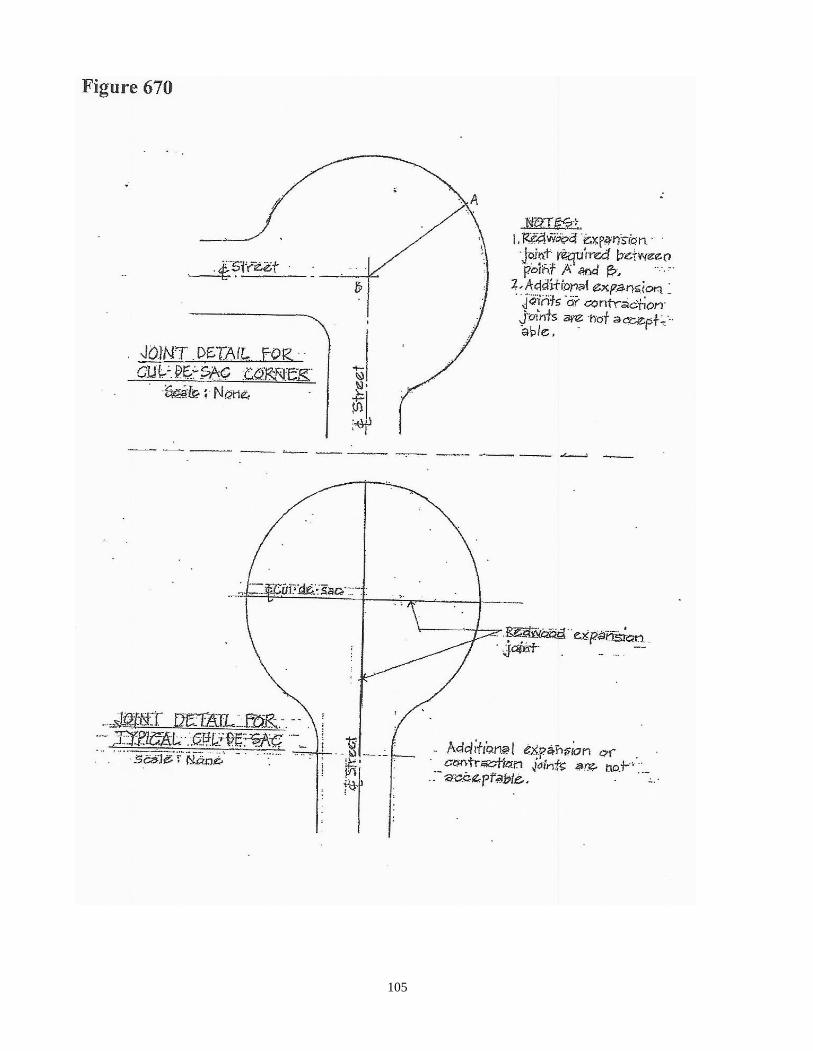
105