Embed Size (px)
Citation preview
The Blackmill CSO is located South West of Blackmill Village, at the confluence of the Gilfach Goch and Ogmore Vale catchments, upstream of Bridgend. It is known to spill for long periods of time after significant rainfall events have abated due to severe infiltration and inflow upstream. The CSO is the last in a series of CSOs that
controls flows and spills to the upper reaches of the River Ogmore. The sewer network follows closely the route of the River Ogmore through this area and the network is significantly influenced by high levels of ground water infiltration and river ingress.
Background The current CSO and adjacent 1,050m3 storage tanks were constructed pre-2000 as part of Welsh Water’s AMP2 CSO Program. The scheme objective during AMP2 was to resolve problems at 7 (No.) CSOs in the Blackmill area by rationalisation into one asset. The tanks were constructed to avoid downstream flooding, which occurred in the event that Formula ‘A’ (248l/s) being passed forward. Limiting the flow to 105l/s, protected the downstream network.
However, degradation of the sewer network allowing large amounts of ground water infiltration to the network, combined with a prolonged delayed rainfall induced response (sometimes in excess of three weeks), the sewer network and storage tanks are now severely under capacity. This led to frequent and prolonged operation of the CSO and has caused significant sewage pollution/flooding to the downstream fields.
Blackmill Rainscape Strategy Schemeworks to prevent a poor performing CSO asset from spilling by implementing a series of surface water removal schemes and network enhancementsby Indrajith Maruthonkara MEng and Neil Campbell BEng (Hons) CEng MICE
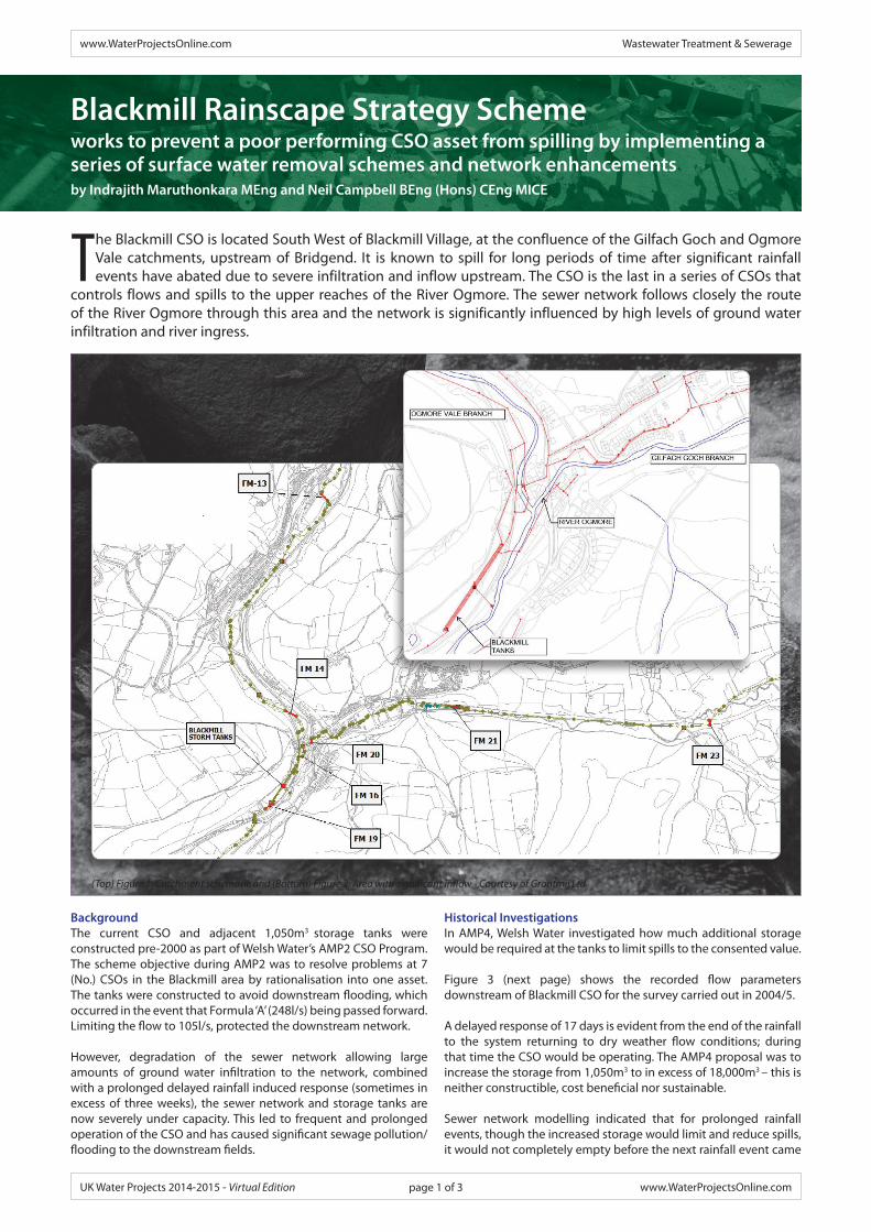
(Top) Figure 1: Catchment schematic and (Bottom) Figure 2: Area with significant inflow - Courtesy of Grontmij Ltd
Historical InvestigationsIn AMP4, Welsh Water investigated how much additional storage would be required at the tanks to limit spills to the consented value.
Figure 3 (next page) shows the recorded flow parameters downstream of Blackmill CSO for the survey carried out in 2004/5.
A delayed response of 17 days is evident from the end of the rainfall to the system returning to dry weather flow conditions; during that time the CSO would be operating. The AMP4 proposal was to increase the storage from 1,050m3 to in excess of 18,000m3 – this is neither constructible, cost beneficial nor sustainable.
Sewer network modelling indicated that for prolonged rainfall events, though the increased storage would limit and reduce spills, it would not completely empty before the next rainfall event came
www.WaterProjectsOnline.com Wastewater Treatment & Sewerage
UK Water Projects 2014-2015 - Virtual Edition www.WaterProjectsOnline.compage 1 of 3
along. This could result in the tanks being full for long periods of time and the benefit of their availability to store sewage being lost.
Combined with this the tanks would be unsustainable and have a high maintenance cost. The challenge to address this issue was to review the network and identify the root cause of the inflow and infiltration, to then locate and prevent it getting into the combined system and hence minimise, if not mitigate, the need for additional storage.
InvestigationsMorgan Sindall and Grontmij undertook numerous investigations to identify the cause of the serious inflow, including:
• 17 week, 36 (No.) monitor catchment wide flow survey.• 4,283m length of CCTV survey.• 9 (No). CSO surveys.
• 183 (No.) of manhole surveys.• 40ha of connectivity surveys.
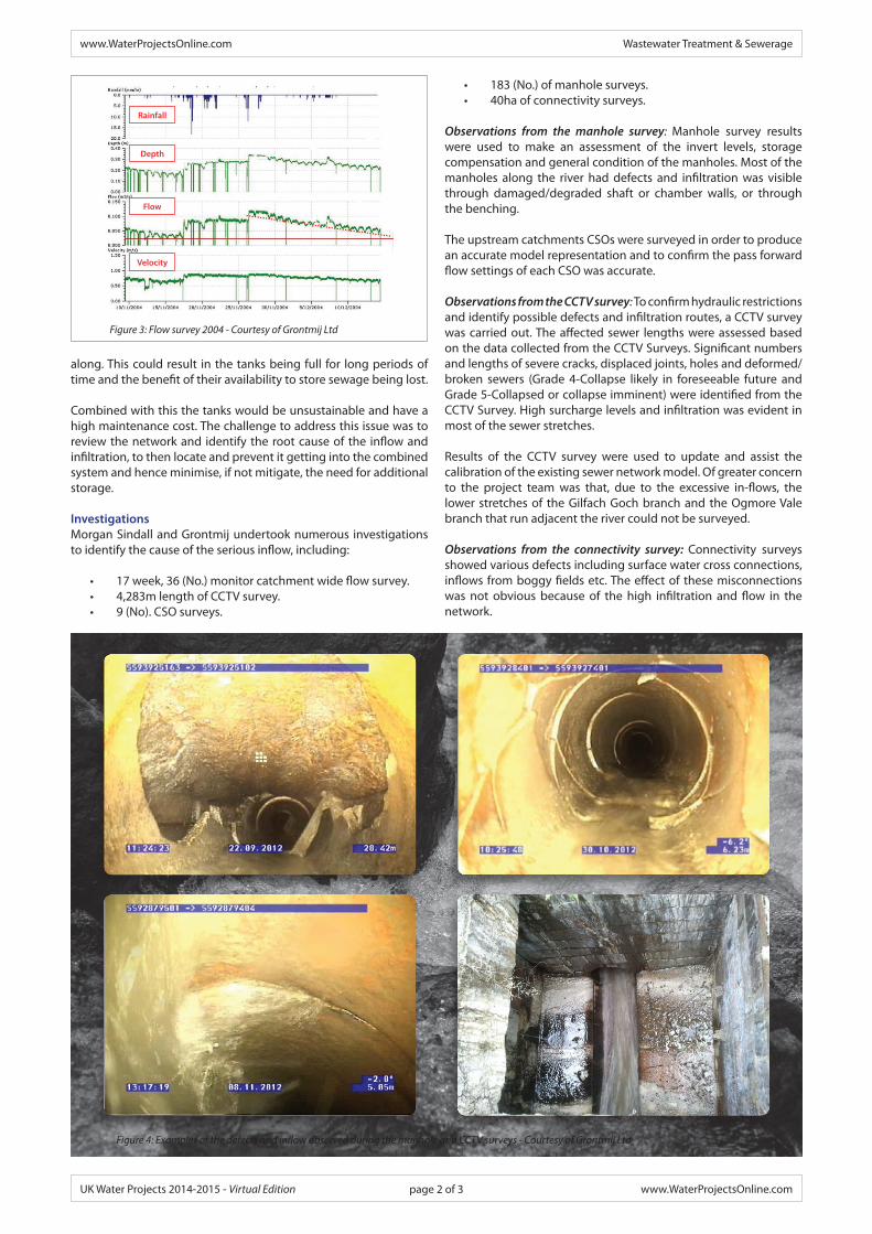
Observations from the manhole survey: Manhole survey results were used to make an assessment of the invert levels, storage compensation and general condition of the manholes. Most of the manholes along the river had defects and infiltration was visible through damaged/degraded shaft or chamber walls, or through the benching.
The upstream catchments CSOs were surveyed in order to produce an accurate model representation and to confirm the pass forward flow settings of each CSO was accurate.
Observations from the CCTV survey: To confirm hydraulic restrictions and identify possible defects and infiltration routes, a CCTV survey was carried out. The affected sewer lengths were assessed based on the data collected from the CCTV Surveys. Significant numbers and lengths of severe cracks, displaced joints, holes and deformed/broken sewers (Grade 4-Collapse likely in foreseeable future and Grade 5-Collapsed or collapse imminent) were identified from the CCTV Survey. High surcharge levels and infiltration was evident in most of the sewer stretches.
Results of the CCTV survey were used to update and assist the calibration of the existing sewer network model. Of greater concern to the project team was that, due to the excessive in-flows, the lower stretches of the Gilfach Goch branch and the Ogmore Vale branch that run adjacent the river could not be surveyed.
Observations from the connectivity survey: Connectivity surveys showed various defects including surface water cross connections, inflows from boggy fields etc. The effect of these misconnections was not obvious because of the high infiltration and flow in the network.
Figure 4: Examples of the defects and inflow observed during the manhole and CCTV surveys - Courtesy of Grontmij Ltd
Figure 3: Flow survey 2004 - Courtesy of Grontmij Ltd
Depth
Flow
Velocity
Rainfall
www.WaterProjectsOnline.com Wastewater Treatment & Sewerage
UK Water Projects 2014-2015 - Virtual Edition www.WaterProjectsOnline.compage 2 of 3

UV liner - Courtesy of Morgan Sindall plc Lining process - Courtesy of Morgan Sindall plc
Plans were submitted to rectify some of the defects in the form of quick fixes, which included surface water separation from cross connections with land drains and surface water networks, to replacement of damaged, or lost, manhole covers to improve the system performance.
Observations from the flow survey: The existing verified hydraulic model was taken as the base model for the study. In order to quantify the infiltration in the sewer network and to carry out re-verification, a total of 36 flow monitors were installed in strategic locations within the catchment. Flow monitors were installed upstream and downstream of each catchment CSOs in the trunk sewer to ensure that all CSOs are not spilling prior to their current consent. Flow monitoring was planned for a longer duration to include the variation in infiltration and delayed rainfall response.
Using the survey data, Grontmij calibrated the Groundwater Infiltration Module (GIM) of the InfoWorks CS model to provide a verification match within guideline parameters between observed and modelled flows. The GIM was used to mimic the observed inflow into the sewer of the high groundwater table and high river level, during wet periods.
Modelling observations: Using the GIM, it was observed that the historical model had previously grossly underpredicted the required storage necessary to ensure the CSO met its consent. The calibrated model predicted that the CSO would operate in excess of 35% of a typical year and that a storage volume to meet consent conditions could actually be in excess of 71,000m3. This level of storage is clearly unbuildable and unaffordable.
Analysis of the flow recorded by the individual flow monitors identified that the area shown in Figure 2 (see page 1), between Blackmill CSO and the first CSO in each branch of the sewer network, known as Dimbath Avenue CSO in Gilfach Goch branch and Lewistown CSO in Ogmore Vale branch had the reaction to rainfall induced infiltration.
These two stretches are very close to the river, running beside and beneath the river as it flows down to Blackmill CSO. These two stretches also correlate to the area that could not be CCTV’d because of the high level of flow, even in dry weather flow conditions.
It was estimated from the flow survey that flow approximately doubles between the upstream CSOs and Blackmill Tanks.
SolutionA phased approach has been adopted and agreed with Natural Resources Wales for the scheme. The modelling exercise by Grontmij established that mitigation works and a long-term strategy to reduce the storage requirement at Blackmill CSO.
Using information from the CCTV and manhole survey, a 3km stretch of sewer between Lewistown CSO and Dimbath Avenue CSO was identified to be replaced and re-lined. Additionally, the
manholes along the route where infiltration through the shaft wall or benching was identified, were also sealed and/or lined.
Grontmij recommended undertaking the works in a phased approach, with Phase 1 being the rehabilitation works. This was undertaken by Lanes for Drains between October 2013 and January 2014.
The lining exercise required work in and around the river, so use of hot cure lining was not advisable, due to the potential of leakage of hot, chemically polluted water into the adjacent river, as well as the removal of that water once the liner was cured. The company therefore used ultra-violet (UV) cured lining. To get the rig through the extremely difficult terrain to the sewer, they fitted the UV rig to “golf buggies” and built a temporary bridge over the Ogmore.
Hydraulic modelling identified that 150l/s is the maximum flow that can be passed forward from Blackmill CSO without causing detriment to the downstream sewer network and as such the control setting of Blackmill CSO has been increased from 105l/s to 150l/s, maximising the capacity of the existing asset base.
Now that Phase 1 is complete, a flow monitoring exercise is on-going, to confirm the reduction in inflow from the river. To date, it is estimated that ‘base infiltration’ has been reduced by 35%, with the CSO forecast to operate only 10% of the year. Currently, based on early results, residual storage has been reduced from 71,000m3 to approximately 3,000m3.
ConclusionSince completion of the lining works, there has been a notable reduction in the flows arriving at the Blackmill CSO. This reduced flow, along with the increased pass forward flow has significantly reduced the spill frequency and volume of the CSO, which will improve the water quality of the receiving river and greatly reduce maintenance and operation costs of the mechanical screen.
Phase 2 – AMP6Following completion of post monitoring of Phase 1, Phase 2 of the strategy will incorporate targeted schemes to further reduce inflow from groundwater, land drain misconnections and surface water mis-connections.
At present, a further 3,000m3 of storage is required to meet the consent conditions. However, by removing a further 10l/s of base infiltration and limiting the inflow of rainwater entering the network, through the targeted schemes, this will be sufficient to negate the need for additional storage at Blackmill CSO.
The editor and publishers would like to thank Indrajith Maruthonkara, Engineer, and Neil Campbell, Principal Engineer, both with Grontmij, for preparing this paper for publication.
The authors thank Dŵr Cymru Welsh Water and Morgan Sindall plc for their assistance with this paper.
www.WaterProjectsOnline.com Wastewater Treatment & Sewerage
UK Water Projects 2014-2015 - Virtual Edition www.WaterProjectsOnline.compage 3 of 3