Embed Size (px)
Citation preview
Delivering sustainable solutions in a more competitive world
Final Scoping Report for the Gamsberg Zinc Mine and Associated Infrastructure in the Northern Cape Black Mountain Mining (Pty) Ltd January 2013 www.erm.com

ENVIRONMENTAL RESOURCES MANAGEMENT SCOPING REPORT FOR GAMSBERG ZINC MINE
I
FINAL SCOPING REPORT Environmental and Social Impact Assessment for the Gamsberg Zinc Mine and Associated Infrastructure in the Northern Cape
Black Mountain Mining (Pty) Ltd
Prepared by: Mel Pillay and Tania Swanepoel January 2013
For and on behalf of Environmental Resources Management Approved by: Stuart Heather-Clark Signed:
Position: Partner Date: 14 January 2013
This report has been prepared by Environmental Resources Management the trading name of Environmental Resources Management Southern Africa (Pty) Limited, with all reasonable skill, care and diligence within the terms of the Contract with the client, incorporating our General Terms and Conditions of Business and taking account of the resources devoted to it by agreement with the client. We disclaim any responsibility to the client and others in respect of any matters outside the scope of the above. This report is confidential to the client and we accept no responsibility of whatsoever nature to third parties to whom this report, or any part thereof, is made known. Any such party relies on the report at their own risk.
ENVIRONMENTAL RESOURCES MANAGEMENT SCOPING REPORT FOR GAMSBERG ZINC MINE
II
TABLE OF CONTENTS
GLOSSARY OF TERMS XI
1 INTRODUCTION 1
1.1 PURPOSE OF REPORT 1 1.2 BACKGROUND TO GAMSBERG MINE 4 1.3 PROPERTY DETAILS 4 1.4 HOLDER OF THE MINING RIGHT 7 1.5 ASSUMPTIONS AND LIMITATIONS 7 1.6 DETAILS OF ESIA PROJECT TEAM 8 1.7 STRUCTURE OF THIS REPORT 9
2 ADMINISTRATIVE FRAMEWORK 10
2.1 NATIONAL LEGISLATIVE AND POLICY REQUIREMENTS 10 2.1.1 National Environmental Management Act (No 107 of 1998) (NEMA) and the
National Environmental Management Amendment Act (No 62 of 2008) 10 2.1.2 National Environmental Management: Waste Act, 2008 (No. 59 of 2008)
(NEMWA) 16 2.1.3 Mineral and Petroleum Resources Development Act (No. 28 of 2002) 17 2.1.4 National Heritage Resources Act (No. 25 of 1999) 19 2.1.5 National Environmental Management: Air Quality Act, 2008 (No. 39 of 2008)
(NEM:AQA) 21 2.1.6 National Water Act (No. 36 of 1998) (NWA) 22 2.1.7 The National Environmental Management: Biodiversity Act, 2008 (No. 10 of
2004) (NEMBA) and associated legislation 24 2.1.8 Integrated Legislative Processes 26 2.2 BROADER POLICY AND PLANNING CONTEXT 28 2.2.1 Northern Cape Provincial Growth and Development Strategy 28 2.2.2 Namakwa District Municipality Local Economic Development Strategy 30 2.2.3 Succulent Karoo Ecosystem Programme (SKEP) 30 2.2.4 Mining Charter 31 2.2.5 Namakwa District Biodiversity Plans(2008) (NDBP) 32 2.3 INTERNATIONAL GUIDELINES 33 2.3.1 IFC Performance Indicators for Sustainability 33 2.3.2 IFC General Environmental, Health and Safety Guidelines 35 2.4 CONSERVATION INTERNATIONAL 36 2.5 VEDANTA’S CORPORATE STANDARDS 37 2.5.1 Sustainable Development Strategy for Gamsberg Zinc Mine 38
3 PROJECT DESCRIPTION 40
3.1 INTRODUCTION 40 3.1.1 Project History 40 3.1.2 Proposed Project 41 3.1.3 Project Location 41
ENVIRONMENTAL RESOURCES MANAGEMENT SCOPING REPORT FOR GAMSBERG ZINC MINE
III
3.1.4 Project Rationale 42 3.1.5 Global Demand 42 3.1.6 Regional Mining 43 3.1.7 Regional Impact of Black Mountain’s Existing Mine 43 3.2 MOTIVATION FOR MINING METHOD 44 3.3 PLANNING & DESIGN 46 3.4 CONSTRUCTION 49 3.4.1 Construction Camp Infrastructure (Office, Workshop, Temporary Storage of
Fuels and Wastes) 50 3.4.2 Contractor Housing Camp (Temporary Staff Housing) 50 3.4.3 Bulk service requirements for the construction camp and temporary
contractor housing camp 50 3.4.4 Non-mineral Waste Management 52 3.5 MINING 52 3.5.1 Open Pit 55 3.5.2 Explosive Storage Area 56 3.5.3 Drilling and Blasting 56 3.5.4 Load and Haul of Overburden and Ore 57 3.5.5 Waste Rock Dumps 58 3.5.6 Earth Moving Equipment 59 3.5.7 Engineering Workshops 59 3.5.8 Mine Bulk Fuel and Lubricant Storage Facility 60 3.5.9 Conveyor System Network 60 3.6 PROCESSING CONCENTRATOR PLANT 60 3.6.1 Crusher Plant 62 3.6.2 Milling Circuit 62 3.6.3 Flotation 63 3.6.4 Dewatering, Filtration and Zinc Concentrate Handling 65 3.6.5 Dewatering 65 3.6.6 Concentrator Plant Bulk Fuel and Lubricant Storage Facilities 65 3.6.7 Material Lay Down and Storage Areas 65 3.6.8 Ore Stockpile Pads 66 3.6.9 Equipment Wash Areas 66 3.6.10 Additional On-site Plant Infrastructure 66 3.6.11 Tailings Dam 66 3.7 ASSOCIATED MINE INFRASTRUCTURE 68 3.7.1 Entrance and Exit Points 68 3.7.2 Power Supply and Substation Network 68 3.7.3 Water Supply System and Storage Dams 68 3.7.4 Raw Water Dam 69 3.7.5 Process Water Dam 69 3.7.6 Dust Suppression Dam 69 3.7.7 Fire Control Dam 69 3.7.8 Waste Facilities 70 3.7.9 Waste Sorting, Re-Use and Recycling 70 3.7.10 Domestic Waste Facility 70 3.7.11 Sewage Treatment Facility 70 3.7.12 Temporary Hazardous Waste Facility 71 3.7.13 Transportation Corridor 71 3.7.14 General Access Roads and Parking Areas 71

ENVIRONMENTAL RESOURCES MANAGEMENT SCOPING REPORT FOR GAMSBERG ZINC MINE
IV
3.7.15 Mine Area Roads 71 3.7.16 Plant Area Roads 71 3.7.17 Burrow Pits for Road Network 72 3.7.18 Administrative Office Block and Control Room 72 3.7.19 Storm Water Management Infrastructure 72 3.7.20 Pollution Control Dams 72 3.7.21 Security and Induction Training Areas 72 3.7.22 Medical Clinic 73 3.8 EMPLOYMENT AND RESIDENTIAL HOUSING DEVELOPMENT 73 3.9 EXPORT OPTIONS 73 3.10 SUMMARY OF PROJECT ALTERNATIVES 74 3.10.1 Location Alternatives 75 3.10.2 Design/ Layout Alternatives 76
4 RECEIVING ENVIRONMENT 81
4.1 CLIMATE CONDITIONS 81 4.1.1 Precipitations 81 4.1.2 Maximum and Mean Monthly Temperatures 82 4.1.3 Monthly Mean Wind Direction and Speed 82 4.2 TOPOGRAPHY 83 4.3 GEOLOGY 83 4.3.1 Regional Geology 83 4.3.2 Local Mine Geology 83 4.4 SOIL POTENTIAL 84 4.4.1 Soil Forms 84 4.4.2 Agricultural Potential 85 4.5 SURFACE WATER 85 4.5.1 Catchment Area Characteristics 85 4.5.2 Site Specific Water Resources 87 4.5.3 Water Quality Management and Sources of Contamination 87 4.6 GROUNDWATER 88 4.6.1 Description of Hydrogeology 88 4.6.2 Current Groundwater Use 88 4.6.3 Groundwater Quality 89 4.6.4 Groundwater Levels and Flow Directions 89 4.7 GEOCHEMISTRY 90 4.8 FLORA 91 4.8.1 Regional Context 91 4.8.2 Site Specific Botanical Analysis 92 4.8.3 Features of Botanical Concern 96 4.9 FAUNA 97 4.9.1 Terrestrial Invertebrates 97 4.9.2 Herpetofauna 99 4.9.3 Mammals 100 4.9.4 Avi-fauna 101 4.9.5 Aquatic Biodiversity 101 4.10 AIR QUALITY 102 4.10.1 Existing Air Quality within the Region 102 4.11 NOISE 104

ENVIRONMENTAL RESOURCES MANAGEMENT SCOPING REPORT FOR GAMSBERG ZINC MINE
V
4.12 TRANSPORTATION NETWORK 104 4.13 SITES OF ARCHAEOLOGICAL AND PALEONTOLOGICAL IMPORTANCE 105 4.14 VISUAL LANDSCAPE 106 4.15 SOCIO-ECONOMIC CONTEXT 107 4.15.1 Institutional Framework 108 4.15.2 Population Statistics 110 4.15.3 Age 111 4.15.4 Gender 112 4.15.5 Ethnicity and Language 113 4.15.6 Education 114 4.15.7 Health 115 4.15.8 Communicable Diseases (HIV/AIDS, TB) 117 4.15.9 Social Problems and Vulnerability 118 4.15.10 Major Economic Activities and Sources of Employment 119 4.15.11 Key Sectors of Namakwa District Municipality (NDM) 120 4.15.12 Other Sectors 122 4.15.13 Regional Employment 123 4.15.14 Households Incomes 125 4.15.15 Bulk Services and Infrastructure 126 4.15.16 Water Supply 127 4.15.17 Sanitation 129 4.15.18 Power Supply 129 4.15.19 Transport, Roads and Rail 131 4.15.20 Land Tenure and Reform 133 4.15.21 Land Reform 133
5 SUMMARY OF KEY ISSUES 135
5.1 AIR QUALITY AND DUST 137 5.2 VISUAL 138 5.3 SURFACE HYDROLOGY 138 5.4 HYDROGEOLOGY 139 5.5 GEOCHEMISTRY 140 5.6 FLORA 140 5.7 FAUNA 144 5.8 NOISE AND VIBRATION 145 5.9 HERITAGE, ARCHAEOLOGY AND PALAEONTOLOGY 147 5.10 SOCIAL 149 5.11 ECONOMIC 150 5.12 TRAFFIC 150 5.13 WASTE CLASSIFICATION 151 5.14 CLIMATE CHANGE AND GREEN HOUSE GAS EMISSIONS 151 5.15 CONCLUSION 152
6 PUBLIC PARTICIPATION PROCESS 153
6.1 OBJECTIVES OF THE PUBLIC PARTICIPATION PROCESS 153 6.2 WHO ARE THE STAKEHOLDERS OR I&APS 154 6.3 PUBLIC PARTICIPATION ACTIVITIES 155 6.4 PUBLIC PARTICIPATION DURING THE IMPACT ASSESSMENT PHASE 159
ENVIRONMENTAL RESOURCES MANAGEMENT SCOPING REPORT FOR GAMSBERG ZINC MINE
VI
6.5 COMPETENT AUTHORITY’S DECISION 160 6.6 NEXT STEPS IN THE ESIA PROCESS 160
7 PLAN OF STUDY FOR ESIA 161
7.1 PURPOSE OF PLAN OF STUDY 161 7.2 ESIA PROJECT TIMING 161 7.3 PROPOSED CONSULTATION WITH COMPETENT AUTHORITY 162 7.4 ASSESSMENT METHODOLOGY 163 7.4.1 Assessing Impacts 164 7.4.2 Mitigation Potential and Residual Impacts 168 7.4.3 Cumulative Impacts 168 7.5 CONSIDERATION OF ECOSYSTEM SERVICES 169 7.6 PROPOSED SPECIALIST STUDIES 169 7.7 INTERDEPENDENCIES OF SPECIALIST INVESTIGATIONS 170 7.8 SPECIALIST TERMS OF REFERENCE 173 7.8.1 Traffic Impact Assessment 173 7.8.2 Noise and Vibration Impact Assessment 174 7.8.3 Air Quality Impact Assessment 175 7.8.4 Waste Classification Assessment 177 7.8.5 Geochemical Impact Assessment 177 7.8.6 Hydrogeological Impact Assessment 179 7.8.7 Hydrological Impact Assessment 180 7.8.8 Climate Change and Green House Gas Emissions Impact Assessment 182 7.8.9 Faunal Impact Assessment (Terrestrial, Aquatic and Avi-fauna) (on-site mine
infrastructure) 183 7.8.10 Botanical Impact Assessment (Terrestrial and Aquatic Flora) (on-site mine
infrastructure) 186 7.8.11 Ecological Impact Assessment (Terrestrial and Aquatic Biodiversity) (off-site
infrastructure) 188 7.8.12 Cultural Heritage, Archaeology and Palaeontology Impact Assessment 190 7.8.13 Social Impact Assessment 191 7.8.14 Visual Impact Assessment 192 7.8.15 Marco-economic Impact Assessment 193
8 CONCLUSION AND WAY FORWARD 196
8.1 CONCLUSION 196 8.2 WAY FORWARD 197
9 REFERENCES 198
9.1 REPORTS 198 9.2 ELECTRONIC RESOURCES 200 9.3 PERSONAL COMMUNICATION 200
ENVIRONMENTAL RESOURCES MANAGEMENT SCOPING REPORT FOR GAMSBERG ZINC MINE
VII
LIST OF FIGURES:
Figure 1.1 Location of the Proposed Gamsberg Mine Figure 1.2 Cadastral Map of Gamsberg Mine Figure 2.1 Integrated Flow Diagram of ESIA Process Figure 2.2 Location of Hotspot Relative to Project Area Figure 2.3 Sustainable Development Strategy Framework Figure 2.4 Decision making principles for project design Figure 3.1 Conceptual layout plan Figure 3.2 Typical open pit operation Figure 3.3 Mining haul trucks expected to be used Figure 3.4 Image of a typical waste rock dump Figure 3.5 Block Flow Schematic Diagram Figure 3.6 Typical image of concentrator plant Figure 3.7 Milling circuit schematic Figure 3.8 Typical Example of a Tailings Facility Figure 3.9 Map of Transport Options 1 (Truck to Port of Saldanha) Figure 3.10 Map of Transport Options 2 (Truck to Loop 10 siding and rail to Port of Saldanha via
Sishen-Saldanha railway line) Figure 4.1 Orange River Catchment Figure 4.2 The Extent of the BIR Figure 4.3 Example of Bushmanland Arid Grassland Vegetation Type Figure 4.4 Typical composition of Bushmanland Inselberg Succulent Shrubland along southern
face of Gamsberg Inselberg Figure 4.5 Plains Quartz Gravel Patch at northern eastern base of Gamsberg Inselberg Figure 4.6 Undescribed Messor Species found in the Gamsberg Basin Figure 4.7 Undescribed Camponotus fulvopilosus-group Species (left) Compared with the Karoo
form of C. fulvopilosus (right) commonly found at Gamsberg and in the Surrounding Regions
Figure 4.8 Paradise Toad Identified at Gamsberg Inselberg Figure 4.9 Age Trend of Khai Ma Municipality from 2001 to 2007 Figure 4.10 HIV/AIDS Incidence Rate in the Northern Cape Province Figure 4.11 Economic Growth Rates in the Northern Cape and Namakwa District (1996 - 2007) Figure 4.12 Sectoral Contributions to GDP in the Namakwa District (1995 to 2007) Figure 4.13 Employment Rate at the Provincial and District Levels Figure 4.14 Sectoral Employment in the Namakwa District (1995 - 2007) Figure 4.15 Household Incomes for the Namakwa District (2001) Figure 5.1 Botanical sensitivity map Figure 5.2 Noise sensitivity map Figure 5.3 Heritage and Archaeological sensitivity map Figure 6.1 Pictures taken during the Public Meeting held in Pella Figure 6.2 Pictures taken during the Public Meeting held in Pofadder
LIST OF TABLES:
Table 1.1 Black Mountain’s Current Mining Operations in Aggeneys and Gamsberg Table 1.2 Directly Affected Properties Table 1.3 Expertise of EAPs Table 1.4 Structure of Draft Scoping Report

ENVIRONMENTAL RESOURCES MANAGEMENT SCOPING REPORT FOR GAMSBERG ZINC MINE
VIII
Table 2.1 Listed Activities in Terms of NEMA EIA Regulations Table 2.2 Information Requirements for Scoping Reports Table 2.3 Listed Activities in Terms of NEM:WA Table 2.4 MPRDA Information Requirements for Scoping Reports Table 2.5 Permitting requirements for heritage resources management Table 2.6 Permitting Requirements for Fossil, Built Environment and Stone Age Archaeology Table 2.7 Permitting Requirements for Burial Grounds and Graves Older than 60 years to
Heritage Northern Cape (HNC) and Historic Burials to the South African Heritage Resources Agency (SAHRA)
Table 2.8 Listed Activities in Terms of NEM:AQA Table 2.9 Water Uses in Terms of Section 21 of the NWA Table 2.10 Summary of Legislative Applications and Relevant Authorities Table 2.11 Performance Indicators for Environmental and Social Sustainability Table 2.12 Vital Signs of Succulent Karoo Table 3.1 Estimated Zinc Mine Production and Metal Usage Table 3.2 Project Programme Table 3.3 Phasing of Concentrator Plant Table 3.4 Construction phase water usage Table 3.5 Conceptual mine work plan Table 3.6 Inventory of equipment Table 3.7 Operational phase water requirement Table 3.8 Summary of Transport Options Table 4.1 Average Monthly Rainfall in the Region Table 4.2 Average Temperature in Pofadder Table 4.3 Summary of Groundwater Abstraction in the area Table 4.4 Species of Conservation Concern Present in the Study Area Table 4.5 Habitats of Conservation Value Table 4.6 List of Herpetofauna Recorded at Gamsberg during the Dry Season Table 4.7 Namakwa District Population Distribution Table 4.8 Population Trends for the Affected Towns Table 4.9 Gender Profile of Namakwa DM and Khai Ma LM Table 4.10 Population distribution by Race Groups within the Namakwa and Khai Ma
Municipalities Table 4.11 Language Groups of the Namakwa DM and Khai Ma LM Table 4.12 Education Levels with the Economically Active Age Group (15-64) in the Namakwa
DM and Khai Ma LM Table 4.13 The Number of Schools in the Zone of Influence Table 4.14 Contribution of Local Municipalities to Namakwa DM GGP Table 4.15 Types of Housing Structures in the Khai Ma LM Table 4.16 Regional Water Provision Methods Table 4.17 Types of Sanitation Facilities at the District and Regional Levels Table 4.18 Sources of Energy for Cooking for the District and Local Municipality Table 4.19 Energy Sources for Lighting at the District and Local Municipalities Table 4.20 Mode of Transport for the Khai Ma LM Table 4.21 Extent of Provincial Road Networks Table 5.1 Summary of Key Issues Raised by IAPs Table 5.2 A proposed framework for quantifying flexibility within the biodiversity constraints
map Table 6.1 Public Participation Activities Table 7.1 ESIA Timing

ENVIRONMENTAL RESOURCES MANAGEMENT SCOPING REPORT FOR GAMSBERG ZINC MINE
IX
Table 7.2 Stages of Consultation with Authorities Table 7.3 Defining Impact Characteristics Table 7.4 Designations for Characteristics Table 7.5 Definitions of likelihood Table 7.6 Context for Defining Significance Table 7.7 Impact Significance Rating Matrix Table 7.8 Mitigation hierarchy Table 7.9 ESIA Specialist Team Table 7.10 Specialist Interdependencies Table 8.1 Details of Public Meetings/ Open House to Obtain Feedback on the Draft Scoping
Report LIST OF ANNEXURES:
Annex A: Acknowledgment of Receipt of Application Forms from DENC and DEA Annex B: Adverts Published in Newspapers during the Project Initiation and Scoping Phase Annex C: Pictures of Site Notices Annex D: Background Information Document and Associated Cover Letter and Registration
Form Annex E: IAP Stakeholder Database Annex F: Minutes of Meetings during Project Initiation and Scoping Phase Annex G: Comments received and associated Comments and Response Report Annex H: Letters of Notification of availability Draft and Final Scoping Report
ENVIRONMENTAL RESOURCES MANAGEMENT SCOPING REPORT FOR GAMSBERG ZINC MINE
XI
GLOSSARY OF TERMS
“alternative”, in relation to a proposed activity, means different means of meeting the general purpose and requirements of the activity, which may include alternatives to- (a) the property on which or location where it is proposed to undertake the
activity; (b) the type of activity to be undertaken; (c) the design or layout of the activity; (d) the technology to be used in the activity; (e) the operational aspects of the activity; and (f) the option of not implementing the activity. “aquifer” means a geological formation which has structures or textures that hold water or permit appreciable water movement through them. “biodiversity” (“biological diversity” or “biodiversity”) means the variability among living organisms from all sources including, terrestrial, marine and other aquatic ecosystems and the ecological complexes of which they are part and also includes diversity within species, between species, and of ecosystems. “buffer area” means, unless specifically defined, an area extending 10 kilometres from the proclaimed boundary of a world heritage site or national park and 5 kilometres from the proclaimed boundary of a nature reserve, respectively, or that defined as such for a biosphere. “catchment” The area from which any rainfall will drain into the watercourse or watercourses or part of the water course, through surface flow to a common point or common points. “clean water system” includes any dam, other form of impoundment, canal, works, pipeline and any other structure or facility constructed for the retention or conveyance of unpolluted water. “concentration” Concentrating involves milling, crushing and flotation of the ore to produce a concentrate for smelting. The ore is crushed and milled to reduce the size of the rock particles and to expose the minerals which contain the PGMs. The particles are mixed with water and special reagents and air is pumped through the liquid, creating bubbles to which the PGM-containing particles adhere. These float to the surface and are removed as a soapy froth. “construction” means the building, erection or establishment of a facility, structure or infrastructure that is necessary for the undertaking of a listed or specified activity but excludes any modification, alteration or expansion of such a facility, structure or infrastructure and excluding the reconstruction of the same facility in the same location, with the same capacity and footprint. “dam” includes any settling dam, slurry dam, evaporation dam, catchment or barrier dam and any other form of impoundment used for the storage of unpolluted water or water containing waste. “dirty area” means any area at a mine or activity which causes, has caused or is likely
ENVIRONMENTAL RESOURCES MANAGEMENT SCOPING REPORT FOR GAMSBERG ZINC MINE
XII
to cause pollution of a water resource. “dirty water system” includes any dam, other form of impoundment, canal, works, pipeline, residue deposit and any other structure or facility constructed for the retention or conveyance of water containing waste. “environment” The surroundings within which humans exist and that are made up of: i. the land, water and atmosphere of the earth; ii. micro-organisms, plant and animal life; iii. any part or combination of (i) and (ii) and the interrelationships among
and between them; and iv. the physical, chemical, aesthetic and cultural properties and conditions
of the foregoing that influence human health and well-being. This includes the economic, social, cultural, historical and political circumstances, conditions and objects that affect the existence and development of an individual, organism or group.
“environmental impact assessment” refers to the process of systematically identifying, predicting, assessing and reporting the potential positive and negative social, economic and biophysical impacts of any proposed project, plan, programme or policy which requires authorisation or permission by law and which may significantly affect the environment. The EIA includes an evaluation of alternatives, as well as recommendations for appropriate mitigation measures for minimising or avoiding negative impacts, measures enhancing the positive aspects of the proposal and environmental management and monitoring measures. Although recognised as an EIA process in a South African context, the EIA process for this project is referred to as an Environmental and Social Impact Assessment (ESIA) in line with International good practice. “expansion” means the modification, extension, alteration or upgrading of a facility, structure or infrastructure at which an activity takes place in such a manner that the capacity of the facility or the footprint of the activity is increased. “fault” a zone of displacement in rock formations resulting from forces of tension or compression of the earth's crust. “Formation” a general term used to describe a sequence of rock layers. “fractured-rock aquifer” groundwater occurring in within fractures and fissures in hard-rock formations. “freeboard” - with respect to water storage dams can be defined as the distance between the full supply level (spillway crest level) and the lowest point on the dam wall crest. Freeboard with respect to tailings dams can be defined as the distance between the mean operating level plus the 1:50 year flood-level and the lowest point on the wall crest of the tailings dam. “groundwater flow” The movement of water through openings and pore spaces in rocks below the water table i.e. in the saturated zone. Groundwater naturally drains from higher lying areas to low lying areas such as rivers, lakes and the oceans. The rate of flow depends on the slope of the water table and the transmissivity of the geological formations.
ENVIRONMENTAL RESOURCES MANAGEMENT SCOPING REPORT FOR GAMSBERG ZINC MINE
XIII
“groundwater recharge” Refers to the portion of rainfall that actually infiltrates the soil, percolates under gravity through the unsaturated zone (also called the Vadose Zone) down to the saturated zone below the water table (also called the Phreatic Zone). “habitat” means a place where a species or ecological community naturally occurs. “Heavy metals “include the elements in the centre of the Periodic Table (Transition metals) and have a density of >3g/cm3 . Common examples are V, Mn, Fe, Co, Ni, Cu, Zn, Ag, Cd, Au, Hg. “hydrogeological” The study of distribution and movement of groundwater. “hydrological” The study of movement, distribution and quality of surface water. “impact” The positive or negative effects on human well-being and / or on the environment. “interested and affected parties (I&APs)” any person, group of persons, organisation or any organ of state that may have jurisdiction over any aspect of / or whose interests may be positively or negatively affected by the proposal or activity and/ or who are concerned with a proposal or activity and its consequences. “natural habitat” Land and water areas where (i) the ecosystems' biological communities are formed largely by native plant and animal species, and (ii) human activity have not essentially modified the area's primary ecological functions. All natural habitats have important biological, social, economic, and existence value. “mitigate” The implementation of practical measures to reduce adverse impacts or enhance beneficial impacts of an action. “permeability” the ease with which a fluid can pass through a porous medium and is defined as the volume of fluid discharged from a unit area of an aquifer under unit hydraulic gradient in unit time (expressed as m3, m2 or m/d). It is an intrinsic property of the porous medium and is independent of the properties of the saturating fluid; not to be confused with hydraulic conductivity, which relates specifically to the movement of water. “porosity” Ratio of the volume of void space to the total volume of the rock or earth material. “proponent” Black Mountain Mining (Pty) Ltd, part of the Vedanta Group plc, is applying for various environmental authorisations / permits / licences in terms of the relevant environmental legislation. "phased activities" means an activity that is developed in phases over time on the same or adjacent properties to create a single or linked entity through interconnected internal vehicular or pedestrian circulation, sharing of infrastructure, or the continuum of design, style or concept by the same proponent or his or her successors. “Prescribe” Means only as prescribe by regulation in the Government Gazette. “Project area“ As demarcated according to mining license boundaries – exclude the town, Eskom and those portions of the land under company charge where mining or
ENVIRONMENTAL RESOURCES MANAGEMENT SCOPING REPORT FOR GAMSBERG ZINC MINE
XIV
accessory works are being carried out. “protected area” means those protected areas contemplated in section 9 of the NEMPAA. “public participation process” A process of involving the public in order to identify issues and concerns, and obtain feedback on options and impacts associated with a proposed project, programme or development. Public Participation Process in terms of NEMA refers to: a process in which potential interested and affected parties are given an opportunity to comment on, or raise issues relevant to specific matters. “reasonable measures” - The measures that a reasonable (ordinary) person would regard necessary for the specific purpose. Reasonable person in this case would refer to a person with expertise in the specific field. “Regulator“ Means the government agent responsible for the application processing, permitting, implementation, control and prosecution of persons and their actions in order to adhere to a specific piece of legislation. “residual deposit” means any residue stockpile remaining at the termination, cancellation or expiry of a prospecting right, mining right, mining permit, exploration right or production right. “residual stockpile” means any debris, discard, tailings, slimes, screening, slurry, waste rock, foundry sand, beneficiation plant waste, ash or any other product derived from or incidental to a mining operation and which is stockpiled, stored or accumulated for potential re-use, or which is disposed of, by the holder of a mining right, mining permit or production right. “runoff” All surface and subsurface flow from a catchment, but in practice refers to the flow in a river i.e. excludes groundwater not discharged into a river. “SANS Class 1” South African National Standard 241:2006 for Drinking Water (Class 1). “saturated zone” The subsurface zone below the water table where interstices are filled with water under pressure greater than that of the atmosphere. “scoping” the process of determining the spatial and temporal boundaries (i.e. extent) and key issues to be addressed in an environmental assessment. The main purpose of scoping is to focus the environmental assessment on a manageable number of important questions. Scoping should also ensure that only significant issues and reasonable alternatives are examined. “significance” significance can be differentiated into impact magnitude and impact significance. Impact magnitude is the measurable change (i.e. intensity, duration and likelihood). Impact significance is the value placed on the change by different affected parties (i.e. level of significance and acceptability). It is an anthropocentric concept, which makes use of value judgements and science-based criteria (i.e. biophysical, social and economic). “Social & Labour Plan (SLP)”Plan required by the Department of Mineral Resources to outline a mine’s plan to align itself with the pillars of the Mining Charter.
ENVIRONMENTAL RESOURCES MANAGEMENT SCOPING REPORT FOR GAMSBERG ZINC MINE
XV
“Stakeholder” A person, group or organization with the potential to affect or be affected by the process or outcome of mine closure. “storage coefficient” the volume of water an aquifer releases from or takes into storage per unit surface area of the aquifer per unit change in head. “test pumping” or aquifer testing is the process whereby an aquifer is subjected to pumping from a borehole under controlled test conditions in order to determine the hydraulic parameters of the groundwater system through its response to the stress of abstraction. “total dissolved solids” It (often abbreviated TDS) is an expression for the total mass content of dissolved ions and molecules or suspended microgranules in a liquid medium. “transmissivity” the rate at which a volume of water is transmitted through a unit width of aquifer under a unit hydraulic head (m2/d); product of the thickness and average hydraulic conductivity of an aquifer. “Wetland” “wetland is the land which is transitional between dry and wet systems, where the water table is usually at or near the surface, or the land is periodically covered with shallow water and which supports or would support vegetation that is adapted to life in saturated soil (National Water Act 36 of 1998 In DWAF, 2005).
ENVIRONMENTAL RESOURCES MANAGEMENT SCOPING REPORT FOR GAMSBERG ZINC MINE
XVI
ACRONYMS BID Background Information Document CARA Conservation of Agricultural Resources Act, 1983 (Act No 43
of 1983) CI Conservation International CMA Catchment Management Agency DoA Department of Agriculture DEA Department of Environmental Affairs DENC Northern Cape Department of Environment and Nature
Conservation DME Department of Minerals and Energy DMR Department of Mineral Resources (previously DME) DMS Dense Medium Separation DSR Draft Scoping Report DWA Department of Water Affairs EAP Environmental Assessment Practitioner ECA Environmental Conservation Act, 1989 (Act No 73 of 1989) ESIA Environmental and Social Impact Assessment EIAR Environmental Impact Assessment Report EMPr Environmental Management Programme EMS Environmental Management System ERM Environmental Resources Management (Pty) Ltd ESMP Environmental and Social Management Plan GN General Notice GNR General Notice Regulation Ha Hectares HDPE High Density Polyethylene I&AP’s Interested and Affected Parties IDP Integrated Development Plan IFC International Finance Corporation CRR Comments and Responses Report IWULA Integrated Water Use Licence Application kV Kilovolts kwh Kilowatt hours LoM Life of Mine MAP Mean Annual Precipitation MAR Mean Annual Runoff mamsl Metres above mean sea level mbgl Metres below ground level MPRDA Mineral and Petroleum Resources Development, 2002 (Act No 28 of
2002) Mm3 Million cubic metres m3 Cubic Metres m2 Square metres m Metres m/s Metres per second MSA Middle Stone Age Mt Million tons Mtpa Million tons per Annum MVA Million Volt-Amperes MWP Mine Works Programme NEMA National Environmental Management Act, 1998 (Act No 107
of 1998)
ENVIRONMENTAL RESOURCES MANAGEMENT SCOPING REPORT FOR GAMSBERG ZINC MINE
XVII
NEM:AQA National Environmental Management: Air Quality Act, 2004 (Act No 39 of 2004)
NEM:BA National Environmental Management: Biodiversity Act, 2004 (Act No 10 of 2004)
NEM:PAA National Environmental Management Protected Areas Act, 2003 (Act No 57 of 2003)
NEM:WA National Environmental Management: Waste Act, 2008 (Act No 59 of 2008)
NGO Non-Governmental Organisation NHRA National Heritage Resources Act, 1999 (Act No 25 of 1999) NO3 Ammonium Nitrate NWA National Water Act, 1998 (Act No 36 of 1998) PCD Pollution Control Dam PoS Plan of Study SA South Africa SAHRA South African Heritage Resources Agency SANS South African National Standards SHE Safety, Health and Environment SLP Social and Labour Plan ToR Terms of Reference tpa Tonnes per annum UNESCO United Nations Educational, Scientific and Cultural
Organisation WMA Water Management Area WRD Waste Rock Deposit

ENVIRONMENTAL RESOURCES MANAGEMENT SCOPING REPORT FOR GAMSBERG ZINC MINE
1
1 INTRODUCTION
1.1 PURPOSE OF REPORT
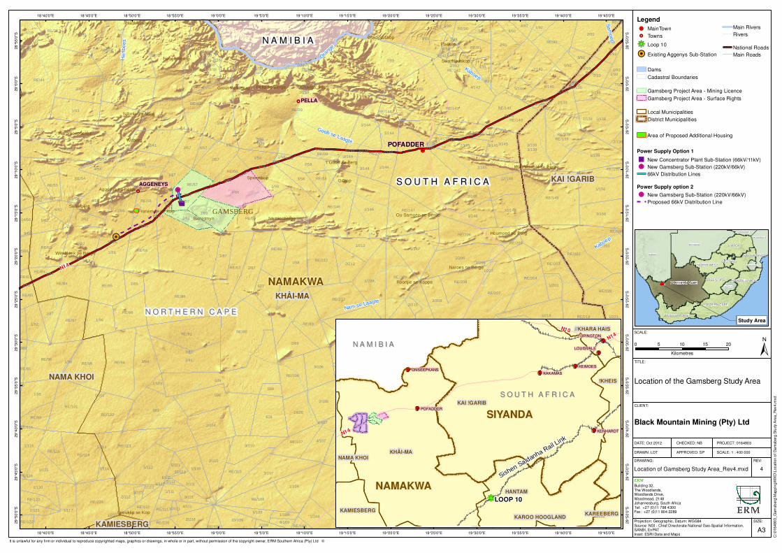
Black Mountain Mining (Pty) Ltd (herein referred to as Black Mountain), part of the global Vedanta mining group, intends to establish the new Gamsberg zinc mine and associated infrastructure near the town of Aggeneys, Northern Cape Province. Black Mountain currently operates a zinc, lead, copper and silver mine located near the town of Aggeneys, based on an existing mining right. Black Mountain also currently has a new order mining right and approved Environmental Management Programme (EMPr) for the zinc resources located within the Gamsberg inselberg 10 km east of Aggeneys. Black Mountain is presently mining 60,000 tons per annum (tpa) (metal production) from underground workings in the inselberg. The ore currently mined at the existing underground operation is transported to the Black Mountain concentrator plant in Aggeneys where it is processed with ore from the Black Mountain Deeps Mine.
Table 1.1 Black Mountain’s Current Mining Operations in Aggeneys and Gamsberg
Current Operations Minerals extracted Volume of ore extracted (tpa)
Existing Black Mountain Mine: Aggeneys.
Zinc, lead, copper and silver.
Zinc: 64,682 Lead: 74,645 Copper: 10,182 Silver: 54,26
Existing Gamsberg Mine. Zinc Zinc: 60,000
Black Mountain intends to establish a new 10 Million tpa (Mtpa) open pit zinc mine (beneficiation volume) in the Gamsberg inselberg together with a concentrator plant and associated infrastructure. Environmental Resources Management Southern Africa (Pty) Ltd (referred to as ERM) has been appointed to undertake the Environmental and Social Impact Assessment (ESIA) for the construction and operation of the new Gamsberg zinc mine and associated infrastructure. As the existing EMPr is based on mining activities currently being undertaken at Gamsberg, the EMPr will need to be amended in light of the new project description in terms of the Minerals Resources Petroleum Development Act (No 28 of 2002) (MPRDA). Furthermore, ERM will compile and submit an Integrated Water Use License Application (IWULA) for a variety of water uses in terms of the National Water Act (No 36 of 1998). Applications in terms of National Environmental Management (No 107 of 1998) (NEMA), National Environmental Management: Air Quality Act (No 39 of 2008) (NEM:AQA) and National Environmental Management:
ENVIRONMENTAL RESOURCES MANAGEMENT SCOPING REPORT FOR GAMSBERG ZINC MINE
2
Waste Act (No. 59 of 2008) (NEM:WA) have also been submitted. All legislative processes will be undertaken in an integrated manner, through the ESIA process as indicated in Figure 2.1 (refer to Figure 2.1: Integrated Flow Diagram of ESIA Process). The scoping process is the first phase of the ESIA process and aims to identify significant issues and determine the scope of the subsequent impact assessment phase. The scoping process culminates in the production of a scoping report, which includes a description of the proposed project, the affected environment, stakeholder engagement, environmental and social issues, potential impacts, potential alternatives and a detailed Plan of Study for the Impact Assessment phase. The stakeholder engagement process forms fundamental component of the ESIA process. All comments received will be used to help guide the planning and design phase of the Project. The Scoping Report therefore aims to: • Outline the proposed project and process to be followed; • Identify all environmental and social impacts of the proposed project; • Identify and address concerns raised by all stakeholders; • Identify feasible alternatives of the proposed project; and • Focus on significant environmental and social issues for further
investigation in the Impact Assessment phase. The regional location of the proposed project and associated transport corridor is presented in Figures 1.1 below, respectively.
DRAFT COPY
Legend!. MainTown
!Ç Towns
hg Loop 10
!H Existing Aggenys Sub-Station
Dams
Cadastral Boundaries
Gamsberg Project Area - Mining Licence
Gamsberg Project Area - Surface Rights
Local Municipalities
District Municipalities
!H
!Ç
!Ç
!Ç
!.
!.
�/
S O U T H A F R I C AS O U T H A F R I C A
N O R T H E R N C A P EN O R T H E R N C A P E
N A M I B I AN A M I B I A
NAMAKWA
PELLA
AGGENEYS
KHÂI-MA
KAI !GARIB
NAMA KHOI
KAMIESBERG
Gifkop
Platkop
Witberg
Bakenskop
Spioenkop
Swartberg
Barietmyn
GAMSBERG
Oskoperskop
Namiesberge
Hoogoorberg
Hartbeesberg
Swartspitskop
Haramoepberge
Charles' Pass
T'Goob se Berg
Pella se Berge
Leeuklip se Kop
Houmoed se Berg
Naroes se Berge
Froneman se Kop
Groot-Pellaberg
Aggenys se Berge
Sillimanite Mine
Poortjie se Koppe
Windhoek se Berge
Ou Samoep se Berge
Mattheusgat se Berge
RE/39
2
1
9
639
599
RE/6
7/89
598
RE/86
RE/61
RE/37
RE/44
627
RE/90
RE/38
1/88
1/91
1/56
RE/149
1/146
1/4
1/36
628
RE/53
4/60
1/42
RE/59
RE/94
1/3
RE/7
2/87
RE/236
RE/237
RE/207
167
1/94
1/145
RE/231
1/206
1/91
RE/146
RE/91
1/53
3/107
1/139
RE/98
5/112
1/58
3/1393/139
1/1381/138
RE/202
RE/216
1/41
RE/95
2/7
2/41
1/209
2/925/89
3/62
RE/84
1/147
RE/204
RE/232
1/40
RE/113
RE/40
2/54
RE/213
RE/101
RE/1411/43
2/43
RE/236
RE/147
2/104
RE/143
1/214
RE/206
RE/56
RE/42
1/117
3/208
RE/36
1/99
1/7
1/60
2/57
1/215
RE/4
RE/114
RE/203
RE/201
1/57
1/2181/96
1/108
2/110
2/89
1/227
1/229
RE/87
RE/41
RE/85
RE/3
RE/102
RE/62
RE/97
2/89
3/150
1/213
4/62
RE/209
RE/54
RE/139RE/139
1/150
RE/212
RE/31
2/91
1/294
1/230
1/56
161
RE/92
1/217
1/293
1/233
2/106
3/110
1/628
3/106
RE/56
RE/88
RE/43
2/148
1/238
3/57
RE/108
9/148
RE/96
RE/218
6/140
2/144
RE/219
1/87
1/115
1/219
10/148
1/82
3/1453/145
1/160
4/107
RE/230
2/58
RE/208
RE/89
3/138
RE/215
5/62
1/116RE/293
1/110
RE/294
1/228
RE/233
1/97
RE/217
2/228
RE/106
3/58
1/168
RE/220
157
1/58
2/212
1/212
RE/142
RE/227
RE/292
RE/388
RE/110
396
RE/140
2/238
2/160
1/144
2/214
4/142
1/140
RE/115
12/148
RE/107
6/62
4/93
2/62
RE/57
RE/228
2/145
1/144
1/120
1/61
2/229
RE/144
2/139
1/85
2/93
1/29
1/931/93
10/109
1/221
2/10
RE/91
5/92
RE/214
RE/99
RE/112
RE/145
4/54RE/60
2/112
RE/30
1/232
RE/140
3/144
2/111
4/91
6/91
1/203
5/91
5/66
2/93
RE/58
2/144
598
5/109
1/92
4/66
1/111
RE/90
4/57
RE/55
1/161158
RE/150
5/140
4/92
2/121
3/92
14/66
RE/83
RE/120
2/219
RE/229
1/114
1/90
9/111
4/111
RE/39
RE/57
RE/84
RE/111
3/38
5/111
2/145
2/227
RE/160RE/2382/109
1/109
1/103
3/62
8/109
7/93
2/138
1/38
RE/109
1/292
2/58
1/112
1/62
RE/168
1/237
3/54
4/93
4/89
580
RE/83
2/215
RE/229
1/142
RE/122
RE/145
3/112
2/6
2/293
6/140
2/388
RE/205
2/38
RE/81
1/207
10/111
2/206
3/91
1/54
11/111
2/139
3/111
RE/29
3/142
1/6
1/89
1/98
4/166
1/102
11/39
1/57
12/39
9/66RE/200
3/138
80
RE/61
4/145
6/111
3/58
RE/144
RE/116
2/56
8/140
8/93
5/60
9/93
1/145
7/145
1/84
14/39
7/57
7/39
10/39
8/62
12/56
9/140
8/145
RE/45
4/58
13/56
2/91
4/139
7/144
5/58
6/1444/144
9/39
1/113
2/39
1/83
6/57
4/138
RE/116
2/142
5/57
4/107
RE/78
5/39
4/112
Kaboep
Ora
nge
Nam se Laagte
Goob se Laagte
Ha
rtb
ee
s
N14
POFADDER
Sa
mo
ep
Kaboep
19°45'0"E
19°45'0"E
19°40'0"E
19°40'0"E
19°35'0"E
19°35'0"E
19°30'0"E
19°30'0"E
19°25'0"E
19°25'0"E
19°20'0"E
19°20'0"E
19°15'0"E
19°15'0"E
19°10'0"E
19°10'0"E
19°5'0"E
19°5'0"E
19°0'0"E
19°0'0"E
18°55'0"E
18°55'0"E
18°50'0"E
18°50'0"E
18°45'0"E
18°45'0"E
18°40'0"E
18°40'0"E28
°55
'0"S
28
°55
'0"S
29
°0'0
"S
29
°0'0
"S
29
°5'0
"S
29
°5'0
"S
29
°10
'0"S
29
°10
'0"S
29
°15
'0"S
29
°15
'0"S
29
°20
'0"S
29
°20
'0"S
29
°25
'0"S
29
°25
'0"S
29
°30
'0"S
29
°30
'0"S
29
°35
'0"S
29
°35
'0"S
29
°40
'0"S
29
°40
'0"S
29
°45
'0"S
29
°45
'0"S
29
°50
'0"S
29
°50
'0"S
SIZE:
TITLE:
DATE: Oct 2012
DRAWN: LDT
CHECKED: NB
APPROVED: SP
PROJECT: 0164903
SCALE: 1 : 400 000
DRAWING: REV:
A3
Location of the Gamsberg Study Area
Location of Gamsberg Study Area_Rev4.mxd 4
CLIENT:
ERM
Building 32,The Woodlands,Woodlands Drive,Woodmead, 2148Johannesburg, South AfricaTel: +27 (0)11 798 4300Fax: +27 (0)11 804 2289
±0 5 10 15 20
Kilometres
SCALE:
C:\0
16
490
3_
Gam
sberg
\Map
pin
g\M
XD
\Location o
f G
am
sberg
Stu
dy A
rea_
Rev4.m
xd
Black Mountain Mining (Pty) Ltd
Projection: Geographic, Datum: WGS84Source: NGI - Chief Directorate National Geo-Spatial Information,SANBI, EnPATInset: ESRI Data and Maps
It is unlawful for any firm or individual to reproduce copyrighted maps, graphics or drawings, in whole or in part, without permission of the copyright owner, ERM Southern Africa (Pty) Ltd �
NAMIBIA
BOTSWANA
NORTHERN CAPE
LIMPOPO
EASTERN CAPE
FREE STATE
WESTERN CAPE
NORTH WEST
MOZAMBIQUE
KWAZULU-NATAL
MPUMALANGA
LESOTHO
ZIMBABWE
GAUTENG
SWAZILAND
Study Area
hg
N A M I B I AN A M I B I A
S O U T H A F R I C AS O U T H A F R I C A
Sishen Saldanha R
ail Link
LOOP 10
SIYANDA
NAMAKWA
KAI !GARIB
KHÂI-MA
HANTAM
!KHEIS
//KHARA HAIS
KAMIESBERG
NAMA KHOI
KAREEBERGKAROO HOOGLAND
N14
N10
N14
KEIMOES
KAKAMAS
UPINGTON
KENHARDT
POFADDER
LOUISVALE
ONSEEPKANS
Power Supply Option 1
�/ New Concentrator Plant Sub-Station (66kV/11kV)
!. New Gamsberg Sub-Station (220kV/66kV)
66kV Distribution Lines
Power Supply option 2
!. New Gamsberg Sub-Station (220kV/66kV)
Proposed 66kV Distribution Line
Main Rivers
Rivers
National Roads
Main Roads
Area of Proposed Additional Housing
ENVIRONMENTAL RESOURCES MANAGEMENT SCOPING REPORT FOR GAMSBERG ZINC MINE
4
1.2 BACKGROUND TO GAMSBERG MINE
In 1971, zinc deposits were discovered at Gamsberg by O’okiep Copper Company (Newmont). In 1988 Gold Field bought Newmont’s interest in Gamsberg, however the mine was not developed due to unfavourable market conditions. In 1988, Anglo American Corporation acquired the site and completed prefeasibility and feasibility investigations in order to explore the viability of mining the zinc deposit. The feasibility investigations included an ESIA which addressed the open pit mine development together with all associated infrastructure. The necessary approvals for the mining right and associated EMPr were obtained in 2000. An amendment to this EMPr was approved in 2003 to mine a small part of the deposit underground. This amended EMPr was expanded in 2005 to include the current authorised extraction volumes and concentrate processing at Black Mountain Processing Plant. An additional amendment was made to the EMPr and an EIA and EMP amendment submitted in 2009 for surface exploration along the north eastern section of Gamsberg was subsequently approved. Apart for the abovementioned EMPr all other approvals obtained previously by Anglo American have lapsed. Vedanta Resource Plc. has recently acquired the Black Mountain Mining (Pty) Ltd, from Anglo American Corporation. Due to changes to the environmental legislation and original project description, a new ESIA process will need to be undertaken to obtain the necessary approvals for the mine and associated infrastructure. The ESIA process will address the gaps in knowledge identified and provide a detailed assessment of potential impacts (refer to Figure 2.1: Integrated Flow Diagram of ESIA Process).
1.3 PROPERTY DETAILS
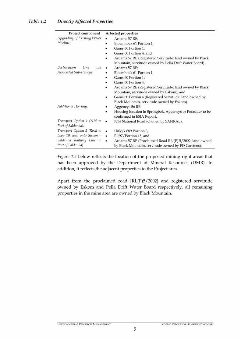
The Project area is located across four properties, which are owned by Black Mountain. In addition to the open pit zinc mine, associated infrastructure in the form of tailings dam, waste rock dump sites and a zinc concentrator will be located on the following properties rezoned for this purpose during 2001 (Reference number HRN/FF/1/8 – Namaqua District): • Bloemhoek 61 Portion 1; • Gams 60 Portion 1; • Aroams 57 RE; and • Gams 60 Portion 4. In light of associated infrastructure, all directly affected properties are presented below, per project components:
ENVIRONMENTAL RESOURCES MANAGEMENT SCOPING REPORT FOR GAMSBERG ZINC MINE
5
Table 1.2 Directly Affected Properties
Project component Affected properties Upgrading of Existing Water Pipeline.
• Aroams 57 RE; • Bloemhoek 61 Portion 1; • Gams 60 Portion 1; • Gams 60 Portion 4; and • Aroams 57 RE (Registered Servitude: land owned by Black
Mountain, servitude owned by Pella Drift Water Board). Distribution Line and Associated Sub-stations.
• Aroams 57 RE; • Bloemhoek 61 Portion 1; • Gams 60 Portion 1; • Gams 60 Portion 4; • Aroams 57 RE (Registered Servitude: land owned by Black
Mountain, servitude owned by Eskom); and • Gams 60 Portion 4 (Registered Servitude: land owned by
Black Mountain, servitude owned by Eskom). Additional Housing. • Aggeneys 56 RE.
• Housing location in Springbok, Aggeneys or Pofadder to be confirmed in ESIA Report.
Transport Option 1 (N14 to Port of Saldanha).
• N14 National Road (Owned by SANRAL).
Transport Option 2 (Road to Loop 10, load onto Sishen – Saldanha Railway Line to Port of Saldanha).
• Uitkyk 889 Portion 3; • F 197/Portion 15; and • Aroams 57 RE (Proclaimed Road RL (P) 5/2002: land owned
by Black Mountain, servitude owned by PD Carstens). Figure 1.2 below reflects the location of the proposed mining right areas that has been approved by the Department of Mineral Resources (DMR). In addition, it reflects the adjacent properties to the Project area. Apart from the proclaimed road [RL(P)5/2002] and registered servitude owned by Eskom and Pella Drift Water Board respectively, all remaining properties in the mine area are owned by Black Mountain.
DRAFT COPY
LegendCadastral Farm Portions
Black Mountain Mine Area - Mining Licence
Gamsberg Project Area - Mining Licence
Gamsberg Project Area - Surface RightsRE/39
RE/61
1/88
1/56
4/60
RE/59
RE/86
2/87
1/42
1/58
2/41
RE/56
1/60
2/57
1/57
1/40
RE/41
1/41
RE/87
RE/56
RE/88
1/56
627
3/57
1/87
3/58
1/58
RE/85
RE/212
2/58
RE/57
1/61
1/85
RE/60
4/62
RE/40
RE/146
RE/534/57
4/54
RE/57
RE/58
627
RE/213
RE/39
2/583/54
RE/96 RE/90
2/62
1/57
RE/61
3/62
RE/54
3/58
RE/42
RE/89
2/56
5/60
7/57
7/39
12/56
4/58
13/56
14/39
8/39
5/58
9/39
6/57
2/61
1/61
6/58
5/57
19°10'0"E
19°10'0"E
19°5'0"E
19°5'0"E
19°0'0"E
19°0'0"E
18°55'0"E
18°55'0"E
18°50'0"E
18°50'0"E29
°5'0
"S
29
°5'0
"S
29
°10
'0"S
29
°10
'0"S
29
°15
'0"S
29
°15
'0"S
29
°20
'0"S
29
°20
'0"S
29
°25
'0"S
29
°25
'0"S SIZE:
TITLE:
DATE: Sept 2012
DRAWN: LDT
CHECKED: NB
APPROVED: SP
PROJECT: 0164903
SCALE: 1 : 150 000
DRAWING: REV:
A3
Cadastral Portions within the Gamsberg Mining Areas
Cadastral Portions within the Gamsberg Mining Areas.mxd
3
CLIENT:
ERM
Building 32,The Woodlands,Woodlands Drive,Woodmead, 2148Johannesburg, South AfricaTel: +27 (0)11 798 4300Fax: +27 (0)11 804 2289
±0 2 4 6 8
Kilometres
SCALE:
C:\0
16
490
3_
Gam
sberg
\Map
pin
g\M
XD
\Ca
da
stra
l P
ort
ions w
ithin
the G
am
sberg
Min
ing A
reas.
mxd
Black Mountain Mining (Pty) Ltd
Projection: Geographic, Datum: WGS84Source: NGI - Chief Directorate National Geo-Spatial Information,SANBI, EnPATInset: ESRI Data and Maps
It is unlawful for any firm or individual to reproduce copyrighted maps, graphics or drawings, in whole or in part, without permission of the copyright owner, ERM Southern Africa (Pty) Ltd �
NAMIBIA
BOTSWANA
NORTHERN CAPE
LIMPOPO
EASTERN CAPE
FREE STATE
WESTERN CAPE
NORTH WEST
MOZAMBIQUE
KWAZULU-NATAL
MPUMALANGA
LESOTHO
ZIMBABWE
GAUTENG
SWAZILAND
Study Area
ENVIRONMENTAL RESOURCES MANAGEMENT SCOPING REPORT FOR GAMSBERG ZINC MINE
7
1.4 HOLDER OF THE MINING RIGHT
Rights to Mineral Resources
Black Mountain Mining (Pty) Ltd currently has a mining right over the Gamsberg zinc ore deposit, which extends across Bloemhoek 61 Portion 1, Gams 60 Portion 1, and Aroams 57 RE. The existing mining right covers a total area of 9,505.7 hectares which includes the Gamsberg inselberg itself. A new order mining right was submitted during 2006 (Licence number ML003200). A new order mining right was issued to Black Mountain (Anglo Operations Ltd) in August 2008 and then ceded to Black Mountain Mining (PTY) Ltd in September 2008. An illustration of the mining license area, for both Black Mountain and the proposed Gamsberg mine, is reflected in Figure 1.2 above. Discoverer's Certificate
The zinc ore reserve was discovered by the O’okiep Copper Company & Newmont in 1971. A copy of the Discoverers certificate is currently being sourced from the DMR.
1.5 ASSUMPTIONS AND LIMITATIONS
During the compilation of this Scoping Report, the following limitations and assumptions were made: • Information sourced from secondary sources is correct. • The scope of the ESIA process is limited to the Gamsberg mine, the
associated infrastructure (including concentrator plant, waste rock dumps, tailings dams, internal road network, housing, workshops etc.) and transport options to the Port of Saldanha and Loop 10. It is assumed at this stage that the infrastructure requirements at the Port of Saldanha will not be substantial and will not trigger any listed activities in terms of the National Environmental Management Act (No. 107 of 1998) and associated Acts.
• The report was prepared based on the most up to date project description provided. The project description may change as the design for the mine and associated infrastructure is developed in more detail.
• All information received from the applicant and associated engineering consultant team is accurate.
• The financial and technical motivation for open pit mining, as received from Black Mountain is robust and accurate.
• Study takes cognisance of the associated works and applications made by the Pella Drift Water Board (PDWB) for a Basic Assessment process to upgrade their water infrastructure. A General Water Use Application will also be made on behalf of the PDWB.
ENVIRONMENTAL RESOURCES MANAGEMENT SCOPING REPORT FOR GAMSBERG ZINC MINE
8
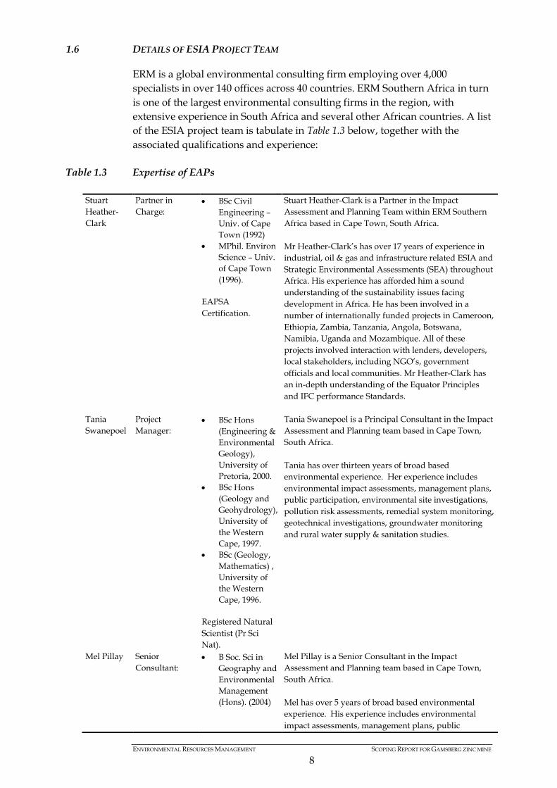
1.6 DETAILS OF ESIA PROJECT TEAM
ERM is a global environmental consulting firm employing over 4,000 specialists in over 140 offices across 40 countries. ERM Southern Africa in turn is one of the largest environmental consulting firms in the region, with extensive experience in South Africa and several other African countries. A list of the ESIA project team is tabulate in Table 1.3 below, together with the associated qualifications and experience:
Table 1.3 Expertise of EAPs
Stuart Heather-Clark
Partner in Charge:
• BSc Civil Engineering – Univ. of Cape Town (1992)
• MPhil. Environ Science – Univ. of Cape Town (1996).
EAPSA Certification.
Stuart Heather-Clark is a Partner in the Impact Assessment and Planning Team within ERM Southern Africa based in Cape Town, South Africa. Mr Heather-Clark’s has over 17 years of experience in industrial, oil & gas and infrastructure related ESIA and Strategic Environmental Assessments (SEA) throughout Africa. His experience has afforded him a sound understanding of the sustainability issues facing development in Africa. He has been involved in a number of internationally funded projects in Cameroon, Ethiopia, Zambia, Tanzania, Angola, Botswana, Namibia, Uganda and Mozambique. All of these projects involved interaction with lenders, developers, local stakeholders, including NGO’s, government officials and local communities. Mr Heather-Clark has an in-depth understanding of the Equator Principles and IFC performance Standards.
Tania Swanepoel
Project Manager:
• BSc Hons (Engineering & Environmental Geology), University of Pretoria, 2000.
• BSc Hons (Geology and Geohydrology), University of the Western Cape, 1997.
• BSc (Geology, Mathematics) , University of the Western Cape, 1996.
Registered Natural Scientist (Pr Sci Nat).
Tania Swanepoel is a Principal Consultant in the Impact Assessment and Planning team based in Cape Town, South Africa. Tania has over thirteen years of broad based environmental experience. Her experience includes environmental impact assessments, management plans, public participation, environmental site investigations, pollution risk assessments, remedial system monitoring, geotechnical investigations, groundwater monitoring and rural water supply & sanitation studies.
Mel Pillay Senior Consultant:
• B Soc. Sci in Geography and Environmental Management (Hons). (2004)
Mel Pillay is a Senior Consultant in the Impact Assessment and Planning team based in Cape Town, South Africa. Mel has over 5 years of broad based environmental experience. His experience includes environmental impact assessments, management plans, public
ENVIRONMENTAL RESOURCES MANAGEMENT SCOPING REPORT FOR GAMSBERG ZINC MINE
9
participation and environmental control services.
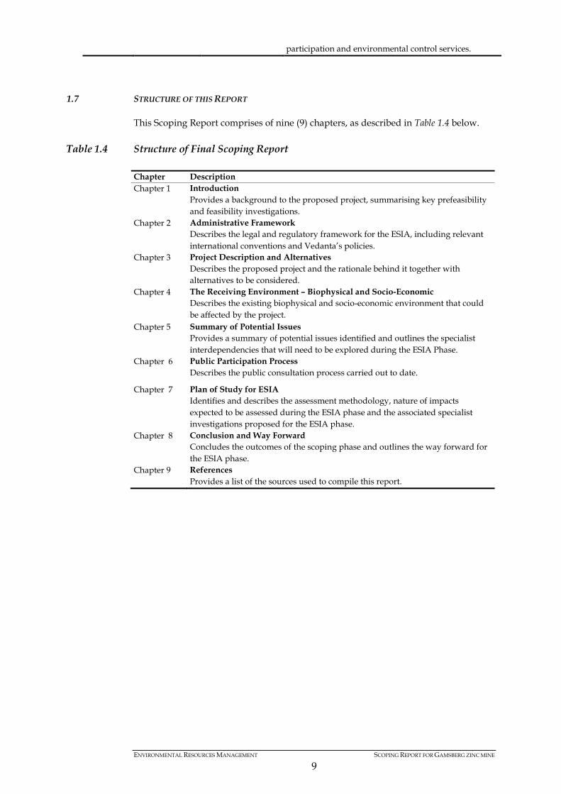
1.7 STRUCTURE OF THIS REPORT
This Scoping Report comprises of nine (9) chapters, as described in Table 1.4 below.
Table 1.4 Structure of Final Scoping Report
Chapter Description Chapter 1 Introduction
Provides a background to the proposed project, summarising key prefeasibility and feasibility investigations.
Chapter 2 Administrative Framework Describes the legal and regulatory framework for the ESIA, including relevant international conventions and Vedanta’s policies.
Chapter 3 Project Description and Alternatives Describes the proposed project and the rationale behind it together with alternatives to be considered.
Chapter 4 The Receiving Environment – Biophysical and Socio-Economic Describes the existing biophysical and socio-economic environment that could be affected by the project.
Chapter 5 Summary of Potential Issues Provides a summary of potential issues identified and outlines the specialist interdependencies that will need to be explored during the ESIA Phase.
Chapter 6 Public Participation Process Describes the public consultation process carried out to date.
Chapter 7 Plan of Study for ESIA Identifies and describes the assessment methodology, nature of impacts expected to be assessed during the ESIA phase and the associated specialist investigations proposed for the ESIA phase.
Chapter 8 Conclusion and Way Forward Concludes the outcomes of the scoping phase and outlines the way forward for the ESIA phase.
Chapter 9 References Provides a list of the sources used to compile this report.

ENVIRONMENTAL RESOURCES MANAGEMENT SCOPING REPORT FOR GAMSBERG ZINC MINE
10
2 ADMINISTRATIVE FRAMEWORK
The proposed Gamsberg mine is subject to legislative and policy requirements at national, provincial and local level as well as international guidelines and conventions. This chapter presents a summary of the administrative framework governing the development of the proposed mine. It focuses on legal requirements related to environmental licensing of activities, as well as legal requirements for environmental protection such as: standards for environmental quality control and pollution, biodiversity protection, and natural, cultural and historic heritage sites. Besides the legal requirements for environmental protection, the legal requirements, policy guidelines and international requirements pertaining to social aspects, public participation and socio-economic aspects are also adhered to through this ESIA process. Also applicable are ISO 14-001 standards currently applied by Black Mountain Mine, the Mining Charter and Vedanta’s Corporate Standards which will govern project related activities.
2.1 NATIONAL LEGISLATIVE AND POLICY REQUIREMENTS
2.1.1 National Environmental Management Act (No 107 of 1998) (NEMA) and the National Environmental Management Amendment Act (No 62 of 2008)
NEMA requires that the potential impact on the environment, socio-economic conditions, and cultural heritage of activities that require authorisation or permission by law must be considered, investigated and assessed prior to implementation, and reported to the relevant authority. An EIA Application was submitted to the Department of Environment and Nature Conservation (DENC) to formally initiate the ESIA process on 26 June 2012 (Reference number: NC/EIA/NAM/KHAI/AGG/2012-NCP/EIA/0000155/2012) (attached as Annex A). The EIA Regulations (R543) promulgated in terms of the NEMA, identifies a suite of activities, which “could have a substantial detrimental effect on the environment”. The listed activities identified require an environmental authorisation from the environmental authority, i.e. the Provincial Department of Environment and Nature Conservation (DENC), prior to commencement of the activity. The proposed zinc mine and associated infrastructure triggers a list of activities, tabulated in Table 2.1 below. Activities listed in terms of R544 and R546 require a Basic Assessment, while activities listed in R545 require a full Scoping and EIA process. Despite the proposed project triggering the need for a Basic Assessment process, a single Scoping and ESIA process will be undertaken to meet the requirements in terms of NEMA.

ENVIRONMENTAL RESOURCES MANAGEMENT SCOPING REPORT FOR GAMSBERG ZINC MINE
11
Table 2.1 Listed Activities in Terms of NEMA EIA Regulations Government Notice R544 of 2010 (Basic Assessment)
Applicability to Project
Activity 9
The construction of facilities or infrastructure exceeding 1000 metres in length for the bulk transportation of water, sewage or storm water - i) with an internal diameter of 0,36 metres or more; or ii) with a peak throughput of 120 litres per second or
more, excluding where:
a) such facilities or infrastructure are for bulk transportation of water, sewage or storm water or storm water drainage inside a road reserve; or
b) where such construction will occur within urban areas but further than 32 metres from a watercourse, measured from the edge of the watercourse.
Construction of an off-take water pipeline (550 mm) from the existing PDWB water pipeline to the Gamsberg mine.
Activity 10
The construction of facilities or infrastructure for the transmission and distribution of electricity - i) outside urban areas or industrial complexes with a
capacity of more than 33 but less than 275 kilovolts; or ii) inside urban areas or industrial complexes with a
capacity of 275 kilovolts or more.
Construction of a 220 kV transmission line.
Activity 11
The construction of: i. canals;
ii. channels; iii. bridges; iv. dams; v. weirs;
vi. bulk storm water outlet structures; vii. marinas;
viii. jetties exceeding 50 square metres in size; ix. slipways exceeding 50 square metres in size; x. buildings exceeding 50 square metres in size; or
xi. infrastructure or structures covering 50 square metres or more;
where such construction occurs within a watercourse or within 32 metres of a watercourse, measured from the edge of a watercourse, excluding where such construction will occur behind the development setback line.
Mine infrastructure exceeding 50 m2 will be located within 32 m of a watercourse.
Activity 12
The construction of facilities or infrastructure for the off-stream storage of water, including dams and reservoirs, with a combined capacity of 50 000 cubic metres or more, unless such storage falls within the ambit of activity 19 of Notice 545 of 2010.
On-site dams for raw water, potable water and dirty water will be constructed.
Activity 18
The infilling or depositing of any material of more than 5 cubic metres into, or the dredging, excavation, removal or moving of soil, sand, shells, shell grit, pebbles or rock or more than 5 cubic metres from: i) a watercourse; ii) the sea; iii) the seashore; iv) the littoral active zone, an estuary or a distance of 100
metres inland of the highwater mark of the sea or an estuary, whichever distance is the greater but
The upgrading of the existing water pipeline will require excavation and infilling into a watercourse that will exceed 5m3.
ENVIRONMENTAL RESOURCES MANAGEMENT SCOPING REPORT FOR GAMSBERG ZINC MINE
12
excluding where such infilling, depositing , dredging, excavation, removal or moving;
a) is for maintenance purposes undertaken in accordance with a management plan agreed to by the relevant environmental authority; or
b) occurs behind the development setback line.
Activity 22
The construction of a road, outside urban areas, i) with a reserve wider than 13,5 meters or, ii) where no reserve exists where the road is wider than 8
metres, or iii) for which an environmental authorisation was
obtained for the route determination in terms of activity 5 in Government Notice 387 of 2006 or activity 18 in Notice 545 of 2010.
Internal haul roads within the Project area are expected to have a reserve wider than 13.5 m. Service roads with different reserves will also be constructed.
Activity 23
The transformation of undeveloped, vacant or derelict land to – i) residential, retail, commercial, recreational, industrial
or institutional use, inside an urban area, and where the total area to be transformed is 5 hectares or more, but less than 20 hectares, or
ii) residential, retail, commercial, recreational, industrial or institutional use, outside an urban area and where the total area to be transformed is bigger than 1 hectare but less than 20 hectares;
except where such transformation takes place – i) for linear activities; or ii) for purposes of agriculture or afforestation, in which
case Activity 16 of Notice No. R. 545 applies.
The Project area exceeds 5 hectares.
Activity 26 Any process or activity identified in terms of section 53(1) of the National Environmental Management: Biodiversity Act, 2004 (Act No. 10 of 2004).
To be confirmed, upon completion of the botanical impact assessment.
Activity 47
The widening of a road by more than 6 metres, or the lengthening of a road by more than 1 kilometre – i) where the existing reserve is wider than 13,5 meters;
or ii) where no reserve exists, where the existing road is
wider than 8 metres – excluding widening or lengthening occurring inside urban areas.
Existing gravel roads within and around the site may need to be widened to accommodate for the traffic flow.
Government Notice R545 of 2010 (Full Scoping and EIA)
Activity 3
The construction of facilities or infrastructure for the storage, or storage and handling of a dangerous good, where such storage occurs in containers with a combined capacity of more than 500 cubic meters.
Proposed storage of fuel on-site that exceeds 500 m3.
Activity 5
The construction of facilities or infrastructure for any process or activity which requires a permit or license in terms of national or provincial legislation governing the generation or release of emissions, pollution or effluent and which is not identified in Notice No. 544 of 2010 or included in the list of waste management activities published in terms of section 19 of the National Environmental Management: Waste Act, 2008 (Act No. 59 of 2008) in which case that Act will apply.
The process of concentration will result in the production of effluent.
Activity 11 The construction of railway lines, stations or shunting yards, excluding railway lines, shunting yards and railway stations in industrial complexes or underground
In order to facilitate the transport of concentrate to Port of
ENVIRONMENTAL RESOURCES MANAGEMENT SCOPING REPORT FOR GAMSBERG ZINC MINE
13
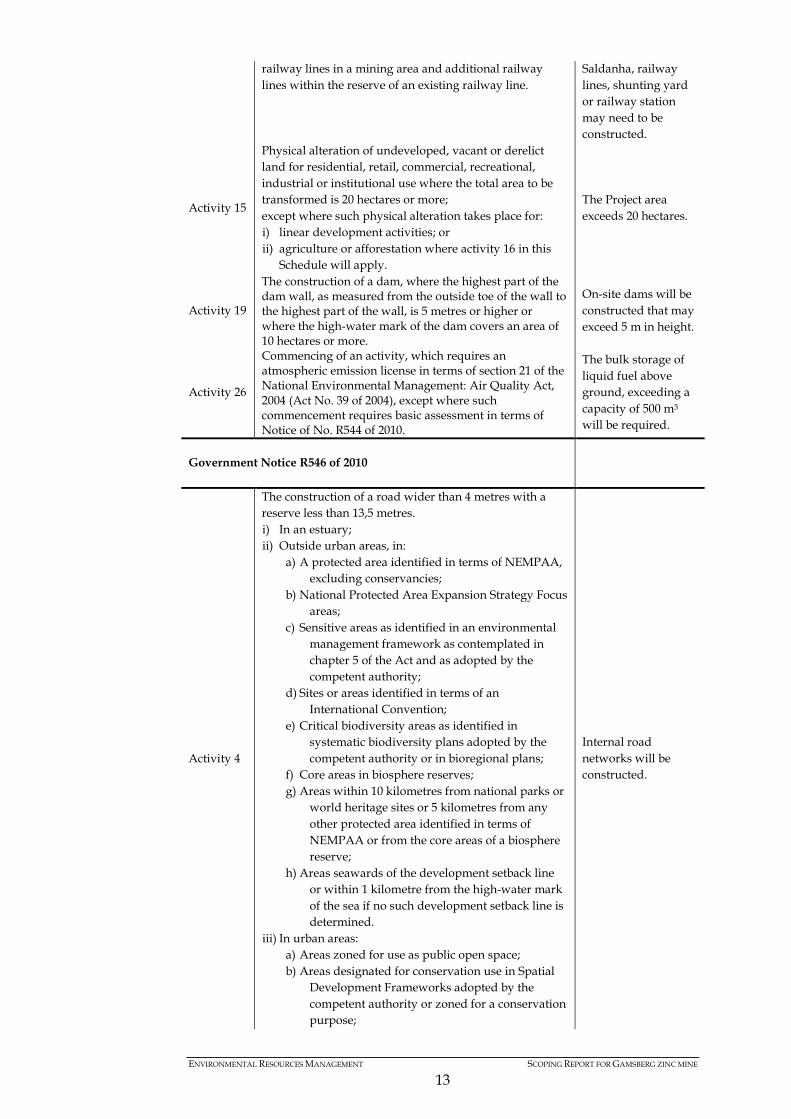
railway lines in a mining area and additional railway lines within the reserve of an existing railway line.
Saldanha, railway lines, shunting yard or railway station may need to be constructed.
Activity 15
Physical alteration of undeveloped, vacant or derelict land for residential, retail, commercial, recreational, industrial or institutional use where the total area to be transformed is 20 hectares or more; except where such physical alteration takes place for: i) linear development activities; or ii) agriculture or afforestation where activity 16 in this
Schedule will apply.
The Project area exceeds 20 hectares.
Activity 19
The construction of a dam, where the highest part of the dam wall, as measured from the outside toe of the wall to the highest part of the wall, is 5 metres or higher or where the high-water mark of the dam covers an area of 10 hectares or more.
On-site dams will be constructed that may exceed 5 m in height.
Activity 26
Commencing of an activity, which requires an atmospheric emission license in terms of section 21 of the National Environmental Management: Air Quality Act, 2004 (Act No. 39 of 2004), except where such commencement requires basic assessment in terms of Notice of No. R544 of 2010.
The bulk storage of liquid fuel above ground, exceeding a capacity of 500 m3 will be required.
Government Notice R546 of 2010
Activity 4
The construction of a road wider than 4 metres with a reserve less than 13,5 metres. i) In an estuary; ii) Outside urban areas, in:
a) A protected area identified in terms of NEMPAA, excluding conservancies;
b) National Protected Area Expansion Strategy Focus areas;
c) Sensitive areas as identified in an environmental management framework as contemplated in chapter 5 of the Act and as adopted by the competent authority;
d) Sites or areas identified in terms of an International Convention;
e) Critical biodiversity areas as identified in systematic biodiversity plans adopted by the competent authority or in bioregional plans;
f) Core areas in biosphere reserves; g) Areas within 10 kilometres from national parks or
world heritage sites or 5 kilometres from any other protected area identified in terms of NEMPAA or from the core areas of a biosphere reserve;
h) Areas seawards of the development setback line or within 1 kilometre from the high-water mark of the sea if no such development setback line is determined.
iii) In urban areas: a) Areas zoned for use as public open space; b) Areas designated for conservation use in Spatial
Development Frameworks adopted by the competent authority or zoned for a conservation purpose;
Internal road networks will be constructed.
ENVIRONMENTAL RESOURCES MANAGEMENT SCOPING REPORT FOR GAMSBERG ZINC MINE
14
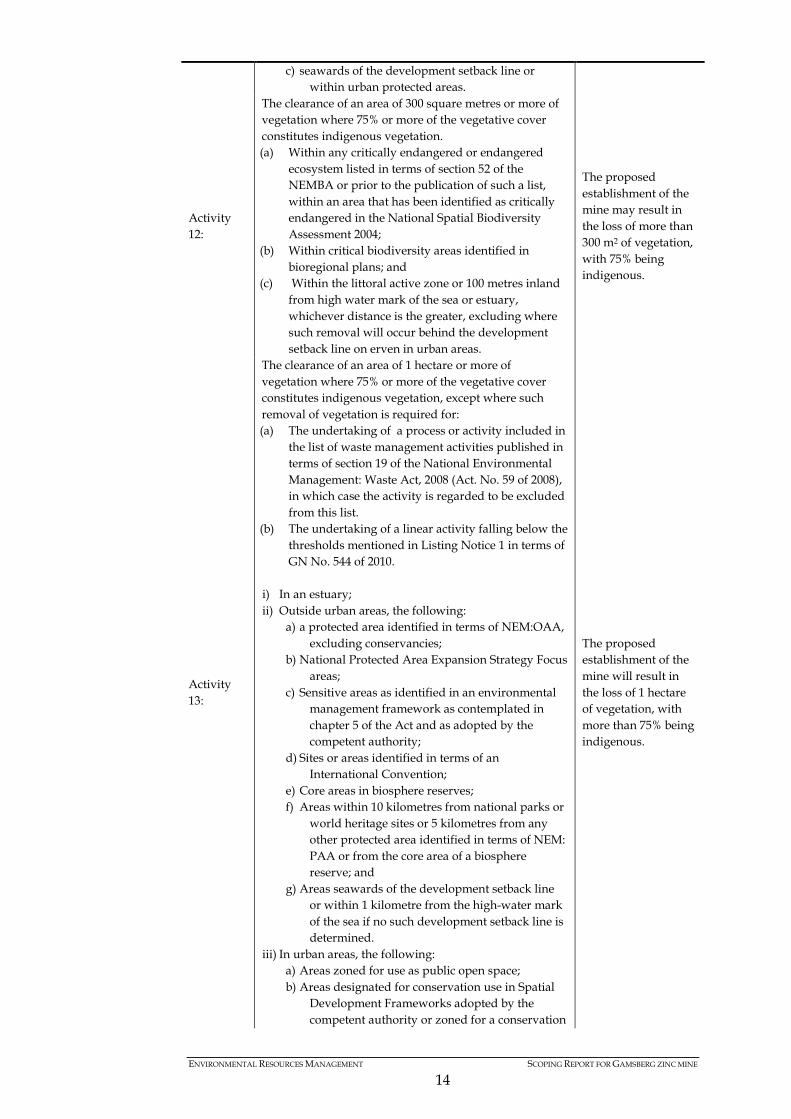
c) seawards of the development setback line or within urban protected areas.
Activity 12:
The clearance of an area of 300 square metres or more of vegetation where 75% or more of the vegetative cover constitutes indigenous vegetation. (a) Within any critically endangered or endangered
ecosystem listed in terms of section 52 of the NEMBA or prior to the publication of such a list, within an area that has been identified as critically endangered in the National Spatial Biodiversity Assessment 2004;
(b) Within critical biodiversity areas identified in bioregional plans; and
(c) Within the littoral active zone or 100 metres inland from high water mark of the sea or estuary, whichever distance is the greater, excluding where such removal will occur behind the development setback line on erven in urban areas.
The proposed establishment of the mine may result in the loss of more than 300 m2 of vegetation, with 75% being indigenous.
Activity 13:
The clearance of an area of 1 hectare or more of vegetation where 75% or more of the vegetative cover constitutes indigenous vegetation, except where such removal of vegetation is required for: (a) The undertaking of a process or activity included in
the list of waste management activities published in terms of section 19 of the National Environmental Management: Waste Act, 2008 (Act. No. 59 of 2008), in which case the activity is regarded to be excluded from this list.
(b) The undertaking of a linear activity falling below the thresholds mentioned in Listing Notice 1 in terms of GN No. 544 of 2010.
i) In an estuary; ii) Outside urban areas, the following:
a) a protected area identified in terms of NEM:OAA, excluding conservancies;
b) National Protected Area Expansion Strategy Focus areas;
c) Sensitive areas as identified in an environmental management framework as contemplated in chapter 5 of the Act and as adopted by the competent authority;
d) Sites or areas identified in terms of an International Convention;
e) Core areas in biosphere reserves; f) Areas within 10 kilometres from national parks or
world heritage sites or 5 kilometres from any other protected area identified in terms of NEM: PAA or from the core area of a biosphere reserve; and
g) Areas seawards of the development setback line or within 1 kilometre from the high-water mark of the sea if no such development setback line is determined.
iii) In urban areas, the following: a) Areas zoned for use as public open space; b) Areas designated for conservation use in Spatial
Development Frameworks adopted by the competent authority or zoned for a conservation
The proposed establishment of the mine will result in the loss of 1 hectare of vegetation, with more than 75% being indigenous.

ENVIRONMENTAL RESOURCES MANAGEMENT SCOPING REPORT FOR GAMSBERG ZINC MINE
15
purpose; c) Areas seawards of the development setback line;
and d) Areas on the watercourse side of the development
setback line or within 100 metres from the edge of a watercourse where no such setback line has been determined.
Activity 14:
The clearance of an area of 5 hectares or more of vegetation where 75% or more of the vegetative cover constitutes indigenous vegetation.
i) All areas outside urban areas.
The proposed establishment of the mine may result in the loss of 5 hectares of vegetation, with 75% being indigenous.
Activity 16
The construction of: i) infrastructure covering 10 square metres or more; where such construction occurs within a watercourse or within 32 metres of a watercourse, measured from the edge of a watercourse, excluding where such construction will occur behind the development setback line.
Infrastructure exceeding 10 m2 will be constructed within 32m of a watercourse.
Activity 19 The widening of a road by more than 4 metres, or the lengthening of a road by more than 1 kilometre.
Existing road networks may need to be widened or lengthened by more than 4 m or 1 km, respectively.
In terms of Section 28 of the EIA Regulations (2010), a scoping report must contain, as a minimum, the following information requirements:
Table 2.2 Information Requirements for Scoping Reports
(a) Details of: Relevant section (i) the EAP who prepared the report; Section 1.6 (ii) the expertise of the EAP to carry out Scoping procedures; Section 1.6
(b) a description of the proposed activity and of any feasible reasonable alternatives that have been identified;
Chapter 3
(c) a description of the property on which the activity is to be undertaken and the location of the activity on the property, or if it is:
Section 1.3
(i) a linear activity, a description of the route of the activity; or Section 1.3 (ii) an ocean-based activity, the coordinates where the activity is to be undertaken;
Not applicable
(d) a description of the environment that may be affected where the activity and the manner in which the physical, biological, social, economic and cultural aspects of the environment may be affected by the proposed activity;
Chapter 4
(e) an identification of all legislation and guidelines that have been considered in the preparation of the Scoping Report;
Chapter 2
(f) a description of environmental issues and potential impacts, including cumulative impacts, that have been identified;
Chapter 5 and Chapter 7
(g) information on the methodology that will be adopted in assessing the potential impacts that have been identified, including any specialist studies or specialised processes that will be undertaken;
Section 7.4
(h) details of the public participation processes conducted in terms of Chapter 6

ENVIRONMENTAL RESOURCES MANAGEMENT SCOPING REPORT FOR GAMSBERG ZINC MINE
16
regulation 28(a), including; (i) the steps that were taken to notify potentially interested and affected parties of the application;
Chapter 6
(ii) proof that notice boards, advertisements and notices notifying potentially interested and affected parties of the application have been displayed, placed or given;
Annex B and C
(iii) a list of all persons or organisations that were identified and registered in terms of regulation 57 as interested and affected parties in relation to the application; and
Annex E
(iv) a summary of the issues raised by interested and affected parties, the date of receipt and response of the EAP to these issues;
To be presented in the Final Scoping Report
(i) a plan of study for environmental impact assessment which sets out the proposed approach to the environmental impact assessment of the application, which must include:
Chapter 7
(i) a description of the tasks that will be undertaken as part of the environmental impact assessment process, including any specialist reports or specialised processes, and the manner in which such tasks will be undertaken;
Section 7
(ii) an indication of the stages at which the competent authority will be consulted;
Section 7.6 and 7.7
(iii) a description of the proposed method of assessing the environmental issues and alternatives, including the option of not processing with the activity; and
Section 7.4
(iv) particulars of the public participation process that will be conducted during the environmental impact assessment process; and
Section 6.6
(j) any specific information required by the competent authority. Not applicable
2.1.2 National Environmental Management: Waste Act, 2008 (No. 59 of 2008) (NEMWA)
According to the NEM:WA, the purpose of this piece of legislation is: “To regulating waste management in order to protect health and the environment by providing reasonable measures for the prevention of pollution and ecological degradation and for securing ecologically sustainable development; to provide for institutional arrangements and planning matters; to provide for national norms and standards for regulating the management of waste by all spheres of government; to provide for specific waste management measures; to provide for the licensing and control of waste management activities; to provide for the remediation of contaminated land; to provide for the national waste information system; to provide for compliance and enforcement; and to provide for matters connected therewith.” Based on the infrastructure requirements for the proposed zinc mine, the proposed project would result in the storage of general and hazardous waste on the Project area. In addition, the proposed project would also undertake the treatment of waste and wastewater resulting in the generation of effluent. The NEM:WA identifies various activities that would require a Waste Management License (WML) before proceeding. The listed activities are divided into Category A and B, with Category A activities requiring a Basic Assessment process, and Category B activities require a full Scoping and EIA process.
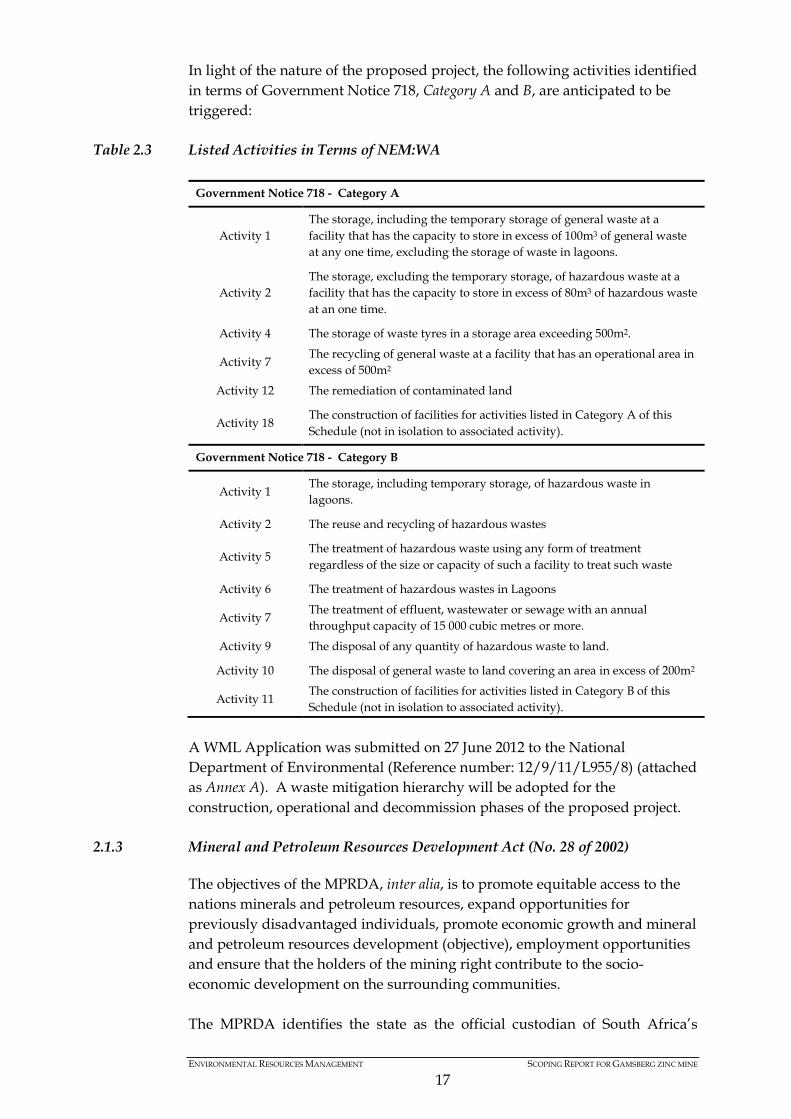
ENVIRONMENTAL RESOURCES MANAGEMENT SCOPING REPORT FOR GAMSBERG ZINC MINE
17
In light of the nature of the proposed project, the following activities identified in terms of Government Notice 718, Category A and B, are anticipated to be triggered:
Table 2.3 Listed Activities in Terms of NEM:WA
Government Notice 718 - Category A
Activity 1 The storage, including the temporary storage of general waste at a facility that has the capacity to store in excess of 100m3 of general waste at any one time, excluding the storage of waste in lagoons.
Activity 2 The storage, excluding the temporary storage, of hazardous waste at a facility that has the capacity to store in excess of 80m3 of hazardous waste at an one time.
Activity 4 The storage of waste tyres in a storage area exceeding 500m2.
Activity 7 The recycling of general waste at a facility that has an operational area in excess of 500m2
Activity 12 The remediation of contaminated land
Activity 18 The construction of facilities for activities listed in Category A of this Schedule (not in isolation to associated activity).
Government Notice 718 - Category B
Activity 1 The storage, including temporary storage, of hazardous waste in lagoons.
Activity 2 The reuse and recycling of hazardous wastes
Activity 5 The treatment of hazardous waste using any form of treatment regardless of the size or capacity of such a facility to treat such waste
Activity 6 The treatment of hazardous wastes in Lagoons
Activity 7 The treatment of effluent, wastewater or sewage with an annual throughput capacity of 15 000 cubic metres or more.
Activity 9 The disposal of any quantity of hazardous waste to land.
Activity 10 The disposal of general waste to land covering an area in excess of 200m2
Activity 11 The construction of facilities for activities listed in Category B of this Schedule (not in isolation to associated activity).
A WML Application was submitted on 27 June 2012 to the National Department of Environmental (Reference number: 12/9/11/L955/8) (attached as Annex A). A waste mitigation hierarchy will be adopted for the construction, operational and decommission phases of the proposed project.
2.1.3 Mineral and Petroleum Resources Development Act (No. 28 of 2002)
The objectives of the MPRDA, inter alia, is to promote equitable access to the nations minerals and petroleum resources, expand opportunities for previously disadvantaged individuals, promote economic growth and mineral and petroleum resources development (objective), employment opportunities and ensure that the holders of the mining right contribute to the socio-economic development on the surrounding communities. The MPRDA identifies the state as the official custodian of South Africa’s

ENVIRONMENTAL RESOURCES MANAGEMENT SCOPING REPORT FOR GAMSBERG ZINC MINE
18
Mineral and Petroleum Resources.
Therefore all activities relating to reconnaissance, prospecting rights, mining rights, mining permits and retention permits are regulated by the State.
An Application must be submitted and approved by the National Department of Mineral Resources, before proceeding. Black Mountain has an existing new order mining right and approved Environmental Management Programme (EMPr) for the proposed Gamsberg mine. The existing mining right allows the applicant to mine (using an open pit technique) an area of 9 505 hectares on erf Bloemhoek 61 Portion 1 and Gams 60 Portion 1, Aroams 57 RE. It should be noted however that the existing mining right is applicable to the current mining operations in terms of mining method, volumes and infrastructure scope. Due to changes in the project description, the existing EMPr (including the social labour plan and associated works programme) would require amendment in light of the changes to the proposed project description. In terms of Section 102 of the MPRDA, amendments to an approved EMPr will require an EIA process to be undertaken in terms of NEMA. In addition, Section 49 and 50 of Regulation 527 of the MPRDA outlines specific information requirements for the Scoping and EIA Reports, inter alia, are as follows: • Stakeholder engagement process; • Assessment of impacts; • Assessment of feasible alternatives; • Development of an environmental management and monitoring plan; • Provision of maintenance and emergency procedures; and • Environmental awareness plan.
The amended EMPr will also need to include a revised Social and Labour Plan (SLP), Mine Works Programme (MWP), Closure Plan and Financial Provision for the Rehabilitation of Land Disturbed by Mining Activities. In terms of Regulation 49 of the MPRDA Regulations a scoping report must contain, as a minimum, the following information requirements:
Table 2.4 MPRDA Information Requirements for Scoping Reports Regulation 49 (1) Requirement Relevant section
(a) describe the methodology applied to conduct scoping
Chapter 5
(b) describe the existing status of the environment prior to the mining operation
Chapter 4
(c) identify and describe the anticipated environmental, social and cultural impacts, including the cumulative effects, where applicable
Chapter 5 and 7
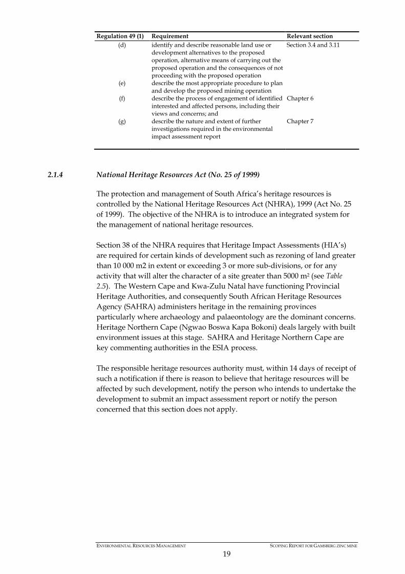
ENVIRONMENTAL RESOURCES MANAGEMENT SCOPING REPORT FOR GAMSBERG ZINC MINE
19
Regulation 49 (1) Requirement Relevant section (d) identify and describe reasonable land use or
development alternatives to the proposed operation, alternative means of carrying out the proposed operation and the consequences of not proceeding with the proposed operation
Section 3.4 and 3.11
(e) describe the most appropriate procedure to plan and develop the proposed mining operation
(f) describe the process of engagement of identified interested and affected persons, including their views and concerns; and
Chapter 6
(g) describe the nature and extent of further investigations required in the environmental impact assessment report
Chapter 7
2.1.4 National Heritage Resources Act (No. 25 of 1999)
The protection and management of South Africa’s heritage resources is controlled by the National Heritage Resources Act (NHRA), 1999 (Act No. 25 of 1999). The objective of the NHRA is to introduce an integrated system for the management of national heritage resources. Section 38 of the NHRA requires that Heritage Impact Assessments (HIA’s) are required for certain kinds of development such as rezoning of land greater than 10 000 m2 in extent or exceeding 3 or more sub-divisions, or for any activity that will alter the character of a site greater than 5000 m2 (see Table 2.5). The Western Cape and Kwa-Zulu Natal have functioning Provincial Heritage Authorities, and consequently South African Heritage Resources Agency (SAHRA) administers heritage in the remaining provinces particularly where archaeology and palaeontology are the dominant concerns. Heritage Northern Cape (Ngwao Boswa Kapa Bokoni) deals largely with built environment issues at this stage. SAHRA and Heritage Northern Cape are key commenting authorities in the ESIA process. The responsible heritage resources authority must, within 14 days of receipt of such a notification if there is reason to believe that heritage resources will be affected by such development, notify the person who intends to undertake the development to submit an impact assessment report or notify the person concerned that this section does not apply.
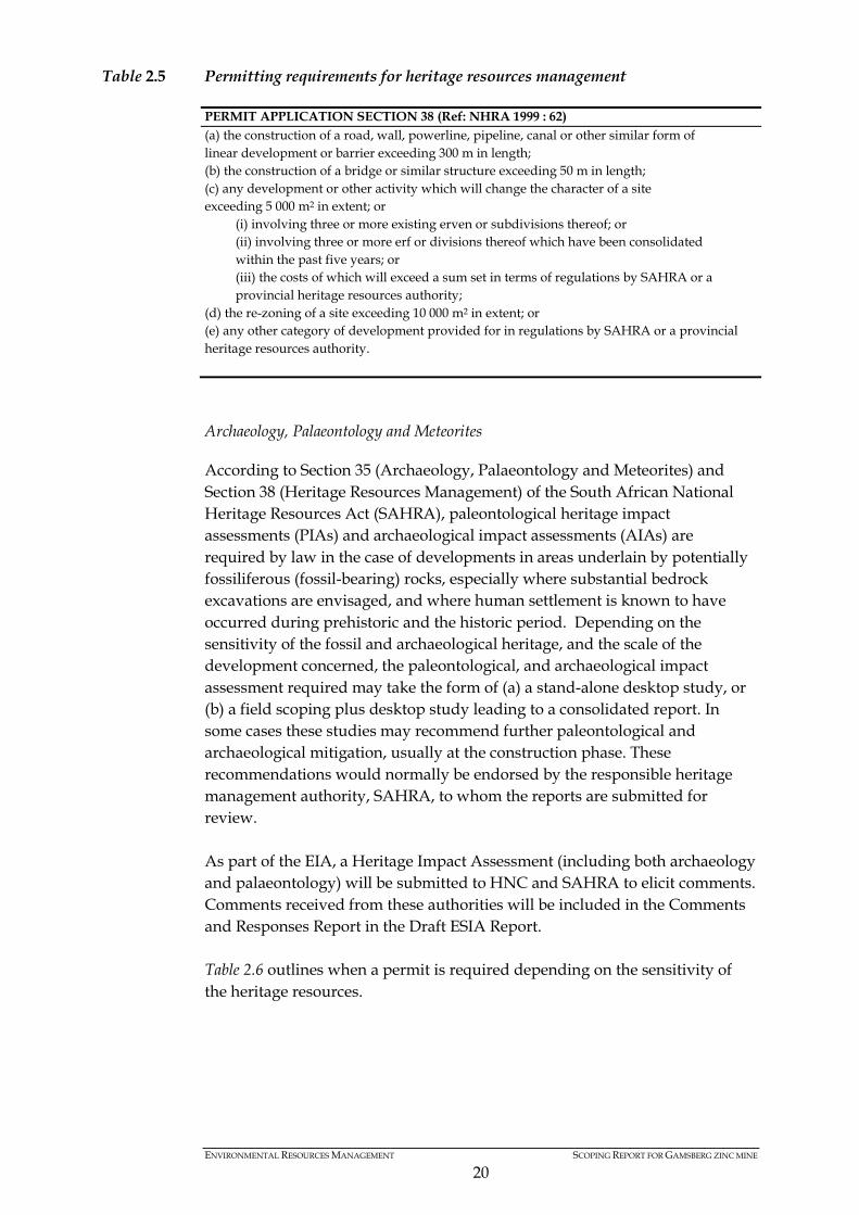
ENVIRONMENTAL RESOURCES MANAGEMENT SCOPING REPORT FOR GAMSBERG ZINC MINE
20
Table 2.5 Permitting requirements for heritage resources management
PERMIT APPLICATION SECTION 38 (Ref: NHRA 1999 : 62) (a) the construction of a road, wall, powerline, pipeline, canal or other similar form of linear development or barrier exceeding 300 m in length; (b) the construction of a bridge or similar structure exceeding 50 m in length; (c) any development or other activity which will change the character of a site exceeding 5 000 m2 in extent; or
(i) involving three or more existing erven or subdivisions thereof; or (ii) involving three or more erf or divisions thereof which have been consolidated within the past five years; or (iii) the costs of which will exceed a sum set in terms of regulations by SAHRA or a provincial heritage resources authority;
(d) the re-zoning of a site exceeding 10 000 m2 in extent; or (e) any other category of development provided for in regulations by SAHRA or a provincial heritage resources authority.
Archaeology, Palaeontology and Meteorites
According to Section 35 (Archaeology, Palaeontology and Meteorites) and Section 38 (Heritage Resources Management) of the South African National Heritage Resources Act (SAHRA), paleontological heritage impact assessments (PIAs) and archaeological impact assessments (AIAs) are required by law in the case of developments in areas underlain by potentially fossiliferous (fossil-bearing) rocks, especially where substantial bedrock excavations are envisaged, and where human settlement is known to have occurred during prehistoric and the historic period. Depending on the sensitivity of the fossil and archaeological heritage, and the scale of the development concerned, the paleontological, and archaeological impact assessment required may take the form of (a) a stand-alone desktop study, or (b) a field scoping plus desktop study leading to a consolidated report. In some cases these studies may recommend further paleontological and archaeological mitigation, usually at the construction phase. These recommendations would normally be endorsed by the responsible heritage management authority, SAHRA, to whom the reports are submitted for review. As part of the EIA, a Heritage Impact Assessment (including both archaeology and palaeontology) will be submitted to HNC and SAHRA to elicit comments. Comments received from these authorities will be included in the Comments and Responses Report in the Draft ESIA Report. Table 2.6 outlines when a permit is required depending on the sensitivity of the heritage resources.
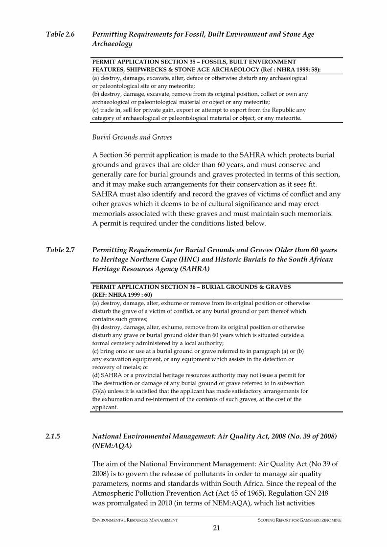
ENVIRONMENTAL RESOURCES MANAGEMENT SCOPING REPORT FOR GAMSBERG ZINC MINE
21
Table 2.6 Permitting Requirements for Fossil, Built Environment and Stone Age Archaeology
PERMIT APPLICATION SECTION 35 – FOSSILS, BUILT ENVIRONMENT FEATURES, SHIPWRECKS & STONE AGE ARCHAEOLOGY (Ref : NHRA 1999: 58): (a) destroy, damage, excavate, alter, deface or otherwise disturb any archaeological or paleontological site or any meteorite; (b) destroy, damage, excavate, remove from its original position, collect or own any archaeological or paleontological material or object or any meteorite; (c) trade in, sell for private gain, export or attempt to export from the Republic any category of archaeological or paleontological material or object, or any meteorite.
Burial Grounds and Graves
A Section 36 permit application is made to the SAHRA which protects burial grounds and graves that are older than 60 years, and must conserve and generally care for burial grounds and graves protected in terms of this section, and it may make such arrangements for their conservation as it sees fit. SAHRA must also identify and record the graves of victims of conflict and any other graves which it deems to be of cultural significance and may erect memorials associated with these graves and must maintain such memorials. A permit is required under the conditions listed below.
Table 2.7 Permitting Requirements for Burial Grounds and Graves Older than 60 years to Heritage Northern Cape (HNC) and Historic Burials to the South African Heritage Resources Agency (SAHRA)
PERMIT APPLICATION SECTION 36 – BURIAL GROUNDS & GRAVES (REF: NHRA 1999 : 60) (a) destroy, damage, alter, exhume or remove from its original position or otherwise disturb the grave of a victim of conflict, or any burial ground or part thereof which contains such graves; (b) destroy, damage, alter, exhume, remove from its original position or otherwise disturb any grave or burial ground older than 60 years which is situated outside a formal cemetery administered by a local authority; (c) bring onto or use at a burial ground or grave referred to in paragraph (a) or (b) any excavation equipment, or any equipment which assists in the detection or recovery of metals; or (d) SAHRA or a provincial heritage resources authority may not issue a permit for The destruction or damage of any burial ground or grave referred to in subsection (3)(a) unless it is satisfied that the applicant has made satisfactory arrangements for the exhumation and re-interment of the contents of such graves, at the cost of the applicant.
2.1.5 National Environmental Management: Air Quality Act, 2008 (No. 39 of 2008) (NEM:AQA)
The aim of the National Environment Management: Air Quality Act (No 39 of 2008) is to govern the release of pollutants in order to manage air quality parameters, norms and standards within South Africa. Since the repeal of the Atmospheric Pollution Prevention Act (Act 45 of 1965), Regulation GN 248 was promulgated in 2010 (in terms of NEM:AQA), which list activities
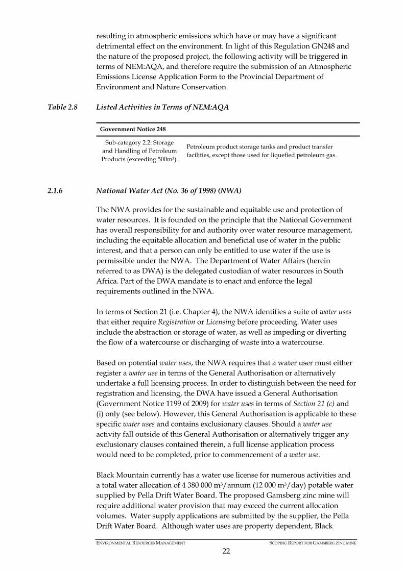
ENVIRONMENTAL RESOURCES MANAGEMENT SCOPING REPORT FOR GAMSBERG ZINC MINE
22
resulting in atmospheric emissions which have or may have a significant detrimental effect on the environment. In light of this Regulation GN248 and the nature of the proposed project, the following activity will be triggered in terms of NEM:AQA, and therefore require the submission of an Atmospheric Emissions License Application Form to the Provincial Department of Environment and Nature Conservation.
Table 2.8 Listed Activities in Terms of NEM:AQA
Government Notice 248
Sub-category 2.2: Storage and Handling of Petroleum Products (exceeding 500m3).
Petroleum product storage tanks and product transfer facilities, except those used for liquefied petroleum gas.
2.1.6 National Water Act (No. 36 of 1998) (NWA)
The NWA provides for the sustainable and equitable use and protection of water resources. It is founded on the principle that the National Government has overall responsibility for and authority over water resource management, including the equitable allocation and beneficial use of water in the public interest, and that a person can only be entitled to use water if the use is permissible under the NWA. The Department of Water Affairs (herein referred to as DWA) is the delegated custodian of water resources in South Africa. Part of the DWA mandate is to enact and enforce the legal requirements outlined in the NWA. In terms of Section 21 (i.e. Chapter 4), the NWA identifies a suite of water uses that either require Registration or Licensing before proceeding. Water uses include the abstraction or storage of water, as well as impeding or diverting the flow of a watercourse or discharging of waste into a watercourse. Based on potential water uses, the NWA requires that a water user must either register a water use in terms of the General Authorisation or alternatively undertake a full licensing process. In order to distinguish between the need for registration and licensing, the DWA have issued a General Authorisation (Government Notice 1199 of 2009) for water uses in terms of Section 21 (c) and (i) only (see below). However, this General Authorisation is applicable to these specific water uses and contains exclusionary clauses. Should a water use activity fall outside of this General Authorisation or alternatively trigger any exclusionary clauses contained therein, a full license application process would need to be completed, prior to commencement of a water use. Black Mountain currently has a water use license for numerous activities and a total water allocation of 4 380 000 m3/annum (12 000 m3/day) potable water supplied by Pella Drift Water Board. The proposed Gamsberg zinc mine will require additional water provision that may exceed the current allocation volumes. Water supply applications are submitted by the supplier, the Pella Drift Water Board. Although water uses are property dependent, Black
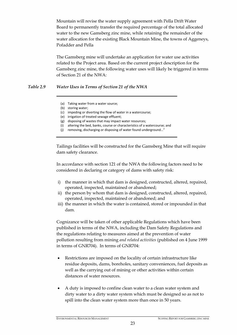
ENVIRONMENTAL RESOURCES MANAGEMENT SCOPING REPORT FOR GAMSBERG ZINC MINE
23
Mountain will revise the water supply agreement with Pella Drift Water Board to permanently transfer the required percentage of the total allocated water to the new Gamsberg zinc mine, while retaining the remainder of the water allocation for the existing Black Mountain Mine, the towns of Aggeneys, Pofadder and Pella The Gamsberg mine will undertake an application for water use activities related to the Project area. Based on the current project description for the Gamsberg zinc mine, the following water uses will likely be triggered in terms of Section 21 of the NWA:
Table 2.9 Water Uses in Terms of Section 21 of the NWA
(a) Taking water from a water source; (b) storing water; (c) impeding or diverting the flow of water in a watercourse; (e) irrigation of treated sewage effluent; (g) disposing of wastes that may impact water resources; (i) altering the bed, banks, course or characteristics of a watercourse; and (j) removing, discharging or disposing of water found underground…”
Tailings facilities will be constructed for the Gamsberg Mine that will require dam safety clearance. In accordance with section 121 of the NWA the following factors need to be considered in declaring or category of dams with safety risk: i) the manner in which that dam is designed, constructed, altered, repaired,
operated, inspected, maintained or abandoned; ii) the person by whom that dam is designed, constructed, altered, repaired,
operated, inspected, maintained or abandoned; and iii) the manner in which the water is contained, stored or impounded in that
dam. Cognizance will be taken of other applicable Regulations which have been published in terms of the NWA, including the Dam Safety Regulations and the regulations relating to measures aimed at the prevention of water pollution resulting from mining and related activities (published on 4 June 1999 in terms of GNR704). In terms of GNR704: • Restrictions are imposed on the locality of certain infrastructure like
residue deposits, dams, boreholes, sanitary conveniences, fuel deposits as well as the carrying out of mining or other activities within certain distances of water resources.
• A duty is imposed to confine clean water to a clean water system and dirty water to a dirty water system which must be designed so as not to spill into the clean water system more than once in 50 years.
ENVIRONMENTAL RESOURCES MANAGEMENT SCOPING REPORT FOR GAMSBERG ZINC MINE
24
• Regulation 7 imposes various requirements regarding the protection of water resources.
To the extent that these Regulations apply to the Gamsberg mine, compliance therewith will be sought. Finally, the general duty of care provisions of the NWA will be considered and applied.
2.1.7 The National Environmental Management: Biodiversity Act, 2008 (No. 10 of 2004) (NEMBA) and associated legislation
The NEM:BA serves to provide a framework for the management and conservation of South African biodiversity, under the auspices of the NEMA. This legislation promotes the sustainable use of natural biological resources, ensuring equitable access and sharing of benefits arising from the use of biological resources. In terms of Section 56(1) of NEM:BA a person may not carry out a restricted activity involving a specimen of a listed threatened or protected species without a permit issued in terms of Chapter 7. These threatened and protected species have been listed in terms of GNR.151 of 2007: Publication of lists of critically endangered, endangered, vulnerable and protected species. A restricted activity in relation to a specimen of a listed threatened or protected species, means: • hunting, catching, capturing or killing any living specimen of a listed
threatened or protected species by any means, method or device whatsoever, including searching, pursuing, driving, lying in wait, luring, alluring, discharging a missile or injuring with intent to hunt, catch, capture or kill any such specimen;
• gathering, collecting or plucking any specimen of a listed threatened or
protected species; • picking parts of, or cutting, chopping off, uprooting, damaging or
destroying, any specimen of a listed threatened or protected species; • importing into the Republic, including introducing from the sea, any
specimen of a listed threatened or protected species; • exporting from the Republic, including re-exporting from the Republic,
any specimen of a listed threatened or protected species; • having in possession or exercising physical control over any specimen of a
listed threatened or protected species; • growing, breeding or in any other way propagating any specimen of a
listed threatened or protected species, or causing it to multiply; • conveying, moving or otherwise translocating any specimen of a listed
threatened or protected species;
ENVIRONMENTAL RESOURCES MANAGEMENT SCOPING REPORT FOR GAMSBERG ZINC MINE
25
• selling or otherwise trading in, buying, receiving, giving, donating or
accepting as a gift, or in any way acquiring or disposing of any specimen of a listed threatened or protected species; or
• any other prescribed activity which involves a specimen of a listed
threatened or protected species. Should a project result in the loss of biodiversity identified in terms of GN 151 of 2010, a permit application will need to be submitted to the Provincial Department of Environment and Nature Conservation for approval, before proceeding with the activity. A specialist botanical impacts assessment will be undertaken as part of the ESIA phase of the proposed project. The applicability of the NEM:BA will be confirmed upon completion of the botanical investigation (i.e. removal of a listed species), and if required, a permit will be submitted to the provincial authorities for review and decision making. Section 52 of NEM:BA provides for the publication of a national list of ecosystems that are threatened and in need of protection. A list of threatened ecosystems in the terrestrial environment was published on 9 December 2011 in GN 1002 GG 34809. The list, which provides that only 9.5% of natural areas remain in threatened terrestrial ecosystems in South Africa aims to reduce the rate of ecosystem and species extinction in these areas. 53 critically endangered ecosystems, 53 endangered and 107 vulnerable ecosystems have been listed. Detail of the location and description of each listed threated terrestrial ecosystem is provided, including the province(s) and municipality (ies) in which the ecosystem is located. Reference is also made to protection status of the ecosystem (i.e. if it falls within a Nature Reserve, World Heritage Site etc.) and (where possible) the known number of species of special concern found in the ecosystem (i.e. red data animal and plant species). Activity 12 of GNR546 of the NEMA listed activities requires basic assessment for the clearance of 300m2 or more of vegetation where 75% or more of the vegetative cover constitutes indigenous vegetation within any listed critically endangered or endangered ecosystem. Should this activity be triggered by the Gamsberg mine, authorisation therefore will be sought in the NEMA environmental authorisation application which has been submitted. Consideration will also be given to the Northern Cape Nature Conservation Act, No. 9 of 2009 (NCNCA) which came into force on 21 January 2010 and which repealed the Ordinance on Nature Conservation in the Northern Cape. NCNCA prescribes restricted activities in relation to specially protected plants and animals (Schedule 1) and protected plants and animals (Schedule 2) for which licensing are required. NCNCA furthermore prescribes prohibited acts in relation to invasive species (Schedule 6) for which licensing is required and restricted activities in relation to certain damage causing animals (Schedule 4) for which licensing are required. To the extent that licences are required in terms of the NCNCA for the Gamsberg mine these will be obtained.
ENVIRONMENTAL RESOURCES MANAGEMENT SCOPING REPORT FOR GAMSBERG ZINC MINE
26
Finally, the National Forests Act, No. 84 of 1998 (NFA) deals with the protection of trees. The Minister is required to annually publish a list of all species protected under Section 12. No person may cut, disturb, damage, destroy or remove any protected tree; or collect, remove transport, export, purchase, sell, donate or in any other manner acquire or dispose of any protected tree, except under a licence granted by the Minister. To the extent that protected tree licences are required for the Gamsberg mine these will be obtained.
2.1.8 Integrated Legislative Processes
Due to nature of the proposed project, a suit of environmental legislation will be applicable. In order to meet the various legislative requirements, ERM intends to run a single integrated ESIA process, which will also meet the requirements in terms of the following laws: • NEMA; • NEM:WA; • NEM:AQA; • NEM:BA • NWA; • NHRA; and • MPRDA.
Table 2.10 Summary of Legislative Applications and Relevant Authorities
Permit/ Application Competent Authority NEMA: Environmental and Social Impact Assessment.
Provincial Department of Environment and Nature Conservation.
NEM:WA: Waste Management License Application.
National Department of Environmental Affairs (Waste Directorate).
NEM:AQA: Atmospheric Emissions License Application.
Provincial Department of Environment and Nature Conservation (Air Quality and Climate Change Directorate).
NWA: Water Use Licence Application. National Department of Water Affairs. NHRA: Notice of Intent to Develop and Phase 1 Heritage Impact Assessment.
South African Heritage Resources Agency.
MPRDA: Application for amendment to existing Environmental Management Programme.
Department of Mineral Resources.
NEM:BA: Permit application for loss of biodiversity (applicability to be confirmed in Draft ESIA Report).
Provincial Department of Environment and Nature Conservation.
The proposed ESIA process will be undertaken in terms of NEMA and the associated EIA Regulations of 2010 (as amended). The requirements for the WML and AEL Application can be met as part of the ESIA process. The public participation requirements in terms NEM:WA and NEM:AQA will be met through the EIA Regulations requirement for public participation. Based on the existing new order mining right for Gamsberg, the existing EMPr will need to be amended in accordance with the project description and

ENVIRONMENTAL RESOURCES MANAGEMENT SCOPING REPORT FOR GAMSBERG ZINC MINE
27
proposed activities. The amended EMPr will be produced during the ESIA phase of the project, and will fulfil the requirements in terms of the MPRDA and the associated Government Notice 527 of 2004. The public participation requirements for an amendment to an existing EMPr will be undertaken in line with the ESIA requirements. The legislative requirements in terms of the NHRA will be fulfilled through the completion of a comprehensive heritage impact assessment, with the documents made available for public comment during the ESIA phase.

ENVIRONMENTAL RESOURCES MANAGEMENT SCOPING REPORT FOR GAMSBERG ZINC MINE
27
Figure 2.1 Integrated Flow Diagram of ESIA Process
Submitted Submitted
NC/EIA/NAM/KHAI/AGG/2012-NCP/EIA/0000155/2012 14 days 12/9/11/L955/8 NCS 30/5/1/2/2/1/518
30 days
Die Burger WestDie Plattelander Gemsbok Die Eland WestNamakwalanderExpress Northern Cape
40 days
14 days30 days 21 days
40 days
14 days60 days45 days2 days
PARALLEL ENVIRONMENTAL APPROVAL PROCESSES
WATER USE AUTHORISATION PROCESSNATIONAL WATER ACT, 1998
ENVIRONMENTAL IMPACT ASSESSMENTEIA REGULATIONS
NATIONAL ENVIRONMENTAL MANAGMENT ACT, 1998
WASTE PERMITEIA REGULATIONS
NATIONAL ENVIRONMENTAL MANAGMENT: WASTE ACT, 2008
MINERAL & PETROLEUM RESOURCES DEVELOPMENT ACT, 2002
EMP
SECTION 40 & 42 REGULATIONS GN 543, 544,545,546 REGULATIONS GN 718 SECTION 102
Pre-application consultation with DWA Pre-application consultation with DENC Pre-application consultation with DEA Pre-application consultation with DMR
Formal application to DENC Formal application to DEA
Public Participation Process
Advertisements
Notifications
Background Information Document
Draft SCOPING REPORT & PLAN OF STUDY FOR EIA
Final SCOPING REPORT & PLAN OF STUDY FOR EIA
I & AP Comment Period
Authority Review
Authority Acceptance
Draft ENVIRONMENTAL IMPACT REPORT (EIA) & ENVIRONMENTAL MANAGEMENT PLAN (EMP)
I & AP Comment Period
Authority Review / consideration
Authority Decision
Appeal period
WATER USE AUTHORISATION ENVIRONMENTAL AUTHORISATION WASTE PERMIT APPROVED EMP
NOTIFICATION TO ALL REGISTERED I & APSNotice 10 daysAppeal 30 days
No specified timeframes
Final ENVIRONMENTAL IMPACT REPORT (EIA) & ENVIRONMENTAL MANAGEMENT PLAN (EMP)
NEM
: AIRQ
UALITY ACT, 2004
NEM
: BIODIVERSITY
ACT, 2004
NATIO
NAL HERITAGE
RESOURCES ACT, 1999
Public Meetings
WE ARE HERE IN THE
PROCESS
Public Meetings

ENVIRONMENTAL RESOURCES MANAGEMENT SCOPING REPORT FOR GAMSBERG ZINC MINE
28
Based on the identification of the potential water uses, an Integrated Water Use License Application (IWULA) will be compiled and released for a 40 day public comment period, together with the Draft ESIA Report and associated EMPr. Upon completion of the comment period, the final IWULA will be submitted to the DWA for review and comment. Should the proposed project result in the loss of listed ecosystems in terms of NEM:BA, a permit application will be submitted to the provincial authorities for consideration during the release of the Draft ESIA Report and associated EMPr. The outcome of this permit application will be advertised, together with the decision made in terms of NEMA, NEM:WA, NEM:AQA and NHRA. Please note that the decision on the IWULA and amended EMPr can only be issued, once a decision is reached on the above legislation. Similarly, to the extent that the NCNCA and NFA apply, the necessary permits will be applied for as part of the ESIA process.
2.2 BROADER POLICY AND PLANNING CONTEXT
2.2.1 Northern Cape Provincial Growth and Development Strategy
A Provincial Growth and Development Strategy (PGDS) (2011) plays a vital role in achieving efficacy in delivery of the overall development objectives of Northern Cape. Although not currently a legislative requirement, the compilation of a PGDS enables stakeholders from the public, private, parastatal and labour and civil society to determine a plan for the sustainable growth and development of the Province. In this way, the collective efforts to promoting economic growth and social development can be undertaken as an integrated approach. From a variety of societal challenges, the Northern Cape Government has identified the following aspects that require attention: • Reducing the backlog of basic needs such as water, sanitation and housing; • Improving and increasing access to health, education and social services; • Decreasing the prevalence rate of TB, HIV and AIDS; • Creating opportunities for employment; • Reducing contact crime; and • Targeting vulnerable groups. The strategy identifies long-term sustainable economic growth and development as an effective means to target the key societal concerns. A suite of sectors have been identified, with one of which being mining. To develop conditions that will enable economic growth and development, human and social capital of the people of the province would need to be improved, through the following means: • Creating opportunities for lifelong learning; • Improving the skills of the labour force to increase productivity; and

ENVIRONMENTAL RESOURCES MANAGEMENT SCOPING REPORT FOR GAMSBERG ZINC MINE
29
• Increasing accessibility to knowledge and information. Economic growth in the mining sector has been identified as an important aspect for development in the region. In order to achieve this, the following items are considered to be key: • Promote the development of synergies between the mining and other
economic activities. • Promote the role mines play in terms of rural economic development. • Promote further large-scale mining development. • Minerals tax development. • Promoting industrial development and minerals beneficiation. In encouraging economic growth within the Province, the PGDS also recognising the importance of the biodiversity and water resources in the region. Economic growth, especially within the mining sector, is required to be undertaken in a responsible manner to promote growth and development, but must take cognisance of environmental sensitivities in the region. Furthermore, the PGDS has a strong focus on the reduction of greenhouse gas emissions and its associated implications in terms of Climate Change. A list of 12 projects of priority has been identified for the Khai Ma Local Municipality (LM). One of the priority projects in the LM is supporting sustainable mining development at Gamsberg. The aim of the project is to establish public private partnership with mining companies to promote sustainable mining activities. The NSDP regards the Namakwa district as an area with very low development potential in terms of Gross Geographic Product (GGP). The NCPGDS, taking into account National initiatives, has set out the following targets: • to maintain an average annual economic growth rate between 3 and 4.5 %; • to create in excess of 16,000 jobs per annum by 2014; • to reduce the number of households living in absolute poverty by 5 % per
annum; • improve the literacy rate by 50 % by 2014; • to reduce child mortality by two-thirds by 2014; • to reduce maternal mortality by two thirds by 2014; • to provide shelter for all by 2014; • to provide clean drinking water to all by 2014; • to eliminate sanitation backlog by 2014; • to reduce crime by 10 % by 2014; • to reduce the transmission of HIV and Sexually Transmitted Infections
(STIs) by 50 %by 2014; • to redistribute 30% of productive agricultural land to previously
disadvantaged individuals by 2015; • to conserve and protect 6.5 % of biodiversity by 2014; • to reduce the infrastructure backlog for economic growth and
development by 2014; and
ENVIRONMENTAL RESOURCES MANAGEMENT SCOPING REPORT FOR GAMSBERG ZINC MINE
30
• to foster vibrant and sustainable rural communities with access to economic infrastructure and basic services by 2014.
These targets will be taken cognisance if in terms of determining the outcomes associated with the ESIA process.
2.2.2 Namakwa District Municipality Local Economic Development Strategy
The Local Economic Development Strategy (2007) for the District Municipality identifies a suite of sectors that are seen to play a critical role in the economic growth of the District. The mining sector has been identified as one of the key potential development sectors within the District Municipality. It is anticipated that the mining sector contributes 52.3% of the District Municipality’s GDP and 21.3% of formal employment. In addition to the direct impact through exports and employment opportunities, the strategy recognises the important role mines play within communities, in terms of providing services such as clinics, crèches, training and skills development and business support programmes. The strategy recognises that implications of the economic recession on mining activities and subsequent implications on employment opportunities. However, as global mineral markets are stabilising, mining is seen as an important activity to generate employment. The strategy acknowledges the large labour pool available for mining activities. However, as minerals are generally exported in its raw form, the resources are not fully utilised and beneficial to the region. There is a drive to encourage processing and manufacturing of minerals into final product, as this will result in increased economic development as well as additional employment opportunities. Despite the large labour pool available, the strategy identifies the lack of technical and engineering skills. Labourers usually experience on-site training and access to basic educational facilities. This approach to skilling local communities does not result in the generation of skilled labourers to provide coordination and management of large economic ventures. The strategy refers to a “One-Stop Mining Centre”. This is envisaged as a facilitation centre where information and guidance on business opportunities will be made available, as well as assist with formulating business plans, proposals and tenders related to the local mining industry.
2.2.3 Succulent Karoo Ecosystem Programme (SKEP)
The Succulent Karoo Ecosystem Programme (SKEP) is the result of a planning process, combined with a rigorous scientific process with broad land-user participation to generate broad agreement around an ultimate vision and set of conservation targets for the Succulent Karoo (www.bgis.sanbi.org). The SKEP 20-year strategy is derived from a variety of stakeholder inputs, and consists of a comprehensive set of actions, that will achieve conservation
ENVIRONMENTAL RESOURCES MANAGEMENT SCOPING REPORT FOR GAMSBERG ZINC MINE
31
targets by addressing constraints and maximizing opportunities that are most relevant for each sub-region. The rich biodiversity of the Succulent Karoo is due to an extensive and complex array of habitat types derived from topographical and climatic diversity in the regions rugged mountains, semi-arid shrublands, and coastal dunes. The trademark feature of the Succulent Karoo is its exceptionally diverse and endemic-rich flora, especially succulents and bulbs. The 116 000 km2 biome houses at least 6356 plant species, 40% of which are endemic and 936 (17%) of which are Red Data Listed. Based on the understanding of the distribution of biodiversity and transformation pressures in the Succulent Karoo, the conservation of the regions species and ecological processes are managed together with conservation targets for biodiversity features (vegetation types, river ecosystems, sand movement corridors, presence of Red Data and endemic species). The geographical priority areas have been identified within this biome. One of the priority areas is the Bushmanland Inselbergs, of which, the Gamsberg inselberg forms part of. Furthermore, based on the Biodiversity Land Management Classification, the proposed Gamsberg mine is located within a Critical Biodiversity Area 2 (CBA 2). A CBA 2 is considered to be an important area that is known to contain high levels of biodiversity. The land management objective of a CBA 2 is to “maintain near-natural landscapes with no or limited loss of biodiversity pattern and limited loss of ecosystem processes”. According to the Biodiversity Land Management Classification key, underground mining has been identified as a suitable activity for the region, with surface mining, dumping and dredging considered to be unsuitable activities. The Project area also appears to form part of the ecological support areas identified in the area. The land management objective for ecological support areas is to maintain near-natural landscapes with some loss of biodiversity pattern and limited loss of ecosystem processes.
2.2.4 Mining Charter
The Mining Charter was established to redress historical and social inequalities through facilitating the introduction of historically disadvantaged South Africans (HDSA) into the mining sector. The Mining Charter aims to achieve the following objective: • Promote equitable access to the nation’s mineral resources to all the people
of South Africa;
• Substantially and meaningfully expand opportunities for HDSA’s including women, to enter the mining and minerals industry and to benefit from the exploitation of the nation’s mineral resources;
• Utilize the existing skills base for the empowerment HDSA’s;

ENVIRONMENTAL RESOURCES MANAGEMENT SCOPING REPORT FOR GAMSBERG ZINC MINE
32
• Expand the skills base of HDSAs in order to serve the community;
• Promote employment and advance the social and economic welfare of
mining community and the major sending areas; and
• Promote beneficiation of South Africa’s mineral commodities; The Mining Charter introduced nine (9) elements (incorporating relevant legislation) aimed at redressing past racially discriminatory practices that excluded HDSA’s from actively participating in the ownership and management of the mining sector. These elements are as follows: • Human resource development Employment equity • Migrant labour • Mine Community development • Housing and living conditions • Procurement • Ownership and joint venture • Beneficiation • Reporting Specific requirements and standards are set in terms of the Mining Charter that will need to be met. The requirements outlined in terms of the Mining Charter will play an influential role with the project description and infrastructure requirements.
2.2.5 Namakwa District Biodiversity Plans(2008) (NDBP)
The NDBP is “intended to help guide land-use planning, environmental assessments and authorisations; and, natural resource management in order to promote development which occurs in a sustainable manner. It has been developed to further the awareness of the unique biodiversity in the area, the value this biodiversity represents to people as well as the management mechanisms that can ensure its protection and sustainable utilisation”. The biodiversity guidelines and landuse planning suggestions contained in the NDBP is also included into the Spatial Development Frameworks and Integrated Development Plans for the six Local Municipalities. The Gamsberg mine is located within the Khai Ma local municipality which lies to the East of the Richtersveld and contains virtually the entire extent of the Bushmanland Inselberg priority area - one of the nine zones identified through the SKEP process as important conservation areas in the Succulent Karoo (NDBP, 2008). Species endemic to the Gamsberg inselberg (i.e. Conophyturatum, Conophytum limpidum and an as yet unnamed Trachyandra species) are considered to be of significant importance.

ENVIRONMENTAL RESOURCES MANAGEMENT SCOPING REPORT FOR GAMSBERG ZINC MINE
33
2.3 INTERNATIONAL GUIDELINES
2.3.1 IFC Performance Indicators for Sustainability
The International Finance Corporation (IFC) have developed a set of performance standards that are directed towards providing guidance on how to identify risks and impacts and measures to avoid, mitigate and manage risks and impacts. The performance indicators also promote stakeholder engagement at various stages of the project lifecycle. In order to determine the risk of impacts associated with a development activity, three categories have been developed to distinguish between projects of varying scales. The categories are as follows: • Category A: Business activities with potential significant adverse
environmental or social risks and/or impacts that is diverse, irreversible, or unprecedented.
• Category B: Business activities with potential limited adverse environmental or social risks and/or impacts that are few in number, generally site-specific, largely reversible, and readily addressed through mitigation measures.
• Category C: Business activities with minimal or no adverse environmental or social risks and/or impacts.
In the case of direct investments for the IFC (including project and corporate finance provided through financial intermediaries), the IFC requires that its clients apply the Performance Standards to manage associated environmental and social risks and impacts (IFC, 2012). The performance standards that developments are measured against are as follows:
ENVIRONMENTAL RESOURCES MANAGEMENT SCOPING REPORT FOR GAMSBERG ZINC MINE
34
Table 2.11 Performance Indicators for Environmental and Social Sustainability
Performance Standards Objectives Performance Standard 1: Assessment and Management of Environmental and Social Risks and Impacts:
• To identify and assess environmental and social risks and impacts of the project.
• To adopt a mitigation hierarchy to anticipate and avoid, or where avoidance is not possible, minimise, and where residual impacts remain, compensate/offset for risks and impacts to workers, affected communities, and the environment.
• To promote improved environmental and social performance of clients through the effective use of management systems.
• To ensure that grievances from Affected Communities and external communications from other stakeholders are responded to and managed appropriately.
• To promote and provide means for adequate engagement with Affected Communities throughout the project cycle on issues that could potentially affect them and to ensure that relevant environmental and social information is disclosed and disseminated.
Performance Standard 2: Labour and Working Conditions
• To promote the fair treatment, non-discrimination and equal opportunity of workers.
• To establish, maintain and improve the worker management relationship.
• To promote compliance with national labour and employment laws.
• To protect workers, including vulnerable categories of workers such as children, migrant workers, workers engaged by third parties, and workers in the clients supply chain.
• To promote safe and healthy working conditions, and health of workers.
• To avoid the use of forced labour. Performance Standard 3: Resource Efficiency and Pollution Prevention
• To avoid or minimise adverse impacts on human health and the environment by avoiding or minimizing pollution from project activities.
• To promote more sustainable use of resources, including energy and water.
• To reduce project-related greenhouse gas emissions. Performance Standard 4: Community Health, Safety and Security
• To anticipate and avoid adverse impacts on health and safety of the Affected Community during the project life from both routine and non-routine circumstances
• To ensure that the safeguarding of personnel and property is carried out in accordance with relevant human rights principles and in a manner that avoids or minimises risks to the Affected Communities.
Performance Standard 5: Land Acquisition and Involuntary Resettlement
• To avoid, and when avoidance is not possible, minimise displacement by exploring alternative project designs.
• To avoid forced eviction. • To anticipate and avoid, or where avoidance is not possible,
minimise adverse social and economic impacts from land acquisition or restrictions on land use by; (i) Providing compensation for loss of assets at replacement cost;
and (ii) Ensuring that resettlement activities are implemented with
appropriate disclosure of information, consultation, and the informed participation of those affected.
• To improve, or restore, the livelihoods and standards of living of displaced persons.
• To improve living conditions among physically displaced persons
ENVIRONMENTAL RESOURCES MANAGEMENT SCOPING REPORT FOR GAMSBERG ZINC MINE
35
through the provision of adequate housing with security of tenure at resettlement sites.
Performance Standard 6: Biodiversity Conservation and Sustainable Management of Living Natural Resources
• To protect and conserve biodiversity. • To maintain the benefits from ecosystem services. • Promote the sustainable management of living natural resources
through the adoption of practices that integrate conservation needs and development priorities.
• To ensure that the development activity results in no net loss in natural biodiversity, and a net gain in critical biodiversity.
Performance Standard 7: Indigenous Peoples
• To ensure that the development process fosters full respect for the human rights, dignity, aspirations, culture, and natural resource-based livelihoods of Indigenous Peoples
• To anticipate and avoid adverse impacts of projects on communities of Indigenous Peoples, or when avoidance is not possible, to minimise and/or compensate for such impacts.
• To promote sustainable development benefits and opportunities for Indigenous Peoples in a culturally appropriate manner.
• To establish and maintain an on-going relationship based on Informed Consultation and Participation (ICP) with the Indigenous Peoples affected by a project through the projects life-cycle.
• To respect and preserve the culture, knowledge and practices of Indigenous Peoples.
Performance Standard 8: Cultural Heritage
• To protect cultural heritage from the adverse impacts of project activities and support its preservation
• To promote the equitable sharing of benefits from the use of cultural heritage.
2.3.2 IFC General Environmental, Health and Safety Guidelines
The IFC General Environmental, Health, and Safety (EHS) Guidelines are technical reference documents with general and industry-specific examples of Good International Industry Practice (IFC, 2007). When one or more members of the World Bank Group are involved in a project, these EHS Guidelines are applied as required by their respective policies and standards. These General EHS Guidelines are designed to be used together with the relevant Industry Sector EHS Guidelines which provide guidance to users on EHS issues in specific industry sectors. For complex projects, use of multiple industry-sector guidelines may be necessary. The general EHS guidelines are organised into 4 broad categories, including Environmental, Occupational Health and Safety, Community Health and Safety and Construction and Decommissioning. Within each of these broad categories, a list of more specific guidelines has been developed. Although the proposed Black Mountain Gamsberg zinc mine may not be reliant on donor funding, it is the intention of the applicant to ensure that the proposed project is undertaken in a manner consistent with good international industry practice. In light of this, the EHS Guideline on Mining has been considered, with respect to the industry specific impacts and associated management measures, which are as follows:
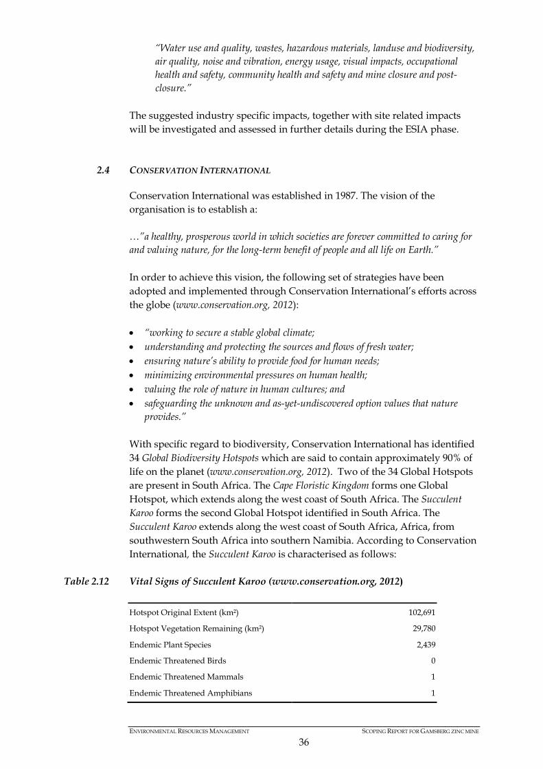
ENVIRONMENTAL RESOURCES MANAGEMENT SCOPING REPORT FOR GAMSBERG ZINC MINE
36
“Water use and quality, wastes, hazardous materials, landuse and biodiversity, air quality, noise and vibration, energy usage, visual impacts, occupational health and safety, community health and safety and mine closure and post-closure.”
The suggested industry specific impacts, together with site related impacts will be investigated and assessed in further details during the ESIA phase.
2.4 CONSERVATION INTERNATIONAL
Conservation International was established in 1987. The vision of the organisation is to establish a: …”a healthy, prosperous world in which societies are forever committed to caring for and valuing nature, for the long-term benefit of people and all life on Earth.” In order to achieve this vision, the following set of strategies have been adopted and implemented through Conservation International’s efforts across the globe (www.conservation.org, 2012): • “working to secure a stable global climate; • understanding and protecting the sources and flows of fresh water; • ensuring nature’s ability to provide food for human needs; • minimizing environmental pressures on human health; • valuing the role of nature in human cultures; and • safeguarding the unknown and as-yet-undiscovered option values that nature
provides.” With specific regard to biodiversity, Conservation International has identified 34 Global Biodiversity Hotspots which are said to contain approximately 90% of life on the planet (www.conservation.org, 2012). Two of the 34 Global Hotspots are present in South Africa. The Cape Floristic Kingdom forms one Global Hotspot, which extends along the west coast of South Africa. The Succulent Karoo forms the second Global Hotspot identified in South Africa. The Succulent Karoo extends along the west coast of South Africa, Africa, from southwestern South Africa into southern Namibia. According to Conservation International, the Succulent Karoo is characterised as follows:
Table 2.12 Vital Signs of Succulent Karoo (www.conservation.org, 2012) Hotspot Original Extent (km²) 102,691
Hotspot Vegetation Remaining (km²) 29,780
Endemic Plant Species 2,439
Endemic Threatened Birds 0
Endemic Threatened Mammals 1
Endemic Threatened Amphibians 1
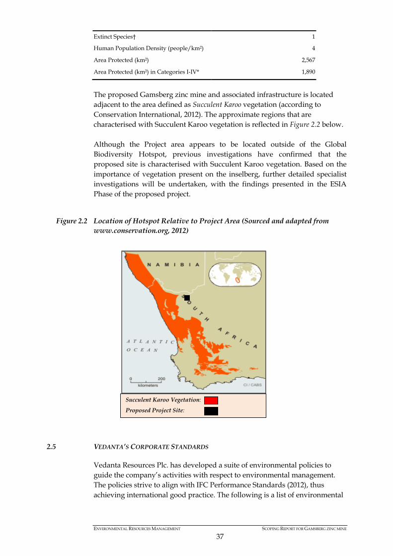
ENVIRONMENTAL RESOURCES MANAGEMENT SCOPING REPORT FOR GAMSBERG ZINC MINE
37
Extinct Species† 1
Human Population Density (people/km²) 4
Area Protected (km²) 2,567
Area Protected (km²) in Categories I-IV* 1,890
The proposed Gamsberg zinc mine and associated infrastructure is located adjacent to the area defined as Succulent Karoo vegetation (according to Conservation International, 2012). The approximate regions that are characterised with Succulent Karoo vegetation is reflected in Figure 2.2 below. Although the Project area appears to be located outside of the Global Biodiversity Hotspot, previous investigations have confirmed that the proposed site is characterised with Succulent Karoo vegetation. Based on the importance of vegetation present on the inselberg, further detailed specialist investigations will be undertaken, with the findings presented in the ESIA Phase of the proposed project.
Figure 2.2 Location of Hotspot Relative to Project Area (Sourced and adapted from www.conservation.org, 2012)
2.5 VEDANTA’S CORPORATE STANDARDS
Vedanta Resources Plc. has developed a suite of environmental policies to guide the company’s activities with respect to environmental management. The policies strive to align with IFC Performance Standards (2012), thus achieving international good practice. The following is a list of environmental
Succulent Karoo Vegetation:
Proposed Project Site:

ENVIRONMENTAL RESOURCES MANAGEMENT SCOPING REPORT FOR GAMSBERG ZINC MINE
38
polices developed and implemented on all developments associated with Vedanta’s activities: • Biodiversity Policy • Energy and Carbon Policy • HIV/ AID Policy • Health, Safety and Environment Policy • Human Rights Policy • Social Policy • Water Management Policy
2.5.1 Sustainable Development Strategy for Gamsberg Zinc Mine
Planning takes into consideration sustainable development as defined by Vedanta Corporate Sustainability Model. For such a critical project as Gamsberg, the absence of a strategic framework could lead to a short-term reactive focus on the immediate problems without a clear and long-term strategic response to sustainable development imperatives. This project is planned according to a sustainable development strategy that aims to: • Set decision-making principles for the Project (many actions deviate from
their planned direction, and a basis for decision making is required to stream line these decisions).
• Provide a framework to which the permitting process can be aligned. • Provide solutions to known risks. • It will also consider and expand on relevant and appropriate components
of existing and future sustainable development initiatives. • Address non-government, government and community concerns
regarding the Project. • Ensure long-term sustainability beyond the life of the Project.
The Sustainable Development Strategy will achieve the above listed objectives by applying the following management framework.
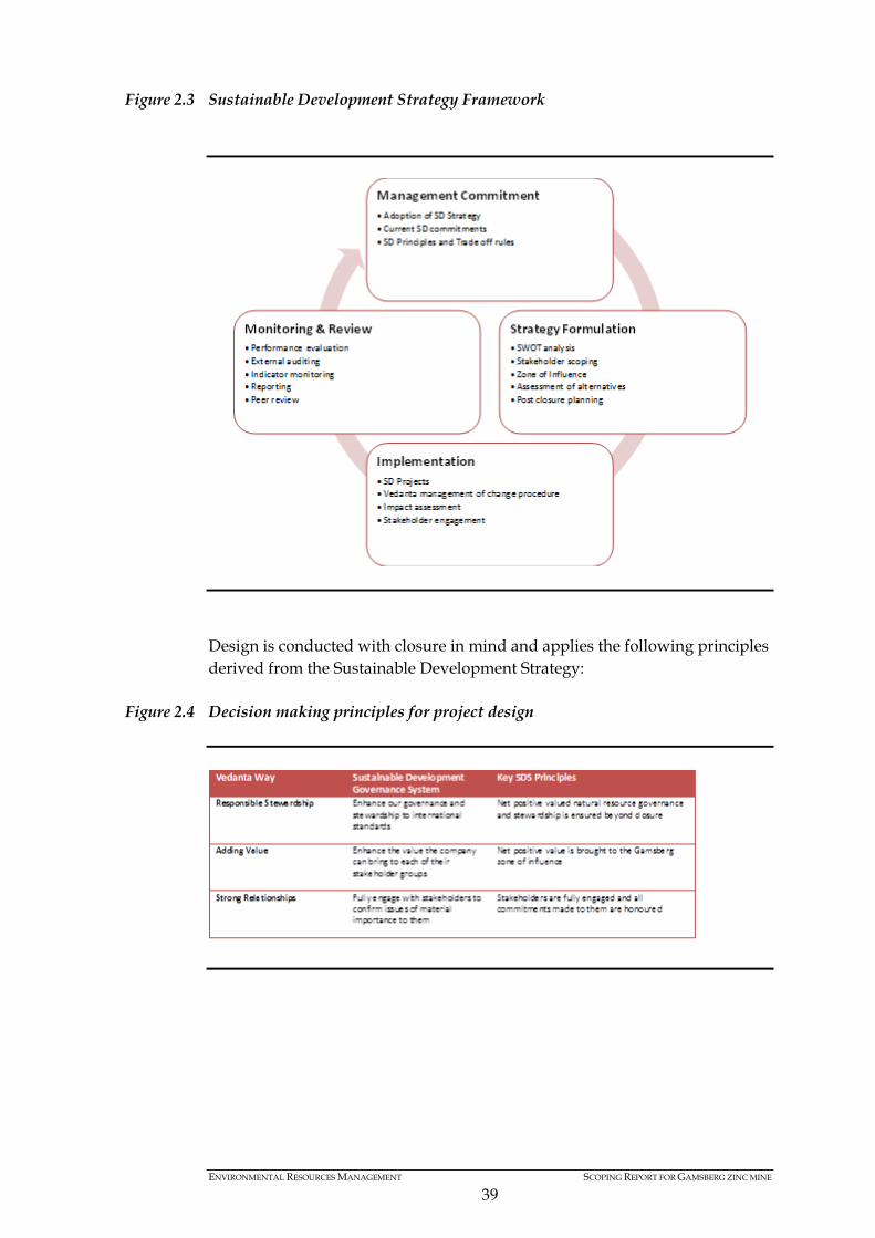
ENVIRONMENTAL RESOURCES MANAGEMENT SCOPING REPORT FOR GAMSBERG ZINC MINE
39
Figure 2.3 Sustainable Development Strategy Framework
Design is conducted with closure in mind and applies the following principles derived from the Sustainable Development Strategy:
Figure 2.4 Decision making principles for project design

ENVIRONMENTAL RESOURCES MANAGEMENT SCOPING REPORT FOR GAMSBERG ZINC MINE
40
3 PROJECT DESCRIPTION
3.1 INTRODUCTION
The purpose of this Chapter is to provide a description of the Project. Provisional specifications and dimensions of project components are provided. However, as current design parameters are in a conceptual stage, an updated project description will be presented in the Draft ESIA Report.
3.1.1 Project History
In 1998, Anglo American purchased Goldfield’s interest in the Gamsberg mine and commenced detailed feasibility studies for the establishment of a large scale open pit mine with a metal production capacity of 300 kilotons per annum (ktpa). Upon completion of the feasibility study in 1999, Anglo American commenced with all environmental and other regulatory approval processes in order to establish the mine. An old (1) order mining right was granted in terms of the Mineral Act (No 50 of 1991). Environmental approvals were received for the proposed mine, associated infrastructure and waste management facilities undertaken in 2000 in terms of the Environmental Conservation Act (No 73 of 1989). Furthermore, a water use registration was received, water license was applied for and water abstraction authorisations obtained in terms of the NWA. Despite receiving the necessary approvals to proceed with the construction and operation of an open pit mine and associated refinery, Anglo American did not initiate the full project development for various reasons. Anglo American subsequently established a small scale underground mining operation which commenced at Gamsberg in 2003. The current operations produce a total of 60 000 tpa of ore. The material is concentrated at Black Mountain Mine Concentrator; it is then transported to Loop 10 siding (approximately 160 km east of Aggeneys) and railed to the Port of Saldanha, via the Sishen – Saldanha railway line. The feasibility study undertaken during the initial EIA process in 2000 (SRK Consulting) explored various mining options, however concluded that the viability of a mine at Gamsberg would be dependent on a zinc metal production of 300 000 tpa for at least 25 years. In order to achieve this zinc metal production, open pit mining was identified to be the only feasible option, as it would have a life span of 33 years, meet the production targets and recover 95% of the ore reserves. The underground mining option confirmed that the production level could only attain 250 000 tpa, with a life span of less than 25 years as only 65% of ore deposits could be recovered. Based on these findings, Anglo American pursued the option of open pit mining to achieve project viability.
(1) It should be noted that the old mining right in terms of the Minerals Act (No 50 of 1991) for the Gamsberg Mine was converted into a new order mining right in terms of the Minerals Petroleum Resources Development Act (No 28 of 2002).
ENVIRONMENTAL RESOURCES MANAGEMENT SCOPING REPORT FOR GAMSBERG ZINC MINE
41
The proposed construction of the open pit zinc mine and associated refinery was placed on hold until 2007, at which time Anglo American commenced a Concept Study to augment the 1999 Feasibility Study. The Concept Study scaled up the proposed metal production from 300 ktpa to 400 ktpa. However, upon completion of this Concept Study, the project was placed on hold once again due to insecurity of electricity supply and rising costs of power. In 2009/ 2010, Anglo American introduced additional project components and therefore initiated a Gap Analysis. The purpose of the Gap Analysis served to identify legislative and technical requirements that were now required, based on the changes in environmental legislation and project components. Upon completion of the Gap Analysis in 2010, Vedanta Resources plc acquired Black Mountain Mining Pty Ltd (subsidiary of Anglo American) as well as the Project area. Black Mountain (now a subsidiary of the Vedanta Resources plc.) intends developing the mine and has initiated the necessary feasibility studies and associated environmental studies. Black Mountain has appointed ERM to undertake the necessary environmental regulatory processes in terms of NEMA, NWA and MPRDA (amongst others).
3.1.2 Proposed Project
Black Mountain intends to establish the Gamsberg mine with resultant waste rock dumps; mine machinery fleet and workshops. A concentrator plant with resultant stockpile areas and tailings facility, supporting infrastructure such as water supply, laboratories, sewage works and office complex will be established to process the mined ore. A port facility is required for shipment and export. Temporary storage facilities for the deposition, storage and handling will be required. The Port of Saldanha is currently used by Black Mountain and it is intended that the Gamsberg project will use this port. Off-site linear infrastructure in the form of energy and water supply as well as transport routes will be established. Residential housing in support of the project will also be established.
3.1.3 Project Location
The mine is located between the existing town of Aggeneys and the town of Pofadder, approximately 120 km east of the Springbok, along the N14. The mine and plant site will be located on properties Bloemhoek 61 Portion 1, Gams 60 Portion 1, Aroams 57 RE and Gams 60 Portion 4, approximately 14 km east of the town of Aggeneys, along the eastern border of the N14 (see Figure 1.1). The proposed site is commonly referred to as Gamsberg, and is characterised by an oval shaped inselberg approximately 220 meters above the surrounding plains. The existing gravel road from Gamsberg to the Sishen-Saldanha railway line, at Loop 10 railway siding, is located approximately 160 km east of the Gamsberg mine. The Loop 10 siding and associated infrastructure is the property of Black Mountain.

ENVIRONMENTAL RESOURCES MANAGEMENT SCOPING REPORT FOR GAMSBERG ZINC MINE
42
Through optimising existing infrastructure of the Loop 10 Road, N14 and railway lines, Black Mountain intends to transfer the zinc concentrate from the mine to the Port of Saldanha, if this is selected as the preferred port of export. The presence of existing transportation infrastructure provides a strategic advantage and market viability for Black Mountain, while limiting the footprint of the proposed development. At present, a temporary stockpiling and transfer site at the Port of Saldanha is leased by Black Mountain from the Transnet Ports Authority. Additional storage and transfer facilities will be required to accommodate the Gamsberg concentrate at the Port of Saldanha. For purposes of this ESIA, it is assumed that any upgrades proposed at the Port of Saldanha will not trigger any environmental legislative requirements, however, this will be confirmed in the Draft ESIA Report. The Transnet Ports Authority will be the responsible landowner for the new facility and will be contacted during this ESIA process.
3.1.4 Project Rationale
In order to understand the need and desirability for the project, the driving factors for the establishment of the Gamsberg mine is presented below. The need for the project is presented within the context of the global market and its relation to the South African context. Black Mountain’s motivation for the Gamsberg mine is presented, followed by the regional mining context within the Northern Cape.
3.1.5 Global Demand
Zinc is the fourth most common metal in use globally, behind iron, aluminium, and copper, with an annual production of about 12 million tons (www.minerals.usgs.gov). According to the United States Geological Survey, the total global zinc resource is approximately 1,9 billion metric tons. According to the International Lead and Zinc Study Group (ILZSG), 50% of the end use of zinc is galvanising, followed by zinc alloying and the production of brass and bronze. Zinc is also used in the chemical industries as well as household products, but the volumes are minimal compared to the end uses identified above. The current global mine production of zinc slightly exceeds the current global usage of zinc, as indicated in Table 3.1 below. The forecasted growth of zinc demand however is projected to increase over the period 2012 – 2025 at a rate of 3.7% per annum (Wood Mackenzie, 2012). The growing global demand for zinc will exceed current global production by approximately 503 KTPA by the year 2015 (Wood Mackenzie, 2012).

ENVIRONMENTAL RESOURCES MANAGEMENT SCOPING REPORT FOR GAMSBERG ZINC MINE
43
Table 3.1 Estimated Zinc Mine Production and Metal Usage (Sourced from Wood Mackenzie, 2012)
The establishment of the proposed zinc mine is expected to introduce approximately 500 000 tpa of zinc into the global market at its peak production capacity. The zinc concentrate generated from the proposed Gamsberg project would be exported to Europe and Asia for refining and distribution, until such time a zinc refinery is established in South Africa. Although the current global supply exceeds the current global usage of zinc (Wood Mackenzie, 2012), the proposed mine intends to meet the growing demand, at the time of commencement of operation of the mine (i.e. 2015). The viability of the proposed Gamsberg project is closely linked to timing of, and increasing, global demand trends. In fact, leading zinc mines like Century in Australia and Lisheen in Ireland are expected to close during 2014-16 and large mines like Rampura-Agucha in India would experience fall in production, thereby generating greater demand for concentrate produced from Gamsberg.
3.1.6 Regional Mining
Mining is a major GDP contributor and provides about 50% of the employment in Northern Cape Province (SRK Consulting, 2010). Mining in the north western area of the Northern Cape is however declining with a significant impact on the region. Black Mountain has a long term view to exploit additional resources to ensure mining continues in the region. The Swartberg Mine and Broken Hill Mine are no longer mined and the Deeps Mine has a life of mine until 2020. Black Mountain Deeps Mine will continue to explore potential mining opportunities to expand its Life of Mine. Gamsberg is a key project to ensure mining continues in the region. The Gamsberg mine will have an expected life of mine of 20 years with future potential of possible extending the Life of Mine. South Africa has been a net importer of refined zinc resulting in loss of foreign exchange for the nation. The Gamsberg project will not only save the same, but would also cater to the growing demand for zinc in South Africa and generate foreign exchange earnings for the nation.
3.1.7 Regional Impact of Black Mountain’s Existing Mine
Currently Black Mountain Mining Pty (Ltd) has a positive significant socio-economic impact, which is outlined below:
World Refined Zinc Supply and Usage 2008 – 2012 (thousand tons) & projection for 2015
Year 2008 2009 2010 2011 2012 2015
Mine Production 11 487 11 174 12 712 12 992 13 457 14 870 Metal Usage 11 198 10 136 11 681 12 584 13 191 15 373
ENVIRONMENTAL RESOURCES MANAGEMENT SCOPING REPORT FOR GAMSBERG ZINC MINE
44
• Employing in excess of 1 300 persons, operating as the largest private employer in the Namakwa District and it is a stable employer for the last 30 years. 80 % of the employees are local, with 62% from Namakwa, Khai-Ma and Nama Khoi municipal areas.
• Residential accommodation is provided by the mine to almost all its employees. The town currently houses the existing Black Mountain Mine work force of approximately 700 permanent employees and approximately 680 sub contracted staff.
• Basic service provision to the town of Aggeneys is maintained for all residents. Monitoring of resources like water, energy as well as waste and its recycling takes place continually to enable sustainable management of resources by all the users.
• An indirect result of the Black Mountain Mine and by the support of Black Mountain Mine, potable water is provided to Pofadder, Pella, Aggeneys and surrounding farmers (a total of approximately 11 200 people)
• The public provincial gravel road of 160 km from the N14 to Loop 10 railroad siding is maintained by Black Mountain Mine.
• Supporting businesses and clubs are directly or indirectly supported by Black Mountain Mine providing additional employment and non-mine skills development and economic benefit to the area.
• In addition to the above, the Black Mountain Social and Labour Plan currently implement four projects, affecting approximately 9000 persons positively with a total spent of approximately R 16.5 million over five years.
It is expected that the Gamsberg project will continue to add socio-economic value in similar manner in the future.
3.2 MOTIVATION FOR MINING METHOD
Black Mountain has considered the information available for the Gamsberg deposit and identified the most suitable mining method applicable for a financially viable and environmentally acceptable extraction of the ore for the production of zinc concentrate. The Gamsberg deposit is considered to be a low grade deposit with zinc contents in the order of 6% zinc but also containing manganese and other contaminants that make the deposit a marginal one. In order to address these challenges, mining methods capable of high production levels have been assessed for the deposit such that the economies of scale resultant from high production rates can be used to make a mining project economically feasible. Two mining concepts have therefore been assessed in order to obtain a basic concept of the mining method that should be applied to the Gamsberg deposit. These mining methods have been evaluated on a common basis for the calculation of estimated capital and operating costs. The financial results were evaluated by the Anglo American Technical Services Economics Section, leading to a decision on the mining method, and the production rate to be used in the feasibility study.
ENVIRONMENTAL RESOURCES MANAGEMENT SCOPING REPORT FOR GAMSBERG ZINC MINE
45
The underground mining option was evaluated assuming a maximum potential underground production capacity of approximately 6 Mtpa. The ore would be treated to generate some 360 000 tpa of zinc concentrate. The open pit mining option was assessed assuming a production level (at full capacity) of approximately 10 Mtpa. Numerous factors affect the financial performance of the two options but the main ones considered during past feasibility studies for the project are as follows: • Ore Extraction
Open pit mining methods achieve approximately between 85% and 90% of efficiency in extracting the economical ore available in the deposit. Due to the requirement for underground support structures, pillars to ensure the overall stability of the mine, and also due to the relative lower flexibility of underground accesses, underground mining methods only achieve approximately 60% to 70% extraction. The above results in a shortening or the life of mine overall but perhaps most importantly in the reduction of capital efficiency where a unit of capital expenditure to develop the mine grants access to a reduced volume of ore. • Operating Costs
Industry standards in South Africa indicate that operating costs (R / t mined) are significantly higher for underground operations than for open pit mines. Operating costs for underground mines are estimated to be 2 to 3 times higher than open pit operating costs. The costs per ton of zinc ore at the nearby Black Mountain Underground Mine are for comparison 2.5 times higher than the operating cost per ton for the Scorpion Zinc Mine in Namibia, an Open pit operation. Using the above information and applying Vedanta’s extensive knowledge of the zinc market, a preliminary financial analysis of the two options was undertaken. The assessment concluded that the only way to have a viable project, is to design a mine which can sustain a minimum production rate of 335 000 tpa of saleable zinc concentrate. With this established as the required production rate for the mine, the open-pit mining method was the only feasible option. The following factors influence this conclusion • The high level of production can only be achieved economically from an
open pit operation and not from an underground mine, owing to the nature and structure of the ore body. For an underground mine the extent to which open stopping methods can be utilised, limits higher production rates, with cut and fill operations unable to provide the balance of the
ENVIRONMENTAL RESOURCES MANAGEMENT SCOPING REPORT FOR GAMSBERG ZINC MINE
46
required tonnage i.e. block caving which is a high production level underground mining method, is not suitable for the geometry of the Gamsberg deposit.
• A 260 000 tpa saleable zinc concentrate underground mine (maximum underground size found to be potentially viable) will significantly lower the total extraction rates achieved, hence limiting the life of the operation.
• An underground mine will constitute a higher risk to the health and safety of the employees relative to the open pit mine.
• The development of an open pit operation does not preclude deeper areas potentially containing additional resources from future exploitation by underground methods.
• Additionally, the financial analysis shows that the underground options presents significantly negative NPV (NPV = negative US$ 300 Million) for the operation making the underground option not feasible and therefore not considered viable for the Gamsberg project.
Based on the above analysis and considerations, an open pit mining method has been selected as the method to be considered in future for the Gamsberg project.
3.3 PLANNING & DESIGN
Previous investigations undertaken in 2000 and 2010 (SRK Consulting) identified a number of sensitive receptors within the area of influence. Taking cognisance of these receptors, the ESIA specialist team undertook a site visit in order to update existing baseline information and produce a variety of sensitivity mapping. In line with the mitigation hierarchy (contained in Section 7.5.2), the sensitivity mapping will be used to guide the layout of the mine based on the sensitivities present. Black Mountain developed a conceptual layout plan (refer to Figure 3.1) and associated alternatives based on technical feasibility and previous studies. However, the layout plan is based on conceptual design and the suggested locations and footprints will be subject to further investigation and refined based on the environmental and social sensitivities of the project area. The conceptual layout plan will now be presented to the ESIA specialist team for consideration. A specialist workshop will be undertaken during the Scoping phase, together with the design engineers, to review potential layout alternatives in light of sensitive receptors. Based on the sensitivity maps contained in Chapter 5, a revised layout plan will be developed to avoid sensitivities, as far as technically possible. Based on a revised layout plan and final project description, the specialist team will undertake their detailed assessments. The revised layout plan and associated mitigation measures will be presented in the Draft ESIA Report for public review and comment. Throughout the planning and design phase, mine closure objectives will be developed to inform the post mining landuse and rehabilitation process. The

ENVIRONMENTAL RESOURCES MANAGEMENT SCOPING REPORT FOR GAMSBERG ZINC MINE
47
mine closure objectives will be informed through the mining charter and requirements set out by the Department of Mineral Resources. Consideration of post-mining landuse and associated rehabilitation efforts will be addressed as part of the proposed specialist investigation.
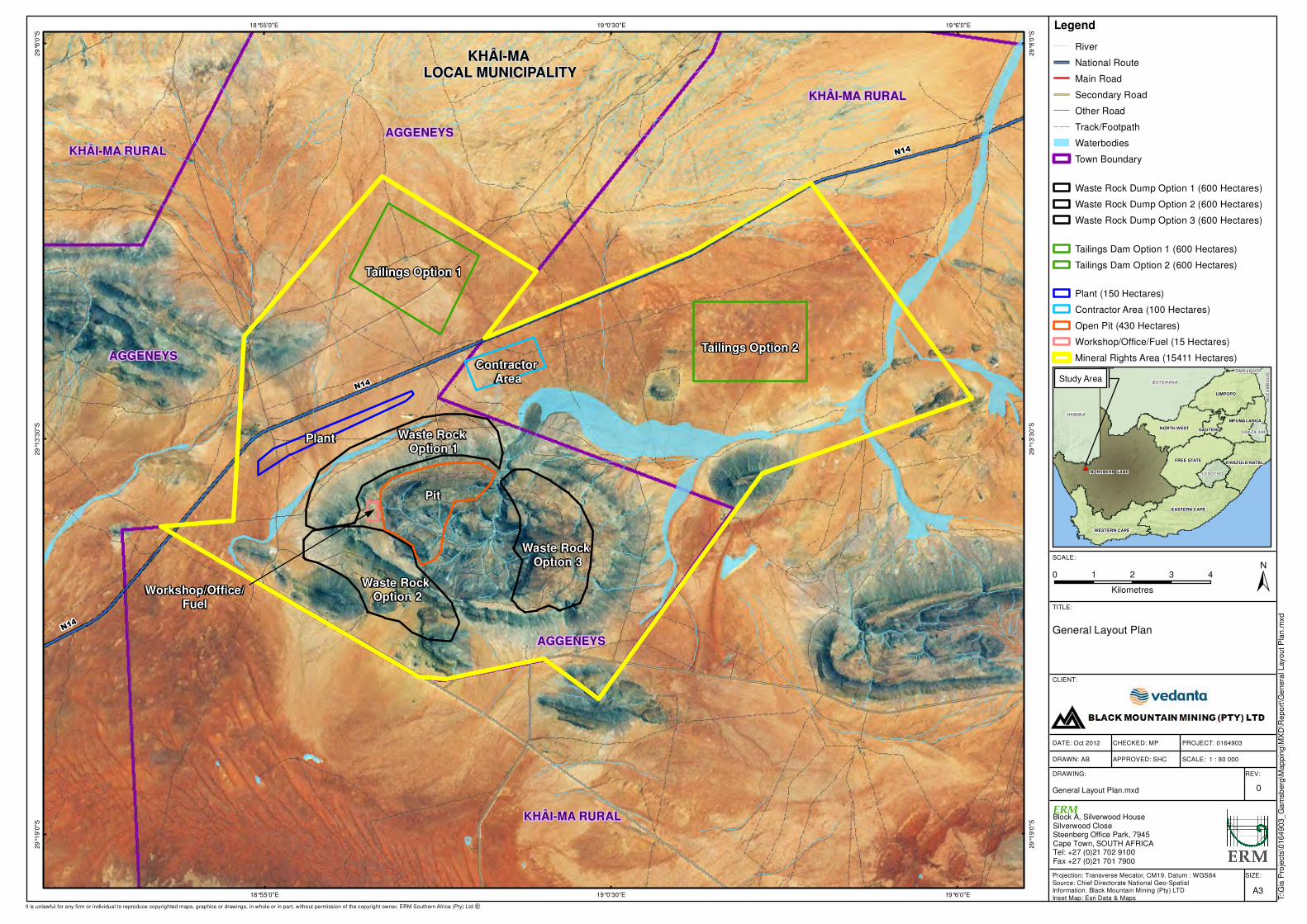
0 1 2 3 4
Kilometres
N14
KHÂI-MA RURAL
AGGENEYS
AGGENEYSN14
Workshop/Office/Fuel
Waste Rock Option 2
Pit
Waste Rock Option 1
Plant
Contractor Area
Tailings Option 1
Tailings Option 2
Waste Rock Option 3
N14
AGGENEYS
KHÂI-MA RURAL
KHÂI-MA RURAL
KHÂI-MA LOCAL MUNICIPALITY
19°6'0"E
19°6'0"E
19°0'30"E
19°0'30"E
18°55'0"E
18°55'0"E
29
°8'0
"S
29
°8'0
"S
29
°13
'30
"S
29
°13
'30
"S
29
°19
'0"S
29
°19
'0"S
SIZE:
TITLE:
DATE: Oct 2012
DRAWN: AB
CHECKED: MP
APPROVED: SHC
PROJECT: 0164903
DRAWING: REV:
A3
General Layout Plan
General Layout Plan.mxd 0
CLIENT:
±SCALE:
T:\G
is P
roje
cts
\0164
903_
Ga
msb
erg
\Map
pin
g\M
XD
\Repo
rt\G
enera
l Layout P
lan
.mxd
Projection: Transverse Mecator, CM19. Datum : WGS84
Source: Chief Directorate National Geo-Spatial Information. Black Mountain Mining (Pty) LTD
Inset Map: Esri Data & Maps
SCALE: 1 : 80 000
It is unlawful for any firm or individual to reproduce copyrighted maps, graphics or drawings, in whole or in part, without permission of the copyright owner, ERM Southern Africa (Pty) Ltd �
#*
MO
ZA
MB
IQU
E
NAMIBIA
BOTSWANA
NORTHERN CAPE
LIMPOPO
EASTERN CAPE
FREE STATE
WESTERN CAPE
NORTH WEST
KWAZULU-NATAL
MPUMALANGA
LESOTHO
GAUTENG SWAZILAND
ZIMBABWE
Study Area
Legend
River
National Route
Main Road
Secondary Road
Other Road
Track/Footpath
Waterbodies
Town Boundary
Waste Rock Dump Option 1 (600 Hectares)
Waste Rock Dump Option 2 (600 Hectares)
Waste Rock Dump Option 3 (600 Hectares)
Tailings Dam Option 1 (600 Hectares)
Tailings Dam Option 2 (600 Hectares)
Plant (150 Hectares)
Contractor Area (100 Hectares)
Open Pit (430 Hectares)
Workshop/Office/Fuel (15 Hectares)
Mineral Rights Area (15411 Hectares)
Block A, Silverwood HouseSilverwood CloseSteenberg Office Park, 7945Cape Town, SOUTH AFRICATel: +27 (0)21 702 9100Fax +27 (0)21 701 7900
ERM
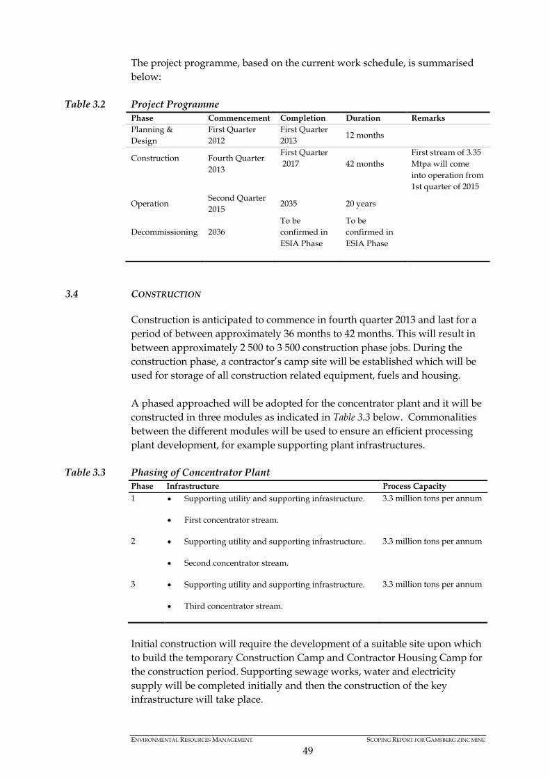
ENVIRONMENTAL RESOURCES MANAGEMENT SCOPING REPORT FOR GAMSBERG ZINC MINE
49
The project programme, based on the current work schedule, is summarised below:
Table 3.2 Project Programme Phase Commencement Completion Duration Remarks Planning & Design
First Quarter 2012
First Quarter 2013
12 months
Construction
Fourth Quarter 2013
First Quarter 2017 42 months
First stream of 3.35 Mtpa will come into operation from 1st quarter of 2015
Operation Second Quarter 2015
2035 20 years
Decommissioning 2036 To be confirmed in ESIA Phase
To be confirmed in ESIA Phase
3.4 CONSTRUCTION
Construction is anticipated to commence in fourth quarter 2013 and last for a period of between approximately 36 months to 42 months. This will result in between approximately 2 500 to 3 500 construction phase jobs. During the construction phase, a contractor’s camp site will be established which will be used for storage of all construction related equipment, fuels and housing. A phased approached will be adopted for the concentrator plant and it will be constructed in three modules as indicated in Table 3.3 below. Commonalities between the different modules will be used to ensure an efficient processing plant development, for example supporting plant infrastructures.
Table 3.3 Phasing of Concentrator Plant Phase Infrastructure Process Capacity 1 • Supporting utility and supporting infrastructure.
• First concentrator stream.
3.3 million tons per annum
2 • Supporting utility and supporting infrastructure.
• Second concentrator stream.
3.3 million tons per annum
3 • Supporting utility and supporting infrastructure.
• Third concentrator stream.
3.3 million tons per annum
Initial construction will require the development of a suitable site upon which to build the temporary Construction Camp and Contractor Housing Camp for the construction period. Supporting sewage works, water and electricity supply will be completed initially and then the construction of the key infrastructure will take place.

ENVIRONMENTAL RESOURCES MANAGEMENT SCOPING REPORT FOR GAMSBERG ZINC MINE
50
3.4.1 Construction Camp Infrastructure (Office, Workshop, Temporary Storage of Fuels and Wastes)
During the construction phase, a construction camp will be established, which will cover a total area of approximately 2 to 4 hectares. It is proposed to locate the construction camp north of the inselberg, along the southern border of the N14. The following areas will be needed for the construction camp: • Office Complex • Workshops • Washing bays • Temporary Storage of materials • Fuel storage • Truck yard and Vehicle parking It is expected that the following variety of large equipment will be required during the construction phase. • Cranes • Dump trucks • Front end loaders • Shovels • Concrete batch plant • Excavators • Boom placer • Road roller
3.4.2 Contractor Housing Camp (Temporary Staff Housing)
In order to house the work force, temporary on-site housing will be constructed. The proposed housing will be located near the construction camp and cover a total area of approximately 15 hectares to 20 hectares. A total of approximately 500 units will be erected. The proposed housing and construction camp will have bulk water, sewage, electricity and supporting road networks as discussed below.
3.4.3 Bulk service requirements for the construction camp and temporary contractor housing camp
Water The Pella Drift Water Board is the official water service provider for the towns of, inter alia, Aggeneys, Pella and Pofadder. The Pella Drift’s Water Board current infrastructure includes an existing pumpstation and water treatment works, located along the Orange River, near the town of Pella. A pipeline extends from the water treatment works to the town of Aggeneys.
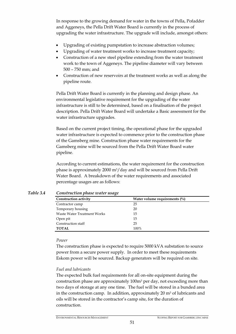
ENVIRONMENTAL RESOURCES MANAGEMENT SCOPING REPORT FOR GAMSBERG ZINC MINE
51
In response to the growing demand for water in the towns of Pella, Pofadder and Aggeneys, the Pella Drift Water Board is currently in the process of upgrading the water infrastructure. The upgrade will include, amongst others: • Upgrading of existing pumpstation to increase abstraction volumes; • Upgrading of water treatment works to increase treatment capacity; • Construction of a new steel pipeline extending from the water treatment
work to the town of Aggeneys. The pipeline diameter will vary between 500 – 750 mm; and
• Construction of new reservoirs at the treatment works as well as along the pipeline route.
Pella Drift Water Board is currently in the planning and design phase. An environmental legislative requirement for the upgrading of the water infrastructure is still to be determined, based on a finalisation of the project description. Pella Drift Water Board will undertake a Basic assessment for the water infrastructure upgrades. Based on the current project timing, the operational phase for the upgraded water infrastructure is expected to commence prior to the construction phase of the Gamsberg mine. Construction phase water requirements for the Gamsberg mine will be sourced from the Pella Drift Water Board water pipeline. According to current estimations, the water requirement for the construction phase is approximately 2000 m3/day and will be sourced from Pella Drift Water Board. A breakdown of the water requirements and associated percentage usages are as follows:
Table 3.4 Construction phase water usage Construction activity Water volume requirements (%) Contractor camp 25 Temporary housing 20 Waste Water Treatment Works 15 Open pit 15 Construction staff 25 TOTAL 100%
Power The construction phase is expected to require 5000 kVA substation to source power from a secure power supply. In order to meet these requirements Eskom power will be sourced. Backup generators will be required on site. Fuel and lubricants The expected bulk fuel requirements for all on-site equipment during the construction phase are approximately 100m3 per day, not exceeding more than two days of storage at any one time. The fuel will be stored in a bunded area in the construction camp. In addition, approximately 20 m3 of lubricants and oils will be stored in the contractor’s camp site, for the duration of construction.
ENVIRONMENTAL RESOURCES MANAGEMENT SCOPING REPORT FOR GAMSBERG ZINC MINE
52
Sewage In order to manage the sewage generated during the construction period, a temporary sewage treatment plant will be constructed to service the construction team. The proposed sewage plant will have a treatment capacity of approximately 600m3 per day. The proposed temporary treatment works will be appropriately designed. The discharge after treatment will be according to South African water quality standard and tested for quality before released to a soak away. Upon completion of the construction phase, the sewage treatment plant will probably be decommissioned and closed. All remaining sludge will be investigated for re-use or final disposal.
3.4.4 Non-mineral Waste Management
Domestic waste from the contractor’s camp and the construction operations will be separated. Paper and plastics will be recycled, with the remaining domestic wastes disposed of at a registered landfill facility. Industrial waste produced would include steel, packaging material and material off-cuts. The expected volumes of domestic and industrial wastes will be presented in the ESIA Report. Domestic wastes will be stored within the contractor’s camp site, covering a total area of half a hectare. The wastes will be disposed of at a registered landfill site, as and when required. The location of a registered landfill site within feasible proximity will be confirmed in the Daft ESIA Report. Hazardous waste will mainly include oil contaminated wastes, which will be collected and disposed of as and when required. The proposed hazardous temporary storage facility will be located within the contractor’s yard and cover a total area of 0.5 hectares. Hazardous wastes will be temporarily stored within closed containers (possibly within covered skips) and removed, as and when needed. In order to manage the construction phase wastes, the existing Black Mountain salvage yard and disposal facility will also be utilised. It should be noted that Black Mountain currently has two contractors on site responsible for general and hazardous waste removal. Proof will be obtained from each contractor as to the final disposal location and volume of domestic and hazardous wastes.
3.5 MINING
Black Mountain intends to establish the Gamsberg mine with an expected extraction rate of 10 million tons of ore per year. Black Mountain is exploring different mining techniques to determine the most suitable approach to balance the financial, technical and environmental considerations of the proposed project. The zinc deposit present in the Gamsberg inselberg is a defined ore body that ranges from 100 m to 500 m in depth. The ore body has a large lateral extent of 3 500 m. The ore body is characterised with high content of sulphide and manganese, resulting in a low grade ore deposit of approximately 6% of zinc.
ENVIRONMENTAL RESOURCES MANAGEMENT SCOPING REPORT FOR GAMSBERG ZINC MINE
53
In order to ensure operational feasibility (as discussed above in section motivating mining method used), an open pit mining technique will be adopted. The overburden covering the ore body will be stripped and deposited into a waste rock dump. The open pit mining method will include drilling, blasting and transferring of ore to a crusher. The ore will then be crushed and transferred to a flotation plant. The ore will be milled and concentrate will be extracted from the milled ore through a unit process of flotation. Residues produced during the concentrating process will be disposed of into a tailings dam. Finally, the concentrate will be filtered down to maximum 15% moisture content and transported to the Port of Saldanha for export, should more detailed studies confirm that this is the best point for export. Based on current estimations, a total of 150 000 000 tons of ore will be mined from the Gamsberg inselberg over the Life of Mine. Of this expected tonnage, approximately 18 000 000 tons of zinc concentrate will be extracted. Based on the relatively low grade of the zinc deposit, the treatment process will generate approximately 132 000 000 tons of tailings over the Life of Mine. A conceptual mine work plan is presented below and will be refined throughout the process taking into due consideration the environmental, health, safety and social and labour considerations.
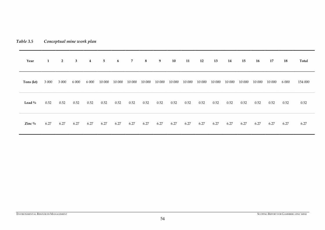
ENVIRONMENTAL RESOURCES MANAGEMENT SCOPING REPORT FOR GAMSBERG ZINC MINE
54
Table 3.5 Conceptual mine work plan
Year 1 2 3 4 5 6 7 8 9 10 11 12 13 14 15 16 17 18 Total
Tons (kt) 3 000 3 000 6 000 6 000 10 000 10 000 10 000 10 000 10 000 10 000 10 000 10 000 10 000 10 000 10 000 10 000 10 000 6 000 154 000
Lead % 0.52 0.52 0.52 0.52 0.52 0.52 0.52 0.52 0.52 0.52 0.52 0.52 0.52 0.52 0.52 0.52 0.52 0.52 0.52
Zinc % 6.27 6.27 6.27 6.27 6.27 6.27 6.27 6.27 6.27 6.27 6.27 6.27 6.27 6.27 6.27 6.27 6.27 6.27 6.27

ENVIRONMENTAL RESOURCES MANAGEMENT SCOPING REPORT FOR GAMSBERG ZINC MINE
55
Ramp up and phasing of the mine production will have to align with a phased construction of the plant in three streams. The scope of the infrastructure for mining and the mining process is detailed according to: • Open Pit • Explosives Storage Area • Load and Haul of Overburden and Ore • Waste Rock Dumps • Earth Moving Equipment • Engineering Workshops and associated offices, parking • Mine Bulk Fuel and Lubricant Storage Facilities • Change house • Primary Crusher (in pit)
3.5.1 Open Pit
The Gamsberg deposit is a tabular relatively thin mineralised lens dipping to the south east which will result in a pit developed initially to extract the ore reserve closest to surface and sequentially excavating push backs to gain depth and access to deeper reserves. The north and western faces will be excavated to final slope angles on the footwall face of the deposit whilst pushbacks will extract ore and hanging wall overburden. The final pit is generally determined by the economics of the operation which in turn are determined by, amongst other things, the following parameters: • Resource characteristics (grade of zinc, contaminants, etc.); • Geotechnical parameters (pit slope angle, height and width of benches); • Pit geometrical characteristics (as defined by geotechnical parameters and
which determine overall strip ratio (i.e. waste to ore); • Pit operating costs; • Process plant operating costs; and • Process plant recoveries.
The dimensions of the final open pit are not known at this stage but it is expected that the final pit will be the result of the extraction of some 1.65 billion tons of material with a final depth estimated at approximately between 500 and 600 meters and planned dimensions of various length and width. A typical image of an open pit, which is likely to be in a similar order of magnitude to that of the proposed Gamsberg open pit, is shown below.
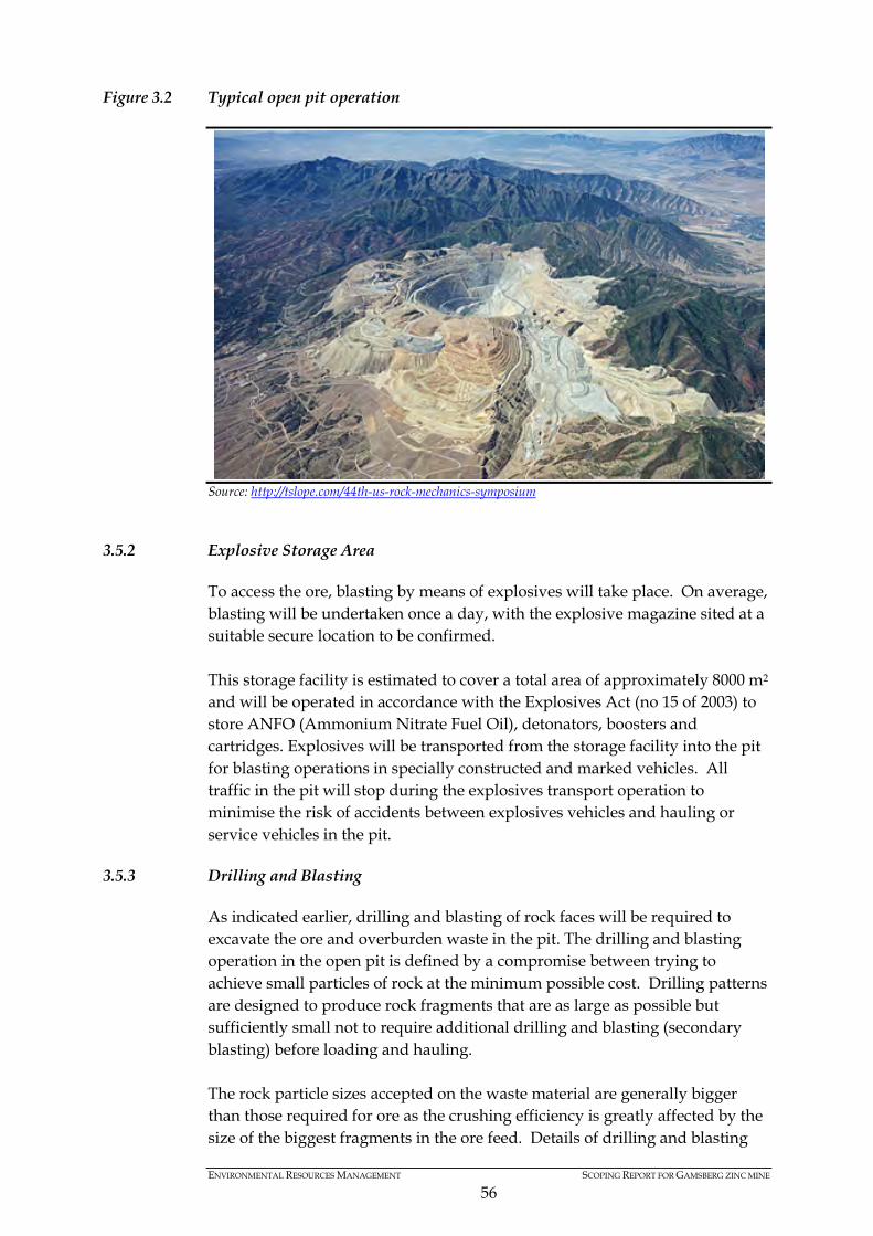
ENVIRONMENTAL RESOURCES MANAGEMENT SCOPING REPORT FOR GAMSBERG ZINC MINE
56
Figure 3.2 Typical open pit operation
Source: http://tslope.com/44th-us-rock-mechanics-symposium
3.5.2 Explosive Storage Area
To access the ore, blasting by means of explosives will take place. On average, blasting will be undertaken once a day, with the explosive magazine sited at a suitable secure location to be confirmed. This storage facility is estimated to cover a total area of approximately 8000 m2 and will be operated in accordance with the Explosives Act (no 15 of 2003) to store ANFO (Ammonium Nitrate Fuel Oil), detonators, boosters and cartridges. Explosives will be transported from the storage facility into the pit for blasting operations in specially constructed and marked vehicles. All traffic in the pit will stop during the explosives transport operation to minimise the risk of accidents between explosives vehicles and hauling or service vehicles in the pit.
3.5.3 Drilling and Blasting
As indicated earlier, drilling and blasting of rock faces will be required to excavate the ore and overburden waste in the pit. The drilling and blasting operation in the open pit is defined by a compromise between trying to achieve small particles of rock at the minimum possible cost. Drilling patterns are designed to produce rock fragments that are as large as possible but sufficiently small not to require additional drilling and blasting (secondary blasting) before loading and hauling. The rock particle sizes accepted on the waste material are generally bigger than those required for ore as the crushing efficiency is greatly affected by the size of the biggest fragments in the ore feed. Details of drilling and blasting

ENVIRONMENTAL RESOURCES MANAGEMENT SCOPING REPORT FOR GAMSBERG ZINC MINE
57
patterns for the Gamsberg mine are not defined at this stage but will be designed to satisfy the above requirements during the next stage of the project. It is expected that two types of drilling equipment will be used in the drilling operations as follows: • Large diameter electric drill rigs for primary blasting. These machines
generally have lower mobility but higher drilling efficiency making them ideal for drilling of regular and pre-determined drilling patterns like those used for daily production blasting in the open pit.
• Smaller hydraulically driven drill rigs. These drill rigs are generally track mounted and due to their smaller size have greater mobility within the pit and provide additional flexibility to drilling operations. They are generally used for secondary drilling (used for blasting of larger rocks not suitable for hauling and left following primary blasting of benches).
3.5.4 Load and Haul of Overburden and Ore
Loading and hauling of ore and overburden waste will be performed in the pit using a fleet of large capacity shovels, loaders, excavators, haul trucks and other service equipment. All topsoil will be removed and stored separate to ore and overburden. Large electric shovels are expected to be used for the excavation and loading of waste material where selectivity of the excavation is not required. Back hoe hydraulic excavators (also large capacity) are expected to be used for the excavation of ore and generally in areas where greater selectivity is required. Due to the large dimensions and limited mobility of the electric shovels and to a lesser extent the hydraulic excavators, wheeled front end loaders will also be made available in the open pit to provide additional flexibility to the loading operations. Hauling of ore to the primary crusher and waste to the waste rock dump will be undertaken using large capacity haul trucks (typically between 220 t and 300 t capacity). Haul trucks of this size are electrically driven with a diesel engine acting as a generator to provide electric power to the electrical drives located in each wheel. The option of providing an overhead electrical system (trolley system) will also be investigated in order to minimise hauling operation costs. Service equipment will include graders for road maintenance, water trucks to minimise the generation of dust during hauling operations, dozers and wheel dozers for the effective construction of safety berms along hauling ramps and the safe and efficient construction of the waste rock dumps as well as maintenance and repair equipment including lubrication trucks, tow trucks and wheel replacement cranes amongst others. A typical image of a haul truck expected to be used at the mine, is presented Figure 3.3.
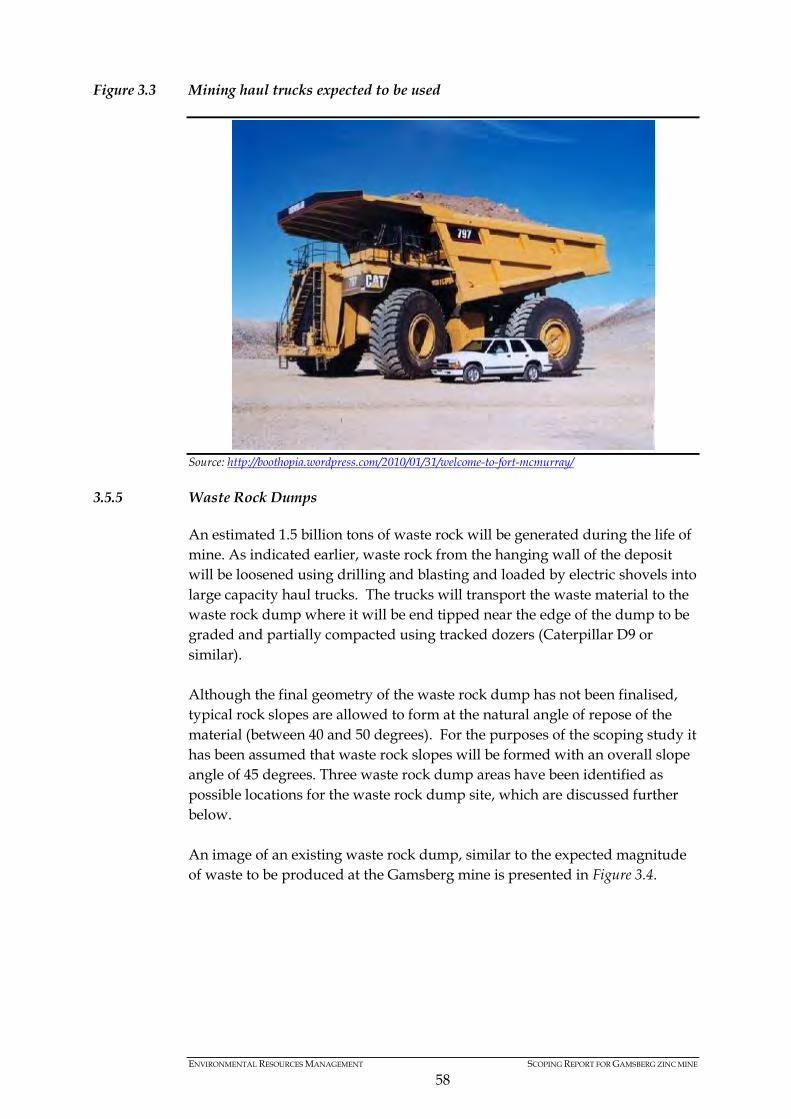
ENVIRONMENTAL RESOURCES MANAGEMENT SCOPING REPORT FOR GAMSBERG ZINC MINE
58
Figure 3.3 Mining haul trucks expected to be used
Source: http://boothopia.wordpress.com/2010/01/31/welcome-to-fort-mcmurray/
3.5.5 Waste Rock Dumps
An estimated 1.5 billion tons of waste rock will be generated during the life of mine. As indicated earlier, waste rock from the hanging wall of the deposit will be loosened using drilling and blasting and loaded by electric shovels into large capacity haul trucks. The trucks will transport the waste material to the waste rock dump where it will be end tipped near the edge of the dump to be graded and partially compacted using tracked dozers (Caterpillar D9 or similar). Although the final geometry of the waste rock dump has not been finalised, typical rock slopes are allowed to form at the natural angle of repose of the material (between 40 and 50 degrees). For the purposes of the scoping study it has been assumed that waste rock slopes will be formed with an overall slope angle of 45 degrees. Three waste rock dump areas have been identified as possible locations for the waste rock dump site, which are discussed further below. An image of an existing waste rock dump, similar to the expected magnitude of waste to be produced at the Gamsberg mine is presented in Figure 3.4.

ENVIRONMENTAL RESOURCES MANAGEMENT SCOPING REPORT FOR GAMSBERG ZINC MINE
59
Figure 3.4 Image of a typical waste rock dump
Source: http://technology.infomine.com/WasteRockDumps/
3.5.6 Earth Moving Equipment
An inventory for all earth moving equipment required for the Gamsberg mine at an operational level is included in Table 3.6 below.
Table 3.6 Inventory of equipment Mining Equipment’s No. Required Excavator (34 M3/45m3) 6 Trucks (220 / 300 T) 32 Water Carts (40/50 KL) 3 FE Loaders (18 m3) - For Blending 2 Track Dozers - For Pit, Roads and waste Dump 5 Motor Graders for Road Maintenance 2 Rock Breaker (mines) 1 Rock breaker (Crusher) 1 Back Hoes 2 Wheel Dozer 1
3.5.7 Engineering Workshops
The mine will have two workshop areas, one in the concentrator plant and one associated with the mine. The mine workshop will be located near the open pit, possibly along the western slopes of the inselberg. This workshop will be a dedicated heavy duty workshop and will be responsible for servicing of all mine related equipment. It will cover a total area of approximately 1 to 2 hectares, with an internal haul road linking to the mine entrance.

ENVIRONMENTAL RESOURCES MANAGEMENT SCOPING REPORT FOR GAMSBERG ZINC MINE
60
3.5.8 Mine Bulk Fuel and Lubricant Storage Facility
The mine bulk storage tank farm will be located in the mine workshop area. This tank farm will store approximately 500 m3 of diesel and cover a total area of approximately 2500 m2. The tank farm may include up to six refuelling bays. The mine would also require the usage of lubricants for equipment and operational activities. Approximately 5 000 litres of various grades of lubricants will be stored, also within the mine vehicle workshop area. The proposed storage facility for the lubricants will cover a total area of approximately 1000 m2 and will be located adjacent to the mine workshop.
3.5.9 Conveyor System Network
The blasted ore from the pit will be trammed to the primary crusher. The primary crushed ore will most probably be transported by means of a conveyor system to the crushed ore (ROM) stock piles. Subsequently the ore will be reclaimed from under the stockpiles and conveyed to the milling section. The proposed conveyor system may extend over a distance of 3 km. The conveyor system will be covered.
3.6 PROCESSING CONCENTRATOR PLANT
The full production capacity of the Gamsberg mine will be 10 Mtpa ore. This capacity will be reached in a modular approach following the mine ramp up plan. The current approach will be to ramp up to the full capacity in three modules. With the first module sized to process 3.35 Mtpa ore and with two additional modules to be added at later stages of the mine ramp up. Modules will share some common facilities. The concentrator processing plant area consists of the following: • Crusher plant • Milling • Flotation • Filtration and concentrate storage • Bulk reagent storage • Plant bulk fuel and lubricant storage facilities • Utilities (process water, seal water, compressed air and blower air
supplies) • Material lay down and storage areas • Ore stockpile pads and silos • Equipment wash areas • Additional on-site plant infrastructure • Tailings facility (see tailings section below) A block flow schematic diagram, for the ore extraction, processing and transportation is contained as Figure 3.5.
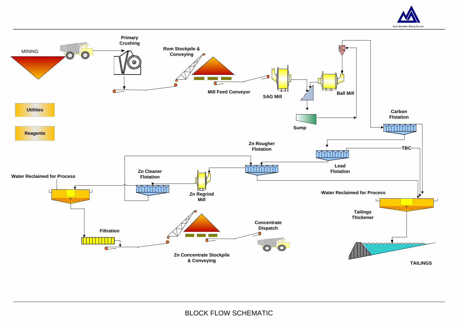
Page 1
BLOCK FLOW SCHEMATIC
Reagents
Utilities
Mill Feed Conveyor
Sump
SAG Mill
Primary
Crushing
Rom Stockpile &
Conveying
Ball Mill
Carbon
Flotation
``Tailings
Thickener
TAILINGS
Lead
Flotation
TBCZn Rougher
Flotation
Zn Regrind
Mill``
Concentrate
Dispatch
Zn Concentrate Stockpile
& Conveying
Zn Cleaner
Flotation
Water Reclaimed for Process
Water Reclaimed for Process
MINING
Filtration

ENVIRONMENTAL RESOURCES MANAGEMENT SCOPING REPORT FOR GAMSBERG ZINC MINE
62
A typical image of a concentrator plant is presented in Figure 3.6, while Figure 3.6 provides an indication of the various components of a Concentrator plant, from mining to concentrate.
Figure 3.6 Typical image of concentrator plant
3.6.1 Crusher Plant
Upon stripping of overburden, the ore will be transported via haul trucks to the primary crusher located adjacent to the open pit. The bulk ore will be transported to the primary crusher which will have a total processing capacity of 10 Mtpa. The primary crushed ore will be transported from the Primary Crusher to the ROM (Run of Mine) ore stockpile via a conveyor system to a ROM stock-pile. The ROM ore will be stored on a stockpile with a 3 day capacity and a total height of approximately 17 m and length of approximately 90 m. Ore will be conveyed through a reclaim conveyor to the milling circuit.
3.6.2 Milling Circuit
Based on the 10 Mtpa ROM ore, the process of concentration will produce 1 Mtpa of concentrate after full mine ramp-up. The concentrator plant will be approximately 40 m high, and contain lower end dust extraction vents of about 30 m in height. No stacks or stack emission is applicable to this concentrator. The plant and supported infrastructure will cover a total area of about 100 hectares in total.

ENVIRONMENTAL RESOURCES MANAGEMENT SCOPING REPORT FOR GAMSBERG ZINC MINE
63
Milling is performed to reduce broken ore to a size at which the minerals can be liberated (valuable mineral grain exposed) from the ore. A Semi-Autogenous Grinding (SAG) mill will be used together with a ball mill and cyclone to perform this duty. Refer to Figure 3.7 for circuit configuration.
Figure 3.7 Milling circuit schematic
The SAG mill is a large rotating drum filled with ore, water and steel grinding balls. The mill makes use of the material itself being crushed as well as additional grinding balls to reduce the size of crushed ore received. The SAG mill material is screened. The oversized material is recycled back to the SAG mill feed and the undersize material proceeds to the cyclone. A cyclone is used to separate the small particles from the larger particles. The small particles will overflow to the flotation circuit, which will have the required grain size for the flotation circuit. The cyclone underflow (larger sized particles) feeds into the ball mill. The ball mill is similar to the SAG mill but operates with a higher load of steel grinding balls to achieve a finer product size. Steel balls will be added continuously to both the SAG mill and the ball mill. The ball mill discharges onto the same screen as the SAG mill screen. The material is then re-circulated through the cyclone in a closed circuit with the cyclone overflow proceeding to flotation.
3.6.3 Flotation
In the flotation process, milled ore mixed with water (pulp) are passed through a series of agitating tanks. Various chemicals are added to the pulp in a sequence that renders some minerals hydrophobic (water-repellent) and other minerals hydrophilic (water-loving). Air is dispersed through the tanks and rises to the surface. The hydrophobic particles attach to the rising air bubbles and are removed from the main volume of pulp as froth.
SAG Mill Ball Mill
MillSump
Screen
ROMOre
Flotation
Lime +Water
Water +Steel Balls
Water +Steel Balls
Oversize recycled to SAG mill
Cyclones

ENVIRONMENTAL RESOURCES MANAGEMENT SCOPING REPORT FOR GAMSBERG ZINC MINE
64
Various combinations of flotation cells in series are utilised to produce a concentrated stream of valuable mineral particles, called the ‘concentrate’ and a waste pulp stream, called ‘tailings’. Similar to the milling plant, the full processing capacity will be obtained with 3 flotation modules. Each module capable of processing approximately 3.35 Mtpa of ore. There will be three stages in the flotation process, a Carbon flotation, Lead flotation and a Zinc flotation circuit. The Carbon flotation circuit consists of carbon conditioning, carbon rougher and carbon cleaner flotation steps. In the carbon flotation circuit graphite is removed from the ore to prevent downstream contamination. Depressants (zinc sulphate and calcium cyanide) are added to depress the flotation of sphalerite (zinc containing crystal). Frother is added to stabilise the air bubble and froth layer which contains the graphite. The graphite froth overflows and is removed to the tailing plant. The flotation tails (zinc containing particles) proceeds to the lead flotation circuit. The lead flotation circuit consists of lead conditioning, lead rougher and lead cleaner flotation steps. Collector (Sodium ethyl xanthate) is added to the conditioning step to assist with galena (Lead containing particle) flotation. Frother is added to the circuit to assist with bubble and froth stabilisation. The galena froth is removed to the tailings plant. The lead flotation tails (zinc containing particles) proceeds to the Zn flotation circuit. The zinc flotation consists of zinc conditioning, zinc rougher flotation, zinc concentrate regrind, followed by a zinc cleaner flotation circuit. Activator (copper sulphate), pH Modifier (lime) and collector (sodium ethyl xanthate) reagents are added to the flotation circuit. The activator makes it possible for the collector to adsorb onto the zinc particle surface. The collector assists with zinc flotation. The pH modifier ensures the discrimination between zinc rich particles and others. Frother is added to the circuit to assist with bubble and froth stabilisation. The zinc particles froth is removed to the Regrind circuit. The zinc flotation tails (gangue material) proceeds to the tailings plant. The zinc flotation concentrate requires regrinding in order to improve the quality of the final zinc concentrate. The regrind mill discharge is diluted with water and pumped through a cyclone cluster. The overflow gravitates to the zinc cleaner flotation circuit. The zinc cleaner flotation circuit consists of conditioning, cleaner and scavenging steps. Again activator, collector and frother are added to perform duties as described above. The zinc cleaner flotation concentrate gravitates to the thickening and dewatering circuit. The zinc cleaner flotation tails goes to a scavenging step to recover any zinc left over in the cleaner tails. The savenger tails is returned to the zinc rougher flotation circuit.
ENVIRONMENTAL RESOURCES MANAGEMENT SCOPING REPORT FOR GAMSBERG ZINC MINE
65
In support of this process, the use of calcium cyanide, copper sulphate according to the regulated Code of Practice will take place as per the International Cyanide Management Code (ICMI) guidelines.
3.6.4 Dewatering, Filtration and Zinc Concentrate Handling
The dewatering process is comprised of two stages, thickening and filtration. A thickener is a large cylindrical tank with a conical bottom. The thickener allows solids to settle to the bottom. Conventional thickeners have rakes at the bottom which moves the solids to an exit point. The solid containing slurry is called the underflow and exits the thickener at the bottom. The liquid in the upper part of the thickener (clear process water) overflows into a launder and is called the overflow. Underflow from zinc thickener will be taken to the filter plant for further dewatering to reduce water content in concentrate. The thickener overflow will return to the plant for re-use. In the filtration process excess water is removed in a filter by mechanical/ physical means. The remaining solids are termed filter cake with the liquid removed termed as filtrate. The filtrate will be sent to the plant for re-use. The filter cake (zinc Concentrate) will be stored under a covered stockpile until dispatched. The stockpile will have a storage capacity of 7 days and will be approximately 12 m high and 50 m in length.
3.6.5 Dewatering
The balance of the material is waste material, tailings running at a grind size of 80% passing 75 microns. These tailings will be taken to the tails pump station from where it will be pumped to the tailings dam via safe pipe-line. In the tailings dam, the decanted and percolated water will be collected and pumped back to the plant for re-use.
3.6.6 Concentrator Plant Bulk Fuel and Lubricant Storage Facilities
A bulk storage tank farm will be constructed adjacent to the Plant and will store approximately 100 m3 of fuel (Diesel & Petrol). The proposed storage facility for the lubricants will cover a total area of 400m2 and will be located at the Plant.
3.6.7 Material Lay Down and Storage Areas
The designated lay down and storage area will be located within the Plant. The lay down area will cover a total area of 2500 m2 close to or inside the plant area, and include materials and approximate quantities as shown in Table 3.7:
Table 3.7 Approximate inventory of materials Material Types Approximate quantities Piping 3000 m Platework 500m2

ENVIRONMENTAL RESOURCES MANAGEMENT SCOPING REPORT FOR GAMSBERG ZINC MINE
66
Material Types Approximate quantities Pump Spares 10% of installed pumps General Mechanical Spares 15% of installed mechanicals Electrical Cable 3000 m
3.6.8 Ore Stockpile Pads
The proposed mine will require a total of three stockpile (two ore and one concentrate) areas at an operational level. The first two ore stockpiles (low grade and high grade) will be an open stockpile area. When mined, the ore will be transferred into this open stockpile area. The ore is then crushed at the open pit and then transported to the Plant. The final stockpile area proposed is for the storage of zinc concentrate (i.e. the final product). The covered concentrate stockpile will cover an area with an approximate height of 12 m and a length of 50m. A loading facility will also be constructed for the transportation of zinc concentrate to the Port of Saldanha.
3.6.9 Equipment Wash Areas
An equipment wash area is proposed at the Plant and will cover a total area of approximately 750 m2. The wash area is expected to store a number of detergents/cleaning solution for cleaning of on-site equipment. Based on current estimations, approximate total of 45 000 m3 (1.5 m3/vehicle for 80 vehicles over 364 days) of water will be required annually for washing purposes. The water will be sourced from recycled water reservoirs at the site for washing/cleaning of equipment. In order to reduce potential run-off of contaminated water, a specific storm water management system will be designed to optimise re-use. The details of recycling and re-use potential will be discussed during the ESIA Phase.
3.6.10 Additional On-site Plant Infrastructure
Back-up generators will be required in the event of a power failure. This would be for emergency lighting, security, certain process equipment, instrumentation, IT equipment and communications.
3.6.11 Tailings Dam
The treatment of 10 Mtpa run of mine ore is expected to lead to approximately 9 Mtpa of tailings material (approximately 6.9 million m3 of slurry containing approximately 4.5 million m3 of water). The mineral wastes (tailings) will be sent to the thickener to reduce the water contents and then pumped to a tailings dam. Percolated water in the tailings dam will be extracted, returned to a process plant and re-used in the concentrating process, via a return water dam.

ENVIRONMENTAL RESOURCES MANAGEMENT SCOPING REPORT FOR GAMSBERG ZINC MINE
67
Based on the expected production of tailings material, one tailings dam will be constructed with a final height of approximately 40m high, cover a total area of 800 hectares and have a total storage capacity of 132 million tons. Protection of the environment and in particular the potential groundwater resource in the area is critical and this will be taken into account when designing and constructing the tailings facility. Drainage measures will be incorporated in the design such that the potential for seepage into the groundwater is minimised. Preparation of the tailings inundation area will also be undertaken such that the risk of seepage is also minimised. The exact measures to be applied will be defined once the preferred site for the facility has been designed and the local environmental conditions assessed. The tailings dam will be constructed in phases and may initially consist of one dam with other dams added later that can be amalgamated to one large dam. Two potential location alternatives are being investigated for the proposed tailings facility, which is discussed in the alternatives below and shown in Figure 3.8. An image of an existing tailings facility, similar to the expected magnitude of waste to be produced at the Gamsberg mine is presented below.
Figure 3.8 Typical Example of a Tailings Facility
Source: http://www.casadei.eng.br/page_7.html

ENVIRONMENTAL RESOURCES MANAGEMENT SCOPING REPORT FOR GAMSBERG ZINC MINE
68
3.7 ASSOCIATED MINE INFRASTRUCTURE
A suite of associated infrastructure is required for the daily operations of the proposed mine and plant. All associated infrastructure will be located within the approved mine area and is described in detail below in terms of:
• Entrance and Exit Points • Energy Supply and Substation Network • Water Supply System and Storage Dams • Waste Facilities • Conveyor System Network • Road Network • Burrow pits for Road Network • Administrative Office Block and Control Room • Storm Water Management Infrastructure • Security and Induction Training Areas • Medical Clinic
3.7.1 Entrance and Exit Points
The proposed mine will have a main entrance/exit point, located along the southern border of the N14. The proposed entrance/ exit point will be tarred and have a total width of 45 m. A second entrance/ exit point will be located along the southern border of the inselberg, leading onto the existing Loop 10 gravel road. This entrance/exit point will not be tarred, but rather a compacted gravel road. Surface material will be sourced from the existing burrow pit located north of the inselberg.
3.7.2 Power Supply and Substation Network
The proposed mine and associated infrastructure will have a power requirement of 490 million kWh per annum. In order to meet the power demand, two potential options will be investigated in the ESIA phase, which is presented in Section 3.10 (Alternatives).
3.7.3 Water Supply System and Storage Dams
The proposed Gamsberg mine and associated infrastructure will require 9,125 million m3 of water per annum to meet the mine and associated infrastructure requirements. In order to meet the water requirements, the applicant intends to construct new 5 km off-take pipeline from the existing Pella Drift Water board pipeline to the Gamsberg mine. A proposed off-take pipeline will be constructed from main line, across the N14 and into the Project area over a distance of 5 km. The proposed off-take pipeline will also be a surface pipeline, with the exception of crossing the N14. The method for constructing across the N14 is still to be confirmed, however, the potential

ENVIRONMENTAL RESOURCES MANAGEMENT SCOPING REPORT FOR GAMSBERG ZINC MINE
69
options for trenching and pipe jacking will be explored in further detail in the ESIA Report and feasibility phases of the project. When relating the water requirements to the operational phase of the proposed project, the following is a breakdown of the percentage water requirements per project component during the operational phase:
Table 3.7 Operational phase water requirement Operational Activity Water Volume Requirements (%) Open Pit 10% Concentrator Plant 40% Housing 15% Dust suppression 10% Plant infrastructure 10% On-site staff 15%
3.7.4 Raw Water Dam
A raw water storage dam will be constructed at the Plant. The proposed water storage dam will have a total capacity of 25 000 m3, cover a total area of 0.5 hectares and have a maximum wall depth of 6 m. The raw water storage dam serves to provide water to the plant, mine and fire hydrant system. The proposed dam will be supplied from the Orange River, via Pella Water Board.
3.7.5 Process Water Dam
A process water dam will be constructed at the Plant and fed with water from de-watering plant, tailing dam reclaim water and treated water from the sewage plant. The proposed dam will cover a total area of 0.5 hectares and has a total storage capacity of 25 000 m3. The proposed dam will have a wall height of 6 m and will be used as part of the zinc concentrating process.
3.7.6 Dust Suppression Dam
A dust suppression dam will be constructed adjacent to the open pit. The proposed dam will have a total storage capacity of 20 000 m3. The dam wall will reach a maximum height of 5 m and cover a total area of 0.4 hectares. Water for dust suppression will be sourced from the raw water dam.
3.7.7 Fire Control Dam
Due to the types of substances being handled on a daily basis, the risk of fire is high. In response to the suggested risks, a fire control dam is being proposed adjacent to the open pit, explosives storage area and fuel tank farm. The proposed fire dam will have a total wall height of 5 m and cover a total area of 0.4 hectares. The dam will have a total storage volume of 20 000 m3 and the water will be sourced from the raw water dam.
ENVIRONMENTAL RESOURCES MANAGEMENT SCOPING REPORT FOR GAMSBERG ZINC MINE
70
3.7.8 Waste Facilities
The project will have a mineral waste and non-mineral waste stream. Mineral Waste will consist of the above described open pit; borrow pits, waste rock dumps, tailings facilities and pollution control dams. Non-mineral waste will consist of general waste in the form of domestic waste that will be disposed of in a Domestic Waste Facility and solid waste that will be processed in a Sewage Treatment Facility. Besides the General Waste, Hazardous waste will be generated from materials stored and used on site such as hydrocarbon fuels and lubricants, laboratory chemicals, radioactive waste from technical equipment, explosives waste and medical wastes.
3.7.9 Waste Sorting, Re-Use and Recycling
Salvageable wastes in the form of metal plate old tyres, batteries and salvage spares will be separated and stored in the salvage yard. The salvage yard will be located within the Plant area and cover a total area of 750 m2. All waste contained in the salvage yard will be temporarily stored and subsequently sold as scrap to local contractors.
3.7.10 Domestic Waste Facility
The proposed domestic waste disposal facility will be constructed within the Plant area and will have a total storage area of 100 m2 for general wastes. Upon nearing the maximum storage capacity, all domestic wastes will be collected and disposed of at a registered landfill site for domestic wastes.
3.7.11 Sewage Treatment Facility
Based on the expected number of operational phase employment opportunities generated, the proposed Gamsberg mine will require sewage treatment plants to fulfil the wastewater management requirements. The sewage treatment plant will be located at the mineral processing plant. The treatment plant will have a daily processing capacity of approximately 200 m3/day. The proposed plant will service an expected work force of approximately 750 people which includes the process plant, mining and administrative labour. A sewage collection sump will be constructed near the open pit area. The sump is expected to collect sewage from the mine work force (approximately 140 people) and pump it to the main sewage treatment plant periodically. Based on the design, the treatment plant will generate approximately 160m3/day of treated effluent and approximately 500 tons of sludge per month. The effluent will be treated to comply with the acceptable water discharge criteria. The treated effluent will be fed into treated sewage effluent dam. The dam will have a 7 day capacity and will be an HDPE lined pond. The pond is expected to be 5m deep with a total storage capacity of 1150 m3 and is
ENVIRONMENTAL RESOURCES MANAGEMENT SCOPING REPORT FOR GAMSBERG ZINC MINE
71
expected to cover a total area of approximately 250 m2. Based on the expected quality of effluent and other wastes produced, effluents will likely be treated and reused. Lastly, all sludge generated from the proposed sewage treatment plant will be collected and disposed of appropriately. However, the potential for re-use of sludge will be discussed and presented in the ESIA Report.
3.7.12 Temporary Hazardous Waste Facility
At an operational level, the proposed Gamsberg mine will result in the generation of hazardous wastes. Based on the proposed operations of the mine, it is likely that hazardous wastes will include fuel or oil laden rags, chemical wastes from the on-site laboratory medical wastes and items contaminated with hazardous substances. In doing so, a temporary hazardous waste management facility will be constructed within the Plant area. The temporary hazardous waste management facility will have a total storage capacity of 100m3 and cover a total area of 150 m2. All hazardous waste collected will be transferred to the Vissershok hazardous waste disposal facility, based on applicable guidelines and legislation.
3.7.13 Transportation Corridor
Two potential options are being investigated to transport the product, which are detailed in the summary of alternative options section below.
3.7.14 General Access Roads and Parking Areas
A parking area will be established at the Plant. The proposed parking area is expected to cover a total area of approximately 5000 m2 and will be tarred. The proposed area will be designed to accommodate 300 - 350 vehicles, which will include employees and visitors. Furthermore, the proposed parking area will include a design specific stormwater management plan to optimise re-use.
3.7.15 Mine Area Roads
Vehicles on-site will be required to access the proposed open pit. A new 45 m wide gravel road will be constructed to access the proposed open pit. The specific haul roads routing will be determined and presented in the ESIA Report. Haul Roads will be limited from the Open Pit to the waste rock dumps, from the Open Pit to the Primary Crusher area and from the Open Pit to the mining workshops adjacent to the Open Pit. Additional supporting roads for lighter vehicles may also be required. The slope angle of the roads should not be more than 10 degrees. This requirement results in an extensive road network.
3.7.16 Plant Area Roads
Internal plant roads will be required for operational and maintenance access between the various plant areas. These will generally be between 5 m and 7 m

ENVIRONMENTAL RESOURCES MANAGEMENT SCOPING REPORT FOR GAMSBERG ZINC MINE
72
wide, depending on function. Access tracks will be required for inspection and maintenance of outlying features such as stormwater impoundment, sewage treatment and perimeter fence. Off-road parking will also be provided.
3.7.17 Burrow Pits for Road Network
The haul road network will have a gravel road surface. Surface material will be sourced from either suitable overburden material and/or available burrow pits at Lemoenplaas located north of the Black Mountain township and compacted over the road surfaces. Depending on the analysis of overburden material through the ESIA process the final option will be evaluated.
3.7.18 Administrative Office Block and Control Room
A building and associated offices will be constructed within the Plant. The building will cover a total area of approximately 1500 m2, and reach a maximum height of 12 m. The proposed building and associated offices will serve to fulfil the administrative requirements associated with the daily operations of the proposed Gamsberg mine. The building is expected to contain at least 100 employees, working 7 days a week. A control room will also be constructed at the Plant, to facilitate the logistics and monitor day to day activities associated with the Gamsberg mine. The proposed control room will cover a total area of approximately 300 m2 and reach a maximum height of 12 m. Another office will be housed at the Project area as a control room with total area of approximately 200 m2.
3.7.19 Storm Water Management Infrastructure
Stormwater management infrastructure is critical for the day to day management of the proposed mine. Based on the nature of on-site activities proposed, the potential for contaminated stormwater run-off is great, and therefore stormwater infrastructure will be constructed to optimise re-use of stormwater.
3.7.20 Pollution Control Dams
Pollution control dams will be constructed according to the final design and location of the plant and pit. Three pollution control dams will be constructed during the construction phase of the project. A total of three dams will be constructed by the operational phase and therefore have a cumulative total storage capacity of approximately 25 000 m3 and cover a total area of approximately half a hectare. The proposed dam wall will be three meters high.
3.7.21 Security and Induction Training Areas
A security and induction training area will be constructed near the main entrance to the Gamsberg mine, along the southern border of the N14. A
ENVIRONMENTAL RESOURCES MANAGEMENT SCOPING REPORT FOR GAMSBERG ZINC MINE
73
security office will be single storey building, covering a total area of approximately 120m2. Adjacent to the security offices, an induction training area will be constructed. In line with the Health and Safety requirements of Black Mountain, any person entering the Project area must undertake a health and safety induction training course.
3.7.22 Medical Clinic
In the event of injuries incurred on site, a medical clinic will be established. The proposed clinic will contain basic medical supplies. The facility will cover a total area of approximately 80 m2 and be located adjacent to the plant. All wastes produced at the clinic will be treated as hazardous waste and will therefore be disposed of at a hazardous waste facility, together with other hazardous wastes produced on site.
3.8 EMPLOYMENT AND RESIDENTIAL HOUSING DEVELOPMENT
The establishment of the proposed Gamsberg mine is expected to result in the generation of approximately 850 permanent jobs during operation. Furthermore, approximately 400 additional jobs will be created during operation, in the form of security, cleaners, catering, gardening, and bus and clinic services. Based on this expected increase in employment at the proposed mine, additional housing will be required to house the expected workforce. The necessary housing will be constructed in accordance with the mining charter and located in Springbok, Aggeneys or Pofadder.
3.9 EXPORT OPTIONS
Based on current estimates, a total of 1 Mtpa of zinc concentrate will be produced at the Gamsberg mine. Potential options to export the concentrate are currently being explored by Black Mountain Mining, which includes utilising the Port of Saldanha or alternatively constructing a new Port at Port Nolloth. Should the Port of Saldanha be the preferred option, the infrastructure requirements will need to be confirmed, however, additional facilities may be required in the form of storage sheds. Should upgrades at the Port of Saldanha trigger a listed activity in terms of the EIA Regulations (2010), a separate ESIA process will be undertaken for the Port upgrade. Alternatively, should the construction of a new port at Port Nolloth be the preferred option, the necessary environmental legislative requirements will be met through a separate ESIA process. The feasibility to utilise either option is currently being explored. For purposes of this ESIA process, it is assumed that the zinc concentrate will be transported to the Port of Saldanha, with no upgrades required. Pending outcomes of the transportation feasibility studies and engagement with Transnet Ports
ENVIRONMENTAL RESOURCES MANAGEMENT SCOPING REPORT FOR GAMSBERG ZINC MINE
74
Authority, the preferred option for exporting of zinc concentrate will be confirmed in the Draft ESIA Report and subject to a separate ESIA if required.
3.10 SUMMARY OF PROJECT ALTERNATIVES
In terms of Section 28 of the EIA Regulations R543 (2010), due consideration must be given to project alternatives during the ESIA process is required. The 2010 EIA Regulations defines “alternatives” as: “in relation to a proposed activity, means different means of meeting the general purpose and requirements of the activity, which may include alternatives to”: (a) the property on which or location where it is proposed to undertake the activity; (b) the type of activity to be undertaken; (c) the design or layout of the activity; (d) the technology to be used in the activity; (e) the operational aspects of the activity; and (f) the option of not implementing the activity” (the ‘no-go’ option). Various potential alternatives (location and design/ technology) have been identified and investigated in this section for consideration in the ESIA Report. Section 31 (2) (g) of the 2010 EIA Regulations requires a description of feasible and reasonable alternatives to be considered in the ESIA Report. In part, the purpose of the Scoping Report is to review and screen alternatives to determine reasonable and feasible alternatives that need to be assessed in further detail in the ESIA Report. In essence, an alternative is a different means to meet the general purpose and need of an action. In terms of the EIA Regulation (2012), alternatives could include, amongst others, the following: • Activity alternatives – also referred to as project alternatives. This
requires a change in the nature of the proposed activity. This category of alternatives is most appropriate at a strategic decision–making level. This includes the ‘no-go’ option.
• Location alternatives – alternative locations for the entire project proposal, or for components of the project proposal (i.e. on-site location alternatives).
• Process alternatives – also referred to as technological or equipment alternatives. The purpose of considering such alternatives is to include the option of achieving the same goal by using a different method or process.
Site layout alternatives – site layout alternatives permit consideration of different spatial configurations of an activity on a particular site.
The project components and on-site activities are considered in relation to the above categories and are explored in further detail below. It must be noted that it is mandatory to consider the “no go” alternative as part of the ESIA process. The “no-go” or “do nothing” option would entail maintaining the status quo. Although this option will not be explicitly
ENVIRONMENTAL RESOURCES MANAGEMENT SCOPING REPORT FOR GAMSBERG ZINC MINE
75
assessed in the ESIA Report, it should be noted that the assessment of all impacts is made relative to the existing environment viz. the status quo, and accordingly there is de facto consideration of the “no go” option.
3.10.1 Location Alternatives
Pipeline Route Alternatives: In order to meet the water requirements of the proposed Gamsberg mine, a new surface pipeline will be constructed from the existing Pella abstraction point along the Orange River and extend in a southerly direction towards the town of Aggeneys. At the point of where the new pipeline passes along the proposed mining license area, along the northern border of the N14, a pipeline off-take will be constructed and extend into the Project area. The pipeline off-take will be a 500 - 750 mm diameter steel/GRP/HDPE pipeline. The proposed pipeline will have a throughput capacity of approximately 1 100 m3 per hour. However, the final pipeline routing can only be confirmed, once site sensitivities are identified and therefore suggested mitigation will be in line with avoidance. A detailed pipeline route will be presented and assessed in the ESIA Report.
Waste Rock Dump Location Alternative Due to the presence of environmental sensitivities on site, three potential locations are currently being explored (as reflected in Figure 3.1). The final location will be defined based on environmental, social and techno economic parameters to be established during the impact assessment phase. Figure 3.1 presents the proposed location and general layout of the three areas identified to hold the life of mine waste rock generated. • Option 1
The site is located north of the proposed open pit, along the northern face of the Gamsberg inselberg. This location for a waste rock dump will require the waste rock to be transported to the crest of the inselberg where a longitudinal haul road will be constructed. Waste rock will be end tipped towards the north to be deposited against the outside slope of the inselberg gradually generating a new face. The elevation difference from the base to the top of the inselberg is estimated at approximately 220 metres. The outside slope of the inselberg has a steep angle and therefore the geometry of the area’s topography is quite favourable for the construction of a waste rock dump. Based on the general geometry of the area as defined by the topography, it is expected that a total area of approximately 300 hectares will be required assuming an average height of the facility of approximately 180 metres.
ENVIRONMENTAL RESOURCES MANAGEMENT SCOPING REPORT FOR GAMSBERG ZINC MINE
76
• Option 2
The site is located to the west of the open pit, along the western slopes of the Gamsberg inselberg. The characteristics of a waste dump at Option 2 site are very similar to those described for Option 1 as the topography of the area is very similar and therefore the resultant geometry of the waste dump will also be very similar. As for Option 1, it is estimated that the total area required assuming an average dump height of 180 metres and a maximum dump height of 220 metres (in line with the top of the inselberg) will be approximately 300 hectares. • Option 3
This site is located in a relatively flat area inside the Gamsberg inselberg south east of the proposed pit. Assuming a relatively flat base and a maximum height of 150 metres it is estimated that a total area of approximately 550 hectares will be required to store the life of mine waste rock generated.
Tailings Dam Location Alternative Two potential location alternatives are being investigated for the proposed tailings facility (as reflected in Figure 3.1). Option 1 is located approximately 2 km north of the Gamsberg inselberg, along the northern border of the N14. Option 2 for the location of the tailings dam is situated north east of the inselberg, approximately 3 km from the Project area. The location of the tailings dam will take cognisance of on-site environmental sensitivities, with the locations being adjusted accordingly to maintain consistency with the mitigation hierarchy of avoidance.
3.10.2 Design/ Layout Alternatives
Power infrastructure - Option 1 Black Mountain intends to construct a new 220kV/ 66kV substation adjacent to an existing 220 kV transmission line, along the northern end of the N14 (approximately 2 km northwest of the Project area). A second 66 kV/11kV sub-station will be constructed at the Project area. Two 66 kV distribution lines will be constructed across the N14 National Road to link the two proposed sub-stations. The two sub-stations will cover a total area of 2 hectares each and reach a total height of 8 m. The connecting 66 kV distribution lines will be extend for approximately 3 km, and require 12 pylons. Each pylon will have a span length of 6 m.
Power infrastructure - Option 2 Alternatively the applicant will construct two new 66 kV distribution lines from the existing Aggeneys substation (132/ 66 kV) to the Project area. The

ENVIRONMENTAL RESOURCES MANAGEMENT SCOPING REPORT FOR GAMSBERG ZINC MINE
77
proposed distribution lines will extend for approximately 15 km and require 50 pylons. Each pylon will have a span length of 6 m. In order to step the voltage down, a new 66 kV/ 11 kV sub-station will be constructed at the Project area. The proposed 66 kV distribution lines will connect the Aggeneys sub-station and the new sub-station. The proposed sub-station will cover a total area of 2 hectares and reach a total height of 8 m. Although the preferred option will be reviewed in light of on-site sensitivities, Eskom remains the overarching authority in determining the preferred option to supply power to the proposed mine. Comment and confirmation from Eskom will be sourced in writing and presented in the ESIA Report as to the preferred power infrastructure option.
Transport Option 1: Truck via N14 and N7 National Road to Port of Saldanha Based on the phasing of the Project, the transportation requirements will increase as production increases at the Gamsberg mine. Two transport options will be utilised when the Gamsberg mine reaches full production. During Phase 1 (initial two years of the project), a total of 0.335 Mtpa of zinc concentrate will be produced. During Phases 2 and 3, production will increase to 0.67 Mtpa and 1 Mtpa respectively. Phase 2 is expected to last for two years, at which point production will ramp up (i.e. Phase 3) to 1 Mtpa for next 13 years (assuming Life of Mine of 18 years). Production is expected to reduce during year 18 to 0.67 Mtpa. Assuming the Port of Saldanha is selected as the preferred export port and based on the anticipated volume for Phase 1, an average of 960 tons per day of zinc concentrate (assuming 350 days a year) will be trucked to the Port of Saldanha. All zinc concentrate produced during Phase 1 will be loaded into 32 ton trucks (axle load) and transported to the Port of Saldanha, via the N14 and N7. The trucks will divert from the N7 onto the R399 and lead to the Port of Saldanha. In order to manage the transportation requirements in Phase 1, 30 trucks per day will be used to transport the concentrate. The existing road infrastructure will not require any form of upgrades to the existing road network. Based on the anticipated production volume for Phase 2, 50% of concentrate produced (i.e. 960 tons per day assuming 350 days a year) will be transported by truck to the Port of Saldanha. In order to manage the transportation requirements, 30 trucks per day will be used to transport the concentrate. During Phase 3, 50% of concentrate produced (i.e. 1 430 tons per day assuming 350 days a year) will be transported by truck to the Port of Saldanha. In order to manage the transportation requirements, 45 trucks per day will be used to transport the concentrate.
ENVIRONMENTAL RESOURCES MANAGEMENT SCOPING REPORT FOR GAMSBERG ZINC MINE
78
Transport Option 2: Truck to Loop 10 via existing Proclaimed Road (RL(P)5/2002) and then by Sishen-Saldanha Railway Line to Port of Saldanha During Phase 2 and 3, an additional option will be utilised to transport zinc concentrate to the Port of Saldanha, assuming the port is selected as the preferred option. Transport Option 2 includes the trucking of zinc concentrate via the Loop 10 gravel road (off the N7), to Loop 10 siding along the Sishen-Saldanha railway line. The existing Sishen-Saldanha railway line is located approximately 150 km south east of the Gamsberg mine. Based on the anticipated production volume during Phase 2, 50% of concentrate produced (i.e. 960 tons per day assuming 350 days a year) will be transported by truck to Loop 10 siding, and railed to the Port of Saldanha. In order to manage the transportation requirements, 30 trucks per day will be used to transport the concentrate to Loop 10, during Phase 2. Each truck will carry 32 tons of concentrate per trip. During Phase 3, 50% of concentrate produced (i.e.1 430 tons per day assuming 350 days a year) will be transported by truck to Loop 10 siding and railed to the Port of Saldanha. In order to manage the transportation requirements, 45 trucks per day will be used to transport the concentrate to Loop 10 siding. Despite the expected increase in traffic volumes, the existing Loop 10 gravel road will not be widened as the current width of 7 – 10 m is sufficient. Upon arrival at the Loop 10 siding, the zinc concentrate will be unloaded into an existing storage shed and then transferred onto rail carriages via a tippler. The existing storage shed at Loop 10 siding covers a total area of 2000 m2 and has a total height of 10 m) and will be sufficient to manage the expected volumes of zinc concentrate. Further engagement will be undertaken with Transnet to confirm if sufficient capacity is available along the Sishen-Saldanha Railway Line to accommodate the production volumes during Phase 2 and 3 of the Project. However, for purposes of this ESIA process, it is assumed that 50% of the zinc concentrate produced will be transported to the Port of Saldanha via trucks (i.e. via N14, N7 and R399). The remaining 50% of zinc concentrate will be trucked to the Loop 10 siding (via Proclaimed Road RL[P]5/2002) along the Sishen-Saldanha railway line, and railed to the Port of Saldanha. A summary of the Transport options are presented below, relative to the Project phasing. Should the Port of Saldanha not be selected as the preferred option, transport routes to Port Nolloth will be investigated as part of a separate ESIA process.
Table 3.8 Summary of Transport Options
Phase 1 (Year 1 and 2)
Phase 2 (Year 3 and 4)
Phase 3 (Year 5 – 17)
Transport Option 1: Road
0.335 Mtpa 0.335 Mtpa 0.500 Mtpa
ENVIRONMENTAL RESOURCES MANAGEMENT SCOPING REPORT FOR GAMSBERG ZINC MINE
79
Phase 1 (Year 1 and 2)
Phase 2 (Year 3 and 4)
Phase 3 (Year 5 – 17)
Transport Option 2: Rail
0 Mtpa 0.335 Mtpa 0.500 Mtpa
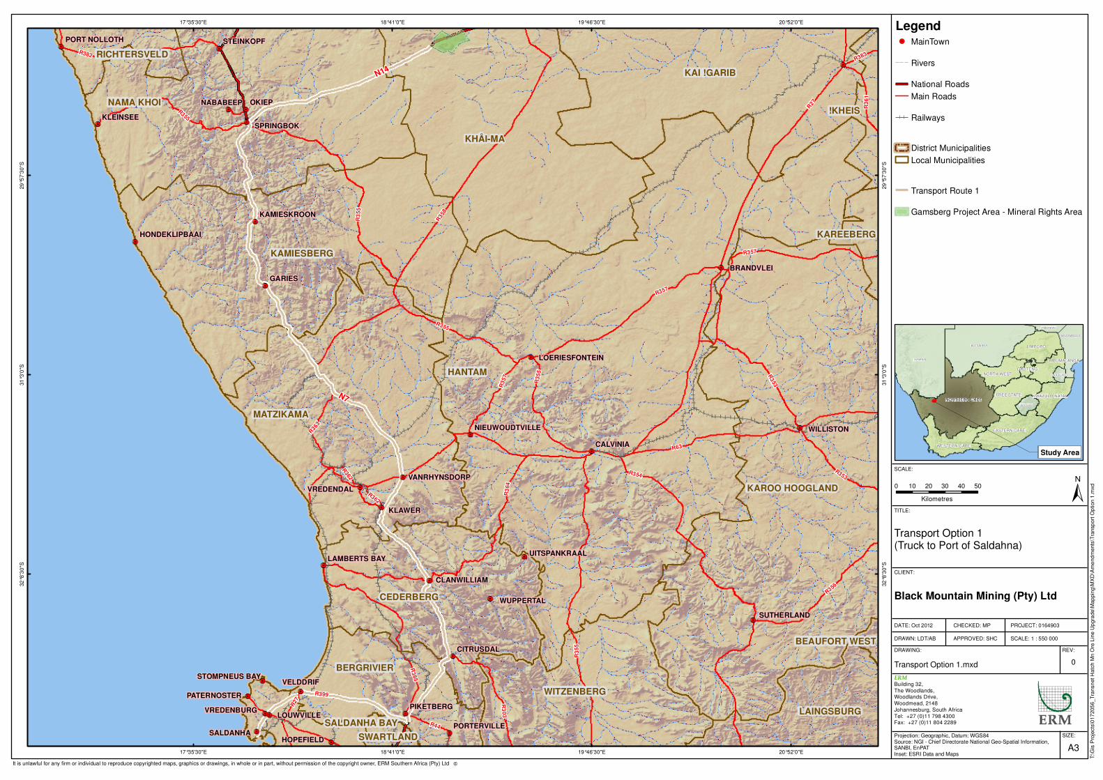
DRAFT COPY
Legend!. MainTown
Rivers
National Roads
Main Roads
Railways
District Municipalities
Local Municipalities
Transport Route 1
Gamsberg Project Area - Mineral Rights Area
OKIEP
KLAWER
GARIES
SALDANHA
VELDDRIF
CALVINIA
NABABEEP
KLEINSEE
LOUWVILLE
HOPEFIELD
PIKETBERG
WUPPERTAL
CITRUSDAL
VREDENDAL
WILLISTON
BRANDVLEI
STEINKOPF
SPRINGBOK
VREDENBURG
SUTHERLAND
PATERNOSTER
PORTERVILLE
CLANWILLIAM
KAMIESKROON
UITSPANKRAALLAMBERTS BAY
VANRHYNSDORP
PORT NOLLOTH
STOMPNEUS BAY
HONDEKLIPBAAI
NIEUWOUDTVILLE
LOERIESFONTEIN
N7
N14
R27
R35
8
R354
R63
R3
55
R3
64
R353
R365
R382
R357
R356
R363
R399
R3
03
R3
61
R44
R362
R383
R27
R362
R355
R357
R3
55
R355
R353
R35
5
R35
7HANTAM
KHÂI-MA
KAROO HOOGLAND
NAMA KHOI
MATZIKAMA
KAMIESBERG
KAI !GARIB
CEDERBERG
WITZENBERG
BERGRIVIER
LAINGSBURG
!KHEIS
RICHTERSVELD
SALDANHA BAY
KAREEBERG
SWARTLAND
BEAUFORT WEST
20°52'0"E
20°52'0"E
19°46'30"E
19°46'30"E
18°41'0"E
18°41'0"E
17°35'30"E
17°35'30"E29
°57
'30
"S
29
°57
'30
"S
31
°3'0
"S
31
°3'0
"S
32
°8'3
0"S
32
°8'3
0"S
SIZE:
TITLE:
DATE: Oct 2012
DRAWN: LDT/AB
CHECKED: MP
APPROVED: SHC
PROJECT: 0164903
SCALE: 1 : 550 000
DRAWING: REV:
A3
Transport Option 1 (Truck to Port of Saldahna)
Transport Option 1.mxd 0
CLIENT:
ERM
Building 32,
The Woodlands,Woodlands Drive,
Woodmead, 2148
Johannesburg, South Africa
Tel: +27 (0)11 798 4300Fax: +27 (0)11 804 2289
±0 10 20 30 40 50
Kilometres
SCALE:
T:\G
is P
roje
cts
\017
205
6_T
ransn
et H
atc
h M
n O
re L
ine U
pgra
de\M
ap
pin
g\M
XD
\Am
end
ments
\Tra
nsp
ort
Op
tion
1.m
xd
Black Mountain Mining (Pty) Ltd
Projection: Geographic, Datum: WGS84Source: NGI - Chief Directorate National Geo-Spatial Information,SANBI, EnPATInset: ESRI Data and Maps
It is unlawful for any firm or individual to reproduce copyrighted maps, graphics or drawings, in whole or in part, without permission of the copyright owner, ERM Southern Africa (Pty) Ltd �
NAMIBIA
BOTSWANA
NORTHERN CAPE
LIMPOPO
EASTERN CAPE
FREE STATE
WESTERN CAPE
NORTH WEST
MOZAMBIQUE
KWAZULU-NATAL
MPUMALANGA
LESOTHO
ZIMBABWE
GAUTENG
SWAZILAND
Study Area
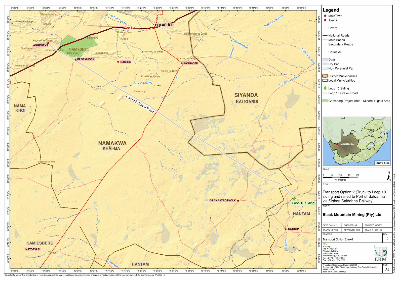
DRAFT COPY
Legend!. MainTown
!Ç Towns
Rivers
National Roads
Main Roads
Secondary Roads
Railways
Dam
Dry Pan
Non Perennial Pan
District Municipalities
Local Municipalities
hg Loop 10 Siding
Loop 10 Gravel Road
Gamsberg Project Area - Mineral Rights Area
!Ç
!Ç
!Ç!Ç
!Ç
!Ç
!Ç
!Ç
!Ç
!Ç
!Ç
!.
hg
Loop 10 Gravel Road
Loop 10 Siding
BLOEMHOEKNAMIES HOUMOED
GRANAATBOSKOLK
STOFVLEI
KATKOP
PELLA
AGGENEYS
Gifkop
Witberg
Bakenskop
Spioenkop
Swartberg
Barietmyn
GAMSBERGNamiesberge
Haramoepberge
T'Goob se Berg
Leeuklip se Kop
Houmoed se Berg
Naroes se Berge
Froneman se Kop
Aggenys se Berge
Sillimanite Mine
Poortjie se Koppe
Windhoek se Berge
Ou Samoep se Berge
Mattheusgat se Berge
NAMAKWA
SIYANDA
KHÂI-MA
KAI !GARIB
HANTAM
KAMIESBERG
HANTAM
NAMA KHOI
R35
8
R3
5 8
N14
Kaboep
Katk
op
Nam se Laagte
Koeiamlaagte
Saadkraal
Brulkolk se H
olte
POFADDER
Goob se Laagte
Banksvlei s
e Holte
Soutputs se Laagte
20°10'0"E
20°10'0"E
20°5'0"E
20°5'0"E
20°0'0"E
20°0'0"E
19°55'0"E
19°55'0"E
19°50'0"E
19°50'0"E
19°45'0"E
19°45'0"E
19°40'0"E
19°40'0"E
19°35'0"E
19°35'0"E
19°30'0"E
19°30'0"E
19°25'0"E
19°25'0"E
19°20'0"E
19°20'0"E
19°15'0"E
19°15'0"E
19°10'0"E
19°10'0"E
19°5'0"E
19°5'0"E
19°0'0"E
19°0'0"E
18°55'0"E
18°55'0"E
18°50'0"E
18°50'0"E
18°45'0"E
18°45'0"E
18°40'0"E
18°40'0"E29
°5'0
"S
29
°5'0
"S
29
°10
'0"S
29
°10
'0"S
29
°15
'0"S
29
°15
'0"S
29
°20
'0"S
29
°20
'0"S
29
°25
'0"S
29
°25
'0"S
29
°30
'0"S
29
°30
'0"S
29
°35
'0"S
29
°35
'0"S
29
°40
'0"S
29
°40
'0"S
29
°45
'0"S
29
°45
'0"S
29
°50
'0"S
29
°50
'0"S
29
°55
'0"S
29
°55
'0"S
30
°0'0
"S
30
°0'0
"S
30
°5'0
"S
30
°5'0
"S
30
°10
'0"S
30
°10
'0"S
30
°15
'0"S
30
°15
'0"S
30
°20
'0"S
30
°20
'0"S
SIZE:
TITLE:
DATE: Oct 2012
DRAWN: LDT/AB
CHECKED: MP
APPROVED: SHC
PROJECT: 0164903
SCALE: 1 : 550 000
DRAWING: REV:
A3
Transport Option 2 (Truck to Loop 10 siding and railed to Port of Saldahna via Sishen Saldahna Railway)
Transport Option 2.mxd 0
CLIENT:
ERM
Building 32,
The Woodlands,Woodlands Drive,
Woodmead, 2148
Johannesburg, South Africa
Tel: +27 (0)11 798 4300Fax: +27 (0)11 804 2289
±0 5 10 15 20
Kilometres
SCALE:
T:\G
is P
roje
cts
\017
205
6_T
ransn
et H
atc
h M
n O
re L
ine U
pgra
de\M
ap
pin
g\M
XD
\Am
end
ments
\Tra
nsp
ort
Op
tion
2.m
xd
Black Mountain Mining (Pty) Ltd
Projection: Geographic, Datum: WGS84Source: NGI - Chief Directorate National Geo-Spatial Information,SANBI, EnPATInset: ESRI Data and Maps
It is unlawful for any firm or individual to reproduce copyrighted maps, graphics or drawings, in whole or in part, without permission of the copyright owner, ERM Southern Africa (Pty) Ltd �
NAMIBIA
BOTSWANA
NORTHERN CAPE
LIMPOPO
EASTERN CAPE
FREE STATE
WESTERN CAPE
NORTH WEST
MOZAMBIQUE
KWAZULU-NATAL
MPUMALANGA
LESOTHO
ZIMBABWE
GAUTENG
SWAZILAND
Study Area
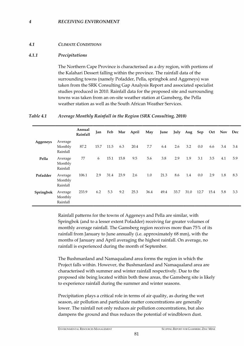
ENVIRONMENTAL RESOURCES MANAGEMENT SCOPING REPORT FOR GAMSBERG ZINC MINE
81
4 RECEIVING ENVIRONMENT
4.1 CLIMATE CONDITIONS
4.1.1 Precipitations
The Northern Cape Province is characterised as a dry region, with portions of the Kalahari Dessert falling within the province. The rainfall data of the surrounding towns (namely Pofadder, Pella, springbok and Aggeneys) was taken from the SRK Consulting Gap Analysis Report and associated specialist studies produced in 2010. Rainfall data for the proposed site and surrounding towns was taken from an on-site weather station at Gamsberg, the Pella weather station as well as the South African Weather Services.
Table 4.1 Average Monthly Rainfall in the Region (SRK Consulting, 2010)
Rainfall patterns for the towns of Aggeneys and Pella are similar, with Springbok (and to a lesser extent Pofadder) receiving far greater volumes of monthly average rainfall. The Gamsberg region receives more than 75% of its rainfall from January to June annually (i.e. approximately 68 mm), with the months of January and April averaging the highest rainfall. On average, no rainfall is experienced during the month of September. The Bushmanland and Namaqualand area forms the region in which the Project falls within. However, the Bushmanland and Namaqualand area are characterised with summer and winter rainfall respectively. Due to the proposed site being located within both these areas, the Gamsberg site is likely to experience rainfall during the summer and winter seasons. Precipitation plays a critical role in terms of air quality, as during the wet season, air pollution and particulate matter concentrations are generally lower. The rainfall not only reduces air pollution concentrations, but also dampens the ground and thus reduces the potential of windblown dust.
Annual Rainfall Jan Feb Mar April May June July Aug Sep Oct Nov Dec
Aggeneys Average Monthly Rainfall
87.2 15.7 11.5 6.3 20.4 7.7 6.4 2.6 3.2 0.0 6.6 3.4 3.4
Pella Average Monthly Rainfall
77 6 15.1 15.8 9.5 5.6 3.8 2.9 1.9 3.1 3.5 4.1 5.9
Pofadder Average Monthly Rainfall
106.1 2.9 31.4 23.9 2.6 1.0 21.3 8.6 1.4 0.0 2.9 1.8 8.3
Springbok Average Monthly Rainfall
233.9 6.2 5.3 9.2 25.3 36.4 49.4 33.7 31.0 12.7 15.4 5.8 3.3

ENVIRONMENTAL RESOURCES MANAGEMENT SCOPING REPORT FOR GAMSBERG ZINC MINE
82
During the dry period, dust concentration levels increase due to drier conditions and reduced vegetation cover.
4.1.2 Maximum and Mean Monthly Temperatures
The temperatures experienced in the Northern Cape are influenced by surrounding topographies, generally characterised with desert and semi-desert conditions. Due to a lack of temperature data at the Gamsberg site, temperature data for the town of Pofadder, which is located 60 km east of the Gamsberg site, is used as a representative indication of temperature at Aggeneys. The region generally experiences hot and dry summers, with maximum temperatures in Pofadder ranging from 35 – 39 oC during the months of November to March. During winter periods, the minimum temperature experienced in Pofadder and Springbok can vary from -1– 13 oC, with significant temperature reductions at night time. The average temperature experienced varies significantly between the summer and winter months, with the highest average temperatures experienced during the wettest months on the year.
Table 4.2 Average Temperature in Pofadder (SRK Consulting, 2010)
Dec Jan Feb Mar Apr May Jun Jul Aug Sep Oct Nov
Dec 2007 to Nov
2008
Average 25.3 27.1 26.8 24.5 19.9 15.8 12.4 12.2 13.7 13.9 20.4 23.0
Min. Temp
10.3 10.5 12.4 7.8 5.2 3.9 1.1 -0.4 0.2 0.3 4.6 8.1
Max. Temp.
38.6 39.2 39.6 36.5 31.0 29.6 25.1 24.7 28.5 32.9 35.5 38.4
Ambient air temperature plays an influential role with respect to plume buoyancy. The greater the temperature gradient is between the plume and ambient air temperature, the higher the plume will rise. In addition, ambient air temperature can be used to determine the mixing depth and inversion layer heights, which influence air quality. Updated weather records will be sourced and used for pollution and dust dispersion modelling.
4.1.3 Monthly Mean Wind Direction and Speed
Similarly to the temperatures presented above, the wind data recorded at Pofadder is used as an indicative representation of wind conditions in the town of Aggeneys. The prevailing winds experienced in the region are southerly and westerly. The southerly winds are experienced mainly during night times, with the westerly wind dominating the day time conditions (SRK Consulting, 2010). The average wind speeds recorded for day and night time is 3.25 m/s and 3.10 m/s respectively.

ENVIRONMENTAL RESOURCES MANAGEMENT SCOPING REPORT FOR GAMSBERG ZINC MINE
83
Based on the seasonal variations, summer and spring experience higher average wind speeds of 3.68 m/s and 3.56 m/s respectively. The winter (2.81 m/s) and autumn (2.75 m/s) seasons are generally cooler, and thus the wind speeds are slower than that experienced in the warmer months (SRK Consulting, 2010). However, prevailing winds are generally similar, with southerly winds experienced during Summer and Spring, and westerly winds experienced during Autumn and Winter.
4.2 TOPOGRAPHY
The local topography is mainly characterised with undulating plains, containing low growing shrubby vegetation and grasses. The surrounding plains are approximately 750 – 900 meters above mean sea level (mamsl), with the highest areas of the Gamsberg inselberg varying between 1100 – 1150 mamsl. The Gamsberg inselberg is approximately 7.2 km east – west and approximately 4.6 km north – south. Erosion along the top of the inselberg has resulted in the creation of a basin within the feature, which subsequently varies between 60 – 70 m below the rim of the inselberg.
4.3 GEOLOGY
4.3.1 Regional Geology
The geology in the region is comprised of an array of Precambrian – age metamorphic rocks, which are collectively referred to as the Namaqua – Natal Province. The geology in the Northern Cape Province is subdivided into a number of tectonically bound terrains. These terrains which comprise the regional geology of the area are as follows (SRK Consulting, 2010): • Bushmanland Terrane • Richtersveld Subprovince • Kakamas Terrane • Areachap Terrane • Kaaien Terrane The proposed two of Aggeneys and surrounds falls within the Bushmanland Terrane, which is characterised with volcano-sedimentary rocks, basement granitic rocks and intrusive charnokite to granitic rocks (SRK Consulting, 2010).
4.3.2 Local Mine Geology
From a local perspective, the Project area falls within the Bushmanland Terrane group. The Bushmanland Subprovince can be subdivided into a southern Garies Terrain and northern Aggeneys Terrain. The proposed site falls within the northern Aggeneys Terrain. The supracrustal rocks of the Aggeneys Terrain (i.e. Bushmanland Group), comprise a thin (<1 km thick)
ENVIRONMENTAL RESOURCES MANAGEMENT SCOPING REPORT FOR GAMSBERG ZINC MINE
84
metavolcano-sedimentary succession composed of a very consistent, shallow marine duplex of sandstone-shale to chemogenic metasedimentary and metavolcanic rocks that have undergone multiple phases of deformation and metamorphism (University of Johannesburg, https://ujdigispace.uj.ac.za). The geology is characteristic of low levels of permeability. Within the Aggeneys sub-group, 6 geological formations are present, which are as follows (SRK Consulting, 2010): • Koeris – maximum thickness of 634 m and comprises of amphibolite,
quartz-feldspar-biotite-muscovite gneiss with sporadic pebbles of metaconglomerate, quartzite and quartz-feldspar gneiss.
• Hotson – thickness varies between 70 m – 500 m across the proposed site and comprises quartzite, quartz-feldspar gneiss and biotite-sillimanite schist.
• T’hammaberg - 270 m in thickness and is characterised by quartzmuscovite-sillimanite schist interlayered with quartzite with sporadic fuchsite and graphite.
• Skelm poort - 47-58 m in thickness and comprises dark quartzite grading into graphite bearing quartz-muscovite schist with fuchsite patches.
• Wortel - composed of a basal biotite-sillimanite schist and quartzite, with sporadic magnetite-rich lenses.
• Witputs - Formation is lithologically similar and is therefore grouped together with the Wortel Formation.
4.4 SOIL POTENTIAL
4.4.1 Soil Forms
The Project area is characterised with extensive peneplain. The soils present in the peneplain are predominantly shallow and stony. However, soils found within the inselberg are characterised with bouldery and stony scree slope soils (SRK Consulting, 2010). The scarps and crest of the inselberg are characterised with bare rocks, while the Gamsberg Basin itself is characterised with shallow gravelly soils. The soils present on the peneplain are generally characterised with reddish sandy topsoil that is shallow in nature. However, a 10cm thick red sandy surface layer is present along the northern section of the proposed site. The western and southern part of the proposed site is characterised with deeper red soils, varying in depth from 30 cm to 60 cm. Along the south western portion of the proposed site, deeper red soils occur. It should be noted that the Gamsberg inselberg has been managed so as to disallow grazing to occur on-site. In doing, the level of land degradation is limited for this inselberg. The surrounding farm lands have experienced some degree of degradation as a result of overgrazing.

ENVIRONMENTAL RESOURCES MANAGEMENT SCOPING REPORT FOR GAMSBERG ZINC MINE
85
The Project area (which comprises of 4 properties) are already zoned for mining, with the exception of Gams 60, Portion 4 which is zoned for farming. However, it must be noted that Black Mountain Mining has an existing surface right to mine Gams 60, Portion 4 and therefore no grazing is currently undertaken on this property.
4.4.2 Agricultural Potential
Due to limited water available in the region, crop farming is not the prevailing agricultural activity in this region. As a result, livestock farming is the dominant form of farming activities in the region. The Project area has an existing mining right, and thus the grazing potential of the site has not been investigated. Furthermore, grazing activities have been prevented on the Gamsberg inselberg, which has indirectly contributed to the conservation of the biodiversity on-site.
4.5 SURFACE WATER
4.5.1 Catchment Area Characteristics
The northern section of the Project area drains into the Orange River Basin, whereas the southern section drains into a catchment referred to as an endoreic area, (i.e. an interior catchment that doesn’t feed out into the ocean) (SRK Consulting, 2010). The Orange River basin is considered to be the largest river basin in South Africa with a total catchment area of approximately 1 000 000 km2 (www.dwa.gov.za, 2012). Approximately 600 000 km2 of the total catchment area is located inside the Republic of South Africa (refer to Figure 4.1 below). The remainder of the catchment area is spread across Lesotho, Botswana and Namibia. The Orange River, (called the Senqu River in Lesotho), originates high in the Lesotho Highlands, approximately 3 300 m above sea level. The average annual rainfall can exceed 1 800 mm (www.dwa.gov.za, 2012). The river is approximately 2 300 km long (i.e. from the source in Lesotho to the estuary in Alexander Bay). According to various sources the average natural mean annual run-off (MAR) from the total basin is more than 12 000 million m3/a, however, this volume is representative of the natural MAR, and therefore excludes current development activities and storage facilities on the system (www.dwa.gov.za, 2012). The current MAR of the Orange River, at the proposed point of abstraction will be presented in the ESIA Report. There are three main storage reservoirs within the Orange River basin, namely Gariep Dam, Vanderkloof Dam (located within South Africa) and the recently completed Katse Dam in Lesotho on the Senqu River (www.dwa.gov.za, 2012). The Gariep Dam has a total capacity in excess of 5 000 million m3 while

ENVIRONMENTAL RESOURCES MANAGEMENT SCOPING REPORT FOR GAMSBERG ZINC MINE
86
Vanderkloof Dam has a storage capacity of over 3 200 million m3. The storage capacity of the Katse dam is 1 950 million m3.
Figure 4.1 Orange River Catchment (Sourced from www.dwa.gov.za website, 2012)
The Project will require a total of 9,125 million m3/ annum of water to fulfil the operational requirements for all Project components. The construction phase is expected to last 30 months. It is the intention of Black Mountain to source the water requirements for the Project from the Orange River during construction and operation. Based on the water requirements for the Project, the suggested volume of water for the operational phase (i.e. 9,125 million m3/ annum) is approximately 0.083% of the natural MAR of the Orange River system. Due to its length, the Orange River is divided into the upper and lower Orange water management areas. The proposed site falls within the lower Orange Water Management Area, which is further divided into 4 sub-areas. The length of river extending from Pella to Alexandra Bay is part of the fourth sub-area (DWA, 2009). However, there are a number of users identified from
ENVIRONMENTAL RESOURCES MANAGEMENT SCOPING REPORT FOR GAMSBERG ZINC MINE
87
downstream of the Pella abstraction point. Approximately 166 km downstream of Pella, the Orange River crosses the Vioolsdrift Weir, where water is pumped to the town of Springbok. Slightly downstream of the Vioolsdrift Weir is a small farming town of Vioolsdrift located along the southern side of the Orange River. Downstream of the town of Vioolsdrift, the Orange River enters the Richtersveld area, which is comprised of many local Nama communities. Due to the migration patterns of the Nama communities, approximately 160 000 hectares of the Richtersveld has been declared a UNESCO World Heritage Site (DWA, 2009). Approximately 145 km downstream of Vioolsdrift, the Fish River (a major tributary) links into the Orange River. Approximately 150km downstream of the Fish River confluence, the Orange River feeds into the Atlantic Ocean, at Alexandra Bay.
4.5.2 Site Specific Water Resources
The Project area falls within three quaternary catchment areas, namely, D82C, D82A and D81G. During the hydrology and surface water analysis undertaken by SRK Consulting (2010), the Project area and associated infrastructure is expected to impact on 10 local water catchment areas in the three quaternary catchments. Based on the previous investigations, the area for each catchment ranges from 0.97 km2 to 272 km2. The MAR for each of these catchments were based on based on area weighting WR2005 data (SRK Consulting, 2010). The area weighted MAR for each of these catchment areas varied from 300 m3 to 84 000 m3. However, due to the limited rainfall experienced in the region, most of the water courses identified are ephemeral in nature. Notwithstanding, the small catchment area identified on top of the inselberg does contain a spring, and therefore can experience seasonal to perennial flows.
4.5.3 Water Quality Management and Sources of Contamination
During the hydrological baseline investigations undertaken by SRK Consulting in 2010, water monitoring stations were set up to determine flow volumes as well as obtain water quality data. However, due to the lack of rainfall during the monitoring period from May – August 2009, data was only collected from three of the ten monitoring stations (in and around the inselberg). Thus the information contained is a reflection of the dry season data for water quality. The results from the water quality monitoring were compared to the South African National Standards for drinking water (SANS 241 of 2006). This initial analysis confirmed that water from the springs on the Gamsberg inselberg is considered to be suitable for domestic use and livestock watering (SRK Consulting, 2010). The concentration levels of Barium found in the water did comply with SANS 241 over the monitoring period. However Barium concentrations did exceed the World Health Organisations standard for drinking water. It must be noted that the nitrate concentrations recorded during the months of July and August were approximately 10 times higher

ENVIRONMENTAL RESOURCES MANAGEMENT SCOPING REPORT FOR GAMSBERG ZINC MINE
88
than those during May and June. Although the nitrate levels remains within SANS 241 standards for drinking water, the nitrate concentrations are likely to be linked to fertilizers, sanitation problems and livestock.
4.6 GROUNDWATER
4.6.1 Description of Hydrogeology
As part of the baseline study, a hydro-census analysis was undertaken by SRK Consulting in 2010 of the Gamsberg region to obtain information related to groundwater. Approximately 41 water sources (including boreholes, wells and springs) were identified, however, only 27 of those were operational with the required equipment. The baseline study confirmed that no regional aquifers have developed in the Namaqualand Metamorphic Complex. Furthermore, due to thinly developed soils, primary weathered zone aquifers are infrequent and localised. Groundwater is mainly found within secondary fractured-rock aquifers and tends to be found along fractures within hydraulically isolated rocks of low permeability, which are commonly found in the surrounding areas. According to the baseline report, the transmissivity of the fractured aquifers is considered to be low (SRK Consulting, 2010). The geology in the Gamsberg area is mainly comprised of dense metamorphic rocks which are characterised with low permeability, and as such, the movement of groundwater in the area is largely influenced by secondary structural features. Features such as shears, thrust faults and fractures will impact on the movement of groundwater. Interconnected features would facilitate a greater movement of groundwater across the region, while unconnected features will limit groundwater flows to the individual faults or fractures. The structural features identified are largely oriented in a north to northwest direction of the proposed Gamsberg site, with a few features present to the east to west and southeast directions.
4.6.2 Current Groundwater Use
Groundwater resources in the Namakwa District are more abundant than surface water features. Groundwater serves as a key water source, especially for livestock farmers in the Project area. Based on estimated projections, a total of ~75 000 m3/a of groundwater is abstracted, primarily for livestock watering and domestic use. This was calculated based on the hydro-census analysis undertaken in 2010 by SRK Consulting for the various boreholes, wells and springs. The boreholes present in the region are expected to yield between 0.1 and 0.5 ℓ/s, which are likely to experience seasonal variations based on rainfall patterns.

ENVIRONMENTAL RESOURCES MANAGEMENT SCOPING REPORT FOR GAMSBERG ZINC MINE
89
A breakdown of current groundwater abstraction in the surrounding region is presented below.
Table 4.3 Summary of Groundwater Abstraction in the area (SRK Consulting, 2010) Groundwater Use Abstraction (m3/a) No. of water sources Domestic 2 700 2 Domestic/Livestock 28 129 6 Drilling Water 19 450 2 Livestock 15 500 13 Monitoring 9461 4 Unused 0 14 Total 75 240 41
4.6.3 Groundwater Quality
Groundwater sampling and analysis was undertaken in 2010 by SRK Consulting. The Electrical Conductivity (EC) and pH levels were measures at locations within and around the Gamsberg inselberg. The EC levels in the water sampled in the Gamsberg inselberg appears to be lower than those sampled from sites adjacent to and surrounding the inselberg. This implies that the Gamsberg inselberg has a higher recharge rate. The pH values of the water sampled varied between 6.15 and 8.45, with a mean of 7.45. Fluoride concentrations in groundwater samples ranged between 0.2 and 4.2 mg/ℓ, with a mean value of 2.07 mg/ℓ. Majority of the samples tested exceeded the Class two water quality parameters, and is thus considered not suitable for drinking purposes in terms of SANS 241 of 2006. The elevated Fluoride concentrations were limited to samples taken from sources surrounding the Gamsberg inselberg, and could potentially be attributed to evaporation rates, mineralogy of the rock or holding time of groundwater. Nitrate concentrations found in the groundwater varied from below 0.3 mg/ℓ (below detection limit) to 43 mg/ℓ (sample found at a dug up well) (SRK Consulting, 2010). The higher levels of nitrate concentration identified exceed the limits outlined in SANS 214 of 2006, and is thus considered unsuitable for drinking purposes.
4.6.4 Groundwater Levels and Flow Directions
The mean annual effective recharge from mean annual precipitation in the study area is projected to be approximately 319 000 m3/a, which equates to an average recharge rate of 0.85 % of mean annual precipitation. However, evaporation rates in the Namakwa region are considered to be high as ~3 500 mm/annum and therefore the area suffers a permanent water deficit (SRK Consulting, 2010). This deficit is highest (in excess of 400 mm) from November to January. The area is categorized as hyper-arid, where potential evapotranspiration is almost 20 times greater than rainfall experienced, thus resulting in slight surface flow but high drought vulnerability.

ENVIRONMENTAL RESOURCES MANAGEMENT SCOPING REPORT FOR GAMSBERG ZINC MINE
90
The depth of groundwater ranges from 0 meters below ground level (mbgl) within the Gamsberg inselberg and increases in depth to approximately 51 mbgl in the surrounding plains. Based on modelled groundwater level contours, groundwater flows are limited to the south west and north east of the Gamsberg inselberg. The groundwater flows are consistent with the general surface topography in the area, which are indicative of an unconfined aquifer condition. Based on the mean annual effective recharge from mean annual precipitation relative to evaporation rates experienced in the region, groundwater is not seen as a viable source in the affected quaternaries due to an existing deficit in these catchments.
4.7 GEOCHEMISTRY
In 2010, SRK Consulting undertook a desktop geochemical analysis of tailings samples in order to characterise the potential to generate acidic, saline and/ or metal rich leachates. The following tests and analyses were undertaken for the solid fraction: • Static acid based accounting test • Net Acid Generating (NAG) test • Total Digest Based on the liquid fractions obtained, the following anlayses were undertaken: • pH • EC • alkalinity • major cations and anions • metal/metalloid concentrations Based on the results of the total metal concentration, the sample is characterised with by iron and aluminium with relatively high concentrations of calcium, lead, magnesium, manganese and potassium. Furthermore, the tailings contained arsenic, cadmium, cobalt, copper, lead, manganese, nickel, titanium, chrome and zinc. The acid based accounting tests were undertaken to determine the acid generation potential and neutralisation potential of wastes generated by the mine. The results indicated that the sample contained high levels of sulphide (32%) which indicates a high potential for acid generation. Furthermore, the NAG test undertaken also indicated a high propensity to generate acid run –off. However, the NAG test has a limitation of the sulphide content in any sample, and the 32% concentration exceeded the NAG tests thresholds.
ENVIRONMENTAL RESOURCES MANAGEMENT SCOPING REPORT FOR GAMSBERG ZINC MINE
91
The metals concentrations in the leachate generated from the tailings are not considered to be environmentally significant, with the exception of releases of higher concentrations of zinc, iron and manganese into groundwater resources. This risk and the impact of this would have to be calculated and determined by undertaking longer term kinetic testing (to determine acid and neutralisation potential) and relating the findings to the hydrogeological model. The initial analyses undertaken indicate that the tailings material is likely to have an impact on the environment. However, it is recommended that the test period be extended to explore the full neutralising potential in order to determine a final leachate characteristic. A detailed geochemical investigation will need to be undertaken to verify or update existing results and tests. However, as the existing analysis have indicated acid producing and metal leachate potential, suitable mitigation will be explored upon completion of the geochemical and hydrogeological investigations.
4.8 FLORA
4.8.1 Regional Context
The Gamsberg inselberg sits within what is termed the Bushmanland Inselberg Region (BIR), which includes all the large, quartzite-capped inselbergs located in the northern Bushmanland plains in South Africa. The BIR is said to cover a total area of about 6 300km2 (Desmet, 2010). The BIR extends through the boundary between summer and winter rainfall systems in Southern Africa. Based on this location, the vegetation found on the plains and along the warmer north-facing slopes is characteristic of the Nama Karoo Biome whereas that of cooler higher-elevation plains and south-facing slopes is characteristic of the Succulent Karoo Biome. The overlap of these biomes makes these inselbergs a unique feature, thus forming the fundamental difference of these inselbergs as compared to other inselbergs found elsewhere in the Nama Karoo. Due to erratic rainfall experienced during different seasons, summer and winter rainfall flora can co-exist in this region, and thus contributing to its unique value. The vegetation found on these inselbergs forms a distinct centre of plant endemism located within the larger Eastern Gariep Centre of Endemism (Desmet, 2010), which includes the Orange River valley between Vioolsdrif and Pofadder/Onseepkans. As there are a number of species identified that is considered to be endemic to the Bushmanland inselbergs and the BIR itself, the region has been termed “Bushmanland Inselberg Centre of Endemism” or sometimes the “Gamsberg Centre of Endemism”. The extent of the BIR is reflected below. A regional investigation undertaken by Dr Phillip Desmet (2000), confirmed that the Gamsberg inselberg is considered to be the most regionally important
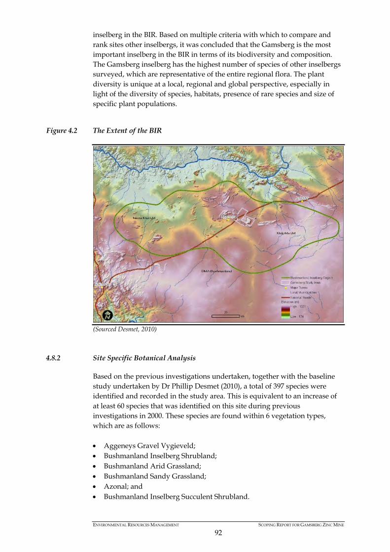
ENVIRONMENTAL RESOURCES MANAGEMENT SCOPING REPORT FOR GAMSBERG ZINC MINE
92
inselberg in the BIR. Based on multiple criteria with which to compare and rank sites other inselbergs, it was concluded that the Gamsberg is the most important inselberg in the BIR in terms of its biodiversity and composition. The Gamsberg inselberg has the highest number of species of other inselbergs surveyed, which are representative of the entire regional flora. The plant diversity is unique at a local, regional and global perspective, especially in light of the diversity of species, habitats, presence of rare species and size of specific plant populations.
Figure 4.2 The Extent of the BIR
(Sourced Desmet, 2010)
4.8.2 Site Specific Botanical Analysis
Based on the previous investigations undertaken, together with the baseline study undertaken by Dr Phillip Desmet (2010), a total of 397 species were identified and recorded in the study area. This is equivalent to an increase of at least 60 species that was identified on this site during previous investigations in 2000. These species are found within 6 vegetation types, which are as follows: • Aggeneys Gravel Vygieveld; • Bushmanland Inselberg Shrubland; • Bushmanland Arid Grassland; • Bushmanland Sandy Grassland; • Azonal; and • Bushmanland Inselberg Succulent Shrubland.

ENVIRONMENTAL RESOURCES MANAGEMENT SCOPING REPORT FOR GAMSBERG ZINC MINE
93
The Aggeneys Gravel Vygieveld is comprised of four habitat units, covering a total area of approximately 1 556 hectares, which is approximately 9% of the regional extent of this vegetation type. The specific habitat unit of Mountains Plateau cover an area of approximately 587 hectares, which is equivalent to 36,7% of the regional extent of this habitat. Furthermore, the Plains Gravel Quartz Plateau habitat is also present, covering a total area of 208 hectares. This equates to 41% of the regional extent of this habitat type. This vegetation type is generally found in Northern Cape Province, at elevations exceeding 950 m, and found generally along plateau summits of inselbergs and koppies. The vegetation in the region is characterised with sparse, low-growing species. The species found throughout the year are characterised by small to very small succulent plants, with a general absence of trees and grasses, except along drainage lines. Although the vegetation types can vary, Succulent Karoo vegetation is prominent in the area. The Bushmanland Inselberg Shrubland is comprised of two habitat units, covering a total area of just over 3 000 hectares. The habitat units present include Mountains and Plains Rocky, which covers an area of 2 545 and 626 hectares respectively. The habitat units present on-site contain between 3,2% and 3,8% of the regional extent of these habitat units. The Bushmanland Inselberg Shrubland is generally found at elevations varying from 850 m – 1 150 m, typically found on the slopes of inselbergs and koppies. The vegetation is characterised with sparse to dense vegetation with varied composition. The vegetation is a combination of a mixture of low-growing grasses, leaf-succulent karoo shrubs, microphyllous and spinescent karoo shrubs and succulent trees. The Bushmanland Arid Grassland vegetation type is present in the region, and contains three specific habitat units, namely, Plains Sandy flat, Plains Sandy hummocky and Plains Gravel Calcrete, which cumulatively covers a total area of approximately 3 000 hectares. Of the three habitat units, the Plains Gravel calcrete forms the smallest area (i.e. 211.5 hectares), however equates to 23.7% of the regional extent of this vegetation type. The remaining habitat units form less than 1% of the regional extent of their respective vegetation units. The Bushmanland Arid Grassland vegetation is the dominant vegetation on the sandy plains around the base of the Gamsberg inselberg is and also extends along the plains to the north of the N14. The vegetation is typical of extensive grasses extending along sandy plains, containing a variety of shrubs.
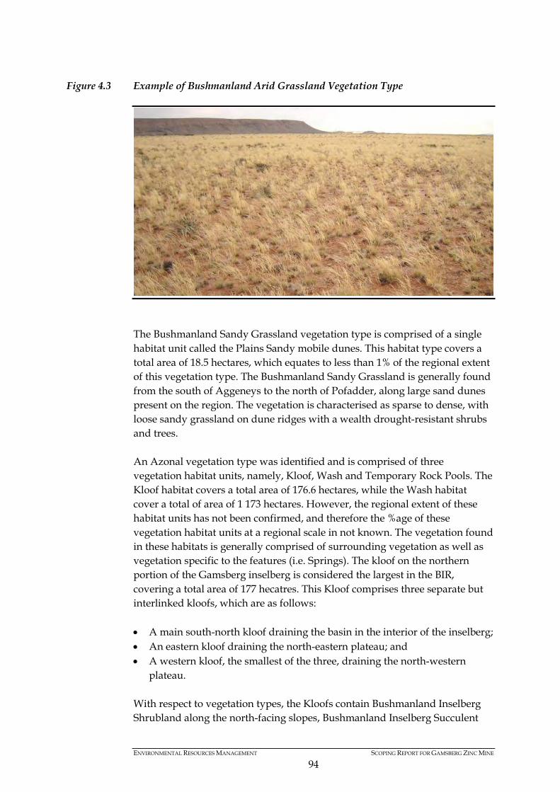
ENVIRONMENTAL RESOURCES MANAGEMENT SCOPING REPORT FOR GAMSBERG ZINC MINE
94
Figure 4.3 Example of Bushmanland Arid Grassland Vegetation Type
The Bushmanland Sandy Grassland vegetation type is comprised of a single habitat unit called the Plains Sandy mobile dunes. This habitat type covers a total area of 18.5 hectares, which equates to less than 1% of the regional extent of this vegetation type. The Bushmanland Sandy Grassland is generally found from the south of Aggeneys to the north of Pofadder, along large sand dunes present on the region. The vegetation is characterised as sparse to dense, with loose sandy grassland on dune ridges with a wealth drought-resistant shrubs and trees. An Azonal vegetation type was identified and is comprised of three vegetation habitat units, namely, Kloof, Wash and Temporary Rock Pools. The Kloof habitat covers a total area of 176.6 hectares, while the Wash habitat cover a total of area of 1 173 hectares. However, the regional extent of these habitat units has not been confirmed, and therefore the %age of these vegetation habitat units at a regional scale in not known. The vegetation found in these habitats is generally comprised of surrounding vegetation as well as vegetation specific to the features (i.e. Springs). The kloof on the northern portion of the Gamsberg inselberg is considered the largest in the BIR, covering a total area of 177 hecatres. This Kloof comprises three separate but interlinked kloofs, which are as follows: • A main south-north kloof draining the basin in the interior of the inselberg; • An eastern kloof draining the north-eastern plateau; and • A western kloof, the smallest of the three, draining the north-western
plateau. With respect to vegetation types, the Kloofs contain Bushmanland Inselberg Shrubland along the north-facing slopes, Bushmanland Inselberg Succulent

ENVIRONMENTAL RESOURCES MANAGEMENT SCOPING REPORT FOR GAMSBERG ZINC MINE
95
Shrubland along the south-facing slopes and lastly, wash vegetation in the floor of the Kloof. Wash vegetation type contains all drainage lines present in the Gamsberg inselberg and is characterised with many species found in the surrounding area. Due to seasonal rainfall experienced in the region, periodic flooding has created a high disturbance habitat, which some species have suitably adapted to. Lastly, temporary rock pools are pan like structures that develop ephemeral pan ecosystems, based on standing water in these rock pools. Generally, perennial plant species are absent in these rock pools, however, the ecosystem is recognised as a unique and complex ecosystem based on the faunal communities and extreme spatial and temporal heterogeneity and dynamics (Desmet, 2010). Lastly, the Bushmanland Inselberg Succulent Shrubland vegetation type was identified on-site, as well as in the surrounding region. It should be noted that the botanist (Dr Phillip Desmet, 2010) identifies this as a new vegetation type, not previously described. This categorisation was undertaken in order to accommodate vegetation found on the upper (>950m) south-facing slopes of the Gamsberg inselberg. It was confirmed that this vegetation type covers a total area of 480 hectares, which equates to just over 10% of the regional extent of this vegetation type. The Bushmanland Inselberg Succulent Shrubland is limited to the upper south-facing slopes (above approximately 950m) of the Gamsberg and adjoining inselbergs in the south of the study area. The vegetation is generally characterised with dense coverage of leaf-succulent shrubs, leaf-deciduous shrubs, trailing stem succulents and tree succulents.
Figure 4.4 Typical composition of Bushmanland Inselberg Succulent Shrubland along southern face of Gamsberg Inselberg
A brief census was undertaken to review the relative population size of gravel-patch specialist plant species. A total of 13 patches were identified and assessed, which contained a total number of approximately 40 000 plants (Desmet, 2010). However, despite the sizes of these gravel patches, the

ENVIRONMENTAL RESOURCES MANAGEMENT SCOPING REPORT FOR GAMSBERG ZINC MINE
96
importance of these gravel patches is measured in terms of specie density and habitat size. Further detailed analysis of gravel patches will be presented during the scoping phase.
Figure 4.5 Plains Quartz Gravel Patch at northern eastern base of Gamsberg Inselberg
4.8.3 Features of Botanical Concern
Based on previous investigations undertaken by Dr Philip Desmet (2000 and 2010), species of biodiversity concern were defined and assessed in terms of botanical sensitivity/ importance. The criteria used to define the species were rare, endemic or threatened plant species. These criteria considered the Gamsberg Centre of Endemism, IUCN threatened status (Red Data Listed species), rare species (restricted to 3 or less inselbergs) and relic species (common in their core range but rare in the BIR and considered relics of past wetter or drier climates). Using these criteria, the following species of conservation concern were identified:
Table 4.4 Species of Conservation Concern Present in the Study Area (Sourced Desmet, 2010) Species Name Category Habitat Anacampseros bayeriana Rare Calcrete gravel patches. Crassula mesembrianthemopsis Rare Calcrete gravel patches. Titanopsis hugo-schlechteri var. hugo-schlechteri Rare Calcrete gravel patches. Conophytum ratum (plains form) Endemic & Vulnerable Plains quartz gravel
patch. Mesembryanthemum inachabense Endemic Plains quartz gravel
patch. Trachyandra sp. nov. Endemic Plateau. Tylecodon sulphureus Endemic Plateau. Adromischus nanus Endemic Plateau quartz gravel
patch. Conophytum angelicae subsp. angelicae (dwarf form) Rare Plateau quartz gravel
patch. Conophytum ratum (dwarf/plateau form) Endemic & Vulnerable Plateau quartz gravel
patch.
ENVIRONMENTAL RESOURCES MANAGEMENT SCOPING REPORT FOR GAMSBERG ZINC MINE
97
Aloe microstigma Relic South slopes. Conophytum limpidum (dwarf form) Endemic South slopes. Othonna sp. nov. Endemic South slopes. Sceletium tortuosum Relic South slopes. Azima tetracantha Relic Springs. Hydrodictyon sp. nov. Endemic Kloof. Based on the species of conservation concern identified above, together with habitat rarity, ecosystem functioning and status, habitats of specialist concern were identified. A total of 11 habitats of special concern were identified, as is tabulated below:
Table 4.5 Habitats of Conservation Value (Sourced Desmet, 2010) Habitat name Criteria notes Kloofs Rare habitat, climate refuge, keystone resource (water). Springs Very rare habitat, climate refuge, keystone resource
(water). Headwater Seeps Very rare habitat, keystone resource (forage). Headwater catchments Ecological support area. Temporary Rock Pools Very rare habitat. Plateau Quartz Gravel Patches Endemic species and rare habitat. Plains Quartz Gravel Patches Endemic species. Plateau Climate refuge and rare habitat. Calcrete Gravel Patches South Slopes Climate refuge. Washes Conduits for water movement in the landscape. During the baseline investigation undertaken (Desmet, 2010), it was confirmed that the habitats of conservation value were not rated and ranked in terms of sensitivities. Additional information in the form of detailed and quantitative assessments, together with further data sets to augment the population levels analysis. This exercise will be undertaken as part of the ESIA phase and the findings presented thereto.
4.9 FAUNA
A faunal baseline study was undertaken by Groundtruth in 2010 to update the existing faunal assessment previously undertaken during the initial EIA process (2000) as well as to identify additional areas for detailed investigation. The findings of this baseline investigation are presented below, together with further investigations required to present a comprehensive faunal assessment to inform decision making.
4.9.1 Terrestrial Invertebrates
Based on the field work and observations undertaken, it was confirmed that no Red Data invertebrate species were identified in the Gamsberg region (Groundtruth, 2010). This was said to unlikely change through further investigations as most of the Red Data invertebrates in South Africa are butterfly’s, with none of which expected to occur in the Gamsberg region.
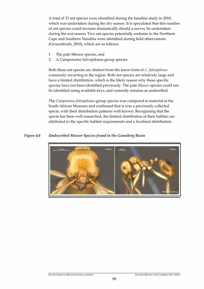
ENVIRONMENTAL RESOURCES MANAGEMENT SCOPING REPORT FOR GAMSBERG ZINC MINE
98
A total of 13 ant species were identified during the baseline study in 2010, which was undertaken during the dry season. It is speculated that this number of ant species could increase dramatically should a survey be undertaken during the wet season. Two ant species potentially endemic to the Northern Cape and Southern Namibia were identified during field observations (Groundtruth, 2010), which are as follows: 1. The pale Messor species, and 2. A Camponotus fulvopilosus-group species Both these ant species are distinct from the karoo form of C. fulvopilosus commonly occurring in the region. Both ant species are relatively large and have a limited distribution, which is the likely reason why these specific species have not been identified previously. The pale Messor species could not be identified using available keys, and currently remains as undesribed. The Camponotus fulvopilosus-group species was compared to material at the South African Museum and confirmed that is was a previously collected specie, with their distribution patterns well known. Recognising that the specie has been well researched, the limited distribution of their habitat can attributed to the specific habitat requirements and a localised distribution.
Figure 4.6 Undescribed Messor Species found in the Gamsberg Basin
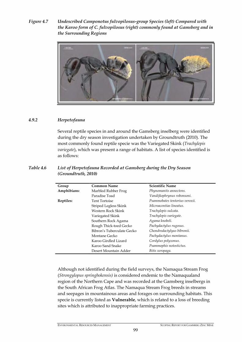
ENVIRONMENTAL RESOURCES MANAGEMENT SCOPING REPORT FOR GAMSBERG ZINC MINE
99
Figure 4.7 Undescribed Camponotus fulvopilosus-group Species (left) Compared with the Karoo form of C. fulvopilosus (right) commonly found at Gamsberg and in the Surrounding Regions
4.9.2 Herpetofauna
Several reptile species in and around the Gamsberg inselberg were identified during the dry season investigation undertaken by Groundtruth (2010). The most commonly found reptile specie was the Variegated Skink (Trachylepis variegate), which was present a range of habitats. A list of species identified is as follows:
Table 4.6 List of Herpetofauna Recorded at Gamsberg during the Dry Season (Groundtruth, 2010) Group Common Name Scientific Name Amphibians: Marbled Rubber Frog Phynomantis annectens. Paradise Toad Vandijkophrynus robonsoni. Reptiles: Tent Tortoise Psammobates tentorius veroxii. Striped Legless Skink Microacontias lineatus. Western Rock Skink Trachylepis sulcata. Variegated Skink Trachylepis variegate. Southern Rock Agama Agama knobeli. Rough Thick-toed Gecko Pachydactylus rugosus. Bibron’s Tuberculate Gecko Chondrodactylyus bibronii. Montane Gecko Pachydactylus montanus. Karoo Girdled Lizard Cordylus polyzonus. Karoo Sand Snake Psammophis notostictus. Desert Mountain Adder Bitis xeropaga.
Although not identified during the field surveys, the Namaqua Stream Frog (Strongylopus springbokensis) is considered endemic to the Namaqualand region of the Northern Cape and was recorded at the Gamsberg inselbergs in the South African Frog Atlas. The Namaqua Stream Frog breeds in streams and seepages in mountainous areas and forages on surrounding habitats. This specie is currently listed as Vulnerable, which is related to a loss of breeding sites which is attributed to inappropriate farming practices.

ENVIRONMENTAL RESOURCES MANAGEMENT SCOPING REPORT FOR GAMSBERG ZINC MINE
100
The Good’s Gecko (Pachydactylus goodi) is a recently described endemic specie that is found with the lower Gariep River (Groundtruth, 2010). This species habitat is partly threatened by mining and although not recorded during the 2010 survey, this is likely to occur along the slopes of Gamsberg inselberg. Lastly, the Paradise Toad (Bufo robinsoni) was identified within the Gamsberg inselberg, mainly along the Gamsberg stream (Groundtruth, 2010). This specie of toad is considered to be endemic to the Namaqualand, with its habitat mainly around water holes and natural springs. Due to the species range and distribution, the Paradise Toad is not considered threatened and is common in the region.
Figure 4.8 Paradise Toad Identified at Gamsberg Inselberg
4.9.3 Mammals
One specimen of bat was identified during the field survey undertaken by Groundtruth (2010). After careful evaluation, the specie was identified as the Darling’s Horseshoe Bat (Rhinolophus darling), which according to the IUCN Red Data List, is classified as Least Threatened. However, the South African Red Data Book for mammals classifies the conservation status of this specie as Near Threatened. During previous mammal surveys undertaken in the region, Red Data mammal species were confirmed at Gamsberg (Groundtruth, 2010): • Aardvark (Orycteropus) - Vulnerable • African Wild Cat (Felis lybica) – Vulnerable • Pygmy Rock Mouse (Petromyscus collinus) – Data deficient
ENVIRONMENTAL RESOURCES MANAGEMENT SCOPING REPORT FOR GAMSBERG ZINC MINE
101
It should be noted that Groundtruth field survey was limited to the dry season, and therefore species with a seasonal distribution would not have been identified. Further analysis is required during the wet season to ensure that seasonal variations are included into the assessment.
4.9.4 Avi-fauna
Based on the Harrison & Harebottle investigation undertaken in 2000, Groundtruth undertook a desktop analysis of avi-fauna in the region, but confirming and augmenting (where necessary) the findings of the previous investigations. During the 2010 baseline study, a total of 29 bird species were observed in and around the Gamsberg area (Groundtruth, 21010). It was confirmed that during this field survey during the dry seasons, no Red Data species were identified. This is despite that Gamsberg has been recognised to support a number of Red Data listed birds. The previous investigation by Harrison & Harebottle (2000) identified two red data species, namely Martial Eagle (Polemaetus bellicosus) (Vulnerable) and Secretary Bird (Sagittarius serpentarius) which are considered Vulnerable and Near-threatened respectively. The Red Lark (Certhilauda burra), which has a Red Data Conservation status of Vulnerable, is known to occur in the region surrounding the Gamsberg inselberg. The Red Lark’s distribution is limited to habitat availability (red sand dunes), which is found a few kilometres to the south west of the Gamsberg inselberg (Groundtruth, 2010). Lastly, the Verreaux's Eagle (Aquila verreauxii) was identified during previous investigation, with two nests being present along the southern slopes of the Gamsberg inselberg. In terms of the IUCN Red Data list, the Verreaux's Eagle is classified as Least Concern.
4.9.5 Aquatic Biodiversity
In order to review the aquatic biodiversity of the region, diatoms were sampled at four sites and taken for microscopic examination and analysis (Groundtruth, 2010). Springs located to the south and south east, as well as the Gamsberg River and Gamsberg Spring was sampled. It must be noted that the sampling was undertaken during the dry season and therefore findings are subject to a wet season review as well. Based on the results of the sampling undertaken at the four sites, the aquatic ecology at Gamsberg was characterised as a “poor ecological” state. However, as there were no symptoms of water quality/river heath degradation, it is suspected that the “poor” ecological state is directly attributed to the fact that samples were taken from stagnant pools of water. As the pools were identified as stagnant, nutrients (or other water quality parameters) have likely accumulated over a period of time and is subsequently of a concentrate state.
ENVIRONMENTAL RESOURCES MANAGEMENT SCOPING REPORT FOR GAMSBERG ZINC MINE
102
The fifth version of the South African Scoring System (SASS5) method was developed as a rapid bio-assessment technique. The SASS5 method is used by the South African Department of Water Affairs as a standard method for River Health Assessment, which feeds the national River Health Programme and the national Rivers Database. One of the four water sources identified (ie Gamsberg stream) was considered suitable for the use of the SASS5 method to determine water quality. Based on the findings of this bio-assessment tool, the ecological conditions of the Gamsberg stream are considered to be poor”, based on the aquatic macroinvertebrates present, the families and their respective tolerances to water quality. At the time of sampling, only stones and gravel/sand/mud biotopes were present for sampling purposes, which has thus reflected the ecological state to be “poor”. Furthermore, as this analysis was undertaken during the dry season, the results to determine ecological status of the aquatic features can vary in the wet season.
4.10 AIR QUALITY
4.10.1 Existing Air Quality within the Region
Based on the air quality baseline studies undertaken by SRK Consulting (2010), the following existing sources of emissions were identified: • Agricultural activities; • Fugitive dust sources (windblown dust especially during the dry season); • Vehicle Tailpipe Emissions; • Household fuel combustion; and • Mining operations in the region. The dominant form of farming currently undertaken in the region is livestock farming. Due to climatic conditions, crop farming is prevalent along the Orange River. The activity of ploughing is generally limited to small plots of land, and not part of larger commercial farming activities. Due to the scale of farming in the region, agricultural activities are seen as a minor contributor to particulate matter (i.e. PM10 and Total Suspended Particles) concentrations in the region. Coal and wood are the dominant fuel source for the rural communities and can be responsible for the airborne particulates. Gaseous pollutants such as sulphur dioxide (SO2), nitrogen oxides (NOx), carbon monoxide (CO) and carbon dioxide (CO2), together with airborne particulate matter are the main emissions from coal and wood combustion. However, as the proposed area is sparsely populated, the expected levels of emissions contribution from wood and coal combustion are likely to be negligible. In addition, vehicle tailpipe emissions can act as a large contributor to air emissions. Vehicle emissions are categorised as primary or secondary pollutants, with the latter a result of chemical reactions in the atmosphere. However, due to the limited number of road users currently in the area, vehicle emissions are likely to contribute minor concentrations of air pollutants.
ENVIRONMENTAL RESOURCES MANAGEMENT SCOPING REPORT FOR GAMSBERG ZINC MINE
103
Fugitive dust sources are generally considered primary pollutants (as they are unlikely to experience any chemical or physical reactions) and are generally associated with the use of gravel roads or windblown erosion. The soil moisture content and density of vegetation cover can influence fugitive dust emissions. Due to limited rainfall in the Gamsberg region, fugitive dust emissions are likely to increase during the dry seasons. Mining activities are likely to significantly contribute to air emissions in the region. Mining activities are generally associated with the release of sulphur dioxide (SO2), nitrogen oxides (NOx), carbon monoxide (CO) and carbon dioxide (CO2). In addition, fugitive dust emissions such as PM2.5, PM10 and Total Suspended Particles are also characteristic of mining activities such as materials handling, blasting, drilling, haul vehicles, stockpiling and waste management. Taking cognisance of the existing mining operations within Aggeneys, the existing Black Mountain Mine is likely to contribute to the ambient air concentration levels in the region. Air quality monitoring was undertaken from June to October of 2009 to determine the current ambient air quality concentrations related to PM10, SO2 and NO2 (SRK Consulting, 2010). The SO2 results obtained for the months of June and September were registered below the 24 hour South African standard of 125 µg/m3 and the SANS 1929:2005 24 hour standard of 125 µg/m3 for all monitoring points. Furthermore, NO2 levels were obtained from existing monitoring stations, which indicated that the concentration levels are below the South African Standard limit of 200 µg/m3 and SANS 1929:2005 limit of 200 µg/m3 for both the June and September sampling periods. PM10 data was collected from 28 May 2009 to November 2009. The PM10 monitor was situated at Aggeneys High School, because the high school is the closest human receptor to the Gamsberg inselberg. The average 24 hour PM10 concentration levels were below the South African Standard of 120 µg/m3 for all months. There was one 24 hour exceedance above the South African proposed standard of 75 µg/m3 during the month of November 2009. The PM10 level of 92 µg/m3 was observed in November 2009. However, the PM10, SO2 and NO2 concentration levels in the surrounding area are generally within the requirements outlined in terms of NEM:AQA and SANS. It should be noted however that dust fallout levels do fluctuate in the area, with higher concentration levels recorded during the dry, windy seasons (i.e. July and September). Dust concentration levels do exceed SANS 1929:2005 standards during months characterised with less rainfall (July to September) and greater wind speeds. Furthermore, as the dry season is characterised with limited vegetation, the potential for windblown dust is also greater. Due to existing dust concentration levels exceeding SANS 1929:2005 during certain periods of the year, future mining activities would need to ensure that dust generation and suppression is efficiently managed, so as to overcome potential cumulative impacts of a new mine in the region.
ENVIRONMENTAL RESOURCES MANAGEMENT SCOPING REPORT FOR GAMSBERG ZINC MINE
104
4.11 NOISE
The Gamsberg inselberg is located in an area that is sparsely populated, with limited sensitive noise receptors in the immediate area. Sensitive receptors in the area include the town of Aggeneys, adjacent land owners and road users (N14 and Loop 10 gravel road). The proposed Gamsberg zinc mine will result in the generation of noise through the use of diesel equipment, crushing, concentrating and activity of mining (i.e. blasting and drilling). Recognising the potential noise sources, the existing ambient noise levels in the area were identified. The N14 National Road and Loop 10 gravel road has been identified as major sources of noise, due to levels of traffic experienced in the area. Furthermore, the town of Aggeneys is characterised with community related activities and thus contributes to the existing ambient noise levels. However, as Aggeneys is approximately 14 km south west of the proposed mine, the town results in minimal noise emissions, relative to the Project area. A large source of noise identified in the immediate area is the existing Black Mountain Mine. Although the proposed mine is located more than 15 km south west of the proposed Gamsberg mine, the on-site diesel equipment and crusher contribute to the ambient noise levels of the area. However, due to the topography, existing koppies act as a natural screening mechanism to reduce the significance of noise impacts. Notwithstanding, the establishment of the proposed Gamsberg zinc mine will result in an increase in the ambient noise levels in the immediate surroundings and therefore further investigations is required.
4.12 TRANSPORTATION NETWORK
Upon concentration of the zinc ore, Black Mountain intends to transport the product to the Port of Saldanha, either via the Loop 10 gravel road and onto the existing Sishen-Saldanha Railway line. Alternatively, the zinc concentrate can be transported via trucks along the N14 and N7, into Port of Saldanha. The existing Sishen - Saldanha railway line is a single, heavy haul line purpose built to transport iron ore from Sishen to the Saldanha harbour. However, the line also currently carries copper and lead concentrates, salt, gypsum, coal and zinc concentrates. The line has 19 loops situated approximately 45km apart to allow trains travelling in opposite directions to cross each other. Black Mountain transport zinc, copper and lead by road from Black Mountain to Loop 10 of the rail line, along the Loop 10 Road off the N14 (Aurecon, 2010). The distance from the N14 to the Loop 10 siding is approximately 165km. Currently, the railway line is almost operating at full capacity and is unlikely to be able to provide sufficient capacity to Black Mountain for the transportation of zinc concentrate to Saldanha Port.

ENVIRONMENTAL RESOURCES MANAGEMENT SCOPING REPORT FOR GAMSBERG ZINC MINE
105
Loop 10 Road is a proclaimed Northern Cape Provincial Road that extends from the N14 to the Sishen – Saldanha bulk haul rail line. The Loop 10 road is approximately 165 km long, with an 11m wide formation width (gravel surface width). Stormwater drainage is sufficient and the road is generally in fair condition, apart from some sections that are in poor condition (Aurecon, 2010). The gravel road is generally flat with a few rises and falls and is generally straight with minor bends along its length. The road only serves the farms along its length and the heavy vehicles transporting concentrates from the Black Mountain mine. Even though the road is a proclaimed Provincial Road, the road is principally maintained by the Black Mountain Mining (Pty) Ltd. There are temporary borrow pits along its length that are used for road maintenance purposes and the speed limit along this road is 80 km/ h. Loop 10 gravel road carries consistent volumes of bulk haul heavy vehicles throughout the day as well as traffic generated by the farms along this road (Aurecon, 2010). These traffic volumes are, however, also very low (less than 100 vehicles per day) particularly during peak periods. Existing traffic conditions are very good (free flow conditions, no congestion at all) and the road has plenty of spare capacity to accommodate an increase in traffic volumes (Aurecon, 2010). The N14 is a single carriageway road 10,0m wide with 3,75m wide lanes and 1,25m wide asphalt shoulders. The road is in good condition and has adequate stormwater facilities. The road serves national and regional traffic. The results of traffic counts undertaken in 2010 by Aurecon confirmed that traffic flows during peak period are low, with limited flows recorded in both directions. The N14 links into the N7, which leads into the Western Cape. The N7 National Road is also characterised with good conditions and adequate stormwater facilities. However, the expected increase in traffic relative to the current traffic flows on these roads will be investigated and assessed.
4.13 SITES OF ARCHAEOLOGICAL AND PALEONTOLOGICAL IMPORTANCE
The Northern Cape region is characterised with remains from the early, middle and late Stone Age era, and contains a number of remnants related to historical communities that are/ was present in this region. Further details regarding the types of communities are presented in the social baseline section below. During the baseline investigation undertaken by Dr David Morris (2010), the various sections of the Gamsberg inselberg were inspected and recorded. The northern slope of the Gamsberg inselberg and adjacent plains were inspected and minimal archaeological artefacts, in the form of isolated stone flakes, were uncovered. Due to the limited archaeological traces identified, the northern slope was identified to be of little archaeological importance. Although Dr Phillip Desmet (a botanist) identified a potential site of archaeological value along the adjacent plains of the northern slope of the Gamsberg inselberg, it was later confirmed by the archaeologist that this specific area was previously used for drilling and contained small quantity of ostrich eggshell fragments
ENVIRONMENTAL RESOURCES MANAGEMENT SCOPING REPORT FOR GAMSBERG ZINC MINE
106
(Morris, 2010). These fragments was suggested to possibly be indicative of a Later Stone Age context at the ridge, however no stone tools or any other artefacts were identified. Upon inspection of the western slope of the Gamsberg inselberg and adjacent plains, a low density of Later Stone Age flaked quartz artefacts was identified, as well as an isolated scatter of ostrich eggshells (Morris, 2010). Further isolated flakes were also identified along the northern and western rim of the inselberg. However, a site of regional archaeological significance was identified along one section of the northern rim of the inselberg. A Middle Stone Age workshop site was identified along the northern rim and covers total area of 150 m x 50 m. It must be noted however that this site was previously quarried and therefore artefacts are likely to be discovered below the surface (Morris, 2010). An inspection of the eastern rim of the inselberg revealed the presence of a low density of artefacts, that likely date back to the Middle Stone Age era. Within the Gamsberg basin, a number of sites containing artefacts of archaeological importance was identified, most of which dating back to the Pleistocene age. Two Acheulean workshop sites was identified, and similar to the workshop site identified along the northern rim, indicates that the Gamsberg inselberg was favoured as a raw material source. In addition, the stream courses found within the Gamsberg basin contains a mixture of low density Middle Stone Age and Acheulean material, which could likely be indicative of the area in which historical communities lived in (Morris, 2010). A small cave was identified along the northern side of the Gamsberg basin, and was suspected to contain artefacts related to the hunter-gatherers of the Later Stone Age. However, as the site was previously impacted by mining, the site contained no traces of archaeological value, with the exception of a single quartz flake. Based on the findings of the investigation undertaken by Dr David Morris (2010), physical salvage of the sites within the Gamsberg basin and along the northern rim was recommended. In addition, further investigations were proposed to ensure that no sub-surface archaeological artefacts are present.
4.14 VISUAL LANDSCAPE
The extensive dry plains and low growing vegetation is the basis for the visual character (SRK Consulting, 2010). The landscape contains rugged focal points, which based on the flat nature of the surrounding landscape, serves as a backdrop when viewed from a distance. Due to the lack of anthropogenic factors, the visual features create a landscape that can be considered to be of a high visual quality and integrity. Due to the flat nature and limited vegetation coverage of the surrounding landscape, the visual absorption capacity is generally low, as the development
ENVIRONMENTAL RESOURCES MANAGEMENT SCOPING REPORT FOR GAMSBERG ZINC MINE
107
cannot easily be concealed into the landscape (SRK Consulting, 2010). The visual exposure of the Project varies, with higher levels of exposure being experienced by activities abutting the northern rim of the inselberg. This section of visual exposure includes a 24 km stretch of the N14 and the town of Aggeneys. Project activities located north of the N14 will likely have a lower visual exposure, based on surrounding koppies that may provide natural mitigation. In addition, area located to the south, south east and south west of the inselberg has a higher visual absorption capacity due to surrounding koppies. The key visual receptors identified include users of the N14, surrounding farmsteads and the town of Aggeneys and associated elevated positions. When travelling on the N14, the inselberg will be visible from about 14 km south west and 8 km north east. All areas within a 4 km of the proposed mine is considered to be sensitive from a visual perspective (SRK Consulting, 2010).
4.15 SOCIO-ECONOMIC CONTEXT
The socio-economic baseline for the Scoping report is primarily based on a previous socio-economic baseline report undertaken in 2009/2010 for the proposed Gamsberg mine. Where possible the statistics have been updated along with any material changes to the socio-economic context. Preliminary statistics from the 2011 Census are not yet available. The latest available statistics are from the 2007 Community Survey and 2011 Labour Force Survey, from Statistics South Africa. Key secondary sources used were Municipal documents such as the District’s Local Economic Development Framework (2010) and the latest Integrated Development Planning document from the Khai Ma Local Municipality (LM) Two previous baseline studies for the Project area have been completed in 2000 and 2010. In addition, Black Mountain Mining undertook a Social Closure Plan (SCP) in 2009 for their current operation. The objective of the study was to: • determine the demographic characteristics of employees; • determine the profiles of employee households in the labour sending
areas; and • assess BMM’s interaction with its surrounding regional socio-economic
structure (including affected communities). The understanding of the current status quo has been formed using these documents. Since the original study in 2000 there has not been significant economic growth in the broader area. The Northern Cape is characterised by extreme disparity in wealth, with 44.7 % of the population earning less than 9.8 % of the income. The unequal income distribution has severely hampered development ((NCPGDS, 2011). Migration patterns suggest that there has been economic decline in the area, as people leave in search for opportunities in other Provinces such as the Western Cape, Gauteng and Eastern Cape
ENVIRONMENTAL RESOURCES MANAGEMENT SCOPING REPORT FOR GAMSBERG ZINC MINE
108
Provinces. Population growth has given rise to a very young population structure. Rising levels of unemployment and the increase in the economically inactive population has resulted in increased pressure on the diminishing employed population and a high dependency on the State for support. The mining sector continues to be the primary economic sector although recent trends in the sector show the sector to be in decline. This is evident from the mine closures in the District egg Kleinsee Provision of services and infrastructure continues to be a challenge. This is exacerbated by the highly dispersed distribution of settlements.
4.15.1 Institutional Framework
Northern Cape Province The Northern Cape Province covers the largest area out of all of the nine provinces in the Republic of South Africa. It more than ten times the size of Gauteng Province, or three times the size of Germany. It covers 29.7% of South Africa's land surface at 361,830 km2 (Gauteng 1.4% or 17,010 km2) (SRK Consulting, 2010). The Province is bordered by the Atlantic Ocean to the west, Namibia and Botswana to the north-west and north respectively. It is fringed by the Swartberg Mountain range on its southern border with the Calvinia District of the Western Cape Province. The Northern Cape has five administrative districts or District Municipalities (DMs) comprising Pixley Ka Seme, Frances Baard, Namakwa, Siyanda and Kgalagadi. These five DMs districts are made up of twenty-six local municipalities. The major towns in these DMs are De Aar, Kimberley, Upington, Springbok, and Kuruman. Namakwa District Municipality (NDM) The NDM is the largest District Municipality (DM) in South Africa covering an area of approximately 126 747 km2. The NDM comprises six local municipalities, which include Nama Khoi, Khai-Ma, Richtersveld, Kamiesberg, Hantam and Karoo Hoogland. The regional centre of the NDM is Springbok. The NDM is well known for its perennial flower display between August and October each year. The area is also rich in mineral deposits of diamonds and precious stones as well as ore deposits of zinc, copper and lead. Strategic development within the NDM is aligned with the Northern Cape Provincial Growth and Development Strategy (NCPGDS) and other national development initiatives. Despite this, the district suffers from a lack of resources and a backlog of service delivery. The developmental focus of the NDM has shifted from the provision of infrastructure and basic services to socio-economic development and the spatial identification of areas with development potential (Namakwa District Municipality, IDP 2006-2011). Two areas identified to have exceptional potential include the coastline and the Orange River.
ENVIRONMENTAL RESOURCES MANAGEMENT SCOPING REPORT FOR GAMSBERG ZINC MINE
109
The Namakwa Local Economic Development Strategy (LED) identified nine thrusts (1) for the regeneration of the NDM economy formulated from economic opportunities and public sector interventions identified in an opportunity analysis for the NDM. These thrusts are: • institutional development for investor readiness; • SMME development; • agricultural sector development; • mining sector development; • industrial development; • renewable energy development; • space research and development spin-offs; • tourism development; and • quality of life improvement. Khai Ma LM (LM) Gamsberg falls into the Khai-Ma LM. This LM covers an area of around 8,331 km2 and is home to approximately 12,571 people and 3,787 households. The main towns in the Khai-Ma LM are Pofadder, which is both an economic hub and the seat of local government and Aggeneys, which is the only significant population concentration in the immediate vicinity of the proposed mine. The Khai-Ma LM is broken up into four wards, with the proposed mine falling within Ward 4. The Khai-Ma LM sits in Pofadder, the local economic and political hub. The role of the LM is to monitor and manage service delivery to settlements within its jurisdiction, implement plans and policies of the NDM and to carry out the development objectives outlined within the LED. Local government is represented in the communities by seven ward councillors who are assisted by six community development workers. The number of councillors per area has increased to two since the local government elections in 2011. The exception is Aggeneys which only has one councillor. Pella and Witbank share two councillors who are responsible for both areas. These councillors represent local government in the various towns and work closely with local government departments. The role of the councillors is to monitor and maintain existing service delivery such as water, sanitation and refuse removal and to initiate new projects within the communities. Councillors work closely with the Community Development Workers (CDWs). These are local people employed by the Department of Housing and Local Government. There are six CDWs assisting councillors across the municipal area. The role of these CDWs is to represent their communities at a local and district government level and to identify potential development
(1) A thrust can be identified as 'Planned actions aimed at creating an impetus and a critical mass in the local economic environment in order to generate momentum in the economy.

ENVIRONMENTAL RESOURCES MANAGEMENT SCOPING REPORT FOR GAMSBERG ZINC MINE
110
opportunities and needs. Once a month all CDWs meet with the LM in Pofadder to discuss common issues. Nama Koi LM (LM) The Nama Koi LM is the largest of the six local municipalities with the largest population concentration of all the local municipalities in the NDM. Its population is estimated at 54,644 or approximately 15,656 households (Stats SA, 2009). The geographical area covered is by this LM approximately 15,025 km2. The towns in the Nama Koi LM include Springbok as the seat of administration as well as, Okiep, Concordia and Komaggas as economic hubs. Other towns include Steinkopf as well as the border post town of Vioolsdrift.
4.15.2 Population Statistics
The Northern Cape covers 361,830 km2 and has a population of approximately 1.15 million people. Despite having the largest surface area of South Africa’s nine provinces, the population of the Northern Cape represents 2.2 percent of the national population. The Northern Cape has a net migration of 25,500 between 2000 and 2011, of which 66,000 were out-migrants and 41,100 were in-migrants. People mostly migrated to the Western Cape and Gauteng Provinces, although migration to the Eastern Cape Province increased significantly between 2006 and 2011. Despite the large area covered by the NDM, it has a small and dispersed population. The total population is estimated at over 126,000 with a population density of 0.99 people/km (Stats SA, 2009). The population distribution for the Namakwa District is shown in Table 4.7 below. The Nama Khoi LM is home to 43 % of the District’s population and has had a steady increase since 1996. The Khai Ma LM has had a modest population growth but has seen a decrease in the proportion it represents of the District’s population. In 2007 it was home to 10 % of the District’s population compared to 10.49 % in 2001. Karoo Hoogland LM is home to 8 % of the District’s population. Portions of the Namakwa District Management Areas (DMA) have been subsumed by five of the six local municipalities since the local government elections in 2011. Only the Richtersveld LM was not affected by changes to its municipal boundaries (www.cogta.gov.za).
Table 4.7 Namakwa District Population Distribution
Municipality 1996 Population
Percent (%)
2001 Population
Percent (%)
2007 Population
Percent (%)
Namakwa DMA
1,470 1.34 813 0.75 897 1
Richtersveld LM
12,820 11.72 10,125 9.37 14,613 11
Karoo Hoogland LM
11,842 10.83 10,512 9.72 10,420 8
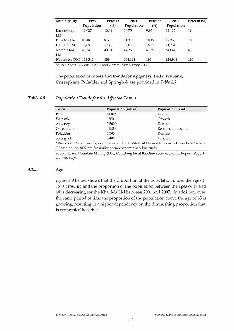
ENVIRONMENTAL RESOURCES MANAGEMENT SCOPING REPORT FOR GAMSBERG ZINC MINE
111
Municipality 1996 Population
Percent (%)
2001 Population
Percent (%)
2007 Population
Percent (%)
Kamiesberg LM
11,027 10.09 10,754 9.95 12,117 10
Khai Ma LM 9,348 8.55 11,344 10.49 12,257 10 Hantam LM 19,091 17.46 19,813 18.33 21,234 17 Nama Khoi LM
43,742 40.01 44,750 41.39 54,644 43
Namakwa DM 109,340 100 108,111 100 126,949 100 Source: Sats SA, Census 2001 and Community Survey 2007. The population numbers and trends for Aggeneys, Pella, Witbank, Onseepkans, Pofadder and Springbok are provided in Table 4.8
Table 4.8 Population Trends for the Affected Towns
Town Population (urban) Population trend Pella 4,000* Decline Witbank “300 Growth Aggeneys 2,500^ Decline Onseepkans “1500 Remained the same Pofadder 6,500 Decline Springbok 8,400 Unknown * Based on 1996 census figures ^ Based on the Institute of Natural Resources Household Survey “ Based on the 2009 pre-feasibility socio-economic baseline study. Source: Black Mountain Mining, 2010, Gamsberg Final Baseline Socio-economic Report. Report no.: 396036/5.
4.15.3 Age
Figure 4.9 below shows that the proportion of the population under the age of 15 is growing and the proportion of the population between the ages of 19 and 40 is decreasing for the Khai Ma LM between 2001 and 2007. In addition, over the same period of time the proportion of the population above the age of 65 is growing, resulting in a higher dependency on the diminishing proportion that is economically active.
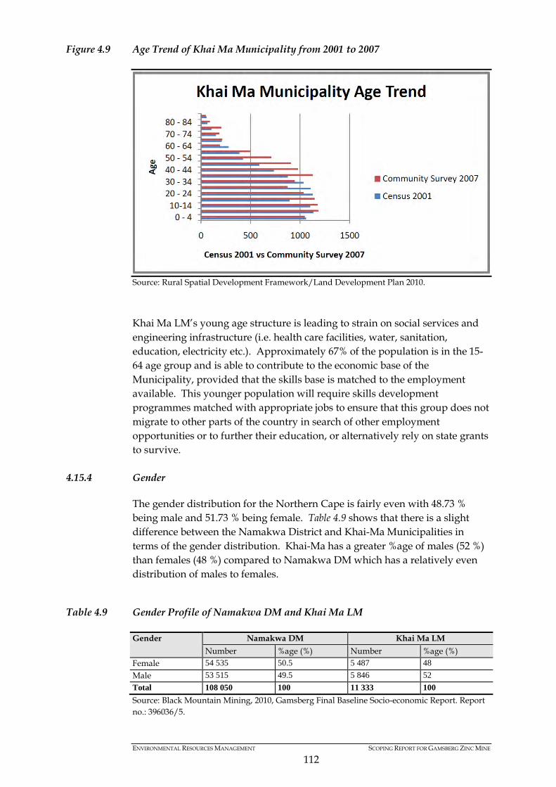
ENVIRONMENTAL RESOURCES MANAGEMENT SCOPING REPORT FOR GAMSBERG ZINC MINE
112
Figure 4.9 Age Trend of Khai Ma Municipality from 2001 to 2007
Source: Rural Spatial Development Framework/Land Development Plan 2010. Khai Ma LM’s young age structure is leading to strain on social services and engineering infrastructure (i.e. health care facilities, water, sanitation, education, electricity etc.). Approximately 67% of the population is in the 15-64 age group and is able to contribute to the economic base of the Municipality, provided that the skills base is matched to the employment available. This younger population will require skills development programmes matched with appropriate jobs to ensure that this group does not migrate to other parts of the country in search of other employment opportunities or to further their education, or alternatively rely on state grants to survive.
4.15.4 Gender
The gender distribution for the Northern Cape is fairly even with 48.73 % being male and 51.73 % being female. Table 4.9 shows that there is a slight difference between the Namakwa District and Khai-Ma Municipalities in terms of the gender distribution. Khai-Ma has a greater %age of males (52 %) than females (48 %) compared to Namakwa DM which has a relatively even distribution of males to females.
Table 4.9 Gender Profile of Namakwa DM and Khai Ma LM
Gender Namakwa DM Khai Ma LM Number %age (%) Number %age (%)
Female 54 535 50.5 5 487 48 Male 53 515 49.5 5 846 52 Total 108 050 100 11 333 100 Source: Black Mountain Mining, 2010, Gamsberg Final Baseline Socio-economic Report. Report no.: 396036/5.
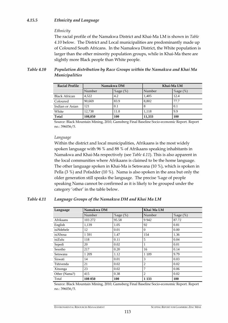
ENVIRONMENTAL RESOURCES MANAGEMENT SCOPING REPORT FOR GAMSBERG ZINC MINE
113
4.15.5 Ethnicity and Language
Ethnicity The racial profile of the Namakwa District and Khai-Ma LM is shown in Table 4.10 below. The District and Local municipalities are predominantly made up of Coloured South Africans. In the Namakwa District, the White population is larger than the other minority population groups, while in Khai-Ma there are slightly more Black people than White people.
Table 4.10 Population distribution by Race Groups within the Namakwa and Khai Ma Municipalities
Racial Profile Namakwa DM Khai-Ma LM Number %age (%) Number %age (%)
Black African 4,522 4.2 1,405 12.4 Coloured 90,669 83.9 8,802 77.7 Indian or Asian 121 0.1 8 0.1 White 12,738 11.8 1,118 9.9 Total 108,050 100 11,333 100 Source: Black Mountain Mining, 2010, Gamsberg Final Baseline Socio-economic Report. Report no.: 396036/5. Language Within the district and local municipalities, Afrikaans is the most widely spoken language with 96 % and 88 % of Afrikaans speaking inhabitants in Namakwa and Khai-Ma respectively (see Table 4.11). This is also apparent in the local communities where Afrikaans is claimed to be the home language. The other language spoken in Khai-Ma is Setswana (10 %), which is spoken in Pella (3 %) and Pofadder (10 %). Nama is also spoken in the area but only the older generation still speaks the language. The precise %age of people speaking Nama cannot be confirmed as it is likely to be grouped under the category ‘other’ in the table below.
Table 4.11 Language Groups of the Namakwa DM and Khai Ma LM
Language Namakwa DM Khai Ma LM Number %age (%) Number %age (%)
Afrikaans 103 272 95.58 9 942 87.72 English 1,139 1.05 92 0.81 isiNdebele 12 0.01 0 0.00 isiXhosa 1 591 1.47 154 1.36 isiZulu 118 0.11 5 0.04 Sepedi 20 0.02 1 0.01 Sesotho 217 0.20 16 0.14 Setswana 1 209 1.12 1 109 9.79 Siswati 14 0.01 3 0.03 Tshivenda 21 0.02 2 0.02 Xitsonga 23 0.02 7 0.06 Other (Nama?) 415 0.38 2 0.02 Total 108 050 100 1 133 100 Source: Black Mountain Mining, 2010, Gamsberg Final Baseline Socio-economic Report. Report no.: 396036/5.
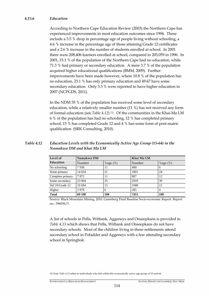
ENVIRONMENTAL RESOURCES MANAGEMENT SCOPING REPORT FOR GAMSBERG ZINC MINE
114
4.15.6 Education
According to Northern Cape Education Review (2003) the Northern Cape has experienced improvements in most education outcomes since 1994. These include a 3.5 % drop in percentage age of people living without schooling, a 4.6 % increase in the percentage age of those attaining Grade 12 certificates and a 2.6 % increase in the number of students enrolled at school. In 2001 there were 208,406 learners enrolled at school, compared to 205,059 in 1996. In 2001, 15.1 % of the population of the Northern Cape had no education, while 71.3 % had primary or secondary education. A mere 3.7 % of the population acquired higher educational qualifications (BMM, 2009). Further improvements have been made however, where 10.8 % of the population has no education, 23.1 % has only primary education and 49.67 have some secondary education. Only 3.3 % were reported to have higher education in 2007 (NCPGDS, 2011). In the NDM 35 % of the population has received some level of secondary education, while a relatively smaller number (11 %) has not received any form of formal education (see Table 4.12) (1). Of the communities in the Khai-Ma LM 6 % of the population has had no schooling, 12 % has completed primary school, 15 % has completed Grade 12 and 4 % has some form of post-matric qualification (SRK Consulting, 2010).
Table 4.12 Education Levels with the Economically Active Age Group (15-64) in the Namakwa DM and Khai Ma LM
Level of Education
Namakwa DM Khai Ma LM Number %age (%) Number %age (%)
No schooling 7 938 11 480 6 Some primary 14 654 21 1801 24 Complete primary 7 872 11 887 12 Some secondary 23 964 35 2910 39 Std 10/Grade 12 10 694 15 1088 15 Higher 3 978 6 285 4 Total 69 100 100 7451 100 Source: Black Mountain Mining, 2010, Gamsberg Final Baseline Socio-economic Report. Report no.: 396036/5. A list of schools in Pella, Witbank, Aggeneys and Onseepkans is provided in Table 4.13 which shows that Pella, Witbank and Onseepkans do not have secondary schools. Most of the children living in these settlements attend secondary school in Pofadder and Aggeneys with a few attending secondary school in Springbok.
(1) Note Table 4.12 refers to individuals who fall within the economically active age group of 15 and 64.
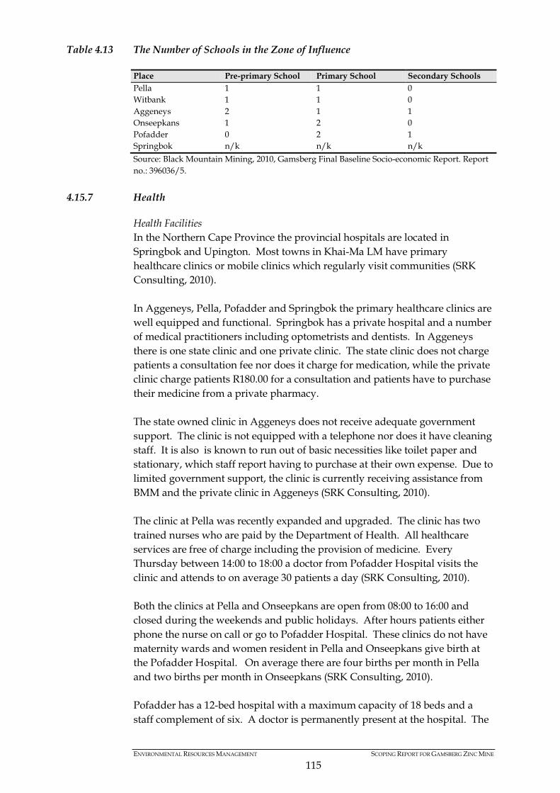
ENVIRONMENTAL RESOURCES MANAGEMENT SCOPING REPORT FOR GAMSBERG ZINC MINE
115
Table 4.13 The Number of Schools in the Zone of Influence
Place Pre-primary School Primary School Secondary Schools Pella 1 1 0 Witbank 1 1 0 Aggeneys 2 1 1 Onseepkans 1 2 0 Pofadder 0 2 1 Springbok n/k n/k n/k Source: Black Mountain Mining, 2010, Gamsberg Final Baseline Socio-economic Report. Report no.: 396036/5.
4.15.7 Health
Health Facilities In the Northern Cape Province the provincial hospitals are located in Springbok and Upington. Most towns in Khai-Ma LM have primary healthcare clinics or mobile clinics which regularly visit communities (SRK Consulting, 2010). In Aggeneys, Pella, Pofadder and Springbok the primary healthcare clinics are well equipped and functional. Springbok has a private hospital and a number of medical practitioners including optometrists and dentists. In Aggeneys there is one state clinic and one private clinic. The state clinic does not charge patients a consultation fee nor does it charge for medication, while the private clinic charge patients R180.00 for a consultation and patients have to purchase their medicine from a private pharmacy. The state owned clinic in Aggeneys does not receive adequate government support. The clinic is not equipped with a telephone nor does it have cleaning staff. It is also is known to run out of basic necessities like toilet paper and stationary, which staff report having to purchase at their own expense. Due to limited government support, the clinic is currently receiving assistance from BMM and the private clinic in Aggeneys (SRK Consulting, 2010). The clinic at Pella was recently expanded and upgraded. The clinic has two trained nurses who are paid by the Department of Health. All healthcare services are free of charge including the provision of medicine. Every Thursday between 14:00 to 18:00 a doctor from Pofadder Hospital visits the clinic and attends to on average 30 patients a day (SRK Consulting, 2010). Both the clinics at Pella and Onseepkans are open from 08:00 to 16:00 and closed during the weekends and public holidays. After hours patients either phone the nurse on call or go to Pofadder Hospital. These clinics do not have maternity wards and women resident in Pella and Onseepkans give birth at the Pofadder Hospital. On average there are four births per month in Pella and two births per month in Onseepkans (SRK Consulting, 2010). Pofadder has a 12-bed hospital with a maximum capacity of 18 beds and a staff complement of six. A doctor is permanently present at the hospital. The

ENVIRONMENTAL RESOURCES MANAGEMENT SCOPING REPORT FOR GAMSBERG ZINC MINE
116
hospital has three ambulances, which collect patients from Pella, Aggeneys, Witbank and Onseepkans, however these ambulances are old and often breakdown (SRK Consulting, 2010). The clinic at Witbank is only open twice a month by a visiting nurse from Pofadder Hospital. This is usually on the last Tuesday and Thursday of every month. Common problems faced by the Khai Ma LM health care facilities include limited funding and lack of maintenance of buildings and equipment, shortage of medicine and qualified personnel (Khai Ma Rural SDF, 2011) State of Health The Northern Cape Province is affected by a number of health conditions and infectious diseases, which are primarily caused by poverty, poor nutrition and generally unhygienic living conditions. Some of the key health challenges faced by the Province include malnutrition and Foetal Alcohol Syndrome (FAS), tuberculosis (TB), chronic diseases (the incidence rate of Hypertension has seen an increase over the past five years), and HIV/AIDS. According to information gathered in focus group interviews from the 2010 Gamsberg Socio-economic Baseline Report, local health problems were reported to be prevalent in the Project area were, hypertension, diabetes, tuberculosis, HIV/AIDS, liver problems, stomach problems (bacterial infections, dysentery), headaches, arthritis and cancer. For women in particular, high blood pressure was identified as most prevalent and diarrhoea, flu and measles for children. Key health issues prevalent in men were high blood pressure, liver problems and diabetes (SRK Consulting, 2010). The primary causes of death in the Northern Cape include HIV/AIDS, hypertensive disorders, obstetric haemorrhage, pregnancy related sepsis and pre-existing medical disorders (Northern Cape Provincial Department of Health, 2006). The proportion of men receiving treatment for hypertension in the Northern Cape is double that of the national average (21.5% compared to 10.7%), while the proportion of women receiving treatment for hypertension is 35% compared to 27.7% nationally (Northern Cape Provincial Department of Health, 2006). The infant mortality rate in the Northern Cape increased from 55.6 per 1,000 in 1996 to 58.8 per 1,000 in 2002. These rates are favourable when compared to national figures. In 2007 the national rate for the country was 70.9 per 1,000. Both the national and provincial rates for infant mortality are higher than the national targets for infant mortality, which is currently set at 15 per 1,000 (Northern Cape Provincial Department of Health, 2006).
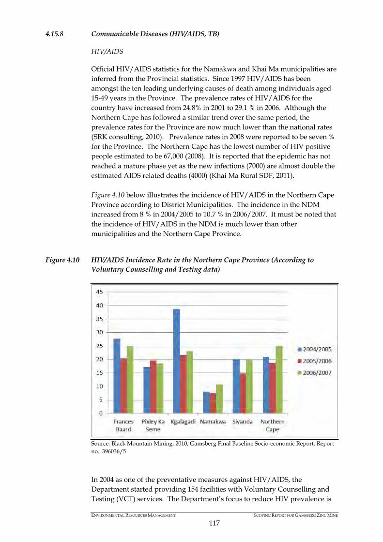
ENVIRONMENTAL RESOURCES MANAGEMENT SCOPING REPORT FOR GAMSBERG ZINC MINE
117
4.15.8 Communicable Diseases (HIV/AIDS, TB)
HIV/AIDS
Official HIV/AIDS statistics for the Namakwa and Khai Ma municipalities are inferred from the Provincial statistics. Since 1997 HIV/AIDS has been amongst the ten leading underlying causes of death among individuals aged 15-49 years in the Province. The prevalence rates of HIV/AIDS for the country have increased from 24.8% in 2001 to 29.1 % in 2006. Although the Northern Cape has followed a similar trend over the same period, the prevalence rates for the Province are now much lower than the national rates (SRK consulting, 2010). Prevalence rates in 2008 were reported to be seven % for the Province. The Northern Cape has the lowest number of HIV positive people estimated to be 67,000 (2008). It is reported that the epidemic has not reached a mature phase yet as the new infections (7000) are almost double the estimated AIDS related deaths (4000) (Khai Ma Rural SDF, 2011). Figure 4.10 below illustrates the incidence of HIV/AIDS in the Northern Cape Province according to District Municipalities. The incidence in the NDM increased from 8 % in 2004/2005 to 10.7 % in 2006/2007. It must be noted that the incidence of HIV/AIDS in the NDM is much lower than other municipalities and the Northern Cape Province.
Figure 4.10 HIV/AIDS Incidence Rate in the Northern Cape Province (According to Voluntary Counselling and Testing data)
Source: Black Mountain Mining, 2010, Gamsberg Final Baseline Socio-economic Report. Report no.: 396036/5 In 2004 as one of the preventative measures against HIV/AIDS, the Department started providing 154 facilities with Voluntary Counselling and Testing (VCT) services. The Department’s focus to reduce HIV prevalence is

ENVIRONMENTAL RESOURCES MANAGEMENT SCOPING REPORT FOR GAMSBERG ZINC MINE
118
among others to implement syndrome management of Sexually Transmitted Infections (STIs) in all public facilities in the province (Northern Cape Department of Health, 2006). Hope for Life, a Community Base Organisation assisting people in Aggeneys, Pella, Witbank and Onseepkans with HIV/AIDS awareness and training, argues that this %age is much higher. None of the state clinics in Pella, Aggeneys, Witbank and Onseepkans provide antiretroviral treatment (ARVs). Patients are referred to Pofadder Hospital for HIV treatment. It is estimated that four people die from HIV/AIDS per month based on Provincial statistics of 11 deaths daily. , The %age population of Province which falls within the Khai Ma LM is 10.93 % (Khai Ma Rural SDF, 2011). Tuberculosis (TB)
TB is recognised as a key health concern for the District and Local Municipality. The Department of Health has a TB Case Load project underway, but details of this project and the infection rate cannot be confirmed. Medicinal Plants
In the Project area, people use medicinal plants to treat high blood pressure, diabetes, stomach ache, headaches, cancer and flu. These medicinal plants include; Kalkoentjiebos, Klipsweet, Gamostahoe, Dasiepis, Baarbos, Loesering, Agdag geneesbos, Hoedia, Skaapbos and Wymryk. There are no conservation programmes to protect or manage the collection of medicinal plants, which are found in the veld surrounding the settlements.
4.15.9 Social Problems and Vulnerability
The quality of life of people in settlements within the Project’s area of influence is considered to be generally poor with limited access to social services and inadequate infrastructure. There are high incidences of poverty, unemployment, and dependency on state grants resulting in a lack of food security and the inability to meet basic social needs as well as a lack of access to opportunities. This is exacerbated by the geographic isolation in most of the settlements in the area of influence and the general lack of access to economic opportunities. Social problems such as alcoholism have been identified in earlier baseline work and by key informants, as pervasive in the affected communities. Drug abuse is also identified as a problem amongst youth. Other social problems occurring in the area include domestic violence and reported prostitution in some settlements. Anecdotal evidence gathered during initial field visits and stakeholder interviews suggest that petty crime levels are increasing, which may be linked to the rising drug abuse. In general intra-family conflict, domestic violence and socially deviant behaviour correlate closely with alcohol and drug abuse.
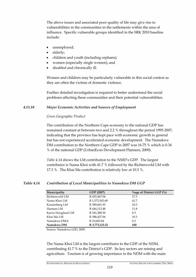
ENVIRONMENTAL RESOURCES MANAGEMENT SCOPING REPORT FOR GAMSBERG ZINC MINE
119
The above issues and associated poor quality of life may give rise to vulnerabilities in the communities in the settlements within the area of influence. Specific vulnerable groups identified in the SRK 2010 baseline include: • unemployed; • elderly; • children and youth (including orphans); • women (especially single women); and • disabled and chronically ill. Women and children may be particularly vulnerable in this social context as they are often the victims of domestic violence. Further detailed investigation is required to better understand the social problems affecting these communities and their potential vulnerabilities.
4.15.10 Major Economic Activities and Sources of Employment
Gross Geographic Product
The contribution of the Northern Cape economy to the national GDP has remained constant at between two and 2.2 % throughout the period 1995-2007, indicating that the province has kept pace with economic growth in general but has not experienced accelerated economic development. The Namakwa DM contribution to the Northern Cape GDP in 2007 was 16.75 % which is 0.34 % of the national GDP (UrbanEcon Development Planners, 2009). Table 4.14 shows the LM contribution to the NMD’s GDP. The largest contributor is Nama Khoi with 41.7 % followed by the Richtersveld LM with 17.3 %. The Khai Ma contribution is relatively low at 10.3 %.
Table 4.14 Contribution of Local Municipalities to Namakwa DM GGP
Municipality GDP (2007) %age of District GGP (%) Richtersveld LM R 652,467.04 17.3 Nama Khoi LM R 1,573,543.68 41.7 Kamiesberg LM R 389,601.93 10.3 Hantam LM R 444,112.48 11.8 Karoo Hoogland LM R 341,288.30 8.3 Khai Ma LM R 388,427.06 10.3 Namakwa DMA R 10,682.84 0.3 Namakwa DM R 3,773,123.32 100 Source: Namakwa LED, 2009. The Nama Khoi LM is the largest contributor to the GDP of the NDM, contributing 41.7 % to the District’s GDP. Its key sectors are mining and agriculture. Tourism is of growing importance in the NDM with the main

ENVIRONMENTAL RESOURCES MANAGEMENT SCOPING REPORT FOR GAMSBERG ZINC MINE
120
attraction being the wild flower displays which occur from August to October annually.
4.15.11 Key Sectors of Namakwa District Municipality (NDM)
The Namakwa District Municipality’s regional gross domestic product (GDP) amounted to R3.77 billion in 2007. The Khai Ma LM was responsible for a roughly 10.3% (or R388 million) portion of this GDP primarily thanks to mining operations in Aggeneys. With regard to the rate of economic growth, Figure 4.11 presents the GDP growth rates of the Namakwa District municipal area in comparison to the Northern Cape and country for the period 1996 to 2007. It shows that the Namakwa District’s economy grew modestly at an annual average rate of 2.03% over the period whilst the provincial average was 2.4% and the national average was 4%.
Figure 4.11 Economic Growth Rates in the Northern Cape and Namakwa District (1996 - 2007)
Source: Quantec data in Urban-Econ (2009). Figure 4.12 shows the sectoral contribution to the Namakwa District’s regional GDP over time. Mining played the major role in GDP contributing 52.4% in 2007 although this contribution has decreased from roughly 59% in 2001. After mining wholesale and retail trade, catering and accommodation is the next largest GDP contributor at 13.2%. This sector has also showed the greatest growth between 1995 and 2007 some of which is likely to be associated with growth in tourism.
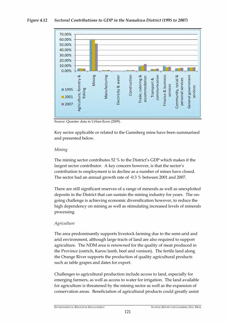
ENVIRONMENTAL RESOURCES MANAGEMENT SCOPING REPORT FOR GAMSBERG ZINC MINE
121
Figure 4.12 Sectoral Contributions to GDP in the Namakwa District (1995 to 2007)
Source: Quantec data in Urban-Econ (2009). Key sector applicable or related to the Gamsberg mine have been summarised and presented below. Mining
The mining sector contributes 52 % to the District’s GDP which makes it the largest sector contributor. A key concern however, is that the sector’s contribution to employment is in decline as a number of mines have closed. The sector had an annual growth rate of -0.3 % between 2001 and 2007. There are still significant reserves of a range of minerals as well as unexploited deposits in the District that can sustain the mining industry for years. The on-going challenge is achieving economic diversification however, to reduce the high dependency on mining as well as stimulating increased levels of minerals processing Agriculture
The area predominantly supports livestock farming due to the semi-arid and arid environment, although large tracts of land are also required to support agriculture. The NDM area is renowned for the quality of meat produced in the Province (ostrich, Karoo lamb, beef and venison). The fertile land along the Orange River supports the production of quality agricultural products such as table grapes and dates for export. Challenges to agricultural production include access to land, especially for emerging farmers, as well as access to water for irrigation. The land available for agriculture is threatened by the mining sector as well as the expansion of conservation areas. Beneficiation of agricultural products could greatly assist

ENVIRONMENTAL RESOURCES MANAGEMENT SCOPING REPORT FOR GAMSBERG ZINC MINE
122
in the transformation of the sector and to the empowerment of emerging farmers.
4.15.12 Other Sectors
Fishing and Mariculture
The Namaqualand coastline is bordered by the nutrient-rich Benguela current. The Benguela current supports the larger proportion of the South African fishing industry; however it is an industry in decline due to declining fish stocks. An area of opportunity is the establishment of on-shore mariculture industries which entails the cultivation of a range of high value marine species. Given the dominance of the diamond mining industry off-shore fishing is more dominant. This generally employs fewer people than the small scale fishing industry. There are indications that mariculture offers sufficient growth potential to replace diamond mining as the principle industry in the coast region of NDM. Development in this area is critically important in the wake of closing mines along the coast (UrbanEcon Development Planners, 2009). Tourism
Tourism as an industry spans several economic sectors ranging from accommodation to catering retail and wholesale, manufacturing, transport and communication, businesses and social services (UrbanEcon Development Planners, 2009). The NDM has experienced growth in tourism and is also identified as an important growth area for the District as well as the Khai Ma Local Municipality. The NDM has the tourism potential in the following niche markets: • Eco-tourism due to the vast open land, natural flora and fauna and a
number of national parks and conservancies; • Adventure tourism through 4x4 trails as well as hiking and fishing; • Historical and cultural tourism due to the rich local heritage of the Khoi
San and Nama people; and • Technological tourism as a result of the South African Large Telescope
(SALT), the Square Kilometre Array (SKA) as well as a number of proposed renewable energy projects in the area.
The Khai-Ma Municipality indicated that tourism activity in the Project area of influence is very limited, with the main features being a number of 4X4 and hiking trails, the Cathedral at Pella and a few accommodation establishments (SRK Consulting, 2010). A number of major new conservation and eco-tourism developments (Ai-Ais Richtersveld and Orange River Mouth transfrontier developments amongst others) have been completed in the Namakwa region. The Northern Cape Economic Development Agency is also currently developing several tourist areas in the Province including the Wildebeestkuil Rock Art site, which is known for its more than 400 rock engravings that are between 800 and 1,200 years old. There is likely to be some growth in tourist

ENVIRONMENTAL RESOURCES MANAGEMENT SCOPING REPORT FOR GAMSBERG ZINC MINE
123
facilities with a low investment requirement such as hiking trails, 4X4 trails as well Bed & Breakfast style accommodation. Local Businesses
The local businesses in the directly affected towns of Pofadder, Aggeneys and Pella primarily service the agricultural and mining sector. There are a number of businesses in Aggeneys that exclusively service the mine through long standing contracts. As such these have a very high dependency on Black Mountain Mining. The services they offer include transport services, contract miners, replacement parts suppliers and service companies. The mining sector is seen as a key sector for the development of the Province and the District, both of which support mining activities explicitly in their respective policy documents. A one-stop mining centre aimed at servicing the sector is envisioned for the District as well as a diamond polishing and cutting centre (UrbanEcon Development Planners, 2009).
4.15.13 Regional Employment
The unemployment rate for the Northern Cape has increased to approximately 31.3 % in 2010 compared to 24.2 % in 2007 (StatsSA, 2008). The Northern Cape Province recorded the lowest average annual growth rate between 2002 and 2009 at 2.6 % compared to the national growth rate of 3.7 % over the same period. The economy of the Northern Cape is driven mainly by the primary sector (agriculture and mining) and the tertiary sector (service) (NCPGDS, 2009). The NDM has a shortage of highly skilled people, where 58 % of the economically active population are classified as unskilled. Approximately five % of the population has no schooling and only 1.5 % has higher education (NCPGDS, 2009). The 2007 employment rate is shown in Figure 4.13. In 2007, 12.8 % of the population was unemployed, 45.7 % was employed and 37.3 % was not economically active. Due to the poor employment statistics and the quality of jobs (in relation to the skills levels) approximately 75 % of the population falls below the poverty line. This leads to a reliance on state support with 36 % of households registered as indigent and 25 % of the population receiving state grants (NCPGDS, 2009). The population is regarded to have a high dependency ratio with 7.39 % of the population over the age of 65 and 25 % under 15 years (NCPGDS, 2009).

ENVIRONMENTAL RESOURCES MANAGEMENT SCOPING REPORT FOR GAMSBERG ZINC MINE
124
Figure 4.13 Employment Rate at the Provincial and District Levels
Source: Namakwa LED, 2009. With regard to the sectoral division of employment opportunities, for the Namakwa District as a whole, the dominant sector in terms of employment provision is mining which provided 21.3% of all employment opportunities in 2007 followed by agriculture and fishing which provided 18% of all jobs (see Figure 4.14 below). Whilst remaining the major sources of employment, the relative contribution made by these sectors declined between 1995 and 2007 by roughly 5% for each of them. The wholesale retail trade, catering and accommodation sector showed the greatest proportional increase in job creation over the period up from 11% of employment in 1995 to 14% in 2007.
Figure 4.14 Sectoral Employment in the Namakwa District (1995 - 2007)
Source: StatsSA, 2002.

ENVIRONMENTAL RESOURCES MANAGEMENT SCOPING REPORT FOR GAMSBERG ZINC MINE
125
Unfortunately it is not possible to get an accurate estimate of current jobs in the tourism sector on the basis of Census statistics as they do not have a separate category for tourism. Tourism is, however, recognised as a key sector in the local area and region making a highly significant contribution to employment creation. As a general rule, the tourism sector is reflected primarily in the transport, retail trade, personal services and business services sectors. These sectors have shown robust growth which is probably at least partially attributable to growth in the tourism sector. With regard to the skills levels of employees, the Namakwa District is characterised by relatively high %ages of people working in elementary occupations (38.4% of workers) and other relatively low skill occupations (13.2% in craft and related trades, 11% as clerks and 10.4% as service and sales workers). Only 6.5% are employed as legislators, senior officials and managers and 2.6% as professionals (Urban-Econ, 2009). These statistics indicate the need for local skills development programmes.
4.15.14 Households Incomes
Figure 4.15 shows the annual household income levels within the Namakwa District municipal area for 2001. The following key trends can be identified (Urban-Econ, 2009): • 11.8% of households in the District earn no income making them
dependent on state grants, charity and possibly extended family/social networks for survival.
• 75% of households in the District earned below R 38,400 per annum. • Very few households had high spending power – just 1.8% of the
households were classified as high-income (earning more than R 307,201 per annum).

ENVIRONMENTAL RESOURCES MANAGEMENT SCOPING REPORT FOR GAMSBERG ZINC MINE
126
Figure 4.15 Household Incomes for the Namakwa District (2001)
Source: Census 2001 in Urban-Econ (2009). Aside from very low income levels, the situation in the local area and district with regard to grants gives further credence to high levels of poverty. Roughly 36% of households in the Namakwa District are registered as indigent and an even larger portion (65% and the highest in the District) are registered as indigent in the Khai Ma LM as measured in 2005 (Urban-Econ Development Planner, 2009). When compared with the unemployment rate, the above shows that even economically active people are grant recipients, implying that employment opportunities are generally low-paid (Urban-Econ Development Planner, 2009).
4.15.15 Bulk Services and Infrastructure
Housing
In the Northern Cape Province there are approximately 264,653 households of which 65 % are found in urban areas. At least 80 % of the households live in formal structures and the remainder in informal structures. Approximately 67.4 % of the houses in the Northern Cape are built on separate stands and about four % of the houses constitute traditional dwellings. The average household size for the Province is four compared to 3.5 and 3.3 for the District and Local Municipalities respectively (StatsSA, 2009). It is estimated that the NDM consists of 36,438 households. It is estimated that 85.5 % of households reside in formal dwelling structures, 5 % of these households reside in informal dwellings and 2.4 % in traditional huts (Urban-Econ Development Planner, 2009). In the Khai-Ma LM dwellings are either houses/brick structures on separate stands (68 %), living quarters that are not housing units (17%), traditional dwellings (13%) or flats in backyards (13%) (SRK Consulting, 2010).

ENVIRONMENTAL RESOURCES MANAGEMENT SCOPING REPORT FOR GAMSBERG ZINC MINE
127
Table 4.15 Types of Housing Structures in the Khai Ma LM
Housing Structures Khai Ma LM Number %age People (%)
Brick structure 1,948 58.0 Traditional structure 455 13.6 Flat 100 3.0 Townhouse or semi-detached structure 5 0.1 Garden flat 86 2.6 Informal structure in garden 10 0.3 Informal structure 30 0.9 Room/flat on shared property 29 0.9 Caravan or tent 85 2.5 Not applicable 610 18.2 Total 7,451 100 Source: Black Mountain Mining, 2010, Gamsberg Final Baseline Socio-economic Report. Report no.: 396036/5. There have been significant challenges in addressing the housing backlog, which has been identified as an issue in the Khai Ma Rural Spatial Development Framework/ Land Development Plan (2010). Lack of funding has been identified as a key limitation as well as the lack of economic stimulation to improve the tax base to address the housing back log as well as other service delivery challenges. There is currently a housing backlog in all of the communities of the Khai Ma LM. In Pella there is a diverse range of housing structures; approximately 20 % of the population is living in traditional structures built of mud, 65 % in brick structures and 15 % in pre-fabricated zinc buildings. In Aggeneys most dwellings are houses or brick structures on separate stands (75 %), living quarters that are not a housing unit (14 %), a flat in a block of flats (6 %), and caravan/park homes (4%) (SRK Consulting, 2010). In Witbank most houses are RDP houses (95 %), with a small proportion of people (5 %) having built their own houses in the town. Onseepkans consists of approximately 60 % brick houses and 40 % traditional structures (built using locally sourced reeds and mud).
4.15.16 Water Supply
The Northern Cape Regional Office of the Department of Water Affairs (DWA) is responsible for managing water resources in the Province. The Province is an arid to semi-arid region with low summer rainfall, apart from a small strip of winter-rainfall which occurs in the area along the west coast. Rainfall variability results in periodic episodes of severe and prolonged drought. Approximately 5.6 % of households in the Northern Cape have no access to clean piped water. According to the Department of Water Affairs’ standard requirements for adequate access to water, households must have at least 20 to 30 litres of clean safe water per person per day, available within 200 m of the
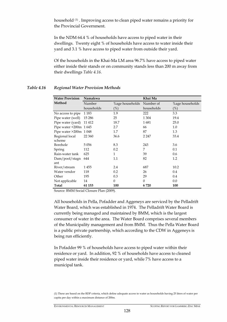
ENVIRONMENTAL RESOURCES MANAGEMENT SCOPING REPORT FOR GAMSBERG ZINC MINE
128
household (1) . Improving access to clean piped water remains a priority for the Provincial Government. In the NDM 64.4 % of households have access to piped water in their dwellings. Twenty eight % of households have access to water inside their yard and 3.1 % have access to piped water from outside their yard. Of the households in the Khai-Ma LM area 96.7% have access to piped water either inside their stands or on community stands less than 200 m away from their dwellings Table 4.16.
Table 4.16 Regional Water Provision Methods
Water Provision Method
Namakwa Khai Ma Number households
%age households (%)
Number of households
%age households (%)
No access to pipe 1 183 1.9 222 3.3 Pipe water (well) 15 286 25 1 304 19.4 Pipe water (yard) 11 412 18.7 1 681 25.0 Pipe water <200m 1 645 2.7 66 1.0 Pipe water >200m 1 048 1.7 87 1.3 Regional local scheme
22 360 36.6 2 247 33.4
Borehole 5 056 8.3 243 3.6 Spring 112 0.2 7 0.1 Rain-water tank 625 1 39 0.6 Dam/pool/stagnant
644 1.1 82 1.2
River/stream 1 455 2.4 687 10.2 Water vendor 118 0.2 26 0.4 Other 195 0.3 29 0.4 Not applicable 14 0 0 0.0 Total 61 153 100 6 720 100 Source: BMM Social Closure Plan (2009). All households in Pella, Pofadder and Aggeneys are serviced by the Pelladrift Water Board, which was established in 1974. The Pelladrift Water Board is currently being managed and maintained by BMM, which is the largest consumer of water in the area. The Water Board comprises several members of the Municipality management and from BMM. Thus the Pella Water Board is a public private partnership, which according to the CDW in Aggeneys is being run efficiently. In Pofadder 99 % of households have access to piped water within their residence or yard. In addition, 92 % of households have access to cleaned piped water inside their residence or yard, while 7% have access to a municipal tank.
(1) These are based on the RDP criteria, which define adequate access to water as households having 25 litres of water per capita per day within a maximum distance of 200m.

ENVIRONMENTAL RESOURCES MANAGEMENT SCOPING REPORT FOR GAMSBERG ZINC MINE
129
All households in Aggeneys are supplied with free water by Black Mountain and have piped water inside their dwellings. Occasional water shortages occur in the more isolated towns of Witbank and Onseepkans. Both towns source their water from the Orange River using small pumping stations. Shortages primarily occur when the pumps breakdown.
4.15.17 Sanitation
In the Northern Cape 11.2 % of all households have no access to sanitation and a further 11.8 % of households only have access to bucket latrine systems. According to Department of Water Affairs (Department of Water Affairs, 2008), basic sanitation is supplied to over 83 % of all households in the Province. In 2007, however, a total of 36,285 households living in settlements had no basic sanitation facilities and another 19,057 households living on farms had no basic sanitation (DWA, 2008). Most households in the NDM have access to acceptable sanitation with 64 % using flushing toilets, 15 % using the bucket system and 9 % without sanitation. In the Khai-Ma LM, 11% of households do not have access to sanitation and 7 % use pit latrines (SEAT, 2006) (see Table 4.17).
Table 4.17 Types of Sanitation Facilities at the District and Regional Levels
Type of sanitation facility
Namakwa DM Khai Ma LM Number of households
%age households (%)
Number of households
%age households (%)
Flush toilet sewer 16 308 53.4 2 009 59.8 Flush toilet tank 3 373 11 437 13 Chemical toilet 581 1.9 2 0.1 Pit latrine (With/V) 1 465 4.8 199 5.9 Pit latrine (WO/V) 1 367 4.5 59 1.8 Bucket latrine 4 662 15.3 290 8.6 None 2 802 9.2 363 10.8 Not applicable 7 0 0 0.0 Total 30 565 100 3 358 100 Source: Black Mountain Mining, 2010, Gamsberg Final Baseline Socio-economic Report. Report no.: 396036/5.
4.15.18 Power Supply
In 2007 the Northern Cape had the second largest proportion of households using electricity (87.3 %). The provisioning of electricity to households in the Province has increased significantly over the years from 64.2 % in 1996 to 88.3 % in 2005. The electricity service backlog was estimated at 33,738 households in 2007 (10.1 %). The majority of these backlogs were in the Eskom supply areas. In 2008 this improved to an electricity service backlog of only 4.4 % in Eskom supply areas (SRK Consulting, 2010).
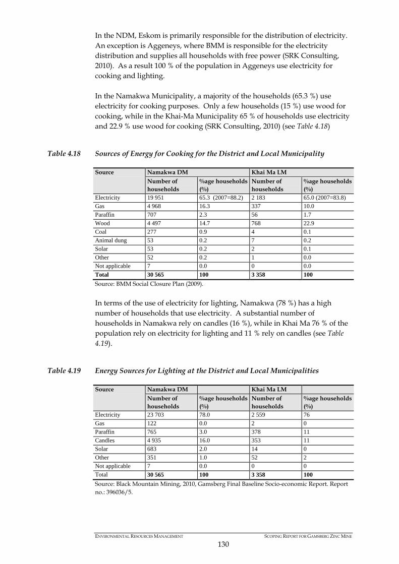
ENVIRONMENTAL RESOURCES MANAGEMENT SCOPING REPORT FOR GAMSBERG ZINC MINE
130
In the NDM, Eskom is primarily responsible for the distribution of electricity. An exception is Aggeneys, where BMM is responsible for the electricity distribution and supplies all households with free power (SRK Consulting, 2010). As a result 100 % of the population in Aggeneys use electricity for cooking and lighting. In the Namakwa Municipality, a majority of the households (65.3 %) use electricity for cooking purposes. Only a few households (15 %) use wood for cooking, while in the Khai-Ma Municipality 65 % of households use electricity and 22.9 % use wood for cooking (SRK Consulting, 2010) (see Table 4.18)
Table 4.18 Sources of Energy for Cooking for the District and Local Municipality
Source Namakwa DM Khai Ma LM Number of households
%age households (%)
Number of households
%age households (%)
Electricity 19 951 65.3 (2007=88.2) 2 183 65.0 (2007=83.8) Gas 4 968 16.3 337 10.0 Paraffin 707 2.3 56 1.7 Wood 4 497 14.7 768 22.9 Coal 277 0.9 4 0.1 Animal dung 53 0.2 7 0.2 Solar 53 0.2 2 0.1 Other 52 0.2 1 0.0 Not applicable 7 0.0 0 0.0 Total 30 565 100 3 358 100 Source: BMM Social Closure Plan (2009). In terms of the use of electricity for lighting, Namakwa (78 %) has a high number of households that use electricity. A substantial number of households in Namakwa rely on candles (16 %), while in Khai Ma 76 % of the population rely on electricity for lighting and 11 % rely on candles (see Table 4.19).
Table 4.19 Energy Sources for Lighting at the District and Local Municipalities
Source Namakwa DM Khai Ma LM Number of households
%age households (%)
Number of households
%age households (%)
Electricity 23 703 78.0 2 559 76 Gas 122 0.0 2 0 Paraffin 765 3.0 378 11 Candles 4 935 16.0 353 11 Solar 683 2.0 14 0 Other 351 1.0 52 2 Not applicable 7 0.0 0 0 Total 30 565 100 3 358 100 Source: Black Mountain Mining, 2010, Gamsberg Final Baseline Socio-economic Report. Report no.: 396036/5.
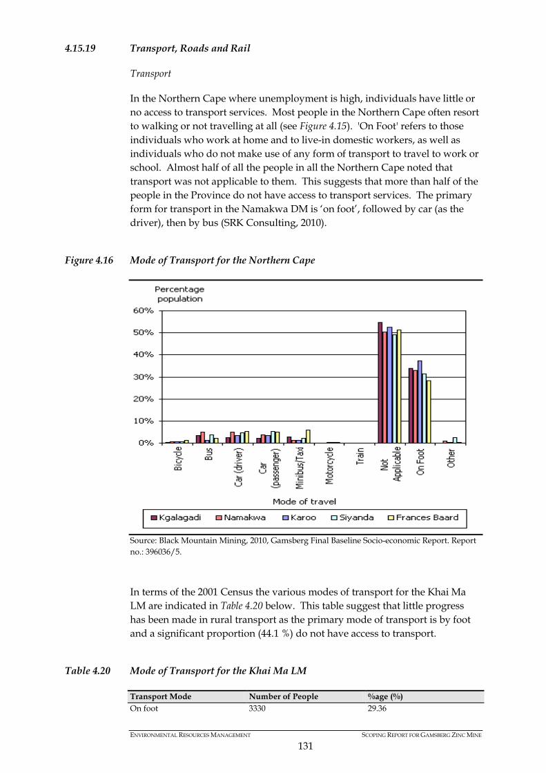
ENVIRONMENTAL RESOURCES MANAGEMENT SCOPING REPORT FOR GAMSBERG ZINC MINE
131
4.15.19 Transport, Roads and Rail
Transport
In the Northern Cape where unemployment is high, individuals have little or no access to transport services. Most people in the Northern Cape often resort to walking or not travelling at all (see Figure 4.15). 'On Foot' refers to those individuals who work at home and to live-in domestic workers, as well as individuals who do not make use of any form of transport to travel to work or school. Almost half of all the people in all the Northern Cape noted that transport was not applicable to them. This suggests that more than half of the people in the Province do not have access to transport services. The primary form for transport in the Namakwa DM is ‘on foot’, followed by car (as the driver), then by bus (SRK Consulting, 2010).
Figure 4.16 Mode of Transport for the Northern Cape
Source: Black Mountain Mining, 2010, Gamsberg Final Baseline Socio-economic Report. Report no.: 396036/5. In terms of the 2001 Census the various modes of transport for the Khai Ma LM are indicated in Table 4.20 below. This table suggest that little progress has been made in rural transport as the primary mode of transport is by foot and a significant proportion (44.1 %) do not have access to transport.
Table 4.20 Mode of Transport for the Khai Ma LM
Transport Mode Number of People %age (%) On foot 3330 29.36
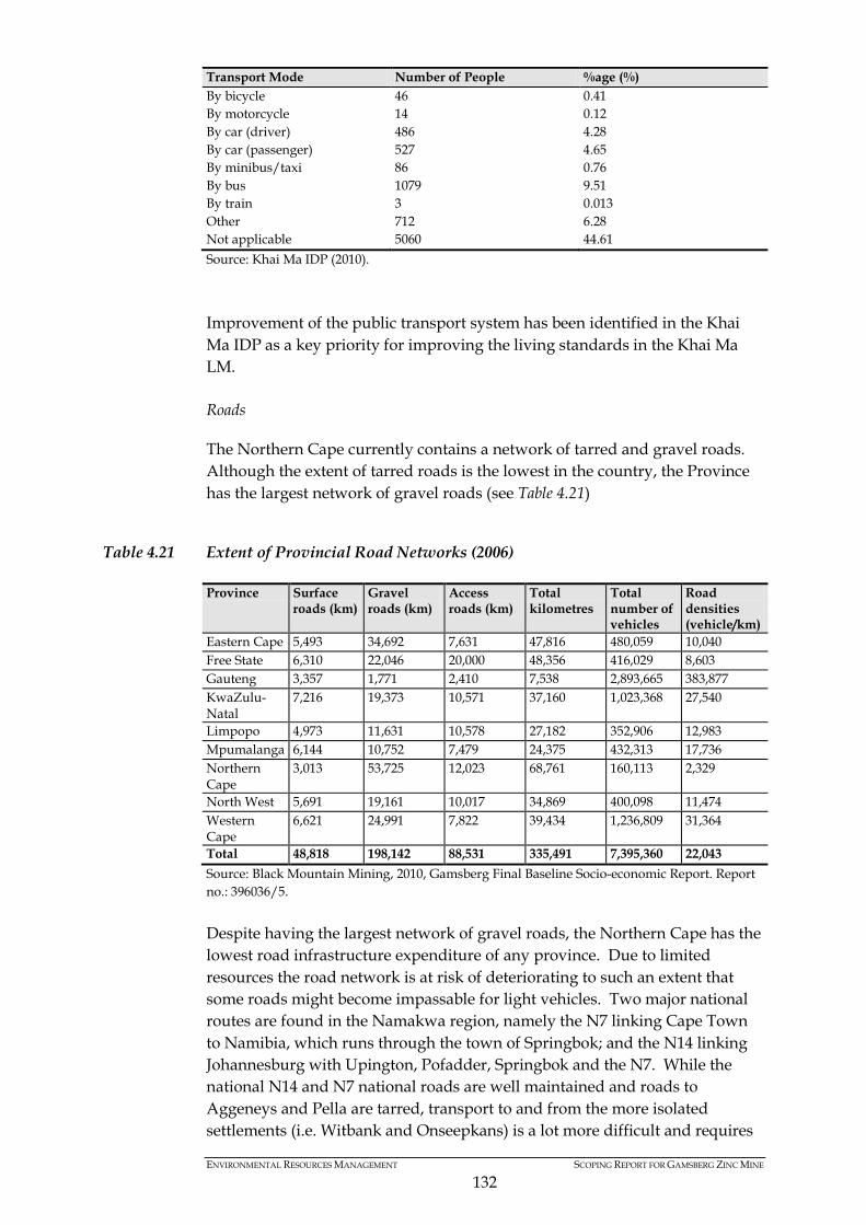
ENVIRONMENTAL RESOURCES MANAGEMENT SCOPING REPORT FOR GAMSBERG ZINC MINE
132
Transport Mode Number of People %age (%) By bicycle 46 0.41 By motorcycle 14 0.12 By car (driver) 486 4.28 By car (passenger) 527 4.65 By minibus/taxi 86 0.76 By bus 1079 9.51 By train 3 0.013 Other 712 6.28 Not applicable 5060 44.61 Source: Khai Ma IDP (2010). Improvement of the public transport system has been identified in the Khai Ma IDP as a key priority for improving the living standards in the Khai Ma LM. Roads
The Northern Cape currently contains a network of tarred and gravel roads. Although the extent of tarred roads is the lowest in the country, the Province has the largest network of gravel roads (see Table 4.21)
Table 4.21 Extent of Provincial Road Networks (2006)
Province Surface roads (km)
Gravel roads (km)
Access roads (km)
Total kilometres
Total number of vehicles
Road densities (vehicle/km)
Eastern Cape 5,493 34,692 7,631 47,816 480,059 10,040 Free State 6,310 22,046 20,000 48,356 416,029 8,603 Gauteng 3,357 1,771 2,410 7,538 2,893,665 383,877 KwaZulu-Natal
7,216 19,373 10,571 37,160 1,023,368 27,540
Limpopo 4,973 11,631 10,578 27,182 352,906 12,983 Mpumalanga 6,144 10,752 7,479 24,375 432,313 17,736 Northern Cape
3,013 53,725 12,023 68,761 160,113 2,329
North West 5,691 19,161 10,017 34,869 400,098 11,474 Western Cape
6,621 24,991 7,822 39,434 1,236,809 31,364
Total 48,818 198,142 88,531 335,491 7,395,360 22,043 Source: Black Mountain Mining, 2010, Gamsberg Final Baseline Socio-economic Report. Report no.: 396036/5. Despite having the largest network of gravel roads, the Northern Cape has the lowest road infrastructure expenditure of any province. Due to limited resources the road network is at risk of deteriorating to such an extent that some roads might become impassable for light vehicles. Two major national routes are found in the Namakwa region, namely the N7 linking Cape Town to Namibia, which runs through the town of Springbok; and the N14 linking Johannesburg with Upington, Pofadder, Springbok and the N7. While the national N14 and N7 national roads are well maintained and roads to Aggeneys and Pella are tarred, transport to and from the more isolated settlements (i.e. Witbank and Onseepkans) is a lot more difficult and requires
ENVIRONMENTAL RESOURCES MANAGEMENT SCOPING REPORT FOR GAMSBERG ZINC MINE
133
4X4 vehicles. Both Witbank and Onseepkans are accessed via lengthy (50-70km) gravel roads, which are poorly maintained in places. Rail
The dedicated mineral-ore railway line, which runs from the iron ore and manganese mines around Hotazel, Sishen and Postmasburg to the Port of Saldanha, forms a major transport route for the local mining industry. BMM is currently trucking zinc, copper, silver and lead concentrate via the Loop 10 gravel road to the Sishen – Saldanha Railway line. The concentrate is loaded onto wagons and transported to the Port of Saldanha for export purposes.
4.15.20 Land Tenure and Reform
Land Ownership
Land management and distribution in the Northern Cape is governed by the Department of Agriculture, Land Reform and Rural Development. Almost all the land in the Northern Cape is privately owned. The land tenure and ownership system in the Khai Ma LM is briefly summarised as follows: • most of the land in Khai Ma is privately owned; • a large portion of Pella is owned by the Pella community; • BMM owns the land around Aggeneys, including Gamsberg; • the Khai Ma LM owns land in Pofadder, Onseepkans and farm portions to
the west of Aggeneys and south of Pofadder; • the Republic of South Africa owns the land along the Orange River and in
the vicinity of Witbank; and • the Witbank Development Trust owns the land at Witbank (Khai Ma
Rural SDF, 2010).
4.15.21 Land Reform
The land reform process is currently in progress in the Province and consists of land restitution, redistribution and tenure reform. Land Restitution
The Restitution of Land Rights Act (22 of 1994) addresses the restitution of land rights lost by South Africans as the result of discriminatory laws passed since 1913. The Act governs the establishment of the Commission on Restitution of Land Rights as well as the Land Claims Court. By the end of 2003, the Northern Cape had processed 2,606 land claims out of a total 2,773 (SRK Consulting, 2010). Land Redistribution
Land redistribution entails making land available for agricultural production, settlement and non-agricultural enterprises. In the past, state agricultural

ENVIRONMENTAL RESOURCES MANAGEMENT SCOPING REPORT FOR GAMSBERG ZINC MINE
134
land was made available to emerging commercial farmers, via leasing, outright sale and access to grazing land. This was undertaken through the Settlement Land Acquisition Grant (SLAG) and Land Redistribution for Agricultural Development (LRAD). SLAG was a R16,000 cash grant for which poor landless Black South Africans could form a group to apply to buy and develop farm land. The SLAG programme ended in 2000 and LRAD was introduced later that year. The LRAD programme is designed to reduce rural poverty by helping previously disadvantaged people to manage their own farms effectively. Tenure Reform
Laws introduced after the 1994 to give people security of tenure over both house and the land where they work and stay (especially farm workers and labour tenants). Surplus Peoples Project was appointed by the NDM to facilitate the process of land tenure reform. The land reform projects and land claims in the Khai Ma LM are as follows: • Land claims have been registered on the farms Bloemhoek, Katko,
Gariepdale and Karee Plaat. These claims are in the “research” phase; • In terms of the Transformation of Certain Rural Areas Act (94 of 1998) the
Minister of Land Affairs granted approval of five areas in Namakwa to be transferred to the legal entities of the community’s choice. These are:
o Pella; o Concordia; o Richtersveld; o Steinkopf; and o Leliefontein (Khai Ma Rural SDF, 2010).
In Pella, the community elected for the land to be transferred to a Communal Property Association (CPA), however, a CPA was never established and the land is currently being managed by the Municipality as an interim measure (1).
(1) Personal Communication, Pella Community Leaders, 21 June 2012.
ENVIRONMENTAL RESOURCES MANAGEMENT SCOPING REPORT FOR GAMSBERG ZINC MINE
135
5 SUMMARY OF KEY ISSUES
Based on the analysis of the affected environment presented above, together with preliminary comments received from stakeholders and members of public and previous studies (SRK Consulting, 2000; and SRK Consulting, 2010), a suite of key issues have been identified for further investigation during the impact assessment phase. The key issues for further investigation are presented under each of the proposed specialist studies and will feed directly into the specialist Terms of Reference. The Project will result in construction, operational and decommissioning phase impacts. Furthermore, the “legacy” left behind upon decommissioning will also be included in the ESIA process. Specialist studies will include an analysis and assessment for each of the different phases associated with the Project. Furthermore, cumulative impacts will also be identified and assessed, in light of current and reasonably foreseeable developments in the surrounding region. A mitigation hierarchy of avoidance, avoid, abate, remedy and compensate will be adopted for all specialist investigations. A summary of key issues raised during initial consultation with key stakeholders are tabulated below.
Table 5.1 Summary of Key Issues Raised by IAPs on BID and Draft Scoping Report
Category Comments raised
Project specific • More detailed information about the various Project components is needed in order to determine anticipated impacts.
• The option of a new railway line(s) needs to be considered as an alternative method of transportation of ore.
• Use of energy for the Project needs to closely managed due to the shortage of energy in the region and use of renewable energy should be strongly considered.
• An alternative transport option should be considered where ore is taken to the Port Nolloth Port for export.
• The option of the transportation of ore on the existing tar road (N14) will not be feasible as the roads are not built to carry such traffic.
• The N14 and N7 national roads should not be considered as options for transportation, since these roads would not be able to sustain the additional trucks.
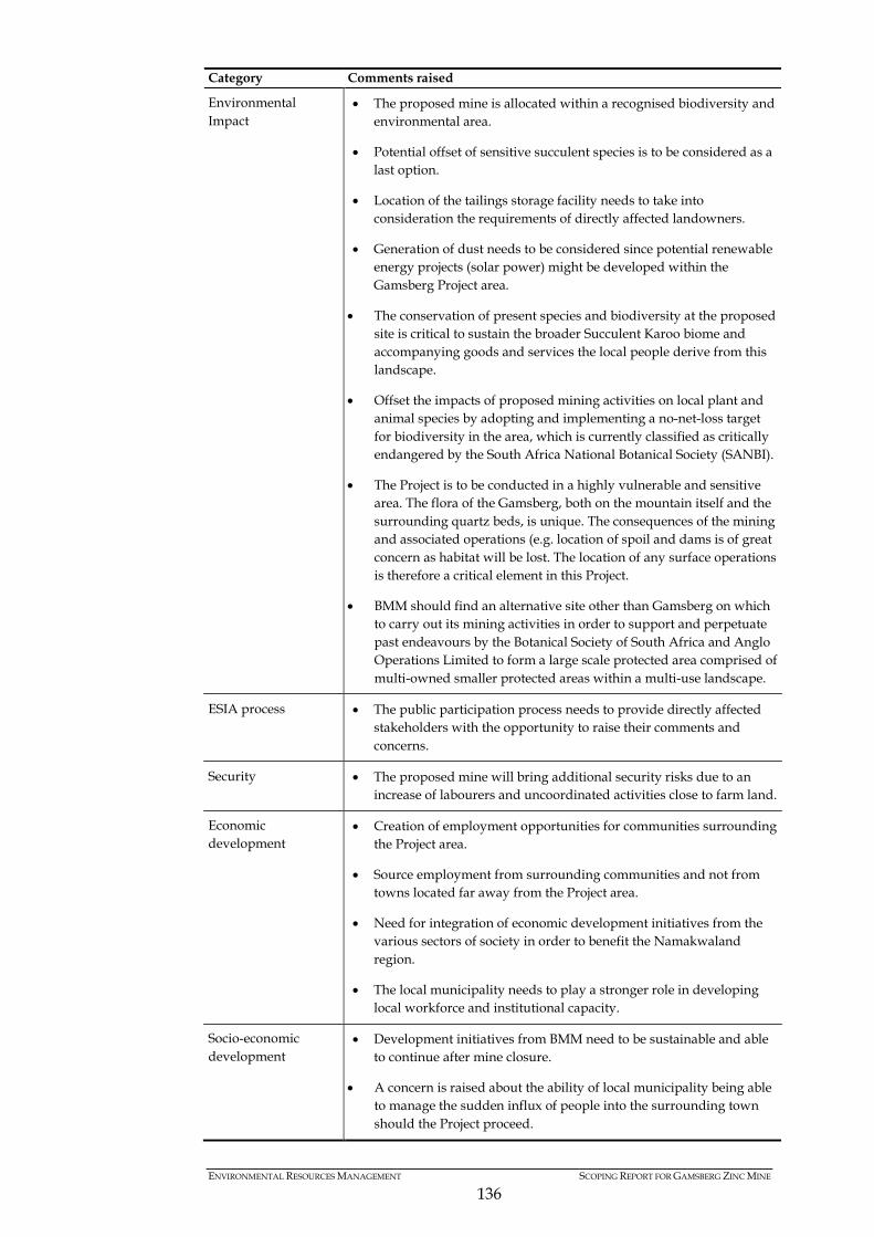
ENVIRONMENTAL RESOURCES MANAGEMENT SCOPING REPORT FOR GAMSBERG ZINC MINE
136
Category Comments raised
Environmental Impact
• The proposed mine is allocated within a recognised biodiversity and environmental area.
• Potential offset of sensitive succulent species is to be considered as a last option.
• Location of the tailings storage facility needs to take into consideration the requirements of directly affected landowners.
• Generation of dust needs to be considered since potential renewable energy projects (solar power) might be developed within the Gamsberg Project area.
• The conservation of present species and biodiversity at the proposed site is critical to sustain the broader Succulent Karoo biome and accompanying goods and services the local people derive from this landscape.
• Offset the impacts of proposed mining activities on local plant and animal species by adopting and implementing a no-net-loss target for biodiversity in the area, which is currently classified as critically endangered by the South Africa National Botanical Society (SANBI).
• The Project is to be conducted in a highly vulnerable and sensitive area. The flora of the Gamsberg, both on the mountain itself and the surrounding quartz beds, is unique. The consequences of the mining and associated operations (e.g. location of spoil and dams is of great concern as habitat will be lost. The location of any surface operations is therefore a critical element in this Project.
• BMM should find an alternative site other than Gamsberg on which to carry out its mining activities in order to support and perpetuate past endeavours by the Botanical Society of South Africa and Anglo Operations Limited to form a large scale protected area comprised of multi-owned smaller protected areas within a multi-use landscape.
ESIA process • The public participation process needs to provide directly affected stakeholders with the opportunity to raise their comments and concerns.
Security • The proposed mine will bring additional security risks due to an increase of labourers and uncoordinated activities close to farm land.
Economic development
• Creation of employment opportunities for communities surrounding the Project area.
• Source employment from surrounding communities and not from towns located far away from the Project area.
• Need for integration of economic development initiatives from the various sectors of society in order to benefit the Namakwaland region.
• The local municipality needs to play a stronger role in developing local workforce and institutional capacity.
Socio-economic development
• Development initiatives from BMM need to be sustainable and able to continue after mine closure.
• A concern is raised about the ability of local municipality being able to manage the sudden influx of people into the surrounding town should the Project proceed.

ENVIRONMENTAL RESOURCES MANAGEMENT SCOPING REPORT FOR GAMSBERG ZINC MINE
137
5.1 AIR QUALITY AND DUST
A summary of ambient air guidelines and standards for priority pollutants is presented below. Standards published in Government Gazette No.32816, Notice No. 1210 on 24 December 2009 in terms of Section 9(1) of the NEM:AQA (referred to the NEM:AQA Standard) as well as those published in SANS 1929:2005 for PM10, SO2, NO2 and for dust fallout, is included. During the Gap Analysis completed by SRK Consulting in 2010, a dust fallout and gas monitoring network was established. The results from the monitoring station indicate that dust fallout levels do fluctuate in the area, with higher concentration levels recorded during the dry, windy seasons (i.e. July and September). Dust concentration levels do exceed SANS 1929:2005 standards during months characterised with less rainfall and greater wind speeds. Furthermore, as the dry season is characterised with limited vegetation, the potential for windblown dust is also greater. Due to existing dust concentration levels exceeding SANS 1929:2005 during certain periods of the year, future mining activities would need to ensure that dust generation and suppression is efficiently managed, so as to overcome potential cumulative impacts of a new mine in the region. The SO2 concentrations obtained for the months of June and September were registered below the 24 hour NEM:AQA Standard of 125 µg/m3 and the SANS 1929:2005 24 hour standard of 125 µg/m3 for all monitoring points. Furthermore, NO2 levels were obtained from existing monitoring stations, which indicated that the concentration levels are below the NEM:AQA Standard limit of 200 µg/m3 and SANS 1929:2005 limit of 200 µg/m3. A PM10 monitoring station situated at Aggeneys High School (as it’s the closest human receptor to the Gamsberg inselberg), measured an average 24 hour PM10 concentration levels to be below the NEM:AQA Standard of 120 µg/m3 for all months. There was one 24 hour exceedance (92 µg/m3) above the proposed NEM:AQA standard of 75 µg/m3 during the month of November. Based on the potential for seasonal variations in the region, air dispersion modelling will be undertaken to anticipate expected changes to the surrounding ambient air quality (gases and dust), in light of the Gamsberg mine. Furthermore, cognisance will also need to be taken of existing and future developments (within a foreseeable timeframe) to ensure that cumulative impacts are also addressed. Particular attention will be focussed on the impacts associated with dust generation, and modelling will be undertaken based on current and historic weather data. Although the average 24 hour PM10 concentration levels were below the NEM:AQA Standard of 120 µg/m3, the Project will strive to remain within the proposed NEM:AQA standard of 75 µg/m3.

ENVIRONMENTAL RESOURCES MANAGEMENT SCOPING REPORT FOR GAMSBERG ZINC MINE
138
5.2 VISUAL
Due to the flat nature and limited vegetation coverage, the visual absorption capacity of the surrounding landscape is generally low, especially for activities abutting the northern rim of the inselberg. This section of visual exposure includes a 24 km stretch of the N14 and the town of Aggeneys. Project activities located north of the N14 and to the south, south east and south west of the inselberg is will likely have a lower visual exposure, based on surrounding koppies that increases the visual absorption capacity. In recognising the visually sensitive areas, a visual impact assessment will be undertaken to explore the visual impacts associated with the Project. Particular focus will be given to key visual receptors relative to Project infrastructure, as well explore the potential for visual mitigation. Key infrastructure that is likely to impact the visual landscape at an operational level includes the waste rock dump site, tailings dam, process plant and associated buildings. Furthermore, proposed power infrastructure in the form of sub-stations and distribution lines will also disrupt the visual texture of the surround region. At a construction phase, the contractors camp site (expected to be located along the southern border of the N14) will also need to situated, based on areas with a high visual absorption capacity. Inputs from a visual perspective will be used to guide the planning and overall placement of Project infrastructure, together with other environmental sensitivities present onsite. Furthermore, the visual specialist will also be required to provide mitigation measures to avoid or reduce expected impacts.
5.3 SURFACE HYDROLOGY
The proposed Gamsberg site drains into two catchment areas, in with the northern section of the Project into the Orange River Basin, whereas the southern section drains into a catchment referred to as an endoreic area (i.e. closed catchment). During the hydrology and surface water analysis undertaken by SRK Consulting (2010), it was established that the Project area and associated infrastructure will impact 10 local water catchment areas in the surrounding region. The area for each catchment ranges from 0.97 km2 to 272 km2. The area weighted MAR for each of these catchment areas varied from 300 m3 to 84 000 m3. However, due to the limited rainfall experienced in the region, most of the water courses identified are ephemeral in nature, and are largely dependent on sub-surface flows. Water quality monitoring, when compared to the South African National Standards for drinking water (SANS 241 of 2006), confirmed that water from the springs on the Gamsberg inselberg is considered to be suitable for domestic use and livestock watering (SRK Consulting, 2010). The concentration levels of Barium found in the water did comply with SANS 241
ENVIRONMENTAL RESOURCES MANAGEMENT SCOPING REPORT FOR GAMSBERG ZINC MINE
139
over the monitoring period, but exceed concentration standards in terms of the World Health Organisations standard for drinking water. It must be noted that the nitrate concentrations recorded during the months of July and August were approximately 10 times higher than those during May and June, but remained within SANS 241 standards for drinking water The nitrate concentrations present in the groundwater, in and around the inselberg are likely to be linked to fertilizers, sanitation and livestock. Based on rainfall patterns in the region, short periods of high intensity rainfall can be expected, thus increasing the erosion potential. Recognising the erosion potential, suitable mitigation will be recommended to manage erosion impacts. Cognisance must also be taken of surface water contamination potential, especially with the spring found inside of the inselberg. Specific construction and operational phase measures will need to be formulated during the ESIA Phase. Due to a closed catchment located to the south of the inselberg, discharge into this region will result in higher surface water impacts due to a lack of drainage. Mining activities will need to be considered in light of the three sub-catchments of the region, and try to be limited to a single catchment. This potential will be explored during the ESIA Phase.
5.4 HYDROGEOLOGY
Groundwater resources in the Namakwa District are more abundant than surface water features. Groundwater serves as a key water source, especially for livestock farmers in the surrounding area. Based on estimated projections, a total of ~75 000 m3/annum of groundwater is abstracted by surrounding water users, primarily for livestock watering and domestic use. The boreholes present in the region are expected to yield between 0.1 and 0.5 ℓ/s, which are likely to experience seasonal variations based on rainfall patterns. Groundwater is mainly found within secondary fractured-rock aquifers and tends to be found along fractures within rocks of low permeability. Recognising the potential for rock fractures/ faults to act as a conduit for pollution dispersion to secondary rock fractured aquifers, the location of waste related facilities must take cognisance of fault lines located to the south of the inselberg, and others identified during the hydrogeological investigation. Due to Fluoride and Nitrate concentrations present in the samples previously tested, the groundwater in the region exceeded the Class two water quality parameters, and is thus considered not suitable for drinking purposes in terms of SANS 241 of 2006. Although not suitable for drinking purposes, the high groundwater dependency of surrounding livestock farming activities makes this resource critical for a number of surrounding users. Based on the nature of the geological formations present in the area, the acid generation potential will be investigated as part of a geochemical assessment. The findings of the
ENVIRONMENTAL RESOURCES MANAGEMENT SCOPING REPORT FOR GAMSBERG ZINC MINE
140
geochemical investigation will need to feed into the hydrogeological modelling to determine groundwater pollution potential and its potential implications to surrounding groundwater users.
5.5 GEOCHEMISTRY
The previous acid based accounting tests determine a high potential for acid generation, due to high sulphide concentrations in the samples tested. The metals concentrations in the leachate generated from the sample were not considered to be environmentally significant, with the exception of releases of higher concentrations of zinc, iron and manganese into groundwater resources. This risk and the impact of this would be calculated and determined by undertaking longer term kinetic testing and inserting the findings to the hydrogeological model. The geochemist will provide the updated kinetic testing results for inclusion into the hydrogeological monitoring. In order to understand the geochemical qualities of the geology and associated waste materials, acid-base accounting and NAG (1) will be undertaken. In addition, static geochemical testing will also be undertaken as part of the assessment to determine the acid producing potential and associated neutralising potential. The correlation between the duration of the neutralising potential relative to the acid producing potential will be determined through the kinetic testing. The investigations will present the expected impacts from long term geochemical processes and identify suitable mitigation to impacts associated with the tailings dam, waste rock dump site and onsite waste facilities. The need for suitable lining to avoid acid rock drainage into the surrounding environment will also be investigated.
5.6 FLORA
The general vegetation type found on the Gamsberg inselberg is described as Nama and Succulent Karoo, that latter of which is identified as a Global Biodiversity Hotspot. Although the proposed mine will fall outside of the area defined as the Succulent Karoo Biodiversity Hotspot, the vegetation found in and around the inselberg is characteristic of Succulent Karoo vegetation. Based on the species of conservation concern identified in and around the Gamsberg inselberg, together with habitat rarity, ecosystem functioning and status, at least 11 habitats of special concern will be investigated. In order to manage the impacts associated with the habitats and species of special concern, the botanical assessment will map areas of sensitivity, and
(1) ( ) In order to predict acid rock drainage potential of mine wastes, net acid generation (NA) testing will be undertaken to confidential determine acid potential classification and identify further investigation ,if required.
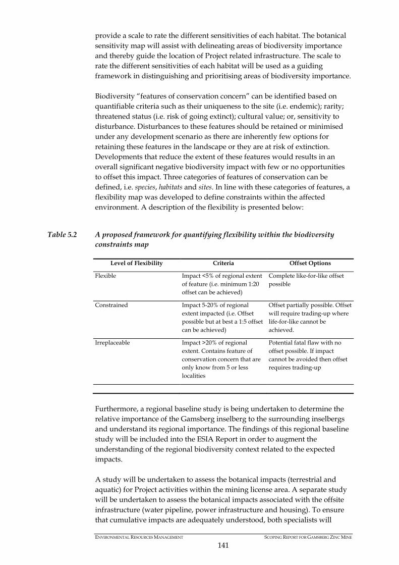
ENVIRONMENTAL RESOURCES MANAGEMENT SCOPING REPORT FOR GAMSBERG ZINC MINE
141
provide a scale to rate the different sensitivities of each habitat. The botanical sensitivity map will assist with delineating areas of biodiversity importance and thereby guide the location of Project related infrastructure. The scale to rate the different sensitivities of each habitat will be used as a guiding framework in distinguishing and prioritising areas of biodiversity importance. Biodiversity “features of conservation concern” can be identified based on quantifiable criteria such as their uniqueness to the site (i.e. endemic); rarity; threatened status (i.e. risk of going extinct); cultural value; or, sensitivity to disturbance. Disturbances to these features should be retained or minimised under any development scenario as there are inherently few options for retaining these features in the landscape or they are at risk of extinction. Developments that reduce the extent of these features would results in an overall significant negative biodiversity impact with few or no opportunities to offset this impact. Three categories of features of conservation can be defined, i.e. species, habitats and sites. In line with these categories of features, a flexibility map was developed to define constraints within the affected environment. A description of the flexibility is presented below:
Table 5.2 A proposed framework for quantifying flexibility within the biodiversity constraints map
Level of Flexibility Criteria Offset Options
Flexible Impact <5% of regional extent of feature (i.e. minimum 1:20 offset can be achieved)
Complete like-for-like offset possible
Constrained Impact 5-20% of regional extent impacted (i.e. Offset possible but at best a 1:5 offset can be achieved)
Offset partially possible. Offset will require trading-up where life-for-like cannot be achieved.
Irreplaceable Impact >20% of regional extent. Contains feature of conservation concern that are only know from 5 or less localities
Potential fatal flaw with no offset possible. If impact cannot be avoided then offset requires trading-up
Furthermore, a regional baseline study is being undertaken to determine the relative importance of the Gamsberg inselberg to the surrounding inselbergs and understand its regional importance. The findings of this regional baseline study will be included into the ESIA Report in order to augment the understanding of the regional biodiversity context related to the expected impacts. A study will be undertaken to assess the botanical impacts (terrestrial and aquatic) for Project activities within the mining license area. A separate study will be undertaken to assess the botanical impacts associated with the offsite infrastructure (water pipeline, power infrastructure and housing). To ensure that cumulative impacts are adequately understood, both specialists will
ENVIRONMENTAL RESOURCES MANAGEMENT SCOPING REPORT FOR GAMSBERG ZINC MINE
142
require regular interaction and coordination in terms of their investigation and findings. Due to the biodiversity sensitivity of the area DENC has requested that the feasibility of biodiversity offsets are investigated in parallel to the ESIA. Biodiversity offsets will only be pursued after the mitigation hierarchy of avoidance, minimization, mitigation and rehabilitation has been implemented. An initial botanical sensitivity map for the affected area is presented below.
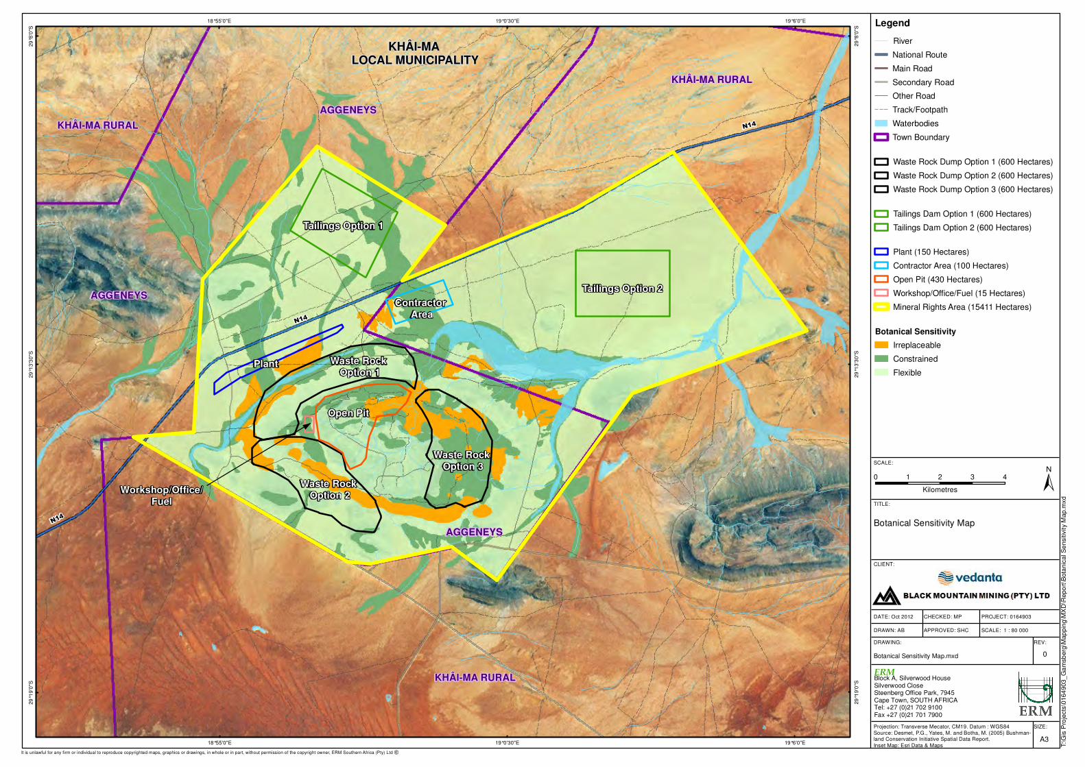
0 1 2 3 4
Kilometres
N14
KHÂI-MA RURAL
AGGENEYS
AGGENEYSN14
Workshop/Office/Fuel
Waste Rock Option 2
Open Pit
Waste Rock Option 1
Plant
Contractor Area
Tailings Option 1
Tailings Option 2
Waste Rock Option 3
N14
AGGENEYS
KHÂI-MA RURAL
KHÂI-MA RURAL
KHÂI-MA LOCAL MUNICIPALITY
19°6'0"E
19°6'0"E
19°0'30"E
19°0'30"E
18°55'0"E
18°55'0"E
29
°8'0
"S
29
°8'0
"S
29
°13
'30
"S
29
°13
'30
"S
29
°19
'0"S
29
°19
'0"S
SIZE:
TITLE:
DATE: Oct 2012
DRAWN: AB
CHECKED: MP
APPROVED: SHC
PROJECT: 0164903
DRAWING: REV:
A3
Botanical Sensitivity Map
Botanical Sensitivity Map.mxd 0
CLIENT:
±SCALE:
T:\G
is P
roje
cts
\0164
903_
Ga
msb
erg
\Map
pin
g\M
XD
\Repo
rt\B
ota
nic
al S
ensitiv
ity M
ap.m
xd
Projection: Transverse Mecator, CM19. Datum : WGS84
Source: Desmet, P.G., Yates, M. and Botha, M. (2005) Bushman-land Conservation Initiative Spatial Data Report.
Inset Map: Esri Data & Maps
SCALE: 1 : 80 000
It is unlawful for any firm or individual to reproduce copyrighted maps, graphics or drawings, in whole or in part, without permission of the copyright owner, ERM Southern Africa (Pty) Ltd �
Legend
River
National Route
Main Road
Secondary Road
Other Road
Track/Footpath
Waterbodies
Town Boundary
Waste Rock Dump Option 1 (600 Hectares)
Waste Rock Dump Option 2 (600 Hectares)
Waste Rock Dump Option 3 (600 Hectares)
Tailings Dam Option 1 (600 Hectares)
Tailings Dam Option 2 (600 Hectares)
Plant (150 Hectares)
Contractor Area (100 Hectares)
Open Pit (430 Hectares)
Workshop/Office/Fuel (15 Hectares)
Mineral Rights Area (15411 Hectares)
Botanical Sensitivity
Irreplaceable
Constrained
Flexible
Block A, Silverwood HouseSilverwood CloseSteenberg Office Park, 7945Cape Town, SOUTH AFRICATel: +27 (0)21 702 9100Fax +27 (0)21 701 7900
ERM
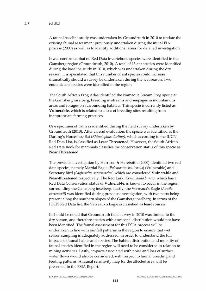
ENVIRONMENTAL RESOURCES MANAGEMENT SCOPING REPORT FOR GAMSBERG ZINC MINE
144
5.7 FAUNA
A faunal baseline study was undertaken by Groundtruth in 2010 to update the existing faunal assessment previously undertaken during the initial EIA process (2000) as well as to identify additional areas for detailed investigation. It was confirmed that no Red Data invertebrate species were identified in the Gamsberg region (Groundtruth, 2010). A total of 13 ant species were identified during the baseline study in 2010, which was undertaken during the dry season. It is speculated that this number of ant species could increase dramatically should a survey be undertaken during the wet season. Two endemic ant species were identified in the region. The South African Frog Atlas identified the Namaqua Stream Frog specie at the Gamsberg inselberg, breeding in streams and seepages in mountainous areas and forages on surrounding habitats. This specie is currently listed as Vulnerable, which is related to a loss of breeding sites resulting from inappropriate farming practices. One specimen of bat was identified during the field survey undertaken by Groundtruth (2010). After careful evaluation, the specie was identified as the Darling’s Horseshoe Bat (Rhinolophus darling), which according to the IUCN Red Data List, is classified as Least Threatened. However, the South African Red Data Book for mammals classifies the conservation status of this specie as Near Threatened. The previous investigation by Harrison & Harebottle (2000) identified two red data species, namely Martial Eagle (Polemaetus bellicosus) (Vulnerable) and Secretary Bird (Sagittarius serpentarius) which are considered Vulnerable and Near-threatened respectively. The Red Lark (Certhilauda burra), which has a Red Data Conservation status of Vulnerable, is known to occur in the region surrounding the Gamsberg inselberg. Lastly, the Verreaux's Eagle (Aquila verreauxii) was identified during previous investigation, with two nests being present along the southern slopes of the Gamsberg inselberg. In terms of the IUCN Red Data list, the Verreaux's Eagle is classified as least concern It should be noted that Groundtruth field survey in 2010 was limited to the dry season, and therefore species with a seasonal distribution would not have been identified. The faunal assessment for this ESIA process will be undertaken in line with rainfall patterns in the region to ensure that wet season sampling is adequately addressed, in order to understand the full impacts to faunal habits and species. The habitat distribution and mobility of faunal species identified in the region will need to be considered in relation to mining activities. Lastly, impacts associated with noise and loss of surface water flows would also be considered, with respect to faunal breeding and feeding patterns. A faunal sensitivity map for the affected area will be presented in the ESIA Report.

ENVIRONMENTAL RESOURCES MANAGEMENT SCOPING REPORT FOR GAMSBERG ZINC MINE
145
5.8 NOISE AND VIBRATION
The Gamsberg inselberg is located in an area that is sparsely populated, with limited sensitive noise receptors in the immediate area. Sensitive receptors in the area include the town of Aggeneys, adjacent land owners and road users (N14 and Loop 10 gravel road). The proposed Gamsberg mine will result in the generation of noise through the use of diesel equipment, crushing, concentrating and activity of mining such as blasting and drilling and hauling of rock and concentrate. Current noise generation activities include the Black Mountain Mine, road users of the N14 and residents within the town of Aggeneys. A noise and vibration impact assessment will be undertaken to consider the potential impacts generated from the Project and the manner in which sensitive receptors will be impacted. A draft version of the initial noise sensitivity map is contained below.
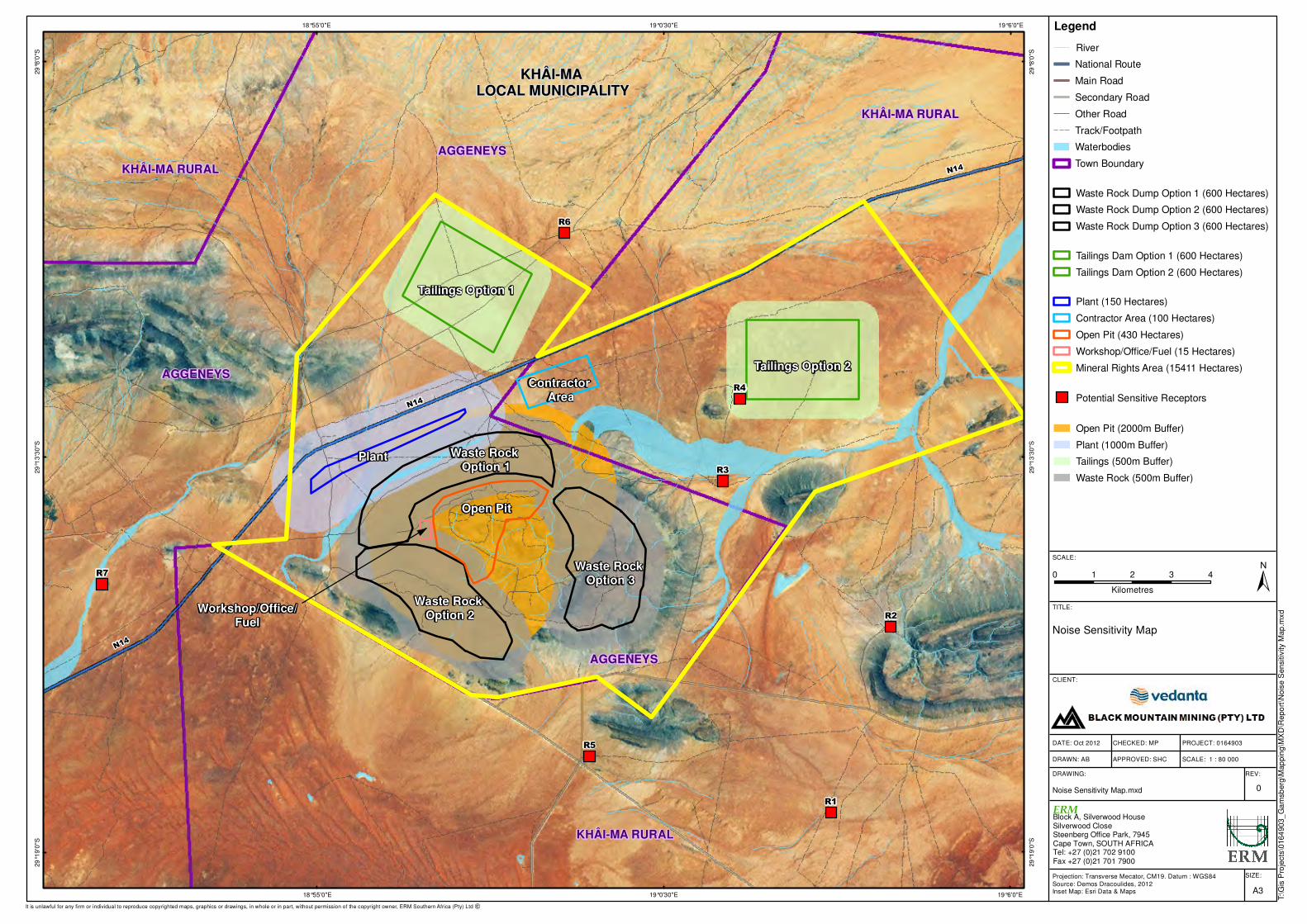
0 1 2 3 4
Kilometres
N14
KHÂI-MA RURAL
AGGENEYS
AGGENEYSN14
Workshop/Office/Fuel
Waste Rock Option 2
Open Pit
Waste Rock Option 1
Plant
Contractor Area
Tailings Option 1
Tailings Option 2
Waste Rock Option 3
N14
AGGENEYS
KHÂI-MA RURAL
KHÂI-MA RURAL
Pella
KHÂI-MA LOCAL MUNICIPALITY
R4
R3
R2
R1
R5
R7
R6
19°6'0"E
19°6'0"E
19°0'30"E
19°0'30"E
18°55'0"E
18°55'0"E
29
°8'0
"S
29
°8'0
"S
29
°13
'30
"S
29
°13
'30
"S
29
°19
'0"S
29
°19
'0"S
SIZE:
TITLE:
DATE: Oct 2012
DRAWN: AB
CHECKED: MP
APPROVED: SHC
PROJECT: 0164903
DRAWING: REV:
A3
Noise Sensitivity Map
Noise Sensitivity Map.mxd 0
CLIENT:
±SCALE:
T:\G
is P
roje
cts
\0164
903_
Ga
msb
erg
\Map
pin
g\M
XD
\Repo
rt\N
ois
e S
ensitiv
ity M
ap
.mxd
Projection: Transverse Mecator, CM19. Datum : WGS84
Source: Demos Dracoulides, 2012Inset Map: Esri Data & Maps
SCALE: 1 : 80 000
It is unlawful for any firm or individual to reproduce copyrighted maps, graphics or drawings, in whole or in part, without permission of the copyright owner, ERM Southern Africa (Pty) Ltd �
Legend
River
National Route
Main Road
Secondary Road
Other Road
Track/Footpath
Waterbodies
Town Boundary
Waste Rock Dump Option 1 (600 Hectares)
Waste Rock Dump Option 2 (600 Hectares)
Waste Rock Dump Option 3 (600 Hectares)
Tailings Dam Option 1 (600 Hectares)
Tailings Dam Option 2 (600 Hectares)
Plant (150 Hectares)
Contractor Area (100 Hectares)
Open Pit (430 Hectares)
Workshop/Office/Fuel (15 Hectares)
Mineral Rights Area (15411 Hectares)
Potential Sensitive Receptors
Open Pit (2000m Buffer)
Plant (1000m Buffer)
Tailings (500m Buffer)
Waste Rock (500m Buffer)
Block A, Silverwood HouseSilverwood CloseSteenberg Office Park, 7945Cape Town, SOUTH AFRICATel: +27 (0)21 702 9100Fax +27 (0)21 701 7900
ERM
ENVIRONMENTAL RESOURCES MANAGEMENT SCOPING REPORT FOR GAMSBERG ZINC MINE
147
5.9 HERITAGE, ARCHAEOLOGY AND PALAEONTOLOGY
The northern slope of the Gamsberg inselberg contained minimal archaeological artefacts, in the form of isolated stone flakes. A Middle Stone Age workshop site was identified along the northern rim of the inselberg however as this site was previously quarried and artefacts therefore are unlikely to be discovered below the surface. Two Acheulean workshop sites were also identified, and similar to the workshop site identified along the northern rim, indicates that the Gamsberg inselberg was favoured as a raw material source for historical communities. In addition, the stream courses found within the Gamsberg basin contains a mixture of low density Middle Stone Age and Acheulean material, which could be indicative of an area in which historical communities lived in (Morris, 2010). Since the last investigation, Black Mountain has been undertaking surface mining in various sections of the Gamsberg inselberg. The mining activities within the inselberg have already resulted in some disturbance to existing archaeological artefacts. A detailed heritage and archaeological impact assessment will be undertaken as part of this ESIA process to understand the current context and identify artefacts or sites of importance. The assessment will identify artefacts and sensitive sites for preservation of conservation importance and outline mitigation measures. No specific areas of cultural heritage value were identified during the previous investigation. However, the study will explore the cultural heritage value of the site in relation to historic and surrounding communities. Areas or items of cultural significance that could potentially be impacted will be identified and assessed. A draft version of the initial heritage and archaeological sensitivity map is contained below. Palaeontology is the affected region is limited, with no particular areas of sensitivity previously identified. However, in line with good practice, a Palaeontologist will undertake a desktop Palaeontological Impact Assessment.
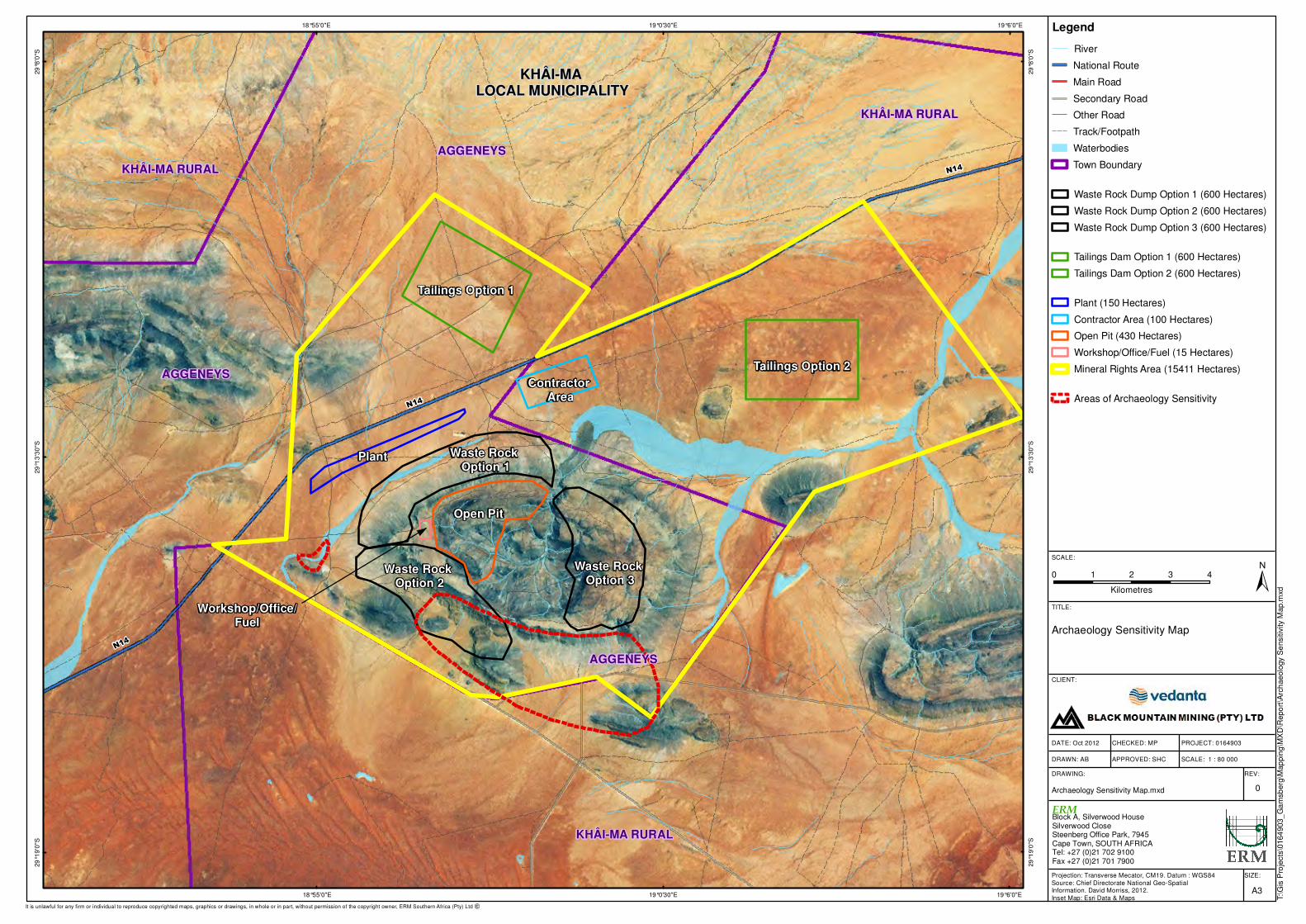
0 1 2 3 4
Kilometres
N14
KHÂI-MA RURAL
AGGENEYS
AGGENEYSN14
Workshop/Office/Fuel
Waste Rock Option 2
Open Pit
Waste Rock Option 1
Plant
Contractor Area
Tailings Option 1
Tailings Option 2
Waste Rock Option 3
N14
AGGENEYS
KHÂI-MA RURAL
KHÂI-MA RURAL
Pella
KHÂI-MA LOCAL MUNICIPALITY
19°6'0"E
19°6'0"E
19°0'30"E
19°0'30"E
18°55'0"E
18°55'0"E
29
°8'0
"S
29
°8'0
"S
29
°13
'30
"S
29
°13
'30
"S
29
°19
'0"S
29
°19
'0"S
SIZE:
TITLE:
DATE: Oct 2012
DRAWN: AB
CHECKED: MP
APPROVED: SHC
PROJECT: 0164903
DRAWING: REV:
A3
Archaeology Sensitivity Map
Archaeology Sensitivity Map.mxd 0
CLIENT:
±SCALE:
T:\G
is P
roje
cts
\0164
903_
Ga
msb
erg
\Map
pin
g\M
XD
\Repo
rt\A
rch
aeolo
gy S
ensitiv
ity M
ap.m
xd
Projection: Transverse Mecator, CM19. Datum : WGS84
Source: Chief Directorate National Geo-Spatial Information. David Morriss, 2012.
Inset Map: Esri Data & Maps
SCALE: 1 : 80 000
It is unlawful for any firm or individual to reproduce copyrighted maps, graphics or drawings, in whole or in part, without permission of the copyright owner, ERM Southern Africa (Pty) Ltd �
Legend
River
National Route
Main Road
Secondary Road
Other Road
Track/Footpath
Waterbodies
Town Boundary
Waste Rock Dump Option 1 (600 Hectares)
Waste Rock Dump Option 2 (600 Hectares)
Waste Rock Dump Option 3 (600 Hectares)
Tailings Dam Option 1 (600 Hectares)
Tailings Dam Option 2 (600 Hectares)
Plant (150 Hectares)
Contractor Area (100 Hectares)
Open Pit (430 Hectares)
Workshop/Office/Fuel (15 Hectares)
Mineral Rights Area (15411 Hectares)
Areas of Archaeology Sensitivity
Block A, Silverwood HouseSilverwood CloseSteenberg Office Park, 7945Cape Town, SOUTH AFRICATel: +27 (0)21 702 9100Fax +27 (0)21 701 7900
ERM
ENVIRONMENTAL RESOURCES MANAGEMENT SCOPING REPORT FOR GAMSBERG ZINC MINE
149
5.10 SOCIAL
The settlements within the Gamsberg mine’s direct area of influence include Aggeneys, Pella and Pofadder. These are all located within a 50 km (1) radius of the Project area. Witbank, Onseepkans and Springbok are considered to form part of the Project’s area of indirect influence as potential labour sending areas and in the case of Springbok as a regional economic centre. The quality of life of people in settlements within the Project’s area of influence is considered to be generally poor with limited access to social services and inadequate infrastructure. There are high incidences of poverty, unemployment, and dependency on state grants resulting in a lack of food security and the inability to meet basic social needs as well as a lack of access to opportunities. This is exacerbated by the geographic isolation in most of the settlements in the area of influence and the general lack of access to economic opportunities. Social problems such as alcoholism have been identified in earlier baseline work and by key informants, as pervasive in the affected communities. Drug abuse is also identified as a problem amongst youth. Other social problems occurring in the area include domestic violence and reported prostitution in some settlements. Anecdotal evidence gathered during initial field visits and stakeholder interviews suggest that petty crime levels are increasing, which may be linked to the rising drug abuse and unemployment. In general intra-family conflict, domestic violence and socially deviant behaviour correlate closely with alcohol and drug abuse.
The above issues and associated poor quality of life may give rise to vulnerabilities in the communities in the settlements within the area of influence. Specific vulnerable groups identified in the SRK 2010 baseline include:
• unemployed; • elderly; • children and youth (including orphans); • women (especially single women); and • disabled and chronically ill.
Women and children may be particularly vulnerable in this social context as they are often the victims of domestic violence. Further detailed investigation is required to better understand the social challenges affecting these communities and their potential vulnerabilities. The existing vulnerabilities will also be considered in conjunction with migration in to the region, based on perceptions of employment opportunities.
(1) The 50km radius used to define affected communities is in terms of the Minerals and Petroleum Resources Development Act (28 of 2002).

ENVIRONMENTAL RESOURCES MANAGEMENT SCOPING REPORT FOR GAMSBERG ZINC MINE
150
Furthermore, crime and health issues related to migration into the region will need to be explored. The interface between decommissioning of the existing Black Mountain Mine (expected in 20xx) and establishment of the Gamsberg zinc mine will need to be investigated. Lastly, the legacy of the proposed Gamsberg zinc mine, upon completion of decommissioning and final landuse will be investigated in light of the social environment.
5.11 ECONOMIC
Unemployment is a major challenge in the Khoi Ma Local Municipality. This situation continues to be exacerbated by the current difficult economic climate with low levels of economic growth. With regard to the sectoral division of employment opportunities, for the Namakwa District as a whole, the dominant sector in terms of employment provision is mining which provided 21.3% of all employment opportunities in 2007 followed by agriculture and fishing which provided 18% of all jobs.
In light of the economic context in the local, district and provincial levels, an Economic Assessment will be undertaken to understand the manner in which the proposed Gamsberg mine will impact (negatively and positively) on the surrounding region in terms of employment, household incomes, skills developments and general economic output at a local, district and provincial level. Furthermore, the tax revenue generated from the mine will also be considered, together with land prices impacts and potential for secondary industries. Furthermore, skills levels required for the proposed mine will be considered in relation to employment opportunities, to understand the potential of existing labour force to meet the skills requirements for employment. Lastly, economic evaluation will be undertaken for the loss of metaphysical items in the environment (i.e. areas of cultural importance) and secondary impacts of biophysical processes (i.e. impacts of groundwater contamination on household incomes).
5.12 TRAFFIC
Two options for the transportation of the zinc concentrate will be investigated and assessed in the ESIA Report. The first option will be to transport the zinc concentrate on trucks, via the N14, N7and R399, to the Port of Saldanha. The N14 road currently contains limited traffic flows, relative to the carrying capacity (Aurecon, 2010). The increase of heavy duty traffic flow on the N14 and N7 will also be investigated to determine suitability. This transport option will be viable for Phase 1 of the Project (335,000 tpa production).
During Phase 2 and Phase 3 of the mine production (670, 000 and 1, 000 000 tpa production respectively), a second transport option will be introduced, which includes trucking the zinc concentrate, via the Loop 10 gravel road, to Loop 10 rail siding. The concentrate will be off-loaded onto the existing Sishen-Saldanha railway line and railed to the Port of Saldanha.

ENVIRONMENTAL RESOURCES MANAGEMENT SCOPING REPORT FOR GAMSBERG ZINC MINE
151
Although previous investigations have confirmed that the Loop 10 road would have capacity to manage the expected traffic flows, revised traffic counts will be undertaken to understand the current status quo. Furthermore, Black Mountain is currently trying to obtain confirmation of capacity along the Sishen-Saldanha Railway line, based on current and future flows expected. The option to utilise the existing railway line will be considered as part of the Traffic Impact Assessment. However, the viability and operational costs associated with utilising Loop 10 and the railway line will need to be investigated as well.
Lastly, the decommissioning of the existing Black Mountain Mine (expected within the next 10 years) will be considered relative to projected traffic volumes, to understand the long term cumulative impacts of the proposed Gamsberg mine. Due to the expected production volumes in Phase 3 (1 000 000 tpa production), both options will be utilised to transport zinc concentrate to the Port of Saldanha.
5.13 WASTE CLASSIFICATION
The construction and operational phases of the proposed mine will result in the generation of both mineral (waste rock and tailings dams) and non-mineral (domestic, industrial and hazardous) wastes. In order to manage the non-mineral waste streams, Gamsberg mine will have a temporary storage facility onsite for domestic and hazardous wastes. A waste management study will be undertaken to classify hazardous and non-hazardous wastes produced and to outline suitable procedures for the removal and disposal of all wastes. Furthermore, a waste management plan will be developed, taking into consideration the mitigation hierarchy of Waste Avoidance, Recycling and Re-use, Treatment and Disposal.
5.14 CLIMATE CHANGE AND GREEN HOUSE GAS EMISSIONS
Climate change, and the associated political and social response, is already presenting material risks and opportunities to business and industrial sectors. These risks and opportunities have grown in prominence over the last five years and are expected to increase significantly in scale and coverage in the next ten years. Governments are proposing and implementing legislation to mitigate greenhouse gas emissions such as carbon taxes, emission limits, and the cost of business interruption following extreme weather events is increasing the need for implementation of adaptation measures. A climate change impact assessment will be undertaken to understand the potential impacts of climate change on the development activities, as well as the impact of the development activity on climate change. The latter will be achieved through developing a detailed Green House Gas (GHG)
ENVIRONMENTAL RESOURCES MANAGEMENT SCOPING REPORT FOR GAMSBERG ZINC MINE
152
Emissions inventory, which will consider sources from construction, operation and decommissioning phase activities. The GHG inventory will also be used to develop a carbon footprint of the operational phase of the Project. The climate change assessment will conduct an assessment of the impact of the emissions associated with the Gamsberg mine on South Africa’s national emissions inventory. The nature and complexity of the impacts of climate change are such that ascribing significance to impacts, such as a rise in sea level or a change in global temperature, as a result of a single development, is not possible. The impact significance of the greenhouse gas emissions from this Project will be described in relation to its impact on South Africa’s National Greenhouse Gas Inventory. Mitigation of greenhouse gas emissions involves the installation of low carbon technologies and renewable energy and the implementation of systems which maximise energy efficiency. Based on a high level review of the development’s plans and of global best practice, the assessment will provide recommendations on how design specifications could be modified to reduce emissions if possible.
5.15 CONCLUSION
From the above discussion, it can be seen that the proposed Gamsberg mine will be developed in a sensitive biophysical environment, where the interdependencies of groundwater, surface water hydrology and ecological functioning of the Gamsberg inselberg will be important to understand. While the biophysical environmental is sensitive, the socioeconomic environment is such that the proposed mine development could result in significant socioeconomic benefits at a local, district and provincial levels in an environment of high unemployment, low levels of education and several other socioeconomic challenges. To understand both the negative impacts of the development, together with the benefits, the ESIA report will need to investigate each of the key issues identified above. The specialist studies and the methodology for addressing the complexity of environmental and social issues are described in the Plan of Study below.

ENVIRONMENTAL RESOURCES MANAGEMENT SCOPING REPORT FOR GAMSBERG ZINC MINE
153
6 PUBLIC PARTICIPATION PROCESS
The public participation process (PPP) has been designed to comply with the regulatory requirements set out in the NEMA, NEM:WA, NEM:AQA, MPRDA and NWA, as well as international good practice. Public participation in an ESIA is not only a statutory requirement in terms of the EIA Regulations (2010), but a process that is designed to provide I&APs with an opportunity to evaluate all aspects of the proposed development, with the objective of maximising its benefits while minimising its adverse effects. I&APs represents relevant sectors of society and various relevant organs of state. The ESIA process is seen as a tool to facilitate cooperative governance through informed comments from a spectrum of stakeholders and organs of state. The aim of which is to ensure that an informed decision making process is undertaken, which incorporates social, financial and environmental considerations. The PPP is also aligned with the International Finance Corporation (IFC) which is recognised as international good practice. The IFC’s Performance Standard 1, Social and Environmental Management and Assessment Systems requires that consultation be carried out in two stages, one before the ESIA scope is finalized (i.e. Scoping Phase), and one after the Draft ESIA report has been prepared. It highlights the importance of integrated assessment, effective community engagement and the proponent’s management of social and environmental performance throughout the life of the Project. This chapter provides an overview of the PPP and describes what engagement activities have been undertaken to date and includes the next steps in the public engagement process.
6.1 OBJECTIVES OF THE PUBLIC PARTICIPATION PROCESS
The PPP has been designed to achieve the following objectives: • To ensure that stakeholders are well informed about the proposed
development; • To provide a broad set of stakeholders sufficient opportunity to engage and
provide input and suggestions on the Project; • To verify that stakeholder issues have been accurately recorded; • To draw on local knowledge in the process of identifying environmental
and social issues associated with the Project, and to involve stakeholders in identifying ways in which these can be addressed; and
• To comply with the legal requirements and international good practice. The PPP has been designed around five phases within the ESIA process, namely:
ENVIRONMENTAL RESOURCES MANAGEMENT SCOPING REPORT FOR GAMSBERG ZINC MINE
154
Initial consultation
• Identification of additional stakeholders; • Engagements with key stakeholders including representatives from the
local municipalities, farmer’s association and environmental NGO’s; • Providing information of the Project and the associated processes to
stakeholders; • Obtain issues of concern, comments and suggestions from key
stakeholders; and • Invite stakeholders to register as I&APs. Pre-scoping phase
• Officially initiates, and notifies the public of, the formal ESIA process; • Distribution of a Project Background Information Document (BID),
placement of statuary adverts and site notices; • Engagements with key stakeholders including representatives from the
local and district municipalities, farmers association, directly affected landowners and environmental NGOs;
• Obtain issues of concern, comments and suggestions from stakeholders; and
• Invite stakeholders to register as I&APs. Scoping phase
• Acknowledge and forward suggestions for enhanced Project benefits and reasonable alternatives to the applicant;
• Verify that issues raised by stakeholders have been accurately recorded; and
• Record and address concerns, suggestions and comments about the Project, the Draft Scoping Report and the Draft Plan of Study for EISA phase.
Impact Assessment phase
• Provide further detail about the specialist studies conducted; • Allow I&APs to comment on findings of the specialist impacts assessments
as well as in the development of appropriate mitigation measures; and • Verify that issues raised by stakeholders have been accurately recorded. Decision making phase
• Notification of I&APs of the outcome of the decision by the relevant authorities; and
• Notification of the I&APs of the appeals process and how they can engage this process.
6.2 WHO ARE THE STAKEHOLDERS OR I&APS
One of the key principles informing the PPP is that it should be an inclusive process. Given the sensitivities around the biodiversity associated with the

ENVIRONMENTAL RESOURCES MANAGEMENT SCOPING REPORT FOR GAMSBERG ZINC MINE
155
Project location and high rate of unemployment in the region, it is important that stakeholders from the district and local municipalities, environmental bodies and landowners are given the opportunity to participate in the process. Notification activities have been designed to ensure that stakeholders are invited to be involved in the process. Stakeholders were invited to become part of the process in two ways:
• Through notification activities which were designed to ensure that the broader public were informed of the process and invited to be involved;
• Through ERM’s proactively registering stakeholders identified as potentially interested or affected through the pre-scoping phase; and
• Networking with key stakeholders throughout consultations. Stakeholders have been notified and invited to register as I&APs in the Project and the associated licensing processes through a series of English and Afrikaans PPP notification materials as indicated in Table 6.1. Stakeholders are grouped into the following categories:
• Government: National, Provincial, District and Local authorities; • Landowners: Directly affected and surrounding landowners; • Communities: Surrounding communities; • Adjacent Landowners: Neighbouring farm owners and communities; • Non-Governmental Organisations (NGOs): Environmental organisations
and social focused organisations; • Business: small medium enterprises and formal organisations; and • Unions. A stakeholder database has been compiled and will continue to be updated throughout the PPP. The existing full stakeholder database is appended as Annexure E.
6.3 PUBLIC PARTICIPATION ACTIVITIES
Table 6.1 below provides details of the public participation activities during the ESIA.
Table 6.1 Public Participation Activities
Activity Details Reference in DSR Initial consultation
Meeting with authorities.
Provisioning information and general discussion around the Gamsberg Project. The following authorities were consulted on 10 July 2012: • Department of Water Affairs; and • Department of Environment and Nature
Conservation.
Annex F Meeting minutes

ENVIRONMENTAL RESOURCES MANAGEMENT SCOPING REPORT FOR GAMSBERG ZINC MINE
156
Meeting with key stakeholders.
Provisioning information and general discussion around the Gamsberg Project. The following key stakeholders were consulted on 20 and 21 June 2012: • Pella Local Municipality and community
leaders (20 June, Pella); • South African National Botanical Institute
(SANBI) (20 June, Springbok); • Khai-Ma Local and Namakwa District
Municipalities (21 June, Pofadder); and • Pofadder Landbou Vereniging (21 June,
Pofadder).
Annex F Meeting minutes
Pre-Scoping Phase
Distribution of Project announcement letter and Background Information Document (BID).
BID and announcement documentation emailed and posted to stakeholders on 30 July 2012.
(Registration period of 30 days: 30 July – 29 August 2012).
Annex D
BID.
Placing of adverts. Afrikaans adverts were placed in the Die Plattelander (3 August 2012), Die Namakwalander (3 August 2012), Eland (8 August 2012), Die Burger West (5 August 2011) newspapers and English adverts were placed in the Die Gemsbok (3 August 2012.
Annex B
Adverts.
Putting up of site notices.
Eight Afrikaans and Eight English site notices were put up at the Project area, local libraries, municipal offices and frequently visited shops or recreational venues Pella, Aggeneys and Pofadder:
• Gamsberg Project area;
• Aggeneys Kaffee;
• Aggeneys Recreation Hall;
• Black Mountain Main Building Aggeneys;
• Pella Library;
• Pella Municipal Office;
• Pofadder Library; and
• Pofadder Municipal Office.
Annex C
Site notices.
Identification of stakeholders.
Stakeholder database which includes interested and affected parties from various sectors of society including directly affected and adjacent landowners in and around the Project area (see Section 5.2).
Annex E
Stakeholder database.

ENVIRONMENTAL RESOURCES MANAGEMENT SCOPING REPORT FOR GAMSBERG ZINC MINE
157
Meetings with relevant stakeholders.
Meetings and telephonic consultations were conducted with the following stakeholders in mid-August 2012:
• Landowners/farmers telephonic consultations (27 July);
• Environmental NGOs telephonic consultations (8 August);
• Pofadder Landbou Vereniging meeting (15 August, Pofadder);
• Conservation South Africa, SANBI and NAGO meeting (16 August, Springbok); and
• Khai-Ma Local Municipality meeting (16 August, Pofadder).
Annex F
Minutes of meeting
Obtained comments from stakeholders.
Comments, issues of concern and suggestions received from stakeholders are included.
Annex F
Minutes of meeting.
Scoping Phase
Announcement of DSR. DSR announcement letter sent to all I&APs on the database on 9 November 2012.
Adverts placed in the following newspapers:
• Die Gemsbok
• Die Plattelander
• Die Namakwalander
• Eland
• Die Burger West
• Express Northern Cape
Annex F
Letters of notification
Making DSR available to I&APs.
DSR and accompanying documents are placed at the following public places within the Project area:
• Pofadder Public Library
• Pofadder Local Municipal Offices
• Springbok Municipal Offices
• Springbok Library
• Aggeneys Public Library
• Pella Public Library and Local Municipality
• Project website
(DSR public review period of 30 days: 9 November – 14 December 2012).
DSR Public Participation material to be provided in Final Scoping Report.

ENVIRONMENTAL RESOURCES MANAGEMENT SCOPING REPORT FOR GAMSBERG ZINC MINE
158
Stakeholder meetings. Details of public meetings proposed are as follows:
- Pofadder Community Hall
27 November 2012 16:00 – 18:00
- Pella Community Hall - 28 November 2012 - 16:00 – 18:00
- Aggeneys Recreational Club - 29 November 2012 - 16:00 – 18:00
Details of focus group meetings during the Scoping Phase are as follows:
- Pofadder Landbou Community Hall - Pofadder Farmers Association
28 November 2012 10:00 – 12:00
- Conservation South Africa Offices - Social and Environmental Non-
Governmental Organisations - 28 November 2012 - 16:00 – 18:00
Annex F
Minutes of meeting.
Obtain comments from stakeholders.
Comments, issues of concern and suggestions received from stakeholders during the DSR public review period will be captured in the Comment and Response Report, which will also be made available to I&APs. The Comment and Response Report will be distributed to all IAPs who submitted comment.
Annex G
Comments received and Comments and Response Report
Making Final Scoping Report available to I&Ps
The Final Scoping Report will be simultaneously submitted to competent authority and made available to I&APs. A public review period of 21 days will be provided for I&APs to provide comments directly to DENC.
Annex F
Letters of notification
Figures 6.1 and 6.2 below are pictures taken during the public meetings held in the towns of Pella and Pofadder.

ENVIRONMENTAL RESOURCES MANAGEMENT SCOPING REPORT FOR GAMSBERG ZINC MINE
159
Figure 6.1 Pictures taken during the Public Meeting held in Pella
Figure 6.2 Pictures taken during the Public Meeting held in Pofadder
6.4 PUBLIC PARTICIPATION DURING THE IMPACT ASSESSMENT PHASE
Public participation during the impact assessment phase of the ESIA will revolve around a review of the findings of the ESIA, presented in the Draft ESIA Report, and the specialist studies. The Draft ESIA Report and associated EMPr will be made available for a 40 day public comment during the first quarter of 2013. I&APs will be advised timeously of the availability of these reports, of how to obtain them, and of the date and venue of the meetings where the content of the reports will be presented for comment. They will be encouraged to comment either in writing (mail or email), by attending the stakeholder meetings or by telephonic consultation. Ample notification of due dates will be provided.

ENVIRONMENTAL RESOURCES MANAGEMENT SCOPING REPORT FOR GAMSBERG ZINC MINE
160
The objective of engagement during the Impact Assessment includes:
• To provide further information on the Project, where new information is available;
• To provide information about key findings of the specialist studies conducted;
• To involve key stakeholders and I&APs in the identification of potential impacts of the Project and in the assessment of these impacts, including positive and negative impacts; and
• To involve I&APs in identifying and assessing mitigation measures proposed to reduce these impacts (or to maximize positive impacts).
As with the Scoping phase, similar activities will be undertaken to ensure that stakeholders are given the opportunity to comment on the Draft ESIA Report. It is anticipated that this phase of activity will commence in the first quarter of 2013.
6.5 COMPETENT AUTHORITY’S DECISION
Once the The DENC has taken a decision about the Project, the public participation office will immediately notify I&APs of this decision and of the opportunity to appeal. This notification will be provided as follows: • A letter will be sent out, personally addressed to all registered I&APs,
summarising the authority’s decision and explaining how to lodge an appeal should they wish to; and
• An advertisement to announce the Competent Authority’s decision will be published in the relevant newspapers.
6.6 NEXT STEPS IN THE ESIA PROCESS
The next steps in the process include:
• Finalise the Scoping Report and make available to stakeholders for 21 day comment period;
• The FSR has been made available to I&APs for comment and submitted to the relevant authorities for approval simultaneously, although I&AP comments will need to be submitted directly to the DENC;
• The initiation of the Impact Assessment phase (first quarter of 2013); • The Draft ESIA Report will be available to the public for a 40 day review
period; and • The Final ESIA Report will be updated and submitted to the competent
authority and simultaneously made available to I&APs for a 21 day public review period.

ENVIRONMENTAL RESOURCES MANAGEMENT SCOPING REPORT FOR GAMSBERG ZINC MINE
161
7 PLAN OF STUDY FOR ESIA
7.1 PURPOSE OF PLAN OF STUDY
The Plan of Study (PoS) for the ESIA has been compiled in line with Section 28 (1) (n) of EIA Regulations R543 of 2010 (as amended). The purpose of the PoS is to ensure that the Impact Assessment phase is undertaken in a manner that is consistent with the requirements outlined in the NEMA and associated EIA Regulations. The PoS for the proposed ESIA process describes the tasks that are to be performed, indication of when the competent authority will be contacted, details of public participation that will be required and specific information required by the competent authority. An understanding of the project description, sensitivity of affected environment and comments received from stakeholders during initial consultation has led to the identification of key issues of concerns (see Section 5.1 above). To address these key issues, a number of specialist studies have been recommended and detailed Terms of Reference developed as part of the PoS. These together with the remainder of the Impact Assessment process are described below.
7.2 ESIA PROJECT TIMING
This ESIA process will be undertaken in terms of NEMA and the associated EIA Regulations (2010) and comprise a Scoping and Impact Assessment Phase. The requirements in terms of the MPRDA, NWA and NEM:AQA and NHRA will be met during the ESIA process. Scoping Phase The Draft Scoping Report was distributed for a public comment period of 30 days. Upon completion of the public comment period, the Scoping Report was finalised and re-submitted for an additional public comment period, and submitted to the DENC simultaneously. All comments received on the Final Scoping Report will be forwarded to DENC directly. The DENC will then review the Final Scoping Report and associated Plan of Study for the Impact Assessment phase and either reject, approve or request for further information. A summary of the Project timing is presented in Table 7.1. Impact Assessment Phase Upon approval of the Final Scoping Report, the Draft ESIA Report will be compiled and distributed for public and authority comment. The Draft ESIA Report will contain the findings of all specialist studies, together with an EMPr which will outline measures to mitigate and manage potential impacts. Upon completion, the Draft ESIA Report will be finalised and re-submitted for an additional 21 day public comment period and to the decision making

ENVIRONMENTAL RESOURCES MANAGEMENT SCOPING REPORT FOR GAMSBERG ZINC MINE
162
authorities simultaneously. All comments received will be forwarded to DENC and DEA directly, for decision making. Decision Making Upon completion of the 21 day public comment period on the Final ESIA Report, the DENC, together with DEA, will first determine if there is sufficient information to make an informed decision. If there is sufficient information included, the DENC and DEA will accept the Final ESIA Report and proceed with the decision making period. An integrated decision will be issued for both the ESIA and Waste Management Licence Application. ERM will formally notify all registered I&APs and general public of the decision made, through letters of notification as well as adverts in relevant newspapers.
Table 7.1 ESIA Timing Phase Expected date Public comment Draft Scoping Report Fourth Quarter 2012 30 days Final Scoping Report First Quarter 2013 21 days Draft Impact Assessment Report Second quarter 2013 30 days Final Impact Assessment Report Second quarter 2013 21 days Acceptance/ Rejection of Final Impact Assessment Report
Third quarter 2013 60 days
Notice of decision Third quarter 2013 55 days after receipt of Letter of acceptance
Upon issuing, the Environmental Authorisation and WML will be forwarded to the Department of Water Affairs (DWA) and Department of Mineral Resources (DMR). Upon receipt of these authorisations, the DWA and DMR will commence with their decision making period. DMR has a total of 120 days to issue a separate decision for the amendment of the EMPr. The DWA is not subject to a regulated timeframe for decision making on water use license application, however, will endeavour to review and issue a decision upon receipt of the ESIA and WML authorisations. The decision making on water use license application and amended EMPr will need to be issued, prior to commencement of construction. Lastly, in terms of the Atmospheric Emissions License (AEL), an approval will be issued for the proposed development, upon commencement of operation of the proposed mine.
7.3 PROPOSED CONSULTATION WITH COMPETENT AUTHORITY
All relevant authorities (ie DENC EIA and Air Quality Directorate, SAHRA, DEA (Waste Directorate), DMR and DWA) will be contacted at the following stages of the ESIA process:
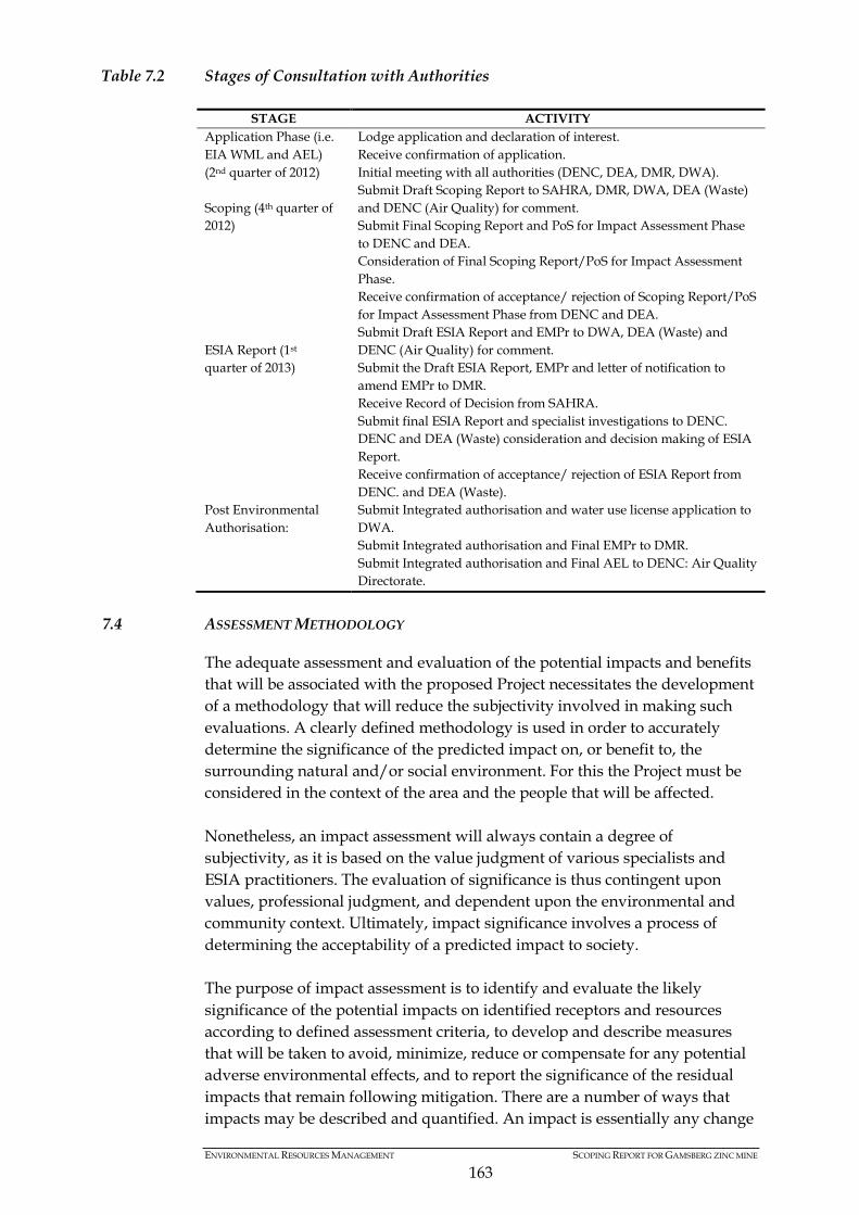
ENVIRONMENTAL RESOURCES MANAGEMENT SCOPING REPORT FOR GAMSBERG ZINC MINE
163
Table 7.2 Stages of Consultation with Authorities
STAGE ACTIVITY Application Phase (i.e. EIA WML and AEL) (2nd quarter of 2012)
Lodge application and declaration of interest. Receive confirmation of application. Initial meeting with all authorities (DENC, DEA, DMR, DWA).
Scoping (4th quarter of 2012)
Submit Draft Scoping Report to SAHRA, DMR, DWA, DEA (Waste) and DENC (Air Quality) for comment. Submit Final Scoping Report and PoS for Impact Assessment Phase to DENC and DEA. Consideration of Final Scoping Report/PoS for Impact Assessment Phase. Receive confirmation of acceptance/ rejection of Scoping Report/PoS for Impact Assessment Phase from DENC and DEA.
ESIA Report (1st quarter of 2013)
Submit Draft ESIA Report and EMPr to DWA, DEA (Waste) and DENC (Air Quality) for comment. Submit the Draft ESIA Report, EMPr and letter of notification to amend EMPr to DMR. Receive Record of Decision from SAHRA. Submit final ESIA Report and specialist investigations to DENC. DENC and DEA (Waste) consideration and decision making of ESIA Report. Receive confirmation of acceptance/ rejection of ESIA Report from DENC. and DEA (Waste).
Post Environmental Authorisation:
Submit Integrated authorisation and water use license application to DWA. Submit Integrated authorisation and Final EMPr to DMR. Submit Integrated authorisation and Final AEL to DENC: Air Quality Directorate.
7.4 ASSESSMENT METHODOLOGY
The adequate assessment and evaluation of the potential impacts and benefits that will be associated with the proposed Project necessitates the development of a methodology that will reduce the subjectivity involved in making such evaluations. A clearly defined methodology is used in order to accurately determine the significance of the predicted impact on, or benefit to, the surrounding natural and/or social environment. For this the Project must be considered in the context of the area and the people that will be affected. Nonetheless, an impact assessment will always contain a degree of subjectivity, as it is based on the value judgment of various specialists and ESIA practitioners. The evaluation of significance is thus contingent upon values, professional judgment, and dependent upon the environmental and community context. Ultimately, impact significance involves a process of determining the acceptability of a predicted impact to society. The purpose of impact assessment is to identify and evaluate the likely significance of the potential impacts on identified receptors and resources according to defined assessment criteria, to develop and describe measures that will be taken to avoid, minimize, reduce or compensate for any potential adverse environmental effects, and to report the significance of the residual impacts that remain following mitigation. There are a number of ways that impacts may be described and quantified. An impact is essentially any change
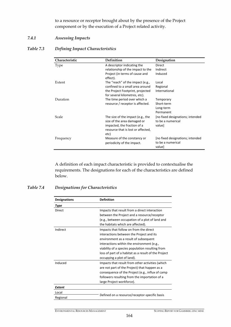
ENVIRONMENTAL RESOURCES MANAGEMENT SCOPING REPORT FOR GAMSBERG ZINC MINE
164
to a resource or receptor brought about by the presence of the Project component or by the execution of a Project related activity.
7.4.1 Assessing Impacts
Table 7.3 Defining Impact Characteristics
Characteristic Definition Designation Type A descriptor indicating the
relationship of the impact to the Project (in terms of cause and effect).
Direct Indirect Induced
Extent The “reach” of the impact (e.g., confined to a small area around the Project Footprint, projected for several kilometres, etc).
Local Regional International
Duration The time period over which a resource / receptor is affected.
Temporary Short‐term Long‐term Permanent
Scale The size of the impact (e.g., the size of the area damaged or impacted, the fraction of a resource that is lost or affected, etc)
[no fixed designations; intended to be a numerical value]
Frequency Measure of the constancy or periodicity of the impact.
[no fixed designations; intended to be a numerical value]
A definition of each impact characteristic is provided to contextualise the requirements. The designations for each of the characteristics are defined below.
Table 7.4 Designations for Characteristics
Designations Definition Type Direct Impacts that result from a direct interaction
between the Project and a resource/receptor (e.g., between occupation of a plot of land and the habitats which are affected).
Indirect Impacts that follow on from the direct interactions between the Project and its environment as a result of subsequent interactions within the environment (e.g., viability of a species population resulting from loss of part of a habitat as a result of the Project occupying a plot of land).
Induced Impacts that result from other activities (which are not part of the Project) that happen as a consequence of the Project (e.g., influx of camp followers resulting from the importation of a large Project workforce).
Extent Local
Defined on a resource/receptor‐specific basis Regional
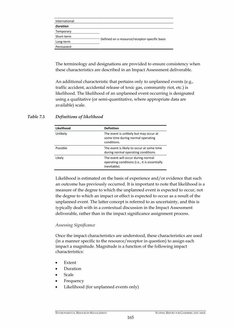
ENVIRONMENTAL RESOURCES MANAGEMENT SCOPING REPORT FOR GAMSBERG ZINC MINE
165
International Duration Temporary
Defined on a resource/receptor‐specific basis Short‐term Long‐term Permanent The terminology and designations are provided to ensure consistency when these characteristics are described in an Impact Assessment deliverable. An additional characteristic that pertains only to unplanned events (e.g., traffic accident, accidental release of toxic gas, community riot, etc.) is likelihood. The likelihood of an unplanned event occurring is designated using a qualitative (or semi-quantitative, where appropriate data are available) scale.
Table 7.5 Definitions of likelihood Likelihood Definition Unlikely The event is unlikely but may occur at
some time during normal operating conditions.
Possible The event is likely to occur at some time during normal operating conditions.
Likely The event will occur during normal operating conditions (i.e., it is essentially inevitable).
Likelihood is estimated on the basis of experience and/or evidence that such an outcome has previously occurred. It is important to note that likelihood is a measure of the degree to which the unplanned event is expected to occur, not the degree to which an impact or effect is expected to occur as a result of the unplanned event. The latter concept is referred to as uncertainty, and this is typically dealt with in a contextual discussion in the Impact Assessment deliverable, rather than in the impact significance assignment process. Assessing Significance
Once the impact characteristics are understood, these characteristics are used (in a manner specific to the resource/receptor in question) to assign each impact a magnitude. Magnitude is a function of the following impact characteristics: • Extent • Duration • Scale • Frequency • Likelihood (for unplanned events only)

ENVIRONMENTAL RESOURCES MANAGEMENT SCOPING REPORT FOR GAMSBERG ZINC MINE
166
Magnitude essentially describes the degree of change that the impact is likely to impart upon the resource/receptor. The magnitude designations are as follows: • Positive • Negligible • Small • Medium • Large The methodology incorporates likelihood into the magnitude designation (i.e., in parallel with consideration of the other impact characteristics), so that the “likelihood-factored” magnitude can then be considered with the resource/receptor sensitivity/vulnerability/importance in order to assign impact significance. The magnitude of impacts takes into account all the various dimensions of a particular impact in order to make a determination as to where the impact falls on the spectrum from negligible to large. Some impacts will result in changes to the environment that may be immeasurable, undetectable or within the range of normal natural variation. Such changes can be regarded as essentially having no impact, and should be characterised as having a negligible magnitude. In addition to characterising the magnitude of impact, the other principal step necessary to assign significance for a given impact is to define the sensitivity/vulnerability/importance of the impacted resource/receptor. There are a range of factors to be taken into account when defining the sensitivity/vulnerability/importance of the resource/receptor, which may be physical, biological, cultural or human. Where the resource is physical (for example, a water body) its quality, sensitivity to change and importance (on a local, national and international scale) are considered. Where the resource/receptor is biological or cultural (for example, the marine environment or a coral reef), its importance (for example, its local, regional, national or international importance) and its sensitivity to the specific type of impact are considered. Where the receptor is human, the vulnerability of the individual, community or wider societal group is considered. Other factors may also be considered when characterising sensitivity/vulnerability/importance, such as legal protection, government policy, stakeholder views and economic value. As in the case of magnitude, the sensitivity/vulnerability/importance designations themselves are universally consistent, but the definitions for these designations will vary on a resource/receptor basis. The universal sensitivity/vulnerability/importance designations are: • Low • Medium • High
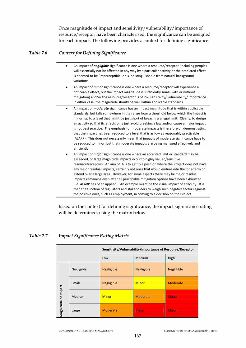
ENVIRONMENTAL RESOURCES MANAGEMENT SCOPING REPORT FOR GAMSBERG ZINC MINE
167
Once magnitude of impact and sensitivity/vulnerability/importance of resource/receptor have been characterised, the significance can be assigned for each impact. The following provides a context for defining significance.
Table 7.6 Context for Defining Significance
• An impact of negligible significance is one where a resource/receptor (including people) will essentially not be affected in any way by a particular activity or the predicted effect is deemed to be ‘imperceptible’ or is indistinguishable from natural background variations.
• An impact of minor significance is one where a resource/receptor will experience a noticeable effect, but the impact magnitude is sufficiently small (with or without mitigation) and/or the resource/receptor is of low sensitivity/ vulnerability/ importance. In either case, the magnitude should be well within applicable standards.
• An impact of moderate significance has an impact magnitude that is within applicable standards, but falls somewhere in the range from a threshold below which the impact is minor, up to a level that might be just short of breaching a legal limit. Clearly, to design an activity so that its effects only just avoid breaking a law and/or cause a major impact is not best practice. The emphasis for moderate impacts is therefore on demonstrating that the impact has been reduced to a level that is as low as reasonably practicable (ALARP). This does not necessarily mean that impacts of moderate significance have to be reduced to minor, but that moderate impacts are being managed effectively and efficiently.
• An impact of major significance is one where an accepted limit or standard may be exceeded, or large magnitude impacts occur to highly valued/sensitive resource/receptors. An aim of IA is to get to a position where the Project does not have any major residual impacts, certainly not ones that would endure into the long‐term or extend over a large area. However, for some aspects there may be major residual impacts remaining even after all practicable mitigation options have been exhausted (i.e. ALARP has been applied). An example might be the visual impact of a facility. It is then the function of regulators and stakeholders to weigh such negative factors against the positive ones, such as employment, in coming to a decision on the Project.
Based on the context for defining significance, the impact significance rating will be determined, using the matrix below.
Table 7.7 Impact Significance Rating Matrix
Sensitivity/Vulnerability/Importance of Resource/Receptor
Low Medium High
Mag
nitu
de o
f Im
pact
Negligible Negligible Negligible Negligible
Small Negligible Minor Moderate
Medium Minor Moderate Major
Large Moderate Major Major
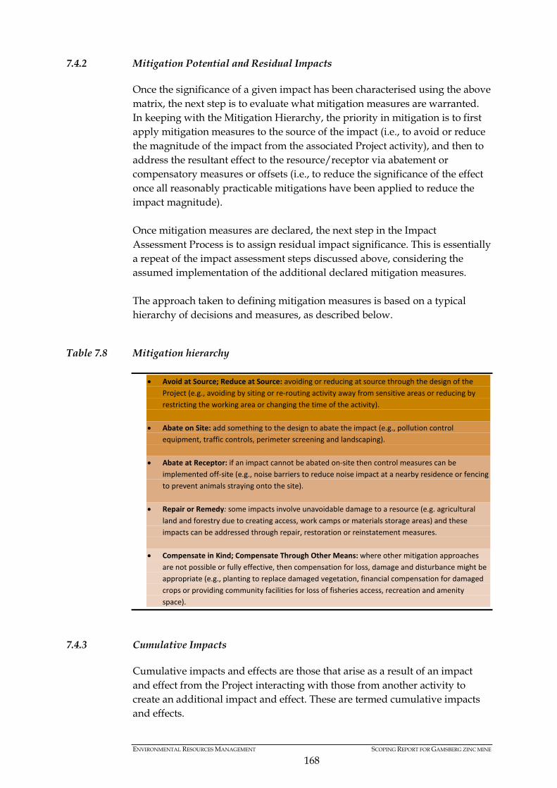
ENVIRONMENTAL RESOURCES MANAGEMENT SCOPING REPORT FOR GAMSBERG ZINC MINE
168
7.4.2 Mitigation Potential and Residual Impacts
Once the significance of a given impact has been characterised using the above matrix, the next step is to evaluate what mitigation measures are warranted. In keeping with the Mitigation Hierarchy, the priority in mitigation is to first apply mitigation measures to the source of the impact (i.e., to avoid or reduce the magnitude of the impact from the associated Project activity), and then to address the resultant effect to the resource/receptor via abatement or compensatory measures or offsets (i.e., to reduce the significance of the effect once all reasonably practicable mitigations have been applied to reduce the impact magnitude). Once mitigation measures are declared, the next step in the Impact Assessment Process is to assign residual impact significance. This is essentially a repeat of the impact assessment steps discussed above, considering the assumed implementation of the additional declared mitigation measures. The approach taken to defining mitigation measures is based on a typical hierarchy of decisions and measures, as described below.
Table 7.8 Mitigation hierarchy
7.4.3 Cumulative Impacts
Cumulative impacts and effects are those that arise as a result of an impact and effect from the Project interacting with those from another activity to create an additional impact and effect. These are termed cumulative impacts and effects.
• Avoid at Source; Reduce at Source: avoiding or reducing at source through the design of the Project (e.g., avoiding by siting or re‐routing activity away from sensitive areas or reducing by restricting the working area or changing the time of the activity).
• Abate on Site: add something to the design to abate the impact (e.g., pollution control
equipment, traffic controls, perimeter screening and landscaping). • Abate at Receptor: if an impact cannot be abated on‐site then control measures can be
implemented off‐site (e.g., noise barriers to reduce noise impact at a nearby residence or fencing to prevent animals straying onto the site).
• Repair or Remedy: some impacts involve unavoidable damage to a resource (e.g. agricultural
land and forestry due to creating access, work camps or materials storage areas) and these impacts can be addressed through repair, restoration or reinstatement measures.
• Compensate in Kind; Compensate Through Other Means: where other mitigation approaches
are not possible or fully effective, then compensation for loss, damage and disturbance might be appropriate (e.g., planting to replace damaged vegetation, financial compensation for damaged crops or providing community facilities for loss of fisheries access, recreation and amenity space).

ENVIRONMENTAL RESOURCES MANAGEMENT SCOPING REPORT FOR GAMSBERG ZINC MINE
169
The ESIA Report will predict any cumulative impacts/effects to which the Project may contribute. The approach for assessing cumulative impacts and effects resulting from the Project and another activity affecting the same resource/receptor is based on a consideration of the approval/existence status of the ‘other’ activity and the nature of information available to aid in predicting the magnitude of impact from the other activity.
7.5 CONSIDERATION OF ECOSYSTEM SERVICES
Ecosystem services are the services provided by an ecosystem functioning with human use value, and are generally categorised as follows: • Provisioning Services: The extent and frequency that the land unit
provides consumable goods (e.g. food, freshwater; timber, fibre, medicinal plants, etc.);
• Regulating Services: The extent to which the land unit provides regulating services such as flood attenuation, water purification; storage, climate regulation, carbon sequestration, etc.);
• Cultural Services: The extent to which the land unit provides cultural services (e.g. tourism attraction; spiritual attraction; aesthetic value, etc.), and; and
• Supporting Services: The extent to which the land unit provides supporting ecological services, either positive (e.g. migration corridor; refuge area; primary production; pollination; pest control; nutrient cycling; soil formation), or negative (e.g. disease sources; pest outbreaks).
An overview of potential ecosystem services that may be impacted will be undertaken by the specialist team and presented in the Draft ESIA Report.
7.6 PROPOSED SPECIALIST STUDIES
On completion of this scoping exercise, and review of the previous ESIA reporting (including specialist investigations), a number of specialists studies have been identified to conduct detailed assessments to determine the significance of impacts associated with the Project (refer to Section 5.1 above). The nature and extent of specialist investigations have also been informed by comments received during the initial 30 day public comment period and initial face to face consultation with a variety of stakeholders. This comment period and initial engagement enabled the identification of key environmental and social issues for consideration in the Impact Assessment phase. Recognising the sensitivities associated with the region (based on findings of previous investigations) as well as public comment received, the following specialist team has been appointed to undertake detailed investigations related to the Project. A list of the specialists studies proposed for the Impact Assessment phase is presented in Table 7.9 below.

ENVIRONMENTAL RESOURCES MANAGEMENT SCOPING REPORT FOR GAMSBERG ZINC MINE
170
Table 7.9 ESIA Specialist Team Name Company Expertise
Dr David Morris McGregor Museum Heritage and Archaeology
Mr John Pether Private Consultant Palaeontology
Mr Bertie Phillips Kantey & Templer Traffic
Mr Graham A Young Newtown Landscape Architects Visual
Mr Demos Dracoulides DDA Environmental Engineers Noise, Vibration and Air Quality
Dr Mark Graham GroundTruth Fauna (aquatic and avi-fauna) (on-site mine infrastructure)
Dr Phillip Desmet Private Consultant Terrestrial and aquatic flora (on-site mine infrastructure)
Dr Hugo Van Zyl Independent Economic Researcher
Marco-economics
Dr David Baldwin Private Consultant Waste Management
Mr Simon Todd Simon Todd Consulting General ecologist ( terrestrial and aquatic biodiversity) (off-site infrastructure)
Ms Alta van Wyk Alta van Wyk Environmental Consultancy cc
Water Use License Specialist
Mr Stefan Muller ERM Hydrogeology
Mr Stewart Whyte ERM Geochemistry
Mr Fred De Villiers ERM Surface hydrology
Ms Libby Schroen ERM Social Specialist
Ms Lisa Constable ERM Climate Change and Green House Gas Emissions
Mr Nestus Bredenhann ERM Stakeholder engagement Specialist
7.7 INTERDEPENDENCIES OF SPECIALIST INVESTIGATIONS
Specialist studies undertaken as part of an ESIA process are usually done in isolation, with the findings and associated mitigation limited to that particular investigation. In undertaking a large ESIA process, the interrelationship of specialist studies must be considered so as to explore the relationship between varieties of environmental and social issues to identify the most practicable options/mitigation strategies. In order to achieve a level of integration in terms of specialist findings, the sharing and sequencing of specialist studies become critically important. This is more so when a single question or impacts requires input from more than one specialist. The interdependencies of specialist studies can be assured through the drafting a specific Terms of Reference that will ensure that the required information/ data and subsequent findings can be integrated. Based on the complexity of the ESIA for the proposed Gamsberg mine and specialist team proposed, there are a number of interdependencies between the specialist assessments. In order to understand the linkages and cross
ENVIRONMENTAL RESOURCES MANAGEMENT SCOPING REPORT FOR GAMSBERG ZINC MINE
171
pollination of specialist investigations, the inherent interdependencies must be explored and agreed to upfront. This will be achieved through a specialist workshop. The intention is to have all specialists present at a workshop, after their site visit and baseline write ups, to discuss the Project in light of sensitivities and subsequent potential overlaps. A copy of the Draft Scoping Report was made available to specialists, prior to the workshop, to ensure that all specialists understand the Project details and can begin to recognise the linkages in their investigation. A preliminary table (Table 7.10) outlining potential interdependencies are shown below. All proposed specialist studies are tabulated, illustrating the potential interdependencies between the studies. In the case of the specialist investigations proposed for the Gamsberg mine, all specialist studies share a degree of interdependency of at least one other specialist investigation. The scoping phase will serve to ensure that the specialist teams recognise the interdependencies of each of their assessments.

ENVIRONMENTAL RESOURCES MANAGEMENT SCOPING REPORT FOR GAMSBERG ZINC MINE
172
Table 7.10 Specialist Interdependencies KEY: No interdependencies expected. No communication anticipated Interdependencies expected. Communication anticipated.
Specialist Study
Faun
al Im
pact
Ass
essm
ent
(Ter
rest
rial
, A
quat
ic &
Avi
faun
a)
Hyd
roge
olog
ical
Impa
ct A
sses
smen
t
Gen
eral
Eco
logi
cal A
sses
smen
t (O
ff-si
te
infr
astr
uctu
re)
Econ
omic
Impa
ct A
sses
smen
t
Soci
al Im
pact
Ass
essm
ent
Air
Qua
lity
and
Hea
lth Im
pact
A
sses
smen
t
Noi
se a
nd V
ibra
tion
Impa
ct
Ass
essm
ent
Bota
nica
l Im
pact
Ass
essm
ent
(Ter
rest
rial
& A
quat
ic)
Vis
ual I
mpa
ct A
sses
smen
t
Clim
ate
chan
ge &
GH
G E
mis
sion
s A
sses
smen
t
Hyd
rolo
gica
l Im
pact
Ass
essm
ent
Was
te M
anag
emen
t & C
lass
ifica
tion
Geo
chem
ical
Ana
lysi
s
Traf
fic Im
pact
Ass
essm
ent
Her
itage
/ A
rcha
eolo
gy
Heritage/ Archaeology
Traffic Impact Assessment
Geochemical Analysis
Waste Management & Classification
Hydrological Impact Assessment
Climate change & GHG Emissions Assessment
Visual Impact Assessment
Botanical Impact Assessment (Terrestrial & Aquatic)
Noise and Vibration Impact Assessment
Air Quality and Health Impact Assessment
Social Impact Assessment
Economic Impact Assessment
General Ecological Assessment (off-site infrastructure)
Hydrogeological Impact Assessment
Faunal Impact Assessment (terrestrial, aquatic & avifauna)
ENVIRONMENTAL RESOURCES MANAGEMENT SCOPING REPORT FOR GAMSBERG ZINC MINE
173
7.8 SPECIALIST TERMS OF REFERENCE
The Terms of Reference for each of the specialist studies are discussed below. However, a generic list of requirements is bulleted below, which will apply to all specialists, where relevant: • All specialist assessments will take into account public comments
received during the Public Participation process as well as the applicable South African and International standards and Provincial Guidelines.
• The direct and indirect areas of influence (as discussed in Section 5.10 above) will be considered by each specialist study.
• The environmental and operating scenarios that will be established by the specialist team will need to be in line with current trends/ best practice for the relevant areas of specialisation.
• Establish and outline an appropriate time and scale for the baseline and impact assessment process.
• The mitigation hierarchy of Avoid, Abate, Remediate or Compensate (in order of priority), as described in Section 6.2 above will be used.
7.8.1 Traffic Impact Assessment
The Terms of Reference for the proposed Traffic Impact Assessment is as follows: • Review the previous investigations undertaken as part of the initial EIA
(SRK Consulting ,2000) and the Gap Analysis (SRK Consulting, 2010) undertaken for the Project and utilise the information, where relevant, for the updated impact assessment;
• Liaise with the Road and Rail Authorities (SANRAL, Provincial Government of the Northern Cape and Transnet) in terms of the issues and constraints on the existing roads and rail service in the study area;
• Evaluate the existing traffic operations at the key intersections and roadways during peak hours by observation on site and analysis using the appropriate software;
• Determine the trip generation and distribution of the proposed development;
• Assess and comment on the impacts on traffic for the no go option, construction, operation and decommissioning/closure phases of the Project (i.e. lifespan of the facility and legacy of decommissioning/closure);
• Undertake a transportation impact assessment (including the necessary modelling and investigations), taking into consideration potential alternatives for transporting the material between the mine, concentrator and Port of Saldanha, including: • Define the direct and indirect area of influence; • Using the assessment methodology assess the impact significance of
direct, indirect, irreversible and cumulative (in light of surrounding

ENVIRONMENTAL RESOURCES MANAGEMENT SCOPING REPORT FOR GAMSBERG ZINC MINE
174
and reasonably foreseeable development activities) impacts on relevant road infrastructure;
• Demonstrate alignment with the South African legal, policy and strategic context relevant to the traffic environment in the area of influence;
• Demonstrate consistency of Project activities and assessment findings with respect to IFC Performance Standard’s for Environmental and Social Sustainability (2012);
• Recommendation of mitigating and monitoring measures, in accordance with the principles of the mitigation hierarchy; and
• Evaluate and assess residual impacts, post mitigation. • Develop construction, operational and decommissioning management
plan for traffic flows into and out of the Project area; and • Cross collaboration is required with the air quality (including health),
climate change and noise specialist to understand how expected traffic flows will contribute to air emissions (dust and gas) and noise impacts. The health and climate change impacts of such will be fed into the social and economic impact assessments.
7.8.2 Noise and Vibration Impact Assessment
The Terms of Reference for the proposed Noise and Vibration Impact Assessment is as follows: • Review the previous investigations undertaken as part of the initial EIA
(SRK Consulting ,2000) and the Gap Analysis (SRK Consulting, 2010) undertaken for the Project and utilise the information, where relevant, for the updated impact assessment;
• Undertake the collection of baseline data from existing sources in order to determine: • Major noise sources in the vicinity of the proposed sites (including
seismic impacts); • Noise levels along the major road, rail and/or conveyor routes; • Noise levels emitted from surrounding activities; • Noise levels at sensitive receptors; and • The above measurements will be A-weighted equivalent sound
pressure levels with minimum and maximum levels during the recording period also recorded. Measurements and assessments will comply with SANS 10103: 2003, SABS 0210:1996, SABS 0328:2001, SABS 0357:2000, DEA R154 and the applicable Northern Cape noise regulations.
• Establish noise contour estimation, which will include: • Estimating noise sources and ambient noise levels from the
proposed operations in and around the mill and mine using internationally accepted prediction software that can take into account: topography, ground cover, existing and future buildings, meteorological effects, road and rail and other point sources of noise.

ENVIRONMENTAL RESOURCES MANAGEMENT SCOPING REPORT FOR GAMSBERG ZINC MINE
175
• Determine the vibration levels in the surrounding area due to the mining operations and associated infrastructure, in light of expected drilling and blasting;
• Build a detailed environmental noise impact model to assess noise impacts of the proposed mine and associated infrastructure on surrounding land users, for the no go option, construction, operation and decommissioning including: • Define the direct and indirect area of influence with regards to the
affected environment; • Map all sensitive areas related to the affected environment; • Using the assessment methodology assess the impact significance of
direct, indirect, irreversible and cumulative (in light of surrounding and reasonably foreseeable development activities) impacts on sensitive receptors;
• Demonstrate alignment with the South African legal, policy and strategic context relevant to noise and vibration;
• Demonstrate consistency of Project activities and assessment findings with respect to IFC Performance Standard’s for Environmental and Social Sustainability (2012);
• Recommendation of mitigating and monitoring measures, in accordance with the principles of the mitigation hierarchy’s; and
• Evaluate and assess residual impacts, post mitigation. • Develop a construction, operational and decommissioning management
plan for activities that generate noise and vibrations; and • Cross collaboration is required with the social and heritage specialist to
understand the expected noise and vibration impacts to the social and cultural heritage environment. Furthermore, potential noise contours should be used to guide the faunal impact studies to recognise the noise distribution patterns and determine subsequent impacts in terms of sensitive faunal habitats.
7.8.3 Air Quality Impact Assessment
The Terms of Reference for the proposed Air Quality Impact Assessment is as follows: • Review the previous investigations undertaken as part of the initial EIA
(SRK Consulting ,2000) and the Gap Analysis (SRK Consulting, 2010) undertaken for the Project and utilise the information, where relevant, for the updated impact assessment;
• Compiling an emissions inventory for the construction and operational phases of the Project which must include PM10, TSP, SO2, NOx, NO2.and CO, while taking into account: • Construction phase emissions e.g. site clearance and earthworks, • Operational phase emissions e.g. raw materials handling, waste
disposal, emissions associated with the concentrator, low level dust and mining activities for the lifespan of the facility;
• Emissions during transportation of material;

ENVIRONMENTAL RESOURCES MANAGEMENT SCOPING REPORT FOR GAMSBERG ZINC MINE
176
• Emissions during routine and emergency conditions; and • Emissions during shutdowns.
• Predict potential impacts of the Project and associated infrastructure by: • Selecting and populating an appropriate South African Bureau of
Standards accepted air dispersion model; • Applying the air dispersion model to determine incremental and
cumulative pollutant concentrations in the ambient air as a result of the construction and operational phases of the Project; and
• Assess the impacts associated with the Project in terms of air quality parameters, including CO, PM10, TSP, SO2, NOx, NO2.
• Assess and comment on the impacts on air quality and health for the no go option, construction, operation and decommissioning/closure phases of the Project (i.e. lifespan of the facility and legacy of decommissioning/closure);
• Assessment of air quality impacts, including: • Define the direct and indirect area of influence with regards to the
affected environment; • Map all sensitive areas related to the affected environment; • Using the assessment methodology assess the impact significance of
direct, indirect, irreversible and cumulative (in light of surrounding and reasonably foreseeable development activities) impacts on sensitive receptors;
• Demonstrate alignment with the South African legal, policy and strategic context relevant to noise and vibration;
• Demonstrate consistency of Project activities and assessment findings with respect to IFC Performance Standard’s for Environmental and Social Sustainability (2012);
• Recommendation of mitigating and monitoring measures, in accordance with the principles of the mitigation hierarchy’s, and commenting on the likely success of suggested mitigation; and
• Evaluate and assess residual impacts, post mitigation; • Recommendation of mitigating and monitoring measures, in
accordance with the principles of the mitigation hierarchy; and • Evaluate and assess residual impacts, post mitigation.
• Cross collaboration is required with the social and botanical specialist to understand the manner in which air quality will impact the social and botanical environment. Comment provided on the health impacts will also need to feed into the social assessment. Collaboration with the climate change specialist will be required to ensure expected air quality and dispersion patterns can be included into the climate change and GHG emissions assessment. Based on the interdependencies, air quality impact assessment will also feed into the faunal and botanical assessment, to understand the potential impacts of increased dust and PM10 concentrations on the biodiversity. Lastly, potential increase in dust fallout could negatively impact surface hydrology, and thus the findings of the air quality study must feed into the hydrological analysis.
• Develop a construction, operational and decommissioning air quality management plan.
ENVIRONMENTAL RESOURCES MANAGEMENT SCOPING REPORT FOR GAMSBERG ZINC MINE
177
• Complete the Atmospheric Emissions License to meet the requirements of the National Environmental Management: Air Quality Act.
7.8.4 Waste Classification Assessment
The Terms of Reference for the proposed Waste Management and Classification Assessment is as follows: • Review the previous investigations undertaken as part of the initial EIA
SRK Consulting, 2000) and the Gap Analysis (SRK Consulting, 2010) undertaken for the Project and utilise the information, where relevant to waste management and classification;
• Identification and classification of waste material using the Draft Standards and Regulations, which are expected to be published at the end of 2012; the Draft Contaminated Land Strategy and, if necessary the Minimum Requirements for the Classification and Disposal of Hazardous Waste, 1998;
• Identifying and Quantifying expected wastes, i.e. potentially hazardous and non-hazardous;
• Procedures for the removal and suitable disposal of asbestos roofing and other hazardous wastes generated during the construction, operational, decommissioning/ closure phases;
• Compile a Waste Management Plan, i.e. using the NEM: Waste Act, Minerals Petroleum Resources Development Act and associated amendments; the National Waste Management Strategy; OHS Act; and relevant SANS documents such as SANS 10234: 2008 and SANS 10248. This will include opportunities for Waste Avoidance, Recycling and Re-use, Treatment and Disposal;
• Demonstrate consistency of IFC Performance Standard’s for Environmental and Social Sustainability (2012) as well as the IFC Environmental, Health and Safety Guidelines for Mining (2007);
• Review and update (where relevant) the Final Waste Management License Application, for submission to the competent authority;
• Develop a construction, operational and decommissioning management plan for waste related activities; and
• Cross collaboration will be required with the geochemical and hydrogeological specialists to understand the ARD and metal leachate potential and subsequent potential for groundwater pollution. This will need to be considered into the waste management plan. Lastly, the presence of surface water features will also influence the waste management and disposal on site. The surface water investigation will be used to help limit waste management and disposal to as few local water catchment areas as possible.
7.8.5 Geochemical Impact Assessment
The Terms of Reference for the proposed Geochemical Impact Assessment is as follows:

ENVIRONMENTAL RESOURCES MANAGEMENT SCOPING REPORT FOR GAMSBERG ZINC MINE
178
• Review the previous investigations undertaken as part of the initial EIA SRK Consulting, 2000) and the Gap Analysis (SRK Consulting, 2010) undertaken for the Project and utilise the information, where relevant to the geochemical investigation;
• Develop a conceptual model of key geochemical and flow processes associated with each of the mining facilities (i.e. pit, the waste rock dumps, the tailings storage facility and the concentrate ore stockpiles). The conceptual models will take account of the following factors: • The location and dimensions of facilities and workings; • The volume/mass of materials; • The composition or exposure modes of geological materials and
mine wastes; and • Climate/water flow/balance considerations.
• Samples must be taken from suitable areas in and around the Project components and individual solid samples will be subjected to the following geochemical testing: • Acid-base accounting (ABA) using the Modified Sobek (2001)
methodology. This includes determination of sulphur species (Total S, S2- and SO4), acid potential (AP) and neutralisation potential (bulk NP, carbonate NP);
• Net acid generation (NAG) testing per the methodology of Miller et al., 1997. This includes determination of paste pH, sulphur species and mobile metals under conditions of complete sulphide oxidation, thereby representing a worst-case scenario;
• Major element composition by X-ray fluorescence (XRF); • Trace element composition by whole rock (aqua regia) digestion,
and inductively-coupled plasma mass spectroscopy (ICP-MS) analysis of digest; and
• Mineralogical composition by X-ray diffraction combined with petroscopic assessment of sulphide mineral form and mode of occurrence. It is proposed to focus these determinations on samples for which ABA and/or NAG analysis show uncertain to certain ARD/ML potential.
• Synthetic precipitation leaching procedure (SPLP) testing per EPA Method 1312. This typically involves 24 hour leaching of -9.5 mm sample particles with pH 5 lixiviant at a 4:1 (by weight) solution:solid ratio. The leachate solutions are then analysed for physical parameters (including pH, EC, TDS and alkalinity), major ions and trace elements. Note that a peroxide leach protocol may be followed instead of the SPLP leach protocol.
• Undertake kinetic geochemical testing which will include: • Running of standard ASTM humidity cells according to the
ASTM5744-96 (Re-approved 2001) standard methodology. The method specifies that the cells be run for a minimum of 21 weeks, with possible extension of the test programme up to 52 weeks (or more) should leaching rates not have yet reached steady state conditions. The leachates will be analysed for major ions and trace

ENVIRONMENTAL RESOURCES MANAGEMENT SCOPING REPORT FOR GAMSBERG ZINC MINE
179
metals (by ICP-MS). The exact number and duration of these cells will be determined once static test data becomes available; and
• Standard static geochemical tests will be conducted on the materials before and after the kinetic testing program.
• Determine the operational and closure phase seepage volumes and qualities that can be expected from mine waste facilities and workings. This is referred to as the Source-Term component of the study;
• Given the above Source-Term, determine the impact on the receiving water resource (surface and groundwater);
• Suggest source and pathway controls can be applied to ensure that the impact remains within acceptable risk levels and/or is compliant with water use standards;
• Determine what operational and closure assessment and monitoring is required to calibrate mine water quality predictions and manage water quality impacts;
• Assess and comment on the geochemical impacts for the construction, operation and decommissioning/closure phases of the Project (i.e. lifespan of the facility and legacy of decommissioning/closure);
• Compile a report containing the findings of the investigation; • Compile a report containing the findings of the investigation; • Recommendation of mitigating and monitoring measures, in accordance
with the principles of the mitigation hierarchy; and • Cross collaboration is required with the hydrogeological specialists to
provide the ARD and metal leachates potential for consideration into the hydrogeological investigation. Furthermore, the findings of the geochemical investigation will also feed into the waste classification and investigation, to ensure that waste management measures take cognisance of the geochemistry in the region.
7.8.6 Hydrogeological Impact Assessment
The Terms of Reference for the proposed Hydrogeological Impact Assessment is as follows: • Review the relevant study/ies undertaken as part of the previous EIA for
the Project and utilise the information, where relevant, for the updated groundwater inputs to the ESIA;
• The report/specialist comment prepared for the EIA will need to discuss the following, amongst other issues identified during Scoping: • The components and activities of the Project which have the
potential to affect groundwater resource quantity and quality within the local and regional study area during Project development and operation; and
• The nature of the potential effects on water resources, including, potential conflicts with other water users and proposed resolutions to these conflicts (i.e. downstream boreholes/springs); and predicted changes in groundwater quality.
ENVIRONMENTAL RESOURCES MANAGEMENT SCOPING REPORT FOR GAMSBERG ZINC MINE
180
• Undertake a hydro-census to assess what water users exist in the area and their dependencies on local water resources;
• Based on the results of the geochemical investigation, the impacts associated with the potential for metal leachate and acid rock drainage will be modelled to determine the impacts to groundwater flows and overall resources;
• Assess and comment on the impacts on hydrogeology for the no go option, construction, operation and decommissioning/closure phases of the Project (i.e. lifespan of the facility and legacy of decommissioning/closure);
• List additional or required permitting and/or licensing requirements; • Undertake a hydrogeological impact assessment, including:
• Identify and map areas of sensitivity in terms of groundwater resources and affected receptors;
• Define the direct and indirect area of influence with regards to groundwater resources and sensitive receptors;
• Using the assessment methodology assess the impact significance of direct, indirect, irreversible and cumulative (in light of surrounding and reasonably foreseeable development activities) impacts on groundwater resources;
• Demonstrate alignment with the South African legal, policy and strategic context relevant to groundwater;
• Demonstrate consistency of Project activities and assessment findings with respect to IFC Performance Standard’s for Environmental and Social Sustainability (2012);
• Recommendation of mitigating and monitoring measures, in accordance with the principles of the mitigation hierarchy; and
• Evaluate and assess residual impacts, post mitigation. • Develop a construction, operational and decommissioning management
plan for groundwater resources; and • Cross collaboration is required with the geochemical specialists to
understand the potential for ARD and metal leachates and model the results for the hydrogeological investigation. The potential for groundwater contamination will be fed into the social and economic assessment, to understand the implications on dependent livelihoods and household incomes. Lastly, the findings of the hydrogeological impact assessment will have direct bearing on biodiversity habitats due to high dependencies on sub-surface flows. The impact to ecosystem services will need to be considered.
7.8.7 Hydrological Impact Assessment
The Terms of Reference for the proposed Hydrological Impact Assessment is as follows: • Review the previous relevant study/ies undertaken as part of the
previous EIA for the Project and utilise the information, where relevant, for the updated water, groundwater and water quality inputs to the EIA;

ENVIRONMENTAL RESOURCES MANAGEMENT SCOPING REPORT FOR GAMSBERG ZINC MINE
181
• The nature and significance of the potential effects on water resources
with respect to: o Inter-relationship between groundwater and surface water in terms
of surface water quantity and quality; o implications to terrestrial or riparian vegetation, aquatic resources
(streams and springs) including wetlands; o Potential conflicts with other water users and proposed resolutions to
these conflicts (i.e. downstream resources); and o Predict changes in surface water quality.
• Assess and comment on the impacts on hydrology for the no go option, construction, operation and decommissioning/closure phases of the Project (i.e. lifespan of the facility and legacy of decommissioning/closure);
• Compile a report containing the findings of the investigation, to include the following: o Identify and map areas of sensitivity in terms of surface water
resources and affected receptors; o Define the direct and indirect area of influence with regards to
surface water resources and sensitive receptors; o Using the assessment methodology assess the impact significance of
direct, indirect, irreversible and cumulative (in light of surrounding and reasonably foreseeable development activities) impacts on surface water resources;
o Demonstrate alignment with the South African legal, policy and strategic context relevant to surface water resources;
o Demonstrate consistency of Project activities and assessment findings with respect to IFC Performance Standard’s for Environmental and Social Sustainability (2012);
o Recommendation of mitigating and monitoring measures, in accordance with the principles of the mitigation hierarchy; and
o Evaluate and assess residual impacts, post mitigation. • Develop a construction, operational and decommissioning management
plan for activities in and around surface water features; and
• Cross collaboration is required with the hydrogeological specialists to understand the interdependencies of surface and groundwater in the region and the manner in which they interact and influence hydrological processes. The potential for groundwater contamination will be fed into the social and economic assessment, to understand the implications on dependent livelihoods and household incomes. Lastly, the findings of the hydrogeological impact assessment will have direct bearing on biodiversity habitats due to high dependencies on sub-surface flows.

ENVIRONMENTAL RESOURCES MANAGEMENT SCOPING REPORT FOR GAMSBERG ZINC MINE
182
7.8.8 Climate Change and Green House Gas Emissions Impact Assessment
The Terms of Reference for the proposed Climate Change and Green House Gas Emissions Impact Assessment is as follows: The impact of the Project in relation to climate change will be conducted in line with IFC Performance Standards 1, 3 and 4 and will include estimation of the operational carbon footprint of Project activities as well as an assessment of the risks and opportunities arising from the physical impacts of climate change as outlined in further detail below. • Determine the operational carbon footprint of the mine and associated
activities in accordance with the methodologies such as the Greenhouse Gas (GHG) Protocol and Intergovernmental Panel on Climate Change (IPCC) 2006 GHG Inventory Guidelines;
• Review of Project description and design relevant to the production of emissions;
• Analysis of spatial data on global risks of natural hazards from databases that have been developed by multiple agencies (incl. UNEP, UNDP, UNISDR and the World Bank). The databases cover cyclones and related storm surges, drought, earthquakes, biomass fires, floods, landslides, tsunamis and volcanic eruptions;
• Analysis of South Africa’s Risk and Vulnerability Atlas;
• Delineation of the operational and organisational boundaries;
• Identification of emission sources and collection of activity data;
• Calculation of the carbon footprint;
• Analysis of the results should include the following: o Benchmarking against similar facilities globally; o Identification of emission reduction and energy efficiency mitigation
opportunities; and o Assessment of the potential exposure of the Project to regulation (e.g.
carbon tax).
• a methodology outlining High, Medium and Low impact scenarios will be developed and applied for the physical impacts most likely to affect the operations and major logistics hubs in question;
• Identify the physical impacts of climate change which could affect Gamsberg zinc mine operations over the life of the Project and the risks and opportunities associated with these impacts as well as potential adaptation measures. This process should involve:
ENVIRONMENTAL RESOURCES MANAGEMENT SCOPING REPORT FOR GAMSBERG ZINC MINE
183
o Analysis of historic weather events in the region and future climate change projections;
o Review of the Project description and design, surrounding communities and environment which could be impacted by climate variables; and
o Assessment of potential direct and indirect climate-related adverse effects that may affect the Project during its life-cycle and those that may be exacerbated by the Project.
• Compile a report containing the findings of the investigation, to include
the following: o Define the direct and indirect area of influence with regards to
surface water resources and sensitive receptors; o Using the assessment methodology assess the impact significance of
direct, indirect, irreversible and cumulative (in light of surrounding and reasonably foreseeable development activities) impacts on climate change;
o Demonstrate alignment with the South African legal, policy and strategic context relevant to climate change and GHG Emissions;
o Demonstrate consistency of Project activities and assessment findings with respect to IFC Performance Standard’s for Environmental and Social Sustainability (2012);
o Recommendation of mitigating and monitoring measures, in accordance with the principles of the mitigation hierarchy; and
o Evaluate and assess residual impacts, post mitigation.
• Develop a construction, operational and decommissioning management plan for GHG emissions; and
• Cross collaboration is required with the air quality and traffic specialist to ensure that the proposed GHG emissions inventory is consistent with all specialist studies. Furthermore, the impacts related to climate change will feed into the social and economic assessments for consideration. Lastly, the hydrological and hydrogeological assessment will need to be reviewed, in light of climate change impacts of surface and sub-surface water features.
7.8.9 Faunal Impact Assessment (Terrestrial, Aquatic and Avi-fauna) (on-site mine
infrastructure)
The Terms of Reference for the proposed Faunal Impact Assessment is as follows: Administrative Framework • Review the previous investigations undertaken as part of the initial EIA
(SRK Consulting ,2000) and the Gap Analysis (SRK Consulting, 2010) undertaken for the Project and utilise the information, where relevant, for the updated impact assessment;
ENVIRONMENTAL RESOURCES MANAGEMENT SCOPING REPORT FOR GAMSBERG ZINC MINE
184
• Provide a summary of any limitations identified in the existing data
sources as well as any limitations in your current study and the implications for these on the findings;
• Provide a summary of any assumptions that you make in your analysis or discussion;
• Include a summary of the Project teams qualifications and relevant experience; and
• A signed declaration of independence. Baseline Environment • Undertake field surveys of terrestrial and aquatic elements associated
with the fauna (i.e. herpetofauna, mammals, birds and freshwater biodiversity) with the aim to fulfil the recommendations for additional field studies made in earlier specialist studies;
• Provide a baseline chapter that highlights species of conservation significance (i.e. endemics, rare and Red Data species) and determine which of those are present or likely to be present. These should be summarised in a comprehensive table including, but not limited to, conservation status, distribution, rarity, CITES listing, and habitat requirements providing an indication whether certain species are restricted to the Project area;
• The baseline chapter shall provide a regional contextualization of faunal biodiversity and aquatic ecosystems with particular focus on other inselbergs and how these contribute to biodiversity and ecological stability, functioning and processes across the regional landscape. This should include reference to IBAs and identified critical habitats such as those identified by the Succulent Karoo Ecosystems Programme (SKEP) and relevant fine-scale vegetation maps and conservation plans. Comparisons should be drawn between the biodiversity found in the current study area and the other identified priority conservation areas;
• Comment on threats to sensitive species or species habitat such as specific species in the area that are or may be subject to human pressures such as trade in reptiles, providing examples of degree of occurrence based on available data if possible;
• Provide a map of sensitive faunal habitats in the context of existing mapping of critical biodiversity areas (CBAs); and
• Attendance of specialist workshop.
ENVIRONMENTAL RESOURCES MANAGEMENT SCOPING REPORT FOR GAMSBERG ZINC MINE
185
Impact Assessment • Undertake a faunal impact assessment, including:
o Define the direct and indirect area of influence with regards to terrestrial and aquatic faunal ecology;
o Identify and map areas of sensitivity in terms of supporting faunal biodiversity and aquatic ecological elements;
o Identify and assess the impacts on terrestrial and aquatic fauna for the construction, operation and decommissioning/closure phases of the Project (i.e. lifespan of the facility and legacy of decommissioning/closure) using the provided ERM Impact Assessment methodology;
o Using the provided ERM impact assessment methodology assess the impact significance of direct, indirect, irreversible and cumulative (in light of surrounding and reasonably foreseeable development activities) impacts on terrestrial and aquatic faunal ecology. This shall include the direct impacts of Project construction as well as potential indirect impacts arising from increase in human population to the area (such as increased hunting / collecting pressure on reptiles);
o Identify and assess impacts on biodiversity; o Demonstrate alignment with the South African legal, policy and
strategic context relevant to biodiversity, including the Western Cape D:EADP Guideline for Involving Biodiversity Specialists in EIA processes (2005) and the KZN Wildlife biodiversity Impact Assessment Handbook (2010;
o Demonstrate alignment of Project activities and assessment findings with respect to IFC Performance Standard’s for Environmental and Social Sustainability (2012), including comment on whether the fauna species & habitats identified in the area warrant critical habitat determination based on their known distribution and population;
o Identify and discuss the potential impacts to ecosystem services and contextualise these within the affected environment;
o Recommend suitable mitigation and monitoring measures, in accordance with the principles of the mitigation hierarchy (avoid, mitigate, rehabilitate, compensate, offset); and
o Evaluate and assess residual impacts, post mitigation. • Develop a construction, operational and decommissioning management
plan for direct and indirect impacts to fauna and associated habitats during the operational phase;
• Attendance of specialist workshop to facilitate collaboration across the specialist studies; and
• Cross collaboration is required with other specialists on the team to ensure all overlapping or influencing variables are adequately integrated into an ecosystem level of understanding. For example, inputs will be required from the botanical specialist and general ecologist to ensure that

ENVIRONMENTAL RESOURCES MANAGEMENT SCOPING REPORT FOR GAMSBERG ZINC MINE
186
the faunal assessment of the Project is done in the context of the habitat types identified by the botanist to ensure synergy in habitat terminology and for understanding of the ecological drivers of habitat persistence. Furthermore, the noise impact assessment will feed into the faunal assessment to determine noise impacts relative to sensitive faunal habitats (including breeding or feeding grounds). In addition, the findings of the hydrological and hydrogeological impact assessment will have a direct influence on aquatic faunal habitats and distribution patterns.
7.8.10 Botanical Impact Assessment (Terrestrial and Aquatic Flora) (on-site mine
infrastructure)
The Terms of Reference for the proposed Botanical Impact Assessment is as follows: Administrative Framework • Review the previous investigations undertaken as part of the initial EIA
(SRK Consulting ,2000) and the Gap Analysis (SRK Consulting, 2010) undertaken for the Project and utilise the information, where relevant, for the updated impact assessment;
• Provide a summary of any limitations identified in the existing data sources as well as any limitations in your current study and the implications for these on the findings;
• Provide a summary of any assumptions that you make in your analysis or discussion;
• Include a summary of qualifications and relevant experience; and
• A signed declaration of independence. Baseline Environment • Undertake a field visit to fill gaps identified in earlier vegetation studies;
• Prepare a report to integrate all baseline information, including:
o Legal context for biodiversity protection, including Critical Biodiversity Areas; Trade in endangered species (CITES); and other protected status;
o Provide a regional contextualization of botanical biodiversity (terrestrial and aquatic) with particular focus on other inselbergs and how these contribute to biodiversity and ecological stability, functioning and processes across the regional landscape. This shall include reference to SKEP and CBAs and designated conservation areas;

ENVIRONMENTAL RESOURCES MANAGEMENT SCOPING REPORT FOR GAMSBERG ZINC MINE
187
o A description of habitat and vegetation types, their uniqueness, and known or potential ecological processes that maintain their persistence;
o Identify all key endemic, rare, unique and Red Listed plant species, and the ecological requirements that sustain their persistence (egg potential links to pollinators); and
o Provide a vegetation map and a floral/vegetation sensitivity map highlighting potential “no go” or other restricted activity zones.
• Comment on threats to sensitive species or species habitat such as specific species in the area that are or may be subject to human pressures such as trade in succulents, providing examples of level of occurrence based on available data if possible;
• Assess and comment on the impacts on terrestrial and aquatic flora for the construction, operation and decommissioning/closure phases of the Project (i.e. lifespan of the facility and legacy of decommissioning/closure);
• Based on inputs from other specialists, produce an integrated “biodiversity sensitivity map” that integrates all biodiversity and related environmental information (vegetation, fauna, hydrology, aesthetics, etc.) into a map(s) that rank areas based on biodiversity pattern and process attributes and a clear set of quantitative of qualitative value objectives;
• Determine alien vegetation species present; their distribution within the study area, assess potential risk of alien introduction and spread and recommend management actions;
• Clarify species of special concern (SSC) and that are known to be: o endemic to the region; o of conservational concern; o listed in commercial trade (CITES listed species); and/or o of cultural significance.
Impact Assessment • Undertake a botanical impact assessment, including:
o Define the direct and indirect area of influence with regards to terrestrial and aquatic flora;
o Using the assessment methodology assess the impact significance of direct, indirect, irreversible and cumulative (in light of surrounding and reasonably foreseeable development activities) impacts on terrestrial and aquatic faunal ecology;
o Demonstrate alignment with the South African legal, policy and strategic context relevant to biodiversity;
o Demonstrate consistency of Project activities and assessment findings with respect to IFC Performance Standard’s for Environmental and Social Sustainability (2012), including the Western Cape D:EADP

ENVIRONMENTAL RESOURCES MANAGEMENT SCOPING REPORT FOR GAMSBERG ZINC MINE
188
Guideline for Involving Biodiversity Specialists in EIA processes (2005) and the KZN Wildlife biodiversity Impact Assessment Handbook (2010;
o Identify and discuss the potential impacts to ecosystem services and contextualise these within the affected environment;
o Recommendation of mitigating and monitoring measures, in accordance with the principles of the mitigation hierarchy; and
o Evaluate and assess residual impacts, post mitigation.
• Develop a construction, operational and decommissioning management plan for direct and indirect impacts to vegetation during the operational phase;
• Attendance of specialist workshop to facilitate collaboration across the specialist studies; and
• Cross collaboration is required with the fauna specialist and general ecologist to ensure that the Project in its entirety is assessed. The findings of the faunal impact assessment will feed into the botanical assessment to better understand faunal distribution patterns and the interdependencies with habitats. Furthermore, the botanical impact assessment will feed into the social and economic assessment, to understand the loss of plants from an ecosystem services perspective. Lastly, the findings of the hydrological and hydrogeological impact assessment will have direct bearing on floral habitats due to high dependencies on surface and sub-surface flows.
7.8.11 Ecological Impact Assessment (Terrestrial and Aquatic Biodiversity) (off-site
infrastructure)
The Terms of Reference for the proposed Ecological Impact Assessment for off-site mine infrastructure is as follows: Administrative Framework • Review the previous investigations undertaken as part of the initial EIA
(SRK Consulting ,2000) and the Gap Analysis (SRK Consulting, 2010) undertaken for the Project and utilise the information, where relevant, for the updated impact assessment;
• Provide a summary of any limitations identified in the existing data sources as well as any limitations in your current study and the implications for these on the findings;
• Provide a summary of any assumptions that you make in your analysis or discussion;
• Include a summary of qualifications and relevant experience; and

ENVIRONMENTAL RESOURCES MANAGEMENT SCOPING REPORT FOR GAMSBERG ZINC MINE
189
• A signed declaration of independence. Baseline Environment • Undertake a field visit to fill gaps identified in earlier biodiversity studies;
• Prepare a report to integrate all baseline information, including:
o Legal context for biodiversity protection, including Critical Biodiversity Areas; Trade in endangered species (CITES); and other protected status;
o Provide a regional contextualization of biodiversity (terrestrial and aquatic) with particular focus on other inselbergs and how these contribute to biodiversity and ecological stability, functioning and processes across the regional landscape. This shall include reference to SKEP and CBAs and designated conservation areas;
o A description of habitat and vegetation types, their uniqueness, and known or potential ecological processes that maintain their persistence;
o Identify all key endemic, rare, unique and Red Listed species, and the ecological requirements that sustain their persistence (egg potential links to pollinators); and
o Provide a vegetation map and a biodiversity sensitivity map highlighting potential “no go” or other restricted activity zones.
Impact Assessment • Undertake a biodiversity impact assessment, including:
o Define the direct and indirect area of influence with regards to terrestrial and aquatic biodiversity;
o Using the assessment methodology assess the impact significance of direct, indirect, irreversible and cumulative (in light of surrounding and reasonably foreseeable development activities) impacts on terrestrial and aquatic ecology;
o Demonstrate alignment with the South African legal, policy and strategic context relevant to biodiversity;
o Demonstrate consistency of Project activities and assessment findings with respect to IFC Performance Standard’s for Environmental and Social Sustainability (2012), including the Western Cape D:EADP Guideline for Involving Biodiversity Specialists in EIA processes (2005) and the KZN Wildlife biodiversity Impact Assessment Handbook (2010;
o Identify and discuss the potential impacts to ecosystem services and contextualise these within the affected environment;
o Recommendation of mitigating and monitoring measures, in accordance with the principles of the mitigation hierarchy; and
o Evaluate and assess residual impacts, post mitigation.

ENVIRONMENTAL RESOURCES MANAGEMENT SCOPING REPORT FOR GAMSBERG ZINC MINE
190
• Develop a construction, operational and decommissioning management plan for direct and indirect impacts to biodiversity during the operational phase;
• Attendance of specialist workshop to facilitate collaboration across the specialist studies; and
• Cross collaboration is required with the faunal and botanical specialist to ensure that the Project in its entirety is assessed. Furthermore, the findings of the faunal impact assessment will feed into the ecological assessment to better understand faunal distribution patterns and the interdependencies across the region. Furthermore, the ecological impact assessment will feed into the social and economic assessment, to understand the loss of plants from an ecosystem services perspective. Lastly, the findings of the hydrological and hydrogeological impact assessment will have direct bearing on floral habitats due to high dependencies on surface and sub-surface flows.
7.8.12 Cultural Heritage, Archaeology and Palaeontology Impact Assessment
The Terms of Reference for the proposed Cultural Heritage, Archaeological and Paleontological Impact Assessment is as follows: • Review the previous investigations undertaken as part of the initial EIA
SRK Consulting, 2000) and the Gap Analysis (SRK Consulting, 2010) undertaken for the Project and utilise the information, where relevant, for the updated cultural heritage, archaeological and Paleontological impact assessment;
• Assess and comment on the impacts on cultural heritage, archaeology and palaeontology for the no go option, construction, operation and decommissioning/closure phases of the Project (i.e. lifespan of the facility and legacy of decommissioning/closure);
• Undertake a cultural heritage, archaeological and paleontological impact assessment, including: o Define the direct and indirect area of influence with regards to
cultural heritage, archaeological and paleontological resources; o Map all cultural heritage, archaeological and paleontological
artefacts; o Using the assessment methodology assess the impact significance of
direct, indirect, irreversible and cumulative (in light of surrounding and reasonably foreseeable development activities) impacts on cultural heritage, archaeological and paleontological resources;
o Demonstrate alignment with the South African legal, policy and strategic context relevant to the heritage and archaeological environment, including the National Heritage Resources Act (No 25 of 1999);
ENVIRONMENTAL RESOURCES MANAGEMENT SCOPING REPORT FOR GAMSBERG ZINC MINE
191
o Demonstrate consistency of Project activities and assessment findings with respect to IFC Performance Standard’s for Environmental and Social Sustainability (2012);
o Recommendation of mitigating and monitoring measures, in accordance with the principles of the mitigation hierarchy; and
o Evaluate and assess residual impacts, post mitigation.
• Develop a construction, operational and decommissioning management plan for the protection of artefacts of cultural heritage and archaeological importance; and
• Cross collaboration is required with the social specialist and the visual specialist to explore the overlap with the cultural landscape and social heritage. Furthermore, the economic specialist provides an analysis to for the loss of cultural heritage, archaeological artefacts and landscapes; and
• Prepare and submit the necessary documentation for the required heritage authorisations including but not limited to: o Notice of Intent to Develop o Phase 1 HIA
7.8.13 Social Impact Assessment
The Terms of Reference for the proposed Social Impact Assessment is as follows: • Review the previous investigations undertaken as part of the initial EIA
(SRK Consulting ,2000) and the Gap Analysis (SRK Consulting, 2010) undertaken for the Project and utilise the information, where relevant, for the updated impact assessment;
• Align the SIA process with the ESIA Public Participation process to ensure impacts and mitigation measures are appropriately informed by and designed to respond to stakeholder issues and comments about the Project;
• Develop an updated socio-economic baseline description;
• Conduct an assessment of the principle socio-economic impacts (both negative and positive) anticipated to arise as a result of the Project. The study will focus on the potential impacts associated with the existing/‘no-go’ option, construction, operational and decommissioning phase (i.e. lifecycle) of the proposed Project and will include, but not be limited to consideration of the Project’s anticipated effects on: o The Regional and National Economy; o Labour, Employment and Skills – particularly during the construction
period; o Livelihoods and Household Incomes; o Infrastructure and Services – including roads, transport networks,
water and power supply;

ENVIRONMENTAL RESOURCES MANAGEMENT SCOPING REPORT FOR GAMSBERG ZINC MINE
192
o Community Health; o Community Safety and Security – in particular in relation to road
safety during the construction phase; o Social Dynamics and Networks; and o Land Tenure and Use.
• Undertake a social impact assessment and consider the following: o Define the direct and indirect area of influence; o Using the assessment methodology assess the impact significance of
direct, indirect, irreversible and cumulative (in light of surrounding and reasonably foreseeable development activities) impacts on relevant road infrastructure;
o Demonstrate alignment with the South African legal, policy and strategic context relevant to the social environment;
o Demonstrate consistency of Project activities and assessment findings with respect to IFC Performance Standard’s for Environmental and Social Sustainability (2012);
o Recommendation of mitigating/enhancement and monitoring measures, in accordance with the principles of the mitigation hierarchy; and
o Evaluate and assess residual impacts, post mitigation.
• Develop a construction, operational and decommissioning management plan to records and address social concerns; and
• Cross collaboration is required with the full specialist team. The social specialist will require a detailed review of all specialist reports produced, to ensure that impacts associated with the Project are adequately considered from a social perspective.
The impact assessment will draw on the findings of the ESIA Stakeholder Identification in order to take into account stakeholder comments, issues and concerns about the Project received during consultation activities undertaken for the Scoping, Baseline Surveys and Impact Assessment phases
7.8.14 Visual Impact Assessment
The Terms of Reference for the proposed Visual Impact Assessment is as follows: • Review the previous investigations undertaken as part of the initial EIA
(SRK Consulting ,2000) and the Gap Analysis (SRK Consulting, 2010) undertaken for the Project and utilise the information, where relevant, for the updated impact assessment;
• Undertake a review of baseline information, describe the receiving environment; and establish a view catchment area, view corridors, and viewpoints;
ENVIRONMENTAL RESOURCES MANAGEMENT SCOPING REPORT FOR GAMSBERG ZINC MINE
193
• Undertake 3D modelling and simulations for the concentrator plant, the mining site, waste rock dumps and relevant associated infrastructure including: o Views with and without mitigation; o Views under the worst (least visible) and best (most visible) weather
conditions; o Views during night time; and o Views under varying operating scenarios.
• Assess and comment on the impacts on visual environment for the no go option, construction, operation and decommissioning/closure phases of the Project (i.e. lifespan of the facility and legacy of decommissioning/closure);
• Undertake an assessment of the visual impacts (day and night) at the sites, taking into consideration: o The direct and indirect area of influence with regards to the visual
environment; o Map all sensitive areas related to the visual landscape; o Using the assessment methodology assess the impact significance of
direct, indirect, irreversible and cumulative (in light of surrounding and reasonably foreseeable development activities) impacts on the visual character of the affected environment;
o Demonstrate alignment with the South African legal, policy and strategic context relevant to the visual environment;
o Demonstrate consistency of Project activities and assessment findings with respect to IFC Performance Standard’s for Environmental and Social Sustainability (2012);
o Recommendation of mitigating and monitoring measures, in accordance with the principles of the mitigation hierarchy; and
o Evaluate and assess residual impacts, post mitigation.
• Develop a construction, operational and decommissioning management plan for limiting visual impacts of day to day activities; and
• Cross collaboration is required with the social and cultural heritage specialist to explore the overlap of the impacts to the social fabric and cultural heritage landscape of the proposed mine and immediate surrounds.
7.8.15 Marco-economic Impact Assessment
The Terms of Reference for the proposed Macro-economic Impact Assessment is as follows: • Review the previous investigations undertaken as part of the initial EIA
SRK Consulting, 2000) and the Gap Analysis (SRK Consulting, 2010) undertaken for the Project and utilise the information, where relevant, for
ENVIRONMENTAL RESOURCES MANAGEMENT SCOPING REPORT FOR GAMSBERG ZINC MINE
194
the updated cultural heritage, archaeological and Paleontological impact assessment;
• Establish and describe the existing economic context that would be affected by the proposed Project via the review of: o Existing Project information; o Statistical databases for example Census information; o Local economic development and planning documents; and o Other Specialist studies/ reporting during the EIA phase.
• Assess and comment on the impacts on the local, regional and national economy for the construction, operation and decommissioning/closure phases of the Project (i.e. lifespan of the facility and legacy of decommissioning/closure); o Assessing the impacts for each alternative compared against the ‘no-
go’ option, and o Commenting on significant economic impacts on the national/ macro
level.
• Assessment/ evaluation of the economic impacts that include: o A review of the justification and financial sustainability of the Project
using a broad cost-benefit review of financial projections and highlighting risk factors vital for the Project’s success;
o Determining the need for the Project (economy); o Direct impacts (long and short term) on the region due to increased
commercial activity and Project expenditure (including employment, international service provider visits, household incomes and production);
o Impacts on municipal finances - rates and payments for services and assessment of positive and negative impacts regarding the financial position of the Municipality;
o Indirect impacts; o Impacts on property values/tourism market value focusing on
properties affected by the activities; o Assessing the impacts for each of the alternative sites and compared
against the ‘no-go’ option, and o Commenting on significant economic impacts on the national/ macro
level.
• Comment on the potential risk and short and long term and cumulative impacts on commercial activities/ enterprises near the site, and on the tourism sector: o Define the direct and indirect area of influence with regards to the
economic environment; o Using the assessment methodology assess the impact significance of
direct, indirect, irreversible and cumulative (in light of surrounding and reasonably foreseeable development activities) impacts on economic environment;
ENVIRONMENTAL RESOURCES MANAGEMENT SCOPING REPORT FOR GAMSBERG ZINC MINE
195
o Demonstrate alignment with the South African legal, policy and strategic context relevant to the economic environment;
o Demonstrate consistency of Project activities and assessment findings with respect to IFC Performance Standard’s for Environmental and Social Sustainability (2012);
o Recommendation of mitigating and monitoring measures, in accordance with the principles of the mitigation hierarchy; and
o Evaluate and assess residual impacts, post mitigation.
• Similar to the social specialist, cross collaboration is required with the full specialist team. The biodiversity assessments (which may share an interdependency with respect to ecosystem services) will be incorporated into the economic assessment. The heritage specialist studies will share interdependency with the economic assessment, based on loss to cultural heritage. The economic specialist will require a detailed review of the social assessment to ensure that all social costs are considered. Lastly, potential impacts to groundwater and surface resources may have a direct economic impact to livelihoods dependent on these resources. These potential costs will also be quantified.

ENVIRONMENTAL RESOURCES MANAGEMENT SCOPING REPORT FOR GAMSBERG ZINC MINE
196
8 CONCLUSION AND WAY FORWARD
8.1 CONCLUSION
The aim of the Scoping Report is to identify the key environmental and social risks and impacts associated with the proposed Gamsberg mine and to focus the environmental assessment on important issues and ensure that only these issues and reasonable alternatives are assessed in more detail. The Scoping process allows for Public Participation and a process of developing an understanding of the Project and affected environment which allows for the development of applicable Terms of References for specialist studies to be undertaken as part of the ESIA. It is acknowledged that the proposed Gamsberg mine will be developed in a sensitive biophysical environment, where the interdependencies of groundwater, surface water hydrology and ecological functioning of the Gamsberg inselberg will be important to understand. While the biophysical environmental is sensitive, the socioeconomic environment is such that the proposed mine development could result in significant socioeconomic benefits at a local, district and provincial levels in an environment of high unemployment, low levels of education and several other socioeconomic challenges. Potential impacts have been identified and these will be assessed in the Impact Assessment Phase. Based on this scoping exercise, the following impacts will be assessed during the ESIA phase and supplemented with specialist investigations: • Impact on traffic in the region; • Impact of noise and vibration; • Impact on air quality; • Impact of waste management; • Impact of geochemical processes (ARD and metal leachate); • Impact on hydrogeology; • Impact on surface hydrology; • Impact on climate change GHG emissions; • Impact on terrestrial and aquatic flora (on-site infrastructure); • Impact on terrestrial, aquatic and avi-fauna (on-site infrastructure); • Impact on general ecology (off-site infrastructure); • Impact on heritage and archaeology; • Impact on the social environment; • Impact on the visual environment; and • Impact on the economic environment. Based on the initial investigation of potentially significant issues, it has been concluded that there are no clear environmental or social fatal flaws which could prevent the development of the proposed Project; however, the potential significant environmental and social sensitivities highlighted in this report will need to be further investigated and assessment during the ESIA.
ENVIRONMENTAL RESOURCES MANAGEMENT SCOPING REPORT FOR GAMSBERG ZINC MINE
197
The ESIA will present and describe the residual impacts of the Project, together with their impact significance rating. This will result in the compilation of an EMPr (addressing environmental and social aspects) for key issues identified. The EMPr will outline requirements for on-site management of bio-physical and socio-economic aspects during the construction phase, and for the ongoing management and monitoring during the operational and closure phases of the Project.
8.2 WAY FORWARD
The next stage of the public process includes the lodging of the FSR in public libraries, municipal offices, and on the ERM website for a 21 day comment period. Registered I&APs were informed of the FSR public comment period via a letter dated xx January 2013 which was emailed and/ or posted. All comments received on the FSR will be forwarded directly to the DENC for consideration into their decision making process. Upon decision making by the DENC, ERM will notify all registered I&APs of the decision made on the FSR and associated Plan of Study. Please remember to submit your comments on the FSR by the xx January 2013. All comments must be forwarded to the following:
ATT: PAUL MONARE ENVIRONMENTAL RESOURCES MANAGEMENT (ERM)
POSTAL ADDRESS: POSTNET SUITE 624, PRIVATE BAG X29, GALLO MANOR, 2052
TEL: (011) 798 4300 FAX: 086 292 7318
EMAIL: [email protected]

ENVIRONMENTAL RESOURCES MANAGEMENT SCOPING REPORT FOR GAMSBERG ZINC MINE
198
9 REFERENCES
9.1 REPORTS
Aurecon. (2010). Specialist Baseline Traffic & Transportation Study for the Gamsberg Zinc Mine Project Located at Aggeneys, Northern Cape. Undertaken for SRK Consulting on behalf of Anglo Operations Limited, Cape Town. February 2010. Constitution of the Republic of South Africa (1996). DEAT (2006) Guideline 4: Specialist Studies, 2006. Integrated Environmental Management Guideline Series, Department of Environmental Affairs and Tourism (DEAT), Pretoria. Department of Water and Environmental Affairs (DWA), 2009. Development of an Integrated Water Quality Management Strategy for the Upper and Lower Orange Water Management Areas, Desktop Catchment Assessment Study: Lower Orange Water Management Area (WMA 14). Report No. 2.2 (P RSA D000/00/7909/3). Edition 1 August 2009. Desmet, P. (2010). Gamsberg Zinc Project. Vegetation Baseline Report. Report for SRK Consulting on behalf of Anglo Operations Limited, Cape Town. February 2010. Desmet, P. (2000). Gamsberg Zinc Project. Regional context of Gamsberg Flora. GroundTruth. (2010). Gamsberg Zinc Project. Baseline Study: Faunal and Aquatic Biodiversity. Report for SRK Consulting on behalf of Anglo Operations Limited, Cape Town. February 2010. Harrison, JA. and Hartbottle, DN. (2000). The potential ecological impacts of proposed zinc mining activities on avifauna in Gamsberg. International Finance Corporation. Performance Standards on Social and Environmental Sustainability (2012). Khai Ma Local Municipality (report prepared by Umsebe Development Planners). (2010). Rural Spatial Development Framework/Land Development Plan. Pofadder. Mineral and Petroleum Resources Development Act (No 28 of 2002). Ministry of Cooperative Governance and Traditional Affairs. (2011). 'Circular to Provinces and Municipalities on Transitional Arrangements for Pre and

ENVIRONMENTAL RESOURCES MANAGEMENT SCOPING REPORT FOR GAMSBERG ZINC MINE
199
Post 18 May 2011 Local Government Elections.' (www.cogta.gov.za -accessed 8 August 2012). Morris, D. (2010). Cultural Heritage Assessment. Gamsberg Supplementary Observations to a Previous Specialist Report on Archaeological Resources. Namakwa District Municipality (NDM). 2006. Integrated Development Plan 2006 – 2011. Namakwa District Municipality, Springbok. Northern Cape Provincial Government. (2011). Northern Cape Provincial Growth and Development Strategy (NCPGDS) Abridged Version, July 2011. National Environmental Management Act (No 107 of 1998) and associated EIA Regulations R543, R544, R545 and R546 (2010, as amended). National Environmental Management: Waste Act, 2008 (No. 59 of 2008) and associated Regulations Government Notice 718, Category A and B. National Environment Management: Air Quality Act (No 39 of 2008) and associated Regulation GN248. National Environmental Management: Biodiversity Act, 2008 (No. 10 of 2004) and associated Regulations Government Notice 151 of 2010. National Heritage Resources Act (No 25 of 1999). National Water Act (No. 36 of 1998). Provincial Government of the Northern Cape (PGNC). 2011. Northern Cape Provincial Growth and Development Strategy. PGNC, Kimberley. SRK Consulting. (2010). Gamsberg Zinc Project Environmental and Social Assessment Gap Analysis Report and associated specialist studies. Report Prepared for Gamsberg Prefeasibility Project. SRK Consulting. (2000). Gamsberg Zinc Project. Final Environmental Impact Report. Statistics South Africa. (2009). Community Survey 2007: Basic Results Northern Cape Report number 03-01-29. Pretoria. Statistics South Africa. (2008). Labour Force Survey Historical Revision March Series 2001 to 2007. Pretoria Urban-Econ. 2009. Namakwa District Local Economic Development Strategy. Report to the Namakwa District Municipality. Urban-Econ, Pretoria. Wood Mackenzie Ltd. 2012. Metals Market Service Long Term Outlook - June 2012, United Kingdom.

ENVIRONMENTAL RESOURCES MANAGEMENT SCOPING REPORT FOR GAMSBERG ZINC MINE
200
9.2 ELECTRONIC RESOURCES
www.ifc.org www.bgis.sanbi.org www.conservation.org www.ilzsg.org www.dwa.gov.za www.ujdigispace.uj.ac.za
9.3 PERSONAL COMMUNICATION
Personal Communication, Pella Community Leaders, 21 June 2012.