Embed Size (px)
Citation preview
1
Biodiversity Hot Spots:
The Florida Everglades
edited by
David L. Alles
Western Washington University
e-mail: [email protected]
Last updated 2012-11-1
Note: In PDF format most of the images in this web paper can be enlarged for greater detail.
2
Introduction
"Biodiversity hot spots are areas where endemic species with small ranges are concentrated. Not all are in the tropics, but most are. Hot spots can be extraordinarily concentrated; thousands of species may be found within a relatively small area. Species with small ranges are particularly vulnerable to impacts. Nature has put her eggs in a small number of baskets, and we are in danger of dropping them. On land, worldwide 25 areas are recognized as hotspots which contain concentrations of endemic species that are disproportionately vulnerable to extinction from regional habitat destruction. These areas retain less than 10% of their original habitat and have unusually high human population densities." (Pimm, 2001) The Florida Everglades contains one of the highest concentrations of species vulnerable to extinction in the United States. The 5,000-square-kilometre wetland in southern Florida is home to at least 60 endangered species, including the American crocodile (Mason, 2003). And the area retains less than 10% of its original habitat as the human population density of southern Florida threatens to over-run one of the most unique habitats in North America.
3
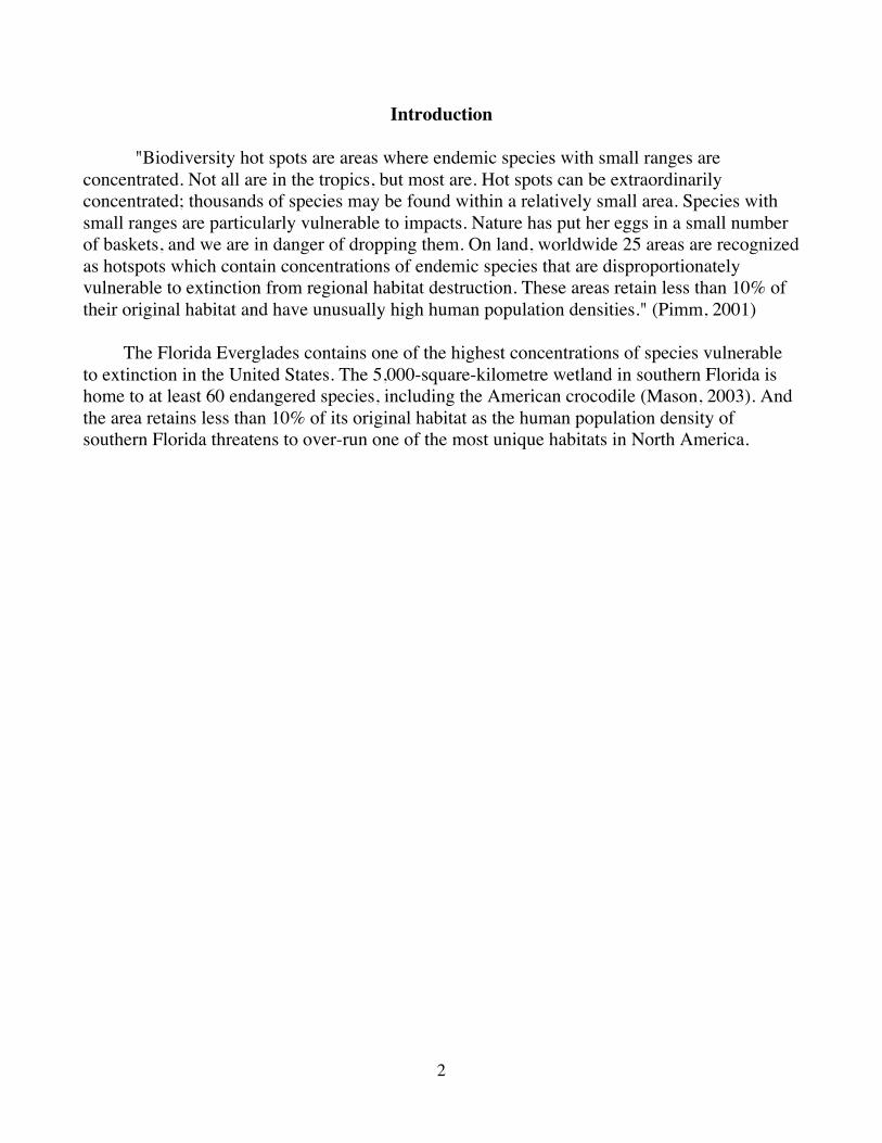
The Florida Everglades in the Afternoon Sun
Nourished by the rain soaked Kissimmee River Basin and stretching south from 700 square mile Lake Okeechobee (left center), the Everglades are a wide slow moving river of marsh and saw grass covering some 4,500 square miles, flowing slowly towards the mangrove estuaries of the Gulf of Mexico (right below center). The Everglades are a unique habitat; there are no other everglades in the world. No other place combines a subtropical climate, a broad, shallow river, and a stunning diversity of plants and animals into such a complex and fragile ecosystem. No other place is so dramatically defined by annual rhythms of drought and flood, fire and sunshine and torrential rain.
(Space Shuttle photograph courtesy of NASA)
4
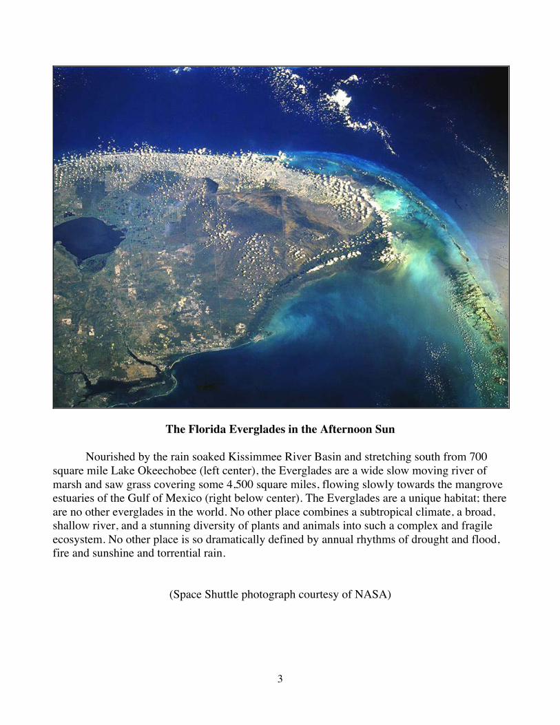
Everglades National Park is the largest remaining subtropical wilderness in the United States. Its abundant wildlife includes rare and endangered species, such as the American crocodile, Florida panther, and West Indian manatee. Alligators, like the one shown above, are an important part of this ecosystem, and are regarded as a “keystone” species of the Everglades. The Florida Everglades ecosystem is also the only place in the world where alligators and crocodiles exist side by side.
5
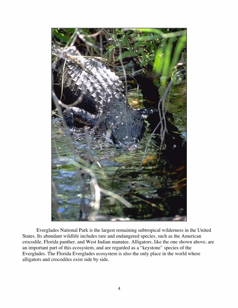
The American crocodile, shown above, was listed as an endangered species in Florida in 1975. It’s numbers had dropped dramatically because of hunting and loss of habitat. Today, the American crocodile's habitat is limited to the southern half of Florida, and has an estimated population of 2,000 up from approximately 200 to 400 two decades ago. They are found in the U.S. in the remaining tidal marshes in the Everglades along Florida Bay and in the Florida Keys. Though the species resemble one another, crocodiles vary greatly from the more than 1 million alligators found in Florida. Crocodile color ranges from olive green to gray compared with the black hue of alligators. Their snouts are narrower, and the bottom and top teeth are visible from the side when the mouth is closed; only the upper teeth are seen on an alligator. Adult crocodiles are larger than some other crocodile species, with some males reaching lengths of 6.1 m (20 ft). Decidedly less aggressive than the infamous Nile and Australian crocodiles, American crocodiles are rarely seen by people.
(Photograph by D. Chalfant)
Web Reference http://en.wikipedia.org/wiki/American_crocodile
6
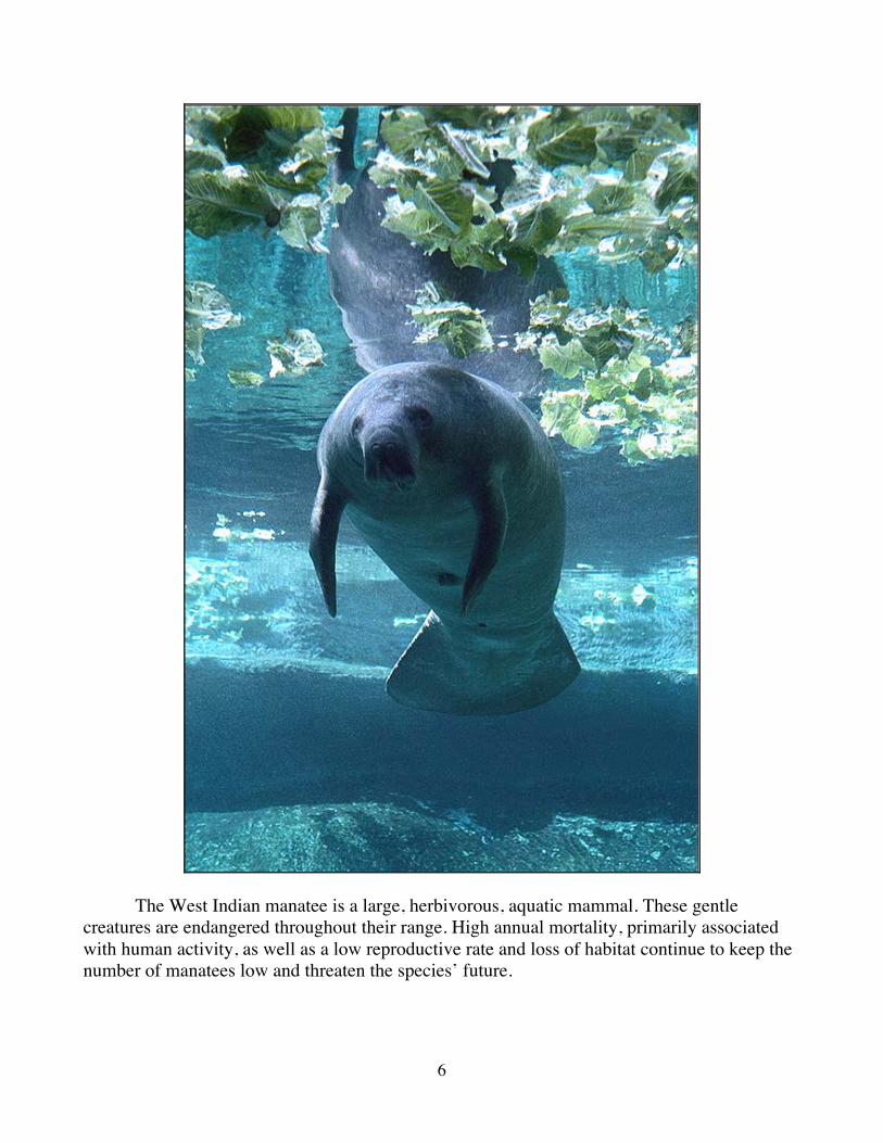
The West Indian manatee is a large, herbivorous, aquatic mammal. These gentle creatures are endangered throughout their range. High annual mortality, primarily associated with human activity, as well as a low reproductive rate and loss of habitat continue to keep the number of manatees low and threaten the species’ future.
7
The manatee population has long been the focus of battles between conservationists and boaters. Boating kills dozens of manatees a year, crushing or gashing the slow-moving mammals as they rise to the surface to breathe. Red tide algae blooms have been another cause of mortality for manatees along Florida's south-central Gulf Coast. The one-cell organism that causes red tide releases a toxin when it dies, sickening manatees. Once the toxin is in the animal, it affects their coordination and causes paralysis (Flewelling, et al., 2005). "Manatees on Florida’s Gulf coast are frequently exposed to brevetoxin, a potent neurotoxin produced by the dinoflagellate Karenia brevis, during red tide events. In 1996, 151 manatees were documented to have died in southwest Florida from brevetoxicosis. This epizootic was particularly detrimental to the manatee population because more adults were killed than any other age class. Other red tide epizootics in 1982, 2002, 2003, and 2005 resulted in the deaths of 37, 34, 96, and (preliminarily) 81 manatees, respectively. There is no clear evidence that these events have been increasing in frequency along Florida’s coast, but certainly the impact on the manatee population has increased over the past two decades. Viewed globally, harmful algal blooms have been increasing over the past 25 years in frequency and in their impacts on the economy, public health, and marine life."
Excerpt from: Final Biological Status Review of the Florida Manatee, 2006. http://research.myfwc.com/features/view_article.asp?id=26364
For more on manatees go to:
http://en.wikipedia.org/wiki/West_Indian_manatee
For more on red tides and water pollution in Florida go to: http://fire.biol.wwu.edu/trent/alles/WaterPollution.pdf
8
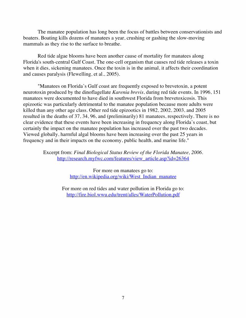
Mangrove Estuaries of Florida Bay
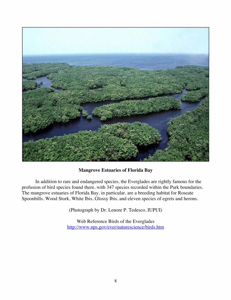
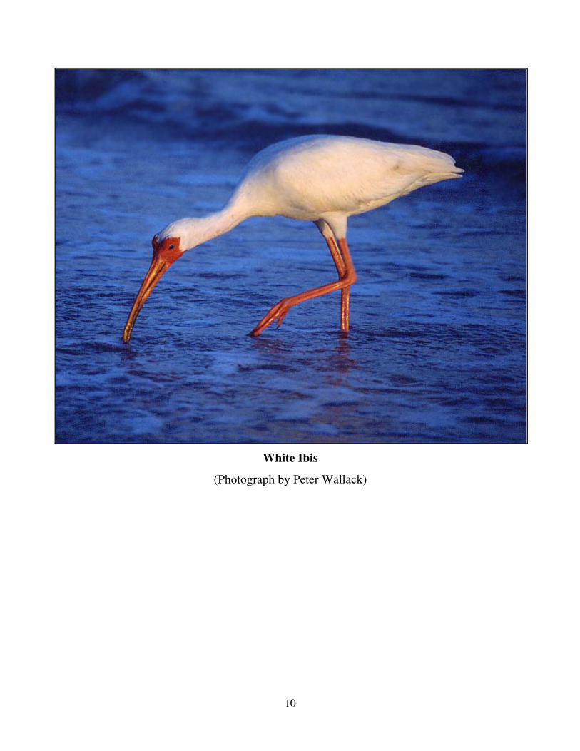
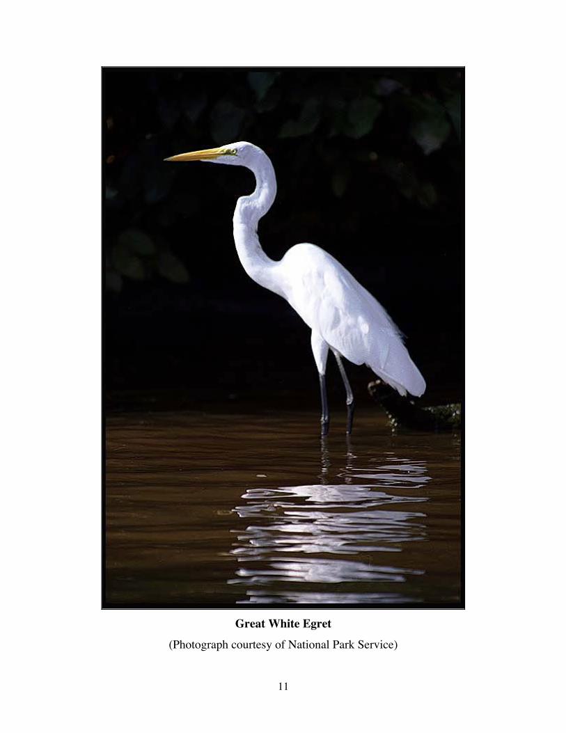
In addition to rare and endangered species, the Everglades are rightly famous for the profusion of bird species found there, with 347 species recorded within the Park boundaries. The mangrove estuaries of Florida Bay, in particular, are a breeding habitat for Roseate Spoonbills, Wood Stork, White Ibis, Glossy Ibis, and eleven species of egrets and herons.
(Photograph by Dr. Lenore P. Tedesco, IUPUI)
Web Reference Birds of the Everglades http://www.nps.gov/ever/naturescience/birds.htm
9
Roseate Spoonbill
(Photograph courtesy of Philip Greenspun http://photo.net/philg/ )
10
White Ibis
(Photograph by Peter Wallack)
11
Great White Egret
(Photograph courtesy of National Park Service)
12
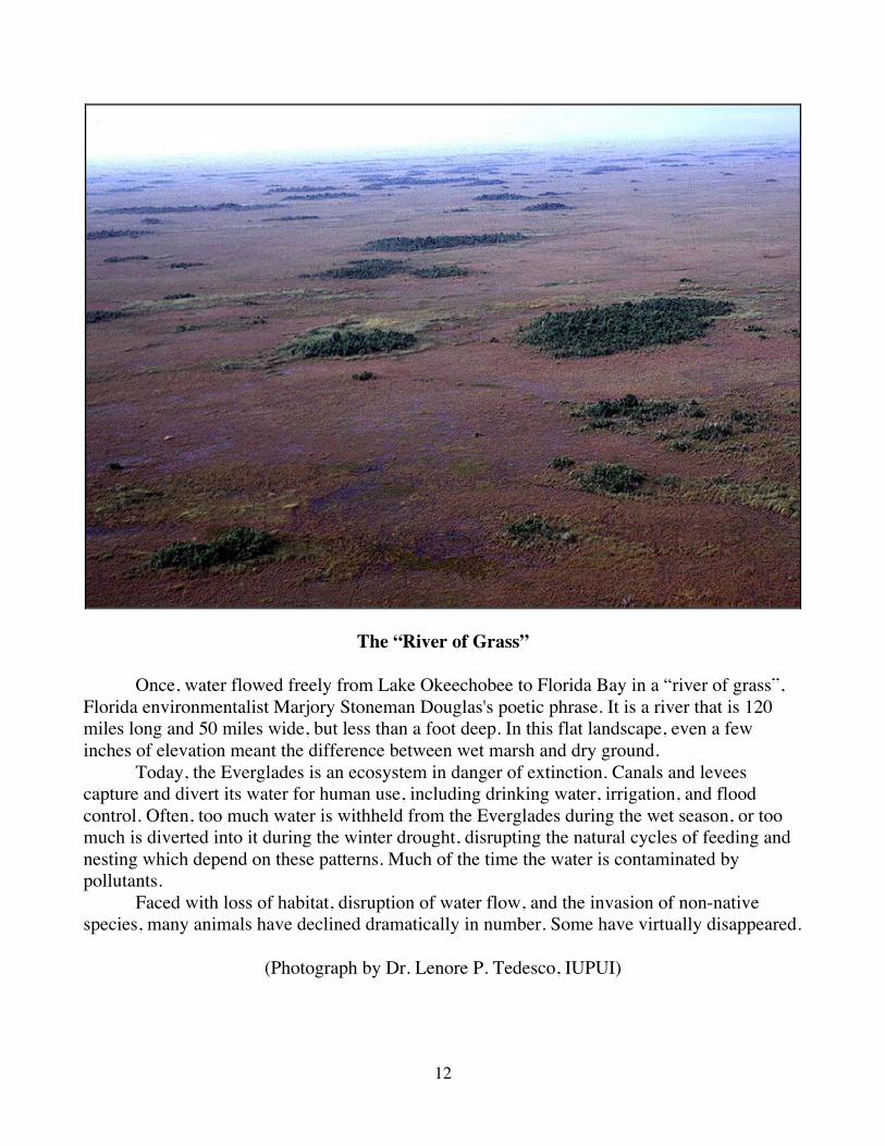
The “River of Grass”
Once, water flowed freely from Lake Okeechobee to Florida Bay in a “river of grass”, Florida environmentalist Marjory Stoneman Douglas's poetic phrase. It is a river that is 120 miles long and 50 miles wide, but less than a foot deep. In this flat landscape, even a few inches of elevation meant the difference between wet marsh and dry ground. Today, the Everglades is an ecosystem in danger of extinction. Canals and levees capture and divert its water for human use, including drinking water, irrigation, and flood control. Often, too much water is withheld from the Everglades during the wet season, or too much is diverted into it during the winter drought, disrupting the natural cycles of feeding and nesting which depend on these patterns. Much of the time the water is contaminated by pollutants. Faced with loss of habitat, disruption of water flow, and the invasion of non-native species, many animals have declined dramatically in number. Some have virtually disappeared.
(Photograph by Dr. Lenore P. Tedesco, IUPUI)
13
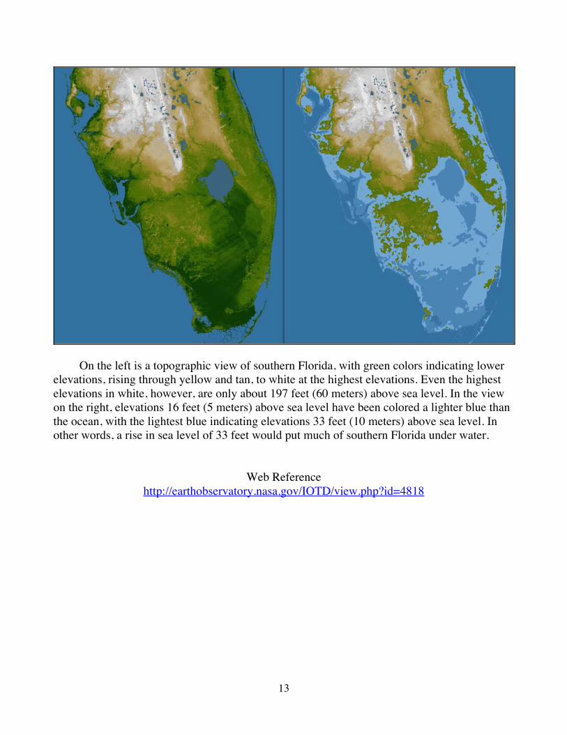
On the left is a topographic view of southern Florida, with green colors indicating lower elevations, rising through yellow and tan, to white at the highest elevations. Even the highest elevations in white, however, are only about 197 feet (60 meters) above sea level. In the view on the right, elevations 16 feet (5 meters) above sea level have been colored a lighter blue than the ocean, with the lightest blue indicating elevations 33 feet (10 meters) above sea level. In other words, a rise in sea level of 33 feet would put much of southern Florida under water.
Web Reference http://earthobservatory.nasa.gov/IOTD/view.php?id=4818
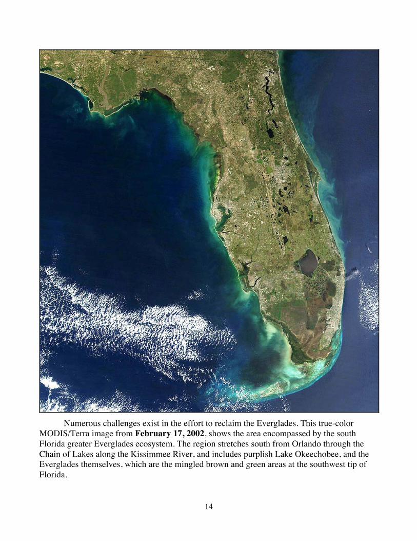
14
Numerous challenges exist in the effort to reclaim the Everglades. This true-color MODIS/Terra image from February 17, 2002, shows the area encompassed by the south Florida greater Everglades ecosystem. The region stretches south from Orlando through the Chain of Lakes along the Kissimmee River, and includes purplish Lake Okeechobee, and the Everglades themselves, which are the mingled brown and green areas at the southwest tip of Florida.
15
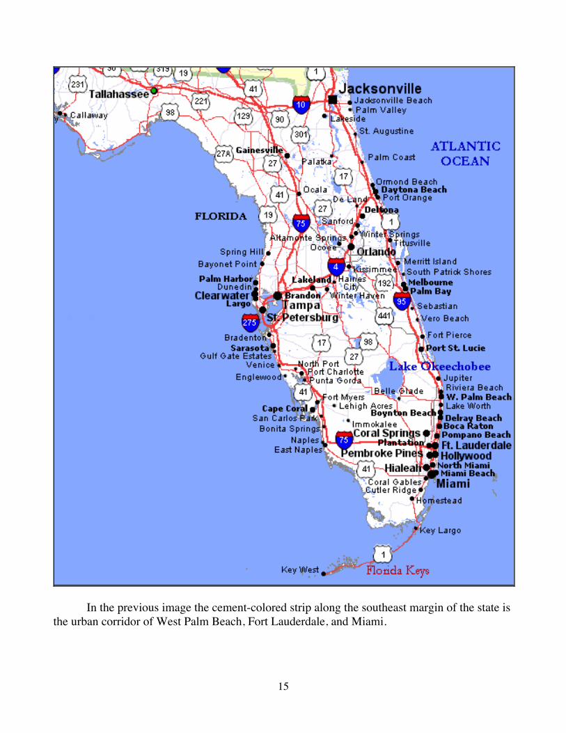
In the previous image the cement-colored strip along the southeast margin of the state is the urban corridor of West Palm Beach, Fort Lauderdale, and Miami.
16
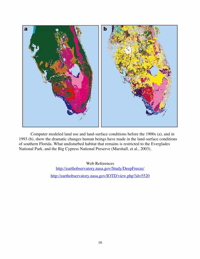
Computer modeled land use and land-surface conditions before the 1900s (a), and in 1993 (b), show the dramatic changes human beings have made in the land-surface conditions of southern Florida. What undisturbed habitat that remains is restricted to the Everglades National Park, and the Big Cypress National Preserve (Marshall, et al., 2003).
Web References http://earthobservatory.nasa.gov/Study/DeepFreeze/
http://earthobservatory.nasa.gov/IOTD/view.php?id=5520
17
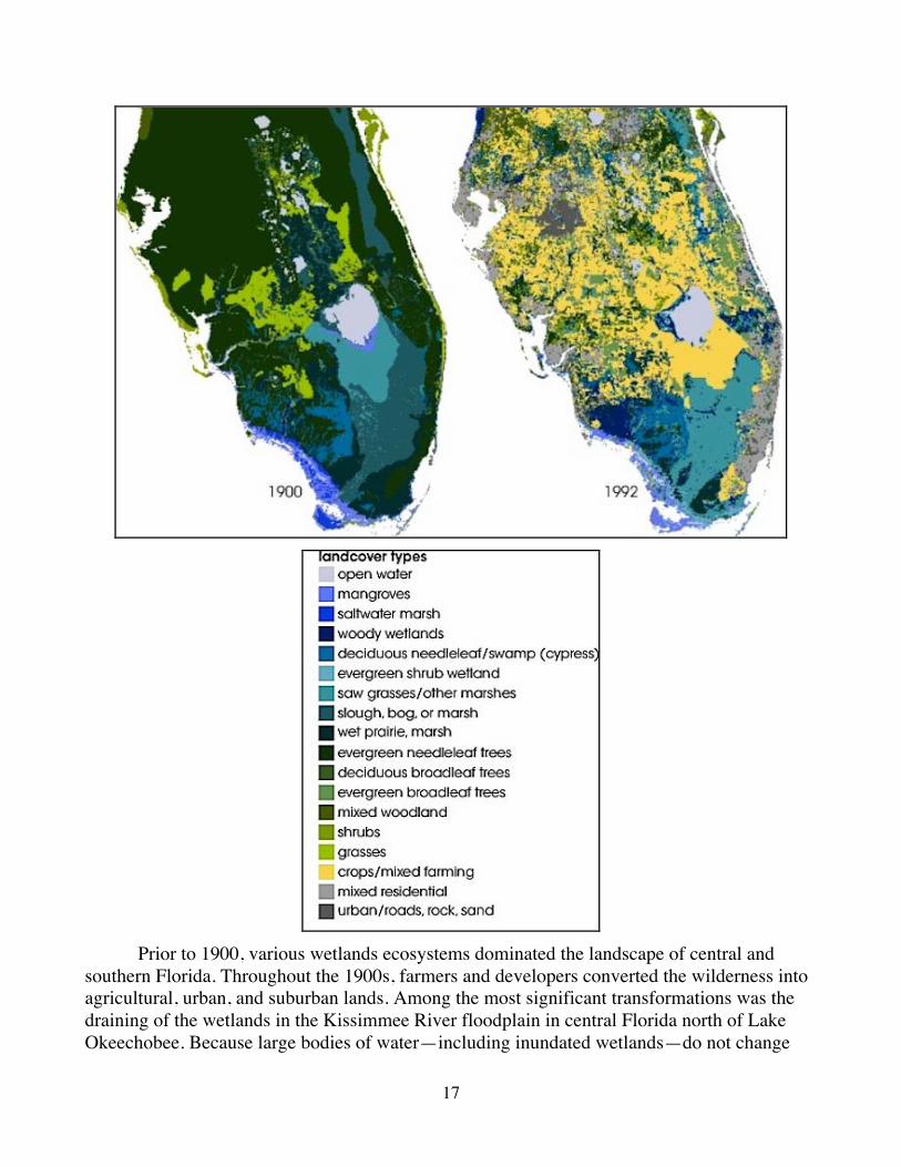
Prior to 1900, various wetlands ecosystems dominated the landscape of central and southern Florida. Throughout the 1900s, farmers and developers converted the wilderness into agricultural, urban, and suburban lands. Among the most significant transformations was the draining of the wetlands in the Kissimmee River floodplain in central Florida north of Lake Okeechobee. Because large bodies of water—including inundated wetlands—do not change
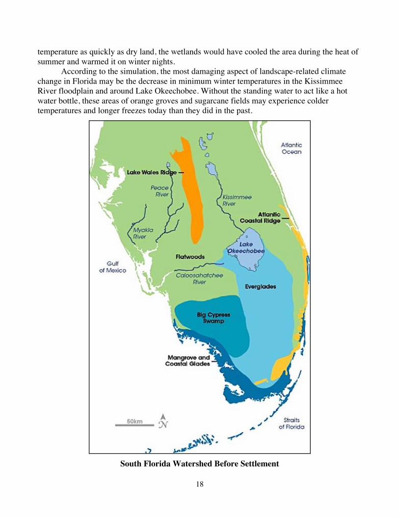
18
temperature as quickly as dry land, the wetlands would have cooled the area during the heat of summer and warmed it on winter nights. According to the simulation, the most damaging aspect of landscape-related climate change in Florida may be the decrease in minimum winter temperatures in the Kissimmee River floodplain and around Lake Okeechobee. Without the standing water to act like a hot water bottle, these areas of orange groves and sugarcane fields may experience colder temperatures and longer freezes today than they did in the past.
South Florida Watershed Before Settlement
19
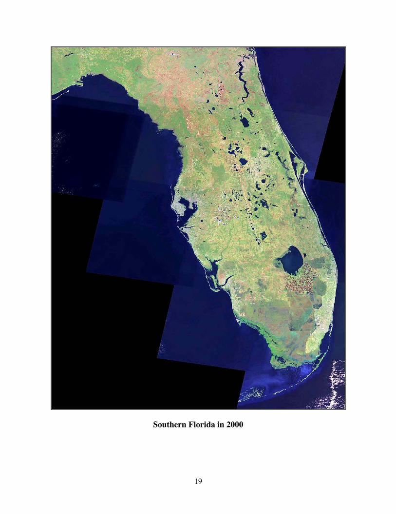
Southern Florida in 2000
20
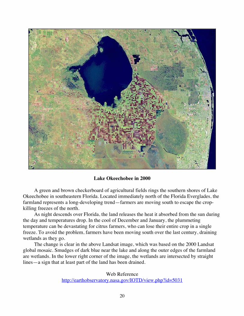
Lake Okeechobee in 2000
A green and brown checkerboard of agricultural fields rings the southern shores of Lake Okeechobee in southeastern Florida. Located immediately north of the Florida Everglades, the farmland represents a long-developing trend—farmers are moving south to escape the crop-killing freezes of the north. As night descends over Florida, the land releases the heat it absorbed from the sun during the day and temperatures drop. In the cool of December and January, the plummeting temperature can be devastating for citrus farmers, who can lose their entire crop in a single freeze. To avoid the problem, farmers have been moving south over the last century, draining wetlands as they go. The change is clear in the above Landsat image, which was based on the 2000 Landsat global mosaic. Smudges of dark blue near the lake and along the outer edges of the farmland are wetlands. In the lower right corner of the image, the wetlands are intersected by straight lines—a sign that at least part of the land has been drained.
Web Reference http://earthobservatory.nasa.gov/IOTD/view.php?id=5031
21
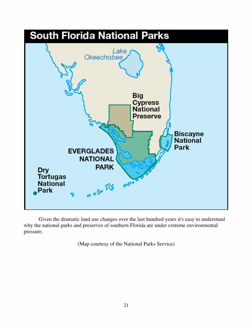
Given the dramatic land use changes over the last hundred years it's easy to understand why the national parks and preserves of southern Florida are under extreme environmental pressure.
(Map courtesy of the National Parks Service)
22
The Comprehensive Everglades Restoration Plan (CERP) The decline of the Everglades, whose problems include salt water intrusion, habitat loss, pollution, agricultural and urban run-off, and staggering reductions in native plants and animals, is the long-term result of a water management strategy implemented in the early 1950s to provide flood protection and freshwater to south Florida through the construction of over a thousand miles of canals and levees. These canals and levees can be seen crisscrossing the Everglades, and while they have served their intended purpose, they also have radically changed the normal flow of water through Florida. Freshwater is being pumped out of underground aquifers faster than rainfall is recharging them, and saltwater from the oceans seeps in to fill the empty spaces. This water seeps into aquifers that are being used to supply the region with drinking and irrigation water, making them unfit for their intended uses. While the canals and levees protect the region from flooding during the rainy season, they also channel vast amounts of fresh water into coastal estuaries, where disturbing the delicate balance of fresh and salt water negatively impacts fish and other biological populations. Among the threatened estuaries are Biscayne Bay, located at the southernmost end of the southeast's urban corridor, and Caloosahatchee estuary, located southwest of Lake Okeechobee on Florida's west coast. In response to these pressing water and other environmental concerns, the federal government joined with state, regional and tribal organizations under the Everglades Restoration Plan to protect water and environmental quality while still meeting the water needs of those who live in the area. The plan was approved by congress in 2000. When completed the Comprehensive Everglades Restoration Plan will capture freshwater destined for the sea and direct it back to the ecosystem to revitalize it. The nation's largest such project, it will cost $8 billion and take more than 20 years to develop.
Web Reference
http://fl.water.usgs.gov/CERP/cerp.html
23
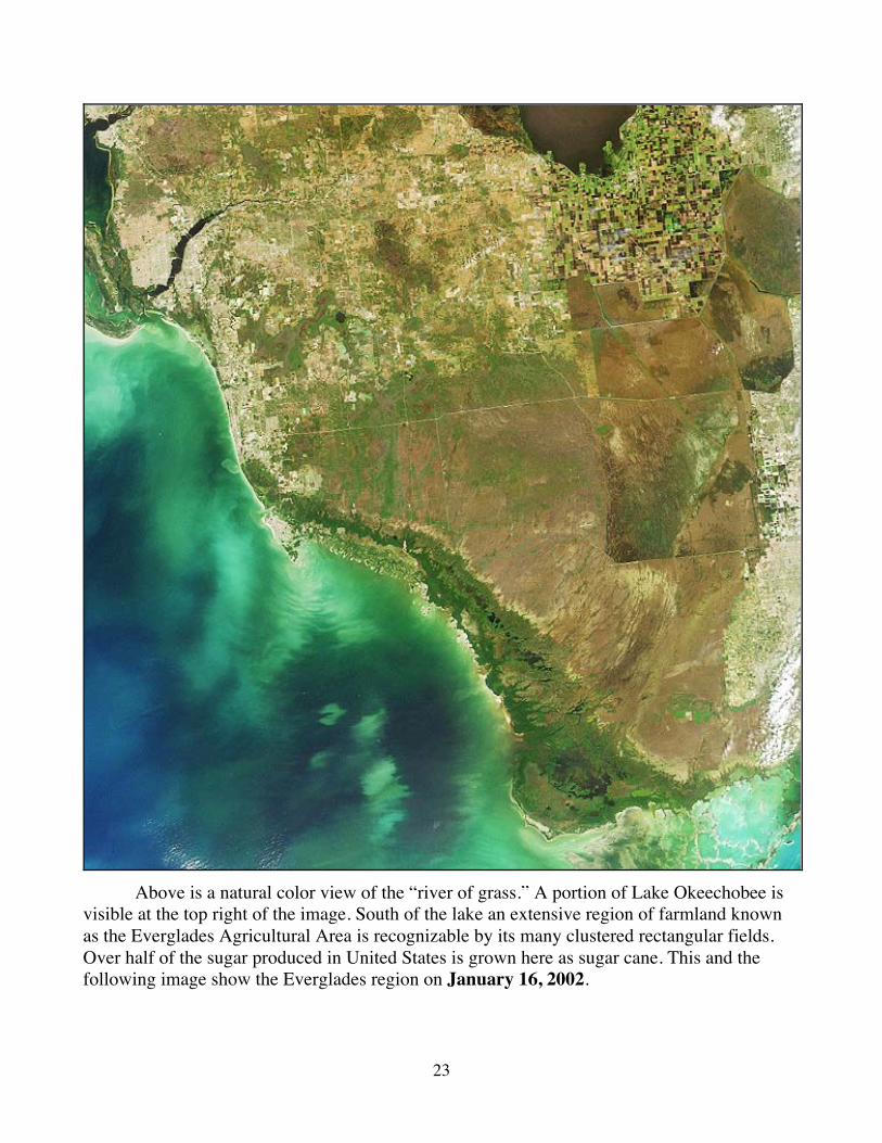
Above is a natural color view of the “river of grass.” A portion of Lake Okeechobee is visible at the top right of the image. South of the lake an extensive region of farmland known as the Everglades Agricultural Area is recognizable by its many clustered rectangular fields. Over half of the sugar produced in United States is grown here as sugar cane. This and the following image show the Everglades region on January 16, 2002.
24
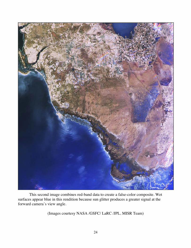
This second image combines red-band data to create a false-color composite. Wet surfaces appear blue in this rendition because sun glitter produces a greater signal at the forward camera’s view angle.
(Images courtesy NASA /GSFC/ LaRC /JPL, MISR Team)
25
What is the status of the Everglades restoration plan (CERP) today?
-----------------------
The following is from the New York Times editorial for April 21, 2003, entitled Everglades in Peril. “The most ambitious environmental rescue operation ever tried in this country— a $7.8 billion plan to restore the Everglades—is suddenly at risk. The reason is that one of the major players in the enterprise, Florida’s politically connected sugar cane industry, wants to postpone into the distant future the deadline for cleaning up the polluted water flowing into the Everglades. And the Florida Legislature is poised to let the industry do it. This could mean serious trouble for an already fragile ecosystem. It would also violate the spirit of the federal-state partnership underlying the project and threaten the revenue stream on which it depends. The project is the result of 15 years of bipartisan negotiation, with costs to be shared equally by the state and federal governments. In essence, it’s a vast replumbing scheme aimed at rerouting one trillion gallons of Florida’s copious rainwater to the Everglades, which desperately needs it. But fancy engineering will mean nothing unless the water itself is clean. The main culprit is phosphorous, which flows from the farms and sugar cane fields north of the Everglades, and which 15 years ago topped out at more than 300 parts per billion—30 times the maximum amount that scientists said the Everglades could handle. After much debate, the growers and other parties agreed to reduce that level to 10 parts per billion by 2006. Great strides have been made. But with the goal in sight, Big Sugar now wants to weaken the standard to a biologically unacceptable 15 parts per billion and delay the compliance deadline 20 years. A bill written by a sugar loyalist named Joe Spratt codifying these wishes is now sailing through Florida’s House.” -----------------------
This is from the journal Nature October 9, 2003 (Mason, 2003).
Judge's sacking rocks Everglades clean-up The Florida Everglades clean-up effort—one of the world's largest and most hotly debated environmental projects—is in trouble this week, after the judge charged with overseeing the scheme was kicked out for alleged political bias. The ousting on 23 September of Judge William Hoeveler of the US District court at Fort Lauderdale is the culmination of six months of bitter wrangling over desirable phosphorous levels in the Everglades. The 5,000-square-kilometre wetland in southern Florida is home to at least 60 endangered species, including the American crocodile.
26
The removal of Hoeveler—largely brought about by sugar growers whose farms north of the Everglades are the source of phosphorus flowing into the swamp—has alarmed some supporters of the $8-billion clean-up effort. "The scientific system has been undercut," claims ecologist Curt Richardson of Duke University in Durham, North Carolina. In its natural state, the Everglades supported a unique ecosystem made up of plants and animals that thrive in nutrient-poor conditions. Adjusting the nutrient balance can cause radical changes to the ecosystem, including the invasion of cattails, which overrun native saw-grass and choke the flow of water through the region. Ecologists want phosphorus levels to be kept below 10 parts per billion (p.p.b.), but levels are as high as 80 p.p.b. in some water flowing into the Everglades. As a result, a 'phosphorous front' has been gradually encroaching on the wetlands at around a kilometer per decade, says ecologist Evelyn Gaiser of Florida International University in Miami. "Every day counts," says Dan Childers, who studies the Everglades ecosystem at Florida International University in Miami. "As we wait, more and more of the Everglades will be impacted." When the restoration project began in 1992, Florida's state government agreed to bring the levels of phosphorous in water entering the Everglades down to 10 p.p.b. by 2006. Since then, sugar farmers—who avoid using phosphorus-based fertilizers, but whose water-management practices cause the release of the chemical—have greatly reduced the amount of phosphorus leaving their farms. But the 2006 deadline is looming, and most experts agree that it is unlikely to be met. So in May, a law supported by the farmers to extend the deadline until 2016 was passed by the Florida legislature and signed by state governor Jeb Bush, brother of US president George W. Bush. Hoeveler—whose court has overseen the restoration project from the outset—was quoted in the Florida press as saying that he was "deeply troubled by the content of the bill", and that Governor Bush had allowed the project to "fall into the hands of those who don't like the Everglades". Under a federal code of ethics that prohibits judges from appearing biased or commenting publicly on the merits of a pending case, the US Sugar Corporation of Clewiston, Florida, successfully filed for the judge's removal. "The principle behind the original settlement was that no contribution to pollution was acceptable," says Neal McAliley, a former US Justice Department attorney on the Everglades case. "Implicit in the new law is the idea that some pollution is acceptable. In my view that represents a shift in thinking at a policy level."
27
The changes leave ecologists worried that delays could now undermine the entire restoration. But Gary Goforth, an environmental engineer at the South Florida Water Management District, the state agency that is implementing the project, says that most aspects of it are still ahead of schedule. "It's not a date that matters," says Judy Sanchez, director of corporate communications at US Sugar. "It's progress that matters. And progress has been extraordinary." Environmentalists remain unconvinced, however. "The sugar industry's interest is and always has been delay," says Thom Rumberger, chair of the Everglades Trust.
"This is the ultimate delay."
----------------------- For a Congressional Research Service report to congress January 13, 2004, on the Everglades
restoration plan go to:
http://digital.library.unt.edu/govdocs/crs//data/2004/upl-meta-crs-7374/RL32131_2004Jan13.pdf?PHPSESSID=728b54aebcd3141eaa430de4ce75a00f
28
Florida Bay
Florida Bay is a large, shallow marine ecosystem immediately south of the Everglades. It may be thought of as the marine extension of the Florida peninsula, beginning where the gently sloping land surface of the southern Everglades descends below sea level. It is bounded on the east and south by the Florida Keys and on the west by the Gulf of Mexico. It covers about 850 square miles (2200 square kilometers), mostly within Everglades National Park and the Florida Keys National Marine Sanctuary. It is dotted with several hundred small, mangrove-rimmed islands. The average depth of Florida Bay is less than one meter and it is generally well mixed vertically. Shallow carbonate banks divide it into semi-isolated basins that restrict circulation, especially in the central and eastern zones. Its salinity is a function of direct rainfall and evaporation, inflow of Gulf of Mexico and Florida shelf water across its open western boundary, inflow of fresh water into the northeastern Bay by sheetflow and creeks fed by Taylor Slough, outflow through the Keys to the southeast, and saline groundwater discharge. Cells of hypersaline water are common during the dry season. For at least several decades until the late 1980s, clear water and dense sea grass (largely Thalassia testudinum, commonly known as turtle grass) meadows characterized most of Florida Bay. However, beginning around 1987, the turtle grass beds began dying in the central and western Bay, for reasons that remain uncertain and controversial. Water in the central and western Bay, which had been clear during recent decades, has become turbid because of phytoplankton blooms (which can also cause fish kills by consuming dissolved oxygen and releasing toxins) and sediment resuspension. A decline in fishing success for some species that use the Bay as a juvenile nursery habitat also was reported during that period. Florida Bay is linked intimately to the Everglades. Some of the water draining from the Everglades through Taylor Slough/Craighead Basin flows directly into Florida Bay, supplying it with freshwater runoff. Additional water from the Everglades appears to reach the Bay indirectly after it is discharged from Shark River Slough to the northwest and mixes with inshore shelf water. The Everglades have been altered greatly during the past century, including the construction of canals, levees, pumps and control structures, and conversion of land to cities and farms. This has led to water quality degradation, nutrient enrichment, loss of wetlands, and landscape fragmentation in various parts of the Everglades (CRGEE, et al., 2002).
Web Reference http://www.nap.edu/nap-cgi/chaphits.cgi?term=phytoplankton+blooms&isbn=0309084911
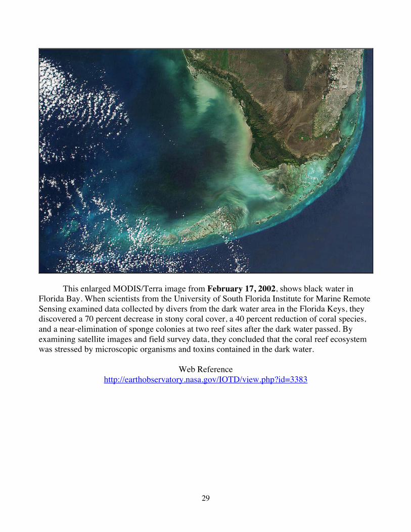
29
This enlarged MODIS/Terra image from February 17, 2002, shows black water in Florida Bay. When scientists from the University of South Florida Institute for Marine Remote Sensing examined data collected by divers from the dark water area in the Florida Keys, they discovered a 70 percent decrease in stony coral cover, a 40 percent reduction of coral species, and a near-elimination of sponge colonies at two reef sites after the dark water passed. By examining satellite images and field survey data, they concluded that the coral reef ecosystem was stressed by microscopic organisms and toxins contained in the dark water.
Web Reference http://earthobservatory.nasa.gov/IOTD/view.php?id=3383
30
Remote Sensing and Gelbstoff One of the initial challenges in ocean color remote sensing was determining the difference between phytoplankton chlorophyll and dissolved organic matter, called gelbstoff. A high concentration of gelbstoff affects how much sunlight penetrates the water, which impacts the growth of phytoplankton populations, and can present a false signal in the satellite’s color measurements of chlorophyll. “If you’ve ever raked leaves and put them in a bucket of water, you see the water turn yellow over time — the yellow color is gelbstoff,” said Ken Carder, professor of ocean optics at the University of South Florida. Carder developed an algorithm, called chlor-a 3, that distinguishes between gelbstoff and chlorophyll by measuring the chlorophyll a molecules. “CZCS didn’t have the ability to separate gelbstoff from phytoplankton. High concentrations of gelbstoff looked just like chlorophyll,” Carder said. “So CZCS and SeaWiFS historically overestimated the amount of chlorophyll, and chlor-a 3 now adjusts for that.” The first remote sensing instrument designed to survey ocean color, the Coastal Zone Color Scanner (CZCS), operated from 1978 to 1986. The Sea-viewing Wide Field of View Sensor (SeaWiFS) was launched in 1997 and is still operational. Using data from the chlorophyll bands on CZCS and SeaWiFS, researchers could track the size and movement of phytoplankton populations, but they could not determine phytoplankton health or efficiency. What scientists needed was chlor-a 3 fluorescence data, which is now available from the Moderate Resolution Imaging Spectroradiometer (MODIS), launched in 1999.
Web Reference http://earthobservatory.nasa.gov/Study/glowingalgae/
31
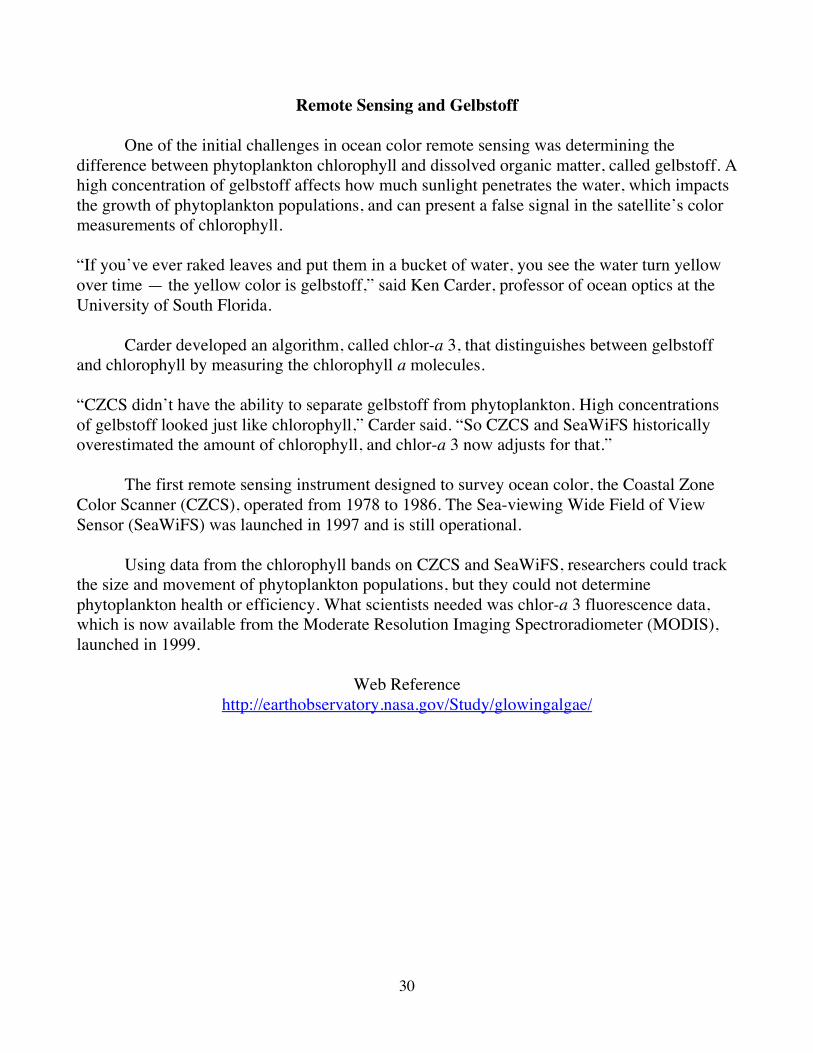
The University of South Florida study has demonstrated that satellite images can track water quality in Florida Bay. This MODIS/Terra image acquired February 3, 2003, show dark swirls of algal blooms and sediments flowing from the north, and east from the mangrove estuaries of the Everglades into Florida Bay. Recent evidence points to the black water being associated with large algal blooms fed by increased nutrient input from agricultural and urban run-off (CRGEE, et al., 2002).
32
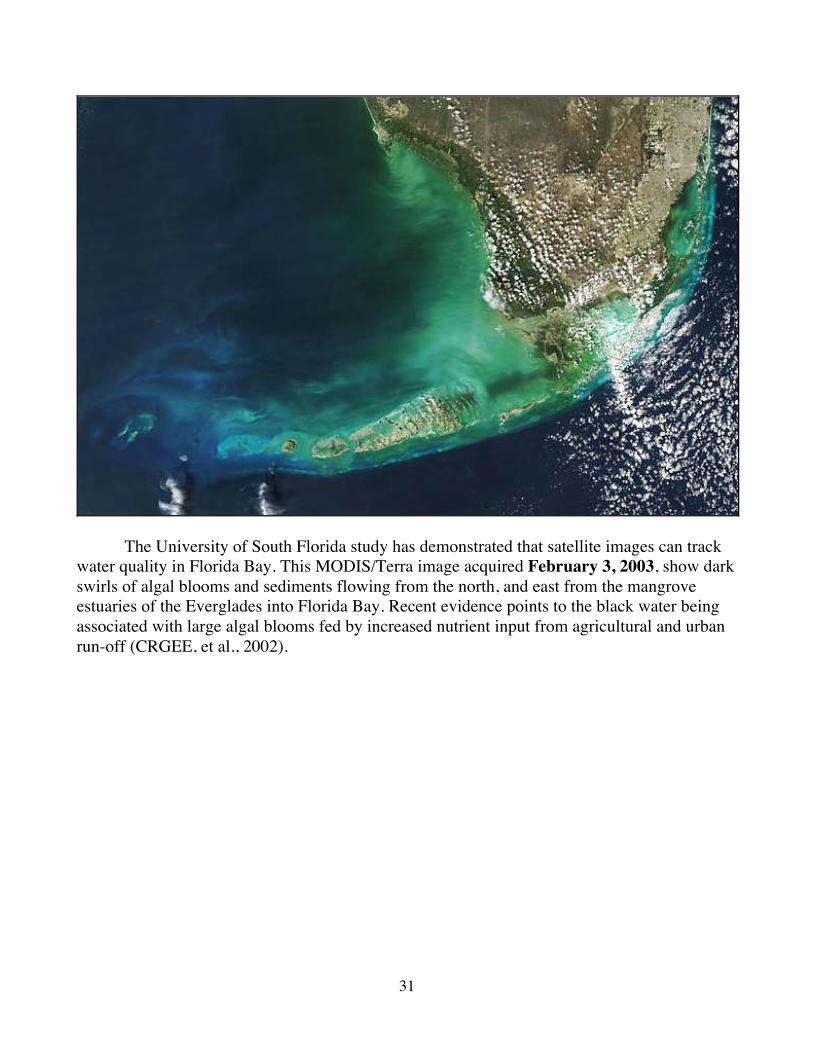
Hurricanes and heavy rains in 2004, flushed above normal levels of nutrients mixed with sediment into the sea. This true color MODIS/Terra image from November 21, 2004, shows a dark plume flowing into Florida Bay from the north. Studies of satellite fluorescence data acquired the same day confirmed that the plume consisted of a red tide of chlorophyll containing algal blooms.
Web References http://earthobservatory.nasa.gov/IOTD/view.php?id=5071
http://fire.biol.wwu.edu/trent/alles/WaterPollution.pdf
33
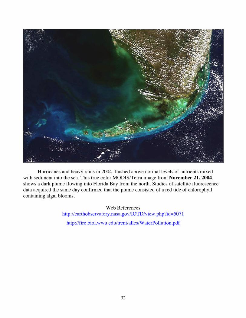
October 27, 2005, MODIS/Aqua image of re-suspended sediments in Florida Bay.
In 2005, three hurricanes passed near or directly over Florida Bay and the Everglades, hurricanes Katrina, Rita, and Wilma. With each passing storm bottom sediments were churned to the surface of the shallow waters by the high winds, later only to settle to the bottom again. Added to this was flooding in the entire drainage basin that flows from Lake Okeechobee, through the Everglades, south to into Florida Bay. In the image above light blue plumes of sediments flow into the Gulf of Mexico. The darker plumes flowing from the north and the Everglades are contaminated runoff water.
34
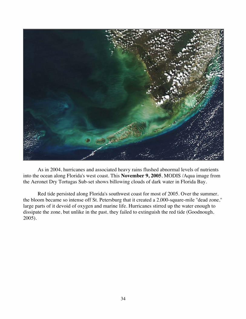
As in 2004, hurricanes and associated heavy rains flushed abnormal levels of nutrients into the ocean along Florida's west coast. This November 9, 2005, MODIS /Aqua image from the Aeronet Dry Tortugas Sub-set shows billowing clouds of dark water in Florida Bay. Red tide persisted along Florida's southwest coast for most of 2005. Over the summer, the bloom became so intense off St. Petersburg that it created a 2,000-square-mile ''dead zone,'' large parts of it devoid of oxygen and marine life. Hurricanes stirred up the water enough to dissipate the zone, but unlike in the past, they failed to extinguish the red tide (Goodnough, 2005).
35
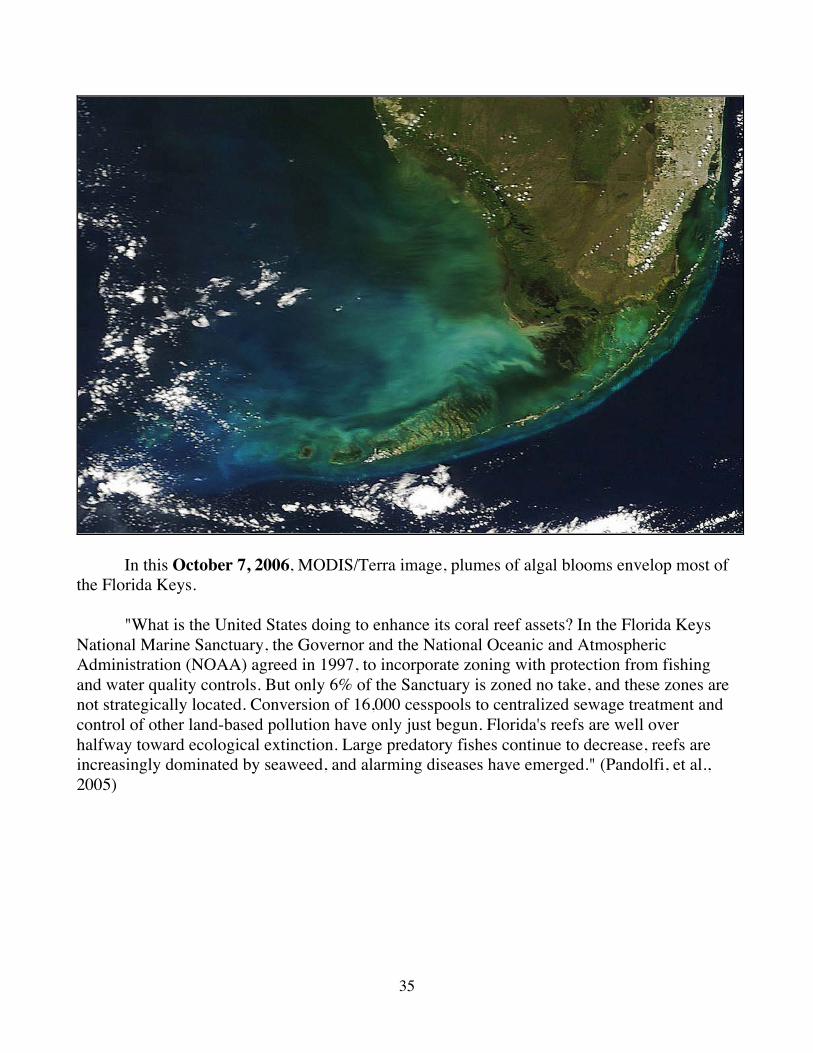
In this October 7, 2006, MODIS/Terra image, plumes of algal blooms envelop most of the Florida Keys. "What is the United States doing to enhance its coral reef assets? In the Florida Keys National Marine Sanctuary, the Governor and the National Oceanic and Atmospheric Administration (NOAA) agreed in 1997, to incorporate zoning with protection from fishing and water quality controls. But only 6% of the Sanctuary is zoned no take, and these zones are not strategically located. Conversion of 16,000 cesspools to centralized sewage treatment and control of other land-based pollution have only just begun. Florida's reefs are well over halfway toward ecological extinction. Large predatory fishes continue to decrease, reefs are increasingly dominated by seaweed, and alarming diseases have emerged." (Pandolfi, et al., 2005)
36
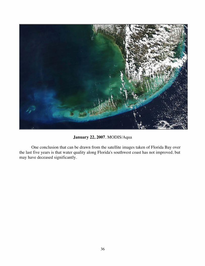
January 22, 2007, MODIS/Aqua
One conclusion that can be drawn from the satellite images taken of Florida Bay over the last five years is that water quality along Florida's southwest coast has not improved, but may have deceased significantly.
37
References
CRGEE, WSTB, & NRC (2002). Florida Bay Research Programs and Their Relation to the Comprehensive Everglades Restoration Plan. Washington D. C.: National Academy Press. Flewelling, L. J., et al. (2005). Red tides and marine mammal mortalities. Nature, 435 (June 9), 755-756. Goodnough, A. (2005, Oct 8). Persistent Red Tide Takes Toll on Florida Sea Life and Tourism. The New York Times, National Desk. Marshall, C. H., Pielke Sr, R. A., and Steyaert, L. T. (2003). Crop freezes and land-use change in Florida. Nature 426(Nov 6):29-30. Mason, B. (2003). Judge's sacking rocks Everglades clean-up. Nature 425(Oct 9), 551. Pandolfi, J. M., et al. (2005). Are U.S. Coral Reefs on the Slippery Slope to Slime? Science, 307(March 18), 1725-1726. Pimm, S. L. (2001). The World According to Pimm. New York: McGraw-Hill.
-----------------------
For further information on related topics go to:
Alles Biodiversity Lecture http://fire.biol.wwu.edu/trent/alles/Biodiversity.pdf
Global Ecology and Remote Sensing
http://fire.biol.wwu.edu/trent/alles/GlobalEcologyindex.html
Alles Biology Home Page
http://fire.biol.wwu.edu/trent/alles/index.html