Embed Size (px)
Citation preview
Environment and Natural Resource Use 67
Biodiversity
The Convention on Biological Diversity of1992 defines biological diversity, orbiodiversity, as the variability among livingorganisms from all sources including, among
others, terrestrial, marine, and other aquaticecosystems and the ecological complexes of whichthey are part; the term includes diversity withspecies, between species, and of ecosystems.
Maintaining the biodiversity of plants andanimals, which entails keeping enough habitat fortheir sustained existence, is important: we dependon many animals and plants for our own existence,not only as food but also as sources of enzymes,genes, chemicals, resins, and fibers that we canexploit to cure disease, provide substance, and createeconomic wealth. If we are to continue to enjoy theseand other benefits—such as aesthetic andrecreational—we must also conserve the ecosystems,that is, the animals and plants and the habitats onwhich they depend.
The subregion has a rich biological diversity. Itsvaried land forms and climate have given rise tounique land species, including many rare animalsthat have only been discovered recently. The MekongRiver system holds 1,400–1,800 species of fish;freshwater fisheries catches in the lower Mekong areestimated to be more than 3 million tons a year. Thesefish are the protein staple for most of the 55 millionpeople who live within the basin. The forestecosystems are composed of a rich and variedassemblage of plants and animals. These range fromwet, evergreen, high and deciduous forests to swamp,mangrove, and dry coastal forests. Theirinnumerable plant species represent a rich mosaicof biological diversity and provide a vital habitat foranimal life. They are home to elephants, tigers,primates, and other large mammals. And theysupport an abundance of insects, amphibians,reptiles, and birds.
Biodiversitydefined
Biodiversity is of three general
kinds: habitat diversity, species
diversity, and genetic diversity.
Each depends on the health of
the other two.
•Habitat diversity refers to
the variety of places where life
exists—coral reefs, old-growth
tropical forests, grasslands,
coastal wetlands, and many
others. As the habitat
disappears, many of the species
it harbors also disappear.
However, as has happened in
the old-growth forests and
coastal wetlands throughout the
Greater Mekong Subregion, a
habitat often does not disappear
completely but dwindles to
scattered patches.
•Species diversity is what
most people commonly
understand as biodiversity. The
species is the basic
classification of living things
that share common
characteristics. The earth has
about 1.5 million named and
many more unnamed species.
All in all, probably about 5–15
million species exist.
•Genetic diversity is the
varied mix of genes within
species that allows plant and
animal populations to adapt to
changes in their environment.
Genetic homogeneity, which
occurs when a species’—be it
elephant, tiger, or dolphin—
population size becomes small,
makes the species far less
adaptable, and less likely to
survive.
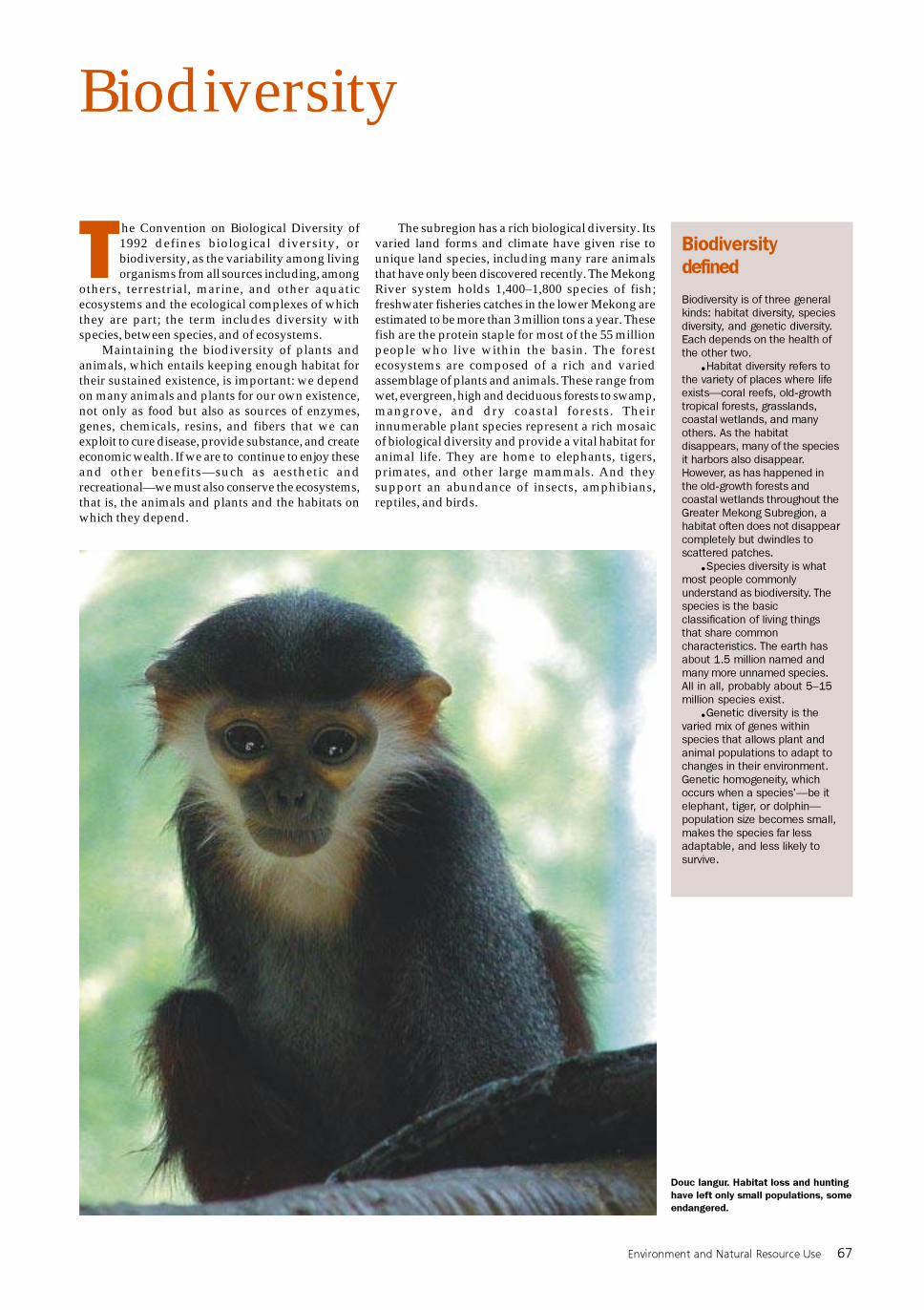
Douc langur. Habitat loss and hunting
have left only small populations, some
endangered.
68 Greater Mekong Subregion Atlas of the Environment
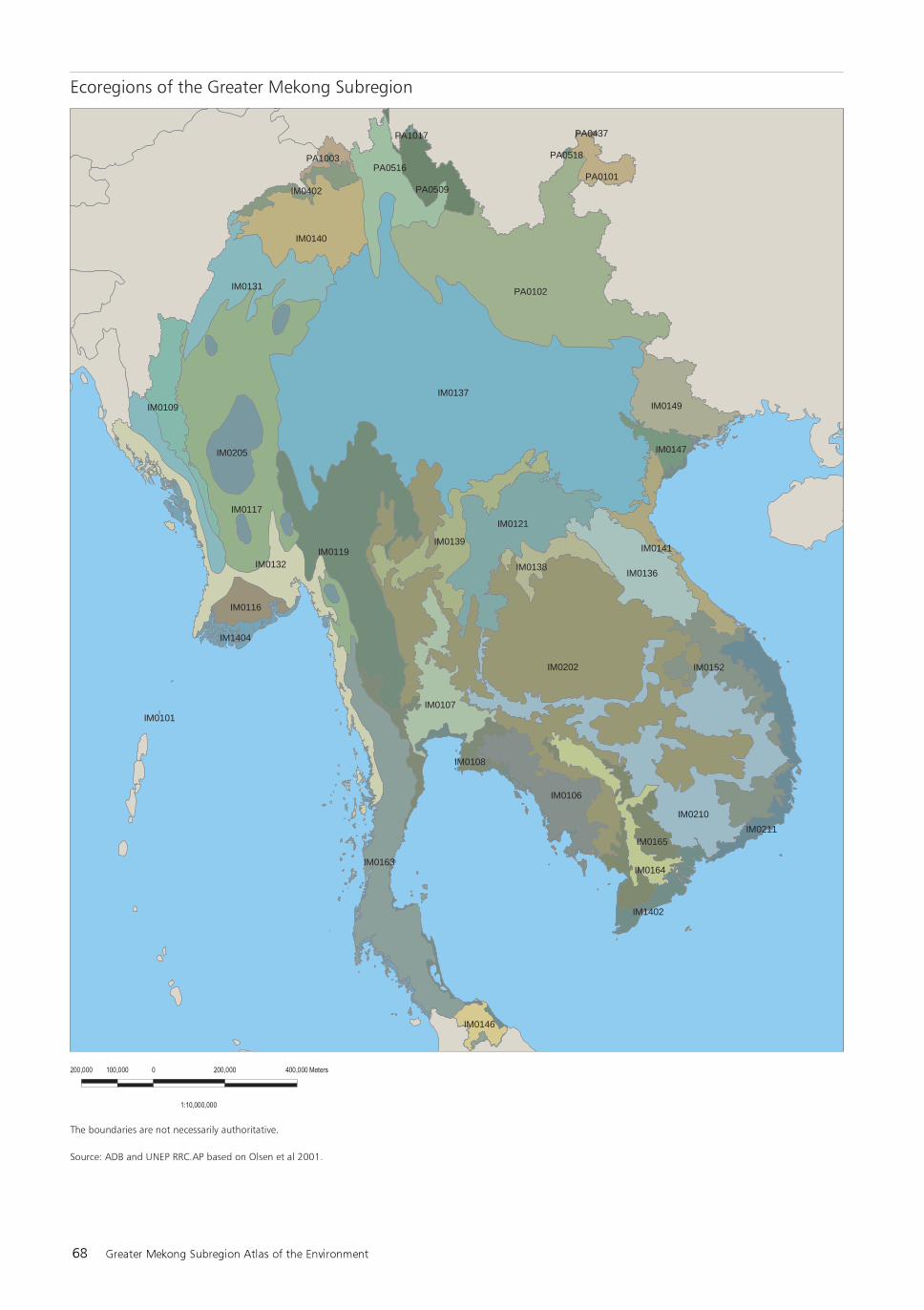
IM0137
IM0202
PA0102
IM0117
IM0210
IM0119
IM0163
IM0121
IM0140
IM0131
IM0132IM0136
IM0139
IM0106
IM0149
IM0107
PA0516
IM0211
IM0109
IM0152
IM0205
IM0141
PA0509
IM0138
IM0164
IM0116
PA0101
IM0165
IM0402
IM0147
IM1402
IM0146
IM0108
IM1404
PA1003 PA0518
PA1017 PA0437
IM0101
Environment and Natural Resource Use 69
An Ecological View
The surface of our planet is composed ofecosystems—areas of land or bodies of water, or acombination of both, and the complex webs of lifethey support. The subregion is made up of manymontane, forest, river, wetland, and marineecosystems.
The concept of ecoregions—natural ecologicalcommunities with shared species, dynamics, andenvironmental conditions—offers a useful way ofunderstanding the biodiversity of the ecosystems ofthe subregion and planning for their protection. Torepresent the original distribution of plants andanimals on earth, the World Wide Fund for Nature(WWF) has divided the entire planet into 867terrestrial ecoregions, of which 40 are in thesubregion.
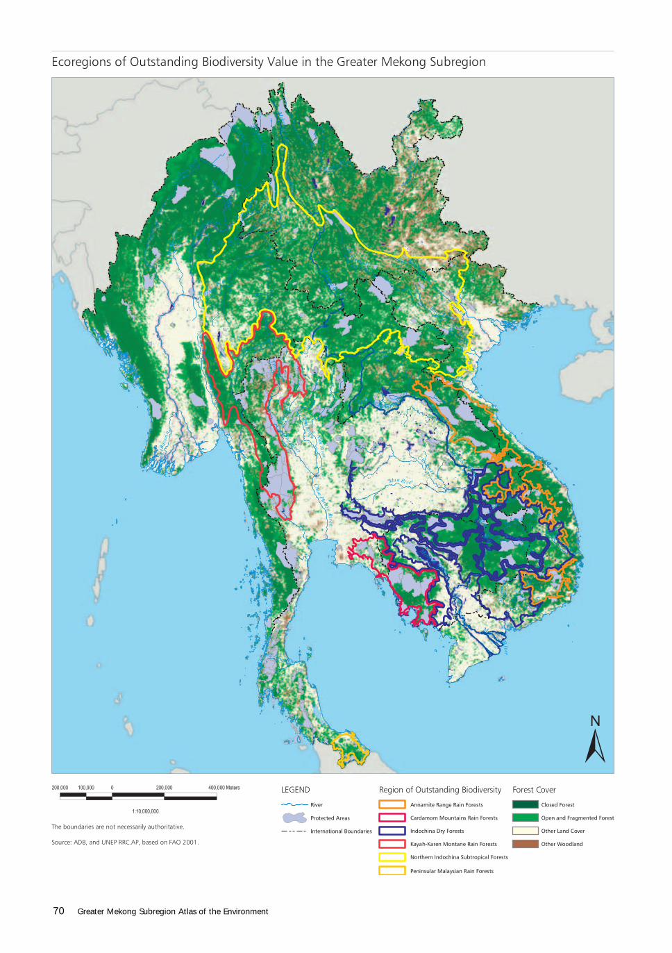
In its Global 200 project, WWF selectedapproximately 200 ecoregions that are outstandingexamples of biodiversity (see Box below). Sixterrestrial ecoregions fully within the subregion arein the Global 200 list: (i) Northern IndochinaSubtropical Moist Forests, (ii) Annamite Range RainForests, (iii) Cardamom Mountains Rain Forests,(iv) Indochina Dry Forests, (v) Peninsular MalaysianLowland and Montane Forests, and (vi) Kayah-Karen Montane Rain Forests. A seventh WWF-selected ecoregion, Eastern Himalayan Broadleafand Conifer Forests, overlaps with the northwesterncorner of Myanmar.
The 6 outstanding ecoregions are described andillustrated in the following pages. Images from all40 ecoregions of the subregion are presented onp. 135–174.
Selecting the Global 200Ecoregions
The Global 200 ecoregions are the results of
regional analyses of biodiversity across the
continents and oceans of the world, completed in
collaboration with hundreds of regional experts
worldwide and by conducting extensive literature
reviews.
The Global 200 ecoregions were chosen from
outstanding examples of each terrestrial,
freshwater, and marine major habitat type.
Ecoregions that represent the most distinctive
examples of biodiversity for a given major habitat
type were chosen, based on the following
parameters:
•species richness;
•endemism;
•higher taxonomic uniqueness (e.g.,
unique genera or families, relict species
or communities, primitive lineages);
•extraordinary ecological or evolutionary
phenomena (e.g., extraordinary adaptive
radiations, intact large vertebrate assem-
blages, migrations of large vertebrates);
and
•global rarity of the major habitat type.
Only the biodiversity values of ecoregions
sharing the same major habitat type were com-
pared because the relative magnitude of param-
eters such as richness and endemism varies widely
among them.
70 Greater Mekong Subregion Atlas of the Environment
p70.p65 3/1/04, 2:15 PM70
Environment and Natural Resource Use 71
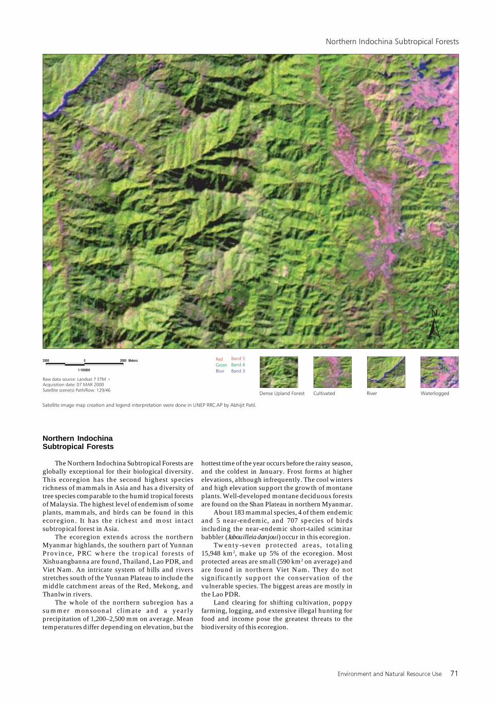
Northern IndochinaSubtropical Forests
The Northern Indochina Subtropical Forests areglobally exceptional for their biological diversity.This ecoregion has the second highest speciesrichness of mammals in Asia and has a diversity oftree species comparable to the humid tropical forestsof Malaysia. The highest level of endemism of someplants, mammals, and birds can be found in thisecoregion. It has the richest and most intactsubtropical forest in Asia.
The ecoregion extends across the northernMyanmar highlands, the southern part of YunnanProvince, PRC where the tropical forests ofXishuangbanna are found, Thailand, Lao PDR, andViet Nam. An intricate system of hills and riversstretches south of the Yunnan Plateau to include themiddle catchment areas of the Red, Mekong, andThanlwin rivers.
The whole of the northern subregion has asummer monsoonal climate and a yearlyprecipitation of 1,200–2,500 mm on average. Meantemperatures differ depending on elevation, but the
hottest time of the year occurs before the rainy season,and the coldest in January. Frost forms at higherelevations, although infrequently. The cool wintersand high elevation support the growth of montaneplants. Well-developed montane deciduous forestsare found on the Shan Plateau in northern Myanmar.
About 183 mammal species, 4 of them endemicand 5 near-endemic, and 707 species of birdsincluding the near-endemic short-tailed scimitarbabbler (Jabouilleia danjoui) occur in this ecoregion.
Twenty-seven protected areas, totaling15,948 km2, make up 5% of the ecoregion. Mostprotected areas are small (590 km2 on average) andare found in northern Viet Nam. They do notsignificantly support the conservation of thevulnerable species. The biggest areas are mostly inthe Lao PDR.
Land clearing for shifting cultivation, poppyfarming, logging, and extensive illegal hunting forfood and income pose the greatest threats to thebiodiversity of this ecoregion.
72 Greater Mekong Subregion Atlas of the Environment
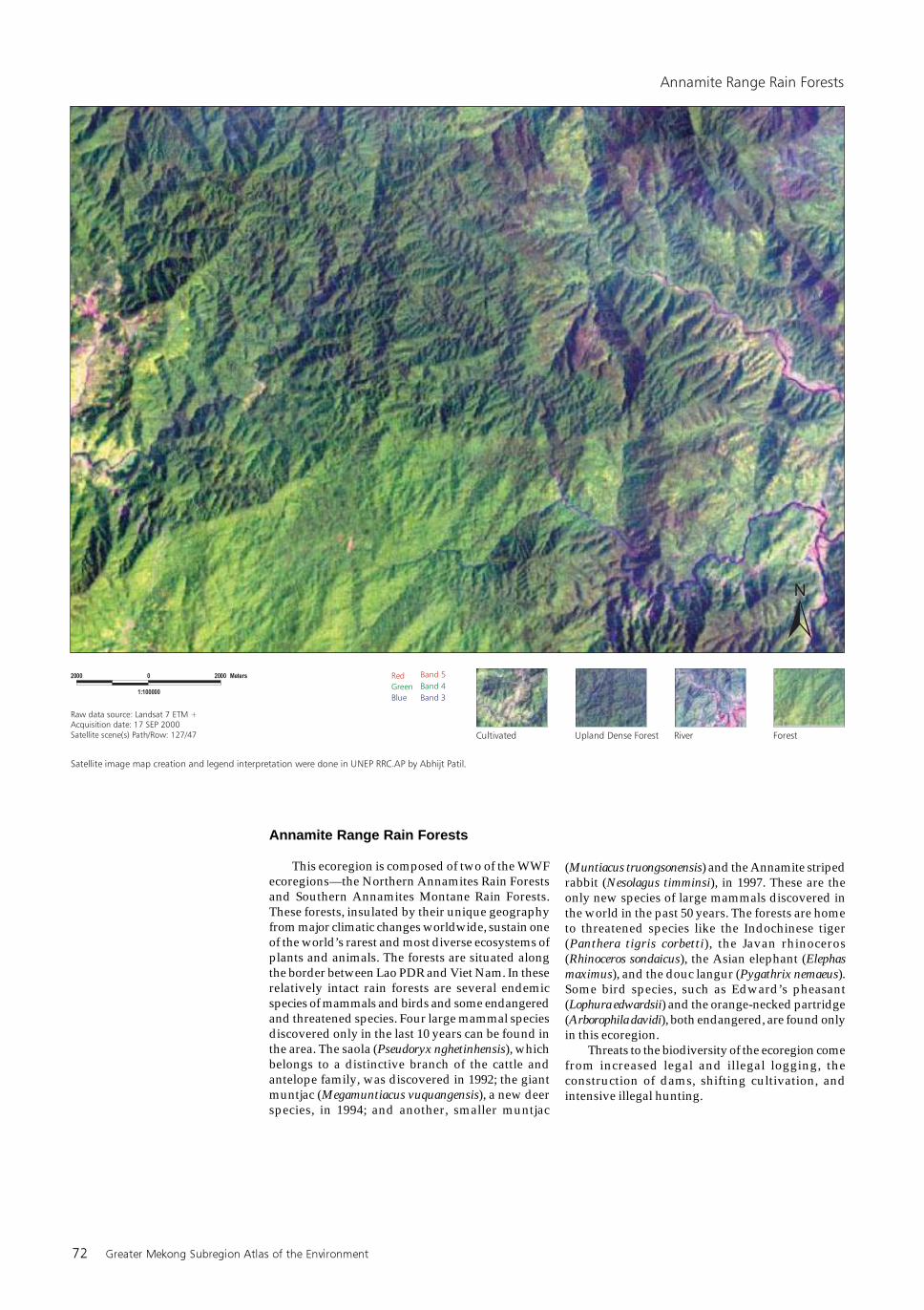
Annamite Range Rain Forests
This ecoregion is composed of two of the WWFecoregions—the Northern Annamites Rain Forestsand Southern Annamites Montane Rain Forests.These forests, insulated by their unique geographyfrom major climatic changes worldwide, sustain oneof the world’s rarest and most diverse ecosystems ofplants and animals. The forests are situated alongthe border between Lao PDR and Viet Nam. In theserelatively intact rain forests are several endemicspecies of mammals and birds and some endangeredand threatened species. Four large mammal speciesdiscovered only in the last 10 years can be found inthe area. The saola (Pseudoryx nghetinhensis), whichbelongs to a distinctive branch of the cattle andantelope family, was discovered in 1992; the giantmuntjac (Megamuntiacus vuquangensis), a new deerspecies, in 1994; and another, smaller muntjac
(Muntiacus truongsonensis) and the Annamite stripedrabbit (Nesolagus timminsi), in 1997. These are theonly new species of large mammals discovered inthe world in the past 50 years. The forests are hometo threatened species like the Indochinese tiger(Panthera tigris corbetti), the Javan rhinoceros(Rhinoceros sondaicus), the Asian elephant (Elephasmaximus), and the douc langur (Pygathrix nemaeus).Some bird species, such as Edward’s pheasant(Lophura edwardsii) and the orange-necked partridge(Arborophila davidi), both endangered, are found onlyin this ecoregion.
Threats to the biodiversity of the ecoregion comefrom increased legal and illegal logging, theconstruction of dams, shifting cultivation, andintensive illegal hunting.
Environment and Natural Resource Use 73
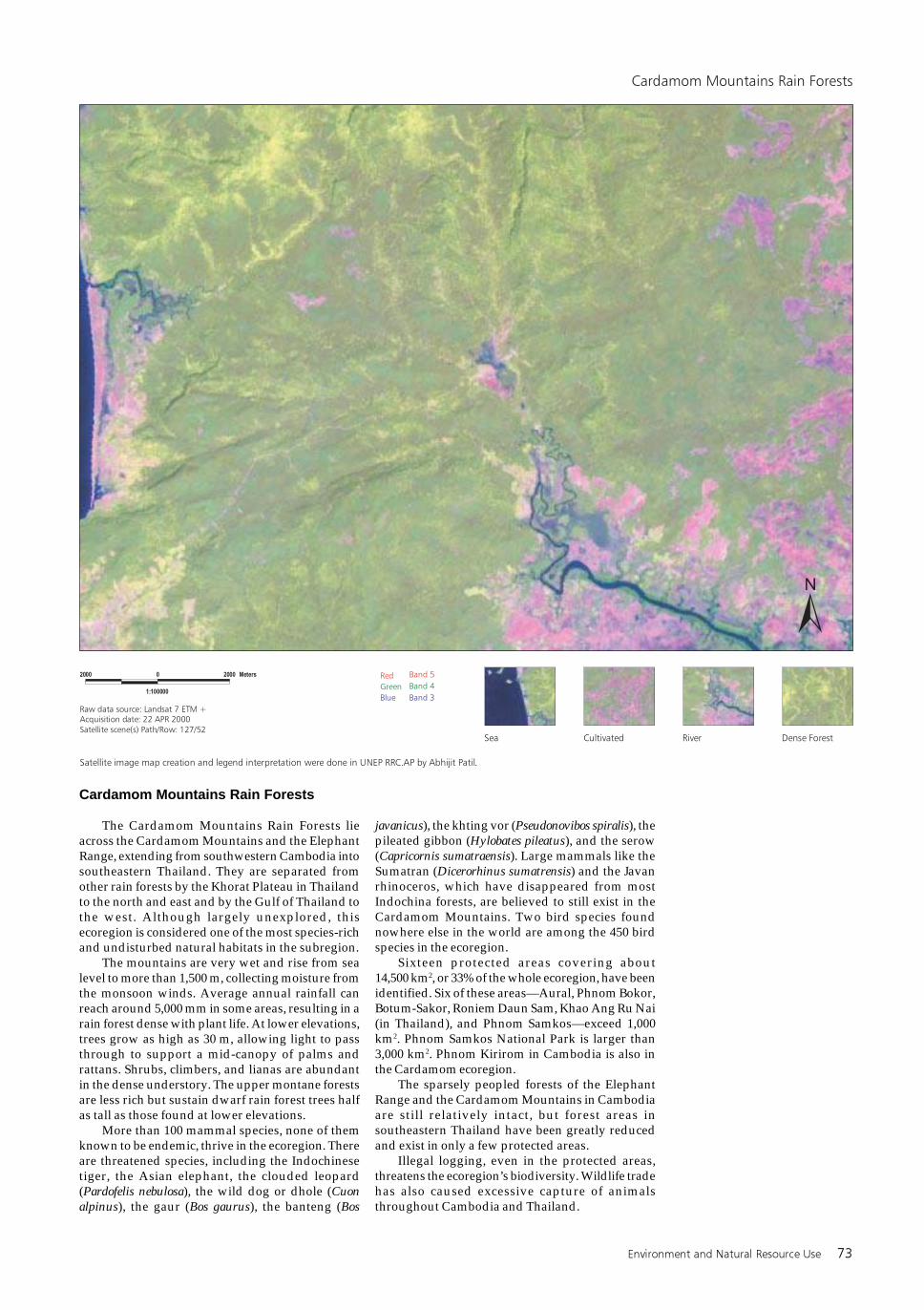
Cardamom Mountains Rain Forests
The Cardamom Mountains Rain Forests lieacross the Cardamom Mountains and the ElephantRange, extending from southwestern Cambodia intosoutheastern Thailand. They are separated fromother rain forests by the Khorat Plateau in Thailandto the north and east and by the Gulf of Thailand tothe west. Although largely unexplored, thisecoregion is considered one of the most species-richand undisturbed natural habitats in the subregion.
The mountains are very wet and rise from sealevel to more than 1,500 m, collecting moisture fromthe monsoon winds. Average annual rainfall canreach around 5,000 mm in some areas, resulting in arain forest dense with plant life. At lower elevations,trees grow as high as 30 m, allowing light to passthrough to support a mid-canopy of palms andrattans. Shrubs, climbers, and lianas are abundantin the dense understory. The upper montane forestsare less rich but sustain dwarf rain forest trees halfas tall as those found at lower elevations.
More than 100 mammal species, none of themknown to be endemic, thrive in the ecoregion. Thereare threatened species, including the Indochinesetiger, the Asian elephant, the clouded leopard(Pardofelis nebulosa), the wild dog or dhole (Cuonalpinus), the gaur (Bos gaurus), the banteng (Bos
javanicus), the khting vor (Pseudonovibos spiralis), thepileated gibbon (Hylobates pileatus), and the serow(Capricornis sumatraensis). Large mammals like theSumatran (Dicerorhinus sumatrensis) and the Javanrhinoceros, which have disappeared from mostIndochina forests, are believed to still exist in theCardamom Mountains. Two bird species foundnowhere else in the world are among the 450 birdspecies in the ecoregion.
Sixteen protected areas covering about14,500 km2, or 33% of the whole ecoregion, have beenidentified. Six of these areas—Aural, Phnom Bokor,Botum-Sakor, Roniem Daun Sam, Khao Ang Ru Nai(in Thailand), and Phnom Samkos—exceed 1,000km2. Phnom Samkos National Park is larger than3,000 km2. Phnom Kirirom in Cambodia is also inthe Cardamom ecoregion.
The sparsely peopled forests of the ElephantRange and the Cardamom Mountains in Cambodiaare still relatively intact, but forest areas insoutheastern Thailand have been greatly reducedand exist in only a few protected areas.
Illegal logging, even in the protected areas,threatens the ecoregion’s biodiversity. Wildlife tradehas also caused excessive capture of animalsthroughout Cambodia and Thailand.
74 Greater Mekong Subregion Atlas of the Environment
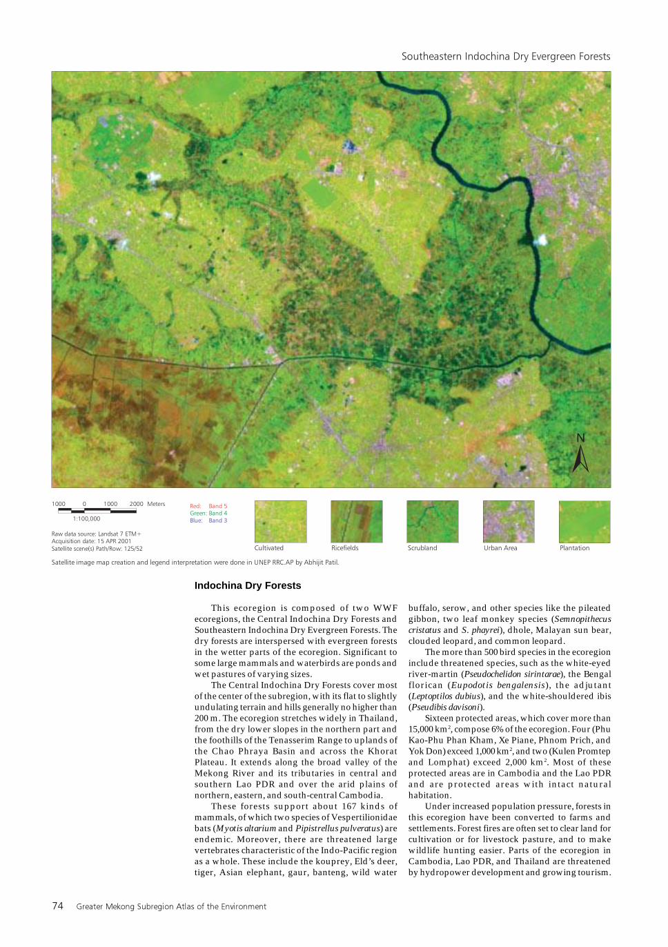
Indochina Dry Forests
This ecoregion is composed of two WWFecoregions, the Central Indochina Dry Forests andSoutheastern Indochina Dry Evergreen Forests. Thedry forests are interspersed with evergreen forestsin the wetter parts of the ecoregion. Significant tosome large mammals and waterbirds are ponds andwet pastures of varying sizes.
The Central Indochina Dry Forests cover mostof the center of the subregion, with its flat to slightlyundulating terrain and hills generally no higher than200 m. The ecoregion stretches widely in Thailand,from the dry lower slopes in the northern part andthe foothills of the Tenasserim Range to uplands ofthe Chao Phraya Basin and across the KhoratPlateau. It extends along the broad valley of theMekong River and its tributaries in central andsouthern Lao PDR and over the arid plains ofnorthern, eastern, and south-central Cambodia.
These forests support about 167 kinds ofmammals, of which two species of Vespertilionidaebats (Myotis altarium and Pipistrellus pulveratus) areendemic. Moreover, there are threatened largevertebrates characteristic of the Indo-Pacific regionas a whole. These include the kouprey, Eld’s deer,tiger, Asian elephant, gaur, banteng, wild water
buffalo, serow, and other species like the pileatedgibbon, two leaf monkey species (Semnopithecuscristatus and S. phayrei), dhole, Malayan sun bear,clouded leopard, and common leopard.
The more than 500 bird species in the ecoregioninclude threatened species, such as the white-eyedriver-martin (Pseudochelidon sirintarae), the Bengalflorican (Eupodotis bengalensis), the adjutant(Leptoptilos dubius), and the white-shouldered ibis(Pseudibis davisoni).
Sixteen protected areas, which cover more than15,000 km2, compose 6% of the ecoregion. Four (PhuKao-Phu Phan Kham, Xe Piane, Phnom Prich, andYok Don) exceed 1,000 km2, and two (Kulen Promtepand Lomphat) exceed 2,000 km2. Most of theseprotected areas are in Cambodia and the Lao PDRand are protected areas with intact naturalhabitation.
Under increased population pressure, forests inthis ecoregion have been converted to farms andsettlements. Forest fires are often set to clear land forcultivation or for livestock pasture, and to makewildlife hunting easier. Parts of the ecoregion inCambodia, Lao PDR, and Thailand are threatenedby hydropower development and growing tourism.
Environment and Natural Resource Use 75
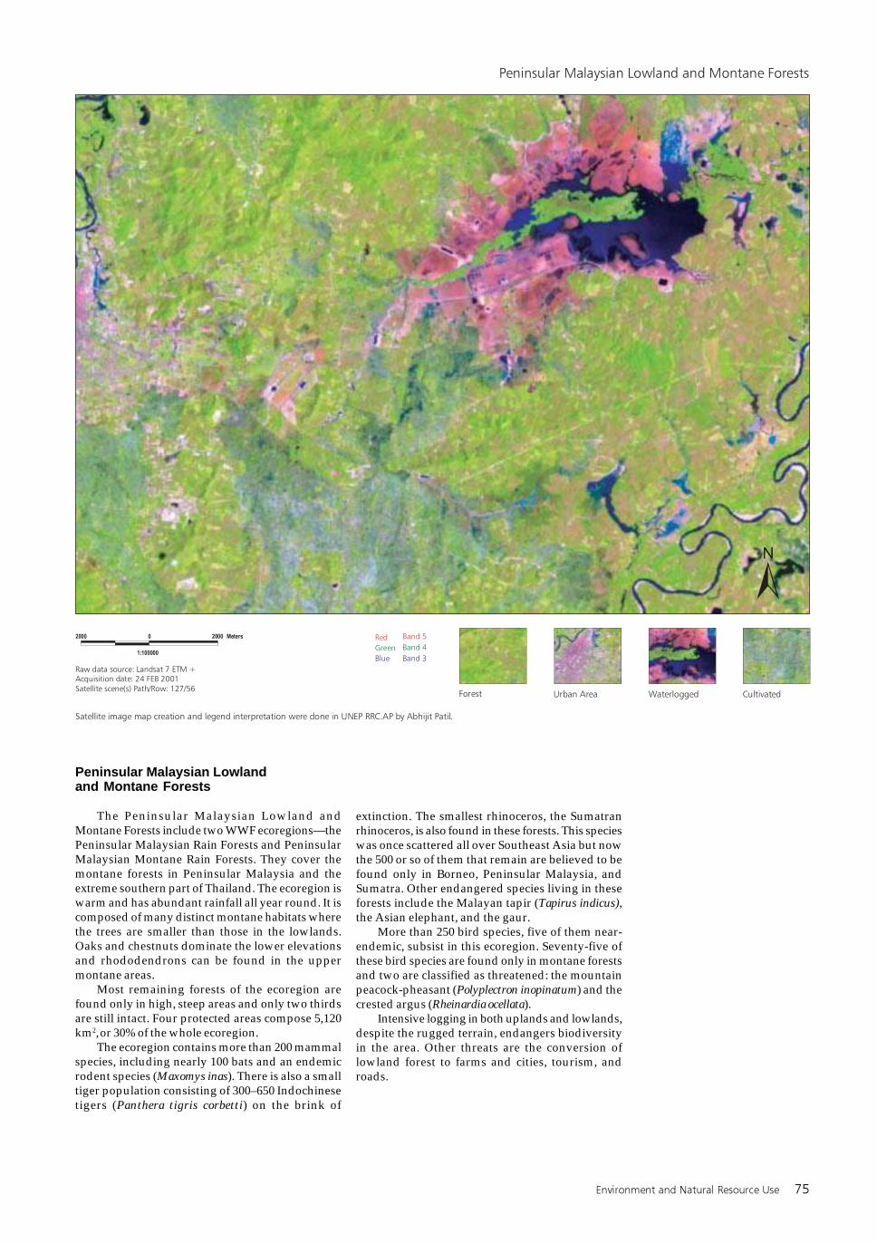
Peninsular Malaysian Lowlandand Montane Forests
The Peninsular Malaysian Lowland andMontane Forests include two WWF ecoregions—thePeninsular Malaysian Rain Forests and PeninsularMalaysian Montane Rain Forests. They cover themontane forests in Peninsular Malaysia and theextreme southern part of Thailand. The ecoregion iswarm and has abundant rainfall all year round. It iscomposed of many distinct montane habitats wherethe trees are smaller than those in the lowlands.Oaks and chestnuts dominate the lower elevationsand rhododendrons can be found in the uppermontane areas.
Most remaining forests of the ecoregion arefound only in high, steep areas and only two thirdsare still intact. Four protected areas compose 5,120km2, or 30% of the whole ecoregion.
The ecoregion contains more than 200 mammalspecies, including nearly 100 bats and an endemicrodent species (Maxomys inas). There is also a smalltiger population consisting of 300–650 Indochinesetigers (Panthera tigris corbetti) on the brink of
extinction. The smallest rhinoceros, the Sumatranrhinoceros, is also found in these forests. This specieswas once scattered all over Southeast Asia but nowthe 500 or so of them that remain are believed to befound only in Borneo, Peninsular Malaysia, andSumatra. Other endangered species living in theseforests include the Malayan tapir (Tapirus indicus),the Asian elephant, and the gaur.
More than 250 bird species, five of them near-endemic, subsist in this ecoregion. Seventy-five ofthese bird species are found only in montane forestsand two are classified as threatened: the mountainpeacock-pheasant (Polyplectron inopinatum) and thecrested argus (Rheinardia ocellata).
Intensive logging in both uplands and lowlands,despite the rugged terrain, endangers biodiversityin the area. Other threats are the conversion oflowland forest to farms and cities, tourism, androads.
76 Greater Mekong Subregion Atlas of the Environment
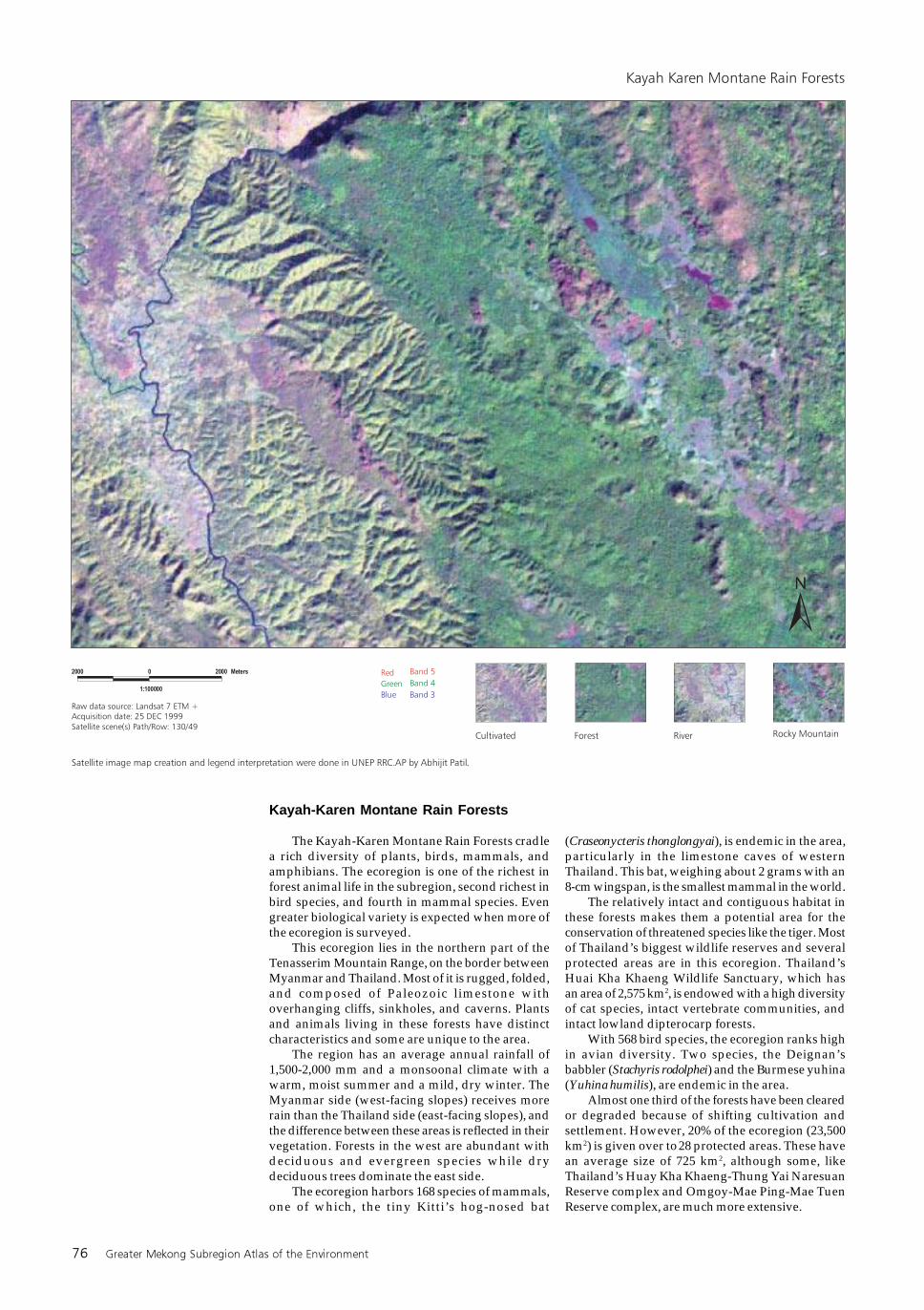
Kayah-Karen Montane Rain Forests
The Kayah-Karen Montane Rain Forests cradlea rich diversity of plants, birds, mammals, andamphibians. The ecoregion is one of the richest inforest animal life in the subregion, second richest inbird species, and fourth in mammal species. Evengreater biological variety is expected when more ofthe ecoregion is surveyed.
This ecoregion lies in the northern part of theTenasserim Mountain Range, on the border betweenMyanmar and Thailand. Most of it is rugged, folded,and composed of Paleozoic limestone withoverhanging cliffs, sinkholes, and caverns. Plantsand animals living in these forests have distinctcharacteristics and some are unique to the area.
The region has an average annual rainfall of1,500-2,000 mm and a monsoonal climate with awarm, moist summer and a mild, dry winter. TheMyanmar side (west-facing slopes) receives morerain than the Thailand side (east-facing slopes), andthe difference between these areas is reflected in theirvegetation. Forests in the west are abundant withdeciduous and evergreen species while drydeciduous trees dominate the east side.
The ecoregion harbors 168 species of mammals,one of which, the tiny Kitti’s hog-nosed bat
(Craseonycteris thonglongyai), is endemic in the area,particularly in the limestone caves of westernThailand. This bat, weighing about 2 grams with an8-cm wingspan, is the smallest mammal in the world.
The relatively intact and contiguous habitat inthese forests makes them a potential area for theconservation of threatened species like the tiger. Mostof Thailand’s biggest wildlife reserves and severalprotected areas are in this ecoregion. Thailand’sHuai Kha Khaeng Wildlife Sanctuary, which hasan area of 2,575 km2, is endowed with a high diversityof cat species, intact vertebrate communities, andintact lowland dipterocarp forests.
With 568 bird species, the ecoregion ranks highin avian diversity. Two species, the Deignan’sbabbler (Stachyris rodolphei) and the Burmese yuhina(Yuhina humilis), are endemic in the area.
Almost one third of the forests have been clearedor degraded because of shifting cultivation andsettlement. However, 20% of the ecoregion (23,500km2) is given over to 28 protected areas. These havean average size of 725 km2, although some, likeThailand’s Huay Kha Khaeng-Thung Yai NaresuanReserve complex and Omgoy-Mae Ping-Mae TuenReserve complex, are much more extensive.
Environment and Natural Resource Use 77
Fauna
Recent discoveries of new species (such as thesaola, a forest dwelling ox, found in the Annamitesin 1993) and the dedicated search for the elusivekouprey have captured the imagination ofconservationists worldwide and heightened globalawareness of the need to conserve the biodiversityof the subregion. Biological surveys continue to turnup new discoveries, emphasizing the region’s highconcentration of unique plants and animals. Thesesurveys also highlight the fact that the subregion ishome to some of the world’s most threatened species.While a few have become extinct (such asSchromburk’s deer, the pink-headed duck, and thewhite-eyed river-martin), most species are stillrelatively widespread in the subregion. However,wildlife populations are coming under increasingpressure from growing human populations,infrastructure development, and extraction forinternational markets. Many species of largemammals are close to extinction in several countries.These include the tiger, banteng, wild water buffalo,Eld’s deer, and Javan and Sumatran rhinoceroses.Other threatened groups include large water birds(such as cranes, storks, ibises, and pelicans),pheasants, large foragers (hornbills, imperialpigeons), freshwater turtles, and large migratoryfish.
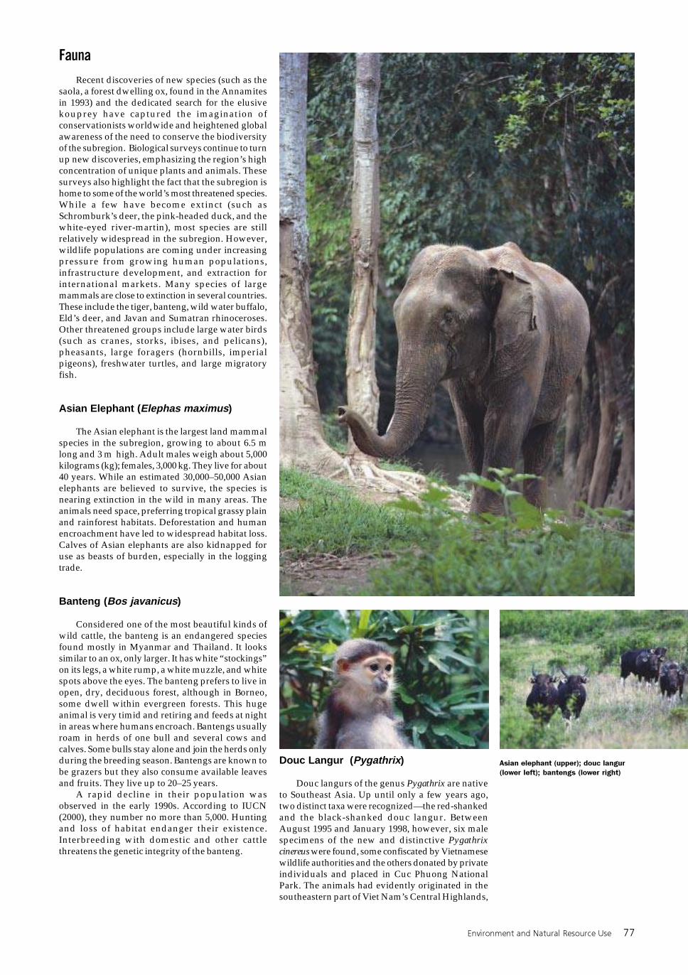
Asian Elephant (Elephas maximus)
The Asian elephant is the largest land mammalspecies in the subregion, growing to about 6.5 mlong and 3 m high. Adult males weigh about 5,000kilograms (kg); females, 3,000 kg. They live for about40 years. While an estimated 30,000–50,000 Asianelephants are believed to survive, the species isnearing extinction in the wild in many areas. Theanimals need space, preferring tropical grassy plainand rainforest habitats. Deforestation and humanencroachment have led to widespread habitat loss.Calves of Asian elephants are also kidnapped foruse as beasts of burden, especially in the loggingtrade.
Banteng (Bos javanicus)
Considered one of the most beautiful kinds ofwild cattle, the banteng is an endangered speciesfound mostly in Myanmar and Thailand. It lookssimilar to an ox, only larger. It has white “stockings”on its legs, a white rump, a white muzzle, and whitespots above the eyes. The banteng prefers to live inopen, dry, deciduous forest, although in Borneo,some dwell within evergreen forests. This hugeanimal is very timid and retiring and feeds at nightin areas where humans encroach. Bantengs usuallyroam in herds of one bull and several cows andcalves. Some bulls stay alone and join the herds onlyduring the breeding season. Bantengs are known tobe grazers but they also consume available leavesand fruits. They live up to 20–25 years.
A rapid decline in their population wasobserved in the early 1990s. According to IUCN(2000), they number no more than 5,000. Huntingand loss of habitat endanger their existence.Interbreeding with domestic and other cattlethreatens the genetic integrity of the banteng.
Douc Langur (Pygathrix)
Douc langurs of the genus Pygathrix are nativeto Southeast Asia. Up until only a few years ago,two distinct taxa were recognized—the red-shankedand the black-shanked douc langur. BetweenAugust 1995 and January 1998, however, six malespecimens of the new and distinctive Pygathrixcinereus were found, some confiscated by Vietnamesewildlife authorities and the others donated by privateindividuals and placed in Cuc Phuong NationalPark. The animals had evidently originated in thesoutheastern part of Viet Nam’s Central Highlands,
Asian elephant (upper); douc langur
(lower left); bantengs (lower right)
78 Greater Mekong Subregion Atlas of the Environment
where field primatologists had also identified wildpopulations of the same description in a regionoccupied by red- and black-shanked monkeys. Wildpopulations of the three doucs have been reduced tosmall numbers by habitat loss and hunting. WhileCambodia and the Lao PDR may have more sizeablepopulations of the red-shanked and black-shankeddouc, the newly discovered Pygathrix cinereus isknown only from Viet Nam and is considered themost critically endangered species.
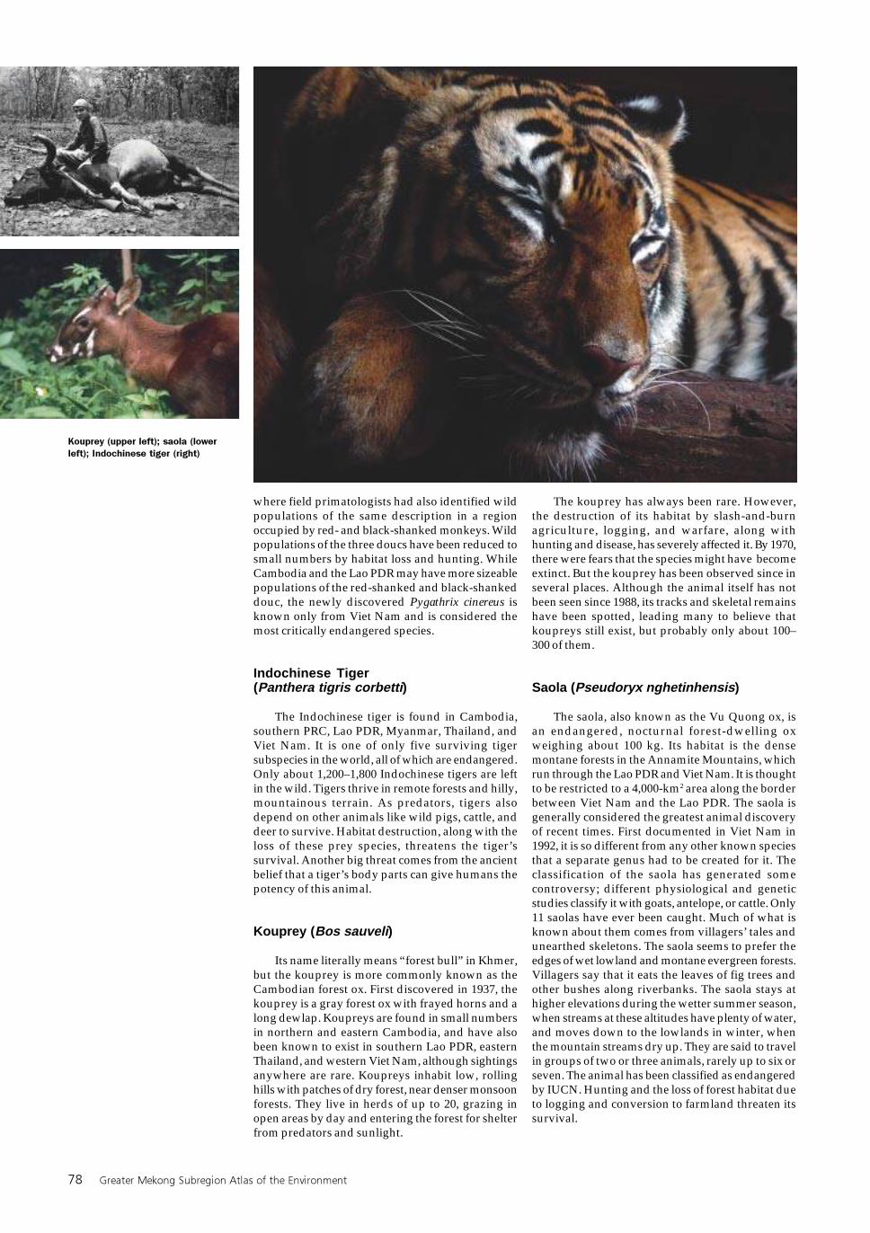
Indochinese Tiger(Panthera tigris corbetti)
The Indochinese tiger is found in Cambodia,southern PRC, Lao PDR, Myanmar, Thailand, andViet Nam. It is one of only five surviving tigersubspecies in the world, all of which are endangered.Only about 1,200–1,800 Indochinese tigers are leftin the wild. Tigers thrive in remote forests and hilly,mountainous terrain. As predators, tigers alsodepend on other animals like wild pigs, cattle, anddeer to survive. Habitat destruction, along with theloss of these prey species, threatens the tiger’ssurvival. Another big threat comes from the ancientbelief that a tiger’s body parts can give humans thepotency of this animal.
Kouprey (Bos sauveli)
Its name literally means “forest bull” in Khmer,but the kouprey is more commonly known as theCambodian forest ox. First discovered in 1937, thekouprey is a gray forest ox with frayed horns and along dewlap. Koupreys are found in small numbersin northern and eastern Cambodia, and have alsobeen known to exist in southern Lao PDR, easternThailand, and western Viet Nam, although sightingsanywhere are rare. Koupreys inhabit low, rollinghills with patches of dry forest, near denser monsoonforests. They live in herds of up to 20, grazing inopen areas by day and entering the forest for shelterfrom predators and sunlight.
The kouprey has always been rare. However,the destruction of its habitat by slash-and-burnagriculture, logging, and warfare, along withhunting and disease, has severely affected it. By 1970,there were fears that the species might have becomeextinct. But the kouprey has been observed since inseveral places. Although the animal itself has notbeen seen since 1988, its tracks and skeletal remainshave been spotted, leading many to believe thatkoupreys still exist, but probably only about 100–300 of them.
Saola (Pseudoryx nghetinhensis)
The saola, also known as the Vu Quong ox, isan endangered, nocturnal forest-dwelling oxweighing about 100 kg. Its habitat is the densemontane forests in the Annamite Mountains, whichrun through the Lao PDR and Viet Nam. It is thoughtto be restricted to a 4,000-km2 area along the borderbetween Viet Nam and the Lao PDR. The saola isgenerally considered the greatest animal discoveryof recent times. First documented in Viet Nam in1992, it is so different from any other known speciesthat a separate genus had to be created for it. Theclassification of the saola has generated somecontroversy; different physiological and geneticstudies classify it with goats, antelope, or cattle. Only11 saolas have ever been caught. Much of what isknown about them comes from villagers’ tales andunearthed skeletons. The saola seems to prefer theedges of wet lowland and montane evergreen forests.Villagers say that it eats the leaves of fig trees andother bushes along riverbanks. The saola stays athigher elevations during the wetter summer season,when streams at these altitudes have plenty of water,and moves down to the lowlands in winter, whenthe mountain streams dry up. They are said to travelin groups of two or three animals, rarely up to six orseven. The animal has been classified as endangeredby IUCN. Hunting and the loss of forest habitat dueto logging and conversion to farmland threaten itssurvival.
Kouprey (upper left); saola (lower
left); Indochinese tiger (right)
Environment and Natural Resource Use 79
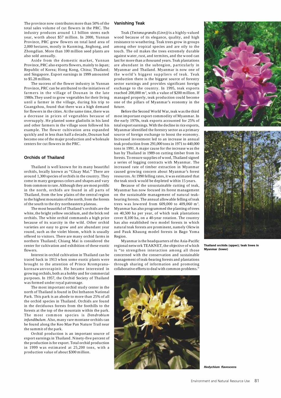
Siamese Crocodile(Crocodylus siamensis)
The Siamese crocodile, also known as the soft-belly crocodile, is an endangered species found inCambodia, Lao PDR, Thailand, and Viet Nam. Itprefers to move in groups in slow-moving areas offreshwater, feeding on fish, amphibians, reptiles,birds, small mammals, and carrion. It grows to about3 m. The Siamese crocodile is not considereddangerous to humans, although it has beenmistaken for its far more threatening cousin, thesaltwater crocodile, which is larger and has anarrower snout. The Siamese crocodile has all butdisappeared from many countries in the subregion,although a new population has been discovered inthe Cardamom Mountains. Expectations for itssurvival are poor because it is under significantthreat from poaching and habitat destruction.
Fish of the Major River Systems
About 1,200 species of fish have been identifiedin the Mekong River system, and the number isexpected to increase as more field studies are doneand the system of classification improves. Thediscovery of new species is especially likely in themountain tributaries of the Lao PDR and YunnanProvince, PRC, where little or no research has beendone. Only the Amazon River system of SouthAmerica has greater fish diversity—about 2,000 fishspecies are found in a river basin roughly nine timesthe size of the Mekong. Many fish species found inthe Mekong are also found in other rivers of thesubregion. The Ayeyarwady, Thanlwin, and Redrivers, however, have endemic fish species not foundin the Mekong. In fact, the Ayeyarwady River is morelike the Ganges River in its fish species composition.Yunnan Province, PRC, through which all four riversrun, probably has the highest fish diversity of anyregion in the PRC.
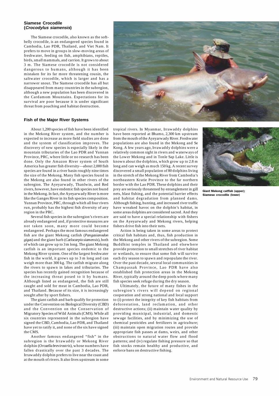
Several fish species in the subregion’s rivers arealready endangered and, if protective measures arenot taken soon, many more could becomeendangered. Perhaps the most famous endangeredfish are the giant Mekong catfish (Pangasianodongigas) and the giant barb (Catlocarpio siamensis), bothof which can grow up to 3 m long. The giant Mekongcatfish is an important species endemic to theMekong River system. One of the largest freshwaterfish in the world, it grows up to 3 m long and canweigh more than 300 kg. The catfish migrate alongthe rivers to spawn in lakes and tributaries. Thespecies has recently gained recognition because ofthe increasing threat posed to it by humans.Although listed as endangered, the fish are stillcaught and sold for meat in Cambodia, Lao PDR,and Thailand. Because of its size, it is increasinglysought after by sport fishers.
The giant catfish and barb qualify for protectionunder the Convention on Biological Diversity (CBD)and the Convention on the Conservation ofMigratory Species of Wild Animals (CMS). While allsix countries represented in the subregion havesigned the CBD, Cambodia, Lao PDR, and Thailandhave yet to ratify it, and none of the six have signedthe CMS.
Another famous endangered “fish” in thesubregion is the Irrawaddy or Mekong Riverdolphin (Orcaella brevirostris), whose numbers havefallen drastically over the past 3 decades. TheIrrawaddy dolphin prefers to live near the coast andat the mouth of rivers. It also lives upstream in some
tropical rivers. In Myanmar, Irrawaddy dolphinshave been reported at Bhamo, 2,300 km upstreamfrom the mouth of the Ayeyarwady River. Freshwaterpopulations are also found in the Mekong and SeKong. A few years ago, Irrawaddy dolphins were arelatively common sight in rivers and waterways ofthe Lower Mekong and in Tonle Sap Lake. Little isknown about the dolphins, which grow up to 2.8 mlong and can weigh as much 150 kg. A recent surveydiscovered a small population of 80 dolphins livingin the stretch of the Mekong River from Cambodia’snortheastern Kratie Province to the far northernborder with the Lao PDR. These dolphins and theirprey are seriously threatened by entanglement in gillnets, blast fishing, and the potential barrier effectsand habitat degradation from planned dams.Although fishing, hunting, and increased river traffichave wreaked havoc on the dolphin’s habitat, insome areas dolphins are considered sacred. And theyare said to have a special relationship with fisherson the Ayeyarwady and Mekong rivers, helpingfishers drive fish into their nets.
Action is being taken in some areas to protectcritical fish habitats and, thus, fish production inthe Mekong and other rivers of the subregion. SomeBuddhist temples in Thailand and elsewhereprovide protection to small stretches of river habitator wetlands, to ensure that some fish will surviveeach dry season to spawn and repopulate the river.Over the past decade, several local communities inChampassak Province, Lao PDR have alsoestablished fish protection areas in the MekongRiver, typically around the deep pools where manyfish species seek refuge during the dry season.
Ultimately, the future of many fishes in thesubregion’s rivers will depend on regionalcooperation and strong national and local supportto (i) protect the integrity of key fish habitats fromdeforestation, land reclamation, and otherdestructive actions; (ii) maintain water quality byproviding municipal, industrial, and domesticsewage facilities, and by minimizing the use ofchemical pesticides and fertilizers in agriculture;(iii) maintain open migration routes and provideappropriate fish passes at dams, weirs, and otherobstructions to natural water flow and floodpatterns; and (iv) regulate fishing pressure so thatfish stocks remain healthy and productive, andenforce bans on destructive fishing.
Giant Mekong catfish (upper);
Siamese crocodile (lower)

80 Greater Mekong Subregion Atlas of the Environment
Flora
The subregion is home to an enormous numberof plant species, at least 20,000 and possibly manymore. Thailand has about 12,600, Viet Nam 10,500,and Myanmar 7,000 species of higher plants. About20% of the plant species in Thailand and Viet Namoccur only in those countries. The flora of YunnanProvince, PRC is estimated to contain 14,000 species.There is undoubtedly great overlap between thecountries and considerable overlap with the moretemperate Yunnan Province, PRC. Numbersrecorded depend not only on the actual numbersthat occur, but also on the nature of the country, andefforts taken to survey and collect data. The moreintensively an area is studied, the greater the numberof plants and animals likely to be discovered.
The flora in the subregion includes many rareornamental flowers and trees that beautify the entireregion and support a thriving horticulture industryin most of the countries. The flora also includeshighly valued hardwood tree species like teak thatgenerate a major share of the forestry income andare currently the focus of major conservation effortsto stop illegal logging and cross-border trade.
Significant numbers of plant species arethreatened with extinction within the subregion,nearly 400 species in Thailand and more than 300in Viet Nam, although only a handful in Cambodia,Lao PDR, and Myanmar. Around 300 species arethreatened in the entire PRC; presumably those inYunnan Province are far fewer.
The Three Parallel Rivers of Yunnan ProtectedAreas (see p. 83), a newly affirmed World HeritageSite, contains the richest diversity of higher plantsin the PRC and a wide spectrum of fungi and lichens.The protected area is one of the world’s leastdisturbed ecological areas. It has 22 vegetationsubtypes and harbors 6,000 plant species. Thisrepresents more than 20% of the PRC’s higher plants,10% of which are endemic to the area.
Botanical explorations in the subregioncontinue to yield new plant species. In 1999, a newgenus and species of conifer, Xanthocyparis
vietnamensis, was discovered on steep limestoneridges in a mountainous area in northern Viet Nam.In 2002, a new genus and species of fern, Caobangiasquamata, was found in a collection made by aNational Geographic Society expedition.
Human activities such as deforestation, illegaltrade of endangered species, and agriculturalencroachment, however, threaten the richness ofplant species in the subregion. Nevertheless, theflora continues to be a resource to be conserved anda beauty to be appreciated.
Flowers of Yunnan
Because of the unusual natural conditions inYunnan Province, PRC—no extreme cold in winterand no intense heat in summer—the province ishome to 2,500 kinds of ornamental rare flowers anduncommon trees. Yunnan Province, PRC is said toproduce the best quality and cheapest flowers in theworld. Flowers are grown on a vast scale and areproduced with very minimal requirements.
The province has a long history of growingflowers. One thousand years ago, people from thearea cultivated flowers to uplift their spirits, decoratetheir gardens, and enhance their environment. InKunming, breeding of flowers began as early as inthe Tang and Song dynasties. Camellias becamepopular and were widely grown during the YuanDynasty. In the Ming Dynasty, there were about 70famous types of ornamental flowers and the numbergrew to more than 180 during the Qing Dynasty andthe rise of the Republic. The province presentlyidentifies “eight famous flowers of Yunnan.” Theyare camellia, rhododendron, indigo, primrose, lily,orchid, rough gentian, and meconopsis. Camelliawas chosen as the city flower of Kunming.
In the late 1980s, Yunnan Province, PRC startedto develop a flower industry and the Government ofYunnan decided to support this as a way to boostthe local economy. By 1994, Yunnan Province hadreplaced Shanghai as the flower center of the PRC.
Sterculla brevissima (top left); flower
sellers along the Mekong Delta, Viet
Nam (top right); Musella lasioca
(middle); Mekong River palm (bottom)
Environment and Natural Resource Use 81
The province now contributes more than 50% of thetotal sales volume of cut flowers in the PRC. Theindustry produces around 1.1 billion stems eachyear, worth about $57 million. In 2000, YunnanProvince, PRC grew flowers on total land area of2,000 hectares, mostly in Kunming, Jinghong, andZhongdian. More than 100 million seed plants arealso sold annually.
Aside from the domestic market, YunnanProvince, PRC also exports flowers, mainly to Japan;Republic of Korea; Hong Kong, China; Thailand;and Singapore. Export earnings in 1999 amountedto $5.28 million.
The success of the flower industry in YunnanProvince, PRC can be attributed to the initiatives offarmers in the village of Dounan in the late1980s.They used to grow vegetables for their livinguntil a farmer in the village, during his trip toGuangzhou, found that there was a high demandfor flowers in the cities. At the same time, there wasa decrease in prices of vegetables because ofoversupply. He planted some gladiolis in his landand other farmers in the village soon followed hisexample. The flower cultivation area expandedquickly and in less than half a decade, Dounan hadbecome one of the major production and wholesalecenters for cut flowers in the PRC.
Orchids of Thailand
Thailand is well known for its many beautifulorchids, locally known as “Gluay Mai.” There arearound 1,300 species of orchids in the country. Theycome in many gorgeous colors and shapes and varyfrom common to rare. Although they are most prolificin the north, orchids are found in all parts ofThailand, from the low plains of the central regionto the highest mountains of the north, from the forestsof the south to the dry northeastern plateau.
The most beautiful of Thailand’s orchids are thewhite, the bright yellow oncidium, and the brick redorchids. The white orchid commands a high pricebecause of its scarcity in the wild. Other orchidvarieties are easy to grow and are abundant yearround, such as the violet bloom, which is usuallyoffered to visitors. There are many orchid farms innorthern Thailand; Chiang Mai is considered thecenter for cultivation and exhibition of these exoticflowers.
Interest in orchid cultivation in Thailand can betraced back in 1913 when some exotic plants werebrought to the attention of Prince Kromprana-kornsawanvorapinit. He became interested ingrowing orchids, both as a hobby and for commercialpurposes. In 1957, the Orchid Society of Thailandwas formed under royal patronage.
The most important orchid study center in thenorth of Thailand is found in Doi Inthanon NationalPark. This park is an abode to more than 25% of allthe orchid species in Thailand. Orchids are foundin the deciduous forests from the foothills to theforests at the top of the mountain within the park.The most common species is Dendrobiuminfundibulum. Also, many rare montane orchids canbe found along the Keo Mae Pan Nature Trail nearthe summit of the park.
Orchid production is an important source ofexport earnings in Thailand. Ninety-five percent ofthe production is for export. Total orchid productionin 1999 was estimated at 25,200 tons, with aproduction value of about $300 million.
Vanishing Teak
Teak (Tectona grandis (Linn)) is a highly-valuedwood because of its elegance, quality, and highresistance to weathering. Teak trees grow in groupsamong other tropical species and are oily to thetouch. The oil makes the trees extremely durableagainst water, rust, and termites, and the wood canlast for more than a thousand years. Teak plantationsare abundant in the subregion, particularly inMyanmar and Thailand. Myanmar is now one ofthe world’s biggest suppliers of teak. Teakproduction there is the biggest source of forestrysector earnings and provides significant foreignexchange to the country. In 1995, teak exportsreached 200,000 m3, with a value of $200 million. Ifmanaged properly, teak production could becomeone of the pillars of Myanmar’s economy in thefuture.
Before the Second World War, teak was the thirdmost important export commodity of Myanmar. Inthe early 1970s, teak exports accounted for 25% oftotal export earnings. With the decline in rice exports,Myanmar identified the forestry sector as a primarysource of foreign exchange to boost the economy.Increased investment led to an increase in annualteak production from 291,000 tons in 1971 to 440,000tons in 1991. A major cause for the increase was theban by Thailand in 1989 on cutting timber from itsforests. To ensure supplies of wood, Thailand signeda series of logging contracts with Myanmar. Theincreased rate of timber extraction in Myanmarcaused growing concern about Myanmar’s forestresources. At 1990 felling rates, it was estimated thatthe teak stock would be depleted within 15 years.
Because of the unsustainable cutting of teak,Myanmar has now focused its forest managementon the sustainable management of natural teak-bearing forests. The annual allowable felling of teaktrees was lowered from 609,000 to 409,060 m3.Myanmar has also programmed the planting of treeson 40,500 ha per year, of which teak plantationscover 8,100 ha, on a 40-year rotation. The countryhas also established two model forests in whichnatural teak forests are prominent, namely Oktwinand Pauk Khaung model forests in Bago YomaRegion.
Myanmar is the headquarters of the Asia-Pacificregional network TEAKNET, the objective of whichis “to strengthen interaction among all thoseconcerned with the conservation and sustainablemanagement of teak-bearing forests and plantationsthrough sharing of information and promotingcollaborative efforts to deal with common problems.”
Thailand orchids (upper); teak trees in
Myanmar (lower)
Hedychium flavescens
82 Greater Mekong Subregion Atlas of the Environment
Environment and Natural Resource Use 83
Protected Areas
Protected areas are the primary means ofprotecting biodiversity. The WorldConservation Union (IUCN) defines aprotected area as an area of land and/or
sea especially dedicated to the protection andmaintenance of biological diversity, and of naturaland associated cultural resources, and managedthrough legal or other effective means.
As defined by IUCN, protection must maintainbiodiversity and natural resources. And it must havean explicit legal or social basis.
Sites that combine attraction, recreation, andnature conservation uses can also qualify if at least75% of the area is managed primarily forconservation. Nonconsumptive and low-intensityuses are compatible with some categories within theIUCN scheme, but such sites as forest plantationsmanaged primarily for timber production do notqualify.
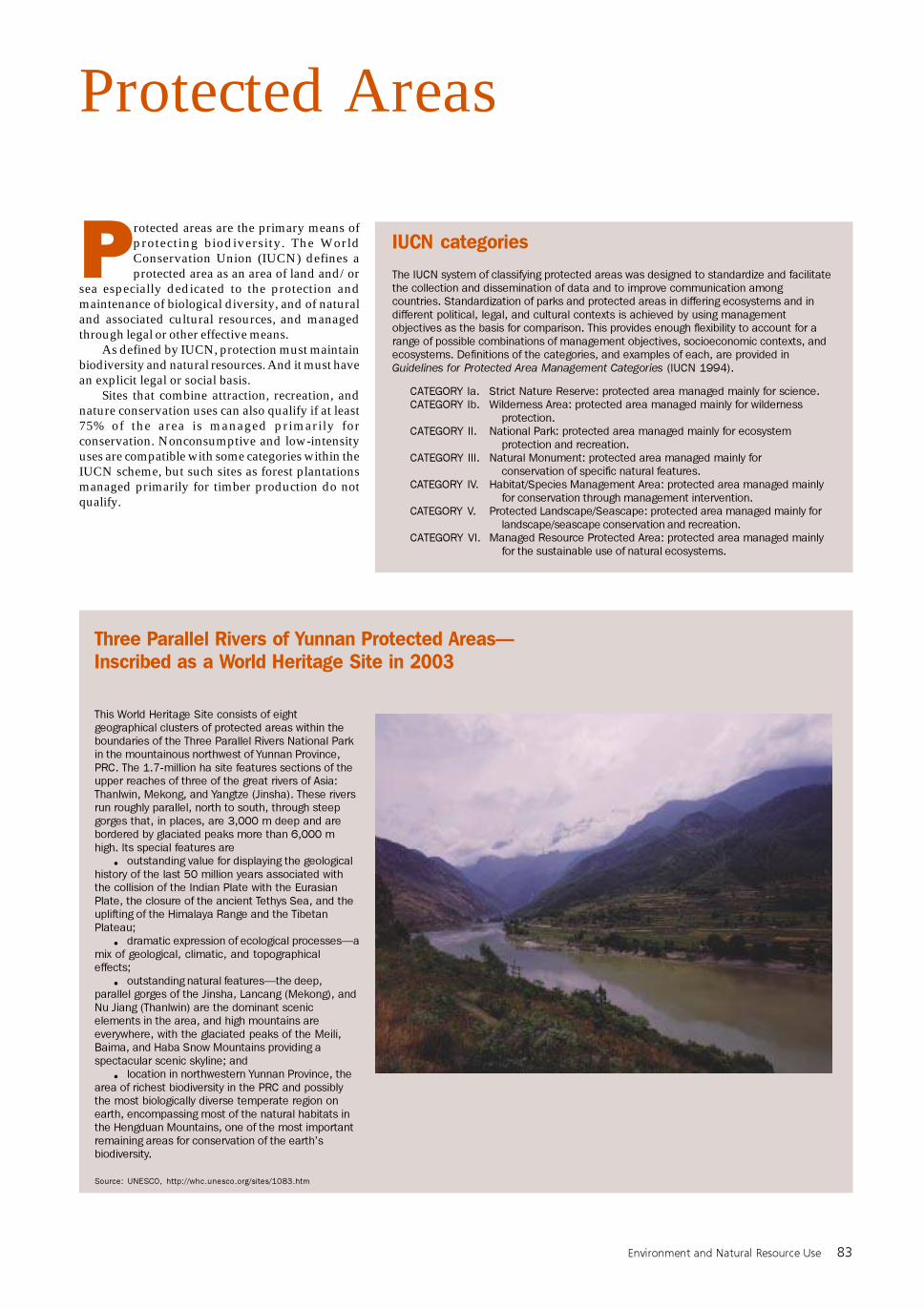
Three Parallel Rivers of Yunnan Protected Areas—Inscribed as a World Heritage Site in 2003
This World Heritage Site consists of eight
geographical clusters of protected areas within the
boundaries of the Three Parallel Rivers National Park
in the mountainous northwest of Yunnan Province,
PRC. The 1.7-million ha site features sections of the
upper reaches of three of the great rivers of Asia:
Thanlwin, Mekong, and Yangtze (Jinsha). These rivers
run roughly parallel, north to south, through steep
gorges that, in places, are 3,000 m deep and are
bordered by glaciated peaks more than 6,000 m
high. Its special features are
• outstanding value for displaying the geological
history of the last 50 million years associated with
the collision of the Indian Plate with the Eurasian
Plate, the closure of the ancient Tethys Sea, and the
uplifting of the Himalaya Range and the Tibetan
Plateau;
• dramatic expression of ecological processes—a
mix of geological, climatic, and topographical
effects;
• outstanding natural features—the deep,
parallel gorges of the Jinsha, Lancang (Mekong), and
Nu Jiang (Thanlwin) are the dominant scenic
elements in the area, and high mountains are
everywhere, with the glaciated peaks of the Meili,
Baima, and Haba Snow Mountains providing a
spectacular scenic skyline; and
• location in northwestern Yunnan Province, the
area of richest biodiversity in the PRC and possibly
the most biologically diverse temperate region on
earth, encompassing most of the natural habitats in
the Hengduan Mountains, one of the most important
remaining areas for conservation of the earth’s
biodiversity.
Source: UNESCO, http://whc.unesco.org/sites/1083.htm
IUCN categories
The IUCN system of classifying protected areas was designed to standardize and facilitate
the collection and dissemination of data and to improve communication among
countries. Standardization of parks and protected areas in differing ecosystems and in
different political, legal, and cultural contexts is achieved by using management
objectives as the basis for comparison. This provides enough flexibility to account for a
range of possible combinations of management objectives, socioeconomic contexts, and
ecosystems. Definitions of the categories, and examples of each, are provided in
Guidelines for Protected Area Management Categories (IUCN 1994).
CATEGORY Ia. Strict Nature Reserve: protected area managed mainly for science.
CATEGORY Ib. Wilderness Area: protected area managed mainly for wilderness
protection.
CATEGORY II. National Park: protected area managed mainly for ecosystem
protection and recreation.
CATEGORY III. Natural Monument: protected area managed mainly for
conservation of specific natural features.
CATEGORY IV. Habitat/Species Management Area: protected area managed mainly
for conservation through management intervention.
CATEGORY V. Protected Landscape/Seascape: protected area managed mainly for
landscape/seascape conservation and recreation.
CATEGORY VI. Managed Resource Protected Area: protected area managed mainly
for the sustainable use of natural ecosystems.
84 Greater Mekong Subregion Atlas of the Environment
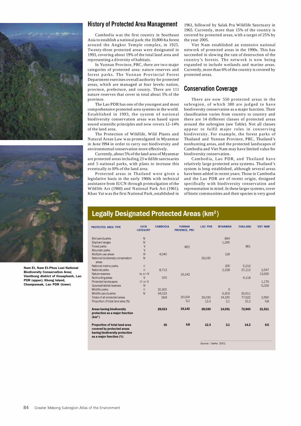
1961, followed by Salak Pra Wildlife Sanctuary in1965. Currently, more than 15% of the country iscovered by protected areas, with a target of 25% bythe year 2005.
Viet Nam established an extensive nationalnetwork of protected areas in the 1990s. This hassucceeded in slowing the rate of destruction of thecountry’s forests. The network is now beingexpanded to include wetlands and marine areas.Currently, more than 6% of the country is covered byprotected areas.
Conservation Coverage
There are now 550 protected areas in thesubregion, of which 380 are judged to havebiodiversity conservation as a major function. Theirclassification varies from country to country andthere are 14 different classes of protected areasaround the subregion (see Table). Not all classesappear to fulfil major roles in conservingbiodiversity. For example, the forest parks ofThailand and Yunnan Province, PRC, Thailand’snonhunting areas, and the protected landscapes ofCambodia and Viet Nam may have limited value forbiodiversity conservation.
Cambodia, Lao PDR, and Thailand haverelatively large protected area systems. Thailand’ssystem is long established, although several areashave been added in recent years. Those in Cambodiaand the Lao PDR are of recent origin, designedspecifically with biodiversity conservation andrepresentation in mind. In these larger systems, coverof biotic communities and their species is very good
History of Protected Area Management
Cambodia was the first country in SoutheastAsia to establish a national park: the 10,800-ha forestaround the Angkor Temple complex, in 1925.Twenty-three protected areas were designated in1993, covering about 19% of the total land area andrepresenting a diversity of habitats.
In Yunnan Province, PRC, there are two majorcategories of protected area: nature reserves andforest parks. The Yunnan Provincial ForestDepartment exercises overall authority for protectedareas, which are managed at four levels: nation,province, prefecture, and county. There are 111nature reserves that cover in total about 5% of theprovince.
The Lao PDR has one of the youngest and mostcomprehensive protected area systems in the world.Established in 1993, the system of nationalbiodiversity conservation areas was based uponsound scientific principles and now covers 12–14%of the land area.
The Protection of Wildlife, Wild Plants andNatural Areas Law was promulgated in Myanmarin June l994 in order to carry out biodiversity andenvironmental conservation more effectively.
Currently, about 5% of the land area of Myanmarare protected areas including 23 wildlife sanctuariesand 5 national parks, with plans to increase thiseventually to l0% of the land area.
Protected areas in Thailand were given alegislative basis in the early 1960s with technicalassistance from IUCN through promulgation of theWildlife Act (1960) and National Park Act (1961).Khao Yai was the first National Park, established in
Legally Designated Protected Areas (km2 )
Bird sanctuaries
Elephant ranges
Forest parks
Mountain parks
Multiple use areas
National biodiversity conservation
areas
National marine parks
National parks
Nature reserves
Nonhunting areas
Protected landscapes
Species/habitat reserves
Wildlife parks
Wildlife sanctuaries
Totals of all protected areas
Proportion of total land area (%)
Areas having biodiversity
protection as a major function
(km2 )
Proportion of total land area
covered by protected areas
having biodiversity protection
as a major function (%)
IUCN
CATEGORY
LAO PDR MYANMAR THAILAND VIET NAMYUNNAN
PROVINCE, PRC
IV
IV
V
V
VI
IV
II
II
Ia or IV
V
III or V
IV
II
IV
4,040
8,713
970
20,300
34,023
18.8
29,013
16
29,030
29,030
12.3
29,030
12.3
894
1,295
129
205
2,328
6
9,303
14,160
2.1
14,031
2.1
861
5,219
37,113
4,118
30,611
77,922
15.2
72,943
14.2
862
19,142
20,004
5.0
19,142
4.8
Source: Clarke 2001.
PROTECTED AREA TYPE CAMBODIA
2,547
13,935
1,179
5,029
2,690
6.8
21,511
6.5
Nam Et, Nam Et-Phou Loei National
Biodiversity Conservation Area;
Vienthong district of Houaphanh, Lao
PDR (upper); Khong Island,
Champassak, Lao PDR (lower)
Environment and Natural Resource Use 85
although there is a paucity of lowland dry evergreenforest. Forests of this type, where they occur inland,have been extensively destroyed throughoutSoutheast Asia.
In Cambodia, 12 out of 17 protected areas arelarger than 500 km2, and comprise 95% of the totalsystem. The figures for the Lao PDR are even higher:19 out of 20 and 98%, respectively. The average sizeof Thailand’s protected areas is less than half thosefor Cambodia and the Lao PDR, only 50 out of 124areas being larger than 500 km2, covering 73% of thetotal protected area.
Yunnan Province’s and Myanmar’s protectedarea systems have the smallest average sizes in thesubregion. In Yunnan Province, PRC, only 8 out ofthe 111 protected areas exceed 500 km2 although,because five areas are larger than 1,000 km2, theyinclude 67% of the total system by area.
The protected area system in Myanmar hasscope for enlargement. The ultimate target of 10%cover, according to the Myanmar National ForestPolicy of 1995, is believed to be a realistic targetbecause large, well-forested, and sparsely populatedtracts of country exist in the north. At present,Myanmar has the lowest proportion of cover in thesubregion (2.1%), and most of its protected areas arein the 101–500 km2 range (average 494 km2). Nine ofits 29 protected areas are larger than 500 km2 and4 exceed 1,000 km2.
Viet Nam’s system has good biodiversityrepresentation but individual protected areas arerelatively small. Only 11 out of the 80 protected areasare larger than 500 km2—covering 49% of the totalprotected area.
Legal instruments for biodiversity conservationand protected area management vary from countryto country. Thailand has the most sophisticated setof laws and regulations while the Lao PDR has theleast developed. Viet Nam is thinking of revising itsnational wildlife laws, while Cambodia and the LaoPDR plan to do so soon. In many cases, the broadumbrella of laws and policies is in place but theimplementing regulations are still to come.
Thailand, Viet Nam, and Yunnan Province,PRC have already used up a large portion of theirforests. The remaining forests are now mostly withinprotected areas. However, in many cases, this hasnot stopped the continuing unsustainable and illegalextraction of timber. To safeguard the biodiversity ofthe subregion for future generations, this issue mustbe tackled. In Cambodia, Lao PDR, and Myanmar,governments at the highest levels must support theprotected area system while committing the humanresources necessary to ensure that the areas aremanaged appropriately. In the short run, the much-needed support is likely to continue to come frominternational and nongovernment organizations.
Protected Areas Highlighted in the Atlas
PROTECTED AREA DESIGNATION COUNTRY ATLAS FEATURE PAGE
Aural
Botum-Saakor
Can Gio
Cang Shan, Er Hai Hu
Chu Mom Ray
Dian Chi Hu
Huai Kha Khaeng
Inle Lake
Khammouane Limestone
Khao Ang Ru Nai
Kulen Promtep
Lomphat
Mae Tuen
Mae Yuam Fang Khwa
Mui Ca Mau
Muong Nhe
Nakai-Nam Theun
Nam Et
Nam Kading
Omgoy
Phnom Bokor
Phnom Prich
Phnom Samkos
Phou Dene Dinh
Phou Loeuy
Phou Xang He
Phu Kao-Phu Phan Kham
Pu Mat
Roniem Daun Sam
Sam Roi Yod
Si Nakarin
Thung Yai Naresuan
Tonle Sap Lake
Umphang
Xe Piane
Xishuangbanna
Yok Don
Wildlife Sanctuary
National Park
Biosphere Reserve
Nature Reserve
Nature Reserve
Nature Reserve
Wildlife Sanctuary
Bird Sanctuary
National Biodiversity
Conservation Area
Wildlife Sanctuary
Protected Landscape
Wildlife Sanctuary
Wildlife Sanctuary
Wildlife Sanctuary
National Park
Nature Reserve
National Biodiversity
Conservation Area
National Biodiversity
Conservation Area
National Biodiversity
Conservation Area
Wildlife Sanctuary
National Park
Wildlife Sanctuary
Wildlife Sanctuary
National Biodiversity
Conservation Area
National Biodiversity
Conservation Area
National Biodiversity
Conservation Area
National Park
Nature Reserve
Wildlife Sanctuary
National Park
National Park
Wildlife Sanctuary
Multilpe Use Area
Biosphere Reserve
National Biodiversity
Conservation Area
State Nature Reserve
National Park
Cambodia
Cambodia
Viet Nam
Yunnan Province, PRC
Viet Nam
Yunnan Province, PRC
Thailand
Myanmar
Lao PDR
Thailand
Cambodia
Cambodia
Thailand
Thailand
Viet Nam
Viet Nam
Lao PDR
Lao PDR
Lao PDR
Thailand
Cambodia
Cambodia
Cambodia
Lao PDR
Lao PDR
Lao PDR
Thailand
Viet Nam
Cambodia
Thailand
Thailand
Thailand
Cambodia
Thailand
Lao PDR
Yunnan Province, PRC
Viet Nam
Cardamom Mountains Rain Forests
Cardamom Mountains Rain Forests
Can Gio Wetland
Er Hai Lake
Se San Watershed
Dian Chi Lake
Kayah-Karen Montane Rain Forests
Inle Lake
Annamite Range Rain Forests
Cardamom Mountains Rain Forests
Indochina Dry Forests
Indochina Dry Forests
Kayah-Karen Montane Rain Forests
Kayah-Karen Montane Rain Forests
Dat Mui Wetlands
Northern Indochina Subtropical
Forests
Annamite Range Rain Forests
Northern Indochina Subtropical
Forests
Annamite Range Rain Forests
Kayah-Karen Montane Rain Forests
Cardamom Mountains Rain Forests
Indochina Dry Forests
Cardamom Mountains Rain Forests
Nam Ou Watershed
Northern Indochina Subtropical
Forests
Annamite Range Rain Forests
Indochina Dry Forests
Annamite Range Rain Forests
Cardamom Mountains Rain Forests
Sam Roi Yod Wetlands
Kayah-Karen Montane Rain Forests
Kayah-Karen Montane Rain Forests
Tonle Sap Lake
Kayah-Karen Montane Rain Forests
Indochina Dry Forests
Luishaihe Watershed; Northern
Indochina Subtropical Forests
Indochina Dry Forests
73
73
59
61
43
60
76
62
72
73
74
74
76
76
58
71
72
71
72
76
73
74
73
45
71
72
74
72
73
57
76
76
55
76
74
44, 71
74
Note: Only those protected areas with areas of 1,000 km2 or more are included in the above list.
Source: WWF 2003.
Freshwater lake in the limestone
region of Viet Nam (upper);
Siphandon Wetlands, Champassak,
Lao PDR (lower)
86 Greater Mekong Subregion Atlas of the Environment
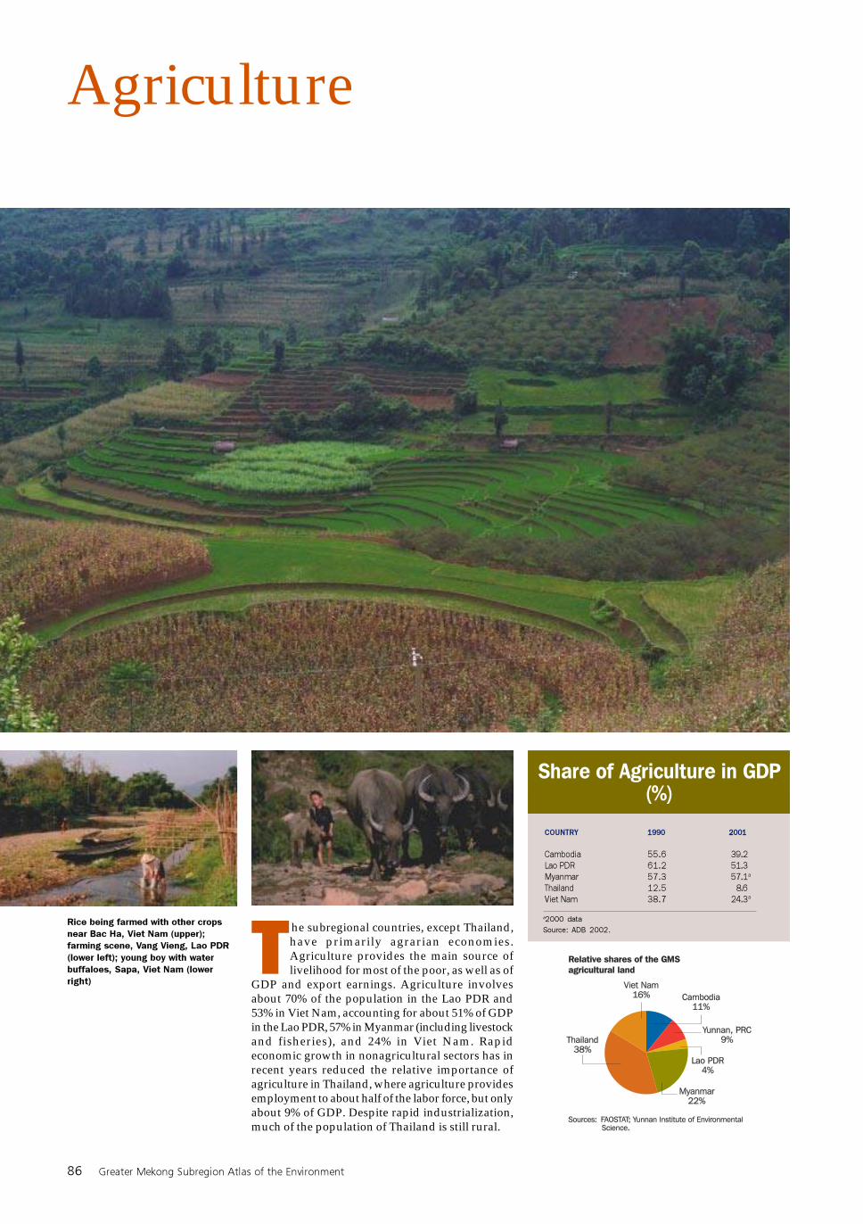
Agriculture
Rice being farmed with other crops
near Bac Ha, Viet Nam (upper);
farming scene, Vang Vieng, Lao PDR
(lower left); young boy with water
buffaloes, Sapa, Viet Nam (lower
right)
COUNTRY
Cambodia
Lao PDR
Myanmar
Thailand
Viet Nam
Share of Agriculture in GDP(%)
1990
55.6
61.2
57.3
12.5
38.7
2001
39.2
51.3
57.1
8.6
24.3
a2000 data
Source: ADB 2002.
The subregional countries, except Thailand,have primarily agrarian economies.Agriculture provides the main source oflivelihood for most of the poor, as well as of
GDP and export earnings. Agriculture involvesabout 70% of the population in the Lao PDR and53% in Viet Nam, accounting for about 51% of GDPin the Lao PDR, 57% in Myanmar (including livestockand fisheries), and 24% in Viet Nam. Rapideconomic growth in nonagricultural sectors has inrecent years reduced the relative importance ofagriculture in Thailand, where agriculture providesemployment to about half of the labor force, but onlyabout 9% of GDP. Despite rapid industrialization,much of the population of Thailand is still rural.
a
a
Environment and Natural Resource Use 87
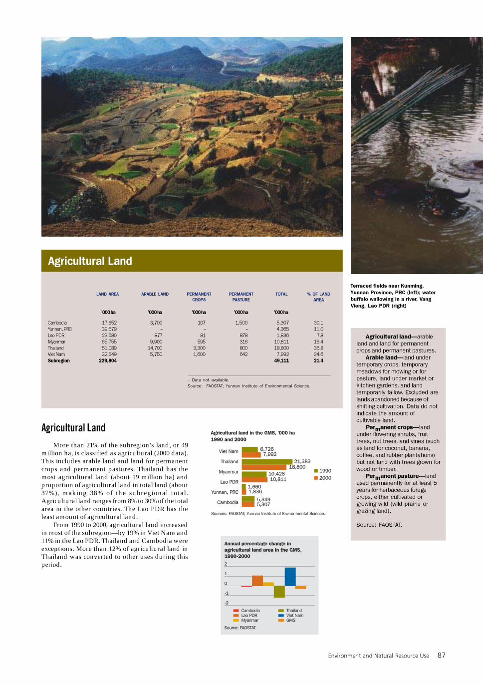
Agricultural Land
Terraced fields near Kunming,
Yunnan Province, PRC (left); water
buffalo wallowing in a river, Vang
Vieng, Lao PDR (right)
Agricultural land—arable
land and land for permanent
crops and permanent pastures.
Arable land—land under
temporary crops, temporary
meadows for mowing or for
pasture, land under market or
kitchen gardens, and land
temporarily fallow. Excluded are
lands abandoned because of
shifting cultivation. Data do not
indicate the amount of
cultivable land.
Permanent crops—land
under flowering shrubs, fruit
trees, nut trees, and vines (such
as land for coconut, banana,
coffee, and rubber plantations)
but not land with trees grown for
wood or timber.
Permanent pasture—land
used permanently for at least 5
years for herbaceous forage
crops, either cultivated or
growing wild (wild prairie or
grazing land).
Source: FAOSTAT.
Cambodia
Yunnan, PRC
Lao PDR
Myanmar
Thailand
Viet Nam
Subregion
’000 ha ’000 ha ’000 ha ’000 ha
30.1
11.0
7.8
16.4
36.8
24.6
21.4
– Data not available.
Source: FAOSTAT; Yunnan Institute of Environmental Science.
PERMANENT
PASTURE
LAND AREA ARABLE LAND PERMANENT
CROPS
TOTAL % OF LAND
AREA
’000 ha
Agricultural Land
More than 21% of the subregion’s land, or 49million ha, is classified as agricultural (2000 data).This includes arable land and land for permanentcrops and permanent pastures. Thailand has themost agricultural land (about 19 million ha) andproportion of agricultural land in total land (about37%), making 38% of the subregional total.Agricultural land ranges from 8% to 30% of the totalarea in the other countries. The Lao PDR has theleast amount of agricultural land.
From 1990 to 2000, agricultural land increasedin most of the subregion—by 19% in Viet Nam and11% in the Lao PDR. Thailand and Cambodia wereexceptions. More than 12% of agricultural land inThailand was converted to other uses during thisperiod.
17,652
39,679
23,680
65,755
51,089
32,549
229,804
3,700
–
877
9,900
14,700
5,750
107
–
81
595
3,300
1,600
1,500
–
878
316
800
642
5,307
4,365
1,836
10,811
18,800
7,992
49,111
88 Greater Mekong Subregion Atlas of the Environment
p88.p65 3/1/04, 2:15 PM88
Environment and Natural Resource Use 89
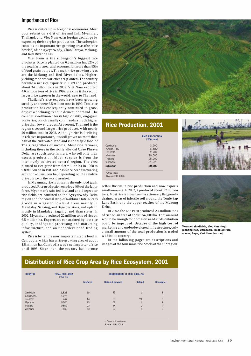
Importance of Rice
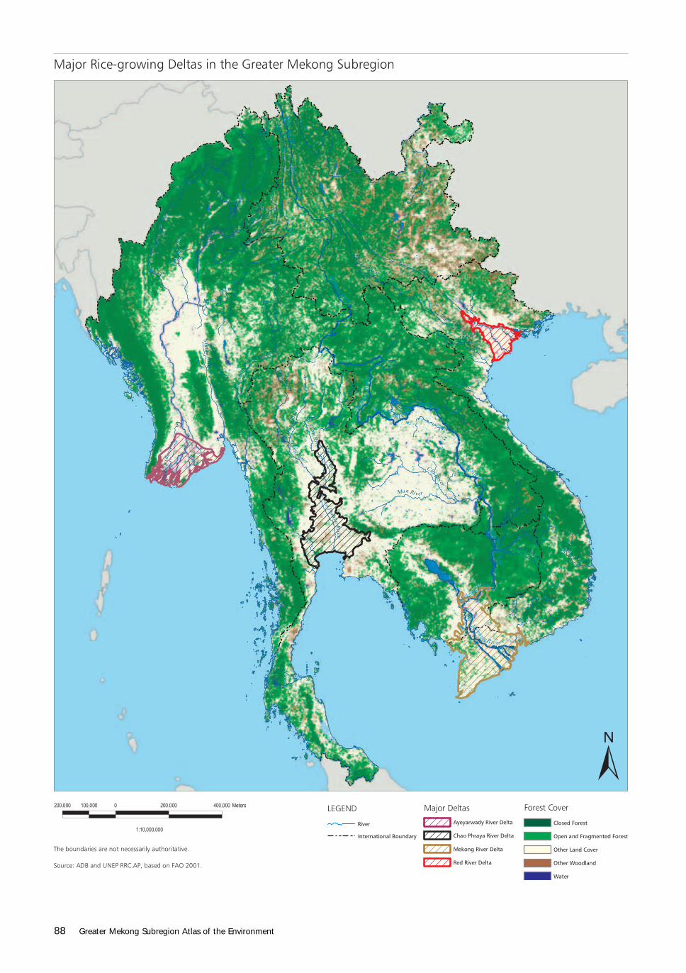
Rice is critical to subregional economies. Mostpoor subsist on a diet of rice and fish. Myanmar,Thailand, and Viet Nam earn foreign exchange byexporting their surplus production. The subregioncontains the important rice-growing areas (the “ricebowls”) of the Ayeyarwady, Chao Phraya, Mekong,and Red River deltas.
Viet Nam is the subregion’s biggest riceproducer. Rice is planted on 6.3 million ha, 82% ofthe total farm area, and accounts for more than 85%of food grain output. The major rice-growing areasare the Mekong and Red River deltas. Higher-yielding modern varieties are planted. The countrybecame a net rice exporter in 1989 and producedabout 34 million tons in 2002. Viet Nam exported4.6 million tons of rice in 1999, making it the secondlargest rice exporter in the world, next to Thailand.
Thailand’s rice exports have been growingsteadily and were 6.5 million tons in 1999. Total riceproduction has consequently continued to grow,despite a declining trend in domestic demand. Thecountry is well known for its high-quality, long-grainwhite rice, which usually commands a much higherprice than lower grades. At present, Thailand is theregion’s second largest rice producer, with nearly26 million tons in 2002. Although rice is decliningin relative importance, it is still grown on more thanhalf of the cultivated land and is the staple food ofThais regardless of income. Most rice farmers,including those in the richly alluvial Chao PhrayaDelta, are subsistence farmers, who sell only theirexcess production. Much surplus is from theintensively cultivated central region. The areaplanted to rice grew from 6.9 million ha in 1968 to9.8 million ha in 1988 and has since been fluctuatingaround 9–10 million ha, depending on the relativeprice of rice in the world market.
In Myanmar, rice is virtually the only food grainproduced. Rice production employs 40% of the laborforce. Myanmar’s rain-fed lowland and deepwaterrice fields are confined to the Ayeyarwady Deltaregion and the coastal strip of Rakhine State. Rice isgrown in irrigated lowland areas mainly inMandalay, Sagaing, and Bago divisions, and uplandmostly in Mandalay, Sagaing, and Shan states. In2002, Myanmar produced 22 million tons of rice on6.5 million ha. Exports are constrained by low ricequality, inadequate processing and marketinginfrastructure, and an underdeveloped tradingsystem.
Rice is by far the most important staple food inCambodia, which has a rice-growing area of about1.8 million ha. Cambodia was a net importer of riceuntil 1995. Since then, the country has become
self-sufficient in rice production and now exportssmall amounts. In 2002, it produced about 3.7 milliontons. Most rice is grown on the extremely flat, poorlydrained areas of infertile soil around the Tonle SapLake Basin and the upper reaches of the MekongDelta.
In 2002, the Lao PDR produced 2.4 million tonsof rice on an area of about 747,000 ha. That amountwould be enough for domestic needs if distributioncould be improved. Because of the high cost ofmarketing and underdeveloped infrastructure, onlya small amount of the total production is tradedwithin the country.
In the following pages are descriptions andimages of the four main rice bowls of the subregion.
Distribution of Rice Crop Area by Rice Ecosystem, 2001
COUNTRY TOTAL RICE AREA
(‘000 ha)
Irrigated Rain-fed Lowland Upland Deepwater
DISTRIBUTION OF RICE AREA (%)
Cambodia
Yunnan, PRC
Lao PDR
Myanmar
Thailand
Viet Nam
1,821
1,074
747
6,500
9,800
7,500
16
–
14
30
20
53
75
–
65
59
74
39
1
–
21
4
2
5
8
–
0
7
4
3
– Data not available.
Source: IRRI 2003.
Cambodia
Yunnan, PRC
Lao PDR
Myanmar
Thailand
Viet Nam
Rice Production, 2001
RICE PRODUCTION
(‘000 tons)
a2000 data
Source: IRRI 2003.
3,600
5,682
2,202
20,600
25,200
31,925
Terraced ricefields, Viet Nam (top);
planting rice, Cambodia (middle); rural
scene, Sapa, Viet Nam (bottom)
a
Subregion 89,209
90 Greater Mekong Subregion Atlas of the Environment
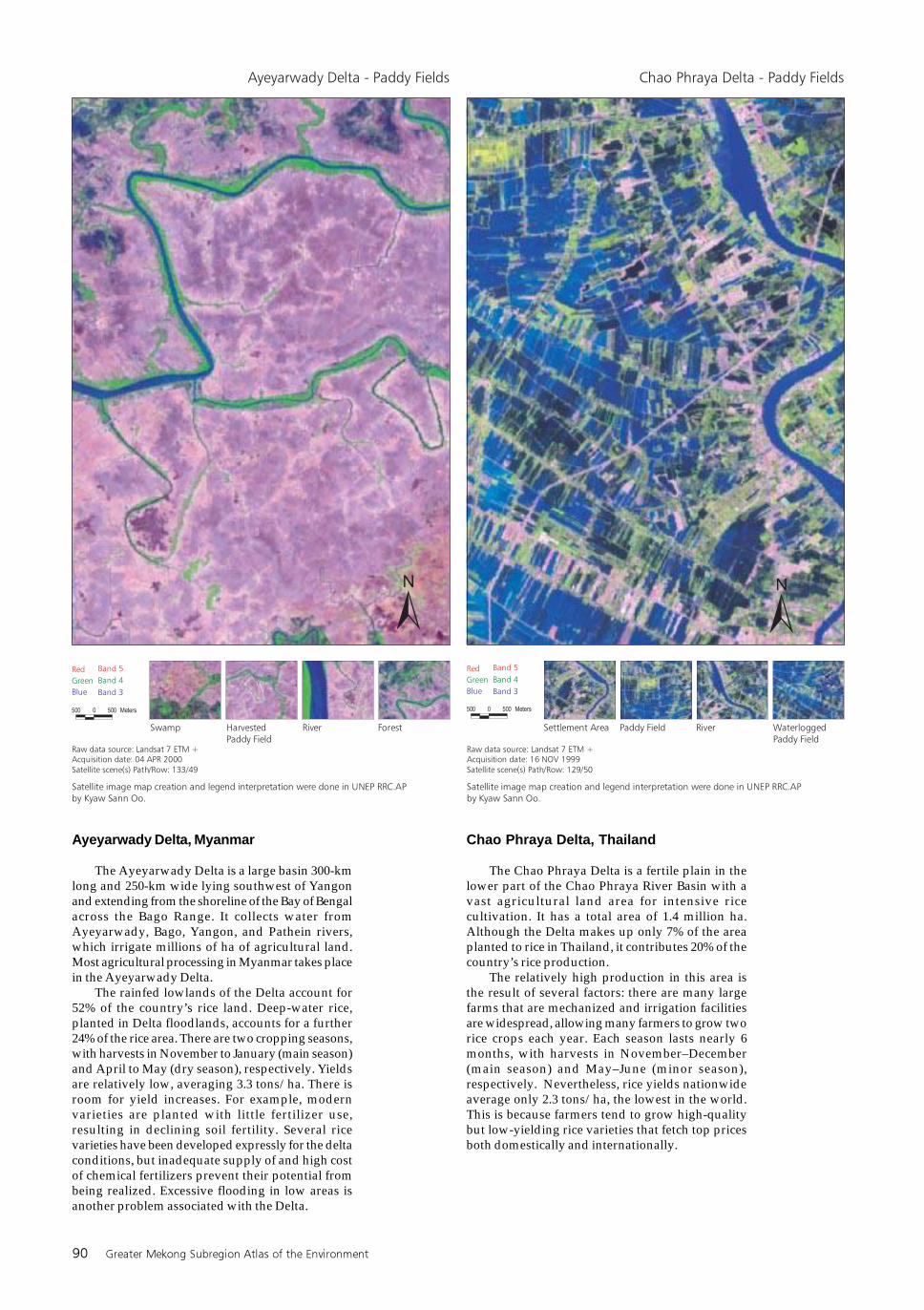
Ayeyarwady Delta, Myanmar
The Ayeyarwady Delta is a large basin 300-kmlong and 250-km wide lying southwest of Yangonand extending from the shoreline of the Bay of Bengalacross the Bago Range. It collects water fromAyeyarwady, Bago, Yangon, and Pathein rivers,which irrigate millions of ha of agricultural land.Most agricultural processing in Myanmar takes placein the Ayeyarwady Delta.
The rainfed lowlands of the Delta account for52% of the country’s rice land. Deep-water rice,planted in Delta floodlands, accounts for a further24% of the rice area. There are two cropping seasons,with harvests in November to January (main season)and April to May (dry season), respectively. Yieldsare relatively low, averaging 3.3 tons/ha. There isroom for yield increases. For example, modernvarieties are planted with little fertilizer use,resulting in declining soil fertility. Several ricevarieties have been developed expressly for the deltaconditions, but inadequate supply of and high costof chemical fertilizers prevent their potential frombeing realized. Excessive flooding in low areas isanother problem associated with the Delta.
Chao Phraya Delta, Thailand
The Chao Phraya Delta is a fertile plain in thelower part of the Chao Phraya River Basin with avast agricultural land area for intensive ricecultivation. It has a total area of 1.4 million ha.Although the Delta makes up only 7% of the areaplanted to rice in Thailand, it contributes 20% of thecountry’s rice production.
The relatively high production in this area isthe result of several factors: there are many largefarms that are mechanized and irrigation facilitiesare widespread, allowing many farmers to grow tworice crops each year. Each season lasts nearly 6months, with harvests in November–December(main season) and May–June (minor season),respectively. Nevertheless, rice yields nationwideaverage only 2.3 tons/ha, the lowest in the world.This is because farmers tend to grow high-qualitybut low-yielding rice varieties that fetch top pricesboth domestically and internationally.
Environment and Natural Resource Use 91
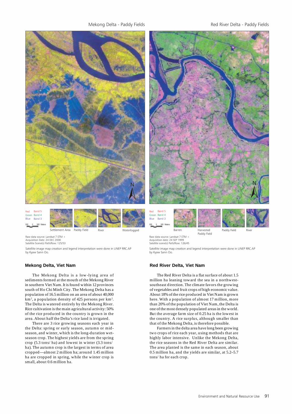
Red River Delta, Viet Nam
The Red River Delta is a flat surface of about 1.5million ha leaning toward the sea in a northwest-southeast direction. The climate favors the growingof vegetables and fruit crops of high economic value.About 18% of the rice produced in Viet Nam is grownhere. With a population of almost 17 million, morethan 20% of the population of Viet Nam, the Delta isone of the most densely populated areas in the world.But the average farm size of 0.25 ha is the lowest inthe country. A rice surplus, although smaller thanthat of the Mekong Delta, is therefore possible.
Farmers in the delta area have long been growingtwo crops of rice each year, using methods that arehighly labor intensive. Unlike the Mekong Delta,the rice seasons in the Red River Delta are similar.The area planted is the same in each season, about0.5 million ha, and the yields are similar, at 5.2–5.7tons/ha for each crop.
Mekong Delta, Viet Nam
The Mekong Delta is a low-lying area ofsediments formed at the mouth of the Mekong Riverin southern Viet Nam. It is found within 12 provincessouth of Ho Chi Minh City. The Mekong Delta has apopulation of 16.5 million on an area of about 40,000km2, a population density of 425 persons per km2.The Delta is watered entirely by the Mekong River.Rice cultivation is the main agricultural activity: 50%of the rice produced in the country is grown in thearea. About half the Delta’s rice land is irrigated.
There are 3 rice growing seasons each year inthe Delta: spring or early season, autumn or mid-season, and winter, which is the long-duration wet-season crop. The highest yields are from the springcrop (5.3 tons/ha) and lowest in winter (3.3 tons/ha). The autumn crop is the largest in terms of areacropped—almost 2 million ha; around 1.45 millionha are cropped in spring, while the winter crop issmall, about 0.6 million ha.
92 Greater Mekong Subregion Atlas of the Environment
Other Crops
While rice is the staple food across the subregion,many other crops are grown, which reflect nationalpreferences as well as the nature of availablefarmland.
Surprisingly, the major crop in Thailand is notrice, but sugarcane. More than twice as muchsugarcane—62.4 million tons in 2002—as rice isproduced each year. Sugar is important also in VietNam—where it is about half the size of the rice crop—and Myanmar.
After rice, the other major staple in Thailand andViet Nam is cassava. In Thailand, the cassava cropis two thirds (16.9 million tons in 2002) the size ofthe annual rice crop. This fondness for cassava isunmatched elsewhere in the subregion. Viet Nam isthe next largest cassava producer, at 4.2 million tonsin 2002, a quarter the size of the Thailand crop. It isa relatively minor crop elsewhere in the subregion.Falling a far third, maize is the next staple, followedby sweet potatoes.
Vegetables are important crops. Viet Nam is byfar the leading producer at 7.6 million tons in 2002.Fruits are also important, particularly in Thailand,which produced some 7.7 million tons in 2002.Coconuts are a significant product in Thailand (1.4million tons) and Viet Nam (0.8 million tons).Cambodia produces only 70,000 tons, but that makescoconuts the seventh largest crop in that country.
Some of the top 10 crops in each country arevery minor in other countries. For example, Thailandalone produces large amounts of oil palm fruit andis the subregion’s leading rubber producer. Viet Namis the subregional coffee bean producer. Myanmarproduces far more dry beans, groundnuts, andonions than the other countries and is the only oneproducing plaintains. Tobacco is one of the top 10crops in the Lao PDR (although some of the othercountries produce about the same amount). YunnanProvince, PRC is the leading tobacco producer. It isone of the most important tobacco-growing areas inthe PRC. The industry makes up nearly 55% of thetotal industrial production of the province.
Livestock
Three main kinds of livestock are grown in theregion—pigs, chickens, and beef cattle, with buffalosand ducks significant in some countries also.Quantities produced in the different countries varyconsiderably, based to some extent on differentcultural values. The main product in Cambodia, LaoPDR, and Viet Nam is pig meat (88,000, 32,000, and1.7 million tons, respectively, in 2002), while inMyanmar and Thailand it is chicken meat (230,000and 1.3 million tons in 2002) and associated heneggs. Thailand’s egg production at 800,000 tons isfour times that of Viet Nam, the second largest eggproducer. Thailand not only produces the most heneggs (500,000 tons) but also is the only big producerof duck eggs (300,000 tons).
Beef is relatively important in most countries,except Thailand. Milk production is corres-pondingly significant, especially in Myanmar,which produced not only 0.5 million tons of cowsmilk—nearly as much as Thailand and more thansix times that of Viet Nam—but also more than100,000 tons of buffalo milk in 2002.
Swidden Agriculture
Swidden cultivation, practiced for centuries inthe highlands of the subregion, is the dominantfarming system among traditional ethnic societies.Two forms of swidden cultivation can bedistinguished: pioneering and established. Vieticgroups, such as Arao, Maleng, and Malang in theLao PDR, practice pioneering swidden cultivation,a simple slash-and-burn technique formonocropping mainly cereals and legumes. Otherethnic groups, such as the Brou of the Lao PDR,practice the more stable established form, in whichtrees, annual crops, short-term cereals, and legumesare grown together.
Swidden cultivation is understood differentlyby government, academe, and civil society groups.Some believe swidden cultivation causesdeforestation and soil erosion. But, in reality it can
Top 10 Primary Crops Production, 2002
Rice, Paddy
Vegetables and Melons, Total
Fruit excl. Melons, Total
Cassava
Sugarcane
Maize
Coconuts
Natural Rubber
Sweet Potatoes
Soybeans
Potatoes
Tobacco Leaves
Coffee Green
Beans Dry
Groundnuts in Shell
Onions
Plantains
Oil Palm Fruit
Sorghum
CAMBODIA YUNNAN, PRC LAO PDR MYANMAR THAILAND VIET NAM
3,740,002
473,000
322,200
186,800
168,850
168,060
70,000
32,365
25,538
21,250
–
4,692
300
19,600
8,720
–
–
–
–
–
–
–
–
–
–
–
–
–
–
–
–
–
–
–
–
–
–
–
2,410,000
673,000
181,500
70,000
210,000
113,000
–
–
102,000
3,002
35,000
33,400
18,000
3,000
175,000
–
–
–
–
21,900,000
3,525,010
1,365,000
96,818
6,333,000
660,000
275,000
35,662
57,382
114,700
318,585
48,161
2,016
1,467,330
700,000
592,823
400,000
–
–
25,945,000
2,960,723
7,670,622
16,870,000
62,350,000
4,170,000
1,396,000
2,460,000
97,370
300,000
84,070
73,000
59,537
260,000
128,816
265,573
–
3,900,000
300,000
34,063,500
7,614,125
4,274,800
4,157,700
16,823,500
2,314,700
838,000
331,400
1,725,100
201,400
377,472
34,400
688,700
141,900
397,000
222,811
–
–
–
Notes:
Top 10 primary crops are shown in bold.
– Data not available.
Source: FAOSTAT.
Production (tons)
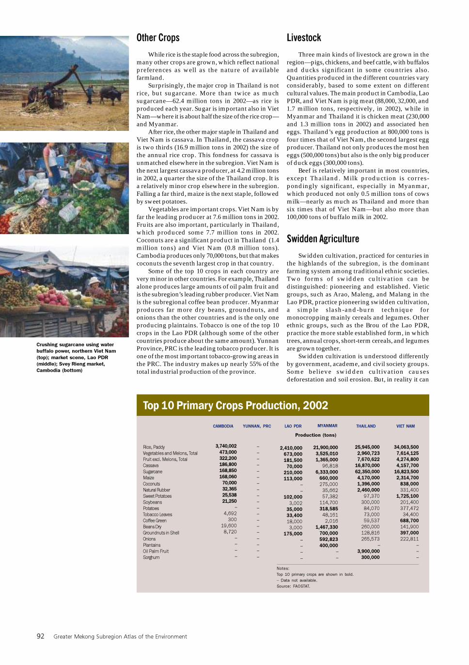
Crushing sugarcane using water
buffalo power, northern Viet Nam
(top); market scene, Lao PDR
(middle); Svey Rieng market,
Cambodia (bottom)
Environment and Natural Resource Use 93
contribute to biodiversity conservation and soilerosion control. Established rotational cultivationrepresents an important means of in situconservation of traditional plant varieties. Especiallyin the subsistence-oriented swidden agriculture ofethnic minorities, important genetic resources areconserved. These endemic varieties are highlyadapted to local conditions. However, this is not todeny that there are some swidden cultivationpractices that are destructive to the environment.
Viet Nam Central Highlands
Ethnic minorities rely on swidden cultivationfor their subsistence. For instance, in the Se Sanwatershed of the Central Highlands of Viet Nam,the Gia Rai and Ba Na peoples plant upland rice inforest clearings. Most Gai Rai swiddens use few cropspecies, depending on the suitability of the soil. Thecommon swidden cycle takes 5–7 years: 2 years ofdry rice farming, followed by 3–5 years fallow. Somerice swiddens are almost pure monocultures. Theaverage area cultivated for swidden rice isapproximately 0.05 hectare per person, yielding anaverage harvest of 65 kg. Cassava swiddens are oftenplanted in soils that are too sandy and infertile tosupport rice.
The Chamkars of Cambodia
In Cambodia, clearing for swidden or chamkar—a field or garden cut from the forest—starts duringthe dry season (March–April). Villagers clearswidden plots of timber and underbrush with handtools. Areas cleared are usually secondary forest orforest fallows. Old-growth forest is usually not cutfor swidden plots except when secondary forest islacking.
Chamkars typically surround a village, and plotsmay be up to 4–5 km away. Chamkars are cultivatedfor 1–5 years, depending on soil quality, after whichthey are left fallow for 7–10 years. Villagers then shifttheir farming sites to other fields that have regainedtheir fertility or have never been cut. The fallowperiod is determined by the extent of tree regrowth,soil fertility, and the absence of weeds. Fallowperiods, when the forest can regenerate, are essentialfor maintaining the soil fertility and sustainabilityof this system.
Most villagers move to the chamkars during therainy season, which is the busiest work period ofthe year. A field hut is constructed to serve as agranary and a resting and working place for family
members. Swidden plots are planted at the beginningof the rainy season using sharp sticks to sow theseeds. Rice is the central or staple crop of the swiddensystem, and in each chamkar 3–7 different varietiesof rice, usually upland rice, are grown. Many othercrops are grown for food security, includingvegetables (sesame and legumes), root crops, gourds,fruit (bananas), and nonfood crops like tobacco andcotton. The rice seeds are mixed with the other seedsin order to cultivate crops of different heights. Thismethod helps to maintain a complete cover ofvegetation, which prevents soil erosion, retainsmoisture during dry periods, and discourages thegrowth of grasses.
The Hai System of the Lao PDR
In the Lao PDR, the swidden cultivation or haisystem is relatively stable under ideal conditions andhas minor environmental impact. Ideal conditionsinclude low population density (less than 0.4persons per ha) and low to moderate croppingintensity. Hai fallows should be long, 10–15 years,to ensure the system’s sustainability. When a fallowperiod of less than 6 years is used, the hai systembecomes unsustainable, as indicated by such factorsas poor fallow vegetation cover, rapid reduction ofyield, high weeding requirements, acute rice deficit,and rapid depletion of forest resources and othercommunal resources.
Precarious Balance: Ecologyand Development
Population pressure and lack of governmentsupport have generally undermined productivityand sustainability of swidden cultivation.Government campaigns of fixed settlement andcultivation have limited the mobility of ethnicminority communities. In Viet Nam, householdspracticing swidden agriculture have been allocateda fixed area for cultivation, with leaseholdownership of 20–30 years. As a result, the livingspace of these households that were formerlydependent on swidden farming has now beenlimited to the few hectares of land allocated to them.
Mixed farming scene, Cambodia
(upper); slash-and-burn activity, Viet
Nam (lower)
Top Five Primary Livestock Products, 2002
Pigmeat
Beef and Veal
Cows’ Milk
Chicken Meat
Buffalo Meat
Hen Eggs
Buffalo Milk
Eggs, excluding Hen Eggs
CAMBODIA YUNNAN, PRC LAO PDR MYANMAR THAILAND VIET NAM
87,500
53,400
20,400
19,008
13,440
12,800
–
3,500
–
–
–
–
–
–
–
–
32,000
25,000
6,000
11,960
17,000
11,000
–
288
122,724
108,000
525,114
230,373
21,250
101,710
116,018
10,995
485,807
172,313
580,000
1,344,000
52,624
504,200
–
297,500
1,653,595
102,454
78,453
310,000
98,900
200,500
30,000
–
Notes:
Top 5 primary livestock products are shown in bold.
– Data not available.
Source: FAOSTAT.
Production (tons)
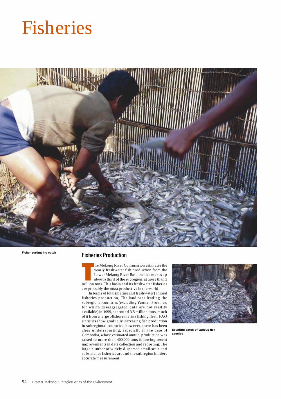
94 Greater Mekong Subregion Atlas of the Environment
Fisheries
Fisheries Production
The Mekong River Commission estimates theyearly freshwater fish production from theLower Mekong River Basin, which makes upabout a third of the subregion, at more than 3
million tons. This basin and its freshwater fisheriesare probably the most productive in the world.
In terms of total (marine and freshwater) annualfisheries production, Thailand was leading thesubregional countries (excluding Yunnan Province,for which disaggregated data are not readilyavailable) in 1999, at around 3.5 million tons, muchof it from a large offshore marine fishing fleet. FAOstatistics show gradually increasing fish productionin subregional countries; however, there has beenclear underreporting, especially in the case ofCambodia, whose estimated annual production wasraised to more than 400,000 tons following recentimprovements in data collection and reporting. Thelarge number of widely dispersed small-scale andsubsistence fisheries around the subregion hindersaccurate measurement.
Fisher sorting his catch
Bountiful catch of various fish
species
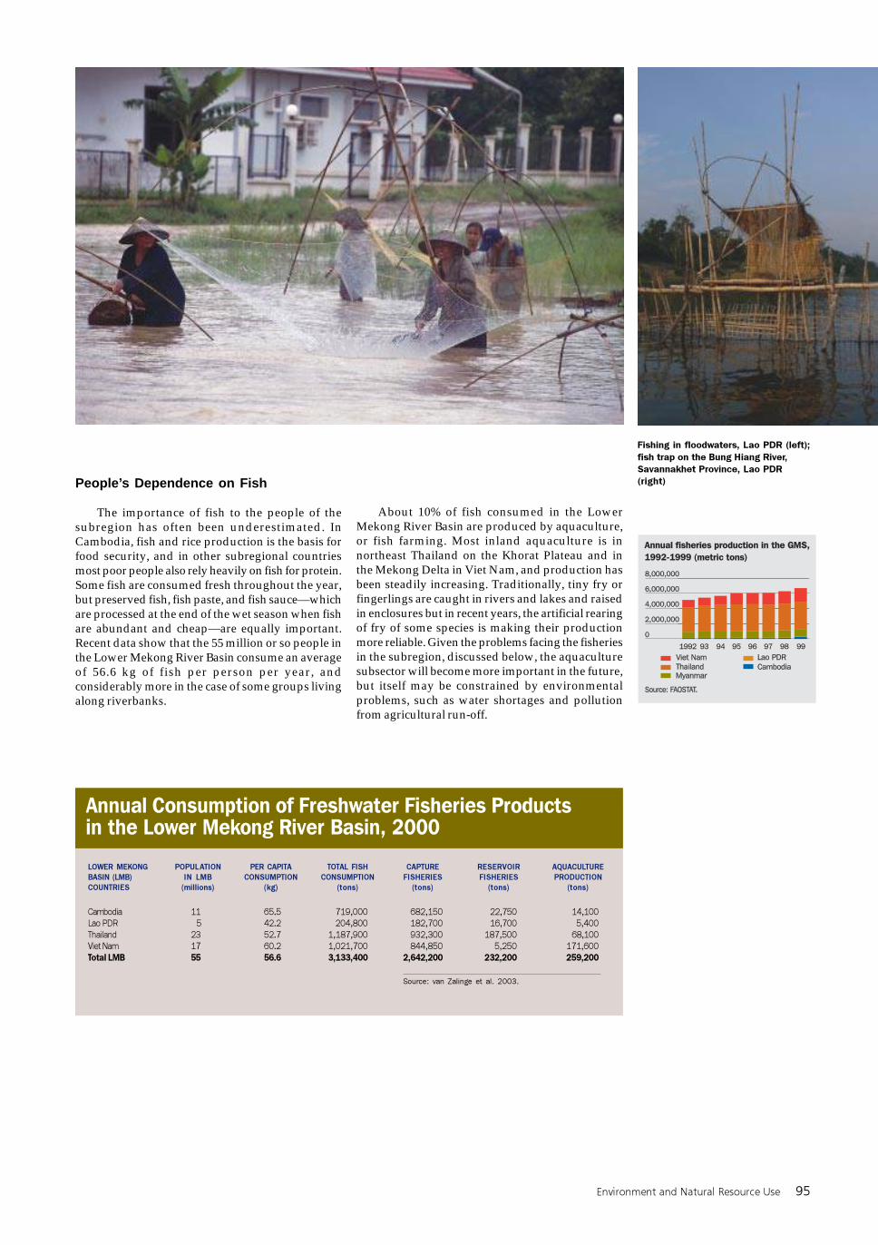
Environment and Natural Resource Use 95
Fishing in floodwaters, Lao PDR (left);
fish trap on the Bung Hiang River,
Savannakhet Province, Lao PDR
(right)People’s Dependence on Fish
The importance of fish to the people of thesubregion has often been underestimated. InCambodia, fish and rice production is the basis forfood security, and in other subregional countriesmost poor people also rely heavily on fish for protein.Some fish are consumed fresh throughout the year,but preserved fish, fish paste, and fish sauce—whichare processed at the end of the wet season when fishare abundant and cheap—are equally important.Recent data show that the 55 million or so people inthe Lower Mekong River Basin consume an averageof 56.6 kg of fish per person per year, andconsiderably more in the case of some groups livingalong riverbanks.
Annual Consumption of Freshwater Fisheries Productsin the Lower Mekong River Basin, 2000
LOWER MEKONG
BASIN (LMB)
COUNTRIES
POPULATION
IN LMB
(millions)
PER CAPITA
CONSUMPTION
(kg)
TOTAL FISH
CONSUMPTION
(tons)
CAPTURE
FISHERIES
(tons)
RESERVOIR
FISHERIES
(tons)
AQUACULTURE
PRODUCTION
(tons)
Cambodia
Lao PDR
Thailand
Viet Nam
Total LMB
11
5
23
17
55
65.5
42.2
52.7
60.2
56.6
719,000
204,800
1,187,900
1,021,700
3,133,400
682,150
182,700
932,300
844,850
2,642,200
22,750
16,700
187,500
5,250
232,200
14,100
5,400
68,100
171,600
259,200
Source: van Zalinge et al. 2003.
About 10% of fish consumed in the LowerMekong River Basin are produced by aquaculture,or fish farming. Most inland aquaculture is innortheast Thailand on the Khorat Plateau and inthe Mekong Delta in Viet Nam, and production hasbeen steadily increasing. Traditionally, tiny fry orfingerlings are caught in rivers and lakes and raisedin enclosures but in recent years, the artificial rearingof fry of some species is making their productionmore reliable. Given the problems facing the fisheriesin the subregion, discussed below, the aquaculturesubsector will become more important in the future,but itself may be constrained by environmentalproblems, such as water shortages and pollutionfrom agricultural run-off.
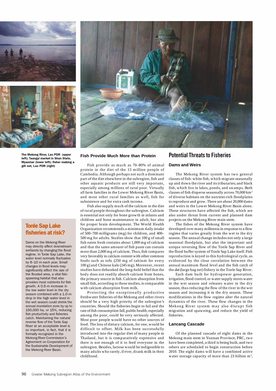
96 Greater Mekong Subregion Atlas of the Environment
Fish Provide Much More than Protein
Fish provide as much as 70–80% of animalprotein in the diet of the 13 million people ofCambodia. Although perhaps not such a dominantpart of the diet elsewhere in the subregion, fish andother aquatic products are still very important,especially among millions of rural poor. Virtuallyall farm families in the Lower Mekong River Basin,and most other rural families as well, fish forsubsistence and for extra cash income.
Fish also supply much of the calcium in the dietof rural people throughout the subregion. Calciumis essential not only for bone growth in infants andchildren and bone maintenance in adult, but alsofor proper brain development. The World HealthOrganization recommends a minimum daily intakeof 500–700 milligrams (mg) for children, and 400–500 mg for adults. Studies show that 100 g of smallfish eaten fresh contains about 1,000 mg of calciumand that the same amount of fish paste can containmore than 2,000 mg of calcium. Thus, fish comparesvery favorably in calcium content with other commonfoods such as tofu (250 mg of calcium for every100 g) and Chinese kale (245 mg). Moreover, recentstudies have debunked the long-held belief that thebody does not readily absorb calcium from bones,the primary source in fish. Calcium absorption fromsmall fish, according to these studies, is comparablewith calcium absorption from milk.
Protecting the exceptionally productivefreshwater fisheries of the Mekong and other riversshould be a very high priority of the subregion’scountries. Should the fisheries begin to fail and therate of fish consumption fall, public health, especiallyamong the poor, could be very seriously affected.Most poor people would have no other sources offood. The loss of dietary calcium, for one, would bedifficult to offset. Milk has been successfullyintroduced into the regular diet of many people inThailand, but it is comparatively expensive andthere is not enough of it to feed everyone in thesubregion. Besides, lactose would be indigestible tomany adults who rarely, if ever, drank milk in theirchildhood.
Potential Threats to Fisheries
Dams and Weirs
The Mekong River system has two generalclasses of fish: white fish, which migrate seasonallyup and down the river and its tributaries; and blackfish, which live in lakes, ponds, and swamps. Bothclasses of fish disperse seasonally across 70,000 km2
of diverse habitats on the nutrient-rich floodplainsto reproduce and grow. There are about 20,000 damsand weirs in the Lower Mekong River Basin alone.These structures have affected the fish, which arealso under threat from current and planned damprojects on the Mekong River main stem.
The fishes of the Mekong River system havedeveloped over many millennia in response to a flowregime that varies greatly from the wet to the dryseason. The annual change includes not only a largeseasonal floodplain, but also the important andunique reversing flow of the Tonle Sap River andthe flood buffer system of Tonle Sap Lake itself. Fishreproduction is keyed to this hydrological cycle, asevidenced by the close correlation between theannual maximum flood level and the fish catch ofthe dai (large bag net) fishery in the Tonle Sap River.
Each dam built for hydropower generation,irrigation, flood control, or water supply stores waterin the wet season and releases water in the dryseason, thus reducing the flow of the river in the wetseason and increasing it in the dry season. Thesemodifications in the flow regime alter the naturaldynamics of the river. These flow changes in theMekong River system may also disrupt fishmigration and spawning, and reduce the yield offisheries.
Lancang Cascade
Of the planned cascade of eight dams in theMekong main stem in Yunnan Province, PRC, twohave been completed, a third is being built, and twoothers are scheduled to begin construction before2010. The eight dams will have a combined activewater storage capacity of more than 23 billion m3,
The Mekong River, Lao PDR (upper
left); Taungyi market in Shan State,
Myanmar (lower left); fisher making a
gill net, Lao PDR (right)
Tonle Sap Lakefisheries at risk?
Dams on the Mekong River
may directly affect downstream
wetlands by changing the flood
regime. In Tonle Sap Lake, the
water level normally fluctuates
by 6–10 m each year. Small
changes in flood levels may
significantly affect the size of
the flooded area, a vital fish-
spawning habitat that also
provides most nutrients for fish
growth. A 0.5-m increase in
the low water level in the dry
season combined with a 1.0-m
drop in the high water level in
the wet season could shrink the
annual inundation zone by up to
150,000 ha, or 15%, reducing
fish productivity and fisheries
catch. Maintaining the natural
reverse flow of the Tonle Sap
River at an acceptable level is
so important, in fact, that it is
formally recognized in the
Mekong River Commission’s
Agreement on Cooperation for
the Sustainable Development of
the Mekong River Basin.
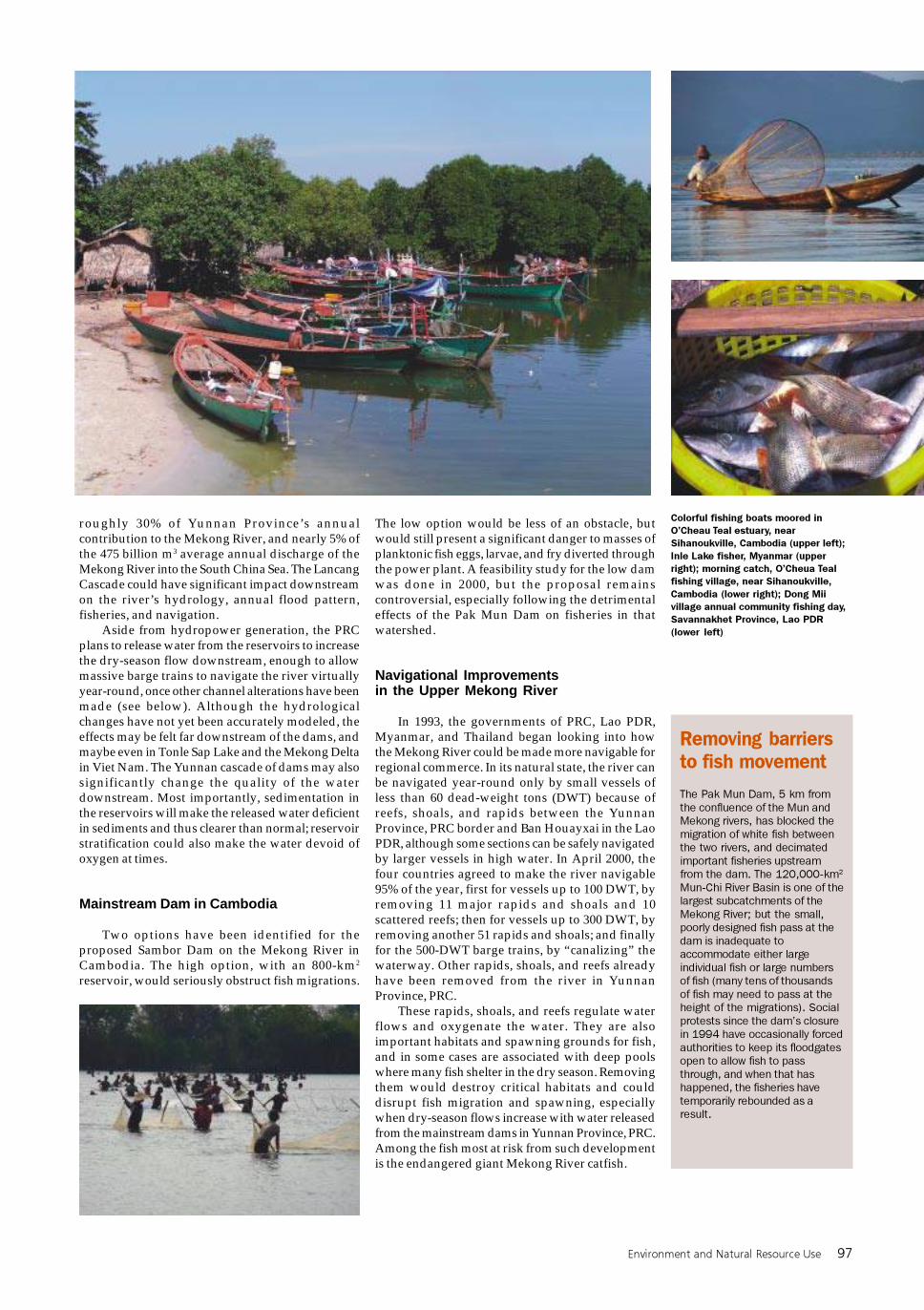
Environment and Natural Resource Use 97
roughly 30% of Yunnan Province’s annualcontribution to the Mekong River, and nearly 5% ofthe 475 billion m3 average annual discharge of theMekong River into the South China Sea. The LancangCascade could have significant impact downstreamon the river’s hydrology, annual flood pattern,fisheries, and navigation.
Aside from hydropower generation, the PRCplans to release water from the reservoirs to increasethe dry-season flow downstream, enough to allowmassive barge trains to navigate the river virtuallyyear-round, once other channel alterations have beenmade (see below). Although the hydrologicalchanges have not yet been accurately modeled, theeffects may be felt far downstream of the dams, andmaybe even in Tonle Sap Lake and the Mekong Deltain Viet Nam. The Yunnan cascade of dams may alsosignificantly change the quality of the waterdownstream. Most importantly, sedimentation inthe reservoirs will make the released water deficientin sediments and thus clearer than normal; reservoirstratification could also make the water devoid ofoxygen at times.
Mainstream Dam in Cambodia
Two options have been identified for theproposed Sambor Dam on the Mekong River inCambodia. The high option, with an 800-km2
reservoir, would seriously obstruct fish migrations.
The low option would be less of an obstacle, butwould still present a significant danger to masses ofplanktonic fish eggs, larvae, and fry diverted throughthe power plant. A feasibility study for the low damwas done in 2000, but the proposal remainscontroversial, especially following the detrimentaleffects of the Pak Mun Dam on fisheries in thatwatershed.
Navigational Improvementsin the Upper Mekong River
In 1993, the governments of PRC, Lao PDR,Myanmar, and Thailand began looking into howthe Mekong River could be made more navigable forregional commerce. In its natural state, the river canbe navigated year-round only by small vessels ofless than 60 dead-weight tons (DWT) because ofreefs, shoals, and rapids between the YunnanProvince, PRC border and Ban Houayxai in the LaoPDR, although some sections can be safely navigatedby larger vessels in high water. In April 2000, thefour countries agreed to make the river navigable95% of the year, first for vessels up to 100 DWT, byremoving 11 major rapids and shoals and 10scattered reefs; then for vessels up to 300 DWT, byremoving another 51 rapids and shoals; and finallyfor the 500-DWT barge trains, by “canalizing” thewaterway. Other rapids, shoals, and reefs alreadyhave been removed from the river in YunnanProvince, PRC.
These rapids, shoals, and reefs regulate waterflows and oxygenate the water. They are alsoimportant habitats and spawning grounds for fish,and in some cases are associated with deep poolswhere many fish shelter in the dry season. Removingthem would destroy critical habitats and coulddisrupt fish migration and spawning, especiallywhen dry-season flows increase with water releasedfrom the mainstream dams in Yunnan Province, PRC.Among the fish most at risk from such developmentis the endangered giant Mekong River catfish.
Colorful fishing boats moored in
O’Cheau Teal estuary, near
Sihanoukville, Cambodia (upper left);
Inle Lake fisher, Myanmar (upper
right); morning catch, O’Cheua Teal
fishing village, near Sihanoukville,
Cambodia (lower right); Dong Mii
village annual community fishing day,
Savannakhet Province, Lao PDR
(lower left)
Removing barriersto fish movement
The Pak Mun Dam, 5 km from
the confluence of the Mun and
Mekong rivers, has blocked the
migration of white fish between
the two rivers, and decimated
important fisheries upstream
from the dam. The 120,000-km2
Mun-Chi River Basin is one of the
largest subcatchments of the
Mekong River; but the small,
poorly designed fish pass at the
dam is inadequate to
accommodate either large
individual fish or large numbers
of fish (many tens of thousands
of fish may need to pass at the
height of the migrations). Social
protests since the dam’s closure
in 1994 have occasionally forced
authorities to keep its floodgates
open to allow fish to pass
through, and when that has
happened, the fisheries have
temporarily rebounded as a
result.
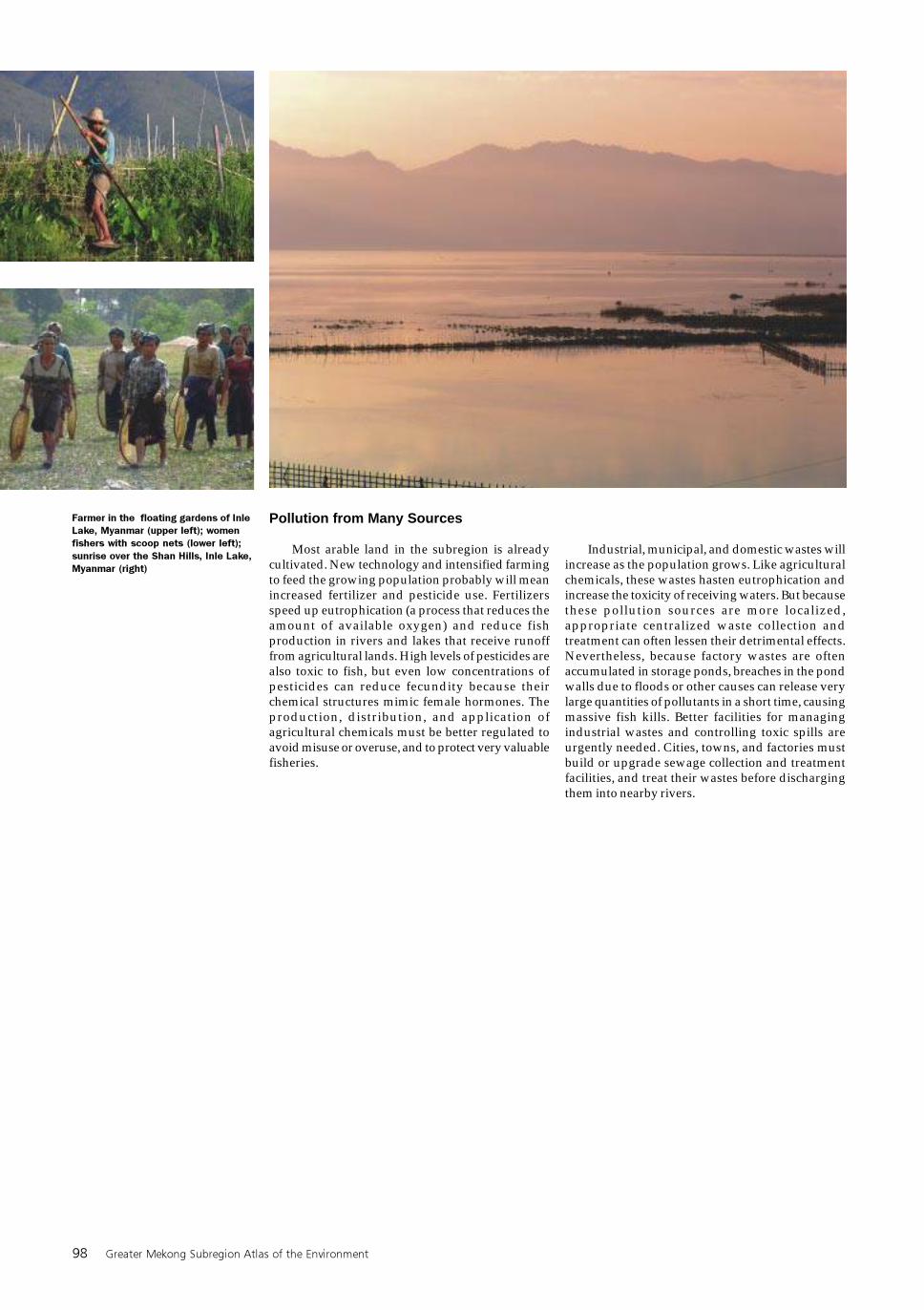
98 Greater Mekong Subregion Atlas of the Environment
Pollution from Many Sources
Most arable land in the subregion is alreadycultivated. New technology and intensified farmingto feed the growing population probably will meanincreased fertilizer and pesticide use. Fertilizersspeed up eutrophication (a process that reduces theamount of available oxygen) and reduce fishproduction in rivers and lakes that receive runofffrom agricultural lands. High levels of pesticides arealso toxic to fish, but even low concentrations ofpesticides can reduce fecundity because theirchemical structures mimic female hormones. Theproduction, distribution, and application ofagricultural chemicals must be better regulated toavoid misuse or overuse, and to protect very valuablefisheries.
Farmer in the floating gardens of Inle
Lake, Myanmar (upper left); women
fishers with scoop nets (lower left);
sunrise over the Shan Hills, Inle Lake,
Myanmar (right)
Industrial, municipal, and domestic wastes willincrease as the population grows. Like agriculturalchemicals, these wastes hasten eutrophication andincrease the toxicity of receiving waters. But becausethese pollution sources are more localized,appropriate centralized waste collection andtreatment can often lessen their detrimental effects.Nevertheless, because factory wastes are oftenaccumulated in storage ponds, breaches in the pondwalls due to floods or other causes can release verylarge quantities of pollutants in a short time, causingmassive fish kills. Better facilities for managingindustrial wastes and controlling toxic spills areurgently needed. Cities, towns, and factories mustbuild or upgrade sewage collection and treatmentfacilities, and treat their wastes before dischargingthem into nearby rivers.