Embed Size (px)
Citation preview

BIODIVERSITY ASSESSMENT REPORT REF: 21TMX02 i
BIODIVERSITY ASSESSMENT REPORT
Proposed Development
Lot 10 and 11, DP 271141
14 Distribution Drive
Orchard Hills
30 June 2021
(REF: 21TMX02)

BIODIVERSITY ASSESSMENT REPORT REF: 21TMX02 ii
BIODIVERSITY ASSESSMENT REPORT
Proposed Residential Development
Lot 10 and 11, DP 271141, 14 Distribution Drive, Orchard Hills
Report authors:
George Plunkett B. Sc. (Hons.), PhD – Botanist – Accredited Assessor no. BAAS19010
Michael Sheather-Reid B. Nat. Res. (Hons.) – Managing Director Accredited Assessor no.
BAAS17085
Corey Mead B. App. Sc. – Contract Fauna Ecologist
Flora survey: George Plunkett B. Sc. (Hons.), PhD – Botanist – Accredited Assessor no. BAAS19010
Fauna survey: Corey Mead B. App. Sc. – Contract Fauna Ecologist
Plans prepared: Sandy Cardow B. Sc.
Approved by: Michael Sheather-Reid (Accredited Assessor no. BAAS17085)
Date: 30/06/21
File: 21TMX02
This document is copyright © Travers bushfire & ecology 2021
Disclaimer:
This report has been prepared to provide advice to the client on matters pertaining to the particular and specific development proposal as advised
by the client and / or their authorised representatives. This report can be used by the client only for its intended purpose and for that purpose only.
Should any other use of the advice be made by any person, including the client, then this firm advises that the advice should not be relied upon. The
report and its attachments should be read as a whole and no individual part of the report or its attachments should be interpreted without reference
to the entire report.
The mapping is indicative of available space and location of features which may prove critical in assessing the viability of the proposed works.
Mapping has been produced on a map base with an inherent level of inaccuracy, the location of all mapped features are to be confirmed by a
registered surveyor.

BIODIVERSITY ASSESSMENT REPORT REF: 21TMX02 iii
LIST OF ABBREVIATIONS
APZ asset protection zone
BAM Biodiversity Assessment Method (2020)
BAR Biodiversity Assessment Report
BC Act Biodiversity Conservation Act (2016)
BC Reg Biodiversity Conservation Regulation (2017)
BCAR Biodiversity Certification Assessment Report
BDAR Biodiversity Development Assessment Report
BOS Biodiversity Offset Scheme
BPA bushfire protection assessment
BSSAR Biodiversity Stewardship Site Assessment Report
CEEC Critically endangered ecological community
CM Act Coastal Management Act 2016
DAWE Department of Agriculture, Water and the Environment.
DCP development control plan
DEC NSW Department of Environment and Conservation (superseded by DECC from April 2007)
DECC NSW Department of Environment and Climate Change (superseded by DECCW from October 2009)
DECCW NSW Department of Environment, Climate Change and Water (superseded by OEH from April 2011)
DEWHA Commonwealth Department of Environment, Water, Heritage & the Arts (superseded by SEWPAC)
DOEE Commonwealth Department of Environment & Energy (superseded by DAWE)
DPIE NSW Department of Planning, Industry and Environment
EEC endangered ecological community
EPA Environment Protection Authority
EP&A Act Environmental Planning and Assessment Act (1979)
EPBC Act Environment Protection and Biodiversity Conservation Act (1999)
FM Act Fisheries Management Act
IBRA Interim Biogeographic Regionalisation for Australia
LEP local environmental plan
LGA local government area
LLS Act Local Land Services Act (2013)
NES national environmental significance
NPW Act National Parks and Wildlife Act (1974)
NRAR Natural Resources Access Regulator (NSW)
NSW DPI NSW Department of Industry and Investment
OEH Office of Environment and Heritage (superseded by DPIE from August 2019)
PCT plant community type
PFC projected foliage cover
RFS NSW Rural Fire Service
ROTAP rare or threatened Australian plants
SAII Serious And Irreversible Impacts
SEPP State Environmental Planning Policy
SEWPAC Commonwealth Dept. of Sustainability, Environment, Water, Population & Communities (superseded by DOEE)
SIS species impact statement
SULE safe useful life expectancy
TEC threatened ecological community
TPZ tree preservation zone
TSC Act Threatened Species Conservation Act (1995) – superseded by the Biodiversity Conservation Act (2016)
VMP vegetation management plan

BIODIVERSITY ASSESSMENT REPORT REF: 21TMX02 iv
TABLE OF CONTENTS
1. INTRODUCTION ................................................................................................. 1
Purpose ................................................................................................... 1
1.1.1 Terminology ........................................................................................................... 3
Site description ........................................................................................ 3
1.2.1 Site overview ......................................................................................................... 3 1.2.2 Landscape features ............................................................................................... 4 1.2.3 Zoning .................................................................................................................... 4 1.2.4 Proposed development .......................................................................................... 5
2. IMPACTS ON BIODIVERSITY VALUES ............................................................ 8
Vegetation Abundance ............................................................................ 8
Vegetation Integrity................................................................................ 13
Threatened Species Abundance............................................................ 13
Habitat Suitability ................................................................................... 13
Habitat Connectivity ............................................................................... 13
Threatened Species Movement ............................................................. 14
Flight Path Integrity................................................................................ 14
Water Sustainability ............................................................................... 14
Prescribed Impacts ................................................................................ 14
3. CONCLUSION ................................................................................................... 16

BIODIVERSITY ASSESSMENT REPORT REF: 21TMX02 v
Figures
Figure 1 – Study area. Source: Nearmap (2021). .................................................................. 1 Figure 2 – Zoning .................................................................................................................. 5 Figure 3 – Site Plan .............................................................................................................. 6 Figure 4 – Flora & fauna survey effort & results .................................................................... 7 Figure 5 – Biodiversity Values Map ....................................................................................... 8 Figure 6 – Aerial imagery of the site dated 5 Sept 2017 ........................................................ 9 Figure 7 – BioNet records of GGBF within 10 km ................................................................ 24
Tables
Table 1 – Site features .......................................................................................................... 3 Table 2 – Landscape features ............................................................................................... 4 Table 3 – Flora species recorded (Appendix 1) ................................................................... 20
Appendices
Staff qualifications and experience ........................................................ 17 Flora species list .................................................................................... 20 Green and golden bell frog potential habitat and impact assessment .... 22 Habitat assessment proforma ................................................................ 28

BIODIVERSITY ASSESSMENT REPORT REF: 21TMX02 1
1. INTRODUCTION
Travers bushfire & ecology has been engaged to undertake a biodiversity assessment report
for the purposes of a BDAR waiver in relation to the State Significance Development (SSD)
proposal within Lot 10 and 11, DP 271141, at 14 Distribution Drive, Orchard Hills within the
Penrith City Council local government area (LGA). The extent of this entire lot is shown in
Figure 1 and will hereafter be referred to as the ‘study area’.
The proposal shall be assessed under the Biodiversity Conservation Act (BC Act), 2016.
Figure 1 – Study area. Source: Nearmap (2021).
The proponent of the SSD proposal is Mr Ben Caporale of TMX, at 68 Moncur Street, Woollahra, NSW, 2025. His contact details are;
- Email: [email protected] - Phone: 0409 853 224
Purpose
Biodiversity assessment required for an SSD is described in Section 7.9 of the BC Act. Clause
2 of section 7.9 of this Act indicates that an application for development consent for an SSD:
is to be accompanied by a biodiversity development assessment report unless the
Planning Agency Head and the Environment Agency Head determine that the

BIODIVERSITY ASSESSMENT REPORT REF: 21TMX02 2
proposed development is not likely to have any significant impact on biodiversity
values.
The purpose of this Biodiversity Assessment Report is to determine whether the SSD proposal
is likely to have any significant impact on biodiversity values. Under Section 1.5 of the BC Act,
biodiversity values are defined as:
vegetation integrity, being the degree to which the composition, structure and function
of vegetation at a particular site and the surrounding landscape has been altered from
a near natural state
habitat suitability, being the degree to which the habitat needs of threatened species
are present at a particular site
Also, Section 1.4 of the Biodiversity Conservation Regulation 2017 lists biodiversity values
that are not included in the BC Act. The listed biodiversity values are described as:
vegetation abundance, being the occurrence and abundance of vegetation at a
particular site
threatened species abundance, being the occurrence and abundance of threatened
species or threatened ecological communities, or their habitat, at a particular site
habitat connectivity, being the degree to which a particular site connects different areas
of habitat of threatened species to facilitate the movement of those species across
their range
threatened species movement, being the degree to which a particular site contributes
to the movement of threatened species to maintain their lifecycle
flight path integrity, being the degree to which the flight paths of protected animals over
a particular site are free from interference
water sustainability, being the degree to which water quality, water bodies and
hydrological processes sustain threatened species and threatened ecological
communities at a particular site
In addition, Section 1.6 of the Biodiversity Conservation Regulation lists the following
additional biodiversity impacts:
the impacts of development on the following habitat of threatened species or ecological
communities:
o karst, caves, crevices, cliffs and other geological features of significance,
o rocks,
o human made structures,
o non-native vegetation,
the impacts of development on the connectivity of different areas of habitat of
threatened species that facilitates the movement of those species across their range,
the impacts of development on movement of threatened species that maintains their
lifecycle,
the impacts of development on water quality, water bodies and hydrological processes
that sustain threatened species and threatened ecological communities (including from
subsidence or upsidence resulting from underground mining or other development),
the impacts of wind turbine strikes on protected animals,
the impacts of vehicle strikes on threatened species of animals or on animals that are
part of a threatened ecological community.
BIODIVERSITY ASSESSMENT REPORT REF: 21TMX02 3
1.1.1 Terminology
Throughout this report the terms development footprint and study area are used. It is important
to have a thorough understanding of these terms as they apply to the assessment.
Development footprint means the area directly affected by the proposal. It has the same
meaning as “subject land” defined below.
Study area is the portion of land that encompasses all surveys undertaken and is usually all
land contained within the designated property boundary. The study area extends as far as is
necessary to assess all important biodiversity values known and likely to occur within the
subject land and includes the development footprint and any additional areas which are likely
to be affected by the proposal, either directly or indirectly.
Direct impacts are those that directly affect the habitat and individuals. They include, but are
not limited to, death through clearing, predation, trampling, poisoning of the animal/plant itself
and the removal of suitable habitat. When applying each factor, consideration must be given
to all of the likely direct impacts of the proposed activity or development.
Indirect impacts occur when project-related activities affect species, populations or
ecological communities in a manner other than direct loss. Indirect impacts can include loss
of individuals through starvation, exposure, predation by domestic and/or feral animals, loss
of breeding opportunities, loss of shade/shelter, deleterious hydrological changes, increased
soil salinity, erosion, inhibition of nitrogen fixation, weed invasion, fertiliser drift, or increased
human activity within or directly adjacent to sensitive habitat areas. As with direct impacts,
consideration must be given, when applying each factor, to all of the likely indirect impacts of
the proposed activity or development.
Site description
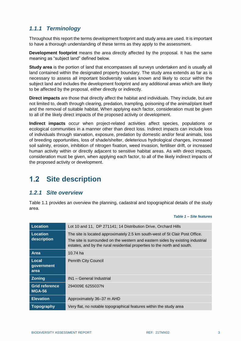
1.2.1 Site overview
Table 1.1 provides an overview the planning, cadastral and topographical details of the study
area.
Table 1 – Site features
Location Lot 10 and 11, DP 271141; 14 Distribution Drive, Orchard Hills
Location
description
The site is located approximately 2.5 km south-west of St Clair Post Office.
The site is surrounded on the western and eastern sides by existing industrial
estates, and by the rural residential properties to the north and south.
Area 10.74 ha
Local
government
area
Penrith City Council
Zoning IN1 – General Industrial
Grid reference
MGA-56
294009E 6255037N
Elevation Approximately 36–37 m AHD
Topography Very flat, no notable topographical features within the study area

BIODIVERSITY ASSESSMENT REPORT REF: 21TMX02 4
Catchment and
drainage
The site is effectively flat but is tiered such that there is a smaller southern tier
that drops down to the main area in the north. The site drains to the north, west
and east into constructed swales.
Existing land
use
Vacant land
1.2.2 Landscape features
Table 1.2 examines the landscape features of the proposed development site in accordance
with the BAM.
Table 2 – Landscape features
Patch size 5–24 ha
IBRA bioregions and subregions
Sydney Basin bioregion – Cumberland subregion
NSW landscape region and area (ha)
Cumberland Plain
Cleared areas Approximately 10.74 ha of land within the study area is cleared
Connectivity features
There is very poor connectivity to the development footprint. There is existing industrial development to the west and east, while rural residential properties exist to the north and south of the study area. These rural properties consist of large areas of cleared grassy pasture with sparsely scattered trees.
Geology and soils
Geology; Wianamatta Shales across approximately 85% of the study area. Fine-grained Quaternary in the north-western corner. Soils; Kurosols (Natric) across 40% of the south-eastern portion of the site. Hydrosols across 60% of the north-western portion of the site.
1.2.3 Zoning
The site is currently zoned IN1 under the Penrith LEP of 2010 (Figure 2) which is for general
industrial use.

BIODIVERSITY ASSESSMENT REPORT REF: 21TMX02 5
Figure 2 – Zoning
(Source: Planning Portal, 2021)
1.2.4 Proposed development
The proposed development consists of an industrial facility, adjacent to the recently
constructed warehouse facility of SSD-9429 (sit plan is shown on Figure 3). The proposed
development would be operated by Snack Brands Australia, concurrently with the
neighbouring site.
This proposal involves:
a new purpose-built industrial food manufacturing facility (approximately 20,225 m2 of
Gross Floor Area (GFA)) at 14 Distribution Drive, Orchard Hills; and
an adjustment to the operations of the existing warehouse and distribution facility at 2
Distribution Drive, Orchard Hills, to include industrial food manufacturing.
Current Zoning
IN1

BIODIVERSITY ASSESSMENT REPORT REF: 21TMX02 6
Figure 3 – Site Plan

BIODIVERSITY ASSESSMENT REPORT REF: 21TMX02 7
Figure 4 – Flora & fauna survey effort & results

BIODIVERSITY ASSESSMENT REPORT REF: 21TMX02 8
2. IMPACTS ON BIODIVERSITY VALUES
Figure 2-1 shows that Biodiversity Values Land is mapped to the south of the proposed development
area within Lot 11 DP271141 (No. 2 Distribution Drive). This mapped area is currently occupied by the
existing facility, and no vegetation or other habitat features are present.
Figure 5 – Biodiversity Values Map
Vegetation Abundance
Aerial imagery shows that the entire site was previously cleared and devoid of any vegetation from
September 2017. All currently existing vegetation is therefore derived following this date.

BIODIVERSITY ASSESSMENT REPORT REF: 21TMX02 9
Figure 6 – Aerial imagery of the site dated 5 Sept 2017
Site inspection on 18 May 2021 found the following vegetation within the development footprint:
Grassland
This occupies the majority of the site, and is dominated by exotic grasses including Chloris virgata,
Chloris gayana, Cenchrus clandestina, Paspalum spp., Setaria parviflora, Eragrostis curvula and
Panicum maximum. Exotic forbs are also abundant and include Trifolium repens, Plantago
lanceolata, Sonchus oleraceus, Hypochaeris radicata, Cirsium vulgare, Modiola caroliniana,
Medicago sp. and Conyza bonariensis. Few native ground cover species are present except
Cynodon dactylon. There are a few isolated shrubs such as exotic/non-native Acacia saligna, A.
podalyriifolia, Lycium ferocissimum and Genista spp., plus the occasional native A.
parramattensis and A. falcata.
Derived aquatic vegetation
This vegetation occurs within the constructed drainages and as fringing vegetation surrounding
the stormwater dam. It is comprised of a mix of exotic and native species. Exotic species include
Cyperus eragrostis, Myriophyllum aquaticum and Alternanthera philoxeroides. Native species
include Typha orientalis, Persicaria decipiens, Juncus usitatus, Schoenoplectus mucronatus and
Marsilea hirsuta.

BIODIVERSITY ASSESSMENT REPORT REF: 21TMX02 10
Photo 1 – grassland in the south of the development footprint, looking north.
Photo 2 – occasional non-native and exotic shrubs within grassland vegetation in the north of the development footprint

BIODIVERSITY ASSESSMENT REPORT REF: 21TMX02 11
Photo 3 – grassland in the north-west of the development footprint, looking south-east.
Photo 4 – artificial dam in the north-west corner of the site, with fringing vegetation.

BIODIVERSITY ASSESSMENT REPORT REF: 21TMX02 12
Photo 5 – derived aquatic vegetation within the northern drainage line
Photo 6 – derived aquatic vegetation within the western drainage line

BIODIVERSITY ASSESSMENT REPORT REF: 21TMX02 13
Vegetation Integrity
All existing vegetation is derived and highly disturbed. The general absence of native species from the
grassland areas indicates that this vegetation has very low to no vegetation integrity.
Vegetation surrounding the dam and along the drainage lines has slightly higher vegetation integrity,
with a greater abundance of native species. This vegetation and the associated waterbodies may
provide marginal habitat for Green and Golden Bell Frog (GGBF), although due to the previous
disturbance on site and the isolation of this habitat from other areas potential habitat, it is very unlikely
that GGBF would use this habitat. GGBF is assessed in further detail within Appendix 3.
As the vast majority of the vegetation present is exotic and there are a few native species present, it is
not considered that vegetation on site provides sufficient vegetation integrity to warrant detailed
assessment.
Threatened Species Abundance A detailed consideration of GGBF potential habitat within the study area, potential core breeding habitat in the nearby locality and local records has been provided in Appendix 3. This includes a Test of Significance in accordance with Section 7.3 of the BC Act. From this it can be summarised that:
- The study area does not likely support GGBF breeding and shelter habitat in the absence
of use of other localised habitat areas used for core breeding;
- The study area is now surrounded by recently constructed industrial development providing
a barrier to the other potential breeding locations that remain.
- The other local breeding opportunities that do exist are not likely to support core habitat for
a local population;
- There are no local or recent records to suggest that a population persists in the locality.
It is therefore concluded that the study area is not of any likely of importance or use to GGBF and a
viable local population is not likely present to warrant any further survey or assessment.
Habitat Suitability
As the site has previously been cleared it provides very low to no potential habitat for threatened species. The only species with any potential to utilise the site is GGBF: vegetation surrounding the dam and along the drainage lines may provide marginal habitat for this species. A detailed assessment for GGBF is provided in Appendix 3, and concludes that as GGBF are not likely to be present. Therefore the proposal will not cause a significant impact on any threatened species, including GGBF.
Habitat Connectivity
The site is isolated on all aspects from any areas of native vegetation or habitat by existing roads,
buildings, hardstand and open paddocks. Likewise, the site does not contribute any connectivity values
within the landscape. Figure 1 shows local connectivity relative to the study area.

BIODIVERSITY ASSESSMENT REPORT REF: 21TMX02 14
Threatened Species Movement
The site does not contribute any connectivity values within the landscape and as such does not
contribute to the movement of threatened species across the landscape. The proposal will therefore
not impact on the threatened species movement.
Flight Path Integrity
The site is not significant for the flight paths of species that have been recorded in the locality as it
already occurs in a highly fragmented landscape and most flying species are likely to utilise South
Creek that occurs to the west of the site. Threatened microbats that may forage in the area are not
likely to be impeded by the proposal.
Therefore, the proposal is not likely to significantly impact on the ability of flying species to move
throughout the locality.
Water Sustainability
All waterbodies and drainage lines on site are artificial and are not of any likely importance for
threatened species. The site is of sufficient distance from natural waterways to avoid impacts (700 m),
and it is expected that stormwater management will be conducted to avoid impacts to water quality,
water bodies and hydrological processes.
Prescribed Impacts
The following potential impacts on biodiversity values as a result of the proposal are prescribed (as per
clause 6.1 of the BC Reg) as biodiversity impacts to be assessed under the biodiversity offsets scheme:
Karst, caves, crevices, cliffs and other geological features of significance,
These features are absent from the site.
Rocks,
There are no large rocks within the site.
Human made structures,
There are no human-made structures suitable to provide habitat for any threatened
species.
Non-native vegetation,
Non-native vegetation covers the vast majority of the site. Vegetation in the dam and
drainage lines provide marginal habitat for GGBF. Appendices 3 & 4 provides a
detailed assessment of GGBF and has concluded that this vegetation is not of any
likely importance or use to GGBF and a viable local population is not likely present to
warrant any further survey or assessment. The remaining vegetation, which is

BIODIVERSITY ASSESSMENT REPORT REF: 21TMX02 15
managed exotic grassland, does not provide any potential habitat for threatened
species.
Connectivity of different areas of habitat of threatened species that facilitates the movement of
those species across their range,
As noted above, the site does not contain any connective values between different
areas of habitat suitable for use by threatened species.
Movement of threatened species that maintains their lifecycle,
The site is isolated on all aspects from any areas of native vegetation or habitat by
existing roads, buildings, hardstand and open paddocks. The site is not of any likely
importance for threatened species, including GGBF (Appendix 4). As such, the
proposal will not impact the movement of any threatened species.
Water quality, water bodies and hydrological processes that sustain threatened species and
threatened ecological communities (including from subsidence or upsidence resulting from
underground mining or other development),
As stated in Section 2.8, all waterbodies and drainage lines on site are artificial and
are not of any likely importance for threatened species. The site is of sufficient
distance from natural waterways to avoid impacts (700 m), and it is expected that
stormwater management will be conducted to avoid impacts to water quality, water
bodies and hydrological processes.
Wind turbine strikes on protected animals,
The proposal does not involve wind turbines and therefore there will be no impact
from wind turbine strikes.
Vehicle strikes on threatened species of animals or on animals that are part of a threatened
ecological community
The proposal is unlikely to increase the chance of vehicle strikes on threatened
species of animals or on animals that are part of a threatened ecological community.
Internal roads within the development footprint will have a low speed limit and
therefore vehicle strikes will be very unlikely.

BIODIVERSITY ASSESSMENT REPORT REF: 21TMX02 16
3. CONCLUSION
Travers bushfire & ecology has completed a biodiversity assessment report (BAR) for the purposes of
a BDAR waiver request in relation to the State Significance Development (SSD) proposal within Lot 10
and 11, DP 271141, at 14 Distribution Drive, Orchard Hills within the Penrith City Council local
government area (LGA).
In summary, this assessment has found:
The site is highly disturbed and previously completely cleared (Figure 1)
All vegetation present is derived and almost entirely comprised of exotic species
The study area provides vegetated stormwater drains and a dam providing potential frog
breeding habitat. Detailed assessment of Green and Golden Bell Frog provided in Appendix 3
and Appendix 4 (including a Test of Significance) concludes that the study area is not of any
likely importance or use to Green and Golden Bell Frog and a viable local population is not
likely present to warrant any further survey or assessment.
Based on this assessment, it is concluded that the proposal will not cause a significant impact on
biodiversity values including threatened species. As such, a BDAR waiver request should be granted
for the proposal.

BIODIVERSITY ASSESSMENT REPORT REF: 21TMX02 17
STAFF QUALIFICATIONS AND EXPERIENCE

BIODIVERSITY ASSESSMENT REPORT REF: 21TMX02 18
Team member
(role)
Accreditations and qualifications
Experience Employment history Skills and expertise
George Plunkett (Botanist)
Biodiversity Assessment Method (BAM) Assessor (Accredited Assessor no. BAAS19010)
PhD – Plant systematics, ecology and evolution
Bachelor of Science (Honours) – Ecology / Botany, University of New England (UNE), NSW
Four-wheel drive vehicle operation
Senior First Aid Certificate
George has 12 years of experience as a plant taxonomist, flora ecologist and botanist, including a PhD in plant systematics, ecology and evolution, and has a very well-developed understanding of the Australian flora.
2017-Current: Botanist, Travers bushfire & ecology
2016-2017: Research Botanist, UNE
2010-2011: Research Botanist, UNE
2008-2009: Plant Ecologist, Ecotone Flora Fauna Consultants
High-quality report writing
Application of the BAM and BOS
Highly experienced in botanical survey and ecological analysis
Plant identification and taxonomy
Flora and fauna assessment
Threatened species, ecological communities and endangered population surveys and analysis
Habitat tree analysis and assessment
Noxious weed identification
Tree assessment
Michael Sheather-Reid (Managing Director)
Bachelor of Natural Resources (Hons), University of New England
BioBanking Assessor
Engineering Assistant – CAD Drafting
MUSIC Modelling – Stormwater quality and quantity modelling (RMIT)
Bush Regeneration II Certificate, Ryde TAFE
NSW WorkCover OHS Construction Induction
Chemical Handling Certificate, Ryde TAFE
Michael has a wealth of experience in environmental consulting and on ground management of bushland, wetland and riparian habitats having undertaken environmental assessment, ecological consultancy and restoration in both the private and public sectors for over 22 years.
2007- Current: Senior Ecologist, Travers bushfire & ecology
2004 -2007: Senior Ecologist, Conacher Travers Pty Ltd
2002-2004: Project Manager, Urban Bushland Management Projects Pty Ltd
1999-2002: Project Manager Sustainable Vegetation Management Pty Ltd
1995-1999: Managing Director Sheather-Reid & Associates Pty Ltd
1996-1997: NSW Landcare Liaison Officer, Australian Conservation Foundation
1992-1995: Environmental Officer, Dept. Land & Water Conservation
1990-1992: Scientific Officer Dept. of Water Resources
Ecological assessment
Rezoning studies
Biodiversity offset planning
Restoration management and coordination
Biotic and soil translocation
Watercourse assessment
Project ecologist services
EPBC Act referrals
Controlled Activity Approvals
Vegetation management plans
Sandy Cardow (GIS officer)
Bachelor of Science (Biological Sciences) (Macquarie University)
Sandy has over twenty years of experience in Spatial Information (Geographic Information Systems (GIS)), which includes preparation of mapping in local government roles and has completed a Bachelor of Science (Biological Sciences).
2017 – Current: GIS Officer, Travers bushfire & ecology
2014 – 2017: GIS Consultant, Forestry Corp. NSW
2005 – 2011: GIS Analyst, Forests NSW
2002 – 2005: GIS Data Librarian, Forests NSW
2000 – 2002: GIS Operator, Forests NSW
2000 – 2002: GIS Data Import / Export Officer, Forests NSW
1999 2000: GIS Project Officer DECC
1998 – 1999: GIS Support Officer DECC
1998 – 1999: Wildlife Atlas Data Entry Officer DECC
Geographic Information Systems
Data management and analysis
Spatial databases and database administration
GPS
Cartography
Natural resource management
Client liaison

BIODIVERSITY ASSESSMENT REPORT REF: 21TMX02 19
Team member
(role)
Accreditations and qualifications
Experience Employment history Skills and expertise
Corey Mead (Contract fauna ecologist)
Southern Cross University – B. App. Sc.
BAM Accredited Assessor (BAAS.19050)
Accredited BioBanking Assessor (No.231)
Scientific License (Sl102477)
Animal Ethics Permit (TRIM V20/32969)
Bionet Sensitive Species Data License (No. 1589)
Licence to Harm Protected Animals (MWL000103525)
Possum Catch & Release Licence (MWL000103525)
Reptile Catch & Release Licence (MWL000103525)
Tre climbing techniques (AHCARB312)
Chainsaw operation
NSW NPWS – Intro to ArcView GIS
First Aid Certificate (HLTAID003)
Class C vehicle, Boat & Divers Licences
OHS General Induction (CGI00761144SEQ1)
Risk Assessment Training (Taronga Zoo)
NSW RFS – Firefighters Certificate
Report Writing – Pollack Learning Alliance
Frog, Reptile & Bat Survey, ID & Mgt Training – NSW Forestry
Anabat Techniques Training – Titley Scientific – Smiths Lake
Cert III – Building & Carpentry (assist in construction of nest boxes)
Corey has developed extensive specialist knowledge over 20 years in fauna survey techniques, threatened species target surveys, data analysis and visual and call identification of vertebrate fauna within coastal habitats of NSW.
Corey has also worked alongside a number of industry recognised frog specialists including Prof Michael Mahony, Ross Wellington and Frank Lemckert.
Specific habitat & assessment work on GGBF:
Expert Report – Macarthur Gardens Campbelltown
Prepared GGBF profile for Gosford City Council
Target surveys – water pipeline North Avoca pop.
Target surveys – subdivision Greendale pop.
Target surveys – reference site Davistown pop.
Target surveys / assessment – rezoning Five Dock pop.
Habitat assessment – industrial development Southerland pop.
Target surveys / assessment – Industrial Development – Erskine Park
Target surveys / assessment – Residential Development – Hamlyn Terrace
Target surveys / assessment – Bridge Development – Botany
Target surveys / assessment – Residential subdivision – Prestons
Target surveys / BAM assessment – Residential subdivision – Mardi
Target surveys / assessment – Industrial subdivision – Riverstone
Nov 20 – Present – Contract Fauna Ecologist (TreeHouse Ecology)
Oct 07 – Nov 20 – Senior Fauna Ecologist (Travers Bushfire & Ecology)
Jan 06 – Oct 07 – Field Tech / Fauna Ecologist (Conacher Travers Environmental Consultants)
Feb 03 – Jan 06 – Head Reptile Keeper (Australian Reptile Park)
Jan 03 – Sept 05 – Visitor Services Officer (National Parks & Wildlife Service)
Dec 02 – Jan 03 – Marine Turtle Project Officer (National Park & Wildlife Service)
Aug 00 – Feb 03 – Venom Room Attendant (Australian Reptile Park)
Nov 99 – Feb 00 – Waste Minimisation Education Officer (Manly Council)
Apr 97 – Sept 00 – Environmental Education Officer (Australian Reptile Park)
BAM-C fauna data and credit assessment
Remote and independent terrestrial vertebrate surveys
Threatened fauna target surveys & assessment
Large hollow relocation methods
Microbat Call Identification & active monitoring
AnalookW, Anapocket, Insight & CFC Read bat analysis software
Kaleidoscope Pro song-meter clustering & classifier analysis
Advanced song classifiers for threatened owls, frogs & gliders
Owl breeding ecology
Squirrel Glider radio-tracking surveys
Project Ecologist during habitat clearance
Habitat tree assessment / audits
Advanced reptile captive management
Fire trail audits & bushfire risk analysis
Advanced venomous snake handling & training
Education/training program development
GPS data transfer and management

BIODIVERSITY ASSESSMENT REPORT REF: 21TMX02 20
Flora species list Table 3 – Flora species recorded (Appendix 1)
Family Scientific name Common name
TREES
Fabaceae Acacia falcata -
Fabaceae Acacia parramattensis Sydney Green Wattle
Fabaceae Acacia podalyriifolia Queensland Silver Wattle
Fabaceae Acacia saligna* Orange Wattle
Fabaceae Genista linifolia* Montpellier Broom
Fabaceae Genista stenopetala* Madeira Broom
Solanaceae Lycium ferocissimum* African Boxthorn
Solanaceae Solanum linnaeanum* Apple of Sodom
Fabaceae Acacia falcata -
Fabaceae Acacia parramattensis Sydney Green Wattle
Fabaceae Acacia podalyriifolia* Queensland Silver Wattle
Fabaceae Acacia saligna* Orange Wattle
GROUNDCOVERS
Polygonaceae Acetosella vulgaris* Sheep Sorrel
Asteraceae Aster subulatus* Wild Aster
Poaceae Cenchrus clandestinus* Kikuyu, Kikuyu Grass
Poaceae Chloris gayana* Rhodes Grass
Poaceae Chloris virgata* Feathertop Rhodes Grass
Asteraceae Cirsium vulgare* Spear Thistle
Asteraceae Conyza bonariensis* Flax-leaf Fleabane
Poaceae Cynodon dactylon Common Couch
Cyperaceae Cyperus brevifolius* Mullumbimby Couch
Cyperaceae Cyperus eragrostis* Umbrella Sedge
Poaceae Eragrostis curvula* African Lovegrass
Euphorbiaceae Euphorbia prostrata* Red Caustic Weed
Asteraceae Hypochaeris radicata* Flatweed
Juncaceae Juncus usitatus Common Rush
Fabaceae Medicago sp.* A Medic
Malvaceae Modiola caroliniana* Red-flowered Mallow
Poaceae Paspalum dilatatum* Paspalum
Poaceae Paspalum urvillei* Vasey Grass
Polygonaceae Persicaria decipiens Slender Knotweed
Plantaginaceae Plantago lanceolata* Ribwort
Asteraceae Senecio madagascariensis* Fireweed
Poaceae Setaria parviflora*
Malvaceae Sida rhombifolia* Common Sida
Asteraceae Sonchus oleraceus* Common Sow-thistle

BIODIVERSITY ASSESSMENT REPORT REF: 21TMX02 21
Family Scientific name Common name
Fabaceae Trifolium repens* White Clover
Verbenaceae Verbena bonariensis* Purpletop
AQUATICS
Amaranthaceae Alternanthera philoxeroides* Alligator Weed
Marsileaceae Marsilea hirsuta Short-fruited Nardoo
Haloragaceae Myriophyllum aquaticum* Brazilian Water Milfoil
Cyperaceae Schoenoplectus mucronatus River Clubrush
Typhaceae Typha orientalis Cumbungi
* denotes species not native to NSW
It should be noted that not all garden, cultivar or landscape species have been identified as
part of this assessment.

GREEN AND GOLDEN BELL FROG POTENTIAL HABITAT AND IMPACT ASSESSMENT
BACKGROUND
The study area provides vegetated stormwater drains and a dam providing potential frog
breeding habitat. The following habitat assessment, review of records and test of significance
has been applied with consideration to the Green and Golden Bell Frog (GGBF). GGBF is
listed as endangered under state legislation and is listed as vulnerable under national
legislation.
The species was formerly distributed along the NSW coast from the north coast to Victoria
Since 1990 there have been approximately 50 recorded locations in NSW, most of which are
small, coastal, or near coastal populations. These locations occur over the species’ former
range; however they are widely separated and isolated. Populations are located around the
metropolitan areas of Sydney, many of these occurring in highly disturbed areas.
Optimum habitat for GGBF as described within the OEH species profile, includes water-bodies that are unshaded, free of predatory fish such as Plague Minnow (Gambusia holbrooki), have a grassy area nearby and diurnal sheltering sites available. As this description suits the study area, a detailed habitat assessment has been undertaken to inform the Test of Significance.
HABITAT ASSESSMENT
A site habitat assessment was undertaken by Senior Fauna Ecologist Corey Mead on the 8th June 2021. Corey’s skills and experience relevant to GGBF is provided in Appendix 1.
The habitat assessment included a review of independent potential breeding locations within
the study area in accordance with habitat criteria outlined by Pyke & White (1996) as well as
the Draft Recovery Plan for the Green and Golden Bell Frog (DEC 2005). Pyke & White (1996)
found that, for a site to support a breeding population of GGBF, it should contain water bodies
which are still, shallow, ephemeral, unpolluted, unshaded and free of Gambusia and other
predatory fish. It should have a grassy area nearby and other nearby vegetation should be no
higher than woodland. The substrate of the ponds should be sand or rock, aquatic plants
should be present and there should be a range of possible diurnal shelter sites, including
vegetation and rocks.
Habitat value was assessed on a field proforma to quantify presence of both breeding and
shelter / foraging habitat characteristics. The proforma has been prepared so that the more
“yes” answers noting presence of suitable habitat features, the higher consideration of quality
habitat potential. Having said this, a single aspect such as poor water quality can eliminate all
breeding potential. This proforma as well as a summary of breeding potential is provided in
Appendix 4.
Within the study area three separate potential breeding locations were independently
assessed. These are each depicted as containing “derived aquatic vegetation” from the flora
survey as shown on Figure 3. These locations are:
- 1 – The northern stormwater drainage channel;

- 2 – The western surface drain; and
- 3 – The north-western small dam
The detailed habitat assessment is provided and summarised in Appendix 4. Fundamentally,
the two drainages (locations 1 & 2) would provide the most suitable potential for breeding
opportunity however both of these locations are not ideal and would only support any potential
for breeding where a core area of breeding habitat is otherwise present in the locality.
Location 1 is not ideal as it would receive poor quality from periodic surface stormwater flows
off surrounding industrial areas. This was evident by surface oils in some pools during the site
visit. Furthermore, GGBF does not typically breed in areas of flowing water, so this drainage
would only be utilised following prolonged rain to clean the system, which would then settle
for a long non-flow period for tadpole development, without any further periodic flows or poor
quality runoff.
Location 2 would provide the best water quality however this ditch is very shallow and would
be expected to dry up quickly during the warmer breeding months.
Location 3 is too deep and contains no emergent aquatic vegetation for preferred shelter.
As a result, any potential for GGBF occurrence should be in consideration to potential for
surrounding core breeding habitat and with consideration also to records.
LOCAL HABITAT POTENTIAL
A review of aerial photography prior to the site habitat assessment was undertaken to
determine localised dams, wetlands and other potential suitable waterbodies that may support
core breeding habitat.
The next closest potential breeding area is a constructed stormwater basin 300 m to the west
on the other side of the current industrial complex. Nearmap images show this was
constructed only in 2017 with no prior potential. A dam approximately 600 m west, also on the
other side of the recently constructed industrial complex, is located within a highly managed
rural paddock with little surrounding shelter opportunity. Nearmap analysis shows this dam
also periodically dries up. A likely more suitable larger dam was located approximately 1 km
south, but this has recently been removed for The Yards development complex.
There may be some peripheral breeding opportunity to South Creek to the west, but these
would be beyond a distance that would contribute to the study area habitat.
LOCAL RECORDS
A search of records on BioNet (DPIE 2021) was undertaken to identify GGBF records located
out to 10km. These are shown on Figure 7 below. There are no records within 5 km of the
study area. The nearest GGBF records to the east, north-east and north are from 1966, 1973
and 1993 respectively. The most recent record is from 2019 at 10 km to the WSW at
Luddenham. Therefore, although GGBF would have been expected to occur historically in the
locality, there are no recent records to suggest a population persists in the nearby locality.

Figure 7 – BioNet records of GGBF within 10 km
BC ACT 2016 - SECTION 7.3 – TEST OF SIGNIFICANCE
Section 7.2 of the BC Act requires a determination as to whether a development or activity is
likely to significantly affect threatened species or ecological communities, or their habitats.
Henceforth this is referred to as the ‘test of significance’.
For the purposes of this part, development or an activity is likely to significantly affect
threatened species if:
(a) it is likely to significantly affect threatened species or ecological communities, or
their habitats, according to the test in Section 7.3, or
(b) the development exceeds the biodiversity offsets scheme threshold if the
biodiversity offsets scheme applies to the impacts of the development on
biodiversity values, or
(c) it is carried out in a declared area of outstanding biodiversity value.
The following test of significance has been applied specifically to the Green and Golden Bell
Frog.
(d) In the case of a threatened species, whether the proposed development or
activity is likely to have an adverse effect on the life cycle of the species such
that a viable local population of the species is likely to be placed at risk of
extinction,
Green and Golden Bell Frog
Study area

A detailed consideration to GGBF potential habitat within the study area, potential core breeding habitat in the nearby locality and local records has been provided above. From this it can be summarised that:
- The study area does not likely support GGBF breeding and shelter habitat in the
absence of use of other localised habitat areas used for core breeding;
- The study area is now surrounded by recently constructed industrial development
providing a barrier to the other potential breeding locations that remain.
- The other local breeding opportunities that do exist are not likely to support core
habitat for a local population;
- There are no local or recent records to suggest that a population persists in the
locality.
It is therefore concluded that the study area is not of any likely importance or use to Green
and Golden Bell Frog and a viable local population is not likely present to warrant any further
survey or assessment.
(a) In the case of an endangered ecological community or critically endangered
ecological community, whether the proposed development or activity:
(i) Is likely to have an adverse effect on the extent of the ecological community
such that its local occurrence is likely to be placed at risk of extinction, or
Not applicable to GGBF.
(ii) Is likely to substantially and adversely modify the composition of the
ecological community such that its local occurrence is likely to be placed at
risk of extinction
Not applicable to GGBF.
(b) In relation to the habitat of threatened species or ecological community:
(i) The extent to which habitat is likely to be removed or modified as a result of
the proposed development or activity, and
The development footprint will remove the three areas containing derived aquatic
vegetation totalling 0.17 ha as well as the very limited existing surrounding shelter
opportunities.
(ii) Whether an area of habitat is likely to become fragmented or isolated from
other areas of habitat as a result of the proposed development or activity,
and
No local population of GGBF is expected such that any further fragmentation of
habitat would occur.
(iii) The importance of the habitat to be removed, modified, fragmented or
isolated to the long-term survival of the species or ecological community in
the locality
The proposed area of impact is not of high quality, of any likely breeding importance
or central to the home range requirements of GGBF.
(c) Whether the proposed development or activity is likely to have an adverse effect
on any declared area of outstanding biodiversity value (either directly or
indirectly),

The development footprint is not within any declared area of outstanding biodiversity value.
Therefore, the proposal will not have any adverse effects on any declared area of outstanding
biodiversity value (either directly or indirectly).
(d) Whether the proposed development or activity is or is part of a key threatening
process or is likely to increase the impact of a key threatening process.
A key threatening process is defined as a process that threatens, or could threaten, the
survival or evolutionary development of species, populations or ecological communities.
The current list of key threatening processes, and whether the proposed activity is recognised
as a potential threatening process to GGBF, is shown below.
Listed key threatening process consistent with threats identified to GGBF by the TBDC.
Potential to impact on GGBF?
Likely Possible Unlikely
Alteration to the natural flow regimes of rivers and streams and their floodplains and wetlands
Anthropogenic Climate Change
Clearing of native vegetation
Infection of frogs by amphibian chytrid causing the disease chytridiomycosis
Predation by the European Red Fox (Vulpes vulpes)

BIBLIOGRAPHY
Barker, J., Grigg, G. C. & Tyler, M. J. (1995) A Field Guide to Australian Frogs. Surrey Beatty
& Sons.
Cogger, H. G. (1996) Reptiles and Amphibians of Australia. Reed Books, Australia.
DEC (2004) Threatened Species Survey and Assessment: Guidelines for developments and
activities (working draft), New South Wales Department of Environment and
Conservation, Hurstville, NSW.
DEC (2005) Draft Recovery Plan for the Green and Golden Bell Frog (Litoria aurea). DEC
NSW, Hurstville, NSW.
DECC (2008) Hygiene protocol for the control of disease in frogs. Information Circular Number
6. DECC (NSW), Sydney South.
Ehmann, H. (1997) Threatened Frogs of New South Wales. FATS Group.
EPBC (1999) Environmental Protection and Biodiversity Conservation Act 1999 - Interactive
Map Database Search - http://epbcweb.ea.gov.au/image/otherbatch.html
Griffiths, K. (1997) Frogs and Reptiles of the Sydney Region. University NSW Press.
Hoser, R. (1989) Australian Reptiles and Frogs. Pierson & Co.
OEH (2014) Biobanking Assessment Methodology.
OEH (2021) Atlas of NSW Wildlife (Bionet).
Pyke G. & White A. (1996) Habitat requirements for the Green and Golden Bell Frog Litoria
aurea (Anura: Hylidae). Australian Zoologist: 1996, Vol. 30, No. 2, pp. 224-232
Robinson, M. (1996) A Field Guide to Frogs of Australia. Reed.

Habitat assessment proforma
Location / Area
BREEDING -Water-body Characteristics SHELTER / FORAGING - close to water-body(s) REFUGE
Ephemeral
and/or widely
fluctuating
waterbody
present?
Still or slow
flowing? Shallow?
Un-
polluted?
Sand or
rock
substrate?
Without
heavy
shade?
Free of
Gambusia?
Grassy Areas?
Woodland or
Lower with
complex structure
(preferred)
Clumps of aquatic
Plants Present eg
Typha,
Eleocharis,
Juncus,
Phragmites
Terrestrial fringing
or nearby tussock
plants eg Gahnia,
Danthonia,
Lomandra
Other nearby
shelters
Abundant shelter
opportunities eg.
rocks, logs, dense
tussock forming veg,
artificial refuse?
1. Northern Stormwater drainage channel
yes Periodic
flows yes no no yes yes yes
managed open grassland – no
structure
yes:
Typha
no:
managed grasses Very limited
no:
not accessible to north
2. Western Surface Drain yes: temporary yes yes yes no yes yes yes Managed open grassland – no
structure yes
no:
managed grasses no no
3. North-west Dam no yes no yes no yes yes: appears
so yes
Managed open grassland – no
structure Only fringing Only fringing no no
Location / Area Summary of Results (Breeding, over-wintering, diurnal roost close to breeding
1. Northern Stormwater drainage channel
Potential periodic breeding opportunity only as a satellite to core breeding elsewhere. Not suitable during follow up rainfall due to flows. Not suitable following single short rain due to obvious runoff pollutants. Shelters beyond the instream habitat are limited to absent.
2. Western Surface Drain Potential periodic breeding opportunity only as a satellite to core breeding elsewhere. The shallow and open drain would likely only provide temporary inundation after summer rains, therefore only sufficient time for tadpole development if follow up rains occurs. Shelters beyond the instream habitat are absent.
3. North-west Dam Low potential periodic breeding opportunity only as a satellite to core breeding elsewhere. Water is deep and aquatic plants are absent within the waterbody itself, only fringing. Shelters beyond the instream habitat are limited to absent.