Embed Size (px)
Citation preview

BIODATA OF DR. SHAILESH NAYAK
1. NAME: SHAILESH NAYAK Director, National Institute of Advanced Studies Bangalore, India
Chancellor, TERI-School of Advanced Studies, New Delhi
2. DATE OF BIRTH: August 21, 1953
3. ADDRESS: Indian Institute of Science (IISc) Campus Bengaluru 560012
Phone: +91-80-23601969 Email: [email protected] [email protected]
10, Institutional Area, Vasant Kunj New Delhi 110070
Phone: +91 11 71800222 Fax: +91 11 26122874 E-mail: [email protected]
4. BIOGRAPHICAL INFORMATION: i) Subject: Earth System Sciences
Specialization: Oceanography / Remote Sensing
Area(s) of Research: Coastal and Ocean processes, air-sea interaction, natural hazards, coastal geomorphology, geological/geomorphic processes
ii) Academic Qualification: Sl. No
Degree Subjects Class Year University
1 Ph. D.* Geology - 1980
M. S. University of Baroda Vadodara, Gujarat, India
Title: “Geology of the bauxite deposits of Kutch and Valsad districts (Gujarat State) with special reference to their mode of occurrence, genesis and economic utility”
2 M. Sc. Geology First with Distinction 1975 3 B. Sc. Geology, Physics,
Chemistry First 1973
iii) Positions Held
YEAR INSTITUTE POSITION HELD Mar, 2018 onwards National Institute of Advanced Studies, Bengaluru Director
Jan. 2019 onwards
TERI School of Advanced Studies (TERI-SAS), Delhi Chancellor
Jan, 2016 to Nov, 2017 36th International Geological Congress President
Oct, 2015 to Mar 2018 Ministry of Earth Sciences (MoES) Distinguished Scientist
Aug, 2008 to Aug 2015 Ministry of Earth Sciences (MoES) Secretary, MoES
Chairman, Earth Commission
May 2006 Indian National Centre for Ocean Information Centre (INCOIS), MoES Director

BIODATA OF DR. SHAILESH NAYAK
Page 2 of 30
Feb. 2001 Space Applications Centre (ISRO) Group Director Marine & Water Resources
Jun 1998 Space Applications Centre (ISRO) Head Marine & Water Resources
Jan, 1978 to Apr, 2006 Space Applications Centre (ISRO) Scientist at SAC, ISRO,
Ahmedabad Mar. 1977 Gujarat Engineering Research Institute Senior Scientific Asst.
iv) Professional recognitions (honors, awards, prizes, honorary degrees) a) Fellowships • Academician, International Academy of Astronautics, Paris • Fellow, Indian National Science Academy, New Delhi • Fellow, Indian Academy of Sciences, Bengaluru • Fellow, The National Academy of Sciences, India, Allahabad • Fellow, International Society of Photogrammetry and Remote Sensing • Honorary Member, The Association of Hydrologists (AHI), Visakhapatnam • Fellow, Gujarat Academy of Sciences, Ahmedabad • Fellow, Indian Society of Remote Sensing, Dehradun • Fellow, Indian Geophysical Union, Hyderabad • Fellow, Geological Society of India, Bangalore • Fellow, Indian Meteorological Society, New Delhi • Fellow, Indian Society of Geomatics, Ahmedabad • Fellow, Mineralogical Society of India, Mysore • Honorary Scientific Consultant, Office of the Principal Scientific Adviser (PSA), Govt. of India.
b) Honorary Degrees • Honorary Degree of Doctor of Science, Assam University, 2013 • Honorary Degree of Doctor of Science, Andhra University, 2011 • Honorary Degree of Doctor of Science, Amity University, 2014
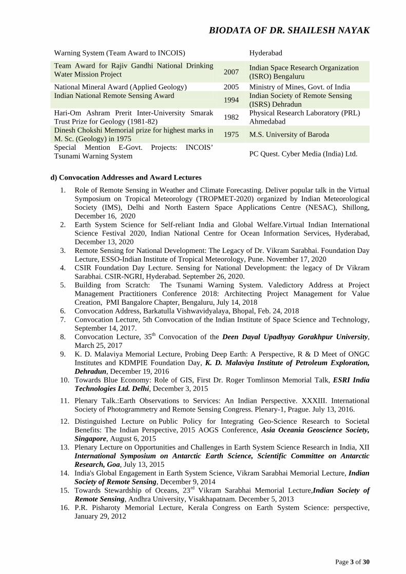
c) Awards AWARD YEAR CONFERRED BY
Hari Narain Lifetime Achievement Awardin Geosciences 2013 Indian Geophysical Union
(IGU), Hyderabad Vikram Sarabhai Memorial Award for 2011-12 2012 Indian Science Congress Association
(ISCA), Kolkata Bhaskara Award 2010 Indian Society of Remote Sensing
(ISRS) Dehradun Web Ratna 09 Platinum Award for Excellence in E-Governance Initiatives for Tsunami Early Warning System Project under the category “Innovative Use of Technology” (Team award)
2010 Dept. of IT and Communications, Government of India
Skoch Challenger Award for Security and Disaster Management (for setting up Tsunami Warning Centre)
2009 Skoch Development Foundation, New Delhi
Indian Space Research Organization's Team Award for Snow and Glacier project 2008 Indian Space Research Organization
(ISRO) Bengaluru Special Achievement in GIS (S.A.G.) Award (for Tsunami Warning Centre) 2008 E.S.R.I., San Diego, USA
Geospatial Solution of the Year for Tsunami 2008 Geospatial Today Magazine,
BIODATA OF DR. SHAILESH NAYAK
Page 3 of 30
Warning System (Team Award to INCOIS) Hyderabad
Team Award for Rajiv Gandhi National Drinking Water Mission Project 2007 Indian Space Research Organization
(ISRO) Bengaluru National Mineral Award (Applied Geology) 2005 Ministry of Mines, Govt. of India Indian National Remote Sensing Award 1994 Indian Society of Remote Sensing
(ISRS) Dehradun Hari-Om Ashram Prerit Inter-University Smarak Trust Prize for Geology (1981-82) 1982 Physical Research Laboratory (PRL)
Ahmedabad Dinesh Chokshi Memorial prize for highest marks in M. Sc. (Geology) in 1975 1975 M.S. University of Baroda
Special Mention E-Govt. Projects: INCOIS’ Tsunami Warning System PC Quest. Cyber Media (India) Ltd.
d) Convocation Addresses and Award Lectures
1. Role of Remote Sensing in Weather and Climate Forecasting. Deliver popular talk in the Virtual Symposium on Tropical Meteorology (TROPMET-2020) organized by Indian Meteorological Society (IMS), Delhi and North Eastern Space Applications Centre (NESAC), Shillong, December 16, 2020
2. Earth System Science for Self-reliant India and Global Welfare.Virtual Indian International Science Festival 2020, Indian National Centre for Ocean Information Services, Hyderabad, December 13, 2020
3. Remote Sensing for National Development: The Legacy of Dr. Vikram Sarabhai. Foundation Day Lecture, ESSO-Indian Institute of Tropical Meteorology, Pune. November 17, 2020
4. CSIR Foundation Day Lecture. Sensing for National Development: the legacy of Dr Vikram Sarabhai. CSIR-NGRI, Hyderabad. September 26, 2020.
5. Building from Scratch: The Tsunami Warning System. Valedictory Address at Project Management Practitioners Conference 2018: Architecting Project Management for Value Creation, PMI Bangalore Chapter, Bengaluru, July 14, 2018
6. Convocation Address, Barkatulla Vishwavidyalaya, Bhopal, Feb. 24, 2018 7. Convocation Lecture, 5th Convocation of the Indian Institute of Space Science and Technology,
September 14, 2017. 8. Convocation Lecture, 35th Convocation of the Deen Dayal Upadhyay Gorakhpur University,
March 25, 2017 9. K. D. Malaviya Memorial Lecture, Probing Deep Earth: A Perspective, R & D Meet of ONGC
Institutes and KDMPIE Foundation Day, K. D. Malaviya Institute of Petroleum Exploration, Dehradun, December 19, 2016
10. Towards Blue Economy: Role of GIS, First Dr. Roger Tomlinson Memorial Talk, ESRI India Technologies Ltd. Delhi, December 3, 2015
11. Plenary Talk.:Earth Observations to Services: An Indian Perspective. XXXIII. International Society of Photogrammetry and Remote Sensing Congress. Plenary-1, Prague. July 13, 2016.
12. Distinguished Lecture on Public Policy for Integrating Geo-Science Research to Societal Benefits: The Indian Perspective, 2015 AOGS Conference, Asia Oceania Geoscience Society, Singapore, August 6, 2015
13. Plenary Lecture on Opportunities and Challenges in Earth System Science Research in India, XII International Symposium on Antarctic Earth Science, Scientific Committee on Antarctic Research, Goa, July 13, 2015
14. India's Global Engagement in Earth System Science, Vikram Sarabhai Memorial Lecture, Indian Society of Remote Sensing, December 9, 2014
15. Towards Stewardship of Oceans, 23rd Vikram Sarabhai Memorial Lecture,Indian Society of Remote Sensing, Andhra University, Visakhapatnam. December 5, 2013
16. P.R. Pisharoty Memorial Lecture, Kerala Congress on Earth System Science: perspective, January 29, 2012

BIODATA OF DR. SHAILESH NAYAK
Page 4 of 30
17. 48th Convocation Address,Shivaji University, Kolhapur, January 25, 2012 18. Earth System Science: A Perspective, Platinum Jubilee Lecture, Earth System Science Session,
99thScience Congress, Bhubaneswar, January 4, 2012 19. 79th Convocation Address, Climate Change and Humanity, Annamalai University, November 9,
2011 20. Prof. R. Vaidyanathan Lecture, Geological Society of India, on Remote Sensing for Coastal
Geomorphology, Visakhapatnam, September 26, 2011 21. Managing Earth System Geospatially. Todarmal Lecture Series, XXX INCA International
Congress, Dehradun, November 10, 2010 22. Indian Society of Geomatics Millennium Lecture, Impact of Climate Change on Coastal Zone,
Ahmedabad, February, 4, 2010 23. H. Sidique Memorial Lecture and Gold Medal of Indian Geophysical Union, “Ocean and
Society’, Wadia Institute of Himalayan Geology, Dehradun, October 5, 2009 24. Birbal Sahni Institute of Paleobotany Foundation Day Lecture, ‘Towards Climate Information
and Services’, Lucknow, September 10, 2009 25. 26th Convocation Address, Gandhigram University, Gandhigram, on ‘Earth Science and Rural
Development’, July 18, 2009 26. Indian Society of Remote Sensing Pisharoty Memorial Lecture, The Planet Earth: Finite
Resources and Civilizations, April 24, 2009, Ahmedabad 27. Indian Geological Congress 12th Foundation Lecture of IGC on Tsunami warning System for the
Indian Ocean, 16th Convention of the Indian Geological Congress, National Geophysical Research Institute, Hyderabad, February 2, 2009
28. Indian National Cartographic Association (INCA), Dr. S.P. Chatterjee Memorial Lecture on, ‘Remote Sensing and GIS for Coastal Zone Management’, November 22, 2007, Visakhapatanam
v) Membership of Academic/Professional Bodies: • Life Member, Astronautical Society of India (ASI), Bangalore • Life Member, Indian Geological Congress (IGC), Roorkee • Life Member, Indian Society of Geomatics (ISG), Ahmedabad • Life Member, Indian Society of Remote Sensing (ISRS), Dehradun • Life Member, Mangrove Society of India (MSI), Goa • Life Member, Meteorological Society of India (MSI), New Delhi • Life Member, Ocean Society of India (OSI)
5. INTELLECTUAL PROPERTY, TECHNOLOGICAL INNOVATIONS, NEW
PRODUCTS ETC.
• Conceptualized, installed and operationalized the Tsunami Early Warning system for India • Algorithms and software for retrieving bio-geo-chemical parameters from ocean colour sensors
has been provided to many institutions in the country. • Satellite based technique for identifying potential fishing grounds has been operationally being
utilized by the Indian National Centre for Ocean Information Services (INCOIS) for providing forecast to fishermen for the entire Indian coast.
• GIS-based model for selecting suitable sites for brackish water aquaculture
Major R & D projects/programs implemented/being Implemented
As a Director of the National Institute of Advanced Institute of Advanced Studies, providing leadership towards integrating multidisciplinary research output towards sustainable development, conceptualize sustainability and developing policy framework for ‘Blue Economy’.
As a President of the International Geological Congress (IGC-2020) provided leadership to organize
scientific activities, logistics and finances as well as interaction with the International Union of Geosciences.

BIODATA OF DR. SHAILESH NAYAK
Page 5 of 30
As a Distinguished Scientist, mainly focused on scientific aspects understanding triggered earthquakes and their impact on society, guidance for developing the flood warning system for Chennai, providing direction and guidance for polar research in India and organizational and coordination issues for implementing international Indian Ocean Expedition.
As the Secretary, MoES, Dr. Shailesh Nayak has initiated several new programmes/centres/activities relating to Global change and use of earth system science for overall societal benefits. To name a few, monsoon mission, severe weather, Arctic research, evolution of Himalayas, earthquake research, ocean biogeochemistry, ocean ecosystem including modelling, multi-hazard warning system, marine resources and Antarctica data base organization and management, web and location-based services, building HPC infrastructure, development of human resources, etc. Due to his efforts, the forecast for weather, climate and hazards has improved considerably. A Centre for Climate Change Research has been established in Pune. A National Centre for Seismology is being set up. The setting up of a Coastal Research Centre has been initiated. A Training School for Climate and Earth System is being set up in Pune. He has initiated discussions and the preparation of a National Vision document on the role Earth Sciences should play in national issues. He also led an expert group for setting up National-GIS which is now under implementation.
As Project Director, Early Warning System for Tsunami and Storm Surge, May 2006, planned and implemented an Early Warning System involving network of seismic stations, tidal stations, bottom pressure recorders, and real time analysis of data, modelling of travel time, propagation of tsunami wave and inundation and generation of high resolution bathymetry and coastal topography data. The work involved direction, guidance, coordination of three departments/ministries and fourteen national institutions involving more than 300 scientists to design, develop and making such system operational in record time of 10 months at a cost of Rs.125 crores. Two major R & D projects, on the tectonic modelling of the Andaman Trench and History of Tsunami have been conceptualized and being implemented through NGRI, PRL, NCAOR, IITs and academic institutions. The capability of India was effectively represented in international fora. One of the major achievements was that the project was executed without any increase in the cost of the project.
Project Director, Argo Project, organized activities related to deployment of ARGO floats in the Indian Ocean, reception and processing data in near real time, quality checks, generation of products and applications. Various applications of Argo data are being developed.
As Director, INCOIS, provided direction and guidance for the societal services in the field of Potential Fishing Zone and Ocean State Forecast Advisories. The success of PFZ advisories is around 74 per cent and led to savings in time and fuel. Due to innovative methods, the user base in fishermen was increased to 27 per cent. The OSF is being widely used by shipping, Coast Guards and the Indian Navy.
A project on ‘Chlorophyll Monitoring of the Indian Ocean’ was conceptualized and being implemented using MODIS/OCM data. The project is envisaged to help to monitor ecosystem health and will provide input for ecosystem modelling.
As Director of INCOIS, various steps were taken to increase activities in operational oceanography.
At SAC, Conceptualized, executed and guided and provided leadership to following national level projects by involving many national and state level institutions in the field of coastal and marine environment.
Principal Investigator, Jan. 2004 - April 2006, Coastal Studies (inventory, zonation of coral reefs and mangroves, coastal geomorphology, sea level rise, shoreline change, coastal zone information system), and Snow and Glacier Studies (snow monitoring, glacier inventory and retreat, mass balance, information system) Funded by the Ministry of Environment and Forests, Govt. of India (Rs. 30 crores).
Focal Point, Meteorology and Oceanography Programme (funded by ISRO), and Satellite Coastal and Oceanographic Research. Funded by the Dept. of Ocean Development, GOI. 2003 to April 2006, Biological and Geological Oceanography component and Development of Cal Val site in the

BIODATA OF DR. SHAILESH NAYAK
Page 6 of 30
Lakshadweep Sea (Rs. 5 crores)
Deputy Project Director, Satellite Coastal and Oceanographic Research. Funded by the Dept. of Ocean Development, GOI. Indian Remote Sensing Satellite (IRS) – P4 OCM Utilisation, ISRO. 1998-2003. Development of algorithms for retrieving bio-geo-chemical parameters from Ocean Colour Monitor (OCM), its validation and operationalization, development of methodology for of application of OCM data for fisheries and coastal processes (Rs. 7 Crores).
Focal Point. Development Plans of Kachchh District. Preparation of land and water resources development plans. 2001-2004 (Rs. 2.25 crores).
Deputy Project Director, Integrated Coastal and Marine Area Management Project, Funded by the Dept. of Ocean Development. GOI. 1998-2003. Development of methodology for eco-geomorphological zonation of mangroves and coral reefs using Indian Remote Sensing data (Rs. 1 Crore).
Principal Investigator, Coastal Zone Development. Joint project SPARRSO, Bangladesh and ISRO. Funded BY UN-ESCAP. 1997-2000. Transfer of technology to SPARRSO for coastal studies and specifically selection of brackish water aquaculture sites.
Principal Investigator, IRS P3 Validation Experiment – Ocean. Joint Project DLR, Germany and ISRO. 1995-98. Development of algorithms for retrieving bio-geo-chemical parameters and standardizing validation procedures using MOS-B data Rs. 30 Lakhs).
Project Leader; Land Use Mapping of Coastal Regulation Zone, Funded by the Ministry of Environment and Forests, GOI. 1993-1997. Developed techniques to delineate high tide line and low tide line using satellite data and generated database for the entire country’s coastline on 1:25,000 scale and GIS based model for classifying coastal zone for managing coastal zone (Rs. 30 Lakhs).
Principal Investigator, Coastal Studies, Funded by the Dept. of Ocean development, GOI. 1990-1995. Developed methodology for identifying coral reef features and generated data base on coral reef, mangroves and areas under erosion and deposition on 1: 50,000 scale for the entire country’s coastline Rs. 50 Lakhs).
Project Leader, Coastal Land Use Mapping for Brackish Water Aquaculture Site Selection, Remote Sensing Application Mission, Funded By the Ministry of Agriculture, GOI.1990-94. Generated data base on coastal land use on 1:50,000 scale and developed a model to integrate satellite-based information with in situ information on ecology, infrastructure, etc. to select sites for brackish water aquaculture (Rs. 30 Lakhs).
Project Leader, Coastal Environment, Remote Sensing Applications Mission (RSAM), Funded by the Ministry of Environment and Forests, Govt. of India (GOI). 1988-92. Generated database on coastal wetland/landform and shoreline change on 1:250,000 scale for the entire country’s coastline Rs. 18 Lakhs).
Principal Investigator, Monitoring of Coastal Environment, Indian Remote Sensing Utilization Programme (IRS-UP), ISRO. 1984-1990. Developed methodology and classification system for identifying coastal wetland and landform and shoreline change. Prepared a detailed manual for the same (Rs. 32 Lakhs).
Principal Investigator, Coastal Morphology: A Case Study in the Gulf of Khambhat. End-to-End Experiment, National Natural Resources Management System, Indian Space Research Organisation (ISRO). 19
6. LIST OF TEN IMPORTANT PUBLICATIONS 1. Nayak, S., Srinivasa Kumar, T. and Rama Rao, E. P. 2020. Tsunami Watch and Warning Centres; In
Encyclopedia of Solid Earth Geophysics. (Harsh K. Gupta, Ed.), Springer Dordrecht, https://doi.org/10.1007/978-3-030-10475-7_230-1. (invited contribution)
2. Srinivaskumar, T., Mahendra, R.S., Nayak, S., Radhakrishnan, K., Sahu, K.C. 2010. Coastal

BIODATA OF DR. SHAILESH NAYAK
Page 7 of 30
vulnerability assessment for Orissa State, East Coast of India. Jour. of Coastal Research. 26(3):523-534. (cited 264 times)
3. Nayak, S. 2009. Application of Remote Sensing and GIS for Coastal Zone Management. In the Manual of Geographic Information Systems (ed. M. Madden), The American Society for Photogrammetry and Remote Sensing, Bethesda, MD. pp. 1075-1094 (Invited contribution)
4. Vinaychandran, P. N., Chauhan, P., Mohan, M. and Nayak, S. 2004. Biological response of sea around Sri Lanka to summer monsoon. Geophysical Research Letters, 31:L01302. 2004. (cited 109 times)
5. Chauhan, P., Mohan, M., Sarangi, R. K., Beenakumari, Nayak, S. and Matondkar, S. G. P. 2002 Surface chlorophyll a estimation in the Arabian Sea using IRS P4 Ocean Colour Monitor (OCM) satellite data. Inter. Jour. of Remote Sensing. 23(8):1663-1676. 2002 (cited 78 times)
6. Nayak, S. and Bahuguna, A. 2001. Application of remote sensing data to monitor mangroves and other coastal vegetation in India. Indian Jour. Of Marine Sciences. 30(4): 195-213 (cited 128 times)
7. Solanki H.U., Dwivedi R.M., and Nayak S. Somvanshi, V.S., Gulati, D.K. Fishery forecast using OCM Chlorophyll concentration and ACHRR SST: Validation results off Gujarat Coast, Indina Inter. Jour. Remote Sensing 24 (18): 3691-3699. 2003. (cited 78 times)
8. Nayak, S., Sarangi, R. K. and Rajawat, A. S. 2001. Application of IRS P4 OCM data to study impact of cyclone on coastal environment of Orissa. Current Science, 80(9):1208-1213. 2001. (cited 78 times)
9. Nayak, S. Use of satellite data in coastal mapping.Indian Cartographer, 22 : 147-157. (cited 62 times)
10. Nayak, S. and Sahai, B. Coastal morphology: a case study in the Gulf of Khambhat. Inter. Jour. of Remote Sensing, 6 (3 & 4): 559-567. 1985. (cited 61 times)
7. ACADEMIC AND RESEARCH ACTIVITIES: National-Curricular • Member, Governing Board, The Energy and Resources Institute (TERI), New Delhi • Member, Governing Board, Foundation for Ecological Security (FES), Anand • Member, Governing Council, Indian Council of World Affairs, New Delhi • Member, Governing Board, Research and Information System for Developing Countries (RIS),
New Delhi • Member, Apex Committee on STI Policy, Technology-led- Innovation Policy Framework 2020,
DST, Govt. of India. (Jan 20) • Member, Council, National Academy of Sciences, India (2019 onwards). • Member, Thematic Group (TG-STI) on Policy Governance, PSA and DST, Govt. Of India • Member, Indian National Commission for cooperation with UNESCO (INCCU), New Delhi.
Sub- Commission on Natural Sciences (Jan 20). • Member, Science and Engineering Research Board, Ministry of Science and Technology, GoI
(2010-2015). • Member, CSIR Society (2010-2015) • Member of Strategic Policy Group, Cabinet Secretariat, July 2011. • Member, CoS on National GIS (2011-13) • Member, Executive Committee on Climate Change, PMO (2013-2015) • Member, Consultative Group on Climate Change, Ministry of Environment and Forest, GoI
(2012-2015) • Chair, Standing Committee on Meteorology and Ocean Resources, National Natural Resources
Management System, Planning Commission, GOI (August 2008-2015) • Chair, Research Council, National Institute of Oceanography. Goa (2008-2015)

BIODATA OF DR. SHAILESH NAYAK
Page 8 of 30
• Member, DPRC, Ministry of Environment and Forest (Sci. F to G), Jan. 10, 2014 • Member, DPRC, Department of Information Technology (Sci. E to F), April 4, 2013, July 4,
2013 • Member, Peer Review Committee, DRDO, Sci. F to G, G to H, H to DS. July 5, 2013 • Member, Departmental Peer Review Committee, Extension of Service beyond the Age of
Superannuation, DRDO. July, 30, 2013 • Member, GIS Advisory Board, National GIS Mission (2013-2014) • Member, National Steering Committee on Climate Change, MoEF • Member, Board of Governors, IISER, Pune; IISER, Kolkata • Member, Apex Committee for DRDO Awards, 2012. • Member, Advisory Board, State Awards in Science, M. P. • Member, implementation of Modified FCS in Organizations under Ministry of Water Resources • Member, Scientific Advisory Committee to the Prime Minister (2008-14) • Member, Scientific Advisory Committee to the Cabinet (2008-15) • Member, Search-cum-Selection Committee, CSIR • Member, expert Committee, UNESCO Kalinga Prize for Popularizing of Science • Member Award Making Committee, Ministry of Mines, GOI. January 21, 2014 • Member, Programme Advisory Committee on Natural Resources Management and Climate
Change, MSSRF, Chennai • Member, National Bio-resource Board, Delhi • Visitor’s Nominee, Selection Committee doe Selection of Professors/Associate Professors/Asst.
Professors, IIT-Bombay
b) International (Curricular) • Chair, Executive Board, Regional Integrated Multi-Hazard Early Warning System (RIMES) for
Africa and Asia (2010-2015) • Co-Chair, Core Committee for Hosting International Geological Congress in 2020 in India • Represented India at Intergovernmental Global Ocean Observing System (I-GOOS), 2006-2008 • Represented ISRO at the International Ocean Colour Co-ordinating Group (IOCCG). 2001-2004
c) National- Extra- Curricular • Chair, Research Council, ESSO-National Centre for Polar and Ocean Research (NCPOR), Goa. • Chair, Research Council, ESSO-National Centre for Coastal Research, Chennai. • Chair, Research Council, CSIR-National Environmental Engineering Research Institute, Nagpur. • Chair, Research Council, Wadia Institute of Himalayan Geology (WIHG), Dehradun. • Chair, Programme Advisory Committee - Koyna Deep Borehole Research, Ministry of Earth
Sciences, Govt. Of India (2020-2023). • Chair, High Level Committee (HLC) for Merging of CSIR Laboratories CSIR -4PI, CSIR-
NISCAIR, CSIR-NISTADS as per Apex Committee Proposal (2020). • Chair, Monitoring Committee of CSIR Mission ‘Safety & Security of Vital Installations’, New
Delhi. • Chair, Committee of Experts to Review DST-Policy Research Centres, Department of Science
and Technology (DST), New Delhi (2018 onwards) • Chair, Blue Flag India National Jury, Blue Flag India, Pune (2018 onwards) • Member, Review Committee, Centre of Atmospheric and Oceanic Sciences (CAOS), Centre for
Earth Sciences (CEaS) and Divecha Centre for Climate Change (DCCC) at IISc, Bangalore (2018)
• Chair, Expert Group on National Geospatial Policy (NGP), Department of Science and Technology (DST), New Delhi (2018 onwards)
• Chair, Vikram Sarabhai Centenary Celebrations Committee, Indian Space Research Organization, Bengaluru (Dec. 2012 onwards)

BIODATA OF DR. SHAILESH NAYAK
Page 9 of 30
• Chair, National SCAR Committee, Indian National Science Academy, New Delhi (2016-2019) • Chair, Project Appraisal and Monitoring Committee, Ocean Science and Resources. Ministry of
Earth Sciences (2015-). November19-20, 2015 • Chair, National Organising Committee, International Symposium on the Indian Ocean '
Dynamics of the Indian Ocean: Perspective and Retrospective' to Celebrate 50th Anniversary of Completion of International Indian Ocean Expedition (IIOE) and Golden Jubilee of CSIR-National Institute of Oceanography (NIO), Goa. November 30- December 4, 2015
• Member, Governing Council, The Energy Research Institute, Delhi. (2012 onwards) • Chair, Research Advisory Committee, Centre for Earth Science Studies, Thiruvananthapuram
(2007-14) • Chair, Governing Body, Birbal Sahni Institute of Paleobotany, Lucknow (2010-2014) • Chair, Governing Board, Gujarat Energy Research and Management Institute, Gandhinagar (2013
onwards) • Chair, National Resources Data Management System, Department of Science & Technology
(2009-2015) • President, Indian Social Science Academy (2021-22) • President, Federation of Indian Geoscientists Association, Hyderabad (2014-2017) • President, Indian Geophysical Union (2014-2016, 2016-2018, 2020-2022) • President, Indian Society of Geomatics (2010-14) • President, Indian Meteorological Society (2012-14) • President, Indian Society of Remote Sensing (2008-2010, 2016-2018) • President, Mangrove Society of India (2016 onwards) • Adviser, Interview Board (Additional Director General, P & A, G. S. I.), UPSC, New Delhi.
November 9, 2015 • Chair, GeoSmart India Awards Committee, Geospatial, December 17, 2015 • Chair, Bhatnagar Prize Award Committee for Earth Science, Sep. 4, 2015 • Chair, Award Committee, Indian Society of Geomatics, Ahmedabad • Member, Editorial Advisory Board, GIS Development • Member, Advisory Committee, Centre for Mathematical Modelling and Computer Simulation,
Bangalore (2007 - 2008) • Member of Editorial Board, Indian Journal of Marine Science, National Institute of Scientific
Communications (2001-2004), Delhi and Geospatial Today, Hyderabad • Member, National Coastal Zone Authority, MOEF • Member, Scientific Research Advisory Board, Nansen Environmental Research Centre-India,
Kochi (2007 onwards) • Member, Scientific Advisory Committee, Institute of Seismological Research, Gandhi Nagar
(2007 onwards) • Member, Expert Committee of NRDMS Programme, DST, New Delhi (2007-2008) • Member, Committee to update and develop Curricula in RS, GIS, GPS and allied subjects, DOS,
Bangalore • Member, Research Advisory Committee, Wadia Institute of Himalayan Geology, Dehradun
(2003-06) • Member, Coastal Protection and Development Advisory Committee (CPDAC), Ministry of Water
Resources, GoI. (1999-2008) • Member, Programme Advisory Committee, Earth Sciences (PAC-ES) – Dept. of Science and
Technology, GOI (2004-07, 1998-2001) • Member, Gujarat Coastal Zone Authority, Gandhinagar • Member, Expert Group on SAR Interferometer, Department of Science & Technology, GoI
(2002-2006) • Member, Sub-Group I on Cyclone Early Warning System, NDMA • Chair, Assessment Board, National Institute of Hydrology, Roorkee. Jan. 17, 2014

BIODATA OF DR. SHAILESH NAYAK
Page 10 of 30
d) International-Extra-Curricular
• Regional Representative, Asia, International Society of Photogrammetry and Remote Sesnsing • President, International Geological Congress-2020 (Dec. 2015 – 2017) • Member, Integrated Global Ocean Observing System (IGOS) – Coastal Theme. 2003-2006. • President, International Society of Photogrammetry and Remote Sensing (ISPRS), Technical
Commission IV on ‘Geo-databases and Digital Mapping’ (2004-2008). • Secretary, International Society of Photogrammetry and Remote Sensing (ISPRS), Technical
Commission VII on Resource and Environmental Monitoring and Chairman, ISPRS WG VII/3 on ‘Integrated Monitoring System for Resource Management’ (2000-2004).
• Co-ordinated various activities of ISPRS Technical Commission I on ‘Sensors, Platforms and Imagery.’ (1996-2000).
• Organized an International training program on “Remote Sensing of Ocean Colour: Techniques & Applications”, sponsored by IOCCG, POGO and ISRO during February 12-23, 2001 at SAC Nine participants from abroad and eleven participants from India attended the training program.
• Faculty Member in a Training Course on “Ocean Colour”, Asian Institute of Technology, Organized by NASDA, Bangkok, Thailand, December, 2000
• Faculty member in a training course on “Remote Sensing and GIS for Coastal Applications”, organized by SEAMEO BIOTROP at Bogor, Indonesia during October 20-29, 2001. Delivered lectures and conducted tutorials on Ocean Colour
• A Pre-Conference Training Module on Ocean Colour was organized during PORSEC 2000 during Nov. 30 - Dec.2, 2000 at Goa. An interactive CD-ROM was developed
• Organized a Tutorial on ‘Integrated Coastal Zone Management’, Pre-symposium Tutorial, ISPRS TC VII Symp. December 2, 2002
• Chaired Book Discussion Programme on Rao, U. R. India's Rise as a Space Power. New Delhi: Foundation Books, 2014. Bagla, Pallav & Subhadra Menon. Reaching for the Stars: India's Journey to Mars and Beyond. New Delhi: Bloomsbury, 2014. At India International Centre, New Delhi, April 8, 2015
• Radio Talk on Exploring the Unexplored Antarctica. National Channel, All India Radio. June 17, 2015
• Chairman, Indian Ocean – Global Ocean Observing System (IO-GOOS). (2006-2012) • Member, International Expert Committee, Institute of Remote Sensing and Digital Earth, Chinese
Academy of Sciences, China (2013 onwards) • Chair, Indian Ocean Observing System Resource Forum (IRF) (2009-2013) • Vice Chair, Intergovernmental Coordinating Group on Indian Ocean Tsunami Warning System
(ICG-IOTWS), (2007-2011) • Member, OGC Global Advisory Council, USA • Executive Committee Member, Partnership for Observation of Global Ocean (POGO), 2006-07
e) Important Committees
• Chair, Committee to Review the Issues related to Coastal Regulation Zone Notification, 2011. Ministry of Environment and Forests, GoI. Formed in June 17, 2014. Submitted Report to the H'ble Minister, Ministry of Environment and Forests on January 19, 2015
• Chair, Standardization of Methodology for Demarcation of HTL/LTL, Ministry of Environment and Forests, GoI
• Chair, National GIS Interim Core Group, Planning Commission, GOI. Oct, 2011 • Chair, Task Force on Procedures from Mapping Technology, GOI, 2010
8. INVITED TALKS
a. International: 38 b. National: 85 c. Academic Institutes: 51

BIODATA OF DR. SHAILESH NAYAK
Page 11 of 30
Related to Earth system science research and societal benefits, Future Earth, Changing climate, Climate resilience, Impact of climate on coastal environment, Climate information and services, Stewardship of Oceans, Ocean observations and services, Ocean biology and coastal processes, Blue economy, Energy from oceans, Arctic and Antarctica, Himalayan glaciers, Polar science and climate, Geoscience and public policy, Scientific drilling, Monsoon Mission, Forecasting monsoon, Monsoon variability, Disaster and risk reduction, Ocean hazards, Tsunami warning system, Earthquake Risk, Bhuj earthquake, High impact weather, Landslides, Oil spills, Remote sensing Applications, Geographic Information System ((GIS), GIS policy, Data sharing, Ocean data and management, Ocean colour remote sensing, OCEANSAT, Remote sensing applications to fisheries, Remote sensing and coastal zone regulations,, Integrated coastal zone management, Coastal and marine biodiversity, Coastal Mapping, Coastal geomorphology, Space technology for water cycle, Water quality, etc.
9. RECOGNIZED PH. D. GUIDE University Subject
Andhra University, Vishakhapatnam Oceanography Berhampur University, Berhampur Marine Science Gujarat University, Ahmedabad Geology-Remote Sensing Vikram University, Ujjain Geology University of Pune, Pune Geology University of Rajasthan, Jaipur Geology Mangalore University, Mangalagangothri Marine Geology & GeoinforMatics Nirma University, Ahmedabad Geology, Earth Science
10. NUMBER OF PH.D.S GUIDED Name Topic Year of
Award University
Sumisha Velloth Habitat Classification of Coral Reefs of India using Multispectral and Hyperspectral Remote Sensing Data
2015 Mangalore University, Mangalore
Janaki Janak Desai
Applications of Remote Sensing Techniques and GIS to Study Fluvio-Geomorphology and Evolution of Ganga River covering parts of Uttar Pradesh, India
2014 Gujarat University, Ahmedabad
Mini Raman Estimating Primary Production in the Arabian Sea using Satellite Derived Data
2014 Mangalore University,
Thomaskutty A.V.
Study of Sediment Dynamics along the Coastal Waters off Karnataka based on Remote Sensing and GIS Techniques
2012 Mangalore University
Navin Kumar Bollu
A Remote Sensing and GIS Mineral Prognostic Study in parts of SE Rajasthan
2009 Vikram University, Ujjain
Ramanuj Banerjee
Seismic Hazard Zonation Of Kachchh Area Using Remote Sensing
2009 Pune University
R. K. Sarangi Impact of surface feature changes on phytoplankton variability in seas off southern part of the Indian peninsula: a remote sensing approach
2008 Berhampur University
A. S. Rajawat Reconstruction, evolution and significance of paleo-drainage network in Western Rajasthan: an investigation based on multi-sensor satellite data and GIS.
2006 Vikram Univ, Ujjain
Devendra Kumar
Application of satellite-derived terrain parameters for the geomorphic and structural studies in the Jharia coal field, Jharkhand.
2006 Rajasthan University, Jaipur
Yashwant Pradhan
Circulation and dispersal pattern in the Bay of Bengal – a study based on satellite derived ocean colour applications
2005 Berhampur University Berhampur
B. Deshmukh Geomorphological study of coral reefs in a part of Gulf of Kachchh using remote sensing data
2004 Vikram University, Ujjain

BIODATA OF DR. SHAILESH NAYAK
Page 12 of 30
11. CHAIR IN INTERNATIONAL CONFERENCES 1. Moderator. Climate Change Adaptation in Coastal Areas & other Sectors. Side Event at the Twenty-
first Session of the Conference of Parties, Paris. Society for Integrated Coastal Zone Management, Ministry of Environment, Forest and Climate Change. December 9, 2015
2. Launch of IIOE -2 and Closing Session. Symposium on the Indian Ocean ' Dynamics of the Indian Ocean: Perspective and Retrospective' to Celebrate 50th Anniversary of Completion of International Indian Ocean Expedition (IIOE) and Golden Jubilee of CSIR-National Institute of Oceanography ( NIO), Goa. December 4, 2015
3. Historical climate trends and climate change projections. Workshop on Climate Change Projections, Vulnerability and Adaptation under the aegis of Third National Communication. Ministry of Environment and Forests and Climate Change. October 28, 2015
4. Geopolitics of the Polar Region. International Conference on Geopolitics of Arctic-Antarctic-Himalaya, LIGHTS Research Foundation (Learning in Geography, Humanities and Science), New Delhi. September 29, 2015
5. Make in India. Brain-Storming Meeting on Radar Meteorology. IISc and ESSO-IMD, Bangalore. September 26, 2015
6. Panel Discussion and Closing Session. WMO 3rd International Monsoon Heavy Rainfall Workshop. ESSO-IMD. New Delhi. September 24, 2015
7. President, Federation of Geoscience Associations, Hyderabad (2014-17) 8. President, Indian Union of Geophysics, Hyderabad (2014-17) 9. Plenary Session on Future Earth. ISPRS Technical Commission Mid Term Symposium on
'Operational Remote Sensing Applications: Opportunities, Progress and Challenges. ISRS and ISG, Hyderabad. December 9, 2014
10. Oceans and Monsoons, International Conference on ‘Celebrating the Monsoon’ IISC, July 26, 2007, Bangalore
11. POGO Business, 8th POGO Meeting, Qingtao, China, January 19, 2007 12. “Implementation Strategy for Coastal Module of GOOS.” 3rd Regional GOOS Forum, Cape Town,
South Africa, November 14-17, 2006 13. Remote Sensing, 4th Annual Meeting of IO-GOOS, Zanzibar, October 10-12, 2006 14. Early Warning System for various marine hazards – Present Status” at the International Conference
on Marine hazards and opportunities”, July 3, FICCI, Chennai 15. Silver Jubilee Symposium on Antarctica Expedition, May 25-26, 2006
Research Papers
1. Nayak, S. 2020. Sensing for National Development: the legacy of Dr Vikram Sarabhai. Jour. Indian Society of Remote Sensing , 48 (8): 1101-1120. https://10.1007/s12524-020-01156-x.
2. Nayak, S. 2020. Charting a new course for Oceans. Preface, Special Section, Current Science (Guest Editor), 118 (11): 1679-1680.
3. Nayak, S. 2020. Ocean Science to Services. Sentinels of the Seas. Geography and You (Guest Editor). Vol. 20, Issue 6-7, No. 144-145. pp.4-5.
4. Nayak, S. 2020. Towards Blue Economy: a perspective. Indian Jour. of Geoscience, 74 (3): 191-196
5. Nayak, S. and Suba Chandran D. 2020. Arctic: why India should pursue the North Pole from a science and technology perspective? Current Science, 119 (6): 901-904
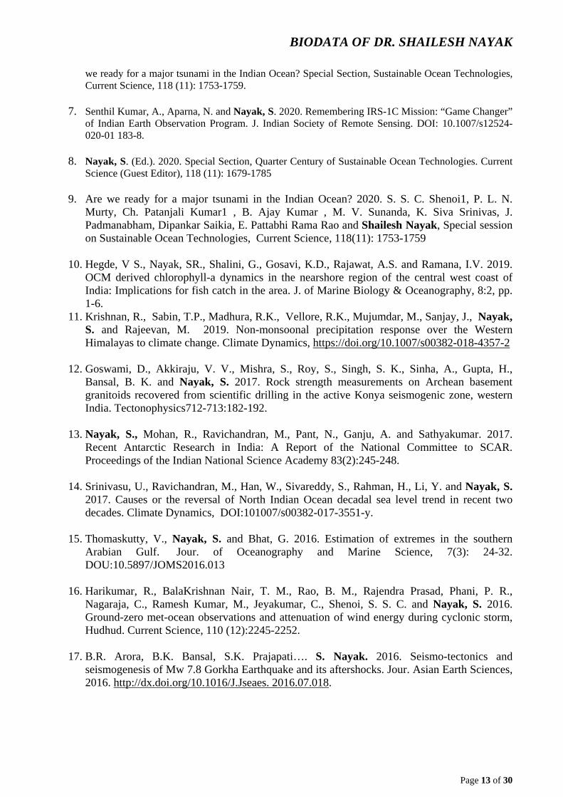
6. S. S. C. Shenoi1, P. L. N. Murty, Ch. Patanjali Kumar1 , B. Ajay Kumar , M. V. Sunanda, K. Siva Srinivas, J. Padmanabham, Dipankar Saikia, E. Pattabhi Rama Rao and Shailesh Nayak, 2020. Are
BIODATA OF DR. SHAILESH NAYAK
Page 13 of 30
we ready for a major tsunami in the Indian Ocean? Special Section, Sustainable Ocean Technologies, Current Science, 118 (11): 1753-1759.
7. Senthil Kumar, A., Aparna, N. and Nayak, S. 2020. Remembering IRS-1C Mission: “Game Changer” of Indian Earth Observation Program. J. Indian Society of Remote Sensing. DOI: 10.1007/s12524-020-01 183-8.
8. Nayak, S. (Ed.). 2020. Special Section, Quarter Century of Sustainable Ocean Technologies. Current Science (Guest Editor), 118 (11): 1679-1785
9. Are we ready for a major tsunami in the Indian Ocean? 2020. S. S. C. Shenoi1, P. L. N. Murty, Ch. Patanjali Kumar1 , B. Ajay Kumar , M. V. Sunanda, K. Siva Srinivas, J. Padmanabham, Dipankar Saikia, E. Pattabhi Rama Rao and Shailesh Nayak, Special session on Sustainable Ocean Technologies, Current Science, 118(11): 1753-1759
10. Hegde, V S., Nayak, SR., Shalini, G., Gosavi, K.D., Rajawat, A.S. and Ramana, I.V. 2019. OCM derived chlorophyll-a dynamics in the nearshore region of the central west coast of India: Implications for fish catch in the area. J. of Marine Biology & Oceanography, 8:2, pp. 1-6.
11. Krishnan, R., Sabin, T.P., Madhura, R.K., Vellore, R.K., Mujumdar, M., Sanjay, J., Nayak, S. and Rajeevan, M. 2019. Non-monsoonal precipitation response over the Western Himalayas to climate change. Climate Dynamics, https://doi.org/10.1007/s00382-018-4357-2
12. Goswami, D., Akkiraju, V. V., Mishra, S., Roy, S., Singh, S. K., Sinha, A., Gupta, H., Bansal, B. K. and Nayak, S. 2017. Rock strength measurements on Archean basement granitoids recovered from scientific drilling in the active Konya seismogenic zone, western India. Tectonophysics712-713:182-192.
13. Nayak, S., Mohan, R., Ravichandran, M., Pant, N., Ganju, A. and Sathyakumar. 2017. Recent Antarctic Research in India: A Report of the National Committee to SCAR. Proceedings of the Indian National Science Academy 83(2):245-248.
14. Srinivasu, U., Ravichandran, M., Han, W., Sivareddy, S., Rahman, H., Li, Y. and Nayak, S. 2017. Causes or the reversal of North Indian Ocean decadal sea level trend in recent two decades. Climate Dynamics, DOI:101007/s00382-017-3551-y.
15. Thomaskutty, V., Nayak, S. and Bhat, G. 2016. Estimation of extremes in the southern
Arabian Gulf. Jour. of Oceanography and Marine Science, 7(3): 24-32. DOU:10.5897/JOMS2016.013
16. Harikumar, R., BalaKrishnan Nair, T. M., Rao, B. M., Rajendra Prasad, Phani, P. R.,
Nagaraja, C., Ramesh Kumar, M., Jeyakumar, C., Shenoi, S. S. C. and Nayak, S. 2016. Ground-zero met-ocean observations and attenuation of wind energy during cyclonic storm, Hudhud. Current Science, 110 (12):2245-2252.
17. B.R. Arora, B.K. Bansal, S.K. Prajapati…. S. Nayak. 2016. Seismo-tectonics and
seismogenesis of Mw 7.8 Gorkha Earthquake and its aftershocks. Jour. Asian Earth Sciences, 2016. http://dx.doi.org/10.1016/J.Jseaes. 2016.07.018
.

BIODATA OF DR. SHAILESH NAYAK
Page 14 of 30
18. H.K. Gupta…..2015. Investigations related to scientific deep drilling to study reservoir-triggered earthquake at Koyna, India. Int. J. Earth Sci., 104:1511-1522, 2015. DOI. 10.1007/5000531-614-1128-0.
19. R. Harikumar, N. K. Hithin, T. M. Balakrishnan Nair, P. Sirisha, B. Krishna Parasad, C.
Jeyakumar and Nayak. S. 2015. Ocean State Forecast along Ship Routes: Evaluation Using ESSO-INCOIS Real-Time Ship-Mounted Wave Height Meter and Satellite Observations, Jour. of Atmospheric and Oceanic Technology · August 2015, doi: 10.1175/Jtech-D-15-0047.1
20. T. Srinivasa Kumar, P.L.N. Murty, M. Pradeep Kumar, M. Krishna Kumar, J. Padmanabham,
N. Kiran Kumar, S.C. Shenoi, M. Mohapatra, S. Nayak& Prakash Mohanty 2015. Modeling Storm Surge and its Associated Inland Inundation Extent Due to Very Severe Cyclonic Storm Phailin, Marine Geodesy, 38:4, 345-360, DOI: 10.1080/01490419.2015.1053640.
21. N. K. Hithin, P. G. Remya, T. M. Balakrishnan Nair, R. Harikumar, Raj Kumar, and Shailesh
Nayak, 2015.Validation and Intercomparison of SARAL/AltiKa and PISTACH-Derived Coastal Wave Heights Using In-Situ Measurements, IEEE Journal of Selected Topics in Applied Earth Observations and Remote Sensing. August 2015, DOI: 10.1109/JSTARS.2015.2418251.
22. Harsh Gupta · N. Purnachandra Rao · Sukanta Roy · Kusumita Arora · V. M.
Tiwari · Prasanta K. Patro · H. V. S. Satyanarayana ·D. Shashidhar · K. Mallika · Vyasulu V. Akkiraju, D. Ch. V. Raju · Ujjal Borah · K. Chinna Reddy · Narendra Babu · Sunil Rohilla · Upasana Dhar · Mrinal Sen · Y. J. Bhaskar Rao · B. K. Bansal · Shailesh Nayak, 2014. Investigations related to scientific deep drilling to study reservoirtriggered earthquakes at Koyna, India, Int J Earth Sci (Geol Rundsch) DOI 10.1007/s00531-014-1128-0.
23. *M.C. Kennicutt Ii, S.L. Chown, J.J. Cassano, D. Liggett, L.S. Peck, R. Massom, S.R.
Rintoul, J.Storey, D.G. Vaughan, T.J. Wilson, I. Allison, J. Ayton, R. Badhe, J. Baeseman, P.J. Barrett, R.E. Bell, N. Bertler, S. Bo, A. Brandt, D. Bromwich, S.C. Cary, M.S. Clark, P. Convey, E.S. Costa, D. Cowan, R. Deconto, R. Dunbar, C. Elfring, C. Escutia, J. Francis, H.A. Fricker, M. Fukuchi, N. Gilbert, J. Gutt, C. Havermans, D. Hik, G. Hosie, C. Jones, Y.D. Kim, Y. Le Maho, S.H. Lee, M. Leppe, G. Leitchenkov, X. Li, V. Lipenkov, K. Lochte, J. López-Martínez, C. Lüdecke, W. Lyons, S. Marenssi, H. Miller, P. Morozova, T. Naish, S. Nayak, R. Ravindra, J. Retamales, C.A. Ricci, M. Rogan-Finnemore, Y. Ropert-Coudert, A.A. Samah, L. Sanson, T. Scambos, I.R. Schloss, K. Shiraishi, M.J. Siegert, J.C. Simões, B. Storey, M.D. Sparrow, D.H. Wall, J.C. Walsh, G. Wilson, J.G. Winther, J.C. Xavier, H. Yang And W.J. Sutherland, 2014. A roadmap for Antarctic and Southern Ocean science for the next two decades and beyond, Antarctic Science 2014. doi:10.1017/S0954102014000674.
24. *Gupta H., Nayak, S., Ellsworth W., Rao Y.J.B., Rajan S., Bansal B.K., Purnachandra Rao
N., Roy S., Arora K., Mohan R., Tiwar V.M., Satyanarayana H.V.S., Patro P.K., Shashidhar D., and Mallika K. 2014. Probing reservoir-triggered earthquakes in Koyna, India, through scientific deep drilling. Scientific.Drilling 18, 5-9. doi:10.5194/sd-18-5-2014.
25. Lotliker, A.A., Srinivasa Kumar, T., Reddem, V.S., Nayak, S. 2014. Cyclone Phailin
enhanced the productivity following its passage: Evidence from satellite data. Current Science, 106 (3), pp. 360-361.

BIODATA OF DR. SHAILESH NAYAK
Page 15 of 30
26. Velloth, S., Mupparthy, R.S., Raghavan, B.R., Nayak, S. 2014. Coupled correction and classification of hyperspectral imagery for mapping coral reefs of Agatti and Flat Islands, India. International Journal of Remote Sensing, 35 (14), pp. 5544-5561.
27. Balakrishnan Nair, T.M., Remya, P.G., Harikumar, R., Sandhya, K.G., Sirisha, P., Srinivas,
K., Nagaraju, C., Nherakkol, A., Krishna Prasad, B., Jeyakumar, C., Kaviyazhahu, K., Hithin, N.K., Kumari, R., Sanil Kumar, V., Ramesh Kumar, M., Shenoi, S.S.C., Nayak, S. 2014. Wave forecasting and monitoring during very severe cyclone Phailin in the Bay of Bengal. Current Science, 106 (8), pp. 1121-1125.
28. Balakrishnan Nair, T.M., Sirisha, P., Sandhya, K.G., Srinivas, K., Sanil Kumar, V., Sabique,
L., Nherakkol, A., Krishna Prasad, B., Kumari, R., Jeyakumar, C., Kaviyazhahu, K., Ramesh Kumar, M., Harikumar, R., Shenoi, S.S.C., Nayak, S. 2013. Performance of the Ocean State Forecast system at Indian National Centre for Ocean Information Services. Current Science, 105 (2), pp. 175-181.
29. Roy, Sukanta., Rao, N.P., V.Akkiraju, Vyasulu., Goswami, Deepjyoti., Sen, Mrinal., Gupta,
Harsh., Bansal, B.K., Nayak, S. 2013.Granitic Basement below Deccan Traps Unearthed by Drilling in the Koyna Seismic Zone, Western India., Jour. Geol. Sci. India, Vol.81, Feb. 2013.
30. Mohanty, P.C., Mahendra, R.S., Bisoyi, H., Srinivasa Kumar, T., Grinson, G., Nayak, S.,
Kumar Sahu, B. 2013. Assessment of the coral bleaching during 2005 to decipher the thermal stress in the coral environs of the Andaman Islands using remote sensing. European Journal of Remote Sensing, 46 (1), pp. 417-430.
31. Sabique, L., Balakrishnan Nair, T.M., Srinivas, K., Nayak, S. 2013. Comparison of Grid
Averaged Altimeter and Buoy Significant Wave Heights in the Northern Indian Ocean, Marine Geodesy, 36 (1), pp. 72-85.
32. Harikumar, R., Balakrishnan Nair, T.M., Bhat, G.S., Nayak, S., Reddem, V.S., Shenoi,
S.S.C. 2013. Ship-mounted real-time surface observational system on board Indian vessels for validation and refinement of model forcing fields. Atmospheric and Oceanic Technology, 30 (3), pp. 626-637.
33. Ajai, Bahuguna, A., Chauhan, H.B., Sen Sarma, K., Bhattacharya, S., Ashutosh, S., Pandey,
C.N., Thangaradjou, T., Gnanppazham, L., Selvam, V., Nayak, S. 2013. Mangrove inventory of India at community level National Academy Science Letters, 36 (1), pp. 67-77.
34. Sudhakar, T., Dash, S.K., Rao, R.R., Srinivasan, R., Zacharia, S., Atmanand, M.A.,
Subramaniam, B.R., Nayak, S. 2013. Detection of sea-surface temperature anomaly in the equatorial region of Bay of Bengal using indigenous Lagrangian drifter. Current Science, 104 (2), pp. 177-178.
35. Prakash, P., Prakash, S., Rahaman, H., Ravichandran, M., Nayak, S. 2012. Is the trend in
chlorophyll-a in the Arabian Sea decreasing? Geophysical Research Letters, 39 (23), art. no. L23605.

BIODATA OF DR. SHAILESH NAYAK
Page 16 of 30
36. Nayak, S., Usha, T., Kankara, R.S., Reddy, N.T. 2012. Tsunami Inundation Modeling and Mapping using ALTM- and CARTOSAT-Derived Coastal Topographic Data Marine Geodesy, 35 (4), pp. 429-440.
37. Prakash, P., Srinivasa Kumar, T., Rahman, S.H., Nayak, S. 2012. Binning algorithm for
high-resolution IRS-P4 OCM chlorophyll image. International Journal of Remote Sensing, 33 (18), pp. 5789-5798.
38. Srinivasa Kumar, T., Nayak, S., Kumar, C.P., Yadav, R.B.S., Kumar, B.A., Sunanda, M.V.,
Devi, E.U., Kumar, N.K., Kishore, S.A., Shenoi, S.S.C. 2012. Successful monitoring of the 11 April 2012 tsunami off the coast of Sumatra by Indian Tsunami Early Warning Centre. Current Science, 102 (11), p. 1519.
39. Joseph, S., Wallcraft, A.J., Jensen, T.G., Ravichandran, M., Shenoi, S.S.C., Nayak, S. 2012.
Weakening of spring Wyrtki jets in the Indian Ocean during 2006-2011. Journal of Geophysical Research: Oceans, 117 (4), art. no. C04012.
40. Srinivasa Kumar, T., Mahendra, R.S., Nayak, S., Radhakrishnan, K., Sahu, K.C. 2012.
Identification of hot spots and well managed areas of Pichavaram mangrove using Landsat TM and Resourcesat-1 LISS IV: An example of coastal resource conservation along Tamil Nadu Coast, India Journal of Coastal Conservation, 16 (1), pp. 1-12.
41. Nayak, S., Hegde, V.S., Shalini, R., Rajawat, A.S., Ali, M., Venkateshwarlu, B., Ramana,
I.V. 2012. Application of satellite remote sensing for investigation of suspended sediment dispersion pattern in the near shore region: A case study from the central west coast of India. Journal of Coastal Research, 28 (2), pp. 399-406.
42. Hegde, V.S., Nayak, S., Shalini, G., Krishnaprasad, P.A., Rajawat, A.S., Girish, K.H.,
Tejaswini, B. 2012. Spit dynamics along the central west coast of India: Implications for coastal zone management. Journal of Coastal Research, 28 (2), pp. 505-510.
43. Srinivasa Kumar, T., Nayak, S., Kumar, P., Yadav, R.B.S., Kumar, A., Sunanda, M.V., Uma
Devi, E., Shenoi, S.S.C. 2012. Performance of the tsunami forecast system for the Indian Ocean. Current Science, 102 (1), pp. 110-114.
44. *Gupta, H., Nayak, S. 2011. Deep scientific drilling to study reservoir-triggered earthquakes
in Koyna, Western India. Scientific Drilling, (12), pp. 53-54.
45. Chauhan, O.S., Raghavan, B.R., Singh, K., Rajawat, A.S., Ajai, N., Kader, U.S.A., Nayak, S. 2011. Influence of orographically enhanced SW monsoon flux on coastal processes along the SE Arabian Sea. Journal of Geophysical Research: Oceans, 116 (12), art. no. C12037.
46. Raghavan, B.R., Nayak, S., Shylini, S.K., Deepthi, T., Sadatipour, S.M.T., Chauhan, P.,
Srinivasa kumar, T., Lotliker, A., Venkat Reddy, D., Kumaraswami, M., Ashwini, S., Nisaj, M. 2011. Heterogeneous microbial oceanographic environments: Application of GIS technology in deciphering of microenvironment scenarios off the central west coast of India. International Journal of Earth Sciences and Engineering, 4 (3), pp. 395-410.
47. *Mahendra, R.S., Mohanty, P.C., Bisoyi, H., Srinivasa Kumar, T., Nayak, S.
2011. Assessment and management of coastal multi-hazard vulnerability along the

BIODATA OF DR. SHAILESH NAYAK
Page 17 of 30
Cuddalore-Villupuram, east coast of India using geospatial techniques. Ocean and Coastal Management, 54 (4), pp. 302-311.
48. Mahendra, R.S., Mohanty, P.C., Srinivasa Kumar, T., Shenoi, S.S.C., Nayak, S.
2010. Coastal Multi-hazard vulnerability mapping: A case study along the coast of Nellore District, East Coast of India. Italian Journal of Remote Sensing / Rivista Italiana di Telerilevamento, 42 (3), pp. 67-76.
49. *Nayak, S. 2010. Societal benefits of earth system science, Journal of the Indian Institute of
Science, 90 (4), pp. 503-513.
50. Nayak, S., V.S. Hegde, G. Shalini, A.S. Rajawat, K.H. Girish, S. Jayakumar and A. Suryanaryana., 2010. Geomorphic Processes in the Vicinity of the Venkatapur River Mouth, Central West Coast of India:Implications for Estuarine Sedimentation. Jour. of Coastal Research 26-5-925-934, West Palm Beach, Florida.
51. Mahendra, R.S., Bisoyi, H., Mohanty, P.C., Velloth, S., Srinivasa Kumar, T., Nayak, S.
2010. Applications of the multi-spectral satellite data from IRS-P6 LISS-III and IRS-P4 OCM to decipher submerged coral beds around Andaman Islands. International Journal of Earth Sciences and Engineering, 3 (5), pp. 626-631.
52. *Srinivasa Kumar, T., Mahendra, R.S., Nayak, S., Radhakrishnan, K., Sahu, K.C. 2010.
Coastal vulnerability assessment for Orissa State, East Coast of India. Journal of Coastal Research, 26 (3), pp. 523-534.
53. Solanki, H.U., Prakash, P., Dwivedi, R.M., Nayak, S., Kulkarni, A., Somvamshi, V.S. 2010.
Synergistic application of oceanographic variables from multi-satellite sensors for forecasting potential fishing zones: Methodology and validation results. International Journal of Remote Sensing, 31 (3), pp. 775-789.
54. Rahul, P.R.C., Salvekar, P.S., Sahu, B.K., Nayak, S., Srinivasa Kumar, T., 2010. Role of a
cyclonic eddy in the 7000-year-old mentawai coral reef death during the 1997 Indian Ocean Dipole event. IEEE Geoscience and Remote Sensing Letters, 7 (2), art. no. 5337986, pp. 296-300.
55. Dwarakish, G.S.D., Natesan, U., Nayak, S., Chauhan, P., Nagur, C.R.C. 2010. Analysis of
IRS-P4 OCM data for estimating the suspended sediment concentrations along the Mangalore Coast, India. International Journal of Imaging, 3 (10 S), pp. 23-39.
56. Prasad Kumar, B., Barman, R., Dube, S.K., Pandey, P.C., Ravichandran, M., Nayak, S. 2010.
Development of a new comprehensive Ocean atlas for Indian Ocean utilizing Argo data, International Journal of Climatology, 30 (2), pp. 185-196.
57. Srinivasa Kumar, T., Mupparthy, R.S., Kumar M., N., Nayak, S. 2009. Phytoplankton bloom
due to cyclone Sidr in the central Bay of Bengal. Journal of Applied Remote Sensing, 3 (1), art. no. 033547 .
58. Nayak, S. 2009.Tsunami warning system for the Indian Ocean, Jour. Ind. Geol. Cong. 1 (2):
20-33.

BIODATA OF DR. SHAILESH NAYAK
Page 18 of 30
59. Udaya Bhaskar, T.V.S., Rahman, S.H., Pavan, I.D., Ravichandran, M., Nayak, S. 2009. Comparison of AMSR-E and TMI sea surface temperature with Argo near-surface temperature over the Indian Ocean. International Journal of Remote Sensing, 30 (10), pp. 2669-2684.
60. Hegde, V.S., Shalini, G., Nayak, S., Rajawat, A.S., Surynarayana, A., Jaykumar, S., Koti,
B.K., Girish, G.K. 2009. Low-scale foreshore morphodynamic processes in the vicinity of a tropical estuary at Honnavar, central west coast of India. Journal of Coastal Research, 25 (2), pp. 305-31.
61. Viswanath S. Hedge, G. Salini, Nayak, S., and Ajay S. Rajawat, 2008. Nearshore Coastal
Processes Between Karwar and Bhatal, Central West Coast of India: Implications for Pollution Dispersion. Remote Sensing and GIS technologies for monitoring and prediction of disasters. Environmental Science and Engineering, part 2, 101-119, DOI:10.1007/978-3-540-79259-8_6.
62. Nayak, S. and Srinivasa Kumar, T., 2008. Addressing the risk of tsunami in the Indian
Ocean. Jour. Of South Asia Disaster Studies, 1 (1): 45-57.
63. Solanki, H.U., Mankodi, P.C., Dwivedi, R.M., Nayak, S. 2008. Satellite observations of main oceanographic processes to identify ecological associations in the Northern Arabian Sea for fishery resources exploration. Hydrobiologia, 612 (1), pp. 269-279.
64. Reddy, P.R.C., Salvekar, P.S., Nayak, S. 2008. Super cyclone induces a mesoscale
phytoplankton bloom in the bay of Bengal. IEEE Geoscience and Remote Sensing Letters, 5 (4), art. no. 4656484, pp. 588-592.
65. Sarangi, R.K., Nayak, S., Panigraphy, R.C. Monthly., 2008. Monthly variability of
chlorophyll and associated physical parameters in the southwest Bay of Bengal water using remote sensing data. Indian Journal of Marine Sciences, 37 (3), pp. 256-266.
66. *Bahuguna, A., Nayak, S., Roy, D. 2008. Impact of the tsunami and earthquake of 26th
December 2004 on the vital coastal ecosystems of the Andaman and Nicobar Islands assessed using RESOURCESAT AWiFS data. International Journal of Applied Earth Observation and Geoinformation, 10 (2), pp. 229-237.
67. Bahuguna, I.M., Kulkarni, A.V., Nayak, S. 2008. Impact of slope on DEM extracted from
IRS 1C PAN stereo image covering Himalayan glaciated region: A few case studies. International Journal of Geoinformatics, 4 (2), pp. 21-28.
68. Singh, S.K., Raman, M., Dwivedi, R.M., Nayak, S. 2008. An approach to compute
Photosynthetically Active Radiation using IRS P4 OCM, International Journal of Remote Sensing, 29 (1), pp. 211-220.
69. Chauhan, O.S., Menezes, A.A.A., Jayakumar, S., Malik, M.A., Pradhan, Y., Rajawat, A.S.,
Nayak, S., Bandekar, G., Almeida, C., Talaulikar, M., Ramanamurty, M.V., Subramanian, B.R. 2007. Influence of the macrotidal environment on the source to sink pathways of suspended flux in the Gulf of Kachchh, India: Evidence from the Ocean Colour Monitor (IRS-P4). International Journal of Remote Sensing, 28 (15), pp. 3323-3339.

BIODATA OF DR. SHAILESH NAYAK
Page 19 of 30
70. *Bahuguna, I.M., Kulkarni, A.V., Nayak, S., Rathore, B.P., Negi, H.S., Mathur, P. 2007. Himalayan glacier retreat using IRS 1C PAN stereo data. International Journal of Remote Sensing, 28 (2), pp. 437-442.
71. Rajawat, A.S., Gupta, M., Acharya, B.C., Nayak, S. 2007. Impact of new mouth opening on
morphology and water quality of the Chilika Lagoon - A study based on Resourcesat-1 LISS-III and AWiFS and IRS-1D LISS-III data. International Journal of Remote Sensing, 28 (5), pp. 905-923.
72. Ramakrishnan, D., Mohanty, K.K., Nayak, S., Chandran, R.V. 2006. Mapping the
liquefaction induced soil moisture changes using remote sensing technique: An attempt to map the earthquake induced liquefaction around Bhuj, Gujarat, India. Geotechnical and Geological Engineering, 24 (6), pp. 1581-1602.
73. Menon, H.B., Lotliker, A.A., Moorthy, K.K., Nayak, S. 2006. Variability of remote sensing
reflectance and implications for optical remote sensing - A study along the eastern and northeastern waters of Arabian Sea. Geophysical Research Letters, 33 (15), art. no. L15602.
74. Dwivedi, R.M., Raman, M., Parab, S., Matondkar, S.G.P., Nayak, S. 2006. Influence of
northeasterly trade winds on intensity of winter bloom in the Northern Arabian Sea. Current Science, 90 (10), pp. 1397-1406.
75. *Chauhan, O.S., Jayakumar, S., Menezes, A.A.A., Rajawat, A.S., Nayak, S. 2006.
Anomalous inland influx of the River Indus, Gulf of Kachchh, India. Marine Geology, 229 (1-2), pp. 91-100.
76. Menon, H.B., Lotliker, A.A., Nayak, S. 2006. Analysis of estuarine colour components
during non-monsoon period through Ocean Colour Monitor. Estuarine, Coastal and Shelf Science, 66 (3-4), pp. 523-531.
77. Rajawat, A.S., Gupta, M., Pradhan, Y., Thomaskutty, A.V., Nayak, S. 2005. Coastal
processes along the Indian coast - Case studies based on synergistic use of IRS-P4 OCM and IRS-1C/1D data. Indian Journal of Marine Sciences, 34 (4), pp. 459-472.
78. Nagamani, P.C.P.V., Nayak, S. 2005. Artificial neural networks (ANN) based algorithms for
chlorophyll estimation in the Arabian Sea. Indian Journal of Marine Sciences, 34 (4), pp. 368-373.
79. *Chauhan, H.B., Nayak, S. 2005. Land use/land cover changes near Hazira region, Gujarat
using remote sensing satellite data. Journal of the Indian Society of Remote Sensing, 33 (3), pp. 413-420.
80. Chauhan, P., Nagamani, P.V., Solanki, H.U., Nayak, S. 2005. Composite image of
chlorophyll and sea surface temperature (SST) using MODIS-AQUA. Journal of the Indian Society of Remote Sensing, 33 (2), pp. 177-180.
81. Deshmukh, B., Bahuguna, A., Nayak, S., Dhargalkar, V.K., Jagtap, T.G. 2005. Eco-
geomorphological zonation of the Bangaram reef, Lakshadweep. Journal of the Indian Society of Remote Sensing, 33 (1), pp. 99-106.

BIODATA OF DR. SHAILESH NAYAK
Page 20 of 30
82. Dwivedi, R.M., Solanki, H.U., Nayak, S., Gulati, D., Somvanshi, V.S. 2005. Exploration of fishery resources through integration of ocean colour with sea surface temperature: Indian experience, Indian Journal of Marine Sciences, 34 (4), pp. 430-440.
83. Shah, D.G., Bahuguna, A., Deshmukh, B., Nayak, S., Singh, H.S., Patel, B.H. 2005. Zoning
and monitoring dominant mangrove communities of a part of the Marine National Park, Gulf of Kachchh, Journal of the Indian Society of Remote Sensing, 33 (1), pp. 155-163.
84. *Solanki, H.U., Pradhan, Y., Dwivedi, R.M., Nayak, S., Gulati, D.K., Somvamshi, V.S.
2005. Application of QuikSCAT SeaWinds data to improve remotely sensed Potential Fishing Zones (PFZs) forecast methodology: Preliminary validation results. Indian Journal of Marine Sciences, 34 (4), pp. 441-448.
85. Solanki, H.U., Mankodi, P.C., Nayak, S., Somvanshi, V.S. 2005. Evaluation of remote-
sensing-based potential fishing zones (PFZs) forecast methodology. Continental Shelf Research, 25 (18), pp. 2163-2173.
86. *Vinayachandran, P.N., Kagimoto, T., Masumoto, Y., Chauhan, P., Nayak, S., Yamagata, T.
2005. Bifurcation of the East India Coastal Current east of Sri Lanka. Geophysical Research Letters, 32 (15), art. no. L15606.
87. Chauhan, P., Nayak, S. 2005. Detection of submerged reef banks in the Lakshadweep Sea
using IRS-P4 OCM satellite data, Current Science, 89 (3), pp. 557-560.
88. Pradhan, Y., Thomaskutty, A.V., Rajawat, A.S., Nayak, S. 2005. Improved regional algorithm to retrieve total suspended particulate matter using IRS-P4 ocean colour monitor data, Journal of Optics A: Pure and Applied Optics, 7 (7), pp. 343-349.
89. Chauhan, O.S., Rajawat, A.S., Pradhan, Y., Suneethi, J., Nayak, S. 2005. Weekly
observations on dispersal and sink pathways of the terrigenous flux of the Ganga-Brahmaputra in the Bay of Bengal during NE monsoon. Deep-Sea Research Part II: Topical Studies in Oceanography, 52 (14-15), pp. 2018-2030.
90. Sarangi, R.K., Chauhan, P., Nayak, S. 2005. Inter-annual variability of phytoplankton
blooms in the northern Arabian Sea during winter monsoon period (February-March) using IRS-P4 OCM data. Indian Journal of Marine Sciences, 34 (2), pp. 163-173.
91. Solanki, H.U., Dwivedi, R.M., Nayak, S., Naik, S.K., John, M.E., Somvanshi, V.S. 2005.
Application of remotely sensed closely coupled biological and physical processes for marine fishery resources exploration. International Journal of Remote Sensing, 26 (10), pp. 2029-2034.
92. Sarangi, R.K., Chauhan, P., Nayak, S., Shreedhar, U. 2005. Remote sensing of
Trichodesmium blooms in the coastal waters off Gujarat, India using IRS-P4 OCM. International Journal of Remote Sensing, 26 (9), pp. 1777-1780.
93. Menon, H.B., Lotliker, A., Nayak, S. 2005. Pre-monsoon bio-optical properties in estuarine,
coastal and Lakshadweep waters. Estuarine, Coastal and Shelf Science, 63 (1-2), pp. 211-223.

BIODATA OF DR. SHAILESH NAYAK
Page 21 of 30
94. Pradhan, Y., Mohan, M., Sengupta, D., Nayak, S. 2005. Radiant heating rates and surface biology during the Arabian Sea Monsoon Experiment. Journal of Geophysics and Engineering, 2 (1), pp. 16-22.
95. Pradhan, Y., Rajawat, A.S., Nayak, S. 2004. Application of IRS-P4 OCM data to study the
impact of tidal propagation on sediment dynamics in the Gulf of Kachchh. Indian Journal of Marine Sciences, 33 (2), pp. 129-137.
96. Sarangi, R. K. Chauhan, P., Mohan. M. and Nayak, S. 2004. Time series analysis of
chlorophyll-a distribution in the northern Arabian Sea using IRS P4 OCM satellite data. Asian J. of Geoinformatics, 5(1):55-60.
97. Chandran, R.V., Solanki, H.U., Dwivedi, R.M., Nayak, S., Jeyaram, A., Adiga, S. 2004.
Studies on the drift of ocean colour features using satellite-derived sea surface wind for updating potential fishing zone. Indian Journal of Marine Sciences, 33 (2), pp. 122-128.
98. Bahuguna, I.M., Kulkarni, A.V., Nayak, S. 2004. DEM from IRS-1C PAN stereo coverages
over Himalayan glaciated region-Accuracy and its utility. International Journal of Remote Sensing, 25 (19), pp. 4029-4041.
99. *Sarangi, R.K., Chauhan, P., Nayak, S. 2004. Detection and monitoring of Trichodesmium
blooms in the coastal waters off Saurashtra coast, India using IRS-P4 OCM data. Current Science, 86 (12), pp. 1636-1641.
100. *Vinayachandran, P.N., Chauhan, P., Mohan, M., Nayak, S. 2004. Biological
response of the sea around Sri Lanka to summer monsoon. Geophysical Research Letters, 31 (1), pp. L01302 1-4.
101. Chauhan, P., Sahay, A., Rajawat, A.S., Nayak, S. 2003. Remote sensing of diffuse
attenuation coefficient (K490) using IRS-P4 Ocean Colour Monitor (OCM) sensor. Indian Journal of Marine Sciences, 32 (4), pp. 279-284.
102. *Nayak, S., Solanki, H.U., Dwivedi, R.M. 2003. Utilization of IRS P4 ocean colour
data for potential fishing zone - A cost benefit analysis. Indian Journal of Marine Sciences, 32 (3), pp. 244-248.
103. Rajawat, A. S., Verma, P. K. and Nayak, S. 2003Reconstruction of paleo-drainage
network in northwest India: Retrospect and Prospect of remote sensing based studies. Proc. Indian National Science Acad. 69 A (2): 217-230.
104. *Bahuguna, I.M., Nayak, S., Tamilarsan, V., Moses, J. 2003. Groundwater
prospective zones in basaltic terrain using remote sensing. Journal of the Indian Society of Remote Sensing, 31 (2), pp. 101-105.
105. Bahuguna, A., Nayak, S., Deshmukh, B. 2003. IRS views the Adams Bridge
(bridging India and Sri Lanka). Journal of the Indian Society of Remote Sensing, 31 (4), pp. 237-239.

BIODATA OF DR. SHAILESH NAYAK
Page 22 of 30
106. Solanki, H.U., Dwivedi, R.M., Nayak, S., Gulati, D.K., John, M.E., Somvanshi, V.S. 2003. Potential Fishing Zones (PFZ) forecast using satellite data derived biological and physical processes. Journal of the Indian Society of Remote Sensing, 31 (2), pp. 67-69.
107. *Solanki, H.U., Dwivedi, R.M., Nayak, S., Somvanshi, V.S., Gulati, D.K., Pattnayak,
S.K. 2003. Fishery forecast using OCM chlorophyll concentration and AVHRR SST: Validation results off Gujarat coast, India. International Journal of Remote Sensing, 24 (18), pp. 3691-3699.
108. Chauhan, P., Mohan, M., Nayak, S. 2003. Comparative analysis of ocean color
measurements of IRS-P4 OCM and seaWiFS in the Arabian Sea. IEEE Transactions on Geoscience and Remote Sensing, 41 (4 PART II), pp. 922-926.
109. Chauhan, P., Mohan, M., Nayak, S., Navalgund, R.R. 2002 Comparison of ocean
color Chlorophyll algorithms for IRS-P40CM sensor using in-situ data. Journal of the Indian Society of Remote Sensing, 30 (1-2), pp. 87-94.
110. *Nayak, S., 2002. Use of satellite data in coastal mapping., Indian Cartographer, 22: 147-
156.
111. Sarangi, R. K., Chauhan, P. and Nayak, S. 2002.Vertical diffuse attenuation coefficient (kd) based classification of IRS P3 MOS-B satellite ocean colour data. Proc. of the Indian. Acad. Of Sciences, Earth and Planetary Sciences, 111 (3): 237-246.
112. Prasad, J.S., Rajawat, A.S., Pradhan, Y., Chauhan, O.S., Nayak, S. 2002. Retrieval of
sea surface velocities using sequential Ocean Colour Monitor (OCM) data. Proceedings of the Indian Academy of Sciences, Earth and Planetary Sciences, 111 (3), pp. 189-195.
113. *Chauhan, P., Mohan, M., Sarngi, R.K., Kumari, B., Nayak, S., Matondkar, S.G.P. 2002.
Surface chlorophyll a estimation in the Arabian Sea using IRS-P4 Ocean Colour Monitor (OCM) satellite data. International Journal of Remote Sensing, 23 (8), pp. 1663-1676.
114. Nayak, S. and Mohanty, K. K. 2001. Mapping liquefaction using remote sensing.
ISPRS Highlights, 6(4): 541-554.
115. *Solanki, H.U., Dwivedi, R.M., Nayak, S. 2001. Synergistic analysis of SeaWifs chlorophyll concentration and NOAA-AVHRR SST features for exploring marine living resources. International Journal of Remote Sensing, 22 (18), pp. 3877-3882.
116. *Chauhan Prakash, Nagur, C.R.C., Mohan, M., Nayak, S. and Navalgund, R. R.,
2001. Surface chlorophyll-a distribution in Arabian Sea and Bay of Bengal using IRS-P4 OCM satellite data. Current Science, Vol. 80, No.2, January.
117. Jagtap, T. G., Nayak, S. and Nagle, V. L., 2001. Assessment of coastal wetland
resources of central-west coast of India, using Landsat data. Jour. Indian. Soc. of Remote Sens., 29 (3): 143-150. (IF: 0.076).
118. Mohanty, K.K., Maiti, K., and Nayak, S. 2001. Monitoring water surges – Remote
sensing images have been helpful in studying temporary water surges associated with earthquake., GIS Development, March 2001, vol. V, No. 3, pp.32-33.
BIODATA OF DR. SHAILESH NAYAK
Page 23 of 30
119. Sarangi, R. K., Chauhan, P., Mohan, M., Nayak, S. and Navalgund, R. R., 2001.
Phytoplankton distribution in the Arabian Sea using IRS-P4 OCM satellite data’. Inter. Jour. of Remote Sensing, Vol. 22, No.15.
120. Sarangi, R.K., Chauhan, P., Nayak, S. 2001. Chlorophyll- a concentration along west
coast of India using IRS-P3 MOS-B data. Journal of the Indian Society of Remote Sensing, 29 (4), pp. 197-201.
121. *Solanlki, H.U., Dwivedi, R.M., Nayak, S., Jadeja, J.V., Thakar, D.B., Dave, H.B.,
Patel, M.I. 2001. Application of Ocean Colour Monitor chlorophyll and AVHRR SST for fishery forecast: Preliminary validation results off Gujarat coast, northwest coast of India. Indian Journal of Marine Sciences, 30 (3), pp. 132-138.
122. Sarangi, R.K., Chauhan, P., Nayak, S. 2001. Phytoplankton bloom monitoring in the
offshore water of northern Arabian Sea using IRS-P4 OCM satellite data. Indian Journal of Marine Sciences, 30 (4), pp. 214-221.
123. *Nayak, S., Bahuguna, A. 2001. Application of remote sensing data to monitor
mangroves and other coastal vegetation of India. Indian Journal of Marine Sciences, 30 (4), pp. 195-213.
124. Gupta, M.C., Krishnarajan, V.P., Nayak, S. 2001. Brackish water aquaculture site
selection in coastal track of Cannanore (Kerala) Using remote sensing and GIS techniques. Journal of the Indian Society of Remote Sensing, 29 (1-2), pp. 79-83.
125. *Nayak, S., Sarangi, R.K., Rajawat, A.S. 2001. Application of IRS-P4 OCM data to
study the impact of cyclone on coastal environment of Orissa. Current Science, 80 (9), pp. 1208-1213.
126. Gupta M.C, Murali O. M, Prakash Mantry, Oza S.R and Nayak, S. 2000.‘Coastal
Zone Information System (CZIS): A GIS based system to prepare CZMP’. GIS Development, Vol. IV, Issue 12, December
127. Nayak, S., Bahuguna, A., Chauhan, P., Chauhan, H. B., and Rao. R. S., 1997. Remote
sensing applications for coastal environmental management in India. MAEERS’S MIT PUNE Journal, 4(15&16): 113-125.
128. *Nayak, S., Chauhan, P., Chauhan, H.B., Bahuguna, A., Narendra Nath, A. 1996.
IRS-1C applications for coastal zone management. Current Science, 70 (7), pp. 614-618.
129. Nayak, S. 1996. Monitoring the coastal environment of India using satellite data Science, Technology and Development, 14 (2), pp. 100-120.
130. *Chauhan, P., Nayak, S., Ramesh, R., Krishnamoorthy, R., Ramachandran, S. 1996.
Remote Sensing of suspended sediments along the Tamil Nadu coastal waters. Journal of the Indian Society of Remote Sensing, 24 (2), pp. 105-114.
131. Dadhwal, V. K. and Nayak, S. 1993. A preliminary estimate of biogeochemical cycle
of carbon for India.Science and Culture, 59 (1 & 2): 9-13.
BIODATA OF DR. SHAILESH NAYAK
Page 24 of 30
132. Desai, P. S., Narain, A., Nayak, S., Manikiam, B., Adiga, S. and Nath, A. N., 1991.
IRS 1A applications in coastal and marine resources. Current Science, 61 (3 & 4): 204-208.
133. Nayak, S., Pandeya, Anjali, Gupta, M.C., Trivedi, C.R., Prasad, K.N., Kadri, S.A. 1989. Application of satellite data for monitoring degradation of tidal wetlands of the Gulf of Kachchh, western India. Acta Astronautica, 20, pp. 171-178.
134. *Shaikh, M.G., Nayak, S., Shah, P.N., Jambusaria, B.B. 1989. Coastal landform
mapping around the Gulf of Khambhat using Landsat TM data. Journal of the Indian Society of Remote Sensing, 17 (1), pp. 41-48.
135. Sahai, B. et al., 1985. Land use survey of Idduki district. Inter. Jour. of Remote
Sensing, 6 (3 & 4): 507-515. 1985.
136. *Nayak, S. R., Sahai, Baldev. 1985. Coastal Morphology: A case study of the Gulf Of Khambhat (Cambay). International Journal of Remote Sensing, 6 (3-4), pp. 559-567..
137. Muley, M. V. and Nayak, S. 1983. Hydrogeomorphic studies in Banaskantha and
Mehsana districts (Gujarat) using Landsat data. Jour. Indian. Soc. Remote Sensing, 11 (2) : 47-52.
138. Nayak, S., Patel, P. K. and Desai, S. D. 1982. Quaternary lateritisation in
South Gujarat., Recent Researches in Geology, 9 : 225-233.
139. Nayak, S., Desai, N. D. and Shrigarpure, D. M., 1982. Recent sediment outwash of Mahi river section between Kadana and Fajalpur – a relation of grain size to sediment distribution pattern.,Recent Researches in Geology, 9 : 297-306.
140. Patel, P. K., Nayak, S. and Desai, N. D.1982.Granulometric techniques confirming
depositional environments of the Ambica river sediments.,Recent Researches in Geology, 9 : 307-310.
141. Nayak, S. and Shringarpure, D. M. 1981. Kutch bauxites: evidence from exotic gibbsitised
fossils of synsedimentary deposition near Naredi, Western India., Sedimentary Geology, 24: 117-124. (IF: 1.957).
142. Nayak, S. and Desai, S. D.1978. A classification of bauxite deposits of Kutch based on their
mode of occurrence.Mineral Wealth, 14 (1) : 20-25. Scientific Reviews
1. *Nayak, S. 2017. Coastal Zone Management in India. -present status and future needs. Jour. Geospatial Information Science (GSIS) 20 (2), Special Issue on 'Perspectives of the Nature of Geospatial Information, DOI: 10.1080/10095020.2017.1333715.
2. *Nayak, S., Rahul Mohan, Ravichandran, M., Pant, N., Ganju, A., and Sathyakumar. 2017. Recent Antarctic Research in India: The National Committee Report to SCAR (2017). Proc. of the Indian National Academy of Sciences, Thematic Issue, 83(2): 245-248. DOI:10.16943/pit said/2017/48943.

BIODATA OF DR. SHAILESH NAYAK
Page 25 of 30
3. Nayak, S. 2016. Perspectives for Geosciences in India. Current Science, 111 (12): 1912-
1914.
4. Nayak, S. 2016. 36th International Geological Congress -2020 India: A Broad Perspective. Jour. Geol. Soc. India, 88, Nov. 2016, 535-538.
5. ayak, S. 2008. Polar research in India, Indian Journal of Marine Sciences, 37 (4), pp. 352-357.
6. Zlatanova, S., Nayak, S. 2007. Second Gi4DM symposium: Remote sensing and GIS in disaster monitoring, GIM International, 21 (1), pp. 38-39.
7. Nayak, S. 2000. Quaternary geomorphology of the Gujarat Coast: an overview. Indian Jour. Of Geomorphology, 5(1&2):9-22.
8. Nayak, S. and Desai, S. D.1977. Bauxite as a refractory material.Jour. M. S. University of Baroda, 25-26 (3): 1-7.
9. Nayak, S. and Desai, S. D.1976. Utilisation of bauxite in industries, Mineral Wealth, 12 (3): 3-11.
Chapters Contributed to Books
1. Nayak, S. 2016. Balancing development and environmental concerns. In Asia and Arctic, Narratives, Perspectives and Policies. Eds. Vijay Sakura and Kapil Narula. Springer, Singapore. Pp. 27-30.
2. Kulkarni, A. V., Nayak, S. and Pratibha, S. 2016. In Observed Climate Variability and Change
over the Indian Region. 2016. Eds. M. N. Rajeevan and Shailesh Nayak. Springer. Singapore. 193-220.
3. Gupta, Harsh al. 2016. Investigations on continued reservoir triggered seismicity at Koyna.
2016. In Tectonics of the Deccan Large Igneous Province (Eds. S. Mukherjee, A. A. Mishra, G. Calves & M. Nemcok). Geological Society, London, Special Publications, 445. http://doi.org/10.1144/SP445.11
4. *Nayak, S. 2016. Potential Fishing Zones: Science to Service. From Fishing Hamlet to Red
Planet. India’s Space Journey (Ed. P.V. Manoranjan, B.N. Suresh, V.P. Balagaganadharan). Hamper Collins Publisher. India.
5. Nayak, S. 2014. Towards Stewardship of Oceans. India: Culture of Science Glorious Past and
Bright Future, (Ed. R.C. Sobti and G.S. Rautela). PP. 735-756. Narendra Publishing House, Delhi, India.
6. *Nayak, S. and Srinivasa Kumar, T., 2011.Tsunami Watch and Warning Centres,
Encyclopedia of Solid Earth Geophysics. In: Gupta, Harsh K. (ed.), Springer Dordrecht, Vol. 2.pp. 1498-1505.

BIODATA OF DR. SHAILESH NAYAK
Page 26 of 30
7. *Nayak, S. 2009. Application of Remote Sensing and GIS for Coastal Zone Management. In Manual of Geographic Information Systems (ed. M. Madden), The American Society for Photogrammetry and Remote Sensing, Bethesda, MD. pp. 1075-1094.
8. Nayak, S. and Srinivasa Kumar, T., 2009. The First Tsunami Early Warning Centre in the
Indian Ocean., In ‘Risc Wise’, Tudor Rose, UK. pp.175-177
9. Nayak, S. and Bahuguna, A. 2008. Application of remote sensing for damage assessment of coastal ecosystems in India due to the December 2004 tsunami., In Remote Sensing and GIS Technologies for Monitoring and Prediction of Disasters. (Nayak, S. and Zlatanova, Sisi Eds). pp.37-56.
10. Wilson, C., Morales, J., Nayak, S., Asanuma, I. and Feldman, G., 2008. Ocean-colour
Radiometry and Fisheries. In Why Ocean Colour? The Societal Benefit of Ocean-Colour Technology (Eds. T. Platt, N. Hoepffner, V. Stuart, C. Brown). Reports of the International Ocean-Colour Coordinating Group, No. 7, IOCCG, Dartmouth, Canada. pp.47-58.
11. Nayak, S., Srinivaskumar, T., and Nagarajakumar, M., 2007. Satellite-based fishery service
in India. In Full Picture Group on Earth Observations (GEO)Tudor Rose, Switzerland. pp. 256-257.
12. Desa, E., Berque, J., Odido, M., Mazzilli, S., Holland, G., Hoguane, A., Ittekkot, V., Nayak,
S., Salami, A., Torres, P. O., 2007. The business of capacity-development., In Full Picture, Group on Earth Observations (GEO),Tudor Rose, Switzerland. pp. 243-245.
13. Mohanty, P.K., Pradhan, Y., Nayak, S., Panda, U.S., Mohapatra, G.N. 2008. Sediment
dispersion in the Bay of Bengal Monitoring and Modeling. Lakes and Coastal Environments, pp. 50-78.
14. Bahuguna, I. M., Kulkarni, A. V., Nayak, S., Rathore, B. P. , Negi, H. S. And Mathur, P.
2006. Fusion of panchromatic and multi-spectral Indian Remote Sensing Satellite images for identification of the Gangotri Glacier snout., Geological Survey of India Special Publication Number 80, pp. 53-60.
15. Solanki, H. U., Dwivedi, R. M. and Nayak, S. 2003. Seasonal and spatial variability in
satellite derived thermal chlorophyll features: A synergistic application for exploring fishery resources., In Large Marine Ecosystem: Exploration and Exploitation for Sustainable Development and Conservation of Fish Stocks (Ed. V. S. Somvanshi), Fishery Survey of India: 166-182.
16. Baba, M., Nayak, S. 2002. Chapter Fifteen Muddy coasts of India, Proceedings in Marine
Science, 4 (C), pp. 375-390. 17. Nayak, S. 2000.Critical Issues in coastal zone management and role of remote sensing. In
Subtle Issues in Coastal Zone Management. Indian Institute of Remote Sensing, Dehradun. Pp. 77-98.

BIODATA OF DR. SHAILESH NAYAK
Page 27 of 30
18. Bhattacharya, S., Nanda, J. and Nayak, S. 1999. Land use pattern within the coastal regulation zone of West Bengal: Application of SPOT 1 HRV MLA data. In Environmental Problems of Coastal Areas in India (Ed. V. K. Sharma). Bookwell, Delhi. Pp. 253-276..
19. *Nayak S. 1994. Application of remote sensing in study of mangrove ecosystems. In
Conservation of Mangrove Forest Genetic Resources – A Training Manual. M. S. Swaminathan Research Foundation, Madras and International Tropical Timber Organisation, Yokohama. pp. 203-220.
20. Nayak, S. 1994.Application of remote sensing data for estimation of impact of sea level rise
along the Gujarat coast.In Global Change Studies. Scientific Results from ISRO Geosphere Biosphere Programme. ISRO-GBP-SR-42-94. ISRO, Bangalore. pp. 337-348.
21. Nayak, S. and Manikiam, B., 1992. IRS 1A applications for coastal zone management., In
Natural Resources Management – New Perspective, ISRO Hq., Bangalore. pp. 181-189. 22. Dadhwal, V. K. and Nayak, S. 1992.Biogeochemical cycle for carbon: a preliminary
estimate. In the Proc. Of the Asian Workshop on International Geosphere Biosphere Programme, IGBP Report No. 18 (2): 109-113.
23. Narain, A., Dwivedi, R. M. and Nayak, S. 1983. Application of remote sensing for island
development. Island Development – Technology options, Indian association of Advancement of Science, New Delhi. Pp. 77-80
24. Nayak, S. and Desai, S. D. 1977. Bauxite deposits of Kutch.,Museum Bull.,Special Issue on
Art, Culture and Natural History of Kutch, 26 : 120-125.
Books Edited
1. Nayak, S., Guest editor, INCOIS Special Issue: Sentinels of the Seas, GeographyandYou (G’nY), Vol. 20(6-7), 2020, https://www.geographyandyou.com/shop/product/detail/NDcy
2. Nayak, S., Guest Editor, Special session on SUSTAINABLE OCEAN TECHNOLOGIES, CURRENT SCIENCE, VOL. 118, NO. 11, 10 JUNE 2020
3. *Nayak, S., Rahul Mohan, M. Ravichandran, N. Pant, A. Ganju, Sathyakumar (Eds). Recent
Antarctic Research in India: The National Committee Report to SCAR(2017). Thematic Issue, Proc. Of the Indian National Science Academy, 83 (2), June 2017. http://www.insa.nic.in.
4. * M. N. Rajeevan and Shailesh Nayak (Eds). Observed Climate Variability and Change over
the Indian Region. 2016. Springer. Singapore. 304 p. GIS
5. *Nayak. S. and Zlatanova, Sisi (Edi).Remote Sensing and GIS Technologies for Monitoring and Prediction of Disaster Springor-Verlag, Berlin 270 p.
6. Chen Jun, Jie Jiang and Nayak, S. The International archives of the Photogrammetry,
Remote Sensing and Spatial Information Sciences, ISPRS Congress, Beijing, 2008, Vol. XXXVII, Part B4, 1864 p.

BIODATA OF DR. SHAILESH NAYAK
Page 28 of 30
7. Nayak, S. Gopal Reddy, K., Rajendra Prasad, P. (Eds.). 2007. Coastal Oceanography :
Remote Sensing & GIS Applications. INCOIS & Andhra University, Visakhapatanam.
8. Frouin, R. J., Agarwal, V. K., Kawamura, H. Nayak, S., Delu Pan. (Eds). Proc. of the Remote Sensing of the Marine Environment, Proc. Of SPIE Vol. 6406, 64016, (2006), 0277-786X, doi : 10.1117/12.694254. 2006.
9. Nayak, S., Pathan, S. K. and Garg, J. K. Proc. Of the ISPRS Commission IV Symposium on
Geospatial Databases for Sustainable Development, Vol. XXXVI, Part 4 (A & B), 1060 p. 2006.
10. *Nayak, S. and Platt, T. Special Issue on Ocean Colour Remote Sensing, Ind. Jour. Of
Marine Sciences, 34 (4):323-480. 2005.
11. Nayak, S. Special Issue on Advances in Remote Sensing Technology with special emphasis on High Resolution Imagery, 33 (1 & 2), 93-165, & 259-291.
12. Navalgund, R. R., Nayak, S. Sudarshana, R., Nagaraja, R. and Ravindran, S. (Eds). Proc. Of
the ISPRS TC VII Symposium on Resources and Environmental Monitoring, Vo1 & 2, 1477 p.2002.
13. Member, Editorial Board. Proceedings of the Symposium on Engineering Applications of
Remote Sensing and Recent Advances, Indore. 1989 Important Reports
1. Nayak, S.2003.IRS P4 OCM/SATCORE Project Report. Atmospheric Correction, Bio-Optical Algorithm Development and Validation of IRS –P4 OCM Data. Vol.I, Scientific Report, Space Applications Centre, Ahmedabad. IRS P4/SATCORE/SAC/RESIPA/MWRG/SR/22/2003. 114 P. 2003
2. Nayak, S.2003. IRS P4 OCM/SATCORE Project Report. Ocean Colour Applications to Ocean Biology. Vol. II. Scientific Report, Space Applications Centre, Ahmedabad. IRS P4/SATCORE/SAC/RESIPA/MWRG/SR/22/2003. 111 P. 2003.
3. Nayak, S. 2003.IRS P4 OCM/SATCORE Project Report. Coastal Processes Vol. III. Scientific Report, Space Applications Centre, Ahmedabad. IRS P4/SATCORE/SAC/RESIPA/MWRG/SR/22/2003. 120 P. 2003.
4. Nayak, S. 2003. Eco-morphological Zonation of selected Coral Reefs of India using Remotely Sensed Data. Scientific Note, Space Applications Centre, Ahmedabad. SAC/RESIPA/MWRG/MSCED/SN/16/2003. 109 p.
5. Nayak, S. 2003. Community zonation of selected Mangrove Habitats of India using satellite Data. Scientific Note, Space Applications Centre, Ahmedabad. SAC/RESIPA/MWRG/MSCED/SN/17/2003. 92 p.
6. Anon. 2003. Island Ecosystem for Andaman and Nicobar. Scientific Note, Space Applications Centre, Ahmedabad. SAC/RESIPA/MWRG/MSCED/TR/15/2003. 84 p.
BIODATA OF DR. SHAILESH NAYAK
Page 29 of 30
7. Nayak S., Anjali Bahuguna, H.B. Chauhan and R.S. Rao. 1999. Mangrove Atlas of India.
Atlas (Other documents). Space Applications Centre, Ahmedabad. SAC/RESA/MWRD/OD/02/99 May, 1999. 63 p.
8. Nayak, S., Rao, R. S., Bahuguna, A., Chauhan, H. B. 1998. Coastal Land Use Atlas of India. V. 2 (Andhra Pradesh, Orissa, West Bengal) SAC/RSA/RSAG/CMASS/OD/11/98. 113 p. 1998.
9. Nayak, S. and Bahuguna, A. 1998. Coastal Land Use Atlas of India. V. 1 (Tamil Nadu, Andaman and Nicobar Group of Islands) SAC/RSA/RSAG/CMASS/OD/10/98. 103 p. 1998.
10. Bahuguna Anjali and Nayak, S. Coral Reefs of the Indian Coast. Scientific Note. SAC, A’bad. SAC/RSA/RSAG/DOD-COS/SN/16/97. 56 p.
11. Nayak, S. and Bahuguna, A. 1997. Coral Reef Atlas of India. SAC/RSA//RSAG//DOD-COS/OD/13/97. 96 P. 1997.
12. Anon. Atlas of Coastal Habitats of Selected Marine protected Areas of India. Project Report. Space Applications Centre, Ahmedabad. SAC/RESIPA/MESG/PR/59/2007. 2007. 76 p.
13. Nayak, S. et al. 2003. Eco-morphological Zonation of selected Coral Reefs of India using Remotely Sensed Data. Scientific Note, Space Applications Centre, Ahmedabad. SAC/RESIPA/MWRG/MSCED/SN/16/2003. 109 p. 2003.
14. Nayak, S. et al. 2003. Community zonation do selected Mangrove Habitats of India using satellite Data. Scientific Note, Space Applications Centre, Ahmedabad. SAC/RESIPA/MWRG/MSCED/SN/17/2003. 92 p. 2003.
15. Anon. 2003. Island Ecosystem for Andaman and Nicobar. Scientific Note, Space Applications Centre, Ahmedabad. SAC/RESIPA/MWRG/MSCED/TR/15/2003.84 p.
16. Anon. 2003. IRS P4 OCM/SATCORE Project Report. Atmospheric Correction, Bio-Optical Algorithm Development and Validation of IRS –P4 OCM Data. Vol. I. Scientific Report, Space Applications Centre, Ahmedabad. IRS P4/SATCORE/SAC/RESIPA/MWRG/SR/22/2003. 114 P. 2003.
17. Anon. 2003. IRS P4 OCM/SATCORE Project Report. Ocean Colour Applications to Ocean Biology. Vol. II. Scientific Report, Space Applications Centre, Ahmedabad. IRS P4/SATCORE/SAC/RESIPA/MWRG/SR/22/2003. 111 P. 2003.
18. Anon. 2003. IRS P4 OCM/SATCORE Project Report. Coastal Processes Vol. III. Scientific Report, Space Applications Centre, Ahmedabad. IRS P4/SATCORE/SAC/RESIPA/MWRG/SR/22/2003. 120 P. 2003.
19. Rajawat, A. S., Gupta, M., Acharaya, B. C. and Nayak, S. 2004. Impact of new mouth opening on morphlogy and water quality of the Chilika lagoon – a study based on IRS P6. In ‘IRS P6 Early Evaluation Studies’ Scientific Report, Space Applications Centre, Ahmedabad. SAC/RESIPA/SR/02/Oct. 2004. pp. 123-138. 2004.
BIODATA OF DR. SHAILESH NAYAK
Page 30 of 30
20. Nayak S., Anjali Bahuguna, H.B. Chauhan and R.S. Rao. 1999. Mangrove Atlas of India. Atlas (Other documents). Space Applications Centre, Ahmedabad. SAC/RESA/MWRD/OD/02/99 May, 1999. 63 p. 1999.
21. Nayak, S., Rao, R. S., Bahuguna, A., Chauhan, H. B. 1998. Coastal Land Use Atlas of India. V. 2 (Andhra Pradesh, Orissa, West Bengal). SAC/RSA/RSAG/CMASS/OD/11/98. 113 p. 1998.
22. Nayak, S. and Bahuguna, A. 1998. Coastal Land Use Atlas of India. V. 1 (Tamil Nadu, Andaman and Nicobar Group of Islands). SAC/RSA/RSAG/CMASS/OD/10/98. 103 p. 1998.
23. Bahuguna Anjali and Nayak, S. 1998. Coral Reefs of the Indian Coast. Scientific Note. SAC, A’bad. SAC/RSA/RSAG/DOD-COS/SN/16/97. 56 p. 1998.
24. Nayak, S. and Bahuguna, A. 1997. Coral Reef Atlas of India. SAC/RSA//RSAG//DOD-COS/OD/13/97. 96 P. 1997.
25. Nayak, S. et al. 1992. Coastal Environment. Space Applications Centre, Ahmedabad. RSAM/SAC/COM/SN/11/92. 114 p. 1992.
26. Nayak, S. et al. 1991. Manual for mapping of coastal wetlands/landforms and shoreline changes using satellite data. Space Applications Centre, Ahmedabad. IRS-UP/SAC/MCE/TN/32/91. 63 p. 1991.