Embed Size (px)
Citation preview

Laguna Blanca (4350m), Reserva Eduardo Avaroa, Bolivia
Bikepacking Reserva Eduardo Avaroa, South West Bolivia – November 2011
I have ridden my bike in some diverse places. Sometimes supported, sometimes unsupported. From single day trips to
those lasting weeks, maybe a month or sometimes longer. There are heaps more places in the world I haven’t seen
than ones I have! In my humble opinion, the South West corner of Bolivia is one of THE places to cycle tour. Ask
anyone who has done a 4WD jeep tour through this region and they will tell you how tough a place it is to visit. Ask
anyone who has done an extended bike tour such as Alaska to Ushuaia and more often than not, this region will crop
up as either one of the hardest, most remote or most beautiful. It’s hard to disagree on any front.
I first visited this region in 2009 on a 5 week trip starting out from Antofagasta in Chile, crossing into Bolivia via the
Reserva Eduardo Avaroa, up to the Salar de Uyuni, finishing in La Paz to ride death road (down & up). On that trip, I
visited in August (winter), together with a friend from New Zealand, both of us towing extrawheel trailers on the
back of full suspension mountain bikes. I rode a Scott Genius MC30 full suspension mountain bike (2005 model). My
friend had a Specialized Epic (2005).
In November 2011, I decided to return. I still had the Genius, but this time I intended to bikepack solo, on a much
shorter trip, sticking solely to the ‘Lagunas’ region of south west Bolivia. I had enough knowledge to be confident I
could ditch the extra security of the trailer but the remoteness and geographical nature of the region meant the
trip would still be a challenge. It really is hard to look beyond the Lagunas and surrounding region if you want an
adventure biking experience. Tick the boxes - mountains, stunning scenery, wildlife, altitude, difficulty, challenging
terrain, remoteness, vastness, extreme environment, foreign country/language/culture and people of different ethnic
origin.
The riding surfaces can be extremely hard going – washboard and sandy dirt being the main culprits. Altitude is
anything from 4300m to 5000m. At 5000m there is half the oxygen available in the air compared to that at sea level.
Climate variation can be massive. Winter temperature extremes can take you from +30 degrees C by day to -20
degrees C at night, in the same 24 hours. That’s a 50 degrees C swing! Head and cross winds can be merciless,
whipping up blinding sandstorms and even toppling riders from their bikes.
Rewards however, definitely exceed effort. Red, green and turquoise lakes occur naturally rather than through
Photoshop. Those volcanic shaped peaks not smattered with snow abound with hues of red, brown, white and gold. Pink
flamingos, llamas, vicunas, alpacas & viscachas are all visible, some more readily than others. The sense of vastness is
awesome. The ever increasing numbers of jeep tours only briefly stem the feeling of remoteness. Solitude is still
your main companion.

As little as 2 years ago information on this region – in terms of services – was sketchy. Even wandering in and out of
the offices of the many jeep tour companies along the main ‘Caracoles’ drag of nearby San Pedro de Atacama,
inquiring about availability of water on the Bolivian altiplano, we were given contradictory information … ‘yes there are
regular supply points’ said one ……… ‘No there’s nothing for days’ said another!
A little bit of knowledge can go a long, long way and having seen first-hand in 2009 the terrain and supply points,
bikepacking this region moved from a stupid to adventurous idea! But achievable doesn’t mean easy. This is a tough
area and not for the inexperienced, badly prepared or faint hearted. I certainly wouldn’t have wanted to have been
running a bikepacking setup in 2009. Apart from the issue of supplies, winter @4600m didn’t mean snow but it did
mean a heavier, bulkier sleeping bag to cope with camping out in minus 20 degrees C.
Two years ago, I remember rolling into San Pedro de Atacama, trailer in tow. We slowed down on a street corner,
pausing to get our bearings for which direction our lodging would be. A young traveller stood nearby, he was thin, frail
even. He had a cold sore on his lip and he didn’t look at all well. He had just come back from a jeep tour of the lagunas
region in South West Bolivia and I remember the ensuing conversation well, as it startled me a little ….
“Where have you come from” he asked
“Antofagasta” I replied
“Where are you headed? ….. Argentina?” he proposed
“No” I replied “Bolivia”
“Are you going to the Lagunas?” he asked, starting to look concerned
“Yes” I said with a mix of calm and excitement, expecting him to wax lyrical about what lay ahead
“Are you going to go up there on a jeep tour? You’re not going to cycle up there are you?” he said with deeper concern
“Don’t go up there” he said shaking his head “It’s freezing up there. I mean freezing. Not cold, freezing”
“Yeah we know it’s going to be cold, we have good gear … sleeping bags, down jackets” I said thinking that would put
him at ease, but not a chance … his concern gathered momentum..
“Are you going to camp? You’ll need to I suppose because of the distances and lack of places” he said with screwed up
face
“We have tents. We can. We expect to” I said, again calmly “We have a stove, food. We can carry a few days’ worth
of water each”
“You’ve got no chance if you camp. We stayed in the buildings. It’s just so cold at night, even in the buildings, it’s
freezing. We had jackets and blankets and duvets, loads of blankets and we were all still freezing. It’s like minus 10,
minus 20 at night. If you cycle up there and camp out, you’ll die, you’ll freeze to death. Don’t go up there. Really!”
My NZ mate Don had garnered directions and had already started to ride off. I raised an eyebrow, wished the guy all
the best and followed!

Reports of my death were, as is often quoted, premature! It was freezing outside our tents. It was freezing inside
our tents. But in good sleeping bags and down jackets we were fine! This time I was coming in summer. It would still
be cold at night, but nowhere near minus 20 and this would allow me to take a much lighter/smaller sleeping bag, more
suited to bikepacking.
Bolivia is South America's poorest country. It is landlocked. You can't fly there direct from Europe, Asia or Oceania.
There used to be the odd direct flight from the US (Miami) but even most of the US flights go via another South
American country first. Roads are of poor quality. Away from the major cities and major routes, tarmac/paved is
rare. Any kind of travel is hard. Hiring bikes to ride down Death Road may be one of Bolivia's biggest tourist
attractions (that’s for another report) but real bikers bring their own wheels and head for the south west corner –
Lipez region and within that, the incomparable Reserva Eduardo Avaroa, unofficially known as the Lagunas region.
Rough and extreme even by Bolivian standards. The 2 main ways to get there are from Uyuni, Bolivia to the north or
the Chile-Argentina road from the south.
From the north, flying straight into La Paz at 3400-3600m (the airport is actually higher!) without any previous
exposure to altitude can give mild altitude sickness symptoms (headaches, nausea, tiredness). Acclimatising would
cost me a few days, then I still had to get south to Uyuni, either by a few days ride or a torturous (bumpy, very
bumpy!) 10hr overnight bus journey. From Uyuni, I was looking at another 3 days until I reached Ollague and the edge
of the Lagunas region (Laguna Hedionda). If you’ve got the time, winding south through the Western Andes spine on
the Chile-Bolivia border is far more attractive and you can then head back inland across the Salar de Uyuni itself.
The lack of infrastructure and development is part of the adventure appeal and experience of Bolivia, so it’s handy
having ‘more advanced’ Chile next door. The infrastructure is way better (planes, coaches and tarmac roads!) and this
allows you to get to the South West corner, very close, very quickly. You can fly direct to Santiago, Chile from
Europe. From Santiago, internal flight options with LAN or the cheaper, but just as good, Sky Airlines whisk you
north to Antofagasta or Calama.
Antofagasta is on the pacific coast and is where the 2009 trailer trip began. Starting here gives the trip a more
rounded goal in that you are riding from sea level up to 5000m and beyond. There aren’t many places where you get to
do that (from actual coastal seal level) in a relatively short space of time (and distance). You also get the dubious
pleasure of ride across the Tropic of Capricorn & part of the Atacama Desert.
No sand really – more rocks, dirt and dust. Very dry rocks, dirt and dust! It’s not great riding as such it has to be
said, more the experience of crossing the driest place on earth. Hard to believe but some areas have never, ever had
rainfall recorded! Your throat won’t disagree! There are towns en route which allow daily food/water/accommodation
stops.
Looking out towards the Andes, across the Atacama Desert, Chile

Calama is 2-3 days ride north east of Antofagasta. It’s the nearby town of one of the world's largest open cast mines
– Chiciquimata (google image it, tours available!) and apart from being unsightly, it does have a rough side! If you want
to save money, get a well maintained, clean and comfortable Turbus or Pullman coach from Santiago to either of the
aforementioned destinations, or even go the whole hog and get one to San Pedro de Atacama.
I chose to fly with Sky Airlines from Santiago to Calama. I purposely left myself a day’s ride in Chile for 2 reasons.
Firstly, a good spin would ensure the bike was working & setup OK, post long haul flight. Secondly, the road takes you
over a 3450m pass and it’s a handy first exposure to altitude. Bearing in mind that from San Pedro (2200m) you climb
up to 4650m to get into Bolivia, that first exposure is very helpful! It’s 65 miles of superb Chilean paved from Calama
to San Pedro. The road has a good shoulder, necessary to give distance between the speeding coaches and mining
trucks that tear by.
When I crossed in mid-November the temperature gauge hit 43 degrees C. The sun is strong so sun block is
essential. Riding is actually cooler than being stationary and gives added incentive to keep going! It's a long grind of
40+ miles uphill to go from 2200m up to 3450m and for me; the altitude really begins to tell when I first pass 3000m.
At the top, the iconic symmetrical Volcan Licancabur comes into sight - part of the Andes Mountain chain that mark
the boundary with Bolivia.
An eyebrow raising glance at a contender for 'World's Best/Strangest Place for a Bus Stop' leads to a welcome 13
miles downhill and sweeping views of the Atacama. A final sting in the tail lies ahead though - a 4 mile climb. Pull off
to the right at the start of the uphill to tour through the Valley of the Moon or continue straight uphill and veer
right off road at the start of the descent for a cliff top view of the same valley.
Bus stop with a view! Symmetrical Volcan Licancabur (5920m) marking the Chile/Bolivia border in the distance
Calama, Chile (2250m) to San Pedro de Atacama, Chile (2300m) via a 3450m pass

Valle de la Luna (Valley of the Moon), San Pedro de Atacama, Chile
San Pedro de Atacama is a town with a very pleasant
main street, expensive hotels as well as cheaper hostels,
good restaurants, convenience stores, ATM and bank. If
you've come from the barren Bolivian altiplano this place
is heaven, albeit one which will quickly eat into all but
the most expansive of budgets. If you're heading north
to Bolivia, enjoy the luxury if you can, it will be your last
for a while!
As you descend into San Pedro you might notice a sign
pointing right, before the town, for Paso de Jama. Paso
de Jama is the mountain pass that connects Chile with
Argentina. You take this road to get to Bolivia, turning
off along the way.
Don't make the mistake I made in 2009, of
remembering this sign and back tracking out of San
Pedro to take this road when you're ready to head
onward. It is only a bypass to take heavy lorries around
the town. A long way round the town! It goes way, way
out of the way and will add a good hour to your ride to
get to a point – Chilean Customs – that you could ride
less than 10mins through town for.
There is no Chilean border post at the actual Chile-
Bolivia border (47km away in distance and 2400m in
altitude). You need to get your Chilean exit stamp in San
Pedro! As is often the case for most countries, exit
through Chilean customs is much quicker than entry, although the complete emptying of bags (on entry) is usually
reserved for the rucksacks of those on jeep tours.
From the customs post,
roll downhill a hundred
yards and take the left
turn onto a long
straight paved road
which looks flat but
actually has a small (1-
2%) uphill gradient.
After a few miles, a
road sign appears and
one of the places listed
is Hito Cajon (customs
post) 40 (km). That's
the Bolivian border
post.
To get there, you have to climb to 4650m and it is hard. Kilometres are helpfully (when you're spinning fine) &
unhelpfully (when the altitude starts to tell) marked out on the tarmac itself with yellow paint. Once the casual
gradient runs out, expect 8-12% and the odd spike of more. Trucks here are generally powerful and in good condition
so no thought is given to Himalayan style switchbacks to help old, choking engines labour to the top. Long straight
sections are great for quick driving and overtaking but they numb the mind and body as there are no natural breaks in
thought or riding position.
Two riders hitch a lift on the back of a slow moving, heavy laden lorry. Thus making light work of the 40km/2500m
climb from San Pedro de Atacama to Bolivia. I hope these guys don’t think about doing the Tour Divide! ;-)

Different views of Volcan Licancabur (5920m) …Top left - morning @3000m, Top right - late afternoon camp @3800m,
Below – as seen from San Pedro de Atacama outskirts, sunset @2200m
The body has had a brief taste of altitude from the
3450m Calama-San Pedro pass and that exposure at least
helps you half of the way. Unfortunately that height is
left behind after a few hours so camping at 3500m or
3800m on the mountain side is recommended for
acclimatisation.
Purists would say ride higher and come back down
(ride/trek high, sleep low etc) but I never want to give
up the hard earned miles! There's a few llama herders
around this height and the llamas themselves are often
seen roadside. Their size can be a shock if you've never
seen one in the flesh.
Even with spending a night on the mountain, part way up the climb, getting to 4650m on conceivably only your third
day of riding - and second at altitude - is still a big effort. It’s not the horizontal metres that matter now, it’s the
vertical ones. Be mindful of altitude sickness symptoms. Always ride within yourself. Expect diminished appetite for a
day or two, fluids need to be maintained, especially sugary ones for riding fuel to compensate for lack of food.
Experience at altitude (with others) is essential before you consider pushing the boundaries in a solo effort.
Very close to the top, I paused for breath, lent my head on my arms which in turn were laid across my handlebars and
crouched over. My heart pounding, my lungs drawing breathe as fast as they could. I wasn’t ill, but I could feel the
effects of altitude on my body as I neared the top. Periods to rest, taking things slowly were par for the course. I
knew I was almost at the top of the 4750m pass and the turn off to Bolivia.

A lorry driver coming down slowed to pedestrian pace. He leaned out of the driver’s window and shouted at me in
Spanish. I didn’t have a clue what he was saying. I had experienced only positive encouragement from drivers on this
climb – nodding heads, waving hands, beeping horns - so I didn’t expect it to be any kind of abuse. I lifted my head to
look at him so I could discern intent from his face as his words were only noise to me.
His last two words and gesture with his hand revealed all “……..blah blah blah blah blah blah blah blah poco poco …..”
was the summation of what my ears heard for the last few seconds of what seemed like at least a one minute speech.
At the same time as the words “poco poco” left his lips he held out his hand and put his forefinger very close to his
thumb, signifying small and pointed back up the hill. He, of course, was telling me what I already knew. I was almost
there and it was only a small distance to go to the top. But his encouragement was more motivating than that of my
garmin. I gave him a thumbs up and smile.
The turn off to Bolivia arrives almost immediately after the pass and the transformation is instant. Proper tarmac is
replaced by the fading, old sort. It is smooth and it won't last for long. This is where the adventure really begins!
The mountains are part of the same chain you've been riding towards for the last day or two but on the Bolivian side
they look instantly more spectacular. Shades of dark lilac and reddy-brown appear – a glimpse of the colour to come.
The road undulates briefly; making you put in some short, sharp bursts, before a general descent begins. After a few
kilometres, the solitary building that is Bolivian 'Migracion' appears.
Heading for Bolivia after turning off the Chile-Argentina road.
The tiny dot in the centre of the pic, to which the road winds, is the Bolivian customs hut
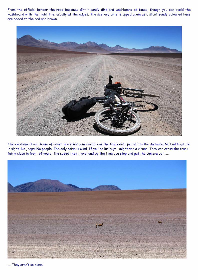
From the official border the road becomes dirt – sandy dirt and washboard at times, though you can avoid the
washboard with the right line, usually at the edges. The scenery ante is upped again as distant sandy coloured hues
are added to the red and brown.
The excitement and sense of adventure rises considerably as the track disappears into the distance. No buildings are
in sight. No jeeps. No people. The only noise is wind. If you're lucky you might see a vicuna. They can cross the track
fairly close in front of you at the speed they travel and by the time you stop and get the camera out …..
…. They aren’t so close!

First sighting of Laguna Blanca (4350m), Bolivia
Don't give all your thoughts up to adventure
and scenery though, as deep sandy sections
require concentration and responsive bike
control.
Some speedy downhill, tail wind miles and a
small sign for Rio Amargo mine, pass.
The sand thickens a little and a slight brow in the track sits below the closest image of golden hues yet, but hides
what lies ahead. Crest the brow and your attention diverts immediately away from the mountains, to your first
sighting of Laguna Blanca. Wow.
If you only came this far and went back it would be worth it! It isn't white as the name suggests, it's a very pale blue
and it looks stunning. After further viewing it isn't hard to see why it's called 'blanca' though. There's a clean, crisp
white about the paleness, especially against the deep blue of the sky, so much so that calling it Laguna Azul (blue)
would be completely inappropriate.
The peaks beyond have streaks of white snow. The downhill and view invites you to speed on but take a moment to
pause. The majority of people who visit this region don't see what is before you now. Seeing this lake from the other
direction is nice but far less spectacular and most people do tend to ride/travel in a southerly direction so seeing
this view requires them to stop and look back. Jeep tours do arrive from San Pedro but the majority come south from
Bolivia. If you don't feel a sense of awe, excitement and adventure here, you never will. This is as close to riding into
a lost world as you can get.
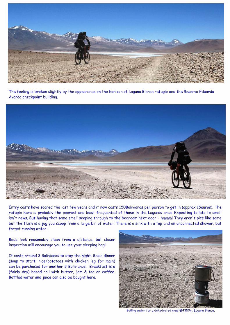
The feeling is broken slightly by the appearance on the horizon of Laguna Blanca refugio and the Reserva Eduardo
Avaroa checkpoint building.
Entry costs have soared the last few years and it now costs 150Bolivianos per person to get in (approx 15euros). The
refugio here is probably the poorest and least frequented of those in the Lagunas area. Expecting toilets to smell
isn't news. But having that same smell seeping through to the bedroom next door – hmmm! They aren't pits like some
but the flush is a jug you scoop from a large bin of water. There is a sink with a tap and an unconnected shower, but
forget running water.
Beds look reasonably clean from a distance, but closer
inspection will encourage you to use your sleeping bag!
It costs around 3 Bolivianos to stay the night. Basic dinner
(soup to start, rice/potatoes with chicken leg for main)
can be purchased for another 3 Bolivianos. Breakfast is a
(fairly dry) bread roll with butter, jam & tea or coffee.
Bottled water and juice can also be bought here.
Boiling water for a dehydrated meal @4350m, Laguna Blanca,
Bolivia

From the refugio and reserva checkpoint the road splits left and right around Laguna Blanca. Take the left route, it’s
a more pleasant ride and it takes you via Laguna Verde viewpoint.
There’s a small, rideable stream crossing that separates the two Lagunas (Blanca & Verde). Cross that, pick your line
up a rise & you'll find yourself at Laguna Verde viewpoint.
The lake's green colour comes
from minerals, mainly arsenic.
In the right light, at the right
time of day, it is a spectacular
sight. Laguna Verde viewpoint
is likely to be your first full on
interaction with jeep tours.
Expect the many lenses to
move from scenery to you as
soon as someone clocks your
impending arrival in the
distance.
Circumnavigating Laguna Blanca!
Laguna Verde (4350m)
Normally a lot greener once the sun
has had a chance to heat it up
San Pedro de Atacama, Chile (2300m) to Laguna Blanca, Bolivia (4350m) via a 4650m pass
(Split this over 2 days for acclimatisation)

Top & Bottom Pics - Climbing the pass between Laguna Verde & Laguna Chalviri
Jeep tours can be the one negative aspect of the Lagunas for bike tourers. The people are great, often giving
support either vocally or through gestures (the encouraging sort!). The drivers however – or the way they drive to be
precise – can be a different matter. The cyclists’ global complaints of too fast, too close, are not absent here. Dust,
dirt and stone showers are common. The jeeps tend to move about in large trains so when one passes, expect a few
more, only seconds behind. The positive side of this is that once you’ve endured a couple of ‘trains’, you are generally
left alone for the rest of the day.
You can see so far ahead and behind in this vast place that the travelling dust clouds are often easy to spot. Keeping
an eye out usually gives you time to take action, which is to pull over to the side of the road, take a deep breath and
cover eyes, mouth and nose as they speed by. You won’t be able to see or breathe until the dust cloud settles so
trying to ride on is often futile and dangerous - following drivers aren’t thinking about dust blinded cyclists who have
inadvertently veered into the middle of the track. Their visibility may also be reduced by the dust, but, unlike for
you, it won’t slow down their forward progress!!
From Laguna Verde, the next target is Laguna Chalviri and the Termas de Polques (hot springs). There's a 400m climb
to a 4750m pass and then a wind assisted downhill which eventually flattens out at Chalviri. A 400m climb sounds
insignificant, especially if you’ve knocked out 1200m each day for the last 2 days, but the terrain can be very sandy
and here a lighter, bikepacking setup with more specific mountain bike tyres and pressures really comes into its own.
Speed may have dropped to walking pace at times, but I didn’t have to push once!

You still need to find the right line and
some chopping and changing is required.
Just keep an eye out for the tour
jeeps, they have the same idea and you
don't have best route priority!
If you do have to push, what you're
pushing towards easily distracts from
the disappointment of not riding. The
mountain colours here match any
elsewhere in the region and you are as
close to them as anywhere else, too.
Cresting the pass takes a couple of
hours from Laguna Verde. If you had
any doubts over how slow progress
would actually be in this region, they
should now be dispelled. Climbing on
sand at altitude easily drops you below
5-6mph.
The main challenge of the Lagunas is
not to ride fast but to stay riding.
Throw in the wind and at times you'll
find yourself as low as 3mph!
If you're the sort of rider who can
block out thoughts of speed and
distance, make a challenge out of
constantly finding a line that is
rideable and measure success by
keeping your feet on the pedals
rather than on the ground, you'll do
well.
A short plateau leads to the descent.
Long straight sections allow good
speed, especially with a front
suspension fork.
Above - Cresting the 4750m pass between Laguna Verde & Laguna Chalviri
Below – On the way down

On the steeper part of the descent I ran into Chris, a Swiss guy cycling from Alaska to Ushuaia on a recumbent bike.
At the time it was an unusual sight for me, seeing another cyclist and on a recumbent bike at that. But both were to
become more common over the coming days.
It was interesting chatting. He told me there were a fair
number of cyclists coming behind him. They had all
gravitated to each other in Uyuni and set off within a
few days of each other with a similar goal – to ride South
through Lipez and Lagunas region into Chile.
The shifter cable on his Rohloff hub had packed up,
leaving him in one gear. He could change but only by
stopping, getting off the bike and doing it manually with a
tool. On top of that he had dropped his camera in the hot
spring pool, resulting in the photos from the last few days
being potentially lost and the water had broken the
camera preventing further photographs - a difficult few
days for him mentally & physically.
The gradient flattens but enough of a slope is retained to reward a bit of legwork. Laguna Chalviri comes into sight
and washboard does it's best to hinder progress. I pass the precise spot we camped out in 2009 when it hit minus
20deg C. We didn’t know then that just round the corner was a place that sold food with a great snack shop & floor
to sleep on.
As you close up on Laguna Chalviri the track bends round to the left and rather new, smart looking building is
revealed. It’s somewhat out of place for a region which doesn’t specialise in new, particularly the smart interior. The
building is a café type stop, consisting of numerous tables and chairs, for the jeep tour groups.

Hot spring pool @Laguna Chalviri 4400m. Overcrowded in the morning, free in the afternoon
Seat with a view - Looking out over Laguna Chalviri
The place is run by a family. They were friendlier to me than the people running the other stop points. You can buy a
hot meal – better standard than elsewhere and the snack shop is brilliant. Pringles, Snickers, Twix, Coke and a lot
more! The real draw of this place however, is the Termas de Polques - hot springs. A natural, thermal hot water
spring pours out from the ground on the edge of the main lake. A low man made wall has been partially built around
the spring – a gap in the wall allows the water to overspill and refresh – creating a pool.
Sitting in the pool, in lovely warm water is the perfect tonic
for tired and dusty limbs. Further, since there are no beds at
the cafe, no tour groups stay here. That works out really well
as in the afternoon, all the tour groups will have passed
through and you can have the place to yourself. Well almost,
the small family that run the restaurant/shop have the same
idea! Sitting in the pool, it’s hard to believe this incredible
experience is free!!
You can camp nearby or the family will let you sleep on the
floor in the café building provided you are up before 6am when
the first of the tour groups start to arrive. The grandfather
aged man diligently sweeps the floor every evening – taking not
inconsiderable time and care to move the many tables and
chairs – but it isn’t dirt or dust that you need to be concerned
about. I stamped on a scorpion scuttling its way innocently
across the room! Check shoes and give clothes a shake in the
morning!
Members of a typical jeep tour stay at one of the refugios
near Laguna Colorada. They leave early (4-5am) and pile up to
the mountain pass (4950m) that separates Chalviri from
Colorada. There is a geyser just beyond the pass that shoots
its spray 15m into the air. The spray loses height as the air
warms up, hence the need for early viewing.

Afterwards, everyone drops down from the geyser to the hot spring pool for a morning dip & breakfast. The morning
experience is in total contrast to the afternoon/evening one. From isolated best, you now are party to its busiest
worst! Jeep after jeep pours in, the travellers pile out, into the pool for a dip, café for breakfast. It is a bit of a
cattle market. 20 odd jeeps. 4-6 people in each. The pool is rammed, so is the café! It’s difficult to criticise. I was
just grateful for the evening experience and thankful I could move under my own steam.
The 16 year old boy – Daniel - of the family who ran the
café was amazed with some of my gear and kept calling his
father or grandfather (I wasn’t able to work that out) to
come and look. It was like watching a kid on Christmas Day
as he worked his way through various items.
First up, the thermarest mattress that came out of a bag disproportionately smaller but confusingly expanded to a
size big enough to enclose a 6ft frame! On top of that, it inflated naturally or – more fun – by blowing it up.
Next, the inflatable pillow which expanded from a bag that sat comfortably within the palm of a hand. This required
active inflation which Daniel wasted no time in completing, giving repeated demonstrations to his (grand?) father.
Now for the sleeping bag: Not quite as mind boggling or as much fun as the other two pieces but still captivating
enough.
He liked my shades, the camera, pics, the bike and the pringles and coke I shared with him too. I don’t speak Spanish
but he had a sheet with English words on and in the late afternoon I helped him with some English pronunciation.
With a small paper pad, a pen and charades we communicated back and forth! It was a memorable time.
Above left - A good floor to sleep on but watch out for the odd scorpion; Above right – Trying Oakleys on for size
Laguna Blanca (4350m) to
Laguna Chalviri (4400m)
via a 4750m pass

Leaving Chalviri and the Polques
behind, I headed off to climb up
to a 5000m pass (4950m to be
precise) – the highest point on the
Lagunas main route if you exclude
the small detour to the geysers
(which would take you over the
5000m mark).
This section now has a bulldozer
type vehicle (a grader I am
reliably told) - that works its way
up and down, clearing the sand and
dirt drifts - created by the
strong winds and vehicles - that
hinder progress.
The quality of track was far
superior to last time but
conditions can change within days,
let alone years!
There is a mine north of the pass,
close to the geyser. That means,
although much less frequent,
jeeps aren’t the only vehicle you
need to be alert for.
Winds pick up as you approach the
summit. Once you reach the
4950m mark, the expectation is
immediate downhill but there are
a few miles of frustrating
undulation and false declines
before the proper descent to
Laguna Colorada starts.
Above - Steam pours off the hot spring pool in the cool early morning
Below – On the way to 4950m
Above – A mining truck hurtles along
Below – Topping out just shy of 5000m

As I began the descent I had my second encounter with other cyclists - a party of 5. Two Dutch, two Australians and
one swede. They had stopped for a food and rest break after climbing up from the Laguna Colorada side. Initially I
thought they were all part of the same yellow panniers group but I soon found out that they were 3 parties who had
joined together out of Uyuni.
The dutch couple were coming to the end of an approx 18 months trip. The Aussie girls
were on their way south travelling Alaska to Ushuaia. I think the Swedish guy was on the
run as he didn’t say anything for the 20 minutes other than to make it known (in good
English, so it wasn’t a language barrier thing) he didn’t want his photo taken!
It was interesting looking at each other’s bikes, setup, gear. I was envious of their
extended trips (but not of the amount of gear they were hauling) and they looked back
admiringly at the guy with no stuff!
We chatted back and forth and then all of a sudden, as I scanned the dutch guy’s bike, I
interrupted the conversation with a loud exclamation of “bloody hell”. Strapped to the
seat stay of his bike was a 2 foot machete!!!! They went on to explain that it was
purposely on show as a message to would be robbers/attackers.
Laguna Colorada gets its colour from a red pigment in the algae. It’s more reddy-brown than red, but still spectacular.
There are plenty of James’ flamingos on show but they are fairly far away. Closer flamingo viewing can be found a
couple of day’s ride north at Laguna Hedionda. The Laguna Colorada basin is large and it’s one big wind tunnel. Hyper
strong gusts don’t seem to be restrained by the Andes Mountains to the west and bolt unbridled over the lake and
adjacent plains. The mountain you are riding down offers some protection on the descent, but the moment you ride
outside that shelter to make a dash across the plains – look out.
The going is harder for fully loaded touring bikes. Safety with numbers ………………. and a machete!
Laguna Chalviri (4400m) to Laguna Colorado (4300m) via a 4950m pass

Descending to Laguna Colorada (4300m)
As the descent meets the plain, the road splits. Straight on (or right) takes you on the eastern side of the lake and
on to Pena Barosa and Volcan Uturuncu. Left is the traditional/main route for El Arbol del Piedra (The Stone Tree) &
and a sequence of 4 or 5 smaller Lagunas, one of which is Laguna Hedionda and some great flamingo spotting.
Like most of the riding here, crossing Laguna Colorada isn’t easy. As well as the wind, the surface and tracks here
aren’t the best either. They do improve marginally, as you go, but it’s still a 1 hour plus slog from the southern tip of
the lake to the refugios on the North West side.
Laguna Colorada actually has a choice of refugios at either end of the lake but the ones on the south west side are
easy to miss as they are off the main track that follows the lake’s western shore. You can’t even see them from the
main track most of the time!
The vast Laguna Colorada basin – man at bottom of pic gives sense of scale

Laguna Colorada
There isn’t a lot between the various refugios
in terms of food and accommodation. Some
have facilities that look enticing but aren’t
actually plumbed in, so bear than in mind in case
you are lured in by a desirable extra that tips
the scales.
Two years ago we rolled up to the newest
refugio building on the southern edge of
Colorada. We were shown decent rooms and the
Bolivian woman didn’t hold back from pointing
out the impressive en-suite bathrooms. After four dusty days riding and camping & not having washed - jackpot! Or
so we thought. Once we took the room she came in and locked the en suite room up … none of the shower, sink or
toilet was ready for use!! Top selling!
Colorada has 2 north western refugios. One of
which has a shower – yeah right, that old
chestnut – hang on, it works?! You can even pay
extra for hot water (although I didn’t find that
out until after I had frozen my nuts off).
Amusingly, the shower vent is a series of large
holes drilled in the wall right behind you. This
area isn’t short of a breeze or two so you get the
pleasurable double of cold air funnelling through
as you rinse in cold water. Actually the facilities
at this refugio are among the best and it isn’t
hard to see why it’s frequented by the jeep
tours.
Don’t expect totally equal treatment. The jeep
tours come through here every day and
represent these people’s livelihood. They get
understandable priority.
As if to reinforce the view, touring cyclists can
look on in envy at how the other half live as the
jeep tour groups roll up with cool boxes of fresh
food not found for miles …. Chicken, pasta,
tomatoes, cucumber, bananas and bread that you
don’t have to dip in tea to make it soft enough to
eat! If you are lucky – as I was on occasion – you
meet some who want to share it with you.
Dusty, weather beaten
cyclists often look and
act like they don’t have
two pennies to rub
together and this often
reinforces the cultural
view outside the western
world that you are on a
bike, instead of in a car,
by necessity rather than
choice!
Climbing again … away from Colorada towards El Arbol de Piedra (The Stone Tree)
Laguna Colorada Refugio, stones on the roof to batten down the hatches
Colourful & warm blankets brighten up dark rooms. Sprung bed bases anyone?

El Arbol de Piedra (The Stone Tree) – formed by the natural erosion of rock by dust & wind
A better look at the bike set up. Not that light by bikepacking standards, but definitely so in
comparison to a more traditional touring setup normally used for this region
The graders have definitely been busy. Two years ago after reaching the plateau a couple of miles short of ‘The
Stone Tree’ we had to push the rest of the way because the sand-gravel mix was too deep to ride. Now they’ve
ploughed a great new track so the previously worst section was now the currently best. El Arbol de Piedra is a
magnificent sight. It’s bigger than you’d expect too. This is a good place to camp – plenty of soft sand for
comfortable sleeping and there are more large rocks around other than the main exhibit providing good wind-break
shelter and privacy. But like most places here, what’s private in the evening, is the opposite in the morning. Don’t be
surprised to find a few photographers waiting outside your tent come dawn!
Better and faster track for you
means better and faster track for
the jeeps and you know what that
means …
The best line is on your side of the
track? I will take your side of the
track! I will drive straight towards
you and not slow down. It is your
job to get out of my way. I will
shower you in stones and dirt in
the process!
I heard first-hand accounts of
bikers who were surprised to find
their middle finger automatically
pointing upwards to the sky now
and again, strangely, always around
the time they were recipients of
such considerate driving.

Laguna Colorada to Hotel Desierto
Just under 20 miles north of The Stone Tree is one of the Lagunas’ best secrets – Hotel Desierto. It’s good, even by
western standards, but out here it’s an absolute treat. Nice big rooms, hot shower, clean crisp sheets, soft blankets,
good food, cold beer, decent wine. Tour groups do stop here but, due to the additional cost, there are less than at
the refugios.
It’s a good target to aim for whichever direction you are travelling and can make the days of not washing more
palatable. Tourers on longer trips tend to be more budget conscious and all of the ones I met had shied away from
staying here. Ironic because the friendly staff & manager took pity on me as a cyclist and they charged me ‘jeep tour
driver rate’, about one third of the normal occupant cost.
The hotel marked the turnaround point for my shortened trip. I had considered riding on to Laguna Hedionda and
Ollague and cutting back to Calama through Chile, but I love this area and I wanted to head back and pick up some
more pics along the way. For me, there are moments to put in big days and there are moments when doing so would
mean me missing out on the surroundings, not stopping to take pictures or interact with local people. If you put in 8
to 12 hour days you can double the daily distances, but that isn’t really the point here. Like a good wine, this area isn’t
meant to be gulped as quickly as possible. I had one challenging period coming back from Laguna Colorada to Laguna
Chalviri. The winds picked up so strong that I started to get blown across the track on my bike. This began to get

Laguna Chalviri to San Pedro de Atacama
dangerous as the strength of the wind meant I was oblivious to approaching vehicle noise from behind. Since I could
see for miles behind, I adopted a cycle of looking to see if no vehicles were coming, riding for 30-60s seconds,
stopping and looking again etc. This worked fine until the wind strength increased further and the front wheel got
blown from under me. After a couple of occurrences I had to bike a hike. Even walking, the winds were so strong that
at times I had to lay my bike flat on its side and crouch as low as possible to stop my bike and myself getting blown
away. The vast open terrain meant there was nothing to shelter behind. Fortunately, the enveloping dust storms
lasted only minutes. After what seemed like an age, I descended down to the safety of Laguna Chalviri café at
4300m. This area and South America are known for their strong headwinds, but that was something else.
Just before I arrived at Hotel Desierto I ran into a Swiss couple who had been riding many months. Their reputation
did in fact go before them as the people I had met prior, all pointed out that “the Swiss couple are really very nice”.
I caught up with them the next day and we had a great time discussing various routes in Asia over spaghetti and a
beer at Laguna Colorada.
I did the same days back except for the last day when I rode from Laguna Chalviri through Laguna Blanca to San
Pedro de Atacama (Chile). All I had to do was make it to the top of the 4650m pass and it was 25 miles of downhill to
San Pedro.
The following pages contain some pics of the return leg without any narrative & a gear list at the end ……
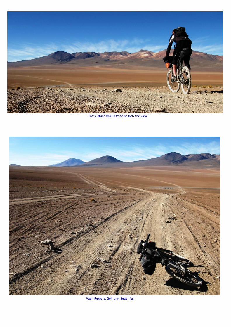
Vast. Remote. Solitary. Beautiful.
Track stand @4700m to absorb the view

The unique red-brown Laguna Colorada


Gear List
Harness (Revelate Designs)
-2 x Black outer straps holding an orange dry bag containing tent (1.23 kg terra nova laser competition 2), thermarest
(full length), inflatable pillow
-1 x grey centre strap holding sleeping bag (cumulus quantum 350, 900 down -6C rated). Sleeping bag has silk liner
inside.
-1 x 2l bottle of water or coke or tube of pringles stuffed on top of orange dry bag under 2 black outer straps
Large Pocket wrapped round handlebars and sleeping bag (Revelate)
-MSR titan kettle containing gas cylinder & Primus windshield
-Waterproof matches, stove, three pronged foldable stove/gas cylinder base
-Bar of soap, spork, head torch, 2 x dehydrated meals (1 x main, 1 x breakfast), 1 x anadin strip, 2 x paracetamol
strip, 2 x antibiotic strips, 2 x immodium instant strips, 1 x wet wipes, travel hand towel, foil emergency blanket, 1
small tube of germolene, 1 foldable toothbrush, 1 small tube of toothpaste, 30 vitamin tablets, spare bolts (seat post,
other), swiss army knife/multi-tool
Right Mountain Feedbag
-1 x 750ml camelbak bottle
Left Mountain Feedbag
-Jelly babies & biscuits
Front Gas Tank (Revelate)
-Camera battery charger & lead, spare battery, Powermonkey extreme battery, powermonkey extreme charging lead
USB/DC in (to use with ipod plug), ipod plug, ipod USB lead, mini USB tip (for garmin edge), Chile travel elec adapter,
Bolivia travel elec adapter
Specialized wedgie saddle pack
Tangle Bag
Pocket Bag (Small)
Pocket Bag (Large))
Seat Bag
Gas Tank Rear
Gas Tank Front
Sleeping Bag
Harness
Mountain Feedbag Right
Mountain Feedbag Left
Tent Poles
Water Bottle 750ml

Rear Gas Tank (Revelate)
-Sun tan lotion, 1 x wet wipes, chamois cream
Tangle Bag (Revelate)
-Right side: 3L camelbak bladder (able to fill to 2.5L)
-Left side: 3 front & 3 rear spokes, shock pump, 2 x disc pad spares, 6 x long cable ties,
-Tent poles attached between tangle bag velcro fastening and bike frame
Seat Bag (Revelate)
-1 x pair of waterproof socks, 3 x ankle cycling socks (2 packed at bottom, 1 at top), 1 x adidas clima cool t-shirt, 1 x
long black socks, 1 (spare) x cycling shorts, 1 pair of lightweight trail/adventure shoes (non cycling), 1 x hooded down
jacket, 1 x cycling tights, 1 x long sleeved 10/2 thermal cycling jersey, 1 x deodorant, 1 x lightweight north face
trekking trousers (legs removable to turn into shorts) with US dollars in zip pocket, 2 x pairs of blue lycra shorts no
padding (for underwear and for sleeping)
Small Pocket - Wrapped around seat bag (Revelate)
-2 x strips of chlorine water treatment tablets, 1 x Epic ride chain oil (large), 4 x dehydrated meals (2 x dinner, 2 x
breakfast), 1 x wet wipes, 1 x electrical tape
Specialized Wedgie Bag (wrapped around suspension linkage)
-2 x inner tubes, 1 x pair of tyre levers, 1 x topeak multi-tool, 1 puncture repair kit
CamelBak
-iphone, spot GPS, additional puncture repair patches, 1 x topeak road morph pump, 3l bladder (fill to 1-2l normally),
long fingered gloves, arm warmers, knee warmers, specialized cycling jersey (for cold morning starts and sleeping), sd
cards (x5), pen, small pad, 30 diamox, 1 x wet wipes
Bike
-1 x 750ml water bottle attached to frame
-Garmin Edge 705 GPS
Wearing
-Cycling shoes, Gore Bikewear Xenon cycling shorts, Assos short sleeved jersey, cycling mitts, sunglasses, 1 pair of
ankle cycling socks, money & credit cards in zipped pocket, lip balm/pocket vaseline in jersey pocket, Canon G9
camera attached to mini gorilla tripod in centre jersey pocket.

Appendix – Some notes for the onward journey from Hotel Desierto
From the hotel, it’s only approx. an 8 miles and 200m climb
up to a pass leading to 12 miles of downhill. Both sections can
be sandy and the descent starts out OK but there are some
real deep sand and rutted washboard sections further down.
The grade flattens and you pass the first of a series of
smaller Lagunas. Some undulation and a choice of tracks
which eventually converge again on the horizon bring you
over a rise to Laguna Hedionda.
There’s a hotel here. It isn’t as plush as the Hotel Desierto
but it’s still a much better standard than the refugios. Like
Colorada, Hedionda has an abundance of flamingos. Unlike
Colorada, they are within genuine viewing & picture taking
range.
From Hedionda, there’s no
great height gain or mountain
pass to be scaled but there
are some short, sharp uphills
over the 12 miles general
incline to the base of Bolivia’s
only active volcano – Volcan
Ollague (5865m).
A small stream of smoke puffs
out of the left hand corner.
One more hill and your legs are
free to enjoy a 20 mile
downhill to the border. If you
want services you have to
cross into Chile to the town of
Ollague.
It does have places to sleep and eat but as a town, Ollague is a pretty grim place. Two streets separated by a rail
track and a few busted train carriages. The bleakness does offer some superb photo opportunities but little else. You
have the opportunity to hike-a-bike your way above 6000m on the slopes of nearby Volcan Aucanquilcha. There is a
track, but it’s very sandy so expect lots of pushing. From Ollague (3600m) it is a few days ride north to the
magnificent Salar de Uyuni (3550m).