Embed Size (px)
Citation preview
1
NYC Bicycle Master Plan
Preface
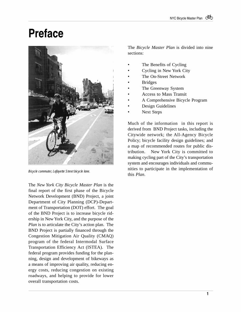
Bicycle commuter, Lafayette Street bicycle lane.
The Bicycle Master Plan is divided into ninesections:
• The Benefits of Cycling• Cycling in New York City• The On-Street Network• Bridges• The Greenway System• Access to Mass Transit• A Comprehensive Bicycle Program• Design Guidelines• Next Steps
Much of the information in this report isderived from BND Project tasks, including theCitywide network; the All-Agency BicyclePolicy; bicycle facility design guidelines; anda map of recommended routes for public dis-tribution. New York City is committed tomaking cycling part of the City’s transportationsystem and encourages individuals and commu-nities to participate in the implementation ofthis Plan.
The New York City Bicycle Master Plan is thefinal report of the first phase of the BicycleNetwork Development (BND) Project, a jointDepartment of City Planning (DCP)-Depart-ment of Transportation (DOT) effort. The goalof the BND Project is to increase bicycle rid-ership in New York City, and the purpose of thePlan is to articulate the City’s action plan. TheBND Project is partially financed through theCongestion Mitigation Air Quality (CMAQ)program of the federal Intermodal SurfaceTransportation Efficiency Act (ISTEA). Thefederal program provides funding for the plan-ning, design and development of bikeways asa means of improving air quality, reducing en-ergy costs, reducing congestion on existingroadways, and helping to provide for loweroverall transportation costs.
2
NYC Bicycle Master Plan
Executive Summaryof bicycle encouragement, engineering, en-forcement and education.
Implementation of the Plan could have a pro-foundly positive impact on New York City,enhancing New Yorkers transportation andrecreation options, improving the city’s airquality, alleviating the city’s notorious noisepollution and congestion and, in general,transforming New York City into a morewelcoming, enjoyable place in which to liveand visit.
The use of the bicycle in New York City hasbeen rising steadily during the last decade.More and more New Yorkers are embracing thebicycle as a liberating, healthy, inexpensive,environmentally beneficial and, in general, funway to travel. Despite its reputation for insuf-ferable congestion, New York City is in manyways ideal for cycling, offering dense land use(ideal for short trips), relatively flat topography,a spectacular, expansive waterfront, and anextensive, linear park system.
The objective of the New York City BicycleMaster Plan is to encourage cycling as a modeof transportation. The goals of the Plan are asfollows:
• Implement and maintain the city's bi-cycle network and greenway system
• Improve cycling safety• Provide bicycle parking and support
facilities• Improve bicycle access on bridges and
mass transit facilities• Institutionalize cycling in public agen-
cies and private organizations
Consistent with these goals, the Plan identi-fies a 909 mile, city-wide bicycle network andproposes design guidelines to assist in theimplementation of the network. The networkmaps are enclosed in the back of the report.The Plan also reports on the New York CityGreenway, a multi-agency initiative to de-velop bicycle routes connecting the city'sparkland, and recommends improved bicycleaccess to bridges and mass transit. Finally,the Plan proposes a Comprehensive BicycleProgram, documenting existing and propos-ing new multi-agency initiatives in the areas
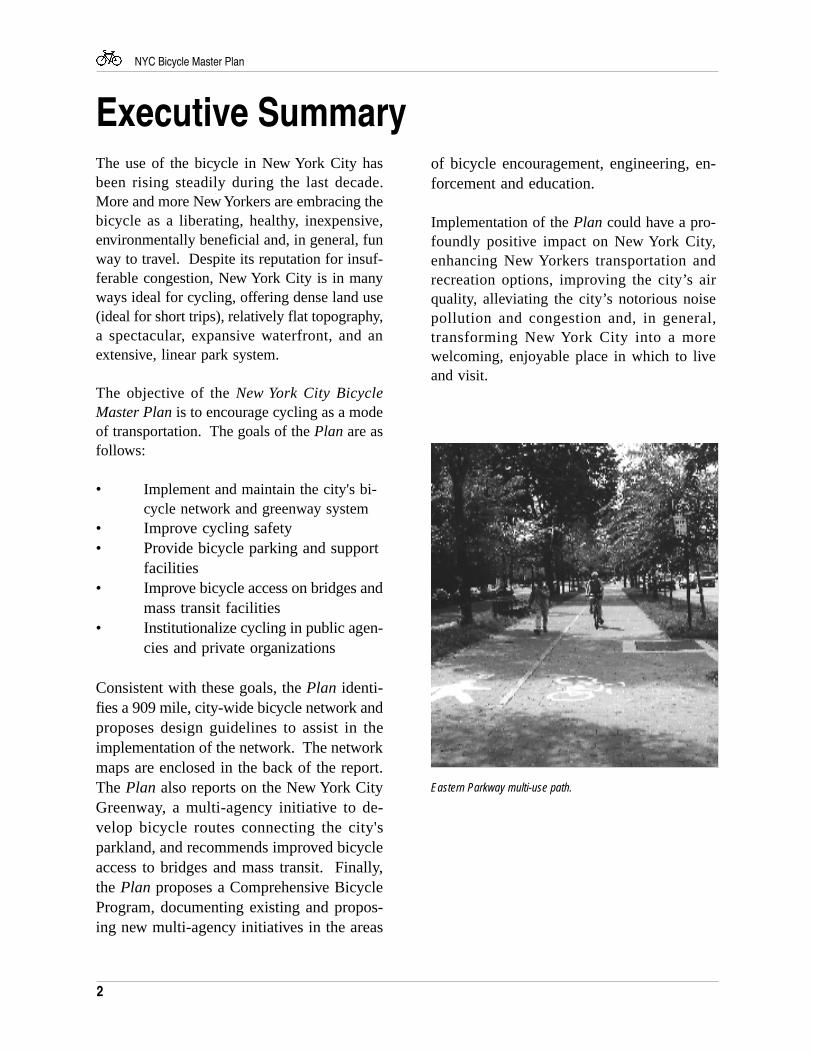
Eastern Parkway multi-use path.
3
NYC Bicycle Master Plan
The Benefits of CyclingCycling can be informative and pleasurable. Bytraveling by bicycle, the rider becomes a partof the environment rather than isolated from it,getting to know different neighborhoods in thecity and finding attractions that could be missedin an automobile.
The bicycle is also economically efficient. Ac-cording to estimates by Transportation Alterna-tives, an advocacy organization devoted to en-vironmentally-friendly transportation, bicycleriding costs the frequent cyclist only one-quar-ter as much as driving, assuming cyclistsreplace their bicycles every three years.Transportation Alternatives estimates that theannual savings would average $1,100 per mo-torist.
The bicycle is one of the most environmentallyefficient modes of transportation. By using arenewable energy source, the human body, thebicycle, in contrast to the automobile, isnon-polluting. The bicycle also uses much lessspace than the automobile, and is considerablymore quiet than other modes of transportation.These benefits are especially attractive in NewYork City, as we struggle with noise andcongestion issues, and are working to meet thefederal mandates of the 1990 Clean Air Act.
The bicycle also has tremendous health ben-efits. Cycling is ranked among the top threeexercises for improving cardiovascular fitness.According to the U.S. Center for Disease Con-trol, the most effective activity regimens aremoderate in intensity, individualized and incor-porated into daily activity. Cycling to work,school or shopping as part of one’s regulardaily routine can be both a sustainable andtime-efficient exercise regimen for maintainingacceptable levels of fitness.
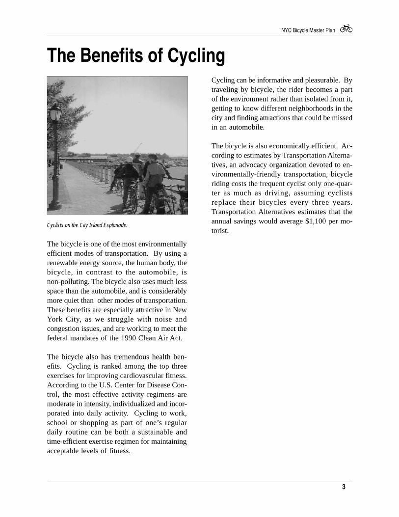
Cyclists on the City Island Esplanade.
4
NYC Bicycle Master Plan
Cycling in New York City
Existing Bicycle Use
There are approximately 119 miles of bicyclefacilities in New York City. The facilities,which are distributed among all five boroughs,range from multi-use park paths, to on-streetlanes on such major arteries as Broadway and
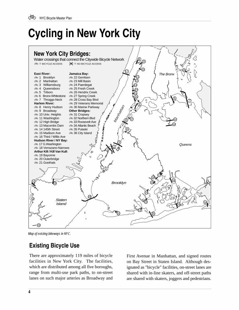
Map of existing bikeways in NYC.
First Avenue in Manhattan, and signed routeson Bay Street in Staten Island. Although des-ignated as "bicycle" facilities, on-street lanes areshared with in-line skaters, and off-street pathsare shared with skaters, joggers and pedestrians.
StatenIsland
Brooklyn
Queens
The Bronx
Man
hatta
n
New York City Bridges:
East River:Ä 1 BrooklynÄ 2 Manhattan Ä 3 Williamsburg Ä 4 QueensboroÄ 5 TriboroÄ 6 Bronx-Whitestone Ä 7 Throggs-Neck Harlem River:Ä 8 Henry HudsonÄ 9 BroadwayÄ 10 Univ. HeightsÄ 11 WashingtonÄ 12 High BridgeÄ 13 Macombs DamÄ 14 145th StreetÄ 15 Madison AveÄ 16 Third / Willis AveHudson River / NY Bay:Ä 17 G.WashingtonÄ 18 Verrazano-NarrowsArthur Kill / Kill Van Kull: Ä 19 BayonneÄ 20 Outerbridge Ä 21 Goethals
Ä = BICYCLE ACCESS Ä = NO BICYCLE ACCESS
Jamaica Bay:Ä 22 GerritsenÄ 23 Mill BasinÄ 24 PaerdegatÄ 25 Fresh CreekÄ 26 Hendrix CreekÄ 27 Spring CreekÄ 28 Cross Bay BlvdÄ 29 Veterans MemorialÄ 30 Marine ParkwayOther Bridges:Ä 31 CropseyÄ 32 Northern BlvdÄ 33 Roosevelt AveÄ 34 Atlantic BeachÄ 35 PulaskiÄ 36 City Island
Water crossings that connect the Citywide Bicycle Network
12
3
4
5
67
89
10
1112
13
1415
16
17
18
19
20
21
23
24
25
26
22
27
28
29
3031
32
33
34
35
37
36
5
NYC Bicycle Master Plan
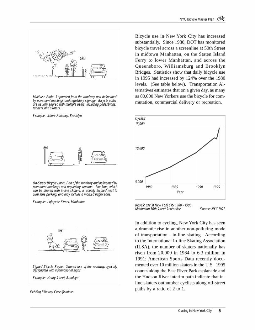
Bicycle use in New York City has increasedsubstantially. Since 1980, DOT has monitoredbicycle travel across a screenline at 50th Streetin midtown Manhattan, on the Staten IslandFerry to lower Manhattan, and across theQueensboro, Williamsburg and BrooklynBridges. Statistics show that daily bicycle usein 1995 had increased by 124% over the 1980levels. (See table below). Transportation Al-ternatives estimates that on a given day, as manyas 80,000 New Yorkers use the bicycle for com-mutation, commercial delivery or recreation.
Existing Bikeway Classifications
In addition to cycling, New York City has seena dramatic rise in another non-polluting modeof transportation - in-line skating. Accordingto the International In-line Skating Association(ILSA), the number of skaters nationally hasrisen from 20,000 in 1984 to 6.3 million in1991; American Sports Data recently docu-mented over 10 million skaters in the U.S. 1995counts along the East River Park esplanade andthe Hudson River interim path indicate that in-line skaters outnumber cyclists along off-streetpaths by a ratio of 2 to 1.
Bicycle use in New York City 1980 - 1995Manhattan 50th Street Screenline Source: NYC DOT
Cycling in New York City
5,000
15,000
1980 1985 1990 1995
10,000
Signed Bicycle Route: Shared use of the roadway, typicallydesignated with informational signs.
Example: Henry Street, Brooklyn
Multi-use Path: Separated from the roadway and delineatedby pavement markings and regulatory signage. Bicycle pathsare usually shared with multiple users, including pedestrians,runners and skaters.
Example: Shore Parkway, Brooklyn
On-Street Bicycle Lane: Part of the roadway and delineated bypavement markings and regulatory signage. The lane, whichcan be shared with in-line skaters, is usually located next tocurb lane parking, and may include a marked buffer zone.
Example: Lafayette Street, Manhattan
Year
Cyclists
6
NYC Bicycle Master Plan
Potential Bicycle Use
Despite the increase in cycling in New YorkCity, the comparative number of cyclists re-mains low. According to the 1990 Census, bi-cycle trips comprised only 0.9% of all tripsmade by vehicles in the city. This low numberis due in large part to the difficult cycling con-ditions and absence of sufficient facilities. NewYork City’s dense land use and flat topographyrenders the city ideal for cycling. New Yorker’spredilection for trips under five miles (62.7%,1990 Census) bodes well for converting tripsfrom auto to bicycle. In fact, the Federal High-way Administration (FHWA) has targeted 10%of all short (five miles or less), individual ve-hicle trips to be made by bicycle by the year2000.
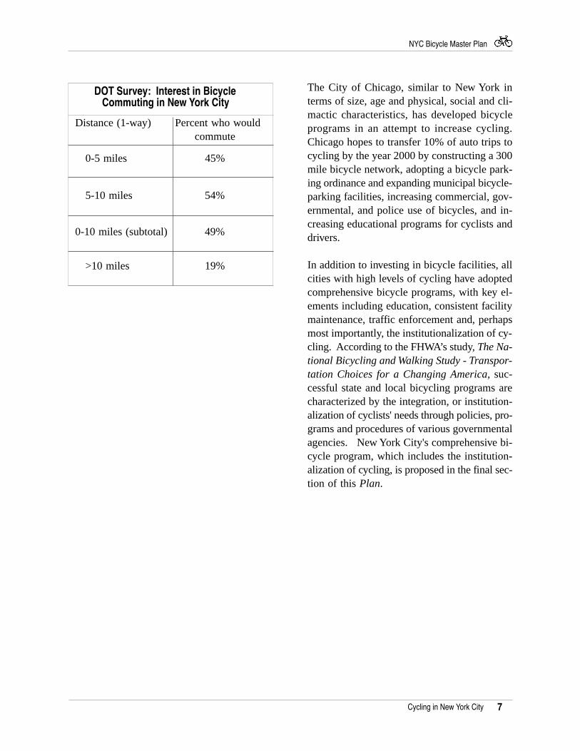
A 1990 survey conducted by DOT indicatessignificant potential bicycle ridership. Accord-ing to the survey, nearly 50% of the 688 Man-hattan office workers living within 10 miles oftheir job and responding to the survey wouldcycle to work if provided with the followingamenities:
• On-street bicycle lanes• Building access for secure bicycle
parking• Facilities to shower and change clothes
Following significant investment in bicycle fa-cilities, cities in industrialized countries haveexperienced dramatic increases in the level ofcycling. For example, Copenhagen experienceda cycling increase of 50% in five years; Eugene,Oregon experienced an increase of 75%; andToronto experienced an increase of 270%. Inaddition, cycling constitutes 25%, 18% and11% of nationwide trips in Denmark, Nether-lands and the former West Germany, respec-tively; 30% of all work and school commutesin Japan; and 50% of all trips in China.
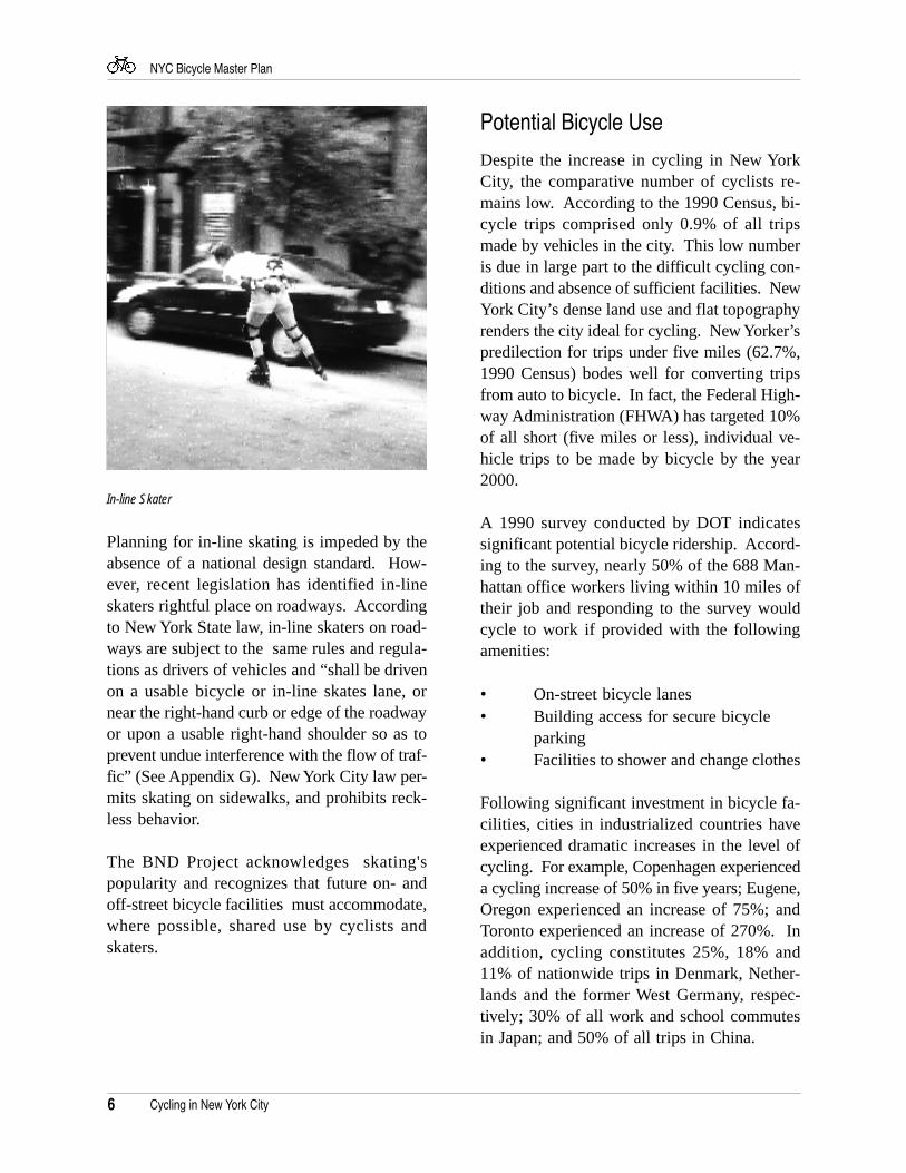
Planning for in-line skating is impeded by theabsence of a national design standard. How-ever, recent legislation has identified in-lineskaters rightful place on roadways. Accordingto New York State law, in-line skaters on road-ways are subject to the same rules and regula-tions as drivers of vehicles and “shall be drivenon a usable bicycle or in-line skates lane, ornear the right-hand curb or edge of the roadwayor upon a usable right-hand shoulder so as toprevent undue interference with the flow of traf-fic” (See Appendix G). New York City law per-mits skating on sidewalks, and prohibits reck-less behavior.
The BND Project acknowledges skating'spopularity and recognizes that future on- andoff-street bicycle facilities must accommodate,where possible, shared use by cyclists andskaters.
In-line Skater
Cycling in New York City
7
NYC Bicycle Master Plan
The City of Chicago, similar to New York interms of size, age and physical, social and cli-mactic characteristics, has developed bicycleprograms in an attempt to increase cycling.Chicago hopes to transfer 10% of auto trips tocycling by the year 2000 by constructing a 300mile bicycle network, adopting a bicycle park-ing ordinance and expanding municipal bicycle-parking facilities, increasing commercial, gov-ernmental, and police use of bicycles, and in-creasing educational programs for cyclists anddrivers.
In addition to investing in bicycle facilities, allcities with high levels of cycling have adoptedcomprehensive bicycle programs, with key el-ements including education, consistent facilitymaintenance, traffic enforcement and, perhapsmost importantly, the institutionalization of cy-cling. According to the FHWA’s study, The Na-tional Bicycling and Walking Study - Transpor-tation Choices for a Changing America, suc-cessful state and local bicycling programs arecharacterized by the integration, or institution-alization of cyclists' needs through policies, pro-grams and procedures of various governmentalagencies. New York City's comprehensive bi-cycle program, which includes the institution-alization of cycling, is proposed in the final sec-tion of this Plan.
Cycling in New York City
>10 miles 19%
0-10 miles (subtotal) 49%
5-10 miles 54%
0-5 miles 45%
Distance (1-way) Percent who would commute
DOT Survey: Interest in Bicycle Commuting in New York City
8
NYC Bicycle Master Plan
The On-Street Network
Educational institutions are major destinations for cyclists.
In an effort to increase the level of cycling byimproving bicycle facilities, the BND Projecthas developed a proposal for a city-wide net-work of 900 miles. The components of the net-work are as follows:
Existing Facilities miles
Multi-Use Paths: 51
Seasonal Bicycle Paths/Lanes: 11.5(Central & Prospect Park Loop Roads)
On-street Bicycle Lanes: 41Signed Bicycle Routes: 8
Bike Accessible Bridges: 7.5
Subtotal 119
Proposed Network miles
Recommended Routes: 678(Streets which do not contain bicycle facilities butare suitable for cycling, or would be suitable with minimal capitalinvestment i.e., striping and/or signage.)
Capital Investment Routes: 112(On and off-street locations appropriatefor cycling with capital investment, i.e., pathconstruction, striping and signage.)
Subtotal 790
Total Mileage: 909
Planning Process
The Network methodology for on-street bicyclelanes, described below, generally follows amethodology recommended by the FederalHighway Administration (FHWA):
Identify the major destinations
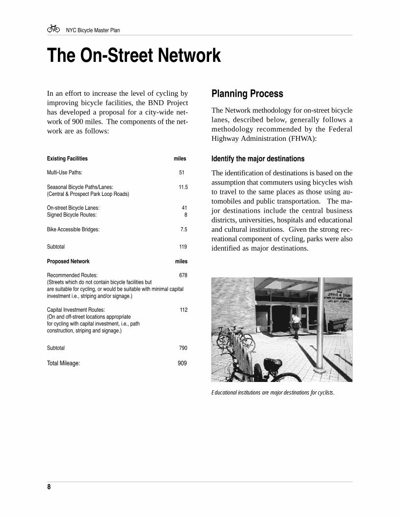
The identification of destinations is based on theassumption that commuters using bicycles wishto travel to the same places as those using au-tomobiles and public transportation. The ma-jor destinations include the central businessdistricts, universities, hospitals and educationaland cultural institutions. Given the strong rec-reational component of cycling, parks were alsoidentified as major destinations.
9
NYC Bicycle Master Plan
Identify travel corridors
The travel corridors are those routes which di-rectly link the major origins and destinations.It logically follows that the travel corridors tendto follow the city’s major traffic arteries. Thetravel corridors can also be thought of as “de-sire lines” - they may not represent where cy-clists are today, but rather the most direct routewhich cyclists wish to follow.
Cycling skill levels
The FHWA identifies three types of skill lev-els - A (advanced); B (moderate); and C (be-ginner). The network is designed primarily forB and C cyclists who, according to the FHWA,value accessible, direct roadways, designatedbicycle facilities and lower traffic volumes.
Select specific routes
Routes were selected within the travel corridorsbased on the following “performance criteria”:
1. Accessibility and directness to majororigins and destinations.
2. Connections with other routes.
3. Attractiveness of the route.
4. Low conflict with other modes.
5. Feasibility of implementation.
6. Safety to cyclists and pedestrians:A stress level methodology, describedbelow, was developed in an attempt torank the safety, or suitability,of existing roadways.
Stress level methodology
The “stress level” is based on a methodologydeveloped by the Traffic Institute at Northwest-ern University and the Madison, Wisconsin De-partment of Transportation. The following fivestress levels were identified:
1. Low - Suitable for all cyclists (exceptchildren under age 10).
2. Moderate - Suitable for A and Bcyclists; alterations may be needed toaccommodate younger cyclists.
3. Significant - Suitable for A cyclists;alterations may be needed to accom-modate B cyclists; not recommendedfor C cyclists.
4. Demanding - Alterations may beneeded to accommodate A cyclists; notrecommended for B and C cyclists.
5. Severe - Not suitable for bicycles.
The following variables were identified as af-fecting a cyclist’s stress level:
1. Curb lane width
2. Curb lane traffic volume
3. Vehicle speed
By riding the entire network, the BND Projectwas able to evaluate the route stress level.
See Appendix C for more detailed informationon stress level methodology.
The On-Street Network
10
NYC Bicycle Master Plan
Public Outreach
The network has been developed with extensiveconsultation with other City agencies, advocacyorganizations, community boards, elected offi-cials, and the bicycle community. Listed be-low are the Project’s primary public outreachefforts.
Technical Advisory Committee
Since the beginning of the BND Project in thesummer of 1994, seven Technical AdvisoryCommittee (TAC) meetings have been held.The purpose of each meeting was to report onthe Project’s progress, and to solicit review andcomments from TAC members. For a list of theTAC members, see Appendix B.
Borough Subcommittees
Following TAC meetings, BND Project staffmet with TAC members and other interestedgroups and individuals on a borough-by-bor-ough basis. This format allowed for detaileddiscussions on recommended routes with bor-ough-based planners and cyclists.
Borough and Community Boards
Presentations of the draft network were madeto the Borough Boards. The Borough Boardmembers encompass the Borough President,community board chairs, and local and stateelected officials. As the design of specificroutes advances, presentations will be made tothe affected community boards. The new on-street lane on St. Nicholas Avenue in UpperManhattan was approved by the affected com-munity boards prior to implementation.
Volunteers
To reach out to those who are familiar withcycling in the City, but may not be active mem-bers of the bicycle community, the Projectposted notices On-line and in the Transporta-tion Alternatives' newsletter City Cyclist seek-ing additional input. In addition, the Projectcoordinated the European Experience, an all-day FHWA seminar on European bicycle andpedestrian facilities, and has made presentationsto such advocacy organizations as Transporta-tion Alternatives and The New York CyclingClub.
Implementation of on-streetroutes
With an identified city-wide network, the imple-mentation of bicycle facilities will follow a des-ignated plan. Prior to implementation, however,DOT completes the following analysis:
• Street and traffic data collection• Existing motor vehicle level of service
analysis (LOS)• Projected LOS with proposed
bicycle facility design• Community outreach• Technical drawings• Pre- and post-implementation bicycle
counts
See Appendix D for a more detailed discussionof the DOT implementation process.
The On-Street Network
11
NYC Bicycle Master Plan
StatenIsland
Brooklyn
Queens
The Bronx
Firs
t
Eig
hth
Cen
tral P
ark
St.N
icho
las
Hud
son
Sec
ond
Bedford
FranklinB
edford
34thSkillman
43rd
39thSanford
164th
Parsons
Uni
vers
ityG
rand
Con
cour
se
Pro
spec
tC
roto
na
RichmondFront
Edgewater
BergenDean
LincolnBerkeley
102nd104th
First
Secon
d
36th
91st92nd
150th153rd
FlushingMeadows Corona Park
Flushing
Jamaica
Prospect Park
Proposed Priority Bicycle Route:
Existing Bicycle Facility(Class I, II, and III):
Bicycle-Accessible Bridge:
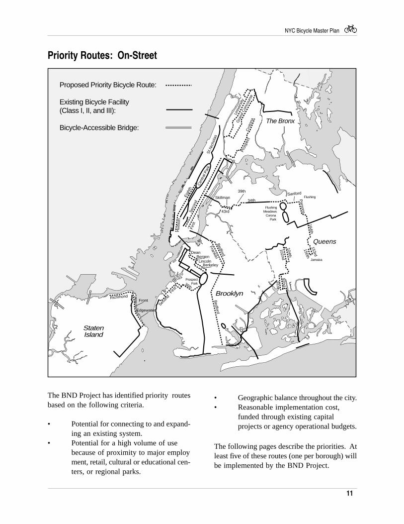
The BND Project has identified priority routesbased on the following criteria.
• Potential for connecting to and expand-ing an existing system.
• Potential for a high volume of usebecause of proximity to major employment, retail, cultural or educational cen-ters, or regional parks.
Priority Routes: On-Street
• Geographic balance throughout the city.• Reasonable implementation cost,
funded through existing capitalprojects or agency operational budgets.
The following pages describe the priorities. Atleast five of these routes (one per borough) willbe implemented by the BND Project.
12
NYC Bicycle Master Plan
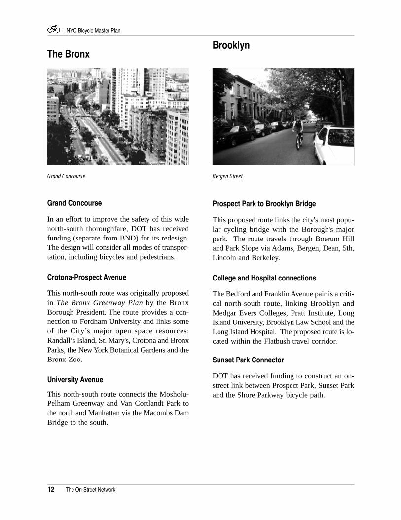
Grand Concourse
In an effort to improve the safety of this widenorth-south thoroughfare, DOT has receivedfunding (separate from BND) for its redesign.The design will consider all modes of transpor-tation, including bicycles and pedestrians.
Crotona-Prospect Avenue
This north-south route was originally proposedin The Bronx Greenway Plan by the BronxBorough President. The route provides a con-nection to Fordham University and links someof the City’s major open space resources:Randall’s Island, St. Mary's, Crotona and BronxParks, the New York Botanical Gardens and theBronx Zoo.
University Avenue
This north-south route connects the Mosholu-Pelham Greenway and Van Cortlandt Park tothe north and Manhattan via the Macombs DamBridge to the south.
Brooklyn
Prospect Park to Brooklyn Bridge
This proposed route links the city's most popu-lar cycling bridge with the Borough's majorpark. The route travels through Boerum Hilland Park Slope via Adams, Bergen, Dean, 5th,Lincoln and Berkeley.
College and Hospital connections
The Bedford and Franklin Avenue pair is a criti-cal north-south route, linking Brooklyn andMedgar Evers Colleges, Pratt Institute, LongIsland University, Brooklyn Law School and theLong Island Hospital. The proposed route is lo-cated within the Flatbush travel corridor.
Sunset Park Connector
DOT has received funding to construct an on-street link between Prospect Park, Sunset Parkand the Shore Parkway bicycle path.
The On-Street Network
The Bronx
Grand Concourse Bergen Street
13
NYC Bicycle Master Plan
Hudson Street and Eighth Avenue
This proposed north-bound route connects theWest Side of Lower Manhattan to Central Park.Major destinations along the route include PennStation and the Port Authority Bus Terminal, theGreenwich Village and Tribeca Historic Dis-tricts, and the local commercial, cultural andtourist attractions in Clinton, Chelsea, Green-wich Village and Tribeca. CDOT is currentlystudying this route's feasibility.
First and Second Avenues
This critical north-south route currently has anon-street lane on First Avenue from 72nd Streetto 125th Street. Additional study is needed todetermine the feasibility of lanes along the en-tire length of First and Second Avenues.
Queens
The On-Street Network
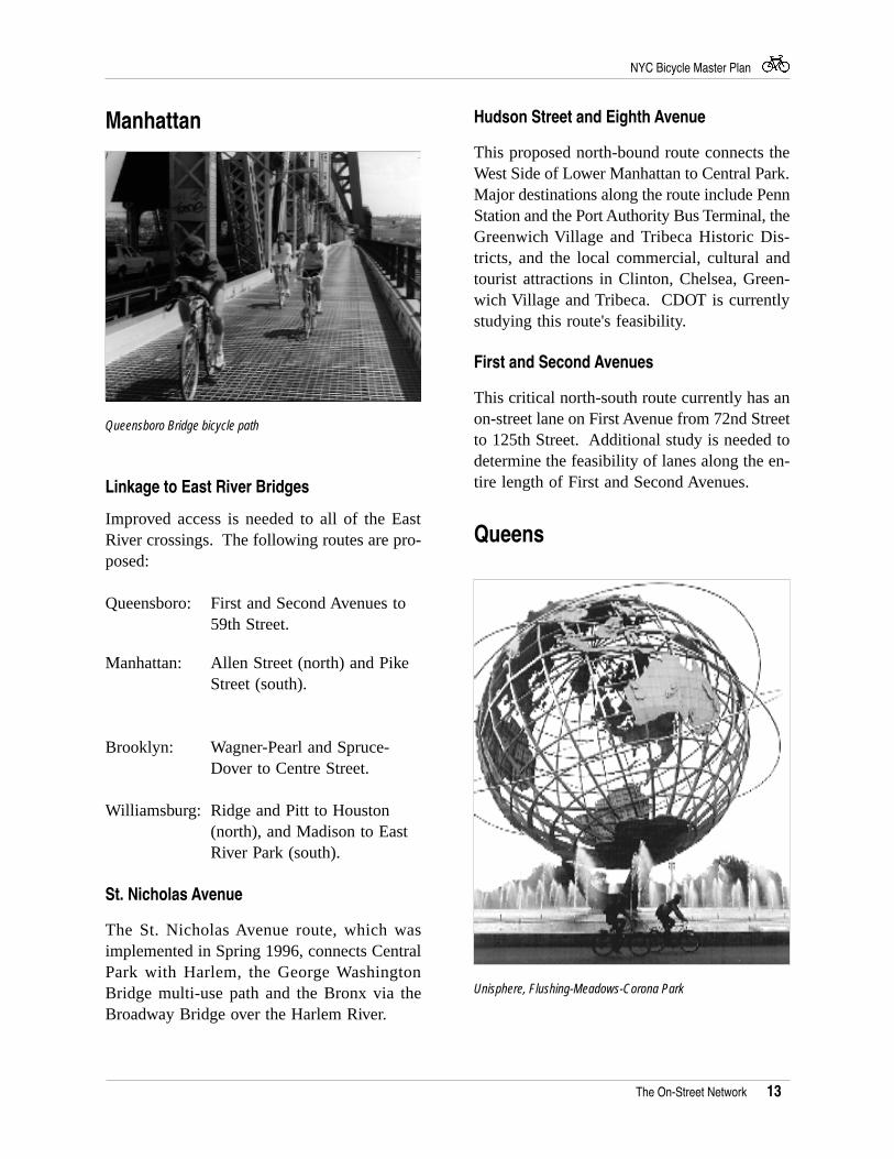
Queensboro Bridge bicycle path
Manhattan
Linkage to East River Bridges
Improved access is needed to all of the EastRiver crossings. The following routes are pro-posed:
Queensboro: First and Second Avenues to59th Street.
Manhattan: Allen Street (north) and PikeStreet (south).
Brooklyn: Wagner-Pearl and Spruce-Dover to Centre Street.
Williamsburg: Ridge and Pitt to Houston(north), and Madison to EastRiver Park (south).
St. Nicholas Avenue
The St. Nicholas Avenue route, which wasimplemented in Spring 1996, connects CentralPark with Harlem, the George WashingtonBridge multi-use path and the Bronx via theBroadway Bridge over the Harlem River.
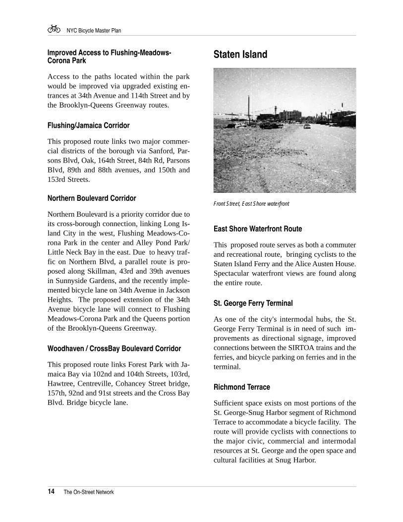
Unisphere, Flushing-Meadows-Corona Park
14
NYC Bicycle Master Plan
Staten Island
The On-Street Network
Improved Access to Flushing-Meadows-Corona Park
Access to the paths located within the parkwould be improved via upgraded existing en-trances at 34th Avenue and 114th Street and bythe Brooklyn-Queens Greenway routes.
Flushing/Jamaica Corridor
This proposed route links two major commer-cial districts of the borough via Sanford, Par-sons Blvd, Oak, 164th Street, 84th Rd, ParsonsBlvd, 89th and 88th avenues, and 150th and153rd Streets.
Northern Boulevard Corridor
Northern Boulevard is a priority corridor due toits cross-borough connection, linking Long Is-land City in the west, Flushing Meadows-Co-rona Park in the center and Alley Pond Park/Little Neck Bay in the east. Due to heavy traf-fic on Northern Blvd, a parallel route is pro-posed along Skillman, 43rd and 39th avenuesin Sunnyside Gardens, and the recently imple-mented bicycle lane on 34th Avenue in JacksonHeights. The proposed extension of the 34thAvenue bicycle lane will connect to FlushingMeadows-Corona Park and the Queens portionof the Brooklyn-Queens Greenway.
Woodhaven / CrossBay Boulevard Corridor
This proposed route links Forest Park with Ja-maica Bay via 102nd and 104th Streets, 103rd,Hawtree, Centreville, Cohancey Street bridge,157th, 92nd and 91st streets and the Cross BayBlvd. Bridge bicycle lane.
Front Street, East Shore waterfront
East Shore Waterfront Route
This proposed route serves as both a commuterand recreational route, bringing cyclists to theStaten Island Ferry and the Alice Austen House.Spectacular waterfront views are found alongthe entire route.
St. George Ferry Terminal
As one of the city's intermodal hubs, the St.George Ferry Terminal is in need of such im-provements as directional signage, improvedconnections between the SIRTOA trains and theferries, and bicycle parking on ferries and in theterminal.
Richmond Terrace
Sufficient space exists on most portions of theSt. George-Snug Harbor segment of RichmondTerrace to accommodate a bicycle facility. Theroute will provide cyclists with connections tothe major civic, commercial and intermodalresources at St. George and the open space andcultural facilities at Snug Harbor.
15
NYC Bicycle Master Plan
Lower New York Bay Atlantic Ocean
Hud
son
Riv
er
LongIslandSound
UpperNew York
Bay
EastchesterBay
Rockaway Inlet
JamaicaBay
Eas
tRiv
er
FlushingBay
L ittleN
eckB
ay
East River
StatenIsland
Brooklyn
Queens
The Bronx
Man
hatta
n
16
1 2
3
4
5 6
7
89
10
11
13
18
1920
21
23
24
2526
22
27
28
29
30
31
39
38
33
35
37
4317
12
1415
32
3436
4041
42
New York City Bridges
East RiverÄ 1 BrooklynÄ 2 Manhattan Ä 3 Williamsburg Ä 4 QueensboroÄ 5 Triboro/Ward's IslÄ 6 Bronx-Whitestone Ä 7 Throggs-Neck Harlem RiverÄ 8 Henry HudsonÄ 9 BroadwayÄ 10 Univ. HeightsÄ 11 WashingtonÄ 12 High BridgeÄ 13 Macombs DamÄ 14 145th StreetÄ 15 Madison AveÄ 16 Third / Willis AveHudson River / NY BayÄ 17 G.WashingtonÄ 18 Verrazano N.Arthur Kill / Kill Van Kull Ä 19 BayonneÄ 20 GoethalsÄ 21 Outerbridge
Jamaica BayÄ 22 GerritsenÄ 23 Mill BasinÄ 24 PaerdegatÄ 25 Fresh CreekÄ 26 Hendrix CreekÄ 27 Spring CreekÄ 28 Cross Bay BlvdÄ 29 Veterans MemorialÄ 30 Marine ParkwayOther BridgesÄ 31 Cropsey AveÄ 32 Stillwell AveÄ 33 Atlantic BeachÄ 34 Grand AveÄ 35 Greenpoint AveÄ 36 PulaskiÄ 37 Roosevelt IslÄ 38 Roosevelt AveÄ 39 Northern BlvdÄ 40 Bruckner BlvdÄ 41 Bruckner BlvdÄ 42 Shore RdÄ 43 City Isl
Ä = BICYCLE ACCESS Ä = NO BICYCLE ACCESS
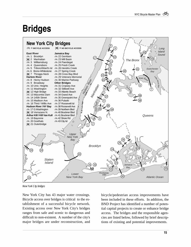
Bridges
New York City has 43 major water crossings.Bicycle access over bridges is critical to the es-tablishment of a successful bicycle network.Existing access over New York City's bridgesranges from safe and scenic to dangerous anddifficult to non-existent. A number of the city'smajor bridges are under reconstruction, and
bicycle/pedestrian access improvements havebeen included in these efforts. In addition, theBND Project has identified a number of poten-tial capital projects to create or enhance bridgeaccess. The bridges and the responsible agen-cies are listed below, followed by brief descrip-tions of existing and potential improvements.
New York City bridges
16
NYC Bicycle Master Plan
East River Bridges Williamsburg (DOT)
Currently under reconstruction, a new bicycle/pedestrian path will include a number of im-provements, including replacing the stairs at theManhattan terminus with a ramp, and enhanc-ing the visibility of the Brooklyn terminus byrelocating the ramp from the interior to theexterior of the Bridge.
Queensboro (DOT)
Also under reconstruction, the QueensboroBridge bicycle path is the city's second mostheavily used. The reconstruction project willreplace the path's steel grating with concreteand construct a barrier between bicycle andmotor vehicles on the Manhattan approach.Due to the reconstruction, the path is currentlyclosed to cyclists and pedestrians between 3 and8 pm, Monday through Friday; DOT operatesa free shuttle during these hours. The path isscheduled for reopening following the recon-struction. DCP will receive funding to studyaccess improvements to the approaches, both ofwhich are difficult and dangerous at the Man-hattan and Queens termini.
Triborough Bridge (MTA)
Although paths exist along this bridge linkingManhattan, the Bronx and Queens with the rec-reational facilities at Randall's Island, access ismade difficult by the stairs leading to the bridgepaths. Signs directing cyclists to walk along thepaths are usually ignored. In its recently re-leased Randall's Island Access Plan, the NYCEconomic Development Corporation (EDC)recommends modifying the existing stairs andramp on the Tri-borough Bridge for the Man-hattan and Queens spans. The construction ofnew pedestrian bridges from all 3 boroughs andthe establishment of ferry service were also pro-posed. Signs on Randall's Island directing cy-clists to the existing Bridge paths are alsoneeded as an immediate improvement.
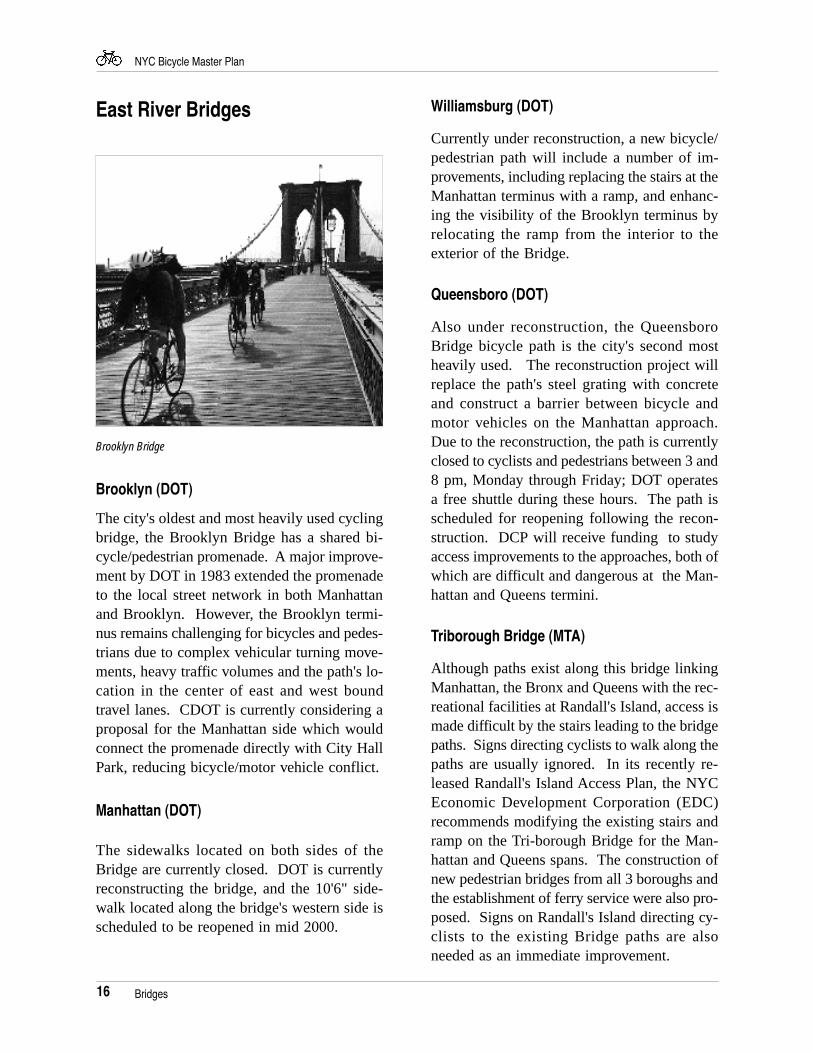
Brooklyn Bridge
Brooklyn (DOT)
The city's oldest and most heavily used cyclingbridge, the Brooklyn Bridge has a shared bi-cycle/pedestrian promenade. A major improve-ment by DOT in 1983 extended the promenadeto the local street network in both Manhattanand Brooklyn. However, the Brooklyn termi-nus remains challenging for bicycles and pedes-trians due to complex vehicular turning move-ments, heavy traffic volumes and the path's lo-cation in the center of east and west boundtravel lanes. CDOT is currently considering aproposal for the Manhattan side which wouldconnect the promenade directly with City HallPark, reducing bicycle/motor vehicle conflict.
Manhattan (DOT)
The sidewalks located on both sides of theBridge are currently closed. DOT is currentlyreconstructing the bridge, and the 10'6" side-walk located along the bridge's western side isscheduled to be reopened in mid 2000.
Bridges
17
NYC Bicycle Master Plan
Bronx-Whitestone (MTA) and Throgs-Neck(MTA)
Paths or sidewalks do not exist along eitherspan. However, Queens Surface Corp., withassistance from DOT, installed bicycle racks onthe QBX1 bus line in April, 1994 to bring cy-clists across the Bronx-Whitestone Bridge. Cy-clists board at 20th Avenue in Queens orLafayette Avenue in the Bronx. This is the onlybike-on-bus program currently operating in theregion.
Harlem River BridgesEight of the nine bridges across the HarlemRiver provide shared bicycle/pedestrian accessalong sidewalks. Modest improvements, suchas curb cuts and directional signage, would sig-nificantly improve cycling conditions alongthese critical crossings. Access along the sce-nic Henry Hudson Bridge (MTA) is currentlylimited to the narrow path on the lower span,though a wider, inaccessible path exists on theupper span. The MTA should consider creat-ing access to the upper path, as noted in the1992 DCP study. The closing of High Bridge,a safe and scenic bicycle and pedestrian cross-ing, should be reassessed by DPR.
Hudson River / New York BayBridges
Although a path exists along the George Wash-ington Bridge (PANYNJ), the Verrazano-Nar-rows Bridge (MTA) is inaccessible to bicyclesand pedestrians. DCP is currently studying pos-sible access options, including a bike-on-busprogram, the dedication of an existing lane forbicycles and pedestrians, and the constructionof a new path or ferry service.
Arthur Kill / Kill Van Kull Bridges
Bayonne (Port Authority of NY & NJ)
Currently under reconstruction, the bicycle/pe-destrian path's access could be improvedthrough signage and the replacement of stairswith a ramp on the New Jersey side.
Outerbridge Crossing (Port Authority of NY &NJ)
Bicycle/pedestrian access was removed in 1963on this Staten Island-New Jersey crossing.
Goethals (Port Authority of NY & NJ)
The current path is extremely narrow and isofficially closed to cyclists. Long-term plansfor a new bridge include a bicycle/pedestrianlane.
Jamaica Bay BridgesShore Parkway Bridges (DOT)
The six bridges along the Shore Parkway bi-cycle path have combined bicycle/pedestriansidewalks. Hendrix and Spring Creek Bridgeswere reconstructed in the mid-1980s, and DOThas received state, federal and city funding toupgrade the Gerritsen, Mill, Paeradegat andFresh Creek Bridges. DOT is currently in thedesign process.
Cross Bay Blvd/Congressman Joseph PAddabbo Bridge (DOT)
Reconstructed in 1991, an on-street lane and aseparate pedestrian/fishing path were installedon this bridge.
Bridges
18
NYC Bicycle Master Plan
Marine Parkway/Gil Hodges Bridge (TBTA)
Sidewalks exist on this Bridge, with signs in-structing cyclists to "walk your bike". Althoughnarrow, cyclists, pedestrians and fishers safelyshare these narrow paths. TBTA has includeda multi-use path in its plans for the reconstruc-tion of the Bridge, which is part of the pro-posed Rockaway-Gateway Greenway.
Additional Bridges
In addition to the city's major water crossings,bridges across industrial areas, railyards andsmaller water bodies also need to provide bet-ter bicycle and pedestrian access. Listed beloware two of the more popular crossings in needof improvements.
Queens Boulevard
Providing a direct connection to Long IslandCity and the Queensboro Bridge, this bridgeover the Sunnyside rail yards is a critical com-ponent of the Network. Because of the narrowroadway width and heavy traffic volume, cy-clists currently ride on the sidewalks, creatingsafety concerns.
Roosevelt Avenue
Similar to the Queens Boulevard Bridge, thesidewalks along this bridge currently serve bothbicycles and pedestrians. Conflicts can emerge,especially during events at the adjacent SheaStadium. Mitigating the bicycle/pedestrianconflicts on both the Queens Boulevard andRoosevelt Avenue Bridges requires furtherstudy.
Bridges
19
NYC Bicycle Master Plan
Lower New York Bay
5 MILES
Atlantic Ocean
Long Island Sound
New Jersey
Queens
❑❑
❑❑
❑
❑ ❑❑
❑ ❑ ❑
➣
➣
➣
➣
➣
➣
Brooklyn
TheBronx
❑❑❑❑❑❑❑
❑
❑
StatenIsland
➣➣➣➣➣ ➣➣
New York City Schematic Greenway Plan
Man
hatta
n
Hud
son
Riv
er
Nassau County
Existing Greenway: Priority Route
Legend
❑ ❑ ❑ ❑ ❑ ❑ ❑ ❑ ❑ ❑ ❑ Proposed Greenway
Existing Greenway
Proposed Greenway: Priority Route
❑❑
❑❑
❑❑
❑❑
❑❑
❑❑
❑❑
❑❑❑❑❑❑❑❑❑❑❑❑❑❑
❑❑
❑❑
❑❑
❑❑
❑❑
❑
❑❑
❑❑
❑❑
❑❑
❑
❑❑
❑❑❑
❑❑
❑❑
❑❑
❑❑
❑
❑
❑❑
❑❑
❑❑
❑
❑❑
❑❑
❑❑
❑❑
❑❑
❑
❑❑
❑❑
❑
❑❑
❑
❑
❑❑
❑❑
❑❑
❑❑
❑❑
❑❑
❑❑
❑❑❑
❑❑
❑❑
❑❑
❑❑
❑❑
❑❑❑❑❑❑❑❑❑❑❑❑
❑❑
❑❑
❑❑
❑❑
❑
❑❑
❑❑❑❑❑❑❑❑
❑❑❑
❑❑❑
❑
❑
❑❑
❑❑
❑❑
❑❑
❑❑
❑ ❑ ❑ ❑ ❑ ❑ ❑ ❑ ❑❑
❑❑ ❑ ❑
❑❑
❑
❑❑
❑❑
❑❑
❑❑
❑
❑❑
❑❑
❑❑
❑❑
❑❑
❑❑
❑❑
❑❑
❑❑
❑
❑❑❑
❑❑❑
❑❑
❑❑
❑
❑❑
❑
❑❑
❑❑
❑❑
❑❑
❑❑
❑❑
❑❑
❑❑
❑❑
❑❑
❑ ❑❑
❑❑
❑❑
❑❑
❑❑
❑❑
❑❑
❑❑
❑❑
❑❑
❑❑
❑❑ ❑
❑
❑❑
❑
❑❑
❑❑
❑
❑
❑❑
❑❑
❑
❑❑
❑❑
❑❑❑❑
❑❑❑❑❑❑
❑ ❑ ❑
❑❑
❑❑
❑
❑❑
❑❑
❑❑
❑❑
❑❑
❑
❑❑
❑❑
❑❑
❑❑
❑❑
❑❑
❑❑
❑❑
❑❑
❑
❑❑
❑
❑❑
❑❑❑❑
❑
❑ ❑ ❑ ❑❑
❑❑
❑❑
❑❑
❑❑
❑ ❑ ❑ ❑ ❑❑❑ ❑
❑❑ ❑ ❑
❑ ❑ ❑ ❑ ❑❑
❑❑
❑❑
❑❑
❑ ❑ ❑ ❑
❑❑
❑❑
❑❑
❑❑
❑
❑❑
❑❑
❑❑ ❑ ❑ ❑ ❑ ❑ ❑ ❑ ❑❑
❑❑
❑❑
❑❑
❑❑
❑❑
❑❑
❑❑
❑❑
❑❑
❑❑
❑❑
❑
❑❑
❑❑
❑❑
❑❑
❑❑
❑❑
❑
❑❑
❑❑
❑❑
❑❑
❑❑
❑❑
❑❑
❑❑
❑
❑❑❑
❑❑
❑❑
❑❑
❑
❑❑
❑
❑
❑❑
❑
❑❑
❑❑
❑
❑❑
❑❑
❑❑
❑ ❑
❑
❑ ❑ ❑ ❑ ❑ ❑ ❑ ❑ ❑
❑❑
❑❑
❑❑
❑❑
❑❑❑❑
❑❑
❑
❑ ❑❑
❑❑
❑❑
❑❑
❑
❑ ❑ ❑ ❑ ❑ ❑ ❑ ❑ ❑ ❑
The Greenway System
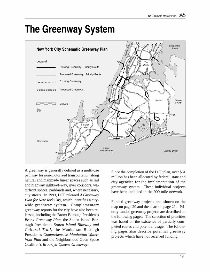
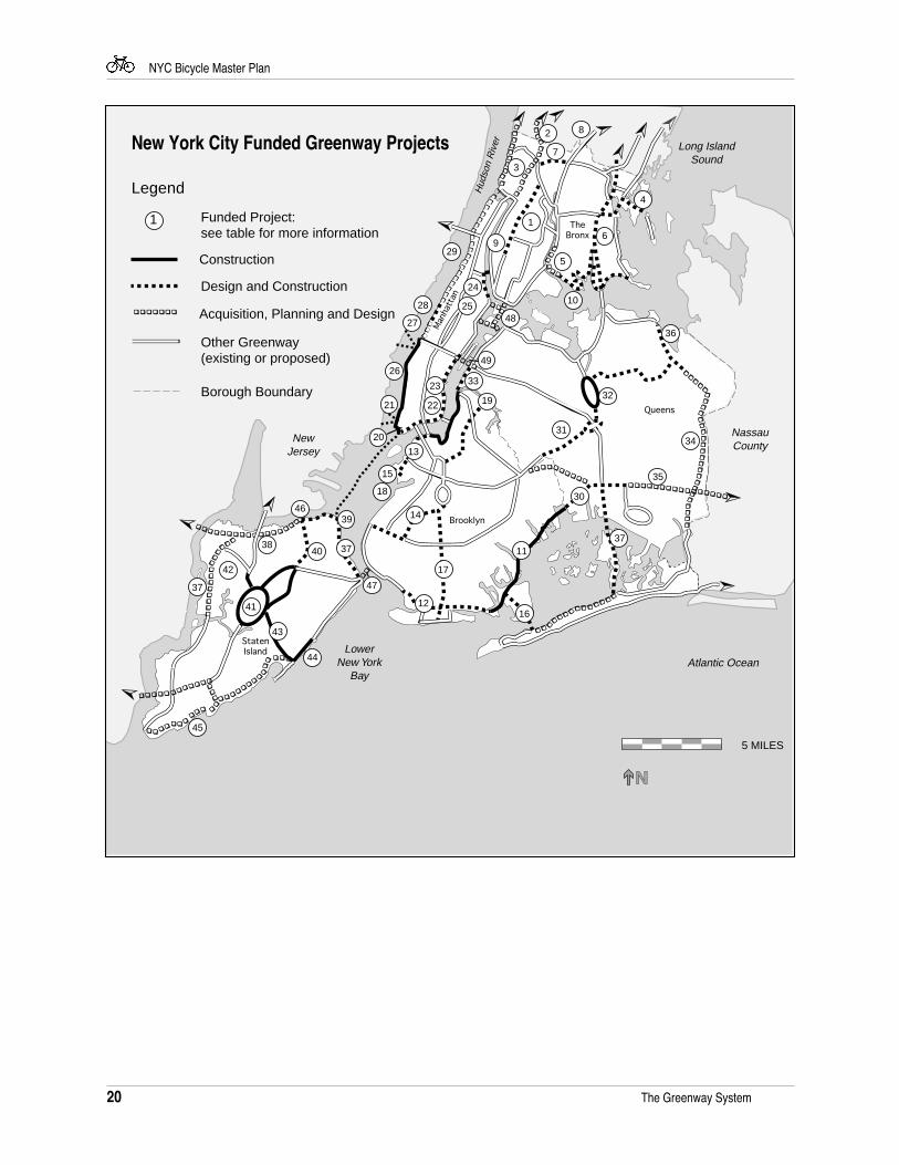
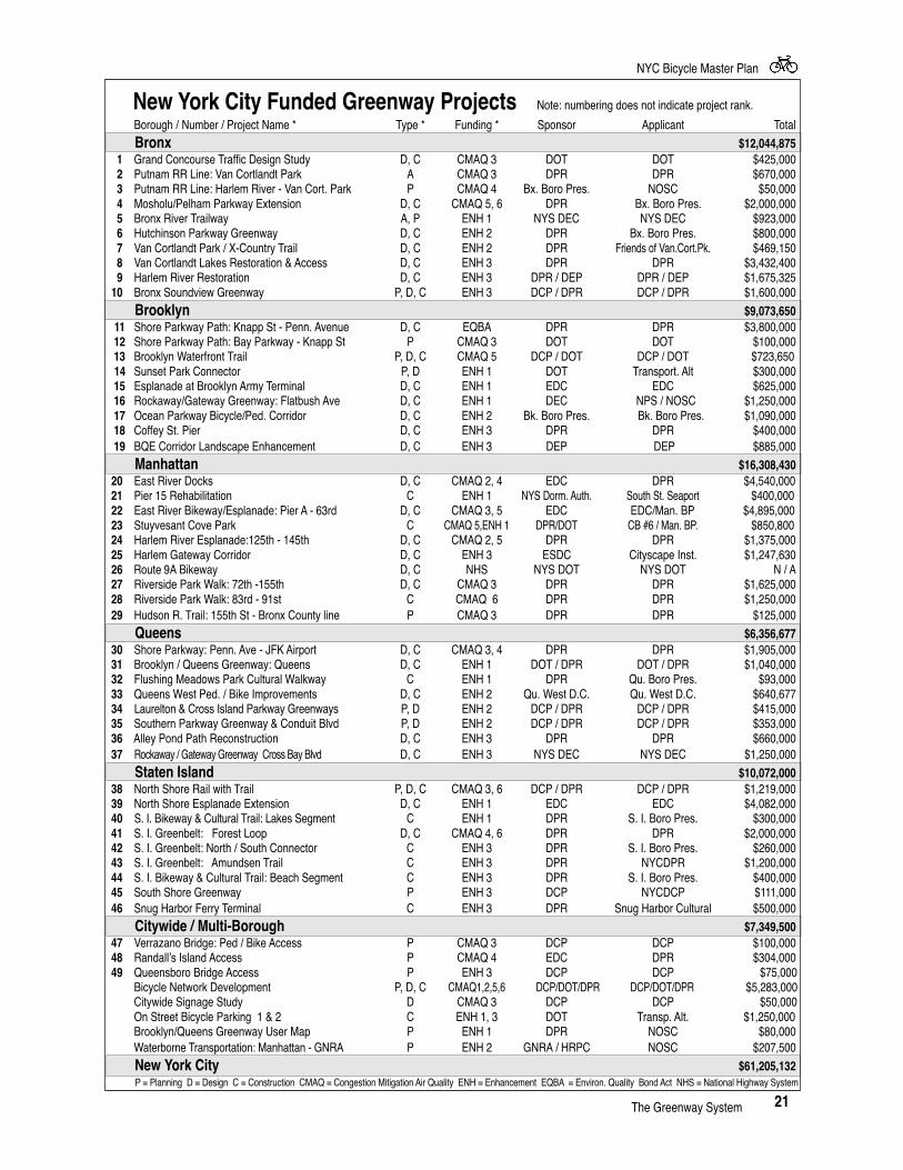
Since the completion of the DCP plan, over $61million has been allocated by federal, state andcity agencies for the implementation of thegreenway system. These individual projectshave been included in the 900 mile network.
Funded greenway projects are shown on themap on page 20 and the chart on page 21. Pri-ority funded greenway projects are described onthe following pages. The selection of prioritieswas based on the existence of partially com-pleted routes and potential usage. The follow-ing pages also describe potential greenwayprojects which have not received funding.
A greenway is generally defined as a multi-usepathway for non-motorized transportation alongnatural and manmade linear spaces such as railand highway rights-of-way, river corridors, wa-terfront spaces, parklands and, where necessary,city streets. In 1993, DCP released A GreenwayPlan for New York City, which identifies a city-wide greenway system. Complementarygreenway reports for the city have also been re-leased, including the Bronx Borough President'sBronx Greenway Plan, the Staten Island Bor-ough President's Staten Island Bikeway andCultural Trail, the Manhattan BoroughPresident's Comprehensive Manhattan Water-front Plan and the Neighborhood Open SpaceCoalition's Brooklyn-Queens Greenway.
20
NYC Bicycle Master Plan
➣
➣
➣
➣
➣
➣
❑❑
❑
❑❑
❑❑
❑❑
❑❑
❑❑
❑
❑ ❑ ❑ ❑ ❑ ❑ ❑ ❑ ❑ ❑ ❑ ❑ ❑ ❑ ❑❑
❑
➣
➣
➣➣➣ ➣➣
❑❑
❑❑
❑❑
❑❑
❑❑
❑❑
❑ ❑ ❑ ❑ ❑ ❑ ❑ ❑ ❑ ❑
❑❑❑❑
❑❑❑❑❑❑
❑
❑
❑❑
❑ ❑ ❑ ❑ ❑ ❑ ❑ ❑ ❑ ❑ ❑ ❑ ❑ ❑ ❑ ❑
❑❑
❑❑
❑❑
❑❑
❑❑
❑❑
❑❑
❑❑
❑❑
❑❑
❑❑
❑❑
❑❑
❑
❑❑
❑❑
❑❑
❑❑ ❑ ❑ ❑ ❑ ❑ ❑ ❑❑ ❑ ❑ ❑ ❑
❑ ❑ ❑
❑ ❑
❑❑
❑❑
❑
❑❑❑
❑❑
❑❑
❑❑
❑❑
❑❑
❑
❑❑
❑❑
❑❑
❑ ❑ ❑ ❑❑ ❑ ❑
❑❑❑ ❑ ❑
❑
❑ ❑ ❑❑
❑❑
❑
❑❑
❑❑
❑ ❑ ❑❑
❑❑
❑
❑❑
❑❑
❑❑
❑❑
❑❑
❑❑
❑❑
❑❑
❑❑
❑❑
12
11
14
13
7
17
16
15
18
19
37
35
30
34
32
31
36
33
49
3740
39
41
38
42
37
45
44
47
46
20
21 22
23
28
27
29
48
24
2 8
1
4
6
5
10
3
25
26
9
43
LowerNew York
BayAtlantic Ocean
Long IslandSound
NewJersey
Queens
Brooklyn
TheBronx
StatenIsland
New York City Funded Greenway Projects
Man
hatt
an
Hud
son
Riv
er
Borough Boundary
Design and Construction
Construction
Legend
❑ ❑ ❑ ❑ ❑ ❑ ❑ Acquisition, Planning and Design
Other Greenway (existing or proposed)
NassauCounty
Funded Project: see table for more information
5 MILES
1
The Greenway System
21
NYC Bicycle Master Plan
The Greenway System
P = Planning D = Design C = Construction CMAQ = Congestion Mitigation Air Quality ENH = Enhancement EQBA = Environ. Quality Bond Act NHS = National Highway System
New York City Funded Greenway Projects Note: numbering does not indicate project rank.
Borough / Number / Project Name * Type * Funding * Sponsor Applicant Total
Bronx $12,044,8751 Grand Concourse Traffic Design Study D, C CMAQ 3 DOT DOT $425,000
2 Putnam RR Line: Van Cortlandt Park A CMAQ 3 DPR DPR $670,000 3 Putnam RR Line: Harlem River - Van Cort. Park P CMAQ 4 Bx. Boro Pres. NOSC $50,000 4 Mosholu/Pelham Parkway Extension D, C CMAQ 5, 6 DPR Bx. Boro Pres. $2,000,000 5 Bronx River Trailway A, P ENH 1 NYS DEC NYS DEC $923,000 6 Hutchinson Parkway Greenway D, C ENH 2 DPR Bx. Boro Pres. $800,000 7 Van Cortlandt Park / X-Country Trail D, C ENH 2 DPR Friends of Van.Cort.Pk. $469,150 8 Van Cortlandt Lakes Restoration & Access D, C ENH 3 DPR DPR $3,432,400 9 Harlem River Restoration D, C ENH 3 DPR / DEP DPR / DEP $1,675,325 10 Bronx Soundview Greenway P, D, C ENH 3 DCP / DPR DCP / DPR $1,600,000
Brooklyn $9,073,65011 Shore Parkway Path: Knapp St - Penn. Avenue D, C EQBA DPR DPR $3,800,00012 Shore Parkway Path: Bay Parkway - Knapp St P CMAQ 3 DOT DOT $100,00013 Brooklyn Waterfront Trail P, D, C CMAQ 5 DCP / DOT DCP / DOT $723,650
14 Sunset Park Connector P, D ENH 1 DOT Transport. Alt $300,00015 Esplanade at Brooklyn Army Terminal D, C ENH 1 EDC EDC $625,00016 Rockaway/Gateway Greenway: Flatbush Ave D, C ENH 1 DEC NPS / NOSC $1,250,00017 Ocean Parkway Bicycle/Ped. Corridor D, C ENH 2 Bk. Boro Pres. Bk. Boro Pres. $1,090,00018 Coffey St. Pier D, C ENH 3 DPR DPR $400,00019 BQE Corridor Landscape Enhancement D, C ENH 3 DEP DEP $885,000
Manhattan $16,308,430 20 East River Docks D, C CMAQ 2, 4 EDC DPR $4,540,000 21 Pier 15 Rehabilitation C ENH 1 NYS Dorm. Auth. South St. Seaport $400,000 22 East River Bikeway/Esplanade: Pier A - 63rd D, C CMAQ 3, 5 EDC EDC/Man. BP $4,895,000 23 Stuyvesant Cove Park C CMAQ 5,ENH 1 DPR/DOT CB #6 / Man. BP. $850,800 24 Harlem River Esplanade:125th - 145th D, C CMAQ 2, 5 DPR DPR $1,375,000 25 Harlem Gateway Corridor D, C ENH 3 ESDC Cityscape Inst. $1,247,630 26 Route 9A Bikeway D, C NHS NYS DOT NYS DOT N / A 27 Riverside Park Walk: 72th -155th D, C CMAQ 3 DPR DPR $1,625,000 28 Riverside Park Walk: 83rd - 91st C CMAQ 6 DPR DPR $1,250,000 29 Hudson R. Trail: 155th St - Bronx County line P CMAQ 3 DPR DPR $125,000
Queens $6,356,677 30 Shore Parkway: Penn. Ave - JFK Airport D, C CMAQ 3, 4 DPR DPR $1,905,000 31 Brooklyn / Queens Greenway: Queens D, C ENH 1 DOT / DPR DOT / DPR $1,040,000 32 Flushing Meadows Park Cultural Walkway C ENH 1 DPR Qu. Boro Pres. $93,000 33 Queens West Ped. / Bike Improvements D, C ENH 2 Qu. West D.C. Qu. West D.C. $640,677 34 Laurelton & Cross Island Parkway Greenways P, D ENH 2 DCP / DPR DCP / DPR $415,000 35 Southern Parkway Greenway & Conduit Blvd P, D ENH 2 DCP / DPR DCP / DPR $353,000 36 Alley Pond Path Reconstruction D, C ENH 3 DPR DPR $660,000 37 Rockaway / Gateway Greenway Cross Bay Blvd D, C ENH 3 NYS DEC NYS DEC $1,250,000
Staten Island $10,072,000 38 North Shore Rail with Trail P, D, C CMAQ 3, 6 DCP / DPR DCP / DPR $1,219,000 39 North Shore Esplanade Extension D, C ENH 1 EDC EDC $4,082,000 40 S. I. Bikeway & Cultural Trail: Lakes Segment C ENH 1 DPR S. I. Boro Pres. $300,000 41 S. I. Greenbelt: Forest Loop D, C CMAQ 4, 6 DPR DPR $2,000,000 42 S. I. Greenbelt: North / South Connector C ENH 3 DPR S. I. Boro Pres. $260,000 43 S. I. Greenbelt: Amundsen Trail C ENH 3 DPR NYCDPR $1,200,000 44 S. I. Bikeway & Cultural Trail: Beach Segment C ENH 3 DPR S. I. Boro Pres. $400,000 45 South Shore Greenway P ENH 3 DCP NYCDCP $111,000 46 Snug Harbor Ferry Terminal C ENH 3 DPR Snug Harbor Cultural $500,000
Citywide / Multi-Borough $7,349,500 47 Verrazano Bridge: Ped / Bike Access P CMAQ 3 DCP DCP $100,000 48 Randall’s Island Access P CMAQ 4 EDC DPR $304,000 49 Queensboro Bridge Access P ENH 3 DCP DCP $75,000
Bicycle Network Development P, D, C CMAQ1,2,5,6 DCP/DOT/DPR DCP/DOT/DPR $5,283,000 Citywide Signage Study D CMAQ 3 DCP DCP $50,000 On Street Bicycle Parking 1 & 2 C ENH 1, 3 DOT Transp. Alt. $1,250,000 Brooklyn/Queens Greenway User Map P ENH 1 DPR NOSC $80,000 Waterborne Transportation: Manhattan - GNRA P ENH 2 GNRA / HRPC NOSC $207,500
New York City $61,205,132
22
NYC Bicycle Master Plan
The Bronx 233rd Street
Roadway width and traffic volume prohibit on-street cycling along this street, a critical east-west route. An existing sidewalk, along thenorthern perimeter of Woodlawn Cemetary,could be upgraded to accommodate bicycles.This route is part of the Woodlawn-Seton FallsGreenway identified in the Bronx BoroughPresident's The Bronx Greenway Plan.
Bronx Park
Although north-south paths exist along theperimeter of this park, there are limited east-west crossings. Cycling on Fordham Road, themajor east-west connection, is undersirable dueto heavy traffic. Multi-use paths are needed toaccommodate bicycles and pedestrians.The Mosholu-Pelham Greenway
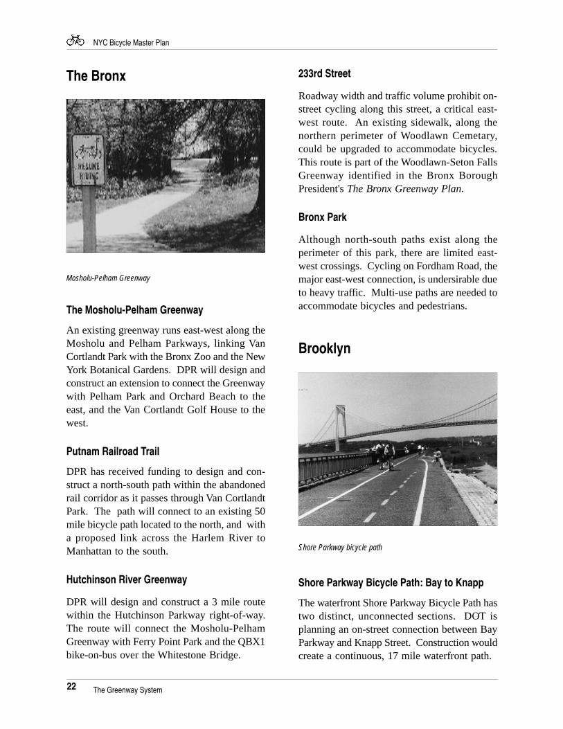
An existing greenway runs east-west along theMosholu and Pelham Parkways, linking VanCortlandt Park with the Bronx Zoo and the NewYork Botanical Gardens. DPR will design andconstruct an extension to connect the Greenwaywith Pelham Park and Orchard Beach to theeast, and the Van Cortlandt Golf House to thewest.
Putnam Railroad Trail
DPR has received funding to design and con-struct a north-south path within the abandonedrail corridor as it passes through Van CortlandtPark. The path will connect to an existing 50mile bicycle path located to the north, and witha proposed link across the Harlem River toManhattan to the south.
Hutchinson River Greenway
DPR will design and construct a 3 mile routewithin the Hutchinson Parkway right-of-way.The route will connect the Mosholu-PelhamGreenway with Ferry Point Park and the QBX1bike-on-bus over the Whitestone Bridge.
Mosholu-Pelham Greenway
Shore Parkway bicycle path
Brooklyn
The Greenway System
Shore Parkway Bicycle Path: Bay to Knapp
The waterfront Shore Parkway Bicycle Path hastwo distinct, unconnected sections. DOT isplanning an on-street connection between BayParkway and Knapp Street. Construction wouldcreate a continuous, 17 mile waterfront path.
23
NYC Bicycle Master Plan
ManhattanRockaway Gateway Greenway
Connecting with the Shore Parkway bicyclepath, this DEC/National Park Service projectwill design a 20 mile route loop around JamaicaBay. Construction along Flatbush Avenue isslated as the first phase of implementation.
Brooklyn Waterfront Trail
Consistent with proposals in the Red Hookcommunity’s 197-a Plan, this DCP/DOT projectwill connect the Brooklyn Bridge promenadepath with the existing and proposed recreationalfacilities at Fulton Pier, Coffey Street Pier andthe Erie Basin Promenade via multi-use pathsand on-street lanes.
Improved Access to Prospect Park
The multi-use path along Eastern Parkwayterminates at the Brooklyn Museum, creatingconflicts between cyclists and pedestriansseeking access to the Brooklyn Public Libraryand Prospect Park. The path could be extendedalong the westbound service road, connectinginto Grand Army Plaza and Prospect Park.Improved access is also needed at Park Circle,the Park's southern terminus.
Connections to the Shore Parkway BicyclePath
Abundant parkland located adjacent to severalinlets offers the potential for connecting theneighborhoods along Jamaica Bay with thecity's longest bicycle/pedestrian path.
The Greenway System
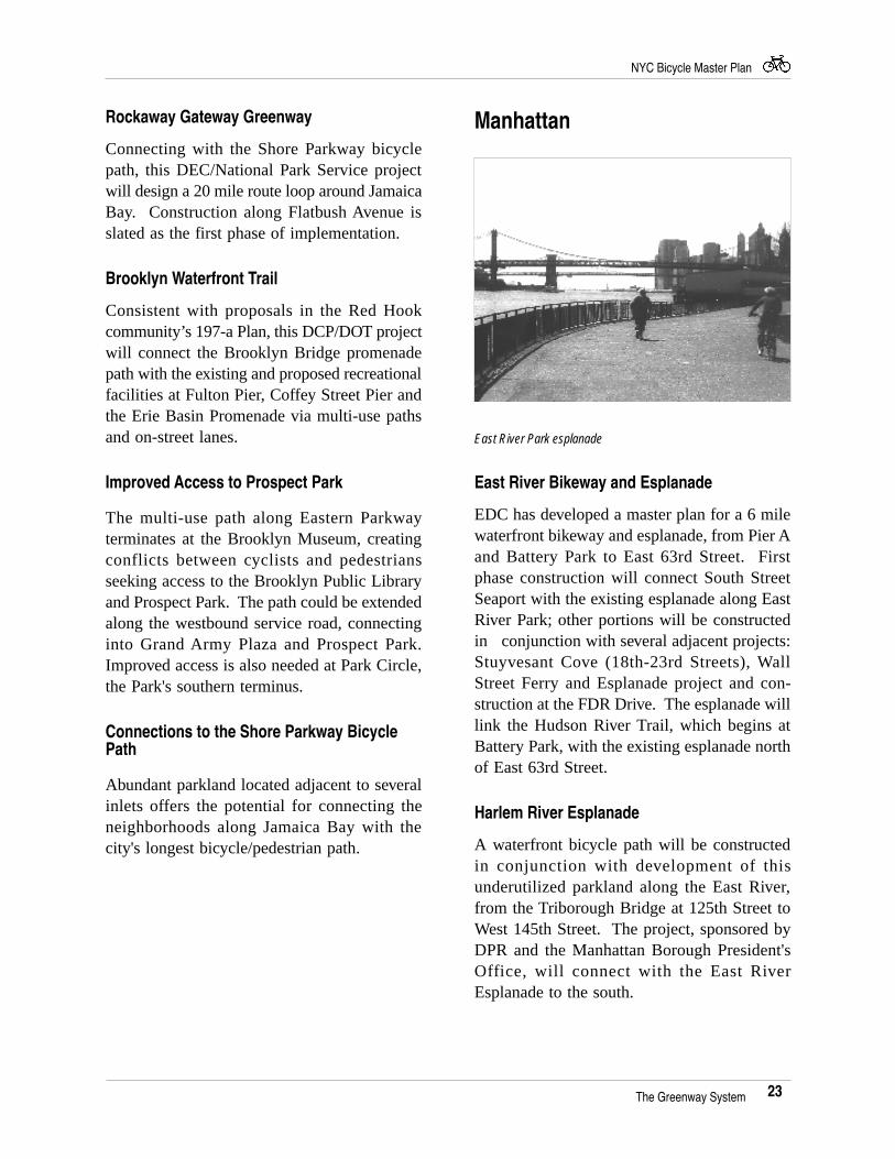
East River Park esplanade
East River Bikeway and Esplanade
EDC has developed a master plan for a 6 milewaterfront bikeway and esplanade, from Pier Aand Battery Park to East 63rd Street. Firstphase construction will connect South StreetSeaport with the existing esplanade along EastRiver Park; other portions will be constructedin conjunction with several adjacent projects:Stuyvesant Cove (18th-23rd Streets), WallStreet Ferry and Esplanade project and con-struction at the FDR Drive. The esplanade willlink the Hudson River Trail, which begins atBattery Park, with the existing esplanade northof East 63rd Street.
Harlem River Esplanade
A waterfront bicycle path will be constructedin conjunction with development of thisunderutilized parkland along the East River,from the Triborough Bridge at 125th Street toWest 145th Street. The project, sponsored byDPR and the Manhattan Borough President'sOffice, will connect with the East RiverEsplanade to the south.
24
NYC Bicycle Master Plan
Queens
Hudson River Trail
This route travels along the entire west sidewaterfronts of Manhattan and the Bronx. Seg-ments include the proposed Route 9A bikeway/walkway from the Battery to 59th Street, andDPR's Riverside Walk, to be constructedthrough Riverside Park. The Route 9A interimpath, from Chambers to W 30th Street, hasproven immensely popular. The route willultimately connect with the Hudson RiverValley Greenway and such regional trails asState Bicycle Route 9 and the East CoastGreenway.
Harlem River Drive: 155th Street - Dyckman
Members of the BND Advisory Committeehave recommended development of a bicyclepath along this narrow strip of waterfrontparkland. The Manhattan Borough President'sComprehensive Waterfront Plan alsorecommends a waterfront route. DCP's Plan forthe Manhattan Waterfront recommends use ofthe Bronx waterfront, from the BroadwayBridge to 155th Street, as an alternative.Additional study is needed to determine thefeasibility of a Manhattan waterfront route.
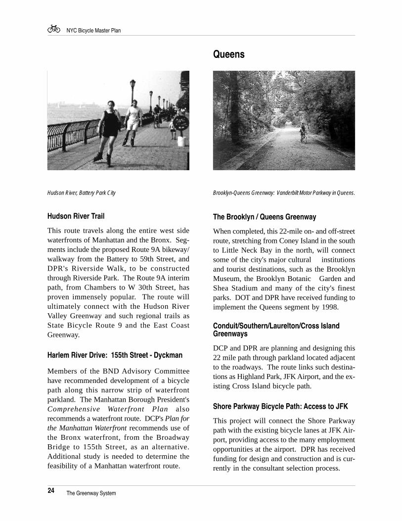
The Brooklyn / Queens Greenway
When completed, this 22-mile on- and off-streetroute, stretching from Coney Island in the southto Little Neck Bay in the north, will connectsome of the city's major cultural institutionsand tourist destinations, such as the BrooklynMuseum, the Brooklyn Botanic Garden andShea Stadium and many of the city's finestparks. DOT and DPR have received funding toimplement the Queens segment by 1998.
Conduit/Southern/Laurelton/Cross IslandGreenways
DCP and DPR are planning and designing this22 mile path through parkland located adjacentto the roadways. The route links such destina-tions as Highland Park, JFK Airport, and the ex-isting Cross Island bicycle path.
Shore Parkway Bicycle Path: Access to JFK
This project will connect the Shore Parkwaypath with the existing bicycle lanes at JFK Air-port, providing access to the many employmentopportunities at the airport. DPR has receivedfunding for design and construction and is cur-rently in the consultant selection process.
Brooklyn-Queens Greenway: Vanderbilt Motor Parkway in Queens.
The Greenway System
Hudson River, Battery Park City
25
NYC Bicycle Master Plan
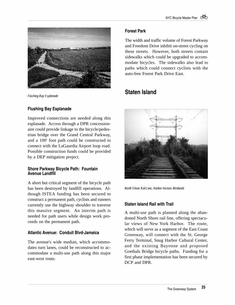
Flushing Bay Esplanade
Improved connections are needed along thisesplanade. Access through a DPR concession-aire could provide linkage to the bicycle/pedes-trian bridge over the Grand Central Parkway,and a 100' foot path could be constructed toconnect with the LaGaurdia Airport loop road.Possible construction funds could be providedby a DEP mitigation project.
Shore Parkway Bicycle Path: FountainAvenue Landfill
A short but critical segment of the bicycle pathhas been destroyed by landfill operations. Al-though ISTEA funding has been secured toconstruct a permanent path, cyclists and runnerscurrently use the highway shoulder to traversethis massive segment. An interim path isneeded for path users while design work pro-ceeds on the permanent path.
Atlantic Avenue: Conduit Blvd-Jamaica
The avenue's wide median, which accommo-dates turn lanes, could be reconstructed to ac-commodate a multi-use path along this majoreast-west route.
Forest Park
The width and traffic volume of Forest Parkwayand Freedom Drive inhibit on-street cycling onthese streets. However, both streets containsidewalks which could be upgraded to accom-modate bicycles. The sidewalks also lead topaths which could connect cyclists with theauto-free Forest Park Drive East.
Staten Island
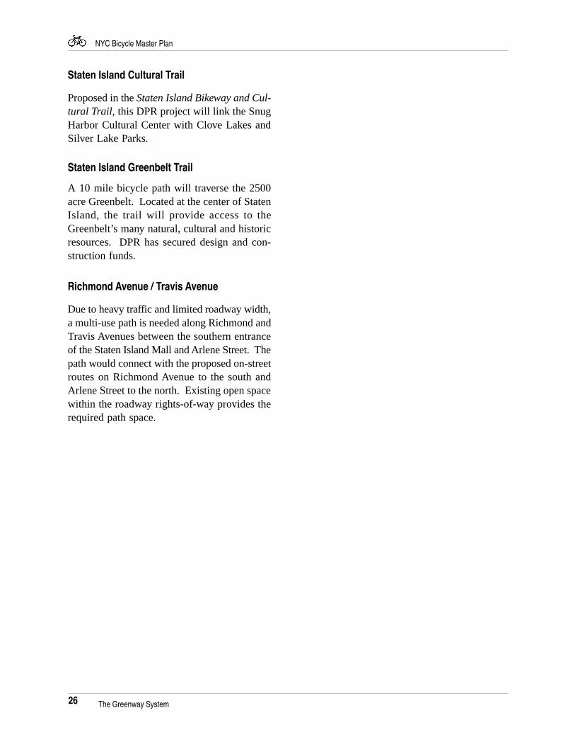
Staten Island Rail with Trail
A multi-use path is planned along the aban-doned North Shore rail line, offering spectacu-lar views of New York Harbor. The route,which will serve as a segment of the East CoastGreenway, will connect with the St. GeorgeFerry Terminal, Snug Harbor Cultural Center,and the existing Bayonne and proposedGoethals Bridge bicycle paths. Funding for afirst phase implementation has been secured byDCP and DPR.
North Shore Rail Line, Harbor Herons Wetlands
Flushing Bay Esplanade
The Greenway System
26
NYC Bicycle Master Plan
The Greenway System
Staten Island Cultural Trail
Proposed in the Staten Island Bikeway and Cul-tural Trail, this DPR project will link the SnugHarbor Cultural Center with Clove Lakes andSilver Lake Parks.
Staten Island Greenbelt Trail
A 10 mile bicycle path will traverse the 2500acre Greenbelt. Located at the center of StatenIsland, the trail will provide access to theGreenbelt’s many natural, cultural and historicresources. DPR has secured design and con-struction funds.
Richmond Avenue / Travis Avenue
Due to heavy traffic and limited roadway width,a multi-use path is needed along Richmond andTravis Avenues between the southern entranceof the Staten Island Mall and Arlene Street. Thepath would connect with the proposed on-streetroutes on Richmond Avenue to the south andArlene Street to the north. Existing open spacewithin the roadway rights-of-way provides therequired path space.
27
NYC Bicycle Master Plan
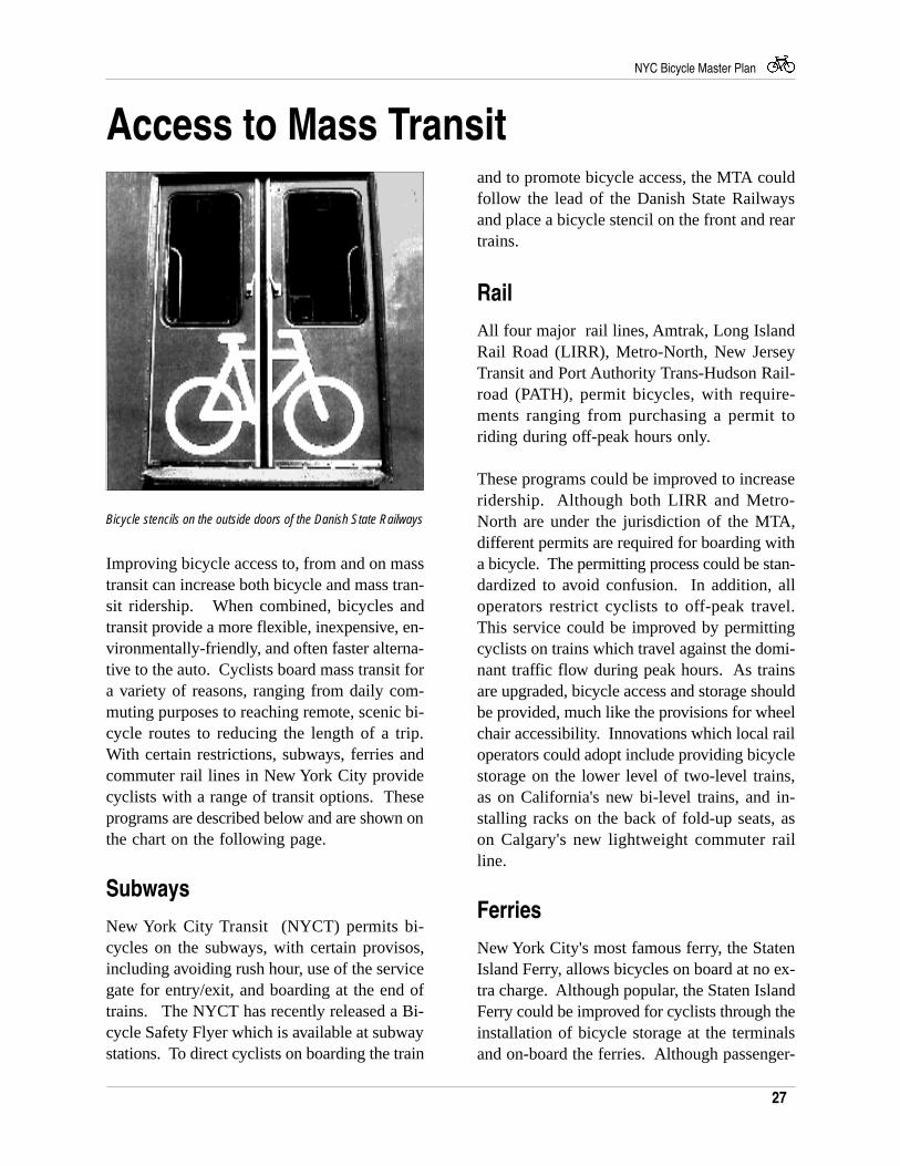
Bicycle stencils on the outside doors of the Danish State Railways
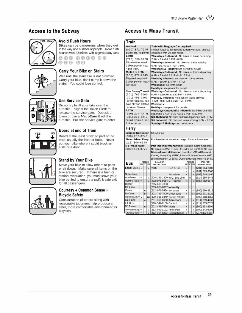
Improving bicycle access to, from and on masstransit can increase both bicycle and mass tran-sit ridership. When combined, bicycles andtransit provide a more flexible, inexpensive, en-vironmentally-friendly, and often faster alterna-tive to the auto. Cyclists board mass transit fora variety of reasons, ranging from daily com-muting purposes to reaching remote, scenic bi-cycle routes to reducing the length of a trip.With certain restrictions, subways, ferries andcommuter rail lines in New York City providecyclists with a range of transit options. Theseprograms are described below and are shown onthe chart on the following page.
Subways
New York City Transit (NYCT) permits bi-cycles on the subways, with certain provisos,including avoiding rush hour, use of the servicegate for entry/exit, and boarding at the end oftrains. The NYCT has recently released a Bi-cycle Safety Flyer which is available at subwaystations. To direct cyclists on boarding the train
Access to Mass Transitand to promote bicycle access, the MTA couldfollow the lead of the Danish State Railwaysand place a bicycle stencil on the front and reartrains.
Rail
All four major rail lines, Amtrak, Long IslandRail Road (LIRR), Metro-North, New JerseyTransit and Port Authority Trans-Hudson Rail-road (PATH), permit bicycles, with require-ments ranging from purchasing a permit toriding during off-peak hours only.
These programs could be improved to increaseridership. Although both LIRR and Metro-North are under the jurisdiction of the MTA,different permits are required for boarding witha bicycle. The permitting process could be stan-dardized to avoid confusion. In addition, alloperators restrict cyclists to off-peak travel.This service could be improved by permittingcyclists on trains which travel against the domi-nant traffic flow during peak hours. As trainsare upgraded, bicycle access and storage shouldbe provided, much like the provisions for wheelchair accessibility. Innovations which local railoperators could adopt include providing bicyclestorage on the lower level of two-level trains,as on California's new bi-level trains, and in-stalling racks on the back of fold-up seats, ason Calgary's new lightweight commuter railline.
Ferries
New York City's most famous ferry, the StatenIsland Ferry, allows bicycles on board at no ex-tra charge. Although popular, the Staten IslandFerry could be improved for cyclists through theinstallation of bicycle storage at the terminalsand on-board the ferries. Although passenger-
28
NYC Bicycle Master Plan
only ferries have indoor storage areas, motorvehicle accessible ferries require cyclists toleave their bicycles on the lower deck with nofacilities for secure storage. Providing a securerack on both ferries would use limited spacemore effectively and reduce conflicts betweenpassengers and cyclists. Two regional ferry op-erators, Express Navigation and NY Waterway,also permit bicycles on board; Express Naviga-tion charges a $3 fee and NY Waterway chargesa $1 fee. As the number of ferries continues torise, the City should ensure consistent bicycleaccess to promote the use of both modes.
Buses
New York City has one "bike-on-bus" program.Installed on the QBX1 bus line, which linksQueens with the Bronx over the WhitestoneBridge, the seasonal bike-on-bus permits twobicycles to be placed on a rack mounted on thefront of the bus. DCP is exploring a bike-on-bus program for the Verrazano-Narrows Bridge.
If sited and publicized correctly, bike-on-busprograms might prove successful throughout thecity, especially in those areas without subwayaccess. Both Phoenix and Portland have suc-cessful bike-on-bus programs. Phoenix's 6-month bike-on-bus demonstration program onthree routes showed a jump from 153 riders inthe first month to 5,500 riders in the sixthmonth, and Portland's bike-on-bus program,which requires cyclists to take a ten-minutecourse on using the racks and to obtain a $5permit, has proven so popular that a systemwide installation has been proposed.
Bicycle Parking at IntermodalCenters
Thus far, efforts to encourage intermodal shift,where transit customers transfer from one trans-portation mode to another, have focused on de-veloping auto "park-and-ride" lots at commuter
rail stations. However, the FHWA's NationalBicycling and Walking Study reports that alarge portion of spaces at park-and-ride lots areoccupied by autos that have been driven dis-tances of 3 miles or less. With the appropriatestorage, many of these energy-inefficient autotrips could be shifted to cycling.
In the New York area, lockers have been in-stalled at select stations, on a trial basis, on theLong Island and Metro North commuter rail-roads. The St. George Ferry Terminal in StatenIsland and the Shea Stadium stop on the 7subway line in Queens may prove to be appro-priate sites for lockers. Phase II of the BNDProject will identify specific implementation lo-cations and, where appropriate, work to installlockers.
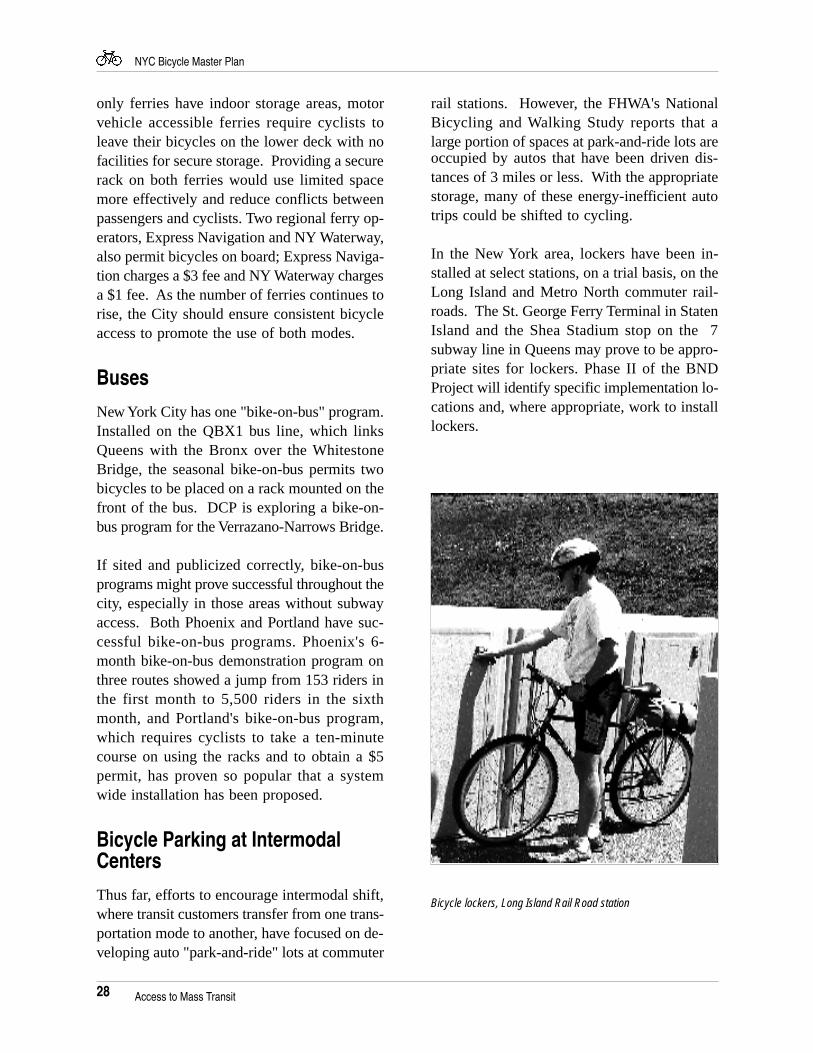
Bicycle lockers, Long Island Rail Road station
Access to Mass Transit
29
NYC Bicycle Master Plan
Access to the Subway
12
6
39
12
3
6
9
7AM - 10AM
4PM - 7PM
YES NO
Consideration of others along with reasonable judgment help produce a safer, more comfortable environment for bicycles.
Courtesy + Common Sense = Bicycle Safety
Move your bike to allow others to pass or sit down. Make sure all items on the bike are secured. If there is a train or station evacuation, you must leave your bike behind to ensure a swift & safe exit for all passengers.
Stand by Your Bike
Bikes can be dangerous when they get in the way of a number of people. Avoid rush hour crowds. Use lines with larger subway cars:
Avoid Rush Hours
A C E B Q F D N RM J Z L G
Do not try to lift your bike over the turnstile. Signal the Token Clerk to release the service gate. Deposit a token or use a MetroCard & roll the turnstile. Pull the service gate to enter.
Use Service Gate
Board at end of TrainBoard at the least crowded part of the train, usually the front or back. Never put your bike where it could block an aisle or a door.
Wait until the staircase is not crowded. Carry your bike, don't bump it down the stairs. You could lose control.
Carry Your Bike on Stairs
Amtrak(800) 872-7245$5 box fee, no permitLIRR (718) 558-8228$5 permit required2 bikes per car, max 4 per train.Metro Nor th(800) 872-7245$5 permit required2 bikes per car, max 4 per train.
New JerseyTransit(201) 762-5100(201) 491-9400 Permit required, freeavail. at Penn. Station, Hoboken, Newark PATH(800) 234-PATH(201) 216-6247Permit required, free. 2 bikes per car
Express Navigation(800) 262-8743Staten Island Ferry(212) 806-6940NY Waterway(800) 533-3779
Ferry
Bus
Train Train with Baggage Car required. No box required for travel to & from Vermont, use car equipped with 20 bike racks. Weekdays Outbound: No bikes on trains departing 7 AM - 9 AM & 3 PM - 8 PM.Weekdays Inbound: No bikes on trains arriving 6 AM -10 AM & 4 PM - 7 PM.Weekends & Holidays: see permit for detailsWeekdays Outbound: No bikes on trains departing 6 AM - 9 AM & 3:01PM - 8:15 PM.Weekday Inbound: No bikes on trains arriving 6 AM - 10 AM & 4 PM - 7 PM.Weekends: no restrictions.Holidays: see permit for details.Weekdays Outbound: No bikes on trains departing 6 AM - 9:30 AM & 3:30 PM - 6 PM.Weekday Inbound: No bikes on trains arriving 6 AM - 9:30 AM & 3:30 PM - 6 PM. Weekends: Holidays: see permit for details.Weekdays Outbound & Inbound: No bikes on trains departing 6 AM - 9:30 AM & 3 PM - 6:30 PM.Sat. Outbound: No bikes on trains departing 7 AM - 2 PM.Sat. Inbound: No bikes on trains arriving 1 PM - 7 PM.Sundays & Holidays: no restrictions.
$3 extra fee. Purchase ticket, no extra charge. Enter at lower level.
Port Imperial/Weehawken: No bikes during rush hour. No bikes on Wall St. line $1 extra fee on W 38 St. line.Bikes allowed all times on: Hoboken - World Financial Center, Jersey City - WFC, Liberty Science Center - WFC, Lincoln Harbor - W 38 St, Queens/Hunters Point - E 34 St.
ACCESSYES NO FEE
Y N
Y N
Y N
N
N
Y $10
N
N
Y N
Y N
CALL FOR RESTRICTIONS
(718)
(908) 291-1300(212) 971-9054(215) 683-7333(203) 878-6867(212) 972-5454(201) 783-7500(800) 936-0440(201) 366-0600(516) 542-0100(201) 491-7456(212) 962-1122(212) 964-6233
Local: QBx 1
Suburban:AcademyAsbury ParkBieberCT LimoCareyDeCampHampton JitneyLakelandL.I. BusNJ TransitNY/Keansburg Olympia Trails
ACCESSYES NO FEE
N
Y N
Y N
N
Y N
Y $3
Y $10
Y N
Y N
Y N
Y N
Y N
Red & Tan SuburbanW.C. Bee LineVT Transit
Inter-city:BonanzaGreyhoundTrailway Affiliate:Adirondack Capitol MartzPeter PanSusquehanna
CALL FOR RESTRICTIONS
(201) 384-2400(201) 529-3666(908) 249-1100(914) 285-5448(802) 862-9671
(800) 566-3815(800) 231-2222(800) 858-8555(914) 339-4230(717) 233-7673(800) 233-8604(800) 343-9999(717) 322-5361
Access to Mass Transit
Access to Mass Transit
30
NYC Bicycle Master Plan
Comprehensive Bicycle Program
The Comprehensive Bicycle Program is com-posed of four sections entitled Encouragement,Education, Engineering, and Enforcement. Theoverall aim of the Program is to encourage cy-cling in New York City through promotional lit-erature and events (encouragement); the devel-opment and maintenance of appropriate facili-ties (engineering); enhancement of bicyclesafety and respect for the cyclist’s rightful placeon the road (education); and the prevention oftheft and policing of bicycle facilities (enforce-ment). Implementation of a comprehensive pro-gram is required if cycling is to become a sig-nificant component of the city’s transportationsystem.
Encouragement
New York Cycling Map
In recognition of the complexities and result-ant time required in implementing a city-widenetwork, the BND Project developed a city-wide map of recommended bicycle routes as apreliminary step in the effort to increase cy-cling. The Map serves two functions, as an aidfor cyclists wishing to traverse the city on rela-tively “bicycle-friendly” streets, and as an op-portunity to educate cyclists on bicycle laws,safety tips, and subway, train, bus and ferry ac-cess. The recommended routes are consistentwith the routes identified in the network.
Bike Week
An annual spring event sponsored by Transpor-tation Alternatives, city agencies and electedofficials, Bike Week promotes commuting by bi-cycle by offering bicycle riding and repairworkshops, free safety equipment and other freeevents.
New York City Century
Sponsored by Transportation Alternatives, theCentury Tour is a 100 mile route through lowor no traffic areas, linking New York City’sparks, bicycle paths and waterfront.
Additional tours
New York City is home to a growing numberof bicycle tours and races, including the Tourof St. George in Staten Island and the Tour deBronx; as well as such charity tours as the AdvilBike Tour for Multiple Sclerosis; AmericanDiabetes Association Tour de Cure; and theNew York City to Boston AIDS Bike Ride.
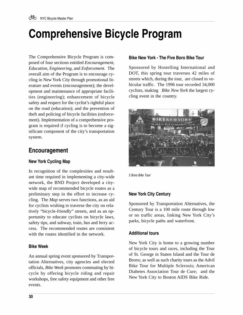
Bike New York - The Five Boro Bike Tour
Sponsored by Hostelling International andDOT, this spring tour traverses 42 miles ofstreets which, during the tour, are closed to ve-hicular traffic. The 1996 tour recorded 34,000cyclists, making Bike New York the largest cy-cling event in the country.
5 Boro Bike Tour
31
NYC Bicycle Master Plan
Community Policing Bicycle Patrol Program DOT Highway Quality Assurance Unit andParking Control Unit
The Highway Quality Assurance unit of DOTsuccessfully uses bicycles in Manhattan, Brook-lyn and Queens to inspect construction and re-port potholes. A pilot program to use bicyclesto issue parking summonses was started in June,1996. Currently under evaluation, the programsappears to be successful.
Private Sector Initiatives
Given the proven positive impact that cyclingto work can have on employees, such as im-proved health and heightened energy, employ-ers could encourage cycling by providing bi-cycle training, secure storage and shower andchanging facilities.
Institutionalization of Bicycle Planning
The following three initiatives have been devel-oped to promote the institutionalization of bi-cycle planning.
All-Agency Bicycle Policy
The BND Project developed the All-AgencyBicycle Policy to guide the actions of City, Stateand regional agencies as they relate to the goalof encouraging cycling as a mode of transpor-tation and a form of recreation. The four goalsof the Policy are:
• Improve facilities• Promote awareness• Integrate with transit modes• Improve safety
See Appendix D for the All-Agency BicyclePolicy.
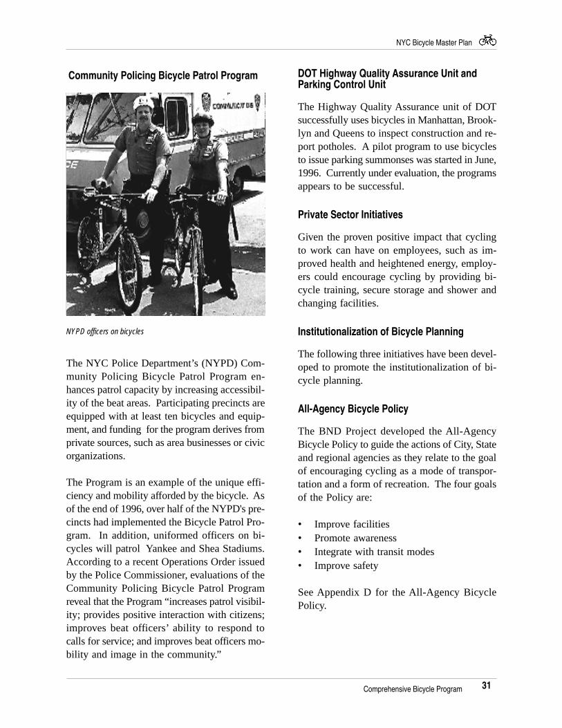
NYPD officers on bicycles
Comprehensive Bicycle Program
The NYC Police Department’s (NYPD) Com-munity Policing Bicycle Patrol Program en-hances patrol capacity by increasing accessibil-ity of the beat areas. Participating precincts areequipped with at least ten bicycles and equip-ment, and funding for the program derives fromprivate sources, such as area businesses or civicorganizations.
The Program is an example of the unique effi-ciency and mobility afforded by the bicycle. Asof the end of 1996, over half of the NYPD's pre-cincts had implemented the Bicycle Patrol Pro-gram. In addition, uniformed officers on bi-cycles will patrol Yankee and Shea Stadiums.According to a recent Operations Order issuedby the Police Commissioner, evaluations of theCommunity Policing Bicycle Patrol Programreveal that the Program “increases patrol visibil-ity; provides positive interaction with citizens;improves beat officers’ ability to respond tocalls for service; and improves beat officers mo-bility and image in the community.”
32
NYC Bicycle Master Plan
national and international bicycle planning anddesign standards was compiled. This library iscurrently housed at the Department of CityPlanning, Transportation Division, and is avail-able for use by appointment. The planningmethodologies described in Chapter 2 and theDesign Guidelines described in Chapter 5 arethe first step in developing a uniform set ofstandards for New York City.
Bicycle Parking
The lack of secure parking in New York Cityis a major disincentive to cycling. This hasbeen shown consistently in the DOT and DCPsurveys. Although in-door parking is neededfor all-day bicycle commuters, outdoor bicyclerack parking is appropriate and needed for mes-sengers and shoppers. Cyclists currently locktheir bicycles to available street furniture,which offers limited, not always secure, optionsfor cyclists and can clutter already crowdedsidewalks.
Short Term Parking: The On-street BicycleParking Facilities program (CITYRACKS) willhelp encourage cycling for short trips and er-rands by providing much needed bicycle park-ing. The program, which is funded through theISTEA Enhancement Program, installed ap-proximately 150 bicycle racks throughout thecity in June, 1996. Additional funding forCityRacks has been approved, and 2,200 addi-tional racks will be installed by 1999.
In conjunction with the Art Commission, theLandmarks Preservation Commission andTransportation Alternatives, DOT has chosen toinstall a continuous, curve-type rack in threeforms:
• An inverted “U” to hold 2 to 3 bicycles.• A 2-loop rack for 5 bicycles.• A 3-loop rack for 7 bicycles.
Mayoral Bicycle / Pedestrian AdvisoryCouncil
Formed in July 1995, the Mayor’s Bicycle/Pe-destrian Advisory Committee (BPAC) is chairedby Rudy Washington, Deputy Mayor for Com-munity Development and Business Services andis comprised of relevant city agencies and ad-vocacy groups. The goals of the BPAC include:
• Interagency coordination in advancing theNetwork.
• Providing a forum for the cyclingcommunity to express its concerns.
• Incorporating bicycle facilities, wherefeasible and appropriate, in all futurecapital projects.
• Promoting enforcement of trafficrules.
New York Metropolitan TransportationCouncil Bicycle / Pedestrian Working Group
This organization, comprised of city, regionaland state cycling advocates and governmentagencies, was instrumental in securing ISTEAfunding for bicycle-related projects. In Octo-ber, 1995, the Working Group became an offi-cial body of the New York Metropolitan Trans-portation Council (NYMTC). The WorkingGroup provides NYMTC with technical assis-tance in the formation of the bicycle/pedestriancomponent of the region’s Long Range Trans-portation Plan.
Engineering
Guidelines and Standards
The planning, design and implementation of allnetwork facilities are guided by minimum stan-dards. To guide the BND Project and otherdesign professionals, a research library on
Comprehensive Bicycle Program
33
NYC Bicycle Master Plan
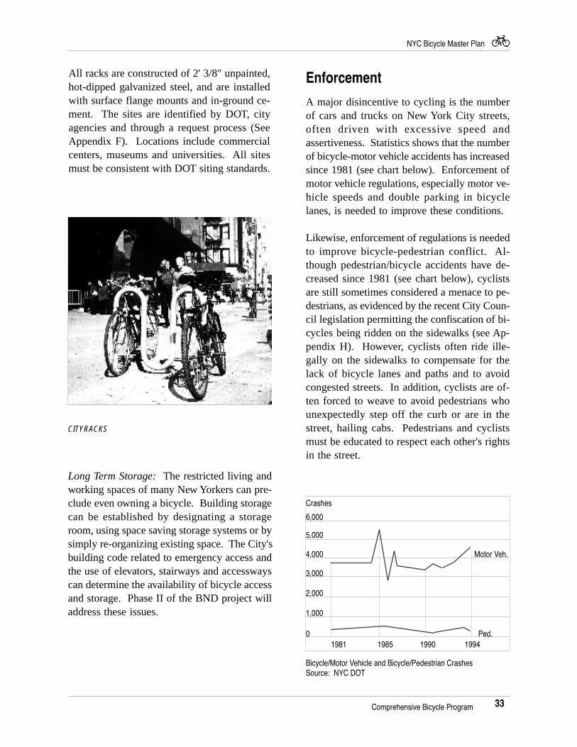
All racks are constructed of 2' 3/8" unpainted,hot-dipped galvanized steel, and are installedwith surface flange mounts and in-ground ce-ment. The sites are identified by DOT, cityagencies and through a request process (SeeAppendix F). Locations include commercialcenters, museums and universities. All sitesmust be consistent with DOT siting standards.
Enforcement
A major disincentive to cycling is the numberof cars and trucks on New York City streets,often driven with excessive speed andassertiveness. Statistics shows that the numberof bicycle-motor vehicle accidents has increasedsince 1981 (see chart below). Enforcement ofmotor vehicle regulations, especially motor ve-hicle speeds and double parking in bicyclelanes, is needed to improve these conditions.
Likewise, enforcement of regulations is neededto improve bicycle-pedestrian conflict. Al-though pedestrian/bicycle accidents have de-creased since 1981 (see chart below), cyclistsare still sometimes considered a menace to pe-destrians, as evidenced by the recent City Coun-cil legislation permitting the confiscation of bi-cycles being ridden on the sidewalks (see Ap-pendix H). However, cyclists often ride ille-gally on the sidewalks to compensate for thelack of bicycle lanes and paths and to avoidcongested streets. In addition, cyclists are of-ten forced to weave to avoid pedestrians whounexpectedly step off the curb or are in thestreet, hailing cabs. Pedestrians and cyclistsmust be educated to respect each other's rightsin the street.
Long Term Storage: The restricted living andworking spaces of many New Yorkers can pre-clude even owning a bicycle. Building storagecan be established by designating a storageroom, using space saving storage systems or bysimply re-organizing existing space. The City'sbuilding code related to emergency access andthe use of elevators, stairways and accesswayscan determine the availability of bicycle accessand storage. Phase II of the BND project willaddress these issues.
CITYRACKS
Comprehensive Bicycle Program
Bicycle/Motor Vehicle and Bicycle/Pedestrian CrashesSource: NYC DOT
1,000
2,000
3,000
4,000 Motor Veh.
5,000
6,000
Crashes
1981 1985 1990 19940 Ped.
34
NYC Bicycle Master Plan
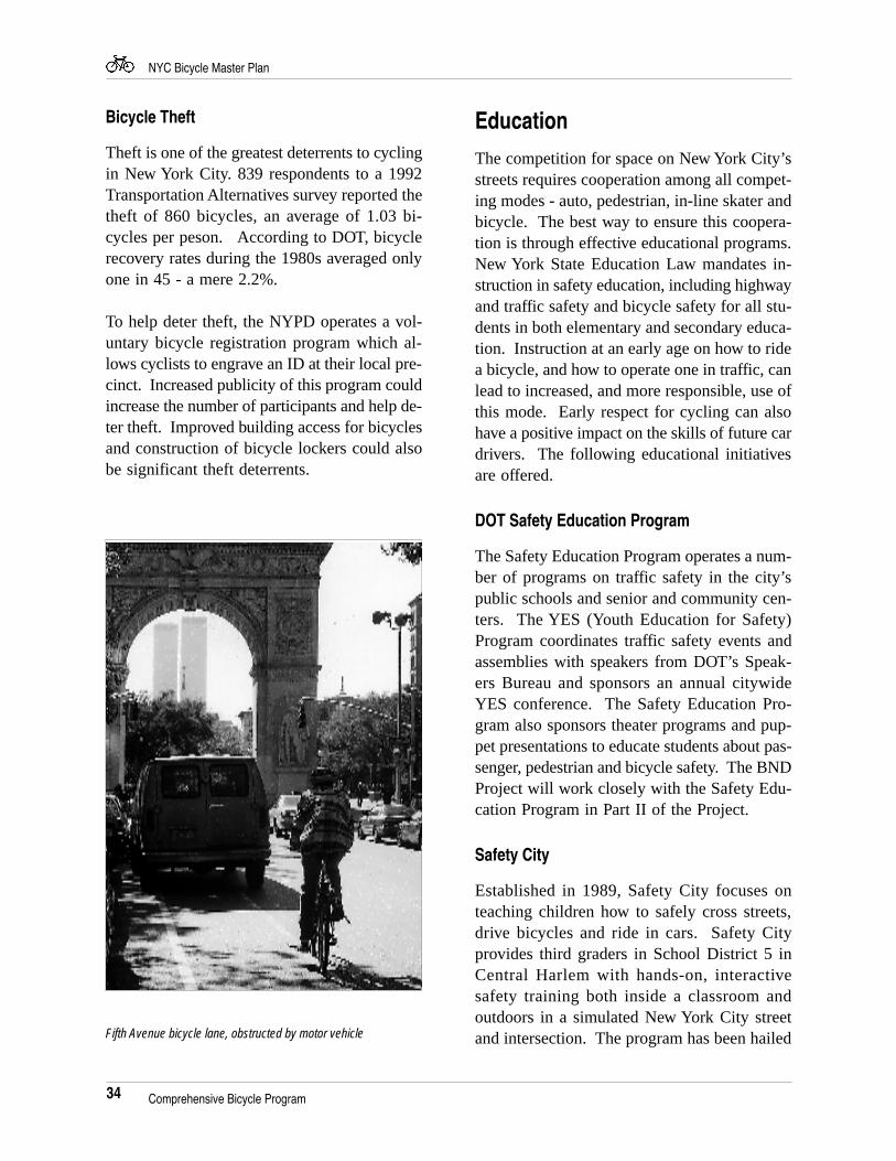
Fifth Avenue bicycle lane, obstructed by motor vehicle
Bicycle Theft
Theft is one of the greatest deterrents to cyclingin New York City. 839 respondents to a 1992Transportation Alternatives survey reported thetheft of 860 bicycles, an average of 1.03 bi-cycles per peson. According to DOT, bicyclerecovery rates during the 1980s averaged onlyone in 45 - a mere 2.2%.
To help deter theft, the NYPD operates a vol-untary bicycle registration program which al-lows cyclists to engrave an ID at their local pre-cinct. Increased publicity of this program couldincrease the number of participants and help de-ter theft. Improved building access for bicyclesand construction of bicycle lockers could alsobe significant theft deterrents.
Education
The competition for space on New York City’sstreets requires cooperation among all compet-ing modes - auto, pedestrian, in-line skater andbicycle. The best way to ensure this coopera-tion is through effective educational programs.New York State Education Law mandates in-struction in safety education, including highwayand traffic safety and bicycle safety for all stu-dents in both elementary and secondary educa-tion. Instruction at an early age on how to ridea bicycle, and how to operate one in traffic, canlead to increased, and more responsible, use ofthis mode. Early respect for cycling can alsohave a positive impact on the skills of future cardrivers. The following educational initiativesare offered.
DOT Safety Education Program
The Safety Education Program operates a num-ber of programs on traffic safety in the city’spublic schools and senior and community cen-ters. The YES (Youth Education for Safety)Program coordinates traffic safety events andassemblies with speakers from DOT’s Speak-ers Bureau and sponsors an annual citywideYES conference. The Safety Education Pro-gram also sponsors theater programs and pup-pet presentations to educate students about pas-senger, pedestrian and bicycle safety. The BNDProject will work closely with the Safety Edu-cation Program in Part II of the Project.
Safety City
Established in 1989, Safety City focuses onteaching children how to safely cross streets,drive bicycles and ride in cars. Safety Cityprovides third graders in School District 5 inCentral Harlem with hands-on, interactivesafety training both inside a classroom andoutdoors in a simulated New York City streetand intersection. The program has been hailed
Comprehensive Bicycle Program
35
NYC Bicycle Master Plan
as a success. According to Harlem Hospital’sPediatric Trauma Unit, there has been a 50%drop in the number of children admitted formotor-vehicle related injuries since SafetyCity’s inception.
The Safety City Program was expanded in 1995to include the Mobile Safety City Program, ajoint City Volunteer Corps project which trans-ported the NYC intersection to schools inBrooklyn, Queens and Staten Island. In Sep-tember 1996, a new Safety City was dedicatedon Staten Island. This project is a cooperativeeffort between DOT, the NYC Board of Edu-cation and the NYPD. Funding is being soughtto expand to all five boroughs.
Share the Road Safely
This recently initiated program is a joint DOT-NYPD effort to improve traffic safety. It fo-cuses on planning and designing pedestrian im-provements and has sponsored public serviceannouncements on the radio on safe cycling.The BND Project recommends that this pro-gram be expanded to include bus and subwayposters.
Comprehensive Bicycle Program
36
NYC Bicycle Master Plan
Design GuidelinesDesign standards are a critical component in theNetwork implementation process. They helpensure a consistent, safe level of service for us-ers and protect local government agencies fromliability issues in the event of injury. NYCDOT is in the process of developing Bicycle Fa-cility Design Standards. This chapter of thePlan offers the following Design Guidelines tobe used while the DOT Standards are being de-veloped.
The Design Guidelines are a compilation ofnational guidelines and examples of existingand proposed facilities in New York City. TheGuidelines are intentionally broad, providingdesigners with the flexibility that is often re-quired in a locale as complex as New York City.
Most local design guidelines have been basedin whole or in part on national and state stan-dards. The national standards are listed below.
1. Guide to the Development of BicycleFacilities, AASHTO
Released in 1981, and updated in 1991, theAASHTO Guide has become the basic refer-ence for facility designers across the country.
2. Manual on Uniform Traffic Control Devices(MUTCD), Federal Highway Administration
Released in 1935, and updated in 1988, theMUTCD is the national manual for streets andhighways. Conformance with the manual’sstandards is required in nearly every state bystatute (New York included).
3. Guidelines for Greenways, The GreenwayCollaborative
This document provides detailed advice on theplanning, design and maintenance of multi-usepaths and trails.
4. Design & Maintenance Manual for Multi-use Trails, Rails-to-Trails Conservancy
This document provides information similar tothat found in Guidelines for Greenways, butwith an emphasis on abandoned rail corridorsand canal tow paths.
5. Guidelines for Establishing In-Line SkateTrails in Park and Recreation Areas,International In-Line Skating Association
As noted on page 5, bicycle facilities are di-vided into the following three categories:
Multi-use Path, separated from motor vehicletraffic
On-Street Bicycle Lane, designated by lanemarkings and signs
Signed Bicycle Route, designated by signs only
On-Street Facilities
Bicycle Lanes - Width
AASHTO: The minimum bicycle lane widthrequirement is 4 feet. However, certain edgeconditions dictate additional desirable bicyclelane width, see Figures A - C.
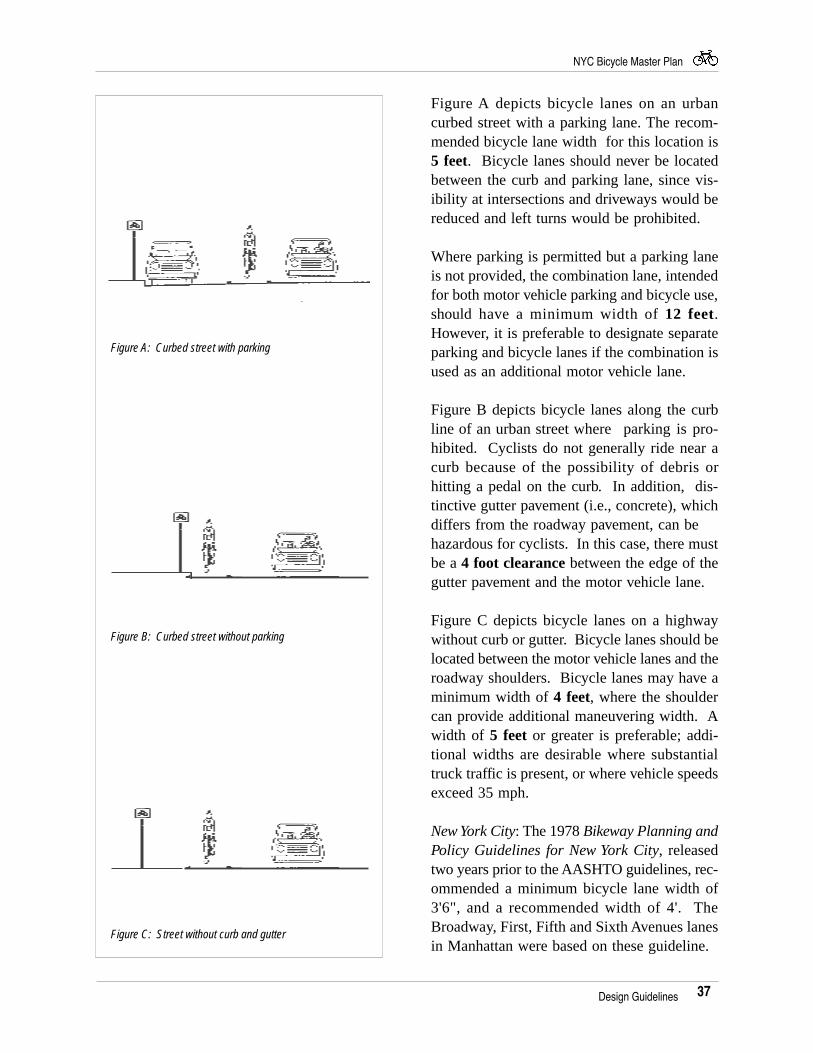
37
NYC Bicycle Master Plan
Figure A depicts bicycle lanes on an urbancurbed street with a parking lane. The recom-mended bicycle lane width for this location is5 feet. Bicycle lanes should never be locatedbetween the curb and parking lane, since vis-ibility at intersections and driveways would bereduced and left turns would be prohibited.
Where parking is permitted but a parking laneis not provided, the combination lane, intendedfor both motor vehicle parking and bicycle use,should have a minimum width of 12 feet.However, it is preferable to designate separateparking and bicycle lanes if the combination isused as an additional motor vehicle lane.
Figure B depicts bicycle lanes along the curbline of an urban street where parking is pro-hibited. Cyclists do not generally ride near acurb because of the possibility of debris orhitting a pedal on the curb. In addition, dis-tinctive gutter pavement (i.e., concrete), whichdiffers from the roadway pavement, can behazardous for cyclists. In this case, there mustbe a 4 foot clearance between the edge of thegutter pavement and the motor vehicle lane.
Figure C depicts bicycle lanes on a highwaywithout curb or gutter. Bicycle lanes should belocated between the motor vehicle lanes and theroadway shoulders. Bicycle lanes may have aminimum width of 4 feet, where the shouldercan provide additional maneuvering width. Awidth of 5 feet or greater is preferable; addi-tional widths are desirable where substantialtruck traffic is present, or where vehicle speedsexceed 35 mph.
New York City: The 1978 Bikeway Planning andPolicy Guidelines for New York City, releasedtwo years prior to the AASHTO guidelines, rec-ommended a minimum bicycle lane width of3'6", and a recommended width of 4'. TheBroadway, First, Fifth and Sixth Avenues lanesin Manhattan were based on these guideline.
Design Guidelines
Figure B: Curbed street without parking
Figure A: Curbed street with parking
Figure C: Street without curb and gutter
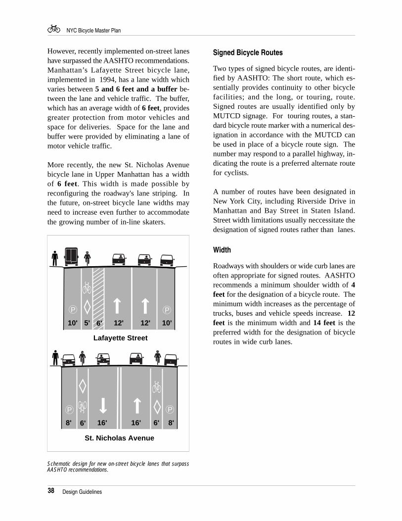
38
NYC Bicycle Master Plan
However, recently implemented on-street laneshave surpassed the AASHTO recommendations.Manhattan’s Lafayette Street bicycle lane,implemented in 1994, has a lane width whichvaries between 5 and 6 feet and a buffer be-tween the lane and vehicle traffic. The buffer,which has an average width of 6 feet, providesgreater protection from motor vehicles andspace for deliveries. Space for the lane andbuffer were provided by eliminating a lane ofmotor vehicle traffic.
More recently, the new St. Nicholas Avenuebicycle lane in Upper Manhattan has a widthof 6 feet. This width is made possible byreconfiguring the roadway's lane striping. Inthe future, on-street bicycle lane widths mayneed to increase even further to accommodatethe growing number of in-line skaters.
Signed Bicycle Routes
Two types of signed bicycle routes, are identi-fied by AASHTO: The short route, which es-sentially provides continuity to other bicyclefacilities; and the long, or touring, route.Signed routes are usually identified only byMUTCD signage. For touring routes, a stan-dard bicycle route marker with a numerical des-ignation in accordance with the MUTCD canbe used in place of a bicycle route sign. Thenumber may respond to a parallel highway, in-dicating the route is a preferred alternate routefor cyclists.
A number of routes have been designated inNew York City, including Riverside Drive inManhattan and Bay Street in Staten Island.Street width limitations usually neccessitate thedesignation of signed routes rather than lanes.
Width
Roadways with shoulders or wide curb lanes areoften appropriate for signed routes. AASHTOrecommends a minimum shoulder width of 4feet for the designation of a bicycle route. Theminimum width increases as the percentage oftrucks, buses and vehicle speeds increase. 12feet is the minimum width and 14 feet is thepreferred width for the designation of bicycleroutes in wide curb lanes.
Design Guidelines
8' 6' 16' 16' 6' 8'
P P
PP
5'10' 10'12' 12'6'
Lafayette Street
St. Nicholas Avenue
Schematic design for new on-street bicycle lanes that surpassAASHTO recommendations.
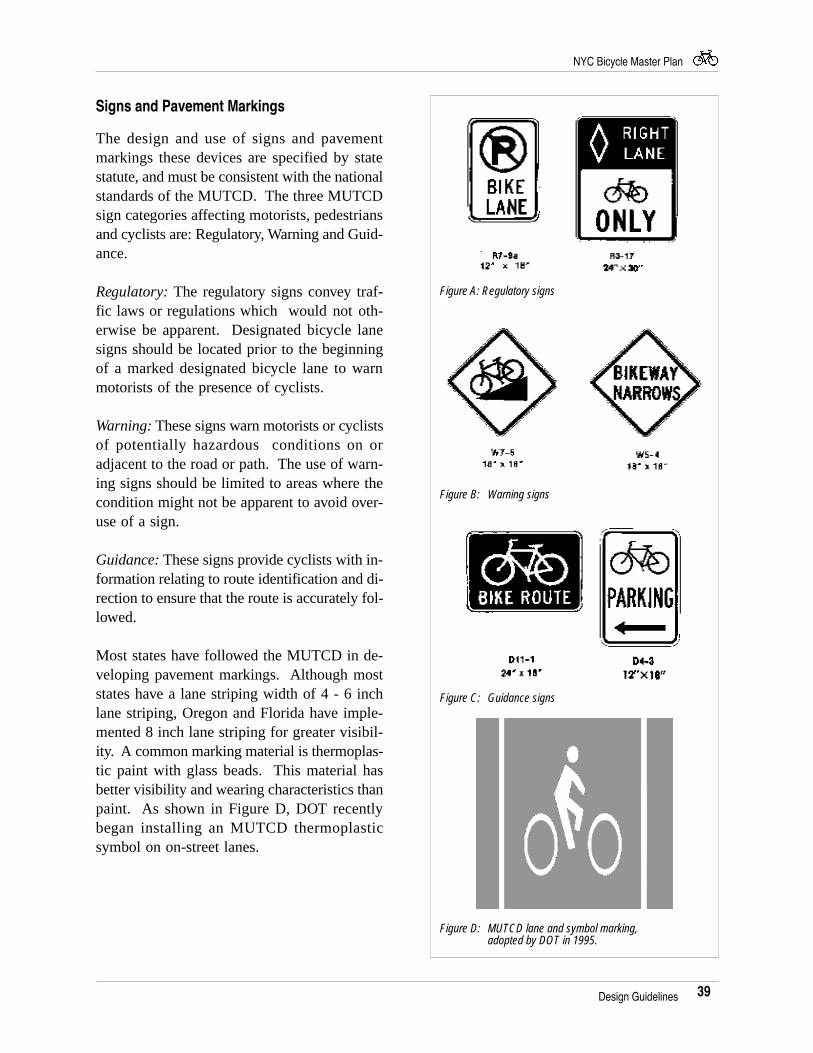
39
NYC Bicycle Master Plan
Signs and Pavement Markings
The design and use of signs and pavementmarkings these devices are specified by statestatute, and must be consistent with the nationalstandards of the MUTCD. The three MUTCDsign categories affecting motorists, pedestriansand cyclists are: Regulatory, Warning and Guid-ance.
Regulatory: The regulatory signs convey traf-fic laws or regulations which would not oth-erwise be apparent. Designated bicycle lanesigns should be located prior to the beginningof a marked designated bicycle lane to warnmotorists of the presence of cyclists.
Warning: These signs warn motorists or cyclistsof potentially hazardous conditions on oradjacent to the road or path. The use of warn-ing signs should be limited to areas where thecondition might not be apparent to avoid over-use of a sign.
Guidance: These signs provide cyclists with in-formation relating to route identification and di-rection to ensure that the route is accurately fol-lowed.
Most states have followed the MUTCD in de-veloping pavement markings. Although moststates have a lane striping width of 4 - 6 inchlane striping, Oregon and Florida have imple-mented 8 inch lane striping for greater visibil-ity. A common marking material is thermoplas-tic paint with glass beads. This material hasbetter visibility and wearing characteristics thanpaint. As shown in Figure D, DOT recentlybegan installing an MUTCD thermoplasticsymbol on on-street lanes.
Figure A: Regulatory signs
Figure B: Warning signs
Figure C: Guidance signs
Figure D: MUTCD lane and symbol marking,adopted by DOT in 1995.
Design Guidelines
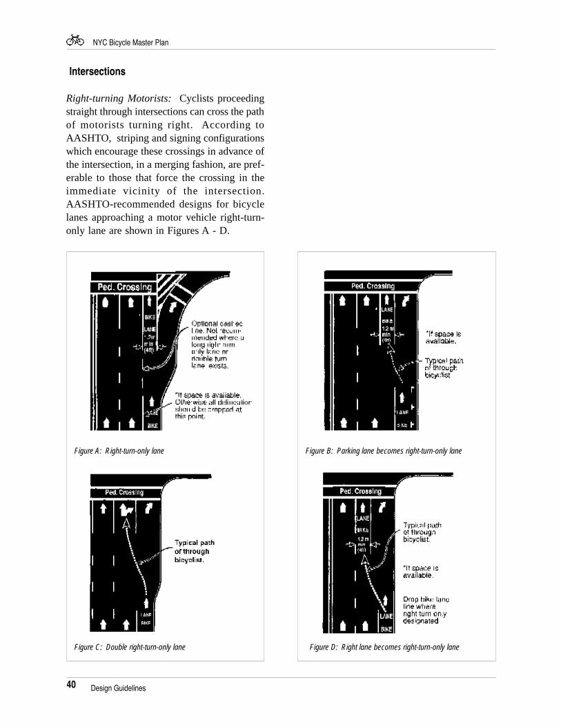
40
NYC Bicycle Master Plan
Intersections
Right-turning Motorists: Cyclists proceedingstraight through intersections can cross the pathof motorists turning right. According toAASHTO, striping and signing configurationswhich encourage these crossings in advance ofthe intersection, in a merging fashion, are pref-erable to those that force the crossing in theimmediate vicinity of the intersection.AASHTO-recommended designs for bicyclelanes approaching a motor vehicle right-turn-only lane are shown in Figures A - D.
Figure B: Parking lane becomes right-turn-only lane
Figure D: Right lane becomes right-turn-only laneFigure C: Double right-turn-only lane
Figure A: Right-turn-only lane
Design Guidelines
41
NYC Bicycle Master Plan
LANEBIKE
LAN
EB
IKE
LANEBIKE
LAN
EB
IKE
LAN
EB
IKE
LAN
EB
IKE
LANEBIKE
Legend
Bicycle
Motor vehicle
Left-turning cyclists: Most vehicle codesallow the cyclist the option of making eithera “vehicular style” left turn (where the cyclistmerges to the same lane used for motor ve-hicle left turn lanes) or a “pedestrian style” leftturn (where the cyclist proceeds straight throughthe intersection, turns left at the far side, thenproceeds across the intersection again on thecross street).
Drainage Grates
Drainage inlets with grate openings which areparallel to traffic can trap the front wheel of abicycle, causing loss of steering control, result-ing in serious damage to the bicycle wheel andframe and/or injury to the cyclist. Such gratesshould be replaced with bicycle-safe and hy-draulically efficient ones, as below.
A temporary correction involves welding steelcross straps or bars perpendicular to the paral-lel bars to provide a maximum safe opening be-tween straps. Identifying a hazardous gratewith pavement marking is inadequate; a cyclistcould miss the pavement marking in the darkor be forced over such a grate inlet by othertraffic.
When a new roadway is designed, all drainagegrate inlets and utility covers should be kept outof the cyclists’ expected path. When an exist-ing roadway is reconstructed, all drainage grateinlets and utility covers should be replacedwherever possible with bicycle-friendly cast-ings to ensure the safety of cyclists.
Typical traffic movements thourgh an intersection. Cyclists canturn left as a vehicle or as a pedestrian.
Bicycle-safe drainage grate
Design Guidelines
42
NYC Bicycle Master Plan
Multi - Use Paths
Width
One-directional path: AASHTO establishes 5feet as the minimum width of a one-directionalbicycle path, but cautions that such a path willbe used as a two-way facility unless measuresare taken to assure one-way operation. TheInternational In-Line Skating Association rec-ommends 8 feet for one-way skating paths; 10feet, 6 inches for combined bicycle / in-lineskate, one-way paths.
Two-directional path: AASHTO establishes 8feet as a minimum and 10 feet as a recom-mended width for a two-directional “bicyclepath”. If substantial bicycle volume and shareduse with joggers and other pedestrians is antici-pated, AASHTO recommends a width of 12feet. The Rails-to-Trails Conservancy recom-mends a width of 16 feet for paths for “non-motorized” use in urban settings.
Widths recommended by AASHTO for multi-use paths.
New York City: Multi-use paths are generallyshared by cyclists, pedestrians, joggers and, in-creasingly, in-line skaters. Pavement markingsand signage or, where space and funds permit,physical dividers are used to separate a “wheelsonly” path (bicycles and in-line skates) from“feet only” path (runners and pedestrians).Typical widths of multi-use paths in New YorkCity are shown below.
Existing Paths
Shore Parkway Bicycle Path(69th Street to 4th Avenue): 11’-6" to 14' (wheels only)(4th Avenue to Bay Parkway):11' to 14' (shared )Ocean Parkway: 10' (wheels only)North Bronx Greenway: 8' (shared)
New or Reconstructed Paths
Shore Parkway Bicycle Path(Knapp St to Penn. Ave): 12' (shared)Route 9A: 16' (wheels only)East River Esplanade: 10' (wheels only)
Buffer
AASHTO establishes a minimum 2 foot, rec-ommended 3 foot, wide graded area locatedadjacent to both the sides of the path to provideclearance from trees, poles, walls, fences,guardrails. AASHTO further recommends awide separation between a bicycle path andadjacent highway to instruct both the cyclistand the motorist that the path functions as anindependent highway for non-motorized ve-hicles. When the distance between the edge ofthe roadway and the bicycle path is less than 5feet, construction of a physical divider is rec-ommended. Such a divider should have a mini-mum height of 4.5 feet to prevent the cyclistfrom toppling over the divider.
Design Guidelines
43
NYC Bicycle Master Plan
Vertical Clearance
AASHTO establishes a minimum vertical clear-ance of 8 feet, although a greater clearance maybe needed to permit passage of maintenancevehicles. A clearance of 10 feet is desirable inunderpasses and tunnels. The Rails-to-TrailsConservancy provides specific vegetative clear-ance requirements.
Grades
AASHTO recommends a maximum 5 percentgrade; higher grades are difficult to climb and,on the downhill, may cause some cyclists to ex-ceed the speeds at which they are competent;grades over 5 percent and less than 500 feetlong are acceptable when a higher design speedis used and additional width is provided; gradessteeper than 3 percent may not be practical forbicycle paths with crushed stone surfaces.
Signing and Pavement Marking
The regulatory, warning and informational typesof MUTCD signing can be applied, where ap-propriate, to multi-use paths. AASHTO alsorecommends a 4" wide yellow centerline stripeto separate opposite directions of travel. Warn-ing stripes on fixed objects (i.e., bollards orelevated roadway columns) are also used todelineate lanes.
Travel Path Restriction Signs are used exclu-sively where there is a shared use with pedes-trians and cyclists, an especially commonoccurance in New York City.
Travel Path Restriction Sign.
Vegetative clearance chart, Rails-to-Trails Conservancy
Alignment
The minimum radius of curvature negotiable bya bicycle is a function of the superelevation rateof the bicycle path surface, the coefficient offriction between the bicycle tires and the bicyclepath surface, and the speed of the bicycle. Thechart below shows the additional, width re-quired, based on curve radii.
Radius (ft.) Additional Pavement Width (ft.)
0-25 425-50 350-75 275-100 1100+ 0
Design Guidelines
44
NYC Bicycle Master Plan
New York City: Unlike on-street lanes, off-streetpaths, generally under the joint jurisdiction ofNYC DPR and DOT, are not subject to con-formance with the State statute on traffic con-trol devices. This permits greater flexibility inaddressing the unique needs of cyclists and pe-destrians.
Proposed pavement marking and signage design for Route 9A Path.Source: NYS DOT
Proposed pavement marking and signage design for theReconstruction of the Shore Parkway Bicycle Path. Source: DPR
Design Guidelines
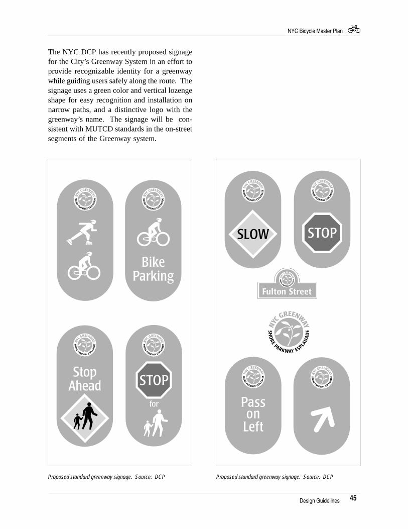
45
NYC Bicycle Master Plan
The NYC DCP has recently proposed signagefor the City’s Greenway System in an effort toprovide recognizable identity for a greenwaywhile guiding users safely along the route. Thesignage uses a green color and vertical lozengeshape for easy recognition and installation onnarrow paths, and a distinctive logo with thegreenway’s name. The signage will be con-sistent with MUTCD standards in the on-streetsegments of the Greenway system.
Design Guidelines
Proposed standard greenway signage. Source: DCP Proposed standard greenway signage. Source: DCP
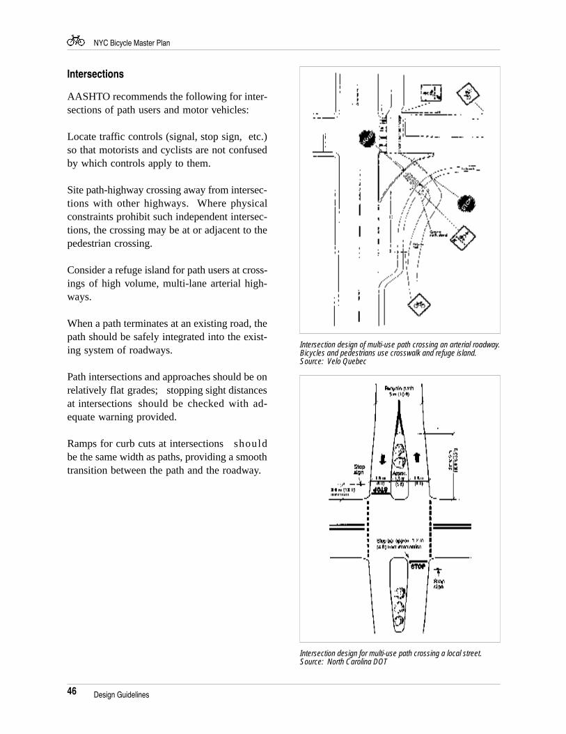
46
NYC Bicycle Master Plan
Intersections
AASHTO recommends the following for inter-sections of path users and motor vehicles:
Locate traffic controls (signal, stop sign, etc.)so that motorists and cyclists are not confusedby which controls apply to them.
Site path-highway crossing away from intersec-tions with other highways. Where physicalconstraints prohibit such independent intersec-tions, the crossing may be at or adjacent to thepedestrian crossing.
Consider a refuge island for path users at cross-ings of high volume, multi-lane arterial high-ways.
When a path terminates at an existing road, thepath should be safely integrated into the exist-ing system of roadways.
Path intersections and approaches should be onrelatively flat grades; stopping sight distancesat intersections should be checked with ad-equate warning provided.
Ramps for curb cuts at intersectionsshouldbe the same width as paths, providing a smoothtransition between the path and the roadway.
Intersection design for multi-use path crossing a local street.Source: North Carolina DOT
Design Guidelines
Intersection design of multi-use path crossing an arterial roadway.Bicycles and pedestrians use crosswalk and refuge island.Source: Velo Quebec
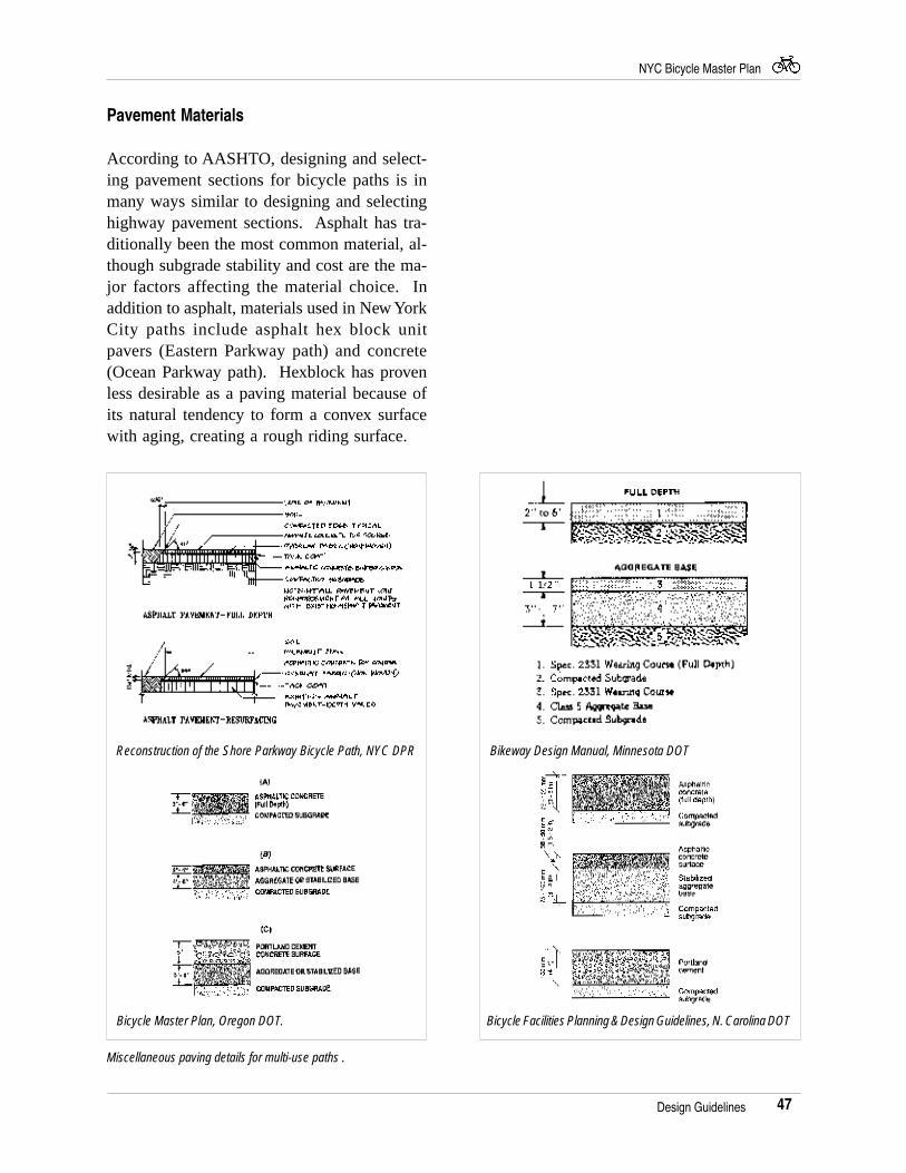
47
NYC Bicycle Master Plan
Pavement Materials
According to AASHTO, designing and select-ing pavement sections for bicycle paths is inmany ways similar to designing and selectinghighway pavement sections. Asphalt has tra-ditionally been the most common material, al-though subgrade stability and cost are the ma-jor factors affecting the material choice. Inaddition to asphalt, materials used in New YorkCity paths include asphalt hex block unitpavers (Eastern Parkway path) and concrete(Ocean Parkway path). Hexblock has provenless desirable as a paving material because ofits natural tendency to form a convex surfacewith aging, creating a rough riding surface.
Reconstruction of the Shore Parkway Bicycle Path, NYC DPR
Miscellaneous paving details for multi-use paths .
Bicycle Master Plan, Oregon DOT.
Bikeway Design Manual, Minnesota DOT
Bicycle Facilities Planning & Design Guidelines, N. Carolina DOT
Design Guidelines
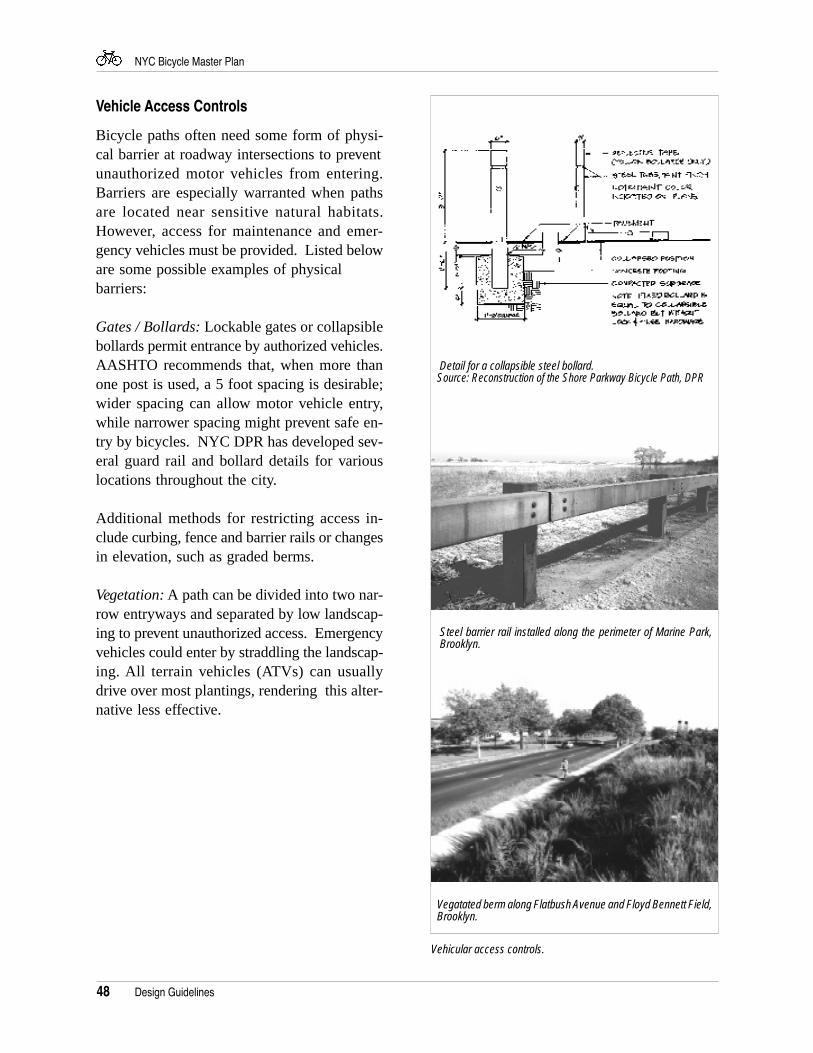
48
NYC Bicycle Master Plan
Vehicle Access Controls
Bicycle paths often need some form of physi-cal barrier at roadway intersections to preventunauthorized motor vehicles from entering.Barriers are especially warranted when pathsare located near sensitive natural habitats.However, access for maintenance and emer-gency vehicles must be provided. Listed beloware some possible examples of physicalbarriers:
Gates / Bollards: Lockable gates or collapsiblebollards permit entrance by authorized vehicles.AASHTO recommends that, when more thanone post is used, a 5 foot spacing is desirable;wider spacing can allow motor vehicle entry,while narrower spacing might prevent safe en-try by bicycles. NYC DPR has developed sev-eral guard rail and bollard details for variouslocations throughout the city.
Additional methods for restricting access in-clude curbing, fence and barrier rails or changesin elevation, such as graded berms.
Vegetation: A path can be divided into two nar-row entryways and separated by low landscap-ing to prevent unauthorized access. Emergencyvehicles could enter by straddling the landscap-ing. All terrain vehicles (ATVs) can usuallydrive over most plantings, rendering this alter-native less effective.
Vehicular access controls.
Design Guidelines
Detail for a collapsible steel bollard.Source: Reconstruction of the Shore Parkway Bicycle Path, DPR
Steel barrier rail installed along the perimeter of Marine Park,Brooklyn.
Vegatated berm along Flatbush Avenue and Floyd Bennett Field,Brooklyn.
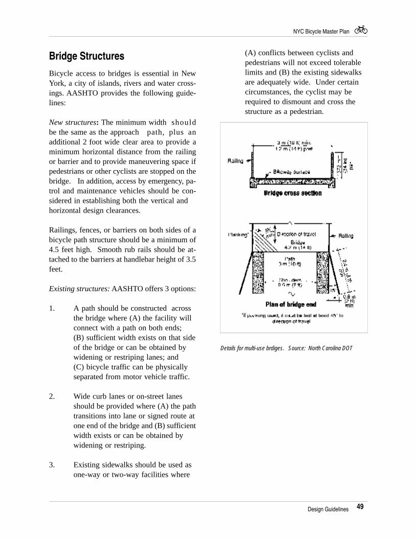
49
NYC Bicycle Master Plan
Bridge Structures
Bicycle access to bridges is essential in NewYork, a city of islands, rivers and water cross-ings. AASHTO provides the following guide-lines:
New structures: The minimum width shouldbe the same as the approachpath, plus anadditional 2 foot wide clear area to provide aminimum horizontal distance from the railingor barrier and to provide maneuvering space ifpedestrians or other cyclists are stopped on thebridge. In addition, access by emergency, pa-trol and maintenance vehicles should be con-sidered in establishing both the vertical andhorizontal design clearances.
Railings, fences, or barriers on both sides of abicycle path structure should be a minimum of4.5 feet high. Smooth rub rails should be at-tached to the barriers at handlebar height of 3.5feet.
Existing structures: AASHTO offers 3 options:
1. A path should be constructed acrossthe bridge where (A) the facility willconnect with a path on both ends;(B) sufficient width exists on that sideof the bridge or can be obtained bywidening or restriping lanes; and(C) bicycle traffic can be physicallyseparated from motor vehicle traffic.
2. Wide curb lanes or on-street lanesshould be provided where (A) the pathtransitions into lane or signed route atone end of the bridge and (B) sufficientwidth exists or can be obtained bywidening or restriping.
3. Existing sidewalks should be used asone-way or two-way facilities where
(A) conflicts between cyclists andpedestrians will not exceed tolerablelimits and (B) the existing sidewalksare adequately wide. Under certaincircumstances, the cyclist may berequired to dismount and cross thestructure as a pedestrian.
Details for multi-use brdiges. Source: North Carolina DOT
Design Guidelines
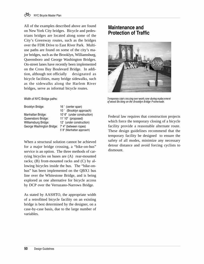
50
NYC Bicycle Master Plan
All of the examples described above are foundon New York City bridges. Bicycle and pedes-trians bridges are located along some of theCity’s Greenway routes, such as the bridgesover the FDR Drive to East River Park. Multi-use paths are found on some of the city’s ma-jor bridges, such as the Brooklyn, Williamsburg,Queensboro and George Washington Bridges.On-street lanes have recently been implementedon the Cross Bay Boulevard Bridge. In addi-tion, although not officially designated asbicycle facilities, many bridge sidewalks, suchas the sidewalks along the Harlem Riverbridges, serve as informal bicycle routes.
Width of NYC Bridge paths:
Brooklyn Bridge: 16 ' (center span)10 ' (Brooklyn approach)
Manhattan Bridge: 10' 6" (under construction)Queensboro Bridge: 11' 10" (proposed)Williamsburg Bridge: 12' (under construction)George Washington Bridge: 7' 4" (between ropes)
5' 8" (Manhattan approach)
When a structural solution cannot be achievedfor a major bridge crossing, a “bike-on-bus”service is an option. The three methods of car-rying bicycles on buses are (A) rear-mountedracks; (B) front-mounted racks and (C) by al-lowing bicycles inside the bus. The “bike-on-bus” has been implemented on the QBX1 busline over the Whitestone Bridge, and is beingexplored as one alternative for bicycle accessby DCP over the Verrazano-Narrows Bridge.
As stated by AASHTO, the appropriate widthof a retrofitted bicycle facility on an existingbridge is best determined by the designer, on acase-by-case basis, due to the large number ofvariables.
Design Guidelines
Temporary stair crossing over work zone during replacementof wood decking on the Brooklyn Bridge Promenade.
Federal law requires that construction projectswhich force the temporary closing of a bicyclefacility provide a reasonable alternate route.These design guidelines recommend that thetemporary facility be designed to ensure thesafety of all modes, minimize any necessarydetour distance and avoid forcing cyclists todismount.
Maintenance andProtection of Traffic
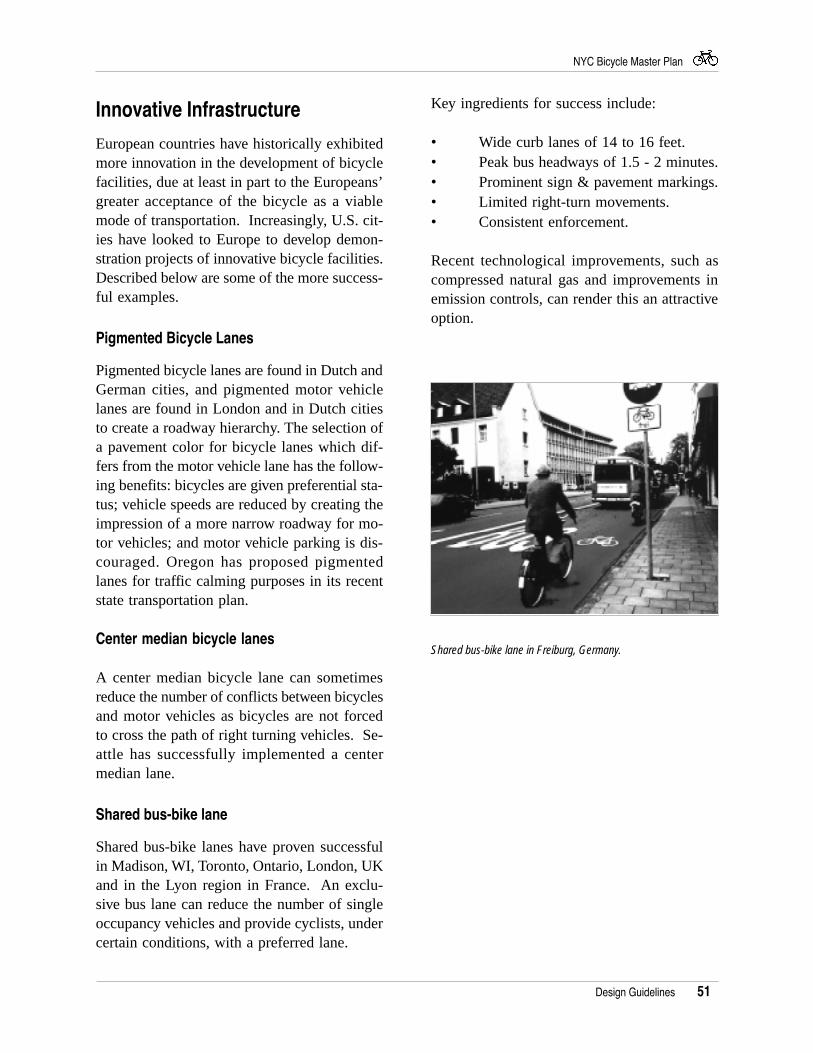
51
NYC Bicycle Master Plan
Innovative Infrastructure
European countries have historically exhibitedmore innovation in the development of bicyclefacilities, due at least in part to the Europeans’greater acceptance of the bicycle as a viablemode of transportation. Increasingly, U.S. cit-ies have looked to Europe to develop demon-stration projects of innovative bicycle facilities.Described below are some of the more success-ful examples.
Pigmented Bicycle Lanes
Pigmented bicycle lanes are found in Dutch andGerman cities, and pigmented motor vehiclelanes are found in London and in Dutch citiesto create a roadway hierarchy. The selection ofa pavement color for bicycle lanes which dif-fers from the motor vehicle lane has the follow-ing benefits: bicycles are given preferential sta-tus; vehicle speeds are reduced by creating theimpression of a more narrow roadway for mo-tor vehicles; and motor vehicle parking is dis-couraged. Oregon has proposed pigmentedlanes for traffic calming purposes in its recentstate transportation plan.
Center median bicycle lanes
A center median bicycle lane can sometimesreduce the number of conflicts between bicyclesand motor vehicles as bicycles are not forcedto cross the path of right turning vehicles. Se-attle has successfully implemented a centermedian lane.
Shared bus-bike lane
Shared bus-bike lanes have proven successfulin Madison, WI, Toronto, Ontario, London, UKand in the Lyon region in France. An exclu-sive bus lane can reduce the number of singleoccupancy vehicles and provide cyclists, undercertain conditions, with a preferred lane.
Key ingredients for success include:
• Wide curb lanes of 14 to 16 feet.• Peak bus headways of 1.5 - 2 minutes.• Prominent sign & pavement markings.• Limited right-turn movements.• Consistent enforcement.
Recent technological improvements, such ascompressed natural gas and improvements inemission controls, can render this an attractiveoption.
Shared bus-bike lane in Freiburg, Germany.
Design Guidelines
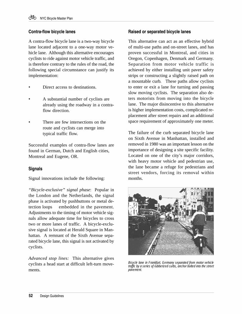
52
NYC Bicycle Master Plan
Raised or separated bicycle lanes
This alternative can act as an effective hybridof multi-use paths and on-street lanes, and hasproven successful in Montreal, and cities inOregon, Copenhagen, Denmark and Germany.Separation from motor vehicle traffic isachieved by either installing unit paver safetystrips or constructing a slightly raised path ona mountable curb. These paths allow cycliststo enter or exit a lane for turning and passingslow moving cyclists. The separation also de-ters motorists from moving into the bicyclelane. The major disincentive to this alternativeis higher implementation costs, complicated re-placement after street repairs and an additionalspace requirement of approximately one meter.
The failure of the curb separated bicycle laneon Sixth Avenue in Manhattan, installed andremoved in 1980 was an important lesson on theimportance of designing a site specific facility.Located on one of the city’s major corridors,with heavy motor vehicle and pedestrian use,the lane became a refuge for pedestrians andstreet vendors, forcing its removal withinmonths.
Contra-flow bicycle lanes
A contra-flow bicycle lane is a two-way bicyclelane located adjacent to a one-way motor ve-hicle lane. Although this alternative encouragescyclists to ride against motor vehicle traffic, andis therefore contrary to the rules of the road, thefollowing special circumstance can justify itsimplementation:
• Direct access to destinations.
• A substantial number of cyclists arealready using the roadway in a contra-flow direction.
• There are few intersections on theroute and cyclists can merge intotypical traffic flow.
Successful examples of contra-flow lanes arefound in German, Dutch and English cities,Montreal and Eugene, OR.
Signals
Signal innovations include the following:
“Bicycle-exclusive” signal phase: Popular inthe London and the Netherlands, the signalphase is activated by pushbuttons or metal de-tection loops embedded in the pavement.Adjustments to the timing of motor vehicle sig-nals allow adequate time for bicycles to crosstwo or more lanes of traffic. A bicycle-exclu-sive signal is located at Herald Square in Man-hattan. A remnant of the Sixth Avenue sepa-rated bicycle lane, this signal is not activated bycyclists.
Advanced stop lines: This alternative givescyclists a head start at difficult left-turn move-ments.
Bicycle lane in Frankfurt, Germany separated from motor vehicletraffic by a series of rubberized curbs, anchor bolted into the streetpavement.
Design Guidelines
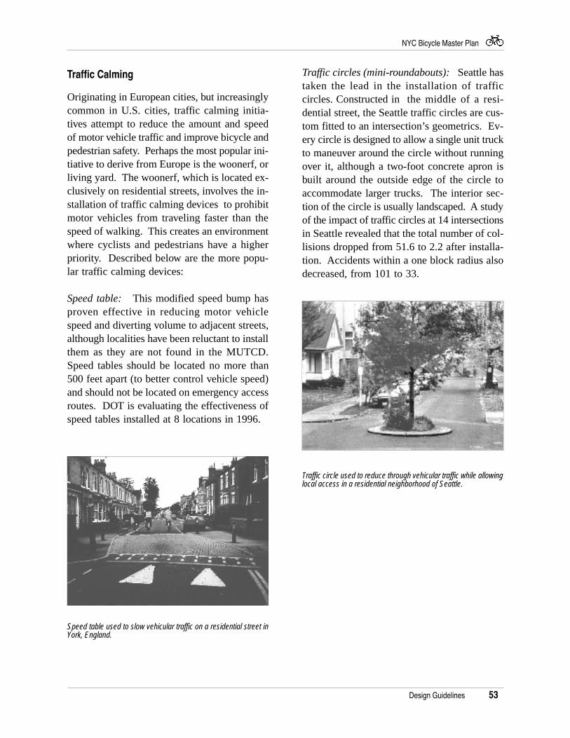
53
NYC Bicycle Master Plan
Traffic Calming
Originating in European cities, but increasinglycommon in U.S. cities, traffic calming initia-tives attempt to reduce the amount and speedof motor vehicle traffic and improve bicycle andpedestrian safety. Perhaps the most popular ini-tiative to derive from Europe is the woonerf, orliving yard. The woonerf, which is located ex-clusively on residential streets, involves the in-stallation of traffic calming devices to prohibitmotor vehicles from traveling faster than thespeed of walking. This creates an environmentwhere cyclists and pedestrians have a higherpriority. Described below are the more popu-lar traffic calming devices:
Speed table: This modified speed bump hasproven effective in reducing motor vehiclespeed and diverting volume to adjacent streets,although localities have been reluctant to installthem as they are not found in the MUTCD.Speed tables should be located no more than500 feet apart (to better control vehicle speed)and should not be located on emergency accessroutes. DOT is evaluating the effectiveness ofspeed tables installed at 8 locations in 1996.
Traffic circles (mini-roundabouts): Seattle hastaken the lead in the installation of trafficcircles. Constructed in the middle of a resi-dential street, the Seattle traffic circles are cus-tom fitted to an intersection’s geometrics. Ev-ery circle is designed to allow a single unit truckto maneuver around the circle without runningover it, although a two-foot concrete apron isbuilt around the outside edge of the circle toaccommodate larger trucks. The interior sec-tion of the circle is usually landscaped. A studyof the impact of traffic circles at 14 intersectionsin Seattle revealed that the total number of col-lisions dropped from 51.6 to 2.2 after installa-tion. Accidents within a one block radius alsodecreased, from 101 to 33.
Design Guidelines
Traffic circle used to reduce through vehicular traffic while allowinglocal access in a residential neighborhood of Seattle.
Speed table used to slow vehicular traffic on a residential street inYork, England.
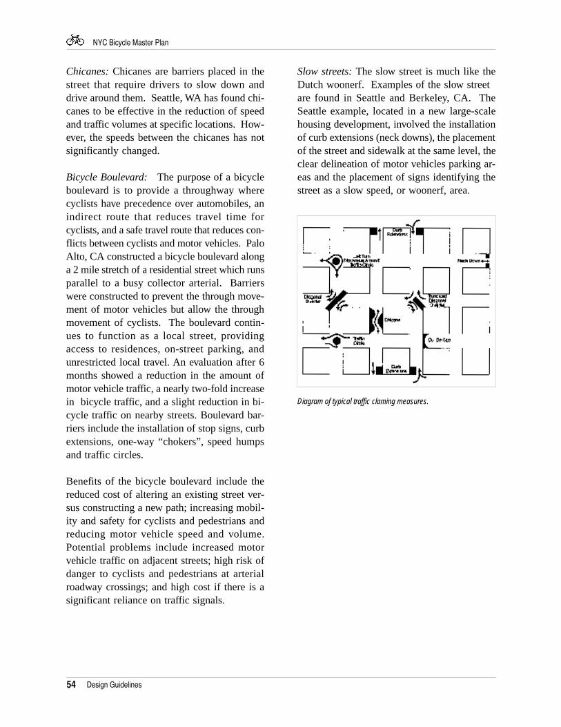
54
NYC Bicycle Master Plan
Design Guidelines
Chicanes: Chicanes are barriers placed in thestreet that require drivers to slow down anddrive around them. Seattle, WA has found chi-canes to be effective in the reduction of speedand traffic volumes at specific locations. How-ever, the speeds between the chicanes has notsignificantly changed.
Bicycle Boulevard: The purpose of a bicycleboulevard is to provide a throughway wherecyclists have precedence over automobiles, anindirect route that reduces travel time forcyclists, and a safe travel route that reduces con-flicts between cyclists and motor vehicles. PaloAlto, CA constructed a bicycle boulevard alonga 2 mile stretch of a residential street which runsparallel to a busy collector arterial. Barrierswere constructed to prevent the through move-ment of motor vehicles but allow the throughmovement of cyclists. The boulevard contin-ues to function as a local street, providingaccess to residences, on-street parking, andunrestricted local travel. An evaluation after 6months showed a reduction in the amount ofmotor vehicle traffic, a nearly two-fold increasein bicycle traffic, and a slight reduction in bi-cycle traffic on nearby streets. Boulevard bar-riers include the installation of stop signs, curbextensions, one-way “chokers”, speed humpsand traffic circles.
Benefits of the bicycle boulevard include thereduced cost of altering an existing street ver-sus constructing a new path; increasing mobil-ity and safety for cyclists and pedestrians andreducing motor vehicle speed and volume.Potential problems include increased motorvehicle traffic on adjacent streets; high risk ofdanger to cyclists and pedestrians at arterialroadway crossings; and high cost if there is asignificant reliance on traffic signals.
Diagram of typical traffic claming measures.
Slow streets: The slow street is much like theDutch woonerf. Examples of the slow streetare found in Seattle and Berkeley, CA. TheSeattle example, located in a new large-scalehousing development, involved the installationof curb extensions (neck downs), the placementof the street and sidewalk at the same level, theclear delineation of motor vehicles parking ar-eas and the placement of signs identifying thestreet as a slow speed, or woonerf, area.
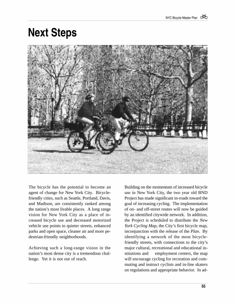
55
NYC Bicycle Master Plan
Next Steps
The bicycle has the potential to become anagent of change for New York City. Bicycle-friendly cities, such as Seattle, Portland, Davis,and Madison, are consistently ranked amongthe nation’s most livable places. A long rangevision for New York City as a place of in-creased bicycle use and decreased motorizedvehicle use points to quieter streets, enhancedparks and open space, cleaner air and more pe-destrian-friendly neighborhoods.
Achieving such a long-range vision in thenation’s most dense city is a tremendous chal-lenge. Yet it is not out of reach.
Building on the momentum of increased bicycleuse in New York City, the two year old BNDProject has made significant in-roads toward thegoal of increasing cycling. The implementationof on- and off-street routes will now be guidedby an identified citywide network. In addition,the Project is scheduled to distribute the NewYork Cycling Map, the City’s first bicycle map,inconjunction with the release of the Plan. Byidentifying a network of the most bicycle-friendly streets, with connections to the city’smajor cultural, recreational and educational in-stitutions and employment centers, the mapwill encourage cycling for recreation and com-muting and instruct cyclists and in-line skaterson regulations and appropriate behavior. In ad-
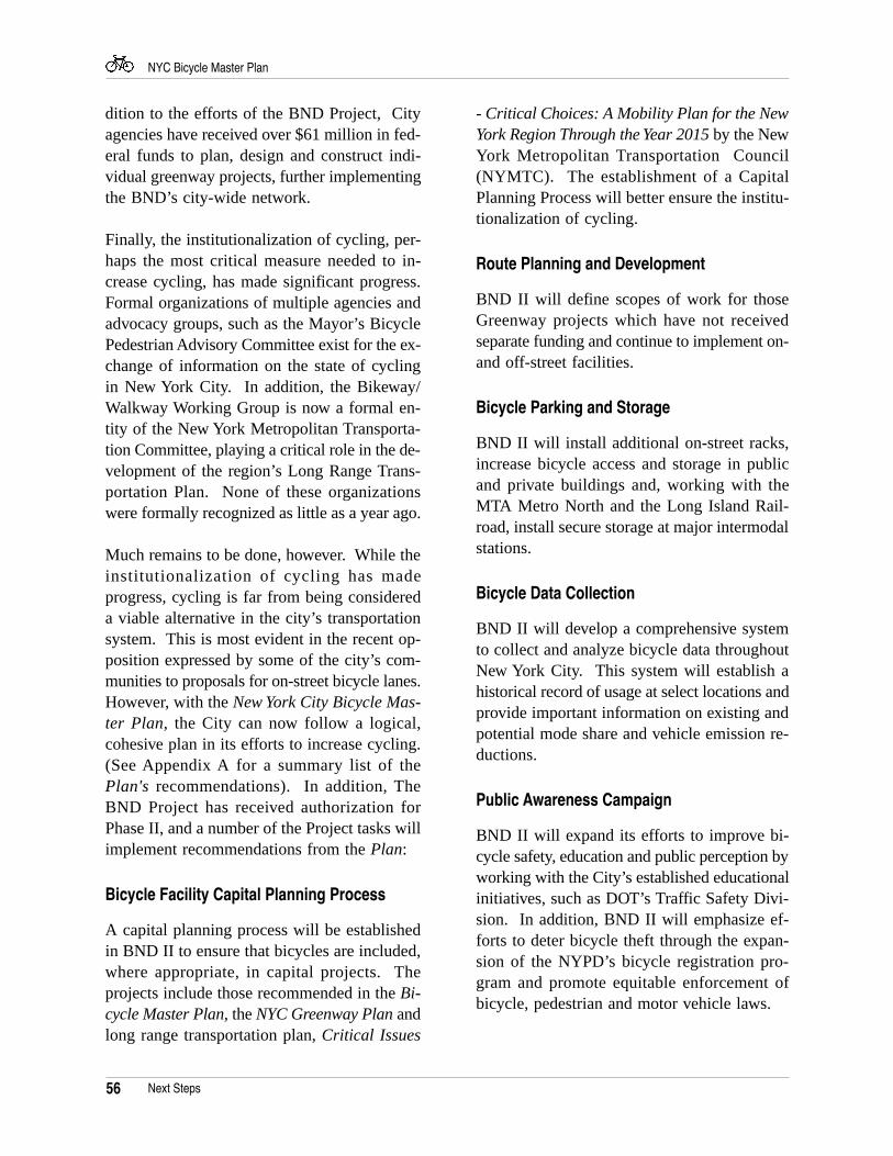
56
NYC Bicycle Master Plan
dition to the efforts of the BND Project, Cityagencies have received over $61 million in fed-eral funds to plan, design and construct indi-vidual greenway projects, further implementingthe BND’s city-wide network.
Finally, the institutionalization of cycling, per-haps the most critical measure needed to in-crease cycling, has made significant progress.Formal organizations of multiple agencies andadvocacy groups, such as the Mayor’s BicyclePedestrian Advisory Committee exist for the ex-change of information on the state of cyclingin New York City. In addition, the Bikeway/Walkway Working Group is now a formal en-tity of the New York Metropolitan Transporta-tion Committee, playing a critical role in the de-velopment of the region’s Long Range Trans-portation Plan. None of these organizationswere formally recognized as little as a year ago.
Much remains to be done, however. While theinstitutionalization of cycling has madeprogress, cycling is far from being considereda viable alternative in the city’s transportationsystem. This is most evident in the recent op-position expressed by some of the city’s com-munities to proposals for on-street bicycle lanes.However, with the New York City Bicycle Mas-ter Plan, the City can now follow a logical,cohesive plan in its efforts to increase cycling.(See Appendix A for a summary list of thePlan's recommendations). In addition, TheBND Project has received authorization forPhase II, and a number of the Project tasks willimplement recommendations from the Plan:
Bicycle Facility Capital Planning Process
A capital planning process will be establishedin BND II to ensure that bicycles are included,where appropriate, in capital projects. Theprojects include those recommended in the Bi-cycle Master Plan, the NYC Greenway Plan andlong range transportation plan, Critical Issues
- Critical Choices: A Mobility Plan for the NewYork Region Through the Year 2015 by the NewYork Metropolitan Transportation Council(NYMTC). The establishment of a CapitalPlanning Process will better ensure the institu-tionalization of cycling.
Route Planning and Development
BND II will define scopes of work for thoseGreenway projects which have not receivedseparate funding and continue to implement on-and off-street facilities.
Bicycle Parking and Storage
BND II will install additional on-street racks,increase bicycle access and storage in publicand private buildings and, working with theMTA Metro North and the Long Island Rail-road, install secure storage at major intermodalstations.
Bicycle Data Collection
BND II will develop a comprehensive systemto collect and analyze bicycle data throughoutNew York City. This system will establish ahistorical record of usage at select locations andprovide important information on existing andpotential mode share and vehicle emission re-ductions.
Public Awareness Campaign
BND II will expand its efforts to improve bi-cycle safety, education and public perception byworking with the City’s established educationalinitiatives, such as DOT’s Traffic Safety Divi-sion. In addition, BND II will emphasize ef-forts to deter bicycle theft through the expan-sion of the NYPD’s bicycle registration pro-gram and promote equitable enforcement ofbicycle, pedestrian and motor vehicle laws.
Next Steps
57
NYC Bicycle Master Plan
Listed below are the Plan's recommendationsto increase cycling in New York City. Theparticipation of many public agencies and privateorganizations is needed for the successfulimplementation of these recommendations.
Reconstructing New York City with Bicycles InMind
Much of the 900 mile network identified in thisPlan can be implemented through the routinereconstruction of the city's aging infrastructure.Therefore, City agencies should considerpermanent, dedicated bicycle/pedestrianfacilities in the planning, design andreconstruction of such major facilities as bridgesand highways.
On-street Facilities
Implement the city-wide network, starting withthe following on-street priority routes:
The Bronx: Grand Concourse; Crotona-ProspectAvenue; University Avenue.Brooklyn: Bergen and Dean; Bedford andFranklin Avenues; Sunset Park Connector.Manhattan: Linkage to East River Bridges;Hudson Street and Eighth Avenue; First andSecond Avenues.Queens: Access to Flushing-Meadows-CoronaPark; Flushing/Jamaica corridor; Woodhaven/Cross Bay corridor.Staten Island: East Shore Waterfront Route; St.George Ferry Terminal; Richmond Terrace
Off-street Facilities
Implement the New York City Greenway system,starting with the following priority routes:
The Bronx: Mosholu-Pelham Greenwayextension; Putnam Railroad Trail; HutchinsonRiver Greenway.Brooklyn: Shore Parkway Bicycle Path (BayParkway to Knapp Street); Rockaway GatewayGreenway; Brooklyn Waterfront Trail.Manhattan: East River Bikeway and Esplanade;Harlem River Esplanade; Hudson River Trail.
Queens: Brooklyn/Queens Greenway; CrossIsland-Southern Greenway; Shore ParkwayBicycle Path (JFK extension).Staten Island: SI Rail with Trail; SI CulturalTrail; SI Greenbelt Trail.
Bridge Access
Brooklyn Bridge: Investigate enhanced accessand safety to the Brooklyn and Manhattantermini of the promenade.
Queensboro Bridge: Implement therecommendations of the DCP QueensboroBridge Bicycle/Pedestrian Access Study(scheduled for 1997).
Triborough Bridge: As a short termimprovement, signs on Randall's Island directingcyclists to the existing bridge paths should beinstalled. Long term improvements includeimplementation of the recommendations of theEDC Randall's Island Access Plan, includingmodifying the existing stairs and ramps on theManhattan and Queens spans of the TriboroughBridge; constructing new pedestrian bridgesfrom all 3 boroughs; and establishing ferryservice. The TBTA should also reassess theirpolicy prohibiting bicycle riding on the Bridge.
Harlem River Bridges: Implement modestaccess improvements, such as curb cuts anddirectional signs.
Henry Hudson Bridge: The MTA shouldreconsider creating access to the upper path, asrecommended in the 1992 DCP study.
High Bridge: DPR should reassess the closingof this safe and scenic bicycle and pedestrianbridge.
Verrazano-Narrows Bridge: The TBTA shouldimplement the recommendations of the DCPVerrazano-Narrows Bridge Bicycle/PedestrianAccess Study (scheduled for completion in1997).
Appendix A: New York City Bicycle Master PlanRecommendations
58
NYC Bicycle Master Plan
Bayonne Bridge: PANYNJ should improveaccess to the existing path by installing signsand replacing the stairs with a ramp on the NewJersey side.
Goethals Bridge: A long term proposal is toconstruct a new bridge with a bicycle/pedestrianlane. As a short term improvement, the PANYNJshould investigate improving and reopening theexisting substandard path by relocating existingpath impediments, such as electrical boxes, pipesand signposts.
Queens Boulevard (Sunnyside rail yards) andRoosevelt Avenue Bridges (Flushing-Meadows-Corona Park): Investigate improvements forbicycle access, such as shared bicycle/pedestrianuse of the sidewalks.
Mass Transit
Subways: The MTA should guide cyclists byplacing bicycle stencils on the front and rear cars.
Rail: The MTA should standardize thepermitting process for the LIRR andMetroNorth; permit cyclists on trains whichtravel against the dominant flow during peakhours; and provide bicycle access and storageas the trains are upgraded.
Ferries: Access on the Staten Island Ferry couldbe improved through the installation of bicyclestorage at the terminals and on-board the ferries.Bicycle access on privately-operated ferriesshould be required by the City.
Buses: Install bike-on-bus racks in appropriatelocations, such as those areas of the city withlimited subway access.
Bicycle Parking
Continue to implement on-street bicycle parkingthroughout the City under DOT's City RacksProgram.
Investigate amending City regulations toimprove opportunities for secure bicycle storagein public and private buildings.
Install bicycle lockers at intermodal stationsthroughout the city.
Encouragement
Distribute the New York Cycling Map, and updateas needed.
Expand the use of bicycles in issuing parkingsummonses if the DOT pilot program provessuccessful.
The NYPD should expand the highly successfulCommunity Policing Bicycle Patrol Program.
The All-Agency Bicycle Policy should beformally adopted by the relevant agencies as astep toward institutionalizing cycling.
Education
Public schools must instruct elementary andsecondary school students in safety education,including highway, traffic and bicycle safety, asrequired by NYS Education Law. SuccessfulDOT projects, such as the YES (Youth Educationfor Safety) and the Safety City Program shouldbe expanded.
The DOT-NYPD Share the Road Safely publicservice effort should be expanded from radioannouncements to include bus and subwayposters.
Enforcement
The NYPD should increase awareness of thebicycle registration program in an attempt todeter bicycle theft.
All modes - motorists, pedestrians and cyclists -must respect the rightful place of others in thestreet. Such traffic violations as double parkedmotor vehicles in bicycle lanes must be enforced.
Engineering
The Plan's Bicycle Facility Design Guidelinesshould be followed in implementing the city-wide bicycle network. Agencies shouldimplement demonstration projects of innovativebicycle facilities, such as shared bike/bus lanes;pigmented lanes; bicycle boulevards; speedtables and traffic circles.
59
NYC Bicycle Master Plan
Appendix B: Technical Advisory Committee
Mayor's Office of TransportationPeter Fleisher
New York City Economic Develop-ment CorporationJeanette Rausch
New York City Department of CityPlanningJudy BernardRay CurranNestor DanylukAR KleinmanMarilyn PfeiferVictor L'EPlattenierShiela MetcalfPeter PfefferJeffrey SugarmanWilbur Woods
New York City Department of Trans-portationAnthony FasuloPaul Michael KazasJack LarsonDan MandoTom Whitehouse
New York City Department of Parksand RecreationMicheal GotkinDoug NashThomas PauloJames RossiPaul SawyerJosephine ScaliaSamantha StoneGretchen TillJackson WandresSteve WhitehouseKevin Wolfe
New York City Department of Envi-ronmental ProtectionGordon HellmanTom Velleca
New York City Transit AuthorityLarry GouldRichard Picone
Office of Bronx Borough PresidentDonald Burns
Rick PanteleoniSamuel Goodman
Office of Brooklyn Borough PresidentChirs BoydGeorge Synefakis
Office of Manhattan Borough Presi-dentJudy McClainSarah StanleyJoan Tally
Office of Queens Borough PresidentDeanna SamuelsJohn SteinmeyerAneash Tewari
Office of Staten Island Borough Presi-dentTom Jost
Port Authority of New York & NewJerseyIvan Rios
Metropolitan Transportation Author-ityDavid Anderson
New York State Department of Trans-portationPeter DunleavyRobert LaravieJeff OlsenArkadiy ShermanMathew StanleyLanny Wexler
New York Metropolitan Transporta-tion CouncilHoward Mann
New York Transportation Coordinat-ing CommitteeChris Hardej
Alley Pond Environmental CenterDan Donohue
Bicycle Transportation ActionRoger Herz
Hudson River Park ConservancyAbby Jo Sigal
5 Boro Bike ClubPaul Sullivan
Friends of Van Cortandt ParkRamsey Adams
League of American BicyclistsAnne Sullivan
Neighborhood Open Space CoalitionDave LutzAnne McClellan
New York Bicycle CoalitionMark SchafferIrene Van Slyke
New York Road Skaters AssociationHeather Williams
Staten Island Bicycling AssociationJoe Kubera
Tri-State Transportation CampaignRick MullerJon Orcutt
Transportation AlternativesJesse KalbJohn Kaehney
Trust for Public LandAndy Stone
Individual ParticipantsHarold AlexisTom AngottiBarbara BrookhartKatherine CarseMark ConsaniSteve FaustMark FogginRichard GansShawn HillZee FrankTed KatanskasCharles Komanoff
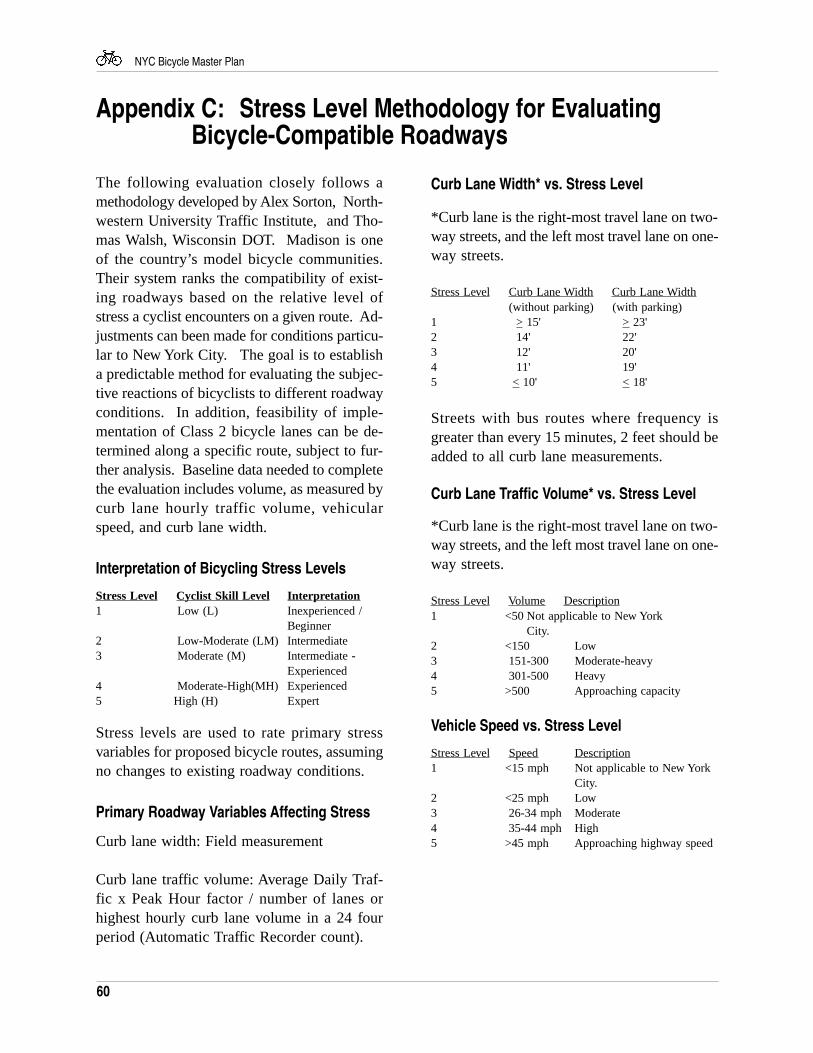
60
NYC Bicycle Master Plan
Appendix C: Stress Level Methodology for EvaluatingBicycle-Compatible Roadways
The following evaluation closely follows amethodology developed by Alex Sorton, North-western University Traffic Institute, and Tho-mas Walsh, Wisconsin DOT. Madison is oneof the country’s model bicycle communities.Their system ranks the compatibility of exist-ing roadways based on the relative level ofstress a cyclist encounters on a given route. Ad-justments can been made for conditions particu-lar to New York City. The goal is to establisha predictable method for evaluating the subjec-tive reactions of bicyclists to different roadwayconditions. In addition, feasibility of imple-mentation of Class 2 bicycle lanes can be de-termined along a specific route, subject to fur-ther analysis. Baseline data needed to completethe evaluation includes volume, as measured bycurb lane hourly traffic volume, vehicularspeed, and curb lane width.
Interpretation of Bicycling Stress Levels
Stress Level Cyclist Skill Level Inter pretation1 Low (L) Inexperienced /
Beginner2 Low-Moderate (LM) Intermediate3 Moderate (M) Intermediate -
Experienced4 Moderate-High(MH) Experienced5 High (H) Expert
Stress levels are used to rate primary stressvariables for proposed bicycle routes, assumingno changes to existing roadway conditions.
Primary Roadway Variables Affecting Stress
Curb lane width: Field measurement
Curb lane traffic volume: Average Daily Traf-fic x Peak Hour factor / number of lanes orhighest hourly curb lane volume in a 24 fourperiod (Automatic Traffic Recorder count).
Curb Lane Width* vs. Stress Level
*Curb lane is the right-most travel lane on two-way streets, and the left most travel lane on one-way streets.
Stress Level Curb Lane Width Curb Lane Width (without parking) (with parking)
1 > 15' > 23'2 14' 22'3 12' 20'4 11' 19'5 < 10' < 18'
Streets with bus routes where frequency isgreater than every 15 minutes, 2 feet should beadded to all curb lane measurements.
Curb Lane Traffic Volume* vs. Stress Level
*Curb lane is the right-most travel lane on two-way streets, and the left most travel lane on one-way streets.
Stress Level Volume Description1 <50 Not applicable to New York
City.2 <150 Low3 151-300 Moderate-heavy4 301-500 Heavy5 >500 Approaching capacity
Vehicle Speed vs. Stress Level
Stress Level Speed Description1 <15 mph Not applicable to New York
City.2 <25 mph Low3 26-34 mph Moderate4 35-44 mph High5 >45 mph Approaching highway speed
61
NYC Bicycle Master Plan
Appendix D: Implementation Methodology forOn-street Bicycle Lanes
Collect Data
• Number and width of travel lanes• Turning movements• Signal timing• Vehicle classification• Peak period traffic volumes including
bicycles
Analyze Existing Level of Service (LOS)
Based on the 1985 Highway Capacity Manual(HCM), the LOS incorporates the collected dataand determines the average delay for each ve-hicle using the critical intersection. Short de-lays result in a good LOS, whereas long delaysresult in a poor LOS. The LOS criteria is de-scribed below.
LOS Stop delay/Vehicles (second)A < = 5.0B 5.1 - 15.0C 15.1 - 25.0D 25.1 - 40.0E 40.1 - 60.0
F > = 60.0
Analyze Future LOS Analysis with BicycleFacility
Following the determination of the existingLOS, an additional LOS analysis is performedwith the same number of vehicles, but with aroadway reconfigured to accommodate an on-street lane.
Community Outreach
Once DOT has determined the suitability of anon-street lane based on the LOS analysis, pre-sentations are made to the affected communityboards and an implementation schedule is pro-posed. Fliers announcing the project are also
distributed throughout the community.
Prepare Technical Drawings
Technical drawing's for signs & pavementmarkings are prepared, approval by DOT engi-neers required.
Implement Bicycle Facility
Signs and pavement markings are installed.
Bicycle Counts
Following implementation, the number of cy-clists are counted to determine the impact of theon-street lane.
62
NYC Bicycle Master Plan
The All Agency Bicycle Policy is proposed toguide the actions of city, state and regionalagencies as they relate to the goal of encour-aging bicycling as a mode of transportation anda form of recreation.
City Agencies
Board of EducationDepartment of TransportationDepartment of City PlanningEconomic Development CorporationDepartment of Environmental ProtectionMayor’s Office of TransportationDepartment of Parks and RecreationNew York City Police Department
Elected Officials
Mayor office of TransportationOffice of The Bronx Borough PresidentOffice of the Brooklyn Borough PresidentOffice of the Manhattan Borough PresidentOffice of the Queens Borough PresidentOffice of the Staten Island Borough President
Other Government Agencies
Metropolitan Transportation AuthorityNational Park Service, Gateway National Recreation AreaNew Jersey TransitNew York Ferry InitiativeNew York Metropolitan Transportation CouncilNew York State Department of EducationNew York State Department of Environmental ConservationNew York State Department of Motor VehiclesNew York State Department of TransportationNew York State Office of Parks, Recreation and Historic PreservationPort Authority of New York and New JerseyUrban Development Corporation
Appendix E: All Agency Bicycle Policy
Nonprofit Advocacy Groups
American Youth HostelsAppalachian Mountain ClubBicycle Transportation ActionCentral Park Cycling & Sports ClubCentury Road ClubDifferent Spokes5 Boro Bike ClubKissena Cycling ClubL&M ToursMetropolitan Greenways CouncilNeighborhood Open Space Coalition/Friends ofGatewayNew York Cycle ClubNew York - New Jersey Trails ConferenceStaten Island Bicycling AssociationTransportation Alternatives
Mission Statement
The agencies whose activities affect bicyclingin New York City are committed to supportingand promoting bicycling as a mode of transpor-tation and form of recreation. This mission rec-ognizes that increased bicycling would meetmany policy goals of New York City and pro-vide benefits to its residents and workers. Thesebenefits include:
• Improved air quality• Improved quality of life• Enhanced mobility to locations not now
well served by public transportation• Enhanced mobility for population
groups not well served by cars orpublic transportation
• Helping New York meet federal CleanAir Act mandates
• Increased transit use• Increased pedestrian access• Increased tourism• Improved personal health
63
NYC Bicycle Master Plan
• Implement the proposed 350-milegreenway system as part of the ClassI bikeway network in New York City.
• Provide bicycle parking and supportfacilities in public and private spacesthroughout the city.
The agencies should support bicycling not justin their functions related to planning and de-sign, but in their maintenance and constructionfunctions as well. They should make all pos-sible efforts to secure federal transportationfunding for the installation of bicycle facilities.In addition, New York City development poli-cies should encourage private commercial prop-erty owners to install facilities for bicycling.
2. Promote awareness
A lack of awareness of the feasibility of bicy-cling and of the needs of bicyclists are two ofthe greatest obstacles to increased bicycle use.The riding and non-riding publics must be in-formed of facilities being put in place to en-courage bicycling. The benefits to be gainedfrom bicycling must also be highlighted. In-creasing awareness of bicycling should encour-age more of the non-riding public to use bi-cycles.
Efforts to increase awareness of bicyclingshould also be directed toward agency staffsand other public officials. Decades of promot-ing the automobile as the favored mode oftravel have embedded institutional arrange-ments which give greater priority to automo-biles than to bicycles. In recent years, aware-ness of bicycling has lagged behind the increas-ing use of bicycles in New York City and theincreasing importance of this mode to the cityin meeting its broader goals. The agenciesshould reverse this situation by treating bicy-cling as any other legitimate mode of transpor-tation and by attempting to eliminate in their
This mission also recognizes that New YorkCity does not now offer an environment whichsatisfactorily supports bicycling, and that pub-lic policies and actions are needed to providebicycling support commensurate with that pro-vided other transportation modes.
Goals
This bicycle policy sets out four major goals tobe pursued by the agencies as a framework foraction. They can be described briefly as:
• Improve facilities• Promote awareness• Integrate with transit modes• Improve safety
The following sections describe these goals,reasons for achieving them, any specific objec-tives which should be met, and actions whichagencies may take to achieve the goals.
1. Improve facilities
Improving bicycle facilities means more thanputting in place more miles of bikeways. It in-volves providing a safe, on-street bicycling en-vironment and installing storage spaces andother infrastructure supporting bicycling. Im-proving facilities should help allow New YorkCity residents and workers to bicycle safely andconveniently to destinations between five andten miles distant for work, school, shopping andrecreation. Providing such an environmentwould do much to attract more people to usebicycles more often.
Objectives which the agencies should adopt asmilestones in meeting this goal include:
• Implement (officially designate, sign andstripe) and maintain a network of on-street bike lanes, (potentially reaching500 miles in length) making bicycling aviable option for more New Yorkers.
Appendix E
64
NYC Bicycle Master Plan
actions, documents and organizational struc-tures any implied hierarchy among transporta-tion modes.
Some specific actions which the agencies couldtake include:
• Develop bicycle maps for each borough.
• Promote bicycle commuting throughprivate employers participating in theEmployee Commute Option (ECO)Program.
• Develop and implement a publicawareness campaign via media on themerits of bicycling.
• Maintain communication with bicycling and advocacy communities.
• Take actions with education departments.
3. Integrate with transit modes
The agencies should provide for the convenientuse of bicycles to and on transit networks, in-cluding ferries, buses and rail transit. The in-tegration of bicycling with other modes will en-courage bicycling as well as increase transitridership.
Some specific actions which the agencies couldtake include the following:
• Identify potential high-volumeintermodal transfer points with the subway, bus, rail and ferry systems.
• Provide bicycle access on transit throughinstalling bike racks on buses, constructing bicycle storage at transitstations, allowing bicycles on railroads,and other programs.
• Encourage use of these facilities with
promotional campaigns.
4. Improve safety
The fear of injury while bicycling is another ofthe major obstacles to increasing bicycle use.Contributing to the riding and non-riding pub-lics’ confidence in the safety of this mode couldhelp increase bicycle use.
An objective which the agencies should adoptas milestone in meeting this goal is:
• Reduce bicycle fatality and injury ratesper mile traveled.
Actions which the agencies should take to in-crease bicycling safety include:
• Educate traffic enforcement officials,bicyclists and the non-riding publicabout the rules of the road.
• Remove/improve roadway hazardssuch as parallel-bar sewage grates.
• Provide training for bicyclists.
• Educate the non-cycling public aboutthe rights of bicyclists, and expand enforcement of bicycling and drivingrules.
• Expand bicycle patrols on streets andin parks.
Appendix E
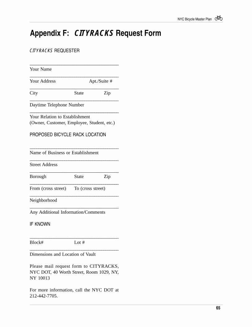
65
NYC Bicycle Master Plan
Appendix F: CITYRACKS Request Form
CITYRACKS REQUESTER
__________________________________________Your Name__________________________________________Your Address Apt./Suite #________________________________________City State Zip_______________________________________Daytime Telephone Number________________________________________Your Relation to Establishment(Owner, Customer, Employee, Student, etc.)
PROPOSED BICYCLE RACK LOCATION
________________________________________Name of Business or Establishment_________________________________________Street Address_________________________________________Borough State Zip_________________________________________From (cross street) To (cross street)________________________________________Neighborhood_________________________________________Any Additional Information/Comments
IF KNOWN
________________________________________Block# Lot #_________________________________________Dimensions and Location of Vault
Please mail request form to CITYRACKS,NYC DOT, 40 Worth Street, Room 1029, NY,NY 10013
For more information, call the NYC DOT at212-442-7705.
66
NYC Bicycle Master Plan
Appendix G: In-line skating legislation
In January 1996 the State of New York officiallyrecognized in-line skates as a vehicle with thesame rights and responsibilities as other road-way users. The following text is a copy of thememorandum of support, submitted by the bill'ssponsors, which gives a concise description ofthe amendments to the vehicle and traffic law.A similar bill to amend the administrative traf-fic code of New York City has been submittedto the City Council. Sponsored New York CityCouncil Members Dear, Eristoff and Leffler, thebill is presently in committee. At the time ofthis publication, a hearing has not been sched-uled.
Sponsors
Assemblyman Stephen B. KaufmanSenator Guy Velella
Title of Bill
An ACT to amend the general business law, thepublic health law, and the vehicle and trafficlaw, in relation to safety requirements in themanufacture, sale and use of in-line skates.
Purpose or General Idea of Bill
This bill would regulate the manufacture, saleand use of in-line skates for the purpose of pre-venting serious injuries from their use.
Summary of Specific Provisions
Section 391-I of the general business law is re-designated section 391-1, and a new section391-m is added to define terms “protectivegear”, “in-line skates”, “stopping device”, and“warning label”. Section 391-I further providesthat after January 1, 1996 no in-line skates shallbe sold in this state unless they are manufac-tured and assembled with a stopping device and
a warning label, and protective gear is sold onthe same premises.
Whenever there is a violation of this section, theAttorney General may bring an application forinjunction in the name of the people and thecourt may impose a civil penalty of not morethan $500.
Subdivision 15 of section 206 of the publichealth law is amended to authorize the commis-sioner to establish a statewide in-line skate hel-met public education and awareness programand a statewide in-line skate helmet distributionprogram. The purpose of these programs is toprovide a plan for city, county, town, and vil-lage efforts to reduce in-line skate related inju-ries and fatalities and to distribute helmets topeople who can demonstrate economic hardshipthat precludes them from purchasing one.
The vehicle and traffic law is amended by add-ing two new sections 140-a and 140-b to definein-line skates and roller skates. The article head-ing of article 34 of Title VII of the vehicle &traffic law is amended as follows:
Operation of Bicycles and Play [Vehicles]
Subdivision (b) of section 1230 of the vehicleand traffic law is amended to make applicableto in-line skates the same regulations that areapplicable to bicycles whenever the bicycle [orin-line skate] is operated upon any highway, pri-vate road open to the public, or path set asidefor the exclusive use of bicycles or in-lineskates.
Section 1231 of the vehicle and traffic and traf-fic law is amended to make traffic laws appli-cable to persons gliding on in-line skates as wellas riding bicycles and skates that every person
67
NYC Bicycle Master Plan
gliding on in-line skates upon a roadway shallbe granted all of the rights and shall be subjectto all of the duties applicable to the driver of avehicle.
Subdivision 1 of section 1233 of the vehicle andtraffic law is amended to prohibit persons ridingupon in-line skates from attaching the same orhimself to any vehicle being operated upon aroadway.
Section 1234 of the vehicle and traffic law isamended to state in-line skates shall be driveneither on a usable bicycle or in-line skates lane,or near the right-hand curb or edge of the road-way or upon a usable right-hand shoulder so asto prevent undue interference with the flow oftraffic. This section also prohibits persons glid-ing on in-line skates upon a roadway fromriding more than two abreast. It continues fur-ther to require persons gliding on in-line skatesto come to full stop when entering the roadwayfrom a private road, driveway, alley or a curb.
Section 1235 of the vehicle and traffic law isamended to read: No person gliding on in-lineskates shall carry any package, bundle, or ar-ticle which obstructs his or her vision in anydirection. Section 1238 of the vehicle traffic lawis amended to add a new subdivision 5-a whichrequires all persons less than fourteen years ofage to wear a helmet meeting the standards ofthe American National Standards Institute whileskating with in-line skates. Violators of the pro-visions of subdivision 5 or 5-a will be fined no more than fifty dollars.
Paragraph (c) of subdivision 6 of section 1238of the vehicle and traffic law is amended to al-low the court to waive any fine for which a per-son who violates the provisions of subdivisionfive of this section would be liable if the courtfinds that due to reasons of economic hardshipsuch person was unable to purchase a helmetor obtain a helmet from an in-line skate and bi-
cycle helmet distribution program. Subdivision8 of section 1238 of the vehicle and traffic lawis amended to authorize a police officer to is-sue a summons for a violation of subdivisions5, 5-a, and 6 inapplicable to any county, city,town or village that has enacted a local law orordinance prior to the effective date of this actthat prohibits a person who is less than fourteenyears of age from skating with in-line skateswithout wearing helmet. A new subdivision 10is added to state that no person shall wear orglide upon in-line skates during the period fromone-half hour after sunset unless such person isalso wearing an outer jacket or clothing of lami-nated or reflective material and of a bright color.
Effect of Current Amendments
Reference to gliding is expanded to includeskating or gliding. Provisions regarding skat-ing at night are clarified.
Justification
Over the years, the increasingly popular sportof in-line skating has caused countless seriousinjuries to skaters. The results of these inju-ries range from fractures to hospitalization toirreversible head injuries. Many injuries oc-curred at sites where protective gear was avail-able, yet not worn. Currently, there is no re-quirements under the law for in-line skaters towear any protective gear. This bill would re-quire in-line skaters under age 14 to wear hel-mets and require that all protective gear be soldon the same premises as the in-line skate equip-ment. This bill would also prohibit the sale ofin-line skates that are not constructed with stop-pers, decreasing the number and severity ofskating injuries.
Appendix G
68
NYC Bicycle Master Plan
Appendix H: Pedestrian Safety Legislation
On January 12th 1996, the City of New Yorkamended administrative traffic code with thegoal of enhancing the safety of pedestrians.The following text is a copy of amended law.
Introduced by Council Members
Dear, Weiner, Freed, Leffler, Eisland, Eristoffand McCaffrey; also Council MembersMarshall, O’Donovan and Fusco — read andreferred to Committee on Transportation.Amended December 12, 1995. Ordered re-printed and laid over.
Local Law
To amend administrative code of the city ofNew York, in relation to enhancing the rightsand safety of pedestrians.
Be it enacted by the Council as follows
Section one: Chapter 1 of title 19 of the ad-ministrative code of the city of New York isamended by adding thereto a new subchapterthree to read as follows:
Subchapter three, pedestrian right and safety
§19-176 Bicycle operation on sidewalkprohibited.
§19-177 Speed Limits; posting of signs.
§19-178 Truck Weight and LengthLimitations.
§19-179 Traffic calming study.
§19-176 Bicycle operation on sidewalkprohibited.
a. For purposes of this section:(1) The term “bicycle” shall mean a two orthree wheeled device upon which a person orpersons may ride, propelled by human powerthrough a belt, a chain or gears, with suchwheels in a tandem or tricycle, except that itshall not include such a device having solid tiresand intended for use only on a sidewalk by achild.
(2) The term “sidewalk” shall mean thatportion of the street, whether paved or unpaved,between the curb lines or the lateral lines of aroadway and the adjacent property lines, in-tended for the use of pedestrians. Where it isnot clear which section is intended for the useof pedestrians the sidewalk will be deemed tobe that portion of the street between the build-ing line and the curb.
(3) The term “child” shall mean a personless than fourteen years of age.
b. No person shall ride a bicycle upon anysidewalk unless permitted by an official sign.
c. A person who violates subdivision b ofthis section under circumstances which createa substantial risk of physical injury to anotherperson shall be guilty of a misdemeanor, pun-ishable by a fine of not more than one hundreddollars and imprisonment for not more thantwenty days or both such fine and imprison-ment. Such person shall also be liable for acivil penalty of not more than one hundreddollars which may be recovered in a proceed-ing before the environmental control board.Where a summons or notice of violations isissued for a violation of this subdivision, a des-
69
NYC Bicycle Master Plan
ignated employee of the department, the de-partment of sanitation or the department ofparks and recreation or a police officer mayseize and impound the bicycle. In any proceed-ing under this subdivision it shall be a defensethat the defendant or respondent was less thanfourteen years old at the time of the commis-sion of the violation.
d. A bicycle impounded pursuant to thissection shall be released to the owner or otherperson lawfully entitled to possession uponpayment of the costs of removal and storage asset forth in the rules of the police depart-ment and proof of payment of any fine or civilpenalty for the violation or, if a proceeding forthe violation is pending in a court or before theenvironmental control board, upon the postingof a bond or other form of security acceptableto the police department in an amount whichwill assure the payment of such costs and anyfine or civil penalty which may be imposed forthe violation. If the court or the environmentalcontrol board finds in favor of the defendant orrespondent, the owner shall be entitled forth-with to possession of the bicycle withoutcharge or to the extent that any amount hasbeen previously paid for release of the bicycle,such amount shall be refunded. The police de-partment shall establish by rule the time withinwhich bicycles which are not redeemed may bedeemed abandoned and the procedures for dis-posal.
e. The owner of a bicycle shall be giventhe opportunity for a post seizure hearingwithin five business days before the environ-mental control board regarding the impound-ment. The environmental control board shallrender a determination within three businessdays after the conclusion of the hearing. Wherethe board finds that there was no basis for theimpoundment, the owner shall be entitled forth-with to possession of the bicycle withoutcharge or to the extent that any amount hasbeen previously paid for release of the bicycle,
such amount shall be refunded.
f. Upon the impoundment of a bicycle, therider shall be given written notice of the proce-dure for redemption of the bicycle is not theowner there of notice provided to the rider shallbe deemed to be notice to the notice to theowner. Where the defendant or respondent isless than eighteen years old such notice shallalso be mailed to the parent, guardian or whererelevant, employer of the respondent, if thename and address of such person is reasonablyascertainable.
g. The provisions of this section may beenforced by the department, the department ofsanitation, the department of parks and recre-ation and the police department.
§19-177 Speed Limits.
a. The official speed limit for a vehicle inthe city of New York shall be thirty miles perhour except where an official sign indicates thata different speed limits is in effect.
b. No person shall drive a vehicle on anystreet in excess of the speed limit in effect forthat street.
c. The commissioner shall post a sign ateach exit within the city of New York of eachbridge and tunnel having only one terminus inthe city of New York that states the speed limitwithin the city.
§19-178 Truck Weight and Length Limitations.The commissioner shall post a sign at each exitwithin the city of city of the New York of eachbridge and tunnel having only one terminus inthe city of New York that states the limits oftruck weight and truck length within the city.
§19-179 Traffic calming study.
Appendix H
70
NYC Bicycle Master Plan
a. The commissioner shall conduct a studyon the feasibility of installing traffic calmingmeasures, including but not limited to, raisedcrosswalks, traffic circles and protected pedes-trian phases in appropriate locations in the city.Within one year of the effective date of thislocal law, the commissioner shall submit a re-port of the department’s findings to the coun-cil.
b. For purposes of this section, the fol-lowing terms shall have the followingmeaning:
(1) “traffic calming” shall mean any engi-neering measure which slows vehicular trafficand accommodate other street users suchas pedestrians, bicyclists or children at play.
(2) “raised crosswalks” shall mean cross-walks which are raised several inches abovestreet level in order to slow vehicular traffic.
(3) “traffic circle” shall mean landscapedislands in the middle of intersections which canreplace traffic control indications or stop signson non-arterial streets.
(4) “protected pedestrian phases” shallmean traffic control indications that are adjustedto provide that all conflicting vehicular move-ments are stopped in order to accommodatepedestrian movement.
§2. This local law shall take effect sixtydays after its enactment into law.
Appendix H
71
NYC Bicycle Master Plan
CreditsDepartment of City Planning
Joseph B. Rose, DirectorAndrew S. Lynn, Executive DirectorWilliam Bernstein, First Deputy Executive Di-rector
Strategic Planning
Sandy Hornick, Deputy Executive DirectorMichael Levine, Director of Studies
Planning Coordination
Barbara Weisberg, Assistant Executive Director
Transportation
Floyd Lapp, DirectorRegina Myer, former Deputy DirectorJacob Schmidt, Deputy DirectorGary Dearborn, former Project ManagerJackson Wandres, Project ManagerJeff Mulligan, City Planner IIAntonia Cornaro, City PlannerKatie Chin, Intern
Waterfront and Open Space Planning
Wilbur Woods, DirectorSheila Metcalf
Graphics
Michael Pilgrim, DirectorMichael GreenCarol Segarra
Bronx Office
John Phillips, DirectorRay Curran, former Associate City Planner
Brooklyn Office
Mitchell Korbey, DirectorRichard Jacobs, Deputy DirectorWinston Von Engel
Manhattan Office
Richard Barth, DirectorPeter Pfeffer
Queens Office
Dennis Ferris, DirectorVictor L'Eplattenier, Deputy Director
Staten Island
Douglas Brooks, DirectorFrank Chaney, former Deputy Director
72
NYC Bicycle Master Plan
Department of Transportation
Christopher R. Lynn, CommissionerJoan McDonald, Chief Transportation OfficerKathie Keegan, First Assistant CommissionerHarley Brooke-Hitching, Assistant Commis-sioner
Peter A. Pennica, Chief, Plans and SurveysTom Hoctor, PhotographerJohn Benfatti, Director, Bicycle ProgramSally Hood, CITYRACKS Program DirectorJohn Griffin, Bicycle ProgramSarah Kahn, Bicycle ProgramStefan Armington, Bicycle ProgramMarni Ratzel, Bicycle ProgramPhilip Blake, Graduate InternJie Liu, Intern, School for the Physical City
73
NYC Bicycle Master Plan
AcknowledgementsThe Departments of City Planning and Trans-portation are grateful to staff from the follow-ing agencies and organizations for their valu-able contributions to the New York City BicycleMaster Plan.
Mayor's Bicycle Pedestrian Advisory Commit-teeMayor’s Office of TransportationMetropolitan Transportation AuthorityCity of New York/Parks and RecreationCity of New York/Economic Development Cor-porationCity of New York/Environmental ProtectionNYS Department of TransportationNY Metropolitan Transportation CouncilFederal Transit AuthorityHudson River Park ConservancyPort Authority of New York and New JerseyCentral Park ConservancyGateway National Recreation AreaProspect Park AllianceOffice of the Bronx Borough PresidentOffice of the Brooklyn Borough President
Office of the Manhattan Borough PresidentOffice of the Queens Borough PresidentOffice of the Staten Island Borough PresidentBicycle Transportation ActionCenter for Appropriate TransportEast Side AssociationFive Boro Bike ClubFriends of Van Cortandt ParkKomanoff Energy AssociatesLeague of American CyclistsNeighborhood Open Space CoalitionNY Bicycle CoalitionNY Road Skaters AssociationStaten Island Bicycle AssociationTransportation AlternativesTri-State Transportation Campaign
Photo credit:Transportation AlternativesNYC Department of Transportation

74
NYC Bicycle Master Plan