Embed Size (px)
Citation preview

Committees, Coordinators, Documents, and Maps 08/04/03
56
6. Bicycle and Pedestrian Committees, Coordinators, Documents, and Maps
The information in the Plan builds upon information provided from Bicycle and Pedestrian Committees and Coordinators regarding existing guidelines, standards, and plans set forth by national organizations, and State, city, and county entities. This section of the Plan outlines these documents that have been compiled and reviewed. At the national level, several documents have been drafted by the Institute of Transportation Engineers (ITE), AASHTO, FHWA, and other authors to guide planners and engineers based on experience and research. At the state/local level, state, county, and city entities have developed bicycle and pedestrian plans that summarize their respective design guidelines and existing/proposed bicycle and pedestrian facilities. These documents have provided the foundation to build the Statewide Plan and framework for design standards.
6.1. Bicycle and Pedestrian Committees and Coordinators
Maintaining a Bicycle and/or Pedestrian Committee is an effective way communities can put bicycle and pedestrian issues in the forefront of their community. It is recommended that all communities within Arizona consider having Bicycle and Pedestrian Advisory Committees. The following is a list of the Bicycle and Pedestrian Advisory Committees within Arizona:
Flagstaff Bicycle Advisory Committee;
Flagstaff Pedestrian Committee;
Glendale Bicycle Advisory Committee;
Maricopa Association of Governments Bicycle Advisory Committee;
Maricopa Association of Governments Pedestrian Working Group;
Maricopa County DOT Bicycle Advisory Committee;
Prescott Bicycle Advisory Committee;
Tucson-Pima County Bicycle Advisory Committee; and
Tempe Bicycle Advisory Committee (includes pedestrian issues).
The ideal situation is that all planners and engineers would sincerely consider the needs of bicycles and pedestrians in all planning and design projects. In that situation, there would not be less of a need to designate a specific Bicycle and/or Pedestrian Coordinator. In most jurisdictions however, that is not the case. Maintaining Bicycle and/or Pedestrian Coordinator positions acknowledges the importance of improving conditions for bicyclists and pedestrians. It is recommended that implementing agencies within Arizona consider having at least one full time Bicycle and/or Pedestrian Coordinator. In addition, it is recommended that ADOT designate one Bicycle and Pedestrian Contact for each district. The following is a list of the Bicycle and or Pedestrian Coordinators positions within Arizona:
ADOT Bicycle/Pedestrian Coordinator;
Maricopa Association of Governments Bicycle/Pedestrian Coordinator;
Maricopa County DOT Bicycle/Multi-Modal Planner;
Mesa Bicycle Coordinator;
Mesa Trails Coordinator;
Oro Valley Bicycle/Pedestrian/Trail Coordinator;
Pima Association of Governments Intermodal Manager;
Committees, Coordinators, Documents, and Maps 08/04/03
57
Pima Association of Governments Regional Bicycle Coordinator;
Pima County DOT Bicycle/Pedestrian Coordinator;
Phoenix Trails Coordinator;
Prescott Trails Coordinator;
Tempe Bicycle/Pedestrian Coordinator; and
Tucson Bicycle/Pedestrian Coordinator.
Due to the responsibilities of ADOT to regulate roadways throughout the State, including coordination with jurisdictions throughout the state, it is recommended that ADOT have the current Bicycle and Pedestrian Coordinator position solely dedicated to bicycle and pedestrian projects. In addition, it is recommended that a Bicycle/Pedestrian Coordinators Assistant Position be developed. This staffing level currently exists at the Nevada Department of Transportation and is typical for numerous Departments of Transportation.
6.2. Bicycle and Pedestrian Planning Documents
Federal/National Documents
Documents exist that provide guidance for the planning of non-motorized facilities. These documents help local agencies plan for, fund, build, and maintain non-motorized facilities. Several design guidelines have been written based on research. Some of the nationally accepted documents include:
Manual on Uniform Traffic Control Devices, FHWA, Millenium Edition Revision 1 with an Arizona Supplement. This manual includes standards for signage of bikeway facilities and provides guidelines for their application.
A Policy on Geometric Design of Highways and Streets, AASHTO, 2001 4th Edition. This manual mainly focuses on the geometric design of highways and streets; however, bicycle facilities are briefly discussed for design consideration.
Guide for the Planning, Design, and Operation of Pedestrian Facilities, AASHTO, August 2001. This document provides pedestrian design guidelines relating to roadway and intersection design.
Guide for the Development of Bicycle Facilities, AASHTO, 1999. This manual addresses bicycle facilities, defines elements of the bikeway network, and provides design standards.
Implementing Bicycle Improvements at the Local Level. Institute of Transportation Engineers. This manual provides guidelines for successful implementation of bicycle facilities.
Selecting Roadway Design Treatments to Accommodate Bicycles. FHWA, 1994. This document provides recommendations for the appropriate facility design to accommodate different levels of bicyclists on different types of roadways. The recommendations are based on the opinion of the author, Wilkinson.
Traffic Control Devices Handbook, Chapter 14. Institute of Transportation Engineers, 2001. This handbook provides guidelines for successful implementation of traffic control devices.
Committees, Coordinators, Documents, and Maps 08/04/03
58
State of Arizona
Arizona Revised Statutes Title 28. These statutes outline traffic laws. The statutes related to bicycle and pedestrian transportation are listed in Section 2.
Arizona Department of Transportation
Provision of Bicycle and Pedestrian Facilities on the State Highway System. SCI. December 2000. A review of bicycle standards and policies for Arizona and recommendations for improving conditions for bicyclists and pedestrians on the State Highway System are presented.
Bicycle Suitability Map.
This map contains suitability ratings for roadways on the State Highway System. The map is available on the ADOT ATIS website at http://map.azfms.com/maps/pdf/biksuit.pdf and a link is provided to it from the ADOT Bicycle and Pedestrian Plan website, http://www.azbikeped.org/.
GIS-Illustrations.
1999, 2000, 2001. The GIS-illustrations of Arizona contain color-coded districts (locations of District Offices, State Milepost System, Arizona Highway System, Engineering and Maintenance Districts, Councils of Governments, Transportation Board Districts, Levels of Road Development, American Indian Reservations, Arizona Legislative Districts, Arizona Congressional Districts, and Arizona Non-Attainment Areas).
Cycle Arizona.
This map of bicycle networks includes major destinations, major street names, descriptions of attractions with pictures and information on bicycle events, average temperatures, and resources.
MGT 02-1 Bicycle Policy. ADOT Intermodal Transportation Division Policy, March 1, 2002. This policy provides uniform guidelines for accommodating bicycle travel on the State Highway System.
Regional Freeway System. January 2002. This map of the regional freeway system in Arizona illustrates remaining life cycle cost.
Traffic Engineering Policies, Guidelines, and Procedures. January 2000. Guidelines for general traffic engineering functions and responsibilities and traffic study guidelines.
Roadway Design Guidelines. May 1996. This document provides design guidelines for roadway facilities under the jurisdiction of ADOT.
Arizona Motor Vehicle Crash Facts 2000. This document contains data for different types of crashes that occurred in 2000 in Arizona and data on the total number of licensed drivers in Arizona.
Arizona Trails 2000, 1999. Arizona State Parks. This is a plan for the State Park System in Arizona.
Committees, Coordinators, Documents, and Maps 08/04/03
59
City of Chandler
Chandler Bike Plan Update. Drake & Associates, October 14, 1999. The Chandler Bike Plan Update provides recommendations for bike lanes and other facilities, education and bicycle-related programs, and enforcement of bicycle-related laws in the City of Chandler.
City of Flagstaff
Flagstaff Area Regional Land Use and Transportation Plan. This Transportation Plan includes a section on the open space, parks, recreation, and trails systems. This document can be found at the following web address: http://flagstaffplanning.com/regional_plan/index.cfm.
City of Glendale
Glendale Transportation Plan, 2002.
This plan includes bicycle and pedestrian elements.
City of Goodyear
Parks, Trails, and Open Space Master Plan, 2001.
City of Kingman
Kingman Master Plan. This plan addresses bicycle and pedestrian facility development.
City of Mesa
Mesa 1997-2000 Bike Plan Revised. 1997. This plan identifies the existing and recommended bicycle networks in the city of Mesa with included maps.
Draft Final Transportation Plan. City of Mesa, April 30, 2002. This multi-modal plan outlines long term plans for streets, public transportation, bicycles, pedestrians, the Town Center, and transportation demand management and includes maps of existing and future bicycle facilities.
City of Prescott
Prescott Bicycle Planning Guide. 1998. This plan provided guidelines for bicycle facilities.
Prescott Trails Plan. This plan identifies recreational trails within Prescott.
Prescott Bicycle and Pedestrian Plan. This plan is currently in draft form.
City of Scottsdale
Scottsdale Bikeways Map. This document maps out the existing bikeways within Scottsdale.

Committees, Coordinators, Documents, and Maps 08/04/03
60
City of Tempe
Pedestrian, Bicycle, Transit Design Criteria. 2001. This document provides design criteria for pedestrian, transit and bicycle facilities in the City of Tempe.
Tempe Comprehensive Transportation Plan-Second Draft. January 23, 2001. This document provides the vision statement and overall goals of the Plan.
Transportation Design Toolbox. 2003. This document provides design options addressing various bicycle and pedestrian issues.
Tempe Bikeway Map. 2003. This document displays the exiting and proposed bicycle facilities in Tempe.
Tempe Mutli-Use Path Detail Plan. 2003. Included in this plan is a map of the path alignments within Tempe.
City of Tucson
Tucson Bike Guide. 1995. This plan provides key information needed to move from plan to bikeway network in the city of Tucson including design criteria for bicycle networks.
City of Yuma
Bicycle Element City of Yuma General Plan. 1995. This plan provides key information needed to move from plan to bikeway network in the City of Yuma, including design criteria for bicycle networks.
Maricopa Association of Governments
Bike Ways – Metropolitan Phoenix Area. A map of the bicycle network in the Phoenix area including different types of non-motorized facilities, major destinations, and major street names.
Pedestrian Plan 2000 Technical Appendix. December 1999. This plan identifies and quantifies potential pedestrian trip activities by using travel demand analysis.
Regional Off-Street System Plan, Creating Non-Motorized Paths/Trails in Existing Corridors. Maricopa Association of Governments, February 28, 2001. This document provides an off-street system of paths/trails for non-motorized users.
MAG Regional Bicycle Plan. Maricopa Association of Governments, Revised January 1999. This plan updates the regional and local plans and maps, re-defines the goals and objectives, identifies a project rating system, and outlines a recommended action plan.
Pedestrian Area Policies and Design Guidelines. Maricopa Association of Governments, October 1995. This document provides design guidelines and recommendations for the design of pedestrian facilities.
Committees, Coordinators, Documents, and Maps 08/04/03
61
Pedestrian Plan 2000. Maricopa Association of Governments, September 24, 1999. This document updates the 1993 Pedestrian Plan and outlines programs and actions to promote pedestrian facilities.
West Valley Multi-Modal Transportation Corridor Plan. Maricopa Association of Governments, October, 2001. This document addresses multi-modal options for the West Valley Corridor, including bicycle and pedestrian accommodation.
Lake Havasu City
Lake Havasu City Master Plan. This plan addresses bicycle and pedestrian facility development.
Maricopa County Department of Transportation
Maricopa County Regional Trail System Plan: Phase One. September 4, 2002. This plan identifies the goals and policies for a regional trail system that will ultimately link together the largest regional park system in the United States. Phase One identifies corridors between four of the parks. Phases Two and Three, currently in the planning process, will complete the loop.
MCDOT Roadway Design Manual Draft. This draft design manual includes illustrations of cross-sections of roads with dimensions.
MCDOT By-Cycle. December 2000. This paper includes statistics on national pedestrian and bicycle fatalities and a listing of problems with bicycling on sidewalks.
PowerPoint Presentations by Reed Kempton. The presentation slides give statistics on bicycling nationwide and in Maricopa County.
Maricopa County Parks and Recreation Department
Proposed Maricopa County Regional Trail System. August 21, 2001. This map illustrates proposed trails with different major corridors and land uses in Maricopa County.
Pima Association of Governments
Regional Plan for Bicycling. July 2000. This plan identifies the policies, priorities, and funding for the regional bicycle system and includes a Bike Map. This document can be found at the following web address: http://www.pagnet.org/TPD/IMSP/Bicycle/bikeplan.pdf and the Bike Map can be found at http://www.pagnet.org/TPD/IMSP/Bicycle/default.htm.
Regional Pedestrian Plan. July 2000. This Plan identifies the policies and priorities for the regional pedestrian system. This document can be found at the following web address: http://www.pagnet.org/tpd/imsp/pedestrian/pedplan.pdf.
Tucson Bike Map. 11th Edition. 2001. This regional map of bicycle networks in Tucson, South Tucson, Oro Valley, Marana, Sahuarita, and Pima County. This map also includes major destinations and major street names. This publication is distributed by the Pima Association of

Committees, Coordinators, Documents, and Maps 08/04/03
62
Governments and funding is provided by the City of Tucson, Pima County, and the Arizona Departments of Environmental Quality and Transportation and the Federal Highway Administration.
Northern Arizona Council of Governments (NACOG)
NACOG Regional Transportation Plan.
1997. This plan includes goals and objectives for improving alternative modes of transportation.
Town of Gilbert
Gilbert Bicycle Plan. June 2002. This plan includes information on trails and bicycling.
The Town of Gilbert 1996 – 2001 Parks, Open Space and Trails Plan.
This plan includes information on trails.
Town of Oro Valley
Oro Valley Pedestrian and Bicycle Plan. Curtis Lueck & Associates. December 1999. A guideline for developing a safe, convenient, and efficient non-motorized network in the Town of Oro Valley.
Western Arizona Council of Governments
1998 Regional Intermodal Transportation Study – Alternatives Modes of Transportation. The goal of this plan is to provide mobility options throughout Western Arizona.
Yuma Metropolitan Planning Organization
YMPO 2000-2023 Regional Transportation Plan Final Report. December 2000. This final report summarizes the facilities plan for Yuma County, including figures for the locations of bicycle lanes and shared-use paths.
Other Documents
Analysis of Gap Patterns in Longitudinal Rumble Strips to Accommodate Bicycle Travel. Moeur, Richard C. This article discusses the feasibility of placing gaps in a rumble strip pattern to permit bicycle traffic to cross the rumble strip area without striking the rumble strip pattern itself.
Street Smarts: Bicycling’s Traffic Survival Guide, Allen, John S., 2001. This document provides guidance on how to ride a bicycle safely and enjoyably by riding with the right attitude and it can be seen at http://www.bikexprt.com/streetsmarts/usa/.

Committees, Coordinators, Documents, and Maps 08/04/03
63
6.3. Non-Motorized Bikeway Maps
The following bicycle and pedestrian plan maps have been obtained from jurisdictions and are provided in Appendix C of this report for reference.
City of Chandler Bike Plan Update Map, 1999;
Flagstaff Area Regional, Land Use, and Transportation Plan, Map 12: Circulation: Regional Bikeways Plan;
City of Glendale Bicycle and Pathway System Map. Obtained in 2002;
City of Goodyear Parks – Figure 3-2 of Trails, and Open Space Master, Plan by RBF Consulting, November 14, 2001;
Maricopa County Department of Transportation, Bicycle Transportation System Plan, Planned Bicycle Facilities Map, 1999;
Maricopa County Parks and Recreation. Proposed Maricopa County Regional Trail System Map. August, 2001;
Maricopa County Regional Trail System Plan. Executive Summary. Proposed Trail Alignments, June 2002;
City of Mesa Existing Bicycle Facilities Map, Transportation Plan: Mesa 2025 A Shared Vision, April 2002;
City of Mesa Future Bicycle Facilities Maps, Transportation Plan, Mesa 2025 A Shared Vision, April 2002;
Town of Oro Valley Pedestrian Systems Plan, December 1999;
Town of Oro Valley Bikeways Plan, December 1999;
City of Phoenix Bikeway Network, Received from City of Phoenix in 2002;
Pima Association of Governments Existing, Programmed, and Planned Regional Bikeway System, November 2000;
Town of Prescott Valley Pedestrian and Bicycle System Master Plan, September 2001;
City of Scottsdale On-Street Bikeway System, December 1994;
City of Scottsdale Off-Street Multiuse System, December 1994;
City of Tempe 2030 Bicycle and Pedestrian Facilities Map, January 14, 2003;
City of Yuma Bikeway Location Plan, 2002 General Plan, Summer 2001;
Yuma MPO 2000-2023 Regional Transportation Plan, Recommended Non-Motorized Plan 2000-2025, December 2000;
Bicycle and Pedestrian User Maps: o Arizona Department of Transportation; o Maricopa Association of Governments; o City of Mesa; o Phoenix Sonoran Bikeway; o City of Scottsdale; o City of Tempe; and o City of Tucson.
Committees, Coordinators, Documents, and Maps 08/04/03
64
The Arizona Bicycle Network includes both the State Highway System and local bicycle facilities that are regionally significant. Regionally significant local bicycle facilities are those that provide a connection between two State Highways. The following agencies within Arizona have an adopted Bicycle Map that is depicted in Exhibit 6:
Flagstaff;
Maricopa Association of Governments;
Pima Association of Governments; and
Prescott Valley.
The Maricopa Association of Governments (MAG) and the Pima Association of Governments (PAG) have adopted bicycle maps that have connectivity through the two major metropolitan areas within Arizona; however, within the Phoenix metropolitan area there is discontinuity in the State Highway System. SR 88 and SR 79 to the east of Phoenix do not continue through the Phoenix metropolitan area and a bicycle route is not currently provided through the metropolitan area. It is recommended that ADOT coordinate with MAG and additional relevant implementing agencies to provide that connection. Within the Tucson Metropolitan Area and the Flagstaff Area, a large percentage of the local bicycle routes that provide an alternative to the State Highway System do not exist at the current time. It is recommended that the relevant implementing agencies put a high priority on implementing these bicycle facilities. Lastly, bicycle route continuity between adjacent local jurisdictions can be improved. Many bicycle routes are on alternating roadways at the boundary between the City of Mesa and the City of Chandler and there is not a bicycle connection between the Cities of Tempe and Phoenix. It is recommended that the two adjacent agencies work together to provide bicycle route connectivity across city boundaries. Connectivity of bicycle facilities is provided in the cities and towns outside of the metropolitan areas of Arizona by the State Highway System.
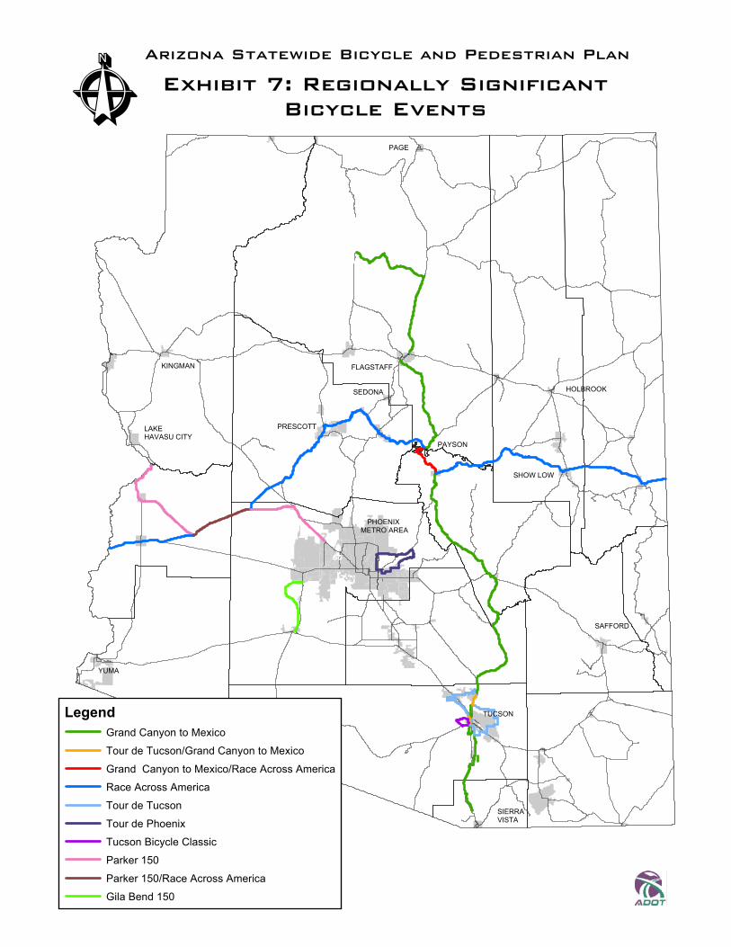
Major bicycling events often generate the most intensive use of a bicycle facility. Arizona is host to numerous local, regional, national, and international bicycling events. The following is a summary of the known events within Arizona that cover a minimum of 100 miles:
Organization Time of Year Adventure Cycling Southern Tier Route* Adventure Cycling Association NA Fast America America By Bicycle April/May MS 150 Best Dam Bike Tour National MS Society November Grand Canyon to Mexico GABA Tucson Sept./Oct. Race Across America Race Across America June Tour de Phoenix Perimeter Bicycling Assoc. of America April Tour de Tucson Perimeter Bicycling Assoc. of America Nov. Tucson Bicycle Classic Tucson Bicycle Classic March
* Entire route information not available at time of printing, see www.adventurecycling.org
The routes are displayed in Exhibit 7. ADOT is finalizing the process for attaining a permit to hold an event on an ADOT facility. Each race organizer should contact the ADOT District Engineer, in the district where the race will start within Arizona, as much in advance as possible to confirm the appropriate procedure for attaining a use permit.

Committees, Coordinators, Documents, and Maps 08/04/03
65
6.4. Recommendations
Section 6 includes the recommendations that:
All communities within Arizona consider having Bicycle and Pedestrian Advisory Committees.
ADOT have the current Bicycle and Pedestrian Coordinator position solely dedicated to bicycle and pedestrian projects and a Bicycle and Pedestrian Coordinator’s Assistant position be developed at ADOT. In addition, it is recommended that ADOT designate one Bicycle and Pedestrian Contact for each district.
Implementing agencies within Arizona consider having at least one full time Bicycle and/or Pedestrian Coordinator.
Implementing agencies put a high priority on implementing proposed local routes that fill a gap between existing bicycle routes.
That two adjacent implementing agencies work together to provide bicycle route connectivity across jurisdictional boundaries.
Each organizer of a major event to be held on an ADOT facility should contact the ADOT District Engineer, in the district where the race will start within Arizona, as much in advance as possible to confirm the appropriate procedure for attaining a use permit.

ÊArizona Statewide Bicycle and Pedestrian Plan
Exhibit 6: Regionally SignificantNon-ADOT Routes (Local Areas)
60
%&'(
%&'(
AË1
AÌ
)*+,-40
17
40B
180
LegendExisting Non-ADOT Bicycle Route
Planned Non-ADOT Bicycle Route
Unpaved Shared Use Path
Paved Shared Use Path
Non-Regional Bicycle Routes
ADOT Roadways
Bicycles Prohibited
Interstate Frontage Roads
A¿
)*+,-
AÅ
%&'(
AÈ
%&'(
!
!
!
!
!
!
!
!
!
!
!
!
!
!
Oracle Hwy
Ina Rd
Silverbell Rd
1st Ave
Broadway Blvd
Valencia Rd
Mission Rd
22nd St.
Sahuarita Rd
Kolb Rd
Houghton RdOld Spanish Trail
Sabino Canyon
Wentworth Rd
19
10
B19
A¹
AË
AÌ
A×
A
1
AÉ
AÉ
1
Aå
%&'(A×
%&'(
%&'(
!
!!
!
!
!
!
!
!
!
!!
!
!
!
!
!
!
!
!
!
!
!
20th St3rd Av
University Dr
Hun
Adobe RdCentral Av
Riggs Rd
Power Rd
Mckellips Rd
Dobbins Rd
Sa
Lindsay Rd
Ecanto Blvd
Beltline Rd
40th St
Union Hills Dr32nd St
Bell Rd
Oak St
67th Av
Horne St
12th St
Western Canal
Cave Creek Rd
10
10
17
60
60
Phoenix Metro Area
Tucson Metro Area
Prescott Valley Area
Flagstaff Area
Local Area Bicycle Route Data provided by:Maricopa Association of GovernmentsCity of FlagstaffTown of Prescott ValleyPima Association of Governments
Note: Available Shared Use Path data does not distinguish between existing and proposed facilities.
PAGE
KINGMAN
LAKE HAVASU CITY
YUMA
PRESCOTT
FLAGSTAFF
SEDONA
PAYSON
HOLBROOK
SHOW LOW
SAFFORD
TUCSON
PHOENIX METRO AREA
SIERRA VISTA
ÊArizona Statewide Bicycle and Pedestrian Plan
Exhibit 7: Regionally SignificantBicycle Events
60
LegendGrand Canyon to MexicoTour de Tucson/Grand Canyon to Mexico
Grand Canyon to Mexico/Race Across AmericaRace Across AmericaTour de Tucson
Tour de PhoenixTucson Bicycle ClassicParker 150
Parker 150/Race Across AmericaGila Bend 150