Embed Size (px)
Citation preview

BEST PRACTICES ON DROUGHT AND
FLOOD MANAGEMENT: ENGINEER’S
CONTRIBUTION
World Federation of Engineers Organizations
Working Group on Water
November 10, 2019


Authorship and contributions
The authorship of the report and the contributions received are shown in the attached Ta-ble.
Authors
Teodoro Estrela World Council of Civil Engineers (WCCE)
Tomás Sancho World Federation of Engineers Organizations.
Contributors
Francesco Ballio Politechnic of Milano, Italy
ZHANG Cheng IWHR - China
Eduardo Echevarria AICCP-Civil Engineering Association Spain
Ignacio González-Castelao IIE- Engineering Institute - Spain
Daniela Molinari International Association for Hydro-Environment Engineering
and Research (IAHR)
Justo Mora WCCE Standing Committee on Water
José Maria Villarroel WCCE Standing Committee on Water
Sara Perales AICCP-Civil Engineering Association Spain
Joaquim Poças Ordem dos Engenheiros –
Engineeers Asociation of Portugal
Virendra Proag University of Mauritius
José Francisco Sáez WCCE Executive Director
Óscar Sánchez CIAPR – Costa Rica
Other contributors (questionnaires)
Hatem Hameed Hussein National Center for Water Resources Management - Iraq
Janja Kramer Stanko Civil Engineering Faculty, University of Maribor, Slovenia

Tobias Rudolph & Peter
Goerke-Mallet
Technische Hochschule Georg Agricola University - Germany
Ali M. Zeidan Khatib & Alami -Lebanon

CONTENTS
Authorship and contributions ................................................................................................. 3
1 Introduction ........................................................................................................................ 2
1.1 Framework ..................................................................................................................... 2
1.2 Objectives ....................................................................................................................... 2
1.3 Summary ........................................................................................................................ 3
2 General framework ............................................................................................................. 4
2.1 Floods and droughts in the world .................................................................................. 7
2.2 Social, economic and environmental impacts ............................................................. 10
2.3 Effects of climate change ............................................................................................. 13
3 Evolution of water policies to manage extreme hydrological events .............................. 16
3.1 Traditional approaches ................................................................................................ 16
3.2 Approaches based on risk reduction ........................................................................... 17
3.3 Governance in the management of extreme hydrological events .............................. 23
4 Knowledge, technology and innovation ........................................................................... 26
4.1 Hydrological and hydraulic models .............................................................................. 26
4.2 Hazard and flood risk maps.......................................................................................... 31
4.3 Actions: technology and innovation ............................................................................ 33
4.4 Advances in warning systems ...................................................................................... 35
5 Experiences and best practices ........................................................................................ 36
5.1 Risk management plans: floods and droughts ............................................................. 36
5.1.1 Risk Management Approach ............................................................................... 36
5.1.2 Flood risk management plans ............................................................................. 37
5.1.3 Drought Management Plans ............................................................................... 38
5.2 Measures to deal with flood risks ................................................................................ 43
5.2.1 Structural Protection Measures .......................................................................... 44
5.2.1.1 Flood control reservoirs ............................................................................45
5.2.1.2 Diversion channels ....................................................................................46
5.2.1.3 Embankments and dykes ..........................................................................47
5.2.1.4 Channel modification ................................................................................48
5.2.1.5 Drainage of linear infrastructures ............................................................49
5.2.1.6 Green infrastructure and natural water retention measures ..................51
5.2.1.7 Hydrological restoration and flood zone measures .................................57
5.2.2 Non-structural or management measures: prevention, alert and response ...... 57
5.2.2.1 Adaptation measures for potentially affected assets, for damage mitigation 57
5.2.2.2 Prevention measures: land management and urban planning ................60
5.2.2.3 Warning measures: flood warning systems .............................................61

5.2.2.4 Response measures: civil protection ........................................................ 63
5.2.2.5 Response measures: flood insurance ....................................................... 63
5.3 Measures to deal with drought risks ........................................................................... 64
5.3.1 Integrated Water Resources Management......................................................... 64
5.3.2 Management and control measures: resource allocation, water savings and temporary transfer of rights................................................................................ 65
5.3.3 Environmental measures .................................................................................... 66
5.3.4 Drought warning and monitoring system ........................................................... 67
5.3.5 Agricultural insurance ......................................................................................... 69
6 Lessons learnt ................................................................................................................... 69
6.1 Importance of planning ............................................................................................... 69
6.2 Adaptative management ............................................................................................. 70
6.3 Technology and improvement of results ..................................................................... 70
6.4 Combination of measures ............................................................................................ 71
7 Challenges for engineers .................................................................................................. 72
7.1 The current role ........................................................................................................... 72
7.2 Professional practice indicators ................................................................................... 73
7.3 Innovation and technology .......................................................................................... 73
7.3.1 Technology development .................................................................................... 75
7.3.2 Infrastructure construction and design of resilient systems .............................. 76
7.3.3 Extreme event management and restoration ..................................................... 76
7.4 Social responsibility ..................................................................................................... 77
7.5 Emerging and future areas .......................................................................................... 78
7.6 New roles and challenges ............................................................................................ 80
8 References ........................................................................................................................ 81
FIGURES
Figure 1. Number of climate-related disasters in the world (1980-2011). Draft figure taken from UNISDR ......................................................................................................... 5
Figure 2. Evolution of water Surface in the Lake Chad .................................................... 11
Figure 3. Type of damages due to floods .......................................................................... 12
Figure 4. Estimated changes for the 2016-2031 period inr: evaporation (%), evaporation minus precipitation (mm/day), total runoff (%), soil moisture in the top 10 cm (%), relative change in specific humidity (%) and absolute change in relative humidity (%). The number in the upper right of the image indicates the number of averaged models.Source: Kirtman et al (2013). ............................................. 14
Figure 5. Copernicus Clima EDGE project demostrator. ................................................... 16
Figure 6. Hazard map of the Ebro river in Zaragoza (100 year return period flood) ........ 23
Figure 7. OECD Principles of water governance. Source: OECD (2015) and www.oecd.org/governance/oecd-principles-on-water-governance.htm ......... 24
Figure 8. Flow simulation in variable regime in one and two dimensions with HEC-RAS 28
Figure 9. State of art of tools for ex-ante flood damage assessment worldwide ............. 30
Figure 10. Example of an area with significant potential flood risk: Porto-Vila Nova de Gaia, Portugal .............................................................................................................. 32
Figure 11. The AQUATOOL software developed at the Universitat Politècnica de València, Spain ................................................................................................................... 34
Figure 12. Drought Indicators Monitoring map in Spain, July 2018.. .................................. 41
Figure 13. Tuni reservoir with a capacity of 21.55 Hm3. In operation since 1977 .............. 43
Figure 14. Johnson Creek River Basin .................................................................................. 44
Figure 15. Rolling of the Aragón river flood as it passes through Sangüesa due to the water held in the Yesa and Itoiz reservoirs................................................................... 46
Figure 16. Ebro river flood episode as it flows through the city of Zaragoza ..................... 46
Figure 17. River Turia’s diversion channel. Source: Sustainable water use in Europe. Part 3: Extreme hydrological events (EEA, 2001)........................................................... 47
Figure 18. Sacramento River’s dyke break .......................................................................... 48
Figure 19. Channeling the Ebro river in Castejón for its 5-year return period flow ........... 49
Figure 20. Viaduct over Chanza river ................................................................................... 50
Figure 21. Small Drainage Work (SDW) on an embankment .............................................. 51
Figure 22. Before and after the restitution of meanders on the Morava river in Slovakia and the Czech Republic ............................................................................................. 52
Figure 23. Plantío meander on the Arga river in Spain ....................................................... 53
Figure 24. Temporary controlled flood area of Pradilla de Ebro on the Ebro river in Spain ............................................................................................................................ 53

Figure 25. Bioretention planter with step-out zone in Washington DC. Source: Green Blue Management S.L. ................................................................................................ 55
Figure 26. SUDS in Bon Pastor, Barcelona. Source: Soto-Fernández and Perales-Momparler, 2018 .................................................................................................................... 57
Figure 27. Damage assessment steps for flood protection ................................................ 58
Figure 28. Example of guides developed for flood protection of buildings and constructions ............................................................................................................................ 59
Figure 29. Flood protection of water treatment stations. Source: USA Environmental Protection Agency .............................................................................................. 60
Figure 30. SAIH control centre at the Júcar River Basin Authority ..................................... 61
Figure 31. Situation of Combined Drought Indicator in Europe - 1st ten-day period of October 2019. ..................................................................................................... 68
Figure 32. U.S.A. Drought Monitor Map, October 15, 2019. .............................................. 69
Figure 33. Combination of measures for flood risk management ...................................... 72
Figure 34. Historical evolution of engineering innovation. Source: Referred by Jose Vieira, OdE Portugal and President FEANI ..................................................................... 74

TABLES
Table 1. Relationships between disaster risk management, climate change and sustainable development. Source: UNDDR, 2019 .............................................. 17
Table 2. Relevant milestones in the management of droughts in the European Union since the beginning of the 21st century (modified and updated by Estrela and Sancho, 2016) ..................................................................................................... 19

2
1 Introduction
1.1 Framework
The Working Group on Water (WGoW) of the World Federation of Engineering Organizations
(WFEO) covers water engineering initiatives and its relations with United Nations’ bodies
and agencies, primarily with UN-Water and UNESCO, showing the contribution of
engineering to the accomplishment of United Nations’ Sustainable Development Goals
(SDG).
WFEO’s WGoW was created by its Executive Council at the meeting held in October 2018 in
London on the occasion of the Global Engineering Congress. This Working Group was jointly
proposed by Spain’s Instituto de la Ingeniería de España and Portugal’s Ordem dos
Engenheiros. IIE’S representative and World Council of Civil Engineers’ Past President, Mr.
Tomás Sancho, was appointed WGoW’s Chair, Mr. Joaquim Poças, Portugal’s Ordem dos
Engenheiros representative as Deputy Chair, and Mr. Teodoro Estrela, current Chair of
WCCE’s Standing Committee on Water Commission as WGoW’s Secretary.
Such Working Group on Water has committed to deliver three monographs during its 2019-
2021 three-year mandate regarding the following topics: Best practices on Drought and
flood management: Engineer’s contribution, 2019; Achieving SDG 6 on Water: Engineer’s
contribution, 2020 and Adaptation to climate change - Water: Engineer’s contribution, 2021.
This monograph addresses the first topic regarding best practices on Drought and flood
management and engineer’s contribution to such practices and builds upon both the
mentioned reference documents and contributions provided by WFEO member
organizations listed in the authorship section of this report.
1.2 Objectives
Extreme hydrological events - droughts and floods - have become current global topics
regarding water issues, as reflected in the United Nations’ 2030 Agenda (UN). In particular,
Sustainable Development Goal - SDG No. 6 addresses water and aims to ensure the
availability and sustainable management of water and sanitation for all people. Related to it
is SDG No. 11, whose target 11.4 intends to reduce significantly the number of lives lost,
victims and economic losses caused by water-related disasters.

3
The goal of this monograph is to describe the best practices for the risk management of
droughts and floods, highlighting the engineer’s contribution to such practices.
1.3 Summary
According to the United Nations’ Office for Disaster Risk Reduction (UNDRR), the major
climate-related disasters by number disasters are floods, followed closely by storms, and
droughts and heat waves at a distance.
The economic impacts caused by extreme hydrological events - floods and droughts - have
been increasing worldwide. These events pose serious threats to human life and the well-
being of society and represent a burden and a serious challenge for the country
governments, responsible for maintaining both economic development and the
environment, on which society relies.
Climate change affects negatively the availability of resources and increases the frequency
of extreme hydrological events, such as droughts and floods. OECD argues that investing in
water security is a necessary condition for sustainable growth and development. Risk
management related to extreme events requires policy coherence in all sectors, such as
adaptation to climate change, water management and disaster risk reduction.
Traditionally, extreme hydrological events have managed as emergency or crisis situations
addressed by mobilizing extraordinary resources, usually by way of urgency. This crisis-based
approach is a reactive approach as it includes measures and actions that are triggered after
the extreme event has begun. Such approach often results in inefficient technical and
economic solutions, because actions take with little time to evaluate the optimal
alternatives and stakeholder participation is very limited. In recent years, these policies are
changing around the world, moving from a crisis management approach to another based
on risk management or adaptive management.
The risk management approach is becoming an increasingly widespread practice in many
fields of science and engineering, not just droughts and floods. Disaster risk reduction seeks
to prevent new potential risks, reduce existing risks and manage residual risk. Addressing
the risks of these extreme phenomena in a planned way allows studying, analysing and
agreeing on measures with all stakeholders, and managing the corresponding risks in
advance, assessing their consequences from all points of view. In recent years, evaluation

4
and management plans for flood and drought risks have developed in many regions of the
world.
Engineering plays a very important role in estimating the time of occurrence of the natural
phenomena, the affected areas, the risks and potential damages, the definition of any
adaptation actions, the best evacuation options to non-affected areas, to guarantee the
essential uses of water and limit the impact in droughts, and to develop risk management
plans for flood and drought episodes.
Addressing these extreme phenomena requires combining a whole series of measures,
where the role of engineering in its design and implementation is essential but is also
necessary to coordinate the different stakeholders involved, reinforcing the need to
previously implement such risk management plans through stakeholder participation, so
that they are acknowledged and assumed by all the agents involved.
It is engineer’s task to apply at earliest convenience the innovations and technological
advances that allow a better management of both floods and droughts, improving
prevention and alert systems and their reliability, applying decision support systems,
making decisions such as flooding areas in a controlled manner, overexploiting temporary
aquifers to cope with droughts or distribution of the available resources to ensure water
security in a context of drought, among many others.
2 General framework
Droughts and floods are extreme hydrological events that bear many similarities, but also
show characteristics that differentiate them.
Floods are probably one of the natural disasters that causes the most damage on our planet,
as is reflected in the large bibliography issued by different international, regional and
national organizations. In these reports, there is a high consensus that and the number of
people at risk by floods and its frequency will increase in the coming years. It is also
foreseeable that global mega trends, such as climate change, population growth and
urbanization will increase the frequency, intensity and impact of floods.
The Organization for Economic Cooperation and Development - OECD estimates that the
number of people at risk will increase from 1.2 to 1.6 billion people by 2050. This represents

5
approximately 20% of the world's population. In 2016, 23.5 million people migrated due to
weather-related disasters, of which the majority were associated with floods or storms.
Between 1998 and 2017, floods accounted for about a quarter of economic losses due to
natural disasters (OECD, 2019).
According to the United Nations Office for Disaster Risk Reduction (UNDRR), the greatest
number of weather-related disasters is due to flooding, followed closely by storms. Then,
although at a considerable distance in number, there are droughts and heat waves.
Figure 1. Number of climate-related disasters in the world (1980-2011). Draft figure taken from UNISDR
Floods are a natural phenomenon that, in general, responds to the behaviour of the
hydrological cycle when large rainfall occurs leading to the overflow of rivers, ravines,
streams and rambles. Under natural conditions, the effects are not, in general, harmful.
Furthermore, flooding is necessary for rivers to develop their natural processes and maintain
an adequate ecological status, with important benefits to nature, such as the fertilization of
flood areas, improved infiltration capacity, increased levels of groundwater, and river bed
clearing. Although the main cause of flooding are extreme rains, flooding can also occur due
to other causes such as sea flooding, snow melting, dam breaks, landslides or roadway
obstructions.
6
Damages caused by floods are due to the use of the watershed for several human activities:
buildings, homes, transport routes, energy production, crops, etc., which sometimes are not
compatible with the river’s natural regimes, limiting the available space to evacuate the
circulating flows.
The total elimination of the risk of flooding is not possible, no matter how many population
protection measures are implemented. Therefore, it is necessary to promote awareness of
self-protection in citizens. Administrations, meanwhile, must define the levels of security
they must provide in each case. For example, the reconstruction of the levees of the city of
New Orleans after Hurricane Katrina in 2005 carried out with levees of similar height to those
previously existing, since substantially increasing the levees’ height would lead to
unacceptable costs.
Unlike floods, droughts are an extreme hydrological phenomenon of low water availability,
which take place slowly and imperceptibly and that sometimes when detected, is too late
and can cause very high social, economic and environmental impacts. Although drought by
itself does not constitute a disaster, it can be a disaster depending on its impact on society
and the environment. The temporal and spatial limits of droughts are uncertain and there is
great difficulty in predicting or identifying cycles or periods. Thus, traditionally mitigation
measures have not been applied until the crisis has arisen.
Extreme hydrological events - droughts and floods - have become current global topics
regarding water issues, as reflected in the United Nations’ 2030 Agenda (UN). In particular,
SDG 6 refers to water and sanitation and aims to ensure the availability and sustainable
management of water and sanitation for all people. Among the goals of SDG 6 related to
scarcity and droughts, is to increase the efficient use of water resources and ensure the
sustainability of the withdrawals to address the shortage and implement the integrated
water resources management. Related to SDG 6, and specifically to extreme hydrological
events, is SDG 11 and in particular goal 11.4 aiming to significantly reduce the number of
deaths, the number of people affected and economic losses due to water-related disasters.
SDG 2, which aims to end hunger, achieve food security, improve nutrition, and promote
sustainable agriculture or SDG 13 that seeks to take urgent measures to combat climate
change and their effects, are deeply intertwined with extreme episodes’ management.

7
To fight and mitigate water-related disasters, the United Nations (UN) provides regulatory
support, data collection and analysis, capacity building and technical assistance, policy
advice and support in its global and regional implementation. Thus, the activities carried out
by the United Nations include regulatory and follow-up support for the Sendai Framework,
which establishes the framework for disaster risk reduction in the 2015-2030 period,
capacity building and policy instruments for member states to reduce disaster losses and
enhance resilience, campaigns to support disaster risk reduction, provision of WASH (Water,
Sanitation and Hygiene) services in responses of emergency, the protection of migrants, the
improvement and application of forecast systems for flash floods and support to countries
and exchange of best practices (UN-Water, 2019).
Within the regulatory support activities, United Nations Office for Disaster Risk Reduction
(UNDRR) has developed the Words into Action (WiA) publication series, thematic guides
developed for the implementation of the Sendai Framework and the integration of disaster
risk management in specific areas (UNDDR, 2019). WiA guides help communities get
involved in disaster risk reduction by facilitating access to straight forward practical
information that is easily applicable for global, local and field use (UN-Water, 2019). Other
international organizations, such as the World Meteorological Organization (WMO) have
also developed manuals and guides on Flood Forecasting and Warning (WMO, 2011).
Within the Sendai Framework for Disaster Risk Reduction, UNDDR has the task of and
promoting integration, coordination and synergies within the 2030 Agenda, in particular in
disaster risk reduction and developing a new Sendai Framework monitoring system. (UN-
Water, 2019).
2.1 Floods and droughts in the world
The economic impacts caused by extreme hydrological events - floods and droughts - have
been increasing around the world. These events pose serious threats to human life and the
well-being of society and represent a burden and in turn, a serious challenge for the States,
responsible for maintaining economic development and maintaining the ecosystem
services, on which society depends. It has been shown worldwide that reducing the risk of
hydrological disasters improves human security, in any of its categories (Kundzewicz and
Matczak, 2015).

8
The largest known floods in modern history have occurred in China, which has suffered
heavy losses of human lives and property damage, with annual damage estimated, on
average, at 1% of the country's gross domestic product. The flooding caused by the Yangtze,
Amarillo and Huai rivers in Central China in 1931 resulted in a multitude of casualties,
estimated by various sources between a few hundred thousand and nearly 4 million people.
In the summer of 1931, snow melting, torrential rains and several cyclonic storms, combined
to produce the most devastating flood in Chinese history. Only in the month of July, central
China was flooded with the rainfall, which normally occurred in one and a half years. In
August, the flows of Yangtze and Huai rivers caused the collapse of protection dikes flooding
huge surface areas. Thousands of people died drowned during the initial phase of the flood,
but many more followed due to widespread famine and disease outbreaks, such as cholera,
typhoid and dysentery.
A case of large flooding largely reported is the great flood of the Mississippi River of 1927 in
USA. It is remembered as the most destructive flood in the history of the United States
discharging 65,000 m3/s. During the summer of 1926, heavy rains were witnessed in the
central part of the Mississippi River, and for Christmas day the water level of the Cumberland
River rose over 17 meters, a record that remains today. The river exceeded its levels in 145
areas, flooding over 70,000 km2 with a water level of 10 meters, causing $ 400 million in
damage and killing 246 people. In addition, although it has not been one of the deadliest
floods, the destruction is still a record for the United States, not even broken by the 2010
floods in the same area.
The 1966 flood on the Arno River in Italy had devastating effects on the cultural heritage of
the city of Florence. The flood began on November 4, when a period of heavy rains caused
the Arno River to overflow. Thousands of homes and businesses destroyed, but the water
also reached several art galleries and libraries that contained priceless relics from the
Renaissance era. Some 1.5 million books submerged in the Nazionale Library. Although
countless works of art were rescued, the restoration process has, in many cases, taken
decades.
On two successive occasions, between 1993 and 1995, European rivers Rhine and Meuse
suffered experienced major water rises that caused severe flooding in the surrounding
areas. The devastation caused by these floods pushed motivated the creation of a

9
transnational prevention program among the affected countries: Belgium, France,
Luxembourg, Germany, and Switzerland and the Netherlands.
In addition to this, the great floods occurred between 1998 and 2004 in Central European
rivers inspired the European Commission’s 2004 Communication to the European Council,
Parliament, Economic and Social Committee and the Committee of the Regions on flood risk
management, communication that initiated the discussion finalized in October 23rd, 2007,
with the approval by the European Parliament of Directive 2007/60 / EC on the assessment
and management of flood risks.
More recently, in December 2015, vast areas of Paraguay, Argentina, Uruguay and Brazil
were affected by the worst floods in the region in 50 years, which forced the evacuation of
more than 150,000 people. The days of heavy rain caused by the El Niño weather
phenomenon caused three major rivers to overflow. The state of emergency was declared
in Paraguay, the most affected nation, where 130,000 people were displaced. In northern
Argentina, some 20,000 people also left their homes.
Droughts have also caused serious damage worldwide. Australia recently suffered the worst
drought in its history, the so-called Millennium Drought, which began in 1997 and officially
ended in 2012. In general, the country survived the effects of this drought demonstrating
the importance of innovation and planning of those situations. Actions were implemented
in Australia’s four largest cities in: Sydney, Melbourne, Brisbane (and the surrounding region
of south-eastern Queensland) and Perth, where special attention was paid to the role of
demand management measures to reducing the impact of drought. It can be said that the
“silent achievement” of this drought was the improvements in urban water efficiency, saving
more water at a lower cost and faster than other supply side alternatives1.
In France, the 2003 drought intensified public authorities' awareness of this phenomenon.
In metropolitan France, the prefects of 77 departments took measures to limit the use of
water, an unprecedented action. Several deficiencies were identified, highlighting the need
to improve the organization and implementation of the drought management system. In a
context of global warming, the French authorities contemplated the possible influence of
1 https://www.researchgate.net/publication/297723736_Managing_Drought_Learning_from_Australia.

10
climate change not only on the frequency of occurrence of the drought but also on its
duration, since the concatenation of several years followed by crisis forced to increase their
means of observation and detailed study of these hydrological phenomena.
2.2 Social, economic and environmental impacts
Extreme hydrological events, both drought situations and floods, have been causing high
social, economic and environmental impacts.
In the case of droughts, their impacts can vary greatly between countries. While in those
that lack water storage infrastructures and water supply depends primarily on precipitation,
a decrease in rainfall over a few months may become a drought, whereas in other countries
with significant reservoir capacity, the largest impacts occur when water deficits extend over
several consecutive years. In the United Kingdom, where the number of reservoirs is
reduced, the lack of rainfall for several consecutive months can cause drought situations,
while in Spain, where there are more than 1,200 large dams with a reservoir capacity of
more than 50,000 hm3, there are watersheds where the effects of the drought do not
become effective until after 2 or 3 years after its beginning.
Knowledge of drought’s environmental impacts require the prior study of the relationships
between the parameters that define the state of water bodies and drought indicators.
Assessing droughts’ socioeconomic impact, the influence of drought periods estimates
through metrics variables such as area affected, production and yield reduction, economic
value and economic performance. On the other hand, socio-economic impact in urban water
supply and hydroelectric power generation sectors assesses by contrasting, respectively,
guarantees and power outputs in normal and drought periods.
Among the intangible impacts, we can mention the loss of soil due to the non-occurrence of
the ground cover, the decrease in the quality of life in cities due to the loss of parks,
population displacement (important in developing countries) and mortality. A well-known
example of forced migration is that of Lake Chad in sub-Saharan Africa.
The most ignored crisis in the world: Lake Chad has lost more than 90% of its original
surface in four decades.

11
Such has been called the great environmental and humanitarian crisis caused by the
effective disappearance of Lake Chad, which in the 1960s - with 25,000 km2 of surface -,
ranked sixth largest lake in the world. Only two decades later, in the 80s, lake Chad’s
surface reduced to just 2,500 km2, that is, 10% of its original dimension. By 2013, the lake
recovered slightly, because of an exceptional increase in rainfall, which returned its
surface to 5,000 km2, only 20% of its former surface, currently reduced to an immense set
of loosely connected ponds, surrounded by a great desert.
The current situation affects around 40 million people, who depended on the lake to
obtain drinking water, fish and cultivate the nearby lands, and who now migrate massively
southwards to Guinea’s savannah, search for better life conditions. United Nations
estimates that almost 11 million people need humanitarian assistance because of this
situation. The cause lies in a situation of prolonged drought, because of the general
decrease in rainfall. Concurrent to this cause, other factors such as the guerrilla war
affecting these 4 countries (Niger, Nigeria, Chad and Cameroon) and an unsustainable
increase in water withdrawals for different uses contribute to worsen such crisis.
Figure 2. Evolution of water Surface in the Lake Chad 2
The impacts of droughts can be classified as tangible, easily determined, and intangible,
which are much harder to quantify. Tangible impacts are normally classified as direct and
2 http://documents.worldbank.org/curated/en/489801468186879029/pdf/102851-v2-WP-P149275-Box394847B-PU-
BLIC-v2-main-report-Lake-Chad-Development-and-Action-Plan-English.pdf

12
indirect. Among the direct impacts are the environmental deterioration, agricultural and
derived industries losses, decrease in hydroelectric power output, losses in the tourism
sector or the deterioration of garden areas. Indirect impacts include the loss of market share
of agricultural products, the increase in unemployment or any extra financial costs incurred
from reduced turnover.
In the case of flooding, there is also a difference between tangible impacts, which
characterize by being able to be quantified and intangibles, which are much more difficult
to quantify (see attached figure). Tangible impacts classify into direct and indirect. Direct
impacts include physical damage to property, the costs of emergency measures, or the costs
of cleaning streets and homes. While indirect impacts include losses from paralysis of
economic activity, the disappearance of jobs, financial cost overruns or devaluation suffered
by flooded land. Intangible impacts include the loss of human life, damage to monuments
and archaeological remains, or changes in the landscape.
Figure 3. Type of damages due to floods
Economic appraisals on the value of life are made in order to be able to comparatively assess
the effects of floods, bearing mind that the value of any life is infinite.
The assessment of human life loss in the European Climate Adapt SUFRI project
Tangible damages
Direct damagesIndirect
damages
Total damages
Intangible damages
Victimis
Historical heritage and
landscape

13
Climate Adapt's Sustainable Strategies of Urban Flood Risk Management with non-
structural measures to cope with residual risk - SUFRI project aims to improve flood risk
management in the event of disaster flooding, especially addressing non-structural
measures. Flood analysis has shown that structural flood protection measures have
limited applicability, especially in urban areas, and that full protection is not achievable.
Under the SUFRI project3, a method has been developed to calculate the number of
possible victims due to floods, in which the estimation of mortality rates depends, among
other factors, on the severity of the flood, the prior warning time to the population, the
type of dam break (if such happens) and the of time of occurrence (day / night).
This project was developed by several technological universities from 4 different
European countries: Graz University of Technology (Austria), Dresden University of
Technology (Germany), University of Pavia (Italy), Polytechnic University of Valencia
(Spain); Polytechnic University of Catalonia (Spain) and University of Graz (Austria).
2.3 Effects of climate change
As a whole, the world suffers from low water availability, making difficult the match of the
available natural resources and the use of water for socio-economic development, avoiding
depopulation and facing climate change with better resilience. Climate change is part of
other global changes of greater scope, which causes negative effects on the availability of
resources and the frequency of presentation of extreme hydrological events, such as
droughts and floods (Intergovernmental Panel on Climate Change, 2014).
The results of International Panel of Experts on Climate Change’s 5th Assessment Report 4,
show that the main runoff reductions are expected in regions such as the southern United
States of America, Central and Southern Europe, North Africa or the Western part of
Australia (see attached figure).
3 https://climate-adapt.eea.europa.eu/metadata/projects/sustainable-strategies-of-urban-flood-risk-management-with-
non-structural-measures-to-cope-with-the-residual-risk.se
4 http://www.climatechange2013.org/

14
Figure 4. Estimated changes for the 2016-2031 period inr: evaporation (%), evaporation minus precipitation (mm/day),
total runoff (%), soil moisture in the top 10 cm (%), relative change in specific humidity (%) and absolute change
in relative humidity (%). The number in the upper right of the image indicates the number of averaged
models.Source: Kirtman et al (2013).
The effects of droughts can be aggravated when they occur in regions where water resources
are scarce, where there are already existing imbalances between available resources and
water demands (Estrela et al, 2102; European Environment Agency, 2001), as is the case in
Southern Europe. Thus, the PESETA project (European Commission, 2014), EU’s Joint
Research Center - JRC has assessed the climate impacts in the 2071-2100 period compared
to the reference period (1961-1990), studying five major regions of the Southern Europe:
Spain, Portugal, Italy, Greece and Bulgaria. The simulations run forecast a temperature rise
of between 2.3 and 3.7 ° C for Southern Europe. In parallel to such temperature rise, rainfall
will reduce by around 6.5% in the region. Another study, this one carried out by Spain’s

15
Center for Hydrographic Studies (CEH, 2017), estimates that, in general, droughts in Spain
will become more frequent as the 21st century progresses, with the consequent increase in
water scarcity due to the reduction of water resources.
There are currently a large number of climate scenarios in accordance to the different
emission scenarios (Representative Concentration Pathway - CPRs of the International Panel
of Experts on Climate Change and to the different climate simulation models existing in the
world. In Europe, within the EC’s Copernicus Climate-Water Program, two Decision Support
Systems have been developed, EDGE and SWICCA, which, in addition to facilitating the
visualization and analysis of climate data, have generated hydrological scenarios using
hydrological models whose input are such climatic scenarios. Engineering has played an
important role in the development of these systems and the models they incorporate.
The EDGE project combines a set of state-of-the-art climate and hydrological models to
obtain a series of climate impact indicators and seasonal predictions that have been jointly
agreed with stakeholders from the public and private water sectors in three European
countries (Kingdom United, Spain and Norway). EDGE's final product is an information
system implemented through a web application. The underlying framework of the EDGE
modelling procedure comprises four phases: 1) climate data processing, 2) hydrological
modelling, 3) co-design with the help of stakeholders and 4) assessments of the uncertainty
and capabilities of the system (Samaniego et al, 2019). Within the EDGE project, tools have
been developed to visualize and analyse seasonal predictions of meteorological and
hydrological variables with a 6 months horizon, information that can be very useful for
drought’s risk management, especially in relation to irrigation farming.

16
Figure 5. Copernicus Clima EDGE project demostrator.
In addition to the previous examples, engineering can actively collaborate to the reduction
of Greenhouse Gases (GHG) within various sectors improving the weather resistance of
infrastructures to resist climate impacts, increasing their reliability and lifespan while
exposed to extreme weather events, and the achievement of the United Nations Sustainable
Development Goals (SDGs).
In particular, hydraulic works projects, especially dams, must incorporate the effects of
climate change in their design, since they are infrastructures with a large lifespan which
require large investments and impact territory, ecosystems and the landscape.
3 Evolution of water policies to manage extreme hydrological events
3.1 Traditional approaches
Traditionally, extreme hydrological events managed as emergency or crises addressed by
mobilizing extraordinary resources, usually by way of urgency. This crisis-based approach is
a reactive approach as it includes measures and actions that are only triggered after the
extreme event has occurred. Such approach often results in inefficient technical and
economic solutions, because actions are taken with little time to evaluate the optimal
alternatives and hindering stakeholder participation. In recent years, these policies are

17
changing around the world, moving from a crisis management approach to another based
on risk management or adaptive management.
3.2 Approaches based on risk reduction
The disaster risk caused by an extreme hydrological event is defined as the potential loss of
life and material damage that could occur to a system, society or community during a specific
period of time, probabilistically determined as a function of the hazard itself, exposure and
vulnerability to such event. Disaster risk reduction is the objective of risk management and
seeks to prevent new risks, reduce existing risks and manage residual risk, all of which
contributes to enhance resilience. A comprehensive approach to disaster risk management
can contribute to climate change mitigation, adaptation and future sustainable
development.
The relationships between disaster risk management, climate change and sustainable
development show in the attached table. Prospective risk management includes activities
that address avoiding the risk of new disasters, corrective management refers activities that
address and seek to eliminate or reduce the of existing disasters’ risks and compensatory
management refers activities that strengthen the social and economic resilience of people
and societies in the face of residual risk that cannot be effectively reduced or avoided
(UNDDR, 2019).
Prospective Corrective Compensation
Disaster risk
manage-
ment
Avoid the risk Reduce/mitigate risk Enhance resilience to dis-
aster (economic and so-
cial)
Climate
change
Climate change
mitigation
Climate change adapta-
tion
Enhance resilience to ex-
treme events associated
to climate change.
Sustainable
Develop-
ment
Contribute to fu-
ture sustainable
development
Enhance the sustainabil-
ity of the current devel-
opment framework
Enhance resilience to all
common risks.
Table 1. Relationships between disaster risk management, climate change and sustainable development. Source:
UNDDR, 2019
18
Among the extreme hydrological events, droughts are phenomena of slow evolution but
unpredictable in time, whose risk management requires long-term preparedness through
prevention (strategies to reduce risk and the effects of uncertainty), mitigation (measures
taken to limit its adverse impacts) and preparation, through proactive management that
develops planned actions in advance.
Researchers and scientists, such as Wilhite et al (2014), indicate that it is necessary to adopt
new approaches to reduce drought risk, given the increasing impacts and trends regarding
the increase of frequency and duration of such associated drought events due to climate
change. On such grounds, the European Union (EU), has developed relevant political
instruments in recent years, to address drought’s negative impacts. Some examples of these
regulations are the Water Framework Directive 2000/60 / EC, the European Commission
communication “Addressing the challenge of water scarcity and droughts in the European
Union” (EC, 2007b), the “Blueprint to Safeguard Europe's Water Resources ” (EC, 2012) or
the European Commission Communication “An EU strategy on adaptation to climate
change”(EC, 2013). Table 1 summarizes European Union’s evolution from traditional
approaches to drought risk management since the adoption of EU’s Water Framework
Directive in 2000 (Estrela and Sancho, 2016).

19
Action Year Relationship with drought management
Water Framework Directive
2000/60/EC
(European Parliament and Council
of European Union, 2000)
2000 The protection of water bodies must contribute to miti-
gate the effects of droughts.
Communication on ''Addressing
the challenge of water scarcity
and droughts in the European Un-
ion'' COM(2007) 414 final (EC,
2007b)
2007 Highlights that water saving must become the priority,
improving water efficiency prior to increasing supply.
States that policy-making should promote participatory
processes. Recommends the development of drought
management plans.
Drought Management Plan Re-
port, Including agricultural,
drought indicators and climate
change aspects, Technical report
2008–023 (EC, 2007a)
2007 General, non-binding guidelines for the development of
Drought Management Plans elaborated jointly by EC and
some leading EU countries (Spain, France and Italy).
European Commission Follow-up
reports to the COM(2007) 414
[COM(2008) 875 final (EC, 2008),
COM(2010) 228 final (EC, 2010)
and COM(2011) 133 final (EC,
2011a)
2008,
2010 and
2011
Reporting on progress made by Member States with re-
gard to addressing the challenge of water scarcity and
droughts.
European Drought Observatory
(EDO) developed by Joint Re-
search Centre of European Com-
mission
2011 EDO enhances the knowledge of droughts using efficient
alert systems which are an essential tool for risk man-
agement.
Blueprint to Safeguard Europe's
Water Resources (EC, 2012)
2012 Outlines actions focusing on better implementation of
current water regulations, the integration of water pol-
icy objectives into other policies, and bridging the gaps
in particular as regards to water quantity and efficiency.
Development of water scarcity
and droughts indicators by Mem-
ber States.
2013-
2016
These studies are being incorporated into the Policy Re-
view of the Strategy for Water Scarcity and Droughts.
Table 2. Relevant milestones in the management of droughts in the European Union since the beginning of the 21st
century (modified and updated by Estrela and Sancho, 2016)
In other regions such as Mexico, the PRONACOSE National Drought Program (Korenfeld et
al, 2014) has focused on reducing vulnerability through the implementation of preventive
action planned under a comprehensive and participatory approach.
Nowadays, drought management policies around the world are based on four fundamental
pillars: the promotion of policies based on risk management, the promotion of preparedness

20
and mitigation measures, drought planning and the consideration of assistance financing
instruments (Iglesias et al., 2009). The promotion of transparent processes of public
participation, agreements between stakeholders, collaboration between water
administrations, as well as the active participation of stakeholders, are essential elements in
drought risk management.
Managing Droughts in Portugal: participatory approaches
The importance of the extreme 2005 drought event in Portugal resulted in the creation of
a Drought Commission by Governmental initiative to monitor the progress of the drought
event and to assist in mitigating its effects. This was the first drought to have an
institutional framework to manage the event and related water scarcity, with a drought
Commission. Four drought severity levels were established and several measures were
planned and put to place during the drought.
The next drought occurring in Portugal in 2012 was followed by a political Commission,
whereas a Working Group was constituted to deal with technical and operational aspects.
The working group included institutions related with the environment and urban water
supply, agriculture, food production, nature protection, human health, civil protection,
energy, territory planning, internal administration, work and social security, and financing.
More recently, during the drought of 2017 a permanent Commission was legally
established to continuously prevent, monitor and follow the consequences of droughts in
Portugal, including Government members from the following areas: environment and
agriculture, that together coordinate the Commission, finances, internal administration,
local administration, work, solidarity and social security, human health, economy and sea.
The Commission is mandated to approve and monitor the implementation of the Drought
Prevention, Monitoring and Contingency Plan and to define the political orientations in
the context of the adverse climate phenomenon of drought. The permanent Commission
is technically advised by a Drought Working Group that encompasses 21 public
institutions. Other public institutions and civil society representatives can be invited to
participate in the Working Group. In addition to the framework presented, the Reservoirs

21
Management Commission is also integrated in drought management, being mandated to
resolve conflicts in the use of stored water.
Although the current framework for drought management and planning in Portugal is still
based on a crisis management approach, drought and scarcity management plans are
being prepared by the Water Authority. These plans will include a characterization of each
River Basin and indicators to forecast and follow drought situations, and to assess
economical, social and environmental impacts. Measures adapted to different drought
levels will also be included. Overall, measures do address drought could include the
increase in the use of treated water (The Legal Regime on Treated Water Reuse was
recently published, Decrew-Law n. 119/2019), and higher levels of efficiency in water use
(namely with precision agriculture and reduction of water losses). In areas with severe
scarcity, the economic viability of desalination of salted or brackish water could also be
assessed.
Similar to what happens with droughts, flood risk management is the process of identifying,
evaluating, selecting, implementing and monitoring the actions taken to mitigate risk levels.
For this, scientifically sound measures must be taken to reduce the risks. In that process,
social, cultural, ethical, environmental, political and legal considerations must also be taken
into account (USA Army Corps, 2009).
Flood risk based approaches handle three fundamental concepts: hazard, vulnerability and
impact or risk. The hazard represents the threat of a flood corresponding to a given
frequency, expressed in the form of magnitude of the water levels, its speeds and / or its
duration. Vulnerability is an internal risk factor of a system exposed to a threat. It depends
on its features and the level of exposure it presents and its internal resilience to the event.
It is the estimated degree of damage or loss of an element or group of exposed elements
because of the occurrence of a phenomena of a given magnitude and intensity. The impact
or risk are the effects resulting from the effective occurrence of the risks on an individual or
system and corresponds to the measurement of its effects (economic, environmental, etc.).
In the United States, since the enactment of the Flood Control Act of 1917, the Corps of
Engineers has played an important role in flood risk management throughout the country.

22
This role has evolved over time, from flood relief to flood damage reduction and now, more
recently, to flood risk management. In 2006, the Corps of Engineers established the National
Flood Risk Management Program in order to advance the objectives of flood risk
identification, communication, response and management services at all levels of
government in order to save lives and reduce property damage caused by floods and coastal
storms.
In the European Union, such types of approaches were introduced in all Member States with
the approval of Directive 2007/60/EC of October 23rd, 2007 on flood risk assessment and
risk management, whose main objectives are to gain adequate knowledge and evaluation of
the risks associated with floods and to achieve a coordinated action of all public
administrations and society to reduce its negative effects.
Main principles of the European Union Flood Directive
The main principles of the Flood Directive are: preliminary risk assessment, hazard and
risk mapping, and flood risk management plans.
The preliminary assessment of the flood risk is intended to determine those areas of the
territory for which it has been concluded that there is a significant potential flood risk or
in which the materialization of that risk may be considered probable.
For areas with significant potential risk, hazard maps and risk maps are to be made at the
most appropriate scale. Hazard maps represent, among others, for floods of different
return periods, the following variables: floodwater levels (see following figure), flow rates
and maximum speeds, wave and tide regimes.
For each of the above scenarios, risk maps are drawn up to include the number of
potentially affected inhabitants, the type of potentially affected economic activity,
facilities that may cause accidental pollution (IPPC and WWTP), protected areas for water
catchment intended for human consumption or areas for the protection of habitats or
species. Flood risk management plans in the European Union determine objectives to
reduce damage to people, the environment, cultural heritage and economic activity. They
cover all aspects of risk management, focusing on Prevention, Protection and
Preparedness (3 P), including flood forecasting and early warning systems.
23
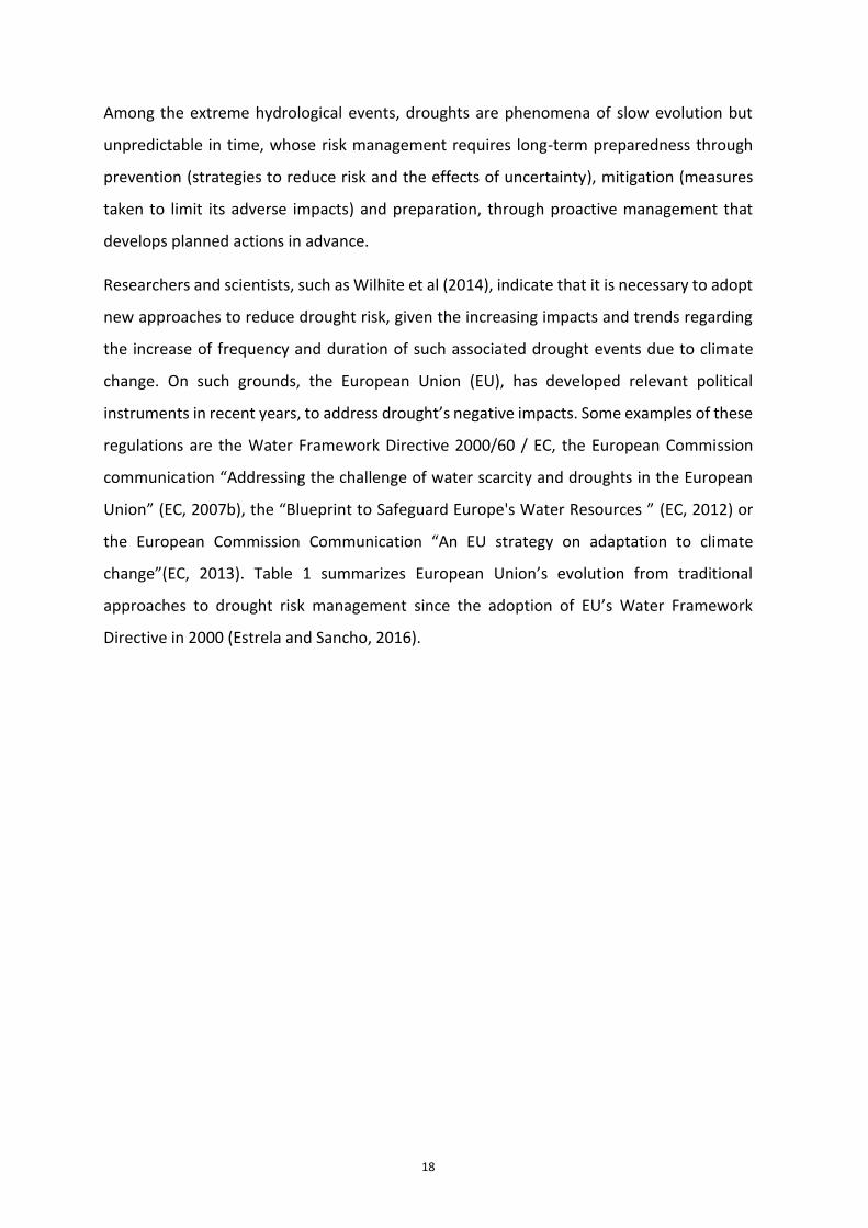
Figure 6. Hazard map of the Ebro river in Zaragoza (100 year return period flood)
3.3 Governance in the management of extreme hydrological events
Governance in the management of extreme hydrological events comprises the system of
stakeholders, mechanisms, regulatory and legal frameworks that guide coordinate and
supervise disaster risk reduction caused by extreme hydrological events.
OECD declares that investing in water security is a requirement for sustainable growth and
development. Risk management related to extreme events requires policy coherence in all
sectors, such as adaptation to climate change, water management and disaster risk
reduction.
In relation to floods, OECD (2019) has recently published the report “Applying OECD
Principles on Water Governance to Floods: A Checklist for Action (2019)”, where it states
that good governance implies an improvement in design, implementation and impact of
flood related policies. It also highlights the importance of including all stakeholders in
decision-making and in the need for increased coordination among all policies, especially
those of water, land management or climate change. Four years after the adoption of
OECD’s Principles on Water Governance in 2015 and within the framework of the
implementation strategy developed under the Water Governance Initiative, this OECD
(2019) report applies its 12 principles of governance to analyze 27 specific cases of flood

24
management worldwide, including a cross-border strategic flood management plan,
national policies and programs, regional, provincial and local flood management plans, as
well as research projects at national or basin levels.
Figure 7. OECD Principles of water governance. Source: OECD (2015) and www.oecd.org/governance/oecd-principles-on-
water-governance.htm
Below is a summary of the main results of the 2019 OECD report on the following aspects:
fragmentation, policy coherence, scale, stakeholder engagement and insurance.
Fragmentation: flood management strategies often occur in institutional frameworks that
present gaps, duplications, unnecessary delays, high transaction costs, irregular data and
lack of information in decision making. The report notes that, in general, administrations
and stakeholders share limited data. Only in 14 of the 27 case studies, information systems
and databases are shared systematically.
Policy coherence: policies regarding topics such as climate change, land management, the
environment, agriculture, urban development and infrastructure, have great influence on
flood management and are not yet sufficiently coordinated. The report shows that 22 of the
27 case studies have included the consideration of other sectors (infrastructure,

25
environmental protection and land management) in their strategies, but in 19 of the 27 cases
the inconsistencies of the sector policies led to increased costs, which could have been
avoided with better coordination.
Scale: Floods take place through administrative, hydrological and political boundaries. Policy
gaps are common in local and national frameworks, leading to an unclear assignment of
roles and responsibilities and which, together with the limited coordination between
different levels of government, makes difficult to apply integrated strategies to different
territorial, urban and rural scales. For example, in Australia, the responsibility for territory
and water management, and by extension, flood management, is regional. However,
activities related to flood management are carried out by municipal or local governments.
Stakeholder engagement: stakeholder platforms are key to promoting long-term flood
management plans and strategies. The participation of civil society can help bridge the gap
that public administrations sometimes have to properly manage floods, as evidenced by the
experience of Kampen, the Netherlands, where most stakeholders: governments, experts ,
users, owners and non-governmental organizations are generally involved in flood-related
decisions. However, the report also reveals that only in some cases, representatives of
groups such as women, the poorest local communities, indigenous populations, have been
involved repeatedly in such decision-making processes.
Insurance: Public and private insurance systems are insufficient and fail to integrate a long-
term vision to minimize the impacts of future floods. The lack of financial protection leaves
homes and businesses - and ultimately governments - exposed to a significant risk of
financial losses. An example that tries to close this gap is the German example "Floodlabel"
5, "A smart tool for governance towards flood-resilient cities" developed by insurance
companies and the German Flood Competition Centre (German Flood Competence Centre)
that uses a long-term mitigation approach to support and also guide home and building
owners to minimize the damage and harm caused by floods .
OECD’s main recommendations in this report are: to conduct self-assessments of
governance to identify what works, what doesn't, what needs to be improved and who can
5 https://jpi-urbaneurope.eu/project/floodlabel/

26
do what, promote multilevel governance to overcome fragmentation in flood management
; promote policy complementarity through sectoral policies; promote stakeholder
participation to carry out inclusive policies, strategies and plans; improve coordination at
local, regional, basin and national levels and promote financing mechanisms to facilitate
flood management.
4 Knowledge, technology and innovation
4.1 Hydrological and hydraulic models
The hydrological and hydraulic models defined for the study of extreme events are
constantly evolving. The increase in the computing capacity of computers occurred in recent
decades makes hydrological and hydraulic processes more accurately simulated, in the latter
enabling the use of three-dimensional (3D) models. In addition to the use of powerful
Graphical User Interfaces (GUI), its integration with Geographic Information Systems (GIS)
makes the models much friendlier than at the end of the last century, when they began to
be developed.
In the study of floods, the problems become increasingly complex, with greater influence of
environmental issues. In the European Union, since the beginning of the century, any
infrastructure project requiring hydraulic studies has undergone a revolution to adapt to the
objectives and principles of the Water Framework Directive and the Flood Risk Assessment
and Management Directive.
Hydrological models allow estimating the evolution of flow rates over time, based primarily
on rainfall data and the features and status of the basins. These flows constitute the main
input to the hydraulic models. One of the applications of hydrological models is the real-
time forecast of floods, which consists in estimating the future evolution of the flows in a
certain forecast horizon. For this, deterministic and stochastic rain-flow models are usually
applied. On the other hand, deterministic models require real-time flow and rainfall data
and usually perform automatic calibration of the model parameters to adjust the calculated
flows to those observed in successive time periods. The advances accomplished in short-
term weather forecasts (hours, days, ...) in recent years have been spectacular and the use
of radar has also been fundamental. Most national meteorological agencies have these
prediction models available.

27
The hydraulic modelling aims to obtain the values of the flood’s water levels and speeds of
the rivers at the study points. One-dimensional hydraulic models are applicable in situations
where the transverse component of the speed is zero or negligible. The use of 2D two-
dimensional models is essential in areas where the speed field is such that both the
component in the direction of flow and in the transverse direction have an important
influence, and occurs in cases such as large alluvial plains or in areas in which lateral
overflows may be relevant. Two-dimensional models solve the Saint-Venant equations in
the nodes of a calculation mesh generated from the topography, according to the finite
volume or the finite element methods. The model must be able to solve situations of change
of hydraulic regime and to deal with internal boundary conditions, in particular in areas of
lateral overflows in linear infrastructure embankments, bridges and weirs. Additionally,
models should be able to import and export information from/to Geographic Information
Systems (GIS).
In recent years, more and more 2D and 3D numerical models have been used, including new
features such as mixed flow regime, sediment transport, etc. One of the best well known
hydraulic models is the HEC-RAS model of the US Army Corps of Engineers. HEC-RAS is
designed to develop one-dimensional and two-dimensional hydraulic calculations for a
network of natural and artificial channels. It includes a user interface, hydraulic analysis
modules, storage and data management tools and reporting modules for the preparation of
graphs and reports.

28
Figure 8. Flow simulation in variable regime in one and two dimensions with HEC-RAS
The main applications of hydraulic models in flood studies are: the development of mapping
of flood areas (hazard and risk maps), the estimation of damage to the territory from the
water levels and speeds, the dimensioning of the linear infrastructures’ drainage works,
storage development in flood areas and riverbed refitting.
These models, surely complex, require not only programming and computer skills for their
elaboration, but also a thorough knowledge of the phenomena they represent, a selection
of the variables and parameters that are required for their operation, and an adjustment
and calibration agreement with the real experiences that are achieved through the
participation of expert engineers. Damage assessment, for example, is based on damage
curves that show the correlation between physical variables - such as the height of flood
water - and the damage suffered by an infrastructure or an affected property. The difficulty
lies both in assessing direct damages (tangible, of course, and intangible) and in assessing
indirect damages, including (or not) the costs of suspending the services provided by the
various affected assets, should these damage curves, obtained based on specific cases
studied, are really representative. The hydrological and hydraulic models developed by the

29
USA Army Corps of Engineers are a good example of the important role that engineering has
had in recent decades to the development and application of this type of models.
State of art on flood damage assessment
In recent years, with the conceptual shift from flood hazard control to flood risk
management policies, flood damage assessment gained increased importance (Merz et
al., 2010). Knowledge of expected or occurred damage in case of flood allows increasing
the efficiency of flood risk mitigation strategies, by overcoming the traditional
management approach based on established safety thresholds, and opening the doors to
actions focused not only on the reduction of the hazard but also on the exposure and
vulnerability components of risk (Plate, 2007).
In particular, before the occurrence of a flood, knowledge of expected damage is key to
identify the most efficient and feasible risk mitigation strategies on the bases of reliable
cost-benefit analyses, in which benefits can be identified as the expected avoided damage
due to the implementation of the strategy (Merz et al., 2010; Shreve and Kelman, 2014;
Mechler 2015 ). After the occurrence of a flood, a detailed survey of occurred damage is
critical to support the recovery phase, by both allowing the identification of needs for
recovery and reconstruction and as the basis of any compensation mechanism, be it
conducted by public or private organisations. Damage data collected in the aftermath of
floods are also needed to investigate flood damage mechanisms and their root causes, for
better calibrating risk assessments before an event so as to support preventive measures
(Ballio et al., 2015; De Groeve et al., 2013; De Groeve et al, 2014).
Next figure depicts the state of art of ex-ante damage assessment tools worldwide.
Columns report the different steps required by a comprehensive estimation of flood
damage: the evaluation of the elements exposed to risk, the estimation of their monetary
value, the evaluation of the direct damage they can suffer and, finally, the evaluation of
indirect damage due to the occurrence of direct one. Rows report instead the different
elements exposed to flood risk for which an estimation of the expected damage is
desirable. Dark green boxes indicate the existence of consolidated approaches, light green
boxes mean that no consolidated approaches exist, white boxes refer to the existence of
sporadic and preliminary studies or to the absence of approaches. The figure highlights

30
that most of consolidated tools refer to the estimation of direct damage to buildings
structure, being residential or commercial/industrial buildings. Less attention has been
paid to the estimation of exposure and direct damage to buildings contents, crops, roads,
population, cultural and environmental heritage, and strategic buildings. Very few studies
refer to the other exposed elements or to the estimation of indirect damage.
Figure 9. State of art of tools for ex-ante flood damage assessment worldwide
Above exposed elements, the residential sector is the one that received most of the
attention by the research community. According to Gerl et al. (2016), almost half of the
models developed for the estimation of flood damage in Europe rely on residential
buildings. Still, no model can be considered as a standard, being damage models
characterised by different levels of robustness and reliability. In such a context, the choice
of the more suitable model(s) to be implemented in a specific context can be challenging,
above all for non-expert users, and may imply significant errors in damage estimates if
done without a critical knowledge of models’ limits and usability. A key question concerns
the coherence between the scales of analysis. Damage models are usually developed and
validated to be applied at a specific scale (e.g. micro, meso) and can be unreliable when
implemented at different scales (see e.g. Jongman et al., 2012; Scorzini and Frank, 2017.,
Cammerer et al., 2013).
Regardless of which exposed element is considered, the lack of consistent and reliable
(damage) data on past flood events is the main limit to the development of (new) robust

31
and reliable damage models, hampering both the calibration and the validation process
of model development (Molinari et al., 2018). In fact, the standardising of flood damage
data collection procedures has been constantly advocated by the scientific community
(see e.g. Cammerer et al., 2013; Handmer, 2003; Rose, 2004; Downton and Pielke, 2005),
in order to create complete and reliable databases, on the basis of which flood risks
assessment and management can be effectively performed. Meanwhile, policy makers
recognized the collection of loss data as one of the key actions that will help countries to
increase their knowledge about natural risks, and to monitor their path towards risks
mitigation objectives (see e.g. the Sendai Framework for Disaster Risk Reduction). Still,
neither standards exist for loss data collection nor guidelines have been proposed for the
effective use of flood damage data for risk mitigation objectives. Experiences and best
practices of damage data collection, storage and analyses, at the worldwide level and with
particular reference to floods, can be found in Molinari et al. (2017), as a first step towards
standardization.
4.2 Hazard and flood risk maps
Hazard maps show information on flood water levels, flow rates and maximum speeds, wave
and tidal regime, as well as areas exposed to erosive processes and trends in rising mean sea
levels as a result of the change climate. This information is usually represented for different
flood scenarios: those of high probability (return periods of 10 or 25 years), those of medium
probability (return period of 100 years) and those of low probability or extreme event
scenario (period of 500 year return period).
For each of the above scenarios, flood risk maps prepared in EU Member States compliant
to the Floods Directive, must include the figures of the population and economic activity
affected, any facilities that can cause accidental pollution (IPPC industries and Wastewater
Treatment Plants, WWTP), protected areas for the collection of water intended for human
consumption, bodies of water for recreational use and areas for the protection of habitats
or species that may be affected , as well as any other relevant risk information, such as solid
transport or sediment flows.

32
Figure 10. Example of an area with significant potential flood risk: Porto-Vila Nova de Gaia, Portugal
Flood mapping project for key areas of China
In 2013-2015, China first launched a large-scale flood mapping project, with a total
investment of some 1.5 billion yuan from the central and local governments. With the aim
of providing basic support for flood control decision making, flood control project
planning, land use in flood control areas, flood impact assessment, enhance public
awareness on flood risks and flood insurance mechanisms, the project developed maps
for protected areas, flood areas, major cities and other types of areas identified in China's
flood control plan. The maps were prepared at the provincial, basin and state levels to
achieve systematic and integrated results.
The project completed the flood maps for a total of 574 units in China, including 227 flood
control protected areas, 78 flood arrest basins, 26 flood plains on major rivers, 45 major
cities, and 198 small river basins and medium, covering an area of 496,000 square
kilometers, and representing 48% of the total area exposed to flood control in China. At

33
the same time, the project formulated more than 10 technical documents, which included
detailed rules for the development of flood mapping and various regulatory documents
related to management. In addition to this, a “software” was developed for flood analysis
and its potential damage assessment. At present, China is working to apply the results of
the flood maps to the planning, formulation and review of flood control plans, to support
decision-making in flood management and control, to develop evacuation guidelines in
flood situations, to the evaluation of the impact of floods, to enhance land management
in flood areas, to foster public awareness of flood risks and to flood insurance.
4.3 Actions: technology and innovation
Technology and innovation are essential to the evaluation and management of risks due to
extreme hydrological events.
In order to properly assess and manage the risks of droughts in recent years, Decision
Support Systems (SAD) have been developed whose purpose is to simulate in a sufficiently
detailed way the flows that run through rivers and canals, storage in reservoirs, the status
of aquifers or the supply schemes to users that would occur for a future horizon, taking into
account different hydro-meteorological scenarios, water demands and adopted measures.
One of the main uncertainties of the risk analysis is due to ignorance of the future hydro-
meteorological scenario. Traditionally, in the absence of adequate forecasts, future hydro-
meteorological scenarios used in drought management have consisted of the establishment
of standard years (dry, normal, wet) or any year that could be relevant for the analysis, such
as corresponding to the last important drought. The results obtained through these
procedures have low reliability due to the ignorance of future hydrology. In recent years,
important technological advances have allowed quantifying these uncertainties, such as the
AQUATOOL Decision Support System developed in Spain.
Drought risk management through the AQUATOOL Decision Support System
The Department of Hydraulic and Environmental Engineering of the School of Civil
Engineering of the Universitat Politècnica de València in Spain, has developed during the
last decade models and Decision Support Systems (DSS), some of them through the

34
AQUATOOL environment (Andreu et al, 2009), which allow to simulate the behaviour of
the basins and the management of their water resources operation systems incorporating
all the complexities they have (available resources, water demands, infrastructure
(reservoirs, canals, WWTPs, ...), returns of water uses, ...). These developments have been
firstly applied to the Júcar river basin, but have also been applied to other Spanish basins.
Júcar basin authority provides a methodology that allows a thorough estimation of
uncertainty and a probabilistic quantification of the evolution of the hydrological variables
and metrics for any month of the future scenario such as, of probabilities of supply deficit
in the supply of a certain amount at a certain demand, or the probability of exceeding a
water storage threshold volume of water stored in a specific reservoir. This methodology,
based on synthetic generation of flow series (Q) using stochastic ARMA models and
multiple simulation models (Andreu et al, 2006), is incorporated into the AQUATOOL
Decision Support System with a specific module (SIMRISK, SR) that performs all the risk
assessment process, which was successfully applied during Júcar basin’s 2005-2008
extreme drought, providing useful information for the meetings of the Permanent
Drought Commission that was established for this task (Andreu et al., 2013 ).
Figure 11. The AQUATOOL software6 developed at the Universitat Politècnica de València, Spain
6 https://aquatool.webs.upv.es/aqt/aquatool/

35
4.4 Advances in warning systems
Warning systems in the management of extreme hydrological events are a fundamental part
of good risk management and governance. They have been evolving since the end of the last
century, taking advantage of the greater capabilities of computer hardware, the
development of friendly Graphical User Interfaces (GUIs), the increasing implementation of
Geographic Information Systems (GIS) and remote sensing or the development of
telecommunication systems increasingly reliable and at a lower cost. The advances in
mathematical modelling of extreme hydrological events have also contributed to this
evolution.
Flood warning systems are a set of elements that allow real-time rainfall monitoring, its
transformation into runoff and eventual flooding that can be generated in the channels.
Spain is a pioneer country in the implementation of Decision Support Systems such as the
Spanish Automatic Hydrological Information System (SAIH) in all basins. SAIHs have been
very effective in flood management at the basin level, since, providing real-time information
on the flows that run through the rivers and the state of the reservoirs, decisions have been
made, with sufficient time to mitigate its effects. To achieve this, management models are
used at the basin level to anticipate the future situation in different parts of the basin,
coordinating any necessary action with Civil Protection officials.
Drought warning and monitoring systems use different types of indicators depending on the
type of drought (Ortega-Gómez et al, 2018). In meteorological droughts the most popular
index worldwide is the Standard Precipitation Index (SPI), while in agricultural droughts the
Palmer Drought Severity Index (PDSI) has been traditionally used, which is the result of the
balance of moisture in the soil from precipitation, air temperature and local soil moisture,
together with its background values. In recent years, indexes based on remote sensing are
increasingly being used, such as the NDVI (Normalized Difference Vegetation Index). The
reflectance for different spectral resolutions reflects the vigour of the vegetation, which is
closely related to soil moisture. Other indexes are also used, such as percentiles for
hydrological droughts or those that take into account the availability of resources and water
demands to track operational droughts, which are those that affect water resource systems.

36
The incidence of drought in Europe during the twentieth century was studied by Lloyd-
Hughes and Saunders (2002) on the basis of the monthly values of the Standardized
Precipitation Index (SPI) calculated on a 0.5º cell resolution across Europe for the period
1901-99. More recently, other indexes such as the Reconnaissance Drought Index (RDI),
based on precipitation and evapotranspiration, have been applied in Europe (Vangelis, H. et
al., 2011). The drought indicators used in water resources management reflect whether it is
possible to meet water demands in situations of reduced water availability and, at the same
time, serve as an aid in decision-making related to water resources management in those
situations.
In the world, different information and decision support systems have been developed that
handle such indicators. Thus, in the European Union in 2011 the European Drought
Observatory (EDO) was established by the Joint Research Center of the European
Commission as part of its efforts to integrate droughts into water policy in the European
Union. EDO’s main objective7 is to improve knowledge of droughts using alert systems and
properly prepare water authorities and managers for drought. Since 2011, EDO has been the
main diffuser of relevant information on droughts in the EU, and as maps of drought-related
indicators that use different data sources: rainfall, satellite measurements and simulations
of soil moisture content, among others. EDO integrates such relevant data, drought
monitoring indicators, information on detection and forecasting of droughts at different
spatial scales, from local and regional to the general overview of the entire EU (Estrela and
Sancho, 2016).
5 Experiences and best practices
5.1 Risk management plans: floods and droughts
5.1.1 Risk Management Approach
The risk approach has become an increasingly widespread practice in many fields of science
and engineering, not just droughts and floods. Disaster risk reduction seeks to prevent new
risks, reduce existing risks and manage residual risk. Addressing the risks of these extreme
phenomena in a planned way allows studying, analysing and agreeing on measures with all
7 https://edo.jrc.ec.europa.eu

37
interested stakeholders, and managing the corresponding risk in advance, assessing their
consequences from all points of view. In recent years, evaluation and management plans for
flood and drought risks have been developed.
5.1.2 Flood risk management plans
The approach based on flood risk planning and management has spread worldwide in recent
years. In the European Union, as a result of the application of the 2007 Floods Directive,
flood risk management plans in river basin districts have been approved in 2015, covering
all aspects of risk management, focusing in prevention, protection and preparation (what is
known as the 3 Ps), including flood forecasting and the development of early warning
systems. These plans may include the promotion of sustainable land use practices,
hydrological-agroforestry restoration measures, improved water retention and controlled
flooding. A fundamental element of these plans is to establish programs of measures that
allow reducing the risk against floods based on the hazard and risk maps issued. Another
relevant element introduced by the European Floods Directive is that structural measures
require a prior cost-benefit analysis.
Elsewhere in the world, such as Japan, acknowledged to withstand several different types of
natural disasters, flood risk management has also been extended. Japan's ability to manage
urban flood risks has been greatly strengthened in the recent years, with an integrated
management approach, which brings together all stakeholders and includes different
measures to manage flood risks: regulations, plans, advanced infrastructure solutions and
coordination and communication mechanisms. The main lessons derived from the
experience of Japan are 8 : a) Risk assessment approaches must take into account the type
of flood and basin features, reflecting the needs and objectives of all stakeholders and
explaining the uncertainty due to climate change, b) National government plays an
important role in supporting local governments in planning and prioritizing actions, although
the latter have an important function of seeking consensus among all interested parties, c)
Implementation of investments’ measures, whenever possible, should include
multifunctional systems that provide complementary other than managing flood risks and
8 https://blogs.worldbank.org/sustainablecities/integrated-urban-flood-risk-management-learning-japanese-experience

38
d) It is necessary to design and implement transparent governance mechanisms. Finally, the
evaluation, control and monitoring of the measures is essential.
5.1.3 Drought Management Plans
Drought reduces water availability and makes it difficult to match demands and
environmental objectives in bodies of water. Experience has shown that those who plan the
response to drought events suffer less negative impacts than those who react when the
disaster is upon them.
In the United States of America (USA), the National Drought Mitigation Center (NDMC) has
developed guidelines that facilitate the development of drought management plans.
According to these guidelines in the planning process, the first steps should try to ensure
that the right people meet, that they know the objectives of the drought plan and that they
are provided with adequate data to make fair and equitable decisions when formulating the
plan. Next, an organizational structure must be developed to carry out the tasks required by
the plan, which must always be understood as a process. During this step, a risk assessment
should be carried out for key economic sectors, population groups, regions and
communities. The last steps refer to the need for continuous research and coordination
between scientists, managers and policy makers. Finally, the plan must be kept updated,
being very important to evaluate its effectiveness in post-drought periods (NDMC, 1990).
In the USA, since the end of the 20th century to the present, drought management plans
have been developed in most of the States of the Union, the most recent plans being those
developed in 2018 in the States of Alabama, Colorado, Connecticut, Maryland, North
Dakota, Pennsylvania and Washington 9.
In the European Union and within the Common Strategy for the Implementation of the
Water Framework Directive, in 2007 the European Commission prepared the technical
report “Drought Management Plan Report, including agricultural, drought indicators, and
climate change aspects” (European Commission, 2007a ), whose main objective is to serve
as a useful tool to prepare drought management plans in the Member States of the
9 https://drought.unl.edu/droughtplanning/Plans/StatePlans.aspx

39
European Union, establishing general criteria and recommending the application of a
battery of measures (Estrela and Vargas, 2012).
The development and implementation of drought management plans in the Member States
of the European Union has not been extended to all river basin districts and this may have
been due to the fact that there is no compulsory commitment to carry them out in the Water
Framework Directive. There is only one recommendation for its development in the
European’s Commission Communication “Addressing the challenge of water scarcity and
droughts in the European Union” (European Commission, 2007b), where drought
management plans are identified as one of the main instruments of EU’s Water policy to
fight droughts.
Despite this, it can be said that the development of these plans is receiving increasing
attention by the Member States. Hervás-Gámez and Delgado-Ramos (2019) indicate that 78
European River Basin Districts (42%) have implemented Drought Management Plans (DMP)
(or similar tools) or have included them in the Program of Measures of its River Basin
Management Plans, RBMP. For example, in Cyprus, DMPs are included as an annex to the
RBMP, while in Spain the last approved DMPs have been developed as complementary
documents to the RBMP. On the contrary, United Kingdom private water supply companies
are obliged to develop Water Resources Management Plans and DMP. France and the
Netherlands have their own operational drought management tools. Other countries have
developed tools focused on emergency management or specific early warning systems.
Cooperation in the planning and management of droughts in the Iberian Peninsula
The planning and management of droughts in the Iberian Peninsula are compliant to the
requirements of the EU’s Water Framework Directive of the year 2000 and in the
European Commission’s Communication Shortage and Droughts (EC, 2007). Drought
planning and management requires joint cooperation between Portugal and Spain, since
the river basins shared between the two countries represent 45 percent of the territory
of the Iberian Peninsula. The harmonization of drought policies of both countries is carried
out through the existing bilateral agreement on the management of river basins, the
Albufeira Covenant, signed in 1998. This agreement establishes the flows that must
40
circulate through the main rivers in periods of drought depending on the status of a series
of indicators set in the agreement itself.
Although the two countries have been cooperating and working to achieve joint
management of shared basins, they are currently at different stages in drought planning
and management. According to Maia and Vicente-Serrano (2017), the drought
management policy in Spain is based on a proactive and planned approach, while
Portugal’s drought management plans have not yet been approved.
Drought management plans in Spain
The heavy impact brought by the drought that struck Spain in the period 1991-1995
contributed to a paradigm shift in drought management. Then, it came clear to establish
an instrument such as Special Drought Plans (PES), which allowed managing drought
minimizing its socio-economic and environmental impacts, and which meant a change
from the traditional approach of crisis management through emergencies (Estrela y
Sancho, 2016).
Thus, Spanish Act 10/2001, of 5 July established through its National Hydrological Plan the
basis for a planned drought management, indicating that: a) the Ministry of Environment
would establish a global system of hydrological indicators to prevent drought situations
that will serve as a general reference for its formal declaration, b) the Basin Organizations
would develop special action plans to address eventual drought situations and c) the
Public Administrations responsible for supplying populations over 20,000 inhabitants
would develop emergency plans for drought situations.
Drought management plans in Spain are drafted by the River Basin Authorities and come
into force when approved through ministerial order. These plans have been developed in
all the State managed river basins. Recently, such plans have had its review updated in
2018 through ministerial order. With these special plans, a monthly series of hydrological
indicators is set up which diagnoses the situation and specifies the result in a summary
map published by the Ministry for Ecological Transition, through its web portal.

41
The basic contents of PES include the drought’s features and diagnosis, the system of
threshold indicators to establish scenarios of prolonged drought or temporary shortage,
the measures and actions to be carried out in the different phases of drought and scarcity,
drought monitoring and post-drought reporting, which would include the evaluation of
socio-economic and environmental impacts and serve as a reference framework for the
preparation of emergency supply plans.
In this regard, it should be noted that the Spanish Association of Supply and Sanitation
(AEAS) has prepared a Guide (AEAS, 2019) to facilitate water supply utilities the review of
their current emergency plans.
Figure 12. Drought Indicators Monitoring map in Spain, July 2018..
Lessons learnt so as not to repeat the same mistakes: La Paz Drought Management
Special Plan in Bolivia
The water supply to the urban conglomerate La Paz - El Alto and nearby towns is provided
by four hydraulic infrastructure systems: 1) Pampahasi system: its supply sources are the
reservoir waters in two contiguous sub-basins, 2) El Alto system: its main supply source is
Tuni dam’s water reservoir, 3) Tilata system its supply source of supply is Pura Purani’s

42
aquifer, located on Bolivia’s plateau and 4) Achachicala system: its main supply source is
the Milluni dam.
The water supply to La Paz - El Alto and adjacent towns went through a serious supply
crisis during a period that began in November 2016, because of the low rainfall recorded
in the preceding months. This situation caused supply restrictions, since the small
available reserves did not guarantee the normal provision of this service. These restriction
measures were accompanied by other emergency actions, such as interconnection works
between different sections of the distribution network, transportation of water tanks, etc.
The consequences of the unplanned management of a crisis of this nature were, among
others, the sudden impact of its effects, the perplexity and lack of preparation of society
to face it, the greater cost and inefficiency of the measures or the remaining situation of
vulnerability to future episodes.
Bolivia’s Ministry of Environment and Water, with the consultancy of the Spanish Agency
for International Development Cooperation (AECID), considered the drafting of a Special
Drought Management Plan, whose objective was the early preparation for future
droughts, limiting its adverse impacts on the economy, social organization and the natural
environment. This plan was established in accordance to the following procedure: a)
definition of mechanisms for forecasting and detecting the occurrence of drought
situations, through an adequate system of indicators, b) determination of threshold
values for monitoring the evolution and intensity of drought, c) definition of the measures
to achieve the specific objectives in each phase of the drought situations, depending on
the status of each system: demand management measures, connection infrastructures of
the Achachicala-El Alto systems and the Tilata-El systems Alto and new additional wells of
the Purapurani aquifer and d) ensure transparency and public participation in the
development of the plans.

43
Figure 13. Tuni reservoir with a capacity of 21.55 Hm3. In operation since 1977
5.2 Measures to deal with flood risks
Measures to deal with flood risks must be identified, prioritized and implemented once the
existing risk is well known and therefore, as already indicated, the development of hazard
and risk maps becomes essential. There are a large number of measures, which classify into
structural protection measures and management or non-structural measures. OECD (2019)
recognizes that "hybrid" solutions combining structural and management measures are
required to address in the most effective way the protection against floods and that
contribute to achieving the good state of water bodies.
Flood risk management and ecosystem restoration at Johnson Creek in Arlington, Texas,
USA
Johnson Creek has experienced a history of flooding, bed erosion and habitat degradation
over the past 60 years, which led to different studies to reduce damage. Economic analysis
showed that it was less expensive to restore flood plains along Johnson Creek, where
homes and businesses were flooded every year, than to annually repair any damaged
infrastructure.

44
Figure 14. Johnson Creek River Basin
The United States Army Corps of Engineers implemented a multi-objective flood risk
management and ecosystem restoration project. Ecosystem restoration alternatives
included the protection of the margins, the design of a natural canal to protect and expand
the riverside corridor, the improvement of the aquatic habitat and the establishment of
wetlands. Non-structural measures include the acquisition and elimination of structures,
while the main structural measure was the channel modification. Thus, 140 residential
structures were acquired and removed from the floodplain corresponding to a 25-year
return period and 155 acres of land were acquired for restoration. The recreational
component of the project consisted on the construction of several trails, walkways and
picnic spots (USA Army Corps of Engineers, 2009).
5.2.1 Structural Protection Measures
Structural measures address the execution of infrastructure works which impact the
mechanisms of generation, action and propagation of floods, altering their hydrological or
hydraulic characteristics. Among the structural measures are those that reduce the

45
magnitude and frequency of flooding, such as flood rolling dams or diversion channels to
alternative channels or to the sea. Other measures modify the level of flooding, such as
embankments and dykes and protective walls or other actions on the channel section. There
are also some other measures which modify the duration of the flood, such as the drainage
works of the linear infrastructures (roads, railways, ...).
5.2.1.1 Flood control reservoirs
Flood control reservoirs hold part of the flood volume decreasing its peak flow rates. In many
river basins, with very irregular regimes, reservoirs constitute a very effective protection
against floods, through the management of seasonal safeguards to reduce peak flows. In
this way, the danger and risk of flooding reduces, while maintaining the same vulnerability
and exposure in all potentially affected assets downstream of these reservoirs.
Flood risk protection through reservoirs flow management. Case of the Ebro basin, Spain
In the Ebro river basin, numerous reservoirs contribute to the reduction of the danger of
flooding episodes, through the management of existing reservoirs and the coordination
of intakes and discharges so as not to overlap flood points. In this management, the
engineers of the Ebro River Basin Authority (world’s first basin authority) take advantage
of the real-time data offered by the SAIH (Automatic Hydrological Information System) to
adjust the discharges to the damage thresholds’ reference flows of at significant points in
the basin.
As an example, the operation of the Yesa and Itoiz reservoirs (in the Aragón rivers and its
tributary the Irati, respectively) safeguards the city of Sangüesa, located at the confluence
of both rivers, at another time hit by floods, contributing decisively to the protection of
the city of Zaragoza, the capital of the Ebro, located downstream from Aragón river
outtake to the Ebro river itself.

46
Figure 15. Rolling of the Aragón river flood as it passes through Sangüesa due to the water held in the Yesa
and Itoiz reservoirs
Figure 16. Ebro river flood episode as it flows through the city of Zaragoza
5.2.1.2 Diversion channels
One alternative to reduce flood flows is to offer a different route for excess water by creating
artificial channels which drive the flow to less vulnerable areas. Diversion channels are not
carried out much in the present due to environmental considerations and the potential risk
increase in the flow’s diverted areas. A clear example of diversion channel can be observed

47
is the of river Turia’s diversion channel to the sea in the city of Valencia, Spain, which was
built in response to the Turia river 1957 floods. This man-made channel takes the flows of
the Turia river to the South of the city, an area where land use is much less vulnerable than
those on the banks of the natural channel (EEA, 2001).
Figure 17. River Turia’s diversion channel. Source: Sustainable water use in Europe. Part 3: Extreme hydrological
events (EEA, 2001)
5.2.1.3 Embankments and dykes
Embankments are linear structures parallel to the main channel widely used to protect
already consolidated urban areas. However, this type of action increases the level in the
channel section and, consequently, the greater speed and water level in the embanked area
infers a greater risk of flooding downstream. Embankments’ other negative aspects are their
frequent breaks (large length, lack of maintenance, regrowth, etc.) or their becoming an
obstacle to tributaries and runoff drainage. In addition to this, any spill or break entails
higher flood risk.
The first dikes reported were built in the Indus Valley (around 2600 BC), on which the
agrarian life of its inhabitants was built upon. Also more than 3,000 years ago in ancient
Egypt, a levee system was built along the left bank of the Nile River with more than 970 km,
from Aswan to the Nile Delta in the Mediterranean. Mesopotamian civilizations and ancient
China also built large levee systems. Much recent and important levee systems are those
along the Mississippi and Sacramento rivers in the United States, and Po, Rhine, Meuse,

48
Rhone, Loire, Vistula and Danube rivers Europe, with special attention to the Rhine , Maas /
Mosa and Scheldt delta in the Netherlands.
The Mississippi levee system represents one of the largest levee systems in the world,
comprising over 5,600 km of dikes, with an average height of 7.5 m. Dike’s break can happen
due to multiple factors, including overflow, erosion, structural breaks or dike saturation. The
most frequent and dangerous are dike break which would leave a large breach for water to
flood the earth that would be be protected by the dike otherwise.
Figure 18. Sacramento River’s dyke break
5.2.1.4 Channel modification
The modification of the channels’ cross-section intends to improve its hydraulic capacity by
an increase in the cross-section surface (increase in width and / or depth) or speed (greater
slope: meander cuts, decrease in roughness). However, it has negative aspects, such as the
increased risk of flooding downstream, impacts on the river ecosystem and changes to the
geomorphological balance.

49
These actions, due to the drawbacks they present, are only really justified in already
consolidated urban areas or in certain cases of river channels’ affected by the construction
of some transport infrastructure. However, in the past, such measure has also been used to
protect arable land. As in the case of embankments and dikes, it is desirable that its design
to be as natural as possible, with at least two different channel widths to address small and
larger floods events.
Figure 19. Channeling the Ebro river in Castejón for its 5-year return period flow
5.2.1.5 Drainage of linear infrastructures
Transport infrastructures, due to their great length, affect numerous waterways, small or
even intermittent, large rivers and very flat areas with diffuse natural drainage. All these
factors are decisive when designing the transverse drainage of the infrastructure.
The purpose of transverse drainage is to restore the continuity of the natural drainage
network of the land (troughs, channels, etc.), allowing the design flow to run through it. The
importance of an adequate design of these works becomes more critical, since, during flood
emergency situations, it is essential that transport infrastructures allow the evacuation and
arrival of aid elements to mitigate their effect.
In the great channels, the main problem that usually occurs is that of the erosion of the river
bed caused by the barrier effect to the flow of water generated by the bridges’ piles and

50
abutments, in addition to the possible narrowing of the water depth during flood episodes
if the abutments are not the out of the riverbed’s core.
Figure 20. Viaduct over Chanza river
In small and intermittent channels, in addition to the previous considerations, it is important
to take into account that their dimensions should allow the passage of trees and vegetation
remains that flood flows carry usually. When the area affected by the infrastructure is very
flat, without defined channels for water circulation, the problem becomes quite complex
and almost the only solution is to determine the possible level that the water could reach
with 2D hydraulic models and then define the level from the slope of the infrastructure and
permeabilize as much as possible the entire linear infrastructure’s route of the same, to
create a kind of communicating vessels network between the areas in which the
infrastructure divides the plain.

51
Figure 21. Small Drainage Work (SDW) on an embankment
5.2.1.6 Green infrastructure and natural water retention measures
Basins which host many flood protection infrastructures have, in many cases, lost the
connection between rivers and floodplains, which has resulted in significant decreases in
river productivity and biodiversity. As a matter of fact, species which are part of freshwater
ecosystems are in greater danger of extinction than terrestrial or marine species, largely due
to the fragmentation of habitats and changes in inflows caused by infrastructure.
Therefore, flood plains face two major challenges to achieve sustainable flood risk
management: develop actions to reduce flood risk and at the same time maintain or restore
connections between rivers and its flood plains (European Environment Agency, 2016).
Although these objectives seem incompatible at first glance, the approach to flood risk
management based on green infrastructures tries to make them compatible. Unlike classical
engineering infrastructures for protection against floods, green infrastructures entails
restoration or conservation of forests, wetlands, rivers and floodplains.
Natural water retention measures (NWRM) constitute an innovative approach to achieve
water management objectives by restoring nature and its functions. NWRMs are not only
means to produce a single benefit, such as flood protection, but they are accompanied by
others, such as increased biodiversity, greenhouse gas mitigation, energy savings or
opportunities for rural development, which affects many people whose well-being is directly
and indirectly improved (European Commission, 2015).
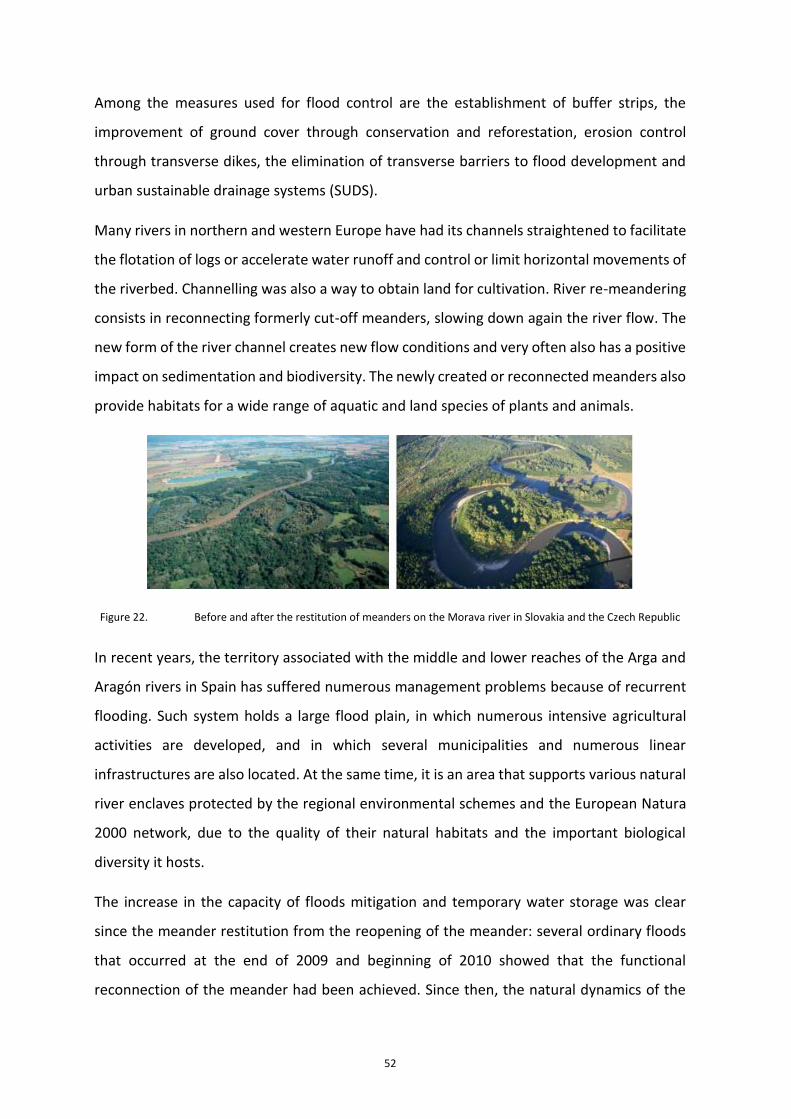
52
Among the measures used for flood control are the establishment of buffer strips, the
improvement of ground cover through conservation and reforestation, erosion control
through transverse dikes, the elimination of transverse barriers to flood development and
urban sustainable drainage systems (SUDS).
Many rivers in northern and western Europe have had its channels straightened to facilitate
the flotation of logs or accelerate water runoff and control or limit horizontal movements of
the riverbed. Channelling was also a way to obtain land for cultivation. River re-meandering
consists in reconnecting formerly cut-off meanders, slowing down again the river flow. The
new form of the river channel creates new flow conditions and very often also has a positive
impact on sedimentation and biodiversity. The newly created or reconnected meanders also
provide habitats for a wide range of aquatic and land species of plants and animals.
Figure 22. Before and after the restitution of meanders on the Morava river in Slovakia and the Czech Republic
In recent years, the territory associated with the middle and lower reaches of the Arga and
Aragón rivers in Spain has suffered numerous management problems because of recurrent
flooding. Such system holds a large flood plain, in which numerous intensive agricultural
activities are developed, and in which several municipalities and numerous linear
infrastructures are also located. At the same time, it is an area that supports various natural
river enclaves protected by the regional environmental schemes and the European Natura
2000 network, due to the quality of their natural habitats and the important biological
diversity it hosts.
The increase in the capacity of floods mitigation and temporary water storage was clear
since the meander restitution from the reopening of the meander: several ordinary floods
that occurred at the end of 2009 and beginning of 2010 showed that the functional
reconnection of the meander had been achieved. Since then, the natural dynamics of the
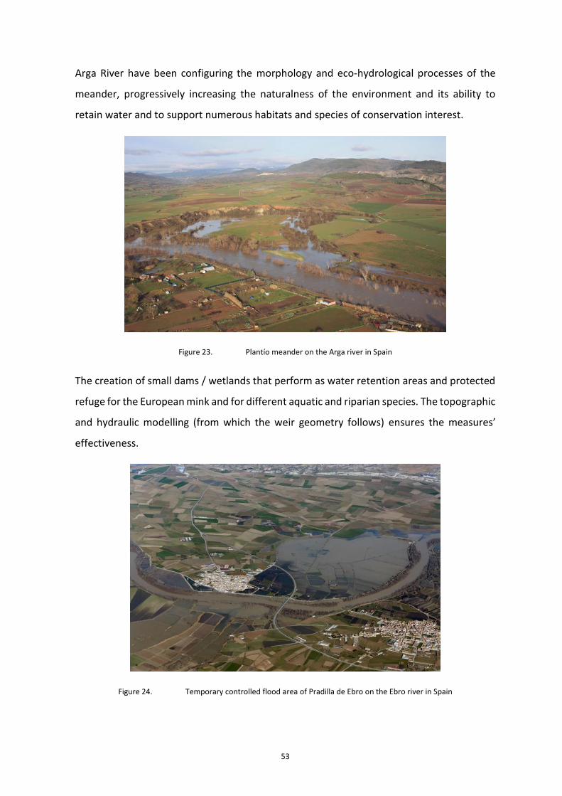
53
Arga River have been configuring the morphology and eco-hydrological processes of the
meander, progressively increasing the naturalness of the environment and its ability to
retain water and to support numerous habitats and species of conservation interest.
Figure 23. Plantío meander on the Arga river in Spain
The creation of small dams / wetlands that perform as water retention areas and protected
refuge for the European mink and for different aquatic and riparian species. The topographic
and hydraulic modelling (from which the weir geometry follows) ensures the measures’
effectiveness.
Figure 24. Temporary controlled flood area of Pradilla de Ebro on the Ebro river in Spain

54
Nature-based solutions to prevent urban flooding
Sustainable urban drainage systems (SUDS) are an alternative approach to urban drainage.
These innovative systems can be considered as a supplement for conventional drainage
networks, and they help to control urban runoff using technics that replicate the nature
behaviour (nature-based solutions) in the scenario prior to urban development, using
elements that are harmonically integrated in the urban landscape.
SUDS should start being applied where the runoff is produced and before it starts to become
an issue: roofs, impermeable areas, gardens, plazas, roads… The main principle of this
approach is to contain and store the runoff at source, for example, infiltrating and storing
stormwater in the public and private green areas. This way, SUDS are able to achieve three
objectives: firstly, they can reduce overall runoff volume infiltrating part of it; additionally,
they are able to improve water quality treating physically and biologically the runoff; and
finally, they can attenuate and reduce peak flows, preventing downstream flooding.
Sustainable Development Goals (SDG) from the United Nations (UN) are seeking for a more
sustainable world by 2030. As expected, many of these goals are water and environment
related, and they aim to improve water quality or to optimize water resources. SUDS are a
key tool to achieve these goals, as they are able to treat water and improve its quality, they
can boost biodiversity and help to prevent flooding issues in cities.
In addition to the continuous growth of the cities, climate change is causing high
temperatures and extreme rainfalls. These factors are increasing the risk of urban flooding,
and sizing up existing networks is not a feasible solution from the economical, technical and
environmental perspective.
In conclusion, SUDS constitute an interesting nature-based solution for urban drainage,
being able to solve part of the problems on the existing drainage networks by attenuating
and reducing the runoff volumes. 2018 World Water Day´s slogan, ”Nature for water”,
highlights the importance of replicating hydrological natural processes. As a nature-based
solution, able to replicate infiltration, evapotranspiration or detention, SUDS constitute an
innovative approach for urban drainage.

55
Although SUDS are a quite recent practice (few decades), there are already really good
examples of SUDS utilisation in various cities around the world.
For example, in 2010 the Green Infrastructure Plan was approved in New York. The main
goal of this plan was to capture and retain 25mm of rainfall using sustainable drainage
systems, in at least 10% of the impermeable areas served by combined sewers (City of New
York – DEP, 2016). By the end of 2015, more than 2,500 rain gardens able to store and treat
runoff from footpaths and carriageways were already constructed, and there are several
regeneration projects currently running that involve more than 250 public assets and 29
parks.
Also in the USA, in 2012 Washington DC’s government prepared a plan to deal with climate
change effects. One of the main goals of this programme was to reduce the impact of
climate change on the existing drainage networks, preventing long-term urban flooding
issues. To achieve this, by 2032 75% of the rainfall events should be captured for infiltration
or storage for re-use (District of Columbia, 2013). Helping to reach these targets,
government published Greening DC Streets: a design guidance for green infrastructures in
the urban landscape (bio-retention strips, permeable paving, infiltration features), which
contains sketches, specifications and O&M plans.
Figure 25. Bioretention planter with step-out zone in Washington DC. Source: Green Blue Management S.L.

56
SUDS are also appearing in Europe, Oceania and Asia. Between 2011 and 2014, several
Chinese cities had flooding issues and as a consequence, Chinese government developed
the Sponge City Programme, which aims to stir up urban drainage management, ensuring
that the urban landscape is able to absorb, store, infiltrate and treat water for re-use.
According to this programme, by 2020, 80% of the urban areas should be ready to store and
re-use at least 70% of the rainfall (Dai, 2017). Wuhan was selected as one of the pilot cities
due to the risk of flooding in this area, and the SCP has developed several projects around,
including the Garden Expo Park, a very popular leisure area constructed on top of a landfill.
In the last decade, SUDS are also emerging in Spain. The Spanish civil engineering magazine
“Revista de Obras Públicas” (edited by Colegio de Caminos, Canales y Puertos), on the March
2019 issue, contains more than 20 articles on sustainable drainage experiences. Cities like
Madrid (where it is worth to highlight the Wanda Metropolitano stadium permeable
parking), Barcelona (that created a SUDS commission within several city departments),
Sevilla (that has a restriction on stormwater flows connecting to the municipal sewer
system), Benaguasil (a 11,500 inhabitants town than holds the 2015 national award to the
most sustainable city in water management), an others like Vitoria-Gasteiz, Santander or
Valencia, count with a number of SUDS projects.
An example of these interventions can be found in the Barcelona Bon Pastor district, which
incorporates SUDS to control urban runoff. As part of the plan, different SUDS were
integrated in the urban landscape, being able to collect and treat runoff from the paved
areas nearby and from the new buildings. Streets and pedestrian areas have incorporated
bioretention areas, rain gardens, permeable paving, and structural soil along the tree
alignments (Soto-Fernández and Perales-Momparler, 2018).

57
Figure 26. SUDS in Bon Pastor, Barcelona. Source: Soto-Fernández and Perales-Momparler, 2018
5.2.1.7 Hydrological restoration and flood zone measures
The measures for the hydrological-agroforestry restoration of basins try to reduce the solid
load carried by the river flow, as well as to favour the rainfall infiltration.
5.2.2 Non-structural or management measures: prevention, alert and response
Non-structural or management measures are those that, without acting on the flood itself
or on the action of the sea, modify the exposure of the flood zone to flood damage. In
Europe, the Floods Directive has placed emphasis on prevention, forecasting, protection and
non-structural measures. The main non-structural or management measures are the
adaptation measures for potentially affected assets, the territorial and urban planning
measures, the flood warning systems, the civil protection measures and the flood insurance
promotion
5.2.2.1 Adaptation measures for potentially affected assets, for damage miti-gation
The damages to flood affected assets and elements, and whose withdrawal is not feasible
are to be identified, classified, studied, and promoted adaptation action. Its objective is to
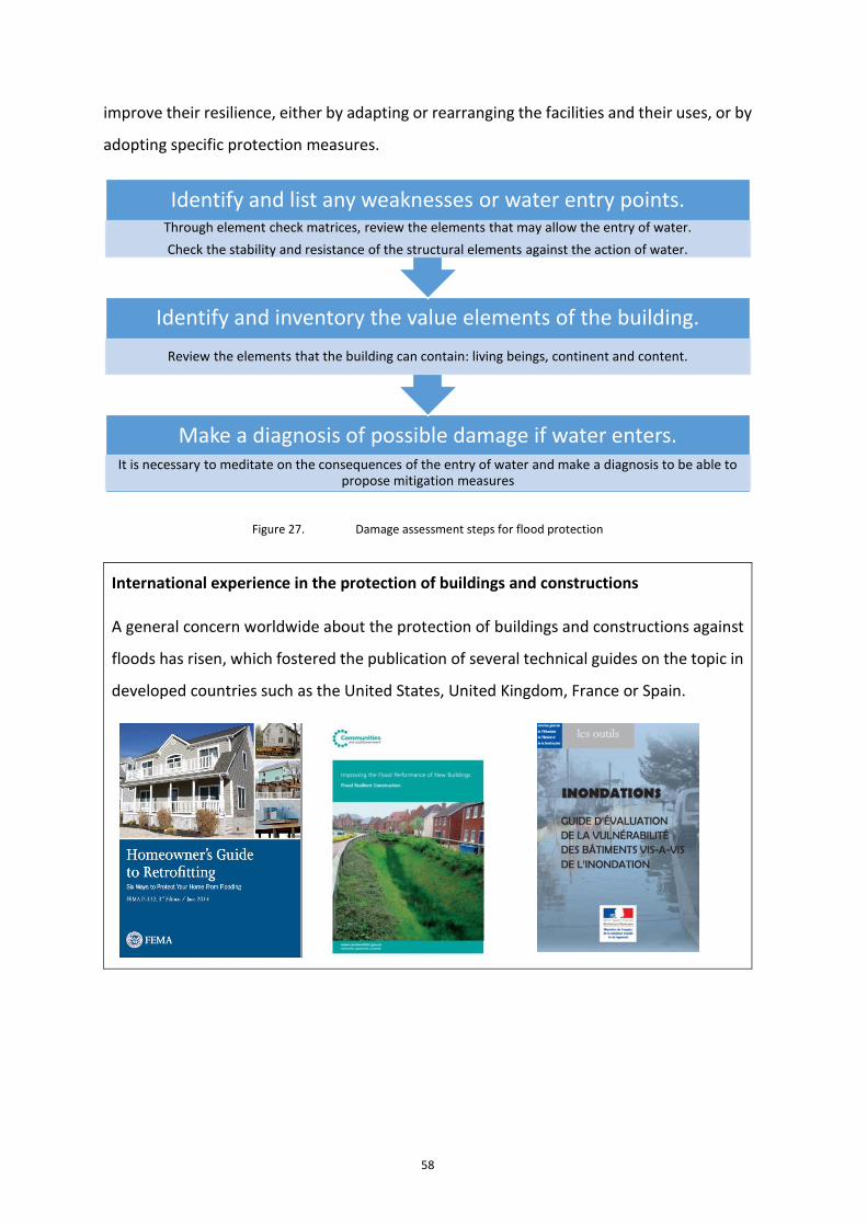
58
improve their resilience, either by adapting or rearranging the facilities and their uses, or by
adopting specific protection measures.
Figure 27. Damage assessment steps for flood protection
International experience in the protection of buildings and constructions
A general concern worldwide about the protection of buildings and constructions against
floods has risen, which fostered the publication of several technical guides on the topic in
developed countries such as the United States, United Kingdom, France or Spain.
Make a diagnosis of possible damage if water enters.It is necessary to meditate on the consequences of the entry of water and make a diagnosis to be able to
propose mitigation measures
Identify and inventory the value elements of the building.
Review the elements that the building can contain: living beings, continent and content.
Identify and list any weaknesses or water entry points.Through element check matrices, review the elements that may allow the entry of water.
Check the stability and resistance of the structural elements against the action of water.

59
Figure 28. Example of guides developed for flood protection of buildings and constructions
As an example, US Environmental Protection Agency (EPA) has developed a methodology
for flood protection for water treatment stations.

60
Figure 29. Flood protection of water treatment stations. Source: USA Environmental Protection Agency
5.2.2.2 Prevention measures: land management and urban planning
Many experts around the world are convinced that unsustainable development contributes
to an increase in flood damage. The design of mitigation strategies provides an adequate
way to avoid or minimize such losses. The limitation of land use in flood prone areas is a
clear example of these mitigation strategies. It is assumed by all that the risk of flooding
cannot be completely eliminated and therefore there is a need to integrate flood risk into
the urban and territorial planning process, bearing in mind that in many cases the most
efficient measure to reduce the impact of floods is to avoid locating the most vulnerable
uses in the most exposed areas.
The territorial and urban planning measures therefore should take into account the
limitations to the land uses of the affected flood zones in its different hazard scenarios, the
criteria used to consider the territory as non-developable, and construction criteria required
for buildings located in flood zone, which must go beyond the requirements of standard
building codes, in order to reduce the loss of life and property damage. Prevention measures
may also include the possibility of removing existing buildings or facilities that pose serious
risk.

61
5.2.2.3 Warning measures: flood warning systems
Since the end of the last century, forecast and early warning systems have been developed
for real-time flood management. These systems usually include tools for visualization and
analysis of real-time data (rainfall, river flows, levels in riverbeds and reservoirs, ...) as well
as mathematical models of simulation and forecasting of flows and floods.
Flood warning systems in Spain
In Spain, the Sistema Automático de Información Hidrológica - Automatic Hydrological
Information System - SAIH was initially launched in 1983 at the Júcar River Basin Authority
(CHJ) as a consequence to river Júcar’s flash floods, which caused Tous dam break in 1982.
In following years, these systems were replicated in other basins.
SAIH is a real-time information system that provides data (within 5 minute intervals) of
the main hydro meteorological and hydraulic variables in the basins for water resources
management, flood management, flood alert and dam safety. Its operation is based on
data collection at key monitoring points, its transmission to the basin authority control
centers and the processing of such information and its analysis. Currently, SAIH has 1,462
rain gauges, 925 gauging sensors in rivers and 848 sensors deployed throughout Spain’s
reservoirs.
Figure 30. SAIH control centre at the Júcar River Basin Authority
The Mediterranean areas of Spain is especially exposed to the flash floods and cold drop
phenomena, which cause intense rainfall in very short periods of time and, consequently,
overflows in the channels and serious floods. The difficult predictability of these
phenomena, the extraordinary virulence of rainfall and the vertiginous rapidity of flooding
in rivers and ravines, makes the response time of the population and the means deployed

62
by Civil Protection Services very scarce. Such motivates the interest of Early Warning
Systems, which trigger the specific warning and initiate the first phases of Flood Risk Civil
Protection Plans, to be the most anticipating as possible. Taking into account the high
speed of propagation of the hydrological process into the channels (intense rains in short
space / large slopes / ...) the SAIH, in addition to using the real-time hydro meteorological
information captured in sensors distributed throughout the basin, carry out alerts and
forecasts hydrological from the information retrieved by meteorological radars.
China’s sudden flood forecast and warning system
The disasters that cause floods in China are mostly sudden and difficult to predict and
prevent, severe in terms of the destruction they produce and vary significantly during the
seasons of the year and in the different regions. In the past, due to the failure of warning
and evacuation systems, the annual average number of deaths caused by flash floods
accounted for about 70% of total flood deaths. To address such disaster risks, the Chinese
government implemented a national plan for the prevention of flash floods. Automatic
monitoring facilities have been built which include automatic, water level, video (image)
rain stations, as well as wireless transmission and communication terminals. China has
already built 2,076 flash flood surveillance platforms at the county and state level and has
extended them to 18,924 between municipalities and cities. Currently, China's flash flood
monitoring and early warning system plays a very important role during the flood season
every year. The number of victims has been greatly reduced and the benefits of flood
control and disaster reduction are evident.
Distributed hydrological models and early warning indicators have also been developed
for communities exposed to this type of flood. Through the use of modern information
technologies, an information exchange network has been built at various administrative
levels (state, provincial, municipal, county and municipality), which provides information
services for the monitoring and control of floods, consultation of information on disasters,
and the dissemination of information to the responsible persons.

63
5.2.2.4 Response measures: civil protection
Civil protection measures include coordination measures with existing civil protection plans,
and protocols for the communication of information and hydrological predictions of the
competent water bodies in the area to the civil protection authorities. They can also include
the measures proposed for the elaboration of civil protection plans if they are not previously
defined.
5.2.2.5 Response measures: flood insurance
This type of measures includes the promotion of flood insurance on people and property
and, especially, agricultural insurance. Insurance policies require the existence of irrigation
maps to determine insurance premiums. An example of insurance policies in the world is the
USA National Flood Insurance Program (NFIP).
USA’s National Flood Insurance Program (NFIP)
USA’s National Flood Insurance Program - NFIP is a voluntary program that operates
through a partnership between the Federal Government and the communities (cities,
towns or villages). NFIP provides flood insurance, backed by the federal government, to
the owners and tenants of the participating communities. In return, each community
adopts and enforces NFIP floodplain management regulations. The creation of the NFIP
was an important step in the evolution of floodplain management in the United States of
America (USA). During the 1960s, Congress studied in depth the traditional approaches to
deal with the damage caused by floods, concluding that: structural flood protection
actions was costly and could not protect everyone; people continued to build in the
floodplains and, therefore, remained at risk; disaster relief was inadequate and expensive;
private insurance industry could not offer flood insurance at an affordable price because
it was only acquired by those in an area exposed to significant risk; and federal flood
control programs were funded by all taxpayers, but helped only those who lived in the
floodplains.
In 1968, the US Congress of America passed the National Flood Insurance Act to correct
some of the deficiencies of traditional flood control programs. The Act created the NFIP
to guide the future development of settlements away from flood risk areas, demanding
that new buildings should be able to withstand the damage caused by floods, provide

64
financial assistance after floods residents and owners in flood plains, especially after small
and medium-sized floods that could not justify federal disaster assistance and transfer
some of the costs of taxpayer flood losses to property owners located on floodplains
through the use of flood insurance premiums.
In 1979, the FIA and the NFIP were transferred to the newly created Federal Emergency
Management Agency (FEMA). Currently, the NFIP is administered by the Federal Insurance
and Mitigation Administration (FIMA) within FEMA.
5.3 Measures to deal with drought risks
5.3.1 Integrated Water Resources Management
The Global Water Partnership - GWP defines Integrated Water Resources Management -
IWRM as “a process that promotes the coordinated management and development of
water, land and related resources, in order to maximize the resulting economic and social
well-being in an equitable manner, without compromising the sustainability of vital
ecosystems ”.
IWRM is based on the principles defined and adopted by the international community since
the Rio and Dublin Summit in 1992. These principles are summarized in: fresh water is a
finite and vulnerable resource, essential for maintaining life, development and environment;
water management must be based on a participatory approach that involves users, planners
and politicians at all levels; Women have a central role in the provision, management and
protection of water and water has economic value in all its uses, competitive with each
other, and should be recognized as an economic asset. IWRM has been accepted worldwide
as a basic instrument to face the great challenges that water offers today. OECD, in its Water
Governance Initiative, considers IWRM as an essential principle at the river basin level.
Droughts are temporary situations of lack of availability of water resources to meet both
water demands and environmental requirements. In drought situations, the coordinated
development of water, land and resources which IWRM entails is especially necessary in arid
and semi-arid territories with imbalances between water resources, demands and the
environment. In these situations, all available resources must be mobilized, through
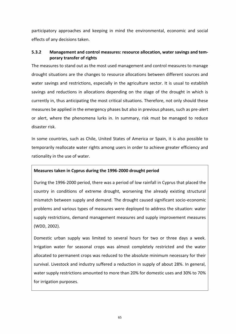
65
participatory approaches and keeping in mind the environmental, economic and social
effects of any decisions taken.
5.3.2 Management and control measures: resource allocation, water savings and tem-porary transfer of rights
The measures to stand out as the most used management and control measures to manage
drought situations are the changes to resource allocations between different sources and
water savings and restrictions, especially in the agriculture sector. It is usual to establish
savings and reductions in allocations depending on the stage of the drought in which is
currently in, thus anticipating the most critical situations. Therefore, not only should these
measures be applied in the emergency phases but also in previous phases, such as pre-alert
or alert, where the phenomena lurks in. In summary, risk must be managed to reduce
disaster risk.
In some countries, such as Chile, United States of America or Spain, it is also possible to
temporarily reallocate water rights among users in order to achieve greater efficiency and
rationality in the use of water.
Measures taken in Cyprus during the 1996-2000 drought period
During the 1996-2000 period, there was a period of low rainfall in Cyprus that placed the
country in conditions of extreme drought, worsening the already existing structural
mismatch between supply and demand. The drought caused significant socio-economic
problems and various types of measures were deployed to address the situation: water
supply restrictions, demand management measures and supply improvement measures
(WDD, 2002).
Domestic urban supply was limited to several hours for two or three days a week.
Irrigation water for seasonal crops was almost completely restricted and the water
allocated to permanent crops was reduced to the absolute minimum necessary for their
survival. Livestock and industry suffered a reduction in supply of about 28%. In general,
water supply restrictions amounted to more than 20% for domestic uses and 30% to 70%
for irrigation purposes.

66
Regarding demand management measures, aids for obtaining good quality resources
were established for domestic urban supply, through the drilling of private wells. Subsidies
were also provided for the installation of grey water recycling systems in homes, schools,
etc. Other measures were the reduction of Non Revenue Water (NRW) in distribution
systems and education and awareness campaigns on water saving needs.
Aids were established for irrigation to collect rainwater from the roofs of the greenhouses
and for the improvement of irrigation systems, water quotas were applied for irrigation
and penalization for excessive consumption, new irrigation areas were halted and the
training of farmers for a better use of water and the adoption of new crops with lower
water demand was promoted.
As for the measures to improve the supply, the existing desalination plant (in Dhekelia)
was expanded from 25,000 to 40,000 m3 / day, the procurement process for a new
desalination plant (west of Larnaca) with a capacity of 52,000 m3 / day was accelerated
and reuse of recycled water was promoted for agriculture use.
5.3.3 Environmental measures
In drought periods it is common for impacts to occur on associated aquatic and terrestrial
ecosystems. The integrated management of all available water resources to meet demands
and environmental needs is of the essence. However, the resources’ greater withdrawal, as
is usually the case with those coming from groundwater, can affect the discharge areas of
aquifers in rivers and wetlands. Thus, it is necessary to control the state of surface and
underground water bodies, the fulfilment of the ecological flows established in the rivers
and the water requirements of wetlands.
Liberating resources from the economic uses of water (agriculture and industry) for the
environment is one of the environmental measures used in drought situations. In the area
of the Júcar River Basin Authority in Spain, agreements have been reached for the temporary
acquisition of rights (wells near the river) between Administration and users for
environmental reasons, with the objective to ensure a minimum flow through the Júcar River
to avoid its channel from drying out.
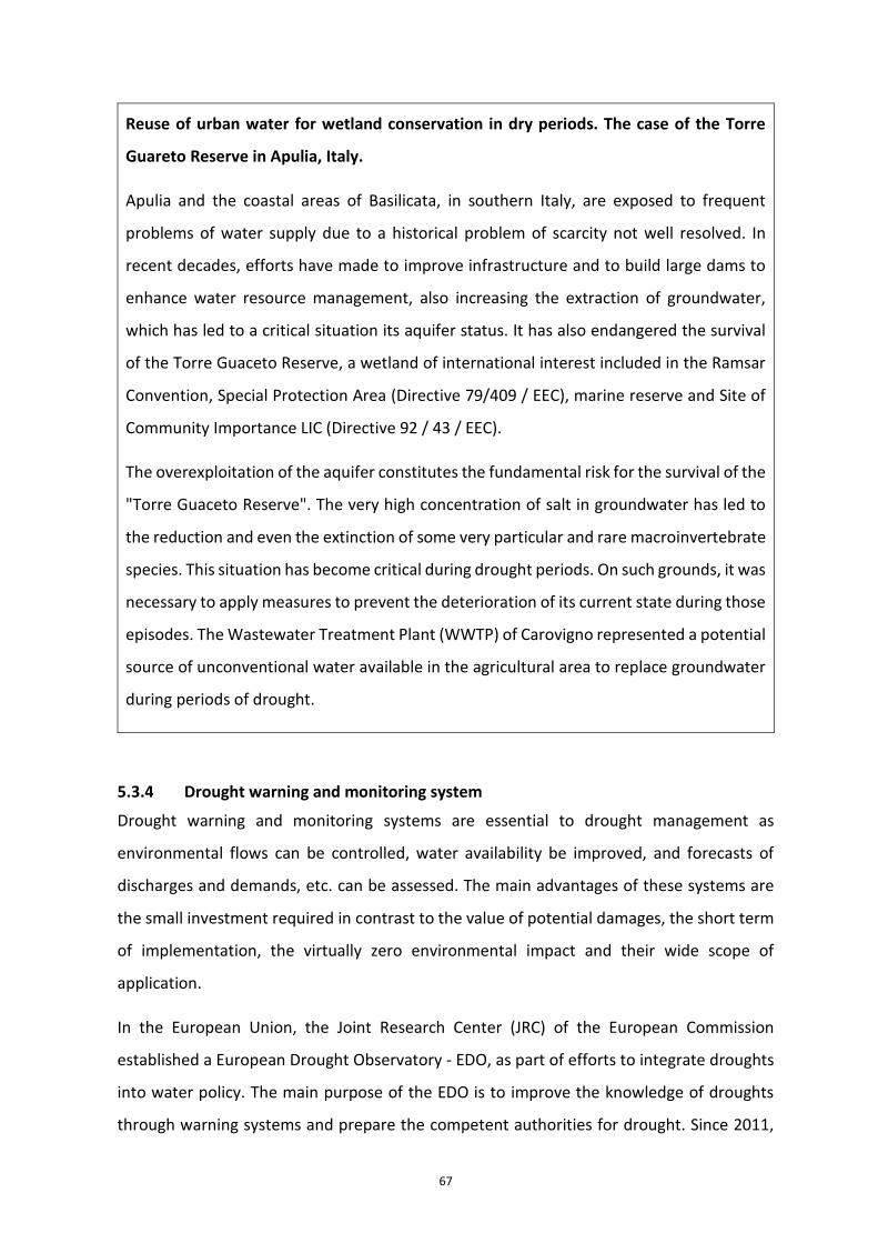
67
Reuse of urban water for wetland conservation in dry periods. The case of the Torre
Guareto Reserve in Apulia, Italy.
Apulia and the coastal areas of Basilicata, in southern Italy, are exposed to frequent
problems of water supply due to a historical problem of scarcity not well resolved. In
recent decades, efforts have made to improve infrastructure and to build large dams to
enhance water resource management, also increasing the extraction of groundwater,
which has led to a critical situation its aquifer status. It has also endangered the survival
of the Torre Guaceto Reserve, a wetland of international interest included in the Ramsar
Convention, Special Protection Area (Directive 79/409 / EEC), marine reserve and Site of
Community Importance LIC (Directive 92 / 43 / EEC).
The overexploitation of the aquifer constitutes the fundamental risk for the survival of the
"Torre Guaceto Reserve". The very high concentration of salt in groundwater has led to
the reduction and even the extinction of some very particular and rare macroinvertebrate
species. This situation has become critical during drought periods. On such grounds, it was
necessary to apply measures to prevent the deterioration of its current state during those
episodes. The Wastewater Treatment Plant (WWTP) of Carovigno represented a potential
source of unconventional water available in the agricultural area to replace groundwater
during periods of drought.
5.3.4 Drought warning and monitoring system
Drought warning and monitoring systems are essential to drought management as
environmental flows can be controlled, water availability be improved, and forecasts of
discharges and demands, etc. can be assessed. The main advantages of these systems are
the small investment required in contrast to the value of potential damages, the short term
of implementation, the virtually zero environmental impact and their wide scope of
application.
In the European Union, the Joint Research Center (JRC) of the European Commission
established a European Drought Observatory - EDO, as part of efforts to integrate droughts
into water policy. The main purpose of the EDO is to improve the knowledge of droughts
through warning systems and prepare the competent authorities for drought. Since 2011,

68
EDO has been the main disseminator of information related to drought in the EU, drawing
up maps of indicators derived from various data sources, also producing reports on drought
events in the EU.
Figure 31. Situation of Combined Drought Indicator in Europe - 1st ten-day period of October 2019.
In the last years, a combined index for drought monitoring has been used in the USA, the US
Drought Monitor, where drought intensity categories are defined through five key
indicators, numerous complementary indicators including those of drought impact and in
local reports from more than 350 experts around the country 10.
10 https://droughtmonitor.unl.edu

69
Figure 32. U.S.A. Drought Monitor Map, October 15, 2019.
5.3.5 Agricultural insurance
In order to face the risks of drought which extend more than one dry period and cause
irreparable economic damage to small farms, agricultural insurance systems together with
other complementary measures to mitigate damages not covered by insurance have
become common. The development of these agricultural insurances must rely on the
specific agro climatic conditions of each territory.
6 Lessons learnt
6.1 Importance of planning
The current approach in the management of extreme hydrological events is no longer
reduced to accepting the consequences of the inevitable and acting to reduce its
catastrophic effects. Addressing the risks of these phenomena in a planned way offers
opportunities for study, reflection and participation of all relevant stakeholders to manage
such risks.
It is highly recommended, therefore, to provide drought and flood management plans that
are compatible and coordinated with the hydrological plans of the respective river basins,
to anticipate the detection of these extraordinary situations, graduated at various levels,
coordinate the different actions to can be taken, establish who should undertake them, and

70
define any necessary coordination. These plans must also include measures to monitor their
implementation and their effectiveness. Such monitoring measures should be periodically
reviewed, especially in a context of climate change that may alter the forecasts and any
starting hydro meteorological axioms.
The scientific and technical knowledge, which enforces ensures the participation of
engineers in its inception, development, implementation and monitoring is quite convenient
and necessary, since only from this knowledge can reasonable, effective measures be
studied, proposed and applied which optimize risk management with the due effectiveness.
6.2 Adaptative management
Nature has its laws, and it is a serious, sterile and fruitless mistake not to accept them. The
application of engineering knowledge and methods cannot change these laws and thinking
about reaching zero risk in the face of these extreme natural phenomena is delusional. Thus,
engineer’s commitment should embrace and encourage adaptive management, which
allows the lower risks to reasonable, feasible and socially acceptable, admitting the natural
function that droughts and floods also have. Adaptive management is staged by acting on
exposure and vulnerability, not only on reducing the impact of events, on which engineering
had traditionally focused. So that for similar intensities of a flood or a drought, adaptive
management reduces the risks and damages caused, by adapting land use, buildings or
facilities, or the timely evacuation of people and property (in case of flooding), or the
adaptation of water use and mindful management of available water resources, in case of
droughts.
In both cases, engineering plays a very important role in estimating the occurrence of time
the natural phenomena, the potential affected areas, the risks and potential damages, the
definition of adaptation actions, the best evacuation alternatives to non-flood areas, the
best options to guarantee the essential uses of water and limit socio-economic damages in
droughts, and to establish previously appropriate guidelines and actions in flood and
drought management plans.
6.3 Technology and improvement of results
The technology is facilitating a rapid improvement in the management of floods and
droughts. Satellites have facilitated the reliability of weather forecasts, and the calibration

71
of the corresponding predictive models, allowing real-time monitoring of the evolution and
forecasts’ readjustment, together with a better knowledge of land uses, essential data to
feed Geographic Information Systems - GIS, very useful auxiliary element for the necessary
studies.
GIS have required, for their effectiveness, the development of automated sensor systems
deployed in the field and the increased capability of transmitting, storing, processing and
distributing these collected data, all of which would not have been possible without the
contribution of Information and Communications Technologies - ICTs.
Digital Terrain Models - DTMs, have required the development of LIDAR technologies,
without whose contribution the hydraulic models with which the potentially affected areas
are estimated could not be reliably and quickly fed, according to the intensity of the extreme
event that may occur. Hydraulic models have required, in order to study the effects of
extreme hydrological phenomena, the best alternatives applicable and damage assessment.
All these alternatives were the contribution of expert engineers in their inception,
development and fine-tuning. Engineering contribution is also present in flow monitoring
during flood events.
But, in addition to participating being in the development of such technologies, engineering
is totally necessary for its correct use and to foster its improvement. As an example, it is
engineering what drives and focuses the development of Decision Support Systems, both in
floods, to decide the best management options based on the existing alternatives and in
situations of droughts, to study and evaluate the most appropriate integrated resource
management options to mitigate their effects.
6.4 Combination of measures
Although adaptive management has been embraced as a main strategic principle, it must be
underscored that dealing with these extreme phenomena requires a proper combination of
a series of measures, which must be executed by different stakeholders, which fosters the
need to previously implement the management plans in a participatory manner.
High-level scientific and technical tools are being developed as part of the systems of
analysis, prediction, monitoring, evaluation, adaptation and support for decision-making
that contribute to the decision-making process. Focused on adaptive flood management,
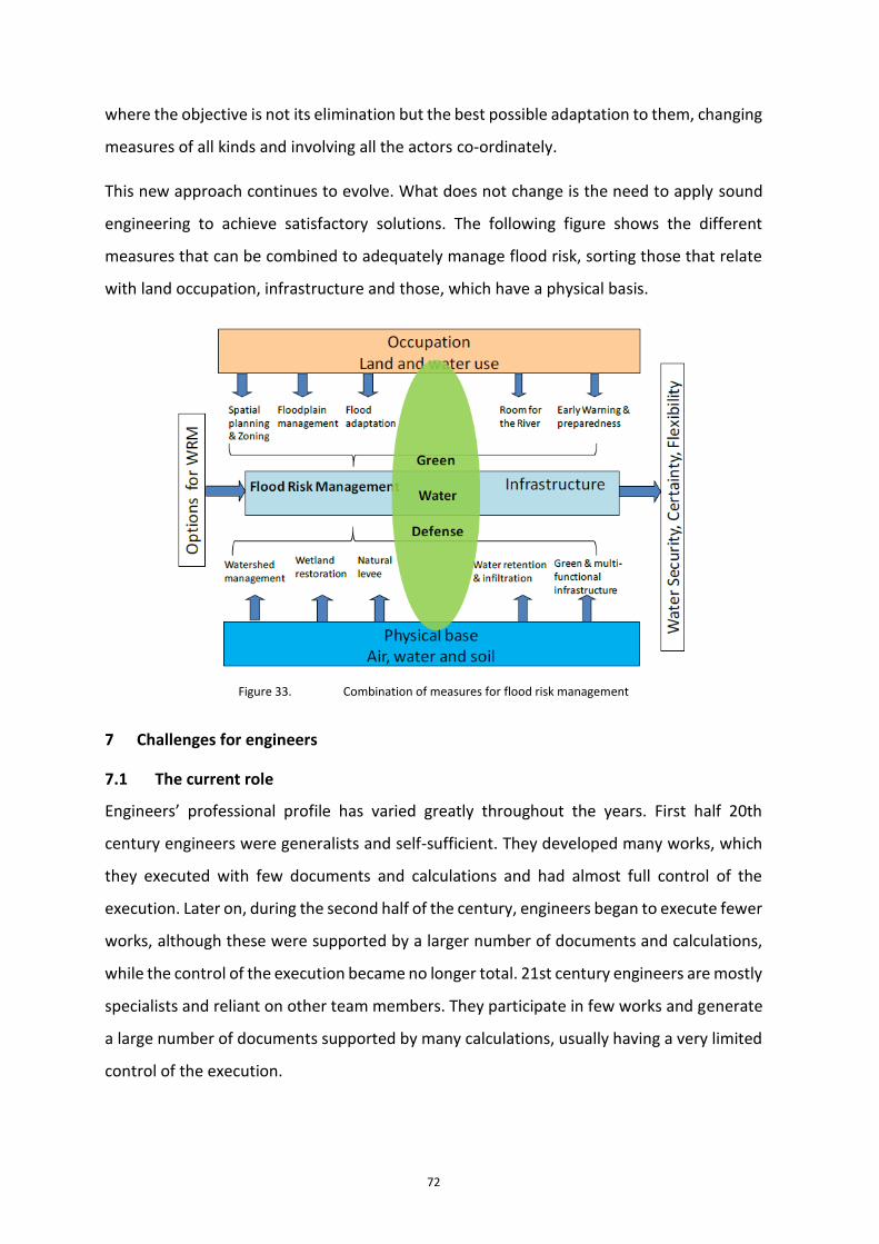
72
where the objective is not its elimination but the best possible adaptation to them, changing
measures of all kinds and involving all the actors co-ordinately.
This new approach continues to evolve. What does not change is the need to apply sound
engineering to achieve satisfactory solutions. The following figure shows the different
measures that can be combined to adequately manage flood risk, sorting those that relate
with land occupation, infrastructure and those, which have a physical basis.
Figure 33. Combination of measures for flood risk management
7 Challenges for engineers
7.1 The current role
Engineers’ professional profile has varied greatly throughout the years. First half 20th
century engineers were generalists and self-sufficient. They developed many works, which
they executed with few documents and calculations and had almost full control of the
execution. Later on, during the second half of the century, engineers began to execute fewer
works, although these were supported by a larger number of documents and calculations,
while the control of the execution became no longer total. 21st century engineers are mostly
specialists and reliant on other team members. They participate in few works and generate
a large number of documents supported by many calculations, usually having a very limited
control of the execution.

73
Current engineering practice has become increasingly collaborative, favouring
specialization, undermining engineers’ leadership roles formerly assumed by more broad-
based generalist self-sufficient engineers. On the other hand, specialization provides high
qualification for the operation of complex tools in the analysis of extreme events, such as
Decision Support Systems (DSS) and Geographic Information Systems GIS for drought
management and floods or mathematical models used in hydraulics studies and in the
design of flood rolling dams and other infrastructures.
Another aspect increasingly present in current engineering is global practice and its
corresponding demands: languages, knowledge of each region’s “water culture” and
adaptation to diverse local factors, as well as the cross-knowledge transfer between
countries with different features and idiosyncrasies.
7.2 Professional practice indicators
There are no reliable indicators of the activity developed by engineers in this flood or
drought management. Even worse, there is a huge void of global statistics regarding the
number of engineering professionals dedicated to water issues. Professional engineering
organizations through its global federations (World Federation of Engineering Organizations
- WFEO, World Council of Civil Engineers - WCCE ) are strongly recommended to establish a
formal consultation with their member organizations in this regard, indicating not only that
number, but also specifying to the engineer's specialty and field of activity.
Fields of activity can be classified through UNESCO’s nomenclature for fields of science and
technology accordingly. Other classification alternatives may define specialties in
accordance to the following branches: civil (including hydraulics), industrial, Information and
Communications Technologies (ICT), environmental and others. On the other hand, water
related areas expertise can in turn be subdivided in: water planning, water management and
administration, hydraulic engineering and consultancy, urban water cycle, universities and
research centers, and others.
7.3 Innovation and technology
Since the end of the 18th century, engineering applications have been constantly applying
innovation to technology. Thus, at the end of the 18th century, engineering produced the
massive application of technology breakthroughs in hydraulic energy, mechanization,
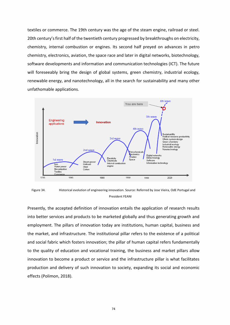
74
textiles or commerce. The 19th century was the age of the steam engine, railroad or steel.
20th century’s first half of the twentieth century progressed by breakthroughs on electricity,
chemistry, internal combustion or engines. Its second half preyed on advances in petro
chemistry, electronics, aviation, the space race and later in digital networks, biotechnology,
software developments and information and communication technologies (ICT). The future
will foreseeably bring the design of global systems, green chemistry, industrial ecology,
renewable energy, and nanotechnology, all in the search for sustainability and many other
unfathomable applications.
Figure 34. Historical evolution of engineering innovation. Source: Referred by Jose Vieira, OdE Portugal and
President FEANI
Presently, the accepted definition of innovation entails the application of research results
into better services and products to be marketed globally and thus generating growth and
employment. The pillars of innovation today are institutions, human capital, business and
the market, and infrastructure. The institutional pillar refers to the existence of a political
and social fabric which fosters innovation; the pillar of human capital refers fundamentally
to the quality of education and vocational training, the business and market pillars allow
innovation to become a product or service and the infrastructure pillar is what facilitates
production and delivery of such innovation to society, expanding its social and economic
effects (Polimon, 2018).
75
Within the scope of extreme hydrological events, engineering can contribute to the
development of better technologies, the construction of infrastructures and the design of
resilient water resources systems, highly robust to hydrological disasters, participating in the
situation management and aftermath response teams of such events.
7.3.1 Technology development
The market currently offers multiple available technologies capable of boosting innovation
in the engineering sector regarding extreme hydrological events such as Building
Information Modeling - BIM, 3D printing, IoT (internet of things) applied to infrastructure
sensing, Big Data, Machine Learning, augmented reality or the use of drones, which allows
the affordable inspection, maintenance and conservation of areas of difficult access
(Urrecho, J., 2018). All these technologies are applicable to the field of droughts and floods.
It is up to engineers not only to actively participate in the technology development, but also
direct investigation topics and its development development towards the fields with more
added value for engineers to contribute, boost new technologies’ phases of innovation and
application, facilitating collaboration between research and technology centers, and the
corporations which undertake product development, finetune and validate innovations’
effectiveness and and initiate a new innovation cycle returning real data feedback to
research and technology centers.
An example of an international project that incorporates smart technologies is the Flood and
Drought Management Portal11, developed by the Global Environment Facility (GEF), the
United Nations Environment Program (UNEP), the International Water Association (IWA)
and the Danish Hydraulic Institute (DHI). The project incorporates real-time satellite data,
seasonal climate forecasts and medium-term climate projections with the objective of
assisting in the planning and management of droughts and floods, in the short, medium and
long term, both at local or transnational scopes. The project was validated in three pilot
basins: the Chao Phraya basin in Thailand, the Victoria Lake basin in East Africa and the Volta
basin in West Africa12.
11 www.flooddroughtmonitor.com
12 http://www.iwa-network.org/projects/flood-and-drought-management-tools/

76
7.3.2 Infrastructure construction and design of resilient systems
Engineers can help mitigate the impact of natural disasters, such as droughts and floods, by
designing and building resilient systems and infrastructure, always keeping in mind that our
role is to minimize life loss, property damage, and provide assistance for an effective
emergency response.
One emerging engineering fields of practice is the incorporation of resilience criteria in the
inception and design phases of new infrastructures or flood defense systems, and the
adaptation of the existing in accordance to such resilience criteria. The latter entails an even
more complex task: offer sophisticated feasible solutions which overrule radical simplistic
alternatives like the decommissioning of affected elements or assets, either physically (from
flood areas) or the permanent inhibition of water demands corresponding to certain uses,
(to deal with the droughts). Engineering, regarding the environmental needs of water-
related ecosystems, must consider and offer stakeholders, in the first place, and society in
general, solutions that do not cause serious socio-economic consequences in the affected
areas by floods and droughts.
Nature-based solutions, as a means of protection against floods, and SUDS (Urban
Sustainable Drainage Systems), in the urban environment, show the mark a line of future
evolution that has to be enhanced.
7.3.3 Extreme event management and restoration
Despite the approval of plans and the development of protective and preventive actions,
when the extreme phenomena arises, an intense engineering activity must be developed to
manage them and, once passed, proceed as soon as possible to restore any damages
suffered.
Engineering’s contribution to water-related extreme episodes management should include
enhanced data collection to better adjust predictive models and decision support systems,
improving potential damage assessment, and monitoring and avoided damages appraisals.
Regarding to restoring action, studies should be undertaken to increase the system’s overall
resilience and adaptation to climate change, rather than just reinstating the former
condition of the works and assets affected.

77
7.4 Social responsibility
Honouring society’s mandate to create a sustainable world and improve human welfare
globally, engineers must serve competently, collaboratively and ethically as expert:
• Planners, designers, builders and managers of society’s economic and social engine,
what is known as the built environment;
• Custodians of the natural environment advocating the efficient and proper use of the
available resources;
• Innovators and integrators of ideas and technologies in academia and the public and
private sectors;
• Managers of risks and uncertainties caused by natural events, accidents and other
hazards under their area of expertise; and
• Trend-setters leading discussions and decisions that compose environmental and
infrastructure public policies.
Nowadays, the scientific community declares that the climate is changing and will continue
to change. In addition to this, evidence suggests that climate change has led to extreme
weather changes such as heat waves, record temperatures and, in many regions, heavy
rainfall over the past half century. Climate change, by diverting the climatic patterns of
historical climate ranges, could negatively affect the robustness of the design, operation and
management of engineering systems. There is a growing demand for engineers to
incorporate design criteria based on future climate projections. It is the engineer's duty to
take all reasonable measures to ensure that these systems are adapted to adequately
anticipate the impact of changing weather conditions.
Engineers have responsibilities in the planning, design, construction, operation and
maintenance of physical infrastructure. These facilities include all types of buildings,
communication systems, power generation and distribution systems, industrial facilities,
transportation networks, water resources services and urban water systems. Such physical
infrastructure is expected to remain functional, sustainable and safe for its service lifespan,
typically ranging from 50 to over 100 years, while exposed and potentially vulnerable to
extreme weather effects such as droughts, floods, heat waves, high winds, storms, fires, and

78
ice and snow accumulation. Engineering standards and best practices must provide
acceptably low risks of failures regarding performance, durability and safety over the service
life of infrastructure systems and services.
Risk assessment and its mitigation is a key principle of engineering practice. Such principle
imposes a responsible commitment to civil engineering professionals to adopt due to assess
the effect of climate change on the works and the service they provide. This is reflected
twofold. Firstly, engineers in charge of public facilities and infrastructure design and
management will have to adapt to climate change at the local level to ensure public health
and safety. Secondly, the growing level of awareness to this risk and the high visibility of the
impacts derived from the most intense storms and extraordinary events raise accountability
issues. Engineers who do not exercise due diligence regarding climate change, in short, may
be considered personally or jointly liable for damages or failures arising from the impacts of
climate change on engineering systems.
7.5 Emerging and future areas
Population concentration in urban areas and climate change, with its associated uncertainty,
are circumstances, which influence the near future. Engineers must express their
commitment, among other things, to:
• Promote engineering links with the society, encouraging participation and
commitment to sustainable development and action against climate change.
• Support with innovative engineering technologies and practices COP-21’s Climate
Agreement and contribute to the achievement of UN’s SDG 6: Ensure availability and
sustainable management of water and sanitation for all and other connected SDGs.
• Promote R & D & I projects regarding risk management, sustainability and climate
action, regarding the nexus between the actions on the territory with the use and
conservation of natural resources and the protection of ecosystems.
• Host congresses, seminars, conferences and meetings in which engineering
principles and commitments are encouraged and adapted to the different fields of
engineering practice.

79
• Actively collaborate through our professional practice in achieving the reduction of
GHG within various sectors, the improvement of weather resistance of various types
of infrastructure to resist climate impacts, increasing their reliability and service life,
and the achievement of engineering challenges for sustainable development,
embodied in United Nations SDG 6 and other connected goals.
Regarding the adaptation of infrastructure to climate change, an increase in average sea
levels is to be expected, together with the occurrence and / or increase in intensity and
frequency of extreme events, such as droughts, floods or hurricanes. It is necessary to
anticipate these phenomena, try to identify and assess them, ensuring corresponding
infrastructure to be prepared for these scenarios: coastal defenses, greater capacity of
reservoirs for prolonged droughts, hurricane resistance, etc. Naturally, the more critical an
infrastructure is, the greater its resilience to extreme events should be. It is required in this
regard to develop the following action:
• Identify and assess, if possible, the potential effects of climate change by geographic
areas.
• Incorporate these effects in the infrastructure design standards.
• Evaluate the resilience of existing infrastructure to predictable changes and
phenomena.
• Identify the need for new specific infrastructure.
• Prioritize and plan maintenance and adaptation actions of existing infrastructure.
• Proceed to build the infrastructure currently unavailable.
On the other hand, climate projections worldwide concur that the impact of climate change
on water resources will entail reductions in water resources, sea level rise in coastal areas,
as well as a possible increase in the frequency and magnitude of extreme events such as
droughts and floods. In order to assess climate change and its adaptation strategies, the
following actions are therefore required:
• Deepen studies of the effects of climate change on resources, the water
environment, droughts and floods and water demands in order to improve their

80
consideration in planning and define and implement the most appropriate
adaptation measures.
• Incorporate climate change measures into national policies, strategies and plans. The
programs of measures of the hydrological plans should be consistent with climate
change scenarios, making progress in adapting to this phenomena and guaranteeing
the resilience of the planned infrastructure.
• Include climate change as one of the factors to consider in the design, operation and
management for the safety of the new Critical Infrastructures, and for the adaptation
of existing ones.
To achieve this goal, the following actions should be implemented:
• Develop joint initiatives between governments, universities, technology and
research centers, and companies to develop projects within the innovation trends
regarding the fields of Information, Planning, Engineering, Technology and Water
Management.
• Join efforts and develop R & D & I projects that, applying the available technologies
and instruments (mathematical models, measurement, telemetry, remote control or
remote control, remote sensing, purification treatments, generation of
unconventional resources through water regeneration or desalination, etc. ) allow
the improvement of water management.
• Establish technological innovation as a key development factor.
• Improve governance, invest in institutional capacity building and apply integrated,
transparent and effective solutions in water management.
7.6 New roles and challenges
Traditionally, engineering has contributed to human welfare as a consequence of economic
growth. Today, the goals and targets of the United Nations 2030 Agenda for Sustainable
Development are closely interconnected and thus achieving or not, a specific goal will also
enhance or undermine the accomplishment of other goals. For this reason, the 2030 Agenda
states that the achievement of sustainable development in its three dimensions, economic,

81
environmental and social, must be addressed in an integrated and balanced manner. Thus,
water is the Sustainable Development Goal 6 and, at European level, water is one of the
sectoral policies which receives the most momentum and action following the approval of
EU’s 2000 Water Framework Directive, whose primary objective is to ensure the good state
water bodies and their associated ecosystems, and the Flood Risk Assessment and
Management Directive of 2007.
Access to water and sanitation, to affordable and non-polluting energy, to food security,
sustainable growth, the ability to adapt to risks related to climate and natural disasters, such
as droughts and floods, resilient infrastructure or international cooperation, are clear
examples of interconnected issues. Today, engineers around the world are addressing global
challenges, such as climate change, locally. Such means that when they carry out studies or
project works they must take these global challenges into consideration.
On the other hand, engineers face decentralized teamwork often. Leading multidisciplinary
teams in natural disaster management, such as droughts and floods, is a great challenges.
Furthermore, increased globalization requires engineers to overcome any cultural bias in its
professional practice, a skill that should be exercised.
Engineers must best practices worldwide such as 2013 WFEO’s Codes of Best Practices for
Sustainable Development and Environmental Protection "Think with a global vision and act
with a local vision" (WFEO, 2013), and 2015 “Code of Good Practices: Principles of
Adaptation to Climate Change for Engineers” (WFEO, 2015), expanded and adapted locally.
8 References
AEAS, 2019. Guía para la redacción de Planes de Emergencia por sequía en sistemas de
abastecimiento urbano. AEAS, Madrid.
Andreu, J., Ferrer-Polo, J., Pérez, M.A., Solera, A., Paredes-Arquiola, J. 2013. Drought plan-
ning and management in the Júcar river basin, Spain. In: Drought in Arid and Semi-Arid
Region (Schwabe, K., Albiac, J., Connor, J.D., eds.). Springer, pp. 237–249.
Andreu, J., Ferrer-Polo, J., Pérez, M. A., Solera, A. 2009. Decision support system for drought
planning and management in the Jucar river basin, Spain. Proceedings of the 18th world
IMACS / MODSIM Congress, July 13-17, Cairns, Australia, 3223–3229.

82
Andreu, J., Capilla, J., Sanchís, E. 1996. AQUATOOL, a generalized decision-support system
for water-resources planning and operational management. Journal of Hydrology, 177(3–4),
269–291. DOI.
Ballio F., Molinari D., Minucci G., Mazuran M., Arias Munoz C., Menoni S., Atun F., Ardagna
D., Berni N., Pandolfo C., 2015. The RISPOSTA procedure for the collection, storage and
analysis of high quality, consistent and reliable damage data in the aftermath of floods,
Journal of Flood Risk Management, 11,S604–S615 (2018), on line first, 2015
Cammerer H., Thieken A.H. and Lammel J., 2013. Adaptability and transferability of flood
loss functions in residential areas. Nat Hazards Earth Syst Sci 2013, 13, 3063–3081.
Centro de Estudios Hidrográficos, 2017. Evaluación del Impacto del Cambio Climático en los
Recursos Hídricos y Sequías en España (2015-2017). Informe técnico para el Ministerio de
Agricultura, Alimentación y Medio Ambiente. CEDEX, Madrid, julio de 2017.
City of New York. Department of Environmental Protection – DEP., 2016. Green
infrastructure performance metrics report.
Dai, L.; Van Rijswick; H.F.M.W.; et al., 2017. Governance of the Sponge City Programme in
China with Wuhan as a case study. International Journal of Water Resources Development.
De Groeve, T., Poljansek, K., Ehrlich, D., and Corbane, C., 2014. Current status and Best
Practices for Disaster Loss Data recording in EU Member States: A comprehensive overview
of current practice in the EU Member States, JRC Scientific and Policy Report, JRC92290,
doi:10.2788/18330, 2014.
De Groeve, T., Poljansek, K., and Ehrlich, D., 2013. Recording Disasters Losses:
Recommendations for a European Approach, JRC Scientific and Policy Reports, JRC83743,
doi:10.2788/98653, 2013.
District of Columbia, 2013. Sustainable DC Plan. District Office of Planning (OP) &
Department of Energy & Environment (DOEE) USA.
Downton M.W. and Pielke R.A., 2005. How accurate are disaster loss data? The case of U.S.
flood damage. Nat Hazards 2005, 35, 211–228.

83
Estrela, T. and Sancho, T., 2016. Drought management policies in Spain and the European
Union: from traditional emergency actions to Drought Management Plans. Water Policy 18
(2016) 153–176. doi: 10.2166/wp.2016.018. IWA Publishing.
Estrela, T.; Pérez-Martín, M.A.; Vargas, E., 2012. Impacts of Climate Change on Water
Resources in Spain. Hydrological Sciences Journal (ISSN 0262-6667). IAHS Press, Vol 57(6)
pp 1154-1167, 2012. DOI:10.1080/02626667.2012.702213
Estrela, T. and Vargas, E., 2012. Drought Management Plans in the European Union. The Case
of Spain. Water Resource Management (ISSN 0920-4741). Vol. 26 Issue 6, p1537-1553. DOI
10.1007/s11269-011-9971-2.
European Commission, 2015. Synthesis document n°8 'Windows of opportunities' for
Natural Water Retention Measures, NWRM SD8, European Commission Directorate General
Environment and NWRM project team, Brussels.
European Commission, 2014. Climate Impacts in Europe. The JRC PESETA II Project. Joint
Reserch Centre. Institute for Prospective Technological Studies, Seville, Spain.
European Commission, 2013. An EU strategy on adaptation to climate change.
European Commission, 2012. Blueprint to Safeguard Europe's Water Resources.
European Commission, 2007a. Drought Management Plan Report. Including Agricultural,
Drought Indicators and Climate Change Aspects. Technical Report - 2008 – 023.
European Commission, 2007b. Addressing the challenge of water scarcity and droughts in
the European Union. Communication from the Commission to the European Parliament and
the Council, COM (2007) 414 final.
European Environment Agency, 2016. Flood risks and environmental vulnerability. Exploring
the synergies between floodplain restoration, water policies and thematic policies. EEA
Report Nº 1/2016
European Environment Agency, 2001. Sustainable Water Use in Europe – Part 3: Extreme
hydrological events: floods and droughts. Environmental Assessment report No 21.
European Environment Agency. Copenhagen.

84
Gerl, Tina; Kreibich, Heidi; Franco, Guillermo; Marechal, David; Schroter, Kai, 2016. A Review
of Flood Loss Models as Basis for Harmonization and Benchmarking. In PloS one 11 (7), pp.
e0159791. DOI: 10.1371/journal.pone.0159791.
Handmer J., 2013. The chimera of precision: inherent uncertainties in disaster loss
assessment. Int J Mass Emerg Disasters 2003, 20, (3), 325–346.
Hervás-Gámez, C. and Delgado-Ramos, F., 2019. Drought Management Planning Policy:
From Europe to Spain. Sustainability 2019, 11, 1862; doi:10.3390/su11071862
Iglesias, A., Garrote, L., Cancelliere, A., Cubillo, F., Wilhite, DA. (Eds.), 2009. Coping with
Drought Risk in Agriculture and Water Supply Systems. Drought Management and Policy
Development in the Mediterranean. Series: Advances in Natural and Technological Hazards
Research, Vol. 26. XVIII, 322 p.
Intergovernmental Panel on Climate Change, 2014. Climate Change 2014. Synthesis Report.
Contribution of Working Groups I, II and III to the Fifth Assessment Report of the
Intergovernmental Panel on Climate Change. Core Writing Team, R.K. Pachauri and L.A.
Meyer (eds.). IPCC, Geneva, Switzerland, 151 pp.
Jongman, B., Kreibich, H., Apel, H., Barredo, J.I., Bates, P.D., Feyen, L., Gericke ,A., Neal, J.,
Aerts, J. C. J. H., and Ward P. J., 2012. Comparative flood damage model assessment: towards
a European approach, Natural Hazards and Earth System Sciences, 12:3733–3752, doi:
10.5194/nhess-12-3733-2012, 2012
Kirtman, B., S.B. Power, J.A. Adedoyin, G.J. Boer, R. Bojariu, I. Camilloni, F.J. Doblas-Reyes,
A.M. Fiore, M. Kimoto, G.A. Meehl, M. Prather, A. Sarr, C. Schär, R. Sutton, G.J. van
Oldenborgh, G. Vecchi and H.J. Wang, 2013: Near-term Climate Change: Projections and
Predictability. In: Climate Change 2013: The Physical Science Basis. Contribution of Working
Group I to the Fifth Assessment Report of the Intergovernmental Panel on Climate Change
[Stocker, T.F., D. Qin, G.-K. Plattner, M. Tignor, S.K. Allen, J. Boschung, A. Nauels, Y. Xia, V.
Bex and P.M. Midgley (eds.)]. Cambridge University Press, Cambridge, United Kingdom and
New York, NY, USA.

85
Korenfeld Federman, D., Arreguín Cortés, F., López Pérez, M., 2014. Constructing a
framework for National Drought Policy: The way forward in Mexico. Weather and Climate
Extremes 3 (2014) 90–94
Kundzewicz, Z.W. and P. Matczak, 2015. Extreme hydrological events and security. Proc.
IAHS, 369, 181–187, 2015. doi:10.5194/piahs-369-181-2015.
Lloyd-Hughes B and Saunders M.A., 2002. A Drought Climatology for Europe. Int J Climatol
22: 1571–1592.
Maia, R. and Vicente-Serrano, S.M., 2017. Drought Planning and Management in the Iberian
Peninsula in Drought and Water Crises. Integrating Science, Management and Policy.
Chapter 23. Edited by D. A. Wilhite and R. S. Pulwarty. CRC Press.
https://doi.org/10.1201/b22009
Mechler R., 2016. Reviewing estimates of the economic efficiency of disaster risk
management: opportunities and limitations of using risk-based cost–benefit analysis, Nat
Hazards 81:2121–2147
Menoni, S., Molinari, D., Ballio, F., Minucci, G., Atun, F., Berni, N.,and Pandolfo C., 2016.
Flood damage: a model for consistent, complete and multi-purpose scenarios, Natural
Hazards and Earth System Sciences, 16:2783-2797, doi: 10.5194/nhess-16-2783-2016, 2016
Merz, B., Kreibich, H., and Lall, U., 2013. Multi-variate flood damage assessment: A tree-
based data-mining approach, Nat. Hazards Earth Syst. Sci., 13, 53–64,
https://doi.org/10.5194/nhess-13-53-2013, 2013.
Molinari D., De Bruijn K., Castillo-Rodríguez J.T., Aronica G.T., Bouwer L.M., 2019. Validation
of flood risk models: Current practice and possible improvements, International Journal of
Disaster Risk Reduction, 33, 441-44, https://doi.org/10.1016/j.ijdrr.2018.10.022, 2019, (on
line first 2018)
Molinari D., Menoni S. Ballio F. (eds), 2017. Flood damage survey and assessment: new
insights from research and practice, AGU-Wiley, 2017
National Drought Mitigation Centre, NDMC, 1990. 10-Step Drought Planning Process, first
published. Author: Donald A. Wilhite, USA, 1990
86
OECD, 2019, Applying the OECD Principles on Water Governance to Floods: A Checklist for
Action, OECD Studies on Water, OECD Publishing, Paris, https://doi.org/10.1787/d5098392-
en.
OECD, 2015, Principles on Water Governance, OECD Publishing, Paris.
Ortega-Gómez, T. Pérez-Martín, M.A. and Estrela, T., 2018. Improvement of the drought
indicators system in the Júcar River Basin, Spain. Science of the Total Environment. 610–611
(2018) 276–290. http://dx.doi.org/10.1016/j.scitotenv.2017.07.250.
Plate, E.J., 2017. Flood risk management for setting priorities in decision making. In Extreme
Hydrological Events: New Concepts for Security; Vasiliev, O.F., van Gelder, P.H.A.J.M., Plate,
E.J., Bolgov, M.V., Eds.; Springer: Dordrecht, The Netherlands, 2007; pp. 21–44. ISBN 978-1-
4020-5739-7.
Polimón, 2018. Bienvenida al IV foro global de ingeniería y obra pública. Revista de Obras
Públicas. nº 3600. Pág 12-15. Julio-Agosto 2018.
Rose A., 2004. Economic principles, issues, and research priorities of natural hazard loss
estimation. In: Y. Okuyama & S. Chang, eds. Modeling of spatial economic impacts of natural
hazards. Heidelberg: Springer, 2004, pp. 13–36.
Samaniego, L., Stephan Thober, Niko Wanders, Ming Pan, Oldrich Rakovec, Justin Sheffield,
Eric F. Wood, Christel Prudhomme, Gwyn Rees, Helen Houghton-Carr, Matthew Fry, Katie
Smith, Glenn Watts, Hege Hisdal, Teodoro Estrela, Carlo Buontempo, Andreas Marx, Rohini
Kumar, 2019, Hydrological forecasts and projections for improved decision-making in the
water sector in Europe. https://doi.org/10.1175/BAMS-D-17-0274.1
Scorzini, A.R. and Frank, E., 2017. Flood damage curves: new insights from the 2010 flood in
Veneto, Italy. Journal of Flood Risk Management, 10 (3), 381-392; DOI:10.1111/jfr3.12163
Shreve C.M. and Kelman I., 2014. Does mitigation save?Reviewin gcost-benefit analyses of
disaster risk reduction, International Journal of Disaster Risk Reduction 10(2014): 213–235
Soto-Fernández, R. and Perales-Momparler, S., 2018. El camino del agua en el paisaje
urbano, barrio de Bon Pastor, Barcelona. EcoHabitar 57.

87
UNDDR, 2019. Words into action. Engaging for resilience in support of the Sendai Framework
for Disaster Risk Reduction 2015-2030
UN-Water, 2019. UN-Water Inventory. An overview of the UN-Water family’s work on water
and sanitation
Urrechu, J. 2018. Los desafíos de la Ingeniería y la Obra Pública. Revista de Obras Públicas.
nº 3600. Pág 16-19. Julio-Agosto 2018.
USA Army Corps, 2009. Flood Risk Management. Value to the Nation.
Vangelis H, Spiliotis M and Tsakiris G, 2011. Drought Severity Assessment Based on Bivariate
Probability Analysis. Water Resour Manage 25 (1): 357-371(15)
WDD, 2002. Use and Conservation of Water in Cyprus, http://www.moa.gov.cy/wdd. C.
Omorphos (2002), A Strategy for Implementing Full Cost Water Pricing in Cyprus under the
EU Water Framework Directive
Wilhite, DA., Sivakumar, M.V.K., Pulwarty, R., 2014. Managing drought risk in a changing
climate : The role of national drought policy. Weather and Climate Extremes 3 (2014) 4–13.
World Federation Engineering Organisations - WFEO, 2015. Code of Good Practices:
Principles of Adaptation to Climate Change for Engineers.
World Federation Engineering Organisations - WFEO, 2013, Best Practices for Sustainable
Development and Environmental. Think with a global vision and act with a local vision.
WMO, 2011. Manual on Flood Forecasting and Warning