Embed Size (px)
Citation preview

BEST PRACTICES GUIDE: REPORTING
ENTOMOLOGICAL SURVEILLANCE RESULTS
TO VECTORMAP
Created by the VectorMap Team, last updated May 2021

1
Best Practices Guide: Reporting Entomological Surveillance Results to VectorMap: Authors: Walter Reed Biosystematics Unit, VectorMap Team 2021 Summary: This document is designed to provide guidance on collecting, managing and reporting data associated with entomological surveillance efforts. Contents:
Background and Vision
Best Practices: Recommendations
Entomological Collection Definitions
Reporting Pathogen Screening Results
To Aggregate or Not to Aggregate?
Good and Bad Locality Data
Minimum Data Reporting
Reporting Ancillary Data
Additional Resources

2
Background: The Armed Forces Health Surveillance Division’s Global Emerging Infections Surveillance and Response System’s (AFHSD-GEIS) mission is “To increase battlespace awareness and improve Total Force Readiness in support of the unified Combatant Commands via a global laboratory network focused on mitigating the threat of emerging infectious diseases to US service members.” The Walter Reed Biosystematics Unit (WRBU) supports this global network by preserving all entomological surveillance data via the VectorMap database. VectorMap is an online repository for entomological surveillance data that standardizes results under a unified data schema. VectorMap combines data from ongoing surveillance projects as well as scientific literature and digitized museum specimens for a clearer picture of vector-borne disease risk around the world. Vision: All entomological surveillance data generated by DOD laboratories should be preserved, managed, and made available on a timely basis at a central source. If data providers are aware of the variety and form of collection information and report these data, published reports would be more complete, and data more easily compared between collection projects. A network of partners providing standardized entomological surveillance data supports the GEIS mission, and would allow evidence-based decision making, including risk assessment of vector-borne disease transmission to U.S. military personnel. A regularly updated, central repository of standardized current and historical surveillance data would empower health planners to make comparisons across time and space, document surveillance efforts, identify strengths and gaps in surveillance coverage and guide future research. Climate, land cover and other data related to vector ecology but not directly measured by the surveillance effort could be combined with entomological and epidemiological surveillance data from other sources to produce high quality vector and disease hazard maps on a routine basis. These data could also be used to generate reports on the global impact of GEIS-funded entomological surveillance.
Return to table of contents
Background and Vision
3
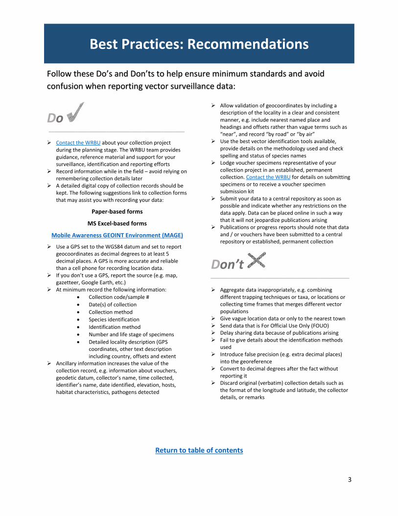
Follow these Do’s and Don’ts to help ensure minimum standards and avoid confusion when reporting vector surveillance data:
Do _______________________________________________
Contact the WRBU about your collection project
during the planning stage. The WRBU team provides guidance, reference material and support for your surveillance, identification and reporting efforts
Record information while in the field – avoid relying on remembering collection details later
A detailed digital copy of collection records should be kept. The following suggestions link to collection forms that may assist you with recording your data:
Paper-based forms
MS Excel-based forms
Mobile Awareness GEOINT Environment (MAGE)
Use a GPS set to the WGS84 datum and set to report geocoordinates as decimal degrees to at least 5 decimal places. A GPS is more accurate and reliable than a cell phone for recording location data.
If you don’t use a GPS, report the source (e.g. map, gazetteer, Google Earth, etc.)
At minimum record the following information: • Collection code/sample # • Date(s) of collection • Collection method • Species identification • Identification method • Number and life stage of specimens • Detailed locality description (GPS
coordinates, other text description including country, offsets and extent
Ancillary information increases the value of the collection record, e.g. information about vouchers, geodetic datum, collector’s name, time collected, identifier’s name, date identified, elevation, hosts, habitat characteristics, pathogens detected
Allow validation of geocoordinates by including a description of the locality in a clear and consistent manner, e.g. include nearest named place and headings and offsets rather than vague terms such as “near”, and record “by road” or “by air”
Use the best vector identification tools available, provide details on the methodology used and check spelling and status of species names
Lodge voucher specimens representative of your collection project in an established, permanent collection. Contact the WRBU for details on submitting specimens or to receive a voucher specimen submission kit
Submit your data to a central repository as soon as possible and indicate whether any restrictions on the data apply. Data can be placed online in such a way that it will not jeopardize publications arising
Publications or progress reports should note that data and / or vouchers have been submitted to a central repository or established, permanent collection
Don’t ________________________________________________ Aggregate data inappropriately, e.g. combining
different trapping techniques or taxa, or locations or collecting time frames that merges different vector populations
Give vague location data or only to the nearest town Send data that is For Official Use Only (FOUO) Delay sharing data because of publications arising Fail to give details about the identification methods
used Introduce false precision (e.g. extra decimal places)
into the georeference Convert to decimal degrees after the fact without
reporting it Discard original (verbatim) collection details such as
the format of the longitude and latitude, the collector details, or remarks
Return to table of contents
Best Practices: Recommendations

Entomological surveillance efforts are composed of individual collection projects each composed of a number of collection events. Each collection event results in collection records, specimens and laboratory testing results. Standardization of terms and the introduction of minimum reporting requirements allows valid data aggregation and comparison between collecting events as well as guaranteeing at least a minimum level of data quality.
A collection project refers to a cohesive set of related collection events, often carried out by the same personnel, often resulting from the same funds, and with the same aims and objectives.
A collection event refers to a collection episode that is clearly demarcated in time and space from other similar episodes. A collection event could refer to an overnight adult mosquito trap catch, larvae arising from a day’s collecting at a site, or pooled human landing collections representing biting rates at a village for the day or month.
A collection object is the intended target of the collection event, e.g. mosquitoes via an EVS mosquito trap, rodents via a Sherman trap etc.
The collection record is the metadata (What, When, Where, How, How many) recorded about the specimens resulting from the collection event. The record can refer to a part of a specimen, a whole specimen, or a pool of specimens of the same taxon. The collection record could refer to a human observation when no specimens have been preserved or a preserved specimen where vouchers or physical specimens exist. Paradoxically, the collection record could also reference a consistent lack of a species despite its presence at other sites within the collection project, i.e. a species absence record.
A species collection record refers to that most inclusive group of specimens of the same species of the collection object caught during the collection event, i.e. a specimen, or pool of specimens of the same species. Replicate collection events are those collection records that are sufficiently similar in terms of time and place that their aggregation will not reduce the overall information content of the collection record.
Return to table of contents
Entomological Collection Definitions

Figure 1: Workflow of entomological surveillance efforts showing collection projects, collection events, identifying specimens from each event and reporting data in a single format. Examples are given from surveillance efforts in West Africa.
Return to table of contents

A collection record can vary in taxonomic, spatial, and temporal resolution and depends heavily on the level of aggregation carried out by the data provider. Any records that combine species, trap sites or trap nights generally involve aggregation. Examples of aggregation could be reports of the number of mosquitoes within a genus (i.e. not to species), trapping numbers summarized as a yearly average figure, and collections from a number of villages combined according to an administrative region. Imprecision of data may or may not result from aggregation, e.g. a specimen may only be able to be identified to genus level or specimens have been identified to species but are deliberately pooled according to genus (this practice is not recommended).
The level of aggregation often depends on what information the provider values and the goals and objectives of the surveillance effort. Aggregation in reports is usually done to provide a summary of raw data that is more understandable, and addresses the points that the provider wishes to convey to the reader. However, for the purposes of reporting data via the ESWG network, a level of disaggregation is required that would enable the presence of a taxon (preferably at the species level) to be shown as a point on a map.
When deciding whether to aggregate data one must consider whether the conditions surrounding the collection event are sufficiently similar (i.e. Replicate collection events); combining the results of larval collections conducted by different human collectors around the same locality and time period is probably OK, but not the combining of larval and adult trap data.
Similarly, if specimens are tested individually for pathogens, these data could be aggregated by vector species if the events surrounding the data are sufficiently similar and no voucher remains after processing. In this case, a single aggregated record for the collection event could suffice, especially if a record is made of the codes of the specimens tested, and the specimen code of any positive specimens.
Replicate species collection events may come from the same trap or larval site, traps or larval sites within close proximity, or collection events conducted over a short time span. "Close proximity" for collection events is where it is likely that the same population of immatures or adults will be sampled. A "short time frame" is one that is likely to sample the same cohort of immatures or adults. Flight
To Aggregate or Not to Aggregate?

ranges of mosquitoes typically do not exceed 2 km, so adult traps greater than this distance apart should not normally be aggregated. Adult mosquitoes typically do not survive beyond 2-3 weeks, so combining adult trapping conducted over a greater time frame is not advisable.
Another consideration for determining whether collection events should be aggregated is the goal of the surveillance effort. For example, when mapping the occurrence and abundance of vector species, aggregation might depend on the resolution of remote sensing data applied to collection data to model habitat suitability, and the likely flight, oviposition, and larval dispersal ranges of the species. Remote sensing data is typically 1-8 km resolution, and 1-100 m resolution is often deemed appropriate for study of larval habitats, so combining adult and larval collection data conducted over greater distances is not advisable.
The GPS coordinates act as an anchor point to map the location of the collecting event. Some record of the extent of the collecting event will allow others to estimate the area over which the collecting took place. For example, if a GPS coordinate is taken to represent a general area where specimens were aggregated from similar larval sites, a record of the furthest distance from the GPS anchor point that collecting took place will allow others to estimate the uncertainty associated with the GPS coordinate for that record.
Return to table of contents

As a collector, you may have an intended use for the data you collect. In a publically available database, the data you collect have the potential to be used in unforeseen ways; therefore, the value of your data is directly related to the fitness of those data for a variety of uses. High quality locality data can be achieved by following the guidelines given in the “MVZ Guide for Recording Localities in Field Notes”, and by studying the examples given below. Examples of Good and Bad Localities: BAD: These are localities that give a large area without more specific detail
BETTER: These suggestions improve the accuracy and precision of the locality description Vague Localities BAD: Sacramento River Delta - an extremely large geographic area
BETTER: Locke, Sacramento River Delta, Sacramento Co., California - names a specific town within the Delta BAD: 3 mi W of San Jose/Cartago border - without additional details, this would mean anywhere 3 mi W of the border
GOOD: 3 mi W of San Jose/Cartago border on Highway 2, San Jose Province, Costa Rica – provides more details to narrow this collection site to a more specific location BAD: Pond along Chattahoochee River, Fulton Co., Georgia – there are millions of ponds along the Chattahoochee River
GOOD: Pond, 0.43 mi SW of intersection of Nancy and Ridgewood Roads, Chattahoochee River National Recreation Area, Fulton Co., Georgia – provides enough information to locate the specific collection site
Return to table of contents
Good and Bad Locality Data – Does it Matter?

Names of Roads without Additional Points of Reference BAD: Highway 9, Alajuela Province, Costa Rica - Directions given with no distances, road or air miles noted GOOD: Intersection of Hwy 9 and Rio Cariblanco, Cariblanco (town), Alajuela Province, Costa Rica - provides a cross point to the location of the specific collection site BAD: S Berkeley, Alameda County, California
GOOD: Oakland, 1 mi S Berkeley on Telegraph Ave. (1 mi S of intersection of 66th St and Telegraph Ave), Alameda Co., California - provides a cross point and more details to narrow this collection site to a more specific location Localities that are Difficult to Georeference For many countries, especially Spanish-speaking ones, there are oftentimes several cities with the same name in the same province.
BAD: San Marcos, Intibucá Province, Honduras - There are at least five San Marcos in Intibucá Province
BETTER: San Marcos, ca 7.5 km south of Los Chaguites, Intibucá Province, Honduras If there is both a city and a geographic feature that share the same name, then note which locality (city, mountain, creek, lake) you meant.
BAD: Battle Mountain, Lander Co., Nevada
BETTER: Battle Mountain (city), Lander Co., Nevada Highway mi/km markers are very difficult to georeference retrospectively unless additional information is given.
BAD: Km 58 Pan American Highway
GOOD: Km 58 Pan American Highway, 6 km S of Cartago on Pan American Highway, Cartago Province, Costa Rica
Return to table of contents

Things to watch out for: • Crossing County/State/Country lines while collecting - make sure to use the
correct names and specify clearly if using a town in a different county/state for an offset, e.g., 10 mi below Ehrenberg (La Paz Co, Arizona) on the Colorado River, Imperial Co, California
• Spelling of foreign localities - while a misplaced letter in a familiar name is easily corrected, for example "Berkely" instead of "Berkeley," a misspelling in any other language can cause confusion. e.g. Turrubares instead of Turrucares, Barra Blanca instead of Vara Blanca
• Due to the nature of the georeferencing guidelines, localities that are simply given as a city name are georeferenced as the center of the city. If the specimen is collected on the outskirts of the city, then it must be noted as such. Specifying an exact intersection is best.
Return to table of contents
The following section lists and elaborates the minimum essential data requirements that should be reported for every collection event. The naming convention for the data fields follows that reported in the accompanying collection/reporting form for vectors supplied by WRBU and is used here for your convenience:
Name of study Project Identifier Collection Code and Sample # Identification Taxon Identification Method Dates of Collecting to the day Country Detailed Location Description Geographic Coordinates Number, sex and life stage of specimens Collection Method
Name of study: The name of the project or person(s) that the record should be uniquely associated with, (e.g. AFRIMS 2005 General Survey, GEIS funded project: Ecological Niche Modeling of Sand fly Vectors of Leishmaniasis and Bartonellosis in Peru). This will assist with efficient data retrieval for that project.
Project Identifier: Record a project identifier such as a funding source or military exercise. For GEIS partners, please record the PROMIS ID in this field and include the name of the associated military exercise if applicable. CollectionCode and Sample Number: The code (or acronym) identifying the collection within the unit in which the organism record is cataloged. An example for a collection code/ catalog number format for mosquitoes is the one developed at the WRBU website. In this case, the collection code includes a country code and unique number identifying individual collection events and is combined with a unique sample number, an example is provided below.
Return to table of contents
Minimum Data Reporting

CollectionCode and Sample Number Examples
Example Explanation US 1 When specimens are collected in the field, a unique
collection code is assigned to an individual collection event.
US 1-1 - 9999L When a mosquito larva is collected from the field and
preserved, a subnumber (1-999) followed by an L is combined with the collection code.
US 1-1 - 9999A When a mosquito adult is collected from the field and preserved, a number (1-999) followed by an A is combined with the collection code.
US 1-1 - 9999P When a mosquito pupa is collected from the field and preserved, a number (1-999) followed by a P is combined with the collection code.
Identification Taxon: The most inclusive taxonomic designation determined, i.e. genus, subgenus, species and author, year (if known). Otherwise genus, subgenus, or complex is also acceptable. Contact WRBU for assistance with identification and/ or current taxonomy of vectors.
Identification Method: Brief description of how the identification was made. If preliminary sorting was by morphology followed by DNA, then details of both methods should be recorded. Include specific taxonomic keys or molecular protocols used. For example: “Morphology: ID based on keys of Darsie and Ward, 2005” or “DNA: ID based on PCR, GenBank Accession Number 0011334”.
Dates of Collecting to the day: The specific date(s) collection event was carried out. If collecting event spans multiple days (e.g. overnight traps) report when traps were set to when they were turned off. Note: format cells as "TEXT" in Excel
Country: Current country name, e.g. ISO 3166-1 or CIA fact book.
Return to table of contents
Detailed Location Description: A detailed description of each collection event’s location allows for the validation of the geographic coordinates, in which data entry errors are otherwise difficult or impossible to detect. Ask yourself, could someone else find this location given my description? The highest quality locality description is one with as few sources of uncertainty as possible. For more information and examples of locality descriptions see the Good and Bad Locality Data – Does it Matter? Section.
Note: If multiple traps or sampling efforts are aggregated or pooled for a specific site, make sure to include the number of sample sites and the maximum distance (m) between the GPS coordinate and those sites, or the maximum distance between sites (see “Max. distance between sample points” below).
Geographic Coordinates: Geographic coordinates typically provide a more accurate and permanent location record than text locations (streets and towns can be rerouted or renamed, ponds can be drained, etc.). GPS units should be set to report locations in decimal degrees to eliminate the need to make conversions from other coordinate systems and to allow easy integration into GIS applications. Record only as many decimals of precision as given by the GPS unit. Be consistent in the use of a coordinate system to avoid confusion, e.g. don’t combine decimal degrees, degree minutes, and degrees decimal minutes.
A GPS device is highly recommended to record geographic coordinates during all collection events. A GPS unit (which calculates its location using GPS satellite signals) is preferred for recording coordinates rather than a cell phone, because most cell phones calculate position based on cell phone signals which may not be available in all field collection areas and are not as accurate as GPS readings.
Decimal Latitude. The latitude of the location from which the organism or observation was collected, expressed in decimal degrees. Positive values are north of the Equator, negative values are south of the Equator.
Decimal Longitude. The longitude of the location from which the organism or observation was collected, expressed in decimal degrees. Positive values are east of the Greenwich Meridian (e.g. Asia); negative values are west of the Greenwich Meridian (e.g. the Americas).
Number, sex and life stage of specimens: Number refers to the number of individuals of the identified taxon collected during the same collection event. The life stage refers to the stage of the specimen when it was identified, or if a

voucher was lodged, the stage of the voucher. For instance, if a mosquito larvae was collected but reared and preserved as an adult then the correct entry is "adult". However, in that case, the fact that a larval collection was made should be obvious by reference to the collection method information. In the unusual event that a specimen was identified to species from the larval stage and an adult subsequently preserved the record should be "adult" but a note entered in the "Remark" field to that effect. Sex refers to whether the specimen was Male or Female, and Unknown, if appropriate.
Collection Method: Record all the methods used to produce the specimens featured in the collection record. Note specific number of traps, trap types or other sampling methods for each collection record.
Some suggestions include: Egg collection; Egg/Larva collection; ovitraps; Larval collection; Pupal collection; CDC light trap, Mosquito Magnet; Adult, swarming collections; Adult, animal landing/biting; Adult, human landing/biting; Adult, resting outdoor; Adult, animal shed resting; Adult, house resting; Adult, with non-attraction traps; Adult, with attraction traps, Dragging, Flagging, Attached or crawling on animal, Attached or crawling on human, Free living. Some specific non-attraction trap types include: Malaise, Gressitt, Manitoba, window, truck, sticky, resting traps, sweeping, exit and entry traps, nets, caught on the wing, suction trap (e.g. Dust Buster), Berlese Funnel.
Return to table of contents

Additional (ancillary) information increases the value of the collection record and should be included if possible. Below are some examples of the types of data that can be added to the minimum data fields described in the previous section. The naming convention for the data fields follows that reported in the collection/reporting forms for vectors supplied by WRBU and is used here for convenience:
Collector(s) Voucher information State, Province, County GPS: Datum, Model, Accuracy Max. distance between sample points Identified by Date Identified Collection Effort Time Collected Environment Height Above Ground Degree of Shade Aquatic Habitat Type Aquatic Habitat Condition Elevation Terrestrial Habitat Type Host Name Host Count # Hosts infested Host Identified By Host Date Identified Host Collection Code and Sample # Remarks
Reporting Ancillary Data

Collector(s): The name(s) of the collector(s) of the original data for the object or observation. The primary collector or observer, if designated, should be listed first.
Voucher information: Record whether the specimen(s) was preserved in a permanent repository and include an institution code and catalog numbers associated with the repository and specimens respectively. Voucher specimens for all specimens collected are not required but it is recommended that a representative sample (5-10 specimens) of all unique taxa are preserved in a permanent repository. For information about how to submit voucher specimens to the WRBU for accession into the Smithsonian Institution’s National Arthropod Collections, contact the WRBU.
Examples:
Vouchered reference specimens (WRBU Acc. 3267) lodged with the Center of Excellence for Vectors and Vector-borne Diseases, Mahidol University, Thailand.
A reference collection for this study is housed at the Entomology Laboratory of the Colombia National Institute of Health
State, Province, County: The full, unabbreviated name of the state, province, or region (i.e. the next smaller administrative division below country) and, if known, the county, shire, or municipality (i.e. the next smaller political region than State/ Province) in which the collection event took place. E.g. San Jose Province
GPS details: Datum, Model, Accuracy: Geodetic Datum: A geodetic datum is a reference system that specifies the size and shape of the earth, and the base point from which the latitude and longitude of all other points on the earth’s surface are referenced. Confusion about the datum can result in positional errors of hundreds to thousands of meters. We recommend setting your GPS to report coordinates using the WGS84 datum. Regardless, always record the datum used when reporting GPS coordinates. For instructions on how to set the datum, consult your GPS unit user manual.
GPS accuracy: Most GPS devices are able to report a theoretical horizontal accuracy based on local conditions at the time of reading. For highly specific localities, it may be possible for the potential error in the GPS reading to be on the same order of magnitude as the extent of the locality. In these cases, the GPS

accuracy can make a non-trivial contribution to the overall uncertainty in the position given by the coordinates. By habitually recording the GPS accuracy, you will not have to worry about whether this is the case, and your data will be of the highest possible quality. E.g. WGS84; Magellan 3600, 10 m
Georeference Sources: If it is not possible to use a GPS unit to record geographic coordinates for your collection events make sure to record the specific source of the coordinates recorded and any details that would allow anyone in the future to use the same resource to georeference the same locality and produce an identical result.
Example: " Map: L708 Sheet 5349-III 1:250,000" or Gazetteer: GeoNames: Washington D.C.; capital of political entity; GeoNameID: 4140963.
Maximum distance between sample points: The maximum distance measurement allows an estimate of the extent. The extent is a measure of the size of the area within which collecting or observations occurred for a given locality – the distance from the point described by the locality and coordinates to the furthest point where collecting or observations occurred in that locality, e.g. a 1 km linear trap line for which the coordinates refer to the center has an extent of 0.5 km. Note: It is preferable to record the locations of each point along a trap line, unless the points are extremely close together (< 5 meters apart). If it is not clear where in the sampling area the GPS coordinates refer to then the maximum distance between sample points should be given.
Identified by: The name(s) of those who applied the scientific name to the specimen(s), e.g. Patton, James L.
Date Identified: The date in which the specimen(s) were identified as being a member of the taxon. Note: format cells as "TEXT" in Excel.
Collection Effort: Time in hours that it took to collect the specimen. This could be the number of hours that a trap was set, or person hours spent collecting larvae at a particular site for the collection event. This will give an indication of the completeness of a survey at that site on that occasion, e.g. 24 hours for a collection event consisting of two traps set overnight (12 hours each). If results are pooled from multiple traps, record the total number of traps used. Noting these details (e.g. in Remarks) will allow others to calculate trap index. Examples:
3 collectors x 4 h x 2 sites = 24 h 2 collectors x 45 min x 6 h x 3 d = 27 h

1 trap x 12 h x 3 days = 36 h
Time Collected: The time(s) collection occurred or time range traps were set, e.g. 1800-0600 h. Note: format cells as "TEXT" in Excel.
Environment: A brief description of the type of environment that is being sampled. Examples: Rural village, Rice fields, Cloud forest, Tropical rainforest canopy, Peridomestic urban area
Height Above Ground: For example, 20 m, in the case of an ovitrap placed in a tree canopy tower
Degree of Shade: Describe as either: Partial Shade, Full Sun, Full Shade
Aquatic Habitat Type: Refers to natural or artificial aquatic habitat - applies mainly to larval collection of mosquitoes.
Suggestions include: Bamboo, Pitcher plant, Fallen fruit husk, Fallen leaf, Tree-hole, Tree rot-hole, Leaf axil, Snail shell, Crab-hole, Animal foot-print, Can, bottle, tire, Domestic water-storage, Water tank, cistern, Latrine, septic tank, Well, Subterranean, Polluted water, Exposed pool, puddle, Exposed pond, borrow pit, Exposed stream, ditch, channel, Forest pool, Forest pond, Forest stream, Gravel stream bed, Rock-pool, Salt-water pool, Salt-water pond, Salt-water marsh, Ricefields, flooded field, Marsh, Swamp, Lake
Aquatic Habitat Condition: Refers to natural or artificial aquatic habitat - applies mainly to larval collection of mosquitoes. Includes water salinity; pH; color; turbidity; conductivity; water flow; oxygen level; water permanence; presence or absence of vegetation and fish. In addition, we suggest to pick one of each of the following descriptors:
- Clear, turbid, or polluted water - Fresh, brackish water - Standing or slow, moderate or fast flowing water - No, emergent, floating, submerged vegetation or algae present - Permanent, semi-permanent or temporary water
Note: It is recommended that habitat condition data be reported in a consistent order and separated by a delimiter such as a colon or semicolon so that elements can be easily separated and analyzed.

Elevation: A text representation of the altitude in meters. Example: "1000+- meters". Note that a GPS may not be accurate for recording elevation. The height displayed by a GPS receiver is actually the height in relation to an ellipsoid as a model of the Earth’s surface, and not a height based on mean sea level, or to a standard height datum. A barometric altimeter, when properly calibrated, is much more reliable than a GPS for obtaining accurate elevations however, some GPS units are sold with a built-in altimeter.
Terrestrial Habitat Type: Description of habitat of free-living ticks, fleas or mites, or resting sites for adult mosquitoes and sand flies. More than one descriptor of the habitat may be possible but the most informative regarding the identity of the possible host is preferred. For example, for a tick caught on the floor of a bat cave, the descriptor might be better as Cave with bats rather than Soil. Additional information can be given in the Remarks field.
Suggested descriptions for ticks/mites/fleas include: Burrow, Nest or resting site, Vegetation, SoilSandLitter, CaveWellMine, House, HoldingYardCoop, AntTermite Mound, WaterholeRiverbank, Rock shelter
For Sand flies: Animal burrows, Animal shelter, Buttresses, Cave, Cracks in walls, House, Rainforest, Rock crevices, Termite hill, Tree hollows, Tree canopy, Tree trunk, Forest floor, Wells
Host Name: If the surveillance effort includes arthropods collected while feeding on a host, record the scientific name of the host here, e.g. Bos taurus, Rattus rattus, Cynomys parvidens. The common name can be included if you are unsure of the scientific name, e.g. Rattus rattus (Black rat). Host Name refers mainly to ectoparasites like ticks, mites and fleas but could refer to collections of mosquitoes or sand flies collected from animal or human bait
Host Count: Number of hosts of the same species from the same time and place (i.e. same collecting event) that were inspected for ticks/mites/fleas.
Number of Hosts infested: How many of the hosts that were inspected (i.e. Host Count) were actually infested with ticks/mites/fleas?
Host Identified By: The name(s) of those who applied the scientific name to the host(s), e.g. Patton, James L.
Host Date Identified: The date in which the hosts(s) were identified as being a member of the taxon. Note: format cells as "TEXT" in Excel.

Host Collection Code and Sample #: A unique identifier for each Host specimen or pool of host specimens collected at the same collection event.
Remarks: Any additional data that cannot be categorized under the other data fields should be included in the remarks field.
Each surveillance effort will be slightly different so there may be other data fields of interest. These can easily be added in with the ancillary data fields.
Return to table of contents

Reporting pathogen (Plasmodium, virus etc.) screening results adds important infection risk information to vector collection records. There are several challenges when reporting these results, including the involvement of different laboratories with different protocols and recording schemes, pooling of vector specimens and relating pathogen testing records back to vector collection records, and the timeliness of testing results, which often appear sometime after vector collection. Ideally, pathogen test results should be able to be linked to specific vector collection records. Possible scenarios are a one to one relationship between vector and pathogen records, aggregating (pooling) multiple vector collections (many to one), and disaggregating (splitting) vector collections for pathogen detection (one to many) – see Figure 2. Below are some examples of the types of data reporting for pathogen screening of vector collections that allows matching of pathogen and vector metadata. The naming convention for the data fields follows that available in the collection/reporting forms supplied by WRBU for vectors and is used here for convenience:
Collection Code and Sample # Testing Code/ Sample Number Pathogen Tester Diagnostic Methods Number of Specimens Tested Date(s) Tested Number of specimens tested Associated Pathogen (1-5) Number of pools/ specimens tested for Pathogen (1-5) Infection Rate Pathogen (1-5) Pathogen Remarks
Return to table of contents
Reporting Pathogen Screening Results

CollectionCode and Sample #: The code identifying the vector collection within the unit in which the organism record is cataloged. Noting this will allow the pathogen test results to be associated with the vector collection
Testing Code/Sample Number(s): The organization conducting the screening will likely assign a testing code/sample number to samples tested for pathogens. This testing code ideally should be able to be matched to a vector collection record(s).
Pathogen Tester: The name(s), if known, of both the individuals and the organizations conducting the pathogen screening.
Diagnostic Methods: A brief description of what methods were used to identify the pathogen (e.g. ELISA, Cell culture, RT-PCR, etc.).
Date(s) Tested: The specific date(s) screening was carried out. If pathogen screening spans multiple days report range of days (e.g. 11 Nov to 14 Dec, 2015).
Number of specimens tested: The total number of specimens or pools of specimens referred to in the pathogen test record, e.g. 1620 (141 pools). Individual vector collections relating to a single record may be subdivided or collections combined into pools of different size classes for pathogen testing (see below), which presents special challenges when it comes to relating the vector and pathogen metadata.
Number of pools/specimens tested for Pathogen: For pools that are tested for pathogens, arrange them in ascending order of pool class size (i.e. number of specimens) followed by the number of pools of this size class (in parentheses), e.g. 10(8), 20(15), 40(2), which means 8 pools each of 10 specimens, plus 15 pools of 20 specimens, plus 2 pools of 40 specimens. This format allows multiple records from the pathogen testing to be associated with a single vector collection record, in the example above, the number of specimens would be 460. Compressing the pathogen testing information into one line containing pool class size and number of pools also provides all the information necessary for determining infection rates (see below).
Associated Pathogen (1-5): Identity of pathogen associated with individual mosquito or pool of individuals of the same taxon. (e.g. P. falciparum, P. vivax, P. ovale, P. malariae, DEN-1, DEN-2, DEN-3, DEN-4, CHIKV, JEV, EEEV, LCV, MVE, RRV, SLEV, WNV, WEEV, YFV, ZIKV etc.). Each pathogen can be entered in a separate column.

Number of pools/specimens tested for Pathogen 1-5: Record the number of specimens or pools tested for pathogen 1 (e.g. P. falciparum) to 5 in the same order of pool classes as entries under "Number of pools/specimens tested for Pathogen" above. If no positives for a particular pools class then record this as "0", e.g. 0, 1, 1, which means that zero of the 8 pools of 10 specimens referred to above was positive for P. falciparum, but 1 of the 15 pools of 20 specimens and 1 of the 2 pools of 40 specimens were positive for P. falciparum. This format allows the reader to see which pools types listed in “Number of pools/specimens tested” were positive or negative for a particular pathogen. Fields are provided for up to 5 pathogens but more can be added if needed.
Infection Rate Pathogen: EITHER - Minimum Infection rate, number positive specimens or pools/total number females tested X 1000 - OR - Maximum likelihood estimation with Scale set to 1000, e.g. with Excel Add-in, B. Biggerstaff/CDC (see Additional Resources below). If using the latter then make a comment in Remarks. Fields are provided for up to 5 pathogens.
Pathogen Remarks: Any additional data that cannot be categorized under the other data fields should be included in the remarks field.
Figure 2: Worked example of how vector and pathogen records are related for 3 scenarios: “One to one”, “Many to one” and “One to many”.
Return to table of contents

Armed Forces Health Surveillance Division-Global Emerging Infections Surveillance and Response (AFHSB-GEIS) Febrile and Vector Borne Infections (FVBI) Pillar Website: https://www.health.mil/Military-Health-Topics/Combat-Support/Armed-Forces-Health-Surveillance-Branch/Global-Emerging-Infections-Surveillance-and-Response/Febrile-and-Vector-Borne-Infections GEIS Partners by Region: Website: https://www.health.mil/Military-Health-Topics/Combat-Support/Armed-Forces-Health-Surveillance-Branch/Global-Emerging-Infections-Surveillance-and-Response/GEIS-Partners Walter Reed Biosystematics Unit (WRBU) Website: https://wrbu.si.edu/ Contact: [email protected] VectorMap (VM) Website: http://vectormap.si.edu/ Contact: Alec Richardson [email protected] Vector Hazard Reports Website: https://www.wrbu.si.edu/resources/vector_hazard_reports Contact: David Pecor [email protected] Armed Forces Pest Management Board (AFPMB) Website: http://www.acq.osd.mil/eie/afpmb/ Contact: [email protected] United States Army Public Health Center (APHC-Main) Website: https://phc.amedd.army.mil/Pages/default.aspx Contact: https://phc.amedd.army.mil/Pages/Contact.aspx World Health Organization, Integrated Vector Management (WHO-IVM) Website: http://www.who.int/neglected_diseases/vector_ecology/ivm_concept/en/
Additional Resources
Centers for Disease Control and Prevention (CDC): Ten Guiding Principles for Data Collection, Storage, Sharing, and Use to Ensure Security and Confidentiality Website: http://www.cdc.gov/nchhstp/programintegration/tenguidingprinciples.htm Biggerstaff, B. PooledInfRate, Version 3.0: A Microsoft Excel Add-In to Compute Prevalence Estimates from Pooled Samples; Centers for Disease Control and Prevention: Fort Collins, CO, USA, 2006. Available from: http://www.cdc.gov/westnile/resourcepages/mosqsurvsoft.html The GeoNames geographical database covers all countries and contains over eleven million placenames that are available for download free of charge. http://www.geonames.org/ Wieczorek J. et al. (2012). Georeferencing – quick reference guide http://georeferencing.org/docs/GeoreferencingQuickGuide.pdf Foley, D.H., R.C. Wilkerson, and L.M. Rueda (2009). Importance of the ‘what’, ‘when’, and ‘where’ of mosquito collection events. J. Med. Entomol. 46: 717-722. http://jme.oxfordjournals.org/content/46/4/717
Return to table of contents


![Entomological Society of Queensland NEWS BULLETIN1].pdf · Entomological Society of Queensland NEWS BULLETIN Volume 43, ... The ENTOMOLOGICAL SOCIETY OF QUEENSLAND, ... Geoff Thompson…](https://img.pdfslide.us/doc/110x75/5b078ec07f8b9ad1768e5cc7/entomological-society-of-queensland-news-1pdfentomological-society-of-queensland.jpg)