Embed Size (px)
Citation preview
1 - 1 -
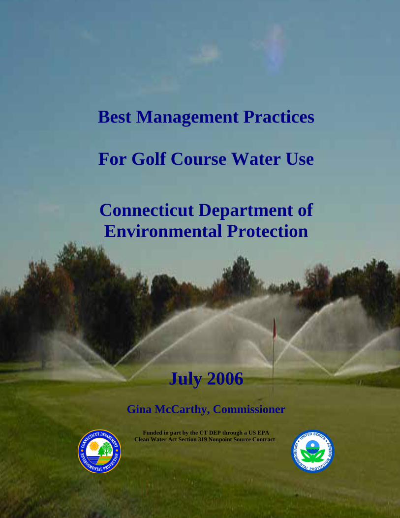
Best Management Practices
For Golf Course Water Use
Connecticut Department of Environmental Protection
July 2006
Gina McCarthy, Commissioner
Funded in part by the CT DEP through a US EPA Clean Water Act Section 319 Nonpoint Source Contract .
Page i DEP Best Management Practices for Golf Course Water July 2006
BEST MANAGEMENT PRACTICES FOR GOLF COURSE WATER USE Foreword ......................................................................................................................................... ii Advisory Committee Members...................................................................................................... iii 1.0 INTRODUCTION ................................................................................................................ 1 2.0 WATER QUANTITY MANAGEMENT: SUPPLY MANAGEMENT.............................. 2
2.1 Source Management – Water Supply Selection ................................................................ 2 Specific BMPs for water source management............................................................................. 2 2.2 Water Supply - Pond Location and Design ....................................................................... 3 2.3 Water Supply - Leakage and Ground water Recharge from Constructed Ponds .............. 5 2.4 Water Supply – Pond Usage and Maintenance ................................................................. 5 2.5 Water Supply – Water Level Monitoring in Storage Ponds.............................................. 6 2.6 Source Management – Environmental and Regulatory Permit Considerations ................ 6 2.7 Source Management – Metering........................................................................................ 8
3.0 WATER QUANTITY MANAGEMENT: DISTRIBUTION MANAGEMENT................. 9 3.1 Distribution Management - Irrigation Leak Detection and System Layout ...................... 9 3.2 Distribution Management - Irrigation Heads and Sprinklers .......................................... 10 3.3 Distribution Management - System Maintenance ........................................................... 11
4.0 WATER QUANTITY MANAGEMENT: DEMAND AND CONSTRUCTION MANAGEMENT................................................................................................................ 12
4.1 Cultural Practices – Turfgrass ......................................................................................... 12 4.2 Cultural Practices - Landscaping..................................................................................... 14 4.3 Equipment Maintenance Practices................................................................................... 14 4.4 Design Standards and Construction Practices ................................................................. 12 4.5 Irrigation Requirements................................................................................................... 14 4.6 Water Conservation ......................................................................................................... 17
5.0 WATER QUALITY - SURFACE AND GROUND WATER PROTECTION ................. 17 5.1 Evaluation of Existing Conditions................................................................................... 17 5.2 Water Quality Protection – Riparian/Wetland Buffer Zones .......................................... 18 5.3 Wetland and Watercourse Protection .............................................................................. 21 5.4 Stormwater Management................................................................................................. 22 5.5 Erosion and Sediment Control......................................................................................... 24 5.6 Turf Management - Nutrient and Integrated Pest Management (IPM) Plans.................. 24 5.7 Equipment Maintenance, Fueling, Chemical Storage and Mixing Areas ...................... 26 5.8 Spill Response ................................................................................................................. 27 5.9 Waste Management Plan ................................................................................................. 27
6.0 GLOSSARY OF TERMS................................................................................................... 28 7.0 APPENDICES .................................................................................................................... 31
Appendix I. Water Quality Monitoring.................................................................................. 31 Appendix II. Riparian Zones for Water Quality Protection ..................................................... 35 Appendix III. Estimating Turf Water Use ................................................................................ 46 Appendix IV. Selected Water Statutes, Regulations and Advice on Spills.............................. 57 Appendix V. Permits and Licenses........................................................................................... 69
8.0 GENERAL REFERENCES................................................................................................ 71
Page ii DEP Best Management Practices for Golf Course Water July 2006
Foreword
In November of 2000, the Connecticut Department of Environmental Protection ( CT DEP) and the Connecticut Institute of Water Resources (IWR) began collaborating on a water management information transfer project. The focus of the project was to facilitate the development of a list of potential best management practices for golf course water use and to manage an outreach effort to include a one day conference for industry professionals.
An advisory committee was created consisting of members of the golf course industry,
consultants, public interest groups, government agencies and the academic community. Three working subcommittees were formed to study and write portions of this document entitled Water Quality, Water Supply and Water Demand. The entire advisory committee convened monthly to discuss the evolving BMP document, and subcommittees met as needed to review relevant publications and write individual sections. The subcommittees began their work with a survey of existing best management practices for golf course water use that had been developed for use in other parts of the country. Additionally, they examined peer-reviewed, scientific literature regarding to golf course water. The subcommittees evaluated the existing best management practices and the published studies to determine their applicability in Connecticut. During the committees' discussions, it became clear that further investigation of some practices (for example fertigation) relevant to Connecticut is needed.
The report of the advisory committee to the CT DEP on best management practices for golf
course water use was distributed at a conference “Water Resources Management in a Golf Course Environment” held in October 2003. This conference devoted one session to outlining these best management practices, and another to provide the opportunity for public discussion and comment.
Except for minor edits and some reordering of paragraphs the following document represents the
report developed by the advisory committee and distributed at that conference. It is not intended to be all-inclusive. Additionally, not all of the best management practices described here will be applicable to all golf courses, since many of the recommendations must take into account site-specific conditions.
The Department of Environmental Protection is an affirmative action/equal opportunity employer, providing programs and services in a fair and impartial manner. In conformance with the Americans with Disabilities Act, DEP makes every effort to provide equally effective services fro persons with disabilities. Individuals with disabilities needing aids or services, or for more information by voice or TTY/TDD call 860-424-3000.

Page iii DEP Best Management Practices for Golf Course Water July 2006
Advisory Committee Members
Michael J. Astram Irrigation Consultant Northern Designs Patricia Bresnahan Associate Director Connecticut Institute of Water Resources Andy Dangler Environmental Analyst CT DEP Inland Water Resources Division Bill Dest University of Connecticut- Emeritus Stuart J. Fairbank Civil Engineer Angus McDonald, Gary Sharpe & Associates, Inc. Carla Feroni Environmental Analyst & Project Coordinator CT DEP Inland Water Resources Division Heather Garvin Golf Course Superintendent Canton Public Golf Course Tessa Gutowski Management Analyst CT DEP Planning & Standards Division Rob Hust Supervising Environmental Analyst CT DEP Planning and Standards Division Dana Karpowich CT DEP Pesticides and Waste Management Steve Lewis Trout Unlimited Brian Murphy Fisheries Biologist
CT DEP Fisheries Division David Murphy Hydrologist Milone & MacBroom, Inc. Christy O' Neill University of Connecticut Tim O'Neill Golf Course Superintendent Country Club of Darien Chris Stone Sanitary Engineer CT DEP Permitting and Enforcement Division Peter Pierson Golf Course Superintendent Pequabuck Golf Club Steve Rackliffe, C.G.C.S. Extension Instructor, Turfgrass Science University of Connecticut John Ruzbatsky Golf Course Superintendent Country Club of Farmington Russ Slayback Chairman Leggette, Brashears and Graham, Inc. Glenn Warner Director Connecticut Institute of Water Resources Margery Winters Rivers Alliance of Connecticut
Page 1 DEP Best Management Practices for Golf Course Water July 2006
1.0 INTRODUCTION The best management practices for golf course water use (BMPs) are intended to promote water conservation, preserve or improve water quality and protect water resources. These BMPs were developed by a work group consisting of superintendents, environmental regulators, and specialists from local engineering, scientific, and irrigation consulting groups. They were developed for the use of golf course planners, architects, developers, and local regulators who may need assistance and guidance in developing new golf courses, or making changes to existing golf courses, under the regulatory and environmental constraints that exist in the State of Connecticut. These BMPs are divided into the following categories: Section 2 - Water Quantity Management: Supply Management Section 3 - Water Quantity Management: Distribution System Section 4 - Water Quantity Management: Construction and Demand Management Section 5 - Water Quality Management and Protection Some BMPs fit into more than one category. Although we have attempted to avoid excessive overlap, some particularly important BMPs are repeated in more than one category for completeness. “Supply management” includes conservation measures that improve the efficiency of, and eliminate waste in, the production and distribution of water within a system. “Demand management” includes conservation measures that achieve water savings by reducing water need. These definitions are paraphrased from the document Planning Guidance for Water Conservation (DEP, DHS, DPUC, OCC, and OPM, 1990). There is a glossary of terms located in Section 6 of this document. Words included in the glossary are set in bold upon their first occurrence in the text.
Page 2 DEP Best Management Practices for Golf Course Water July 2006
2.0 WATER QUANTITY MANAGEMENT: SUPPLY MANAGEMENT Supply management deals with the management of water as it moves from its original source, such as a well, to the end of the distribution system. At golf courses the distribution system is generally comprised of pumps, underground water lines and sprinkler heads. Some components of supply management overlap with section 3 (Water Quantity Management: Distribution System) and section 4 (Water Quantity Management: Construction and Demand Management). The reader should read all of sections 2, 3 and 4 to become familiar with all aspects of distribution management. 2.1 Water Supply Selection It is important to understand where irrigation water comes from and what the impacts of using that water may be on other water resources in the area. At any given site, multiple water sources may be available for irrigation. Potential water sources include ponds, lakes, watercourses, wells, runoff, effluent and public water supply. The environmental impacts, cost, engineering feasibility and regulatory requirements of each of these alternatives should be fully evaluated. The evaluation of environmental impacts should analyze the affects of a potential irrigation source on nearby wetlands, watercourses and wells, with specific attention to low flow and drought conditions. Specific BMPs for water source management • Perform a feasibility study that analyzes water supply sources. The study, usually requiring a
qualified professional consultant, should evaluate all potential sources with respect to supply adequacy, economic viability, engineering considerations, and environmental impacts. This should be an automatic first step for a proposed course. Some potential water sources include: larger streams, rivers, and flowing watercourses, surface water in natural or existing ponds or impoundments, constructed (excavated or earth bermed) ponds, ground water from drilled (deep) bedrock wells, ground water from shallow wells in unconsolidated deposits, storm runoff from impervious surfaces captured in retention ponds, high flow (flood) water diversion into storage ponds, secondary or tertiary effluent from a sewage treatment plant, grey water, and treated or raw water from a local public water supply distribution system.
These potential sources are not listed in any priority from either a reliability or an environmental impact standpoint. Many factors are involved in the selection of the appropriate or suitable source(s) including:
Page 3 DEP Best Management Practices for Golf Course Water July 2006
low flow rate in streams relative to the irrigation demand, particularly during dry seasons, yield of wells at different drawdown levels, proximity and interaction of wells, streams, and wetlands, particularly for wells in
unconsolidated deposits near streams, and instream flow requirements mandated by regulatory processes for aquatic organisms,
habitat, dilution and demand by other users. • Use a combination of water sources to provide system flexibility and minimize
environmental impacts under different irrigation scenarios. For example, during drought periods when low flows occur in surface waterbodies and irrigation demands are greatest, irrigation should be shifted from sources dependent on surface water to deep bedrock wells that are usually less affected by short-term drought. Also, storage ponds can be constructed and used temporarily to lessen the impact on existing surface water sources (such as watercourses) during drought periods.
• Conduct a water resources analysis for existing irrigation systems on courses under the
following conditions:
loss of one or more sources due to natural conditions (such as persistent drought), loss of one or more sources due to cost increases (such as frequent well rehabilitation
caused by plugging), loss of one or more sources as a result of a regulatory process (example: diversion permit
condition restricting or prohibiting use of source during low stream flow conditions), Repeated stress on existing resources during peak irrigation times.
• Use a qualified professional to perform a watershed analysis to estimate the amount of runoff
that could be captured using different sizes, shapes, and locations of storage ponds. Conduct this analysis in conjunction with the drainage planning for the course.
2.2 Pond Location and Design Ponds or impoundments can provide a storage facility that helps reduce the peak demand on other water sources such as streams or wells. It is often feasible to include excavated or bermed ponds within the local landscape, and they could be an aesthetic course feature. Ground water elevations, watershed size and surface water characteristics need to be evaluated when locating and designing storage ponds. Ponds should be located outside of regulated areas such as inland wetlands and watercourses. For example, impoundments of even minor streams can cause a number of problems, such as flooding or blockage of fish passage, that make them undesirable. Ponds may be located adjacent to a watercourse to allow for the skimming of flood flows to recharge storage. Dependent on pond bottom leakage and/or seepage, it may be necessary to line a pond with clay or a geotextile to gain any usable storage. Pond storage provides supply redundancy, which allows superintendents to meet peak demands even if the primary source of water is temporarily impaired or off-line. With increased storage capacity from constructed ponds, irrigation systems can be operated more easily and safely. The

Page 4 DEP Best Management Practices for Golf Course Water July 2006
more storage available to the system, the less likely environmental impacts are to occur due to peak pumping of wells or withdrawing from watercourses during low flow periods. In addition to providing water supply, constructed storage ponds can be designed to provide beneficial habitat for wildlife. Storage ponds with shallow margins can be planted with native wetland vegetation, which is utilized by many wildlife species. Buffers of native herbaceous and shrub vegetation can also be planted around the perimeter of the storage ponds to enhance wildlife habitat. The collection of stormwater runoff in constructed ponds generally creates a source of water that can be used without significant environmental impacts. This practice can be especially beneficial as a source supply when the stormwater runoff is generated from a large impervious area, such as a course parking lot. With careful planning and design, the course drainage plan can include grass swales or diversions that direct stormwater runoff from the landscape to a series of collection and storage ponds. This can be a very important water source, since a relatively small area can generate large volumes of water in a storm event. For example, capturing one inch of runoff from a one-acre catchment will yield 27,154 gallons of water. However, very few golf courses can irrigate through a whole season with only stormwater. Also, since runoff from impervious areas (the “first flush”) can include pollutants, such as sediment, nutrients and heavy metals, the basins and/or swales in the collection system should be designed to remove pollutants before they reach irrigation water storage ponds. Specific BMPs for constructed water storage ponds • Construct storage ponds to increase water supply for use during peak irrigation times. • Direct drainage from natural slopes and impervious surfaces through areas with vegetative
cover, such as swales and diversions, and into storage ponds to maximize the collection of runoff from local storm events.
• Use high flow diversions or pumping to fill the storage ponds during flood flows. • Plan new ponds and the enlargement of existing ponds in upland areas to avoid disturbing
wetlands and watercourses. • Line excavated ponds based on an evaluation of potential seepage losses from the pond,
especially in sandy soils or coarse geologic deposits such as stratified drift. • Construct ponds with irregular shorelines and bottom contours to enhance wildlife habitat. • If possible, construct ponds with shallower side slopes (7:1 ratio) to encourage the
establishment of a wetland shelf along the pond shoreline. • If possible, construct ponds in a series, or “train”, to treat stormwater/site runoff. The first
pond will catch the “first flush”, the second will provide additional filtering and the third will filter and serve as a primary withdrawal pond for irrigation.
Page 5 DEP Best Management Practices for Golf Course Water July 2006
2.3 Leakage and Ground water Recharge from Constructed Ponds Water loss by seepage from constructed ponds to ground water may result in increased demand on the primary source (well, stream, natural pond, effluent, or public water supply). Over-pumping any water source can have significant environmental effects and is costly, because energy is wasted. Ponds receiving local runoff or irrigation return water may also have elevated chemical concentrations, which can contribute to ground water pollution if seepage occurs. Depending on the soil, geologic material and ground water table levels, it may be necessary to line ponds to prevent leakage. Ponds receiving inflows containing high amounts of organic matter and/or fine soil materials (silt and clays) will often form a natural impervious layer that minimizes seepage. Ponds that intercept the water table may rely almost solely on ground water inflow to sustain their levels. The direction of ground water movement to or from the ponds can be determined by identifying water level changes, adjusting for evaporation from the pond surface during non-pumping periods. Shallow wells can also be installed adjacent to the pond to determine whether the local water table is lower or higher than the surface water elevation in the pond and to indicate the gradient for ground water movement. If a constructed pond gains water naturally from the surrounding deposits, it will behave as a large dug well, drawing in more water as it is removed for irrigation, unless outflow is exactly balanced by inflow from some other source. Specific BMPs for leakage from a constructed pond • Evaluate the direction of water movement by installing piezometers or monitoring wells
around ponds to determine the hydraulic gradient. • Measure and maintain records of pond levels during both pumping and non-pumping periods.
Use the variation in water levels, as adjusted for estimated evaporation and pumping, to estimate the seepage rate to or from the pond. A reliable estimate of the evaporation rate from shallow ponds is 0.8 times the evaporation rate from a Class A evaporation pan (see Appendix III, Part A., Estimating Evapotranspitation.).
• Assess the water quality of the pond water to determine the potential of ground water
pollution by seepage from the pond. • Design constructed ponds with an impervious lining to prevent loss of water to the ground
water table where necessary. A pond lining may be clay or synthetic. 2.4 Pond Usage and Maintenance Specific BMPs for management of constructed ponds within the larger irrigation system.
Page 6 DEP Best Management Practices for Golf Course Water July 2006
• Use a floating intake when withdrawing from a pond, so that the irrigation water is taken from the upper two feet of the water column. Surface water is generally better quality than the bottom water.
• Use a mechanical solution when aquatic weed management is required in order to prevent
contamination or corrosion of the irrigation system. • Use herbicides as a last-resort measure, and only use fully permitted products applied by a
licensed applicator. • Obtain required local, state or federal permits to remove sediment from constructed ponds. • Consider using grass carp to control vegetation when needed (see CT DEP Fisheries for fish
stocking permit). 2.5 Water Level Monitoring in Storage Ponds Specific BMPs for monitoring water levels in storage ponds • Fit storage ponds with staff gages that show the stage (level) of water to the nearest
hundredth of a foot. • Develop a stage-volume relationship, such that the volume can be estimated quickly from a
table or graph if the reader knows the stage. • Take staff gage readings at least once per day during water withdrawal operations. If
possible, take readings immediately before and after storm water events to assess the volume of water collected.
2.6 Environmental and Regulatory Permit Considerations Surface water withdrawals directly from a stream system will cause immediate reduction of in-stream flows, potential loss of in-stream habitats, and potential conflicts with downstream water users. Natural or existing ponds may not have enough storage to sustain continued withdrawals, and wetlands surrounding a pond may be dewatered or otherwise adversely affected if the pond is drawn down. Withdrawal of water from wells (especially when located in unconsolidated deposits next to streams) may cause lowering of the ground water table, induced infiltration from streams and wetlands, reduced discharge to streams (which has the same effect as induced infiltration), or drawdown of nearby public or private water supply wells. Deep, bedrock wells generally have smaller or delayed effects on nearby streams, since the bedrock aquifer is less likely to be directly connected to the stream. The use of treated wastewater effluent for irrigation is common in other parts of the United States with more severe water allocation problems. In some cases, effluent may be useful for

Page 7 DEP Best Management Practices for Golf Course Water July 2006
irrigation in Connecticut, provided that public health concerns are properly addressed. Some larger streams rely on effluent, in part, for in-stream flow maintenance. Therefore, the water supply feasibility study may need to address competing uses for effluent as well as the degree of treatment (e.g. secondary versus tertiary treatment) including nutrient levels and chlorine concentrations. Also, the effluent generator will need a plan for discharges when the golf course is not operating or irrigating. Effluent may be stored directly in constructed ponds for irrigation draw, or be used to recharge the ground water table and therefore mitigate down-gradient withdrawals from wells or a watercourse. Another alternative source of irrigation water is grey water, which may be collected on-site via a system of pipes that is separate from toilet discharges. Grey water includes wastewater from kitchens, showers and baths, laundry facilities, and other cleaning and rinsing operations. Typically, the amount of grey water available from a golf course would be relatively small as compared to its irrigation needs and therefore would only be available as a supplemental source or for small landscaped areas. The use of treated water, such as water from a public water supply, is often considered too expensive for irrigation, and is typically considered an imprudent use of potable water. However, use of this water has several advantages and may not be more expensive than untreated water when the fixed costs for wells, pumps, storage ponds, etc. and the operating costs for energy, filtration and chemical treatment to prevent clogging of nozzles by particles or chemical precipitation of solutes are considered. Use of public water supplies may also be advisable if there are no on-site supply sources, or if the use of on-site sources causes significant environmental impacts. If a course is near a public water supply source, e.g. a reservoir, the course may be able to obtain raw (untreated) water from that source, but the need for filtration and chemical treatment (e.g. for hardness) needs to be evaluated. If treated water is used it should not be released directly into a natural pond or a watercourse (due to concerns about chlorine levels) but may be released into constructed ponds or pumped directly into the irrigation distribution system. Another concern related to public water supplies is the availability of water during droughts or "alerts" when the public use of water is restricted. Temporary storage of water in ponds or alternative small sources may be needed in some cases to maintain greens and tees. Specific BMPs for environmental and regulatory concerns associated with water supply • Contact the CT DEP to arrange a pre-application meeting to discuss the permitting
requirements for an existing or proposed golf course irrigation system. It is likely that most golf course irrigation systems are subject to regulation by DEP, since any withdrawal (or combination of withdrawals) of surface or ground water in excess of 50,000 gallons in any twenty-four hour period requires a water diversion permit. A pre-application meeting should greatly expedite the permit process by allowing for discussion of alternative water sources and identification of significant environmental issues.
Page 8 DEP Best Management Practices for Golf Course Water July 2006
• Withdraw water from relatively large streams, third order or greater, if an alternatives analysis determines that surface water withdrawals are environmentally appropriate. Withdraw from smaller second order streams only if water is excessively withdrawn during storm events and transferred to storage ponds, so that base flows are not reduced.
• Withdraw from lakes, existing stream impoundments and "natural" multi-purpose ponds only
after performing an analysis that determines the available storage of the pond and associated environmental impacts under different drawdown scenarios. Typically, an existing pond should not be drawn down more than a few feet, or even less if the pond is in play.
• Construct retention ponds to capture runoff from the local watershed, especially any
impervious surfaces, and to supplement supply sources. • Conduct an aquifer pump test to evaluate the effects on nearby wetlands, watercourses and
private and public water supply wells from using the maximum withdrawals from the proposed irrigation well(s).
• Evaluate the feasibility of using effluent and/or grey water as a supplemental irrigation
source. • Use water from a public water supply as a last resort, such as when the use of on-site sources
causes significant environmental impacts. 2.7 Metering Specific BMPs for metering water withdrawals • Use a meter at each source of water withdrawal. Metering of the sources should be at the
discharge side of the source pumps prior to any off-take piping. • Choose a meter that provides both a numeric cumulative volume reading and an
instantaneous flow reading. This will enable the user to gage consumption and obtain a quick estimation of the flow rate.
• At least once a year, prior to the start of the irrigation season, calibrate meters in accordance
with the manufacturer's recommendations.
Page 9 DEP Best Management Practices for Golf Course Water July 2006
3.0 WATER QUANTITY MANAGEMENT: DISTRIBUTION SYSTEM This section deals with the performance of the irrigation system. Parts of this section overlap with material found in Section 4.0, Water Quantity Management: Construction and Demand Management. Leak detection should be made an integral part of irrigation system management. Leaks may occur between the source of supply and the storage ponds, or between the storage ponds and the sprinkler heads. Numerous firms offer automated leak detection technology services. Computerizing the irrigation management system not only saves labor, but is also more efficient and flexible. Golf course irrigation systems can be linked to a golf course superintendent’s home or business computer, allowing the system to be remotely monitored and shut off. Often weather changes occur rapidly in the summer months, and rainstorms occur during times when irrigation managers are not on-site. In the event that an irrigation cycle is taking place and a storm occurs, a computerized rain gage shut off would allow the irrigation system to shut down automatically. By using a computerized system, the irrigation manager has the ability to set the precipitation rate at which the system automatically shuts off. Superintendents should take advantage of weather stations or weather satellite companies. In New England, microclimates and conditions may vary throughout the golf course due to slope aspect, shade, soil conditions and water tables. The use of weather stations or daily weather data such as evapotranspiration (ET) rates can be used as a reference point by irrigators to determine the amount of water they need to replenish. To complement available weather data, on-site rain gages should be linked into the irrigation control system. Weather forecasts are also important for predicting significant amounts of rainfall from frontal or tropical storms that are expected in the area. It is important to note that irrigation (and application of chemicals) before large rainfall events increases the potential for both leaching and runoff. 3.1 Irrigation Leak Detection and System Layout Specific BMPs for leak detection and system layout • Perform leak detection on a regular basis several times per year, including in the spring at the
start of the irrigation season and at the end of a season to ensure the proper closure of the system.
• Install water meters in critical locations throughout the irrigation system. For example,
metering should be done at the original source(s) (wells, streams) and between any storage ponds and the distribution system.
• Use isolation valves before all main lines and major laterals to be able to quickly shut off
leaking areas before turf is damaged and water is lost.
Page 10 DEP Best Management Practices for Golf Course Water July 2006
• Use an onsite weather station combined with an automated sprinkler system governed by atmospheric conditions. The computer system should be easily programmed to accommodate expected weather conditions and expected turf water requirements.
• Use long and medium range forecasts to schedule irrigation to reduce the risk of runoff and
leaching during large rainfall events. • Use a computerized irrigation management system equipped with flow management to
increase irrigation efficiency. • Rain shutoff switches should be installed on all new and existing irrigation systems to avoid
over-watering following significant rainfall. 3.2 Irrigation Heads and Sprinklers Specific BMPs for irrigation heads and sprinklers • Install low volume irrigation heads in new irrigation systems and in existing courses where
feasible. Low volume sprinklers can reduce water loss due to evaporation, wind drift, leaching and runoff from sloping surfaces.
• Use low or adjustable trajectory nozzles. These allow the irrigation manager to reduce the
effects of wind on evaporation during irrigation and to compensate for sloping areas. • Choose sprinkler heads that do not exceed the lowest infiltration rate of the specific soil.
Observe where runoff typically occurs during the irrigation and adjust or replace nozzles to decrease the application to fit the local conditions.
• Adjust run times and amount of water applied during irrigation and do not apply more than
the available holding capacity of the root zone for the specific site. Soil types can vary greatly within small areas, and different turf species may have different root depths.
• Replace full-circle sprinklers with part-circle sprinklers to reduce water being applied to out-
of-play areas. • Use automatic controllers and/or portable hand-held devices, where feasible, to apply water
in a more efficient manner.
• Improve irrigation uniformity through careful evaluation of design criteria such as nozzle size, rotation speed, spacing, scheduling coefficient and pressure selection.
• Use available testing data from research organizations such as Center for Irrigation
Technology (CIT) when designing a new system or retrofitting an irrigation system. • Annually inspect and replace nozzles that are worn, partially clogged or do not rotate freely.

Page 11 DEP Best Management Practices for Golf Course Water July 2006
• Assure that the correct nozzle sizes are used/replaced in accordance with the position along
the system and with pressure head distributions and water requirements for the specific turf and landscape position.
3.3 System Maintenance In Connecticut, golf course irrigation systems are active about 7 months a year, typically from April 1 to October 31. Proper winterization of an irrigation system is paramount to a trouble-free and effective system. Most irrigation systems are closed in early November. An air compressor with a high volume (CFM) and regulated, relatively low pressure (40-60psi, just enough to activate the heads) can be connected at the highest point in the system to dewater it prior to closure. Improper sizing of the compressor used to close the system could result in major problems when startup occurs in the spring. Proper winterization will avoid damage to the system, thus conserving water. Proper spring startup of the irrigation system is almost as important as proper winterization. The system should be charged at low pressure and the main piping system checked for leaks. As the system is being charged with water, air that was in the system for the winter should be evacuated by the use of quick couplers or air relief valves at the ends of the mains, and at any high spots along the piping run that trap air. After the main lines have been charged, the lateral lines should be charged with water and checked for leaks. It is recommended that the irrigation system be charged with water in the early spring so that if any leaks are found, they can be repaired before the system is put into use. Specific BMPs for Winterization and Spring Start up of Irrigation Systems • Winterize the irrigation system by evacuating as much water as possible from the system
using a properly sized air compressor for the system being closed. • Charge irrigation system in spring at low pressure. • Check for irrigation system leaks during early spring start up.

Page 12 DEP Best Management Practices for Golf Course Water July 2006
4.0 WATER QUANTITY MANAGEMENT: DEMAND AND CONSTRUCTION MANAGEMENT Demand management deals with identifying and using techniques that promote conservation from the perspective of demand. It can be as simple as selecting drought-resistant turf, and as complicated as planning a cultural system to conserve water. Best management practices for water conservation could be described as the combination of proper plant selection and cultural maintenance practices that provide quality turf for the game of golf while minimizing water use. 4.1 Design Standards and Construction Practices Design criteria should minimize the need for site disturbance where possible and should be consistent with the existing topography and golf course design objectives. A water balance assessment should be conducted to show present conditions such as water flow and storage in soils. The assessment might include, but not be limited to, water infiltration rates of onsite soils, saturated hydraulic conductivity, water retention characteristics, depth to water table (both perched and ground water), from surface, topsoil depth, soil organic matter content, soil structure and soil bulk density. An assessment provides the opportunity to develop a plan of action to minimize effects of construction activities on water partitioning. Water partitioning refers to the amount of water that infiltrates, exits as surface runoff, is retained in the soil or percolates to ground water. Specific BMPs for minimizing effect on water partitioning by construction activities • Site fairways to minimize cuts and fills and avoid wetland crossings. • Maintain existing vegetation, such as forest or grassland, that is consistent with golf course
design objectives. • Use low ground pressure track equipment to move soil in order to minimize soil compaction. • Keep rubber tire machinery, except for landscape tractors, to haul roads where possible to
avoid soil compaction. • Minimize the amount of exposed soil at any one time to reduce risks of soil erosion. • Provide a construction sequence plan. • Minimize use of subsurface drainage systems on fairways and roughs to maintain the water
table, if present, provided it does not interfere with the playing surface or movement of service vehicles once the golf course is constructed.
• Stabilize exposed soils with a temporary cover if left for over 30 days during construction.

Page 13 DEP Best Management Practices for Golf Course Water July 2006
• Prior to finish grading, alleviate subsoil compaction from construction equipment using
subsoilers, rippers and/or chisel plows. Soil compaction is a barrier to plant root penetration and water infiltration.
• Alleviate compaction of the topsoil using harrows, rotary tillers and or chisel plows. • Conserve topsoil during removal of existing vegetation by using appropriate equipment, such
as excavators, to remove stumps. • Soils low in organic matter should be amended with organic material to promote soil
aggregation and increase water available to plants. 4.2 Cultural Practices – Turfgrass • Select low-water-use turfgrasses, such as the fine-leaf fescues, where feasible. A list of
varieties is provided in the National Turfgrass Evaluation Program, National Fineleaf Fescue Test. (See reference list)
• Designate areas that can be naturalized for lower maintenance, thus less water use. • Provide adequate and balanced levels of nutrients to the turf. Avoid excessive amounts of
nitrogen, and apply nutrients based upon turf species and cultivar nutrient requirements, level of use and soil type.
• Use soil cultivation techniques such as spiking, slicing and core aerification to improve
water infiltration and minimize runoff during irrigation or rainfall events. • Use environmentally safe wetting agents to improve water infiltration. • Explore the potential use of polymers as a means of increasing water retention and reducing
water loss to evaporation. • Limit cart traffic to paths to minimize turf wear and soil compaction.
• Prune roots of trees near critical turf areas to prevent tree root competition with the turf for
moisture and nutrients. • Contour the land around irrigation ponds to collect storm water that otherwise would be lost,
or create a storage pond for this purpose.
• To reduce evaporation losses, irrigate in the early morning or evening hours when evaporation and winds are at their lowest.
Page 14 DEP Best Management Practices for Golf Course Water July 2006
• Vary the irrigation amount and rates in accordance with different soil types, degree of slope and slope aspect, drainage patterns and microclimates.
• Observe and map areas of high seasonal water tables where irrigation demands may be less,
due to capillary movement of water into the root zone from a shallow water table. Late winter and early spring are usually good times to observe.
• Observe runoff producing zones under typical winter/spring storms (e.g. nor’easters) and
summer thunderstorms. Avoid over irrigation and use precautions in fertilizer/pesticide applications in these runoff zones, especially during early spring and late fall.
• Observe and map areas that have different water use patterns based on turf response to dry
periods. Use the maps to plan and operate the irrigation systems. • Choose sprinkler heads that do not exceed the lowest infiltration rate of the specific soil.
4.3 Cultural Practices - Landscaping
• Use drip irrigation in landscape areas to apply water only to the plants that need it. • Use mulches in shrub and flowerbeds to reduce water evaporation losses. • Consider use of polymers as a means of increasing water retention and reducing water loss to
evaporation. • Use xeriscape landscaping or native drought tolerant plants where feasible around buildings,
parking areas or other appropriate places. Gravel pathways or borders that permit infiltration but have low evaporation potential are one example of xeriscape landscaping.
• Retain existing vegetation when possible on a new course and plant native vegetation on new
and existing courses.
4.4 Equipment Maintenance Practices • Use a hose with a shutoff nozzle if washing all equipment and machinery with water. Where
available, use pressurized air to clear clippings off equipment.
• Use wash pads to recycle water or divert washwater to a storage pond for reuse in the irrigation system.
4.5 Irrigation Requirements
Page 15 DEP Best Management Practices for Golf Course Water July 2006
Irrigation requirements for a period from April to October can range from 8.9 acre inches (amount of water to irrigate an acre of turf for the growing season) during a season of average precipitation to 18.2 acre inches during a drought year. This assumes that the antecedent soil moisture is at or near field capacity (0.01 MPa) throughout the growing season. However, at various times during the growing season, plants may begin to transpire less water as a result of an increase in soil matrix suction (affinity of water for soil particle surfaces) making it more difficult for plants to extract water from the soil. Determining irrigation requirements for a new golf course or an existing golf course that is upgrading its irrigation system requires several steps. These are:
Step 1 - Estimate Potential Evapotranspiration The potential evapotranspiration (ETp) rate can be described as the rate the atmosphere can accept water. There are many methods of estimating ETp (See Appendix III, Part A). Some of the more common approaches include obtaining data from outside sources, physically measuring actual evapotranspiration, and calculating ETp with equations. The Penman equation calculates ETp using four weather variables: solar radiation, wind, temperature and humidity. Another equation, the modified Penman equation, allows one to estimate the ETp of a particular reference crop, a 3-6" tall cool season grass that completely covers the ground and is supplied with an adequate amount of water. Estimating ETp is only a first step in estimating water use, however, since it describes the evapotranspiration rate of a reference turf in a well-watered condition, which might not equate to field conditions. The next step adjusts the equation to reflect the actual turf and conditions on the ground.
Step 2 - Estimate Actual Evapotranspiration The actual amount of water used by the plant (crop) differs from the calculated ETp and is calculated by adding crop coefficients (Kc) to the equation. These coefficients are developed by research, which determine the actual amount of water used (ETa) by the crop (in this case a specific turf species in a specific climate). The equation then calculates the ratio of ETp to actual ETa in which:
ETa = ETp x Kc where:
ETa = actual water use Kc = crop coefficient
Examples of crop coefficients for turfgrasses are shown in Appendix III, Part B. Some of these have been developed in other regions of the country so coefficients may differ from those developed here.

Page 16 DEP Best Management Practices for Golf Course Water July 2006
Step 3 - Estimate Monthly and Yearly Irrigation Requirements Using Effective Rainfall
Not all rainfall replenishes soil moisture; therefore effective rainfall (re) can be defined as the fraction of rainfall that restores soil moisture. For example, a one-inch rainfall event would have little effect on restoring soil moisture if antecedent soil moisture is at or near field capacity. Instead, it may result in most of the rainfall being lost to runoff, deep percolation, or evaporation directly back to the atmosphere. It therefore is important to estimate irrigation requirements using re in which:
Ir = ETa - re where:
Ir = irrigation requirement ETa = actual water use in step 2 re = effective rainfall
Note: Curves and a table are shown in Irrigation Water Requirements, in which
effective rainfall can be determined, Tech Release No. 21 USDA. SCS Engineering Division, April 1967. The curves and table show the relationship between average monthly rainfall, monthly evapotranspiration and monthly effective rainfall. Caution is recommended in the Tech Release in using the curves and table. See Table 7, Appendix III.
Step 4 - Correct Irrigation Requirement for Distribution Uniformity
Even the most sophisticated irrigation systems do not distribute water uniformly. Distribution uniformity (DU) is a measure of how evenly the system applies water to the turf. On average, DU is between 60 to 80 percent efficient, although this can be variable. Therefore, a last step needs to be factored into the equation for calculating irrigation requirements (Ir) in which:
Ir = ETa - re
DU where:
Ir = irrigation requirement ETa = actual water use re = effective precipitation DU = distribution uniformity
Page 17 DEP Best Management Practices for Golf Course Water July 2006
4.6 Water Conservation Water conservation begins with using the correct amount of water to replenish soil moisture depleted by evapotranspiration. Methods for determining daily evapotranspiration are provided in Appendix III, Part A. Another means to conserve water is the use of deficit irrigation. Deficit irrigation refers to the replacement of only a fraction of water lost by turf to irrigation. The amount of water is determined by referenced soil moisture content or by ETP. This method is often used during drought periods. An example would be to irrigate with 80% of ETP estimated from the Penman equation, open pan evaporation or other method. A second example would be to establish a soil moisture release curve in which a soil moisture level is chosen as a reference point and then irrigating to a percentage of the reference value based upon the depth of the root zone. A means to measure soil moisture would have to be set in place, such as use of a tensiometer or time-domain reflectometry. Desired turfgrass quality, grass species, percent slope, slope aspect, topographic position and presence of a water table would need to be considered when using this method. Specific BMPs for Water Conservation • Reduce irrigation rates in secondary rough areas and, where possible, eliminate irrigation of
non-play areas. • Develop a drought emergency plan to balance the most critical golf course water demands
during times of water use restrictions. 5.0 WATER QUALITY - SURFACE AND GROUND WATER PROTECTION The goal of this section is to present BMPs that minimize the potential of pollutants reaching surface or ground water as a result of golf course construction and maintenance operations and thereby minimize non-point source pollution. Many of the BMPs associated with the previous sections, which deal with water use, are also important in minimizing pollutant transport through soils and surface runoff. Those practices that prevent over-watering are especially important for minimizing pollutant transport through leaching or by surface runoff. The maintenance of high infiltration and water holding capacities of soils is also critical. 5.1 Evaluation of Existing Conditions Evaluation of the potential impact of a golf course should start with a site assessment to examine the current conditions. Baseline water quality data should also be collected before the construction of a new golf course. Elements to include in a baseline water quality evaluation are discussed in Appendix I. The evaluation should then examine potential impacts to water located both on and off the golf course. Qualified staff or consultants should perform all evaluations. Ongoing water quality evaluation may be necessary for sensitive areas such as a public drinking
Page 18 DEP Best Management Practices for Golf Course Water July 2006
water supply source area or critical wetland resource. See Appendix I, Water Quality Monitoring and Appendix IV, Selected Water Statutes and Regulations. Specific BMP for Site Evaluation • Develop an existing conditions survey and site plan that includes:
drought emergency plan to balance the most critical golf course water demands during times of water use restrictions; existing contours, direction of drainage, surface water resources, wetland boundaries,
floodplains and the type and function of all affected wetland areas (e.g. vernal pools, intermittent streams, marshes, etc.), located both on and neighboring offsite; soil maps with identification of steep slopes and erodible soils; location of existing or potential drinking water sources, including reservoir watersheds,
public wells and private well areas;" existing land cover (e.g. forest, meadow, old field, etc.); Natural Diversity Data Maps and a flora and fauna inventory; location of all existing and proposed buildings, roads, parking lots, storm drainage, water
supply ponds, sewers, septic systems, stream crossings, and other permanent structures and their proximity to surface waters and wetlands; location of all facilities, structures, treatments and measures used for soil erosion and
sedimentation control and long-term stormwater management; location of existing and proposed site vegetation and the extent of proposed or existing
buffer areas; location of pesticide/fertilizer storage and mix/load sites and fuel and chemical storage
areas in relation to water resources; identification of areas of active erosion (e.g. stream banks, exposed slopes, drainage
channels); identification of upstream and downstream land uses; ground water locations in relation to the surface of the course, particularly in any areas
that have a seasonally high water table (<24") or shallow bedrock (<4'); location of saturated source areas that become seasonal runoff producing zones (these
areas can be determined by field observations after high rainfalls in both early spring and in late summer and will vary seasonally within the landscape due to the variation in water tables and amount of recent evapotranspiration); and an evaluation of opportunities for compensatory mitigation in a proprietary order of
restoration, enhancement and creation that the proponent chooses to consider.
5.2 Water Quality Protection – Riparian/Wetland Buffer Zones
One of the best ways to protect surface water quality is to develop, enhance, restore or protect riparian vegetated buffers along the banks of golf course wetlands, watercourses and other water bodies and along the edges of surrounding, undeveloped upland areas. Buffers function as sediment filters that catch and trap sediment, as well as pollutants attached to sediment, from
Page 19 DEP Best Management Practices for Golf Course Water July 2006
runoff before it can reach surface waters. Buffers slow runoff and may increase infiltration and ground water recharge. Chemical and biological activity occurring in these buffers can capture and transform nitrogen and attenuate other pollutants into less harmful forms. Nutrients can be taken up by roots and stored in the vegetative biomass of trees, shrubs, ground cover and grasses. Vegetated buffers along wetlands and watercourses, consisting of differing strata of native woody (trees and shrubs) and herbaceous (grasses and wildflowers) vegetation, provide important wildlife habitat for insects, birds and mammals. Forested buffers along watercourses and water bodies provide leaves and organic materials, which are an important contribution to the aquatic food chain, and provide shade to maintain cooler water temperatures and higher dissolved oxygen levels in water bodies, which is critical to healthy fishery resources. Vegetated buffers around ponds may also discourage the use of nearby areas by Canada geese. The amount of protection and the functions provided by vegetated buffers will depend on buffer widths, slope of the stream bank and adjacent land, vegetation type, drainage patterns, amount of water and pollutants entering the buffer zone. Soil water content and ground-surface water interactions are important hydrologic variables associated with the potential for denitrification. Overall, wider vegetated buffers along watercourses or waterbodies provide higher water quality and wildlife habitat benefits. More detailed analysis of the benefits and construction of buffers, information on recommended widths of buffers and a list of references are presented in Appendix II, Riparian Zones for Water Quality Protection. Specific BMPs for vegetative buffers • Protect and maintain existing woody vegetation as natural buffers, to the maximum extent
possible, during the design and construction of new courses or during course maintenance. It is important to mark the limit of clearing prior to construction.
• Plant grasses, other herbaceous vegetation and woody vegetation in buffer strips where
existing vegetation is lacking. Plants included in a riparian buffer zone restoration or an overall habitat enhancement plan should be native and non-invasive. (DEP Non-Native Invasive & Potentially Invasive Vascular Plants in CT, March 2001)
• Locate new vegetated buffers between water bodies, wetlands and wellheads and any
potential pollution sources such as fertilized areas or runoff producing areas, such as impervious surfaces and seasonally saturated soil areas.
• Design buffer widths to vary in accordance with landscape position and amount of runoff and
potential pollutants entering the buffer at a specific location. Minimum buffer widths will vary with the intended buffer function and the specific site conditions including hydrogeology, slope, vegetation, soil type, presence of wetlands and the type of nutrient or pollutant to be removed.
Page 20 DEP Best Management Practices for Golf Course Water July 2006
• Where a desired buffer width cannot be met due to course layout, prevent runoff from
entering the water body at that location by diverting it to adjacent areas where adequately wide buffers can be developed and maintained. Methods of diversion can include shallow swales, low berms, and grading of fairway slopes away from stream banks.
• Maintain wider temporary buffers for sediment control during construction periods. • Maintain appropriate vegetation on steep or highly erodible stream banks at all times to
prevent stream bank erosion. Dense woody vegetation such as willow shrubs and saplings (Salix sp.) is often best at resisting and reducing high stream velocities that can easily erode stream banks. Mature hardwood trees may impede development of a dense ground cover due to shading. This makes mature trees less effective than dense shrubs in preventing stream bank erosion.
• Vary the width, height and type of vegetation to meet the specific functions of the buffer and
growing conditions at the specific location. Use a combination of native trees, shrubs and grasses along or around the wetland, watercourse or water body to meet the objectives for pollutant control and to provide a variety of habitats at each location.
• Select some woody vegetation to provide shade, especially along the south side of wide
sections of a watercourse or water body, to provide shading, cool water temperatures and to maintain suitable dissolved oxygen levels.
• Mow grass buffers infrequently, (e.g. 1 or 2 times per year), to preserve the functions of the
buffer while controlling woody vegetation. Remove clippings after mowing grass buffer zones to help reduce the cycling of nutrients back into the buffer zone and ultimately to a water resource.
• Do not dispose of grass clippings or prunings in the buffer areas. • Maintain buffer vegetation by regular monitoring of the health of the plants, by disease and
pest management using an integrated pest management plan and by appropriate pruning and cutting of woody vegetation when necessary.
• Protect woody vegetation from root damage caused by heavy equipment during construction. • Prevent placement of fill within the drip line of woody vegetation (where the water runs off
the tree canopy). • Control foot and cart traffic in buffer areas through signs and fencing. • Rotate public access points to buffers as needed to protect or restore vegetative cover. • Maintain a pesticide-free zone adjacent to buffer areas and around drinking supply wells.
See Appendix IV regarding public health code setbacks.
Page 21 DEP Best Management Practices for Golf Course Water July 2006
• Leave roughs in natural condition but keep vegetation height at about one foot to allow
raptors access to mice and voles and for tick control. • Design detention ponds with a continuous wide band of tall emergent plants around the edges
and in the shallow water to discourage geese. • Inspect buffers several times each year, particularly after runoff events, to assure that sheet
flow is occurring across vegetative buffers. Where channelized flow is developing, re-grade as necessary and use flow spreaders to encourage lateral flow of runoff along the outer edge of the buffer.
5.3 Wetland and Watercourse Protection Wetlands and watercourses provide enormous benefits to water quality and thus should be protected from human induced environmental changes. Wetlands should be managed as natural areas, with their habitat structure and existing hydrology fully protected. Wetlands and watercourses should be protected from excessive runoff discharges, de-watering effects from irrigation sources and from nutrients or pesticides used during golf course maintenance. For existing courses, where redesign opportunities to minimize stream crossings are few, replacement of failing culverts provides an opportunity to upgrade stream crossings to improve stream channels, wetlands and buffer areas. Installation of raised cart paths and boardwalks in soggy or environmentally sensitive areas may also provide water quality or wildlife habitat protection benefits. Be aware that there are municipal, state and federal agencies that administer statutes and regulations protecting wetlands and watercourses. Prior to initiating any activities within or adjacent to wetlands and watercourses, coordinate with these regulatory agencies to determine if permits or authorizations are required. Specific BMPs for Wetland and Watercourse Protection • Do not place fill within or adjacent to wetlands, watercourses and floodplains. • Avoid grading when possible within and adjacent to wetlands, watercourses and floodplains. • Minimize crossings of wetlands and watercourses. • Use shortest route possible at the narrowest width of the wetland, if crossings are necessary. • Use bridges instead of culverts. The use of bridges, which span the watercourse, instead of
culverts, is preferred in order to minimize soil, vegetation and water flow disturbance, fish habitat alteration and direct watercourse and wetland filling. Use construction materials and techniques that will minimize environmental impacts.
Page 22 DEP Best Management Practices for Golf Course Water July 2006
• Preserve as much vegetation as possible when installing crossings and replant disturbed areas
to restore lost vegetation. • Consider the hydrologic connections between the wetlands, their water sources and land
drainage areas when new courses are designed and contoured. Modifications to floodplains and watercourses should be avoided.
• Locate ponds outside of wetlands or watercourses for irrigation water supply, as course
hazards or for stormwater retention. • Locate buildings, parking lots and stormwater management facilities outside of watercourse
buffers, wetlands or floodplains. • Control pond overflow and surface runoff to avoid introducing warmer water to receiving
water bodies. • Site fairways to eliminate or minimize the number of wetland and watercourse crossings.
Perpendicular wetland and watercourse crossings at the narrowest point of the water resource are preferred, as they minimize the total area of disturbance.
• Design fairways to minimize the need to remove woody vegetation on steep or erodible
slopes. 5.4 Stormwater Management
The purpose of stormwater management is to slow water velocities and reduce peak discharges in order to reduce erosion, flooding, and pollutant loads in runoff before it enters streams, wetlands or ground water. Stormwater from golf courses can be a source of pollution. Management of both the quantity and quality of runoff is necessary to protect receiving waters. A number of stormwater documents and guides are available and they discuss impact assessment, management options, and design criteria for implementation. Site layout and design is important to minimize impacts and maintain natural protection of receiving surface and ground waters. The course site plan should maintain the natural wetland and watercourse systems and buffers, and locate necessary stormwater management structures to upland areas. This helps maintain the natural drainage patterns and allows for recharge of runoff. As described in Section 2.2 of these BMPs, a series or train of stormwater diversions, swales and basins can be designed to collect stormwater runoff for use in supplementing irrigation. Specific BMPs for Stormwater Management
Page 23 DEP Best Management Practices for Golf Course Water July 2006
• Design the course to maintain natural wetland and watercourse corridors and their buffers to minimize intrusions.
• Minimize the use of impervious surfaces and maximize sheet flow where possible. To do
this, consider using pervious pavers for walkways, paths and parking lots and minimizing the use of curbing on parking areas. Where reduction is difficult, large parking areas can incorporate landscaped areas to help maintain natural recharge. Pervious overflow parking should be used to accommodate seasonal parking.
• Avoid the direct discharge of stormwater runoff from parking lots, service areas, buildings
and roadways directly into wetlands and watercourses. Control the quality of surface runoff with appropriate filtration practices such as grassy swales, filter strips and constructed wetlands.
• Use a combination of vegetative swales, stormwater retention ponds, detention basins and
buffers to treat runoff from intensively managed areas such as tees and greens to help reduce the movement of nutrients and pesticides into wetlands and watercourses.
• Evaluate whether you should have stormwater retention ponds or detention basins for water
storage to address irrigation or flood management needs. • Use detention techniques such as wet ponds and detention basins to moderate surface runoff
and store peak flows. Structural measures such as infiltration trenches, detention basins, filter beds or soaking pits may be used in certain conditions but will require site-specific engineered design. Knowledge of the location and seasonal variation of the water table is especially critical in order to assure proper functioning of these structural measures.
• Use impervious liners or clay in stormwater retention ponds located in highly permeable soils
to prevent ground water contamination and seepage to natural watercourses. • Discharge or divert surface runoff onto wide, relatively flat vegetated areas to promote
infiltration and ground water recharge. • Design and install measures such as catch basin inserts, swirl concentrators or oil/particle
separators to treat the runoff from high use parking lots and service areas to minimize the discharge of hydrocarbons and sediment. Follow all manufacturers' maintenance recommendations to ensure the separators are functioning as they are designed to.
• Use appropriate erosion and sedimentation control measures during course construction or
modification. • Insure all wastewater discharges are properly connected and disposed. Illicit connections to
storm drains found at existing facilities must be corrected immediately. • Minimize the application of sodium chloride chemicals as a deicing agent for snow and ice
control, and maximize the use of abrasives, especially in the wellhead areas.

Page 24 DEP Best Management Practices for Golf Course Water July 2006
• Maintain roughs at a 2” to 3” mowing height to act as additional buffers. • Use chemical pesticide and fertilizers in accordance with an Integrated Pest Management
plan. • Locate pesticide and fertilizer mixing and loading areas away from wetlands and
watercourses and drinking water supply wells. Also divert runoff from these facilities into appropriate treatment areas.
• Store hazardous materials inside a structure with secondary containment. • Prevent stormwater contact with all waste and raw material storage areas, and divert clean
stormwater away from these areas. A full discussion of stormwater management recommendations is beyond the scope of this report. For specific BMPs related to stormwater quality see the 2004 Connecticut Stormwater Quality Manual by the CT DEP.
5.5 Erosion and Sediment Control Temporary sediment and erosion controls are critical during course construction or modification activities in order to protect water quality. Areas of wetlands and watercourses, steep slopes, significant fill and/or grading are especially vulnerable. A control plan should include construction phasing. Temporary sediment traps and basins may be necessary in addition to typical sediment barriers and inspection and maintenance schedules. Specific BMPs for Erosion and Sediment Control
• Use DEP Bulletin 34 entitled 2002 Connecticut Guidelines for Soil Erosion and Sediment
Control as the standard for BMPs for soil erosion and sediment control. • Fence off protected areas such as vegetative buffers to keep construction equipment and
people out. • Control cart traffic to avoid highly erodible areas. 5.6 Turf Management - Nutrient and Integrated Pest Management (IPM) Plans Integrated Pest Management (IPM) is defined as the use of all available pest control techniques, including judicious use of pesticides when warranted, to maintain a pest population at or below an acceptable level, while decreasing the use of pesticides. IPM includes the combined use of

Page 25 DEP Best Management Practices for Golf Course Water July 2006
many techniques. Some of these techniques include: site scouting or monitoring; correct pest and damage identification; use of resistant turf cultivars and varieties; proper cultural practices (irrigation, mowing, soil aerification and thatch management); soil and plant tissue testing; nutrient management; weather monitoring; physical controls; biological controls; identification of beneficial organisms; record keeping; equipment calibration and maintenance; good communication, and the precise timing and proper selection of pesticides. A nutrient management plan should also be developed that addresses the timing and placement of fertilizers based on seasonal demand or usage of specific turf species, landscape position and weather. Areas of seasonally high water tables should be flagged during typically wet periods in spring and fall. Special care should then be taken in the timing of applications to these areas since they become surface runoff zones during storms. A full discussion of IPM recommendations is beyond the scope of this report. Some specific BMPs related to water quality are listed below. For more information see "Integrated Pest Management for Golf Courses", available through the United States Environmental Protection Agency (US EPA), "Model Integrated Pest Management Plan for Connecticut State Agencies, Ornamental and Turf", available through CT DEP, "Professional Guide for IPM in Turf for Massachusetts", available through University of Massachusetts, or "University of Connecticut Turfgrass Nutrient and Integrated Pest Management Guide for Turfgrass" (December 2001) available through University of Connecticut. Specific BMPs for Turf Management
• Do not apply fertilizer to soggy areas until the water table is lowered enough for the turf to be able to absorb the nutrients. These areas are typically in converging and flatter areas in the landscape and can usually be detected during wet periods such as late winter/early spring.
• Avoid spraying pesticides when the soil is saturated, when heavy rains are imminent or
under any other conditions where surface runoff may result.
• Establish pesticide free zones around water bodies and near drinking water wells.
• Spray pesticides when the wind is calm. Be careful to avoid drifting of pesticides towards sensitive areas or water.
• Locate compost piles away from surface waters, wetlands, floodplains, steep slopes and
areas with high water tables.

Page 26 DEP Best Management Practices for Golf Course Water July 2006
5.7 Equipment Maintenance, Fueling, Chemical Storage and Mixing Areas Equipment maintenance, fueling, and chemical storage can impact water quality on and off-site, both during construction and during the maintenance of existing courses. To minimize these impacts follow BMPs for daily operations. Specific BMPs for Course Operation • Store and maintain vehicles and equipment on covered, sealed impervious areas. • Locate fueling facilities on roofed and concrete paved (not asphalt) and areas equipped with
spill containment and recovery facilities. • Locate fueling facilities away from surface waters and drinking water wells. • Eliminate floor drains in fueling and maintenance facilities unless they drain to storage tanks. • Equipment washing areas must drain to an oil/water separator and from there to a sanitary
sewer or holding tank. • Keep containment booms and absorbent materials on hand for the containment and
remediation of spills. • Familiarize employees with the locations of all underground structures, such as storage tanks,
septic fields and storm drains. • Provide secondary containment for all hazardous materials, including storage areas for liquid
fertilizers. • Store all hazardous materials in sealed, locked areas or buildings. Identify locations for these
materials on the site plan and register all materials with the local fire marshal. • Locate pesticide, fertilizer and hazardous material storage, mixing and loading areas at least
200 feet away from surface water resources, high ground water table areas and drinking water wells.
• Locate pesticide, fertilizer and hazardous material storage, mixing and loading areas in
separate areas so that they cannot be confused with one another. • Provide impervious surfaces in chemical mixing areas. • Dispose of hazardous materials in a manner consistent with the label and state and federal
regulations.
Page 27 DEP Best Management Practices for Golf Course Water July 2006
• Buy fertilizers and pesticides in limited quantities and do not store large volumes of chemicals on site.
• Minimize the use of underground fuel storage and eliminate chemical storage tanks in
drinking water ground water supply areas. 5.8 Spill Response The goal of a spill response plan is to have a series of steps in place so employees can respond to an emergency spill safely and swiftly. The policy should be written, employees should be acquainted with it and it should be posted in an easily accessible place. See Appendix IV for more on spill response planning. Specific BMPs for hazardous spill response • Develop plans to be followed in case chemicals are spilled. Tailor the plans to the specific
potential hazards posed by each chemical used on site. Plans should identify all potential hazards, develop safe-handling measures, and outline appropriate spill response procedures.
• Clearly identify the appropriate responding authorities – DEP, state police, or local
emergency response. Maintain a list of people to be notified in the event of a spill, including drinking water suppliers, if the course is in a public water supply water watershed.
5.9 Waste Management Plan Specific BMPs for Waste Management • Dispose of all non-hazardous wastes and litter in trash cans, dumpsters or other appropriate
and properly maintained receptacles. • Establish an inspection and maintenance schedule and reporting plan for on-site sewage
treatment and septic systems in accordance with local health district, CT DEP and/or DPH regulations and requirements.
• Use septic systems for domestic (sewage) waste only. Do not dispose of process wastewater,
hazardous waste, or raw chemicals down the drain because they can pass untreated to ground water.
• Store, recycle or dispose of waste products such as used motor oil, electric batteries and
unused solvents properly according to the law and available community disposal techniques. • Ensure that solid waste dumpsters have plugs intact and covers closed and that spillage won't
drain to surface waters, drinking water wells or storm drains.
Page 28 DEP Best Management Practices for Golf Course Water July 2006
6.0 GLOSSARY OF TERMS Consumptive water use – That part of water withdrawn that is evaporated, transpired by plants, incorporated into products or crops, consumed by humans or livestock, or otherwise removed from the immediate water environment and not returned to the environment near the location from where it was withdrawn. Regulatory consumptive water use - Connecticut defines consumptive water use from a regulatory point of view in 22a-378a of the General Permit Regulations as meaning any withdrawal from or removal of the waters of the state, including but not limited to any withdrawal for public or private water supply, industrial use, irrigation, hydropower generation, flood management, water quality management, recreation, landscaping ponds and decorative water fountains, or any other purpose; but does not mean the channelizing, damming, collecting, piping, culverting, filling, relocating, or dredging of a watercourse or the detaining of stormwater management. Core Aerification – A method of improving aeration of turf by removing soil cores 1/4" to 3/4" in diameter and 3" to 6" deep, depending on soil type, soil moisture, and type of machine. Core spacing and depth will vary depending upon the make and model of the machine. In general, the more cores removed per square foot, the more effective the cultivation will be; removing fifteen to thirty cores per square foot is recommended. Deficit Irrigation – Replacement of only a fraction of the water lost to evapotranspiration by turf over the growing season. Amounts are determined by either a reference soil moisture content (field capacity) or by potential evapotranspiration calculations. Demand Management – Management of the factors that cause water demand and also affect the rate and schedule of demand, with the goal of reducing consumption. Detention Basin – An impoundment made by constructing a dam or and embankment (embankment detention basin), or by excavating a pit or dug out (excavated detention basin) for the purpose of temporarily detaining stormwater runoff to control its rate of flow. Basins resulting from both excavation and embankment construction are classified as embankment detention basins where the depth of water impounded against the embankment at the emergency spillway elevation is three feet or more. Drawdown - A lowering of the ground water surface caused by pumping; also, a term to describe a method of reducing aquatic weeds in ponds and lakes. Drip Irrigation – An irrigation method where pipes or tubes filled with water slowly drip onto the root zone of crops or plants. Evapotranspiration – The sum of water loss from a given area by evaporation from the soil surface and transpiration by plants.
Page 29 DEP Best Management Practices for Golf Course Water July 2006
Grey Water – Wastewater from clothes washing machines, showers, bathtubs, hand washing, lavatories and sinks. Field Capacity – Also known as Specific retention –The water content, on a mass or volume basis, remaining in the soil at which internal drainage allegedly ceases. This is expressed as a ratio of the volume (or mass) of water retained, to the volume (or mass) of the soil. Hydraulic Conductivity – A measure of the capacity of a porous media (in some cases sediment, soil or fractured rock media) to transmit water or other fluids; sometimes used synonymously with “permeability”. Strictly speaking, the volume of water that will move through a medium in a unit of time under a unit hydraulic gradient through a unit area measured perpendicular to the direction of flow. Infiltration – Flow of water from the land surface into the subsurface. Irrigation – The controlled application of water for agricultural or turf-growing purposes through artificial systems to supply water requirements that are not satisfied by rainfall. Lysimeter – A device for measuring percolation and leaching losses from a column of soil under controlled conditions. Microclimate – A variation from the general climate that can occur in small areas of a locality due to differences in topography, ground cover, hydrology, and other natural and human-induced factors. Naturalize – Maintain or convert an area such that it contains non-invasive vegetation that was in place before development Non-point Source (NPS) Pollution – Pollution discharged over a wide land area, rather than from one specific location. Pollutants caused by small intermittent or mobile sources. These are forms of diffuse pollution caused by sediment, nutrients, and organic and toxic substances originating from land-use activities, which are carried to lakes and streams by surface runoff. Permeability – The ability of a material, such as a porous media, to allow the passage of a liquid and gasses. Retention Pond – An area made to collect storm water runoff from a stormwater management to retain stormwater having no outlet, except for an emergency spillway. In Connecticut retention pools typically have some permanent water. Runoff – That part of the precipitation, snowmelt, or irrigation water that appears in uncontrolled surface streams, rivers, drains or sewers. Runoff may be classified according to speed of appearance after rainfall or melting snow as direct runoff or base runoff, and according to source as surface runoff, storm interflow, or ground-water runoff.

Page 30 DEP Best Management Practices for Golf Course Water July 2006
Saturated Source Areas – Areas where the ground water table has intersected the ground surface, or where precipitation has collected, such that surface water flow may result. Slicing – A method of improving aeration of turf by cutting thin slits into the soil. Slope Aspect - The direction in which the slope faces (e.g. North, South, East, West). Soil Moisture – Subsurface liquid water in the unsaturated zone expressed as a fraction of the total porous medium volume occupied by water. It is less than or equal to the porosity. Spiking – A method of improving aeration of turf by cutting thin, triangular-shaped holes in soil. Stream Order – A numbering system that indicates the location of s stream segment in its watershed, from upstream to downstream: 1. First Order – a stream with no tributaries 2. Second Order – a stream with only first-order tributaries 3. Third Order – a stream with first and second-order tributaries Supply Management – Management of water supply sources, distribution, storage facilities, and application systems to reduce loss of water in advance of its consumption. Tensiometer - A device used to measure the moisture tension in the unsaturated zone. Time Domain Reflectometer (TDR) – A device used to measure soil moisture using electrical conductivity. Wastewater Effluent - Water that flows from a sewage treatment plant after it has been treated. References: 1. http://ga.water.usgs.gov/edu/dictionary.html 2. The Federal Glossary of Selected Terms: Subsurface-Water Flow and Solute Transport,
Department of Interior, U.S. Geological Survey, Office of Water Data Coordination, August 1989.
3. http://www.sowacs.com/sensors/tdr.html
Page 31 DEP Best Management Practices for Golf Course Water July 2006
7.0 APPENDICES Appendix I. Water Quality Monitoring There are a number of good reasons for golf course operators to set up a water quality monitoring program. Monitoring may help to fulfill permit requirements, determine chemical applications and watering schedules and assess the effectiveness of golf course management techniques. Most importantly, a carefully designed and implemented program ensures the early detection of water quality problems, making the problems easier to solve. The program’s design must not only take into account the various goals of the monitoring effort, but also reflect the extremely site-specific factors that affect the source, flow, destination and chemistry of the water, such as soil type, slope, drainage and vegetation. In most instances, qualified consulting services should be retained to assist in setting up and, in some cases, implementing the program. There are five basic elements in any water quality monitoring program:
1. Monitoring goal; 2. Monitoring network; 3. Sampling plan and procedures; 4. Data management and evaluation; and 5. Plan for response if a problem is detected.
Identifying the Water Quality Monitoring Goal The first step in the development of a water quality monitoring program is to identify the monitoring goal. The purpose of the goal is to articulate and define what the monitoring program will be expected to accomplish. A well-defined goal focuses the monitoring effort, both in terms of the water quality parameters to be evaluated and the physical extent of the area to be monitored. Some potential monitoring goals would be to:
Evaluate the effectiveness of an IPM program; Evaluate the frequency and timing of nutrient or pesticide applications;
Determine baseline water quality; Detect any potential problems early to allow adjustment of practices before the impacts are significant;
Monitor course impact on particularly sensitive areas; Meet specific local or state regulatory requirements; Determine the extent and degree of a known problem; or Monitor the effectiveness of remediation or mitigation of a known problem.
Page 32 DEP Best Management Practices for Golf Course Water July 2006
Developing the Monitoring Network Once the monitoring goals have been identified, the spatial layout of the monitoring network must be designed. The exact location of monitoring sites depends on the program’s goal and the site-specific factors affecting the parameters to be monitored. For example, a program designed to monitor surface water runoff should sample at locations where runoff is likely to accumulate, while a ground water monitoring network should sample at locations where the ground water is likely to be affected by potential contaminants. In order to determine the best location for a monitoring station, the program designer must identify all possible sources of contamination, understand and plan for all the potential pathways the contaminant might take in the ground or surface water, and identify all final discharge points for the contaminant (such as streams, ponds and property lines). For example, when monitoring nutrient or pesticide applications to the tees and greens, an evaluation of how ground water moves from those areas to the discharge point would be appropriate. The spatial network should also include stations for monitoring “background” levels of contaminants. These sites should be chosen to ensure that the ground or surface water collected does not come into contact with the site where contamination is likely to occur. For example, construction activities may cause erosion and sedimentation impacts to a wetland or stream. In this case, sediment should be monitored both at locations that are and are not impacted by the construction activity. Sediment loads resulting from construction can then be evaluated by comparing the two sets of numbers. The number of sampling locations necessary to ensure adequate data depends on the size of the area of interest and the complexity of the flow system. At least 3-4 sample locations are usually required to assess water quality, but in many cases, more locations may be necessary. For streams and rivers, set up monitoring points where the stream enters and exits the site. Developing the Sampling Plan and Procedures Once the spatial monitoring network is designed, a protocol defining the sampling plan and procedures must be developed. The plan spells out the parameters to be sampled, the sampling frequency and quality control for sample collection. Consideration must be given to procedures that are simple, cost effective, and technically sound, and that minimize sampling related biases and ensure data integrity. Sampling Parameters. The parameters chosen for measurement must be good indicators of water quality. General parameters are temperature, pH, specific conductance, dissolved oxygen and nutrients. General nutrients include nitrate nitrogen, ammonia nitrogen and total phosphorus. If a specific nutrient or pesticide is of concern then it should be included in the sampling and testing plan. Consideration should also be given to any breakdown products of a

Page 33 DEP Best Management Practices for Golf Course Water July 2006
particular compound as well as other substances associated with a particular parameter, if information is available. For example, pesticide products often contain “inert” or carrier products that are combined with the active ingredient of a product. Although “inert” with respect to their effectiveness as a pesticide, these substances may be oils, surfactants or solvents that can potentially impact water quality. A list of “inert” substances may sometimes be found on the product’s packaging, or obtained from the manufacturer’s Material Safety Data Sheet. Biological monitoring should also be considered in the design of a sampling program. Resident aquatic communities can integrate the effects of water quality over an extended time period. Three biological communities are routinely used as indicators of water quality. These are fish, benthic macroinvertebrates and periphyton (attached algae). Each has advantages and disadvantages. The choice of one or more for monitoring depends on the goals of the particular monitoring program, the physical habitat of the receiving stream and resources available to support the project. Water quality is only one of a wide range of environmental variables that can influence the structure of biological communities. Monitoring projects must be carefully planned and implemented to control for these effects so as to avoid misinterpretation of the results. A useful reference document for planning and implementing biological monitoring projects is available from the US EPA (Barbour, et al. 1999). Biological monitoring should begin in the preconstruction phase, especially for small, cold-water streams. Sampling Frequency and Duration. The occurrence and concentration of contaminants varies over time, as well as spatially. Depending on the contaminant and purpose of monitoring, sampling may occur continuously, or at specific, regular time intervals (daily, monthly, etc.). When surface water runoff is of concern, the base flow sampling regime may be intensified during and after storm events or snowmelt. The sampling plan should also specify the duration of the monitoring program, whether it will occur for a fixed length of time to address a short-term issue or whether it will be ongoing. Quality Control and Quality Assurance. Quality control and quality assurance protocols need to be established to ensure that samples are representative. The quality control plan should describe in detail the methodology, sampling containers, transect characteristics, preservatives, methods of documentation, blanks, quality control measures, and laboratory or specialist agreements. Any surface water samples or transects must include a measurement of stream discharge. Weather conditions at date and time of sampling, must be recorded. Photographs of flow conditions during sampling should be taken to aid in interpreting data at a later date. Managing and Evaluating Data The Data Management Plan must ensure accurate and efficient record keeping and provide tools to assist in the identification and evaluation of trends and of statistically significant departures from background water quality conditions. Review the procedures periodically to ensure that all of the elements of the program are effective and reflect the changing environmental and operational conditions. There should be graphical analysis of data to show water quality trends over time. Tables of sample results enable comparisons with standards.

Page 34 DEP Best Management Practices for Golf Course Water July 2006
Developing the Response Plan A Response Plan should be developed that outlines a plan of action to be undertaken if a problem is detected, not responding to treatment, or increasing over time. For each potential event of concern, the Response Plan should indicate a person to contact, outline some procedures that should be attempted to mitigate the problem, and describe any follow-up testing or changes to the sampling regime needed to determine whether the problem has been resolved. The mitigation and sampling procedures should be described in detail, specifying for example additional erosion/sedimentation controls that could be implemented, revisions to the irrigation or application schedules, or specific changes to the sampling regime in space and time. References: Barbour, M.T., J. Gerritsen, B.D. Snyder, and J.B. Stribling. 1999. Rapid Bioassessment Protocols for use in Streams and Wadeable Rivers: Periphyton, Benthic Macroinvertebrates and Fish, Second edition. EPA 841-B-99-002. U.S. EPA; Office of Water, Washington, D.C.
Page 35 DEP Best Management Practices for Golf Course Water July 2006
Appendix II. Riparian Zones for Water Quality Protection Introduction It is widely accepted in both scientific and regulatory fields, that riparian buffer zones are an effective method of protecting and improving water quality. Riparian, from the root word "rip" meaning "bank", indicates the zone adjacent to streams and rivers. In many cases it represents a transition area from wetland communities to upland communities. These areas are usually rich in biological activity and processes. A riparian buffer, for the purposes of this document, is a riparian zone that is managed in a vegetated condition in order to achieve water quality protection or improvement. As used here, a riparian buffer is not limited to forested vegetation, but may contain various types (grasses, forest, shrubs) of vegetation and their combinations. General Benefits of Buffers Riparian buffer zones work to protect water quality in several ways (Schueler 1995a, Malanson 1993, cited from Wenger, 1999). These include:
• Trapping/removing sediment from runoff • Providing flood flow storage • Reducing volume and velocity of runoff • Stabilizing stream banks and reducing channel erosion • Trapping/removing phosphorus, nitrogen, and other nutrients that can lead to
eutrophication of aquatic ecosystems • Trapping/removing other contaminants, such as pesticides • Maintaining habitat for fish and other aquatic organisms by moderating water
temperatures and providing woody debris • Providing habitat for terrestrial organisms • Improving the aesthetics of stream corridors (which can increase property values) • Offering recreational and educational opportunities
Sediment is a large contributor to the degradation of water quality. Sediment is a physical pollutant by itself, reducing water clarity, impairing benthic habitat and filling in the eventual receiving water body. Sediment can also carry with it organic matter, nutrients, petroleum products, metals and other pollutants through the process of adsorption. Riparian buffers can reduce sediment loads in several ways. Vegetation can form a physical trap for sediments by slowing water velocities and allowing heavier sediments to settle out. Plant roots can anchor soils and prevent erosion. Buffer zones can also reduce channel erosion from in-stream velocities by providing a high resistance to flow and by protection of the stream bank. Nutrient concerns in water bodies are centered on nitrogen and phosphorus. Nitrogen removal by riparian areas may happen in several ways. Denitrification (anaerobically reducing nitrate and nitrite to nitrogen gas) is one way that nitrogen is removed from water passing through riparian areas. Nitrogen can also be taken up and stored in the biomass located in vegetated
Page 36 DEP Best Management Practices for Golf Course Water July 2006
buffer zones. However, some of this nitrogen is returned when the plants die and are broken down in the soil. Nitrogen concentrations can also be diluted through the upwelling of ground water in a riparian zone. Nutrient trapping and use by buffers is complex. There is even some disagreement among experts as to whether trees or grasses are better in the retention of nitrogen and carbon. Grasses are more quickly established than trees and can store large amounts of carbon and nitrogen in their root masses. However, above ground biomass may be cycled back into the system more quickly from grasses than from trees. Excess phosphorus can cause algal blooms and accelerate the eutrophication process. Most phosphorus enters water bodies adsorbed to sediment particles, so the sediment removal concerns will also apply to phosphorus. Some phosphorus can also be taken up by vegetative biomass located in the buffer zone. Temperature is another water quality problem that can be helped with a riparian buffer. In this case, tall vegetation such as mature trees can shade smaller water bodies and reduce thermal pollution. This can keep dissolved oxygen levels higher and stream temperatures lower, which is good for many species of fish and invertebrates. Shading can also help keep algal levels lower. Review of Buffer Studies Although there have been a large number of field studies involving the role of buffers in water quality during the past 30 years or more, most of the studies are for agricultural land use and for row crops such as maize (corn) in particular. There are several literature reviews on the subject of riparian buffers available. Wenger (1999) in his report provides a thorough review of most studies and provides a comprehensive analysis of benefits. Wenger has also participated in preparing a document detailing the creation of buffer ordinances, "Protecting Stream and River Corridors: Creating Effective Local Riparian Buffer Ordinances"(2000). This document provides a model ordinance and suggests variable width buffers for the state of Georgia. Another review is from M. Wilson and J. G. Imhof for the Grand River Conservation Authority Administration Office, Cambridge, Ontario, Canada. There is a publication entitled, "Chesapeake Bay Riparian Handbook: A Guide for Establishing and Maintaining Riparian Forest Buffers" (Edited by Roxanne Palone and Albert Todd, May 1997) which provides detailed guidance for determining buffer widths for the Chesapeake Bay water resources. A study by Schmitt et al. (1999) found that making the filter strips wider may not improve sediment settling but will increase infiltration and dilution of runoff. This study also found that including trees and shrubs into the lower half of filter strips does not affect performance, contrary to the recommendations of most publications on riparian buffers. Connecticut's Inland Fisheries Division of the DEP has a position statement and a policy statement on the subject of 100' buffer zones and riparian corridor protection, respectively. They advocate the use of fixed 100' buffers to protect fisheries resources.

Page 37 DEP Best Management Practices for Golf Course Water July 2006
There are very few studies in New England and fewer still for golf courses. The one known buffer study in CT was that of Clausen et al. (2000). That study involved a paired watershed approach with conversion of a riparian area from corn to a mixed grass buffer. Nitrate concentrations in ground water decreased, but most of that decrease occurred within the 2.5 m (8 feet) closest to the edge of the stream (normal water level) where soil water contents were high and the soil was classified as "poorly drained". The nitrate concentration decreases were attributed to a combination of dilution of deep ground water upwelling and de-nitrification. Others in New England include those by Gold et al. (1998) in Rhode Island. See Table 1 for a list of additional sources of information regarding buffers. The most pertinent studies as related to potential BMPs for golf courses are discussed in the next section. Table 1. References for More Information Regarding Buffers Many of these references are for forested buffer zones which may not be as useful for golf courses as grass filter strips, but the basic underlying principles of buffers remain the same and are pertinent. Publications: "Buffer Zones: Their Processes and Potential in Water Protection, The Proceedings of the International Conference on Buffer Zones September 1996". Edited by N.E. Haycock, T.P. Burt, K.W.T. Goulding, and G. Pinay. ISBN 09530051 0 0. Copyright 1997 Quest Environmental, P.O. Box 45, Harpenden, Hertfordshire, AL5 5LJ, UK. "Turfgrass Management for Protecting Surface Water Quality", (1997) University of Minnesota Extension Service, College of Agricultural, Food, and Environmental Sciences, University of Minnesota. #BU-5726-GO Prepared by Robert J. Mugaas, Michael L. Agnew and Nick E. Christians "Water Quality Functions of Riparian Forest Buffer Systems in the Chesapeake Bay Watershed", (August, 1995) US EPA report # 903-R-95-004, Prepared by the Nutrient Subcommittee of the Chesapeake Bay Program "Riparian Forest Buffers: Function and Design for Protection and Enhancement of Water Resources," United States Department of Agriculture, Forest Resources Management, Radnor Pennsylvania #NA-PR-07-91, Prepared by David J. Welsch "Riparian Buffers for the Connecticut River Watershed" (September 2000) Prepared by the Connecticut River Joint Commissions of NH and VT. PO Box 1182, Charlestown NH 03603. Phone # 603-826-4800 http://www.crjc.org/riparianbuffers.htm
Web Resources:

Page 38 DEP Best Management Practices for Golf Course Water July 2006
"Buffer zones and Water Quality protection: general principles" (7/20/2001) D.L. Correll, Smithsonian Environmental Research Center, P.O. Box 28, Edgewater, MD 21037 http://www.riparianbuffers.umd.edu/manuals/correll.html "Understanding the Science Behind Riparian Forest Buffers: Effects on Water Quality", (October 2000) Virginia Cooperative Extension, Virginia State University. # 420-151 http://www.ext.vt.edu/pubs/forestry/420-151/420-151.html "Buffers, Common-Sense Conservation" Published by the Natural Resources Conservation Service (NRCS) and the National Conservation Buffer Team http://www.nrcs.usda.gov/feature/buffers/BufrsPub.html Technical Guide: "Grassed Waterway", (December 2000) USDA, Natural Resources Conservation Service, Conservation Practice Standard Connecticut/Rhode Island, Code # 412 http://efotg.nrcs.usda.gov/references/public/SD/412.pdf Technical Guide: "Filter Strip", (February 2001) USDA, Natural Resources Conservation Service, Conservation Practice Standard Connecticut/Rhode Island, Code #393 http://efotg.nrcs.usda.gov/references/public/SD/393.pdf Technical Guide: "Riparian Forest Buffer", (February 2001) USDA, Natural Resources Conservation Service, Conservation Practice Standard Connecticut/Rhode Island, Code # 391 http://efotg.nrcs.usda.gov/references/public/SD/391.pdf Technical Guide: "Streambank and Shoreline Protection", (February 1998) USDA, Natural Resources Conservation Service, Conservation Practice Standard Connecticut/Rhode Island, Code #580 http://efotg.nrcs.usda.gov/references/public/AL/tg580.pdf "Report No. 8: Design of Forest Riparian Buffer Strips for the Protection of Water Quality: Analysis of Scientific Literature (Part 5) University of Idaho http://www.uidaho.edu/cfwr/pag/pagr8p5.html "Riparian Buffer Management: Riparian Forest Buffer Design, Establishment, and Maintenance" Maryland Cooperative Extension, University of Maryland. Fact sheet #725 Robert l. Tjaden and Glenda M. Weber, Wye Research and Education Center http://www.agnr.umd.edu/MCE/Publications/PDFs/FS725.pdf "Riparian Buffer Management: Riparian Buffer Systems" Maryland Cooperative Extension, University of Maryland. Fact sheet #733 Robert l. Tjaden and Glenda M. Weber, Wye Research and Education Center http://www.agnr.umd.edu/ces/pubs/html/fs733/fs733.html

Page 39 DEP Best Management Practices for Golf Course Water July 2006
General Buffer Design Considerations The optimum size, shape, location and composition of a vegetated buffer depend on both the purpose of the buffer and the unique environmental characteristics of the site. A good buffer design should account for the interaction of these factors in its buffer width and composition specifications. Grass, for example, may be an effective buffer for some goals while others would require a more forested buffer. Whatever the composition, it is recommended that the plants in the buffer zone be native and require minimal inputs of fertilizer or pesticides. The Purpose of the Buffer. A buffer may be designed to accomplish one or more environmental quality goal, such as reducing water sediment, nutrients or total suspended solids, controlling erosion, or enhancing fish and wildlife habitat. In addition, the vegetated zone may need to buffer the stream from more than one source of potential contamination, such as nutrients and pesticides from tees and greens, and runoff from paved parking and access areas. Site-Specific Environmental Characteristics. The exact design of a vegetated buffer must also take into account the site-specific nature of the local environment. Some factors affecting buffer design that are likely to vary within and between sites include: • Topography • Stream size • Flow regime • Regional ground water movement • Amount of runoff to site from upland areas • Loading of sediment, nutrients or pesticides onto buffer • Erosion potential within buffer area from runoff (dependent on soil type, slope, type of
vegetation) • Stream bank erosion potential from stream flow • Water table depth and variation • Soil wetness classification, i.e. poorly drained vs. well drained
Site specificity is especially important in accounting for de-nitrification. De-nitrification requires an anaerobic environment along with suitable temperatures and a carbon source. The anaerobic environment usually occurs due to a high water table . Although water tables vary in the landscape, they are usually consistently the highest immediately adjacent to water bodies. Depths to water table in many parts of the landscape vary greatly by season in Connecticut, falling in spring as evapotranspiration increases and rising in fall as evapotranspiration decreases. When water tables reach the surface, all additional rainfall or snowmelt becomes runoff. This runoff is called "saturated source runoff", and the originating areas are called "saturated source areas". Of course the variation in precipitation is a major factor also. The Importance of Width in Buffer Zones. Many documents advocating buffers call for creating zones of different width and composition throughout a buffer. Most of these are aimed toward agriculture but may have some relevance to golf courses. A buffer with trees and shrubs directly along the bank of a waterbody and native grass species before the tree/shrub zone allows
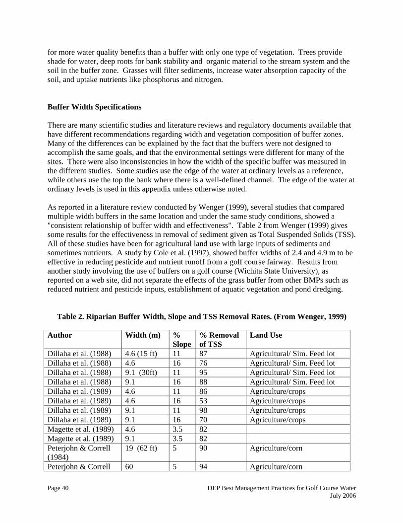
Page 40 DEP Best Management Practices for Golf Course Water July 2006
for more water quality benefits than a buffer with only one type of vegetation. Trees provide shade for water, deep roots for bank stability and organic material to the stream system and the soil in the buffer zone. Grasses will filter sediments, increase water absorption capacity of the soil, and uptake nutrients like phosphorus and nitrogen. Buffer Width Specifications There are many scientific studies and literature reviews and regulatory documents available that have different recommendations regarding width and vegetation composition of buffer zones. Many of the differences can be explained by the fact that the buffers were not designed to accomplish the same goals, and that the environmental settings were different for many of the sites. There were also inconsistencies in how the width of the specific buffer was measured in the different studies. Some studies use the edge of the water at ordinary levels as a reference, while others use the top the bank where there is a well-defined channel. The edge of the water at ordinary levels is used in this appendix unless otherwise noted. As reported in a literature review conducted by Wenger (1999), several studies that compared multiple width buffers in the same location and under the same study conditions, showed a "consistent relationship of buffer width and effectiveness". Table 2 from Wenger (1999) gives some results for the effectiveness in removal of sediment given as Total Suspended Solids (TSS). All of these studies have been for agricultural land use with large inputs of sediments and sometimes nutrients. A study by Cole et al. (1997), showed buffer widths of 2.4 and 4.9 m to be effective in reducing pesticide and nutrient runoff from a golf course fairway. Results from another study involving the use of buffers on a golf course (Wichita State University), as reported on a web site, did not separate the effects of the grass buffer from other BMPs such as reduced nutrient and pesticide inputs, establishment of aquatic vegetation and pond dredging.
Table 2. Riparian Buffer Width, Slope and TSS Removal Rates. (From Wenger, 1999) Author Width (m) %
Slope % Removal of TSS
Land Use
Dillaha et al. (1988) 4.6 (15 ft) 11 87 Agricultural/ Sim. Feed lot Dillaha et al. (1988) 4.6 16 76 Agricultural/ Sim. Feed lot Dillaha et al. (1988) 9.1 (30ft) 11 95 Agricultural/ Sim. Feed lot Dillaha et al. (1988) 9.1 16 88 Agricultural/ Sim. Feed lot Dillaha et al. (1989) 4.6 11 86 Agriculture/crops Dillaha et al. (1989) 4.6 16 53 Agriculture/crops Dillaha et al. (1989) 9.1 11 98 Agriculture/crops Dillaha et al. (1989) 9.1 16 70 Agriculture/crops Magette et al. (1989) 4.6 3.5 82 Magette et al. (1989) 9.1 3.5 82 Peterjohn & Correll (1984)
19 (62 ft) 5 90 Agriculture/corn
Peterjohn & Correll 60 5 94 Agriculture/corn
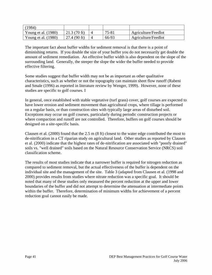
Page 41 DEP Best Management Practices for Golf Course Water July 2006
(1984) Young et al. (1980) 21.3 (70 ft) 4 75-81 Agriculture/Feedlot Young et al. (1980) 27.4 (90 ft) 4 66-93 Agriculture/Feedlot The important fact about buffer widths for sediment removal is that there is a point of diminishing returns. If you double the size of your buffer you do not necessarily get double the amount of sediment remediation. An effective buffer width is also dependent on the slope of the surrounding land. Generally, the steeper the slope the wider the buffer needed to provide effective filtering. Some studies suggest that buffer width may not be as important as other qualitative characteristics, such as whether or not the topography can maintain sheet flow runoff (Rabeni and Smale (1996) as reported in literature review by Wenger, 1999). However, none of these studies are specific to golf courses. I In general, once established with stable vegetative (turf grass) cover, golf courses are expected to have lower erosion and sediment movement than agricultural crops, where tillage is performed on a regular basis, or than construction sites with typically large areas of disturbed soil. Exceptions may occur on golf courses, particularly during periodic construction projects or where compaction and runoff are not controlled. Therefore, buffers on golf courses should be designed on a site-specific basis. Clausen et al. (2000) found that the 2.5 m (8 ft) closest to the water edge contributed the most to de-nitrification in a CT riparian study on agricultural land. Other studies as reported by Clausen et al. (2000) indicate that the highest rates of de-nitrification are associated with "poorly drained" soils vs. "well drained" soils based on the Natural Resource Conservation Service (NRCS) soil classification scheme. The results of most studies indicate that a narrower buffer is required for nitrogen reduction as compared to sediment removal, but the actual effectiveness of the buffer is dependent on the individual site and the management of the site. Table 3 (adapted from Clausen et al. (1998 and 2000) provides results from studies where nitrate reduction was a specific goal. It should be noted that many of these studies only measured the percent reduction at the upper and lower boundaries of the buffer and did not attempt to determine the attenuation at intermediate points within the buffer. Therefore, determination of minimum widths for achievement of a percent reduction goal cannot easily be made.
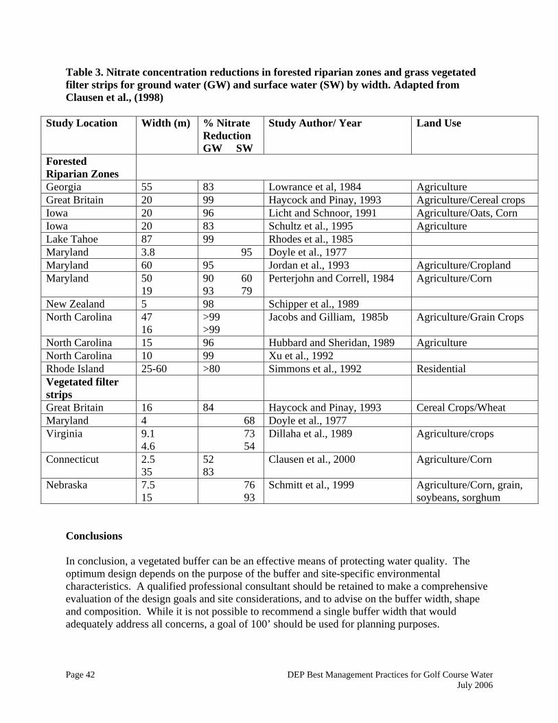
Page 42 DEP Best Management Practices for Golf Course Water July 2006
Table 3. Nitrate concentration reductions in forested riparian zones and grass vegetated filter strips for ground water (GW) and surface water (SW) by width. Adapted from Clausen et al., (1998)
Study Location Width (m) % Nitrate Reduction GW SW
Study Author/ Year Land Use
Forested Riparian Zones
Georgia 55 83 Lowrance et al, 1984 Agriculture Great Britain 20 99 Haycock and Pinay, 1993 Agriculture/Cereal crops Iowa 20 96 Licht and Schnoor, 1991 Agriculture/Oats, Corn Iowa 20 83 Schultz et al., 1995 Agriculture Lake Tahoe 87 99 Rhodes et al., 1985 Maryland 3.8 95 Doyle et al., 1977 Maryland 60 95 Jordan et al., 1993 Agriculture/Cropland Maryland
50 19
90 60 93 79
Perterjohn and Correll, 1984 Agriculture/Corn
New Zealand 5 98 Schipper et al., 1989 North Carolina 47
16 >99 >99
Jacobs and Gilliam, 1985b Agriculture/Grain Crops
North Carolina 15 96 Hubbard and Sheridan, 1989 Agriculture North Carolina 10 99 Xu et al., 1992 Rhode Island 25-60 >80 Simmons et al., 1992 Residential Vegetated filter strips
Great Britain 16 84 Haycock and Pinay, 1993 Cereal Crops/Wheat Maryland 4 68 Doyle et al., 1977 Virginia 9.1
4.6 73 54
Dillaha et al., 1989 Agriculture/crops
Connecticut 2.5 35
52 83
Clausen et al., 2000 Agriculture/Corn
Nebraska 7.5 15
76 93
Schmitt et al., 1999 Agriculture/Corn, grain, soybeans, sorghum
Conclusions In conclusion, a vegetated buffer can be an effective means of protecting water quality. The optimum design depends on the purpose of the buffer and site-specific environmental characteristics. A qualified professional consultant should be retained to make a comprehensive evaluation of the design goals and site considerations, and to advise on the buffer width, shape and composition. While it is not possible to recommend a single buffer width that would adequately address all concerns, a goal of 100’ should be used for planning purposes.
Page 43 DEP Best Management Practices for Golf Course Water July 2006
Cited References: Clausen, J. C., K. Guillard, et al. (2000). “Water Quality Changes from Riparian Buffer Restoration in Connecticut.” Journal of Environmental Quality 29: 1751-1761. Cole, J. T., J.H. Baird, et al. (1997). "Influence of Buffers on Pesticide and Nutrient Runoff from Bermuda grass Turf." Journal of Environmental Quality 26: 1589-1598. "CT DEP Inland Fisheries Division Policy Statement, Riparian Corridor Protection" (1991). Inland Fisheries Division, Connecticut Department of Environmental Protection. 79 Elm Street, Hartford, CT. "CT DEP Inland Fisheries Division Position Statement, Utilization of 100 Foot Buffer Zones to Protect Riparian Areas in Connecticut", Inland Fisheries Division, Connecticut Department of Environmental Protection. 79 Elm Street, Hartford, CT. Dillaha, T. A., J. H. Sherrard, et al. (1988). “Evaluation of vegetative filter strips as a best management practice for feed lots.” Journal of the Water Pollution Control Federation 60(7): 1231-1238. Dillaha, T. A., R. B. Reneau, et al. (1989). “Vegetative Filter Strips for Agricultural Nonpoint Source Pollution Control.” Transactions of the ASAE 32(2): 513-519. Doyle, R. C., G. C. Stanton, et al. (1977). Effectiveness of forest and grass buffer strips in improving the water quality of manure-polluted runoff. Journal of Environmental Quality. Chicago, IL, ASAE, St. Joseph, MI. Haycock, N. E. and G. Pinay (1993). “Ground water dynamics in grass and poplar vegetated riparian buffer strips during the winter.” Journal of Environmental Quality 22: 467-473. Hubbard, R. K. and J. M. Sheridan (1989). “Nitrate movement to ground water in the southeastern coastal plan.” Journal of Soil and Water Conservation 44: 20-27. Jacobs, T. C. and J. W. Gilliam (1985). “Riparian losses of nitrate from agricultural drainage waters.” Journal of Environmental Quality 14: 472-478. Jordan, T. E., D. L. Correll, et al. (1993). “Nutrient interception by a riparian forest receiving inputs from adjacent cropland.” Journal of Environmental Quality 22: 467-473. Licht, L. A. and J. L. Schnoor (1991). Impact of poplar tree buffers on riparian ecosystems. St. Joseph, MI, ASAE. Lowrance, R. R., R. L. Todd, et al. (1984). “Nutrient cycling in an agricultural watershed: 1. Phreatic movement.” Journal of Environmental Quality 13: 22-27.
Page 44 DEP Best Management Practices for Golf Course Water July 2006
Magette, W. L., R. B. Brinsfield, et al. (1989). “Nutrient and sediment removal by vegetated filter strips.” Transactions of the ASAE 32(2): 663-667. Malanson, G. P. (1993). Riparian Landscapes. Cambridge, UK, Cambridge University Press. Palone, R. S. and A. H. Todd (1997). Chesapeake Bay Riparian Handbook: A Guide for Establishing and Maintaining Riparian Forest Buffers. Radnor, PA, USDA Forest Service. Peterjohn, W. T. and D. L. Correll (1984). “Nutrient dynamics in an agricultural watershed: Observations on the role of a riparian forest.” Ecology 65(5): 1466-1475. Rabeni, C. F. and M. A. Smale (1995). “Effects of siltation on stream fishes and the potential mitigating role of the buffering riparian zone.” Microbiologia 303: 211-219. Rhodes, J., C. M. Skau, et al. (1985). Quantification of Nitrate Uptake by Riparian Forests and Wetlands in an Undisturbed Headwaters Watershed. North American Riparian Conference, University of Arizona, Tucson. Schmitt, T. J., M. G. Dosskey, et al. (1999). “Filter Strip Performance and Processes for Different Vegetation, Widths, and Contaminants.” Journal of Environmental Quality 28(5): 1479-1489. Schueler, T. (1995a). “The architecture of urban stream buffers.” Watershed Protection Techniques 1: 4. Schultz, R. C., J. P. Collettii, et al. (1995). “Design and placement of a multi-species riparian buffer strip system.” Agrofor. Syst. 29: 201-226. Simmons, R. C., A. J. Gold, et al. (1992). “Nitrate dynamics in riparian forests: Ground water studies.” Journal of Environmental Quality 21: 659-665. Wenger, S. (1999). A Review Of The Scientific Literature On Riparian Buffer Width, Extent And Vegetation. Athens, GA 30602-2202, Institute of Ecology, University of Georgia: 59. Wenger, S. and L. Fowler (2000). Protecting Stream and River Corridors: Creating Effective Local Riparian Buffer Ordinances, Carl Vinson Institute of Government, University of Georgia: 68. Wilson, M. and J. G. Imhof (1998). Riparian Zone Workshop, Literature Review: Overview of the State of the Science. Cambridge, Ontario Canada, Grand River Conservation Authority Administration Office. Xu, L., J. W. Gilliam, et al. (1992). Nitrate movement and loss in riparian buffer areas. Agronomy Abstracts, ASA, Madison WI: 342.

Page 45 DEP Best Management Practices for Golf Course Water July 2006
Young, R. A., R. Huntrods, et al. (1980). “Effectiveness of vegetated buffer strips in controlling pollution from feedlot runoff.” Journal of Environmental Quality 9(3): 483-487. Web site: Braeburn Golf Course Project, Wichita State University, Kansas. Cited 8/01. http://webs.wichita.edu/biology/319web/braeburn_golf_course_project.htm
Page 46 DEP Best Management Practices for Golf Course Water July 2006
Appendix III. Estimating Turf Water Use The amount of water used by a section of turf over any given period of time depends on local weather conditions, soil moisture availability, and the characteristics of the turf species. Turf water use is also affected by the hydrogeological characteristics of the site and the infiltration rates of the soil. Soil infiltration rates can be measured with single or double ring infiltrometers. One way to quantify the water needs of a particular type of turf is to identify its Water Use Rate (WUR). The WUR is the amount of water needed by the turf for growth, including the water lost through evapotranspiration (ET). ET is the amount of water transferred to the atmosphere by evaporation from soil and plant surfaces, plus the amount of water vapor released through the plant stomata via transpiration. For well-vegetated surfaces, transpiration is much greater than evaporation and therefore makes up the vast majority of ET. Note: Confusion in the use of the term “ET” often exists. There are two definitions of ET- the potential ET and the actual ET. Potential ET (sometimes given as “PET”) is defined as the ET rate that will occur for a given weather condition for “well watered grass”. Actual ET (sometimes given as “AET” and other times as just “ET”) is therefore equal to potential ET except where soil moisture is limiting, in which case actual ET is less than potential ET. Since the potential ET is the principal interest in determining turf water needs for irrigation design, and the term “ET” is used in the industry to refer to potential ET, the term “ET” as used in this appendix will mean potential ET unless otherwise specified. Some of the more commonly used methods of obtaining ET estimates are discussed in Part A below. Variations in water use needs across different turf species is discussed in Part B. Part A. Estimating Evapotranspiration (ET) The most important meteorological factors contributing to ET rates are solar radiation, air temperature, wind speed and atmospheric moisture. Both local meteorology and soil characteristics can vary tremendously within an area the size of a typical golf course. The south side of an elevated area, with greater exposure to wind and radiation will have a greater potential ET rate than a slope with a northern exposure. Consistently, shaded areas will have lower ET rates than areas in full sun. These fine-scale variations in the physical environment are referred to as “microclimate.” Potential ET rates calculated using regional weather data may provide a general indication of potential water use, but they should be adjusted up or down depending on the microclimates present in an individual golf course. Soil moisture availability is greatly influenced by soil type and texture. Sandy soils have high porosities but drain readily and do not have high available water holding capacities. Loam soils have the highest water holding capacities, whereas clay soils, although relative high in water contents, hold water so tightly that plants cannot remove the water for transpiration at lower water contents. Position in the landscape often plays an important role in the availability of soil moisture to plants. A low area lying closer to the water table will require less irrigation than an
Page 47 DEP Best Management Practices for Golf Course Water July 2006
area higher in the landscape because of upward flow of water (capillary rise) into the root zone from the water table, especially for the sandy loam soils common to upland areas in Connecticut. There are many methods of estimating ET. Some of the more common approaches include obtaining data from outside sources, measuring ET, and calculating ET.
1. Outside sources of PET data. ET estimates can be obtained from commercial weather monitoring and forecasting operations. There are also publicly available weather data sets that often include estimates of ET. Values are usually given as a daily rate in mm per day or inches per day and are based on either evaporation pan data or an equation that estimates ET. This data is usually intended to describe conditions at a regional scale, and may over- or underestimate local conditions.
2. Measuring ET On Site. An alternative to using outside, regional ET estimates is the installation of one or more devices to measure on site ET. This alternative would be indicated, for example, when regional weather stations have been shown to consistently misrepresent local conditions. Some devices include:
a. On site weather stations (sometimes incorporated into the irrigation system). b. Class A Evaporation pans. A U.S. Weather Service Class A evaporation pan is
122 centimeters in diameter and 25 centimeters deep and is supported 15 centimeters above the ground. (McCarty, 2001). The pans are filled with water and the amount of water that evaporates from the pan roughly correlates to the amount of water lost from turf due to evapotranspiration. The amount is not exactly the same; more water usually evaporates from the pan than is lost from the turf. A crop coefficient for evaporation pan data (Kp) is applied to the evaporation pan measurements to arrive at potential ET rates.
c. ET gages or Atmometers. These devices have a water reservoir connected by a wicking device to a surface such as a porous plate that mimics a leaf surface. The amount of water lost from the reservoir represents the potential ET for the given weather conditions. Rates will be less than from an evaporation pan since there is some resistance to flow through the wicking material. These are relatively inexpensive and may be located in the various microclimates found on a course.
3. Calculating ET. Regional weather operations and some measurement devices estimate potential ET using theoretical physical equations. These equations use available weather measurements, and normally make some assumptions with respect to local soil conditions and the nature of the plant canopy. It may be possible to obtain more accurate ET estimates by using local weather data, then adjusting the parameters of the ET equation to reflect the characteristics of the specific soil and vegetation present on the golf course. A full discussion of these equations is beyond the scope of this document, but a few of the more commonly used are listed below, along with some references to more technical documents. ET rates calculated with equations are for a reference turfgrass crop and must then be adjusted for the actual turfgrass crop.
Page 48 DEP Best Management Practices for Golf Course Water July 2006
1. Penman equation. This equation, often referred to as the Modified Penman equation, provides an estimate of evaporation from a free water surface. Four weather variables are required for this equation, solar radiation, wind, temperature and humidity. It is often used in place of pan evaporation. Since Penman and others have found that the equation also predicts well the ET from a 3-6" tall cool season grass that completely covers the ground, and is supplied with adequate water, it is sometimes referred to as a reference ET (ETo). A crop coefficient (Kc) for whatever species of grass is being irrigated is applied to the equation to get an estimate of the potential rate of ET for that crop (FAO). Aronson et al. (1987) provide an example of this approach in a study involving cool-season turfgrasses in Rhode Island.
2. Penman-Monteith equation. This equation predicts the ET from a crop directly. The same four weather variables are required as the Penman equation plus a canopy conductance term that accounts for resistance to water movement within the reference plant. The specific canopy conductance values for individual crops are not commonly available; therefore, the Penman-Monteith equation is not used in practice as frequently as the modified Penman equation.
3. Priestly-Taylor equation. The Priestly Taylor equation estimates what is called the equilibrium potential ET. This equation uses net radiation, air temperature and pressure, so it is simpler than a Penman-Monteith, but sometimes less accurate (Dingman, 1994). It assumes a relative humid environment, but appears to do well in New England conditions (David Miller, personal communication). This equation can be used with remotely sensed data.
4. Blaney-Criddle. This equation was originated for use in the Western United States. It uses temperature and day-length as the major independent variables for estimating ET. There are crop coefficients specific to the Blaney-Criddle equation available in the U.S. Soil Conservation Service (1970) handbook. It is recommended that the Blaney-Criddle equation be used for monthly ET estimation. This equation is simple but provides only a rough estimate. It may produce large errors under extreme weather conditions, especially outside of the Western United States where it was developed (Dunne and Leopold, 1978).
Part B. Crop Coefficients and Species Specific Water Use Rates In addition to the physical environmental factors discussed above, the amount of water used by a turf canopy will also depend on the nature of the canopy itself. Within a species, water use needs vary diurnally and seasonally, and depend on the stage of development of the grass. “Crop coefficients” are a useful way of expressing relative water use efficiency numerically.
1. Species and Cultivar variations. Water use needs also vary among species, and cultivars of particular grass species can also vary in their water use rates. Warm season grasses tend to have lower water use rates while cool season grasses, often used in New England, have higher rates. This is partly because cool season grasses use ET as a cooling
Page 49 DEP Best Management Practices for Golf Course Water July 2006
mechanism. Some turf species can have a lower comparative WUR and still require more water to maintain an acceptable quality than a species with a higher WUR. This is because some species have greater drought tolerance than others. The goal is to use grass species or cultivars that have a lower WUR and a high drought tolerance. A study by Aronson et al. (1987a) found that for cool season grasses studied, hard fescues, chewings fescues, perennial ryegrass and Kentucky bluegrass, the fescues were the most drought tolerant. Table 1 shows the ET rates found for various grass species, while Tables 2 and 3 show the relative drought tolerance of several common grass species. They are from different sources and show slightly different rankings, which is why they are both included.
2. Crop Coefficients. Crop coefficients, as mentioned in the explanations above, are ratios of the potential ET of a particular crop, species or cultivar to a reference ET or evaporation rate. These coefficients are determined experimentally, often using weighing lysimeters under “unlimited soil water” conditions. Care must be used in the use of crop coefficients as the term is used for various references, Blaney-Criddle, Penman-Monteith, pan evaporation, and Penman evaporation equation. Crop coefficients will vary with the species of grass in question, the growth stage of the plants, the climate, the season, cutting height, and soil moisture stress, arriving at a single number to use as a crop coefficient can be problematic.
A study of crop coefficients in the Northeast is the study by Aronson et al. (1987b) which determined crop coefficients for selected cool season turfgrasses in Rhode Island under non-limited soil moisture conditions. This study compared measured ET rates for several species or cultivars with both pan evaporation and values predicted by the modified Penman equation. As shown in Tables 4 and 5 for the Penman equation and pan evaporation, rates varied both seasonally and from year to year. The authors concluded that using an averaged Kc value of 1.0 for the cool season turfgrass species studied would be adequate for irrigation scheduling in the Northeast. These values are higher than the typical values for turf of approximately 0.7 to 0.8.
Penman in his original studies in England found values of 0.8 in summer and 0.6 in winter (Dunne and Leopold, 1978). Brown et al. (2001) in a study in Arizona found Kc values ranging from about 0.75 to 0.85 for Bermuda grass. These Kc values are for the Penman-Monteith equation for potential ET, not evaporation, and therefore would be expected to higher rather than lower than values based on the modified Penman equation or pan evaporation. A study by Carrow (1995) found that an average coefficient for tall fescue in the southeast for summer would be (0.79-0.82). This study also found the coefficients for turfgrass differed over the growing season. The tall fescue cultivars in this study were Rebel II and Kentucky-31.
More research is necessary for crop coefficients for cool season turfgrasses in the Northeast, especially for conditions that are water-limited.

Page 50 DEP Best Management Practices for Golf Course Water July 2006
References: Aronson, L.J., A. J. Gold, and R.J. Hull. 1987a. Cool Season Turfgrass Responses to Drought Stress. Crop Science. 27:1261-1266 Aronson, L.J., A.J. Gold, R.J. Hull, and J.L. Cisar. 1987b. Evapotranspiration of Cool-Season Turfgrasses in the Humid Northeast. Agronomy Journal. 79:901-905 Brown, P.W. C.F. Mancino, M.H. Young, T.L. Thompson, P.J. Wierenga, and D.M. Kopec. 2001. Penman Monteith Crop Coefficients for Use with Desert Turf Systems. Crop Sci. 41:1197-1206. Carrow, Robert N. 1995. Drought Resistance Aspects of Turfgrasses in the Southeast: Evapotranspiration and Crop Coefficients. Crop Science. 35:1685-1690. Dingman, S. Lawrence. 1994. Physical Hydrology. Prentice Hall, Englewood Cliffs, New Jersey. Dunne, Thomas and Luna b. Leopold. 1978. Water in Environmental Planning. W.H. Freeman and Company, New York, NY. Food and Agricultural Association of the United Nations. (FAO) Penman-Monteith Equation. Web resource, http://www.fao.org/docrep/X0490E/x0490e06.htm accessed 8/14/2001 McCarty, L.B. 2001. Best Golf Course Management Practices. Prentice-Hall, Inc., Upper Saddle River, New Jersey.

Page 51 DEP Best Management Practices for Golf Course Water July 2006
Table 1. Rankings of potential evapotranspiration rates for major turfgrasses. (from Texas Agricultural Experiment Station, 1985) Relative ranking PET Rate (mm/day) Cool season turf Warm season turf Very low Low Medium High Very High
<6 6-7 7-8.5 8.5-10 >10
Hard fescue Chewings fescue Red fescue Perennial ryegrass Tall fescue Creeping bentgrass Annual bluegrass Kentucky bluegrass Italian ryegrass
Buffalograss Bermudagrass hybrids Centipedegrass Bermudagrass Zoysiagrass Blue Grama Bahiagrass Seashore paspalum St. Augustinegrass Zoysiagrass (emerald)
Table 2. Water use rate of some turfgrass species. (Period covering July 1 - September 1, from Coop Extension, Washington State University) Turfgrass Species ET Rate (inches/day)
Hard Fescue .08 -.15
Chewings Fescue .11 -.18
Creeping red fescue .11 -.18
Perennial ryegrass .14 - .23
Colonial bentgrass .12 - .23
Kentucky bluegrass .12 - .23
Annual bluegrass .15 - .26
Tall fescue .15 - .26
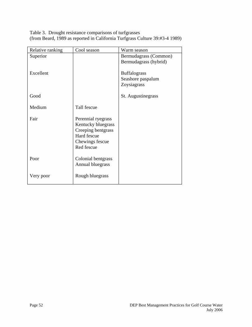
Page 52 DEP Best Management Practices for Golf Course Water July 2006
Table 3. Drought resistance comparisons of turfgrasses (from Beard, 1989 as reported in California Turfgrass Culture 39:#3-4 1989) Relative ranking Cool season Warm season Superior Excellent Good Medium Fair Poor Very poor
Tall fescue Perennial ryegrass Kentucky bluegrass Creeping bentgrass Hard fescue Chewings fescue Red fescue Colonial bentgrass Annual bluegrass Rough bluegrass
Bermudagrass (Common) Bermudagrass (hybrid) Buffalograss Seashore paspalum Zoysiagrass St. Augustinegrass

Page 53 DEP Best Management Practices for Golf Course Water July 2006
Table 4. Relative Drought Resistance of turfgrasses, listed alphabetically (McCarty, 2001) Relative Drought Resistance Turfgrass Excellent Very good Good Fair Poor
Bahiagrass Blue grama Buffalograss Common Bermudagrass Wheatgrass Zoysiagrass Hybrid Bermudagrass St. Augustinegrass Canadian bluegrass Centipedegrass Fine fescue Kentucky bluegrass Seashore paspalum Tall fescue Perennial ryegrass Annual ryegrass Carpetgrass Colonial bentgrass Creeping bentgrass Roughstalk bluegrass

Page 54 DEP Best Management Practices for Golf Course Water July 2006
Table 5. Crop coefficients using the modified Penman equation for selected turfgrass species and cultivars by Aronson et al. 1987b in a Rhode Island study
Table 6. Crop coefficients using pan evaporation for selected turfgrass species and cultivars by Aronson et al. 1987b in a Rhode Island study

Page 55 DEP Best Management Practices for Golf Course Water July 2006
Table 7. Selected tables from Irrigation Water Requirements, Technical Release 21, USDA 1967
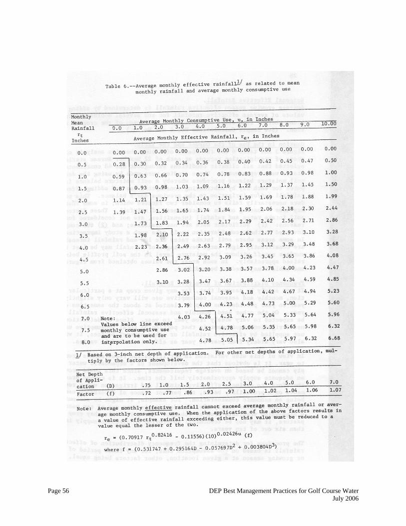
Page 56 DEP Best Management Practices for Golf Course Water July 2006
Page 57 DEP Best Management Practices for Golf Course Water July 2006
Appendix IV. Selected Water Statutes, Regulations and Advice on Spills This appendix contains a selection of water statutes, regulations and other information relevant to golf course water management.
• Section 1. Department of Public Health statutory authorization for regulations in regard to the classification of water company owned land.
• Section 2. Connecticut Department of Public Health Regulations in regard to
sanitation of watersheds.
• Section 3. Well Protection
• Section 4. Department of Public Health Regulations in regard to water supply wells and springs.
• Section 5. Emergency Spill Response Model Plan.
• Section 6. Procedural BMPs for Spill Control Response
Section 1. Department of Public Health statutory authorization for regulations in regard to the classification of water company owned land. Sec.25-37c. Regulations. Classification of land owned by or acquired from a water company. The Department of Public Health shall adopt, in accordance with chapter 54, regulations establishing criteria and performance standards for three classes of water-company-owned land. (a) Class I land includes all land owned by a water company or acquired from a water company through foreclosure or other involuntary transfer of ownership or control which is either: (1) Within two hundred and fifty feet of high water of a reservoir or one hundred feet of all watercourses as defined in agency regulations adopted pursuant to this section; (2) within the areas along watercourses which are covered by any of the critical components of a stream belt; (3) land with slopes fifteen per cent or greater without significant interception by wetlands, swales and natural depressions between the slopes and the watercourses; (4) within two hundred feet of groundwater wells; (5) an identified direct recharge area or outcrop of aquifer now in use or available for future use, or (6) an area with shallow depth to bedrock, twenty inches or less, or poorly drained or very poorly drained soils as defined by the United States Soil Conservation Service that are contiguous to land described in subdivision (3) or (4) of this subsection and that extend to the top of the slope above the receiving watercourse.

Page 58 DEP Best Management Practices for Golf Course Water July 2006
(b) Class II land includes all land owned by a water company or acquired from a water company through foreclosure or other involuntary transfer of ownership or control which is either (1) on a public drinking supply watershed which is not included in class I or (2) completely off a public drinking supply watershed and which is within one hundred and fifty feet of a distribution reservoir or a first-order stream tributary to a distribution reservoir. (c) Class III land includes all land owned by a water company or acquired from a water company through foreclosure or other involuntary transfer of ownership or control which is unimproved land off public drinking supply watersheds and beyond one hundred and fifty feet from a distribution reservoir or first-order stream tributary to a distribution reservoir. "Critical Areas" The definition of Class I land which is described in the State Public Health Code (section 25-37c) would be appropriate for a municipality to consider in its determination of a critical area regardless of whether or not the land is owned by a utility. At a minimum, criteria for critical area designation should include:
• land within 250 feet of a reservoir or public water-supply diversion;
• land within 100 feet or a tributary stream;
• wetlands associated with tributary streams;
• land subject to stream overflow;
• land with slopes 15% or greater without significant interception by wetlands, swales and natural depressions between the slope and the water courses;
• land with soil depth to bedrock of 20 inches or less or poorly drained and very poorly
drained soils as defined by the U.S. Soil Conservation Service that are contiguous to lands described above and that extend to the top of the slope above the receiving watercourse.
Once critical areas have been designated and inventoried, municipalities should focus the efforts of local protection programs on these areas. The zoning enforcement officer, health official, fire marshal, and other municipal entities involved in watershed protection should concentrate their inspection, oversight, education, and enforcement efforts on the defined critical areas. To educate the public and the development community, municipalities should consider delineating critical areas on their official wetlands and watercourse maps. Defining critical areas will be particularly valuable when town-wide ordinances and regulations aimed at watershed protection have been enacted. In addition, municipalities should focus their efforts of land acquisition and conservation restrictions on the critical areas of a water-supply watershed.
Page 59 DEP Best Management Practices for Golf Course Water July 2006
Section 2. Connecticut Department of Public Health Regulations in regard to sanitation of watersheds. R.C.S.A. § 19-13-B32. Sanitation of watersheds Unless specifically limited, the following regulations apply to land and watercourses tributary to a public water supply including both surface and ground water sources. (a) As used in this section, "sewage" shall have the meaning found in section 19-13-B20(a)
of the public health code: "Toxic metals" shall be arsenic, barium, cadmium, chromium, lead, mercury and silver and the salts thereof; "high water mark" shall be the upper limit of any land area which water may cover, either standing or flowing, at any time during the year and "watershed' shall mean land which drains by natural or man-made causes to a public drinking water supply intake.
(b) No sewage disposal system, cesspool, privy or other place for the deposit or storage of sewage shall be located within one hundred feet of the high water mark of any reservoir or within fifty feet of the high water mark of any stream, brook, or watercourse, flowing into any reservoir use for drinking purposes.
(c) No sewage disposal system, cesspool, privy or other place for the deposit or storage of sewage shall be located on any watershed, unless such facility is so constructed that no portion of the contents can escape or be washed into the stream or reservoir.
(d) No sewage shall be discharged on the surface of the ground on any watershed. (e) No stable, pigpen, chicken house or other structure where the excrement of animals or
fowls is allowed to accumulate shall be located within one hundred feet of the high water mark or a reservoir or within fifty feet of the high water mark of any watercourse as above mentioned, and no such structure shall be located on any watershed unless provision is made in a manner acceptable to the commissioner of health for preventing manure or other polluting materials from flowing or being washed into such waters.
(f) No toxic metals, gasoline, oil or any pesticide shall be disposed of as waste into any watercourse tributary to a public drinking water supply or to any ground water identified as supplying a public water supply well.
(g) Where fertilizer is identified as a significant contributing factor to nitrate nitrogen occurring in excess of 8 mg/l in a public water supply, fertilizer application shall be made only under current guidelines established by the commissioner of health in cooperation with the state commissioner of agriculture, the college of agriculture of the University of Connecticut and the Connecticut agricultural experiment station in order to prevent exceeding the maximum allowable limit in public drinking water of 10.0 mg/l for nitrite plus nitrate nitrogen.
(h) Where sodium occurs in excess of 15mg/l in a public drinking water supply, no sodium chlorine shall be used for maintenance of roads, driveways, or parking areas draining to that water supply except under application rates approved by the commissioner of health, designed to prevent the sodium content of the public drinking water from exceeding 20 mg/l.
(i) The design of storm water drainage facilities shall be such as to minimize soil erosion and maximize absorption of pollutants by the soil. Storm water drain pipes, except for crossing culverts, shall terminate at least one hundred feet from the established watercourse unless such termination is impractical, the discharge arrangement is so constructed as to dissipate the flow energy in a way that will minimize the possibility of
Page 60 DEP Best Management Practices for Golf Course Water July 2006
soil erosion, and the commissioner of health finds that a discharge at a lesser distance is advantageous to stream quality. Special protections shall be taken to protect stream quality during construction.
Section 3. Well Protection The state's Aquifer Protection Area Program requires new protection measures for public water supply wells in stratified drift serving over 1,000 people. Other public wells (all those in bedrock and those in stratified drift serving less than 1,000 people) and private wells are protected primarily by the state Water Quality Standards and the Public Health Code, which governs the siting, construction, testing and monitoring of wells. The Public Health Code requires fixed radius setbacks from on-site sewage disposal systems and other sources of pollution to protect wells from the basic pollutants related to sewage. The required setback distances vary to some extent with well withdrawal rates and permeability of the soils. The setbacks do not, however, afford much protection for the wells from pollutants unrelated to sewage, such as hazardous materials and chemicals. Regulatory tools such as zoning or ordinances may be used to better protect wells by setting more stringent setbacks, restricting high risk activities (such as underground fuel storage) within setbacks, or requiring additional monitoring. Hydrogeologic studies can determine the land area that contributes water to a well. Though not a reasonable requirement for every domestic well because of the costs of such a study, the use of simple hydrogeologic mapping techniques for public or community water supply wells - measuring the pumping rate of the well, aquifer permeability and topography (essentially, Level B Aquifer Protection Area mapping) - may better define areas for protection. This type of delineation is more feasible in stratified drift aquifers than bedrock. Reliable hydrogeologic information is encouraged before placing stringent restrictions on land use around wells. Most public wells are tested on a somewhat regular basis, while private wells are only required to be tested for general portability prior to being approved for use. Additional protection can be provided by giving local authority to test wells for a wider range of possible contaminants (such as hydrocarbons), or by requiring periodic testing (once a year). This is particularly appropriate in areas of heavy industrial use. The CT DEP Bureau of Water Protection and Land Reuse can provide recommendations on additional testing parameters or additional well setbacks. Section 4. Department of Public Health Regulations in regard to water supply wells and springs. R.C.S.A. § 19-13-B50. Public and semi-public water supplies In the case of public or semi-public water supplies or water supplies developed for a considerable number of persons necessitating higher rates of pumpage than for residential use, separating distances between wells or springs and sewage disposal systems or drains shall be established in accordance with the provisions of section 25-33 of the general statutes and of section 19-13-B39.
Page 61 DEP Best Management Practices for Golf Course Water July 2006
R.C.S.A. § 19-13-B51a. Effective date The provisions of section 19-13-B51a to 19-13-B51l, inclusive, shall be applicable to all water supply wells constructed after the effective date. (Effective January 12, 1971.) R.C.S.A. § 19-13-B51b. Definitions As used in sections 19-13-B51a to 19-13-B51l, inclusive: (1) "Water supply well" means an artificial excavation, constructed by any method, for the
purpose of getting water for drinking or other domestic use; (2) "Well contractor" means any person, firm or corporation drilling or constructing a water
supply well; (3) "Aquifer" means a water-bearing earth material which can transmit water in significant
quantity. It can be either consolidated rock (ledge rock) or unconsolidated material (sand, gravel, soil with boulders, etc.);
(4) "Dug well" means a well excavated into a shallow aquifer; (5) "Spring" means a place where, without planned intervention of man, water flows from
consolidated rock or unconsolidated material on land or into a body of surface water such as a lake, stream, or river. A spring shall have the same protection requirements as a dug well.
(6) "Driven well" means a well which is constructed by driving a permanent casing with a screen area into unconsolidated material. Driven wells do not penetrate consolidated rock;
(7) "Gravel well" means a well constructed into unconsolidated material. In the zone immediately surrounding the well screen more permeability is obtained by hydraulic action or by removing the finer formation material and replacing it with artificially graded coarser material;
(8) "Drilled well" means a well constructed by drilling a hole and inserting a casing to support the sides of the hole. The portion of the well which is in consolidated rock may not require support of a casing;
(9) "Annular space" means the space between two objects, one of which is surrounded by the other. This includes space between the wall of an excavation and the wall of a pit; between the wall of an excavation and the casing of a well; or between two casings;
(10) "Casing" means an impervious, durable pipe or sidewall placed in a well to prevent the walls from caving, or to seal off surface drainage or undesirable water, gas, or other fluids so they cannot enter the well;
(11) "Established grade" means the elevation of the finished ground surface at the point of intersection of the well casing;
(12) "Pollution" means the adverse effect on water quality created by the introduction of any matter;
(13) "Sewer" means a conduit or pipe used or intended for conveying sewage or other contaminated wastes, or such conduit or pipe into which sewage or wastes may backup;
(14) "Source of pollution" means any place or condition which may result in pollution of a ground water supply; it may include a stream, pond, sewer, privy, septic tank, the field, cesspool, sewage, sewage treatment unit, industrial waste, industrial waste disposal unit,
Page 62 DEP Best Management Practices for Golf Course Water July 2006
location where animal excrement is allowed to accumulate, or disposal site for refuse, industrial waste, sewage sludge or industrial waste sludge;
(15) "Well top seal" means an arrangement used to establish a watertight junction at the top of the casing of a well with special regard to the piping or equipment installed therein;
(16) "Well vent" means a piped outlet at the upper end of a well to allow maintenance of atmospheric pressure within the well casing;
(17) "Well pit" means a structure built wholly or partly underground to house the well top or well appurtenances or both;
(18) "Yield" means the quantity of water delivered per unit of time which may flow or be pumped continuously from the well;
(19) "Public supply well" means a water supply well used or made available by a water company to two or more consumers, as defined in section 25-32a of the 1969 supplement to the general statutes.
(Effective January 12, 1971.) R.C.S.A. § 19-13-B51c. Interconnections No physical connection between piping carrying water from a public water supply and piping carrying water from any other source shall be permitted unless such other water supply is of safe, sanitary quality and the interconnection is approved by the commissioner of health. (Effective January 12, 1971.) § 19-13-B51d. Location All separating distances are to be measured horizontally. (a) Wells with a required withdrawal rate of under ten gallons per minute.
(1) Each such well shall be located at a relatively high point on the premises consistent with the general layout and surroundings; be protected against surface wash; be as far removed from any known or probable source of pollution as the general layout of the premises and the surroundings will permit; and, so far as possible, be in a direction away from ground water flow from any existing or probable source of pollution.
(2) No such well shall be located within seventy-five feet of a system for disposal of sewage or other source of pollution. Greater separating distances shall be required for certain industrial wastes or certain rock formations. If a sewer is constructed of extra heavy cast iron pipe with leaded joints or equal approved type of tight joint, a minimum separating distance of twenty-five feet shall be maintained.
(3) No such well shall be located within twenty-five feet of the high water mark of any surface water body, nor within twenty-five feet of a drain carrying surface water or of a foundation drain.
(b) Wells with a required withdrawal rate of from ten to fifty gallons per minute. (1) Each such well shall be located at a relatively high point on the premises
consistent with the general layout and surroundings; be protected against surface wash; be as far removed from any known or probable source of pollution as the general layout of the premises and the surroundings will permit; and, so far as possible, be in a direction away from ground water flow from any existing or probable source of pollution.

Page 63 DEP Best Management Practices for Golf Course Water July 2006
(2) No such well shall be located within one hundred fifty feet of a system for disposal of sewage or other source of pollution. Greater separating distance shall be required for certain industrial wastes or certain rock formations. If a sewer is constructed of extra heavy cast iron pipe with leaded joints or equal approved type of tight joint, a minimum separating distance of seventy-five feet shall be maintained.
(3) No such well shall be located within fifty feet of high water mark of any surface water body, nor within fifty feet of a drain carrying surface water or of a foundation drain.
(c) Wells with a required withdrawal rate of more than fifty gallons per minute. (1) Location of such well shall be approved by the state department of health in
accordance with the provisions of section 25-33 of the 1969 supplement to the general statutes and section 19-13-B39 of the public health code.
(2) Each such well shall be located at a relatively high point on the premises consistent with the general layout and surroundings; be protected against surface wash; be as far removed from any known or probable source of pollution as the general layout of the premises and the surroundings will permit; and, so far as possible, be in a direction away from ground water flow from any existing or probable source of pollution.
(3) No such well shall be located within two hundred feet of a system for disposal of sewage or other source of pollution. If conditions warrant, greater distance shall be required. Sanitary conditions in the area within the radial distance required shall be under control of the well owner by ownership, easement, or other arrangement approved by the commissioner of health. If a sewer is constructed of extra heavy cast iron pipe with leaded joints or equal approved type of tight joint, a minimum separating distance of one hundred feet shall be maintained.
(4) No such well shall be located within fifty feet of the high water mark of any surface water body nor within fifty feet of a drain carrying surface water or of a foundation drain.
(Effective January 12, 1971.) R.C.S.A. § 19-13-B51e. Precautions A well under construction shall be protected so that there can be no drainage or surface wash into the well. Workmen employed in such construction shall exercise sanitary precautions in disposal of wastes and handling of construction materials so as to avoid contamination of the well and aquifer. All water used in constructing a well shall be disinfected with fifty milligrams per liter (parts per million) of chlorine in order to protect the well from contamination. No polluted water shall be used in connection with the construction of a well. (Effective January 12, 1971.) R.C.S.A. § 19-13-B51f. Construction (a) Materials. Pipe used for casing a well other than a dug well shall be made of steel or
other material approved by the commissioner of health. They shall be free from flaws or defects and shall have watertight connections.
(b) Dug well. The casing or side walls of a dug well shall be constructed of watertight concrete at least four inches thick to a depth of at least ten feet below the ground surface.
Page 64 DEP Best Management Practices for Golf Course Water July 2006
Below the depth of the watertight casing, loosely laid stone, concrete block, brick or other materials approved by the commissioner of health may be used. The annular space between the face of the excavation and the watertight section of casing shall be filled with clean clay or other impervious material.
(c) Gravel well. The casing of a gravel well shall be surrounded with concrete grout to a depth of at least ten feet below the ground surface. The annular space between the casings of a gravel well with artificially placed gravel shall be protected at the top by a watertight covering to prevent any foreign matter entering the well through the gravel.
(d) Drilled well. The construction of a drilled well shall provide for shutting out all water except that from the water bearing formations which are intended to supply water to the well. The casing shall extend at least ten feet below ground surface. Any annular space surrounding the casing pipe needed for drilling shall be filled with concrete grout to a depth of at least ten feet below the ground surface. Below ten feet, any clean fill material can be used. Where the unconsolidated material above consolidated rock is less than twenty feet deep and the casing ends in the consolidated rock, the casing shall be effectively sealed in the rock.
(e) Upper terminal of casing. The casing of every well shall project not less than six inches above the established grade at the well or above the pump house floor. The well contractor shall ascertain the established grade before completion of the well. Where a pitless adapter is used, it shall be designed to, and made of materials that will, keep soil and water from entering the well during the life of the casing. A below-ground connection shall not be submerged in water at the time of installation. Where a pump is not installed immediately following the construction of the well, the well shall be tightly sealed and suitably vented.
(Effective January 12, 1971.) Section 5. Emergency Spill Response Model Plan (a)Any person or entity subject to the provisions of this article upon its effective date shall submit, as to such person or entity, an emergency response plan to the environmental authority of the Town of ______ on or before the effective date. The emergency response plan shall include the following elements:
(1) A map of the site showing the buildings thereon which shall describe hazardous substance storage areas and indicate their normal location; and
(2) A hazard identification and emergency action statement which shall include a concise procedure for responding to emergency situations in each area; and
(3) A procedure for the submitters for reporting fires, chemical spills, or other emergency situations, including procedures for notifying police, fire, health, and civil preparedness departments of the Town of _______; and
(4) A fire response plan, as required by OSHA, identifying the level of fire response which shall be implemented by personnel as outlined in 29 C.F.R. Section 1910(L) (1981) or in any subsequent update thereto; and
(5) An evacuation plan including a list of those persons who are trained in the implementation of a response plan and in the supervision of evacuation procedures.
Page 65 DEP Best Management Practices for Golf Course Water July 2006
The plan shall also include a system for the accounting for all personnel in an evacuation; and
(6) A spill prevention, control and countermeasure plan designed to prevent or minimize the release into the environment of any hazardous substance stored, treated, used, mixed, or produced on the site. This plan shall be based on the types and quantities of hazardous substances, which are on the property as well as the location and design of the major storage and use areas. The plan shall designate at least one person and an alternate, one of who shall be on site during all working hours and who shall be responsible for implementing the spill control procedures. The plan shall also specify construction features designed to control and contain spills from hazardous substance storage areas. These control features shall include one or more of the following systems or their equivalents:
a. Dikes, berms or retaining walls, which are sufficiently impervious to contain spills of hazardous substances;
b. Weirs, booms, curbing or other barriers; c. Culverting, guttering, or other drainage system which leads to a contained
impervious area; d. Sorbent materials; e. Sumps and collection ponds; f. Retention ponds.
Section 6. Procedural BMPs for Spill Control Response, Not all of the following apply to golf courses, but there are some very good general BMPs for spill response and hazardous material management. Material and Waste Inventory Control • Conduct monthly monitoring of inventory and waste generation. • Order raw materials on an as-needed basis and in appropriate volumes to avoid waste and
reduce inventory. • Observe expiration dates on products in inventory. • Eliminate obsolete or excess materials from inventory. • Return unused or obsolete products to the vendor. • Consider waste management costs when buying new materials and equipment. • Ensure material and waste containers are properly labeled. Not labeling or mislabeling is a
common problem. • Mark purchase date and use older materials first. • Maintain product Material Safety Data Sheets to monitor materials in inventory and the
chemical ingredients of wastes. Make MSDS sheets available to employees. • Observe maximum on-site storage times for wastes. • Control access to materials which are hazardous when spent; encourage material substitution.
Page 66 DEP Best Management Practices for Golf Course Water July 2006
Preventative and Corrective Maintenance A regularly scheduled internal inspection and maintenance program should be implemented to service equipment, to identify potential leaks and spills from storage and equipment failure, and to take corrective action as necessary to avoid a release to the environment. At a minimum, the schedule should address the following areas: • Tanks, drums, containers, pumps, equipment, and plumbing; • Work stations and waste disposal stations; • Outside and inside storage areas, and stormwater catch basins and detention ponds; • Evidence of leaks or spills within the facility and on the site; • Areas prone to heavy traffic from loading and off loading of materials and wastes; • Properly secured containers when not in use; • Proper handling of all containers; • Drainage from exhaust vents; • Proper operation of equipment, solvent recovery, and emission control systems. Spill Control • Use emergency spill kits and equipment. Locate them at storage areas, loading and
unloading areas, dispensing areas, work areas. • Clean spills promptly. • Use recyclable rags or absorbent spill pads to clean up minor spills and dispose of these
materials properly. • Clean large spills with a wet vacuum, squeegee and dustpan, absorbent pads, or booms.
Dispose of all clean up materials properly. • Minimize the use of disposable granular or powder absorbents. • Spilled material should be neutralized as prescribed n Material Safety Data Sheets (MSDS),
collected, handled and disposed in accordance with federal, state, and local regulations. • Use shake-proof and earthquake proof containers and storage facilities to reduce spill
potential. Materials and Waste Management • Use spigots, pumps, or funnels for controlled dispensation and transfer of materials to reduce
spillage; use different spigots, etc., for different products to maintain segregation and minimize spillage.
• Store materials in a controlled, enclosed environment (minimal temperature and humidity variations) to prolong shelf life, minimize evaporative releases, and prevent moisture from accumulating.
• Keep containers closed to prevent evaporation, oxidation, and spillage.

Page 67 DEP Best Management Practices for Golf Course Water July 2006
• Segregate wastes that are generated, such as hazardous from non-hazardous, acids from bases, chlorinated from non-chlorinated solvents, and oils form solvents, in order to minimize disposal costs and facilitate recycling and reuse.
• Empty drums and containers may be reused, after being properly rinsed, for storing the same or compatible materials.
• Recycle cleaning rags and have them cleaned by an appropriate industrial launderer. • Use dry cleanup methods and mopping rather than flooding with water. • Floors may be roughly cleaned with absorbent prior to mopping; select absorbents which can
be reused or recycled. • Recycle cardboard and paper, and reuse or recycle containers and drums. • Wastes accumulated in holding tanks and containers must be disposed of through an
appropriately licensed waste transporter in accordance with federal, state, and local regulations.
Management Management involvement in the waste reduction and pollution prevention initiatives is essential to its successful implementation in the work place. By setting the example and encouraging staff participation through incentives or awards, management can increase its employee awareness about environmentally sound practices. A first step is to involve management in conducting a waste stream analysis to determine the potential for waste reduction and pollution prevention. This analysis should include the following steps: • Identify operations where chemicals are used and waste is generated; • Evaluate existing waste management and reduction methods; • Research alternative technologies; • Evaluate feasibility of waste reduction options; • Implement measures to reduce wastes; and • Periodically evaluate your waste reduction program. Develop an energy and materials conservation plan to promote the use of efficient technologies, well-maintained inventories, and reduced water and energy consumption. Sound environmental management should include the currency and completeness of site and facility plans, facility records and inventory management, discharge permits, manifests for disposal of wastes, contracts with haulers for wastes, and contracts with service agents to handle recycling of solvents or to regularly service equipment. Employee Training Training programs should be developed which include the following: • Proper operation of process equipment; • Loading and unloading of materials;

Page 68 DEP Best Management Practices for Golf Course Water July 2006
• Purchasing, labeling, storing, transferring, and disposal of materials; • Leak detection, spill control, and emergency procedures; and • Reuse/recycling/material substitution. Employees should be trained prior to working with equipment or handling of materials, and should be periodically refreshed when new regulations or procedures are developed. Employees should be made aware of MSDS sheets and should understand their information. Employee awareness of the environmental and economic benefits of waste reduction and pollution prevention, and the adverse consequences in ignoring them, can also facilitate employee participation. Communication Posting of signs, communication with staff, education and training, and posting of manuals for spill control, health and safety (OSHA), operation and maintenance of facility and equipment, and emergency response are essential. Storage areas for chemicals and equipment, employee bathrooms, manager's office, and waste handling stations are suggested areas for posting communication. A bulletin board solely for environmental concerns should be considered. Regular inspection and maintenance schedules should be posted and understood by staff. Record Keeping Facility plans, plumbing plans, and subsurface disposal system plans and specifications must be updated to reflect current facility configuration. Copies of associated approvals and permits should be maintained on file. OSHA requirements, health and environmental emergency procedures, materials management plans, inventory records, servicing/repair/inspections logs, medical waste tracking and hazardous waste disposal records must be maintained up to date and made available for inspection by regulatory officials.
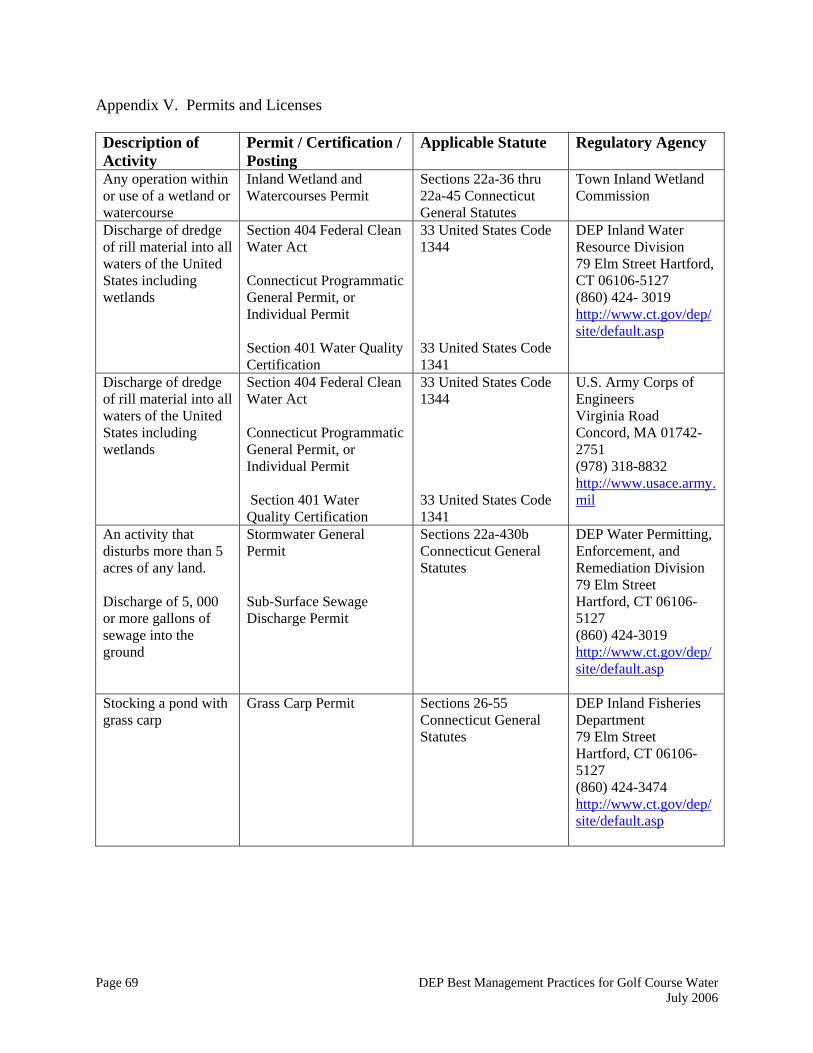
Page 69 DEP Best Management Practices for Golf Course Water July 2006
Appendix V. Permits and Licenses Description of Activity
Permit / Certification / Posting
Applicable Statute Regulatory Agency
Any operation within or use of a wetland or watercourse
Inland Wetland and Watercourses Permit
Sections 22a-36 thru 22a-45 Connecticut General Statutes
Town Inland Wetland Commission
Discharge of dredge of rill material into all waters of the United States including wetlands
Section 404 Federal Clean Water Act Connecticut Programmatic General Permit, or Individual Permit Section 401 Water Quality Certification
33 United States Code 1344 33 United States Code 1341
DEP Inland Water Resource Division 79 Elm Street Hartford, CT 06106-5127 (860) 424- 3019 http://www.ct.gov/dep/site/default.asp
Discharge of dredge of rill material into all waters of the United States including wetlands
Section 404 Federal Clean Water Act Connecticut Programmatic General Permit, or Individual Permit Section 401 Water Quality Certification
33 United States Code 1344 33 United States Code 1341
U.S. Army Corps of Engineers Virginia Road Concord, MA 01742-2751 (978) 318-8832 http://www.usace.army.mil
An activity that disturbs more than 5 acres of any land. Discharge of 5, 000 or more gallons of sewage into the ground
Stormwater General Permit Sub-Surface Sewage Discharge Permit
Sections 22a-430b Connecticut General Statutes
DEP Water Permitting, Enforcement, and Remediation Division 79 Elm Street Hartford, CT 06106-5127 (860) 424-3019 http://www.ct.gov/dep/site/default.asp
Stocking a pond with grass carp
Grass Carp Permit Sections 26-55 Connecticut General Statutes
DEP Inland Fisheries Department 79 Elm Street Hartford, CT 06106-5127 (860) 424-3474 http://www.ct.gov/dep/site/default.asp
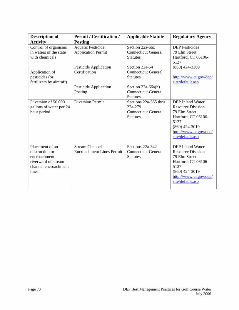
Page 70 DEP Best Management Practices for Golf Course Water July 2006
Description of Activity
Permit / Certification / Posting
Applicable Statute Regulatory Agency
Control of organisms in waters of the state with chemicals Application of pesticides (or fertilizers by aircraft)
Aquatic Pesticide Application Permit Pesticide Application Certification Pesticide Application Posting
Section 22a-66z Connecticut General Statutes Section 22a-54 Connecticut General Statutes Section 22a-66a(h) Connecticut General Statutes
DEP Pesticides 79 Elm Street Hartford, CT 06106-5127 (860) 424-3369 http://www.ct.gov/dep/site/default.asp
Diversion of 50,000 gallons of water per 24 hour period
Diversion Permit Sections 22a-365 thru 22a-279 Connecticut General Statutes
DEP Inland Water Resource Division 79 Elm Street Hartford, CT 06106-5127 (860) 424-3019 http://www.ct.gov/dep/site/default.asp
Placement of an obstruction or encroachment riverward of stream channel encroachment lines
Stream Channel Encroachment Lines Permit
Sections 22a-342 Connecticut General Statutes
DEP Inland Water Resource Division 79 Elm Street Hartford, CT 06106-5127 (860) 424-3019 http://www.ct.gov/dep/site/default.asp
Page 71 DEP Best Management Practices for Golf Course Water July 2006
8.0 GENERAL REFERENCES 2002 Connecticut Guidelines for Soil Erosion and Sediment Control, (May 2002). DEP Bulletin 34. Connecticut Department of Environmental Protection. 79 Elm Street, Hartford CT. DEP Inland Fisheries Division Policy Statement, Riparian Corridor Protection (1991). Inland Fisheries Division, Connecticut Department of Environmental Protection. 79 Elm Street, Hartford, CT 06106 DEP Non Native, Invasive and Potentially Invasive Vascular Plants in CT. March, 2001. Connecticut Department of Environmental Protection, Environmental and Geographic Information Center, 79 Elm Street, Hartford, CT 06106 Guidelines Upland Review Area Regulations, Connecticut's Inland Wetlands and Watercourses Act. (June, 1997) Bureau of Water Management, Wetlands Management Section. State of Connecticut Department of Environmental Protection, 79 Elm Street, Hartford, CT 06106: 15 pgs. Handbook of Integrated Pest Management for Turf and Ornamentals. Anne R. Leslie, 1994. U.S. EPA, Washington, DC. ISBN-0-87371-350-8 Irrigation Water Requirements, Technical Release No 21. (April, 1967-revised 1970). United States Department of Agriculture, Natural Resource Conservation Service, Engineering Division. 88 pgs. Misconceptions about Efficient Irrigation Technologies and Practices-Associate Professor and Extension Agricultural Engineer. Texas Agricultural Extension Service- http:twri.tamu.edu/twriconf/w4tx98/papers/fipps.html Model Integrated Pest Management Plan for CT State Agencies, Ornamental and Turf. Connecticut Department of Environmental Protection, 79 Elm Street, Hartford, CT 06106 National Turfgrass Evaluation Program. www.ntep.org/tables.htm (accessed September, 2001) Professional Guide for IPM in Turf for Massachusetts. (1999) UMASS Bulletin Distribution Center, Draper Hall, Box 32010, UMASS, Amherst, MA 01003-2010 Rapid Bioassessment Protocols for use in Streams and Wadeable Rivers: Periphyton, Benthic Macroinvertebrates and Fish, Second edition. Barbour, M.T., J. Gerritsen, B.D. Snyder, and J.B. Stribling. 1999. EPA 841-B-99-002. U.S. EPA; Office of Water, Washington, D.C. Water Companies Planning Guidance for Water Conservation. (1990) DEP, DPH, DPUC, OPM, OCC (December, 1990) Water Supply Plan Regulations. (2000) RCSA. Section 25-32d.

Page 72 DEP Best Management Practices for Golf Course Water July 2006
University of Connecticut Turfgrass Nutrient and Integrated Pest Management Guide For Turfgrass. (December, 2001) University of Connecticut, C.I.T. Resource Center, U-4035, 1376 Storrs Road, Storrs, CT 06269-4035


![[XLS]s3.amazonaws.com · Web viewLast Hill Golf & R.v. Park Lewis Estates Golf Course Mayfair Golf & Country Club Mccall Lake Golf Course-championship Course Mckenzie Meadows Golf](https://img.pdfslide.us/doc/110x75/5b3867137f8b9a5a518d6124/xlss3-web-viewlast-hill-golf-rv-park-lewis-estates-golf-course-mayfair.jpg)