Embed Size (px)
Citation preview

For comprehensive Waypoint information, visit: www.novatel.com/waypoint
novatel.com
Waypoint®
Best-in-class GNSS and GNSS+INS processing software

For comprehensive Waypoint information, visit: www.novatel.com/waypoint
WaypointEXCEPTIONAL POST-PROCESSING SOFTWARE
Enhance your Position, Velocity and Attitude Accuracy
For applications requiring accurate post-mission
position, velocity or attitude, post-processing is
an ideal solution. Post-processing with Waypoint
software maximizes the accuracy of the trajectory
by processing forward and reverse in time,
backsmoothing and combining the results. The
trajectory may then be output, at the required data
rate, in the coordinate frame required. Waypoint
products also provide the ability to assess the
solution reliability and accuracy with extensive
quality analysis plotting tools.
Waypoint Product Matrix INERTIAL EXPLORER
INERTIAL EXPLORER
XPRESSGRAFNAV GRAFNAV
STATIC
Multi-constellation GNSS Processing + + + +
GNSS+INS Processing + +
Moving Baseline Processing +
Precise Point Positioning + + + +
Multi-base Station Support + + +
Heave Computation +
GrafNet Network Adjustment + +
Kinematic Data Processing + + +
Distance Measurement Instrument (DMI) Support + +
Software Development Kit* + + + +
Command Line Interface* + + + +
* Available as a separate software license
Initerial Explorer®Loosely and tightly coupledGNSS+INS post-processing
Inertial Explorer XpressTightly coupled
GNSS+INS post-processing forlocal area mapping
GrafNavGNSS-only static/kinematic
baseline processor
For comprehensive information on NovAtel® SPAN® GNSS+INS technology, visit www.novatel.com/span
For comprehensive Waypoint information, visit: www.novatel.com/waypoint
novatel.com
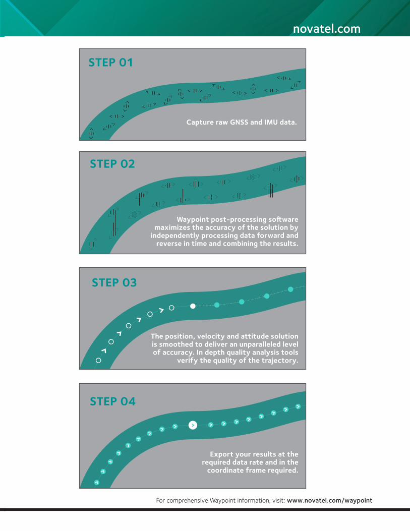
STEP 01
Capture raw GNSS and IMU data.
STEP 03
The position, velocity and attitude solution is smoothed to deliver an unparalleled level of accuracy. In depth quality analysis tools
verify the quality of the trajectory.
STEP 02
Waypoint post-processing software maximizes the accuracy of the solution by
independently processing data forward and reverse in time and combining the results.
STEP 04
Export your results at the required data rate and in the
coordinate frame required.
For comprehensive Waypoint information, visit: www.novatel.com/waypoint
Inertial ExplorerGNSS+INS POST-PROCESSING SOFTWARE
Post-Processing for Improved Accuracy
Inertial Explorer (IE) maximizes the performance of
your GNSS+INS hardware by providing the position,
velocity and attitude accuracy your application
requires. Inertial Explorer is suitable for demanding
applications such as mobile mapping, aerial
photogrammetry and hydrographic surveying.
Real-time GNSS+INS system accuracy is limited by
the quality of the IMU and the duration of GNSS
outage periods. The performance of these systems
can be greatly improved through post-processing.
Inertial Explorer significantly reduces the solution drift
during GNSS outages and virtually eliminates the
solution convergence time experienced in real-time
operation.
Flexible Workflow Capabilities
Inertial Explorer a has workflow to match your business and your expertise. A project wizard is available to allow new GNSS+INS users to quickly become productive. For more experienced users, a variety of processing configuration options are available. Automated processing environment detection allows appropriate GNSS+INS processing settings to be applied automatically, simplifing workflow and reducing the learning curve needed to start producing quality results.
Features such as automated alignment, robust automatic ZUPT detection and the application of various external updates ensure the best possible accuracies are achieved, even in conditions challenging to GNSS signal reception.
IE includes support for both tightly and loosely coupled processing, multiple base stations for large project areas and Precise Point Positioning (PPP) for applications that do not require a base station.
With access to over 50 quality control plots, users can gauge solution accuracy and provide added confidence if problem areas are identified. Inertial Explorer provides access to powerful reprocessing options, quality analysis tools and world class customer support to ensure the success of your application.
For comprehensive Waypoint information, visit: www.novatel.com/waypoint
novatel.com
Powerful Features for Diverse Applications
»Simultaneous GNSS, IMU, DMI (wheel sensor), HMR (dual antenna) and MMR (gimble mount) raw data conversion if using NovAtel SPAN GNSS+INS hardware
»Simultaneous GNSS and IMU processing and simultaneous forward and reverse processing
»Download utility provides access to thousands of publicly available base stations
»Import GNSS data from multiple receiver manufacturers
»Heading updates decoded automatically from NovAtel’s ALIGN® help maximize accuracy in low dynamic applications
»Flexible export tool permits reproduction of most ASCII file formats
»Output w-p-k angles for photogrammetric applications
»Solve for camera IMU orientation difference given w-p-k angles from an external source1
»Remove up to 95% of position error over GNSS outages as compared with a real-time solution
»Model wave dynamics with NovAtel’s Heave option
»Solve the IMU to GNSS lever arm
»Preloaded error models for most popular IMUs as well as customer created error models
Maximize Accuracy
»Multi-pass processing optimizes attitude accuracy, especially for low dynamic surveys
»Raw data and solution specific quality control plots
»IMU-only processing when provided regular external coordinate updates
»Extensive control over GNSS and IMU processing options
»DMI data input to further maximize performance in challenging environments
»Automatic ZUPT detection to help maximize performance in challenging environments
1 Requires separate photogrammetric adjustment package to determine camera exterior orientation angles.
For comprehensive Waypoint information, visit: www.novatel.com/waypoint
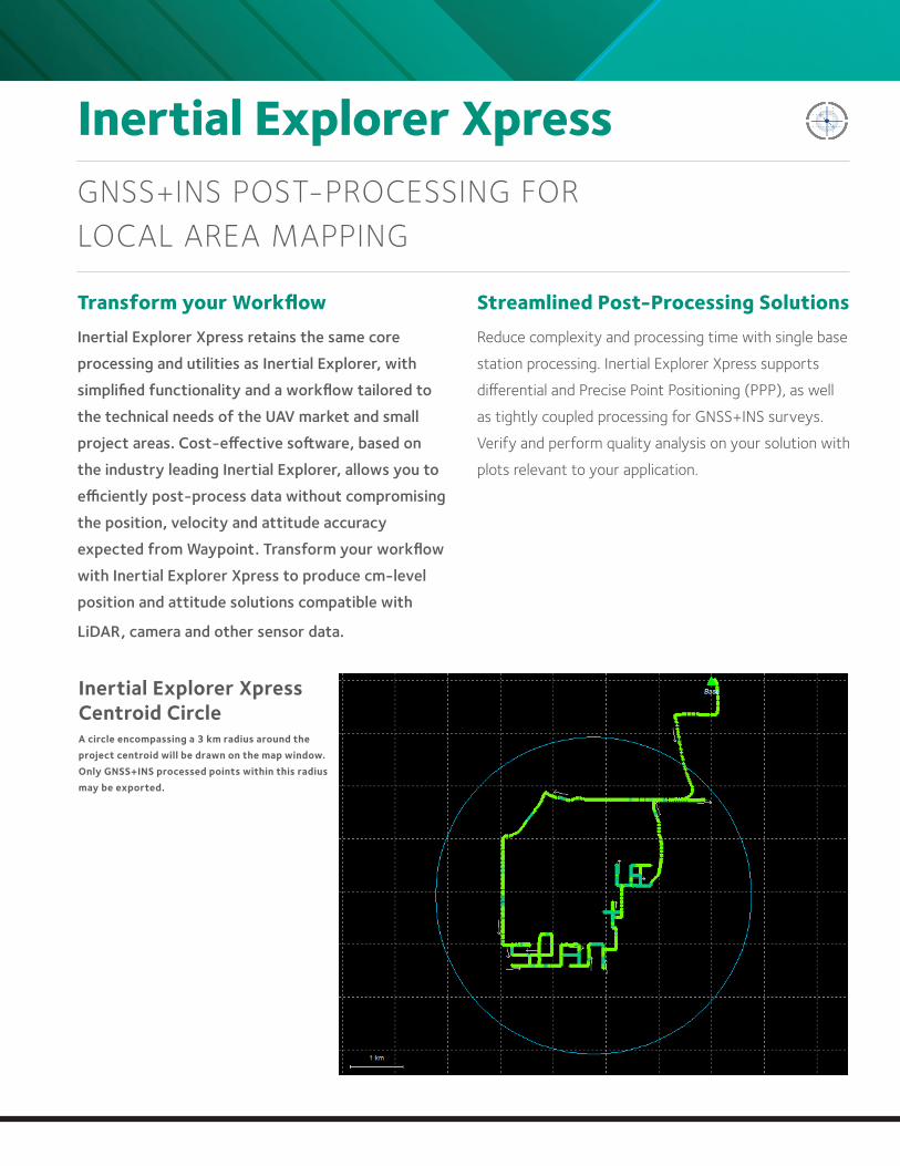
Inertial Explorer XpressGNSS+INS POST-PROCESSING FOR LOCAL AREA MAPPING
Transform your WorkflowInertial Explorer Xpress retains the same core
processing and utilities as Inertial Explorer, with
simplified functionality and a workflow tailored to
the technical needs of the UAV market and small
project areas. Cost-effective software, based on
the industry leading Inertial Explorer, allows you to
efficiently post-process data without compromising
the position, velocity and attitude accuracy
expected from Waypoint. Transform your workflow
with Inertial Explorer Xpress to produce cm-level
position and attitude solutions compatible with
LiDAR, camera and other sensor data.
Streamlined Post-Processing SolutionsReduce complexity and processing time with single base
station processing. Inertial Explorer Xpress supports
differential and Precise Point Positioning (PPP), as well
as tightly coupled processing for GNSS+INS surveys.
Verify and perform quality analysis on your solution with
plots relevant to your application.
Inertial Explorer Xpress Centroid Circle A circle encompassing a 3 km radius around the project centroid will be drawn on the map window. Only GNSS+INS processed points within this radius may be exported.
For comprehensive Waypoint information, visit: www.novatel.com/waypoint
novatel.com
GrafNavGNSS POST-PROCESSING SOFTWARE
Enhanced GNSS AccuracyGNSS technology is used to compute position and
velocity for a variety of real-time applications,
including vehicle navigation and tracking. The real-
time accuracy of GNSS, however, is limited by
real-time transmission of correction data. In many
applications, where absolute position accuracy is
critical, the position information is not required in real-
time. For these applications, the accuracy of the GNSS
position and velocity solution can be greatly improved
by post-processing with GrafNav.
Multiple Processing Options with GrafNetIncluded with GrafNav is a batch static baseline processor
and network adjustment package called GrafNet. It can be
used to establish or check base station coordinates for later
use within GrafNav or to survey entire static networks.
Within minutes, GrafNet processes the entire project,
containing multiple stations, in a single operation. When
the processing is completed, GrafNet color codes the
baselines so problematic baselines are isolated from the
project and are easily analyzed. Statistics are available on
each baseline misclosure and on the adjustment as a whole.
GrafNet allows three types of static baseline processing
solutions:
»Fixed static
»Float
»Ionospheric free
Powerful, Highly Configurable ProcessingGrafNav post-processing software features powerful, highly
configurable processing engine that allows for the best
possible static or kinematic GNSS accuracy. Support of data
formats from most single and multi-frequency commercial
receivers means GrafNav will work with your existing
hardware. A full suite of data and solution visualization
and diagnostic tools are available for quality assurance.
Precise satellite clock and orbit data can be downloaded
from within GrafNav to achieve cm-level position accuracy
without a base station.
»Configure to optimize results
»Easily make use of project specific base station data
»Achieve centimetre level position accuracy with
publicly available reference station data
»Supports multi-base processing for large area
projects
»A float static solution for long and/or noisy baselines
»Built-in ionospheric processing improves accuracies
for dual-frequency users
For comprehensive Waypoint information, visit: www.novatel.com/waypoint
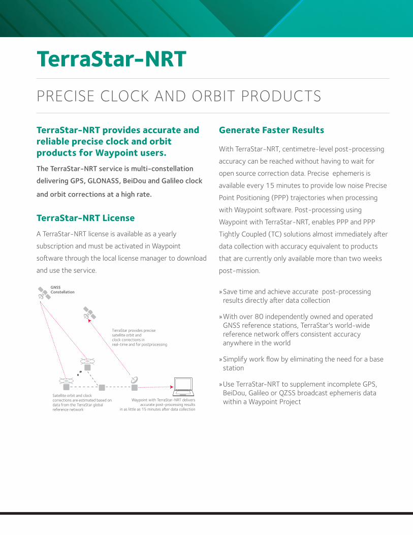
TerraStar-NRTPRECISE CLOCK AND ORBIT PRODUCTS
TerraStar-NRT provides accurate and reliable precise clock and orbit products for Waypoint users. The TerraStar-NRT service is multi-constellation
delivering GPS, GLONASS, BeiDou and Galileo clock
and orbit corrections at a high rate.
TerraStar-NRT LicenseA TerraStar-NRT license is available as a yearly
subscription and must be activated in Waypoint
software through the local license manager to download
and use the service.
Generate Faster Results
With TerraStar-NRT, centimetre-level post-processing
accuracy can be reached without having to wait for
open source correction data. Precise ephemeris is
available every 15 minutes to provide low noise Precise
Point Positioning (PPP) trajectories when processing
with Waypoint software. Post-processing using
Waypoint with TerraStar-NRT, enables PPP and PPP
Tightly Coupled (TC) solutions almost immediately after
data collection with accuracy equivalent to products
that are currently only available more than two weeks
post-mission.
»Save time and achieve accurate post-processing results directly after data collection
»With over 80 independently owned and operated GNSS reference stations, TerraStar's world-wide reference network offers consistent accuracy anywhere in the world
»Simplify work flow by eliminating the need for a base station
»Use TerraStar-NRT to supplement incomplete GPS, BeiDou, Galileo or QZSS broadcast ephemeris data within a Waypoint Project
TerraStar provides precisesatellite orbit andclock corrections inreal-time and for postprocessing
Satellite orbit and clockcorrections are estimated based ondata from the TerraStar globalreference network
GNSSConstellation
For comprehensive Waypoint information, visit: www.novatel.com/waypoint
novatel.com
Waypoint SDKGNSS AND GNSS+INS POST-PROCESSING DEVELOPMENT KIT
Automate your GNSS or GNSS+INS Post-ProcessingThe Waypoint Software Development Kit (SDK)
delivers complete control over the GrafNav and
Inertial Explorer post-processing functions.
Base station downloads, data conversion, data
processing, solution output and quality control
can all be customized to meet the requirements
of any application.
GRAFNAV AND INERTIAL EXPLORER FUNCTIONALITY
»Static and kinematic processing »Forward/reverse and triple-pass processing »Tightly coupled differential processing and tightly coupled PPP processing »Data decoding of multiple receiver and IMU formats »Trajectory smoothing »Local base station, multi-base station and PPP »GPS, GLONASS, BeiDou, Galileo and QZSS support »Data download for reference stations and precise satellite orbit and clock data »Easy import of NovAtel SPAN® data »Flexible solution export »Data and solution quality and assurance tools »Coordinate system and datum support
SYSTEM REQUIREMENTS
»Microsoft Visual Studio 2010 or later »Microsoft Windows 7, 8 and 10 »2 GB RAM or more
Speed Up and Automate Survey Quality ControlWith complete access to the trajectory information,
the Waypoint SDK allows you to set the rules for
determining if the survey meets your accuracy
requirements.
Whether you have just a few systems or hundreds of
them, automated post-processing with the Waypoint
SDK improves results, while saving time and money by
increasing the speed of your workflow.
Software IntegrationNearly all of the functionality contained in Waypoint’s
GrafNav and Inertial Explorer software can be
accessed within the Waypoint SDK. This allows
you to embed GNSS or GNSS+INS processing
functionality into your software, provide an optimized
workflow for your customers and increase the value
of your software products. For your programming
convenience, two separate interfaces are available:
»C++/Win32 ».NET 4.0 or higher
SOFTWARE LICENSING
»Software based licensing with support for remote/virtual desktop »One time software activation through the Internet »Term based licensing with scalable pricing option
For comprehensive Waypoint information, visit: www.novatel.com/waypoint
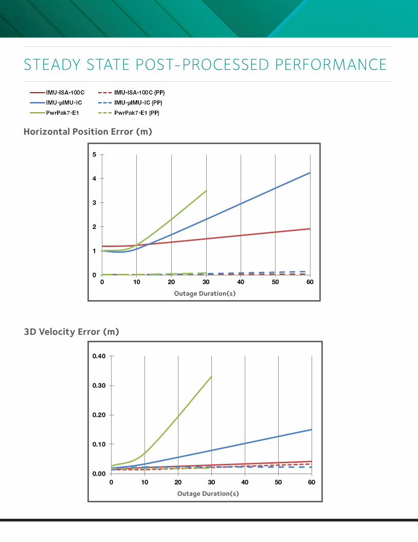
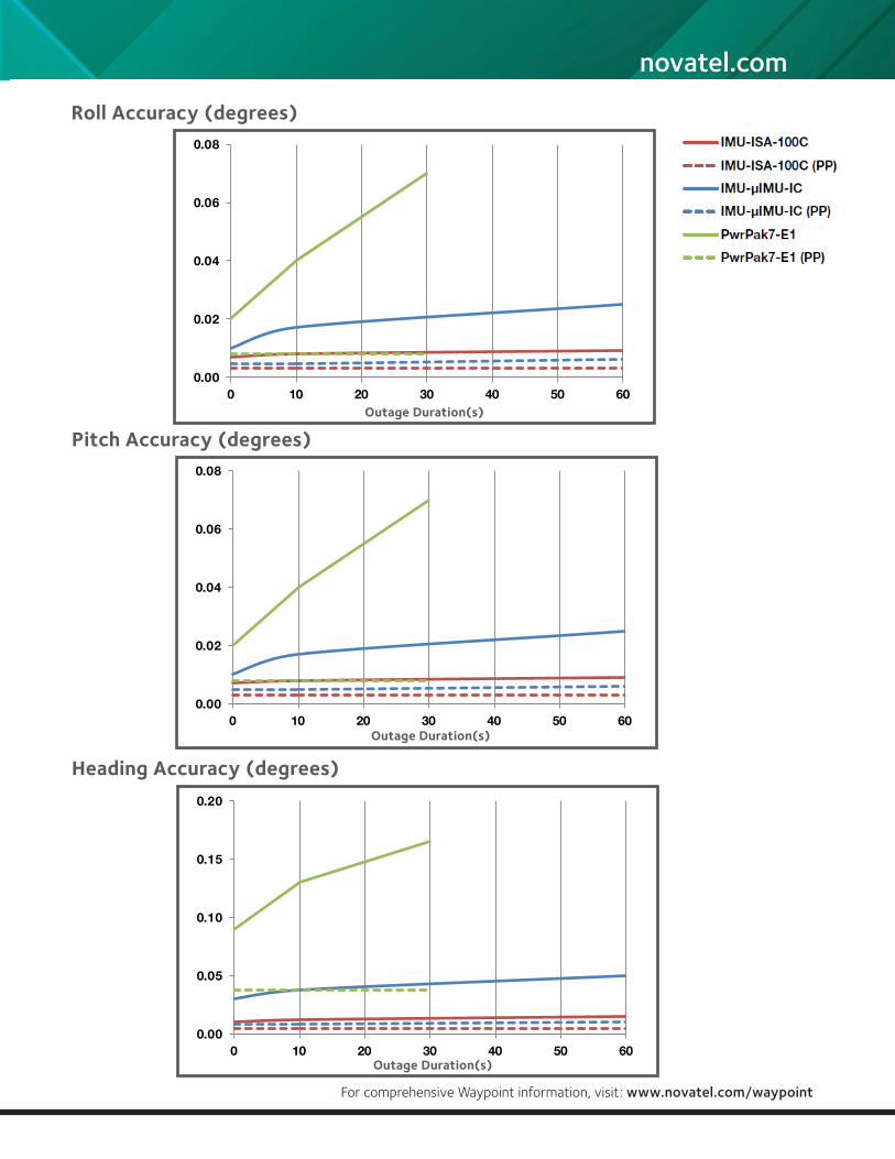
STEADY STATE POST-PROCESSED PERFORMANCE
Horizontal Position Error (m)
3D Velocity Error (m)
0.00
0.10
0.20
0.30
0.40
0 10 20 30 40 50 60
0
1
2
3
4
5
0 10 20 30 40 50 60
Outage Duration(s)
Outage Duration(s)
For comprehensive Waypoint information, visit: www.novatel.com/waypoint
novatel.com
Heading Accuracy (degrees)
0.00
0.02
0.04
0.06
0.08
0 10 20 30 40 50 60
0.00
0.05
0.10
0.15
0.20
0 10 20 30 40 50 60
Pitch Accuracy (degrees)
Outage Duration(s)
Outage Duration(s)
0.00
0.02
0.04
0.06
0.08
0 10 20 30 40 50 60
Roll Accuracy (degrees)
Outage Duration(s)
For comprehensive Waypoint information, visit: www.novatel.com/waypoint
Version 8 Specifications subject to change without notice.
©2018 NovAtel Inc. All rights reserved.
SPAN, ALIGN, Waypoint, Inertial Explorer and NovAtel are registered trademarks of NovAtel Inc.
Refer to www.novatel.com for latest specification revisions.
Printed in Canada
D18034 March 2018
To learn more, visit
www.novatel.com
1-800-NOVATEL (US & Canada) or 403-295-4900
China 0086-21-68882300
Europe 44-1993-848-736
SE Asia & Australia 61-400-883-601
Upgrade/Support
Any software updates released within one year from purchase are
available at no charge. Technical support by phone and e-mail is also
free for one year after date of purchase.