Embed Size (px)
Citation preview

Structure Plan
September 2011
Berwick Village
Our Vision: Casey – Creating the most Caring, Safe, Innovative and Sustainable City
Berwick Village Structure Plan
Document Control
Council policy documents change from time to time and it is recommended that you consult the electronic reference copy at www.casey.vic.gov.au/policiesstrategies to ensure that you have the current version. Alternatively you may contact Customer Service on 9705 5200.
Responsible Department – Strategic Development
Adopted 6 September 2011
Review Period – 5 years
Electronic reference library version 1.1
Preamble
In accordance with a resolution of Council on 21 June 2005 to include defi nitions of Council, Councillors and Council offi cers in all Coun-cil policy documents, the following defi nitions are provided:
Council – means Casey City Council, being a body corporate constituted as a municipal Council under the Local Government Act 1989
Councillors – means the individuals holding the offi ce of a member of Casey City Council
Council offi cers – means the Chief Executive Offi cer and staff of Council appointed by the Chief Executive Offi cer.
Administrative Updates
It is recognised that, from time to time, circumstances may change leading to the need for minor administrative changes to this docu-ment. Where an update does not materially alter this document, such a change may be made administratively. Examples include a change to the name of a Council department, a change to the name of a Federal or State Government department, and a minor update to legislation which does not have a material impact. However, any change or update which materially alters this document must be by resolution of Council.
i
Berwick Village Structure Plan
1. INTRODUCTION 1.1 The Study Area ......................................................... 21.2 The Study ................................................................. 2
2. BACKGROUND2.1 Regional and Local Context ..................................... 32.2 Policy Context........................................................... 4
3. BERWICK VILLAGE ACTIVITY CENTRE3.1 Land Uses ................................................................ 53.2 Access ...................................................................... 73.3 Design and Character............................................... 8
4. VISION AND OBJECTIVES4.1 Land Use ................................................................ 104.2 Access .................................................................... 114.3 Built Form ............................................................... 134.4 Public Realm .......................................................... 15
5. PRECINCTS 5.1 Village Centre ......................................................... 185.2 Village Edge ........................................................... 185.3 Clyde Road ............................................................. 195.4 Berwick Station ....................................................... 195.5 Gloucester Avenue ................................................. 205.6 Princes Highway ................................................... 205.7 Pioneers Park ......................................................... 215.8 Evan and Margaret Streets..................................... 21
6. STRATEGIC SITES6.1 Strategic Site 1 – Southside ................................... 246.2 Strategic Site 2 – Northside .................................... 246.3 Strategic Site 3 – 1-17 Lyall Road .......................... 256.4 Strategic Site 4 – Community Services Hub........... 256.5 Strategic Site 5 – Reserve Street ........................... 26
7. IMPLEMENTATION, MONITORING AND REVIEW7.1 Implementation ...................................................... 247.2 Monitoring and Review ........................................... 24
APPENDIX A – URBAN DESIGN GUIDELINES.......... Ai
PLANSPlan 1. Land Use ...................................................... Plan 2. Access .......................................................... Plan 3. Built Form ..................................................... Plan 4. Public Realm ................................................ Plan 5. The Precincts ............................................... Plan 6. Strategic Sites ..............................................
FIGURESFigure 1: Heritage school building in Pioneers Park .... Figure 2: Aerial Image of Structure Plan Area ...............Figure 3: High Street Built Form .................................... Figure 4: Court House, Heritage Building ..................Figure 5: Regional Map ..................................................Figure 6: High Street ...................................................... Figure 7: Monash University Berwick Campus ............. Figure 8: Chisholm Institute ........................................... Figure 9: Gloucester Avenue, Residential Area ............ Figure 10: Berwick Station ............................................. Figure 11: Impressive Approaches to the Village .......... Figure 12: High Street Interface .................................Figure 13: Berwick Station ............................................ Berwick Station ............................................ Figure 14: Bus stop, Reserve Street ............................ Bus stop, Reserve Street ............................ Figure 15: Evan Street ................................................. Evan Street ................................................. Figure 16: Wilson Street Interface ................................ Figure 17: Berwick Inn, Heritage Building ...................Figure 18: Clyde Road .................................................. Figure 19: Gloucester Avenue Interface ....................... Figure 20: Evan Street .................................................. Figure 21: Monash University ........................................ Figure 22: Chisholm Institute ......................................... Figure 23: Reserve Street Bus Stop ..............................
TABLESTable 1: Key Implementation Projects.......................
ARTIST IMPRESSIONSIIlustration 1: People Places .....................................
iTable of Contents
ii
101113151723
1 2 3 3 4 5 6 6 6 7 8 8
1212121414192021222226
28
16

Berwick Village Structure Plan
11The Berwick Village Structure Plan sets out a framework for the use, development and enhancement of the Berwick Village activity centre over the next 20 years. The Berwick Village activity centre includes the area more commonly known as ‘Berwick Village’, as well as the large education, medical and mixed use precinct to the south of the railway line.
The Structure Plan addresses four main themes - land use, access, built form, and, the public realm - and identifi es local character and land use precincts within the centre, as well as strategic sites to accommodate growth.
A Structure Plan is required for Berwick Village because it is a distinctive and attractive centre with a traditional English Village feel which is under increasing pressure to grow and expand. It is the role of the Structure Plan to balance these forces - to both grow the centre and to retain its valued character - in a way that is acceptable to all stakeholders including the local community, shoppers and visitors, traders and landowners, developers and investors and various government agencies. Without an agreed Plan, development will be ad hoc and Berwick village’s character could be eroded over time.
The Plan sets out a vision for the future of the Berwick Village activity centre – to retain Berwick Village’s distinctive character and village feel - and to accommodate necessary growth and expansion through appropriate development on identifi ed strategic sites and within the. education, medical and mixed use precinct.
The Structure Plan replaces the Berwick Village Commercial Centre Strategy 2006 as the strategic plan for Berwick Village and incorporates urban design guidelines.
Unlike earlier plans, this Structure Plan identifi es opportunities to improve and enhance the Berwick Village activity centre, as well as providing a framework for new development in terms of built form, location and urban design.
A summary of implementation actions to guide a broader Implementation Program is included in the Plan, including the need to amend the Casey Planning Scheme.
Introduction
1
Figure 1: Heritage school building in Pioneers Park

Berwick Village Structure Plan
1.1 THE STUDY AREA
The Berwick Village Activity Centre is identifi ed as a Major Activity Centre under State Government and local planning policy. The Activity Centre covers more than 170 hectares, comprising land extending from the Bill Hudson Reserve in the west to St Margaret’s School in the east, from Pioneers Park in the north to the Princes Freeway in the south, including Monash University, Chisholm Institute and Casey Hospital (refer to Figure 2).
1.2 THE STUDY
The Structure Plan is the outcome of three years of research and consultation. The background research, consultation process and fi ndings are documented in the Berwick Village Structure Plan ‘Key Issues Paper’ (updated August 2011).
The background research included a review of the centre’s existing policy, commercial and socio-economic context, as well as compilation of information about the centre’s land use, employment and customer composition.
Community consultation for the development of this Plan was guided by a Community Stakeholder Strategy prepared for Council in 2008. Consultation included a key stakeholders’ workshop, focus groups, design workshops and a project Steering Committee. These measures have helped inform the vision and have provided input about what is valued and most important to the local community, and also what types of existing and possible activities are most disliked or feared.
Workshops highlighted the…”small-town, friendly historical aspects” and “…less tangible characteristics such as the social and community mix, and the people. Insensitive development, congestion, lack of parking, lack of facilities for young people, and anti-social behaviour around night spots ” were highlighted as community dislikes.
2
Figure 2: Aerial Image of Structure Plan Area

Berwick Village Structure Plan
Berwick Village has a special character which is rarely found in Melbourne’s outer suburbs. There are few other examples of an outer suburban centre which is such a strong focus for the local community in terms of its traditional English ‘feel’ with its vibrant street life, mix of buildings and commercial activities, friendly atmosphere, heritage buildings and distinctive tree plantings. Dingley Village and Eltham town centres may be Berwick’s only rivals in this respect.
Part of Berwick’s character derives from its history. The township was subdivided in 1854 and a store, post offi ce and hotel were established soon after. The Berwick Inn is the oldest building in the Village and contains the original bar from the 1858 building. The township grew along what was the coach road to Gippsland and what subsequently became the Princes Highway, carrying heavy freight traffi c until the Berwick Bypass was opened in 1983. Another important infl uence on the town was that the former Governor-General and his wife, Lord and Lady Casey, retired to Berwick to live in the historic mansion Edrington.
Community consultations have repeatedly confi rmed that retaining Berwick’s heritage and its special character should be a priority for the Structure Plan. However, there are also signifi cant pressures for the Village to grow and expand.
Berwick and its catchment population is forecast to grow from 40,000 to approximately 45-50,000 by 2030 and there will be pressures on the Village to provide the additional retail, health and other services that this population will need. Retail spending per household is also likely to increase over time which will in turn create pressures for more shops, restaurants, entertainment and specialist services.
State metropolitan strategy also favours growth at Berwick Village because it is identifi ed as a Major Activity Centre. State planning policy supports more intensive development for retailing, housing and employment at such centres in order to achieve the metropolitan vision of a more sustainable and liveable city.
CoBerStrVill
Bero aVillhiso ies
Staecolmf a22C
BSV
BtoVthtore
Sbpeo
Background
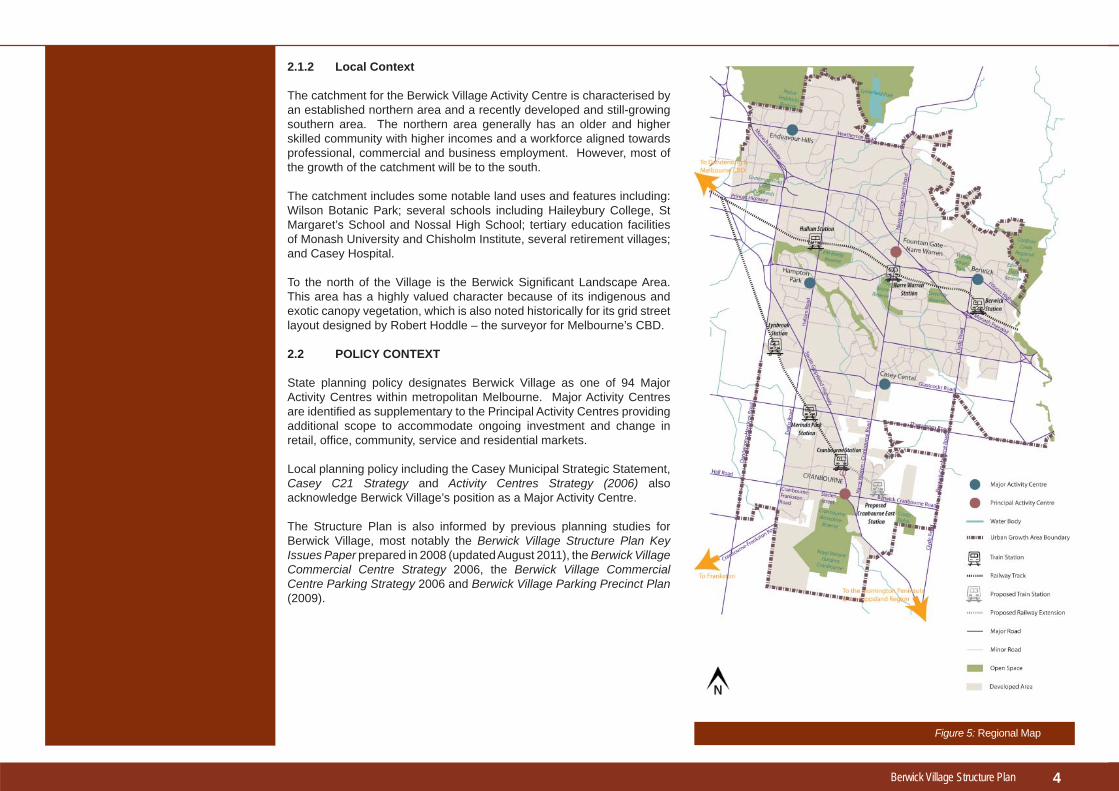
2.1 REGIONAL AND LOCAL CONTEXT
2.1.1 Regional Context
Berwick Village is located on the Princes Highway 46km southeast of Melbourne’s CBD. It lies within a sub-region of 1.6 million people which is focused on Dandenong central activity district, but there are other competing centres within this area, most notably Fountain Gate-Narre Warren (Principal Activity Centre - 4km away), Casey Central (Major Activity Centre - 7km away), Eden Rise and Beaconsfi eld (Neighbourhood Activity Centres - 3-4km away).
The region is generally residential but with large areas dedicated for employment use around Dandenong, and also in the Cardinia Employment Corridor between the proposed C21 Business Park and Pakenham.
3
Figure 3: High Street Built Form
Figure 4: Court House, Heritage Building
Berwick Village Structure Plan
2.1.2 Local Context
The catchment for the Berwick Village Activity Centre is characterised by an established northern area and a recently developed and still-growing southern area. The northern area generally has an older and higher skilled community with higher incomes and a workforce aligned towards professional, commercial and business employment. However, most of the growth of the catchment will be to the south.
The catchment includes some notable land uses and features including: Wilson Botanic Park; several schools including Haileybury College, St Margaret’s School and Nossal High School; tertiary education facilities of Monash University and Chisholm Institute, several retirement villages; and Casey Hospital.
To the north of the Village is the Berwick Signifi cant Landscape Area. This area has a highly valued character because of its indigenous and exotic canopy vegetation, which is also noted historically for its grid street layout designed by Robert Hoddle – the surveyor for Melbourne’s CBD.
2.2 POLICY CONTEXT
State planning policy designates Berwick Village as one of 94 Major Activity Centres within metropolitan Melbourne. Major Activity Centres are identifi ed as supplementary to the Principal Activity Centres providing additional scope to accommodate ongoing investment and change in retail, offi ce, community, service and residential markets.
Local planning policy including the Casey Municipal Strategic Statement, Casey C21 Strategy and Activity Centres Strategy (2006) also acknowledge Berwick Village’s position as a Major Activity Centre.
The Structure Plan is also informed by previous planning studies for Berwick Village, most notably the Berwick Village Structure Plan Key Issues Paper prepared in 2008 (updated August 2011), the Berwick Village Commercial Centre Strategy 2006, the Berwick Village Commercial Centre Parking Strategy 2006 and Berwick Village Parking Precinct Plan (2009).
4
Figure 5: Regional Map

Berwick Village Structure Plan
3.1 LAND USES
3.1.1 Retail
Berwick Village is comprised of a Village Centre focused on small shops and retail services in the High Street strip, with larger retail stores and complexes to the rear with associated at-grade car parking. The High Street shops probably contribute most to Berwick Village’s street life and character, and are also a major employment generator (there were 600 retail jobs in the Village Centre in 2008). As might be expected, the centre has a strong convenience food function anchored by two supermarkets - a Safeway on the ‘Northside’ (rear of shops on north side of the High Street) and a smaller IGA supermarket on the ‘Southside’ (rear of shops on south side). However, it also has a strong profi le in comparison goods, such as clothing and household goods, as well as a particularly strong profi le in cafes, restaurants and dining outlets which serve a wider regional catch-ment.
There is currently a total of 24,800m² retail fl oorspace in the Village Centre with a further 6,200m² of automotive sales fl oorspace in the Princes High-way/Clyde Road precincts. A retail fl oorspace analysis for the centre has been carried out and indicates that population and expenditure growth will generate a demand for the following over time:• additional full-line supermarket• higher order retail store• further expansion of the comparison goods sector (ie. clothing, house-
hold goods etc.)• ongoing provision of convenience goods and services (ie. weekly
shopping needs)• continued growth of restaurant and dining outlets
There are a number of development sites in strategic locations around the Village Centre which could accommodate this level of growth without compromising the scale and character of the High Street shopping strip. Over time, these additions would provide a better range of shops and serv-ices for the local community, whilst catering for the demands of a growing population.
3.1.2 Commercial/Offi ce
Berwick Village has a strong commercial offi ce market which is focused on small-scale businesses such as accountants, legal and construction-related professional services. There is currently about 13,000m2 commer-cial offi ce fl oorspace within the study area with demand for an additional 3-4,000m2 fl oorspace in the medium term (2021). There are currently more than 50 small commercial businesses in the area providing employment for over 250 people, and these are frequently located in High Street, some-times in fi rst fl oor premises.
lotaf
me
Thewithway
eeen
Theheom
Ovecesop
.133cccam
Twwbg• • •
•
• •
TTthtcoOicp
3
Berwick Village Activity Centre
3.1.3 Dining and Entertainment
Berwick Village is unique in Casey as a popular night time venue. There are approximately 40 venues - mainly in the Village Centre - providing some 190 jobs. The restaurant and dining profi le is strong and draws custom-ers from across the wider southeast region. It is one of Berwick Village’s key assets and there is demand to expand this sector further. There are advantages in supporting a cluster of restaurants in terms of better use of parking, choice of venues for visitors, public transport and taxi viability and creating a more vibrant centre at night.
3.1.4 Health Services
There is a very well-developed cluster of health services in Berwick Village which builds on synergies between Casey Hospital and the St John of God private hospital and which has a strategic and regional role in providing services to Casey and the West Gippsland region. The health sector is the dominant employer in the study area with about 350 staff in over 60 practices, located mainly in Clyde Road and Langmore Lane and a further 1000 employed at the Casey Hospitial. The sector provides general prac-titioner and specialist services such as cosmetic surgery, ear nose & throat specialists, dentistry, obstetrics, pathology, physiotherapy and allied mental health. This sector is a key economic strength for Berwick Village and for Casey as a whole and has the capacity to develop as a specialised employ-ment centre for Melbourne’s southeast.
5
Figure 6: High Street

Berwick Village Structure Plan
3.1.5 Community Services
Community services to meet the needs of the people of Berwick are an important element of local community life. Many of these facilities are found in the commu-nity services hub located at the top of High Street on land owned mainly by the City of Casey. This land accommodates a neighbourhood house and community learn-ing centre, senior citizens centre and a vacant property. There are also a number of nearby kindergartens and maternal and child health centres which serve Ber-wick, but are not located within the study area.
3.1.6 Education
There are several education facilities within the study area, including: St Marga-ret’s School - catering for pre-primary through to secondary students; Nossal High School - a select entry secondary school; and the Berwick campuses of Monash University and Chisholm Institute – both offering a range of tertiary courses.
Due to the nature of these facilities they all draw students from well beyond the local area resulting in a heavy reliance on car and public transport.
There are also a number of other educational facilities nearby which serve the Ber-wick region, but are not located within the study area (eg. Haileybury, Beaconhills and Berwick Secondary Colleges) which also contribute to vehicular traffi c and public transport within Berwick.
3.1.7 Housing
There are about 1500 dwellings within a 10-15 minute walk (1 km) of the centre comprised of a mix of detached houses on large blocks and medium density unit developments. There are also a number of pockets of residential development within the study area including unit development (30 dwellings/hectare), a small retirement village (40/ha), and detached housing (15/ha).
More diverse and higher density housing within walking distance of the Village offers a number of benefi ts including better access to shops and services. It also offers local housing opportunities for residents who wish to stay in the area but whose housing needs have changed. For instance, there may be older people who need to fi nd a smaller dwelling to replace the family home, or younger people and students who want to live independently but wish to stay and study in the local area. The larger allotments around Evan and Margaret Streets may provide future opportunities for this type of residential infi ll development.
3.1.8 Automotive Sales
There is a cluster of automotive businesses near the corner of Princes Highway and Clyde Road featuring car showrooms with associated services such as ad-ministration, cleaning, servicing and sales. These automotive businesses provide approximately 220 jobs.
3.1.9 Service Industry
The Enterprise Avenue and Intrepid Street service industry area lo-cated off Clyde Road plays an important and signifi cant role in the Berwick Village activity centre. The estate accommodates a range of businesses that not only service the local community, such as automotive repairs, building and construction services, furniture manufacturing and wholesaling, but also support and provide com-plementary services to other local businesses, including commercial printing, advertising sign manufacturing, scientifi c testing and spe-cialist machinery manufacturing.
6
Figure 7: Monash University Berwick Campus
Figure 8: Chisholm Institute
Figure 9: Gloucester Avenue
Berwick Village Structure Plan
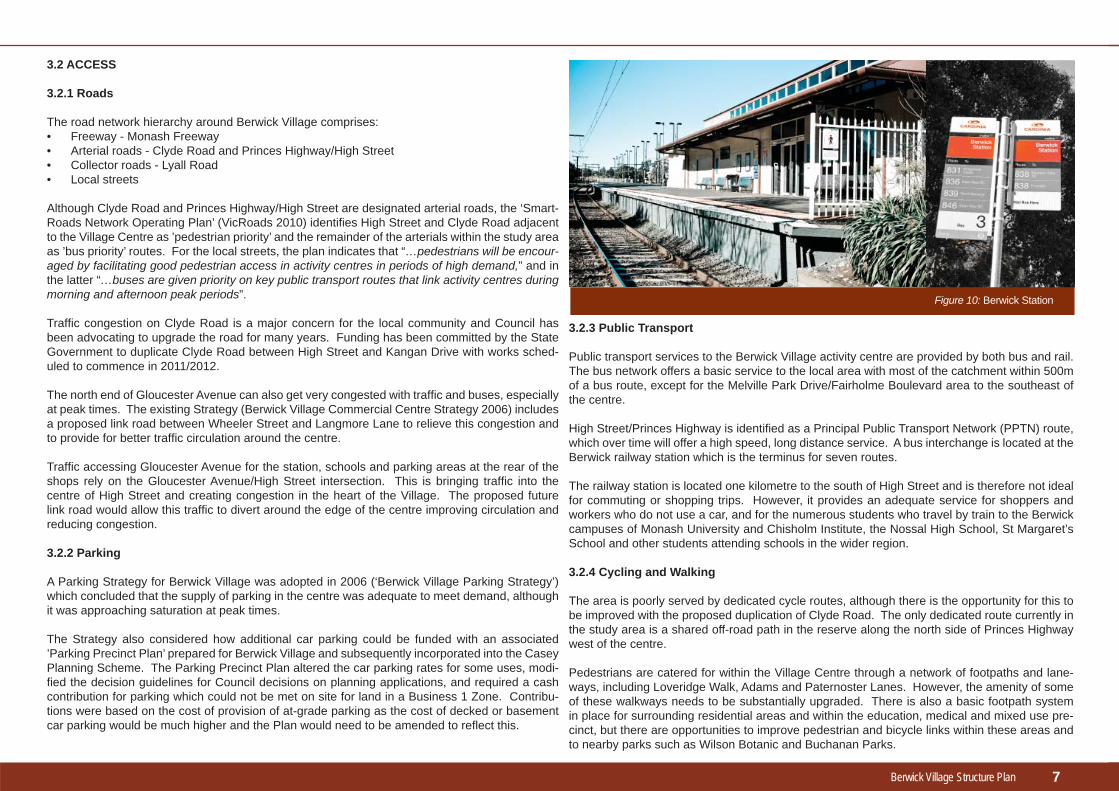
3.2.3 Public Transport
Public transport services to the Berwick Village activity centre are provided by both bus and rail. The bus network offers a basic service to the local area with most of the catchment within 500m of a bus route, except for the Melville Park Drive/Fairholme Boulevard area to the southeast of the centre.
High Street/Princes Highway is identifi ed as a Principal Public Transport Network (PPTN) route, which over time will offer a high speed, long distance service. A bus interchange is located at the Berwick railway station which is the terminus for seven routes.
The railway station is located one kilometre to the south of High Street and is therefore not ideal for commuting or shopping trips. However, it provides an adequate service for shoppers and workers who do not use a car, and for the numerous students who travel by train to the Berwick campuses of Monash University and Chisholm Institute, the Nossal High School, St Margaret’s School and other students attending schools in the wider region.
3.2.4 Cycling and Walking
The area is poorly served by dedicated cycle routes, although there is the opportunity for this to be improved with the proposed duplication of Clyde Road. The only dedicated route currently in the study area is a shared off-road path in the reserve along the north side of Princes Highway west of the centre.
Pedestrians are catered for within the Village Centre through a network of footpaths and lane-ways, including Loveridge Walk, Adams and Paternoster Lanes. However, the amenity of some of these walkways needs to be substantially upgraded. There is also a basic footpath system in place for surrounding residential areas and within the education, medical and mixed use pre-cinct, but there are opportunities to improve pedestrian and bicycle links within these areas and to nearby parks such as Wilson Botanic and Buchanan Parks.
3.2 ACCESS
3.2.1 Roads
The road network hierarchy around Berwick Village comprises:• Freeway - Monash Freeway• Arterial roads - Clyde Road and Princes Highway/High Street• Collector roads - Lyall Road• Local streets
Although Clyde Road and Princes Highway/High Street are designated arterial roads, the ‘Smart-Roads Network Operating Plan’ (VicRoads 2010) identifi es High Street and Clyde Road adjacent to the Village Centre as ’pedestrian priority’ and the remainder of the arterials within the study area as ’bus priority’ routes. For the local streets, the plan indicates that “…pedestrians will be encour-aged by facilitating good pedestrian access in activity centres in periods of high demand,” and in the latter “…buses are given priority on key public transport routes that link activity centres during morning and afternoon peak periods”.
Traffi c congestion on Clyde Road is a major concern for the local community and Council has been advocating to upgrade the road for many years. Funding has been committed by the State Government to duplicate Clyde Road between High Street and Kangan Drive with works sched-uled to commence in 2011/2012.
The north end of Gloucester Avenue can also get very congested with traffi c and buses, especially at peak times. The existing Strategy (Berwick Village Commercial Centre Strategy 2006) includes a proposed link road between Wheeler Street and Langmore Lane to relieve this congestion and to provide for better traffi c circulation around the centre.
Traffi c accessing Gloucester Avenue for the station, schools and parking areas at the rear of the shops rely on the Gloucester Avenue/High Street intersection. This is bringing traffi c into the centre of High Street and creating congestion in the heart of the Village. The proposed future link road would allow this traffi c to divert around the edge of the centre improving circulation and reducing congestion.
3.2.2 Parking
A Parking Strategy for Berwick Village was adopted in 2006 (‘Berwick Village Parking Strategy’) which concluded that the supply of parking in the centre was adequate to meet demand, although it was approaching saturation at peak times.
The Strategy also considered how additional car parking could be funded with an associated ’Parking Precinct Plan’ prepared for Berwick Village and subsequently incorporated into the Casey Planning Scheme. The Parking Precinct Plan altered the car parking rates for some uses, modi-fi ed the decision guidelines for Council decisions on planning applications, and required a cash contribution for parking which could not be met on site for land in a Business 1 Zone. Contribu-tions were based on the cost of provision of at-grade parking as the cost of decked or basement car parking would be much higher and the Plan would need to be amended to refl ect this.
7
Figure 10: Berwick Station

Berwick Village Structure Plan
3.3 DESIGN AND CHARACTER
Landscape character and built form are the defi ning features of Berwick Village and public con-sultation has demonstrated how important these are to the local community. The scattering of heritage buildings, low scale built form, hills, streetscapes, greenery and trees give the Village a distinctive traditional English Village fl avour that sets it apart from competing centres and cre-ates an inviting setting for street-based activity.
Berwick’s distinctive image is largely attributed to the character of High Street with its wide me-dian strip with mature trees, the pattern of small low-scale and fi ne grained shops stepped up the hill and the scattering of heritage buildings. This character is offset somewhat by the eclectic mix of newer buildings of varying architectural quality, but which have nonetheless maintained the overall sense of scale and intimacy of High Street.
Collectively, the following elements contribute to the overall Village character:• The character of High Street with its intimate pedestrian scale.• Prominently sited Victorian-era buildings which date back to the 1850s.• A pedestrian friendly environment (walkability) with many points of access into the area
(permeability).• The green and vegetated setting with both native and exotic mature trees.• Pleasant views to the surrounding leafy hills.• Impressive approaches to the Village along Princes Highway and Clyde Road.
There are ten important heritage properties and three designated heritage trees within the study area. The properties are protected under the Casey Planning Scheme and include the Berwick Post Offi ce and Courthouse, Berwick Inn, the Mechanics Institute and Free Library, the Rech-abite Hall, Berwick Primary School and St Margaret’s School. This strong cluster of historic buildings is the basis for the Berwick heritage walk which provides interest for visitors and a greater appreciation of local history for local residents. There are also a number of attractive parks, open spaces and reserves in the area which can be better connected to the Village. These comprise the Wilson Botanic Gardens, Pioneers Park, Bill Hudson Reserve vand Bucha-nan Park.
8
Figure 12: High Street Streetscaepe
There are opportunities to improve the pedestrian connections to these parks so that shoppers and workers can walk to the parks for a lunchbreak or picnic, or joggers and walkers can link them up for an exercise circuit. The character of the education, medical and mixed use precinct containing Monash University, Chisholm Institute and Casey Hospital, south of the railway is quite different to that of the Village Centre, featuring high rise, contemporary and predominantly larger footprint, campus styles buildings. Given the developing nature fo this precinct, its char-acter is still evolving.
Figure 11: Impressive Approaches to the Village

Berwick Village Structure Plan
44Vision and Objectives
“A thriving commercial centre which meets the needs of a growing regional population while retaining its essential Village character. It will maintain links to its country village heritage and will remain a vibrant, friendly, pleasant and attractive place to be. It will provide development opportunities for retail, commercial and residential, but in the context of a high quality built environment which promotes environmental sustainability.”
The strategic response to this vision is an integrated package of proposals which sees High Street enhanced as the social and retail focus for the activ-ity centre. Opportunities for more intensive development can be provided away from High Street in less sensitive locations.
The scale and character of High Street will be maintained by limiting new development to two storeys, but allowing for infi ll and second storey de-velopment for small offi ces and shop-top housing. The pedestrian scale and atmosphere will be enhanced by further landscape and design improve-ments to the streetscape and the central median strip. The lanes, walkways and arcades feeding into High Street will be improved and provision will be made for additional walkways to make a wonderful pedestrian environment for shoppers, workers and visitors. Walking links to nearby parks will be created to promote a healthy and active lifestyle. High Street will remain as the social and community heart of the Village by ensuring that future devel-opment is spread evenly - or balanced - on both the northern and southern sides of the centre so that High Street does not become geographically mar-ginalised.
A growing population with rising incomes will need improved shopping choices and opportunities to work and live locally. The Berwick Village Activ-ity Centre can provide these opportunities because there are a number of strategic sites and several precincts which can accommodate growth with-out compromising Berwick’s special character.
The strategic sites (refer Plan 6) identifi ed for future development are:• Southside (southern public car park site);• Northside (northern public car park site);• Lyall Road (between Princes Highway and Wilson Street); and,• Reserve Street (adjacent to the railway line on the corner of Clyde
Road).• Community Services Hub (located on the south side of Princes High-
way to the east of the Village Centre);
The precincts (refer Plan 5) identifi ed for future masterplanning to also accommodate signifi cant future development are the: • Berwick Station Precinct; and,• Education, Medical and Mixed Use Precinct (located between the
railway line and the Prices Freeway).
More intensive development is possible in these strategic sites and precincts but needs to be guided by urban design principles to set high standards for design and amenity to protect and enhance the character of Berwick Village. Development in these areas will be easily able to ac-commodate forecast growth over the plan period to 2030.
Mixed use development will be encouraged in order to build a more vi-brant and stimulating atmosphere for the Village and to offer new housing options for local people. Shop-top housing, apartments and infi ll housing in the Evan-Margaret Streets area in particular will be part of this strategy. The Village’s restaurant profi le will be supported and the community serv-ices area at the top of High Street will be enhanced and improved to offer opportunities for new services with shared facilities.
Around 90% of travel to the Village is by car, so catering for this form of transport remains a priority. However, provision must also be made for transition towards more sustainable forms of transport in the longer term.
The duplication of Clyde Road will alleviate some traffi c congestion and provide for an improved layout of the Clyde Road/Princes Highway inter-section. Provision for pedestrians and cyclists will be upgraded as part of this duplication.
Provision for new car parking in line with growth will be needed, but op-tions for at-grade parking have now been virtually exhausted. New provi-sion will therefore need to be underground if viable, or above ground in decked parking. Opportunities for better parking management will also need to be explored so that the load for peak parking is spread more evenly across the Village.
A safer and more convenient cycle network will also be developed with designated cycle routes feeding into Berwick Village along Princes High-way and Clyde Road. Options for Lyall Road and High Street will be further investigated.
The following sections explain the vision in more detail under the four themes as follows:• Land Use• Access• Built Form• Public Realm
The vision for Berwick Village which was developed in consultation with the local community is as follows:
9
Berwick Village Structure Plan
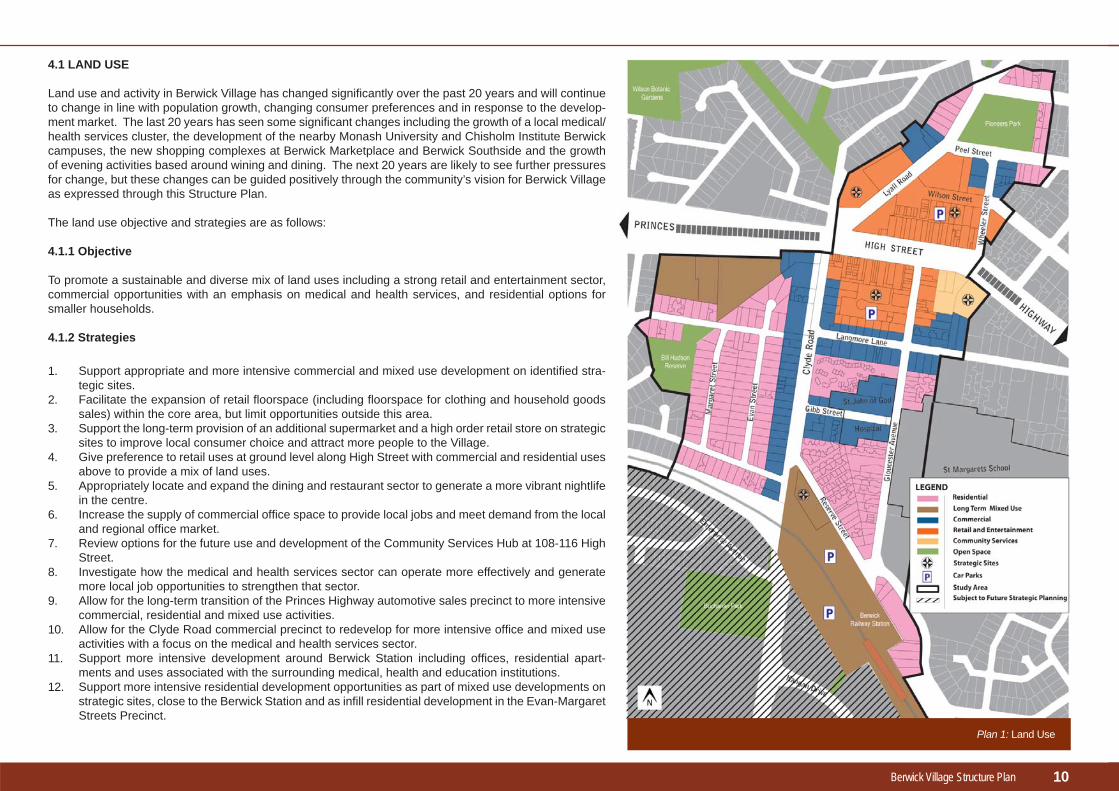
4.1 LAND USE
Land use and activity in Berwick Village has changed signifi cantly over the past 20 years and will continue to change in line with population growth, changing consumer preferences and in response to the develop-ment market. The last 20 years has seen some signifi cant changes including the growth of a local medical/health services cluster, the development of the nearby Monash University and Chisholm Institute Berwick campuses, the new shopping complexes at Berwick Marketplace and Berwick Southside and the growth of evening activities based around wining and dining. The next 20 years are likely to see further pressures for change, but these changes can be guided positively through the community’s vision for Berwick Village as expressed through this Structure Plan.
The land use objective and strategies are as follows:
4.1.1 Objective
To promote a sustainable and diverse mix of land uses including a strong retail and entertainment sector, commercial opportunities with an emphasis on medical and health services, and residential options for smaller households.
4.1.2 Strategies
10
Support appropriate and more intensive commercial and mixed use development on identifi ed stra-tegic sites.Facilitate the expansion of retail fl oorspace (including fl oorspace for clothing and household goods sales) within the core area, but limit opportunities outside this area.Support the long-term provision of an additional supermarket and a high order retail store on strategic sites to improve local consumer choice and attract more people to the Village.Give preference to retail uses at ground level along High Street with commercial and residential uses above to provide a mix of land uses.Appropriately locate and expand the dining and restaurant sector to generate a more vibrant nightlife in the centre.Increase the supply of commercial offi ce space to provide local jobs and meet demand from the local and regional offi ce market.Review options for the future use and development of the Community Services Hub at 108-116 High Street. Investigate how the medical and health services sector can operate more effectively and generate more local job opportunities to strengthen that sector.Allow for the long-term transition of the Princes Highway automotive sales precinct to more intensive commercial, residential and mixed use activities.Allow for the Clyde Road commercial precinct to redevelop for more intensive offi ce and mixed use activities with a focus on the medical and health services sector.Support more intensive development around Berwick Station including offi ces, residential apart-ments and uses associated with the surrounding medical, health and education institutions.Support more intensive residential development opportunities as part of mixed use developments on strategic sites, close to the Berwick Station and as infi ll residential development in the Evan-Margaret Streets Precinct.
1.
2.
3.
4.
5.
6.
7.
8.
9.
10.
11.
12.
Plan 1: Land Use

Berwick Village Structure Plan
4.2 ACCESS
Berwick is a highly car-dependent community with more than 90% of travel being by private car. While issues around traffi c congestion and car parking must therefore remain the priority for local transport planning, the vision for Berwick Village is for a more sustainable environment which reduces car depend-ency by promoting more sustainable transport modes such as walking, cycling and public transport. There needs to be an increased focus on integrating the Berwick Station with the Vil-lage Centre and improving the pedestrian environment.
4.2.1 Objective
To improve accessibility into and around the centre by minimis-ing traffi c congestion, improving parking management, and by promoting the use of more sustainable transport modes such as walking, cycling and public transport.
4.2.2 Strategies
Traffi c1. Support the duplication of Clyde Road between High Street
and the Monash Freeway to reduce local traffi c congestion and provide for improved pedestrian outcomes and cycling facilities.
2. Improve the design of the Clyde Road-High Street inter-section to improve safety and increase traffi c capacity.
3. Review traffi c circulation within the activity centre and pro-vide for safe and effi cient traffi c circulation within the study area, particularly around the Village Centre and associated car parks.
4. Provide for a future link road between Wheeler Street and Langmore Lane to relieve congestion in Gloucester Ave-nue and to improve for traffi c circulation around the centre.
5. Require the provision of Transport Impact Assessments as part of major new retail/commercial/mixed use develop-ments (ie. over 4000m2 fl oor area).
11
Support more intensive residential opportunities which in-crease housing diversity catering for smaller households, and younger and older age groups eg. town houses, shop-top housing, apartments and student housing, particularly as part of mixed use development on strategic develop-ment sites.Discourage land fragmentation which compromises achievement of the Structure Plan’s objectives.
13.
14.
Plan 2: Access

Berwick Village Structure Plan
Cycling
Car Parking
Public Transport
Pedestrians
12
Figure 13: Berwick Station
Figure 14: Bus stop, Reserve Street
Figure 15: Evan Street
Develop a framework of dedicated cycling routes along the main access roads into the centre including Princes Highway and Clyde Road, including investigating cycle options for High Street and Lyall Road.Ensure that dedicated cycle routes have safe and convenient access to key generators such as the railway station, education facilities and the Village Centre.Provide bicycle parking facilities at key locations such as the edge of the main shopping strip, the railway station and local schools.
Ensure that all new development provides parking to meet requirements, including the provision of decked or basement parking in conjunction with new development on strategic sites.Ensure that development outside the Village Centre meets its parking requirements on-site.Revise the Berwick Village Commercial Centre Parking Strategy and associated Parking Pre-cinct Plan to review parking rates, parking provision (ie. on site, cash contributions, etc.), parking management (ie. time limits, paid parking systems, etc.) and consider the case for either or both decked or basement car parking.Ensure that loading facilities are appropriately located to avoid negative impacts on pedestrian amenity or traffi c.
Advocate for a new bus route to connect the Melville Park Drive/Fairholme Boulevard neighbour-hood to the centre and to Berwick Station.Advocate for the long-term grade separation (rail under) of the Clyde Road railway crossing to reduce traffi c congestion.Advocate for the relocation of the railway station adjacent to Clyde Road as part of the grade separation.Advocate for a ‘Smart Bus’ route or improved bus service along Clyde Road.Support ‘transit-oriented’ land uses, such as employment or housing developments, around the railway station which can be shown to generate greater use of public transport.Explore opportunities to improve the bus interchange at Berwick Station and bus facilities in High Street to enhance public transport usage.
Enhance and improve existing linkages from High Street to strategic sites through walkways, laneways and arcades when new development takes place.Improve pedestrian linkages between the centre and adjoining residential areas and open spac-es, including the regional trails network.Develop better pedestrian and bicycle links between the centre and Wilson Botanic Park by pro-viding a shared pathway.Develop a signage and way-fi nding system throughout Berwick Village and surrounding areas to encourage and facilitate walking and cycling.
6.
7.
8.
9.
10.11.
12.
13.
14.
15.
16.17.
18.
19.
20.
21.
22.
Berwick Village Structure Plan
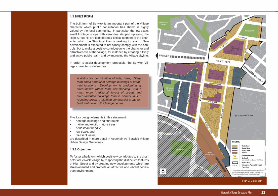
4.3 BUILT FORM
The built form of Berwick is an important part of the Village character which public consultation has shown is highly valued by the local community. In particular, the low scale, small frontage shops with verandas stepped up along the High Street hill are considered a critical element of the char-acter which the Structure Plan is seeking to retain. New development is expected to not simply comply with the con-trols, but to make a positive contribution to the character and attractiveness of the Village, for instance by creating a lively and active public realm and by improving the Village skyline.
In order to assist development proposals, the Berwick Vil-lage character is defi ned as:
Five key design elements in this statement:• heritage buildings and character;• native and exotic mature trees;• pedestrian friendly;• low scale; and,• pleasant views,are described in more detail in Appendix A: ‘Berwick Village Urban Design Guidelines’.
4.3.1 Objective
To foster a built form which positively contributes to the char-acter of Berwick Village by respecting the distinctive features of High Street and by creating new developments which are street-oriented and promote an attractive and vibrant pedes-trian environment.
A distinctive combination of hills, trees, Village form and a handful of heritage buildings at promi-nent locations. Development is predominantly street-based rather than free-standing, with a much more ‘traditional’ layout of streets and street-oriented buildings than is normal in sur-rounding areas. Adjoining commercial areas ex-tend well beyond the Village centre.
13
Plan 3: Built Form

Berwick Village Structure Plan
4.3.2 Strategies
1. Protect the existing low scale Village character by allowing only up to 2-storey development along High Street.
2. Ensure development of up to 4-storeys on designated strategic sites and within commercial mixed use precincts integrates with the surrounding built form by ‘stepping back’ buildings and structures above 2 storeys to allow for solar access, maintain pedestrian scale and protect view lines.
3. Take into account the Berwick Urban Design Guidelines (Appendix A) which provide detailed design requirements and guidance for new development to protect the Village’s distinctive character, including building heights and setbacks.
4. Encourage an active and vibrant streetscape by requiring ’zero building setbacks’ and small shop frontages for new commercial development in the Village Centre and adjoining streets including Clyde Road, Lyall Road, Wilson Street, Langmore Lane and Gibb Street.
5. Ensure that new development protects important view lines, including to surrounding hills, along the avenues of trees and up the High Street hill.
6. Create new access ways and improve amenity at the car park interface by encouraging prop-erties along High Street to redevelop at the rear of their premises to provide a frontage to car parking areas.
7. Protect and enhance designated heritage and prominent buildings by taking into acount the Berwick Urban Design Guidelines (Appendix A) to ensure that adjoining new development respects these buildings heritage qualities and prominence.
8. Ensure that development on strategic sites positively contributes to and respects the character and built form of Berwick Village and High Street.
9. Enhance public safety and reduce the potential for anti-social behaviour through the design of buildings, for instance by applying Crime Prevention through Environmental Design principles.
Figure 16: Wilson Street Interface
Figure 17: Berwick Inn, Heritage Building
14
Berwick Village Structure Plan
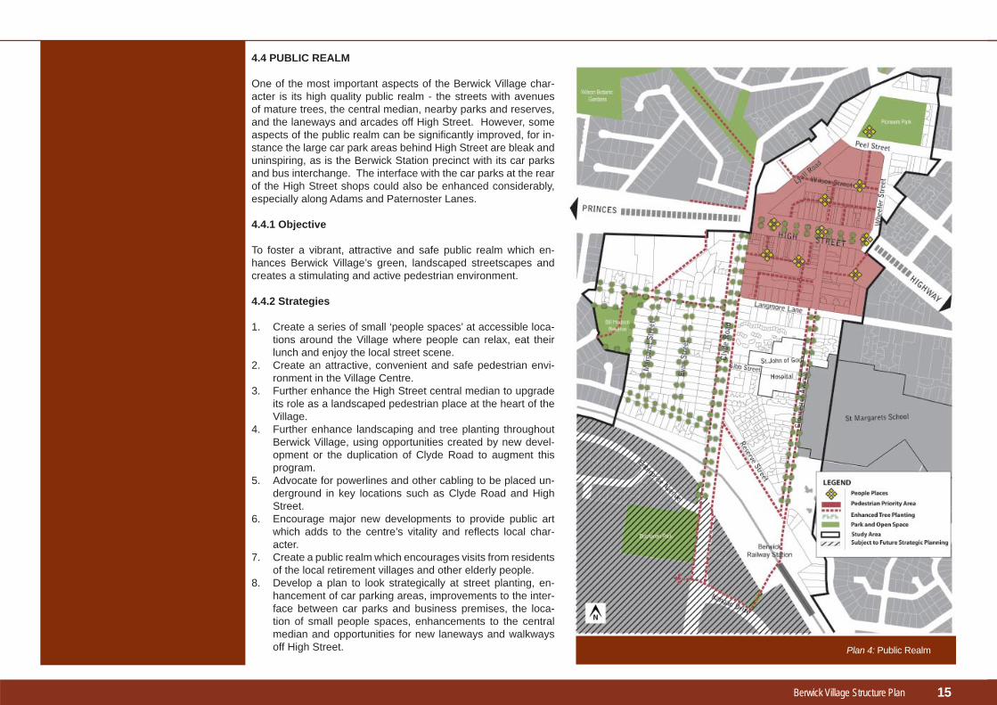
4.4 PUBLIC REALM
One of the most important aspects of the Berwick Village char-acter is its high quality public realm - the streets with avenues of mature trees, the central median, nearby parks and reserves, and the laneways and arcades off High Street. However, some aspects of the public realm can be signifi cantly improved, for in-stance the large car park areas behind High Street are bleak and uninspiring, as is the Berwick Station precinct with its car parks and bus interchange. The interface with the car parks at the rear of the High Street shops could also be enhanced considerably, especially along Adams and Paternoster Lanes.
4.4.1 Objective
To foster a vibrant, attractive and safe public realm which en-hances Berwick Village’s green, landscaped streetscapes and creates a stimulating and active pedestrian environment.
4.4.2 Strategies
1. Create a series of small ‘people spaces’ at accessible loca-tions around the Village where people can relax, eat their lunch and enjoy the local street scene.
2. Create an attractive, convenient and safe pedestrian envi-ronment in the Village Centre.
3. Further enhance the High Street central median to upgrade its role as a landscaped pedestrian place at the heart of the Village.
4. Further enhance landscaping and tree planting throughout Berwick Village, using opportunities created by new devel-opment or the duplication of Clyde Road to augment this program.
5. Advocate for powerlines and other cabling to be placed un-derground in key locations such as Clyde Road and High Street.
6. Encourage major new developments to provide public art which adds to the centre’s vitality and refl ects local char-acter.
7. Create a public realm which encourages visits from residents of the local retirement villages and other elderly people.
8. Develop a plan to look strategically at street planting, en-hancement of car parking areas, improvements to the inter-face between car parks and business premises, the loca-tion of small people spaces, enhancements to the central median and opportunities for new laneways and walkways off High Street.
15
Plan 4: Public Realm

Berwick Village Structure Plan 16
Illustration 1: People Places

Berwick Village Structure Plan
The Berwick Village Activity Centre is comprised of nine precincts differentiated from each other by their mix of character and land uses:• Village Centre (incorporating the High Street Character
area)• Village Edge• Clyde Road• Berwick Station• Gloucester Avenue• Princes Highway• Pioneers Park• Evan-Margaret Streets• Education, medical and mixed use.
The objectives and actions for each of the precincts are outlined in this section of the Structure Plan, while the design objectives and development requirements for each precinct are specifi ed in Appendix A – Berwick Village Urban Design Guidelines.
55Precincts
17
Plan 5: Precincts

Berwick Village Structure Plan
5.1 VILLAGE CENTRE
The ‘Village Centre’ precinct combines bustling activity with a distinctive ‘traditional English Village’ and heritage feel focussed on High Street.
The Village Centre features a wide variety of shopping, business, community and civic activities and an active nightlife based on the many cafes, restaurants and evening venues.
Away from High Street however, the rear car parks and new developments do not contribute to local amenity or urban design.
The real challenge in the Village Centre is to ensure that major new developments on strategic sites achieve more impressive design outcomes, are integrated better with High Street and create more of the pedestrian and small shop feel that is valued by the community.
5.1.1 Objective
To protect and enhance the character of the Village Centre, particularly the High Street Character Area, and promote new development on strategic sites which achieve very high design standards and are strongly integrated with High Street.
5.1.2 Actions
1. Work with owners and the community to achieve appropriate mixed use development on identifi ed strategic sites, including a new supermarket and higher order retail store.
2. Review and extend planning controls over the Village Centre including the Lyall Road strategic site to implement the objectives of this Structure Plan, and to protect and retain the distinctive character of High Street with its small shop fronts, verandas, low scale buildings and pedestrian activity.
3. In assessing planning applications within the Village Centre, ensure that major new developments are integrated with High Street premises in terms of their design and layout and through their pedestrian connections.
4. Upgrade and improve the interface of the rear of the High Street shops with the adjacent car parks and strategic development sites.
5. Further enhance the central median, pedestrian links and other public spaces within the Village Centre.
5.2 VILLAGE EDGE
The ‘Village Edge’ precinct provides a transitional area between the Village Centre and surrounding residential areas. The land is generally zoned for residential uses, but accommodates a range of non-residential uses including commercial, medical and community services.
5.2.1 Objective
To promote this precinct as a transitional area around the Village Centre for uses which have only minimal impacts on the surrounding residential areas in terms of traffi c, parking, noise, built form and design.
5.2.2 Actions
1. Introduce planning controls to provide for low scale and low intensity commercial and community related uses at street level.
2. Encourage shop-top housing, residential apartments and small offi ces on upper fl oors.
3. Discourage more intensive uses adjacent to residential areas including retail and entertainment uses over 150m² in fl oor area and uses operating outside normal working hours.
4. Introduce planning controls to ensure that the design, layout and built form of new development minimises any negative impacts on the amenity of surrounding residential uses.
5. Provide a future link road between Wheeler Street and Langmore Lane to relieve congestion in Gloucester Avenue and to improve traffi c circulation around the centre.
6. Investigate options for the future use and development of the Community Services Hub at 108-116 High Street.
The core retail centre incorporating the High Street Character Area
Low intensity commercial uses providing a transition zone to adjoining residential areas
18
Berwick Village Structure Plan
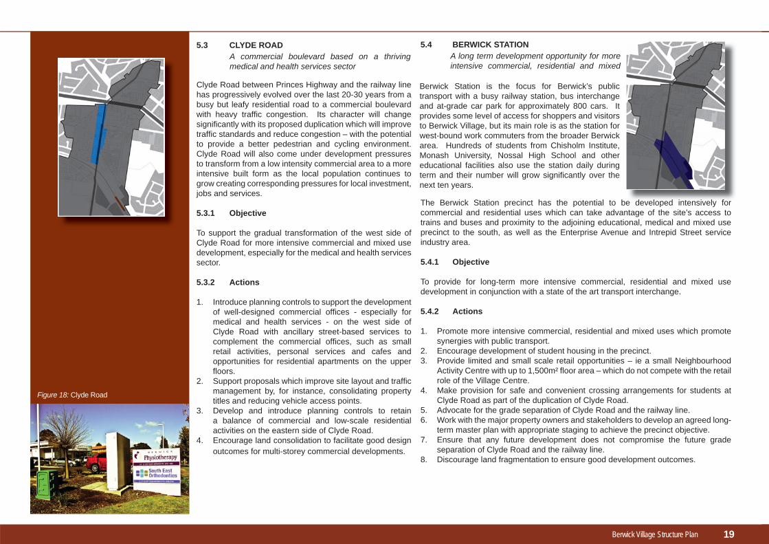
5.3 CLYDE ROAD
Clyde Road between Princes Highway and the railway line has progressively evolved over the last 20-30 years from a busy but leafy residential road to a commercial boulevard with heavy traffi c congestion. Its character will change signifi cantly with its proposed duplication which will improve traffi c standards and reduce congestion – with the potential to provide a better pedestrian and cycling environment. Clyde Road will also come under development pressures to transform from a low intensity commercial area to a more intensive built form as the local population continues to grow creating corresponding pressures for local investment, jobs and services.
5.3.1 Objective
To support the gradual transformation of the west side of Clyde Road for more intensive commercial and mixed use development, especially for the medical and health services sector.
5.3.2 Actions
1. Introduce planning controls to support the development of well-designed commercial offi ces - especially for medical and health services - on the west side of Clyde Road with ancillary street-based services to complement the commercial offi ces, such as small retail activities, personal services and cafes and opportunities for residential apartments on the upper fl oors.
2. Support proposals which improve site layout and traffi c management by, for instance, consolidating property titles and reducing vehicle access points.
3. Develop and introduce planning controls to retain a balance of commercial and low-scale residential activities on the eastern side of Clyde Road.
4. Encourage land consolidation to facilitate good design outcomes for multi-storey commercial developments.
A commercial boulevard based on a thriving medical and health services sector
5.4 BERWICK STATION
The Berwick Station precinct has the potential to be developed intensively for commercial and residential uses which can take advantage of the site’s access to trains and buses and proximity to the adjoining educational, medical and mixed use precinct to the south, as well as the Enterprise Avenue and Intrepid Street service industry area.
5.4.1 Objective
To provide for long-term more intensive commercial, residential and mixed use development in conjunction with a state of the art transport interchange.
5.4.2 Actions
1. Promote more intensive commercial, residential and mixed uses which promote synergies with public transport.
2. Encourage development of student housing in the precinct.3. Provide limited and small scale retail opportunities – ie a small Neighbourhood
Activity Centre with up to 1,500m² fl oor area – which do not compete with the retail role of the Village Centre.
4. Make provision for safe and convenient crossing arrangements for students at Clyde Road as part of the duplication of Clyde Road.
5. Advocate for the grade separation of Clyde Road and the railway line.6. Work with the major property owners and stakeholders to develop an agreed long-
term master plan with appropriate staging to achieve the precinct objective.7. Ensure that any future development does not compromise the future grade
separation of Clyde Road and the railway line.8. Discourage land fragmentation to ensure good development outcomes.
A long term development opportunity for more intensive commercial, residential and mixed
d l d i t i l f
19
Figure 18: Clyde Road
Berwick Station is the focus for Berwick’s public transport with a busy railway station, bus interchange and at-grade car park for approximately 800 cars. It provides some level of access for shoppers and visitors to Berwick Village, but its main role is as the station for west-bound work commuters from the broader Berwick area. Hundreds of students from Chisholm Institute, Monash University, Nossal High School and other educational facilities also use the station daily during term and their number will grow signifi cantly over the next ten years.
Berwick Village Structure Plan
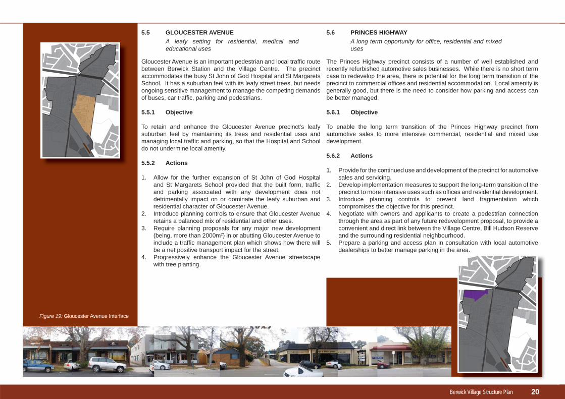
5.5 GLOUCESTER AVENUE
Gloucester Avenue is an important pedestrian and local traffi c route between Berwick Station and the Village Centre. The precinct accommodates the busy St John of God Hospital and St Margarets School. It has a suburban feel with its leafy street trees, but needs ongoing sensitive management to manage the competing demands of buses, car traffi c, parking and pedestrians.
5.5.1 Objective
To retain and enhance the Gloucester Avenue precinct’s leafy suburban feel by maintaining its trees and residential uses and managing local traffi c and parking, so that the Hospital and School do not undermine local amenity.
5.5.2 Actions
1. Allow for the further expansion of St John of God Hospital and St Margarets School provided that the built form, traffi c and parking associated with any development does not detrimentally impact on or dominate the leafy suburban and residential character of Gloucester Avenue.
2. Introduce planning controls to ensure that Gloucester Avenue retains a balanced mix of residential and other uses.
3. Require planning proposals for any major new development (being, more than 2000m2) in or abutting Gloucester Avenue to include a traffi c management plan which shows how there will be a net positive transport impact for the street.
4. Progressively enhance the Gloucester Avenue streetscape with tree planting.
A leafy setting for residential, medical and educational uses
5.6 PRINCES HIGHWAY
The Princes Highway precinct consists of a number of well established and recently refurbished automotive sales businesses. While there is no short term case to redevelop the area, there is potential for the long term transition of the precinct to commercial offi ces and residential accommodation. Local amenity is generally good, but there is the need to consider how parking and access can be better managed.
5.6.1 Objective
To enable the long term transition of the Princes Highway precinct from automotive sales to more intensive commercial, residential and mixed use development.
5.6.2 Actions
1. Provide for the continued use and development of the precinct for automotive sales and servicing.
2. Develop implementation measures to support the long-term transition of the precinct to more intensive uses such as offi ces and residential development.
3. Introduce planning controls to prevent land fragmentation which compromises the objective for this precinct.
4. Negotiate with owners and applicants to create a pedestrian connection through the area as part of any future redevelopment proposal, to provide a convenient and direct link between the Village Centre, Bill Hudson Reserve and the surrounding residential neighbourhood.
5. Prepare a parking and access plan in consultation with local automotive dealerships to better manage parking in the area.
A long term opportunity for offi ce, residential and mixed uses
20
Figure 19: Gloucester Avenue Interface

Berwick Village Structure Plan
5.7 PIONEERS PARK
The Pioneers Park precinct showcases the park and historic Berwick Primary School buildings. The park provides a pleasant and attractive open space for local residents and visitors to the Berwick Village. Surrounding residences overlook the park and benefi t from the setting. These residences are a complementary built form to Pioneers Park because they are sympathetically designed to refl ect the low scale, heritage buildings.
5.7.1 Objective
To enhance the amenity, safety and community role of the Pioneers Park precinct, and particularly the former primary school building, as a social gathering place with a focus on families and children.
5.7.2 Actions
1. Introduce planning controls to ensure adjoining development within the precinct remains residential and sympathetic in style to the precinct’s heritage and amenity values.
2. Require adjoining buildings to be orientated with an outlook towards Pioneers Park with appropriate fencing and edge treatments to enhance public surveillance and amenity.
3. Introduce appropriate signage and information boards to explain and enhance the heritage and educational values of Pioneers Park.
4. Support and encourage longer operating hours of the former primary school building.
5. Ensure the design and layout of Pioneers Park continues to refl ect the heritage values of the old school building and provides more facilities for children.
A community and heritage focus5.8 EVAN-MARGARET STREETS
The Evan and Margaret Streets residential area between Clyde Road and the Bill Hudson Reserve offers opportunities for redevelopment and refurbishment to create more diverse local housing choices. There are few local opportunities for older residents to downsize to smaller town houses, or for young people and students to fi nd a local fl at or apartment in the local area. The larger lots in this precinct - combined with its proximity to Berwick Village, the Berwick Station, Monash University and Chisholm Institute – suggest that this area should be given priority as a housing diversity area for gradual and more intensive residential redevelopment over time.
5.8.1 Objective
To support the progressive redevelopment of the Evan-Margaret Streets precinct to provide opportunities for town houses, fl ats and apartments.
5.8.2 Actions
1. Introduce planning controls which support the development of medium-density housing opportunities which improve the amenity of the neighbourhood through building design and landscaping.
2. Introduce planning controls which prevent land fragmentation that may compromise medium density housing opportunities.
3. Undertake complementary landscaping, tree planting and other improvements to the Bill Hudson Reserve to enhance the precinct as an attractive medium density neighbourhood.
4. Encourage land consolidation to facilitate good design outcomes for residential apartments.
Housing diversifi cation opportunities
21
Figure 20 : Evan Street
Berwick Village Structure Plan
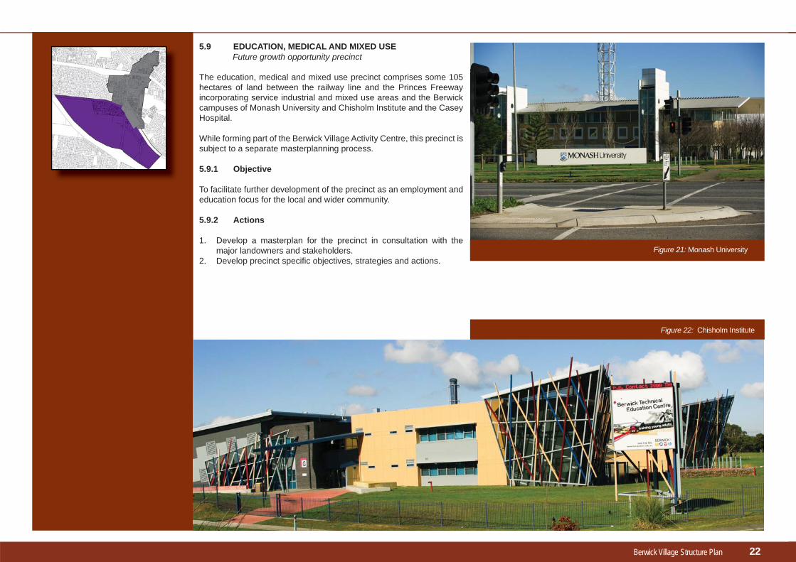
5.9 EDUCATION, MEDICAL AND MIXED USE
The education, medical and mixed use precinct comprises some 105 hectares of land between the railway line and the Princes Freeway incorporating service industrial and mixed use areas and the Berwick campuses of Monash University and Chisholm Institute and the Casey Hospital.
While forming part of the Berwick Village Activity Centre, this precinct is subject to a separate masterplanning process.
5.9.1 Objective
To facilitate further development of the precinct as an employment and education focus for the local and wider community.
5.9.2 Actions
1. Develop a masterplan for the precinct in consultation with the major landowners and stakeholders.
2. Develop precinct specifi c objectives, strategies and actions.
Future growth opportunity precinct
22
Figure 21: Monash University
Figure 22: Chisholm Institute
Berwick Village Structure Plan
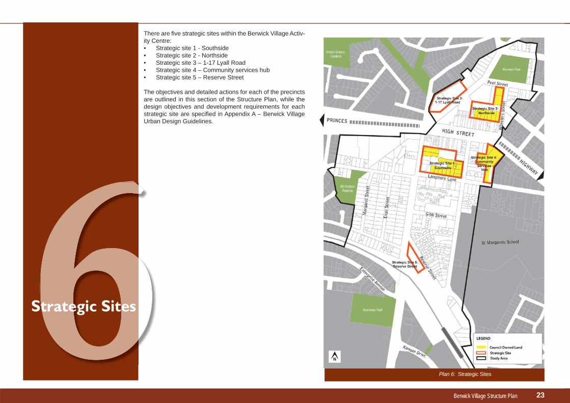
There are fi ve strategic sites within the Berwick Village Activ-ity Centre:• Strategic site 1 - Southside• Strategic site 2 - Northside• Strategic site 3 – 1-17 Lyall Road• Strategic site 4 – Community services hub• Strategic site 5 – Reserve Street
The objectives and detailed actions for each of the precincts are outlined in this section of the Structure Plan, while the design objectives and development requirements for each strategic site are specifi ed in Appendix A – Berwick Village Urban Design Guidelines.
66Strategic Sites
23
Plan 6: Strategic Sites
Berwick Village Structure Plan
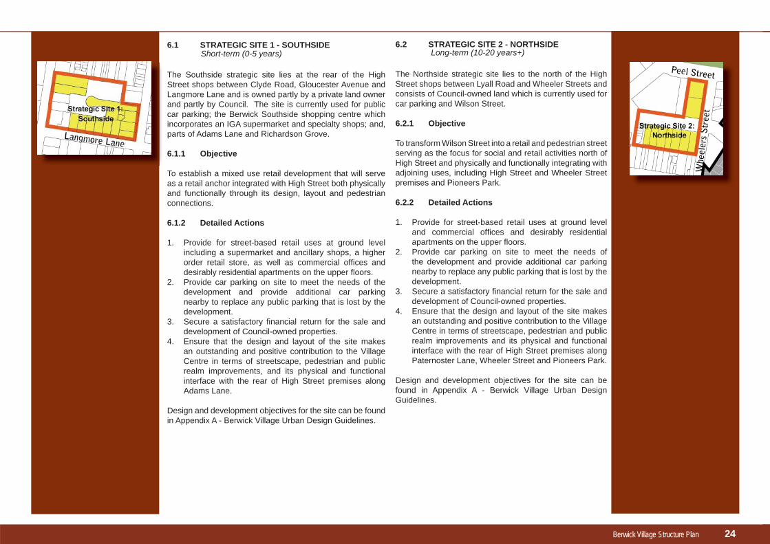
6.1 STRATEGIC SITE 1 - SOUTHSIDE
The Southside strategic site lies at the rear of the High Street shops between Clyde Road, Gloucester Avenue and Langmore Lane and is owned partly by a private land owner and partly by Council. The site is currently used for public car parking; the Berwick Southside shopping centre which incorporates an IGA supermarket and specialty shops; and, parts of Adams Lane and Richardson Grove.
6.1.1 Objective
To establish a mixed use retail development that will serve as a retail anchor integrated with High Street both physically and functionally through its design, layout and pedestrian connections.
6.1.2 Detailed Actions
1. Provide for street-based retail uses at ground level including a supermarket and ancillary shops, a higher order retail store, as well as commercial offi ces and desirably residential apartments on the upper fl oors.
2. Provide car parking on site to meet the needs of the development and provide additional car parking nearby to replace any public parking that is lost by the development.
3. Secure a satisfactory fi nancial return for the sale and development of Council-owned properties.
4. Ensure that the design and layout of the site makes an outstanding and positive contribution to the Village Centre in terms of streetscape, pedestrian and public realm improvements, and its physical and functional interface with the rear of High Street premises along Adams Lane.
Design and development objectives for the site can be found in Appendix A - Berwick Village Urban Design Guidelines.
6.2 STRATEGIC SITE 2 - NORTHSIDE
The Northside strategic site lies to the north of the High Street shops between Lyall Road and Wheeler Streets and consists of Council-owned land which is currently used for car parking and Wilson Street.
6.2.1 Objective
To transform Wilson Street into a retail and pedestrian street serving as the focus for social and retail activities north of High Street and physically and functionally integrating with adjoining uses, including High Street and Wheeler Street premises and Pioneers Park.
6.2.2 Detailed Actions
1. Provide for street-based retail uses at ground level and commercial offi ces and desirably residential apartments on the upper fl oors.
2. Provide car parking on site to meet the needs of the development and provide additional car parking nearby to replace any public parking that is lost by the development.
3. Secure a satisfactory fi nancial return for the sale and development of Council-owned properties.
4. Ensure that the design and layout of the site makes an outstanding and positive contribution to the Village Centre in terms of streetscape, pedestrian and public realm improvements and its physical and functional interface with the rear of High Street premises along Paternoster Lane, Wheeler Street and Pioneers Park.
Design and development objectives for the site can be found in Appendix A - Berwick Village Urban Design Guidelines.
Short-term (0-5 years) Long-term (10-20 years+)
24

Berwick Village Structure Plan
6.3 STRATEGIC SITE 3 – 1-17 LYALL ROAD
The Lyall Road strategic site is privately owned land located on the north side of Lyall Road between Princes Highway and Peel Street.
6.3.1 Objective
To promote a mixed use commercial and residential development which contributes positively to the character of Berwick Village in terms of land use, built form and design and which physically and functionally integrates with the High Street Character area.
6.3.2 Detailed Actions
1. Provide for street-based retail uses at ground level including a supermarket, ancillary shops and restaurants/cafes etc. and commercial offi ces and residential uses on the upper fl oors.
2. Provide car parking on site to meet the needs of the development.
3. Ensure that the development is physically and functionally integrated with the character of Berwick Village and High Street in terms of its built form, design and pedestrian linkages.
4. Ensure that the design, layout and development of the site makes an outstanding and positive contribution to Berwick Village in terms of streetscape, pedestrian and public realm improvements.
Design and development objectives for the site can be found in Appendix A - Berwick Village Urban Design Guidelines.
Short-term (0-5 years)6.4 STRATEGIC SITE 4 - COMMUNITY SERVICES HUB
The Community Services hub strategic site is Council-owned and occupied by the Neighbourhood House and Community Learning Centre, Senior Citizens Centre, Guides Hall and vacant property. Adjoining uses include the Berwick RSL and Masonic Hall. The precinct provides inter-generational facilities including a complementary multi-purpose building.
6.4.1 Objective
To enhance the site as a transitional precinct between the Village Centre and adjoining residential uses, with a focus on community facilities and residential uses but with a potential commercial element in order to make the site viable in the long term. Opportunities for co-location of uses should be investigated to encourage synergies and positive interaction and shared use of facilities.
Medium-term (5-10 years)
6.4.2 Detailed Actions
1. Work with owners, occupiers and other stakeholders to consider options for the future use and development of the site in relation to its suitability forexisting or alternate land uses, car parking and the link road. [This options analysis could consider Council selling the site in conjunction with a development brief, or retaining the site in conjunction with a masterplan. The masterplan or brief would plan to achieve the precinct goal and achieve an integrated mixed use development which addresses pedestrian and vehicle access and includes the option for a link road between Wheeler Street and Langmore Lane].
2. Provide for a complementary mix of community, residential and ancillary commercial and car parking facilities which can benefi t from co-location.
3. Provide for commercial facilities which complement the site’s primary function as a community services precinct eg. car parking, serviced apartments and restaurants or cafes.
4. Ensure that the development is physically and functionally integrated with the character of Berwick Village and High Street in terms of its built form, design and pedestrian linkages and that it is accessible for people with disabilities and for prams.
5. Ensure that the layout and development of the site contributes positively to Berwick Village in terms of streetscape, pedestrian and public realm improvements with provision for a new area of passive open space.
Design and development objectives for the site can be found in Appendix A - Berwick Village Urban Design Guidelines.
25

Berwick Village Structure Plan
6.5 STRATEGIC SITE 5 – RESERVE STREET
The Reserve Street strategic site is privately owned land located on the corner of Clyde Road and Reserve Street within the Berwick Station precinct. The site is strategically located in the activity centre, being part way between the Village Centre and the education, medical and mixed use precinct and adjacent to the Berwick Station.
6.5.1 Objective
To provide a cluster of high order and mixed use activities within an integrated development sensitive to the site’s residential interface and signifi cant heritage tree.
6.5.2 Detailed Actions
1. Facilitate more intensive development of the site that does not compromise the future objectives for the Berwick Station precinct.
2. Ensure that any future development does not compromise the future grade separation of Clyde Road and the railway line.
3. Ensure that the design of any development is appropriately setback to protect the heritage signifi cant trees along Reserve Street.
Design and development objectives for the site can be found in Appendix A - Berwick Village Urban Design Guidelines
Short-term (0-5 years)
26
Figure 23: Reserve Street Bus Stop

Berwick Village Structure Plan
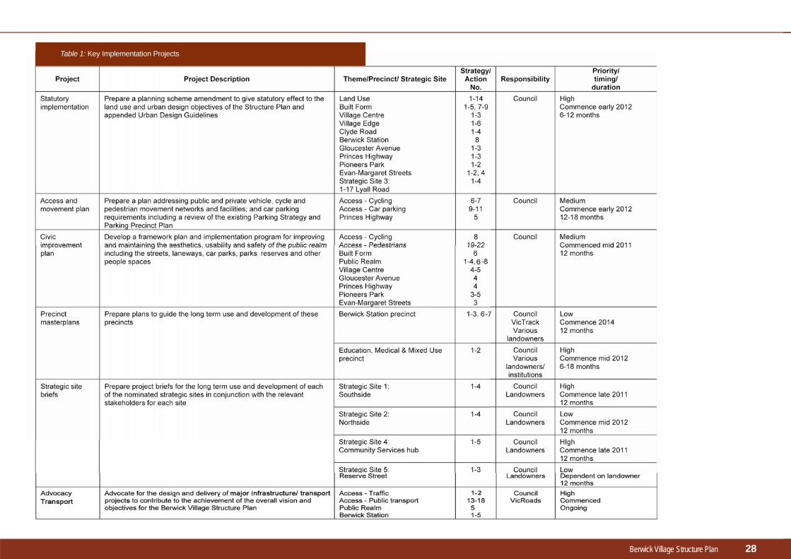
7.1 IMPLEMENTATION
The strategies and actions identifi ed in this Structure Plan will be incorporated into a broader implementation framework for the Berwick Village activity centre addressing planning and design matters; physical works and maintenance; and, advocacy and facilitation.
Table 1 identifi es the key implementation projects which address the strategies and actions outlined throughout this Structure Plan.
Indicative time frames within the life of the Structure Plan have been provided for these key projects, but will be subject to review based on detailed scoping and planning for each, as well as resource availability.
7.2 MONITORING AND REVIEW
The Structure Plan provides a planning framework for Berwick Village for the next 5-10 years. The Plan should be reviewed during the latter part of that period.
Monitoring of implementation of the Structure Plan will be through an annual report to Council.
77Implementation, Monitoring &
Review
27
Berwick Village Structure Plan 28
Table 1: Key Implementation Projects

Customer Service CentresCranbourneCentro Cranbourne
Narre WarrenMagid Drive
Narre Warren SouthAmberly Park Shopping Centre
Telephone: 9705 5200Facsimile: 9704 9544
TTY: 9705 5568TIS: 131 450(Translating and Interpreting Service)
Magid DrivePO Box 1000Narre Warren VIC 3805
Email: [email protected]: www.casey.vic.gov.au