Embed Size (px)
Citation preview

Berkeley Township
Strategic Recovery Planning Report
Page 2
Berkeley Township Strategic Recovery Planning Report
DRAFT- April 29, 2014
Prepared by:
T&M Associates 11 Tindall Road
Middletown, NJ 07748
______________________ Stan C. Slachetka, PP, AICP NJ Professional Planner No.: 03508
The original of this document was signed and sealed in accordance with New Jersey Law.
BERKELEY TOWNSHIP — STRATEGIC RECOVERY PLANNING REPORT
PAGE I
Executive Summary When Superstorm Sandy struck the coast of New Jersey on October 29, 2012, storm surge, flooding, and wind damage caused extensive damage to Berkeley Township, including damages to private and public property, community infrastructure, and community facilities. 252 properties within the Township’s jurisdiction faced substantial damage. Trees and power lines throughout the Township also fell, in some cases damaging buildings. The Township reported 32,072 power outages. Seven of the Township’s sewage pump stations went offline due to floodwater inundation and/or power system failure. The Township also suffered extensive beach and soil erosion.
In response to the impacts faced by Superstorm Sandy, Berkeley’s recovery efforts have been extensive. The Township has restored or repaired a significant portion of critical infrastructure that sustained damages resulting from the storm. The Township is also designing and implementing new techniques, such as living shorelines, in an effort to become more resilient and to mitigate the impacts of storm surge, tidal flooding, and storm events. The Township has also implemented a number of policies to aid its continued recovery from Sandy. Such policies include adopting the Advisory Base Flood Elevation (ABFE) maps released by FEMA, establishing a “Hurricane Sandy Relief Fund Committee” to coordinate the distribution of funds donated to aid victims of the storm
Berkeley property and business owners have also received recovery aid from the New Jersey Department of Community Affairs Community Development Block Grant programs; the Township has been awarded $4,400,000 for the Homeowner Resettlement Program, $13,500,000 for the Homeowner Reconstruction, Rehabilitation, Elevation, and Mitigation program, $330,000 for the Small Rental Properties/Landlord Rental Repair Program, and $435,400 for the Blight Reduction Pilot Program/Neighborhood Enhancement Program. Furthermore, Berkeley has received 121 home loans from the Small Business Administration totaling $8,239,300 and two business and economic injury disaster loans totaling $22,900.
Berkeley Township’s recommended municipal actions to promote recovery from Superstorm Sandy and to reduce vulnerabilities from future storms include (but are not limited to) the following actions: reexamining the Township’s Master Plan Elements; adopting a Floodplain Management Plan; automating and updating the zoning and construction permit process; updating the Township Hazards Mitigation Plan and Emergency Operating Plan; preparing a Capital Improvement Plan; developing a GIS database and user interface to catalog all Township-owned infrastructure; continuing to increase Township participation in FEMA’s Community Rating System (CRS).

BERKELEY TOWNSHIP — STRATEGIC RECOVERY PLANNING REPORT
PAGE II
Acknowledgements Mayor and Council Carmen Amato, Mayor James J. Byrnes, Ward 1, Council President Judy Noonan, Ward 3, Council Vice President Angelo Guadagno, Ward 2 Councilman Sophia Gingrich, Ward 4 Councilwoman John Bacchione, Council-at-Large L. Thomas Grosse, Jr., Council-at-Large Robert G. Ray, Council-at-Large George R. Gilmore, Township Attorney
Township Officials
Christopher Reed, Township Administrator Frederick C. Ebenau, CFO/Treasurer Beverly M. Carle, Township Clerk Karen Stallings, Deputy Township Clerk John Battisti, Zoning Officer Steven J. Seiler, Principal Public Works Manager Anthony Cirz, Construction Official Gary. R. Swirczynski, Assistant Construction Official
Berkeley Township Sewerage Authority
James Curley, Superintendent
Township Engineer
Alan Dittenhofer, PE, PP, CME, Remington, Vernick & Vena Engineers
Township Planner
James M. Oris, PP, T&M Associates
Project Team
Stan Slachetka, PP, AICP Anthony Rodriguez, PP, AICP Jeffrey Cucinotta
BERKELEY TOWNSHIP — STRATEGIC RECOVERY PLANNING REPORT
PAGE III
Table of Contents Acknowledgements ................................................................................................................................................................................................................ ii
Introduction ............................................................................................................................................................................................................................ 1
Description of Berkeley Township ..................................................................................................................................................................................... 2
Assessment of Existing Planning Documents ................................................................................................................................................................... 4
Berkeley Township ............................................................................................................................................................................................................ 4
Comprehensive Master Plan, 1997 ............................................................................................................................................................................. 4
Master Plan Reexamination Report, 2003 ................................................................................................................................................................. 4
Master Plan Reexamination Report, 2008 ................................................................................................................................................................. 4
2020 Vision Statement and Municipal Profile, 2002................................................................................................................................................ 4
Municipal Stormwater Management Plan, 2005 ....................................................................................................................................................... 5
Housing Element and Fair Share Plan, 2008 ............................................................................................................................................................ 5
Land Use and Circulation Master Plan, 2009 ........................................................................................................................................................... 5
Amended Land Development Ordinance, 2011 ...................................................................................................................................................... 6
Town Center Redevelopment Plan, 2009.................................................................................................................................................................. 6
Transfer of Development Rights (TDR) Plan Element, 2012 ............................................................................................................................... 7
Plan Endorsement ...................................................................................................................................................................................................... 10
Environmental Resources Inventory, 2012............................................................................................................................................................. 10
Ocean County .................................................................................................................................................................................................................. 10
Ocean County Comprehensive Master Plan, 2011 ................................................................................................................................................ 10

BERKELEY TOWNSHIP — STRATEGIC RECOVERY PLANNING REPORT
PAGE IV
Ocean County Multi-Jurisdictional All Hazard Mitigation Plan, 2013 ................................................................................................................ 12
Comprehensive Farmland Management Plan, 2008 .............................................................................................................................................. 15
Regional Plans .................................................................................................................................................................................................................. 16
Pinelands Comprehensive Management Plan ......................................................................................................................................................... 16
Coastal Area Facility Review Act (CAFRA) ........................................................................................................................................................... 17
Evaluation of Superstorm Sandy’s Impacts on Berkeley Township ............................................................................................................................ 19
Power Outages ................................................................................................................................................................................................................. 19
Storm Surge ...................................................................................................................................................................................................................... 19
Damage to Properties ..................................................................................................................................................................................................... 19
Damage to Public Buildings .......................................................................................................................................................................................... 22
Damage to Waterfront Areas ........................................................................................................................................................................................ 24
Glen Cove .................................................................................................................................................................................................................... 24
Bowsprit Road ............................................................................................................................................................................................................. 24
Amherst Beach ............................................................................................................................................................................................................ 24
Allen Road (Pebble Beach) ........................................................................................................................................................................................ 25
Sea Bright Avenue....................................................................................................................................................................................................... 25
Pelican Island ............................................................................................................................................................................................................... 25
Mill Creek Boat Ramp ................................................................................................................................................................................................ 25
South Seaside Park Beaches ...................................................................................................................................................................................... 25
Damage to Parks ............................................................................................................................................................................................................. 26

BERKELEY TOWNSHIP — STRATEGIC RECOVERY PLANNING REPORT
PAGE V
Damage to Sanitary Sewer Pump Stations ................................................................................................................................................................... 26
Community Vulnerabilities Exacerbated by Superstorm Sandy ............................................................................................................................... 28
Community Opportunities Created by Superstorm Sandy ....................................................................................................................................... 28
Current Status of Post-Sandy Recovery Efforts .............................................................................................................................................................. 30
Municipal Efforts ............................................................................................................................................................................................................ 30
Community Development Block Grant (CDBG) Disaster Recovery Programs ................................................................................................... 31
Small Business Administration Disaster Loans .......................................................................................................................................................... 32
FEMA’s Hazard Mitigation Grant Program (HMGP) Elevation Program ............................................................................................................ 32
FEMA Public Assistance Grants .................................................................................................................................................................................. 33
Participation in FEMA’s Community Rating System (CRS) ..................................................................................................................................... 33
O.C.E.A.N., Inc. .............................................................................................................................................................................................................. 34
Ocean County Long Term Recovery Group .............................................................................................................................................................. 34
Community Outreach and Involvement ...................................................................................................................................................................... 35
Rebuilding Approaches That Will Be More Resistant to Damage from Future Storms ...................................................................................... 36
Recommended Municipal Actions to Promote Recovery from Superstorm Sandy and to Reduce Vulnerabilities from Future Storms ......... 37
Summary of Actions and Priorities ................................................................................................................................................................................... 42

BERKELEY TOWNSHIP — STRATEGIC RECOVERY PLANNING REPORT
PAGE VI
List of Tables Table 1: Census Tracts with “Severe” or “Major” Damage .......................................................................................................................................... 20
Table 2: Duration of BTSA Power Loss .......................................................................................................................................................................... 27
Table 3: Recommended Actions to Recover from Superstorm Sandy and to Improve Response and Increase Resiliency to Future Storms 38
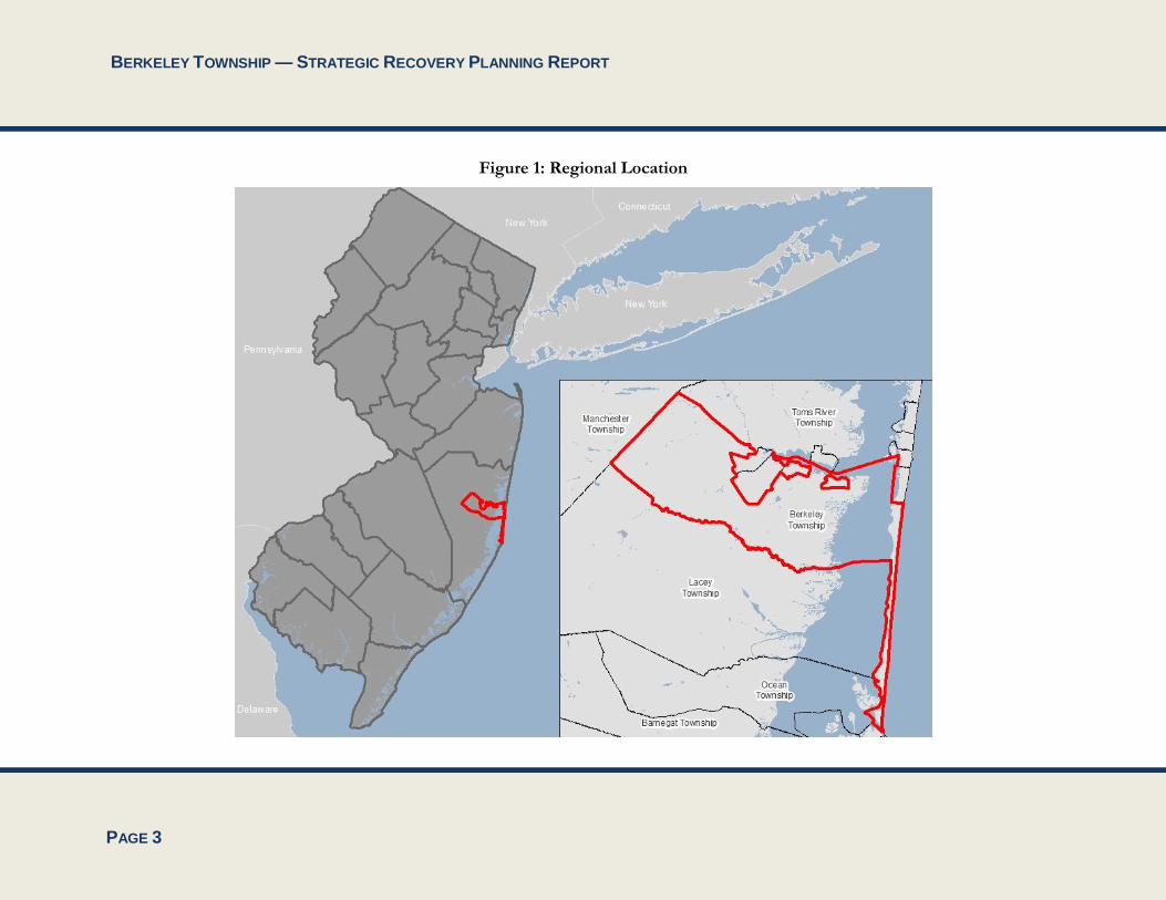
List of Figures Figure 1: Regional Location ................................................................................................................................................................................................. 3
Figure 2: Berkeley Town Center Redevelopment Area .................................................................................................................................................... 8
Figure 3: TDR Sending and Receiving Areas .................................................................................................................................................................... 9
Figure 4: Pinelands and CAFRA Boundaries in Berkeley Township ........................................................................................................................... 18
Figure 5: A Flooded Street in Berkeley Township .......................................................................................................................................................... 19
Figure 6: Storm Damage and Debris at a Berkeley Home............................................................................................................................................. 20
Figure 7: Storm Damage and Debris at a Berkeley Home (2) ....................................................................................................................................... 20
Figure 8: Storm Damage and Debris at a Bayville Home .............................................................................................................................................. 21
Figure 9: Storm Damage and Debris at a Bayville Home (2) ........................................................................................................................................ 21
Figure 10: A Storm-Damaged Home for Sale in Berkeley............................................................................................................................................. 22
Figure 11: Storm Damage at a Berkeley Waterfront Home .......................................................................................................................................... 22
Figure 12: Key Community Facilities and Flood Hazard Areas ................................................................................................................................... 23
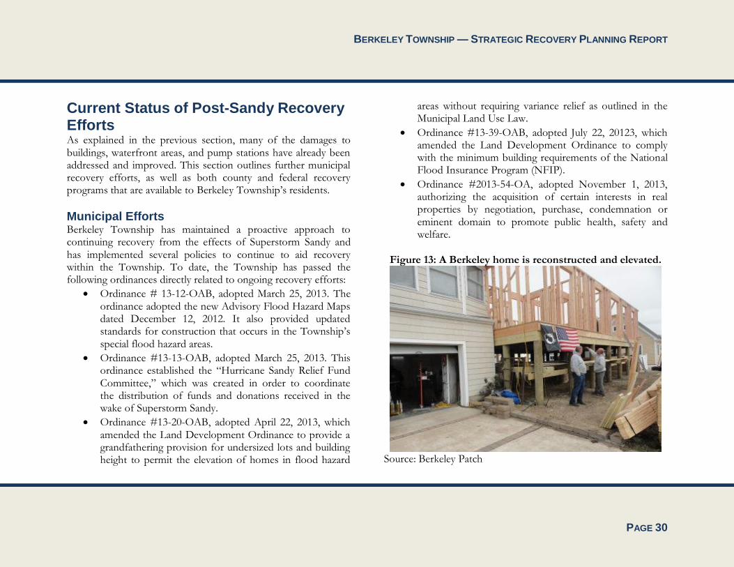
Figure 13: A Berkeley home is reconstructed and elevated. .......................................................................................................................................... 30

BERKELEY TOWNSHIP — STRATEGIC RECOVERY PLANNING REPORT
PAGE 1
Introduction This Strategic Recovery Planning Report (SRPR) will serve as the blueprint to guide Berkeley Township’s recovery from the effects of Superstorm Sandy and to reduce vulnerabilities to future storms. Accordingly, the report:
Evaluates the impacts on affected community features in Berkeley and addresses the conditions created or exacerbated by the storm;
Articulates the planning goals, strategies, and priority actions that are most urgently needed to improve public safety, increase resistance to damage from future storms, and stimulate economic recovery; and
Contains detailed descriptions of each of the projects proposed; a statement of need that demonstrates how each project relates to the impacts of Superstorm Sandy; why the project is important to the economic and environmental health of the community; the major tasks associated with each project; the estimated cost of implementation; identification of potential or actual funding sources to pay for project implementation; and estimated implementation dates.

BERKELEY TOWNSHIP — STRATEGIC RECOVERY PLANNING REPORT
PAGE 2
Description of Berkeley Township Berkeley Township is a suburban community located in central Ocean County along Barnegat Bay. According to the US Census Bureau’s American Community Survey five-year estimates, the Township had a population of 41,376 residents in 2012. The Township is bordered by Toms River Township, Ocean Gate Borough, Pine Beach Borough, Beachwood Borough and South Toms River Borough to the north, Manchester Township to the west, and Lacey Township to the south (see Figure 1). A portion of the Township is located on a barrier island that is separated from the mainland by Barnegat Bay. This section of the Township is bordered by the Borough of Seaside Park to the north and Island Beach State Park to the south. The Township has frontage on the Barnegat Bay, Toms River, and the Atlantic Ocean and has approximately 35 miles of shoreline comprised of roughly 10 miles of oceanfront, 18 miles of bay frontage, and 7 miles of creek, stream, and river frontage.
The Township is bisected by the Garden State Parkway, which runs north to south through the Township. A segment of US Route 9, which comprises the Township’s primary business, retail, and commercial corridor, also traverses the Township from north to south. Figure 2 depicts
The Township has approximately 40 square miles of land cover. Major portions of the Township are within the jurisdiction of the Coastal Management Area (CAFRA) and the Pinelands Commission. There are a number of large State and County parks
in the Township, including Island Beach State Park. Approximately 17% of the Township (4,196 acres) remains vacant.
Berkeley Township can be viewed as three distinct areas – The Pinelands and senior communities located west of the Garden State Parkway; the “eastern mainland,” which stretches from the Parkway to the shores of Barnegat Bay; and the barrier island. The future of the Township west of the Parkway is established for the foreseeable future by the Pinelands Comprehensive Management Plan and existing adult/senior communities of Holiday City and Silver Ridge. The future of the barrier island is likewise established by the presence of the South Seaside Park section of Berkeley and Island Beach State Park.
Much of the future development potential of the Township lies between the Parkway and the bay, containing the bulk of the vacant developable land in the Township. This area is the primary focus of future development and redevelopment proposals. In addition, the eastern mainland consists of neighborhoods with long-established development patterns and available infrastructure including Bayville, Berkeley Shores, Holly Lake Park, and Pinewald. Large tracts of wetlands and open space that are interspersed with existing residential developments run along the bayfront. The Township’s stated intention is to be proactive about the future of the eastern mainland and to reverse undesirable land use trends through the identification of a preferred future for the year 2020, and the adoption of policies that promote that vision.
BERKELEY TOWNSHIP — STRATEGIC RECOVERY PLANNING REPORT
PAGE 3
Figure 1: Regional Location
BERKELEY TOWNSHIP — STRATEGIC RECOVERY PLANNING REPORT
PAGE 4
Assessment of Existing Planning Documents
Berkeley Township
Comprehensive Master Plan, 1997 Berkeley Township’s Comprehensive Master Plan was adopted by the Berkeley Township Planning Board on December 4, 1997. The Plan assesses existing land uses within the Township, the future development potential in the context of zoning and environmental constraints and existing infrastructure capacity.
The Comprehensive Master Plan recognizes the distinct ecology and sensitivity of the Pinelands and areas under the jurisdiction of the Coastal Area Facility Review Act (CAFRA). The Plan also identifies areas east of the Garden State Parkway as most likely to be developed despite CAFRA regulations.
Master Plan Reexamination Report, 2003 This Reexamination Report incorporated the 2001 Pinelands Area Master Plan Amendment into the master plan. This amendment addressed the area of the Township generally located west of the Garden State Parkway, and brought Berkeley’s Master Plan into compliance with the New Jersey Pineland Comprehensive Management Plan.
This Reexamination Report also incorporated the Township’s 2020 Vision Statement into the master plan, which addressed the
area of the Township generally located to the east of the Parkway to Barnegat Bay (the non-Pinelands portion of the Township’s mainland).
Master Plan Reexamination Report, 2008 The objectives and problems relating to land development that were outlined in the 2003 Reexamination Report were still found valid and current in the 2008 Reexamination Report. This Report outlined changes in Berkeley’s demographics as well as relevant State policies that impacted land use in the Township.
The 2008 Reexamination Report recommended the preparation and completion of the Berkeley Town Center Plan, the Transfer of Development Rights (TDR) program, a redevelopment plan for the Manitou Park rehabilitation area, and new master plan land use and circulation elements that support and complement each other. Updates to Berkeley’s zoning ordinance were also recommended.
2020 Vision Statement and Municipal Profile, 2002 The 2020 Vision Statement is a guide for the Township’s long-term policy and planning initiatives. The vision statement departs from Berkeley’s traditional growth trend by establishing four primary targets for future development (Town Center and three commercial nodes) while preserving a substantial portion of the Township as open land. By contrast, the trend scenario would continue to disperse growth throughout the eastern mainland while consuming most of the remaining open lands. Implementation of the Vision Statement would:

BERKELEY TOWNSHIP — STRATEGIC RECOVERY PLANNING REPORT
PAGE 5
Retrofit existing strip-type development along the Route 9 corridor into concentrated, mixed-use alternatives;
Promote in-fill development and efficient use of existing infrastructure;
Promote a well-designed town center as the focus of the Township’s growth;
Preserve environmentally sensitive coastal and undeveloped forest resources;
Maximize circulation and mobility options; and
Maximize housing opportunities.
Municipal Stormwater Management Plan, 2005 Berkeley’s Municipal Stormwater Management Plan (MSWMP) outlines specific stormwater design and performance standards for new development. Additionally, the plan proposes stormwater management controls to address impacts from existing development. Preventative and corrective maintenance strategies are included in the plan to ensure long-term effectiveness of stormwater management facilities. The plan also outlines safety standards for stormwater infrastructure to be implemented to protect public safety. All future development in Berkeley Township must utilize the best available technology to minimize off-site stormwater runoff, increase on-site infiltration, simulate natural drainage systems, and minimize off-site discharge of pollutants to ground or surface water and encourage natural filtration functions.
Housing Element and Fair Share Plan, 2008 The Housing Plan Element includes the following components:
An inventory of Berkeley’s demographic, housing stock, and employment characteristics;
Berkeley’s affordable housing obligation and growth share; and
Berkeley’s municipal ability to accommodate its affordable housing obligation.
The Fair Share Plan includes the following components:
Identification of Berkeley’s participating status in the Ocean County Community Development Block Grant Housing Rehabilitation Program;
Identification of Berkeley’s prior-round obligation; and
A narrative of housing projects used to satisfy Berkeley’s growth share obligation.
Land Use and Circulation Master Plan, 2009 The Land Use Element provides a comprehensive and coordinated approach to achieving the Township’s goals and objectives by clearly identifying the preferred location and intensity of future land uses. It serves as a sound basis for the Township’s policy, regulatory, and investment decisions, and as an alternative to an incremental, site-by-site decision making process. The Land Use Element outlines the following major initiatives:
Establishment of two Town Centers and three corridor nodes at strategic locations along the Route 9 corridor

BERKELEY TOWNSHIP — STRATEGIC RECOVERY PLANNING REPORT
PAGE 6
The creation of five new land use districts for South Seaside Park in an attempt to consolidate zones and provide context sensitive residential and commercial standards for the unique island neighborhood.
Restructuring of the land use districts along the Route 9 corridor to better reflect the Township’s desire for more concentrated and better designed development in the corridor.
Transfer of Development Rights through the State of New Jersey’s program.
The Circulation Element complements the land use element and makes recommendations based on the Township’s ability to move goods and people in an efficient manner given existing and future development patterns outlined in the land use element.
One goal outlined in the Land Use and Circulation Master Plan that is relevant to this SRPR is to preserve the Township’s natural resources to protect water quality, manage stormwater, reduce the potential of flood damage, protect endangered habitats, and provide open space.
Amended Land Development Ordinance, 2011 Berkeley’s Amended Land Development Ordinance is a result of recommendations from the 2008 Master Plan Land Use and Circulation Elements. Updates to the Land Development Ordinance involve the following areas:
Bayfront Commercial Zone
Highway Business Zone on the Route 9 corridor
Town Center 2 Overlay District
Corridor Node Overlay
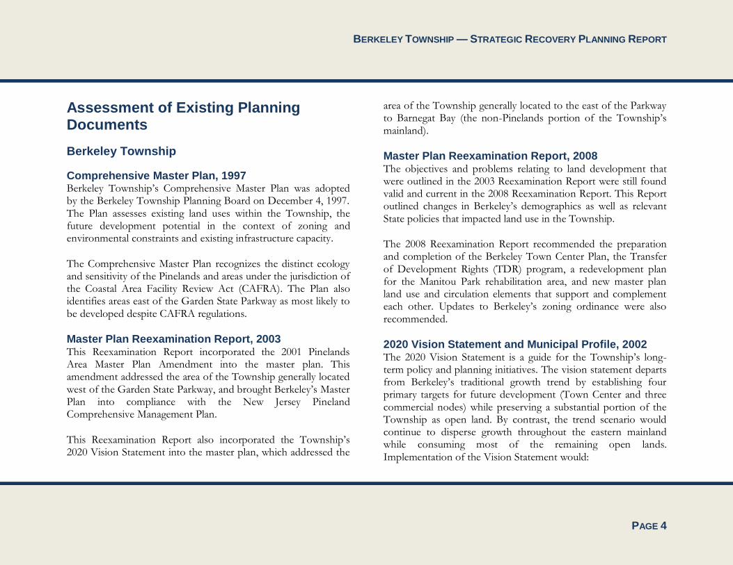
Town Center Redevelopment Plan, 2009 The goal of the Town Center Redevelopment Plan is to promote the development of a compact, pedestrian-oriented Town Center with the potential for 24-hour activity, consisting of high-intensity retail and employment facilities, vibrant and dynamic mixed-use areas, open space and recreation facilities, and residential living environments that provide a broad range of housing types for an array of housing needs. The Town Center redevelopment area is shown in Figure 2.
The Town Center Redevelopment plan also seeks to achieve the following objectives:
Promote a diverse mix of residential, business, commercial, office, institutional, educational, recreational, and cultural and entertainment activities for workers, visitors, and residents;
Encourage pedestrian-oriented development at densities and intensities that will help promote transit usage, interconnected uses, and businesses;
Promote the health and well-being of residents by encouraging physical activity, alternative transportation options, and greater social interaction;
Create a center that represents a unique, attractive, and memorable destination for visitors and residents;

BERKELEY TOWNSHIP — STRATEGIC RECOVERY PLANNING REPORT
PAGE 7
Encourage lively, human-scaled activity areas and gathering places through the promotion of high-quality urban design;
Ensure that all buildings are consistent with and enhanced by high-quality streetscape amenities; and
Accommodate off-street parking in a convenient manner that does not interfere with the rhythm of the street network and building facades.
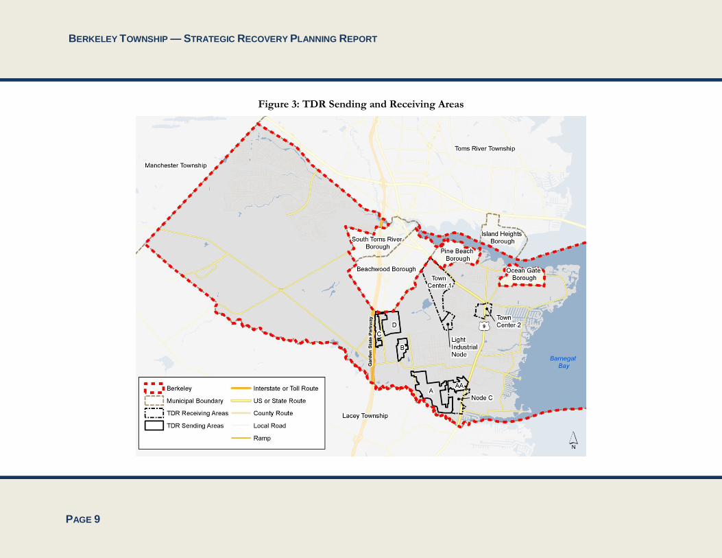
Transfer of Development Rights (TDR) Plan Element, 2012 Berkeley’s Transfer of Development Rights (TDR) Plan Element serves as the basis for the Township’s program and ordinance in accordance with Article 18 of the Municipal Land Use Law, “State Transfer of Development Rights.” The Township of Berkeley turned to the TDR mechanism (enacted in 2004) as a way of shifting development away from the remaining forested areas of the Pinewald section of town west of Route 9 to the underutilized properties along the Route 9 corridor.
The purpose of the TDR program is to provide an incentive-based process for permanently preserving environmentally sensitive and open space lands that provide a public benefit in their natural state. These areas are referred to as sending zones. The TDR provisions are intended to preserve land by transferring the development rights associated with a parcel of land in a sending zone to a pre-determined receiving zone. The Receiving Areas are delineated based on their ability to support additional
growth and density due to the availability of infrastructure and the absence of significant environmental constraints. The Receiving Areas are also reflective of the Township’s vision for guiding growth to well-planned and compact centers and nodes.
Berkeley’s intention, through the TDR program along with other mechanisms, is to preserve more than 840 acres of undeveloped residentially zoned land in the five sending areas and 837 acres of industrially zoned land that currently lacks the necessary sewer, water, and roadway infrastructure needed to accommodate future growth. The sending and receiving areas outlined in the TDR Plan Element are shown in Figure 3.
BERKELEY TOWNSHIP — STRATEGIC RECOVERY PLANNING REPORT
PAGE 8
Figure 2: Berkeley Town Center Redevelopment Area
BERKELEY TOWNSHIP — STRATEGIC RECOVERY PLANNING REPORT
PAGE 9
Figure 3: TDR Sending and Receiving Areas

BERKELEY TOWNSHIP — STRATEGIC RECOVERY PLANNING REPORT
PAGE 10
Plan Endorsement The New Jersey State Planning Commission granted the Township Plan Endorsement on July 6, 2012, and formally recognized the Berkeley Town Center as a designated Center, the Berkeley “Town Center-2” as a designated Core, and established two (2) Nodes – the “Light Industrial” Node located at the western end of Hickory Lane and the “Corridor Node C” located along the Route 9 corridor near the Townships border with Lacey Township. The Township’s completion of the Plan Endorsement process points to its commitment to concentrate growth within centers, to preserve environmentally sensitive lands and undisturbed areas, and to utilize available infrastructure to sustain future growth, all of which are consistent with the Township’s vision and the State Development and Redevelopment Plan (SDRP). The New Jersey Department of Environmental Protection also accepted a CAFRA notice which accepted the Town Center area.
Environmental Resources Inventory, 2012 The Berkeley Environmental Resources Inventory is a compilation of all of the environmental features and characteristics of the Township. It incorporates data on Berkeley Township including land use and land cover, contaminated sites, physical resources, water resources, biological resources, agricultural resources, historic and cultural resources, and open space and public land.
Ocean County
Ocean County Comprehensive Master Plan, 2011 The Ocean County Planning Board adopted the Comprehensive Master Plan on December 21, 2011. It is a policy statement about the future development of the County. The objectives of this plan are intended to address issues of regional concern and to provide a regional perspective on land use and other issues facing Ocean County. The plan seeks to provide some level of coordination between local planning and state plans and regulations, and it also describes various services and programs that the County provides to its citizens. The plan was created to provide a platform for planners to base their decisions regarding capital improvements, land use, and location and intensity of new development.
For all municipalities in the County, the Comprehensive Master Plan outlines population and demographics, transportation and mobility, housing, land use, agriculture, open space, water resources, wastewater management, solid and hazardous waste, air quality. The Plan makes a number of recommendations on these topics that are relevant to Berkeley Township’s recovery from the effects of Superstorm Sandy, and reducing vulnerabilities to future storms. These are outlined below:
Encourage the New Jersey Department of Transportation to modernize and upgrade state highways throughout Ocean County, including US Route 9, NJ Route 35, NJ

BERKELEY TOWNSHIP — STRATEGIC RECOVERY PLANNING REPORT
PAGE 11
Route 37, NJ Route 70, NJ Route 72, NJ Route 88, and NJ Route 166. o Modernizing and upgrading Ocean County’s
highways will improve mobility and facilitate the evacuation of Berkeley Township in times of crisis, including during future storms. This is particularly true for US Route 9, which provides a north-south connection through eastern Berkeley Township, and intersects with numerous state highways and other roadways that provide connections to the west.
Encourage the retention of established residential neighborhoods and the rehabilitation of the county’s older housing stock. Facilitate participation in home rehabilitation and historical preservation grant programs, where applicable.
o Home rehabilitation may help to improve the structural integrity of existing housing stock. This, in turn, provides extra security and protection during extreme weather events, such as hurricanes and storms.
Encourage low-impact design techniques to minimize the disturbance of natural areas and maximize the recharge of stormwater on-site.
o Maximizing the recharge of stormwater on-site may help to decrease the incidence of flooding.
Support the tourism amenities and needs of shore towns and continue to facilitate the protection and replenishment of county’s beaches and shoreline areas.
o Protection and replenishment of the county’s beaches and shorelines areas, including those along Barnegat Bay in the eastern part of Berkeley Township, will help the county to cope with future hurricanes and storms and mitigate their impacts.
Continue to support the Ocean County Agriculture Development Board (OCADB) in its mission to protect and enhance the county’s agricultural resources.
o Preservation of farmland helps to reduce vulnerabilities to storms by protecting and promoting agricultural land uses. Such land uses typically have a very low amount of impervious cover, and consequently support the infiltration of stormwater.
Maintain an ongoing evaluation of the recreational needs of Ocean County residents, and assist in identifying new park and open space areas, as necessary.
o Expansion of park and open space areas, particularly in the eastern part of Berkeley Township, will help to preserve and protect natural and other areas with low impervious surface cover. This supports the infiltration of stormwater. Additionally, it eliminates the potential that such areas will be converted to residential uses. This helps to restrict population development in areas that may be vulnerable to hurricanes and other storms. It also protects the local and regional economy by guiding non-

BERKELEY TOWNSHIP — STRATEGIC RECOVERY PLANNING REPORT
PAGE 12
residential development (such as commercial and industrial uses) away from areas that may be susceptible to disturbance and interruptions caused by extreme weather events.
Continue to work with all federal, state, local, and non-profit partners to acquire open space and maximize financial resources available for preservation. o As has been previously noted, expansion of open
space areas promotes resiliency to future hurricanes and storms.
Continue to assist the State of New Jersey in the implementation of the Governor’s Ten-Point Plan for Barnegat Bay.
o Key parts of the Governor’s Ten-Point Plan that will help to protect Berkeley Township and promote resiliency to extreme weather events include: funding stormwater mitigation projects and acquiring land in the watershed.
Encourage land use planning strategies such as low-impact design to preserve open space and maximize the natural infiltration of stormwater.
o Preservation of open space and maximization of stormwater infiltration helps to minimize flooding and promotes resiliency to future hurricanes and storms.
Explore and assess best management practices used by other areas in the country to address stormwater management.
o Effectively addressing stormwater management helps to minimize flooding and promotes resiliency to future hurricanes and storms.
Continue to assess structural and nonstructural options for stormwater management to increase infiltration, remove debris, and reduce nutrient and pollution loads
o Increasing infiltration will help to reduce flooding. Additionally, removing debris will help to increase the efficiency of existing stormwater management facilities.
Encourage compliance with new legislation that requires the New Jersey Department of Transportation to address stormwater management issues on state highways, including US Route 9, NJ Route 35, NJ Route 37, NJ Route 70, NJ Route 72, NJ Route 88, and NJ Route 166.
o Addressing stormwater management issues along highways will help to minimize their impacts and increase their safety. This is particularly important as highways generate stormwater runoff, and may serve as evacuation routes during emergencies.
Ocean County Multi-Jurisdictional All Hazard Mitigation Plan, 2013 The Ocean County Multi-Jurisdictional All-Hazard Mitigation Plan is being developed for the purpose of:
Providing a blueprint for saving lives and reducing property damage from the effects of future natural and man-made disasters in Ocean County;
BERKELEY TOWNSHIP — STRATEGIC RECOVERY PLANNING REPORT
PAGE 13
Qualifying the County for pre-disaster and post-disaster grant funding;
Complying with state and federal legislative requirements related to local hazard mitigation planning;
Demonstrating a firm local commitment to hazard mitigation principles; and
Improving community resiliency following a disaster event.
At the time of the preparation of this Strategic Recovery Planning Report, this Ocean County plan has not been formally adopted. The assessment of this plan has been completed for the draft plan, which was submitted by the county’s consultant on December 5, 2013. It is anticipated that Ocean County and each of its 33 municipalities will adopt the plan.
The Multi-Jurisdictional All Hazard Mitigation Plan was developed using a multi-jurisdictional approach to include all municipalities within Ocean County. All jurisdictions needed to and did participate in the multi-jurisdictional planning process in order to have their own plan be eligible for FEMA funding after a disaster. Representatives from Berkeley Township (including its clerk, director of community development, emergency management coordinator, and municipal engineer) were involved throughout the plan development process.
This Plan is comprehensive in scope and, in addition to examining the county’s geography and natural environment,
economic assets, population, land use, and built environment characteristics, includes a detailed risk assessment. Among the risks contemplated by the Multi-Jurisdictional All-Hazard Mitigation Plan are: natural hazards such as coastal erosion, drought, earthquakes, extreme temperature, flooding, storms (i.e., hurricanes, tropical storms, and nor’easters), tornadoes and windstorms, wildfires, and winter storms (i.e., heavy snowstorms and blizzards, and sleet and ice storms); human-made hazards such as hazardous materials, nuclear incidents, transportation accidents, urban fire and explosion, and utility interruption; and climate change hazards associated with sea level rise.
The Multi-Jurisdictional All-Hazard Mitigation Plan outlines a mitigation strategy that is centered on the following goals and objectives:
Encourage sustainable development to protect people, property, community resources, and the environment from natural and human-made disasters. o Meet and exceed minimum standards of the National
Flood Insurance Program. o Manage building code, land use code, ordinance, and
other planning mechanisms to prevent and mitigate the impact of disasters on people and property.
o Improve information available for mitigation planning.
o Coordinate and increase applications for federal and state grant programs.
o Integrate and leverage other planning mechanisms from neighboring jurisdictions, local, county, and
BERKELEY TOWNSHIP — STRATEGIC RECOVERY PLANNING REPORT
PAGE 14
regional organizations, and state partnerships in order to implement the plan.
o Improve shelter management.
Build and rebuild structures and infrastructure to protect people and to reduce impacts of future disasters. o Increase the number of residential properties
protected from hazards. o Increase the number of community resources and
amount of infrastructure protected from hazards. o Improve the ability of critical facilities and
infrastructure to safely operate during storms and utility interruptions.
o Improve evacuation capability.
Protect and restore the natural environment to support disaster resiliency. o Improve the health of natural systems to safely and
naturally accommodate flooding and wildfire. o Improve the health of natural systems used to protect
residential properties and other community resources. o Plan for increased open space in the most vulnerable
areas. o Promote appropriate urban-wild land interface for
wildfire mitigation.
Promote education, awareness, and outreach before, during, and after disasters. o Improve and expand information and opportunities
for input available by television, radio, websites, social media, newsletters, and meetings.
o Increase participation in mitigation programs, including the Community Rating System, StormReady, and FireWise programs.
o Tailor timely messages for audiences, including children, parents, community groups, universities, seniors, and other groups.
o Improve alert and warning systems.
As part of the planning process, each municipality in Ocean County identified its risks, and a mitigation strategy was developed to address those risks. The Hazard Mitigation Plan includes detailed action worksheets for each municipality, including assessing the risk, describing required actions, cost estimates, and implementation. The mitigation actions identified for Berkeley Township include:
Continue to participate in the NFIP
Continue to enforce building codes and ordinances
Elevation project for 434 residents in the Township who applied through a web application
Purchase and installation of 3 permanent generators at critical facilities (2 for shelters and 1 for the township police department)
Purchase and install 10 tide flex valves to prevent backflow flood water from the bay and river
Installation of bay-front energy dissipation structure; prevent coastal erosion and help to reduce undermining of bulkheads
Acquisition of 8 homes located in floodplain

BERKELEY TOWNSHIP — STRATEGIC RECOVERY PLANNING REPORT
PAGE 15
USACE replenishment project and dune restoration; USACE seeking permission to construct continuous dune system
Dredge the lagoons within the township; including Glen Cove and Berkeley Shores; remove debris and sand
Dune grass planting in the fall
Continue Fire Prevention Bureau outreach program to schools; hold contest for fire escape plans and have students draw out fire plans
Maintain Police Department Facebook page
Reverse 911 system
Increase CRS Program level
Participate in National Night Out
Have town hall meetings in Club Houses
Continue Police outreach programs in schools
Continue to maintain and update township website; allows for the township to share information with residents and for residents to provide feedback and comments
Further mitigation actions identified for the Berkeley Township Sewerage Authority include:
Emergency by-pass electrical controls for generator and pumps for two locations
On site emergency generator with automatic transfer switch and wiring
Purchase and installation of 2 permanent generators
The mitigation strategy and municipal actions that have been outlines in the Multi-Jurisdictional All-Hazard Mitigation Plan are generally supportive of and promote Berkeley Township’s recovery from the effects of Superstorm Sandy, and the reduction of vulnerabilities to future storms.
Comprehensive Farmland Management Plan, 2008 The overall goal of the Comprehensive Farmland Management Plan is to support the promotion and retention of Ocean County’s agricultural industry through farmland preservation. This is primarily done through a variety of techniques, including purchasing of development easements, donation of development easements, fee-simple acquisition of farmland, and other techniques.
According to this Plan, Berkeley Township has 16 acres of farmland-assessed property. No portion of Berkeley is located within an Agricultural Development Area, which are identified as areas where agricultural uses are preferred. This Plan specifies that the county’s future farmland preservation efforts will focus on its designated Agricultural Development Areas. It follows that Berkeley Township will not be a focus of the future farmland preservation program that is envisioned by the Comprehensive Farmland Management Plan.
It is important to note that the retention and expansion of agriculture in Berkeley Township (as well as in Ocean County as a whole) is generally supportive of reducing vulnerabilities to
BERKELEY TOWNSHIP — STRATEGIC RECOVERY PLANNING REPORT
PAGE 16
storms, as agricultural lands typically have a very low amount of impervious cover and support stormwater infiltration.
Regional Plans Berkeley Township lies in a region of the State that contains 2 regulated areas that require special consideration when development is suggested. Both the Coastal Area Facilities Review Act (CAFRA) zone and the Pinelands National Reserve have a significant effect on development and land use in the Township. These specialty regulation areas are designed to limit the negative effects that development has on environmentally sensitive habitats.
Pinelands Comprehensive Management Plan The Pinelands Comprehensive Management Plan (CMP) is intended to serve two functions: as a general guide for local authorities in preparing master plans and land use ordinances for certification by the Pinelands Commission, and as a planning and regulatory mechanism that can be adopted and enforced by the Commission if a county or municipality fails to secure certification.
The regulations and standards contained in this plan are designed to promote orderly development of the Pinelands so as to preserve and protect the significant and unique natural, ecological, agricultural, archaeological, historical, scenic, cultural, and recreational resources of the Pinelands.
According to the CMP, municipalities that have land within the Pinelands Area must bring their master plan and land use ordinances into conformance with the minimum standards set forth in the CMP. Berkeley was certified by the Pinelands Commission based on the Township’s adoption of the Pinelands Area Master Plan and Pinelands Area Land Development Ordinance in 2001.
Under the guidance of the Pinelands Comprehensive Management Plan, the Pinelands National Reserve is carefully regulated to support and preserve the health of the ecosystem, while permitting compatible development. The Pinelands Commission has applied many smart growth and planning concepts such as watershed management, Transfer of Development Rights (TDR) including the Pinelands Development Credit Program (PDC), and timed growth and conservation planning.
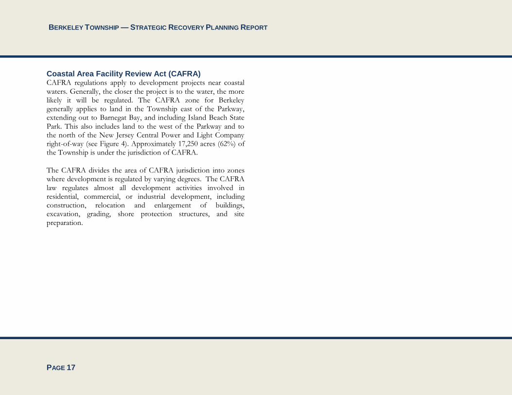
Approximately 10,455 acres (38%) of the Township falls under the jurisdiction of the Pinelands Commission. This includes land to the west of the Garden State Parkway and south of the New Jersey Central Power and Light Company right-of-way (see Figure 4). Most of the National Reserve that is not under the jurisdiction of the Pinelands Commission falls within the CAFRA regulatory jurisdiction where NJDEP is charged with implementing the Pinelands CMP.
BERKELEY TOWNSHIP — STRATEGIC RECOVERY PLANNING REPORT
PAGE 17
Coastal Area Facility Review Act (CAFRA) CAFRA regulations apply to development projects near coastal waters. Generally, the closer the project is to the water, the more likely it will be regulated. The CAFRA zone for Berkeley generally applies to land in the Township east of the Parkway, extending out to Barnegat Bay, and including Island Beach State Park. This also includes land to the west of the Parkway and to the north of the New Jersey Central Power and Light Company right-of-way (see Figure 4). Approximately 17,250 acres (62%) of the Township is under the jurisdiction of CAFRA.
The CAFRA divides the area of CAFRA jurisdiction into zones where development is regulated by varying degrees. The CAFRA law regulates almost all development activities involved in residential, commercial, or industrial development, including construction, relocation and enlargement of buildings, excavation, grading, shore protection structures, and site preparation.
BERKELEY TOWNSHIP — STRATEGIC RECOVERY PLANNING REPORT
PAGE 18
Figure 4: Pinelands and CAFRA Boundaries in Berkeley Township

BERKELEY TOWNSHIP — STRATEGIC RECOVERY PLANNING REPORT
PAGE 19
Evaluation of Superstorm Sandy’s Impacts on Berkeley Township The following sections detail the damage to property within the Township resulting from storm surge, wind, and flooding.
Power Outages According to statistics provided by First Energy Corporation, Superstorm Sandy resulted in a total of 32,072 reported power outages in the Township. However, it should be noted that the power outage count includes multiple power outage reports for single units, which suggests that the reported number of outages is higher than the actual number of households that experienced a power loss.
Storm Surge Berkeley Township sustained significant damage to private and public property, community infrastructure, and community facilities as a result of storm surge. The barrier island section of town (including South Seaside Park and Island Beach State Park) experienced significant impacts and damages to the dune system, and there were several areas of breach into Barnegat Bay. In the mainland areas of the Township along Barnegat Bay, this resulted in flooding, beach and soil erosion, loss of shore stabilization infrastructure (bulkhead and rip-rap), and damage to waterfront community facilities, recreational amenities, and private properties.
Figure 5: A Flooded Street in Berkeley Township
Source: Berkeley Patch
Damage to Properties The State of New Jersey has analyzed the storm damage to heavily impacted communities, as determined by HUD, and has released the CDBG Disaster Recovery Action Plan. The data has been generated using the 2011 American Community Survey 5-Year Survey Data and FEMA Individual Assistance Data (effective March 12, 2013).
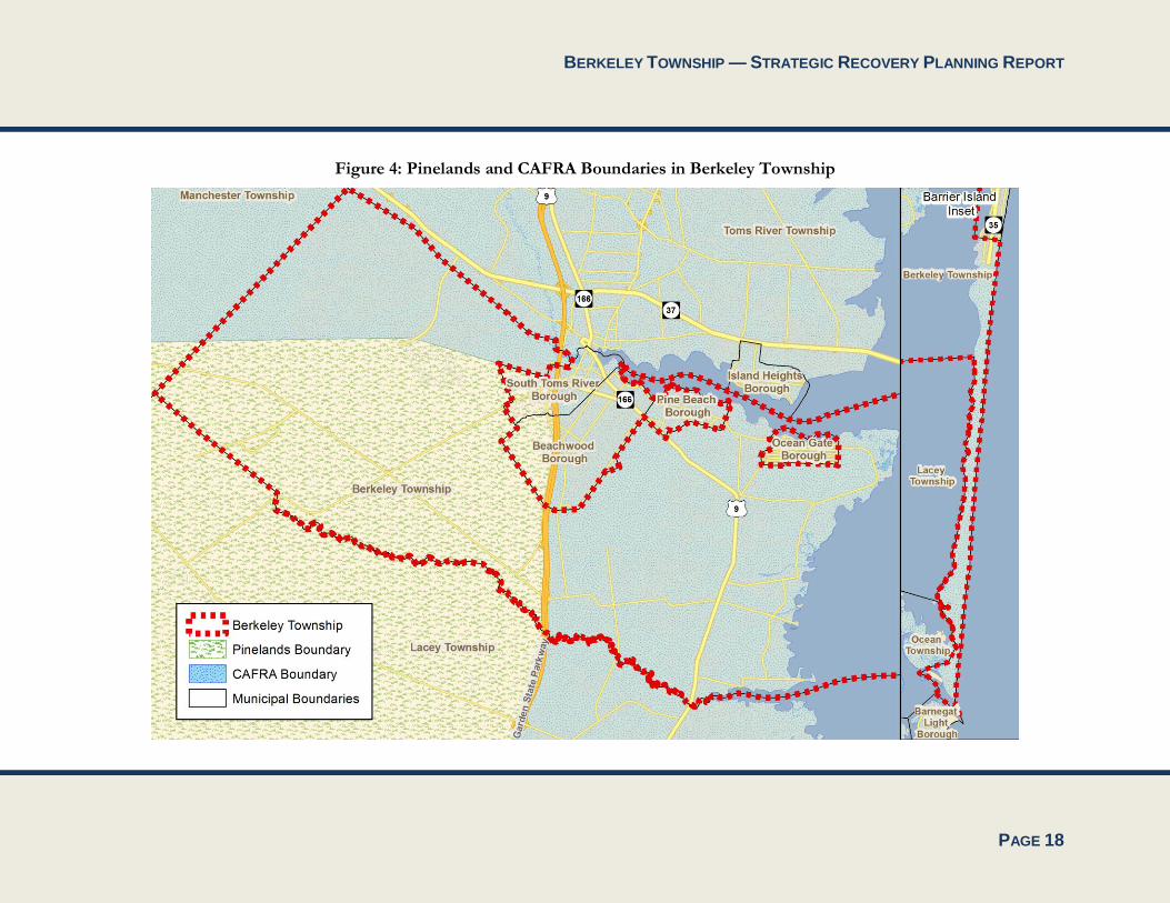
As a result of Superstorm Sandy, three census tracts in Berkeley Township had homes that sustained “severe” or “major” damage to housing units, shown below. This table does not include minor damage sustained, which was common.
BERKELEY TOWNSHIP — STRATEGIC RECOVERY PLANNING REPORT
PAGE 20
Table 1: Census Tracts with “Severe” or “Major” Damage
Census Tract 34029731002
34029731001
34029731101
% of Households with Major/Severe Damage
32% 28% 6%
# of Households 1,448 1,388 1,237
# of Housing Units 1,810 1,876 1,311
Median Household Income
$68,550 $78,472 $65,702
Source: NJ Department of Community Affairs, US Census American Community Survey, 2006-2011 Averages, and FEMA Individual Assistance Records as of March 12, 2013.
More specifically, 252 properties within the Township were “substantially damaged” by Superstorm Sandy.
The Beachwood Plaza shopping center also sustained fire-related damage caused by an electrical fire during the storm.
Figure 6: Storm Damage and Debris at a Berkeley Home
Source: Berkeley Patch Figure 7: Storm Damage and Debris at a Berkeley Home (2)
Source: Berkeley Patch

BERKELEY TOWNSHIP — STRATEGIC RECOVERY PLANNING REPORT
PAGE 21
Figure 8: Storm Damage and Debris at a Bayville Home
Source: Berkeley Patch
Figure 9: Storm Damage and Debris at a Bayville Home (2)
Source: Berkeley Patch
BERKELEY TOWNSHIP — STRATEGIC RECOVERY PLANNING REPORT
PAGE 22
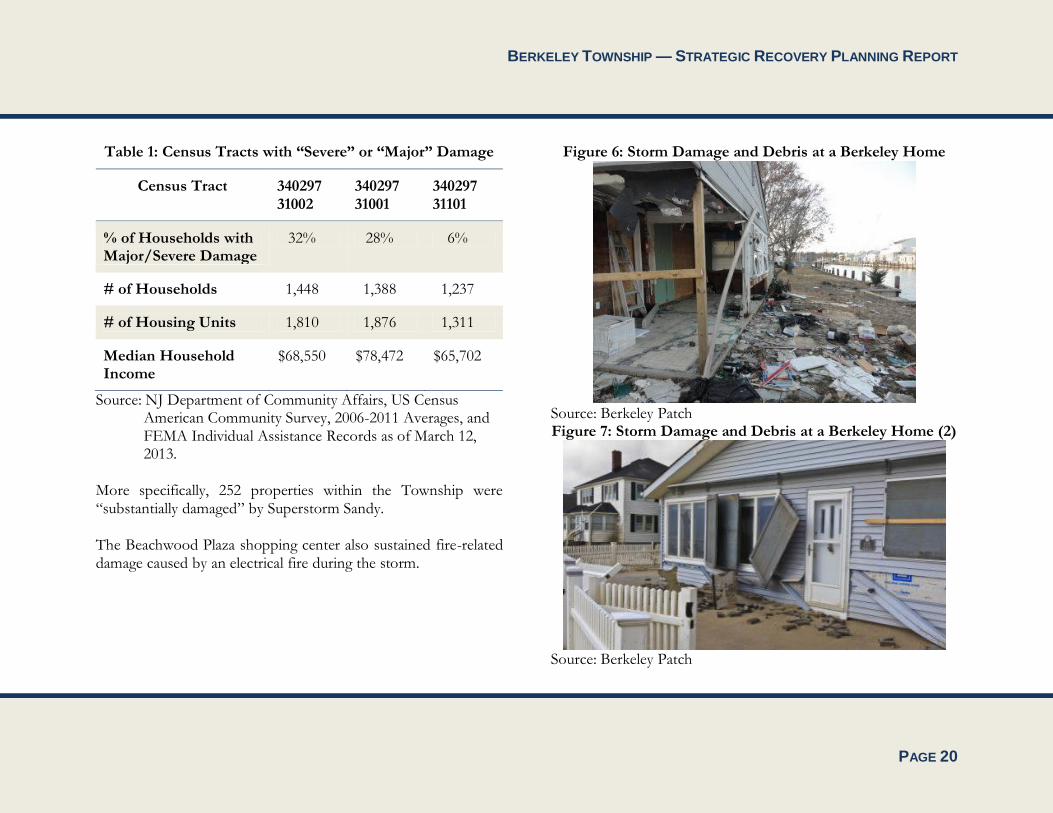
Figure 10: A Storm-Damaged Home for Sale in Berkeley
Source: Berkeley Patch
Figure 11: Storm Damage at a Berkeley Waterfront Home
Source: Berkeley Patch
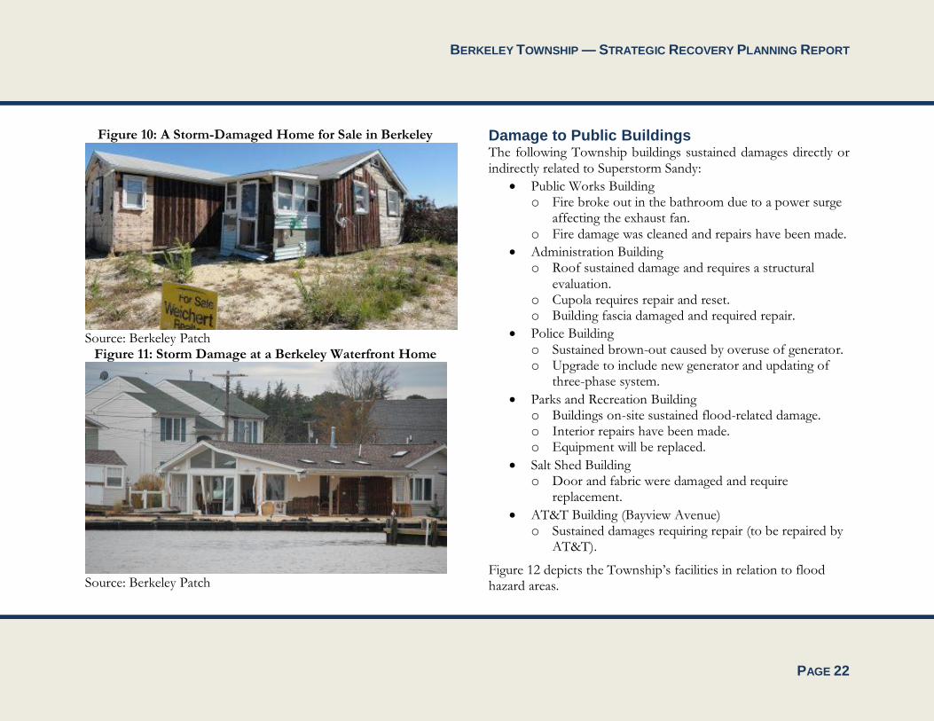
Damage to Public Buildings The following Township buildings sustained damages directly or indirectly related to Superstorm Sandy:
Public Works Building o Fire broke out in the bathroom due to a power surge
affecting the exhaust fan. o Fire damage was cleaned and repairs have been made.
Administration Building o Roof sustained damage and requires a structural
evaluation. o Cupola requires repair and reset. o Building fascia damaged and required repair.
Police Building o Sustained brown-out caused by overuse of generator. o Upgrade to include new generator and updating of
three-phase system.
Parks and Recreation Building o Buildings on-site sustained flood-related damage. o Interior repairs have been made. o Equipment will be replaced.
Salt Shed Building o Door and fabric were damaged and require
replacement.
AT&T Building (Bayview Avenue) o Sustained damages requiring repair (to be repaired by
AT&T).
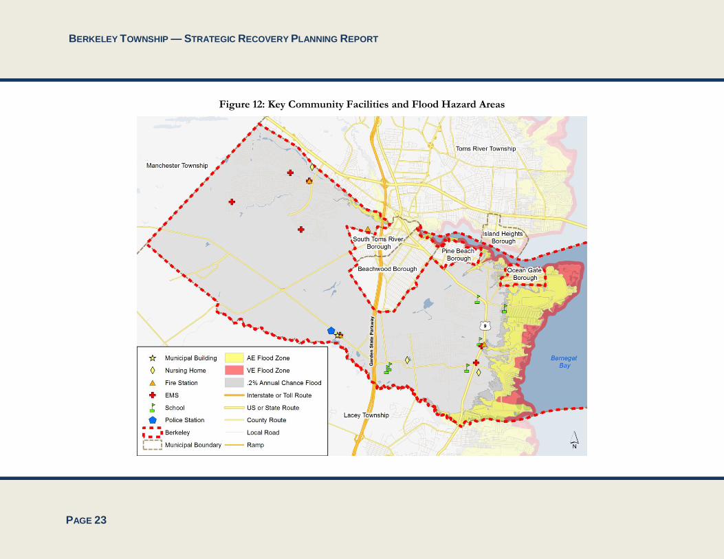
Figure 12 depicts the Township’s facilities in relation to flood hazard areas.
BERKELEY TOWNSHIP — STRATEGIC RECOVERY PLANNING REPORT
PAGE 23
Figure 12: Key Community Facilities and Flood Hazard Areas

BERKELEY TOWNSHIP — STRATEGIC RECOVERY PLANNING REPORT
PAGE 24
Damage to Waterfront Areas Berkeley sustained significant damage along the Barnegat Bay and Atlantic Ocean waterfronts at the hands of Superstorm Sandy. The following subsections detail the extent of damage and current condition of waterfront facilities throughout Township.
Glen Cove The Glen Cove neighborhood is comprised of a series of streets and lagoons located along Barnegat Bay. As such, the neighborhood sustained significant damage to shore stabilization infrastructure. This includes the following:
Sandlewood Drive: The rip-rap and shore stabilization measures at the terminus of Sandlewood Drive sustained significant loss. The Township is currently soliciting bids to replace what remains of the existing rip-rap with a bulkhead along the bayfront.
Cedar Drive: The bulkhead along Cedar Drive sustained damage and required repair to limit soil erosion. Bulkhead repair along Cedar Drive has been completed and the bulkhead’s function has been restored.
Butler Boulevard/Butler’s Beach: Butler’s Beach is a recreation area located along Barnegat Bay at the terminus of Butler Boulevard. This community facility sustained significant damage to existing jetties, playground equipment, and electrical infrastructure. The area sustained significant erosion and degradation of existing rip-rap. The area requires groin and jetty repair,
replacement of playground equipment, beach replenishment, rip-rap replacement to the north jetty, rip-rap replacement behind the existing guardrail and the replacement of a solar navigation light.
Longview Drive: The bulkhead along Longview Drive sustained damage and required repair to limit soil erosion. Bulkhead repair along Longview Drive has been completed and the bulkhead’s function has been restored.
Bay Boulevard: The bayfront at the terminus of Bay Boulevard sustained loss of rip-rap and damage to an existing outfall. The existing rip-rap requires stabilization and the outfall requires replacement.
Bowsprit Road Bowsprit Road sustained damage to existing pavement and existing bulkhead. The Township solicited bids to conduct a comprehensive bulkhead inspection and to remove and replace damaged and undermined pavement on the roadway. The project was awarded and construction is anticipated to commence in spring of 2014.
Amherst Beach Amherst Beach sustained significant beach erosion, changes in water depth along an inlet and damage to existing amenities located within a recreation area. Amherst Beach requires beach replenishment, the replacement of destroyed or missing fencing, garbage and recycling receptacles, and groin and inlet dredging, and the Township has solicited bids for a project that includes
BERKELEY TOWNSHIP — STRATEGIC RECOVERY PLANNING REPORT
PAGE 25
the installation of new bulkhead and rip-rap and beach replenishment.
Allen Road (Pebble Beach) Allen Road (Pebble Beach) was affected by beach erosion, loss of shore stabilization measures, loss of “living shoreline” measures and damage to on-site lighting and the existing parking area. The area requires rip-rap stabilization, beach replenishment, the restoration of living shoreline, the replacement of destroyed foot lighting on the existing walkway and the resurfacing of the existing parking area.
Sea Bright Avenue Sea Bright Avenue sustained beach erosion, loss of plantings and damage to an existing outfall pipe. The roadway and features in the vicinity of the roadway requires beach replenishment, restoration of vegetation and pipe repair.
Pelican Island Pelican Island is a small island located in Barnegat Bay that is accessible via the Route 37 Causeway that provides access to the Barrier Island and Lavallette, Seaside Heights, Seaside Park, South Seaside Park and Island Beach State Park. Pelican Island sustained bulkhead damage along Catalina Drive and Prince Edward Drive. The Township has completed bulkhead repair along Prince Edward Drive and has awarded a contract to complete bulkhead replacement along Catalina Drive in spring of 2014.
Mill Creek Boat Ramp The Mill Creek Boat ramp was destroyed and requires reconstruction.
South Seaside Park Beaches South Seaside Park is a section of the Township located on the Barrier Island between Seaside Park and Island Beach State Park. This section of the Township is bordered by the bayfront to the west and the Atlantic Ocean to the east. This part of the Township sustained significant beach erosion, damage to beach access facilities, beach personnel facilities and dune fencing. The following projects were implemented in order to restore this area:
Beach replenishment at the breach between 21st and 22nd Avenues;
Repair or replacement of damaged/destroyed wooden beach entrance ramps at:
o 20th Avenue (complete rebuild; area of emergency vehicle and equipment access)
o 21st Avenue (complete rebuild) o 22nd Avenue (ramp lifted, repaired, and reset) o 23rd Avenue (ramp cleared of sand, 12 linear foot
of ramp to beach reconstructed)
Repair of lifeguard headquarters at 23rd Avenue o Vinyl floor, tile and plywood replacement o Equipment to be replaced (speak systems in
lifeguard station and on beach)
Snow fence replacement along dunes
BERKELEY TOWNSHIP — STRATEGIC RECOVERY PLANNING REPORT
PAGE 26
The bay beach on the Barrier Island also sustained damages, including a damaged snow fence, bulk head damage, and loss of rip-rap and living shoreline features. To date, the Township has completed the replacement of damaged bulkhead. It is anticipated that the replacement of living shoreline features and the installation of rip-rap will be completed in spring of 2014.
Damage to Parks Given the Township’s unique location and multiple waterfronts, many of its parks are located along Barnegat Bay and incorporate recreational amenities that capitalize on access to the bay. As such, many parks sustained damage during Superstorm Sandy. Damages and needed repairs for Township parks are as follows:
Glen Cove/Butler Boulevard/Butler’s Beach o Replace playground equipment o Replace fencing
Dudley Park o Evaluate bathroom building for structural damage o Replace roof on bathroom and pavilion o Conduct sand replenishment
Whispering Pines o Replace men’s and ladies’ room doors o Replace well-pump start relay o Install in-line surge protector
Veteran’s Park o Replace roofs of upper bath and pavilion o Repair or replace water building fascia and soffit
Forest Hills Soccer
o Replace light fixtures
Eastern Soccer o Readjust light fixtures
Cedar Creek Golf Course o Replace netting and fencing
Damage to Sanitary Sewer Pump Stations The Berkeley Township Sewerage Authority (BTSA) maintains fourteen (14) sanitary sewer pump stations, seven (7) of which sustained some level of damage from the storm. BTSA’s main office also sustained damage due to the storm. The location and extent of damages are as follows:
Rivera Beach Pump Station was completely inundated by floodwaters and required a total rebuild and replacement of all of the electrical equipment in the dry well pump chamber. The damage sustained at this pump station rendered the pump station inoperable and required the use of submersible pumps for approximately two weeks to bypass the pump station. The adjacent generator building also sustained significant roof and ceiling damage. The pump station dry well was raised by eighteen inches (18”) upon the rebuild.
Goodluck Point Pump Station was completely inundated by floodwaters and required a total rebuild and replacement of all of the electrical equipment within the dry well pump chamber. It was also bypassed for approximately two weeks through the use of submersible pumps. The generator building also sustained roof and ceiling damage.

BERKELEY TOWNSHIP — STRATEGIC RECOVERY PLANNING REPORT
PAGE 27
The property where the station is located required stone replacement and yard repair to remedy damages associated with the storm surge. The dry well was raised by eighteen inches (18”) upon reconstruction.
The East Holly Park generator building was flooded and the emergency generator was damaged and required replacement. The electric and compressor components in the pump pit were damaged, which required the BTSA to bypass pumping at this station for approximately one week. The generator building also required roof and soffit repairs to remedy Sandy-related damage.
The Bayview Avenue Pump Station required extensive repair, including electrical infrastructure, generator and ceiling repair within the generator building. No equipment replacement was required at this pump station.
The Belaire Park Pump Station sustained extensive damage from fallen trees and required extensive electrical infrastructure and generator repair.
The Foxmor Pump Station sustained electrical damage to its alarm system.
The Silver Ridge East Pump Station sustained roof damage to the building housing the pump station generator.
The Authority’s main office, located at 255 Atlantic City Boulevard, sustained a damaged roof, ceiling, shutters and fences.
The BTSA also experienced power loss at all of its fourteen (14) pump stations and its main office, as outlined in Table 2.
Table 2: Duration of BTSA Power Loss
Facility Length of Power Loss
Beachwood Pump Station 142.6 hours
Belaire Park Pump Station 101.3 hours
Holiday City Pump Station 128 hours
Silver Ridge Pump Station 1.2 hours
Sonata Bay Pump Station 142.6 hours
Goodluck Point Pump Station 304.7 hours
Rivera Beach Pump Station 334.4 hours
Silver Ridge East Pump Station 90.1 hours
Bayview Avenue Pump Station 245 hours
Holly Park Pump Station 254.8 hours
Sloop Creek Pump Station 244.3 hours
Foxmor Pump Station 54.7 hours
Western Boulevard Pump Station 35.7 hours

BERKELEY TOWNSHIP — STRATEGIC RECOVERY PLANNING REPORT
PAGE 28
Facility Length of Power Loss
Parkway Pump Station 27.2 hours
Main Office 142.5 hours
Source: James Curley, Superintendent, Berkeley Township Sewerage Authority
Community Vulnerabilities Exacerbated by Superstorm Sandy Superstorm Sandy exacerbated the vulnerability of homeowners and business owners located in low-lying areas close to the flooded waterways that border and run through Berkeley Township. The loss of power exposed residents to the dangers of cold fall nights. Furthermore, the damage to the pump stations threatened the health of residents by failing to prevent the backflow of raw sewage into flooded Township streets and further degraded the water quality of Barnegat Bay by failing to prevent the flow of raw sewage into the bay.
In addition to the above, Superstorm Sandy highlighted the vulnerability of waterfront buildings, infrastructure, and community amenities to storm events that bring storm surge, flooding and high winds. The storm ravaged a substantial amount of bulkhead and rip-rap along the Township waterfronts, resulting in a higher rate of beach and soil erosion. While the Township has been proactive in repairing and replacing bulkhead as necessary, it is important to recognize that bulkheads on
private property are the responsibility of the property owner. To date, a number of residents have not repaired damaged bulkheads, and as a result, a considerable amount of soil is being lost through holes in the bulkheads. The loss of soil can further destabilize damaged bulkheads, which may result in flooding during high tide or a major storm event.
The degradation of previously existing dune systems along South Seaside Park also presents a significant vulnerability to the Township. Prior to the storm, South Seaside Park was protected by a characteristically high system of dunes that provided significant protection for the neighborhood. The dune system protected vulnerable structures from high velocity wave action and flooding. However, the beaches and dune system experienced a significant loss of sand due to erosion caused by Sandy, and thus, the protection that the dune systems provide for the structures located behind them has been diminished. This condition leaves certain areas of the Township more vulnerable to flooding and storm surge than before Sandy.
Community Opportunities Created by Superstorm Sandy The impacts of Superstorm Sandy have shed light on the ways in which Berkeley Township may improve its resiliency in future storm events. The Township may improve its resiliency by implementing the following opportunities that have been created:
Promoting public awareness of hazard mitigation and resiliency issues;
BERKELEY TOWNSHIP — STRATEGIC RECOVERY PLANNING REPORT
PAGE 29
Focusing public agencies on community vulnerabilities to hazards such as flooding;
Encouraging regional solutions to flood- and storm-related impacts;
Ensuring that future capital projects are designed and constructed to incorporate features that are resilient to storm- and flood-related impacts; and
Encouraging/supporting the use of sustainable development techniques and green building design in future development and redevelopment.
With regard to increasing resiliency, NJDEP is permitting bulkhead repair and replacement to be constructed up to eighteen inches (18”) higher than existing bulkheads. New bulkheads, if constructed up to this height limit, will provide a greater level of protection for property and are much more suited to resist tidal flooding and flooding caused by storm events.
Similarly, the effects of Sandy allow the Township to redesign existing shore stabilization techniques such as rip-rap and evaluate more resilient and sustainable shore stabilization infrastructure, such as living shorelines, in an effort to provide greater resiliency and to reduce storm-related impacts. The Township has completed several beach replenishment and shoreline stabilization projects and, in many cases, these areas are seeing an improvement to the shore stabilization system. The Township is also in the process of designing living shorelines for
several areas along the bayfront. Living shorelines are proposed for:
Allen Road (Pebble Beach) (not completed)
South Seaside Park Bay Beach (to be completed in spring of 2014)
Seabright Avenue (not completed)
BERKELEY TOWNSHIP — STRATEGIC RECOVERY PLANNING REPORT
PAGE 30
Current Status of Post-Sandy Recovery Efforts As explained in the previous section, many of the damages to buildings, waterfront areas, and pump stations have already been addressed and improved. This section outlines further municipal recovery efforts, as well as both county and federal recovery programs that are available to Berkeley Township’s residents.
Municipal Efforts Berkeley Township has maintained a proactive approach to continuing recovery from the effects of Superstorm Sandy and has implemented several policies to continue to aid recovery within the Township. To date, the Township has passed the following ordinances directly related to ongoing recovery efforts:
Ordinance # 13-12-OAB, adopted March 25, 2013. The ordinance adopted the new Advisory Flood Hazard Maps dated December 12, 2012. It also provided updated standards for construction that occurs in the Township’s special flood hazard areas.
Ordinance #13-13-OAB, adopted March 25, 2013. This ordinance established the “Hurricane Sandy Relief Fund Committee,” which was created in order to coordinate the distribution of funds and donations received in the wake of Superstorm Sandy.
Ordinance #13-20-OAB, adopted April 22, 2013, which amended the Land Development Ordinance to provide a grandfathering provision for undersized lots and building height to permit the elevation of homes in flood hazard
areas without requiring variance relief as outlined in the Municipal Land Use Law.
Ordinance #13-39-OAB, adopted July 22, 20123, which amended the Land Development Ordinance to comply with the minimum building requirements of the National Flood Insurance Program (NFIP).
Ordinance #2013-54-OA, adopted November 1, 2013, authorizing the acquisition of certain interests in real properties by negotiation, purchase, condemnation or eminent domain to promote public health, safety and welfare.
Figure 13: A Berkeley home is reconstructed and elevated.
Source: Berkeley Patch
BERKELEY TOWNSHIP — STRATEGIC RECOVERY PLANNING REPORT
PAGE 31
In addition, Berkeley Township participated in the Private Property Debris Removal (“PPDR”) program. Through June 30, 2013, the Township identified properties that required assistance in demolishing structurally damaged homes and/or removing debris from private property. Participation in the Township’s Demolition program covers the demolition and removal of the dwelling, as well as the removal of any debris or leaning/hanging trees on the property. FEMA reimburses the Township for at least 75% of its costs associated with the program, and the remainder if the responsibility of the homeowner.
Community Development Block Grant (CDBG) Disaster Recovery Programs Berkeley Township has received recovery aid from various federal funding programs. The NJ Department of Community Affairs has put together an online database of CDBG programs that have aided in Superstorm Sandy recovery across New Jersey, updated as of April 28, 2014. Berkeley’s residents have been awarded $18,665,400 from the following CDBG housing programs:
Homeowner Resettlement Program (HRP): $180 million in federal funds have been allocated to support a Homeowner Resettlement Program designed to encourage homeowners to remain in the nine most impacted counties (Atlantic, Bergen, Cape May, Essex, Hudson, Middlesex, Monmouth, Ocean, and Union) that were severely impacted by Superstorm Sandy. The funds may be used for any non-construction purpose that assists
the Homeowner to remain in, or return to, the county in which they lived prior to Superstorm Sandy.
In Berkeley Township, 153 low-to-moderate income housing units and 287 urgent need units were awarded grant monies through the HRP, totaling 440 housing units for the Township. With a grant amount of $10,000 per household, $4,400,000 has been awarded to Berkeley residents, $4,380,000 of which has been disbursed as of April 28, 2014.
Homeowner Reconstruction, Rehabilitation, Elevation, and Mitigation (RREM): $600 million in federal funds have been allocated to help eligible primary homeowners repair or rebuild their Superstorm Sandy impacted homes. The RREM program will assist homeowners in rehabilitation, reconstruction, elevation, and mitigation so that they can complete work on their homes necessary to make them livable and to comply with requirements for structures located in flood plains. RREM provides grants to eligible Homeowners up to $150,000. The RREM program is intended to “fill the gap” between the cost of repairs and other funds the owner has received to repair the structure.
In Berkeley Township, 93 low-to-moderate income housing units and 42 urgent need units have been awarded funding through the RREM program, totaling 135 housing units for the Township. With an average award of $100,000 per application, $13,500,000 has been awarded to Berkeley Township residents. As of April 28, 2014, none of this funding has been disbursed.

BERKELEY TOWNSHIP — STRATEGIC RECOVERY PLANNING REPORT
PAGE 32
Small Rental Properties/Landlord Rental Repair Program (LRRP): This program provides up to $50,000 per unit in grant funding assistance to eligible owners of rental property from 1 to 25 units. The LRRP program will provide funds to help rental property owners restore their properties through rehabilitation, reconstruction, elevation, and mitigation to rental property damaged by Superstorm Sandy. The LRRP program is intended to help existing owners restore their properties and receive reimbursement for eligible building expenses incurred by owners prior to the LRRP implementation but not paid for by other programs.
In Berkeley Township, 11 units have been awarded funding through the LRRP, totaling $330,000 for the Township. As of April 28, 2014, none of this has been disbursed.
Blight Reduction Pilot Program/Neighborhood Enhancement Program (NEP): The Neighborhood Enhancement Program provides funding to stabilize “threatened but viable” neighborhoods, through the creation of affordable housing. The Program is intended to be a component of local plans to invest in and rebuild these communities. It funds the rehabilitation or re-use of abandoned, foreclosed, and vacant housing, structures, or lots and addresses the shortage of affordable housing caused by the storm, while at the same time returning blighted buildings to viability.
The program provides zero percent loans to eligible entities that will create for sale or rental housing units through either
rehabilitation or redevelopment. Initial occupancy of the units developed under this program is restricted to households at or below 80% of Area Medium Income as defined by HUD. $30,000,000 in CDBG-DR funds are allocated to this program.
In Berkeley Township, four units have been awarded funding through the NEP, totaling $435,400 for the Township’s residents. As of April 28, 2014, none of this funding has been disbursed.
Small Business Administration Disaster Loans In the months following Superstorm Sandy, the Small Business Administration (SBA) has been issuing loans to homes and businesses in New Jersey to aid in their recovery and reconstruction efforts. NJ.com has compiled data from the SBA and made it available on their website. As of February 2013, Berkeley had received 121 home loans totaling $8,239,300 and 2 economic injury disaster loans in the amount of $22,900.
FEMA’s Hazard Mitigation Grant Program (HMGP) Elevation Program This is a $100 million reimbursement grant program set up to assist homeowners elevate their homes after Superstorm Sandy. The HMGP elevation program provides up to $30,000 of reimbursement for eligible homeowners to elevate their primary single-family residences. The program is being paid for by FEMA funds. The application period for homeowners closed on September 15, 2013.

BERKELEY TOWNSHIP — STRATEGIC RECOVERY PLANNING REPORT
PAGE 33
The New Jersey standard is to elevate residential structures one foot higher than the Advisory Base Flood Elevation (ABFE). This reduces the risk of damage to the property and its contents in the event of major flooding. It may also provide a significant reduction in flood insurance premiums compared to a structure that is not elevated.
FEMA Public Assistance Grants FEMA has provided public assistance grants to Berkeley Township to aid with disaster recovery. NJ.com has also compiled this data from FEMA and made it available on their website, although due to privacy concerns, data on individual assistance grants that have been issued have not been released. Berkeley has received the following FEMA Public Assistance Grants, totaling $1,160,822:
The Township received: o $1,266 for roads and bridges o $17,476 for protective measures o $988,983 for debris removal
The Berkeley Housing Authority received: o $250 for public buildings o $7,296 for protective measures o $4,763 for debris removal
The Berkeley Township Sewerage Authority received: o $140,788 for protective measures
Participation in FEMA’s Community Rating System (CRS) As of July 31, 2013, there were 2,630 National Flood Insurance Policies (NFIPs) in place in Berkeley Township (source: FEMA NFIP). 13 of these properties have been identified as “severe repetitive loss” properties, and 53 have been identified as “repetitive loss” properties (source: FEMA CIS, Ocean County 2013 Multi-Jurisdictional All Hazard Mitigation Plan Draft, September 2013). Repetitive loss properties are structures insured under the NFIP that have had at least two paid flood losses of more than $1,000 over any 10-year period since 1978, and severe repetitive loss properties when there are at least four losses (each exceeding $5,000) or when there are two or more losses where the building payments exceed the property value.
Berkeley Township has been a participant in FEMA’s NFIP Community Rating System (CRS) since October 1, 1992. It has a Class 7 status, which means that Township residents located in the Special Flood Hazard Area receive a 15% discount on flood insurance premiums, and those outside the SFHA receive a 5% discount.
Under CRS, a municipality receives discounts on flood insurance premiums based on its class rating and its implementation of local mitigation, outreach, and educational activities that go well beyond the minimum NFIP requirements. Premium benefits are just one of the benefits of participation in CRS, but it is more important that these communities are carrying out activities to save shorend reduce property damage. Other benefits include

BERKELEY TOWNSHIP — STRATEGIC RECOVERY PLANNING REPORT
PAGE 34
enhanced public safety, reduced property damage and public infrastructure, avoidance of economic disruption and losses, reduction of human suffering, and protection of the environment.
Below is a list of the activities for which Berkeley received 1,374 points under CRS as of January 2014:
Elevation Certificates: 60 points
Outreach Projects: 27 points
Hazard Disclosure: 5 points
Flood Protection Information: 29 points
Additional Flood Data:150 points
Open Space Preservation: 445 points
Higher Regulatory Standards: 248 points
Flood Data Maintenance: 84 points
Stormwater Management: 103 points
Floodplain Management Planning: 152 points
Flood Protection: 4 points
Dam Safety: 67 points
O.C.E.A.N., Inc. O.C.E.A.N., Inc. is operating several programs aimed at providing financial and counseling assistance to victims of Superstorm Sandy in Ocean County. O.C.E.A.N., Inc. currently has the following programs in place to provide assistance to Sandy victims:
Sandy Homeowner Renter Assistance Program (SHRAP): SHRAP is a temporary relief program intended to assist individuals and families experiencing a housing crisis resulting from Superstorm Sandy. Services provided include case management services, rent, mortgage or security deposit assistance, utility payment assistance and essential item (i.e., furniture, household items, and appliances) replacement assistance.
Community Partners Outreach and Relief Fund: Like, the SHRAP program, the Community Partners Outreach and Relief Fund provides rental assistance, security deposit assistance, mortgage assistance, replacement of food, counseling services and repair services to Sandy victims. The program focuses on ensuring that Ocean County residents are safe and healthy and receive any assistance required to continue to recover from Sandy. Those Ocean County residents who earn 100% to 225% of the Federal Poverty level are eligible to receive assistance.
O.C.E.A.N., Inc., also provides homelessness prevention, as well as weatherization and home energy assistance to county residents.
Ocean County Long Term Recovery Group The Ocean County Long Term Recovery Group (OCLTRG) seeks to provide a coordinated recovery effort to the victims of disasters affecting Ocean County by identifying and assisting households affected by the disaster that do not have adequate
BERKELEY TOWNSHIP — STRATEGIC RECOVERY PLANNING REPORT
PAGE 35
personal resources for basic needs and recovery. The group’s priorities include the following:
Individuals and families who need assistance to maintain or obtain safe, sanitary, and secure housing, and who:
o Are not served or are underserved by other existing aid programs, including people who are ineligible for FEMA.
o Are experiencing economic hardship in pursuing a plan for recovery.
o Are isolated or have difficulty accessing services. o Have begun the recovery process but have
encountered a setback and need assistance with their continued recovery.
o Need assistance in order to prevent deterioration in their continued recovery.
Landlords of owner-occupied residential rental property of four units or less when such assistance will provide safe, sanitary, and secure housing that will be affordable and permanent for the owner-occupant and his or her residential tenants.
Landlords of non-owner occupied residential property of three units or less when such assistance will provide safe, sanitary, and secure housing that will be affordable and permanent for residential tenants.
There is no publicly available data regarding the OCLTRG’s recovery aid in Berkeley Township, but aid from this group remains available for the residents of Berkeley.
Community Outreach and Involvement On November 10, 2012 and January 23, 2013 Berkeley Township held public meetings at the Berkeley Recreation Center and the Berkeley Township Elementary School, respectively, with FEMA representatives present to answer questions from residents in areas affected by Superstorm Sandy.
In March of 2013, Berkeley Township officials held a Superstorm Sandy rebuilding seminar at the Berkeley Township Elementary School, where techniques used to elevate homes were discussed.
In addition, the Township held a meeting in the Township Recreation Center in May of 2013 with the Governor’s Mobile Cabinet. This meeting was open to residents of Berkeley and Lacey Townships to discuss storm-related recovery questions. Federal and State representatives present to provide information included the Governor’s Office of Constituent Relations, the Department of Banking and Investment, the Department of Environmental Protection, the Department of Community Affairs, the Business Action Center, FEMA, and the National Flood Insurance Program.
Berkeley Township also will hold a public hearing at its committee meeting which is scheduled for May 5, 2014, which will allow for residents to discuss public inputs for this SRPR.

BERKELEY TOWNSHIP — STRATEGIC RECOVERY PLANNING REPORT
PAGE 36
Rebuilding Approaches That Will Be More Resistant to Damage from Future Storms The recovery efforts previously mentioned all serve as rebuilding approaches that Berkeley Township is taking to be more resilient in the future. They serve to protect residents from the dangers of potential storm events by providing a solution to damaged services. The Township also may consider the following rebuilding approaches in its recovery efforts:
Rebuilding and renovating homes and structures in accordance with flood hazard and construction codes.
Completing repairs to roadways, bulkheads and docks (including the Parkertown Dock facility).
Educating residents and builders about flood hazards and flood-resistant provisions in codes.
Protecting natural areas that currently buffer developed areas from storm damage and storm surge.
Encouraging/supporting the use of sustainable development techniques and green building design.

BERKELEY TOWNSHIP — STRATEGIC RECOVERY PLANNING REPORT
PAGE 37
Recommended Municipal Actions to Promote Recovery from Superstorm Sandy and to Reduce Vulnerabilities from Future Storms This Strategic Recovery Planning Report recommends that Berkeley Township promote recovery from Superstorm Sandy and resiliency to future hurricanes and storms by taking the actions that are detailed in Table 3. These actions have been developed in consultation with the officials from a variety of Township offices, and are intended to promote recovery from Hurricane Sandy and resiliency to future hurricanes and storms. They are classified in order of priority, with: short-term priority meaning that the particular action should be implemented within 12 months; mid-term priority within 24 months, and long-term priority within 36 months. The prioritization could shift depending on available funding. Actual costs of each project will be prepared at the time that the specific scope of work is determined.
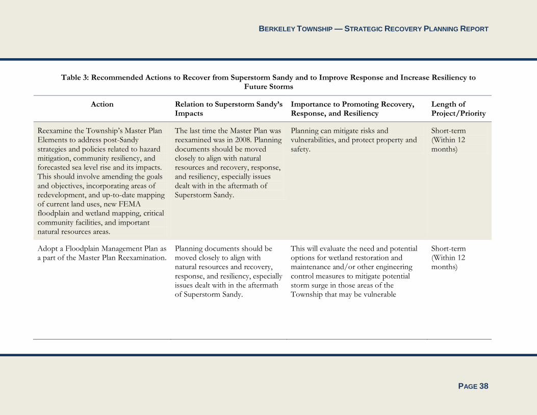
BERKELEY TOWNSHIP — STRATEGIC RECOVERY PLANNING REPORT
PAGE 38
Table 3: Recommended Actions to Recover from Superstorm Sandy and to Improve Response and Increase Resiliency to Future Storms
Action Relation to Superstorm Sandy’s Impacts
Importance to Promoting Recovery, Response, and Resiliency
Length of Project/Priority
Reexamine the Township’s Master Plan Elements to address post-Sandy strategies and policies related to hazard mitigation, community resiliency, and forecasted sea level rise and its impacts. This should involve amending the goals and objectives, incorporating areas of redevelopment, and up-to-date mapping of current land uses, new FEMA floodplain and wetland mapping, critical community facilities, and important natural resources areas.
The last time the Master Plan was reexamined was in 2008. Planning documents should be moved closely to align with natural resources and recovery, response, and resiliency, especially issues dealt with in the aftermath of Superstorm Sandy.
Planning can mitigate risks and vulnerabilities, and protect property and safety.
Short-term (Within 12 months)
Adopt a Floodplain Management Plan as a part of the Master Plan Reexamination.
Planning documents should be moved closely to align with natural resources and recovery, response, and resiliency, especially issues dealt with in the aftermath of Superstorm Sandy.
This will evaluate the need and potential options for wetland restoration and maintenance and/or other engineering control measures to mitigate potential storm surge in those areas of the Township that may be vulnerable
Short-term (Within 12 months)
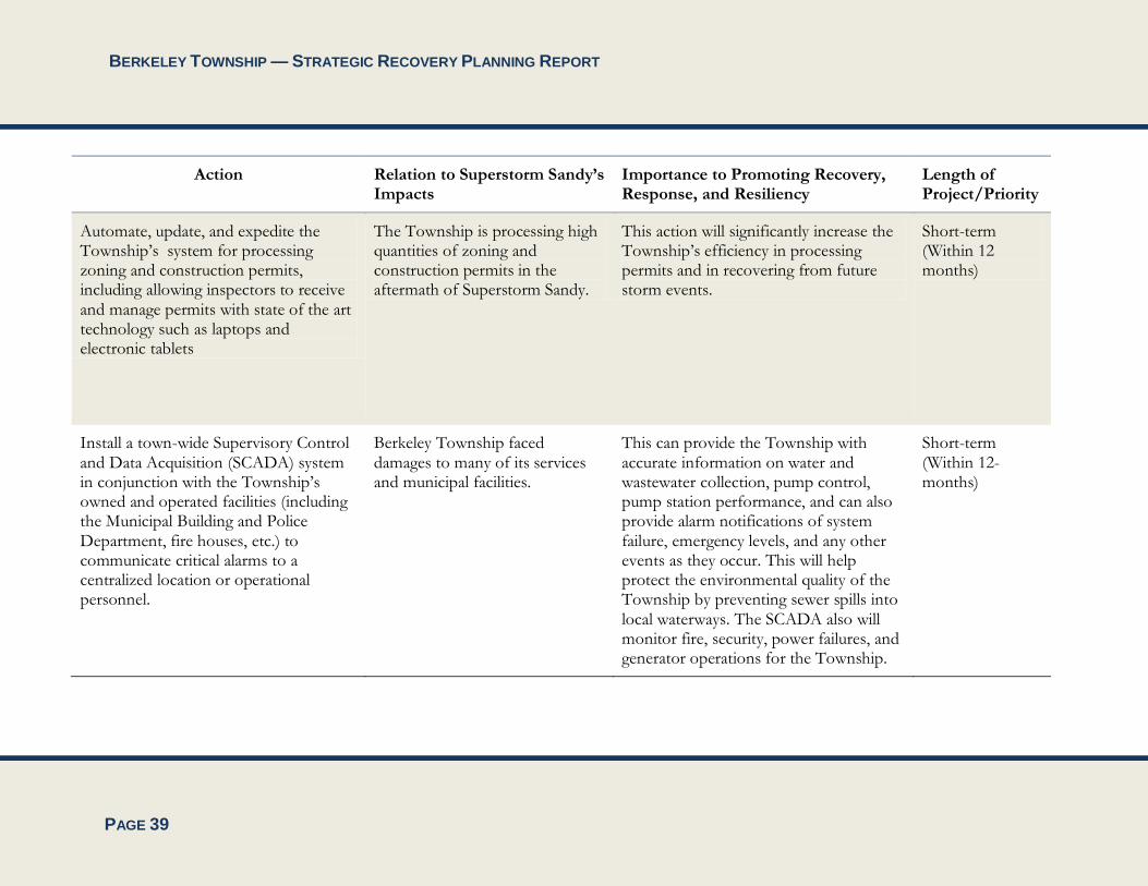
BERKELEY TOWNSHIP — STRATEGIC RECOVERY PLANNING REPORT
PAGE 39
Action Relation to Superstorm Sandy’s Impacts
Importance to Promoting Recovery, Response, and Resiliency
Length of Project/Priority
Automate, update, and expedite the Township’s system for processing zoning and construction permits, including allowing inspectors to receive and manage permits with state of the art technology such as laptops and electronic tablets
The Township is processing high quantities of zoning and construction permits in the aftermath of Superstorm Sandy.
This action will significantly increase the Township’s efficiency in processing permits and in recovering from future storm events.
Short-term (Within 12 months)
Install a town-wide Supervisory Control and Data Acquisition (SCADA) system in conjunction with the Township’s owned and operated facilities (including the Municipal Building and Police Department, fire houses, etc.) to communicate critical alarms to a centralized location or operational personnel.
Berkeley Township faced damages to many of its services and municipal facilities.
This can provide the Township with accurate information on water and wastewater collection, pump control, pump station performance, and can also provide alarm notifications of system failure, emergency levels, and any other events as they occur. This will help protect the environmental quality of the Township by preventing sewer spills into local waterways. The SCADA also will monitor fire, security, power failures, and generator operations for the Township.
Short-term (Within 12-months)
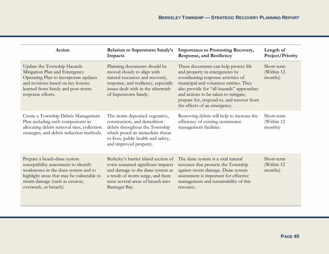
BERKELEY TOWNSHIP — STRATEGIC RECOVERY PLANNING REPORT
PAGE 40
Action Relation to Superstorm Sandy’s Impacts
Importance to Promoting Recovery, Response, and Resiliency
Length of Project/Priority
Update the Township Hazards Mitigation Plan and Emergency Operating Plan to incorporate updates and revisions based on key lessons learned from Sandy and post-storm response efforts.
Planning documents should be moved closely to align with natural resources and recovery, response, and resiliency, especially issues dealt with in the aftermath of Superstorm Sandy.
These documents can help protect life and property in emergencies by coordinating response activities of municipal and volunteer entities. They also provide for “all-hazards” approaches and actions to be taken to mitigate, prepare for, respond to, and recover from the effects of an emergency.
Short-term (Within 12-months)
Create a Township Debris Management Plan including such components as allocating debris removal sites, collection strategies, and debris reduction methods.
The storm deposited vegetative, construction, and demolition debris throughout the Township which posed an immediate threat to lives, public health and safety, and improved property.
Removing debris will help to increase the efficiency of existing stormwater management facilities.
Short-term (Within 12 months)
Prepare a beach-dune system susceptibility assessment to identify weaknesses in the dune system and to highlight areas that may be vulnerable to storm damage (such as erosion, overwash, or breach).
Berkeley’s barrier island section of town sustained significant impacts and damage to the dune system as a result of storm surge, and there were several areas of breach into Barnegat Bay.
The dune system is a vital natural resource that protects the Township against storm damage. Dune system assessment is important for effective management and sustainability of this resource.
Short-term (Within 12 months)

BERKELEY TOWNSHIP — STRATEGIC RECOVERY PLANNING REPORT
PAGE 41
Action Relation to Superstorm Sandy’s Impacts
Importance to Promoting Recovery, Response, and Resiliency
Length of Project/Priority
Prepare a Capital Improvement Plan identifying needed capital improvements to improve local resiliency.
Berkeley Township faced damages to many of its services and municipal facilities.
An up-to-date catalog and inventory of Township-owned infrastructure will better prepare Berkeley to provide recovery and response services in future Sandy-type storms
Mid-term (Within 24 months)
Update the Township’s GIS database and user interface to catalog and inventory all infrastructure owned by the Township, including roadways, and its stormwater and sanitary sewer collection systems. This will include up-to-date GPS mapping of the utility infrastructure, as well as inventory and classification of the road network to build a Township-wide capital improvement plan.
Berkeley Township faced damages to many of its services and municipal facilities.
An up-to-date catalog and inventory of Township-owned infrastructure will better prepare Berkeley to provide recovery and response services in future Sandy-type storms
Long-term (Within 36 months)
Continue to increase Township participation in FEMA’s Community Rating System (CRS), including a resiliency survey or assessment.
FEMA’s CRS promotes recovery from Sandy-type storms.
CRS participation results enhanced public safety, reduced property damage, and discounted flood insurance premium rates, among other benefits.
Long-term (Within 36 months)
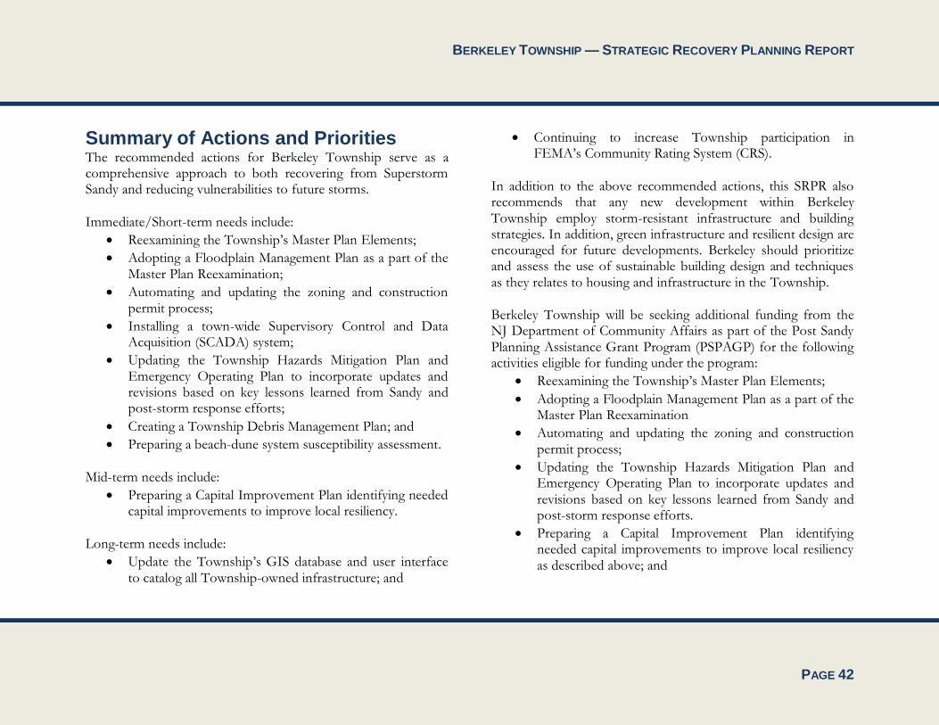
BERKELEY TOWNSHIP — STRATEGIC RECOVERY PLANNING REPORT
PAGE 42
Summary of Actions and Priorities The recommended actions for Berkeley Township serve as a comprehensive approach to both recovering from Superstorm Sandy and reducing vulnerabilities to future storms.
Immediate/Short-term needs include:
Reexamining the Township’s Master Plan Elements;
Adopting a Floodplain Management Plan as a part of the Master Plan Reexamination;
Automating and updating the zoning and construction permit process;
Installing a town-wide Supervisory Control and Data Acquisition (SCADA) system;
Updating the Township Hazards Mitigation Plan and Emergency Operating Plan to incorporate updates and revisions based on key lessons learned from Sandy and post-storm response efforts;
Creating a Township Debris Management Plan; and
Preparing a beach-dune system susceptibility assessment.
Mid-term needs include:
Preparing a Capital Improvement Plan identifying needed capital improvements to improve local resiliency.
Long-term needs include:
Update the Township’s GIS database and user interface to catalog all Township-owned infrastructure; and
Continuing to increase Township participation in FEMA’s Community Rating System (CRS).
In addition to the above recommended actions, this SRPR also recommends that any new development within Berkeley Township employ storm-resistant infrastructure and building strategies. In addition, green infrastructure and resilient design are encouraged for future developments. Berkeley should prioritize and assess the use of sustainable building design and techniques as they relates to housing and infrastructure in the Township.
Berkeley Township will be seeking additional funding from the NJ Department of Community Affairs as part of the Post Sandy Planning Assistance Grant Program (PSPAGP) for the following activities eligible for funding under the program:
Reexamining the Township’s Master Plan Elements;
Adopting a Floodplain Management Plan as a part of the Master Plan Reexamination
Automating and updating the zoning and construction permit process;
Updating the Township Hazards Mitigation Plan and Emergency Operating Plan to incorporate updates and revisions based on key lessons learned from Sandy and post-storm response efforts.
Preparing a Capital Improvement Plan identifying needed capital improvements to improve local resiliency as described above; and
BERKELEY TOWNSHIP — STRATEGIC RECOVERY PLANNING REPORT
PAGE 43
Update the Township’s GIS database to support future planning efforts.
All of the foregoing will help Berkeley Township improve resiliency by improving the Township’s knowledge base, establishing clear procedures and protocols for addressing future emergencies and facilitating restoration, and creating a comprehensive planning framework that will enhance the resiliency and sustainability of the Township and minimize the impacts of future storm events.

BERKELEY TOWNSHIP — STRATEGIC RECOVERY PLANNING REPORT


![COMPLETE Final Woolgoolga Township Marketing Action Plan[1]€¦ · Woolgoolga Township Marketing Action Plan 5 The Scope The Woolgoolga Township Marketing Action Plan has been developed](https://img.pdfslide.us/doc/110x75/5af6d8f67f8b9a154c9195a5/complete-final-woolgoolga-township-marketing-action-plan1-woolgoolga-township.jpg)