Embed Size (px)
Citation preview

BEOLOGI CAL AND GEOCHEMICAL HEPOfZT ON THE
MARMOT CLAIM GROUP, STEWART, EC. C.
SKEENA MINING DIVISION

TABLE OF CONTENTS
ENTRODUCTION
LOCAT I ON, ACCESS, TOPOGRAPHY
FFWFERTY STATUS
AREA HISTORY
FROFERTY SUMMARY
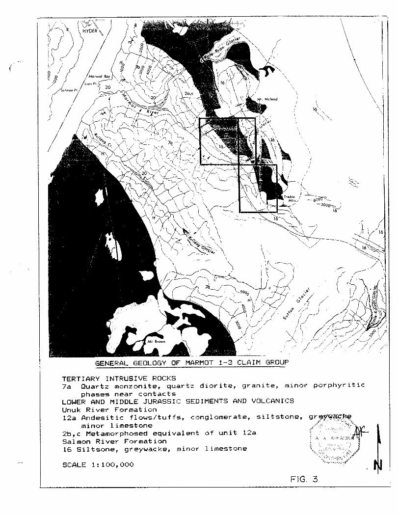
GENERAL GEOLOGY
1’3’35 FIELD PROGRAM
METHOPS AND FROCEDURES
GEClLOGY AND MINERALIZATION
SOIL GEOCHEMISTRY
DISCUSSION OF RESULTS
CONCLUS I RN AND RECCtMMENDAT I ONS
REFEFZENCES

LIST OF FIGURES
GENERAL LOCATION MAP
CLAIM LOCATION MAF’
GENERAL GEOLOGY MAP
PRCIPEETY GEOLQGY AND MINERALIZATION ( 1: 2, fiOO:t
MIDI3LE APIT-HIGH GRADE VEIN GEtlL.& MIN. Cl: 1,CKtc
UPPER & LOWER AD IT GECJL. & MIN. C 1 : 1 , OOO:?
PROPBSED DIAMOND DRILL HOLES
SOIL GEOCHEM COMPILATItlN
APPENDX X A ASSAYS


1 I 0 INTRODUCTION
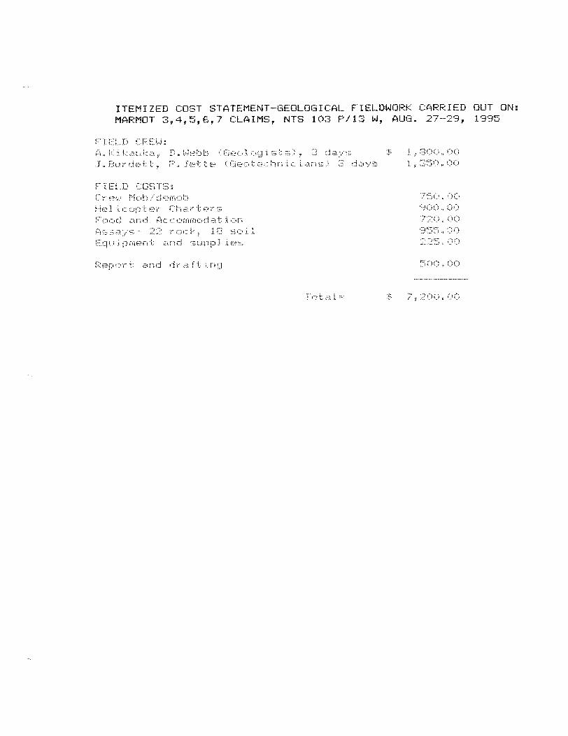
This r epor t descr ibes and evaluates the mineral pstential in con.junct ion with fieldwork carried out on the Marmot claim group. Field WQI 'd cc~-~r,isted sf geoff2gical mapping, :r Q*l: i:: and 5~~1 i 1 geuchemical survey5 carried a_tt an August 25-24, 1932 by Andris Kikauka, Dean Webb Cgeofc~gist5) f Jim Burdett, and Pierre Jette <se&echnicians> _
The property is fccated at the head of the south fork of the Mai-mot River, abaut 16 kilometers southeast of Stewalt, B.C. Elevations on the claim group range from 400~-1,500 meters.
The claim55 c an be accer;sed by logging roads that folltsw the Marmck River to Kate Ryan Creek. Dvergrciwn trails fi~llciw the Marmc& River t ci the headwaters where numerrJur, adits and !rsld WVT- k ingc- have been developed. This includes the Marmut Metals CFeach & Worseshcte>, Engineer, Washington, and High-Grade mineral showings;, which 0: cur can the Marmot 1-7 claim grctup. These &@W8ag% /r Firi exposed along a major northwest trending creek gulley that is a parallel offsat of the Ma-m& R. valley trend.
The tcrpogr aphy of the Marmot River is fU-shaped from glacial act is-i. A relatively flat valley GrJttum is contrasted by steep slaps from 4~+-8C10 meters elevation, with moderate to steep sl cspes above BO!:t meters elevation.
3 . (1) FRUFERTY STATUS <FIG. 2 j
CLAIM NAME UNITS F?EC:!XD PitO. EEC:ORD DATE EXFIF-IY DATE+

The we1 1 mineral ized Stewat-t Comp?ex e:rrtends from Alice #k-m tu the fskut RiVer. Exploration and develupment of major mines in the stewart avea, including Silbak-Premier, Snip, J!rshnny r-luuntain, Anyox, Alice Arm, Granduc, Scottie, Big Missourr i Y Porter-Idaho, Tena.j un SE, and Maple Bay, and new reserves out1 ined at Eskay Creek, Red Mountain, Willoughby, and Sulpherets makr this area is :3ne of Canada's most active mining camps.
The Stewart area has been exploited for minerals since 1'3OcS when the Red Cliff deposit on Lyddrn Creek was mined. Since then, apprcfiximately 100 base and pr ec irkus metal deposits within the Stewart Mining District have been developed.
Tat, a 1 recorded product ion from the Stewart area is 1,'300,000 uunces gcild, .qis f t:,rJO, Q?:to ounces silve.r, and 100, <1!:10, O<@ pcaunds
c~~~pper-lead-zinc. Most of this product ion comet from the famous Silbak-Premier mine which operated frum 1918 ko 1’368. This mine was reactivated i n 1'387 by L-Jestmiri Resources to rixcrver near sur fare bulk tonnage, low-grade gold and silver. Presently the surface re?stlrvEIs are exhausted and Westmin i5 extracting ore from var iuu5 underground levels. Additional ctre has alss been prclduced from the Big Missourri and Ten&on SE deposits.
The E5i:ay Creek deposit cxsntains an est i mat Ed 4 9 t:)~~>O ~ OC>C:> c~unc es
g ce 1 d , 45 I o~~x:~, o~N:t riunc ~5 silvE?r, and 1 20 , Q$f), i:x:b<1 Ounc ~2s c~~:ppeu-lead-zinc n This deposit is buried and eluded disccivery f 07 some SC:; years *:I f explor at ion on the claims. The unique high-grade, stratif43rm 2--6ii meter wide mac.3 i ve sulphide is c~_~tstand irig i n terms of predicability of its geology and tenor, and its relatively well defined, contact controlled assay boundary.
The Psrter-Idaho mine operated during the 1'320'5 and early 30's
and is located G kilometers north cl f the Malmot claims. P, modest 30 f 1306 tons of ore prt2duced an impressive 2,33&,4S2
ounces silver, 3, I:to2,'337 pounds of lead, and l&,435 pounds of -2 liiC .
Other p*rrJspects in the Marmot River area include Wire Gold, Gold Wedge, Patricia, Fraser Group, Bi-Metallic, and Patricia. These base and preciuus metal showings have been per iodical 1 y explc~red and developed over the past fifty years.
A trenching program by Teuton/Level and Wes. has uncc5ver ed new shuidings abc4z 2 kililsmeters east of the Marmot l-7 claims. &z--.J- 43pI)zs up to $3 c;z/t Au a3:r::is~ 2 m. widths were reported in shear z crnes CGecirge C:ross Newsletter, [email protected]>

The Marmc& l-3 claims have an extensive histccy uf previous WCW-k during the late 1920'S and early 133Q's. The fc11 1 clwing showings d-f e located on the claim Group and are summarized from data obtained from Minister of Mines Repccts and recent assessment repui-t;
HCfRSESHOE- Mineralizaticln I--. %_:I_ c rtr s at 3, @>O f,:S‘J t el evat ion abcklt 800 meters west of the Marmut Glacier and 600 meters north of the Marmot River. Sulphides consist of massive sphalerite lenses and f3 i nor pyrite, galena, and chalcopyrite. Rusty mineral zcines are li:lcalized within a 2C:,l~C-30<] fur& wide limestone belt that is distinctly faulted laterally into: four blcicks, the seccnd blcc C:: from the summit containing the main mineral showings;. The faults strike ncrrtheast arfd dip StE’eply nccthwest, A 15 fcctt width averaged 17% zinc and in places, up ti:~ 1 ozit gold C1'328:) =
Recent sampling by Esso Minerals <15'83? confirmed high grade zinc values up t u 10.!5%, with some erratic gold values Cup to 0.215 cc/t ? * These shcgwings are variable in width within the limestune suggesting that they are replaced beds rather than replaced shear zones <Hansun 19?5> 4 r have traced mineral z&es
Several upen cuts and shurt adits fo-r sever al hurrdred feet .
PEfCH- A 180 fo& adit is located at 3,200 foxt elevation about 2 kil ometrr s west of the Marmot 81ac ier and 4QO meters nc~rth of the Marmot River . The adit was driven along a dyi:e striking 015 degrees kihE?r E? sphalerite-galena-pyrite mineralization averaged ati:iut 2r3ri frx / +- _t silver <1923:~, Essc~ Minerals sampled high grade sulphide mineral ization at thE portal in f3S3, returning values
uP t 0 257 c~/t silver, and O.G7f cc/t gold. Mineral z c~i-les we7 e traced for 25-5t:: feet al sng st r i i::e and averaged 8 inches i n w i d t h a
The Peat h and Horseshoe prccspects are part uf the Marmot Metals group 52 f cr13wn grants on the nurth side itf Marmot River. The Engineer, Washington, and High Grade pi-aspects a.re located south of the Marmot River about 2 kilczmleters west of Treble Mountain.
ENGINEER- Fs quartz v fr i n up t Q 8 feet wide contains var iab 1 e amounts _. ;-. f galena, sphalcrite, pyrite, quartz, and calcite and ijlc $I u7 S as lenses within dense, brittle argillites very ~10s~ to the main contact with the Wydw- quartz irrcc~snite pfutc4n at an el evat ion 1:s f 3 ", lots feet. Several n ar 7 0~ quartz argillite carry galena, sphalerite, and pyrite. I I? Marmot Engineer Syndicate drove a 230 foot long adit.
WASH I NGTDN- A &l;CTt fOEit 1 CJng adit is located at 3, ~QC_1 fci:ll:tt ~1 evat i cari 0 rf the south side 0 f Mar mot River. The adit is c 01 1 ar ed 1 i:t!:i feet below four paraXlE veins expos.ed c~-r surface. The v is I n s str i ke nor*thwest anij dip steeply east. The veins are
'-iP t 0 six feet in width and contain pyrite, galena, sphalerite,
and tetrahedrite. The veins are 5+-100 feet apart and are cut off abruptly tci the sr~uth by a ncotheast ti-ending fault. kll the r: r i35sI: ut tunnels and w8r k ings were apparently under this fault zone and consequently were in barren g.rsund.
HIGH GRADE fPREVKOUSL_Y CALLED HkRNEFi GF?OUPb Several veins were d i EK~IIY~~ ed at an $21 evat i sn C&f 4,5Co-5,?:?oC~ feek JI and are located nEai- IThe sa.lt her n 1 imit c:f the Marmc& 3 claim. Attent il3-3 has bren fixused i5n three veins knc~wn as the upper, middle, and 1 ow~r VEZ 1 fi 5 I All thr veins occur in a 5erie5 of metamc~phosed argilliter, and VI31 canl .‘ IS, a shco-t distance from the main cc+ntact with the Hyder quartz mc~onite. The upper vein, at the greatest d i c,t aifc e frcim the ccrntact, is very persistent, and consists of a serie5. of mazr;ive sulphid~ lenses and mc~e sparsely mineral ized z co95 c* f quartz and r,il ic ified cc:untr~y .rock. till of the .veins have bren traced by c~pen cuts and c,h~rt ad its and contain goc*d values in gold.
In 1’387, Corning Resources Ltd. performed an extensive mapping and sampl ing p7 cigr am ssn the "High Grade" prospect. c?: 450 foot 1 co3g f northwest trending adit (middle vein3 traces a quartz-- c a.r tunat e vein with pyrite-chalsopyrite-arsenoFyvite mineralizatiun, hosted andesitis volcanics. 15 rock chip sample5 assayed higher tE:n f,000 ppb Au with the hiqhezt being 7, 500 PPb Au = One hundred feet below ihe adit was a cc~llapsed adit that csul d nst be entered. Belcrw this was a talus sl cipe that consisted largely uf dump material from the lower adit. Fc wide, flat ridge ridge separates the twc~ adits. This talus was sampled and 15 r ~8; 1: samples returned assays greater than 1 f 000 ppb ciu, with the highest being '33,OCK~ ppb Au (2. 626 sz/t Au:) p The 1 ower adit i5 adjacent tiI* a pyritized quartz-carbonate ve i n varying i i-r thicknf35 f r Corn 0 . 5-2 . t:, feet;. ThE- vein was
identified, outcropping in sections, alco-~g an approximate strike length uf 1, O!:?O meter 5. In places9 the vein appeared as a girtc,san wher Er the pyrite and chalcc~pyr ite has weathered to 1 imunite and malachite. This vuiri wa5 al c,o sampled with 13 assays above ? ~ O<>C:i PPb Fru with the highest being G<j,r:tr:)r:! ppb &_~ <and other va 1 ue5 0 f 22 ~ C-Q<:;, f 5, !:100 I and 11, O?X? ppb &_I:! = Eased cU7 thEse y-esul tr,, a prrligram f 0 geilll sgical mapping, EM gesphysics, trenching, and diamond dr if 1 ing wac, recommended.
The St ewa.it Cump 1 e:< includes a thick sequence of !-ate Triassic t 0 Middle Jurassic v~~lcani~, sedimentary, and metamorphic rocks. These have been intruded and cut by a mainly granitic to syenitic suite 0 f tctwer Jurassic through Tertiary p lutons which tugether fclrm part of the Coast Fluti~t;~ic f:izmplex. Jkf or mat i13-3, in part related t u intru5ivr a!:tivity, has pr rsduc ed f 0 mp 1 r:4 fctl d structures al wig t!-ltz ma i n intrusive ccgntacts with simple Gpen folds and ?Jarps dcminant alr;ng the east side uf the cumplex. Cataclasis, mar ked by st 7 ong ncvth -z;ijut h st 7 U.C t ur ~5 I ar e

prominent features that cut this sequence.
l:ciurrt_ j- y rciclic, in the Stewart area comprise mainlj, Hazletc~n Group strata which in:: 1 udec, the tower Jurassic Unuk River Formation, and the Middle .Ju-rassis E&?tty Creek iand Mt.Dillworth:I Format iuns. This sequrnc e i-, unc un for mab 1 y caver 1 a i n by Sal mot-i Ri=.xer Format i co-i, and the Itlass River For mat ion t:&-ove, i'371,198E:!. tlnuk River strata includes mainly fragmental andesitic vo1canics, epic1astic W~lcanicc,, and minsr volcanic f? cW5. Widespread Galenian uplift and erc~~ic~-~ was ful lowed by deposit icon 13 f the partly marine vc~lcaniclastic Betty Creek Formatiun, the mixed Sal mun FZ i ve.r F:x mat ion 9 and the dcsminant-ly c,hallsw marine Ha55 River Format iun I
Intruc,ive activitx, i a the Stewart area has been marked by the LC~W~l- and Middle' Jurassic Texas Creek granodi*Drite with which the Pig M i c,5CG_IT r i , Silbak Premier, SE, and many Other mineral deposits in the district are aszc+c i ated = Yc~-~ger intvmsionr, include the Hyder Quartz Monz 1x7 it e and many Tertiary STOCKS, dykes, and sill5 wh ich f c:r m a large part cif the Coast Range Fil ut c:n i c f:t:*rr!p 1 EX . Mineral deplxsit;s such as B.C. Molybdenum at Alice Arm, Porter-Idaho near Stewart, and a hcsst 0 f c& her deposits a7 E related to 43 to 52 Ma CEucenrZ plut:~~-~s. ThC?5tZ intrusive5 af .56:1 form the regi~~al?y extensive Portland Canal DyC::e Swarm.
Mij.r e thar: 780 mineral deposits and showings have bean discoverrd in a Xarge variet), ,I, f r 01: {::c, and structures in the Stewart camp 1 ex I The Silbak-Premier represents a telesccrped Ctr~nsitional> . L Y epithermal gs 1 d -silver base m&al deposit local ized along c amp 1 ex , steep fracture r,y5trms, i n Lower Jurassic vus can i c 1 ast ic 5 uncfln fctrmabl y Over la in by shal 1 ok' dipping Middle Jurassic Salmc~n River Format ion sedimentary rocks.
In this example, the c:ve-rlying sedimentary units form a barrie-r <-*jr dam, trapping bonan z a type gold -5ilver mineua1irati~x-i at a relatively sha? lc~w depth. Metallogeny of the Silbak-Premier, Big Miss--sourr i f 33, and a numbe-r of other deposits in the Stewart area
ic, related t ,:* early Middle Jurassic plut*~inie--v:~:lcanic events.
&era11 I at I east fuur ma.jsr ep fc,odes, of mineral izat ion involving
go1 d -c, i 1 ver
LOWE:
base metals, mc$3. ybdenum, and tungsten dating fr om
ear 1 y Middle Jtti- 355 i c thr csugh t ::I Tertiary h a 5ie been recsDrded thrcrughuut the Ste?Jart Comp?ex.
7. I METHODS AND FROCEDURES
k total 0 f 0. '5 )::if::fm&er.= of grid line wais surveyed using hip c ha in5 and csmpas5es. A 450 meter east---west trending line and 5G metei- NE trending line were marked at 25 meter increments with
flagging and pickets. Slope <I c:y .r es: t i cln was not per formed.

A total. of 18 seif samples were taken at 25 meter spacing along E-W and NE trending lines <Figure 4,811. Soil sample5 were takeri w i t !-I gri_ibhces f r om a depth of 20-35 cm. and placed intci marked kraft envelup@s, dried, and shipped to Acrn~~ tabs, Vancouver, E.C,
Prq2rrty bedrock gerJlcsgy consists mainly of three distinct rc~k units summarized as fallows;
INTFNSIVE KKK5 Tertiary and older Hyder F'luton
3 Quartz m~nzcinit~l, quartz diur ita, cc~arse g-rain and porphyr it ic granite, and augite-hornblende pzlrphyry dykes
Lower Jur ass i c Llnuk River Fcvmat ion '1' i tithic arrd trystal t;uff, dacitic ci~mptss i t ion, minor
cr_knglc‘meratee, sandstctne, siltstune, and 1 imestc::ine
Triassic Stuhinic?> Formatic~n 1 Sandstone, interbedded sil tstase, m i ri 0-r c cmyl ~xw,sr ate arid
1 im?Stone, lc~cally pyritic Eup to 10% disseminated pyrite:)
Jurassic/Triassic vc11 can i c s and sediments sf tf-re Sti_&inir?) and Unuk R i ~63 Format ilms fsr m rlcjngated northwest t-rending ruc~f pendants within the Csast Range Plutc~nic Cc~mplex Lwhii-h the Hyder Pl t;tcir! is a part of5. The Hyder Fl tit ori ccwet-5 XI ext ensi,ve area t J3 the WESt arid 3: orit tic t 5 the Stuhini CA?:! Fsrmaticcn sediments al W-IQ a stir ike cff 338 degrees on the west and JO0 degrees on the sucit h pur t i i:rn of the property. Bedding in the Stuhini Fcgivmation sediments trend 2x3<;> t fr 32$;] degrees and dip 35-4f degrees northeast . Hassive dacitic tuffs zzf the Unuk River Fc~rmation form the steep mountainous topography in the fast pctrticrn czf the claims and appear t 0 l:,ye-r 1 i e the Stuhini i?> sedimcr.ts. Th? strep terrain is I ikely cat~sed by thrust and/tz*r normal faulting related t !:I the do~minant effect of tha spires czf Treble Mountain IO.3 km.east of the Mar mat claim group:!, and enhanced by Fleistcic~ne alpine glaciatisn.

The emplacement of the Hyder Pluton has di splaced andic~ thrust the Jurassic/Triassic sedimentary and volcanic sequence resulting in extensive faulting and fracturing with large scale open folds.
Replacement, breccia, and vein quartz -carbonate-sulphide mineraiizati~~rf is local 1 ized alc:ng faults and fractures within
the Jurassic/Triassic vi31 :: an ifs and sediments. Secc~ndary
alteratic*n mineral5 include biotite, 1 imon ite, and ser icite
adjacent t ::E mineral zcNIe5. Mineral izat ion z consists of pyrite,
ctialcupyrit42, sphalerite, galena, arsenc~pyrite, in a gangue 0 f
quartz-c arbonate. Nc~rtheast ) nor tl-i f and east trending faults
within the east pCW t ion $2 f the grid area contain several mineralized vein and/Ix replacement tmineral zones. A nccr thwsst
trending contact between Sal mrJr-2 River Fsrmaticzn sediments and
IJnuk R i ver Fw mat i on vc~lcanics contains vein and/or replacement
mineralization z one5 UP t 0 7 feet wide. 22 r SDc: [:: chip samplrs taken fuom mineral z ctne5 with average widtt-rs in exces of 1. I meter 5 Y gave assay values up to l 3*3,'33'3 ppb Au and 1’35.5 ppm Ag. Tt?e average values ~3f the 22 rook chip c,amples are swnmauized a~-
Middle Adit-t-figh grade quartz values: UNDERGROUND- SAMFSLE # AVERAGE %Cu 3% MR--‘+ 12 0. 0 1. 0 . <j i
Lower Adit- SAMPLE # AVEFAGE YCu Mf+-22-25,31 ’ =
72% g. 03 0. r13
veil? gave the follc~wing average
xzn g/t Ag g . ij 1 19.7
cc/‘t Ag 0 . E,
g/t Au 32 _ G.3
1:iz /t Au Q. 35

15 =c,il 5amples taken along an east-west grid line at 25 meter spacing gave the fell lowing results: SAMPLE # AVERAGE ppmCu Pb 7 Lrl fig ppb Au M2S,3+7SE--7+5c2E 119: 6E8 "'Cf, &fJ-_ 43.2 48QCs
As values in rock and zx_*il samples average &out 1% and have a pzDsitive cc~ri-elat ion with increased precious mete+1 values,
a . 0 DISCUSSION C3F FZESULTS
GECI~ c:g i cdl assessment of the Marmot property has out1 ined gold and silver tiearing quartz-s ulphide vein and/or replacement mineral izat ion which 15 focalized along a system of faults and fractu-feS hceted by a sequenca 0 f .~urassic/Triassic ~rdiments and iil:~l~:anics. Geul0gica.l mapping indicates a dominant northwest trend to 1 ithislcqy 5. W-It ac t 5 which is super imputed by north f RWtheast , and east trending fault structures. The main mineral zone5 13 f the Mar mot 4-7 claims are concentrated along Ccc are within several hundred meters of) the contact between StuhiniC?S Fm. sediments and Unuk Eitfer Fm. volcanics, This ci-c-ktact is well mineralized here and dl SO gives a strong Cu-Pb-Zn-Ag-Au-As geixhemical rcz.ponse in soil and rock samplel+. It appeavs there is 3--4 distinct episodes caf mineralization and gold ir associated with pyrite i.massive and/or trace:r f chalcopyritc, arsenopyrite, There iI; a prominent minei-al trend that ext;ends cfver a strike 1 engt h of 1, <]CjC) meters. This trend traces through the lower adit, 1 UC at ed at L 24Ofr E, station O+CK_! N and extends several hundred meters east sf _ 4+-W E, statii2n 2+C@ S.
There i-3 petent ial fur the Marmot 4-7 cl aims to hisst a depssit of c,ever al mill i:x-i tons of 0.4 oz't Au similar to the Wed Mountain deposit lorated 7 kilometers tu the northea&.
9. 0 CONCLUSION AND EECUMMENDATIONS
The Mar mot l--7 claims are located in an area that is well known for hosting gold and silver deposits. Numerous base and prec ious metal mines and showings occur in close proximity to the subject claim5.. Gi3~~lrJgiral setting of the MarmrJt claims i5. similar tra other base and pr ec 1OUS met al deposits that occur within the regiun. The Martrvst prcaperty has teen 5us.j ec t t c;i several explorat ion and devel trspment pr ogr am5 which includes '3ever a 1 adits, numersrus trenches, and open cuts.
The Marmot 1-7 claims have potential to 5 cent a i n ec on urn i f pr ~1: i 1:tu5 m&al deposits. The "High Grade" %hcrwings <Mar-m& 4-7 claims;) are the h ighest or der fisllow up target that requires detailed mapping, trenching, IP geophysics, and d i amend drilling.

The other shawing5 I. oc at ed W-i the MarmlA f-3 claims should br mapped and sampled in detail tis identify potential ILS~E? ~~~~nes. A detaiXed pi-o.ject pi-c$wsal summary is given below:
Eieolc~gist, 3 ge-utechnic ians Meals and ac sccmmc~dat ion Mub /demob Assays 3, (lK)O meter- 5 core dr iL I ing He1 iccqtev charters Field equipment, supplies Report
EEFEEENCES
GIldrick, D-J., Cl'SS3), &+D,l og i 1: al Setting of Pr ec ices Metal Deposits, Stewart, E,C., B.C. Min. uf E.M.& P. Res., Ge43lrlrgical Fieldwlxk.
Gr eve , E.W,, c 1371 :) Gec,l ogy and Mineral Wposits caf the Stewart
Area, ECDM Bulletin I&. 5%.
GT Iyqe, E,W. y <138&f, Eiec~lI3gy and Mineral Depcjsits of the Unuk River- Sal rnC~r-3 River- Anyox Area, Min. cjf E.M.b P.!?es. Bulletin PJu. 03.
._I&nson , t., cl%7>, Assessment Report compiled by I-Ii-Tee Res. Mgmt. Ltd,, fur Corning 52esc~urce5. # lG,F,S2.
Kikauka, i3.i 19.3" dQ? Gec~lugisal, Geclphysical, and Gectc h em i c a 1
Repart on the Marmot i-7 Claim Group, Assessment &port