Embed Size (px)
Citation preview

BELL BLVD
SIDNEY ST
ENTERPRISE DR
MOIRA ST W
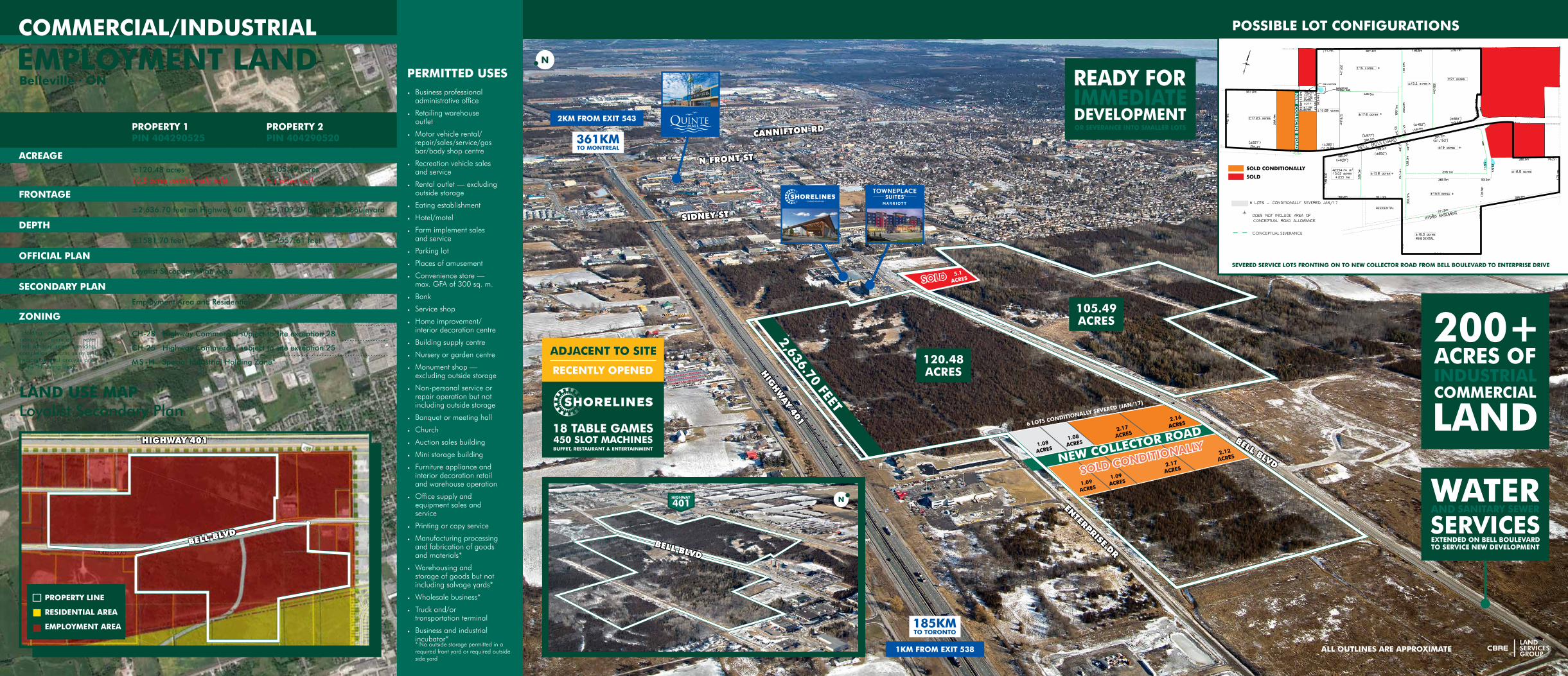
BELLEVILLE · ONTARIO · OVER 200 ACRES
ALL OUTLINES ARE APPROXIMATE
SOLD CONDITIONALLY
PROPERTY 1 PIN 404290525
PROPERTY 2 PIN 404290520
ACREAGE±120.48 acres10.8 acres conditionally sold
±105.49 acres
5.1 acres sold
FRONTAGE
±2,636.70 feet on Highway 401 ±3,109.29 feet on Bell Boulevard
DEPTH
±1581.70 feet ± 2557.61 feet
OFFICIAL PLAN
Loyalist Secondary Plan Area
SECONDARY PLAN
Employment Area and Residential
ZONING
CH-28 Highway Commercial subject to site exception 28
CH-25 Highway Commercial subject to site exception 25
MS-H Special Industrial Holding Zone*
*Holding provision requires adequate municipal water and sanitary sewer servicing, completion of traffic study and hydrogeological analysis prior to the “H” being lifted.
• Business professional administrative office
• Retailing warehouse outlet
• Motor vehicle rental/repair/sales/service/gas bar/body shop centre
• Recreation vehicle sales and service
• Rental outlet — excluding outside storage
• Eating establishment
• Hotel/motel
• Farm implement sales and service
• Parking lot
• Places of amusement
• Convenience store — max. GFA of 300 sq. m.
• Bank
• Service shop
• Home improvement/interior decoration centre
• Building supply centre
• Nursery or garden centre
• Monument shop — excluding outside storage
• Non-personal service or repair operation but not including outside storage
• Banquet or meeting hall
• Church
• Auction sales building
• Mini storage building
• Furniture appliance and interior decoration retail and warehouse operation
• Office supply and equipment sales and service
• Printing or copy service
• Manufacturing processing and fabrication of goods and materials*
• Warehousing and storage of goods but not including salvage yards*
• Wholesale business*
• Truck and/or transportation terminal
• Business and industrial incubator** No outside storage permitted in a required front yard or required outside side yard
PERMITTED USES
LAND USE MAP Loyalist Secondary Plan
PROPERTY LINE
RESIDENTIAL AREA
EMPLOYMENT AREA
HIGHWAY 401
Belleville · ON
BELL BLVDBELL BLVD
2KM FROM EXIT 543
1KM FROM EXIT 538
105.49 ACRES
120.48 ACRES
BELL BLVD
HIG
HW
AY 401
SIDNEY ST
N FRONT ST
CANNIFTON RD
ENTERPRISE DR
2,636.70 FEET
ALL OUTLINES ARE APPROXIMATE
POSSIBLE LOT CONFIGURATIONS
²
CONCEPTUAL SEVERANCE
SOLD CONDITIONALLY
SOLD
SOLD

The site is currently under agreement with the Managed Forest Tax Incentive Program (MFTIP) until 2026. MFTIP is intended to bring greater fairness to the property tax system by valuing forestland according to its current use. Properties that are classified as “Managed Forest” pay 25% of the municipal tax rate. Potential purchasers may be eligible to continue the agreement pursuant to the guidelines set out by the Minister of Natural Resources and Forestry. The accepted agreement and additional information can be found in the online document centre.
MANAGED FOREST TAX INCENTIVE PROGRAM
© 2017 CBRE Limited. Data © TeleAtlas, Google, AerialExpress, DigitalGlobe, Landiscor, USGS, i-cubed. The information contained herein (the “Information”) is intended for informational purposes only and should not be relied upon by recipients hereof. Although the Information is believed to be correct, its accuracy, correctness or completeness cannot be guaranteed and has not been verified by either CBRE Limited or any of its affiliates (CBRE Limited and its affiliates are collectively referred to herein as “CBRE”). CBRE neither guarantees, warrants nor assumes any responsibility or liability of any kind with respect to the accuracy, correctness,completeness, or suitability of, or decisions based upon or in connection with, the Information. The recipient of the Information should take such steps as the recipient may deem appropriate with respect to using the Information. The Information may change and any property described herein may be withdrawn from the market at any time without notice or obligation of any kind on the part of CBRE. The Information is protected by copyright and shall be fully enforced. Layout ID: L10 MapId: 4454884
15
16
17
18
19
20
21
1
23
45
8 9
10
11
6
12
13
14
COMMERCIALQuinte Mall
Walmart Supercentre
Lowe’s
Galaxy Cinemas Belleville
Best Buy
LCBO
Shorelines Casino & TownePlace Suites Marriot
AMENITIES MAP
1. QUINTE MALL
18. BELLEVILLE VIA RAIL
HIGHWAY 401
COLLEGE ST W
BELL BLVD
N FR
ON
T ST
CAN
NIFTO
N R
D
N FR
ON
T ST
SIDN
EY ST
15
16
17
18
20
19
21
Yardmen Arena
Quinte Sports & Wellness Centre
St. Theresa Catholic S.S.
Belleville Via Rail Station
Quinte Secondary School
Parkdale Public School
Parkdale Community Centre
INSTITUTIONAL
9
1
2
3
4
5
6
7
8
10
11
12
13
14
7
Marc’s No Frills
Rhino Sports & Playland
Michael’s
Canadian Tire
FreshCo
Best Western Belleville
Holiday Inn Express & Suites

CBRE Limited2005 Sheppard Ave E,
Suite 800Toronto, Ontario, M2J 5B4
www.cbre.ca/mclsg
*Sales Representative **Broker. This disclaimer shall apply to CBRE Limited, Real Estate Brokerage, and to all other divisions of the Corporation; to include all employees and independent contractors (“CBRE”). The information set out herein, including, without limitation, any projections, images, opinions, assumptions and estimates obtained from third parties (the “Information”) has not been verified by CBRE, and CBRE does not represent, warrant or guarantee the accuracy, correctness and completeness of the Information. CBRE does not accept or assume any responsibility or liability, direct or consequential, for the Information or the recipient’s reliance upon the Information. The recipient of the Information should take such steps as the recipient may deem necessary to verify the Information prior to placing any reliance upon the Information. The Information may change and any property described in the Information may be withdrawn from the market at any time without notice or obligation to the recipient from CBRE. CBRE and the CBRE logo are the service marks of CBRE Limited and/or its affiliated or related companies in other countries. All other marks displayed on this document are the property of their respective owners. All Rights Reserved. Mapping Sources: Google Earth 01/17
Lauren Doughty*Vice President 416 495 6223 [email protected]
Jason Child*Vice President 416 495 6249 [email protected]
Ian Hunt*Vice President 416 495 6268 [email protected]
OFFERING PROCESS
DRIVE TIME MAP
• Signed and Registered Services Agreement (2004)
• Storm Water Management Design Brief (March 2014)
• Lot Severance and Future Road Concept Plan - Watson (August 2016)
• Potential Lot Configuration Concept Plan - Ainley (August 2016)
• MFTIP Plan #11512 Confirmation
© 2017 CBRE Limited. Data © TeleAtlas, Google, AerialExpress, DigitalGlobe, Landiscor, USGS, i-cubed. The information contained herein (the “Information”) is intended for informational purposes only and should not be relied upon by recipients hereof. Although the Information is believed to be correct, its accuracy, correctness or completeness cannot be guaranteed and has not been verified by either CBRE Limited or any of its affiliates (CBRE Limited and its affiliates are collectively referred to herein as “CBRE”). CBRE neither guarantees, warrants nor assumes any responsibility or liability of any kind with respect to the accuracy, correctness,completeness, or suitability of, or decisions based upon or in connection with, the Information. The recipient of the Information should take such steps as the recipient may deem appropriate with respect to using the Information. The Information may change and any property described herein may be withdrawn from the market at any time without notice or obligation of any kind on the part of CBRE. The Information is protected by copyright and shall be fully enforced. Layout ID: L10 MapId: 4458174
U.S.A. BORDER CROSSING 1H 12 MIN
PETERBOROUGH 1H 15MIN
PRINCE EDWARD COUNTY 30 MIN
CLARINGTON 1H
OSHAWA 1H 15MIN
KINGSTON 55MIN
© 2017 CBRE Limited. Data © TeleAtlas, Google, AerialExpress, DigitalGlobe, Landiscor, USGS, i-cubed. The information contained herein (the “Information”) is intended for informational purposes only and should not be relied upon by recipients hereof. Although the Information is believed to be correct, its accuracy, correctness or completeness cannot be guaranteed and has not been verified by either CBRE Limited or any of its affiliates (CBRE Limited and its affiliates are collectively referred to herein as “CBRE”). CBRE neither guarantees, warrants nor assumes any responsibility or liability of any kind with respect to the accuracy, correctness,completeness, or suitability of, or decisions based upon or in connection with, the Information. The recipient of the Information should take such steps as the recipient may deem appropriate with respect to using the Information. The Information may change and any property described herein may be withdrawn from the market at any time without notice or obligation of any kind on the part of CBRE. The Information is protected by copyright and shall be fully enforced. Layout ID: L10 MapId: 4458174
CONFIDENTIALITY AGREEMENT
Potential purchasers that require access to the online document centre are to complete the CA and return it to: [email protected]
DOCUMENT CENTRE
• Traffic Impact Study (October 2014)
• Concept Plan for Lot Severance and New Road
• Phase I ESA (February 2013)
• Hydrogeological Report (June 2013)
• Hydrogeological Assessment Acceptance Letter
All offers are requested to be submitted to:
OFFER SUBMISSIONS
Jason [email protected]
CBRE Limited · 2005 Sheppard Avenue East · Suite 800 · Toronto, ON · M2J 5B4
Mike Czestochowski**Executive Vice President 416 495 6257 [email protected]