Embed Size (px)
Citation preview

Before the Zoning Administrator in and for th eCounty of Monterey, State of Californi a
In the matter of the application of:Venoco LLC exploratory oil and natural gas wells application :(WARD ROWENA JOANNE TRS - File PLN090119 )
RESOLUTION NO. 10-040Resolution by the Monterey County ZoningAdministrator to :1. Adopt a Mitigated Negative Declaration fo r
the Venoco exploratory oil wells proposal ;2. Approve the drilling of up to three
exploratory oil and gas wells on the War dRowena Joanne property (File PLN090119 ;Venoco Inc. Site 7a), based on the findingsand subject to the conditions in Exhibit 1
3. Adopt Mitigation Monitoring and Reportin gPlan .
(PLN090119, WARD ROWENA JOANNETRS, SOUTH COUNTY AREA PLAN (APN :424-101-023-000-000 )
The Venoco LLC exploratory oil and natural gas wells application WARD ROWEN AJOANNE TRS - File PLN090119, came on for public hearing before the Monterey Count yZoning Administrator on September 30, 2010. Having considered all the written an ddocumentary evidence, the administrative record, the staff report, oral testimony, and otherevidence presented, the Zoning Administrator finds and decides as follows :
FINDINGS
1 . FINDING: CONSISTENCY - The project, as described in Condition No . 1 and asconditioned, conforms to the policies, requirements, and standards of th eMonterey County General Plan : Goal 2 to provide for the conservation ,utilization, and development of the County's mineral resources in keepin gwith sound conservation practices : The project site is currently zonedPermanent Grazing, exploratory oil wells would not significantly reduce th eamount of grazing area available nor would the project (exploratory test wells )permanently affect grazing activities within the area. The project has beenconditioned to perform reclamation of the site in the event the site is notconverted to production wells .Goal 20 to provide for the protection and enhancement of Montere yCounty's air quality : The county has mitigated and conditioned the project in amanner that reduces the impacts identified in the environmental document whic hreduce them to a less than significant level per the policies in the General Plan t omodify industrial projects to meet building code and federal and state ambien tare quality standards and the rules and regulations of the Monterey Bay Unifie dAir Pollution Control District .Goal 22 to maintain an overall healthy and quiet environment by trying t oachieve living and working conditions free from annoying and harmfulsounds : The project meets the object of Goal 22 and policy by conditions which

require that the project activities be limited to day operations . However, duringthe drilling phase which will operate for 45 days continuously, the project will b erequired to meet the objectives of in table 6 of the General Plan . The project willbe monitored and be required to submit reports during the drilling phase of th eproject in a manner consistent with Table 6 of the General Plan for Land us eCompatibility for exterior community noise in a form of a biweekly report .Goal 30 to protect all viable farmlands designated as prime, of statewid eimportance, unique, or of local importance from conversion to an dencroachment of non-agricultural uses : The project meets the object of goal 3 0to protect agricultural lands from uses that could interfere with norma lagricultural uses . The project site is currently zoned Permanent Grazing ,exploratory oil wells would not significantly reduce the amount of grazing are aavailable nor do such projects (exploratory test wells) permanently affect grazin gactivities within the area . This is consistent with established policies in the SouthCounty Area Plan and under the Department of conservations definition o fcompatible uses as defined under the Williamson act .Area Plan The project areas were determined to be suitable for the County' sproposed uses under the current Zoning Ordinance Title 21 Section 21 .34.05 0with a use permit . The area plan recognizes that oil exploration throughout th ecounty is on the increase . The three project areas are consistent with the policiesof the Area Plan by mitigating the potential impact identified to Biologica lResources, and Air Quality issues to levels compliant with state and federa lrequirements and therefore to a less than significant level . Refer to Sections VI 3and 4 in the Initial Study, Mitigated Negative Declaration .
EVIDENCE : (a) The text, policies, and regulations in the above referenced documents hav ebeen evaluated during the course of review of applications . No conflicts werefound to exist. No communications were received during the course of reviewof the project indicating any inconsistencies with the text, policies, an dregulations in these documents .
(b) Well site 7a is located in Township 24 South, Range 11 East ; Section 7 . Thesite is approximately 0.60 miles south west of Highway 101 an dapproximately 0.90 miles south east of Jolon Road, (Assessor's Parce lNumber 424-101-023-000) . The parcel is zoned PG/40 ("Permanent Grazing ,40 acres minimum") which allows Use Permit requests for the exploration fo rand the removal of oil and gas (Title 21 Section 21 .34.050 EE). Therefore ,the property is suitable for the proposed development.
(c) The project planner conducted a site inspection in July 20, 2009 to verify tha tthe project on the subject parcel conforms to the plans listed above .
(d) This parcel (Assessor's Parcel Number 424-101-023-000) is a legal lot o frecord as established by its presence in the 1972 Assessor's Parcel Map sTownship 24 Range 11 Section 7 in its current configuration and described i nthe recorded Deed for Oil and Gas Rights recorded April 9, 1981 on Ree l1474 Page 901 Official Records of Monterey County.
(e) The project was referred to the South County Land Use Advisory Committe e(LUAC) for review on April 21, 2010 under the three separate Use Permit sPLN090118, PLN090119, and PLN090120 as described above . On each ofthe proposals, the LUAC voted 3-0 to approve the projects . Each of the votesincluded one abstention and one recusal from the other two members of th efive person quorum. Concerns were expressed about visual impacts, potential
Rowena Joanne Ward (PLN090119)Page 2 of 26

(f)
flares, water use, water quality and that oil production would be good for th earea .The application, project plans, and related support materials submitted by theproject applicant to the Monterey County RMA - Planning Department forthe proposed development found in Project File PLN090119 .
2 . FINDING :EVIDENCE : (a)
(b)
(c)
(d)
SITE SUITABILITY - The site is physically suitable for the use proposed .The project has been reviewed for site suitability by the followin gdepartments and agencies : RMA - Planning Department, Californi aDepartment of Forestry South County Division, Public Works ,Environmental Health Bureau, and Water Resources Agency, Association o fMonterey Bay Area Governments, Monterey Bay Unified Air PollutionControl District, Monterey County Agricultural Commissioner. There hasbeen no indication from these depai tinents/agencies that the site is no tsuitable for the proposed development . Conditions recommended have bee nincorporated .Technical reports by outside biological, archaeological, geotechnical andgeological consultants concluded that there are no physical and/orenvironmental constraints that would indicate that the site is not suitable fo rthe use proposed, provided the appropriate recommendations and mitigatio nmeasures outlined in those reports are followed . County staff concurs. Thefollowing reports have been prepared :
"Cultural Resources Assessment of the Venoco, Inc. # 34b Oil AndNatural Gas Well Project, Monterey County CA" (LIB090347) prepare dby Pacific Legacy Inc, Berkeley, CA, June 9, 2009) ."Biological Assessment Venoco, # 34b, 7a, lb Oil and Natural Gas Wel lProject, Monterey County, CA" (LIB090346) prepared by Bob BooherConsulting, Fairfield, CA, June 2009) ."Geologic Hazards Investigation/Geotechnical Engineering ReportProposed Oil/Gas Well Pad Venoco, Inc. # 34b, 7a, lb Oil And NaturalGas Well Project, Monterey County, CA" (LIB090348 & LIB090349 )prepared by Buena Geotechnical Services, Paso Robles, CA, May 6 ,2009 .
Staff conducted a site inspection in July 20, 2009 to verify that the site i ssuitable for this use .Materials in Project File PLN090119 .
3 . FINDING: CEQA (Neg Dec/Mitigated Neg Dec) - On the basis of the whol erecord before the Monterey County Zoning Administrator, there is n osubstantial evidence that the proposed project as designed, conditionedand mitigated, will have a significant effect on the environment . TheMitigated Negative Declaration reflects the independent judgment an danalysis of the County.
EVIDENCE : a) Public Resources Code Section 21080 .d and California Environmenta lQuality Act (CEQA) Guidelines Section 15064.a.1 requireenvironmental review if there is substantial evidence that the projec tmay have a significant effect on the environment.
b) The Monterey County Planning Department prepared an Initial Stud ypursuant to CEQA . The ‘ Initial Study is on file in the offices of th e
Rowena Joanne Ward (PLN090119)Page 3 of 26
Planning Department and is hereby incorporated by reference(PLN090118, PLN090119, and PLN090120) .
c) Issues that were analyzed in the Mitigated Negative Declarationinclude: Agricultural Resources, Air Quality, Biological Resources,Cultural Resources, Hazards/Materials, Hydrology/Water Quality, Lan dUse, Mineral Resources, Noise, Traffic, and Transportation. Thefollowing is a summary of potential impacts that were identified andmitigated to a less than significant level :
1. The MBUAPCD has determined that construction activities thatinvolve minimal earth moving over an area of 8 .1 acres or morecould result in potentially significant temporary air qualityimpacts, if not mitigated. Mitigation measure number 1 wil lminimize short-term construction emissions ; the project shal limplement the following MBUAPCD-recommended mitigationmeasure during grading and construction activities : The applicantshall submit a construction management plan to the county fo rreview and as part of the grading permit application prior to thebeginning of any clearing of vegetation or grading . The plan shallinclude measures 1 .1 through 1 .14 and shall include a designatedconstruction monitor for all grading and construction activities ona daily basis to ensure that these measures are implemented .
2. The Project construction has potential to impact small vertebratespecies with increased human activity and vehicle traffic in th evicinity and within the APE. Those species observed within andadjacent to the project or APE and buffer areas likely hav eacclimated to on-going activities (i .e., vehicle traffic along accessroads and cattle grazing) . Species likely to be affected by habita tdisturbance are relatively sedentary such as plants, smallmammals, and reptiles . Other more mobile wildlife species, suchas most birds and larger mammals, can avoid project-relatedactivities by moving to other areas temporarily . Mitigationmeasure number 2 will minimize impacts to biological resource sduring construction, by implementing the Biological Avoidanc eMeasures 2 .1 through 2.17 as recommended by the biologist .
3. Mitigation measure number 3 would insure that all equipment ,waste, and other construction debris shall be removed from thesite. Disturbed areas outside of the APE shall be re-vegetatedand/or re-graded as necessary to restore the disturbed areas t othere original state .
d) The Mitigated Negative Declaration (MND) for (PLN090118 ,PLN090119, and PLN090120) was prepared in accordance with CEQ Aand circulated for public review from April 1, 2010 through April 30 ,2010 . The MND was circulated a second time in response to comment son July 19, 2010 through August 18, 2010 (SCH#: 2010041013). Issuesthat were analyzed in the Mitigated Negative Declaration (MND) hav ebeen mitigated to a less than significant level as demonstrated in theMND. Recommended mitigation measures are reflected as conditions o f
Rowena Joanne Ward (PLN090119)Page 4 of 26
approval and mitigations with monitoring actions in this report .e) The Initial Study provides substantial evidence based upon the record a s
a whole, that the project would not have a significant effect on theenvironment. Staff accordingly prepared a Mitigated Negativ eDeclaration. The Initial Study identified several potentially significan teffects, but applicant has agreed to proposed mitigation measures thatavoid the effects or mitigate the effects to a point where clearly n osignificant effects would occur . The Initial Study is on file in the RMA-Planning Department and is hereby incorporated by reference(PLN090118, PLN090119, and PLN090120) . A Condition Complianceand Mitigation Monitoring and/or Reporting Plan has been prepared inaccordance with Monterey County regulations and is designed to ensurecompliance during project implementation and is hereby incorporate dherein by reference as Exhibit 1 . The applicant must enter into an"Agreement to Implement a Mitigation Monitoring and/or ReportingPlan" as a condition of project approval (Condition Number 5 )
f) Evidence that has been received and considered includes : theapplication, technical studies/reports (see Finding 2/Site Suitability) ,staff reports that reflect the County's independent judgment, andinformation and testimony presented during public hearings (a sapplicable) . These documents are on file in the RMA-PlanningDepartment (PLN090118, PLN090119, and PLN090120) and ar ehereby incorporated herein by reference .
g) Staff analysis contained in the Initial Study and the record as a wholeindicates the project could result in changes to the resources listed inSection 753 .5(d) of the Department of Fish and Game (DFG) regulations .All land development projects that are subject to environmental revie ware subject to a State filing fee plus the County recording fee, unless theDepartment of Fish and Game determines that the project will have noeffect on fish and wildlife resources . For purposes of the Fish and GameCode, the project will have a significant adverse impact on the fish an dwildlife resources upon which the wildlife depends . State Departmentof Fish and Game reviewed the MND and recommended necessar yconditions to protect biological resources in this area . Therefore, theproject will be required to pay the State fee plus a fee payable to th eMonterey County Clerk/Recorder for processing said State fee andposting the Notice of Determination (NOD) .
h) Based on the comments received during the first public review period ,the negative declaration was revised and re-circulated for public revie wfrom July 19, 2010 through August 18, 2010 . The County hasconsidered the comments received during both public review periods ,and they do not alter the conclusions in the Initial Study and MitigatedNegative Declaration .
i) Testimony provided at the Zoning Administrator hearing date dSeptember 30, 201 0
j) The Monterey County Planning Department, located at 168 W . Alisal ,Second Floor, Salinas, California, 93901, is the custodian of document sand other materials that constitute the record of proceedings upon whichthe decision to adopt the negative declaration is based .
Rowena Joanne Ward (PLN090119)Page 5 of 26

4. FINDING: HEALTH AND SAFETY - The establishment, maintenance, o roperation of the project applied for will not under the circumstances o fthis particular case be detrimental to the health, safety, peace, morals ,comfort, and general welfare of persons residing or working in th eneighborhood of such proposed use, or be detrimental or injurious toproperty and improvements in the neighborhood or to the genera lwelfare of the County.
EVIDENCE: a) The project was reviewed by RMA - Planning Department, Californi aDepartment of Forestry South County Division, Public Works,Environmental Health Bureau, Water Resources Agency, Association o fMonterey Bay Area Governments, Monterey Bay Unified Air Pollutio nControl District, and Monterey County Agricultural Commissioner . Therespective departments/agencies have recommended conditions, whereappropriate, to ensure that the project will not have an adverse effect o nthe health, safety, and welfare of persons either residing or working i nthe neighborhood .
b) Each drilling pad site will include a drill rig, temporary guard shack,temporary electrical power (power pole) Temporary office trailer wit hpotable water dispenser and portable toilet facilities self containedtrailer for project foreman who may remain on site during the drillingphase. Included are fuel tanks, water tanks and various other temporar yequipment, vehicles and construction equipment. Each site will befenced for security to contain the defined project area. Therefore, theprojects as proposed do not require permanent public facilities .
c) Preceding findings and supporting evidence for PLN090118 ,PLN090119, and PLN090120 see Consistency finding number 1 andSite Suitability finding number 2 .
5. FINDING: NO VIOLATIONS - The subject property complies with all rules an dregulations pertaining to zoning uses, subdivision, and any otherapplicable provisions of the Monterey County Zoning Ordinance . Noviolations exist on the property .
EVIDENCE: a) Staff reviewed Monterey County RMA - Planning Department andBuilding Services Department records and is not aware of anyviolations existing on subject property .
b) Staff conducted a site inspection on July 20 2009 and researche dCounty records to assess if any violation exists on the subject property .
c) There are no known violations on the subject parcel .d) Zoning violation abatement costs, if any, have been paid . A condition i s
included to assure that all zoning abatement costs, if any, have beenpaid .
e) The application, plans, and supporting materials submitted by theproject applicant to the Monterey County Planning Department for theproposed development are found in Project File PLN090118 .
6. FINDING :
APPEALABILITY - The decision on this project is appealable to thePlanning Commission .
EVIDENCE :
Section 21 .80.040 B Monterey County Zoning Ordinance (Title 21) .
Rowena Joanne Ward (PLN090119)Page 6 of 26

DECISION
NOW, THEREFORE, based on the above findings and evidence, the Zoning Administrator doe shereby :1.
Adopt a Mitigated Negative Declaration for the Venoco exploratory oil wells proposal ; and2. Approve the drilling of up to three exploratory oil and gas wells on the Ward Rowena
Joanne TRS property (File PLN090119; Venoco Inc . Site 7a); based on the findings andevidence subject to the conditions of approval in Exhibit 1., in general conformance withthe attached sketch and subject to the conditions (Exhibit 1), both exhibits being attachedhereto and incorporated herein by reference .
3.
Adopt the Mitigation Monitoring and Reporting Program (Exhibit 1 )
PASSED AND ADOPTED this 30th day of September, 2010
Mike Novo, Zoning Administrator
COPY OF THIS DECISION MAILED TO APPLICANT ON OCT ' 0 7 201 0
THIS APPLICATION IS APPEALABLE TO THE PLANNING COMMISSION
IF ANYONE WISHES TO APPEAL THIS DECISION, AN APPEAL FORM MUST BE COMPLETE DAND SUBMITTED TO THE SECRETARY OF THE PLANNING COMMISSION ALONG WITH TH EAPPROPRIATE FILING FEE ON OR BEFORE OCT 1 7 2010
This decision, if this is the final administrative decision, is subject to judicial review pursuant to California Cod eof Civil Procedure Sections 1094 .5 and 1094 .6 . Any Petition for Writ of Mandate must be filed with the Courtno later than the 90th day following the date on which this decision becomes final .
NOTES
1.
You will need a building permit and must comply with the Monterey County Building Ordinance i nevery respect .
Additionally, the Zoning Ordinance provides that no building permit shall be issued, nor any us econducted, otherwise than in accordance with the conditions and terms of the permit granted or unti lten days after the mailing of notice of the granting of the permit by the appropriate authority, or aftergranting of the permit by the Board of Supervisors in the event of appeal .
Do not start any construction or occupy any building until you have obtained the necessary permit sand use clearances from the Monterey County Planning Department and Building Service sDepartment office in Salinas .
2.
This permit expires 3 years after the above date of granting thereof unless construction or use i sstarted within this period .
Rowena Joanne Ward (PLN090119)Page 7 of 26

Project Name : VENOCO/Ward
File No: Ward (7a) PLN09011 9
APN : 424-101-023-00 0
Approved by : Zoning Administrator
Date : September 30, 201 0
RESOLUTION 10-040 - EXHIBIT 1Monterey County Resource Management Agency
Planning DepartmentCondition Compliance and/or Mitigation Monitorin g
Reporting Plan*Monitoring or Reporting refers to projects with an EIR or adopted Mitigated Negative Declaration per Section 21081 .6 of the Public Resources Code .
PermitColldNumber
1t171/ti .Number
( olldul(1111 of
ipp/ oral llll(l o/' 11lti*Ut!(11/
ll('(1511!
1 (111(1
Responsible /(/11/ I se Department
(omp/ianre orllollrlolin
Action s1o bepctfotnle(l. *{ Ii IL applicable, (1
cerr/fled proles slo11o/ is IL juired foraction to be a,.
(pied.
ResponsibleParty for
ComplianceTiming
Verificationof
Compliance(name/date)
RMA - Planning Department
1 . PD001- SPECIFIC USES ONLY Adhere to conditions and uses specified Owner/ Ongoing PLN09011 8This Use Permit The project proposed by Venoc oCorporation is to drill up to three (3) exploratory oil an dnatural gas wells . The proposed sites (7a) will containup to three (3) exploratory oil and gas wells on a singl epad. The drilling of the second and then the thir dexploratory wells on each pad is dependent upon theresults of the testing for the first well . The project wil lbe completed in two phases : 1) a site preparation phase,
in the permit . Applicant unles sotherwisestated
Venoco Inc .Site 34 b(Avila )Neither the uses nor the construction
allowed by this permit shall commenc eunless and until all of the conditions o fthis permit are met to the satisfaction ofthe Director of the RMA - Plannin gDepartment .
RMA -Plalming
road grading for the purpose of access to each of theproposed sites; and development of pads to locate astable
drilling platform for the exploratory drillin gequipment
and
the
construction
of ancillary
nonpermanent structures ; and 2) the drilling and testin gphase. The project will require Use Permits as require dunder the zoning code. Well site #7ab is located i nTownship
24
South,
Range
11
East,
Section
7,approximately 0 .60 miles south west of Highway 10 1and approximately 0 .90 miles south east of Jolon Road,(Assessor's
Parcel
Number
424-101-023-000) .
Theproject sites are located along the west side of Highwa y101 within the South County Area Plan . The project site7a will require 2,770 cubic yards of cut and 2,560 cubi cyards of fill . The remainder of spoils will remain on thesite . This permit was approved in accordance with Countyordinances
and
land use regulations
subject to the
To the extent that the County hasdelegated any condition compliance ormitigation monitoring to the MontereyCounty Water Resources Agency, th eWater Resources Agency shall provideall information requested by the Countyand the County shall bear ultimateresponsibility to ensure that condition sand mitigation measures are properlyfulfilled .
WRA
RMA -Planning
Rowena Joanne Ward (PLN090119)Page 8 of 26

PermitCond.Number
rlfitig.Nnrnber
Conditions of Approval and/or Mitigation Measnr s an dResponsible Laird rice Department
Com plianc e or Monitoring Action sto he performed. Ii here applicable, acertified profeccional is required for
anion to be accept( d.
ResponsibleParty
n -Compliance
Timing
IJeI'lfteatlottof
Complianc e(name/dote) -
following terms and conditions . Neither the uses nor theconstruction allowed by this permit shall commenceunless and until all of the conditions of this permit are me tto the satisfaction of the Director of the RMA - Plannin gDepartment . Any use or construction not in substantialconformance with the terms and conditions of this permitis a violation of County regulations and may result i nmodification or revocation of this permit and subsequen tlegal action. No use or construction other than thatspecified by this permit is allowed unless additiona lpermits are approved by the appropriate authorities . To theextent that the County has delegated any conditioncompliance or mitigation monitoring to the Montere yCounty Water Resources Agency, the Water Resource sAgency shall provide all information requested by theCounty and the County shall bear ultimate responsibilit yto ensure that conditions and mitigation measures ar eproperly fulfilled. (RMA - Planning Department)
2 . PD002 - NOTICE - PERMIT APPROVAL Obtain appropriate form from the RMA- Owner/ Prior t oThe applicant shall record a notice which states : "Apermit (Resolution 10-040) was approved by the ZoningAdministrator for the parcel located in Township 24South, Range 11 East, Section 7, approximately 0 .60miles south west of Highway 101 and approximatel y0 .90 miles south east of Jolon Road (Assessor's Parce lNumber 424-101-023-000) September 30, 2010 . The
Planning Department.
The applicant shall complete the formand furnish proof of recordation of thi snotice to the RMA - PlanningDepartment .
Applicant
RMA-Planning
theissuanceofgradingandbuildingpermits
permit was granted subject to 18 conditions of approvalwhich run with the land . A copy of the permit is on fil ewith the Monterey County RMA - Planning Department . "Proof of recordation of this notice shall be furnished to theDirector of the RMA - Planning Department prior t oissuance of building permits or commencement of the use .(RMA - Planning Department)
orcommnence-ment ofuse.
Rowena Joanne Ward (PLN090119)Page 9 of 2 6

PermitCond.Number
tiling.Number
Conditions of Approval and/Or Mitigation A c'astire (mi lResponsible Land Use Depart nevi
Compliance or Monitoring Actionsto be performed Where applicable, accrtl fled professional is' required o r
action to be accepted.
ResponsiblePClrl)* fo r
ComplianceTiming
Verificationof
Compliance(nalne/date,)
3 . SPD001- INDEMNIFICATION AGREEMENTThe applicant agrees as a condition and in considerationof the approval of the permit to enter into a nindemnification agreement with the County whereby th eapplicant agrees to defend, indemnify, and holdharmless the County, its officers, agents, and employeesfrom actions or claims of any description brought onaccount of any injury or damages sustained by anyperson or property resulting from the issuance of th epermit and the conduct of the activities authorized undersaid permit . Applicant shall obtain the permission of theowner on which the test well site is located to allow th erecordation of said indemnification agreement, and theapplicant shall cause said indemnification agreement t obe recorded by the County Recorder as a prerequisite tothe issuance of the building and/or grading permit . TheCounty shall promptly notify the applicant of any suchclaim, action, or proceeding and the County shal lcooperate fully in the defense thereof . The County may ,at its sole discretion, participate in the defense of suchaction, but such participation shall not relieve applican tof its obligations under this condition . (RMA -Planning Department)
Submit signed and notarize dIndemnification Agreement to th eDirector of RMA - Planning Departmen tfor review and signature by the County .
Proof of recordation of theIndemnification Agreement, as outlined ,shall be submitted to the RMA -Planning Department.
Owner/Applicant
Upondemand o fCountyCounsel o rconcurrentwith theissuance ofbuildingpermits ,use of theproperty,filing ofthefinal/parc e1 map,whicheveroccurs firs tand asapplicable
4 . PD003(A) - CULTURAL RESOURCES -NEGATIVE ARCHAEOLOGICAL REPORTIf, during the course of construction, cultural ,archaeological, historical or paleontological resources ar euncovered at the site (surface or subsurface resources )work shall be halted immediately within 50 meters (16 5feet) of the find until a qualified professional archaeologis tcan evaluate it. The Monterey County RMA - Plannin gDepartment and a qualified archaeologist (i .e ., anarchaeologist registered with the Society of ProfessionalArchaeologists) shall be immediately contacted by th eresponsible individual present on-site . When contacted ,the project planner and the archaeologist shall
Stop work within 50 meters (165 feet) ofuncovered resource and contact th eMonterey County RMA - Plannin gDepartment and a qualified archaeologis timmediately if cultural, archaeological,historical, or paleontological resource sare uncovered. When contacted, theproject planner and the archaeologistshall immediately visit the site t odetermine the extent of the resources an dto develop proper mitigation measure srequired for the discovery .
Owner/Applicant/Archaeo-logist
Ongoing
Rowena Joanne Ward (PLN090JJ9)Page 10 of 2 6
PermitCond.V umber
l7iti«.Number
Conditions of Approval and/orMitigurrnn Il <rsur**c an]Responsible Land Use Depai mien'
Compliance orlblonitoring Action sto be performed. Where applicable, acertified professional is required for
action to he accepted.
ResponsiblePart) fo r
Compliancelinung
Verificationof
Complianc e(name/date')
immediately visit the site to determine the extent of theresources and to develop proper mitigation measure srequired for the discovery . (RMA - PlanningDepartment)
5 . PD006 - MITIGATION MONITORING PROGRAMThe applicant shall enter into an agreement with th eCounty to implement a Mitigation Monitoring and/o rReporting Plan in accordance with Section 21081 .6 of theCalifornia Public Resources Code and Section 15097 o fTitle 14, Chapter 3 of the California Code of Regulations .Compliance with the fee schedule adopted by the Boar dof Supervisors for mitigation monitoring shall b erequired and payment made to the County of Montere yat the time the property owner submits the signe dmitigation monitoring agreement. (RMA - Plannin gDepartment)
1) Enter into agreement with theCounty to implement a MitigationMonitoring Program .
2) Fees shall be submitted at the tim ethe property owner submits the signedmitigation monitoring agreement .
Owner/Applicant
Within 6 0days afterprojectapprova lor prior totheissuance ofgradingandbuildingpermits ,whicheveroccursfirst .
6 . PD007 - GRADING-WINTER RESTRICTIONNo land clearing or grading shall occur on the subjec tparcel between October 15 and April 15 unless authorizedby the Director of RMA - Building Services Department .(RMA - Planning Department and Building Service sDepartment)
Obtain authorization from the Director ofRMA - Building Services Department t oconduct land clearing or grading betweenOctober 15 and April 15 .
Owner/Applicant
Ongoing
7 . PD010 - EROSION CONTROL PLAN ANDSCHEDULEThe approved development shall incorporate therecommendations of the Erosion Control Plan as reviewe dby the Director of RMA - Planning and Director of
An Erosion Control Plan shall b esubmitted to the RMA - PlanningDepartment and the RMA - BuildingServices Department prior to issuanceof building and grading permits .
Owner/Applicant
Prior to theissuance ofgradingandbuildingpermits
Rowena Joanne Ward (PLN090119)Page 11 of 2 6

PermitCond.lumber
birth.
Nltrrlber'Conditions of Approval and/orMitigatlolr 11('tlylrr'('s aii d
Responsible Land Use Department
Compliance or blonitorilig Actionsto he performed. Where applicable, acerritied professional is required fo r
rrc two to bear( c'ptc rL
ResponsibleoParty fir '
ComplianceTiming
VerificationOf
Complianc e(name/date)
Building Services . All cut and/or fill slopes exposedduring the course of construction be covered, seeded, orotherwise treated to control erosion during the course ofconstruction, subject to the approval of the Director o fRMA - Planning and Director of RMA - BuildingServices . The improvement and grading plans shal linclude an implementation schedule of measures for th eprevention and control of erosion, siltation, dust during ,and immediately following construction and until erosioncontrol planting becomes established. This program shallbe approved by the Director of RMA - Planning andDirector of RMA - Building Services . (RMA - Plannin gDepartment and RMA - Building Service sDepartment)
Comply with the recommendations o fthe Erosion Control Plan during th ecourse of construction until projectcompletion as approved by the Directorof RMA - Planning and Director ofRMA - Building Services .
Owner/Applicant
Ongoing
Evidence of compliance with th eImplementation Schedule shall b esubmitted to the RMA - PlanningDepartment and the RMA - BuildingServices Department
Owner/Applicant
Prior t ofinalinspection
8 . P.DSP01(NON - STANDARD CONDITION)EXTERIOR LIGHTING PLANAll exterior lighting shall be unobtrusive, down-lit ,harmonious with the local area, and constructed or locatedso that only the intended area is illuminated and off-siteglare is fully controlled . The applicant shall submit 3copies of an exterior lighting plan which shall indicate th elocation, type, wattage of all light, and schedule indicatin gtime of day and duration of any lighting used durin gdrilling tower operations . The safety lighting needed for
Submit three copies of the lightingplans to the RMA - PlanningDepartment for review and approval .Approved lighting plans shall beincorporated into final building plans .
Owner/Applicant
Prior totheissuance ofgradingpermits orthecommenc emeat ofdrillingoperations .
the drilling tower, during drilling operations that exceed sthe county requirement to control cast off light will b eminimized as much as possible for the duration of th edrilling operations . The project will meet county lightingrequirements during all other operational phases of th eapproved project . The exterior lighting plan shall b esubject to approval by the Director of the RMA - PlanningDepartment, prior to the issuance of building permits .(RMA - Planning Department)
The lighting shall be installed andmaintained in accordance with theapproved plan.
Owner/Applicant
Ongoing
Rowena Joanne Ward (PLN090119)Page 12 of 2 6
PermitCond.Number
9 .
MitiNumber
Conditions ofApproval and/or Mitigation 1tiensures am/Responsible Land Use Departmen t
SPD002 - PERMIT TIME/YEAR & DATEThe permit shall be granted for a period of three (3) years ,to expire on September 30, 2013 unless grading o rbuilding permits are issued and work begins within thatperiod. The applicant shall have one year from th ecommencement of drilling the first test well to determineif the first well is commercially viable and proceed to thenext test well, or to pursue commercial extraction, . Theapplicant shall submit a report every six months to theCounty of Monterey concurrent with drilling and testin gon the status of the test wells or until the expiration of th epermit . All testing must be complete within tree yearsfrom the initial drilling of the first test well and the sitereturned to its original condition . (RMA - PlanningDepartment)
(on/pilau(< orMonitormgAction sto he performed. Where applicable, a
rifled professional is required foraction to he accepted .
None
ResponsibleJ «r tJ f
hrliu/*l/anec
Owner/Applicant
Tlnlmg
As statedin thecondition sofapproval
Verificationof
Complianc e(tame/date)
10 . PDSP02 (NON STANDARD CONDITION)RESTORATION PLAN SOUTH COUNTYNATIVE The applicant shall prepare and submit to th ePlanning Department for approval a restoration plan inconjunction with the Construction Management Plan .Moreover, at the completion of the project or expirationof this permit, the site shall be restored to its origina lcondition . The use of native species consistent with an dfound in the project area shall be a requirement of th erestoration plan. A list of appropriate native plantspecies identified by a qualified Biologist shall b eincorporated into a restoration plan . The applicant willbe required to :1 .
Insure that all stockpiled materials be retained o nsite in a manner that protects air quality an dprevents the erosion of the stock piled materials .All stocked piled materials shall be used to restorethe site . This shall be submitted as a component o fthe Construction Management Plan
2 .
A financial cost estimate for the full restoration o fthe site to its original condition shall be submitted
Submit restoration plans and financia lcost estimate for the full restoration o fthe site to its original condition toRMA - Planning Department fo rreview and approval . Landscapingplans shall include therecommendations from LicensedLandscape Architect and a qualifie dBiologist.
Owner/Applicant/LicensedLandscapeContractor/LicensedLandscap eArchitect/a qualifiedBiologist
plan inconcurrentwith theConstruct-ionManage-meat Planor 60 day sprior toexpirationof thispermit thepropertyowner o rapplicantmustcomplet etherestorationor submitan
Rowena Joanne Ward (PLN090II9)Page 13 of 2 6

PermitCond.Ntultlier
Mitig.Number
Conditions of Approval and/or 1M'1rlhation l'lou*N1'i'1 andResponsible Land Use Departm etlt
( orlrplianee or Monitoring Actionsto he performed. Where applicable, acl ' rtilted professional is required fo r
((!'lion to hc accepted.
Responsibl eParty fo r
ComplianceTiming
Verificationof
Compliance(name/date)
as a component of the Construction Managemen tPlan
3 .
The applicant shall submit a bond or surety in aform acceptable to the County of Monterey for theamount required to fully restore the site to it soriginal condition.
4 .
The applicant must submit proof to the County tha tthe restoration has been completed either 30 day safter the applicant has determined to not utilize th esite for mineral extraction or 30 days prior t oexpiration of this permit .
5 .
The applicant shall notify the RMA-PlanningDepartment 60 days prior to expiration of this permitif the site is to be used for mineral extraction and/o rsubmit an application for a permanent use permit t omine the oil mineral resources . (RMA - PlanningDepartment)
applicationto theCounty toextend thepermit o rto requesttheexploratorywel lbecome aproductionwellthrough anew usepermit
Health DepartmentEnvironmental Health Bureau
11 . EHSP01- HAZARDOUS MATERIALS BUSINESSRESPONSE PLAN (NON STANDARD)The applicant shall maintain an up-to-date Busines sResponse Plan that meets the standards found in theCalifornia Code of Regulations, Title 19, Division 2 ,Chapter 4 (Hazardous Material Release Reporting ,Inventory, and Response Plans) and the Californi aHealth and Safety Code, Division 20, Chapter 6 .95(Hazardous Material Release Response Plans an dInventory) . (Environmental Health)
Submit the signed Business Respons ePlan - Memorandum of Understanding(form available from EHB) thatspecifies an approved Busines sResponse Plan must be on file withHazardous Materials ManagementServices prior to bringing hazardousmaterials on site and/or commencemen tof operation . Once approved, theapplicant shall maintain an up-to-dat eBusiness Response Plan .
CALicensedEngineer/Owner/
Applicant
Prior toissuance ofgrading /buildingpermits
Continuous
12 . EHSP02 - HAZARDOUS WASTE CONTROL (NO NSTANDARD )The facility shall comply with the California Code o fRegulations, Title 22, Division 4 .5 and the Californi aHealth and Safety Code, Chapter 6 .50 for the proper
Register the facility with Hazardou sMaterials Management Services ofEHD .
Comply with all conditions of the
CALicensedEngineer/Owner/
Applicant
Prior tocommenc eanent ofoperation
Rowena Joanne Ward (PLN090119)Page 14 of 26

Perm it .Cond.
' :Nanrher
Mitig.Number
Conditions ofApproval and/or Mitigation Merrsenz' ■ alu !Responsible Land Use Department
ResponsibleParty for
Compliance
onrl'liance or 111ruiitoi ing Actionsto he performed. Where applicable, ac entitled professional is required fo r
action to be accepted.
Veil f ieatio nof
Complianc e(name/date)
handling, storage, and disposal of Hazardous Waste a sapproved by the Environmental Health Bureau (EHB) .(Environmental Health)
Hazardous Materials permit Continuous
13 . EHSP03 - HAZARDOUS MATERIALS - SPIL LPREVENTION CONTROL COUNTER-MEASUR EPLAN (SPCC) (NON STANDARD)Above ground storage tanks for petroleum products (i .e .diesel, oil, and gasoline) with greater than 1320-gallon sof capacity or for cumulative storage of more than 1320 -gallons shall meet the standards as found in theCalifornia Health and Safety Code, Section 25270 etseq . and of the Code of Federal Regulations, Part 11 2(commencing with Section 112 .1) of Subchapter D ofChapter 1 of Title 40 . (Environmental Health)
Submit a Spill Prevention Contro lCountermeasure (SPCC) Plan t oHazardous Materials ManagementServices of the Environmental HealthDivision for review and approval .
Once approved, the applicant shal lmaintain an up-to-date SPCC Plan .
CALicensedEngineer/Owner/
Applicant
Prior tocommenc emeat ofoperation
Continuous
14 . EHSP04 - PERMIT TO CONDUCT WEL LOPERATIONS (NON STANDARD )The applicant must obtain a permit to conduct wel loperations for each exploratory well prior t ocommencing construction pursuant to the CaliforniaDepartment of Conservation, Division of Oil, Gas andGeothermal Resources, Public Resources Code (PRC)01 and 04 . (Environmental Health)
Apply for a permit to conduct wel loperations from the Californi aDepartment of Conservation, Divisionof Oil, Gas, and Geothermal Resource s(DOGGR) for review and approval .
Submit verification to theEnvironmental Health Divisionindicating that DOGGR has issued therequired permits .
CALicensedEngineer/Owner/
Applicant
Prior t ocommenc ewent ofoperation
Continuou s
Water Resources Agency
The applicant shall provide the WaterResources Agency a Construction Sit eWaste Management Plan prepared by aregistered civil engineer
CALicensedEngineer/Owner/
Applicant
Prior t oissuance ofgrading /buildingpermits
Rowena Joanne Ward (PLN090119)Page 15 of 26
Monterey County
WR0047 WASTE MANAGEMENT PLAN (WR)Prior to issuance of any grading or building permits, theapplicant shall provide the Water Resources Agency aConstruction Site Waste Management Plan prepared b ya registered civil engineer that addresses the properdisposal of building materials and other construction sit ewastes including, but not limited to, discarded buildin gmaterials, concrete truck washout, chemicals, litter an dsanitary wastes . The Site Waste Management Plan mustalso address spill prevention, control, and clean up o f
15 .

PermitCond.Number
1Mitig.Number
Conditions 01 Approval and/or Mitigation Alcamo
an dResponsible Land Use Department
C onrplionre ur llonitor tn°
Actionsto he per furnied. II here applicable, arrrrifled profeyuional is required fo r
ictruu to be acceptrd .
ResponsibleParty fo r
CompluwiTilting
Verificationof
Compliance(name/date)
materials such as petroleum products, fertilizers ,solvents, pesticides, paints and cleaners . (Wate rResources Agency)
11
stt
.*rl `.' w;
16 . MM1. CONSTRUCTION MANAGEMENT PLAN :The applicant shall submit a construction managementplan to the county for review and as part of the gradin gpermit application prior to the beginning of any clearingof vegetation or grading. The plan shall includemeasures :1 .1
Prior to issuance of grading permits, the applicantshall incorporate a "Fugitive Dust Control" noteon the grading plans that includes, but is no tlimited to, the measures set forth in MitigationMeasure #1 . During grading operations, thecontractor shall obtain any required Air Districtpermits, and conduct all grading and constructionactivities as required by the Air District .
1 .2
Limit grading and excavation to 2 .2 acres per dayor 8 .1 acres/day of grading;
1 .3
Water all active construction areas at least twicedaily. Frequency should be based on the type ofoperation, soil and wind exposure ;
1 .4
Prohibit all grading activities during periods of hig hwind (over 15 mph) ;
1 .5
Apply
chemical
soil
stabilizers
on
inactiveconstruction
areas
(disturbed
lands
withinconstruction projects that are unused for at leas tfour consecutive days) ;
1 .6
Apply
non-toxic
binders
(e .g .,
latex
acryliccopolymer) to exposed areas after cut and fil loperations and hydroseed areas ;
1 .7
Cover all trucks hauling soil, sand, and other loose
The applicant shall provide the RMA-Planning Department a ConstructionManagement Plan to implementmeasures 1 .1 through 1 .14 inaccordance with the recommendatio nfrom the MBUAPCD and prior toinitiation of any construction activitie sthe applicant shall provide a proof o fthe contract to have a qualifiedconstruction monitor on site
Projectmanager/Owner/
Applicant
Prior t oissuance ofgrading /buildingpermits
Rowena Joanne Ward (PLN090119)Page 16 of 2 6

PermitCompllaJlc N 1L" 1/lonltorin
ActionsResponsible
Verificatio n
Cond.Mitig. Conditions of Approval and/or Mitigation '1cu\ures anal to be pelf iim ". Where applicable, a
Party for Timingof
NumberI✓ Illllber Responsible Land Use Department t
l'tified piYl fetollal is required for Compliance Complianceat 1011 ta he at ( 'pfeu . (name/date)
materials and require all trucks to maintain at leas t2 feet of freeboard ;
1 .8
Enclose, cover, water twice daily, or apply non-toxic soil binders to exposed stockpiles, such asdirt, sand, etc ;
1 .9
Cover inactive storage piles until, the project i scompleted and submit a plan to remediate soi lstock piles through restoration or removal .
1 .10
Sweep streets daily, with water sweepers, if visibl esoil materials are carried onto adjacent publi cstreets ;
1 .11
Install sandbags or other erosion control measuresto prevent silt runoff to public roadways ;
1 .12
All weather paved roads or gravel to reduce dustto and at construction sites ;
1 .13
Construction equipment shall not be left idling forperiods longer than 5 minutes when not in use ; and
1 .14
Post a publicly visible sign which specifies thetelephone
number
and
person
to
contactregarding
emissions-related
complaints .
Thisperson shall respond to complaints and tak ecorrective action within 48 hours . The phonenumber of the Monterey Bay Unified AirPollution Control District shall be visible t oensure compliance with Rule 402 (Nuisance) .
1 .15
The applicant shall utilize low sulfur and lo wemissions vehicles as proposed in the Gree nHouse Gases Mitigation Plan .
1 .16
The Construction Manager shall submit aconcluding report that all mitigations an dmonitoring measures have been complied withand shall include a designated constructionmonitor for all grading and construction activitieson a daily basis to ensure that these measures ar eimplemented .
Rowena Joanne Ward (PLN090119)Page 17 of 2 6

PermitCompliance or Monitoring Actions
ResponsibleIlerifrcatio n
Cond.Mitt T. Conditions of Approval and/or Mitigation 1 Ir'oCf7r ' (mil to be performed. Where applicable, a
PCn'th f01' Timingof
Aunt herNumber Responsible Land Use Department (()tifledprofcscfonal is required for
ComplianceCompliance
17 . MM2 MINIMIZATION AND AVOIDANCE MEASURES
a(tion to be accepted .
The applicant will submit to the RMA- A Qualified Prior to
(Haute/date)
IMPLEMENTATION PLAN :The following minimization and avoidance measures shal lbe implemented for the protection of biological resource sduring project implementation ; The plan shall includemeasures :2 .1
Worker environmental awareness training shall b econducted
prior
to
project
initiation
forconstruction personnel, and should consist of abrief
presentation
in
which
person sknowledgeable in local sensitive habitats andwildlife, and regulatory protection should discus senvironmental concerns . All personnel workingon the project should understand the sensitivity o fadjacent habitats and species .
2 .2
A pre-construction biological species clearancesurvey shall be conducted prior to the beginningof earth moving activities within the project areato ensure that none of the special-status animalspecies identified in Appendix B of the biologicalreport for sites 34b, 7a, and lb .
2 .3
If a special-status avian species is found orsuspected to be nesting within the project APEor buffer area, a qualified biologist will establishan exclusion buffer area to avoid impacts on thenest . If no nesting special-status avian specie sare found, project activities may proceed and nofurther minimization or avoidance measures wil lbe required . The following buffers will beimplemented :
Western burrowing owl typically nests and
Planning Department a plan toimplement avoidance measures 2 . 1through 2 .17. The report will b eprepared by a Qualified Biologist whowill designate a monitor for all gradingand construction activities. The monitorwill ensure that all these measures ar eimplemented prior to any vegetation orgrading activities . If in the remote casethat a sensitive resource may beencountered and a qualified biologist i sunable to successfully ensure protectio nof individual sensitive resource, theyshall contact USFWS and CDFG fo rfurther guidance .
Biologist/Owner/
Applicant
issuance ofgrading /buildingpermitssubmitplan
Ongoingthroughoutpermitactivities
rears young from February through August .Burrowing owls also occupy nesting sitesduring the non-breeding season (Septembe rthrough January) . If an occupied burrow is
Rowena Joanne Ward (PLN090119)Page 18 of 2 6

Permit .Cond.Nzrnrber
Responsible .Party , fnr
Compliance
Conditions ofApproval and/or Mitigation ,11easure .s anal
Responsible Land Use Department
(*w*plianc orMorritor*ing Action sto he performed. Where applicable, acertified prgfessional is required fo r
action to be accepted.
Verificationof
Complianc e(Haire/date)
identified within 160 feet of the project AP Eduring the non-breeding season or within 25 0feet of the APE during the breeding season ,Venoco will consult with CDFG to determin ethe appropriate method to passively relocateowls . Project related activities would beallowed to proceed after owls are passivelyrelocated. If passive relocation of owls i snecessary, it shall occur outside of the nestingseason.
Raptor species typically nest and rear youngfrom March through August . In order to avoidand minimize impacts on nesting rapto rspecies, a 200-foot buffer will be establishe daround active nesting sites during projectrelated activities . No project related activitieswill be allowed to occur within this area . Thebuffer area can be removed prior to August if aqualified biologist determines that all juvenile shave fledged from occupied nests .
Nesting migratory song birds typically nest andrear young from April through August . In orderto avoid and minimize impacts on nestingmigratory song birds, a 100-foot buffer will b eestablished around active nesting sites whe nproject activities will occur during their nestin gperiod. No project activities will be allowed tooccur within this zone. The buffer area can b eremoved prior to August if a qualified biologis tdetermines that all juveniles have fledged fromoccupied nests .
California Condor : This species does not nes tin the project area, nor do the proposed
Rowena Joanne Ward (PLN090119)Page 19 of 26

PermitCond.Number
l'IltlNumber
Conditions of Approval and/or Mitigation Lti erl■uie ■ Utttl
Responsible Land Use Department
Ca111Iiliam e or Monitoring Actionsw he Irc1fo, med. Where applicable, a
;rifled professional is required fin(14 thin to bN UCC('p14 (l.
ResponsiblePart{ fo r
ComplianceTiming
Vert 'cationOf
Compliance(name/(late) . .
exploratory
wells
and
temporary
sitedevelopments present a threat . As such, nobuffers to nesting sites are deemed necessary.
2 .4
The following avoidance and minimizationmeasures will be implemented to avoid potentialsignificant impacts to the Salinas Pocket Mouse :
•
Investigative excavations of burrows ofappropriate size for use by this specie swill be conducted by a qualified biologistto determine if they are being occupie dby Salinas pocket mice . If Salinas pocke tmice are determined to be occurrin gwithin the project APE during pre-construction surveys, Venoco willconsult with CDFG to determine th eappropriate method to relocate the mice .Project related activities would b eallowed to proceed after mice arerelocated .
2.5
The following avoidance and minimizatio nmeasures will be implemented to avoid potentia lsignificant impacts to the American badger:
•
If the qualified biologist determines tha tpotential dens are inactive, the biologistshall excavate these dens by hand with ashovel to prevent badgers from re-usin gthem during construction .
•
If the qualified biologist determines tha tpotential dens may be may be active, theentrances of the dens shall be blocked wit hsoil, sticks, and debris for three to five days
Rowena Joanne Ward (PLN090119)Page 20 of 2 6

Permitcond.
Number
1lrrtig.Number
Conditions of Approval and/or' Mitigation 'Ilea sill es an, /Responsible Land Use Department
l onthliance of '✓Ionitor'U1gAction sto be performed. Where applicable, acertitled professional is required fo r
action to be accepted.
ResponsiblePartyfor
ComplianceTiming
Verificatio nof
Complianc e(ran g e/date)
prior to the return of any badger todiscourage the use of these dens prior toproject disturbance .
The
den
entrancesshall be blocked to an incrementally greaterdegree over the three to five-day period .After the qualified biologist determinesthat badgers have stopped using active den swithin the project boundary, the dens shal lbe hand-excavated with a shovel to preven tre-use during construction .
2 .6
The following avoidance and minimizationmeasures will be implemented to avoid potentia lsignificant impacts to San Joaquin kit fox :
•
If kit foxes become established in the projectAPE or buffer area where they may b edirectly
or
indirectly
impacted
by -construction activities, exclusion zones shallbe established prior to construction by aqualified biologist around dens that arewithin 200 feet of the APE. Exclusion zonefencing should comprise either large flagge dstakes connected by rope or cord, or surveylaths or wooden stakes prominently flaggedwith survey ribbon . Exclusion zones shouldbe roughly circular with a radius of thefollowing distance measured outward fro mthe den entrance:
potential kit fox den 5 0feet, known kit fox den 100 feet, and kit foxpupping den 200 feet .
•
Exclusion zones shall be maintained until allconstruction and drilling activities have bee ncompleted, and then removed . If specifie dexclusion zones cannot be observed for any
Rowena Joanne Ward (PLN090119)Page 21 of 2 6

Permi tCond.
iNumber
llhtlti.Number
Conditions of Approval and/or Mitigation %leasln'es amlResponsible Land Use De l ia/ uncut
Comp11aiu c Ill' 1/oiiitorin
Action sto be pelfulil e(L I I here applicable, acertified pl'IIIc's',vIonal is required fo r
0(6011 10 /Pt aCC(Tl, (l.
ResponsibleParty for
complianceZincing
jrBrlfleatio nof
Compllane e(name/date
reason, USFWS and CDFG should b econtacted for guidance prior to groun ddisturbing activities on or near the subjectden. In the event that USFWS and CDF Gconcur that an occupied San Joaquin kit fo xden will be unavoidably destroyed byplanned project action, procedures detaile din
the
USFWS
StandardizedRecommendations for protection of the Sa nJoaquin Kit Fox (USFWS 1995 and 1999 )will be implemented . Den excavation will b eundertaken only by a qualified biologis tpursuant
to
USFWS
and
CDFGauthorization and direction for excavation o fkit fox dens within the project site .
•
Destruction of a potential kit fox den mayproceed
without
prior
notification
toUSFWS and CDFG if no current or previou suse of the den by kit foxes is evident, a sdetermined
by
a
qualified
biologist.However, if during excavation any potentia lden is determined to be a currently orpreviously used kit fox den (e .g., if kit foxsign is found inside), USFWS and CDF Gwill be notified immediately .
•
If dens
are
discovered
outside
of theconstruction zone, but within 50 to 200 feetof the boundary (depending on the den typ eas listed above), the buffer will be increasedto include all areas within the radius statedabove. Dens occurring in the buffer area willnot
be
excavated .
If
these
dens
aredetermined to be empty, they should b ecovered with plywood or other suitable
Rowena Joanne Ward (PLN090119)Page 22 of 2 6

Permi tCond.Number
Mina.Number
Conditions of Approval and/or Mitigation Measnl c■ an dResponsible Land Use Department
Cilnilli*iucc- orAloriitorino- Action cl
°to be performed. Where applicable, aC milled lprofessional is rL'!(ilrredfo r
action to hc accepted.
ResponsibleParty for
ComplianceTiming
I
riflcationof
Contphanc e(name/date
material that is firmly secured to preventaccess by kit foxes .
Covers
should beinstalled no more than 14 days prior to th estart of construction, and should remain inplace for the duration of construction, afte rwhich they will be removed.
•
If, after following all procedures detailed inthese
recommendations,
the
qualifiedbiologist is unable to successfully ensureprotection of individual kit foxes, they shal lcontact USFWS and CDFG for furtherguidance.
SITE PREPARATION AVOIDANCE MEASURES :The following minimization and avoidance measures wil lbe implemented for protection of Special-Status Mamma lSpecies and Wildlife Habitats resources during projec timplementation, prior to any vegetation or gradin gactivities .
2 .7
Hazardous materials, fuels, lubricants, or solventsthat
are
accidentally
spilled
during
drillingactivities shall be cleaned up and disposed ofimmediately and according to applicable federal ,state, and local regulations .
2 .8
The speed of project-related vehicular traffic shal lbe limited to 15 miles per hour once vehicles haveleft Jolon Road and are traveling along theunpaved dirt access road to and from the well site .
2 .9
All equipment storage during site developmen tand operation shall be confined to the projec tAPE or to previously disturbed areas off sit ethat are not habitat for sensitive species .
2 .10
Sediment-control devices (e.g ., weed-free strawwattles, silt fence, straw bales, etc .) shall be
Rowena Joanne Ward (PLN090119)Page 23 of 26
Permi tCond.Number
1*IItl *T.
NumberConditions of Approval and/or Mitigation il, lcasi es and
Responsible f and Use Department
( otnphnnc c or MonitorActionsfo I)c / w i t()) med. Where applicable, a
ccitified pro feccional is' required fo rac Lion to lu' ac 'c opted.
ResponsibleParty for -
ComplianceTuning
Verificatio nH of
Complianc e(Warne/date)
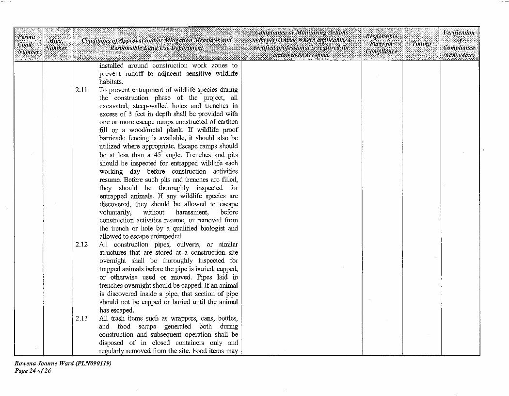
installed around construction work zones toprevent runoff to adjacent sensitive wildlifehabitats .
2 .11
To prevent entrapment of wildlife species durin gthe
construction
phase
of
the
project,
al lexcavated, steep-walled holes and trenches inexcess of 3 feet in depth shall be provided withone or more escape ramps constructed of earthe nfill or a wood/metal plank. If wildlife proofbarricade fencing is available, it should also b eutilized where appropriate. Escape ramps shouldbe at less than a 450 angle . Trenches and pit sshould be inspected for entrapped wildlife eachworking
day
before
construction
activitie sresume. Before such pits and trenches are filled ,they
should
be
thoroughly
inspected
forentrapped animals . If any wildlife species arediscovered, they should be allowed to escap evoluntarily,
without
harassment,
beforeconstruction activities resume, or removed fro mthe trench or hole by a qualified biologist andallowed to escape unimpeded.
2 .12
All
construction
pipes,
culverts,
or
similarstructures that are stored at a construction sit eovernight
shall be thoroughly inspected fortrapped animals before the pipe is buried, capped ,or otherwise used or moved. Pipes laid intrenches overnight should be capped . If an animalis discovered inside a pipe, that section of pipeshould not be capped or buried until the anima lhas escaped .
2 .13
All trash items such as wrappers, cans, bottles ,and
food
scraps
generated
both
duringconstruction and subsequent operation shall bedisposed
of in
closed
containers
only
andregularly removed from the site . Food items may
Rowena Joanne Ward (PLN090119)Page 24 of 2 6

Permitompllance or Monitoring Actions Responsible Verificatio n
Cond.Mitig. Conditions of Approval and/or Mitigation Merl ■ li cs and to be performed. Where applicable, a
Party for Tnnulgof
Number Nlunber Responsible Land Use Department r rtlfiedplofessional is required forCompliance Compliance
a( don to he a(('*/*h'*I . name/date)
attract animals onto a project site, consequentlyexposing such animals to increased risk if injur yor mortality. No deliberate feeding of wildlifeshould be allowed.
2 .14
To prevent harassment, mortality, or unauthorize d"take" of sensitive species and/or their habitat bydomestic dogs and cats, no pets should b epermitted onsite .
2 .15
Night lighting may have an adverse effect o nsensitive habitats and wildlife species near th eproject site. If night lighting is required, thelighting should be directed at the facilities and notat adjacent areas .
2 .16
Impacts
associated with wild
fires
can beminimized
by
maintaining
firefightingequipment
on
site
during
project
relatedactivities . The use of shields, protective mats oruse of other fire preventive methods durin ggrinding and welding activities will prevent orminimize the potential for fire . Personnel shouldbe trained regarding fire hazard for wildlife andtheir habitats .
2 .17
All development activities shall halt if any tak e(harming,
harassment,
pursuing,
hunting,shooting, wounding, killing, trapping, capturing ,or collecting, or any attempt to conduct theprevious), injury, or illness of threatened o rendangered species shall be reported promptlyto the USFWS, CDFG, and Monterrey CountyResources Agency, Planning Department .
These minimization and avoidance measures ar econsistent with measures recommended for other wel lsites permitted in the project area .
Rowena Joanne Ward (PLN090119)Page 25 of 2 6

Conditions of Approval and/or Mitigation Measures andResponsible Land Use Department
Tinting
Compliance or Monitoring Action sto be petfortned. Where applicable, ace'rti fled professional isrequired for
action to hi is rpted.
Verificationof
Complianc e(name/date)
ResponsibleParty fo r
Compliance
Owner/Applicant
The applicant will submit to the RMA-Planning Department photographi cevidence of compliance with thismitigation measure .
CLEAR EXCESS DEBRIS :All equipment, waste, and other construction debri sshall be removed from the site . Disturbed areas outsideof the APE shall be re-vegetated and/or re-graded a snecessary to restore the disturbed areas to their origina lstate in accordance with recommended minimizationavoidance measures and/or the Landscape restorationplan .
Prior t oexpirationof thi spermit orwithin 3 0days ofceasingactivitieswhicheveroccur sfirst .
PermitCond.Number
18 .
Mitig.Number
MM3
END OF MITIGATION S
Rowena Joanne Ward (PLN090119)Page 26 of 26

120 .85000° W 120.63333° W
120 .816x,7° W
WGS84 120.60000' W
!
.l
-f I J
)
-
f
I
-v
'fa ilk
In
O
`, , J\ * * r
. *
*,*
-*
_
1G S
t
\ii
*-- *„ y *
-. I
r) I \l!✓ *.e y
* *
\:. •
tf in ,
*`rf
Y'
8M 941 ir .
. .
y
.v Co-op
..
*-"
*`__
IV
* _
W,
r.=.
vii
mr
**
3 .(\, \*y
PI
1J
oat. n
\
\ \
lU
\.* v*
Z\ 2
Z__*,•'*
*`*
h
\ \1j***1•% `**ti.`* *:<***
!
v
r
t r
}
ti
! "lccess route
7
V,-4 4
-
1 ;
A
aX l*6 .A
.(f -f,/"
+--y d
J
`-`7Cw*rtnl
t
**
*
}(
A
.*% /,1,..-*
A
a
.
t
>v *l -art! 1"'-
1+
t
r r A*
7✓
:,1
d
11
1,
`**.*,
r/
ry/ t„a'
t
-
1 op, c eated-+NItY TO
CnY
. M1lat, .
lI Cv e9raphi
✓ -
y
South Salinas
*-
t""'
R
)*
y1
f
-
*I
**Z
\ -**p
*
'<*\,*
t
** ilr*
('..t *
I l
r
1 -
( U*!*
.1'
`*
A
7i
l*-r-
-P7
l 8
r
ril
120 .85000° W
120 .83333' W 120 .51667° W
WGS84 120 .80000° WIMN
114 °toa ox
am*an
aoar
4010
v»aleer
07/03/09
South Salinas #7-a
Location Map
Robert A. Booher Consulting Venoco, Inc .
6267 Carpinteria Avenue
Carpinteria, California 9301 3
Environmental Planning & Management
3221 Quail Hollow Drive
Fairfield, California 94534 (805) 745-2184
(707) 399-7835

VICINITY AMP875
GRADING PLANFO R
VENOCO, INC. - SOUTH SALINAS 7-A PROJECTMONTEREY COUNTY CALIFORNI A
Yj
424-101-003
424-101-002
424-101-004
424-101-008
424-101-022
]-A HE11 PAD
STNNESFER ROAD,.RICHARD A. STCWESIFFR,
AS SUCCESSOR 7RU57EE FOR( 424-101-027GRNE A. HDAE1TFER1545 GRASS ASS
.LVALLEY HIGHWAY API/45
77940
AUBURN, CA 95603APSE 424-107-012\ Jll RUES
P. \ \
1ACCESS ROAD- \
424-101-02S 424-101-024
PARCEL1(AP1 =1000•
I. Rr.W .DV .D8A .uU1£SS SIONxS SPEOREO FNDiIIlC ALLJX11SWVCII . AND
RW1W.OfMMC COUxiY Of.,SAVRL EOY ILIDARO SPEORCADWf ANA OE1'AD A75557907701 13µ0 SI477407 15,1474 911!1 001500 WIIW70070'4000 5 700 WnAL .1
SOWS CAW AC.
0 ON Im5[J81 65 000! Ara W. All APP...
CWWRCC YICES} INC.. .C . SNAIL
455
LUIOTA6» YARPoÂ(6 71(057SWY 450 PROPER 700 D2 77705 5LW7OPMÂROAIM !IM NOV DC
IFVxô INCA ..It01 ... NCGNNO.NOIS OR ANRISIIRES .Cll uAY O■l6r W 06'PLANS ONANY
IC OIW..B wxxPF[rAIIUN M 4WR(cDCS WLTW. D..SLCWOV9lC
,AWE Alt Naas., SI C`S
AN...WCAIL1.5 Of NOTSPL£AIW.YSNOWI AS SOr5 01..RW.RIO.IED. PR. IOW..
CS... P. PROLI.C Au NmNS rc .1. NLUis.Iw" mPDR°Ri . ACOY0.EIE A. ACC
TAN(RAl RÂUS 74(NÔrW 001£2 ÔRk1.£IrISraw579007774r115VNME DES! L[N(RAL pVACDtI 4 III PFLYAC %° nIA! mr OARWALS AllO
E III£ £50.1£[0 PRIPARWC UIESE PUNS 111110 x01 OC RE4PO1010 P FOR.004IDES ,011444E PLANSu051 DEW ...A. 00DE AffF011W 0077EPRE7A5M OE REW PLAN5 AND DIE 001075.
2 2374677.O.0 A . 070000(57
A . P7r5
x9.
111 W0PAO'
NECESSAR Yl WVIS12 A 7 02 FOR PE 050401 4 2,9014(
CIE 191479. PE.
0504B MRUA.I T C
.ÔIN.4
7SEIN4 ROO*ES DI . DE SECURED NW PAO FOR
COVIwC104 S1Nl RO .Y F6 [ONxrc Ar 1054 16 450.x04 PR.
x54015 RULES9ND RM... RM. .. OC WC[OS*fiI G YC! 7
11E DORN ÂSA. .SDNBE
D PRDAPILY NOWT DIE 771011R. 00440x0 CJ ANY 52051114 rIRrI.'EA rVN.CE27500ÛS 011
re"'" SII isD"° APMSxC 9NuAINr*IOAPoSx
O SIW LA 06RrM.
FFpN.BAR LL NSR
PROJECT DATA TABL ESDUBI OF ./x04 RD.AND NEST OT HIGHWAY 10 1
APPLICANT:
IENOCO, INC6267 CARPINTERIA AIECARRIJ/ERIA CA 93013PHONE (5015) 745-2100RIGFAR0 A. STCWESIFER,AS SUCCESSOR TRUSTEE FORGIEN00LINAE A . STDNE9FER1545 GRASS VALLEY HIGHWAY APT /45AUBURN, 04 95603
.LOT SIZE'
377 A C
LOT COVERAGE
7.65 AC ore .04XLRAOIN*
CUT 2770 Cr FILL 2560 C Y
TREE 004004E
0 TREES
VEGETATION REi10VAL' 1.65 AC GRASSLANDFL000 ZONE:
C - NOT 4IOW4 702-TRFLOOD PLAIN
ZOVINO
PG-40 3 F-40NATURAL CROWD74774 SLOPE GREATERBLW 3004
L0CA11C .
OWNER:
SHEET INDE X
1 . TILE SHEET
2. GRADING AND DRILLING PLAN3. EROSION CONTROL PLAN
S1
424-091-01 7
424-081-018
424-061-019
IA/PROV£NENT PLANSFOR
VENOCO INC. - SOUTH SALINAS 7-A PROJEC T
COUNTY OF MONTEREY CALIFORNIA
TITLE SHEET
DESIGNED BY NUB
DRAWN BY NUB
CHECKED BY NUB
LAUGENOUR AND MEIKL ECIVIL DIOII .YC1111G 1n11DSURVCIIIO•PLN..
REV. DATE DESCR/P700N BY APP'D.
FROU ALVARA00 ROAR DRIVE SOUR, ONHWY. 70I FOR 4.6 WILES TO A D9ITTURNOUT PAST SWAIN VALLEY ROAD.EAST OF CARBON/7E 5I114ESS POSC
ELEV.: 5716' DAR . NATOOB
P.O. 505 054. 7550LAII. . .a1731515 .777. 005:'71304 051_BY
DATE
NEIL U. BU558P.E.1.0.2l EXPIRES0.9
7-9-D9
.r^`ceROADKFI15L2H
RS
. BENCHUAR KDESIGNATIVE SWAN
PIO: 0116701SHEETSCALE
AS SHOWN
OF2960-19>. .7A . COI
DATE' S-IB-09..q 9 NC
2960-19i

• r.,MAwwW *AM GR.. .e ACMMS mClM.O aCA . .I. .AO0 sGM1m14
MM..AMRO PLAN w
u,W4' NM nl[ CpwK SrAROAM SPECIIGPaIf 5(+D
A6 cEMDMRMS CE*L'ME G O. MALI PRIM. AT l1ASIPIHOURSS D011 i10 ME CE4rtcwul OXmEER OrrRMr NEW MR .S£RMMVI A . .IM C
SM11C. ME PRMCOT ODD. MI PAT FOR ME MDST PROIOIIX ME.
6I00R6 LO
DU
PATSLOULEYNEW GT0IS TICC**rsS IAM ACT. Au SOXMFOU Vr RE-rtsrs TIRO R<-wvrcnmz
c r Rnrxom SHALL AInwL AIL since MAM A, AND ELMPYdr NECLSSar 1DADIOI
R Die PIPOSA1 DV (ABU S°
RLYÛEAUSS NA ANTO OR EDP of t 0 HARMLAIMXD DX
. *SSRYY 10 DOLAP BAL x o curl uuqAus4OF ART WAnYtS K .T LCL v
r 0.1 Al =Se= BE FOUR. AT DX '6llCmr ' HURT nL*Y MEW MMMf E
PIE N'IMACiax NULL APPLY OMEA WATER M DINT PAWA ILK.OR RAM FUR
1. Riau TO DN°uAN OF ...TM i IV 1001.S PST DXCSNE P
+â%wAS
oRo vncwsNot MDL
RN 55 ANO •NAA4V N I ST E PS N TND 01 rr,2 MAN: A[[ dR .wIGfHT
I MLLANO EYCAVAiIpI ALwfS 91ALL RE 1'
SS NOO DIHfRM.£
a ALL SCCPW5 AND DEISSA SID. IN MESS PLANS ARC Saar WIDOW M AIRLPREINIAD[E OF ME LRAONO AND DEAWACC 01,3M (PR ME RIDCCr. W ND WAY AREMT WRNGN 10 ROLLET PIE ACMAL CLMSITNTIIOV fEYINHS CC MC FINONa WALLS• WAESS SPLCNGLLY CALLED WT AS '(INSTRUCT ax "RACE' IN PM'S PANS
9N.N4
rwE PIE1VASarA°iz""4s ¢,¢ F0' MEIr'''°"
[ ô¢i mEiiLCit"vs±éEiAnaiE° ALrwAéliâvér âé ADmi•â ciu°rw ûâfsrlwrr Mf
câvmiT.A CL(ARMC 0010000 AND 'RCP ARMS IUPR01IUOYr AREAS
1. RV NC WA F n1IÉ BY I BRÔ WION TOOL MOBAIIO EATIEU w5POSM
MSD AS 10 LUX DIr BN AREAS 0. A
NEAT ADO MOO. APPEARANCE FREE CR. UROR/ MItTMT ODD. E2ATA ..
AEAR1SDYC AMDMIS. LO OXSIDLIOROJO
IS
A, DODD,ol.11YSX A S
ON¢
918 K NIW 1COm MU 0M MLS CIXOICCMOCAI
S..GPDI
SKOOG DM'SI.I
IDUDDAIS
RrfD
lwca hL r,Aa B[ Sn¢PPEO Y IEfi'fn lroV 0.v nnYY 'SfIU MOIU>IN MAI A M4P*CUMC WYNAfO IY
MR. AS . OMEIS K Ai IADW. VPODI CM
M MOOI'Im
A°MMEEDX
DIY PS GAC
E9rinIGHNOI AMOEIE0,
° Armm DAs Faé n 'g, G,ôvlfrn'fmNAE:L Dc
ArTNRED'
sm l nsônrnlu"p4+mGerincEEÔ¢wm
w"r ,''&gA°w-Ve/,cinl Z "A"Au tlf FA«rMLD MIN S4IIAAE 5(A IDM ■S M AttDW.MQ'
WM 1[*IY SPC[YIGnM'S
P DEEIIOIT UIIXOROru muPA°CDCNI Br 11 minor âéPUEnr.
10SA 's ilirnsrûiu"' *r°rnlPAcnwi Hsi .âr[Iirviii sc m
MOD D. PIIM.CR DOM.. OMITnrt 4wslunr canon wmr A,4CYADE Is 1w r4z" N PuWI ne
roe
Ln°LVSE w°li0m"1%ûsNRr cwllNra sin"s(:*Iméor
common. fpu„onn0vf lwx Ml HALE USN nGR(4, uOSMVECw1011ME0
. 1,aY 9IAll DC F0004PACl[D W M[f !0 4*r [cerASiA ism°n,( s m A u'xuw or cn Pracar r n¢ Asw0 33 - I vAANVU ORY 0DI91Y.
If Lu«AD[ 910111 D[âr m naé'r[mi 'nûv o`*AH* xc°YD*°:r ns wFCCn°[ w 5(K
vAIInAA rs DLrWILN As YAICwAI ML «Dlr[m
5a:::'" ÛSNG wi . ,. 0 CPIGPAT MPWU YDSNF F
Ra'[MY Cp4+ACIN nIN nRCVUSIU,fES vMlanI W
o w[c PMM m Lv[G'PMA np. 5(110 nN AMR: W
MM°owr û4Q ue*ôclû.vw°ûi m i n,c v2Pr lEâlû â û4âél: '/ '
p50CAL5AVRAVIRI DOIIiIAEICE r w '%Iif41n*MYMLAI[au[
CCOROEAGL OICMaR
UNn¢ caMACraR•s IXMOOS fox u«vAIMD AM'
DCOIAR. ISIAD r OT
LAYS S TO COPlO VR XDDL R[WNE LPL C.. CA (D !
DRÉ
G["rW
RCC.SSARY SRRECT DC .001 I.
11. RO M['.LL AI&
C'SPOSAL IRISIO 05 DA
ma ..
AODOIDOL=A .DW DYEA. DAN NUT REIXrtVN NR
FNEPAiL ARANw1CO SIMOTADE
sEIDWU«r e.«nu[PNC vAU azwWD'9vAHarfwAt Mr
Rivôû"wsoosAiA.°D°NAÛré1. 1iû âunrirr lôrel niilôâ(nûi Ilk,
âi%nr MO . MIL NOT BC
ROOD . 0.VYY*«fRSCOOR Dar.ASm.rFE
W,RCD BY Ra' pNw6N.
R.
[n r w ANO SUOFVADLLmr fl"' ,",ot g":AA
MOISw PRIXvl' DE PACMS
SN W
GOI LA RRgfl. wnOL v
PA LCx0f FARM
CM
M
a1D¢ Y YIrtD Dw[LV0
9'REAwN 11LI
CPRRLN [LL¢Y 01x0 91AIL MIwPRarO)L av ✓tv:NK 0( 5(A ID.',AL IN GOI GIG.
ûOMfIIWDE ûNRnKL''.gErâ it [d */f1'iPEEJ ' G 91nu
OAE Cp111'xf
1fMioÉ 5*0*âCCFCEO' WUP CIIIÔNr Ô rAgKIN.r MC IYL 401 RÂIÂIr
n00001
DIES SENURE ARE A wMDIE'i&,. O*9n PAS00TR LTV"'
S B?arN nK SroLS [.ri*IWAO[ 914hN **°**ORA I Avnx
MAK *VÂri* s ÂÂ m BP ! iixC nG.[ * W i*Alv[ K
76D
3 5(0111
TO° B- OF SUOGRADE SIIALL BECODPACIED TO APE.AST 95XRELATIVE COUPACLNI AT OR ABOVEO°PEIMI AELYSIURE CONTENT.
- PREPOSED PA D
DOSING GROUND
SEC77ON A-A PROFILE VIEW OF PROPOSED PA D
I11S
EIKLE
•orrLAUGENOUR AND MIK E
°4rL IMPROVEMENT PLANS SCALE SHEETDESIGNED By NUB
DRAM BY
ARCS
~r*uMLA EiiEL
._Dsunv_
.,' ol
a .,,»:
FOR
VENOCO INC. - SOUTH SAUNAS 7-A WELLHEADS"s SNOW
'' 2L-
0F-5( I °°,? °
BYCOUNTY OF MONTEREY
CALIFORNIA 0960-1O7..>A NO,
CHECXED BY NUB SELL U. BUNCH 4
CIl1L
DATE
P.E. R*RS EXPIRf50B/30 OBGRADING AND DRIL L I NG PLAN
DAM
5-a-cm 3(.*REV. DATE DESCRIPTION BY APPU. ,XN Na
Y9R0-)97

LEGEND:
upT tK cWb+c 11:1 GRAM .
WEI. MP RUES
()STABILIZED CONSTR UCTION ENTRANC E
i.!: *é ail I !
,'*J +1* M1m rwu:/ -Lr v'vasuH
FAru[Kr
0739$? CCNTROL BLANWEIPER 0405801MSTORAIW HER O01114 YASSOTAIIOVI Sr$4AIN'A1ERBEST NANAGEJIENF%MOTILE ILWDBUIH• EC-7.
EROSION CONTROL PLA N
'SMSCALE: V.30'
CF1B•
I4ECt ROLL (50AW WA11LE) B' MDR .D Z•
RF DNA. A 05 4110. LENGT1. ERR BUTT*3 -- * -N• ENDS DR ROLLS 105E7HER- DO IRA
OVERLAP.
0
m°;';'."s*-m.°L %small as rus Iota nLat Dwuv„ r,LU+*
sER w-nl.um) D.zn nPl), 4pi*aôâ,oK*1°o.'UI *i
EROSION AND SEDIAIENTATAON CONTROL NOTES1. EMBOLI AND SEDIMENTATION CONTROL MEASURES SHALL BE EFFECTIVE FO RCONSTRUCTION DIMS. THE RAINY SEASON (OCTOBER 15 TO APRIL 15) ANDREADILY AVAILABLE FOR ANY PROECTED STORM S
2. SHOULD THE PROPOSED 01511E 51011 DRAM ST51FM NOT BE IIISTAIIEO D YOCTOBER 145, TIAAORARY SEDIMENO BASINS SHALL BE CAISIRUCIED AROUIID 111 EDPEH1115 OF ANY MISTING STORM PIPES 0111011 DRAMS ME 914 E
3. DIE NAME. ADDRESS AND D4 FOUR 1ELEPIICIIC NUUDER OF TIDE CDIJIRACTCR' SREPRE5ENIATVE RESPONOBI .E FOR IOPI.EMEIJTA11CN OF 111E EROSION AN DSEDILIENTATIOH OOJIROL PLAIT SHALL BE PROMOED .
4. A MINIMUM OF SD' OF ORION 110a. S'-6• DIMICTER. AT A MINIMUM DEPTH OF12•, SHALL BE INSTALLED AT EACH DRIVEWAY ENT1AICE 10 THE 041E. MIS DOESNOT NEED TO BE DONE AT DRIIEWAIS WNIC1 MilL BE CLOSED BY IMMOVABLEBARRICADES CURIO CONSTRUCTOR .
5. ALL ER04011 AND SEDIMENTATION CG'I1RDL MEASUR E S SHALL BE MAINTAINE DUITL D0NRCEO AREAS ARE SIADIUZEO. CHANGES TO 7HE EROSION ANDSRIMONTATON CONTROL PIAII SHALL BE MADE TO IAEET TlEID COHOIRDNS . E:1 TONLY 11111 THE APPROVAL OF OR AT THE DIRECTOR OF 111E COUNTY EICNEER .
8. DURING THE RAINY SEA5011 SPECIFIED III 1107E I. ALL PAVED AREAS SHALL BEKEPT CLEAR OF EARTH MATERIAL 010 DEBRIS. 111E SITE SHAH . SE MAINTAINEDSO AS TO MINIMIZE SEDIMENT LADEN RUNOFF FROM ENTERING ANY 510111DRAINAGE 5TSILIA ,
7. TAIL ER05DB NN SEDIMENTATION COINIROL PENT COVERS ONLY 111E FIRS TWINTER DURING MIN CONSTRUCTION IS TO TAKE PLACE PLANS APE TO O EREBUBMITI0O PRIOR TO SEPTELIBER 1 OF EACH SUBSE0UBIT YEAR UN11L THE SIT EIIIPROVEIAENIS ARE ACCEPTED BY THE CUUIIY.
B . 114E CUNIRA010R SNAIL 11104 4101 0110 REPAIR AIL 0000401 101111101FACOTES AT TIE END OF EACH WORK DAY 01111410 THE 101111 SEASON .
D. TIIE CONTRACTOR SHALL PROTECT IEMP04154 ' SORROW AREAS HO/ERSTOCKPILES 14TH APPITDPR4A1E ER051 g1 CONTROL MEASURES SATISFACTORY TOTHE COUNTY EN0 :NEER.
10. TIE CLEANING OR PAVED STREETS . 01144100 ARID AT TIIE COMPLET0N C FCONSTRUCTION, SHALL BE PERFORMER All MECHANICAL SWEEPERS . THE USE CFWAIST TRUCKS TO 'WASH DOWN' THE STREET IS PRO11EITM . VEHICLES SHALL BECLEAVED 50 AS TO NOT TRACK MATERIAL INTO CITY STREETS. TIE CONTRACTORSHALL SWEEP COUNTY ROADS stria 50E OF CONSIRHGTGII SITE A 111114UM CFO41CE A WEEK OR AS REQUIRED BY 114E COUNTY ,
I1 . THE CONTRACTOR SHALL NOT 0151UNR AREAS OUI0DE OF TIIE 1000114 0ULIIIS WIMIXNT PRIOR APPROVAL OF -am 10041TY Ol4IIEE4 . AU. CONS4TRICIIO4MATERIAL STORAGE AREAS SHALL BE APPROVED BY THE COUNTY EIIGINEER PRIO RTD WORK
12. 01A0141G MALL NOT OCCUR 111)34 RNO SPEEDS EXCEED 2D MFII 0\ER AONE (1) HOUR FERIM.
13. THE CONTRACTOR 91ALL PROVIDE FOR THE NLE010110J OR P105£N11O1 OF00514 10115110E RESULIINO FROM THE CONTRACTOR'S PERFORMANCE OF 144E W01O (AND/OR FROM PUBLIC TRAFFIC PASONC 1411011011 THE WORK AREA .
IN. WATER FOR OUST C0I110L MALL BE BY A MOVIE UNIT 111111 A 0100 .11100APAOW OF 1,000 GALLONS. APPLICATOR $41ALL BE MADE AT (FAST TWIC EDAILY (MID-MORISIJC AND LATE AFIERNOOI) INCLUDING 1101-WORI(IHC DAYS UNO L141E ASPiIALT HAS BLOT PLACED OR MMAL . GRADING HAS BEEN COMPLETED II IAREAS ?MERE MERE 15 NO ASPHALT TO BE PLACED . WATER APPLICATION SHALLNOT BE EXCESSVE 50 AS 10 PRODUCE EROSION.
15. 04 EONTRACTCN SMALL DE RESPONSIBLE FOR 114E PLACEMENT O FTEMPORARY EROSION CONTROL MEASURES DETAILED HEREON . TWO (2) WEEK SGEFORE TIE 555T PROJECTED RA11 OR AS DIRECTED BY 111E COx4TT MOWER .THE CCNT4AC10R S11ALL REMOVE TIE IAJPORARY MEASURES UP044 FINAL000085ANCE OF 114E IMPRAV'BlIIIS OR AFTER 1110 IIPJTAUTICN Of AN YPERMANENT LIEASURLS.
16. INSTAL STRAW 11111[11 PER EC-6 S ODER ROLLS PER 5E-5 (CALIF0RNI 0510104 WRIER SOP HA0000K) ON 141E CUT/FILL MOPES Arlo DISIUREEO AREAS .SEE MOTE 24.
17. A DRIXJGI4T T00EitANT WEED TREE 111X OF NAME AND 41011-IIATVE GRASSE SDR AN ALTERNATE EROSION CONTRC . MEASURE APPROVED BY TIE P11IN140 AN DPUBLIC wags DIRECTOR SHALL BE ESIABN5IED ON ALL OF 111E OISRIRRE DSLOPES PRIOR TO NOVEMBER 1 OF EACH YEAR .
40. ALL DISTURBED AREAS MALL SE 14JEATEO 4 .1114 EROSION CONTROL 14444E 1 0PEI CAL TRANS SPC0FICAl10N5 .
DESIGNED BY ruBLAUGENOUR AND ME IKLE
ASIUPROVE
TPUNS
FORSCA[E SHEET
-
DRAWN BY Mg_ - --
r llRi-.il"iBWÉTB"::'Ri. iTIIE
.. 3'TR Eiii EE603
ORI El■Ar
L
ER HAT"' . '°""°""'" °"' A
ISM) II1-HAY..° .
.
.
Rn1A .me -TAT :
.u- .
r,,.PA AEA
M ,
ROU+A VENOCO INC. - SOUTH SAUNAS 7-A WELLHEADSn 55i10HN 3_
- 1 •`... a4/AUAw COUNTY OF MONTEREY CALIFORNIA 2063- :aA. PA .1O3CHECKED BY :NUB BY •/NEE $ Baal DA 7E•
5-L0-Wi 3-
REV. DATE DESCRIPTION
_
BY
__
APPS. DAIS
AE.ssms E.smaESOB/30 0B EROSION CONTROL PLAN ,A* N$
25 :0- 19 tF

` SOUTH COUNTY% ; ; .'
/c
co : ;11 ,,
.,, . *.
i
-1 -
* . - r
✓pCpN RDs
G'HO*
\ f D
1*..` *... * %
i ,-
--- BRADLEY
1
* ' rrch.
hid5* .w
ey
,6 i. .
\
r ^
^;
1
l';s►
'•'•'
1
*ra *--_ BRADLEY RD
Wj
a D
l
' Z2QZ
*.. ' 1
/
. . . ._
* *.•ij
Er :
:OI
i1
.
*,,1
•\
.*.\
2'i
!
•l
Ico i
/-•\\ \
APPLICANT: VENOCO / WARD-STONESIFER SO SLN #7 N
A
*°vNx*.* c
F
quoAPN: 424-101-023-000
FILE # PLN0901190
2,000 .o
*_ i 300' Limit_*IIIIIII1'I
41850'
_' i r city Limits2500' Limit
_ *,_ F eet