Embed Size (px)
Citation preview

1
2 3 4 5 6 7 8 9
10 11 12 13 14 15 16 17 18 19 20 21 22 23 24 25 26 27 28 29 30 31 32 33 34 35 36 37 38 39 40 41 42 43 44 45
BEFORE THE LAND USE BOARD OF APPEALS
OF THE STATE OF OREGON
WAYNE B. KINGSLEY and CRAIGIVAR INVESTMENTS, LLC,
Petitioners,
vs.
CITY OF PORTLAND, Respondent,
and
BICYCLE TRANSPORTATION ALLIANCE,
Intervenor-Respondent.
LUBA No. 2007-142
SHAWN KARAMBELAS and SK NORTHWEST,
Petitioners,
vs.
CITY OF PORTLAND, Respondent,
and
BICYCLE TRANSPORTATION ALLIANCE,
Intervenor-Respondent.
LUBA No. 2007-143
FINAL OPINION AND ORDER
Appeal from City of Portland. Steve C. Morasch, Vancouver, Washington, filed a petition for review and argued on behalf of petitioners Wayne B. Kingsley and Craigivar Investments, LLC. With him on the brief was Schwabe Williamson & Wyatt PC. Richard H. Allan, Portland, filed a petition for review and argued on behalf of
Page 1

1 2 3 4 5 6 7 8 9
10 11 12 13 14 15 16
petitioners Shawn Karambelas and SK Northwest. With him on the brief were Megan D. Walseth and Ball Janik LLP. Peter A. Kasting, Chief Deputy City Attorney, Portland, filed a response brief and argued on behalf of respondent. Christine M. Cook, Portland, filed a response brief and argued on behalf of intervenor-respondent. BASSHAM, Board Member; HOLSTUN, Board Chair; RYAN, Board Member, participated in the decision. REMANDED 11/08/2007 You are entitled to judicial review of this Order. Judicial review is governed by the provisions of ORS 197.850.
Page 2
1
2
3
4
5
6
7
8
9
10
11
12
13
14
15
16
17
18
19
20
21
22
23
24
25
26
Opinion by Bassham.
NATURE OF THE DECISION
Petitioners appeal a hearings officer’s decision that denies an application for a
Willamette Greenway permit to develop a 1.8-acre riverfront parcel.
MOTION TO INTERVENE
Bicycle Transportation Alliance (intervenor) moves to intervene in both appeals on
the side of respondent. There is no opposition to the motions, and they are allowed.
FACTS
Petitioners seek to develop a vacant 1.8-acre riverfront parcel with a two-story
building, parking/loading area and a dock, as a site for a jet ski retail and repair business.
The parcel is located on the east bank of the Willamette River, and is zoned Heavy Industrial
and Greenway River General, due to its location within the Willamette Greenway. The
property is at the foot of SE Division Place, which provides the only vehicular or pedestrian
access to the site. North of the site is a dock facility that petitioners also own, and a
greenway trail that travels north along the river from the foot of SE Caruthers. The
greenway trail now leaves the river and travels east along SE Caruthers and south along SE
Fourth Avenue, around the subject property, and returns to the greenway south of the
property. South of the site is vacant lot that is under development review for a proposed
multi-story building, dock and greenway trail extension.
In 2005, petitioners filed an application for similar development, which the hearings
officer denied based on lack of evidence to demonstrate that the development would not
result in significant loss of biological productivity in the river, under the city’s Willamette
Greenway Design criteria. In that 2005 decision (which the decision and parties refer to as
the “SK#1” decision), the hearings officer also made two other relevant determinations.
First, the hearings officer agreed with petitioners that Portland City Code (PCC) 33.272.020,
which requires that development applicants grant a greenway trail easement, is
Page 3

unconstitutional on its face.1 Second, the hearings officer accepted petitioners’ proposed
method of determining the “top of the bank,” which determines the location of the required
development setback from the river.
1
2
3
4
5
6
7
8
9
10
11
12
13
14
15
16
17
18
19
20
21
22
Petitioners did not appeal the 2005 decision, but instead filed a new application for a
slightly revised development, with additional evidence to address the two bases for denial in
the 2005 decision. However, planning staff denied the second application because
petitioners declined to dedicate an easement for the greenway trail segment, as required by
PCC 33.272.020. Petitioners appealed the staff denial to the same hearings officer who
issued the 2005 decision. After a hearing, the hearings officer denied the second application,
on two grounds. With respect to the greenway trail easement, the hearings officer concluded,
contrary to his earlier determination, that PCC 33.272.020 is not facially unconstitutional.
The hearings officer then addressed whether PCC 33.272.020 as applied to the proposed
development is unconstitutional under Dolan v. City of Tigard, 512 US 374, 114 S Ct 2309,
129 L Ed 2d 304 (1994). The hearings officer concluded that the greenway trail dedication is
“roughly proportional” to the impacts of the proposed development, and that the required
dedication is consistent with the analysis required by Dolan.
In addition, the hearings officer denied the second application because petitioners
proposed to place a portion of the building within the 25-foot setback from the “top of the
bank.” In making that determination, the hearings officer accepted the method for
determining the top of the bank proposed by planning staff and, contrary to the 2005
decision, rejected petitioners’ method for determining the location of the top of the bank.
This appeal followed.
1 PCC 33.272.020 provides, in relevant part:
“All applicants for a land use review or for building permits on lands designated with a recreational trail symbol on the zoning map are required to grant an easement for the recreational trail. The easement must be done as part of recording a land use review and finalized prior to obtaining a final certificate of occupancy. * * *”
Page 4

INTRODUCTION 1
2
3
4
5
6
7
8
9
10
11
12
13
14
15
16
17
18
19
20
21
22
23
24
25
26
The assignments of error presented in the two petitions for review overlap
considerably, and we address them together where appropriate. Where we address
assignments of error together, references to “petitioners” means the petitioners in both
appeals, unless stated otherwise.
It is also worth noting at the outset that with respect to the constitutionality of PCC
33.272.020, both sets of petitioners argue only that the code provision is facially
unconstitutional. Petitioners do not challenge the hearings officer’s “rough proportionality”
findings under Dolan, and petitioners Kingsley expressly acknowledge that they “do not
raise any ‘as applied’ Dolan arguments before LUBA.” Kingsley Petition for Review 18, n
6. Thus, to the extent it is relevant we assume for purposes of our opinion that the hearings
officer’s “as applied” findings are adequate and supported by the record. In other words, we
assume the greenway easement dedication and other requirements of PCC 33.272.020 are
“roughly proportional” to the impacts of the proposed development, and that that exaction as
applied to petitioners’ property is consistent with the Dolan rough proportionality
requirement.
FIRST ASSIGNMENT OF ERROR (Kingsley)
Petitioners argue that the city is bound by the two determinations the hearings officer
made in the 2005 decision denying the first application, specifically that (1) PCC 33.272.020
is facially unconstitutional and (2) the location of the “top of bank” is determined by the
method or interpretation proposed by petitioners. According to petitioners, because no party
appealed the 2005 decision, the city and all other interested persons are bound by those two
determinations, and those determinations cannot be “collaterally attacked” in the present
decision.
The hearings officer disagreed with that position when presented below, adopting a
series of findings explaining why, in the hearings officer’s view, the findings in the 2005
Page 5

decision regarding the facial constitutionality of PCC 33.272.020 and how to determine the
location of the top of the bank do not preclude the city from reaching different conclusions in
considering petitioners’ new application.
1
2
3
4
5
6
7
8
9
10
11
12
13
14
15
16
17
18
19
20
21 22 23 24 25
The hearings officer’s analysis relied heavily on Lawrence v. Clackamas County, 40
Or LUBA 507 (2001), aff’d 180 Or App 495, 43 P3d 1192 (2002). In Lawrence, LUBA
considered whether the doctrines of claim and issue preclusion apply to land use
proceedings.2 At issue in Lawrence was a hearings officer’s decision denying an application
to verify a go-kart track as a lawful nonconforming use. In an earlier decision, the county
had denied an identical nonconforming use verification application, after concluding that use
of the go-kart track had been abandoned between the years 1969 and 1971, making continued
use of the track was unlawful. Following that decision, the statutes governing
nonconforming use verifications were amended to alter the burden of proof, and the applicant
filed a new application to verify the go-kart track under the amended statute. However, the
hearings officer applied the principle of issue preclusion, and denied the application, finding
that the earlier denial precluded the applicant from relitigating the issue of abandonment.
LUBA remanded, concluding that issue preclusion does not generally apply to local
land use proceedings. That conclusion was based on the fifth of five requirements set out in
Nelson v. Emerald People’s Utility Dist., 318 Or 99, 104, 862 P2d 1293 (1993), and an
earlier LUBA opinion, Nelson v. Clackamas County, 19 Or LUBA 131 (1990). We
summarized the Nelson requirements as follows:
“When an issue has been decided in a prior proceeding, the prior decision on that issue may preclude relitigation of the issue if five requirements are met: (1) the issue in the two proceedings is identical; (2) the issue was actually litigated and was essential to a final decision on the merits in the prior proceeding; (3) the party sought to be precluded had a full and fair
2 As we explained in Lawrence, claim preclusion bars relitigation of claims that were previously decided or
could have been decided in a prior proceeding. Issue preclusion bars relitigation of an issue in subsequent proceedings, where the issue was resolved in a valid and final prior proceeding. 40 Or LUBA at 518.
Page 6
1 2 3 4 5
6
7
8
9
10
11
12
13
14
15
16
17
18
19
20
21
22
23
24
25
26
27
opportunity to be heard on that issue; (4) the party sought to be precluded was a party or was in privity with a party to the prior proceeding; and (5) the prior proceeding was the type of proceeding to which preclusive effect will be given. Nelson v. Emerald People’s Utility Dist., 318 Or at 104.” 40 Or LUBA at 519.
Addressing only the fifth requirement, we affirmed our previous conclusion in Nelson v.
Clackamas County that Oregon’s system of land use adjudication is “incompatible with
giving preclusive effect to issues previously determined by a local government tribunal in
another proceeding.” Id. at 520, quoting Nelson v. Clackamas County, 19 Or LUBA at 140.
In other words, we held that land use proceedings in general are not “the type of proceeding
to which preclusive effect will be given.”
The Court of Appeals affirmed our decision in Lawrence, but on different, narrower
grounds. The Court declined to “decide the broad question of whether local land use
decisions are the type of decisions to which preclusive effect may be accorded,” because, the
Court concluded, the first Nelson requirement (the issue in the two proceedings is identical)
was not met in Lawrence. According to the Court, the intervening statutory change made the
issue of abandonment during the period 1969 to 1971 irrelevant, and therefore the issues in
the two proceedings were not identical.
In the present case, the hearings officer discussed the Lawrence opinions and
concluded that the second and the fifth Nelson requirements are not met in this case.
Specifically, the hearings officer found that the issues of facial constitutionality and how the
top of the bank is determined were not “essential to a final decision on the merits” of the
2005 decision, because the 2005 application was denied based on noncompliance with other,
unrelated Greenway Design standards. The hearings officer also concluded under the fifth
Nelson requirement that the 2005 decision was not “the type of proceeding to which
preclusive effect will be given,” because the 2005 decision was a denial of an application,
not an approval.
Page 7

1
2
3
4
5
6
7
8
9
10
11
12
13
14
15
16
17
18
19
20
21
22
23
24
25
Petitioners challenge both conclusions. Because we agree with the hearings officer
that the second Nelson requirement is not met, we do not address the parties’ contentions
regarding the fifth requirement.
The hearings officer reviewed the relevant findings from the 2005 decision at length,
and concluded that neither the facial constitutionality nor the top of the bank determinations
in the 2005 decision “formed the basis of the ultimate decision.” Record 4. According to the
hearings officer, because neither determination was a reason for denial, and the application
was denied on other grounds, neither determination was “essential to a final decision on the
merits.”
Petitioners argue, however, that the facial constitutionality issue was essential to a
final decision on the merits, because it “was needed to guide the Hearings Officer on how to
apply the approval criteria” that were the basis for denial. Kinglsey Petition for Review 12.
However, petitioners do not explain what relationship the greenway trail dedication has to
the two design standards under which the hearings officer denied the 2005 application. One
basis for denial involved a requirement for separation and screening of parking, loading,
trash dumpsters and similar exterior facilities. The other involved lack of evidence showing
that the proposed private dock would not “result in the significant loss of biological
productivity in the river.” As far as petitioners have established, neither basis for denial has
anything to do with the greenway trail dedication.
With respect to the “top of bank” issue, petitioners make no argument that that issue
had anything to do with the two bases for denial or that it was “essential to a final decision
on the merits.”
We agree with the hearings officer that petitioners have not demonstrated that the
second Nelson requirement is met with respect to either the facial constitutionality or top of
the bank issues. A legal conclusion in a decision denying an application on grounds
Page 8
1
2
3
4 5
6
7
8
9
10
11
12
13
14
15
16
17
18
19
20
21
22
23
24
25
26
27
unrelated to that legal conclusion is not “essential to a final decision on the merits” of that
application. DeBoer v. Jackson County, 46 Or LUBA 24, 37-38 (2003).
The first assignment of error (Kingsley) is denied.
FIRST ASSIGNMENT OF ERROR (Karambelas) SECOND ASSIGNMENT OF ERROR (Kingsley)
In these assignments of error, petitioners argue that the hearings officer erred in
applying the greenway trail dedication requirement at PCC 33.272.020, and related
provisions, which petitioners contend are facially unconstitutional.
PCC 33.440.240(B), part of the city’s Greenway Overlay zone regulations, provides
that “[a]ll sites with a public recreational trail symbol shown on the Official Zoning Maps
must comply with the requirements of Chapter 33.272, Public Recreational Trails * * * and
meet the trail design guidelines contained in the Willamette Greenway Plan.” As noted,
PCC 33.272.020 requires that “[a]ll applicants for a land use review or for building permits
on lands designated with a recreational trail symbol on the zoning map are required to grant
an easement for the recreational trail.” PCC 33.272.030 requires, in certain circumstances,
that the applicant must also construct a trail on the easement. PCC 33.272.030(D) governs in
the present case, and requires the applicant for new development in a non-residential zone to
construct the trail improvements.
In the 2005 decision, the hearings officer opined that the PCC 33.272.020,
33.272.030, and 33.440.240 requirements to grant an easement and construct a trail are
facially unconstitutional, because read literally the regulations appear to require an exaction
of property in all circumstances involving development of property designated with a
recreational symbol on city maps, without expressly granting the city review body discretion
to conduct the analysis of impacts and rough proportionality required by Dolan to ensure that
such exactions do not run afoul of the takings clause of the Fifth Amendment of the United
States Constitution. Petitioners argue that that conclusion was, and is, correct, and that
PCC 33.272.020 and related provisions are facially unconstitutional.
Page 9

Petitioners first note that PCC 33.700.070(A), which includes the “general rules for
application of code language,” requires that “[l]iteral readings of the code language will be
used.”
1
2
3
4
5
6
7
8
9
10
11
12
13
14
15
16
17
18
19
20
21
22
23
3 Thus, petitioners argue, the city code mandates that the hearings officer apply the
terms of PCC 33.272.020 literally. According to petitioners, read literally PCC 33.272.020
requires that “all” applicants for development on lands designated with a recreational trail
symbol on the zoning map must grant an easement for the recreational trail, with no explicit
provision for circumstances where such an exaction would not be permitted under Dolan.
Similarly, petitioners argue that PCC 33.700.070(D)(2)(c) provides that the term
“must” is mandatory. Therefore, petitioners argue, the PCC 33.440.240 requirement that
“[a]ll sites with a public recreational trail symbol shown on the Official Zoning Maps must
comply with the requirements of Chapter 33.272, Public Recreational Trails” is mandatory.
According to petitioners, nothing in the city’s code grants the city any discretion to conduct a
Dolan analysis with respect to the greenway trail requirements or, on the basis of such an
analysis, to modify or waive those mandatory requirements in any way.
As petitioners acknowledge, the general standard for reviewing claims that legislation
is unconstitutional on its face is whether the legislation is incapable of any constitutionally
permissible application. Lincoln City Chamber of Comm. v. City of Lincoln City, 164 Or App
272, 991 P2d 1080 (1999) (upholding regulations requiring applicants to submit information
to be used in determining whether an exaction is “roughly proportional” to the impacts of
development under Dolan). Petitioners contend that PCC 33.272.020, 33.272.030, and
33.440.240 are incapable of any constitutionally permissible application, because in no
circumstances do they allow the city to conduct the constitutionally required Dolan analysis.
According to petitioners, the unconstitutionality of the relevant code provisions can be
3 PCC 33.700.070(A) provides, in relevant part:
“Literal readings of the code language will be used. Regulations are no more or less strict than as stated. * * *.
Page 10

remedied only if the city adds “a code provision that expressly requires a Dolan analysis
before undertaking an exaction.” Kingsley Petition for Review 20.
1
2
3
4
5
6
7
8
9
10
11
12
13
14
15
16
17
18
19
20
21
22
23
24
25
Petitioners Kingsley et al. also argue that petitioners may challenge the facial
constitutionality of the greenway dedication provisions even if those provisions can be
constitutionally applied in some circumstances, pursuant to the “overbreadth” doctrine. In
State of Oregon v. Hirsch, 338 Or 622, 114 P3d 1104 (2005), the Oregon Supreme Court
described the overbreadth doctrine as a particular type of facial constitutional challenge, in
which the challenger contends that, although a statute constitutionally could apply in some
circumstances, it impermissibly and necessarily infringes on a constitutional guarantee in
other circumstances by “prohibiting conduct that is constitutionally protected.” Id. at 628.
According to the Court, a challenger appropriately raises a claim of overbreadth where a
statute “purportedly contravenes a constitutional provision that delineates protected
conduct.” Id. In the present case, petitioners assert that the city greenway dedication
provision “purportedly contravenes a constitutional provision that delineates protected
conduct.”
The city responds, and we agree, that the Supremacy Clause of the United States
Constitution, if nothing else, requires the city to conduct a Dolan analysis to justify any
exaction of property, and that petitioners cite to no constitutional or other requirement that
local codes must first be amended to expressly authorize or require the city to comply with
Dolan. Many local development ordinances legislatively mandate specified exactions as part
of development approval, such as dedication of land for internal or adjacent roads or
sidewalks serving a proposed subdivision. At the time Dolan was decided it is likely that
few, if any, of those ordinances expressly authorized or required an analysis of
proportionality between the exaction and the proposed development. Under petitioners’
view, following Dolan all such ordinances immediately became facially unconstitutional,
Page 11
unless and until the local governments amended the ordinances to expressly authorize a
Dolan analysis.
1
2
3
4
5
6
7
8
9
10
11
12
13
14
15
16
17
18
19
20
Indeed, like the PCC provision at issue here, the ordinance at issue in Dolan
mandated that the development applicant dedicate land located in a floodplain to the city for
a greenway pedestrian/bicycle path.4 As far as we can tell, nothing in the City of Tigard
development ordinance in effect at that time expressly authorized or required the city to
conduct a proportionality analysis of any kind. The city presumably did so (inadequately, it
turned out), because judicial precedent required an analysis, under the then-controlling
“reasonable relationship” test articulated by some state and federal courts. In reversing the
Oregon Supreme Court, the U.S. Supreme Court did not declare Tigard’s regulation
mandating an exaction invalid or facially unconstitutional. Instead, the Court held that the
city’s findings were inadequate to justify the exaction, under the newly-articulated rough
proportionality test. The Court remanded the decision to the Oregon Supreme Court for
further proceedings not inconsistent with its opinion and, in turn, the Oregon Supreme Court
remanded the decision to the City of Tigard for further proceedings. Nothing cited to us in
Dolan or elsewhere suggests that the City of Tigard needed express code authority to conduct
the required rough proportionality analysis or that, absent such express authority, the code
provision at issue was invalid or constitutionally infirm.
Following Dolan, some local governments amended their code to expressly require a
Dolan analysis to justify exactions imposed under local development ordinances, such as the
4 The Tigard Community Development Code (TCDC) at issue in Dolan provided as follows:
“Where land fill and/or development is allowed within and adjacent to the 100-year floodplain, the City shall require the dedication of sufficient open land area for greenway adjoining and within the floodplain. This area shall include portions at a suitable elevation for the construction of a pedestrian/bicycle pathway within the floodplain in accordance with the adopted pedestrian/bicycle plan.” TCDC 18.120.180(A)(8).
Page 12
legislative amendments at issue in Lincoln City Chamber of Comm.. However, not all local
governments have done so. Petitioners cite no authority that would require the city to amend
its code to expressly require or authorize the Dolan analysis, that is required under the Fifth
Amendment and the Supremacy Clause, or that suggests that code provisions requiring
exactions are facially unconstitutional in the absence of such express authorization.
1
2
3
4
5
6
7
8
9
10
11
12
13
14
15
16
17
18
19
20
21
22
23
24
25
26
Petitioners’ arguments that the greenway dedication provision is overbroad are also
unpersuasive. As the city notes, the overbreadth doctrine has been applied to laws that
regulate or prohibit certain constitutionally protected “conduct,” such as speech, the right to
assemble, and the right to bear arms. It is not clear to us, and petitioners do not explain, why
the federal Takings Clause protects “conduct” in the same sense that the federal and state
constitutions protect free speech, the right of assembly and the right to bear arms. The
Takings Clause obligates government to pay just compensation when taking property or,
stated differently, prohibits the government from taking private property without just
compensation; it does not delineate any protected conduct per se. Further, to “purportedly
contravene” a prohibition such as the Takings Clause, the city’s ordinance would presumably
have to authorize the taking of property without providing just compensation. The city’s
ordinance does not purport to do so. Petitioners cite no cases that have applied an
overbreadth analysis to laws that are challenged under the Takings Clause, and we are aware
of none.
In any case, even if an overbreadth challenge can be advanced under the Takings
Clause or under Dolan against the city’s greenway dedication requirement, petitioners have
not demonstrated that the greenway dedication requirement is overbroad. As explained
above, nothing in the city’s code or elsewhere prohibits the city from applying a Dolan
analysis prior to requiring a greenway dedication. In fact, all parties acknowledge that the
city is required by controlling federal law to conduct such an analysis in all cases involving
exactions under that code provision. For all petitioners have demonstrated, the city in fact
Page 13
conducts a Dolan analysis in all cases involving the greenway dedication requirement, as it
did in the present case. The fact that the city’s code does not expressly require such an
analysis does not mean that the greenway dedication requirement is overbroad, i.e., that it
impermissibly and necessarily infringes on a constitutional guarantee by “prohibiting
conduct that is constitutionally protected.” Hirsch, 338 Or at 628.
1
2
3
4
5
6
7
8
9
10
11
12
13
14
15
16
17
18
19 20
21
22
23
24
25 26 27
Petitioners’ point may be that, although the city may in all cases conduct a Dolan
rough proportionality analysis, in some circumstances the results of that analysis will be that
the impacts of the proposed development do not justify an easement dedication. We
understand petitioners to argue that the greenway dedication requirement is facially
unconstitutional because in such circumstances the code still mandates a full easement
dedication for the greenway trail, regardless of Dolan and the outcome of the city’s analysis.
However, PCC 33.272.020 on its face says nothing about what the city does after conducting
a Dolan analysis and certainly does not state on its face or even by implication that the city
must impose an exaction that the city has determined is not justified under Dolan.
For the foregoing reasons, we disagree with petitioners that PCC 33.272.020 is
facially unconstitutional.
The first assignment of error (Karambelas) and the second assignment of error
(Kingsley) are denied.
SECOND ASSIGNMENT OF ERROR (Karambelas) THIRD ASSIGNMENT OF ERROR (Kingsley)
Under these assignments of error, petitioners challenge the hearings officer’s
determinations regarding the location of the “top of bank.”
The 25-foot greenway setback is determined from the “top of bank,” which
PCC 33.910.030 defines as follows:
“The first major change in the slope of the incline from the ordinary high water level of a water body. A major change is a change of ten degrees or more. If there is no major change within a distance of 50 feet from the
Page 14

1 2
3
4
5
6
7
8
9
10
11
12
13
14
15
16
17
18
19
20
21
22
23
24
25
26
27
ordinary high water level, then the top of the bank will be the elevation 2 feet above the ordinary high water level.”
Thus, under PCC 33.910.030 the top of the bank is either (1) the first major change
within 50 feet of the high water line, or (2), if there is no major change within the 50 feet, the
elevation two feet above the high water line. The parties agree that the high water line in this
case is located at an elevation of 18 feet above sea level.
As explained above, in the 2005 decision the hearings officer concluded that the
method the applicant’s engineer used to determine the top of the bank for the subject
property was reasonable. The hearings officer noted that planning staff disagreed with that
method and proposed a somewhat different location for the top of the bank, but failed to
explain how staff determined its preferred location.
In the present application, petitioners submitted the same information to determine
the location of the top of the bank that the hearings officer accepted in the 2005 decision.
Petitioners’ engineer conducted a topographical analysis based on seven cross-sections of the
riverbank at seven points on the subject property. For five of the cross-sections, the engineer
located a “major change” in the slope within 50 feet of the high water line, and thus
determined the top of the bank for the majority of the riverbank based on the elevation of that
major change. The top of the bank elevations for these five cross-sections generally follow
contour lines between 30 feet to 40 feet above sea level. However, two of the cross-sections
showed the first major change (>10 degrees) occurring beyond a distance of 50 feet from the
high water line, at 50 feet, 2 inches in one case and 55 feet, one inch, in another.
Accordingly, the engineer determined the top of the bank for those two portions of the
riverbank based on an elevation two feet above the high water line, which corresponds to
contour lines at around 20 feet above sea level.
The result of the engineer’s analysis is that the top of the bank and the corresponding
greenway setback line is disjointed along the riverbank. For most of the riverbank on the
property, the top of the bank lies approximately at elevation 30 to 40 feet. At two points,
Page 15
1
2
3
4
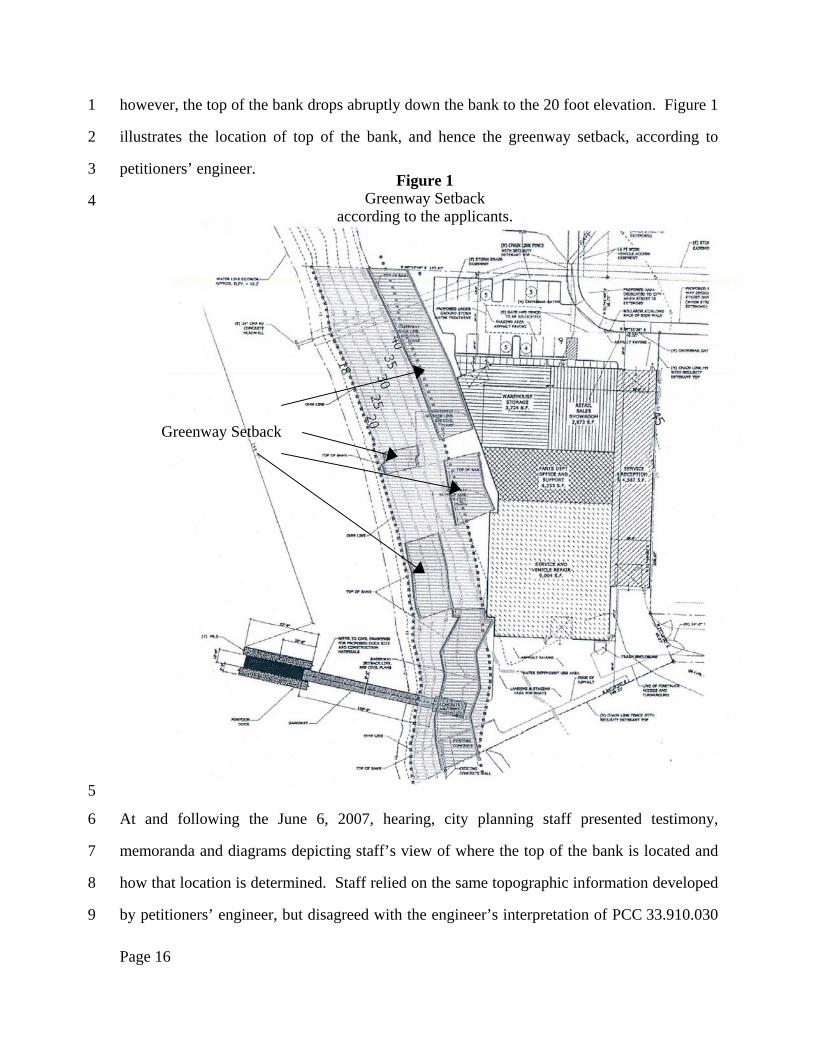
however, the top of the bank drops abruptly down the bank to the 20 foot elevation. Figure 1
illustrates the location of top of the bank, and hence the greenway setback, according to
petitioners’ engineer.
5
6
7
8
9
Figure 1 Greenway Setback
At and following the June 6, 2007, hearing, city planning staff presented testimony,
memoranda and diagrams depicting staff’s view of where the top of the bank is located and
how that location is determined. Staff relied on the same topographic information developed
by petitioners’ engineer, but disagreed with the engineer’s interpretation of PCC 33.910.030
according to the applicants.
Greenway Setback
Page 16

1
2
3
4
5
6
7
8
9
10
11
12
13
14
15
and how the top of the bank is determined. Staff criticized the approach taken by the
applicant’s engineer, indicating that staff had consulted a city civil engineer who stated that
the applicant’s slope analysis did not conform to standard engineering practices or the
general topography of the riverbank. Record 1762. Staff also argued that any approach that
results in a disjointed, discontinuous greenway setback is inconsistent with the context of
PCC 33.910.030, citing zoning diagrams that depict a continuous greenway setback. Staff
also cited to PCC and Willamette Greenway Plan purpose statements indicating that the
purposes of the greenway regulations include increasing recreational opportunities,
increasing public access, providing emergency vehicle access, and providing connections to
other transportation systems. Staff argued that a disjointed, discontinuous setback is
inconsistent with the intent of providing opportunities for public access along the river.
Staff then presented its view of where the greenway setback is located. According to
staff, there is a major change (>10 degrees) in slope within 50 feet of the high water line
across the site’s entire riverfront. Record 1848. Staff presented a map depicting its view of
the top of the bank and greenway setback location. Figure 2 illustrates the staff view:
Page 17

1
2
3
4
5
6
The hearings officer agreed with the staff position, criticizing the applicant’s
approach for relying on a limited number of cross-sections, and finding that staff
interpretation is more consistent with the purpose of the greenway setback than the
applicants’ approach.5
Figure 2 Greenway Setback
according to the city.
Greenway Setback
Encroachment
5 The hearings officer found, in relevant part:
Page 18

Petitioners challenge those findings, arguing the hearings officer misinterpreted the
PCC 33.910 definition of top of the bank. According to petitioners, that definition is
unambiguous, and plainly requires that the top of the bank be determined based on the
particular site conditions on the river frontage, which may result in a disjointed greenway
setback. Petitioners argue that, under the staff interpretation, the top of the bank and
greenway setback for significant stretches of riverfront on the subject property would be
based on neither the “first major change in the slope of the incline” nor “2 feet above the
ordinary high water level.” Instead, petitioners argue, the setback along these stretches
1
2
3
4
5
6
7
8
“The Applicant’s engineer selected 7 points along the frontage of the Subject Property. Why the Applicant’s engineer selected seven points or why they were located in the chosen locations was not explained in his report. * * * With the data collected from the seven cross sections the Applicant’s engineer then proceeded to make his interpretation * * *
“* * * the Hearings Officer finds that the Applicant’s engineer’s interpretation * * * is * * * illogical and unreasonable when considering the policies and purposes set forth in the zoning code and other relevant documents. The Hearings Officer found a City submission to clearly display the illogical and unreasonable nature of the Applicant’s engineer’s interpretation. * * *
“If the purpose of the greenway setback is to accommodate one [or] more of the stated purposes of [PCC] 33.440.010 (i.e., increasing recreational opportunities, increasing public access, providing emergency vehicle access, providing connections to other transportation systems) the disjointed approach advocated by the Applicant’s engineer makes no sense. The problem, from the perspective of the Hearings Officer, is the Applicant’s engineer’s reliance on only a limited number of cross-sections. The Hearings Officer finds that the limited number of cross sections created the opportunity for the disjointed conclusion reached by the Applicant’s engineer. The Applicant’s engineer had topographical data of sufficient detail to determine the top of bank as the City did in its analysis. The City’s interpretation results in a ribbon like line which is not disjointed but rather is contiguous and uniform. The City’s interpretation results in a top of bank line that creates a greenway setback that is also contiguous and uniform.
“As stated earlier in this section the Hearings Officer is not disputing the credibility of the data generated by the Applicant’s engineer. What the Hearings Officer finds, however, is that the City’s interpretation of the data provided by the Applicant’s engineer is more consistent with the policies and purposes of the Greenway Overlay Zone section of the zoning code and the Willamette Greenway Plan.
“The Hearing Officer finds that a portion of the Applicant’s proposed building is within the properly designated greenway setback area and as such the building must either be redesigned to eliminate the setback encroachment or the Applicant must file a Greenway Goal Exception.” Record 13-14.
Page 19

1
2
3
4
5
6
7
8
9
10
11
12
13
14
15
16
17
18
19
20
21
22
23
24
25
26
would be based on continuity with the greenway setback established elsewhere on the
property.
With respect to the purpose statements the city staff and hearings officer relied upon,
petitioners argue that none of those statements specifically relate to the top of the bank or the
greenway setback, but rather apply generally to the greenway regulations as a whole.
Petitioners also dispute the hearings officer’s conclusion that it was the limited number of
cross sections used by the applicants’ engineer that “created the opportunity” for a disjointed
greenway setback. According to petitioners, it is the city’s top of the bank definition that
creates the opportunity for a disjointed greenway setback. If the city desires a contiguous,
continuous greenway setback, petitioners argue, the answer is to amend the code to so
require, and not attempt to achieve that result by interpretation.
The city responds that the hearings officer correctly rejected the approach taken by
the applicants’ engineer based on seven cross-sections of the river frontage, and correctly
concluded, based on the staff testimony, that there is a “major change” in the slope within 50
feet of the ordinary higher water level along the full length of the subject property.
According to the city, staff found that a major change (>10 degree) occurs along the northern
portion of the river frontage between elevation 40 and 45, and between elevations 30 and 35
toward the southern end of the property, where there is an old retaining wall. Because
elevation 40 and below is within 50 feet of the high water level all along the river frontage,
the city argues, there is a “major change” in slope of 10 degrees or more all along the
frontage, and therefore the alternative method of determining the top of the bank set out in
PCC 33.910 never applies in this case.
The city is correct that for most of the river frontage the slope of the bank rises
steeply and fairly uniformly (i.e., without changes of more than 10 degrees) until it flattens
out onto a plateau at a point somewhere between 40 and 45 feet in elevation. The city is also
correct that the 40 foot elevation contour appears to lie entirely within 50 horizontal feet
Page 20
1
2
3
4
5
6
7
8
9
10
11
12
13
14
15
16
17
18
19
20
21
22
23
24
25
26
from the high water level. The proposed building is slightly more than 50 horizontal feet
from the high water level. The 45 foot elevation contour lies well to the east, on the other
side of the proposed building. The city is correct, then, that for most of the property,
somewhere between the 40 foot and 45 foot contours the slope of the incline changes in
excess of 10 degrees. The difficulty with the city’s position, however, is that it presumes that
the major change in slope occurs at or no higher than the 40 foot elevation, and therefore
necessarily within 50 horizontal feet from the high water level. However, the city cites to no
evidence supporting that presumption, and the cross-section survey submitted by petitioners’
engineer suggests that at two points along the river frontage the “major change” between
elevations 40 and 45 occurs more than 50 horizontal feet from the high water level,
specifically at 50 feet, two inches and 55 feet, one inch. If there is any specific evidence to
the contrary, the city does not cite us to it.
The city points out that the greenway review code provisions at PCC 33.400.345
require the applicant to submit a site plan showing five-foot elevation contour lines, as was
done in the present case. We understand the city to suggest that the reason the code requires
five-foot contour lines is that the city intended that any “major change” in slope be
determined by the slope change between five-foot elevation contours, and that any “change”
is deemed to occur not at the actual geographic point between the five-foot contours where
the slope actually changes but at the lower contour. If that is the city’s position, however, we
find no support for it in the text or context of the relevant code provisions. Where, as here,
one foot contours are available to more precisely measure the point or area where the slope
of the bank changes by more than 10 degrees, the city cites no authority for insisting on using
five foot contours that produces a less accurate determination of the area where the slope of
the bank changes by more than 10 degrees.
The city also argues that the hearings officer did not err in rejecting the disjointed
greenway setback produced by the applicant’s engineer, as illogical and inconsistent with the
Page 21

1
2
3
4
5
6
7
8
9
10
11
12
13
14
15
16
17
18
19
20
21
22
23
24
25
26
context and some of the purposes of the greenway, for example to increase public access and
provide emergency vehicle access. The city cites to Figure 440-3 in PCC 33.440, which
illustrates exemptions from the requirement for greenway review. Figure 440-3 depicts a
continuous top of the bank and greenway setback along a hypothetical riverfront. The
hearings officer also cited to the PCC 33.440.010 purpose statement, which indicates that the
purpose of the Greenway regulations includes increasing recreational opportunities,
increasing public access, providing emergency vehicle access, and providing connections to
other transportation systems. We understand the city to argue that a disjointed greenway
setback is less likely to satisfy those purposes, for example by making it more difficult in
some cases to locate and construct a greenway trail along the riverfront.
The city is probably correct that a continuous, uniform greenway setback would
better serve the purposes of the Greenway regulations than a discontinuous setback.
However, as petitioners point out, the purpose statement at PCC 33.440.010 describes the
purpose of the Greenway regulations as a whole, not specifically the greenway setback. The
PCC does not require that the greenway trail be located within the setback. While a
continuous setback may make it easier to locate a trail along the greenway in some cases,
there is no essential connection between the trail and the setback.
More to the point, there is no cited textual support for a requirement that the top of
the bank or the greenway setback must be continuous and uniform. As defined by
PCC 33.910, there are two methods to determine the location of the top of the bank on
riverfront property. Which method applies depends on site conditions. It is entirely
foreseeable and perhaps inevitable that on some sites both methods could apply and in that
event will produce an irregular and disjointed setback. Under the city’s approach, there is
apparently a third method. Where both conditions are found on a particular site, any
discontinuities are smoothed out and the top of the bank is located in the area of such
discontinuities based not at the “first major change in the slope of the incline,” nor at “2 feet
Page 22

above the ordinary high water level,” but rather at geographic points that correspond to
neither. In effect, the city would connect discontinuous segments of the top of the bank,
based solely on the city’s preference for a continuous, uniform setback.
1
2
3
4
5
6
7
8
9
10
11
12
13
14
15
16
17
18
19
20
21
6 While that
approach may make some practical sense, we find nothing in the text or context of the
relevant code provisions that supports that approach. Figure 440-3, while context for the
relevant greenway provisions, is intended to illustrate various exemptions from the
requirement to obtain greenway review approval. The fact that it happens to depict a
continuous top of the bank and greenway setback on a hypothetical riverfront is not a
particularly compelling indication that the city intended that all top of the bank and greenway
setbacks to be continuous and uniform.
As the hearings officer noted, the applicant’s engineer did not explain why he chose
to use only seven cross-sections, at the seven particular locations used. Five of those cross
sections found a major change within 50 horizontal feet; two cross-sections found small
areas that do not have a major change within 50 horizontal feet. Had the engineer made
fewer cross-sections, or chosen slightly different locations for each cross-section, the result
of the survey in locating the top of the bank might have been dramatically different .
Nonetheless, we disagree with the hearings officer that the discontinuity stems from the
“limited number of cross-sections.” There may be some reason for disputing the two cross-
sections that showed the first major change in slope further than 50 horizontal feet from the
ordinary high water line, but if so, the city does not cite it. We do not understand why
conducting additional cross-sections would necessarily result in a continuous top of the bank
6 Actually, both site conditions need not be present in order to result in a discontinuous greenway setback.
It is easy to imagine a riverfront where due to the presence of retaining walls or similar abrupt features the first major change in the slope at one point occurs horizontally close to the ordinary high water level, while a short distance down the riverfront the first major change occurs 50 horizontal feet or more from the ordinary high water level. Similarly, it is easy to imagine a riverfront with no major change in slope within 50 horizontal feet of the high water line, but where due to abrupt dislocations in the shoreline the top of the bank located two vertical feet from the ordinary high water elevation is discontinuous.
Page 23

1
2
3
4
5
6 7
8
9
10
11
12
13
14
and greenway setback, as the hearings officer suggests. On the contrary, we agree with
petitioners that the discontinuity stems from the PCC 33.910 definition of top of the bank,
and the two methods described there for determining the location of the top of the bank,
combined with the particular conditions on the site.
These assignments of error are sustained.
THIRD ASSIGNMENT OF ERROR (Karambelas) FOURTH ASSIGNMENT OF ERROR (Kingsley)
As an alternative to the above assignments of error challenging the hearings officer’s
interpretation of the top of the bank provisions, petitioners argue that the hearings officer
violated ORS 197.522, by not approving the application with conditions requiring redesign
of the building to avoid placement within the greenway setback. Because we have sustained
the above assignments of error, no purpose would be served in addressing these alternative
assignments of error.
The city’s decision is remanded.
Page 24