Embed Size (px)
Citation preview

i
Bear River Greenbelt Survey 2011
By Little Traverse Bay Bands of Odawa Indians and
Tip of the Mitt Watershed Council
Survey performed by:
Jacqueline Pilette (LTBB) and
Kevin L. Cronk (TOMWC)
Report written by:
Kevin L. Cronk

ii
Table of Contents
Page
List of Tables and Figures iii
Summary 1
Introduction 2
Background 2
Study Area 4
Methods 7
Field Survey 7
Data processing 7
Results 9
Discussion 12
Recommendations 14
Literature and Data Referenced 16
Appendix A: Streambank erosion assessment field form 17
iii
List of Tables
Page
Table 1. Bear River Watershed land-cover statistics 4
Table 2. Greenbelt assessment results 9
Table 3. Streambank erosion survey results 9
List of Figures
Page
Figure 1. The Bear River Watershed 5
Figure 2. Land Cover 2006 in the Bear River Watershed 6
Figure 3. Bear River greenbelt and erosion survey results 10
Figure 4. Bear River greenbelt and erosion survey results: lower section 11

1
SUMMARY
Riverfront property development and recreational use often has negative impacts on
the stream ecosystem, including the loss of streambank vegetation (i.e., greenbelts),
accelerated streambank erosion, and the spread of invasive species. The Little Traverse
Bay Bands of Odawa Indians (LTBB) collaborated with Tip of the Mitt Watershed Council
(TOMWC) to comprehensively survey the main branch of the Bear River to assess the
riparian corridor in terms of greenbelts, erosion, and invasive species. Funding for the
project was provided by a grant obtained by LTBB from the United States Environmental
Protection Agency’s Great Lakes Restoration Initiative (GLRI).
During the late summer and early fall of 2011, LTBB and TOMWC assessed greenbelt
health, documented erosion, and noted invasive species for every property on the main
branch of the Bear River from Walloon Lake to Little Traverse Bay. Survey results show
that the riparian corridor of the Bear River is in good shape; nearly 90% of properties
had excellent greenbelts, there were only three areas of severe erosion, and most of the
harmful invasive species were uncommon.
Despite the relatively pristine nature of the Bear River, there is room for improvement.
The negative impacts associated with native riparian vegetation removal and turf grass
installation on riverfront parcels can be moderated by establishing a no-mow buffer
zone or restoring native vegetation by planting herbaceous and woody native plants.
Most areas with eroding streambanks that are contributing sediments and nutrients to
the river could be remediated without incurring excessive costs. Controlling the spread
of most of the harmful invasive species documented during the survey can be done
effectively and affordably because occurrences are limited.
Regulation can be an effective approach for protecting shoreline greenbelts. Melrose
and Bear Creek Townships have adequate ordinances in place to protect greenbelts on
the Bear River. However, the City of Petoskey does not require that a vegetated buffer
strip be maintained on lake and stream shorelines. Survey results show that all
properties with poor greenbelts and severe erosion were located in the City of Petoskey.
Follow-up activities are recommended to get the maximum value out of this survey.
LTBB and TOMWC are working together to get survey results out to Bear River property
owners, local governments, and the general public. This outreach effort is intended to
increase understanding of the ecological value of the riparian corridor, provide
information for improvements, and highlight the effectiveness of water protection
ordinances. The goal of follow-up activities is to improve the health of greenbelts,
reduce erosion, and control the spread of invasive species in the Bear River Watershed,
which will help protect the stream ecosystem and improve water quality.

2
INTRODUCTION
Background:
During the late summer and early fall of 2011, a survey was conducted by the Little
Traverse Bay Bands of Odawa Indians (LTBB) and Tip of the Mitt Watershed Council
(TOMWC) to evaluate the health of greenbelts, assess eroding streambanks, and note
invasive species along the banks of the Bear River. All riverfront properties on the main
branch of the Bear River from Walloon Lake to Little Traverse Bay were assessed. LTBB
acquired funding for the survey through the U.S. Environmental Protection Agency’s
Great Lakes Restoration Initiative (GLRI).
Greenbelts refer to the vegetated areas along the shoreline of lakes, ponds, rivers and
streams. Greenbelts may have a natural look with a mix of different species and plant
types, or may have a more landscaped or formal appearance consisting of a few select
species. Most Northern Michigan rivers and streams contain undeveloped areas where
healthy, natural greenbelts predominate. However, riparian development pressure has
increased over time, resulting in fewer riverfront properties with healthy greenbelts.
Streambank erosion occurs naturally in river systems, but can be accelerated due to
human actions in the watershed. Streambank erosion contributes sediments and
nutrients to the river, which, when excessive, has negative impacts on the stream
ecosystem. Sediments smother fish spawning beds, clog gills of fish and invertebrates,
elevate water temperatures, and reduce habitat by filling interstitial spaces between
gravel, cobble, and rocks.
Invasive species are non-indigenous species that create an ecosystem disruption or
causes harm to the environment when introduced, which varies in terms of the type of
disruption or harm caused and the severity. The introduction of an invasive species can
lead to localized loss of native species, alter fundamental ecosystem processes (e.g.
nutrient cycle disruptions caused by zebra mussels), and even cause hydrological
changes (e.g., water table changes due to dense invasive Phragmites infestations). Some
of the most harmful invasive species in Northern Michigan include invasive Phragmites
(Phragmites australis), purple loosestrife (Lythrum salicaria), Japanese knotweed
(Fallopia japonica), Giant knotweed (Polygonum sachalinense), black swallowwort
(Cynanchum louiseae), and invasive buckthorn (Rhamnus cathartica and Rhamnus
frangula).
Riparian surveys must be conducted periodically to adequately monitor the continually
changing conditions of the stream ecosystem. Many changes are a result of human
actions within the riparian corridor and the watershed. The Bear River was
comprehensively assessed for streambank erosion and in-stream habitat in 2000 and
2001 by Watershed Council staff and volunteers (TOMWC 2005). This assessment

3
included an inventory of 47 road-stream crossings in the watershed. In 2005 and 2007,
the Watershed Council performed follow-up surveys to reassess streambank erosion in
the Bear River. In 2010, the Watershed Council surveyed the entire main branch of the
Bear River for the presence of purple loosestrife and common reed, or invasive
Phragmites (TOMWC 2010). Based on these inventories and assessments, several
restoration projects have been carried out to address streambank erosion and
inadequate or failing culverts at road-stream crossings. Greenbelt health for Bear River
riverfront properties was not comprehensively assessed during these surveys.
The 2011 survey consisted of a comprehensive assessment of all riverfront properties,
thereby providing consistent data for the entire main branch of the Bear River. This
valuable dataset has immediate utility as a river management tool and, in the future, for
determining and assessing trends. Through follow-up activities, such as distributing
educational brochures, offering on-site consultations, holding educational workshops,
correcting streambank erosion, and implementing invasive species control measures,
the health of the riparian corridor can be protected and improved. Regularly updating
(repeating) the survey will provide the necessary information to determine long-term
trends and identify streambank areas that require remedial action.
It is noteworthy to highlight that the Bear River is within the Little Traverse Bay
Watershed, and as such, is included in the EPA/MDEQ-approved Little Traverse Bay
Watershed Protection Plan (Plan) (2007). The Plan includes goals, objectives, and
recommended implementation steps for protecting water quality within the watershed.
The Bear River Greenbelt Survey (2011) works toward achieving the following goals of
the Plan:
• Goal: Improve and maintain navigation is the Bear River and other tributaries by
reducing sediment inputs.
• Goal: Improve warm water fishery by reducing inputs of toxic substances,
sediments and nutrients, and controlling aquatic invasive species.
Furthermore, the recommendations made in this report are consistent with the
following recommended implementation steps of the Plan:
• Develop a hand-out on riverfront living and distribute to river and stream
riparians.
• Inventory riparian corridor of the tributaries to assess health, diversity, and
density of vegetation.
• Repair most severe lakeshore and streambank erosion sites.
• Monitor for the presence of invasive species and work to control purple
loosestrife, Eurasian watermilfoil, and other species that impair aquatic habitat.
• Work with local government to provide better zoning tools to help protect water
quality (e.g. documenting greenbelt conditions, ordinance language).

4
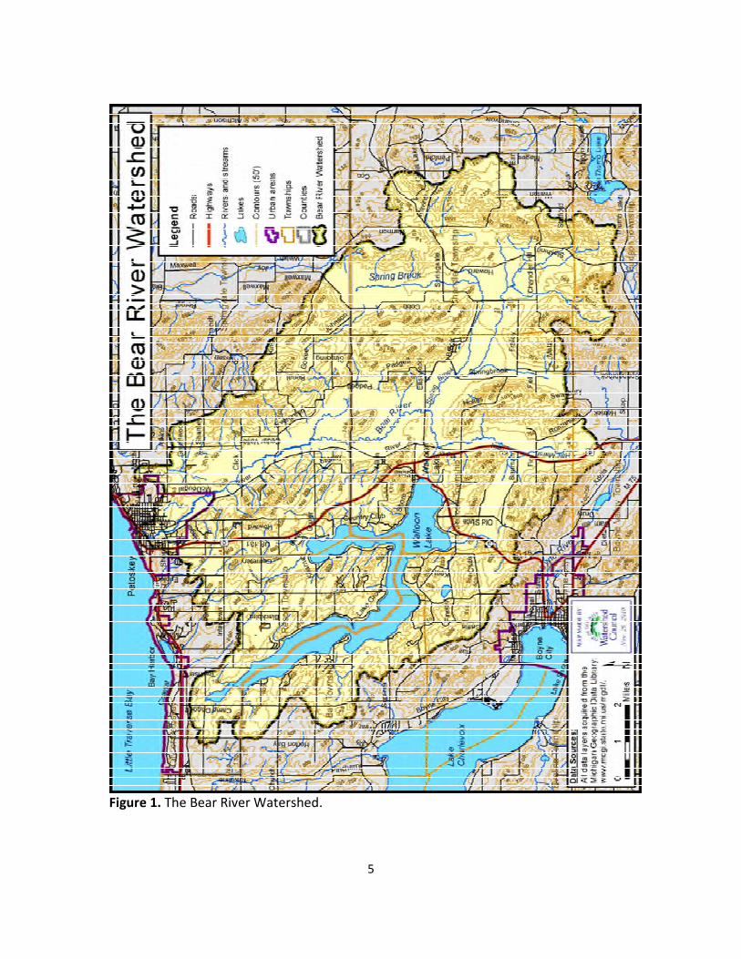
Study area:
The Bear River is located in the northwest Lower Peninsula of Michigan; draining
portions of Bear Creek, Resort, and Springvale Townships in Emmet County and Bay,
Boyne Valley, Chandler, Evangeline, Hudson, and Melrose Townships in Charlevoix
County. The main branch of the river drains 4,600-acre Walloon Lake on the west side of
the watershed, flowing 14.5 miles to Little Traverse Bay (Figure 1). The major tributaries
include Springbrook Creek, which drains the Chandler Hills in the southeast portion of
the watershed, and Hay Marsh Creek, which drains an area in the southwest part of the
watershed between Walloon Lake Village and Boyne Falls.
The Bear River Watershed drains approximately 74,215 acres of land and water. Based
on 2006 remote sensing data from the Coastal Great Lakes Land Cover project,
landcover in the watershed is mostly natural with 49% forested and 18% wetland (Table
1 and Figure 2). Agricultural and urban landcover account for 18% of the watershed
area; they increased by a combined 1.6% between 2000 and 2006.
Table 1. Bear River Watershed land-cover statistics.
Land Cover Type
2000
Acreage*
2000
Percent*
2006
Acreage*
2006
Percent* Change (%)
Agriculture 10199.96 13.73 10625.43 14.31 0.57
Barren 157.79 0.21 169.06 0.23 0.02
Forested 35557.38 47.88 36213.36 48.76 0.88
Grassland 7314.87 9.85 4629.60 6.23 -3.62
Scrub/shrub 1410.95 1.90 1645.73 2.22 0.32
Urban 2045.96 2.76 2821.68 3.80 1.04
Water 4823.54 6.50 4727.00 6.37 -0.13
Wetland 12752.60 17.17 13431.20 18.09 0.91
TOTAL 74263.05 100.00 74263.05 100.00 NA
*Land-cover data from the NOAA Coastal Change Analysis Program.
Water quality monitoring information for the Bear River was compiled in a summary
report written by the Watershed Council (TOMWC 2010). Water quality data have been
collected from the Bear River and its tributaries over the last several decades and are
available through the Michigan Department of Environmental Quality (MDEQ), Tip of
the Mitt Watershed Council (TOMWC), and Little Traverse Bay Bands of Odawa Indians
(LTBB). Physical, chemical, and biological water quality data are available for multiple
sites on the river, as well as Springbrook and Hay Marsh Creeks.
Nearly 40 years of water quality data from the Bear River Watershed show some
changes, but that water quality remains high and the stream ecosystem relatively
healthy. This is not surprising because the Bear River Watershed remains relatively
undeveloped. Furthermore, with its excellent water quality, Walloon Lake supplies
water to and essentially forms the main channel of the river.
5
Figure 1. The Bear River Watershed.

6
Figure 2. Land Cover 2006 in the Bear River Watershed.
7
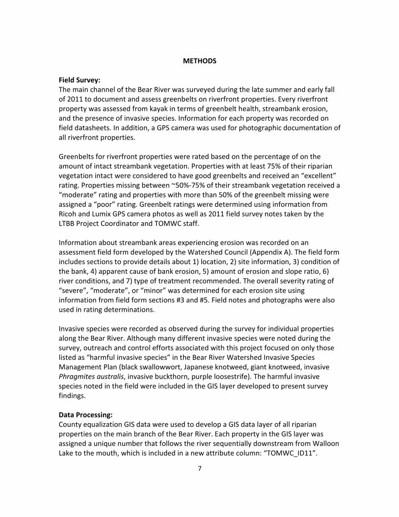
METHODS
Field Survey:
The main channel of the Bear River was surveyed during the late summer and early fall
of 2011 to document and assess greenbelts on riverfront properties. Every riverfront
property was assessed from kayak in terms of greenbelt health, streambank erosion,
and the presence of invasive species. Information for each property was recorded on
field datasheets. In addition, a GPS camera was used for photographic documentation of
all riverfront properties.
Greenbelts for riverfront properties were rated based on the percentage of on the
amount of intact streambank vegetation. Properties with at least 75% of their riparian
vegetation intact were considered to have good greenbelts and received an “excellent”
rating. Properties missing between ~50%-75% of their streambank vegetation received a
“moderate” rating and properties with more than 50% of the greenbelt missing were
assigned a “poor” rating. Greenbelt ratings were determined using information from
Ricoh and Lumix GPS camera photos as well as 2011 field survey notes taken by the
LTBB Project Coordinator and TOMWC staff.
Information about streambank areas experiencing erosion was recorded on an
assessment field form developed by the Watershed Council (Appendix A). The field form
includes sections to provide details about 1) location, 2) site information, 3) condition of
the bank, 4) apparent cause of bank erosion, 5) amount of erosion and slope ratio, 6)
river conditions, and 7) type of treatment recommended. The overall severity rating of
“severe”, “moderate”, or “minor” was determined for each erosion site using
information from field form sections #3 and #5. Field notes and photographs were also
used in rating determinations.
Invasive species were recorded as observed during the survey for individual properties
along the Bear River. Although many different invasive species were noted during the
survey, outreach and control efforts associated with this project focused on only those
listed as “harmful invasive species” in the Bear River Watershed Invasive Species
Management Plan (black swallowwort, Japanese knotweed, giant knotweed, invasive
Phragmites australis, invasive buckthorn, purple loosestrife). The harmful invasive
species noted in the field were included in the GIS layer developed to present survey
findings.
Data Processing:
County equalization GIS data were used to develop a GIS data layer of all riparian
properties on the main branch of the Bear River. Each property in the GIS layer was
assigned a unique number that follows the river sequentially downstream from Walloon
Lake to the mouth, which is included in a new attribute column: “TOMWC_ID11”.

8
Greenbelt ratings, streambank erosion severity ratings, select information from
streambank erosion data forms, and harmful invasive species were inputted into an
Excel® workbook for all riverfront properties. The workbook was joined to the GIS data
layer of riparian properties to create a new GIS data layer containing both county
equalization information and field survey data. Digital GPS photographs taken during
the survey were uploaded to a computer and processed to facilitate review of
streambank conditions and used to develop a GIS point layer that included locations of
all streambank erosion. Final products include a comprehensive database, a complete
set of GPS digital photographs, a GIS polygon layer of riverfront parcels that include
both county equalization and shore survey data, a GIS point layer of streambank erosion
locations, and a map displaying results.
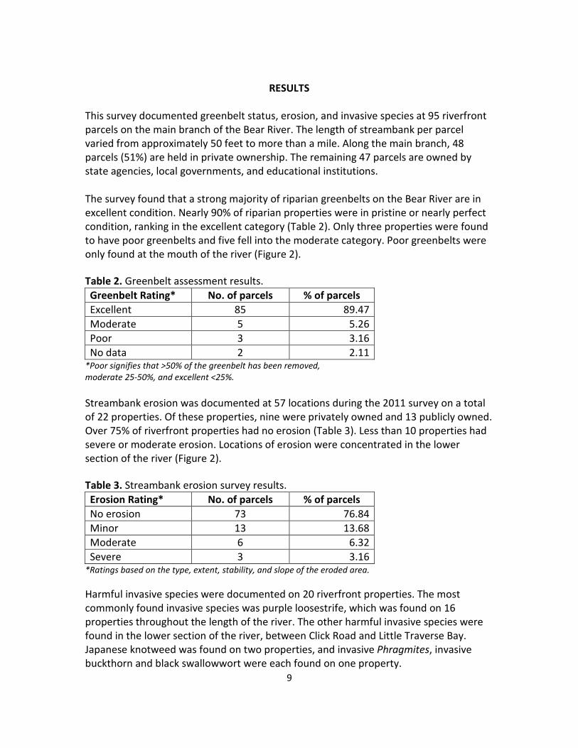
9
RESULTS
This survey documented greenbelt status, erosion, and invasive species at 95 riverfront
parcels on the main branch of the Bear River. The length of streambank per parcel
varied from approximately 50 feet to more than a mile. Along the main branch, 48
parcels (51%) are held in private ownership. The remaining 47 parcels are owned by
state agencies, local governments, and educational institutions.
The survey found that a strong majority of riparian greenbelts on the Bear River are in
excellent condition. Nearly 90% of riparian properties were in pristine or nearly perfect
condition, ranking in the excellent category (Table 2). Only three properties were found
to have poor greenbelts and five fell into the moderate category. Poor greenbelts were
only found at the mouth of the river (Figure 2).
Table 2. Greenbelt assessment results.
Greenbelt Rating* No. of parcels % of parcels
Excellent 85 89.47
Moderate 5 5.26
Poor 3 3.16
No data 2 2.11 *Poor signifies that >50% of the greenbelt has been removed,
moderate 25-50%, and excellent <25%.
Streambank erosion was documented at 57 locations during the 2011 survey on a total
of 22 properties. Of these properties, nine were privately owned and 13 publicly owned.
Over 75% of riverfront properties had no erosion (Table 3). Less than 10 properties had
severe or moderate erosion. Locations of erosion were concentrated in the lower
section of the river (Figure 2).
Table 3. Streambank erosion survey results.
Erosion Rating* No. of parcels % of parcels
No erosion 73 76.84
Minor 13 13.68
Moderate 6 6.32
Severe 3 3.16 *Ratings based on the type, extent, stability, and slope of the eroded area.
Harmful invasive species were documented on 20 riverfront properties. The most
commonly found invasive species was purple loosestrife, which was found on 16
properties throughout the length of the river. The other harmful invasive species were
found in the lower section of the river, between Click Road and Little Traverse Bay.
Japanese knotweed was found on two properties, and invasive Phragmites, invasive
buckthorn and black swallowwort were each found on one property.

10
Figure 3. Bear River greenbelt and erosion survey results.

11
Figure 4. Bear River greenbelt and erosion survey results: lower section.

12
DISCUSSION
The 2011 survey results showed the majority of the riparian corridor along the main
branch of the Bear River to be in excellent condition, with little evidence of human
impacts. Greenbelts were found to be in great shape throughout the length of the river,
the occurrence of invasive species was limited, and streambank erosion was generally
found to be minor and attributable to normal river system processes. Extensive public
land along the main branch of the river undoubtedly plays a role in maintaining the
healthy riparian corridor observed during the survey. In addition, development within
riparian areas is limited due to extensive riverine wetlands throughout much of the
watershed (Figure 2).
Although most of the Bear River is in excellent health, human impacts are evident and
contributing to some degree of water quality degradation. Poor greenbelts as well as
nearly all instances of eroded streambanks were documented in the lower section of the
river (from Click Road downstream) where development is concentrated. Flowing
through the City of Petoskey, the lower section of the river is subject to a number of
stressors associated with urbanization, such as stormwater runoff and recreational
access and use. Flashy and high flows brought on by impervious surfaces, compacted
paths along the river edge, the removal of riparian vegetation to facilitate river access,
and other factors contribute to streambank erosion and greenbelt loss. However, it is
important to keep in mind that high flow velocities in the channel caused by increased
slopes in the lower section of the river naturally lead to streambank erosion.
Invasive species, including the purple loosestrife, were observed throughout the length
of the Bear River from Walloon Lake to Little Traverse Bay. Occurrences of the other
harmful invasive species of concern, invasive Phragmites, invasive buckthorn, and
Japanese knotweed, were concentrated in the lower section of the river (from Click Rd
downstream). Greater human population pressure in the lower section of the river is
implicated in the spread of these invasive species.
Considering the excellent condition of the Bear River, measures should be taken to
address existing problems and protect the river’s water quality. One of the most
effective tools for protecting the Bear River is education. Through information and
education efforts that focus on the importance of maintaining a healthy greenbelt,
addressing or preventing erosion, and controlling invasive species, Bear River waterfront
property owners will become better stewards. In addition, local governments should be
engaged and encouraged to assist with restoration, protection, and education efforts.
Regulation is another effective approach for protecting the greenbelts of lakes and
streams. The main branch of the Bear River flows through Melrose Township in
Charlevoix County, Bear Creek Township in Emmet County, and through the City of

13
Petoskey in its lower section. According to the Charlevoix County Local Ordinance Gaps
Analysis (TOMWC, 2011), Melrose Township has adequate ordinances in place to
protect greenbelts on water bodies. Bear Creek Township falls under Emmet County
zoning, which requires a minimum 40-foot greenbelt buffer in scenic districts, which
includes the Bear River. Zoning for the City of Petoskey lacks any provision to protect
lakeshore and streambank greenbelts. The Bear River survey results show that all poor
greenbelts and severe streambank erosion occurred in the City of Petoskey. Thus, in
terms of regulation, greenbelts along the Bear River would benefit most from passage of
a protective greenbelt ordinance in the City of Petoskey.
Despite the prevalence of healthy greenbelts on the Bear River, there is room for
improvement. Parcels with compromised greenbelts generally had mowed turf grass to
the river’s edge. Although turf does constitute vegetation along the river bank, it does
not provide the same benefits as a diverse, dense greenbelt. Turf grass has short roots
compared with the extensive root system of native plants, shrubs, and trees, which
results in a lesser capacity to filter contaminants from stormwater runoff and stabilize
the streambank against erosion. Maintaining turf grass often requires the addition of
fertilizers and herbicides, which invariably wash into the river. In addition, turf grass
does not contribute habitat structure (e.g. branches), shade, and food energy (e.g.
leaves) to the stream ecosystem. Therefore, the negative impacts associated with
riparian vegetation removal and turf grass installation on riverfront parcels could be
moderated by establishing a no-mow buffer zone or restoring native vegetation by
planting herbaceous and woody plants.
The eroding streambanks documented during this survey are contributing sediments
and nutrients to the river. Most areas exhibiting severe or moderate erosion could be
remediated without incurring excessive costs. Bioengineering, or soft engineering,
techniques can stabilize streambanks while also enhancing habitat.
Negative impacts to the Bear River associated with human activity could potentially
increase as development expands in the greater Petoskey area. Riverfront properties
could be further developed and recreational use and access to the river will likely
increase. Increased population pressure could result in increased streambank erosion, a
greater degree of riparian vegetation loss, and the further spread of invasive species.
Thus, it is important to continually monitor the river and take action to address or
prevent problems.
Two of three local governments in the project area have taken the lead by establishing a
regulatory framework (i.e., passing ordinances) to protect shoreline and streambank
vegetation. The information collected during this survey provides valuable baseline
information for assessing the effectiveness of greenbelt protection ordinances, while
also providing insight into the status of greenbelts along the main branch of the Bear

14
River. By sharing the river’s overall greenbelt status with the public and providing
outreach and technical help to riverfront property owners, this survey has the potential
to protect and improve greenbelts on the Bear River, as well as those on other area
streams.
Recommendations:
The full value of this survey will only be achieved when the information is used to
educate riparian property owners about the importance of shoreline vegetation, and
encourage them to preserve, maintain, establish, or enhance their greenbelts. The
following are recommended follow-up actions:
1. Disseminate results of the survey. The results of this survey should be shared
with the public and in particular, with Bear River riverfront property owners.
Publicizing the results will 1) raise the level of awareness of the overall condition
of the Bear River riparian corridor; 2) increase public appreciation of the
ecological value of streambank vegetation, thereby fostering greater
stewardship of greenbelts, and the river ecosystem in general; and 3) help
riparian owners better understand the value of ordinances. A summary of survey
results should be sent to all riverfront property owners on the Bear River. Survey
results can also be shared through other means, such as newspapers.
2. Utilize the Internet to share survey information. A general summary of the
greenbelt survey and the full report should be posted on the LTBB and TOMWC
web sites. Property-specific information can also be shared via these web pages
by randomizing the shoreline survey database and providing property owners
with a code number that refers specifically to survey results from their property.
Posting the summary and report on the web sites of local governments is also
recommended.
3. Reach out to property owners with poor greenbelts. Inform owners of
properties that received poor greenbelt scores of specific results for their
property. Supply these property owners with information (e.g. printed
brochures) regarding the benefits of greenbelts and guidance for improvements.
Encourage property owners to establish or improve greenbelts using a variety of
native plants. Inform property owners that LTBB and TOMWC can assist with site
assessments, as well as coordinate and implement greenbelt development or
improvement projects.
4. Educate and inform Bear River riparians and the public. Collaboratively plan
and implement an information and education campaign to increase awareness
of the importance of maintaining a healthy riverfront. The campaign should: 1)
encourage riverfront property owners to preserve or create healthy greenbelts

15
along as much streambank as possible, to the greatest depth possible, with
various levels of vertical plant structure (overstory, understory, groundcover);
appropriate plant density, and species diversity; 2) discourage riverfront
alterations, such as seawalls and over-sized riprap, and promote natural
streambanks bioengineering techniques; and 3) discourage the use of turf grass
on or near the river’s edge and the removal of emergent aquatic vegetation. The
campaign can be accomplished through a variety of means, including mailings,
newsletters, newspapers, and the Internet, but should also include informational
meetings and workshops. Workshops should provide information about
greenbelts and survey results, as well as a hands-on component where
participants learn how to create and enhance greenbelts.
5. Correct severe and moderate erosion. Most areas with eroding streambanks
that are contributing sediments and nutrients to the river could be remediated
without incurring excessive costs. Determine appropriate funding sources,
acquire funding, and implement projects that address the worst areas of
streambank erosion.
6. Control the spread of invasive species. Controlling the spread of most of the
harmful invasive species documented during the survey can be done effectively
and affordably because occurrences are limited. Acquire funding and coordinate
treatment of the harmful invasive species. Prioritize control efforts to focus on
the invasive Phragmites, invasive buckthorn, black swallowwort, and Japanese
knotweed infestations documented during this survey. Efforts to control purple
loosestrife should also be undertaken, using biological control in heavily infested
areas and manual removal and/or selective herbicide application in lightly
infested areas.
7. Get other local governments on board. Promote the apparent success of
ordinances that protect greenbelts with other local governments. In particular,
the City of Petoskey should be encouraged to adopt an adequate greenbelt
protection ordinance. Survey results may encourage local governments beyond
the Bear River to pass greenbelt ordinances and thereby, help protect surface
waters throughout the region.
8. Repeat survey on a regular basis. The river’s edge changes continually, both in
terms of physical characteristics and land ownership. Therefore, some version of
this survey should be repeated regularly (ideally every 3-5 years), coupled with
follow-up activities to promote greenbelt awareness and good management
practices on an ongoing basis. Repeating the survey periodically will also help
detect ordinance violations and ensure that any information used for ordinance
enforcement is current.

16
LITERATURE AND DATA REFERENCED Charlevoix County GIS Office. 2004. Charlevoix County Digital Orthophotography.
Charlevoix, MI. http://www.charlevoixcounty.org/
Charlevoix County GIS Office. 2010. Charlevoix County GIS Parcel Data. Charlevoix, MI.
http://www.charlevoixcounty.org/
Emmet County Equalization/GIS. 2008. Emmet County Digital Orthophotography.
Petoskey, MI. http://www.emmetcounty.org/
Emmet County Equalization/GIS. 2011. Emmet County GIS Parcel Data. Petoskey, MI.
http://www.emmetcounty.org/
Michigan Geographic Data Library. 2012. Michigan Geographic Data. Michigan
Department of Information Technology, Center for Geographic Information. Lansing, MI.
http://www.mcgi.state.mi.us/mgdl/
National Oceanic and Atmospheric Administration (NOAA). 2011. Coastal Great Lakes
Land Cover Project. NOAA Coastal Services Center. Charleston, SC.
http://www.csc.noaa.gov/crs/lca/greatlakes.html
Tip of the Mitt Watershed Council. 2005. Little Traverse Bay Watershed Protection Plan.
Tip of the Mitt Watershed Council. Petoskey, MI. http://www.watershedcouncil.org/
Tip of the Mitt Watershed Council. 2010. A Water Quality Summary of the Bear River.
Tip of the Mitt Watershed Council. Petoskey, MI. http://www.watershedcouncil.org/
Tip of the Mitt Watershed Council. 2010. Control and Management of Purple Loosestrife
(Lythrum salicaria) and Phragmites (Phragmites australis) in the Bear River Watershed.
Tip of the Mitt Watershed Council. Petoskey, MI. http://www.watershedcouncil.org/
Tip of the Mitt Watershed Council. 2011.Charlevoix County Local Ordinance Gaps
Analysis. Tip of the Mitt Watershed Council. Petoskey, MI.
http://www.watershedcouncil.org/
Tip of the Mitt Watershed Council. 2010. Comprehensive Water Quality Monitoring
Program Data. Tip of the Mitt Watershed Council. Petoskey, MI.
http://www.watershedcouncil.org/Protect/

17
Appendix A: Streambank erosion assessment field form
Stream Name: _________________________________ Date: _______________________________________
Site Number: __________________________________Recorder’s Name:______________________________
Other Volunteers: ___________________________________________________________________________
LOCATION:
Name of County and Township:________________________________________________________________
Township Number: __________________ Range: ___________________ Section(s): ____________________
Owner (circle one): FEDERAL STATE COUNTY TOWNSHIP PRIVATE OTHER
Nearest Road-Stream Crossing:________________________________________________________________
Other Information Regarding Location: _________________________________________________________
SITE INFORMATION:
Bank-as designated while looking downstream (circle one) RIGHT LEFT (Also mark the appropriate side of the site on the map)
Is the site accessible by road for rock and equipment? (circle one) YES NO
IF NO- Distance from the nearest road (estimate): _________________________________________________
CONDITION OF THE BANK (circle):
A. Toe is undercutting B. Toe is stable; upper bank eroding C. Toe and upper bank are eroding
D. The percent of vegetative cover on the bank is (circle one): 0-10% 11-50% 51-100%
E. Problem trend (circle one): INCREASING DECREASING (annuals growing) STABLE
F. Other (describe): _________________________________________________________________________
APPARENT CAUSE OF BANK EROSION (circle all that apply):
A. Obstruction in river B. Bend in river C. Bank seepage
D. Gullying of bank from side channels. E. Type of foot traffic:___________________________________
F. Other:__________________________________________________________________________________
AMOUNT OF EROSION AND SLOPE RATIO:
A. Sideslope of bank-vertical (circle one): 1 :1 2:1 3:1 4:1 or flatter
B. Length of eroded bank (estimate/measured feet): ______________________________
C. Average height of eroded bank: ____________________________________________
RIVER CONDITIONS:
A. Approximate width of river where erosion occurs (feet):______________________
B. Approximate depth of river:________ at________ feet from the bank. (Preferably get estimate 4' from the bank)
C. Current (circle one): FAST SLOW
D. Soil Texture (circle): SAND CLAY LOAM GRAVEL STRATIFIED SAND OVER CLAY
Other Textures: ________________________________________________________________________
TYPE OF TREATMENT RECOMMENDED (circle):
A. Rock RipRap B. Log Jam Structure C. Obstruction Removal D. Bank Sloping
E. Stairways F. Bank Seeding or Planting G. Brush Placement H. Fencing
I. Other (explain):
__________________________________________________________________________________________