Embed Size (px)
Citation preview
1
The Bush Club Inc., Greater Blue Mountains National Park- Blue Mountains
National Park- Three short adventures on Narrow Neck - Monday 3rd July 2017- EXPLORATORY-
Track Notes Short title Three short adventures on Narrow Neck
Date Monday 3rd July 2017 Leader Brian Fox Maps, etc. Department of Lands Katoomba topographic map, 8930–1S, 1:25000, Third edition,
Department of Lands Jamison topographic map, 8930–2N, 1:25000, Second edition, GPS setting WGS 84.
Walk description and route
1 Diamond Falls Check out the undercliff track on Narrow Neck (This walk was deferred). 2 Skull Cave is a descriptive name of a rock formation thought to be on the second constriction of Narrow Neck, possibly between Fools Paradise and Corral Swamp. Katoomba. Ref: The Katoomba Daily 2nd April 1932, p. 3 and 4th November 1932, p. 3. J 467 613. 3 Upper Psyncaive is located at the top of the escarpment at Narrow Neck, approximately above Psyncaive, Katoomba. Pronounced as ‘Sincave.’ This overhang can accommodate up to 10 people. It is used by bush walkers and rock climbers. Named by Kevin Westren in the early 1960s, when he was looking for a rock climbing base camp. Located about 200m past the junction of the track to the pumping station, a walking track leads to the west from Glenraphael Drive, look for a small gully which has a small waterfall. This is the same waterfall that flows over Psyncaive at the base of the escarpment. Ref: Oral history from Kevin Westren, 1999. K 486 644.
Rating 5, M, LTW Gear issues Have clothes to change into in the car for afterwards. 2 litres of water. GPS,
PLB, appropriate head and footwear, electrolytes, maps, compass. Numbers 6 places available Meeting point
Pymble 0600, Blaxland 0730, Narrow Neck 0830.
Transport Club cars. Comments Possible wet feet. Could be a tape assisted section Close of Bookings
ASAP
Enquiries Brian Fox, [email protected] or tel. 63322590 or Michael Keats, [email protected]; tel. 9144 2096.
The Party Brian Fox, leader, John Fox, Geoff Fox, Michael Keats, Berenice Torstensson, George Maroun, Keith Maxwell, members and Kaan Olmez, guest, 8. The Weather The day started cold with partial cloud cover. A moderate westerly wind chilled an already cold morning by at least 5 degrees. By 1100 cloud cover was 100% and some light rain fell. Later the rain
2
cleared but the cloud cover remained. There was a short fine break while we explored the Psyncaive. Temperature range 2 to 7 degrees. Local Place Names Narrow Neck is that part of the Blue Mountains escarpment which extends generally south from Narrow Neck Lookout, Cliff Drive, Katoomba to Medlow Gap. This narrow, sinuous cliff lined plateau divides Megalong, Jamison and Cedar Valleys. A descriptive name which has two constrictions in its width, often referred to as First and Second Narrow Neck. The fire trail along Narrow Neck is called Glenraphael Drive. Its width varies from 60m to 2km and it is about 12km in length. There are 10 recognised passes of Narrow Neck, discovered and used by early prospectors and miners and later by bushwalkers. The First Narrow Neck was referred to as the, Causeway in 1937. Ref: The Sydney Morning Herald 9th February 1884, p. 14. Survey Plan No. C1373.1507, dated September 1885. Other names include (see) Megalong Ridge, The Narrow Neck and The Neck of Land. K 491 648 to J 471 556. Narrow Neck Plateau is the flat expanse of land on the top of Narrow Neck, Katoomba. A descriptive term to this feature. Narrow Neck extends for about 12km in north, south direction. The walking tracks along the plateau date from the 1880s. The Fire trail along Narrow Neck constructed in 1961 is known as Glenraphael Drive. Ref: Australian Survey Corps Topo Map of Katoomba, 1935. Geographical Names Board, assigned 25th July 1969. Previous names include, Megalong Ridge and Narrow Neck Peninsula. K 491 648 to J 471 556. Corral Creek is a mostly perennial creek rising on Corral Swamp on Narrow Neck Plateau. It flows for 3km generally north, north west into Megalong Creek. The name, corral comes from the American term for stockyard. Ref: Myles Dunphy's notes 1914, record "someone had erected a rough wire and post fence at this strategic point" (That is a corral or stockyard) Barrett, Jim. Narrow Neck and the Birth of Katoomba, 1996, p. 46. J 470 619 to 460 643. Corral Swamp1 refers to a 500m in length area of swampy ground on Narrow Neck Plateau, 1.7km west of Castle Head, Narrow Neck. Katoomba dairy men would depasture stock here during prolonged dry weather. Ref: Myles Dunphy's bushwalking notes of 4th June 1928, record, "second swamp now generally known as Corral Swamp." Tourist Map of Blue Mountains Burragorang Valley, 1933. The Bushwalker, Vol. 1, 1937, p. 15. Barrett, Jim. The Blue Mountains and Burragorang Valley, 1994, p. 40. J 470 617 to K 470 622. Note. The Dunphy reference to Second Swamp in naming Corral Creek and swamp is historically important. Originally the first three main creeks on Narrow Neck, flowing west into Megalong Valley were respectively named First, Second and Third Creeks. First Creek is now Diamond Creek, Second Creek is now Corral Creek and Third Creek is now Mitchells Creek. Diamond Falls is a waterfall on Diamond Creek where it flows over the western escarpment of Narrow Neck Plateau. Walking access to top of the falls is via the locked gate, Glenraphael Drive, Narrow Neck, Katoomba. The spray of water over the falls is often broken up by the westerly winds making a sparkling spray of droplets giving rise to the descriptive term of diamonds. Ref: Dunphy, Myles. Sketch Map of Megalong Valley and Narrow Neck Peninsula, 1928, records as, Diamond Veil Falls. Singleton, C. Tourist Map Katoomba and Leura, 1942, records as, Diamond Falls. K 478 632. Skull Cave3 is a small overhang directly above and on the western side of Corral Creek, 100m south of the main cliff line and start of Redledge Pass, Narrow Neck, Katoomba. It is about 2m wide, 5m long and about 3m high. It affords minimal protection from the elements. Ref: Ref: Katoomba Daily 10th September 1932, p. 2 records, “Years ago Professor Arbuthnot Skull, wandering along the Narrow Neck ridge, was caught in a heavy mist and
3
camped for the night in the cave.” K 470 625. The following more recent research by Brian and John Fox follows. Katoomba Daily (NSW), Saturday 10 September 1932, page 2
SCHOOL CHILDREN HOLIDAY HIKE SKULL CAVE VISITED. On Wednesday last, the Blue Mountains Guide Service conducted the second of the "Holiday
Hike" specially arranged for school children during the present holiday. Twenty-three school children in charge of the chief guide, set out in glorious weather to visit
Scull Cave. The total distance covered was 8 (?) miles and the children were brought back to their homes about 5 o'clock in the afternoon, as fresh and full of energy as when they started. Lunch was eaten at "The Over-hung Pool," on Second Creek and the Cave itself was explored in the afternoon. The children were most intrigued by the name of the cave and imagined a sinister cavern, its floor covered with bleached bones, and containing skulls, showing white and ghost-like through the semi-darkness. As a matter of fact it is an open, sunny shelter, and its only connection with anatomy lies in the fact that it is named after a rather obscure biologist. Years ago Professor Arbuthnot Skull, wandering along the Narrow Neck ridge, was caught in a heavy mist and camped for the night in the cave. Second Creek runs practically through the cave, descending to it over a series of low cascades. As the story goes the learned doctor, hopelessly lost in the mist, wandered down the creek, stepped on the wet rocks of the upper cascade, and slid into the welcome shelter of the cave in a most undignified manner, smashing his spectacles in progress and accidentally losing a box full of rock lizards that he had been at some pains to collect. The little waterfall, where the creek empties into Megalong Valley, is known as "The Lizard's Leap."
The third and last "Holiday Hike" will be conducted on Monday 12th September. The party will leave the office of the Guide Service Railway Steps, Main Street, at 9 am and tickets are available for children and parents at 1/- each. Lizards Leap3 is a waterfall formed by Corral Creek flowing over the cliff at Narrow Neck Plateau. The waterfall is on the western side of Redledge Pass, Narrow Neck, Katoomba. Ref: Katoomba Daily 10th September 1932, p. 2 records, “As the story goes the learned doctor, hopelessly lost in the mist, wandered down the creek, stepped on the wet rocks of the upper cascade, …. in progress and accidentally losing a box full of rock lizards that he had been at some pains to collect. The little waterfall, where the creek empties into Megalong Valley, is known as "The Lizard's Leap." K 470 626. Second Creek3 refers to Corral Creek, Narrow Neck, Katoomba. As it is the second major creek on Narrow Neck Plateau. The First Creek is Diamond Creek. Ref: Katoomba Daily 10th September 1932, p. 2. J 470 619 to K 460 643. Third Creek3 refers to (see) Mitchells Creek. The third creek along Narrow Neck Plateau, Katoomba. The first is Diamond Creek, and the second is Corral Creek. Ref: Esgate, Ben. Hand drawn map of Narrow Neck, August 1942. J 462 591 to HA 445 643. Upper Psyncaive2 is located just below the top of the escarpment at Narrow Neck, approximately above Psyncaive, Katoomba. Pronounced as ‘Sincave.’ This overhang holds up to 10 people and is used by bush walkers and rock climbers. It is about 5m wide, 5m high and 17m long. Named by Kevin Westren in the early 1960s, when he was looking for a rock climbing base camp. Located about 200m past the junction of the track to the pumping station, a walking track leads to the west from Glenraphael Drive, look for a small gully which has a small waterfall. This is the same waterfall that flows over Psyncaive at the base of the escarpment. Ref: Oral history from Kevin Westren, 1999. K 485 643.
4
Track Notes The weather at the start of the day is best described as unpleasant. Fortunately once walking was underway and we were out of the wind conditions moderated and we enjoyed the bracing air. Given the weather and the discovery of information about the Skull Cave, it was determined to explore this area first. At 0906, GR 475 622 there is a four way intersection of tracks with Glenraphael Drive. One track leads to a fine viewing point over the catchment of Cedar Creek and Mount Solitary. Opposite is the track head for Redledge Pass. We continued on south along Glenraphael Drive to a dip in the road, GR 471 616, that also marks the headwaters of Corral Creek. Here there is some new signage advising that there was critically endangered vegetation in the area. The signage also was directed at NPWS personnel. Intriguing questions arise. Has there been a new plant discovery on Narrow Neck? Is the signage designed to protect Corral Swamp species? Or is it just a ploy to try and keep people out of the bush? Our mission to find the Skull Cave that we now knew was on Second Creek (Corral Creek) meant that we needed to walk from the source to the cliff edge as ‘Second Creek runs practically through the cave, descending to it over a series of low cascades.’ The cave could be anywhere along the water course. After a short push through dense stands of Banksia ericifolia we emerged on the southern fringe of Corral Swamp. This hanging swamp is almost impossible to negotiate so we kept close to the periphery walking in the fringing woodland wherever possible. About hanging swamps. It is worth recording “The Blue Mountains Swamps Community in the Sydney Bio Region is characterised by a dense mixture of shrubs and sedges, most of which have sclerophyllous foliage. The shrub stratum typically varies from 0.5 m to over 2.0 m tall and is highly variable in cover. The ground stratum may be up to about 1 m tall and is dominated by a dense sward of sclerophyllous sedges and grasses except in patches where these are displaced by a dense cover of taller shrubs. Ferns, forbs and small shrubs are scattered amongst the sedges and grasses. There is considerable local variation within the swamps in species composition and vegetation structure, which is apparently related to local soil properties and fire history (Keith and Benson 1988, Holland et al. 1991). Structure of the vegetation varies from closed heath or scrub to open heath to closed sedgeland or fernland (Specht 1970). Among the frequently occurring large shrub species, Baeckea linifolia, Leptospermum juniperinum and Hakea teretifolia are relatively ubiquitous, while L. grandifolium and Grevillea acanthifolia subsp. acanthifolia occur primarily on deeper, highly organic, frequently waterlogged soils, and L. polygalifolium and Banksia spinulosa are typically found on intermittently waterlogged, shallower sandy soils with a moderate organic content. Small shrubs, including Almaleea incurvata, Epacris obtusifolia and Sprengelia incarnata, are typically more abundant on the less waterlogged soils. The large tussock sedge, Gymnoschoenus sphaerocephalus, and rhizomatous sedges and cord rushes, including Lepidosperma limicola, Ptilothrix deusta, Lepyrodia scariosa and Leptocarpus tenax are generally common throughout the swamps, as are the grasses Entolasia stricta and Tetrarrhena turfosa. Coral ferns, Gleichenia spp., and Drosera binata are typical of frequently waterlogged soils, while other herbs, including Dampiera stricta, Mirbelia rubiifolia and Gonocarpus teucrioides occur in more open vegetation on intermittently waterlogged soils.
5
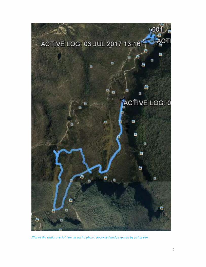
Plot of the walks overlaid on an aerial photo: Recorded and prepared by Brian Fox.
6
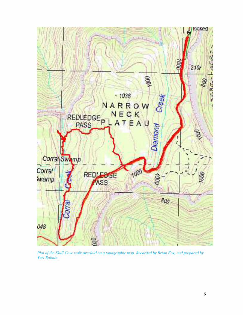
Plot of the Skull Cave walk overlaid on a topographic map. Recorded by Brian Fox, and prepared by Yuri Bolotin.
7
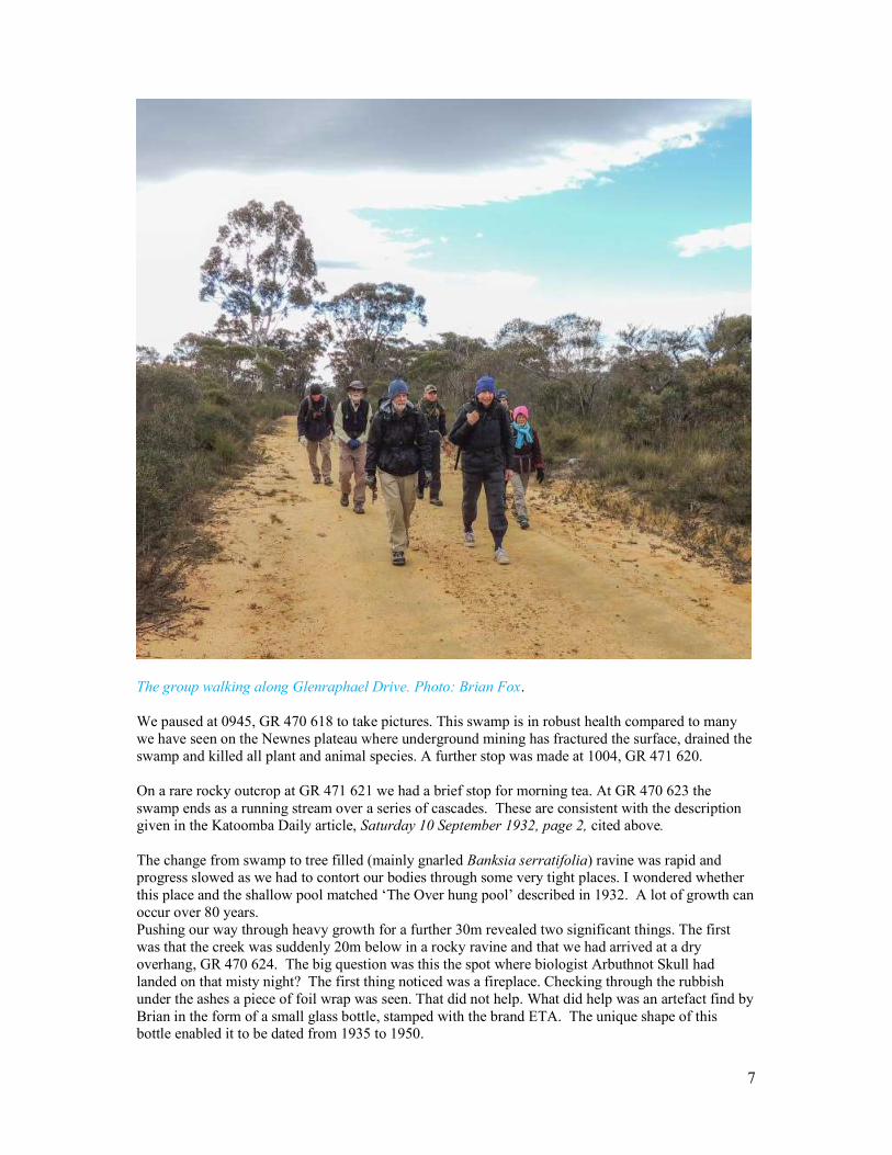
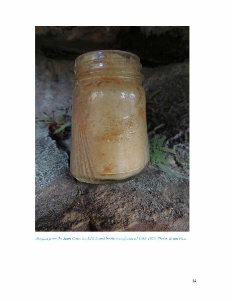
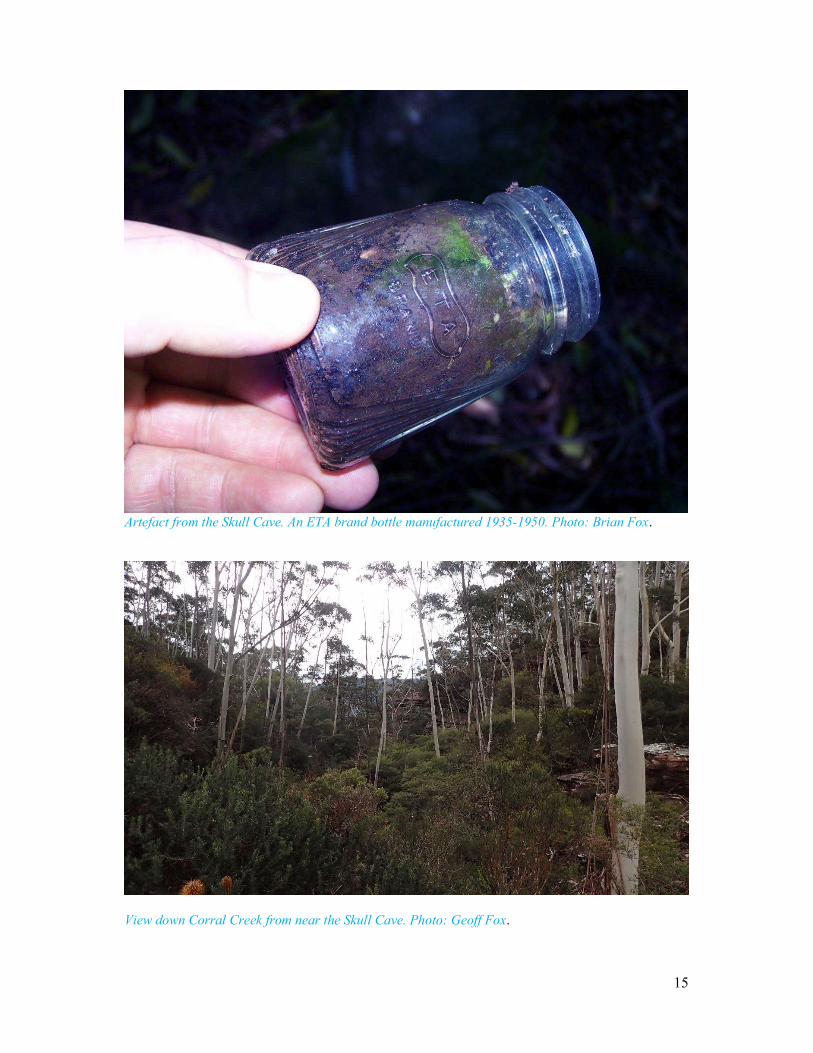
The group walking along Glenraphael Drive. Photo: Brian Fox. We paused at 0945, GR 470 618 to take pictures. This swamp is in robust health compared to many we have seen on the Newnes plateau where underground mining has fractured the surface, drained the swamp and killed all plant and animal species. A further stop was made at 1004, GR 471 620. On a rare rocky outcrop at GR 471 621 we had a brief stop for morning tea. At GR 470 623 the swamp ends as a running stream over a series of cascades. These are consistent with the description given in the Katoomba Daily article, Saturday 10 September 1932, page 2, cited above. The change from swamp to tree filled (mainly gnarled Banksia serratifolia) ravine was rapid and progress slowed as we had to contort our bodies through some very tight places. I wondered whether this place and the shallow pool matched ‘The Over hung pool’ described in 1932. A lot of growth can occur over 80 years. Pushing our way through heavy growth for a further 30m revealed two significant things. The first was that the creek was suddenly 20m below in a rocky ravine and that we had arrived at a dry overhang, GR 470 624. The big question was this the spot where biologist Arbuthnot Skull had landed on that misty night? The first thing noticed was a fireplace. Checking through the rubbish under the ashes a piece of foil wrap was seen. That did not help. What did help was an artefact find by Brian in the form of a small glass bottle, stamped with the brand ETA. The unique shape of this bottle enabled it to be dated from 1935 to 1950.
8
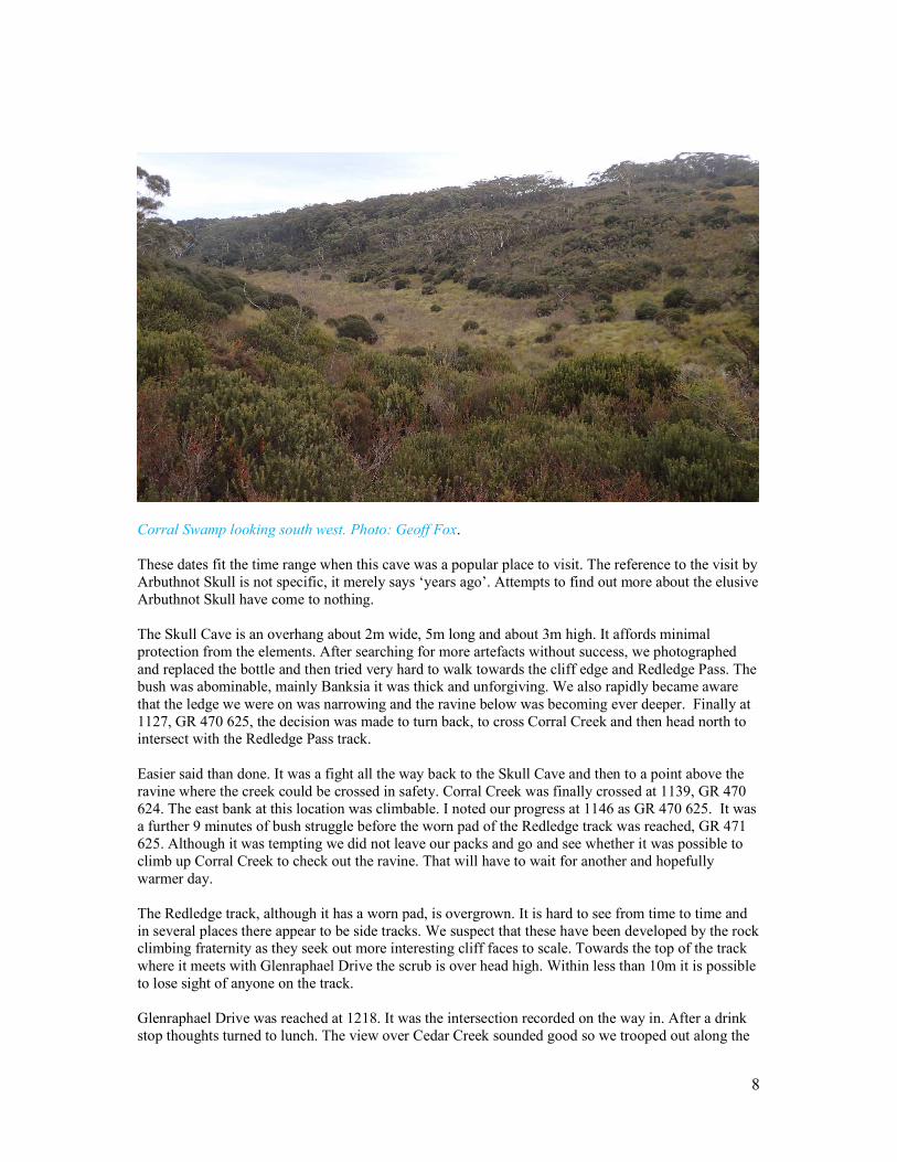
Corral Swamp looking south west. Photo: Geoff Fox. These dates fit the time range when this cave was a popular place to visit. The reference to the visit by Arbuthnot Skull is not specific, it merely says ‘years ago’. Attempts to find out more about the elusive Arbuthnot Skull have come to nothing. The Skull Cave is an overhang about 2m wide, 5m long and about 3m high. It affords minimal protection from the elements. After searching for more artefacts without success, we photographed and replaced the bottle and then tried very hard to walk towards the cliff edge and Redledge Pass. The bush was abominable, mainly Banksia it was thick and unforgiving. We also rapidly became aware that the ledge we were on was narrowing and the ravine below was becoming ever deeper. Finally at 1127, GR 470 625, the decision was made to turn back, to cross Corral Creek and then head north to intersect with the Redledge Pass track. Easier said than done. It was a fight all the way back to the Skull Cave and then to a point above the ravine where the creek could be crossed in safety. Corral Creek was finally crossed at 1139, GR 470 624. The east bank at this location was climbable. I noted our progress at 1146 as GR 470 625. It was a further 9 minutes of bush struggle before the worn pad of the Redledge track was reached, GR 471 625. Although it was tempting we did not leave our packs and go and see whether it was possible to climb up Corral Creek to check out the ravine. That will have to wait for another and hopefully warmer day. The Redledge track, although it has a worn pad, is overgrown. It is hard to see from time to time and in several places there appear to be side tracks. We suspect that these have been developed by the rock climbing fraternity as they seek out more interesting cliff faces to scale. Towards the top of the track where it meets with Glenraphael Drive the scrub is over head high. Within less than 10m it is possible to lose sight of anyone on the track. Glenraphael Drive was reached at 1218. It was the intersection recorded on the way in. After a drink stop thoughts turned to lunch. The view over Cedar Creek sounded good so we trooped out along the
9
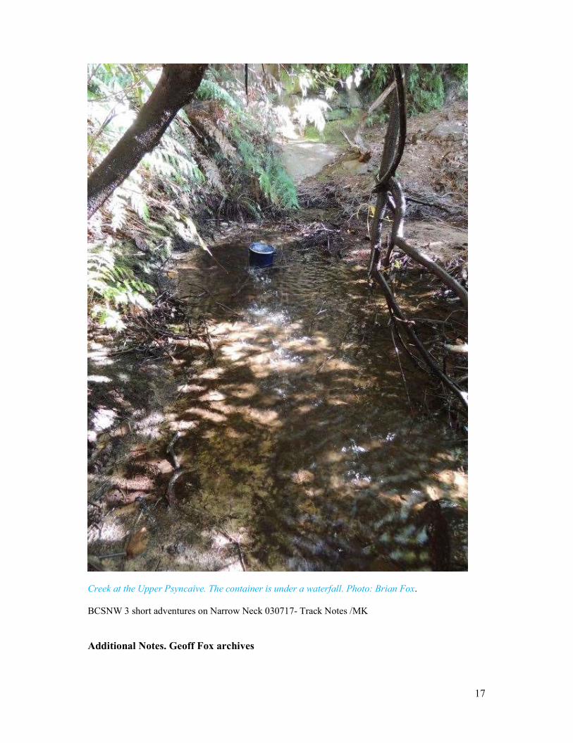
track to GR 476 622. Mount Solitary was illuminated with a rainbow. It was great but there was nowhere to sit so we returned to the road where it promptly decided to shower on us. The next bend on the road at the top of a descent had a great view as well. Nature now decided to turn on a bit more rain. Forget lunch with a view – let’s go back to the vehicles and eat in comfort. Road walking was quick and the cars were reached at 1251. We were just getting ready for our next adventure the Upper Psyscaive when a big group of walkers (30+) appeared. They must have been right behind us. An NPA they had been out to Castlehead, walking to and from Katoomba Station. A number in the group knew me. We had a few words and they kept walking. We then relocated our vehicles prior to searching for the Upper Psyncaive. Total distance walked 6.6km. Total ascents 179m.
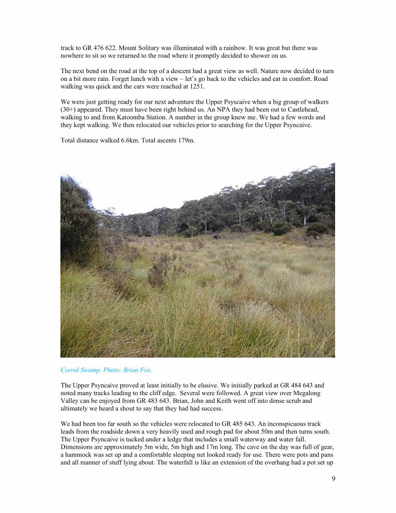
Corral Swamp. Photo: Brian Fox. The Upper Psyncaive proved at least initially to be elusive. We initially parked at GR 484 643 and noted many tracks leading to the cliff edge. Several were followed. A great view over Megalong Valley can be enjoyed from GR 483 643. Brian, John and Keith went off into dense scrub and ultimately we heard a shout to say that they had had success. We had been too far south so the vehicles were relocated to GR 485 643. An inconspicuous track leads from the roadside down a very heavily used and rough pad for about 50m and then turns south. The Upper Psyncaive is tucked under a ledge that includes a small waterway and water fall. Dimensions are approximately 5m wide, 5m high and 17m long. The cave on the day was full of gear, a hammock was set up and a comfortable sleeping net looked ready for use. There were pots and pans and all manner of stuff lying about. The waterfall is like an extension of the overhang had a pot set up
10
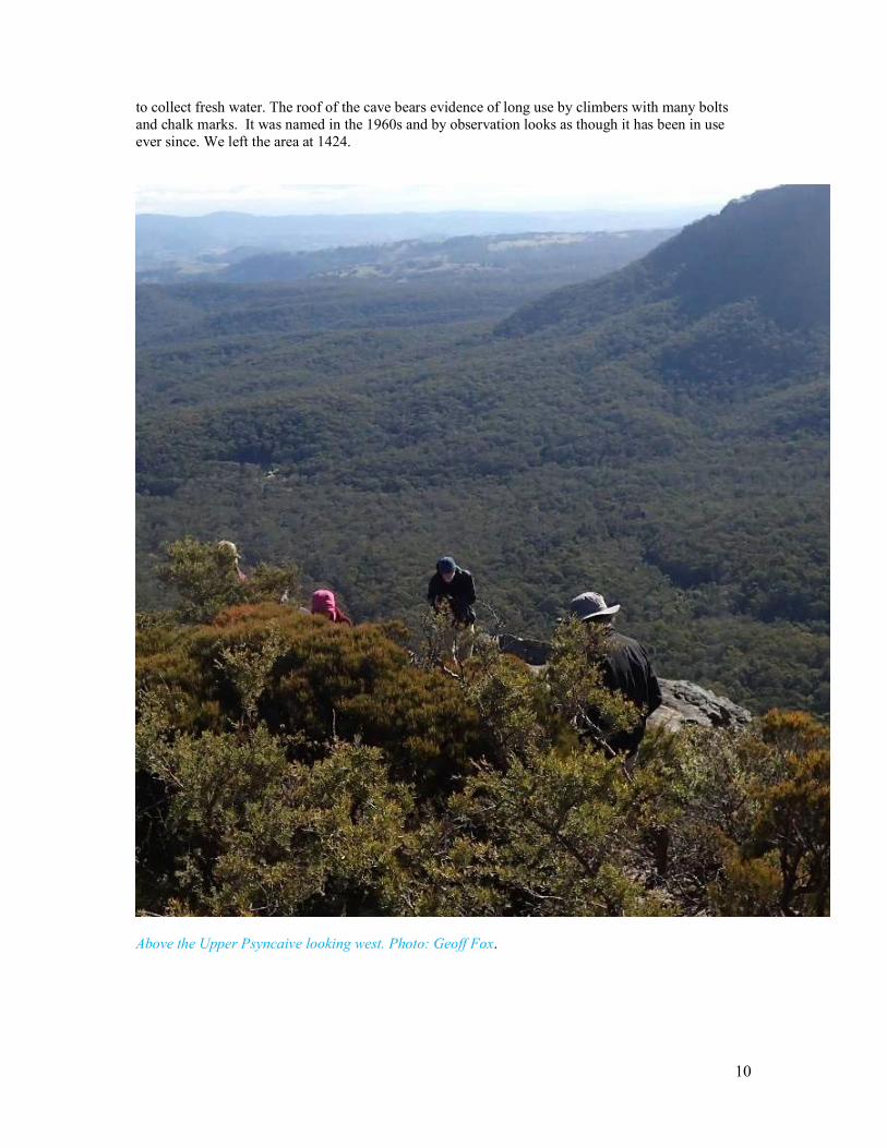
to collect fresh water. The roof of the cave bears evidence of long use by climbers with many bolts and chalk marks. It was named in the 1960s and by observation looks as though it has been in use ever since. We left the area at 1424.
Above the Upper Psyncaive looking west. Photo: Geoff Fox.
11
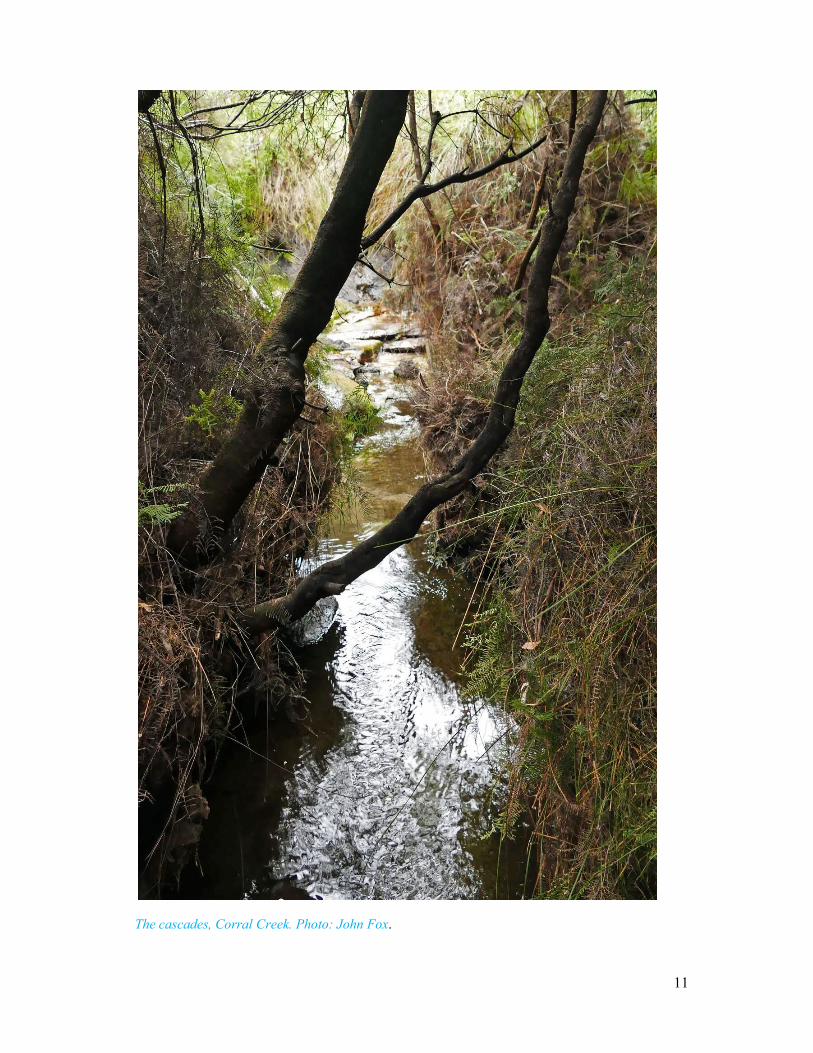
The cascades, Corral Creek. Photo: John Fox.
12
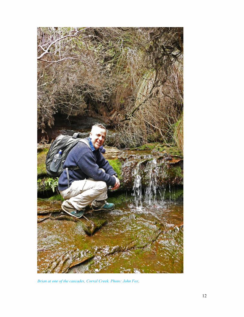
Brian at one of the cascades, Corral Creek. Photo: John Fox.
13
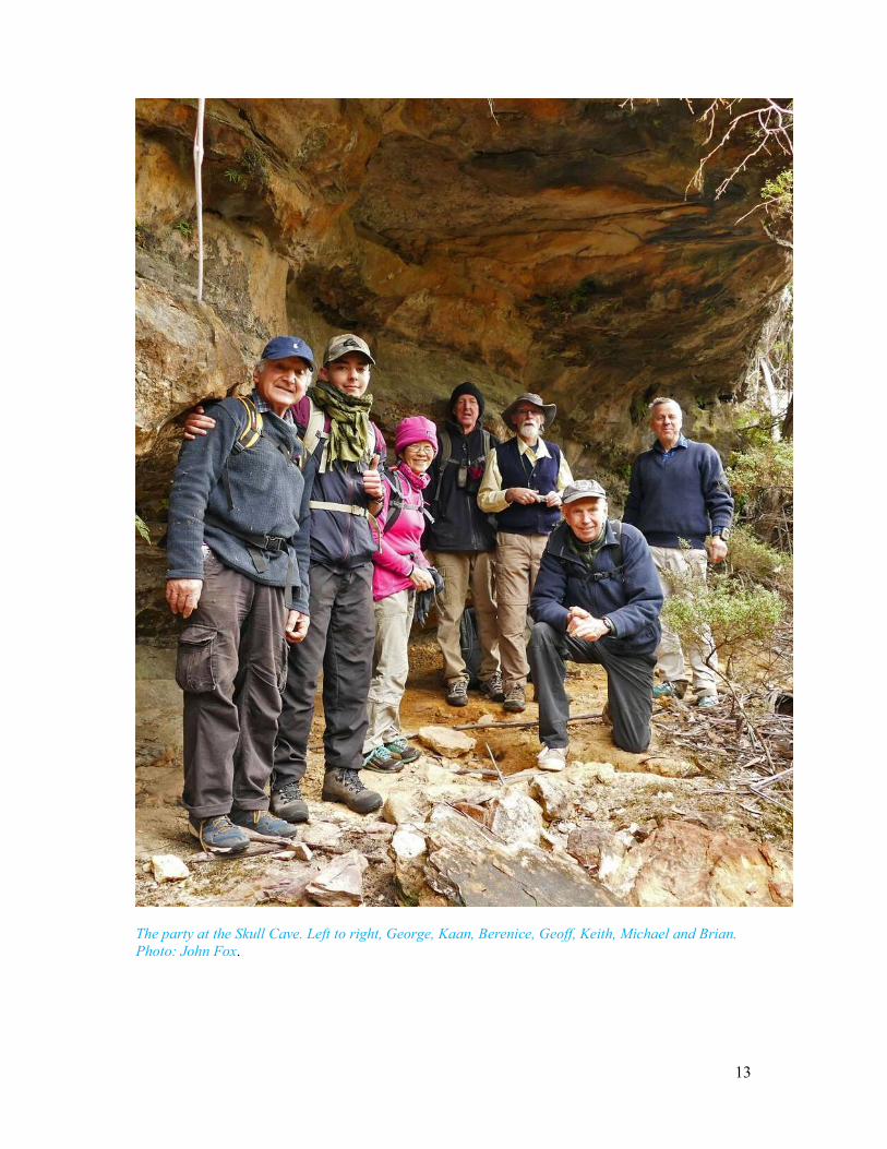
The party at the Skull Cave. Left to right, George, Kaan, Berenice, Geoff, Keith, Michael and Brian. Photo: John Fox.
14
Artefact from the Skull Cave. An ETA brand bottle manufactured 1935-1950. Photo: Brian Fox.
15
Artefact from the Skull Cave. An ETA brand bottle manufactured 1935-1950. Photo: Brian Fox.
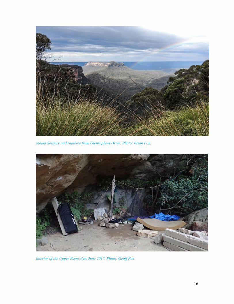
View down Corral Creek from near the Skull Cave. Photo: Geoff Fox.
16
Mount Solitary and rainbow from Glenraphael Drive. Photo: Brian Fox.
Interior of the Upper Psyncaive, June 2017. Photo: Geoff Fox.
17
Creek at the Upper Psyncaive. The container is under a waterfall. Photo: Brian Fox. BCSNW 3 short adventures on Narrow Neck 030717- Track Notes /MK Additional Notes. Geoff Fox archives
18
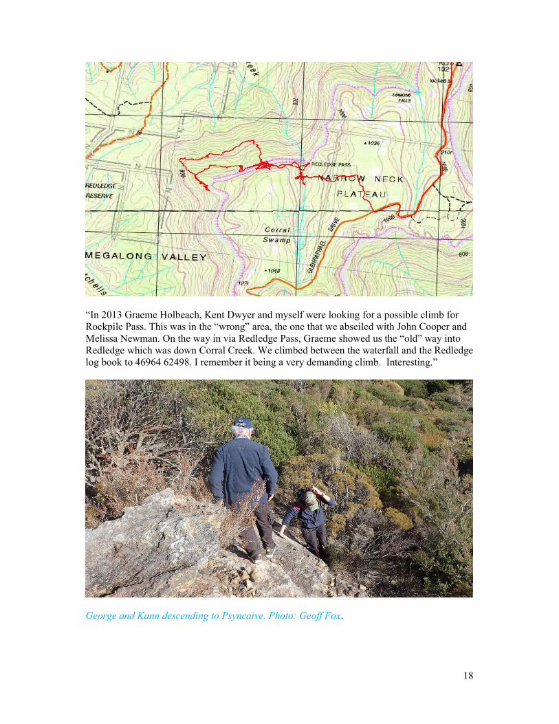
“In 2013 Graeme Holbeach, Kent Dwyer and myself were looking for a possible climb for Rockpile Pass. This was in the “wrong” area, the one that we abseiled with John Cooper and Melissa Newman. On the way in via Redledge Pass, Graeme showed us the “old” way into Redledge which was down Corral Creek. We climbed between the waterfall and the Redledge log book to 46964 62498. I remember it being a very demanding climb. Interesting.”
George and Kann descending to Psyncaive. Photo: Geoff Fox.


![:UH[KDP Y %RUHKDP :RRG · 0rqgd\ 2fwrehu wk 9dqdudpd 1dwlrqdo /hdjxh 1ruwk %udgirug 3dun $yhqxh y *dwhvkhdg &xu]rq $vkwrq y $oiuhwrq 7rzq)l[wxuhv duh vxemhfw wr fkdqjh](https://img.pdfslide.us/doc/110x75/5ff6f4e35ae165041d0fd8a2/uhkdp-y-ruhkdp-rrg-0rqgd-2fwrehu-wk-9dqdudpd-1dwlrqdo-hdjxh-1ruwk-udgirug.jpg)