Embed Size (px)
Citation preview
ASX Announcement | 18 January 2017 | Page 1
Bauxite Hills Mine Reserve Doubles to 96Mt
Metro Mining Ltd (ASX:MMI) is pleased to announce the first stage of the combination of its Bauxite
Hills Project with Gulf Alumina Ltd’s (Gulf) Skardon River Project has led to a significant increase in
the resources and reserves of the project.
The combined projects have been renamed the Bauxite Hills Mine.
The Direct Shipping Ore (DSO) Reserve for The Bauxite Hills Mine is 96.5 million tonnes (Mt)
The addition of the Gulf material, with its indicated higher THA and lower reactive silica levels, potentially
allows the company to offer a diverse product to its customers suited to both high and low temperature
refineries.
Based on the increased Resource and Reserve, work is underway on a bankable feasibility study (BFS) for
the Bauxite Hills Mine which is set to become a globally significant bauxite mining operation within the
internationally acclaimed Weipa bauxite producing region.
Mine construction is planned to commence in the second half of 2017.
Metro currently owns 99.9% of Gulf. As per its announcement on 20 December 2016, Metro has
commenced compulsory acquisition of the remaining Shares in Gulf not owned by Metro.
Reserves Dry DSO Tonnes (Mt) Al2O3% SiO2% Available Al2O3 % (THA) Reactive SiO2 %
Metro Reserves1. 48.2 50.5 11.2 38.4 6.4
Gulf Reserves2. 48.4 49.4 14.7 40.3 6.1
Total 96.5 49.9 12.9 39.4 6.3
1. Includes 41.8Mt Proved and 6.4Mt Probable Reserves from BH1 and BH6 deposits announced to the ASX on 2/6/2015.
2. Gulf’s Proved and Probable Reserves are described on page 2 below.
Resources Dry DSO Tonnes (Mt) Al2O3% SiO2% Available Al2O3 % (THA) Reactive SiO2 %
Metro Resources1. 65.3 50.3 12.4 38.4 6.4
Gulf Resources2. 63.5 49.6 14.3 40.4 6.1
Total 128.8 49.9 13.3 39.4 6.3
1. Includes the combined 41.8Mt Measured, 20Mt Indicated and 3.4Mt Inferred Resources from BH1, BH2 and BH6 deposits
announced to the ASX on 2/6/2015 and 9/12/2015. The Resources are inclusive of Reserves.
2. Gulf’s Measured, Indicated and Inferred Resources are described on page 2 below. The Resources are inclusive of Reserves.
ASX ANNOUNCEMENT
18 January 2017
For
per
sona
l use
onl
y
ASX Announcement | 18 January 2017 | Page 2
BACKGROUND INFORMATION
Gulf Alumina’s Previous Stand-Alone Skardon River Project
As Gulf Alumina Ltd is an unlisted public company it was not previously required to publicly release the Resource &
Reserve estimates for its stand-alone Skardon River Project. Metro is now pleased to announce the Skardon River
Project Measured, Indicated and Inferred Resources & Proved and Probable Reserves.
The Resource estimate was generated for Gulf Alumina Limited by consultancy company Geos Mining in 2015 in
accordance with the requirements of the JORC Code (2012).
The Ore Reserves estimate was prepared by Australian Mine Design and Development Pty Ltd (AMDAD) for Gulf
Alumina in 2016 in accordance with requirements of the JORC Code (2012).
The Skardon River Project Resource and Reserve Estimates are:
Resource Type Dry Tonnes (Mt) SiO2% Al2O3% Reactive SiO2%
(at 1480C)
Available Al2O3%
(at 1480C)
Measured 16.6 13.9 50.2 5.9 41.7
Indicated 32.3 14.5 49.4 6.2 40.0
Inferred 14.6 14.3 49.4 6.1 39.8
Total Resources 63.5 14.3 49.6 6.1 40.4
Note 1: Based on minimum thickness of 0.5m; ≤20% SiO2; ≥40% Al2O3; ≤8% Reactive SiO2
Reserve Type Dry Tonnes (Mt) SiO2% Al2O3% Reactive SiO2 %
(at 1480C)
Available Al2O3 % (at
1480C)
Proved 16.6 14.3 49.8 6.1 41.4
Probable 31.8 15.0 49.2 6.4 39.8
Total Reserves 48.3 14.7 49.4 6.3 40.3
Note 1: Based on minimum thickness of 0.5m; ≤20% SiO2; ≥40% Al2O3; ≤8% Reactive SiO2
Note 2: The Proved and Probable Reserves are included in the Mineral Resource
Resource and Reserve Details
The Mineral Resources being reported are the Measured, Indicated and Inferred Resources of Direct Shipping Ore
(DSO) at the Skardon River Bauxite Project of Gulf Alumina Limited. The Resource estimate was generated for Gulf
Alumina Limited by consultancy company Geos Mining in 2015 in accordance with the requirements of the JORC
Code (2012). As Gulf Alumina was an unlisted public company at the time it was not required to publicly release
the Resource estimate.
The Ore Reserves being reported are derived from the Mineral Resource estimated by Geo Mining using only the
Measured and Indicated blocks. The Ore Reserves estimate was prepared by Australian Mine Design and
Development Pty Ltd (AMDAD) for Gulf Alumina in 2016 in accordance with requirements of the JORC Code (2012).
As Gulf Alumina was an unlisted public company at the time it was not required to publicly release the Ore Reserves
estimate.
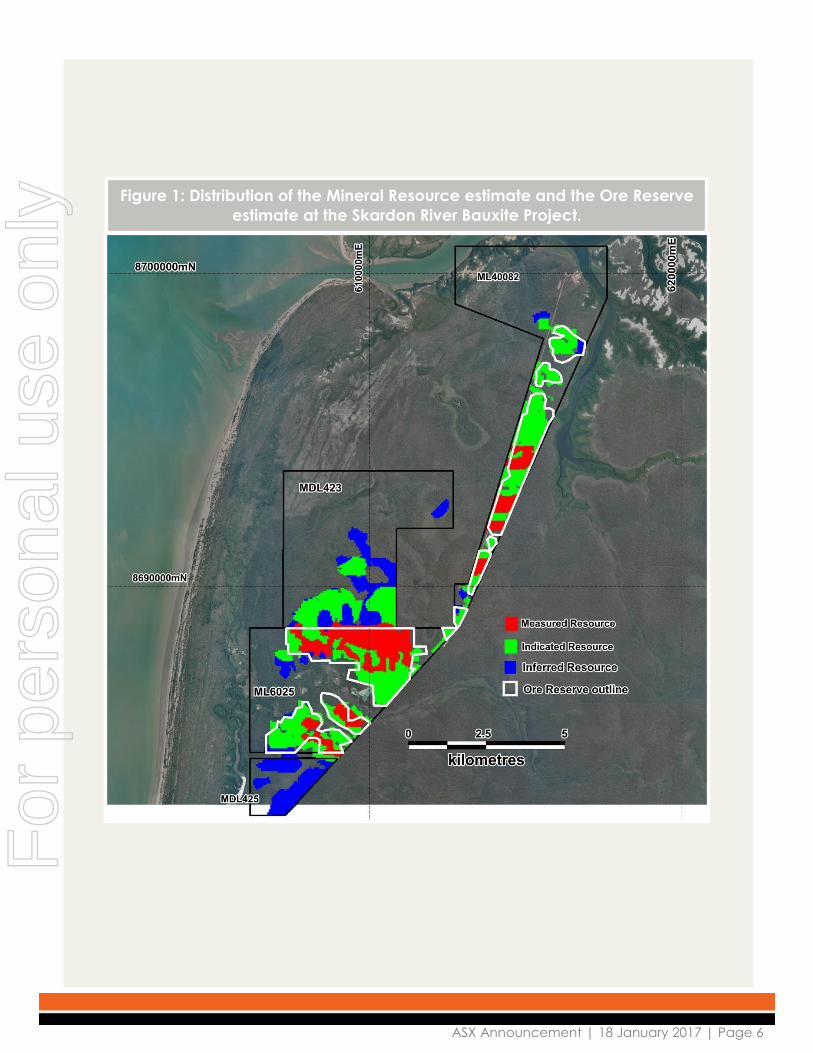
The area of the Mineral Resource estimate and its classifications is shown in Figure 1 which also shows the outline of
the Ore Reserve estimate derived from the Mineral Resource estimate.
Geology and Geological Interpretation
The deposit type is lateritic bauxite derived from the weathering of aluminous sediments in a tropical to sub-tropical
environment. The mineralisation within the Skardon River Bauxite Project forms part of the Weipa Plateau, a
widespread area of aluminous laterite on the west coast of Cape York Peninsula that includes Rio Tinto Alcan’s
Weipa, Andoom and Amrun bauxite deposits as well as Metro Mining’s adjacent Bauxite Hills BH1, BH2 and BH6
deposits.
The bauxite deposits generally consist of a single flat-lying pisolitic bauxite layer, generally 0.5m - 3m thick that is
underlain by a kaolin horizon. Within the resource area the average bauxite thickness is 1.6m. The bauxite deposits
are overlain by lateritic overburden and topsoil. Under the bauxite deposits there is often a ferruginous cemented
layer and a kaolin clay layer. Kaolin, sandy clays and minor quartz sand deposits occur beneath the bauxite layer
and extend beyond the bauxite areas, beneath the Namaleta Creek flood plain.
The geological model is grade-based using a cut-off of ≤20% total SiO2 and ≤8% reactive SiO2 (at 1500C)
For
per
sona
l use
onl
y
ASX Announcement | 18 January 2017 | Page 3
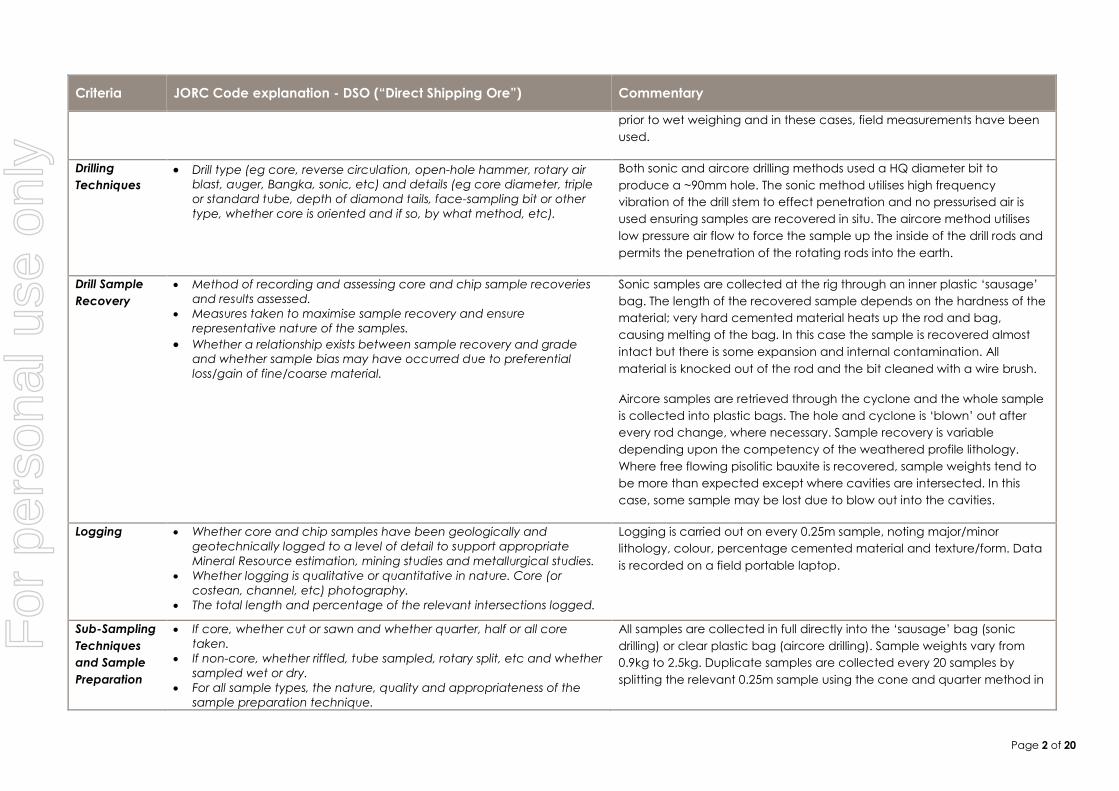
Drilling Techniques
Both sonic and aircore drilling methods were used in several drilling programs between 2005 and 2015.
Both methods used a HQ diameter bit to produce a ~90mm hole. The sonic method utilises high frequency vibration
of the drill stem to effect penetration and no pressurised air is used ensuring samples are recovered in situ. The
aircore method utilises low pressure air flow to force the sample up the inside of the drill rods and permits the
penetration of the rods into the earth. All drill holes are vertical and intersect the mineralisation at 900.
The sonic drilling method also produced samples that were utilised for bulk density measurements.
Hole collars have been surveyed using a differential GPS which has horizontal accuracy of +- 40cms. Vertical
accuracy is much greater at ~80cms. Data is collected with reference to the GDA94 datum and recorded as Zone
54 metric coordinates.
In early 2015, LiDAR data was obtained and elevation data was inserted into the database as a more accurate
measure of RL.
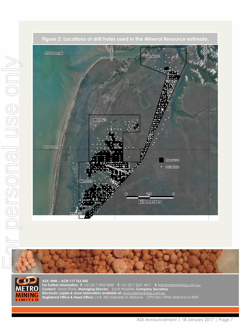
The distribution of the drill holes that were used in the Mineral Resource estimate are shown in Figure 2.
Sampling and Sub-sampling Techniques
In the sampling technique used in the aircore method the entire sample was collected at 0.25m intervals in clear
plastic bags, tightly fitted to the cyclone outlet. Samples were logged and the airtight bags were sealed with cable
ties to retain moisture.
With the Sonic drilling method sampling was carried out in 0.25m intervals. Samples were collected within a custom
designed ‘sausage’ bag that is inserted into the barrel. The sample is retrieved after completing the dri lling run
which varies from 0.5m to 1.5m. The ‘sausage’ is laid out on a table then the length measured and compared to
the actual down hole depth. The sample is then divided into equal lengths of 0.25m, immediately logged then
placed into airtight clear plastic bags and sealed with cable ties to retain moisture.
Geological logging is carried out on every 0.25m sample, noting major/minor lithology, colour, percentage
cemented material and bauxite. Data is recorded on a field portable laptop.
Sample Analysis
Samples were assayed for a suite of elemental oxides and Loss on Ignition by ALS. Analyses are carried out by XRF
Fusion (code ME-XRF13n). ALS includes laboratory standards and blanks in their standard operating procedures.
Assaying of low temperature available alumina and reactive silica was carried out using ALS pulps but analysed by
SGS Laboratories in Perth. The method used is a laboratory modified ‘Bayer Process’.
Estimation Methodology
A gridded seam model was created using Micromine software whereby each bauxite unit in each hole is assigned
a mid-point coordinate and a thickness. A single layer bauxite gridded seam model is created after using the
Ordinary Kriging method of interpolation. This ‘blank’ model was then populated with Al2O3, SiO2, dry bulk density,
available alumina and reactive silica values using Ordinary Kriging of the filtered (bauxite) analyses. A considerable
proportion of assays from beneficiated samples have been used to obtain correlated raw sample assays; the
correlation coefficient is considered moderate at best.
Once the Kriging results have been loaded into the block model, the blocks are cut, according to the appropriate
selection criteria eg an upper cut-off of 20% SiO2 and 8% reactive silica. The remaining blocks are classified (using
the average search distance and the determination of whether assays are measured or correlated) into one of the
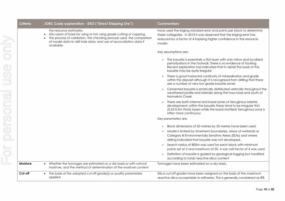
following three classifications: Measured, Indicated, Inferred. Previous estimates have used the kriging standard
error and points per block to determine these categories. In 2013 it was observed that the kriging error has reduced
by a factor of 4 implying higher confidence in the resource model.
Key Assumptions are:
The bauxite is essentially a flat layer with only minor and localised perturbations in the footwall. There is no
evidence of faulting. Recent exploration has indicated that in detail the base of the bauxite may be quite
irregular
There is good horizontal continuity of mineralisation and grade within the deposit although it is recognised
from drilling that there are a number of very low grade bauxite zones
For
per
sona
l use
onl
y
ASX Announcement | 18 January 2017 | Page 4
Cemented bauxite is erratically distributed vertically throughout the weathered profile and laterally along the
haul road and south of Namaleta Creek
There are both internal and basal zones of ferruginous laterite development; within the bauxite these tend to
be irregular thin (0.25-0.5m thick) layers while the basal mottled/ ferruginous zone is often more continuous.
Key Parameters are:
Block dimensions of 50 metres by 50 metres have been used.
Model is limited by tenement boundaries, areas of wetlands or Category B Environmentally Sensitive Areas
(ESAs) and where drilling indicated that bauxite was not developed.
Search radius of 800m was used for each block with minimum points set at 2 and maximum at 20. A sub cell
factor of 4 was used.
Definition of bauxite is guided by geological logging but modified according to total/ reactive silica content.
Mining and Metallurgy
Ore Reserves are derived from the Mineral Resource by application of a mine plan using a strip and block layout for
mining by loaders and trucks. The mine design is based on bauxite quality and economic analyses after
application of mining loss and dilution adjustments.
The bauxite will be mined by large front end loaders loading 200 to 350 tonne road trains. Topsoil will be mined by
scrapers and the subsoil immediately overlying the bauxite will be mined by front end loaders loading rigid body
trucks. No blasting is required.
Pit depths vary from 0.5 to 6.7 metres with 95% less than 3.5 metres. Pit widths are 1 to 5 km. The floor is near level.
No geotechnical analysis was required for the very shallow walls and the reserves assume they are vertical.
The Direct Shipping Ore (DSO) bauxite is defined by alumina and silica content which are laterally consistent over
more than 100 metres through the pits. Vertically the DSO resource is defined by less than or equal to 20% SiO2 in
the drill holes which are sampled on 25cm intervals. There is very little internal dilution vertically within the DSO
horizon. Mining loss and dilution will occur on the roof and floor of the DSO horizon which averages 1.6 metres
thickness. Mining loss and dilution are modelled as a 10cm loss and 10cm dilution skin on both the roof and floor.
Roof dilution grades for silica and alumina were modelled from the first 25cm drill hole sample above the DSO
horizon and floor dilution grades from the first 25cm sample below the DSO horizon. Loss grades were modelled
from the 25cm drill hole samples in the top and base of the DSO horizon.
Grade control drilling on a 20 x 20 metre grid is planned ahead of mining to define the DSO roof and floor which will
be cut by GPS guided machines to meet the ±10cm tolerance in the mining loss and dilution model.
The Ore Reserve model uses the single layer 50 x 50 metre blocks from the Mineral Resource model. A margin
ranking model was prepared to assess the value of each block by deducting the mining, port, barging, site and
royalty costs from the free on board (FOB) value of run of mine (ROM) bauxite in the block. Mining costs are from a
detailed estimate for clearing, topsoil, subsoil and bauxite including variable ore haulage costs to the port. All other
costs were supplied by GAL. Bauxite pricing is based on current Australian sales to China and includes alumina and
silica penalties and sea freight. The margin rank model shows the defined pits to be positive value at 85% of the
bauxite price used in GAL’s financial model.
The Life of Mine schedule in the Pre-feasibility Study includes Inferred Resources. However these are almost entirely
in the last 5 years of a 14 year mine life and the location of Proved and Probable Reserves would still allow them to
be mined even if none of the Inferred were ever mined. Checks were done to ensure that the project is technically
and commercially viable even if none of the Inferred is included.
Mining costs assume contract mining. The mining cost estimate was validated against three budget quotations
received in late 2014 based on a scoping study for a similar mine plan.
The bauxite will be sold as a Direct Shipping Ore without processing other than sizing to -150mm and removal of
tramp wood and metal.
Reference qualities used for pricing on a dry basis (namely CIBX) are 45% available alumina and 5% reactive silica.
The average grades of the Ore Reserves are 40.3% total alumina and 6.3% reactive silica. These qualities are
saleable and return positive block values when expected quality penalties are applied.
Most of the DSO Reserve is expected to be free flowing pisolitic and fines bauxite. Up to 30% may be weakly
cemented. The planned port facility includes sizing to ensure the minus150mm specification is maintained.
For
per
sona
l use
onl
y
ASX Announcement | 18 January 2017 | Page 5
Product quality will be regulated by mining from two locations at any time and by limited blending capability from
the port stockpile.
Bulk Density Data
The sonic drilling programme enabled the measurement of 144 bulk density values from bauxitic material and this
data was used in the resource estimate. An average default value of 1.8 was initially used (compared to previous
conservative estimates of 1.6). The inclusion of an additional 204 measurements from field data has increased the
default bulk density to 1.93 and this has been used in the current resource estimate where blocks are located
outside the search distance of the modelling algorithm.
Classification
The data points, in the form of shallow drill holes, are variably spaced. Data from drill holes spaced at 200m was
used to classify Resources as Measured; data from holes spaced up to 400m used to classify as Indicated; data
from holes >400m used to classify as Inferred.
ASX: MMI | ACN 117 763 443
For Further Information: P: +61 (0) 7 3009 8000 | F: +61 (0) 7 3221 4811| E: [email protected]
Contact: Simon Finnis, Managing Director | Scott Waddell, Company Secretary
Electronic copies & more information available at: www.metromining.com.au
Registered Office & Head Office: Lvl 8, 300 Adelaide St, Brisbane | GPO Box 10955, Brisbane Q 4000
Competent Person Statement: The information in this ASX Release that relates to Gulf Alumina’s Mineral Resources is based on information compiled
by Jeff Randall of Geos Mining, a consultancy group contracted by Metro Mining Limited. Mr Randell is a Member of the Australian Institute of
Geoscientists (MAIG), a Registered Professional Geoscientist (RPGeo) and has sufficient experience that is relevant to the style of mineralisation and
type of deposit under consideration and to the activity being undertaken to qualify as a Competent Person as defined in the 2012 Edition of the
‘Australasian Code for Reporting of Exploration Results, Mineral Resources and Ore Reserves’. Mr Randell consents to the inclusion in this ASX Release
of the matters based on information in the form and context in which it appears.
Competent Person Statement:
The information in this ASX Release that relates to Metro Mining Mineral Resources is based on information compiled by Neil McLean who is a
consultant of Metro Mining Limited. Mr McLean is a Fellow of the Australasian Institute of Mining and Metallurgy (FAusIMM) and has sufficient
experience that is relevant to the style of mineralisation and type of deposit under consideration and to the activity being undertaken to qualify as a
Competent Person as defined in the 2012 Edition of the ‘Australasian Code for Reporting of Exploration Results, Mineral Resources and Ore Reserves’.
Mr McLean consents to the inclusion in this ASX Release of the matters based on information in the form and context in which it appears
Competent Person Statement: The information in this ASX Release that relates to Gulf Alumina’s Ore Reserves is based on information compiled by
John Wyche of Australian Mine Design & Development (AMDAD), a Competent Person who is a Member of the Australasian Institute of Mining and
Metallurgy. John Wyche is a full-time employee of AMDAD. John Wyche has sufficient experience that is relevant to the style of mineralization, type
of deposit under consideration and to the activity being undertaken to qualify as a Competent Person as defined in the 2012 Edition of the
‘Australasian Code for Reporting of Exploration Results, Mineral Resources and Ore Reserves’. John Wyche consents to the inclusion in this ASX
Release of the matters based on his information in the form and context in which it appears.
Competent Person Statement: The information in this report that relates to Metro Reserves is based on information compiled by MEC Mining and
reviewed by Edward Bolton, a Competent Person who is a Member of the Australasian Institute of Mining and Metallurgy. Edward Bolton is a full-time
employee of MEC Mining Pty Ltd. Edward Bolton has sufficient experience that is relevant to the style of mineralization, type of deposit under
consideration and to the activity being undertaken to qualify as a Competent Person as defined in the 2012 Edition of the ‘Australasian Code for
Reporting of Exploration Results, Mineral Resources and Ore Reserves’. Edward Bolton consents to the inclusion in the report of the matters based on
his information in the form and context in which it appears..
Forward Looking Statement: Statements and material contained in this ASX Release, particularly those regarding possible or assumed future
performance, production levels or rates, commodity prices, resources or potential growth of Metro Mining Limited, industry growth or other trend
projections are, or may be, forward looking statements. Such statements relate to future events and expectations and, as such, involve known and
unknown risks and uncertainties. Graphs used in the presentation (including data used in the graphs) are sourced from third parties and Metro Mining
has not independently verified the information. Metro Mining is at an early development stage and while it does not currently have an operating
bauxite mine it is taking early and preliminary steps (such as but not limited to Prefeasibility studies etc.) that are intended to ultimately result in the
building and construction of an operating mine at its project areas. Although reasonable care has been taken to ensure that the facts stated in this
Presentation are accurate and or that the opinions expressed are fair and reasonable, no reliance can be placed for any purpose whatsoever on
the information contained in this document or on its completeness. Actual results and developments may differ materially from those expressed or
implied by these forward looking statements depending on a variety of factors. Nothing in this Presentation should be construed as either an offer to
sell or a solicitation of an offer to buy or sell shares in any jurisdiction.
For
per
sona
l use
onl
y
ASX Announcement | 18 January 2017 | Page 6
Figure 1: Distribution of the Mineral Resource estimate and the Ore Reserve
estimate at the Skardon River Bauxite Project.
For
per
sona
l use
onl
y
ASX Announcement | 18 January 2017 | Page 7
ASX: MMI | ACN 117 763 443
For Further Information: P: +61 (0) 7 3009 8000 | F: +61 (0) 7 3221 4811| E: [email protected]
Contact: Simon Finnis, Managing Director | Scott Waddell, Company Secretary
Electronic copies & more information available at: www.metromining.com.au
Registered Office & Head Office: Lvl 8, 300 Adelaide St, Brisbane | GPO Box 10955, Brisbane Q 4000
Figure 2: Locations of drill holes used in the Mineral Resource estimate.
For
per
sona
l use
onl
y
Page 1 of 20
Appendix 1: JORC Code, 2012 Edition – Table 1 report template
Skardon River Bauxite Project – Gulf Alumina Limited. Resources and Reserves Estimates
Section 1 Sampling Techniques and Data
(Criteria in this section apply to all succeeding sections.)
Criteria JORC Code explanation - DSO (“Direct Shipping Ore”) Commentary
Sampling
Techniques
Nature and quality of sampling (eg cut channels, random chips, or
specific specialised industry standard measurement tools appropriate
to the minerals under investigation, such as down hole gamma sondes,
or handheld XRF instruments, etc). These examples should not be taken
as limiting the broad meaning of sampling.
Include reference to measures taken to ensure sample representivity
and the appropriate calibration of any measurement tools or systems
used.
Aspects of the determination of mineralisation that are Material to the
Public Report.
In cases where ‘industry standard’ work has been done this would be
relatively simple (eg ‘reverse circulation drilling was used to obtain 1 m
samples from which 3 kg was pulverised to produce a 30 g charge for
fire assay’). In other cases more explanation may be required, such as
where there is coarse gold that has inherent sampling problems.
Unusual commodities or mineralisation types (eg submarine nodules)
may warrant disclosure of detailed information.
Both sonic and aircore drilling methods were used in several drilling
programs between 2005 and 2014.
In the sampling technique used in the aircore method the entire sample
was collected at 0.25m intervals via the hollow rods, connecting hose and
then into a cyclone. Clear plastic bags, tightly fitted to the cyclone outlet,
ensured collection of the entire sample. Samples were immediately
logged then the airtight bags were sealed with cable ties to retain
moisture. Sample depth accuracy is estimated to be +- 5cms.
With the Sonic drilling method sampling was carried out in 0.25m intervals.
Samples were collected within a custom designed plastic ‘sausage’ bag
that is inserted into the barrel. The sample is retrieved after completing the
drilling run which varies from 0.5m to 1.5m. The ‘sausage’ is laid out on a
table then the length measured and compared to the actual down hole
depth. The sample is then divided into equal lengths of 0.25m,
immediately logged then placed into airtight clear plastic bags and
sealed with cable ties to retain moisture. Sample depth accuracy is
estimated to be +- 5cms. Drill rods are 1.5m in length and used as a
reference for the sampling.
Bulk density determinations were carried out where there was no
observable damage to the ‘sausage’ bags. The diameter of the
‘sausage’ was measured with a vernier scale and once the sample was
placed into airtight plastic bags it was weighed with allowance for the
weight of the bag. Field measurements of wet bulk density were made
but most samples were also weighed wet and dry in the laboratory to
obtain more accurate dry bulk density values. Some samples were dried
For
per
sona
l use
onl
y
Page 2 of 20
Criteria JORC Code explanation - DSO (“Direct Shipping Ore”) Commentary
prior to wet weighing and in these cases, field measurements have been
used.
Drilling
Techniques
Drill type (eg core, reverse circulation, open-hole hammer, rotary air
blast, auger, Bangka, sonic, etc) and details (eg core diameter, triple
or standard tube, depth of diamond tails, face-sampling bit or other
type, whether core is oriented and if so, by what method, etc).
Both sonic and aircore drilling methods used a HQ diameter bit to
produce a ~90mm hole. The sonic method utilises high frequency
vibration of the drill stem to effect penetration and no pressurised air is
used ensuring samples are recovered in situ. The aircore method utilises
low pressure air flow to force the sample up the inside of the drill rods and
permits the penetration of the rotating rods into the earth.
Drill Sample
Recovery
Method of recording and assessing core and chip sample recoveries
and results assessed.
Measures taken to maximise sample recovery and ensure representative nature of the samples.
Whether a relationship exists between sample recovery and grade
and whether sample bias may have occurred due to preferential
loss/gain of fine/coarse material.
Sonic samples are collected at the rig through an inner plastic ‘sausage’
bag. The length of the recovered sample depends on the hardness of the
material; very hard cemented material heats up the rod and bag,
causing melting of the bag. In this case the sample is recovered almost
intact but there is some expansion and internal contamination. All
material is knocked out of the rod and the bit cleaned with a wire brush.
Aircore samples are retrieved through the cyclone and the whole sample
is collected into plastic bags. The hole and cyclone is ‘blown’ out after
every rod change, where necessary. Sample recovery is variable
depending upon the competency of the weathered profile lithology.
Where free flowing pisolitic bauxite is recovered, sample weights tend to
be more than expected except where cavities are intersected. In this
case, some sample may be lost due to blow out into the cavities.
Logging Whether core and chip samples have been geologically and
geotechnically logged to a level of detail to support appropriate
Mineral Resource estimation, mining studies and metallurgical studies.
Whether logging is qualitative or quantitative in nature. Core (or
costean, channel, etc) photography.
The total length and percentage of the relevant intersections logged.
Logging is carried out on every 0.25m sample, noting major/minor
lithology, colour, percentage cemented material and texture/form. Data
is recorded on a field portable laptop.
Sub-Sampling
Techniques
and Sample
Preparation
If core, whether cut or sawn and whether quarter, half or all core
taken.
If non-core, whether riffled, tube sampled, rotary split, etc and whether
sampled wet or dry.
For all sample types, the nature, quality and appropriateness of the
sample preparation technique.
All samples are collected in full directly into the ‘sausage’ bag (sonic
drilling) or clear plastic bag (aircore drilling). Sample weights vary from
0.9kg to 2.5kg. Duplicate samples are collected every 20 samples by
splitting the relevant 0.25m sample using the cone and quarter method in
For
per
sona
l use
onl
y
Page 3 of 20
Criteria JORC Code explanation - DSO (“Direct Shipping Ore”) Commentary
Quality control procedures adopted for all sub-sampling stages to
3maximize representivity of samples.
Measures taken to ensure that the sampling is representative of the in
situ material collected, including for instance results for field
duplicate/second-half sampling.
Whether sample sizes are appropriate to the grain size of the material
being sampled.
the field at the time of drilling. No compositing of samples was carried out.
Samples were weighed wet, split, dried, re-weighed, crushed and
pulverised at ALS Laboratories, Brisbane.
Quality of
Assay Data &
Laboratory
Tests
The nature, quality and appropriateness of the assaying and
laboratory procedures used and whether the technique is considered
partial or total.
For geophysical tools, spectrometers, handheld XRF instruments, etc,
the parameters used in determining the analysis including instrument
make and model, reading times, calibrations factors applied and their
derivation, etc.
Nature of quality control procedures adopted (eg standards, blanks,
duplicates, external laboratory checks) and whether acceptable
levels of accuracy (ie lack of bias) and precision have been
established.
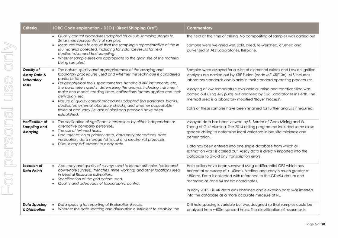
Samples were assayed for a suite of elemental oxides and Loss on Ignition.
Analyses are carried out by XRF Fusion (code ME-XRF13n). ALS includes
laboratory standards and blanks in their standard operating procedures.
Assaying of low temperature available alumina and reactive silica was
carried out using ALS pulps but analysed by SGS Laboratories in Perth. The
method used is a laboratory modified ‘Bayer Process’.
Splits of these samples have been retained for further analysis if required.
Verification of
Sampling and
Assaying
The verification of significant intersections by either independent or
alternative company personnel.
The use of twinned holes.
Documentation of primary data, data entry procedures, data
verification, data storage (physical and electronic) protocols.
Discuss any adjustment to assay data.
Assayed data has been viewed by S. Border of Geos Mining and W.
Zhang of Gulf Alumina. The 2014 drilling programme included some close
spaced drilling to determine local variations in bauxite thickness and
cementation.
Data has been entered into one single database from which all
estimation work is carried out. Assay data is directly imported into the
database to avoid any transcription errors.
Location of
Data Points
Accuracy and quality of surveys used to locate drill holes (collar and
down-hole surveys), trenches, mine workings and other locations used
in Mineral Resource estimation.
Specification of the grid system used.
Quality and adequacy of topographic control.
Hole collars have been surveyed using a differential GPS which has
horizontal accuracy of +- 40cms. Vertical accuracy is much greater at
~80cms. Data is collected with reference to the GDA94 datum and
recorded as Zone 54 metric coordinates.
In early 2015, LiDAR data was obtained and elevation data was inserted
into the database as a more accurate measure of RL.
Data Spacing
& Distribution
Data spacing for reporting of Exploration Results.
Whether the data spacing and distribution is sufficient to establish the
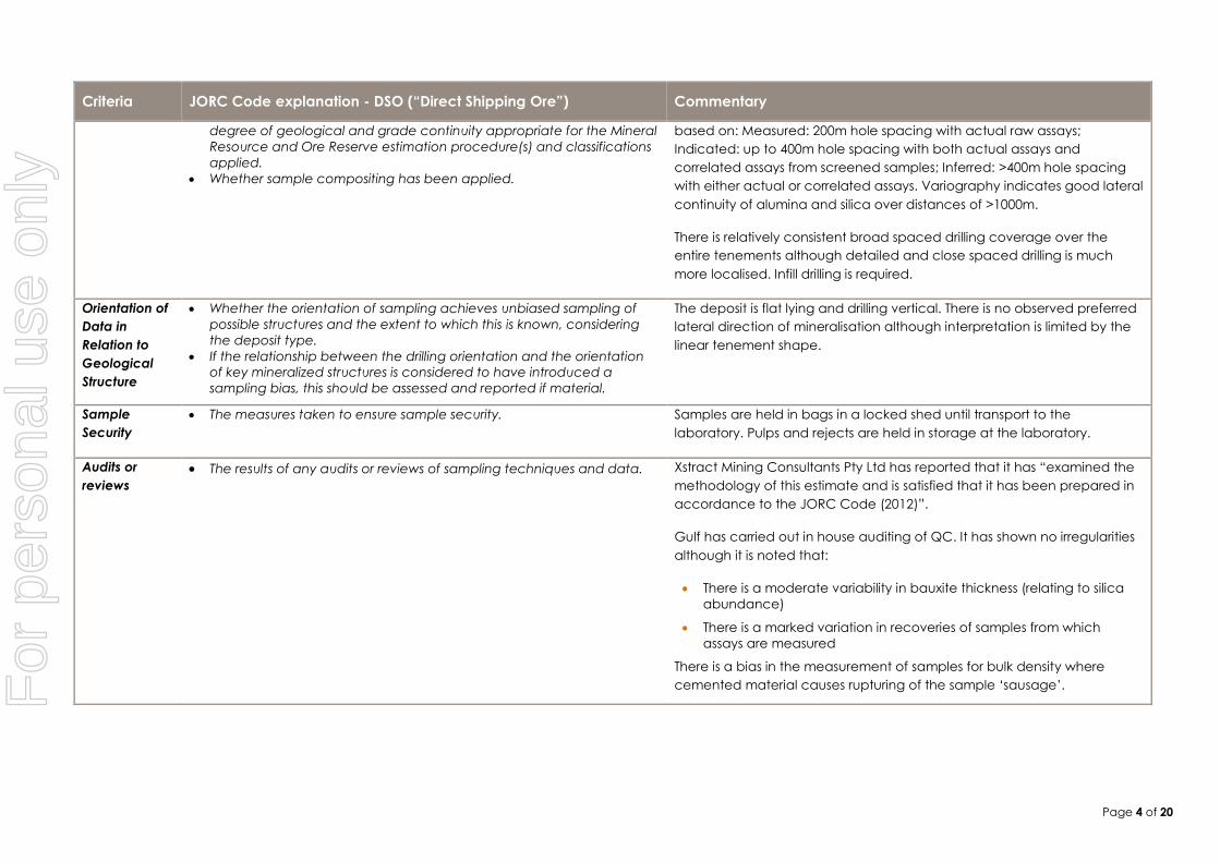
Drill hole spacing is variable but was designed so that samples could be
analysed from ~400m spaced holes. The classification of resources is
For
per
sona
l use
onl
y
Page 4 of 20
Criteria JORC Code explanation - DSO (“Direct Shipping Ore”) Commentary
degree of geological and grade continuity appropriate for the Mineral
Resource and Ore Reserve estimation procedure(s) and classifications
applied.
Whether sample compositing has been applied.
based on: Measured: 200m hole spacing with actual raw assays;
Indicated: up to 400m hole spacing with both actual assays and
correlated assays from screened samples; Inferred: >400m hole spacing
with either actual or correlated assays. Variography indicates good lateral
continuity of alumina and silica over distances of >1000m.
There is relatively consistent broad spaced drilling coverage over the
entire tenements although detailed and close spaced drilling is much
more localised. Infill drilling is required.
Orientation of
Data in
Relation to
Geological
Structure
Whether the orientation of sampling achieves unbiased sampling of
possible structures and the extent to which this is known, considering
the deposit type.
If the relationship between the drilling orientation and the orientation
of key mineralized structures is considered to have introduced a
sampling bias, this should be assessed and reported if material.
The deposit is flat lying and drilling vertical. There is no observed preferred
lateral direction of mineralisation although interpretation is limited by the
linear tenement shape.
Sample
Security
The measures taken to ensure sample security. Samples are held in bags in a locked shed until transport to the
laboratory. Pulps and rejects are held in storage at the laboratory.
Audits or
reviews
The results of any audits or reviews of sampling techniques and data. Xstract Mining Consultants Pty Ltd has reported that it has “examined the
methodology of this estimate and is satisfied that it has been prepared in
accordance to the JORC Code (2012)”.
Gulf has carried out in house auditing of QC. It has shown no irregularities
although it is noted that:
There is a moderate variability in bauxite thickness (relating to silica
abundance)
There is a marked variation in recoveries of samples from which
assays are measured
There is a bias in the measurement of samples for bulk density where
cemented material causes rupturing of the sample ‘sausage’.
For
per
sona
l use
onl
y
Page 5 of 20
Section 2 Reporting of Exploration Results
(Criteria listed in the preceding section also apply to this section.)
Criteria JORC Code explanation - DSO (“Direct Shipping Ore”) Commentary
Mineral
Tenement and
Land Tenure
Status
Type, reference name/number, location and ownership including
agreements or material issues with third parties such as joint ventures,
partnerships, overriding royalties, native title interests, historical sites,
wilderness or national park and environmental settings.
The security of the tenure held at the time of reporting along with any
known impediments to obtaining a licence to operate in the area.
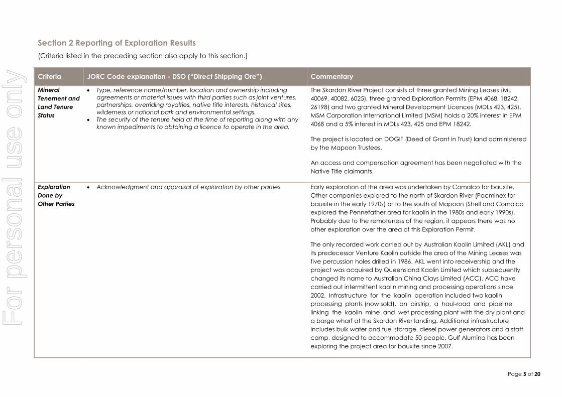
The Skardon River Project consists of three granted Mining Leases (ML
40069, 40082, 6025), three granted Exploration Permits (EPM 4068, 18242,
26198) and two granted Mineral Development Licences (MDLs 423, 425).
MSM Corporation International Limited (MSM) holds a 20% interest in EPM
4068 and a 5% interest in MDLs 423, 425 and EPM 18242.
The project is located on DOGIT (Deed of Grant in Trust) land administered
by the Mapoon Trustees.
An access and compensation agreement has been negotiated with the
Native Title claimants.
Exploration
Done by
Other Parties
Acknowledgment and appraisal of exploration by other parties. Early exploration of the area was undertaken by Comalco for bauxite.
Other companies explored to the north of Skardon River (Pacminex for
bauxite in the early 1970s) or to the south of Mapoon (Shell and Comalco
explored the Pennefather area for kaolin in the 1980s and early 1990s).
Probably due to the remoteness of the region, it appears there was no
other exploration over the area of this Exploration Permit.
The only recorded work carried out by Australian Kaolin Limited (AKL) and
its predecessor Venture Kaolin outside the area of the Mining Leases was
five percussion holes drilled in 1986. AKL went into receivership and the
project was acquired by Queensland Kaolin Limited which subsequently
changed its name to Australian China Clays Limited (ACC). ACC have
carried out intermittent kaolin mining and processing operations since
2002. Infrastructure for the kaolin operation included two kaolin
processing plants (now sold), an airstrip, a haul-road and pipeline
linking the kaolin mine and wet processing plant with the dry plant and
a barge wharf at the Skardon River landing. Additional infrastructure
includes bulk water and fuel storage, diesel power generators and a staff
camp, designed to accommodate 50 people. Gulf Alumina has been
exploring the project area for bauxite since 2007.
For
per
sona
l use
onl
y
Page 6 of 20
Criteria JORC Code explanation - DSO (“Direct Shipping Ore”) Commentary
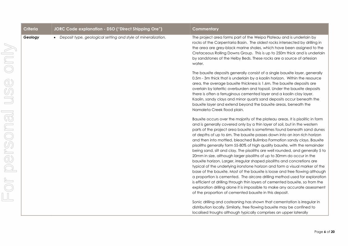
Geology Deposit type, geological setting and style of mineralization. The project area forms part of the Weipa Plateau and is underlain by
rocks of the Carpentaria Basin. The oldest rocks intersected by drilling in
the area are grey-black marine shales, which have been assigned to the
Cretaceous Rolling Downs Group. This is up to 250m thick and is underlain
by sandstones of the Helby Beds. These rocks are a source of artesian
water.
The bauxite deposits generally consist of a single bauxite layer, generally
0.5m - 3m thick that is underlain by a kaolin horizon. Within the resource
area, the average bauxite thickness is 1.6m. The bauxite deposits are
overlain by lateritic overburden and topsoil. Under the bauxite deposits
there is often a ferruginous cemented layer and a kaolin clay layer.
Kaolin, sandy clays and minor quartz sand deposits occur beneath the
bauxite layer and extend beyond the bauxite areas, beneath the
Namaleta Creek flood plain.
Bauxite occurs over the majority of the plateau areas. It is pisolitic in form
and is generally covered only by a thin layer of soil, but in the western
parts of the project area bauxite is sometimes found beneath sand dunes
at depths of up to 6m. The bauxite passes down into an iron rich horizon
and then into mottled, bleached Bulimba Formation sandy clays. Bauxite
pisoliths generally form 55-80% of high quality bauxite, with the remainder
being sand, silt and clay. The pisoliths are well rounded, and generally 5 to
20mm in size, although larger pisoliths of up to 30mm do occur in the
bauxite horizon. Larger, irregular shaped pisoliths and concretions are
typical of the underlying ironstone horizon and form a visual marker of the
base of the bauxite. Most of the bauxite is loose and free flowing although
a proportion is cemented. The aircore drilling method used for exploration
is efficient at drilling through thin layers of cemented bauxite, so from the
exploration drilling alone it is impossible to make any accurate assessment
of the proportion of cemented bauxite in this deposit.
Sonic drilling and costeaning has shown that cementation is irregular in
distribution locally. Similarly, free flowing bauxite may be confined to
localised troughs although typically comprises an upper laterally
For
per
sona
l use
onl
y
Page 7 of 20
Criteria JORC Code explanation - DSO (“Direct Shipping Ore”) Commentary
continuous layer. The base of the bauxite is locally very irregular.
Drill Hole
Information
A summary of all information material to the understanding of the
exploration results including a tabulation of the following information
for all Material drill holes:
o easting and northing of the drill hole collar
o elevation or RL (Reduced Level – elevation above sea level in
metres) of the drill hole collar
o dip and azimuth of the hole
o down hole length and interception depth
o hole length.
If the exclusion of this information is justified on the basis that the
information is not Material and this exclusion does not detract from the
understanding of the report, the Competent Person should clearly
explain why this is the case.
All data is contained within a comprehensive database that has been
validated and is the basis from which the resource model has been built.
All holes are vertical.
Data
Aggregation
Methods
In reporting Exploration Results, weighting averaging techniques,
maximum and/or minimum grade truncations (eg cutting of high
grades) and cut-off grades are usually Material and should be stated.
Where aggregate intercepts incorporate short lengths of high grade
results and longer lengths of low grade results, the procedure used for
such aggregation should be stated and some typical examples of
such aggregations should be shown in detail.
The assumptions used for any reporting of metal equivalent values
should be clearly stated.
Bauxite has been defined initially by visual logging then by selection of
various total and reactive SiO2 cut-off grades. Samples are assayed based
on this criteria whilst bauxite is defined in a gridded seam model for
modelling purposes using these chemical criteria.
Relationship
between
Mineralization
Widths and
Intercept
Lengths
These relationships are particularly important in the reporting of
Exploration Results.
If the geometry of the mineralization with respect to the drill hole angle
is known, its nature should be reported.
If it is not known and only the down hole lengths are reported, there
should be a clear statement to this effect (eg ‘down hole length, true
width not known’).
The bauxite layer is essentially flat lying and all drill holes have been drilled
vertically. Down hole lengths are therefore true widths.
Diagrams Appropriate maps and sections (with scales) and tabulations of
intercepts should be included for any significant discovery being
reported These should include, but not be limited to a plan view of drill
hole collar locations and appropriate sectional views.
See diagrams in the report.
Balanced
Reporting
Where comprehensive reporting of all Exploration Results is not
practicable, representative reporting of both low and high grades
and/or widths should be practiced to avoid misleading reporting of
All resource estimation work is based on the entire database, except
where areas such as environmentally sensitive areas and areas of no
For
per
sona
l use
onl
y
Page 8 of 20
Criteria JORC Code explanation - DSO (“Direct Shipping Ore”) Commentary
Exploration Results. bauxite have been excluded. Information considered material to the
resource estimate has been reviewed and incorporated where
applicable.
Other
Substantive
Exploration
Data
Other exploration data, if meaningful and material, should be reported
including (but not limited to): geological observations; geophysical
survey results; geochemical survey results; bulk samples – size and
method of treatment; metallurgical test results; bulk density,
groundwater, geotechnical and rock characteristics; potential
deleterious or contaminating substances.
Aircore and sonic drilling has been the main exploration method used in
previous drilling programmes, apart from very limited backhoe and hand
sampling.
Further Work The nature and scale of planned further work (eg tests for lateral
extensions or depth extensions or large-scale step-out drilling).
Diagrams clearly highlighting the areas of possible extensions,
including the main geological interpretations and future drilling areas,
provided this information is not commercially sensitive.
Ongoing exploration will mainly comprise further infill drilling using both
aircore and sonic drilling methods together with additional assaying of
remaining un-assayed raw samples. Further bulk density measurements
are recommended where sonic drilling is carried out and costeaning is
considered vital to determine the base of the bauxite and relate this
information to completed drilling results.
Section 3 Estimation and Reporting of Mineral Resources
(Criteria listed in section 1, and where relevant in section 2, also apply to this section.)
Criteria JORC Code explanation - DSO (“Direct Shipping Ore”) Commentary
Database
Integrity
Measures taken to ensure that data has not been corrupted by, for
example, transcription or keying errors, between its initial collection
and its use for Mineral Resource estimation purposes.
Data validation procedures used.
Collar data has been directly downloaded from the GPS instrument to the
Access database. Elevation data has been compiled from recently flown
LiDAR data. Sampling and logging data has similarly been copied directly
from the field geologist’s digital logs. Assay data has been also
downloaded directly from laboratory csv files.
Validation of all data has been undertaken through inbuilt functions of the
modelling software (Micromine), together with visual checks by the
resource geologist.
Site Visits Comment on any site visits undertaken by the Competent Person and
the outcome of those visits.
If no site visits have been undertaken indicate why this is the case.
The Competent Person (CP) has visited site on four occasions, three of
which involved the supervision of drilling programmes. The CP has viewed
surveying methods, geological and sample collection procedures on all
For
per
sona
l use
onl
y
Page 9 of 20
Criteria JORC Code explanation - DSO (“Direct Shipping Ore”) Commentary
these occasions.
Geological
Interpretation
Confidence in (or conversely, the uncertainty of) the geological
interpretation of the mineral deposit.
Nature of the data used and of any assumptions made.
The effect, if any, of alternative interpretations on Mineral Resource
estimation.
The use of geology in guiding and controlling Mineral Resource
estimation.
The factors affecting continuity both of grade and geology.
The regional geological setting has been well known since discovery of
the Weipa deposits, 80kms to the south. The considerable drilling already
completed has given confidence in the local geological setting although
it is noted that the definition of bauxite is essentially a chemical one,
initially guided by lithological logging.
Gulf has completed detailed studies of the bauxite mineralisation but
further work is required to determine the nature of local variability of the
bauxite as observed by chemical variations between adjacent holes. This
will be aided by further infill drilling and costeaning.
Dimensions The extent and variability of the Mineral Resource expressed as length
(along strike or otherwise), plan width, and depth below surface to the
upper and lower limits of the Mineral Resource.
The western edge of Cape York Peninsula is covered by a lateritic
hardcap, some of which is pisolitic and bauxitic. The project area is largely
covered by this lateritic hardcap although there are low lying swamp
areas that are not lateritic or bauxitic. As the defined term ‘bauxite’ is a
chemically derived term, all areas of pisolitic laterite can in a sense be
termed ‘bauxite’ (albeit low grade).
Estimation &
Modelling
Techniques
The nature and appropriateness of the estimation technique(s)
applied and key assumptions, including treatment of extreme grade
values, domaining, interpolation parameters and maximum distance
of extrapolation from data points. If a computer assisted estimation
method was chosen include a description of computer software and
parameters used.
The availability of check estimates, previous estimates and/or mine
production records and whether the Mineral Resource estimate takes
appropriate account of such data.
The assumptions made regarding recovery of by-products.
Estimation of deleterious elements or other non-grade variables of
economic significance (eg sulphur for acid mine drainage
characterisation).
In the case of block model interpolation, the block size in relation to
the average sample spacing and the search employed.
Any assumptions behind modelling of selective mining units.
Any assumptions about correlation between variables.
Description of how the geological interpretation was used to control
A gridded seam model was created using Micromine software whereby
each bauxite unit in each hole is assigned a mid-point coordinate and a
thickness. A single layer bauxite gridded seam model is created after
using the Ordinary Kriging method of interpolation. This ‘blank’ model was
then populated with Al2O3, SiO2, dry bulk density, available alumina and
reactive silica values using Ordinary Kriging of the filtered (bauxite)
analyses. A considerable proportion of assays from beneficiated samples
have been used to obtain correlated raw sample assays; the correlation
coefficient is considered moderate at best.
Once the Kriging results have been loaded into the block model, the
blocks are cut, according to the appropriate selection criteria eg an
upper cut-off of 20% SiO2 and 8% reactive silica. The remaining blocks are
classified (using the average search distance and the determination of
whether assays are measured or correlated) into one of the following
three classifications: Measured, Indicated, Inferred. Previous estimates
For
per
sona
l use
onl
y
Page 10 of 20
Criteria JORC Code explanation - DSO (“Direct Shipping Ore”) Commentary
the resource estimates.
Discussion of basis for using or not using grade cutting or capping.
The process of validation, the checking process used, the comparison
of model data to drill hole data, and use of reconciliation data if
available.
have used the kriging standard error and points per block to determine
these categories. In 2013 it was observed that the kriging error has
reduced by a factor of 4 implying higher confidence in the resource
model.
Key assumptions are:
The bauxite is essentially a flat layer with only minor and localised
perturbations in the footwall. There is no evidence of faulting.
Recent exploration has indicated that in detail the base of the
bauxite may be quite irregular
There is good horizontal continuity of mineralisation and grade
within the deposit although it is recognised from drilling that there
are a number of very low grade bauxite zones
Cemented bauxite is erratically distributed vertically throughout the
weathered profile and laterally along the haul road and south of
Namaleta Creek
There are both internal and basal zones of ferruginous laterite
development; within the bauxite these tend to be irregular thin
(0.25-0.5m thick) layers while the basal mottled/ ferruginous zone is
often more continuous
Key parameters are:
Block dimensions of 50 metres by 50 metres have been used.
Model is limited by tenement boundaries, areas of wetlands or
Category B Environmentally Sensitive Areas (ESAs) and where
drilling indicated that bauxite was not developed.
Search radius of 800m was used for each block with minimum
points set at 2 and maximum at 20. A sub cell factor of 4 was used.
Definition of bauxite is guided by geological logging but modified
according to total/ reactive silica content
Moisture Whether the tonnages are estimated on a dry basis or with natural
moisture, and the method of determination of the moisture content.
Tonnages have been estimated on a dry basis.
Cut-off The basis of the adopted cut-off grade(s) or quality parameters
applied.
Silica cut-off grades have been assigned on the basis of the maximum
reactive silica acceptable to refineries. This is generally considered as 8%
For
per
sona
l use
onl
y
Page 11 of 20
Criteria JORC Code explanation - DSO (“Direct Shipping Ore”) Commentary
Parameters which approximately equates to a total silica value of ~16-20%. However,
where reactive silica assays are available these have been used to
determine whether material is classified as bauxite or waste.
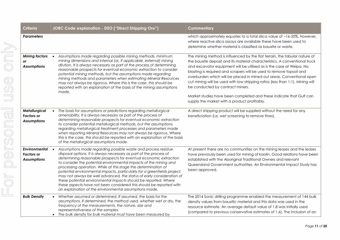
Mining factors
or
Assumptions
Assumptions made regarding possible mining methods, minimum
mining dimensions and internal (or, if applicable, external) mining
dilution. It is always necessary as part of the process of determining
reasonable prospects for eventual economic extraction to consider
potential mining methods, but the assumptions made regarding
mining methods and parameters when estimating Mineral Resources
may not always be rigorous. Where this is the case, this should be
reported with an explanation of the basis of the mining assumptions
made.
The mining method is influenced by the flat terrain, the tabular nature of
the bauxite deposit and its material characteristics. A conventional truck
and excavator equipment will be utilised as is the case at Weipa. No
blasting is required and scrapers will be used to remove topsoil and
overburden which will be placed in mined out areas. Conventional open
cut mining will be used with low stripping ratios (less than 1:1). Mining will
be conducted by contract miners.
Market studies have been completed and these indicate that Gulf can
supply the market with a product profitably.
Metallurgical
Factors or
Assumptions
The basis for assumptions or predictions regarding metallurgical
amenability. It is always necessary as part of the process of
determining reasonable prospects for eventual economic extraction
to consider potential metallurgical methods, but the assumptions
regarding metallurgical treatment processes and parameters made
when reporting Mineral Resources may not always be rigorous. Where
this is the case, this should be reported with an explanation of the basis
of the metallurgical assumptions made.
A direct shipping product will be supplied without the need for any
beneficiation (i.e. wet screening to remove fines).
Environmental
Factors or
Assumptions
Assumptions made regarding possible waste and process residue
disposal options. It is always necessary as part of the process of
determining reasonable prospects for eventual economic extraction
to consider the potential environmental impacts of the mining and
processing operation. While at this stage the determination of
potential environmental impacts, particularly for a greenfields project,
may not always be well advanced, the status of early consideration of
these potential environmental impacts should be reported. Where
these aspects have not been considered this should be reported with
an explanation of the environmental assumptions made.
At present there are no communities on the mining leases and the leases
have previously been used for mining of kaolin. Good relations have been
established with the Aboriginal Traditional Owners and relevant
Queensland Government authorities. An Environmental Impact Study has
been approved.
Bulk Density Whether assumed or determined. If assumed, the basis for the
assumptions. If determined, the method used, whether wet or dry, the
frequency of the measurements, the nature, size and
representativeness of the samples.
The bulk density for bulk material must have been measured by
The 2014 Sonic drilling programme enabled the measurement of 144 bulk
density values from bauxitic material and this data was used in the
resource estimate. An average default value of 1.8 was initially used
(compared to previous conservative estimates of 1.6). The inclusion of an
For
per
sona
l use
onl
y
Page 12 of 20
Criteria JORC Code explanation - DSO (“Direct Shipping Ore”) Commentary
methods that adequately account for void spaces (vugs, porosity,
etc), moisture and differences between rock and alteration zones
within the deposit.
Discuss assumptions for bulk density estimates used in the evaluation
process of the different materials.
additional 204 measurements from field data has increased the default
bulk density to 1.93 and this has been used in the current resource
estimate where blocks are located outside the search distance of the
modelling algorithm.
Classification The basis for the classification of the Mineral Resources into varying
confidence categories.
Whether appropriate account has been taken of all relevant factors
(ie relative confidence in tonnage/grade estimations, reliability of
input data, confidence in continuity of geology and metal values,
quality, quantity and distribution of the data).
Whether the result appropriately reflects the Competent Person’s view
of the deposit.
The resource estimate used the average search distance as the most
appropriate parameter to use for categorising resources combined with
the determination of whether the grade of each block was determined
from actual measured assays or correlated assays. The current estimate
used these parameters with special attention paid to actual available
alumina and reactive silica grades.
Audits or
Reviews
The results of any audits or reviews of Mineral Resource estimates. Geos Mining has carried out resource estimations since 2008. In 2012 a
mineral resource consultant was commissioned by an international
aluminium producer to review the resource. No adverse comments were
received.
In 2016, Xstract Mining Consultants Pty Ltd has reported that it has
“examined the methodology of this estimate and is satisfied that it has
been prepared in accordance to the JORC Code (2012)”.
Discussion of
Relative
Accuracy/
Confidence
Where appropriate a statement of the relative accuracy and
confidence level in the Mineral Resource estimate using an approach
or procedure deemed appropriate by the Competent Person. For
example, the application of statistical or geostatistical procedures to
quantify the relative accuracy of the resource within stated
confidence limits, or, if such an approach is not deemed appropriate,
a qualitative discussion of the factors that could affect the relative
accuracy and confidence of the estimate.
The statement should specify whether it relates to global or local
estimates, and, if local, state the relevant tonnages, which should be
relevant to technical and economic evaluation. Documentation
should include assumptions made and the procedures used.
These statements of relative accuracy and confidence of the estimate
should be compared with production data, where available.
Confidence in the global resource is considered high given the extensive
drilling completed and assay data available. Limitations on the
categorised resource relate to the lack of raw unscreened sample assays
in certain areas of the deposit. Nevertheless, based on results obtained in
2014 and 2015 there is a high probability that mineral resources can be
upgraded in category with additional information.
For
per
sona
l use
onl
y
Page 13 of 20
Section 4 Estimation and Reporting of Ore Reserves
(Criteria listed in section 1, and where relevant in sections 2 and 3, also apply to this section.)
Criteria JORC Code explanation Commentary
Mineral
Resource
estimate for
conversion to
Ore Reserves
Description of the Mineral Resource estimate used as a basis for the
conversion to an Ore Reserve.
Clear statement as to whether the Mineral Resources are reported
additional to, or inclusive of, the Ore Reserves.
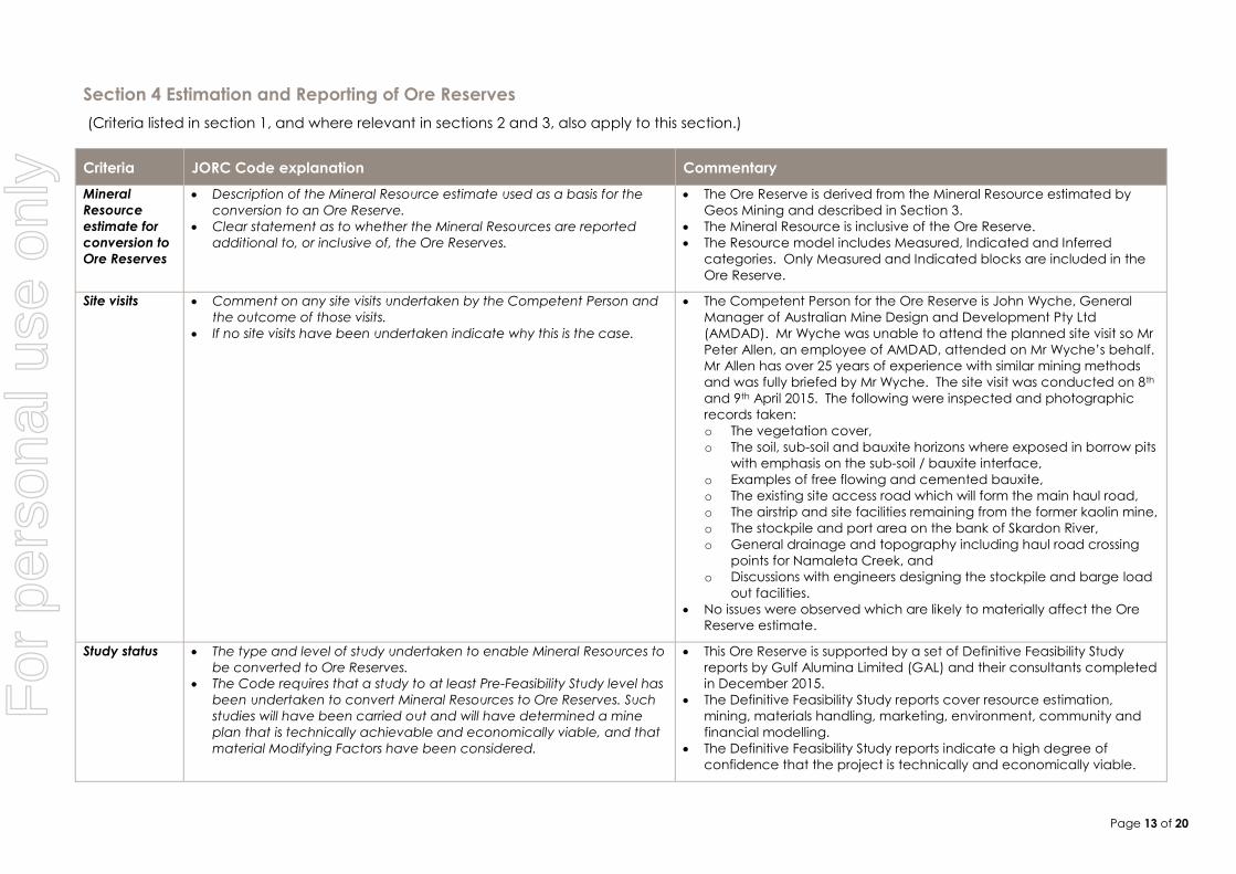
The Ore Reserve is derived from the Mineral Resource estimated by
Geos Mining and described in Section 3.
The Mineral Resource is inclusive of the Ore Reserve.
The Resource model includes Measured, Indicated and Inferred
categories. Only Measured and Indicated blocks are included in the
Ore Reserve.
Site visits Comment on any site visits undertaken by the Competent Person and
the outcome of those visits.
If no site visits have been undertaken indicate why this is the case.
The Competent Person for the Ore Reserve is John Wyche, General
Manager of Australian Mine Design and Development Pty Ltd
(AMDAD). Mr Wyche was unable to attend the planned site visit so Mr
Peter Allen, an employee of AMDAD, attended on Mr Wyche’s behalf.
Mr Allen has over 25 years of experience with similar mining methods
and was fully briefed by Mr Wyche. The site visit was conducted on 8th
and 9th April 2015. The following were inspected and photographic
records taken:
o The vegetation cover,
o The soil, sub-soil and bauxite horizons where exposed in borrow pits
with emphasis on the sub-soil / bauxite interface,
o Examples of free flowing and cemented bauxite,
o The existing site access road which will form the main haul road,
o The airstrip and site facilities remaining from the former kaolin mine,
o The stockpile and port area on the bank of Skardon River,
o General drainage and topography including haul road crossing
points for Namaleta Creek, and
o Discussions with engineers designing the stockpile and barge load
out facilities.
No issues were observed which are likely to materially affect the Ore
Reserve estimate.
Study status The type and level of study undertaken to enable Mineral Resources to
be converted to Ore Reserves.
The Code requires that a study to at least Pre-Feasibility Study level has
been undertaken to convert Mineral Resources to Ore Reserves. Such
studies will have been carried out and will have determined a mine
plan that is technically achievable and economically viable, and that
material Modifying Factors have been considered.
This Ore Reserve is supported by a set of Definitive Feasibility Study
reports by Gulf Alumina Limited (GAL) and their consultants completed
in December 2015.
The Definitive Feasibility Study reports cover resource estimation,
mining, materials handling, marketing, environment, community and
financial modelling.
The Definitive Feasibility Study reports indicate a high degree of
confidence that the project is technically and economically viable.
For
per
sona
l use
onl
y
Page 14 of 20
Criteria JORC Code explanation Commentary
Cut-off
parameters
The basis of the cut-off grade(s) or quality parameters applied. The resource model is a single layer seam defined on a 50 x 50 metre
grid with variable thickness based on total silica grades in each drill
hole being less than or equal to 20% and reactive silica grades being
less than or equal to 8%.
Mining models developed on this resource show that readily
marketable alumina and silica grades can be extracted.
Higher silica cut offs were also modelled by Geos Mining. These
demonstrate that significantly higher tonnes may be extracted by
mining a thicker portion of the bauxite horizon but at the cost of
increased price quality penalties. This Ore Reserve is based on the 20%
total silica limit but the opportunity exists to further improve value in the
operation if future assessment of the trade-off between tonnes and
product quality can be varied.
A margin ranking calculation was applied at the centroid of each
block subtracting the clearing, topsoil, sub-soil and bauxite mining
costs and the stockpile, trans-shipment and site fixed costs from the
FOB bauxite value including alumina and silica price penalty
adjustments. The margin ranking demonstrates a positive vale for all
scheduled areas of the deposit.
Mining factors
or
assumptions
The method and assumptions used as reported in the Pre-Feasibility or
Feasibility Study to convert the Mineral Resource to an Ore Reserve (i.e.
either by application of appropriate factors by optimisation or by
preliminary or detailed design).
The choice, nature and appropriateness of the selected mining
method(s) and other mining parameters including associated design
issues such as pre-strip, access, etc.
The assumptions made regarding geotechnical parameters (eg pit
slopes, stope sizes, etc), grade control and pre-production drilling.
The major assumptions made and Mineral Resource model used for pit
and stope optimisation (if appropriate).
The mining dilution factors used.
The mining recovery factors used.
Any minimum mining widths used.
The manner in which Inferred Mineral Resources are utilised in mining
studies and the sensitivity of the outcome to their inclusion.
The infrastructure requirements of the selected mining methods.
Ore Reserves are derived from the Mineral Resource by application of
a mine plan using a strip and block layout for mining by loaders and
trucks. The mine design is based on bauxite quality and economic
analyses after application of mining loss and dilution adjustments.
The bauxite will be mined by large front end loaders loading 200 to 350
tonne road trains. Topsoil will be mined by scrapers and the subsoil
immediately overlying the bauxite will be mined by front end loaders
loading rigid body trucks. No blasting is required.
Pit depths vary from 0.5 to 6.7 metres with 95% less than 3.5 metres. Pit
widths are 1 to 5 km. The floor is near level. No geotechnical analysis
was required for the very shallow walls and the reserves assume they
are vertical.
The Direct Shipping Ore (DSO) bauxite is defined by alumina and silica
content which are laterally consistent over more than 100 metres
through the pits. Vertically the DSO resource is defined by less than or
equal to 20% SiO2 in the drill holes which are sampled on 25cm
intervals. There is very little internal dilution vertically within the DSO
horizon. Mining loss and dilution will occur on the roof and floor of the
DSO horizon which averages 1.6 metres thickness. Mining loss and
dilution are modelled as a 10cm loss and 10cm dilution skin on both
the roof and floor. Roof dilution grades for silica and alumina were
For
per
sona
l use
onl
y

Page 15 of 20
Criteria JORC Code explanation Commentary
modelled from the first 25cm drill hole sample above the DSO horizon
and floor dilution grades from the first 25cm sample below the DSO
horizon. Loss grades were modelled from the 25cm drill hole samples in
the top and base of the DSO horizon.
Grade control drilling on a 20 x 20 metre grid is planned ahead of
mining to define the DSO roof and floor which will be cut by GPS
guided machines to meet the ±10cm tolerance in the mining loss and
dilution model.
The Ore Reserve model uses the single layer 50 x 50 metre blocks from
the Mineral Resource model. A margin ranking model was prepared
to assess the value of each block by deducting the mining, port,
barging, site and royalty costs from the free on board (FOB) value of
run of mine (ROM) bauxite in the block. Mining costs are from a
detailed estimate for clearing, topsoil, subsoil and bauxite including
variable ore haulage costs to the port. All other costs were supplied by
GAL. Bauxite pricing is based on current Australian sales to China and
includes alumina and silica penalties and sea freight. The margin rank
model shows the defined pits to be positive value at 85% of the
bauxite price used in GAL’s financial model.
The Life of Mine schedule in the Pre-feasibility Study includes Inferred
Resources. However these are almost entirely in the last 5 years of a 14
year mine life and the location of Proved and Probable Reserves
would still allow them to be mined even if none of the Inferred were
ever mined. Checks were done to ensure that the project is
technically and commercially viable even if none of the Inferred is
included.
Mining costs assume contract mining. The mining cost estimate was
validated against three budget quotations received in late 2014
based on a scoping study for a similar mine plan.
Metallurgical
factors or
assumptions
The metallurgical process proposed and the appropriateness of that
process to the style of mineralisation.
Whether the metallurgical process is well-tested technology or novel in
nature.
The nature, amount and representativeness of metallurgical test work
undertaken, the nature of the metallurgical domaining applied and
the corresponding metallurgical recovery factors applied.
Any assumptions or allowances made for deleterious elements.
The existence of any bulk sample or pilot scale test work and the
degree to which such samples are considered representative of the
orebody as a whole.
The bauxite will be sold as a Direct Shipping Ore without processing
other than sizing to -150mm and removal of tramp wood and metal.
Reference qualities used for pricing on a dry basis (namely CIBX) are
45% available alumina and 5% reactive silica. The average grades of
the Ore Reserves are 40.3% total alumina and 6.3% reactive silica.
These qualities are saleable and return positive block values when
expected quality penalties are applied.
Most of the DSO Reserve is expected to be free flowing pisolitic and
fines bauxite. Up to 30% may be weakly cemented. The planned port
facility includes sizing to ensure the -150mm specification is
maintained.
For
per
sona
l use
onl
y
Page 16 of 20
Criteria JORC Code explanation Commentary
For minerals that are defined by a specification, has the ore reserve
estimation been based on the appropriate mineralogy to meet the
specifications?
Product quality will be regulated by mining from two locations at any
time and by limited blending capability from the port stockpile.
Environmental The status of studies of potential environmental impacts of the mining
and processing operation. Details of waste rock characterisation and
the consideration of potential sites, status of design options considered
and, where applicable, the status of approvals for process residue
storage and waste dumps should be reported.
The Queensland Department of Environment and Heritage Protection
(EHP) issued the final terms of reference (TOR) for the Environmental
Impact Statement (EIS) in January 2015. The EIS is at an advanced
stage of completion.
Reserves are only included from outside a 100 metre wide buffer zone
around environmentally sensitive areas, in particular Namaleta Creek
and Skardon River.
EIS based on existing mining leases only but LOM schedule extended
into EPM4068 and EPM18242. Mining in the EPMs is not scheduled until
late in Year 9 of operations. This should allow time for conversion to
Mining Leases and gaining of environmental approvals.
GAL advises that no major obstacles are expected to approval of the
EIS and Environmental Management Plan.
Infrastructure The existence of appropriate infrastructure: availability of land for plant
development, power, water, transportation (particularly for bulk
commodities), labour, accommodation; or the ease with which the
infrastructure can be provided, or accessed.
The mine area has recently been used to mine and ship kaolin. This
project left significant infrastructure including an airstrip, haul roads,
port facility on Skardon River and camp. Plans have been prepared to
upgrade these facilities for the bauxite project.
Since the ore is direct shipping the required stockpiling, barge loadout
and water, power and sewage facilities are much smaller than if
beneficiation was required. Plans are in place for all necessary
facilities. The design status of the infrastructure items range from
preliminary to advanced. The relatively simple nature of the facilities
and low capital cost make finalisation of the design low risk.
Costs The derivation of, or assumptions made, regarding projected capital
costs in the study.
The methodology used to estimate operating costs.
Allowances made for the content of deleterious elements.
The source of exchange rates used in the study.
Derivation of transportation charges.
The basis for forecasting or source of treatment and refining charges,
penalties for failure to meet specification, etc.
The allowances made for royalties payable, both Government and
private.
Preliminary capital costs have been estimated for:
o Stockpile and Port area
o Services (power, water, camp and other site infrastructure)
o Haul road upgrade.
Mine establishment costs have been estimated at a preliminary level
but have been validated by budget quotations from mining
contractors.
Operating costs were estimated on the following bases:
o Mining – First principles cost estimate based on equipment
productivities, fleet ownership and operating costs, operator and
maintenance labour and management, supervision and
technical services costs. Contractor margin applied to operating
items. Benchmarked against contractor budget quotations.
o Stockpile and Port - First principles cost estimate based on
For
per
sona
l use
onl
y
Page 17 of 20
Criteria JORC Code explanation Commentary
equipment productivities and hourly costs including power and
fuel, operator and maintenance labour.
o Administration - First principles cost estimate based on labour and
local services. All labour costs include statutory oncosts and
camp and fly in fly out costs.
Trans-shipment by barge to ships at sea based on detailed contractor
proposal.
State Government, Native Title Holder and funding royalties included.
Ore selection and financial model include penalties for reactive silica
above and available alumina below reference levels.
Revenue
factors
The derivation of, or assumptions made regarding revenue factors
including head grade, metal or commodity price(s) exchange rates,
transportation and treatment charges, penalties, net smelter returns,
etc.
The derivation of assumptions made of metal or commodity price(s),
for the principal metals, minerals and co-products.
Bauxite pricing is based on CRU’s Bauxite and Alumina Market Outlook
and has been checked against published price forecasts from
adjacent projects and the recent Shanghai Metal Market prices for
Australian bauxite sold into China.
Pricing is based on reference grades of 45% available alumina and 5%
reactive silica (namely CBIX). The ore selection process and the
financial model include penalties for available alumina below and
reactive silica above the reference grades.
Sea freight for a Panamax vessel is deducted from the CIF price at
US$15.00 per dmt to set the FOB price at Skardon River. This is higher
than the recent actual sea freight.
The FOB price is converted from US$ to A$ at an exchange rate of
US$0.80 = A$1.00.
Market
assessment
The demand, supply and stock situation for the particular commodity,
consumption trends and factors likely to affect supply and demand
into the future.
A customer and competitor analysis along with the identification of
likely market windows for the product.
Price and volume forecasts and the basis for these forecasts.
For industrial minerals the customer specification, testing and
acceptance requirements prior to a supply contract.
Market assessments based on CRU’s Bauxite and Alumina Market
Outlook. Increasing demand in China and decreased supply from
Indonesia. Market opportunity to at least 2019.
Skardon River has high available alumina and comparable reactive
silica to mines outside Queensland.
DSO offers cheaper production and rapid start up to meet increasing
demand.
Price competitive for China against Atlantic producers.
Good quality is expected to maintain market share beyond 5 year
outlook.
Opportunity exists to significantly increase tonnes by mining thicker
horizon at lower alumina and higher silica if supported by market and
price conditions.
Economic The inputs to the economic analysis to produce the net present value
(NPV) in the study, the source and confidence of these economic
inputs including estimated inflation, discount rate, etc.
The Pre-feasibility Study financial analysis by GAL used a discount rate
of 10% to estimate the project NPV.
GAL presented after tax and financing financial analyses that show
For
per
sona
l use
onl
y
Page 18 of 20
Criteria JORC Code explanation Commentary
NPV ranges and sensitivity to variations in the significant assumptions
and inputs.
high NPV and ROR and less than 5 year payback periods for sensitivity
cases of ±15% on bauxite price, capital costs, operating costs and
US/AUD exchange rate.
AMDAD prepared a margin ranking model which demonstrates that
the area and bauxite tonnes covered by the Ore Reserves in this
statement is almost unchanged at 15% less than the base case bauxite
price.
Social The status of agreements with key stakeholders and matters leading to
social licence to operate.
GAL signed agreements in December 2013 with the Ankamuthi People
who are the Native Title claimants to the affected land. Following
these agreements the Minister for Natural Resources and Mines
representing the State of Queensland signed the Section 31 Deed
pursuant the Native Title Act 1993 in respect of the Company’s
Skardon River mining leases on 20 January 2014.
Skardon River is a remote site. There are no dwellings or infrastructure,
other than matters dealt with in the traditional owner agreements,
which will be affected by the mining, stockpiling and barging
operations.
Other To the extent relevant, the impact of the following on the project
and/or on the estimation and classification of the Ore Reserves:
Any identified material naturally occurring risks.
The status of material legal agreements and marketing arrangements.
The status of governmental agreements and approvals critical to the
viability of the project, such as mineral tenement status, and
government and statutory approvals. There must be reasonable
grounds to expect that all necessary Government approvals will be
received within the timeframes anticipated in the Pre-Feasibility or
Feasibility study. Highlight and discuss the materiality of any unresolved
matter that is dependent on a third party on which extraction of the
reserve is contingent.
Significant risks and mitigation measures assessed include:
o Tropical rainfall impeding mining operations and saturating
stockpiles. Mining and shipping is only planned for nine months
per year over the dry season. Activities are planned to cease in
the three wettest months from January to March each year.
o Market. Current forecasts project a world shortfall of bauxite until
at least 2019. Beyond this time the Skardon River DSO has been
planned to provide bauxite quality which will be competitive
against other sources around the world.
o 82% of the Ore Reserves are in existing Mining Leases area
approved for bauxite mining and covered by the current EIS
update process. The remaining 18% are on adjoining Exploration
Permits area which must be converted to Mining Leases and
which will require new or expanded Environmental Impact
Assessments. However, all ore scheduled for the first 8 years is
within the mining leases. It is reasonable to expect that permitting
can be achieved in this time and the financial analyses
demonstrate that the project is viable even if restricted to the
current Mining Leases.
Classification The basis for the classification of the Ore Reserves into varying
confidence categories.
Whether the result appropriately reflects the Competent Person’s view
Proved and Probable Ore Reserves are derived from Measured and
Indicated Ore Resources respectively. The Ore Reserves do not
include any Inferred resources.
For
per
sona
l use
onl
y
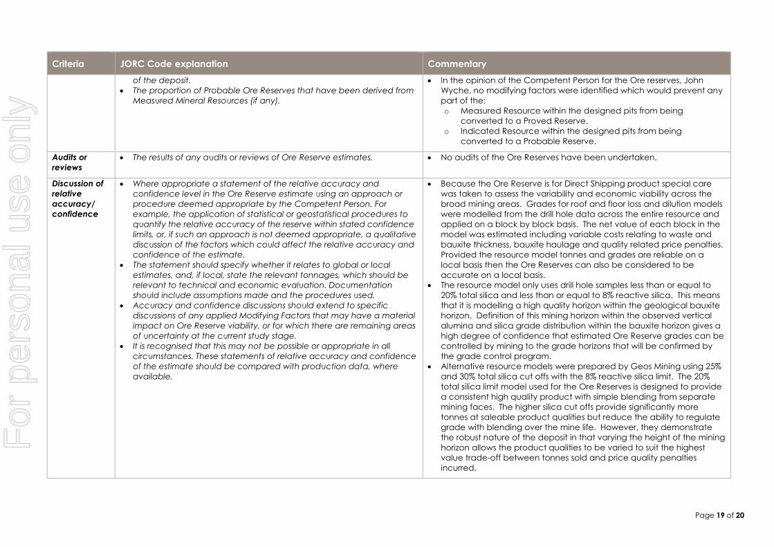
Page 19 of 20
Criteria JORC Code explanation Commentary
of the deposit.
The proportion of Probable Ore Reserves that have been derived from
Measured Mineral Resources (if any).
In the opinion of the Competent Person for the Ore reserves, John
Wyche, no modifying factors were identified which would prevent any
part of the:
o Measured Resource within the designed pits from being
converted to a Proved Reserve.
o Indicated Resource within the designed pits from being
converted to a Probable Reserve.
Audits or
reviews
The results of any audits or reviews of Ore Reserve estimates. No audits of the Ore Reserves have been undertaken.
Discussion of
relative
accuracy/
confidence
Where appropriate a statement of the relative accuracy and
confidence level in the Ore Reserve estimate using an approach or
procedure deemed appropriate by the Competent Person. For
example, the application of statistical or geostatistical procedures to
quantify the relative accuracy of the reserve within stated confidence
limits, or, if such an approach is not deemed appropriate, a qualitative
discussion of the factors which could affect the relative accuracy and
confidence of the estimate.
The statement should specify whether it relates to global or local
estimates, and, if local, state the relevant tonnages, which should be
relevant to technical and economic evaluation. Documentation
should include assumptions made and the procedures used.
Accuracy and confidence discussions should extend to specific
discussions of any applied Modifying Factors that may have a material
impact on Ore Reserve viability, or for which there are remaining areas
of uncertainty at the current study stage.
It is recognised that this may not be possible or appropriate in all
circumstances. These statements of relative accuracy and confidence
of the estimate should be compared with production data, where
available.
Because the Ore Reserve is for Direct Shipping product special care
was taken to assess the variability and economic viability across the
broad mining areas. Grades for roof and floor loss and dilution models
were modelled from the drill hole data across the entire resource and
applied on a block by block basis. The net value of each block in the
model was estimated including variable costs relating to waste and
bauxite thickness, bauxite haulage and quality related price penalties.
Provided the resource model tonnes and grades are reliable on a
local basis then the Ore Reserves can also be considered to be
accurate on a local basis.
The resource model only uses drill hole samples less than or equal to
20% total silica and less than or equal to 8% reactive silica. This means
that it is modelling a high quality horizon within the geological bauxite
horizon. Definition of this mining horizon within the observed vertical
alumina and silica grade distribution within the bauxite horizon gives a
high degree of confidence that estimated Ore Reserve grades can be
controlled by mining to the grade horizons that will be confirmed by
the grade control program.
Alternative resource models were prepared by Geos Mining using 25%
and 30% total silica cut offs with the 8% reactive silica limit. The 20%
total silica limit model used for the Ore Reserves is designed to provide
a consistent high quality product with simple blending from separate
mining faces. The higher silica cut offs provide significantly more
tonnes at saleable product qualities but reduce the ability to regulate
grade with blending over the mine life. However, they demonstrate
the robust nature of the deposit in that varying the height of the mining
horizon allows the product qualities to be varied to suit the highest
value trade-off between tonnes sold and price quality penalties
incurred.
For
per
sona
l use
onl
y