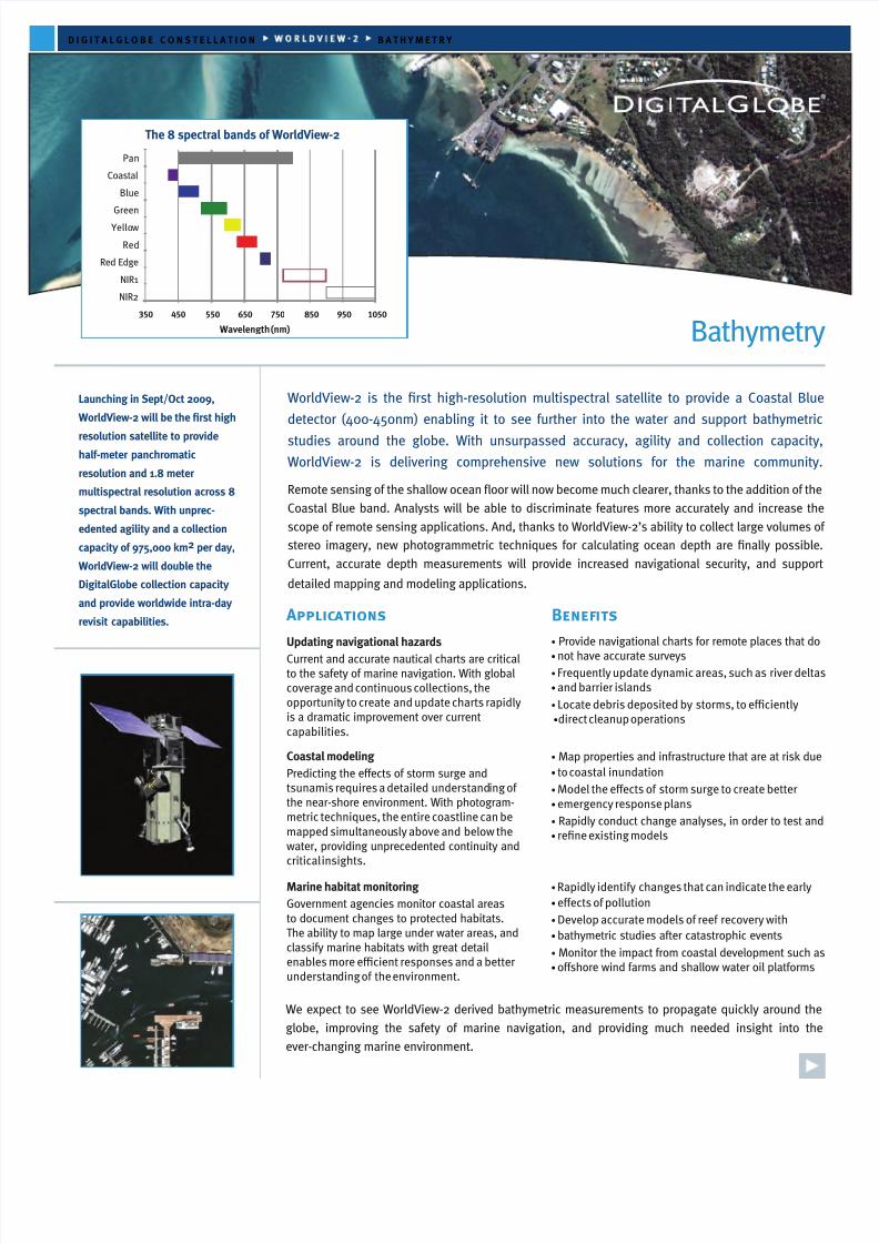
Bathymetry DIGITALGLOBE CONSTELLATION Applic ations Benefits WorldView-2 is the first high-resolution multispectral satellite to provide a Coastal Blue detector (400-450nm) enabling it to see further into the water and support bathymetric studies around the globe. With unsurpassed accuracy, agility and collection capacity, WorldView-2 is delivering comprehensive new solutions for the marine community. Remote sensing of the shallow ocean floor will now become much clearer, thanks to the addition of the Coastal Blue band. Analysts will be able to discriminate features more accurately and increase the scope of remote sensing applications. And, thanks to WorldView-2’s ability to collect large volumes of stereo imagery, new photogrammetric techniques for calculating ocean depth are finally possible. Current, accurate depth measurements will provide increased navigational security, and support detailed mapping and modeling applications. Launching in Sept/Oct 2009, WorldView-2 will be the first high resolution satellite to provide half-meter panchromatic resolution and 1.8 meter multispectral resolution across 8 spectral bands. With unprec- edented agility and a collection capacity of 975,000 km 2 per day, WorldView-2 will double the DigitalGlobe collection capacity and provide worldwide intra-day revisit capabilities. Updating navigational hazards Current and accurate nautical charts are critical to the safety of marine navigation. With global coverage and continuous collections, the opportunit y to create and update charts rapidly is a dramatic improvement over current capabilities. Coastal modelingPredicting the eects of storm surge and tsunamis requires a detailed understand ing of the near-shore environment. With photogram- metric techniques, the entire coastline can be mapped simultaneou sly above and below the water, providing unprecedented continuity and critical insights. Marine habitat monitoringGovernment agencies monitor coastal areas to document changes to protected habitats. The ability to map large under water areas, and classify marine habitats with great detail enables more ecient responses and a better understan ding of the environment. Pan Coastal Blue Green Yello w Red Red Edge NIR1 NIR2 350 450 550 650 750 850 950 1050 Wavelength (nm) BATHYMETRY The 8 spectral bands of WorldView-2 •Provide navigational charts for remote places that do •not have accurate surveys •Frequently update dynamic areas, such as river deltas •and barrier islands •Locate debris deposited by storms, to eciently •direct cleanup operations •Map properties and infrastructure that are at risk due •to coastal inundation •Model the eects of storm surge to create better •emergency response plans •Rapidly conduct change analyses, in order to test and •refine existing models •Rapidly identify changes that can indicate the early •eects of pollution •Develop accurate models of reef recovery with •bathymetric studies after catastrophic events •Monitor the impact from coastal development such as •oshore wind farms and shallow water oil platforms We expect to see WorldView-2 derived bathymetric measurements to propagate quickly around the globe, improving the safety of marine navigation, and providing much needed insight into the ever-changing marine environment.