Embed Size (px)
Citation preview

E02.JNB.000973
BASIC SOCIAL ASSESSMENT REPORT FOR THE N11, SECTION 13, MOKOPANE
15 August 2012 SANRAL
Tel: +27 (0) 11 7986000
Email: [email protected]
Building No 5, Country Club Estate, 21 Woodlands Drive, Woodmead, 2191
DOCUMENT DESCRIPTION
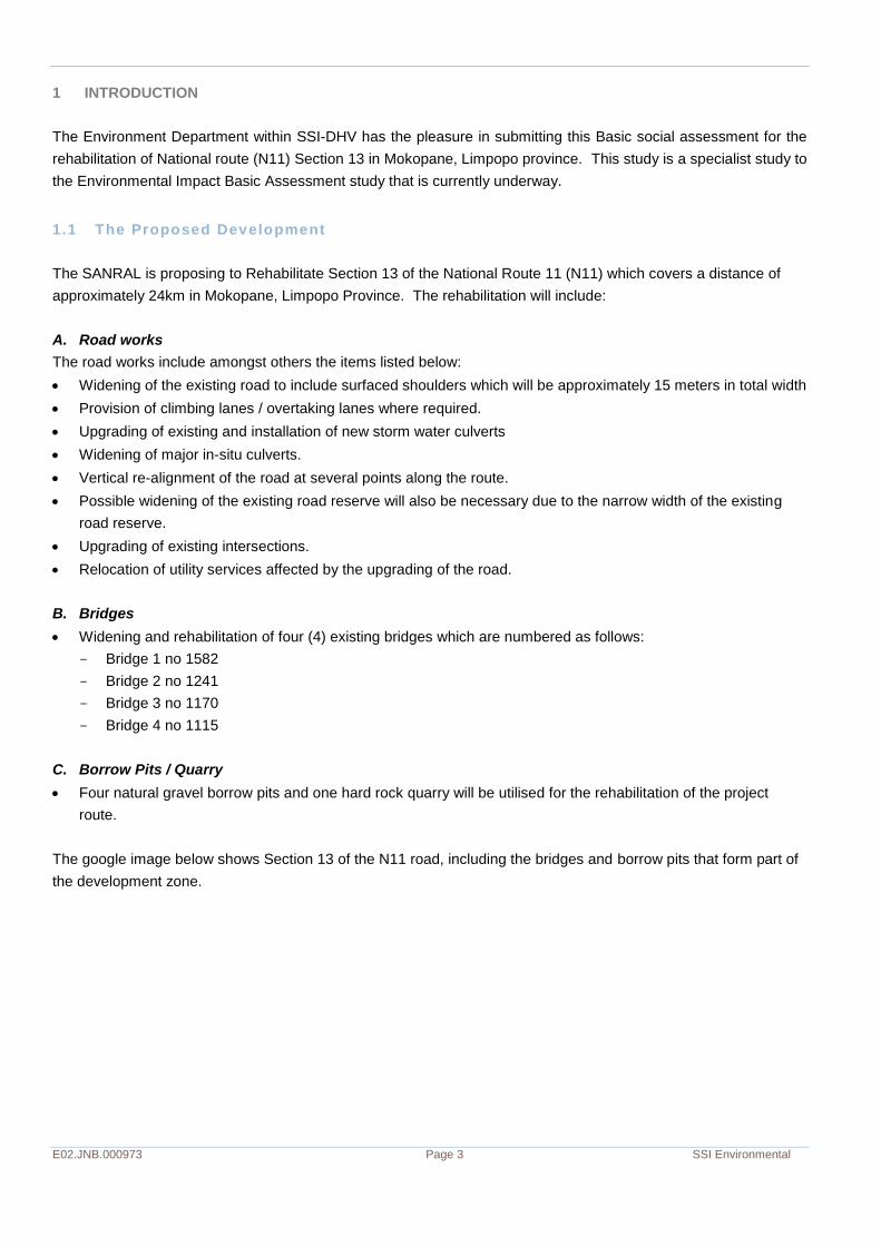
Client:
SANRAL
Report Name:
Basic Social Assessment for N11, Section 13, Mokopane
SSI Environmental Reference Number:
E02.JNB.000973
Authority Reference:
NEAS:DEA/EIA/0000428/2011- DEA:12/12/20/2375
Compiled by:
Kim Moonsamy
Date:
15 August 2012
Location:
Durban
Reviewer: Kim Moonsamy
___________________________
Signature
© SSI Environmental
All rights reserved
No part of this publication may be reproduced or transmitted in any form or by any means, electronic or mechanical, without the written permission from SSI Environmental.

E02.DUR.000973 SSI Environmental
TABLE OF CONTENTS
1 INTRODUCTION 3 1.1 THE PROPOSED DEVELOPMENT 3 1.2 CONSTRUCTION LABOUR 4 1.3 STUDY OBJECTIVE 4
2 THE STUDY ENVIRONMENT 4 2.1 DISTRICT AND LOCAL MUNICIPAL AREAS 4 2.2 THE TRADITIONAL AUTHORITY – MOKOPANE 5
3 UNDERSTANDING PROXIMATE COMMUNITIES 5 3.1 BUSINESSES 7 3.2 BURIAL SITES 8 3.3 SERVICE PROVISION 8 3.4 QUALITATIVE DATA GATHERED 9
4 IMPACT ANALYSIS AND RECOMMENDED MITIGATION 11 4.1 IMPACT RATING 11 4.2 IMPACT SUMMARY 18
LIST OF FIGURES
FIGURE 1-1 : SITE LOCATION 4 FIGURE 3-1 : SITE LOCATION AND VILLAGES 6 FIGURE 3-2 SEMI FORMAL/ FORMAL HOUSING 6
FIGURE 3-3 SEMI FORMAL/ FORMAL HOUSING 6 FIGURE 3-4 SEMI FORMAL/ FORMAL HOUSING 7
FIGURE 3-5 SEMI FORMAL/ FORMAL HOUSING 7 FIGURE 3-6 FORMAL BUSINESS 7
FIGURE 3-7 FORMAL BUSINESS 7 FIGURE 3-8 INFORMAL BUSINESS 7
FIGURE 3-9 POSSIBLE FORMAL BUSINESS 7 FIGURE 3-10 INFORMAL BUSINESS 8
FIGURE 3-11 POSSIBLE FORMAL BUSINESS 8 FIGURE 3-12 HEAVY VEHICLE ROAD USAGE 9
FIGURE 3-13 TYPICAL INTERSECTION ALONG N11 9 FIGURE 3-14 DONKEY AND TRAILER 9
FIGURE 3-15 TRAFFIC AT INTERSECTION - N11 9 FIGURE 3-16 MINDMAP OF COMMUNITY ISSUES 10

E02.DUR.000973 SSI Environmental
LIST OF TABLES
TABLE 4-1 IMPACT RATING AND MITIGATION TABLE (RESULTS) 13
E02.JNB.000973 Page 3 SSI Environmental
1 INTRODUCTION
The Environment Department within SSI-DHV has the pleasure in submitting this Basic social assessment for the
rehabilitation of National route (N11) Section 13 in Mokopane, Limpopo province. This study is a specialist study to
the Environmental Impact Basic Assessment study that is currently underway.
1.1 The Proposed Development
The SANRAL is proposing to Rehabilitate Section 13 of the National Route 11 (N11) which covers a distance of
approximately 24km in Mokopane, Limpopo Province. The rehabilitation will include:
A. Road works
The road works include amongst others the items listed below:
Widening of the existing road to include surfaced shoulders which will be approximately 15 meters in total width
Provision of climbing lanes / overtaking lanes where required.
Upgrading of existing and installation of new storm water culverts
Widening of major in-situ culverts.
Vertical re-alignment of the road at several points along the route.
Possible widening of the existing road reserve will also be necessary due to the narrow width of the existing
road reserve.
Upgrading of existing intersections.
Relocation of utility services affected by the upgrading of the road.
B. Bridges
Widening and rehabilitation of four (4) existing bridges which are numbered as follows:
- Bridge 1 no 1582
- Bridge 2 no 1241
- Bridge 3 no 1170
- Bridge 4 no 1115
C. Borrow Pits / Quarry
Four natural gravel borrow pits and one hard rock quarry will be utilised for the rehabilitation of the project
route.
The google image below shows Section 13 of the N11 road, including the bridges and borrow pits that form part of
the development zone.
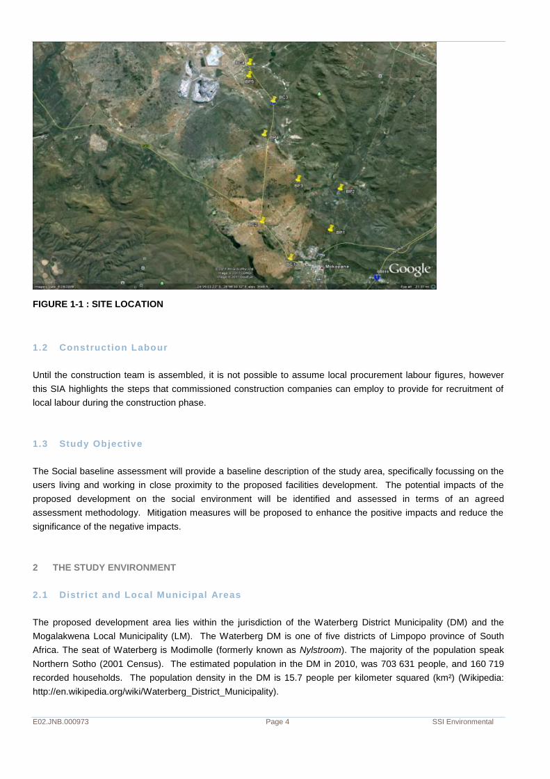
E02.JNB.000973 Page 4 SSI Environmental
FIGURE 1-1 : SITE LOCATION
1.2 Construction Labour
Until the construction team is assembled, it is not possible to assume local procurement labour figures, however
this SIA highlights the steps that commissioned construction companies can employ to provide for recruitment of
local labour during the construction phase.
1.3 Study Objective
The Social baseline assessment will provide a baseline description of the study area, specifically focussing on the
users living and working in close proximity to the proposed facilities development. The potential impacts of the
proposed development on the social environment will be identified and assessed in terms of an agreed
assessment methodology. Mitigation measures will be proposed to enhance the positive impacts and reduce the
significance of the negative impacts.
2 THE STUDY ENVIRONMENT
2.1 District and Local Municipal Areas
The proposed development area lies within the jurisdiction of the Waterberg District Municipality (DM) and the
Mogalakwena Local Municipality (LM). The Waterberg DM is one of five districts of Limpopo province of South
Africa. The seat of Waterberg is Modimolle (formerly known as Nylstroom). The majority of the population speak
Northern Sotho (2001 Census). The estimated population in the DM in 2010, was 703 631 people, and 160 719
recorded households. The population density in the DM is 15.7 people per kilometer squared (km²) (Wikipedia:
http://en.wikipedia.org/wiki/Waterberg_District_Municipality).
E02.JNB.000973 Page 5 SSI Environmental
The seat of Mogalakwena Local Municipality is Mokopane. Mogalakwena Local Municipality contains over 50% of
the Waterberg DM’s total population that is estimated at approximately 557 896 in 2001 and 596 094 in 2007
respectively. This is an increase of about 38 198. However, estimates for Mogalakwena population size vary. Most
recent estimates are based on the 2007 Community Survey by Statistics South Africa. According to these figures
the total population of Mogalakwena Municipality adds up to 330 644 persons at 75 313 households. The average
household is home to 4,4 persons. Many households are home to more than ten persons.
It should, however, be noted that the population size of the municipality could be more than the number of people
indicated as many people live on farms throughout the area. The area population changes with the seasons, since
many residents migrate to work elsewhere. The annual population growth rate is estimated at 1,4%, which
represents the average provincial population growth rate (Mogalakwena IDP 2011-2012 Draft).
2.2 The Tradit ional Authori ty – Mokopane
Chief V Kekana is the present Chief of the Mokopane Traditional Authority, which has jurisdiction over the majority
of all land within the area.
The Environmental Basic Assessment has evidence of engagement with the Chief, where the details of the project
were explained and the Chief’s responses to the proposed development were recorded. This social assessment
acknowledges the main concerns emanating from the consultation with the Chief (Minutes of Meeting, 10 February
2012), as:
People will be sensitive to the existence of borrow pits. Their perception may be that borrow pits are ‘open
cast mines;’
Fence off the borrow pit areas as it may be a danger to people and animals;
Any relocation issues must be brought to the Chief’s attention, and a resolution found;
The upgraded road may be assist in people and traffic movement, however it is likely to become more
dangerous. Public must be made aware of what safety measures will be put in place – fencing between
communities and the road, pedestrian (walk-over) bridges, etc.
3 UNDERSTANDING PROXIMATE COMMUNITIES
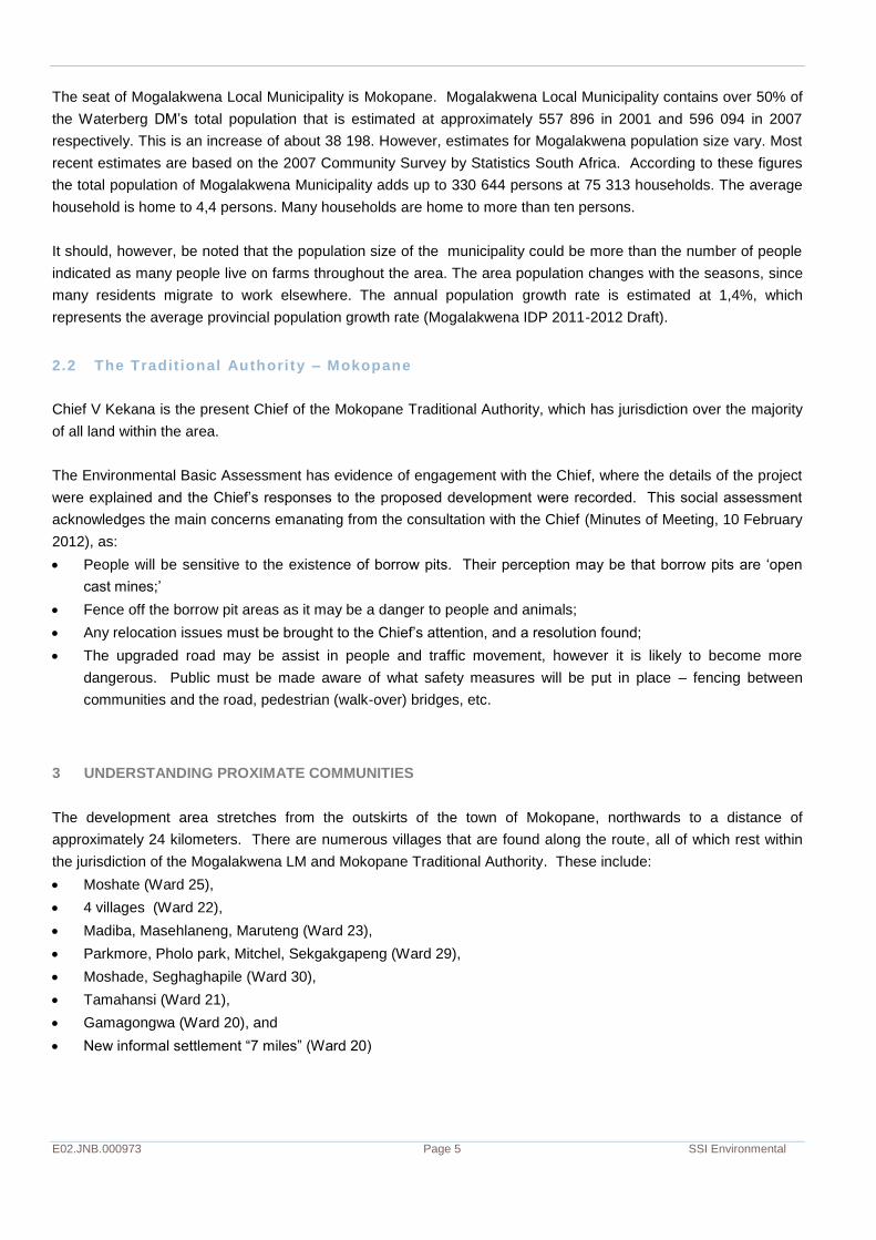
The development area stretches from the outskirts of the town of Mokopane, northwards to a distance of
approximately 24 kilometers. There are numerous villages that are found along the route, all of which rest within
the jurisdiction of the Mogalakwena LM and Mokopane Traditional Authority. These include:
Moshate (Ward 25),
4 villages (Ward 22),
Madiba, Masehlaneng, Maruteng (Ward 23),
Parkmore, Pholo park, Mitchel, Sekgakgapeng (Ward 29),
Moshade, Seghaghapile (Ward 30),
Tamahansi (Ward 21),
Gamagongwa (Ward 20), and
New informal settlement “7 miles” (Ward 20)
E02.JNB.000973 Page 6 SSI Environmental
Figure 3-1 : Site Location and villages
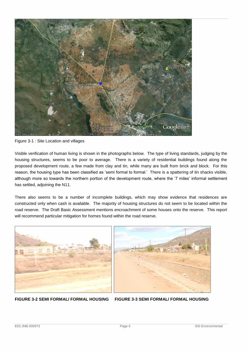
Visible verification of human living is shown in the photographs below. The type of living standards, judging by the
housing structures, seems to be poor to average. There is a variety of residential buildings found along the
proposed development route, a few made from clay and tin, while many are built from brick and block. For this
reason, the housing type has been classified as ‘semi formal to formal.’ There is a spattering of tin shacks visible,
although more so towards the northern portion of the development route, where the ‘7 miles’ informal settlement
has settled, adjoining the N11.
There also seems to be a number of incomplete buildings, which may show evidence that residences are
constructed only when cash is available. The majority of housing structures do not seem to be located within the
road reserve. The Draft Basic Assessment mentions encroachment of some houses onto the reserve. This report
will recommend particular mitigation for homes found within the road reserve.
FIGURE 3-2 SEMI FORMAL/ FORMAL HOUSING FIGURE 3-3 SEMI FORMAL/ FORMAL HOUSING

E02.JNB.000973 Page 7 SSI Environmental
FIGURE 3-4 SEMI FORMAL/ FORMAL HOUSING FIGURE 3-5 SEMI FORMAL/ FORMAL HOUSING
3.1 Businesses
There are a number of roadside and off-road businesses clearly visible from the N11. Many businesses are found
within formal establishments, while other informal businesses (street vendors) are found at the busiest
intersections.
FIGURE 3-6 FORMAL BUSINESS FIGURE 3-7 FORMAL BUSINESS
FIGURE 3-8 INFORMAL BUSINESS FIGURE 3-9 POSSIBLE FORMAL BUSINESS
E02.JNB.000973 Page 8 SSI Environmental
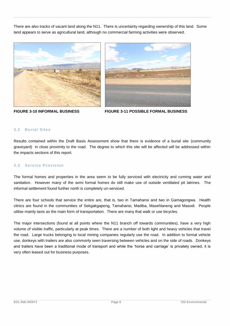
There are also tracks of vacant land along the N11. There is uncertainty regarding ownership of this land. Some
land appears to serve as agricultural land, although no commercial farming activities were observed.
FIGURE 3-10 INFORMAL BUSINESS FIGURE 3-11 POSSIBLE FORMAL BUSINESS
3.2 Burial Sites
Results contained within the Draft Basis Assessment show that there is evidence of a burial site (community
graveyard) in close proximity to the road. The degree to which this site will be affected will be addressed within
the impacts sections of this report.
3.3 Service Provision
The formal homes and properties in the area seem to be fully serviced with electricity and running water and
sanitation. However many of the semi formal homes do still make use of outside ventilated pit latrines. The
informal settlement found further north is completely un-serviced.
There are four schools that service the entire are, that is, two in Tamahansi and two in Gamagongwa. Health
clinics are found in the communities of Sekgakgapeng, Tamahansi, Madiba, Masehlaneng and Masodi. People
utilise mainly taxis as the main form of transportation. There are many that walk or use bicycles.
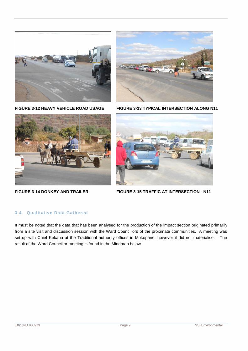
The major intersections (found at all points where the N11 branch off towards communities), have a very high
volume of visible traffic, particularly at peak times. There are a number of both light and heavy vehicles that travel
the road. Large trucks belonging to local mining companies regularly use the road. In addition to formal vehicle
use, donkeys with trailers are also commonly seen traversing between vehicles and on the side of roads. Donkeys
and trailers have been a traditional mode of transport and while the ‘horse and carriage’ is privately owned, it is
very often leased out for business purposes.
E02.JNB.000973 Page 9 SSI Environmental
FIGURE 3-12 HEAVY VEHICLE ROAD USAGE FIGURE 3-13 TYPICAL INTERSECTION ALONG N11
FIGURE 3-14 DONKEY AND TRAILER FIGURE 3-15 TRAFFIC AT INTERSECTION - N11
3.4 Qualitative Data Gathered
It must be noted that the data that has been analysed for the production of the impact section originated primarily
from a site visit and discussion session with the Ward Councillors of the proximate communities. A meeting was
set up with Chief Kekana at the Traditional authority offices in Mokopane, however it did not materialise. The
result of the Ward Councillor meeting is found in the Mindmap below.

E02.JNB.000973 Page 10 SSI Environmental
FIGURE 3-16 MINDMAP OF COMMUNITY ISSUES

E02.JNB.000973 Page 11 SSI Environmental
4 IMPACT ANALYSIS AND RECOMMENDED MITIGATION
4.1 Impact Rat ing
The following parameters1 are used to describe the impact/issues in this assessment:
(i) The risk or likelihood of the impact/issue occurring; and
(ii) The degree of confidence placed in the assessment of the impact/issue
Please note that the rating number is provided in brackets next to the scale interval. Negative impacts are
minus (-) values and positive impacts are plus (+) values. Higher negative valued impacts are more
detrimental than lower negative valued impacts.
1. Temporal Scale
The temporal scale defines the significance of the impact at various time scales, as an indication of the duration of
the impact.
Short Term (1) – less than 5 years.
Medium Term (2) – between 5 and 15 years.
Long Term (3) – between 15 and 30 years.
Permanent (4) – over 30 years and resulting in a permanent and lasting change that will always be there.
2. Spatial Scale
The spatial scale defines physical extent of the impact.
Individual (0) – this scale applies to person/s in the area.
Household (1) – this scale applies to households in the area.
Localised (2) – small scale impacts from a few hectares in extent e.g. local district area.
Regional (3) – the scale applies to impacts on a provincial level.
National (4) – the scale applies to impacts that will affect the whole South Africa.
International (5) – the scale of the impact will extend beyond the borders of South Africa.
3. Significance Scale
Very High (4)
The impacts would be considered by society as constituting a major and usually permanent change to the
environment, and usually result in severe or very severe effects, or beneficial or very beneficial effects.
High (3)
These impacts will usually result in long-term effects on social and/or natural environment. Impacts rated as High
will need to be considered by society as constituting an important and usually long term change to the
environment, Society would probably view these impacts in a serious light.
Moderate (2)
These impacts will usually result in medium to long-term effects on the social and/or natural environment.
Impacts rated as Moderate will need to be considered by society as constituting a fairly important and usually
medium-term change to the environment, These impacts are real but not substantial.
Low (1)
1 Please note that the rating number is provided in brackets next to the scale interval. Negative impacts are minus (-) values and positive
impacts are plus (+) values. Higher negative valued impacts are more detrimental than lower negative valued impacts.

E02.JNB.000973 Page 12 SSI Environmental
These impacts will usually result in medium to short term effects on the social and/or natural environment.
Impacts rated as Low will need to be considered by the public and/or the specialist as constituting a fairly
unimportant and usually short term change to the environment. These impacts are not substantial and are likely
to have little real effect.
Non Significant (0)
There are no primary or secondary effects at all that are important to scientists or the public.
4. Risk or likelihood
The risk or likelihood of all impacts taking place as a result of project actions differs. Although these impacts may
be severe, the likelihood of them occurring may affect their overall significance and will be taken into account.
Very unlikely to occur (1) – the chance of these impacts occurring is extremely slim.
Unlikely to occur (2) – the risk of these impacts occurring is slight.
May occur (3) – the risk of these impacts is more likely, although not definite.
Will definitely occur (4) –this impact will occur.
5. Degree of confidence or certainty
It is also necessary to state the degree of certainty or confidence with which one has predicted the significance of
an impact. For this reason, a ‘degree of certainty’ scale has been provided to enable the reader to ascertain how
certain we are of our assessment of significance:
Definite – More than 90% sure of a particular fact. The use this one will need to have substantial supportive
data.
Probable – Over 70% sure of a particular fact, or of the likelihood of that impact occurring.
Possible – Only over 40% sure of a particular fact or of the likelihood of an impact occurring.
Unsure – Less than 40% sure of a particular fact or the likelihood of an impact occurring.
E02.JNB.000973 Page 13 SSI Environmental
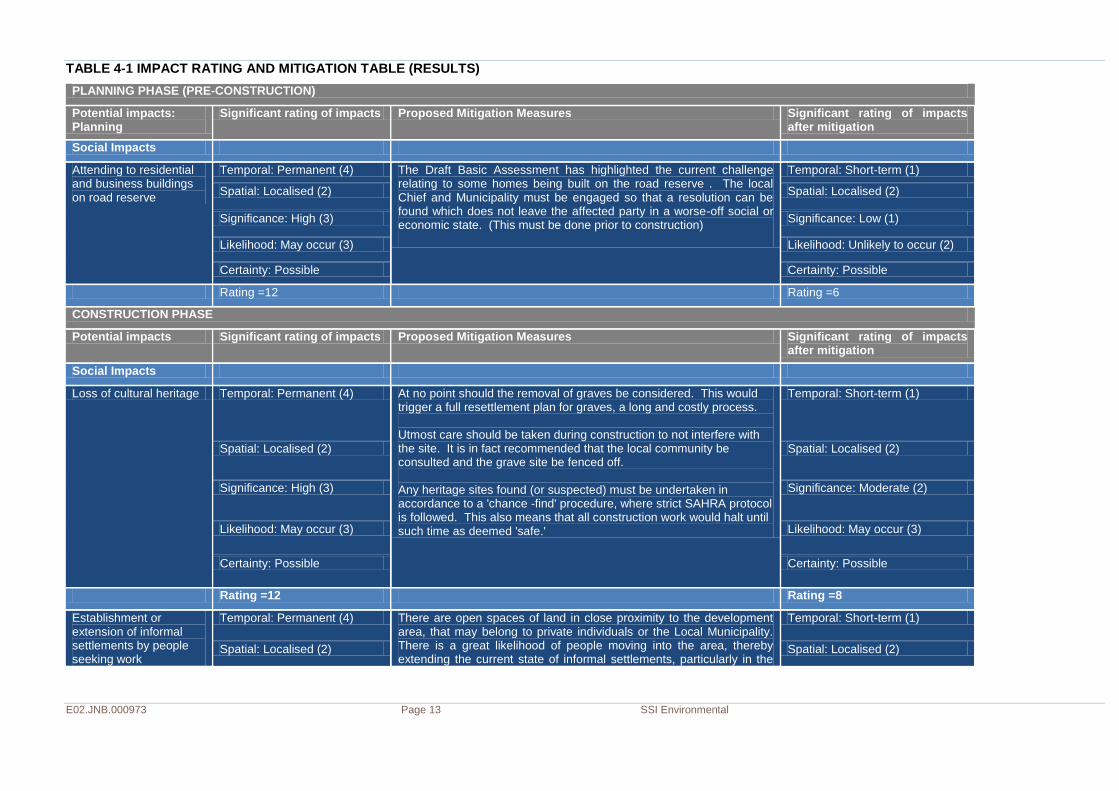
TABLE 4-1 IMPACT RATING AND MITIGATION TABLE (RESULTS)
PLANNING PHASE (PRE-CONSTRUCTION)
Potential impacts: Planning
Significant rating of impacts Proposed Mitigation Measures Significant rating of impacts after mitigation
Social Impacts
Attending to residential and business buildings on road reserve
Temporal: Permanent (4) The Draft Basic Assessment has highlighted the current challenge relating to some homes being built on the road reserve . The local Chief and Municipality must be engaged so that a resolution can be found which does not leave the affected party in a worse-off social or economic state. (This must be done prior to construction)
Temporal: Short-term (1)
Spatial: Localised (2) Spatial: Localised (2)
Significance: High (3) Significance: Low (1)
Likelihood: May occur (3) Likelihood: Unlikely to occur (2)
Certainty: Possible Certainty: Possible
Rating =12 Rating =6
CONSTRUCTION PHASE
Potential impacts Significant rating of impacts Proposed Mitigation Measures Significant rating of impacts after mitigation
Social Impacts
Loss of cultural heritage Temporal: Permanent (4) At no point should the removal of graves be considered. This would trigger a full resettlement plan for graves, a long and costly process. Utmost care should be taken during construction to not interfere with the site. It is in fact recommended that the local community be consulted and the grave site be fenced off. Any heritage sites found (or suspected) must be undertaken in accordance to a 'chance -find' procedure, where strict SAHRA protocol is followed. This also means that all construction work would halt until such time as deemed 'safe.'
Temporal: Short-term (1)
Spatial: Localised (2) Spatial: Localised (2)
Significance: High (3) Significance: Moderate (2)
Likelihood: May occur (3) Likelihood: May occur (3)
Certainty: Possible Certainty: Possible
Rating =12 Rating =8
Establishment or extension of informal settlements by people seeking work
Temporal: Permanent (4) There are open spaces of land in close proximity to the development area, that may belong to private individuals or the Local Municipality. There is a great likelihood of people moving into the area, thereby extending the current state of informal settlements, particularly in the
Temporal: Short-term (1)
Spatial: Localised (2) Spatial: Localised (2)
E02.JNB.000973 Page 14 SSI Environmental
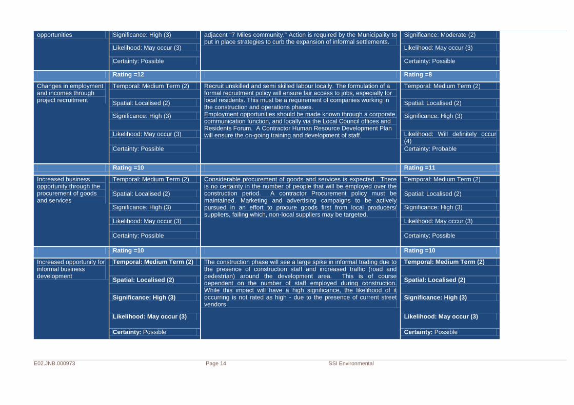
opportunities Significance: High (3) adjacent "7 Miles community." Action is required by the Municipality to put in place strategies to curb the expansion of informal settlements.
Significance: Moderate (2)
Likelihood: May occur (3) Likelihood: May occur (3)
Certainty: Possible Certainty: Possible
Rating =12 Rating =8
Changes in employment and incomes through project recruitment
Temporal: Medium Term (2) Recruit unskilled and semi skilled labour locally. The formulation of a formal recruitment policy will ensure fair access to jobs, especially for local residents. This must be a requirement of companies working in the construction and operations phases. Employment opportunities should be made known through a corporate communication function, and locally via the Local Council offices and Residents Forum. A Contractor Human Resource Development Plan will ensure the on-going training and development of staff.
Temporal: Medium Term (2)
Spatial: Localised (2) Spatial: Localised (2)
Significance: High (3) Significance: High (3)
Likelihood: May occur (3) Likelihood: Will definitely occur (4)
Certainty: Possible Certainty: Probable
Rating =10 Rating =11
Increased business opportunity through the procurement of goods and services
Temporal: Medium Term (2) Considerable procurement of goods and services is expected. There is no certainty in the number of people that will be employed over the construction period. A contractor Procurement policy must be maintained. Marketing and advertising campaigns to be actively pursued in an effort to procure goods first from local producers/ suppliers, failing which, non-local suppliers may be targeted.
Temporal: Medium Term (2)
Spatial: Localised (2) Spatial: Localised (2)
Significance: High (3) Significance: High (3)
Likelihood: May occur (3) Likelihood: May occur (3)
Certainty: Possible Certainty: Possible
Rating =10 Rating =10
Increased opportunity for informal business development
Temporal: Medium Term (2) The construction phase will see a large spike in informal trading due to the presence of construction staff and increased traffic (road and pedestrian) around the development area. This is of course dependent on the number of staff employed during construction. While this impact will have a high significance, the likelihood of it occurring is not rated as high - due to the presence of current street vendors.
Temporal: Medium Term (2)
Spatial: Localised (2) Spatial: Localised (2)
Significance: High (3) Significance: High (3)
Likelihood: May occur (3) Likelihood: May occur (3)
Certainty: Possible Certainty: Possible

E02.JNB.000973 Page 15 SSI Environmental
Rating =10 Rating =10
Inconvenience and danger to proximate residents through increased road traffic and dust.
Temporal: Medium Term (2) A policy on Contractor Health and Safety for the duration of on-site construction work, must apply, and be monitored. Particular focus is to be paid to all construction vehicles (including contractor vehicles) that are utilising adjoining roads as access routes. A Residents Forum (if not already in existence) should be set up to facilitate on-going communication between Project Management (possibly through a Community participation consultant). Regular information sharing discussions must be pursued, also giving residents an opportunity to voice concerns and grievances throughout the project construction duration. Other mitigation include: • Establish safe user zones (particularly for pedestrians, cyclists, etc) be put in place. This simply means that should a one-lane road be open, the road should have on its shoulder a barrier/ fence that serves to protect those not in vehicles. The width of the safe zone does not have to be very wide, as it is a temporary walkway. • Erect proper signage, preferably with light warnings. Signage indicating road works, must be present all along the N11 construction-hampered road. Poor visibility due to dust and the absence of street lights may increase road hazards.
Temporal: Medium Term (2)
Spatial: Localised (2) Spatial: Localised (2)
Significance: Very High (4) Significance: High (3)
Likelihood: Will definitely occur (4)
Likelihood: May occur (3)
Certainty: Definite Certainty: Possible
Rating =12 Rating =10
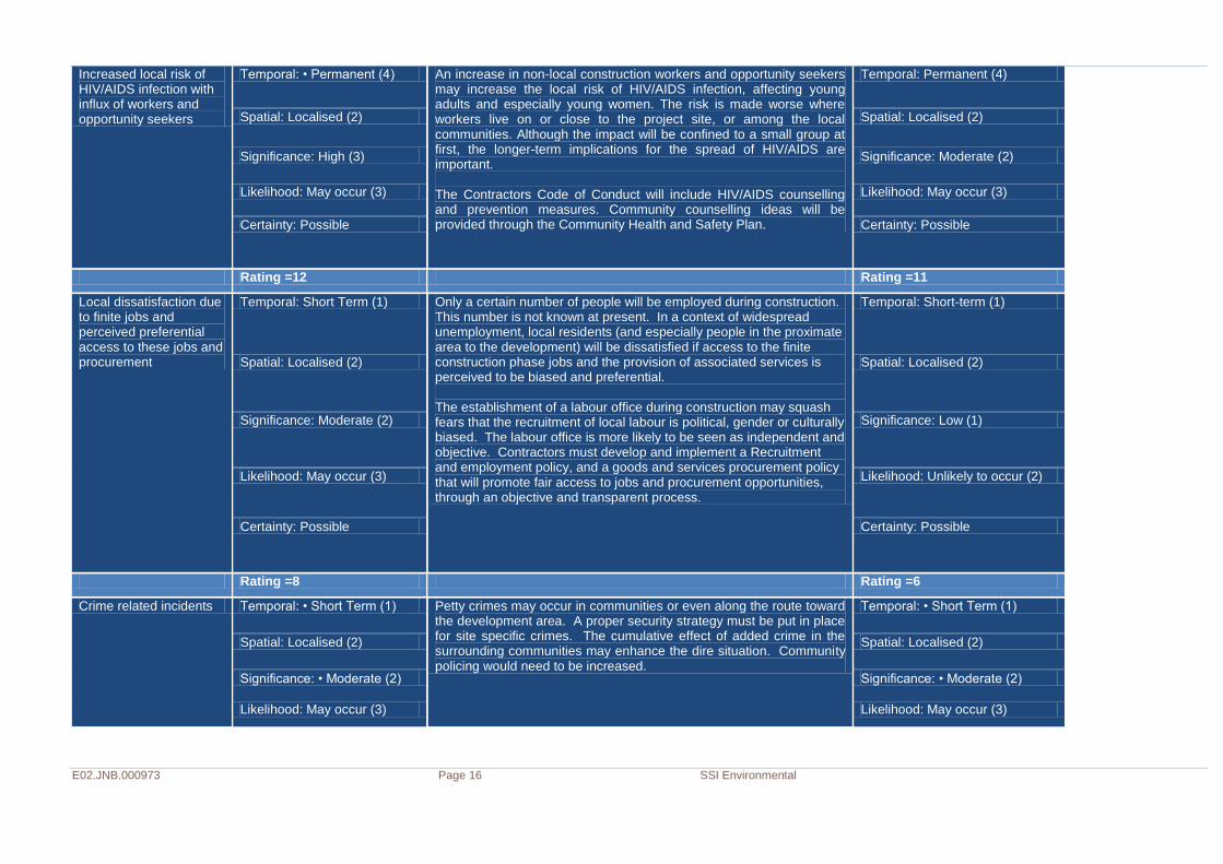
Community disruption by non-local and local construction workers and opportunity seekers
Temporal: Medium Term (2) It is anticipated that the majority of the non-skilled labour force will be recruited from the exiting local communities, however it is still important that a construction phase Code of Conduct should be prepared and implemented among construction workers. The Code of Conduct will enforce and monitor appropriate relationships between construction workers and community members. In addition the Community Health and Safety Policy must act to concretise safety, awareness and conduct in proximate communities. These policies are vital as non-local labourers may take up residence in nearby informal settlements - thus adding to the current social ills in those communities
Temporal: Short-term (1)
Spatial: Localised (2) Spatial: Localised (2)
Significance: High (3) Significance: Moderate (2)
Likelihood: May occur (3) Likelihood: May occur (3)
Certainty: Possible Certainty: Possible
Rating =10 Rating =8
E02.JNB.000973 Page 16 SSI Environmental
Increased local risk of HIV/AIDS infection with influx of workers and opportunity seekers
Temporal: • Permanent (4) An increase in non-local construction workers and opportunity seekers may increase the local risk of HIV/AIDS infection, affecting young adults and especially young women. The risk is made worse where workers live on or close to the project site, or among the local communities. Although the impact will be confined to a small group at first, the longer-term implications for the spread of HIV/AIDS are important. The Contractors Code of Conduct will include HIV/AIDS counselling and prevention measures. Community counselling ideas will be provided through the Community Health and Safety Plan.
Temporal: Permanent (4)
Spatial: Localised (2) Spatial: Localised (2)
Significance: High (3) Significance: Moderate (2)
Likelihood: May occur (3) Likelihood: May occur (3)
Certainty: Possible Certainty: Possible
Rating =12 Rating =11
Local dissatisfaction due to finite jobs and perceived preferential access to these jobs and procurement
Temporal: Short Term (1) Only a certain number of people will be employed during construction. This number is not known at present. In a context of widespread unemployment, local residents (and especially people in the proximate area to the development) will be dissatisfied if access to the finite construction phase jobs and the provision of associated services is perceived to be biased and preferential. The establishment of a labour office during construction may squash fears that the recruitment of local labour is political, gender or culturally biased. The labour office is more likely to be seen as independent and objective. Contractors must develop and implement a Recruitment and employment policy, and a goods and services procurement policy that will promote fair access to jobs and procurement opportunities, through an objective and transparent process.
Temporal: Short-term (1)
Spatial: Localised (2) Spatial: Localised (2)
Significance: Moderate (2) Significance: Low (1)
Likelihood: May occur (3) Likelihood: Unlikely to occur (2)
Certainty: Possible Certainty: Possible
Rating =8 Rating =6
Crime related incidents Temporal: • Short Term (1) Petty crimes may occur in communities or even along the route toward the development area. A proper security strategy must be put in place for site specific crimes. The cumulative effect of added crime in the surrounding communities may enhance the dire situation. Community policing would need to be increased.
Temporal: • Short Term (1)
Spatial: Localised (2) Spatial: Localised (2)
Significance: • Moderate (2) Significance: • Moderate (2)
Likelihood: May occur (3) Likelihood: May occur (3)
E02.JNB.000973 Page 17 SSI Environmental
Certainty: Possible Certainty: Possible
Rating =8 Rating =8
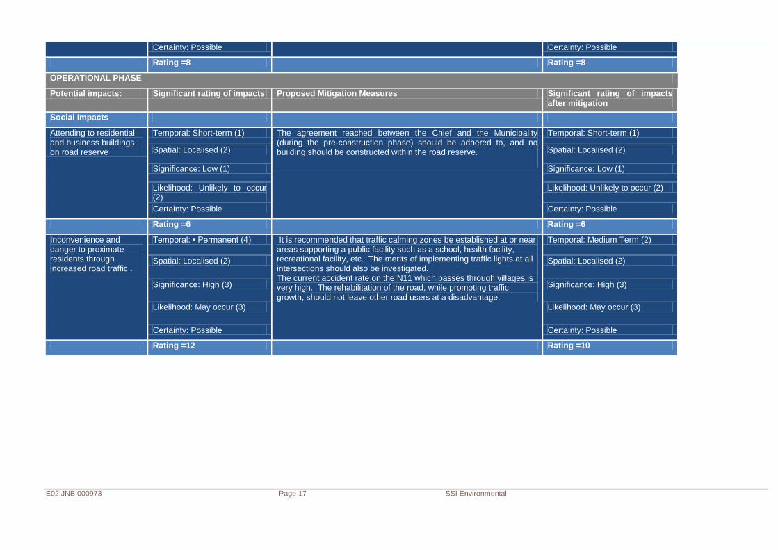
OPERATIONAL PHASE
Potential impacts: Significant rating of impacts Proposed Mitigation Measures Significant rating of impacts after mitigation
Social Impacts
Attending to residential and business buildings on road reserve
Temporal: Short-term (1) The agreement reached between the Chief and the Municipality (during the pre-construction phase) should be adhered to, and no building should be constructed within the road reserve.
Temporal: Short-term (1)
Spatial: Localised (2) Spatial: Localised (2)
Significance: Low (1) Significance: Low (1)
Likelihood: Unlikely to occur (2)
Likelihood: Unlikely to occur (2)
Certainty: Possible Certainty: Possible
Rating =6 Rating =6
Inconvenience and danger to proximate residents through increased road traffic .
Temporal: • Permanent (4) It is recommended that traffic calming zones be established at or near areas supporting a public facility such as a school, health facility, recreational facility, etc. The merits of implementing traffic lights at all intersections should also be investigated. The current accident rate on the N11 which passes through villages is very high. The rehabilitation of the road, while promoting traffic growth, should not leave other road users at a disadvantage.
Temporal: Medium Term (2)
Spatial: Localised (2) Spatial: Localised (2)
Significance: High (3) Significance: High (3)
Likelihood: May occur (3) Likelihood: May occur (3)
Certainty: Possible Certainty: Possible
Rating =12 Rating =10
E02.JNB.000973 Page 18 SSI Environmental
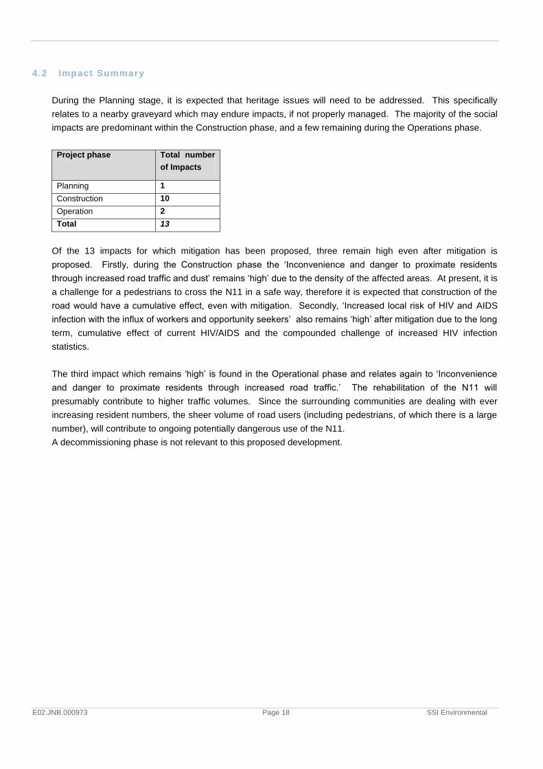
4.2 Impact Summary
During the Planning stage, it is expected that heritage issues will need to be addressed. This specifically
relates to a nearby graveyard which may endure impacts, if not properly managed. The majority of the social
impacts are predominant within the Construction phase, and a few remaining during the Operations phase.
Project phase Total number
of Impacts
Planning 1
Construction 10
Operation 2
Total 13
Of the 13 impacts for which mitigation has been proposed, three remain high even after mitigation is
proposed. Firstly, during the Construction phase the ‘Inconvenience and danger to proximate residents
through increased road traffic and dust’ remains ‘high’ due to the density of the affected areas. At present, it is
a challenge for a pedestrians to cross the N11 in a safe way, therefore it is expected that construction of the
road would have a cumulative effect, even with mitigation. Secondly, ‘Increased local risk of HIV and AIDS
infection with the influx of workers and opportunity seekers’ also remains ‘high’ after mitigation due to the long
term, cumulative effect of current HIV/AIDS and the compounded challenge of increased HIV infection
statistics.
The third impact which remains ‘high’ is found in the Operational phase and relates again to ‘Inconvenience
and danger to proximate residents through increased road traffic.’ The rehabilitation of the N11 will
presumably contribute to higher traffic volumes. Since the surrounding communities are dealing with ever
increasing resident numbers, the sheer volume of road users (including pedestrians, of which there is a large
number), will contribute to ongoing potentially dangerous use of the N11.
A decommissioning phase is not relevant to this proposed development.