Embed Size (px)
Citation preview
The Present Status of Indonesian Tide Gauge Network andIndonesian Permanent GPS Station Network
prepared by: Cecep SubaryaThe Indonesian National Coordination Agency for Surveying and Mapping (BAKOSURTANAL).
email: [email protected] ; phone : 62 21 8757329 ; fax : 62 21 875 2064
INTRODUCTION
The Digital Marine Resource Mapping (DMRM) Project within Indonesian Waters, was carried out in verification of a total of 233 archipelagic basepoints positioning by utilizing Global Positioning System (GPS) observation technique. The Archipelagic basepoints provides geodetic coordinates on the determination of Indonesia’s territorial sea baselines, contiguous zone, exclusive economic zone and continental shelf, to enable the Government of Indonesia to fulfill the requirements laid down in UNCLOS’82 which confirms the intention to affirm the territorial state of the Republic of Indonesia and its sovereignty.
Article 5 of UNCLOS’82 defines the baseline as “the low-water line along the coast as marked on large scale charts officially recognized by coastal State”. “Low water” is not more clearly defined and the DMRM Project has elected to use the Lowest Astronomical Tide (LAT) in order to maximizes the area Indonesia can claim under UNCLOS. A Basepoint is a position of the outermost of land with an altitude of zero based on LAT. Its position is either determined by range and bearing from a concrete Basepoint Reference Monument (BRM) or based on topographic maps, chart, and remotely sensed imagery.
In addition to existing network of sea level gauges of 28 Tide Stations which was as part of the TOGA project and GLOSS network, those gauges have at least 10 years of tidal records,a new Tide Gauge Network comprising 25 Tide Stations was installed and completed at the end of 1998, giving coverage along and inside the Archipelagic Baselines. The data collected from the Tide Stations are used to determine LAT Chart Datum, Harmonic Constants and different Tidal Levels.
Basepoint Reference Monuments and Tide Gauge Benchmark (TGBM) positions was verified by GPS relative positioning using geodetic type dual frequency GPS receivers. Geometric network design of GPS measurement is made in form of a triangle connected to the Zeroth and First Order Geodetic Control Network of Indonesia. The positions for the Zeroth Order Geodetic Control Network sites were used to define the Indonesian Geodetic Datum 1995 (IGD95) or Datum Geodesi Nasional 1995 (DGN95).
The GPS observation at both the BRM and the Zeroth & First Order Control Network sites were combined in a single regional & global GPS solution in terms of the International Terrestrial Reference Frame 1997 (ITRF97) and the resulting coordinates were mapped to a common epoch of 1999.0. ITRF could be considered as a 3D earth-centered Cartesian coordinate system. The BRM and TGBM will have latitude, longitude and height values that relate to a reference ellipsoid called the World Geodetic System 1984 (WGS84).
This report presents in brief the recent status of Tide Gauge Network, Geodetic (GPS) Control Network and Permanent GPS Station Network in Indonesia.
INDONESIAN TIDE GAUGE NETWORKThe establishment of Indonesian Tide Gauge Network is specifically for the purpose of measuring sea level according to different accuracy requirement, from the operational requirement of ship navigation; network of vertical control points and to long-term predictions of global sea level variations due to climate change.
The Present Status of Indonesian Tide Gauge Network andIndonesian Permanent GPS Station Network
prepared by : Cecep Subarya
1

A local employee maintains the Tidal Station; each station has its own Tide Gauge Bench Mark (TGBM), which is used as the primary reference point. A benchmark is a clearly marked point located on a stable surface such as exposed rock, a quay wall or a substantial building. The tide staff zero shall be referred to the TGBM.
Each station of the new network equipped with SM5075 logging hardware and has standard ports operation based on software for remote operation, periodic (daily) acquisition of data and to carry out necessary harmonic analysis and tidal predictions is available at Processing Center in Cibinong – BAKOSURTANAL. Some of the most important items of the standard ports are a computerized remote station with ports for analogue and digital sensors; small sampling interval (15 seconds) of the water level observations; local presentation of water levels and barometric pressure; battery backup; communication with the central computer at Processing Center in Cibinong-BAKOSURTANAL using dialed connection on the ordinary telephone network; interactive communication between remote station and central computer for setting or changing of parameters.
Sea level gauges measure the relative motion between the sea surface and the land, and since sea level records are contaminated by land vertical movements at individual tide gauges, the problems of relative motion must be solved by more sophisticated technology if sea level data are to be properly interpreted and used. The advent of GPS, has led to a the opportunity to link a network of tide gauges to more rigorously relate tidal datum to ellipsoidal heights in a consistent highly accurate global reference system.
In recent years, a select set of TGBM’s of the tide gauge network were connected by high quality GPS measurements to the National Geodetic (GPS) Control Network and the Indonesian Permanent GPS Station Network and therefore to the ITRF. This initial GPS measurement as a case study to get a better understanding of the interaction of the surfaces mentioned above. Initial results of the GPS processing by GAMIT/GLOBK software were available, but further study have not been done.
INDONESIAN GEODETIC (GPS) CONTROL NETWORKThe availability of modern positioning technologies, such as the satellite based Global Positioning System (GPS), can now provide a homogeneous geodetic network. This geodetic network is part of an integrated plan for geodetic development in Indonesia, as this network is fundamental to the development of national spatial data infrastructure.
Since 1989, BAKOSURTANAL has been establishing precise geodetic network in Sumatera observed with GPS to monitor crustal deformation as part of a scientific cooperative program with Scripps Institution of Oceanography,UCSD and Rannselaer Polytechnique Institute, Troy, NY. In 1992, this network is extended from Sumatera to widely spread with good geometry covering the whole country. The present status about 700 control stations with most accessible locations was established, the data collected were processed using GAMIT/GLOBK software, and is classified as the Zeroth & First Order National Geodetic Control Network. The positions for the Zeroth Order Geodetic Control Network sites were used to define the Indonesian Geodetic Datum 1995 (IGD95) or Datum Geodesi Nasional 1995 (DGN95).
The Datum Geodesi Nasional or the Indonesian Geodetic Datum is a realization of the International Terrestrial Reference Frame. ITRF is a global network of accurate coordinates (and their velocities) maintained by the International Earth Rotation Service (IERS) and derived from geodetic observations (VLBI – Very Long Baseline Interferometry, SLR – Satellite Laser Ranging, GPS and DORIS – Doppler Orbitography and Radio positioning Integrated by Satellite) [Seeber,1993,p442]. The ITRF is a dynamic datum that was introduced in ITRF89 meaning that every year is change. The change between ITRF91 and ITRF92 was less than 2 cm and as more observations became available and computational techniques improved revised reference frames were produced, generally on an annual basis (ITRF93, ITRF94, ITRF96, etc). However, the change between it and subsequent ITRF’s is only of the order of a couple of centimetres [Boucher, 1994].
The Present Status of Indonesian Tide Gauge Network andIndonesian Permanent GPS Station Network
prepared by : Cecep Subarya
2
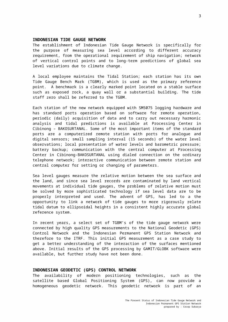
Starting in 1995 BAKOSURTANAL is being developed the establishment of the Indonesian Permanent GPS Station Network (IPGSN), an array of 13 continuously operating and remotely controlled GPS geodetic receivers for (a) supporting accurate national navigation and geodetic control, (b) monitoring crustal deformation, sea level and assessing seismic hazards, (c) providing an active national geodetic base network, (d) monitoring atmospheric water vapor in support of regional weather forecasting and climatological studies, and (e) facilitating regional and international scientific collaboration.
The present status of the IPGSN is in operational at eight locations, three locations as part of scientific cooperation with SIO-UCSD i.e. Cibinong [BAKO] West Java as IGS global station with domes # 23101M002, Trimble 4000SSi; Medan [SAMP] Northern Sumatera, Ashtech Z12; Parepare [PARE] Sulawesi, Ashtech Z12; Tolitoli [TOLI] Sulawesi, Ashtech Z12 as part of scientific cooperation with ENS-Paris-France; Watatu [WATP] Sulawesi, Leica CRS1000; Toboli [TOBP] Sulawesi, Leica CRS1000 as part of scientific cooperation with DEOS, Netherlands; Kupang [KOEP] Timor, Leica RS500; Biak [BIKL] Irian Jaya, Leica RS500.
SUMMARY
This report has given an overview of the establishment of the Indonesian Tide Gauge Network and Indonesian Geodetic (GPS) Control Network. The importance of the network is being devoted to the development of national and international spatial data infrastructure and trends to be consistent with global reference frame the ITRF and WGS84.
The Present Status of Indonesian Tide Gauge Network andIndonesian Permanent GPS Station Network
prepared by : Cecep Subarya
3
INDONESIAN TIDE GAUGE NETWORKAND
INDONESIAN PERMANENT GPS STATION NETWORK
Legend: Pelabuhan Ratu = Tide Gauge Station of DMRM Project; Cilacap = Existing Tide Gauge Station;
CIBINONG = Permanent GPS Station in operational status.The Present Status of Indonesian Tide Gauge Network and
Indonesian Permanent GPS Station Network prepared by : Cecep Subarya
05° LU
00° LU
05° LS
10° LS
095° BT 100° BT 105° BT 110° BT 115° BT 120° BT 125° BT 130° BT 135° BT 140° BT
MalahayatiLhokseumawe
Belawan
Tapaktuan
Padang
Pulau Baai
Bangka
PanjangBanten
Tj. Priok
Pelabuhan Ratu
Cilacap
Semarang
Jepara
Prigi
Surabaya
Kalianget
Celukan Bawang
Benoa Lembar
Waingapu
Maumere
Ende
Baubau
Uj. Pandang
Parepare
Kotabaru
Balikpapan
Mamuju
Palopo
Kendari
Pantoloan
TolitoliBitung
Luwuk
Badas
Tarakan
Jailolo
Tobelo
Sorong
Tahuna
Ambon
Tual
Manokwari
Biak
Jayapura
Saumlaki
Merauke
PemangkatBatamSekupang
S O U T H C H I N A S E A
I N D I A N O C E A N
P A C I F I C O C E A N
J A V A S E A B A N D A S E A
A R A F U R U S E A
T I M O R S
E A
S U L A W E S I S E A
PhilippinePhilippine
Malaysi
a
Malaysi
a
BruneiBruneiMalaysiaMalaysia
ThailandThailand
Timor Leste
JAKARTA
BENGKULU
SingaporeSingaporeSibolga
Christmas Is.
55
75
65
-15
-10
-10
-5
-15
0
0
-20
5
10 15
20
25
10
15
20
25
25
30
35
30
3520-10 -5 0 5 10
-20
-15
40
45
40 45
50
50
50
55
55
55
60
60
60
60
60
60
60
60
60
60
55
55
50
5045 65
65
70
75
75
65
6565
60
55
5045
55
70
CIBINONG
Kupang
MEDAN
WATATU
TOBOLI
PAREPARE
KUPANG
BIAK
TOLITOLI
4
The Present Status of Indonesian Tide Gauge Network andIndonesian Permanent GPS Station Network
prepared by : Cecep Subarya
T ITIK T IT IK REF ER ENSI U N TU K M EN EN TU KAN DAS AR
INF OR M A SI LE BIH L AN J U T H UBU N GI : C EC E P S U BAR YAG eodes i @ indo .net.id Telp. (021) 87573 29 a tau E-mai l :
JAR IN G KON TR OL G EOD ESI N ASIO NAL OR DE N OL
JAR IN G KO N TRO L GEO D ESI NASION AL O RD E S ATU
4 2
4 1
40
4444 A
45
43
BIDANG S URVE I GE ODES I - P USAT SU RVEI DA SAR
P E T A D I ST R I B U SI STASI U N J AR I NG K ONT R OL GE OD E SI NA SI ONA LD AN D I ST R I B U SI T I T I K D ASAR
DAL AM SI ST E M I E R S T E R R E ST R I AL R E F E R E NCE F R AME ( I T R F ) EL L I P SOI D WGS84
5