Embed Size (px)
Citation preview
Geological Society of America Bulletin
doi: 10.1130/0016-7606(1968)79[1421:BIFD]2.0.CO;2 1968;79, no. 10;1421-1426Geological Society of America Bulletin
JOHN J FISHER Barrier Island Formation: Discussion
Email alerting servicesalerts when new articles cite this article
to receive free e-mailwww.gsapubs.org/cgi/alertsclick
SubscribeGeological Society of America Bulletin
to subscribe towww.gsapubs.org/subscriptions/click
Permission requestcontact GSA
tohttp://www.geosociety.org/pubs/copyrt.htm#gsaclick
positions of the Society.political viewpoint. Opinions presented in this publication do not reflect officialby scientists worldwide, regardless of their race, citizenship, gender, religion, or provides this and other forums for the presentation of diverse opinions and positionssite providing the posting includes a reference to the article's full citation. GSA may post the abstracts only of their articles on their own or their organization's Webeducation and science. This file may not be posted to any Web site, but authors copies of items in GSA's journals for noncommercial use in classrooms to furthertable, and/or a brief paragraph of text in subsequent works and to make unlimited permission, without fees or further requests to GSA, to use a single figure, a singlewithin scope of their employment. Individual scientists are hereby granted Copyright not claimed on content prepared wholly by U.S. government employees
Notes
of their employment.government employees within the scope claimed on any material prepared by U.S.Society of America, Inc. Copyright is not Copyright © 1968, The Geological
on June 16, 2014gsabulletin.gsapubs.orgDownloaded from on June 16, 2014gsabulletin.gsapubs.orgDownloaded from
JOHN J. FISHER Department of Geology, University of Rhode Island, Kingston, Rhode Island
Barrier Isknd Formation: Discussion
The recent theory advanced by Hoyt (1967)pertaining to a possible hypothesis for theorigin and development of barrier islandsimplies certain conditions that the author ques-tions in view of known field evidence. Theauthor agrees with Hoyt (1967, p. 1126) andothers that the classical Johnsonian theorywhich relates the origin of barrier islands toshorelines of emergence has never been satis-factorily demonstrated, either in the laboratoryor in the field. The author also agrees with Hoytthat recent evidence suggests that it may actual-ly be coastal submergence rather than emer-gence that is responsible for the origin of barrierislands. The author feels, however, that thebasic mechanisms producing the islands duringsubmergence are far different from those pro-posed by Hoyt. He proposes that barrier islandsdevelop initially as subaerial dunes which arethen submerged to form barrier islands. Theauthor, in contrast, has recently proposed thatbarrier islands are formed as complex spits onthe shoreline of submergence (Fisher, 1967).It is therefore to this point of the formation ofbarrier islands in Hoyt's theory rather than thequestion of submergence that the followingpoints are directed.
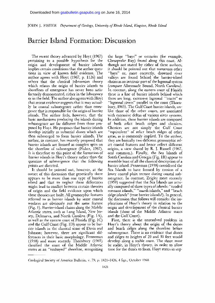
It should be pointed out, however, at theoutset of this discussion that genetically thereappears to be more than one type of barrierisland and that to neglect these differencesmight lead to conflict between certain theoriesof origin and the field evidence upon whichthese theories are built. All geomorphic featuresreferred to as barrier islands by some coastalworkers are obviously not the same feature(Fig. 1). Barrier-island chains along the MiddleAtlantic states, such as Long Island, New Jer-sey, Delmarva, and North Carolina (Fig. 1A),as well as the eastern coast of Florida (Fig. 1C)and the Gulf Coast (Fig. ID) appear to be bar-rier islands in the classical sense of Davis andJohnson; however, there are significant dif-ferences in their basic morphology. Fenneman(1938) and more recently Thornbury (1965)classified the coast of the Middle Atlanticstates as an "embayed" shoreline, recognizing
the large "bays" or estuaries (for example,Chesapeake Bay) found along this coast. Al-though not stated by either of these authors,it should be pointed out that numerous other"bays" or, more correctly, drowned rivervalleys are found behind the barrier-islandchains as an intrinsic part of the lagoonal system(compare Albermarle Sound, North Carolina).In contrast, along the eastern coast of Floridathere is a line of barrier islands behind whichthere are long, extensive lagoonal "tracts" or"lagoonal rivers" parallel to the coast (Thorn-bury, 1965). The Gulf Coast barrier islands, un-like those of the other coasts, are associatedwith extensive deltas of various river systems.In addition, these barrier islands are composedof both relict beach ridges and cheniers.Cheniers are not simply the Gulf Coast"equivalent" of relict beach ridges of otherareas, as is commonly implied. To the author,they are basically two different geomorphic rel-ict coastal features and hence reflect differentorigins, a view shared by R. J. Russell (1967,oral commun.). Finally, the Sea Islands ofSouth Carolina and Georgia (Fig. IB) appear toresemble least of all the classical description of abarrier island. Fenneman (1938) considered theSea Islands to have formed by erosion of alower coastal plain terrace during coastal sub-mergence. In contrast, Zeigler more recently(1959) suggested that the Sea Islands are actu-ally composed of three types of i slands:' 'erodedremnant islands," "marsh islands," and "beachridge islands" (true barrier islands?). In general,the discussion that follows will consider the im-plications of Hoyt's theory in relation to theorigin and development of the classical barrierislands (those of the Middle Atlantic statesand the Gulf Coast).
First, there is the unresolved problem inHoyt's theory about the origin of the dunesand beach ridges along the shoreline beforesubmergence. There is no evidence that dunesand ridges to heights of 20 and 30 feet woulddevelop along a stable coast. The shore mustbe stable, in Hoyt's theory, in order to allowtime for the dunes to form. Hoyt states in sup-
Geological Society of America Bulletin, v. 79, p. 1421-1426, 4 figs., October 1968
1421
on June 16, 2014gsabulletin.gsapubs.orgDownloaded from
1422 J. J. FISHER-BARRIER ISLAND FORMATION: DISCUSSION
B.
Flo.
D.
Figure 1. Barrier-island chain shorelines of the eastern United States. A. Middle Atlantic states.B. Sea Islands of South Carolina and Georgia. C. Eastern Coast of Florida. D. Western Gulf of Mexico.
port of dune building that "such ridges areubiquitous along sediment shorelines of theworld" (1967, p. 1130). This comparison withthe present-day barrier shorelines is not validbecause these shorelines, by the assumption ofHoyt's theory, are second-cycle shorelines ofsubmergence rather than stable shorelines. Inaddition, the author believes that most beachridges and barrier dunes along present-daybarrier islands are actually relict features, hav-ing formed in the past as beach ridges undersubmerging coastal conditions.
The second questionable point in Hoyt'sproposed theory is the implied straightness otthe initial presubmerged shoreline. The se-quence of development presented by Hoyt(1967, p. 1130) is that "the sea must meet theland at the shoreline, . . . dunes will form im-mediately landward of the shoreline . . . andwith submergence . . . the ridge then becomes abarrier island." Considering that present-daybarrier-island shorelines tend to be linear (com-pare Figs. 1, A, C, D), Hoyt's theory that theislands are beach ridges or dunes formed alonga submerging coast would require submergenceof a flat, featureless plain. Submergence of al-most any coastal plain with its streams, valleys,and uplands would produce an irregular shore-line and hence, by Hoyt's theory, an irregularbarrier chain. In Johnson's theory, the barriershoreline was straight because he claimed that itdeveloped on a hypothetically smooth plain,
the emerged offshore sea bottom. Thus, whenanalyzed in map view, the sequence of shorelinedevelopment suggested by Hoyt does not seemto be valid. At least, it is not valid for the regu-lar linear barrier islands of the Atlantic andGulf Coasts.
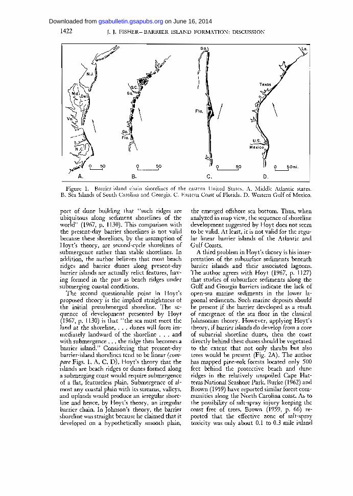
A third problem in Hoyt's theory is his inter-pretation of the subsurface sediments beneathbarrier islands and their associated lagoons.The author agrees with Hoyt (1967, p. 1127)that studies of subsurface sediments along theGulf and Georgia barriers indicate the lack ofopen-sea marine sediments in the lower la-goonal sediments. Such marine deposits shouldbe present if the barrier developed as a resultof emergence of the sea floor in the classicalJohnsonian theory. However, applying Hoyt'stheory, if barrier islands do develop from a coreof subaerial shoreline dunes, then the coastdirectly behind these dunes should be vegetatedto the extent that not only shrubs but alsotrees would be present (Fig. 2A). The authorhas mapped pine-oak forests located only 500feet behind the protective beach and duneridges in the relatively unspoiled Cape Hat-teras National Seashore Park. Burke (1962) andBrown (1959) have reported similar forest com-munities along the North Carolina coast. As tothe possibility of salt-spray injury keeping thecoast free of trees, Brown (1959, p. 66) re-ported that the effective zone of salt-spraytoxicity was only about 0.1 to 0.3 mile inland
on June 16, 2014gsabulletin.gsapubs.orgDownloaded from
NOTES AND DISCUSSIONS 1423
except at one place where it was 1.35 milesinland. The presence of barrier dunes tends toprotect the forest even further from salt-sprayinjury. Thus, if barriers formed as proposedby Hoyt, the subsurface base of the lagoonaldeposits should be a veritable buried forest(compare Fig. 2B). This is definitely not thesituation. Salt marsh and root fragments havebeen found in some deposits (Shepard andMoore, 1955, 1960), but nothing indicative ofsubaerial tree and shrub deposits. So, while theevidence of subsurface lagoonal deposits doesnot indicate open marine sediments as requiredby the Johnsonian classical theory, neither doesthe evidence seem to indicate the subaerialsediments implied by Hoyt's theory. Further-more, the sediment types actually found at thebase of the lagoons along the Gulf Coast aredescribed as a lagoonal or "bay" facies (Shepardand Moore, 1960, p. 133) similar to present-daylagoonal deposits. If this is the case, then thebase of the lagoon could never have been abovesea level as a subaerial region behind coastaldunes as Hoyt's theory would imply. Shepardand Moore further conclude (1960, p. 134) thatthe subsurface sediments indicate that duringthe development of the barrier islands it seems"likely that there was a barrier across most ofthe mouth of the bay" (lagoon). From theauthor's point of view, this barrier could havebeen a spit.
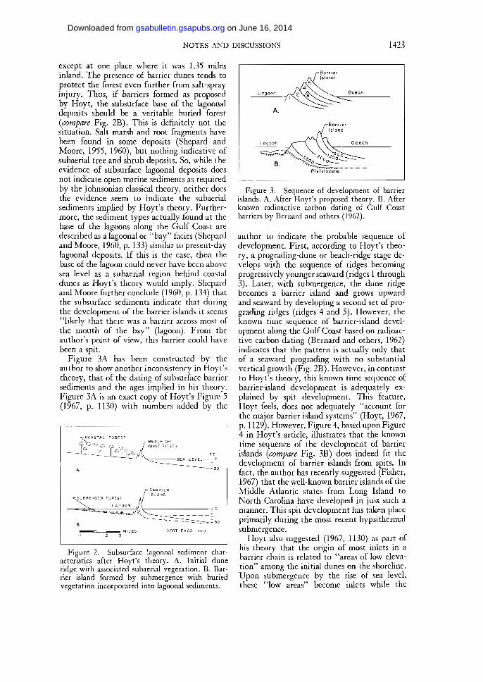
Figure 3A has been constructed by theauthor to show another inconsistency in Hoyt'stheory, that of the dating of subsurface barriersediments and the ages implied in his theory.Figure 3A is an exact copy of Hoyt's Figure 5(1967, p. 1130) with numbers added by the
r C O A S T A L F O R E S T
Figure 2. Subsurface lagoonal sediment char-acteristics after Hoyt's theory. A. Initial duneridge with associated subaerial vegetation. B. Bar-rier island formed by submergence with buriedvegetation incorporated into lagoonal sediments.
B.
Figure 3. Sequence of development of barrierislands. A. After Hoyt's proposed theory. B. Afterknown radioactive carbon dating of Gulf Coastbarriers by Bernard and others (1962).
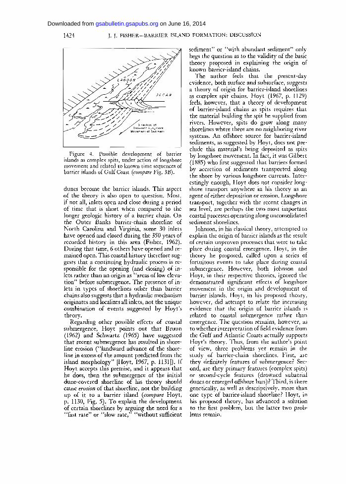
author to indicate the probable sequence ofdevelopment. First, according to Hoyt's theo-ry, a prograding-dune or beach-ridge stage de-velops with the sequence of ridges becomingprogressively younger seaward (ridges 1 through3). Later, with submergence, the dune ridgebecomes a barrier island and grows upwardand seaward by developing a second set of pro-grading ridges (ridges 4 and 5). However, theknown time sequence of barrier-island devel-opment along the Gulf Coast based on radioac-tive carbon dating (Bernard and others, 1962)indicates that the pattern is actually only thatof a seaward prograding with no substantialvertical growth (Fig. 2B). However, in contrastto Hoyt's theory, this known time sequence ofbarrier-island development is adequately ex-plained by spit development. This feature,Hoyt feels, does not adequately "account forthe major barrier island systems" (Hoyt, 1967,p. 1129). However, Figure 4, based upon Figure4 in Hoyt's article, illustrates that the knowntime sequence of the development of barrierislands (compare Fig. 3B) does indeed fit thedevelopment of barrier islands from spits. Infact, the author has recently suggested (Fisher,1967) that the well-known barrier islands of theMiddle Atlantic states from Long Island toNorth Carolina have developed in just such amanner. This spit development has taken placeprimarily during the most recent hypsithermalsubmergence.
Hoyt also suggested (1967, 1130) as part ofhis theory that the origin of most inlets in abarrier chain is related to "areas of low eleva-tion" among the initial dunes on the shoreline.Upon submergence by the rise of sea level,these "low areas" become inlets while the
on June 16, 2014gsabulletin.gsapubs.orgDownloaded from
1424 J. J. FISHER-BARRIER ISLAND FORMATION: DISCUSSION
Figure 4. Possible development of barrierislands as complex spits, under action of longshoremovement and related to known time sequences ofbarrier islands of Gulf Coast (compare Fig. 3B).
dunes become the barrier islands. This aspectof the theory is also open to question. Most,if not all, inlets open and close during a periodof time that is short when compared to thelonger geologic history of a barrier chain. Onthe Outer Banks barrier-chain shoreline ofNorth Carolina and Virginia, some 30 inletshave opened and closed during the 350 years ofrecorded history in this area (Fisher, 1962).During that time, 6 others have opened and re-mained open. This coastal history therefore sug-gests that a continuing hydraulic process is re-sponsible for the opening (and closing) of in-lets rather than an origin as "areas of low eleva-tion" before submergence. The presence of in-lets in types of shorelines other than barrierchains also suggests that a hydraulic mechanismoriginates and localizes all inlets, not the uniquecombination of events suggested by Hoyt'stheory.
Regarding other possible effects of coastalsubmergence, Hoyt points out that Bruun(1962) and Schwartz (1965) have suggestedthat recent submergence has resulted in shore-line erosion ("landward advance of the shore-line in excess of the amount predicted from theisland morphology" [Hoyt, 1967, p. 1131]). IfHoyt accepts this premise, and it appears thathe does, then the submergence of the initialdune-covered shoreline of his theory shouldcause erosion of that shoreline, not the buildingup of it to a barrier island (compare Hoyt,p. 1130, Fig. 5). To explain the developmentof certain shorelines by arguing the need for a"fast rate" or "slow rate," "without sufficient
sediment" or "with abundant sediment" onlybegs the question as to the validity of the basictheory proposed in explaining the origin ofknown barrier-island chains.
The author feels that the present-dayevidence, both surface and subsurface, suggestsa theory of origin for barrier-island shorelinesas complex spit chains. Hoyt (1967, p. 1129)feels, however, that a theory of developmentof barrier-island chains as spits requires thatthe material building the spit be supplied fromrivers. However, spits do grow along manyshorelines where there are no neighboring riversystems. An offshore source for barrier-islandsediments, as suggested by Hoyt, does not pre-clude this material's being deposited as spitsby longshore movement. In fact, it was Gilbert(1885) who first suggested that barriers formedby accretion of sediments transported alongthe shore by various longshore currents. Inter-estingly enough, Hoyt does not consider long-shore transport anywhere in his theory as anagent of either deposition or erosion. Longshoretransport, together with the recent changes insea level, are perhaps the two most importantcoastal processes operating along unconsolidatedsediment shorelines.
Johnson, in his classical theory, attempted toexplain the origin of barrier islands as the resultof certain unproven processes that were to takeplace during coastal emergence. Hoyt, in thetheory he proposed, called upon a series offortuitous events to take place during coastalsubmergence. However, both Johnson andHoyt, in their respective theories, ignored thedemonstrated significant effects of longshoremovement in the origin and development ofbarrier islands. Hoyt, in his proposed theory,however, did attempt to relate the increasingevidence that the origin of barrier islands isrelated to coastal submergence rather thanemergence. The question remains, however, asto whether interpretation of field evidence fromthe Gulf and Atlantic Coasts actually supportsHoyt's theory. Thus, from the author's pointof view, three problems yet remain in thestudy of barrier-chain shorelines. First, arethey definitely features of submergence? Sec-ond, are they primary features (complex spits)or second-cycle features (drowned subaerialdunes or emerged offshore bars) ? Third, is theregenetically, as well as descriptively, more thanone type of barrier-island shoreline? Hoyt, inhis proposed theory, has advanced a solutionto the first problem, but the latter two prob-lems remain.
on June 16, 2014gsabulletin.gsapubs.orgDownloaded from
NOTES AND DISCUSSIONS 1425
References Cited
Bernard, H. A., LeBlanc, R. J., and Major, C. F., 1962, Recent and Pleistocene geology of southeastTexas, p. 175—224 in Geology of the Gulf Coast and central Texas and guidebook of excursions:Houston Geol. Soc.
Brown, C. A., 1959, Vegetation of the Outer Banks of North Carolina: Louisiana State Univ. CoastalStudies Series, no. 4, 179 p.
Bruun, P., 1962, Sea level rise as a cause of shore erosion: Am. Soc. Civil Engineers Proc., Jour. Waterwaysand Harbors Div., v. 88, p. 117-130.
Burke, C. J., 1962, The North Carolina Outer Banks: a floristic interpretation: Jour. Elisha MitchellScientific Soc., v. 78, p. 21-28.
Fenneman, N. M., 1938, Physiography of Eastern United States: New York, McGraw-Hill, 714 p.Fisher, J. J., 1962, Historical geography of North Carolina inlets—a geomorphic re-evaluation: Assoc. Am.
Geographers, S. E. Div., Memorandum Folio, v. 14.1967, Origin of barrier island chain shorelines: Middle Atlantic states (Abstract): Geol. Soc. America
Ann. Meeting Program, p. 66-67.Gilbert, O.K., 1885, The topographic features of lake shores: U. S. Geol. Survey 5th Ann. Rept., p. 69-123.Hoyt, J. H., 1967, Barrier island formation: Geol. Soc. America Bull., v. 78, p. 1125-1136.Schwartz, M., 1965, Laboratory study of sea-level rise as a cause of shore erosion: Jour. Geology, v. 73, p.
528-534.Shepard, F. P., and Moore, D. G., 1955, Central Texas coast sedimentation: characteristics of sedimentary
environment, Recent history and diagenesis: Am. Assoc. Petroleum Geologists Bull., v. 39, p. 1463-1593.1960, Bays of central Texas coast, p. 117-152 in Shepard, F. P., and others, Editors, Recent sediments,
northwest Gulf of Mexico: Am. Assoc. Petroleum Geologists.Thornbury, W. D., 1965, Regional geomorphology of the United States: New York, Wiley, 609 p.Zeigler, J. M., 1959, Origin of the sea islands of southeastern United States: Geog. Rev., v. 49, p. 22-237.
MANUSCRIPT RECEIVED BY THE SOCIETY APRIL 10, 1968
on June 16, 2014gsabulletin.gsapubs.orgDownloaded from