Embed Size (px)
Citation preview
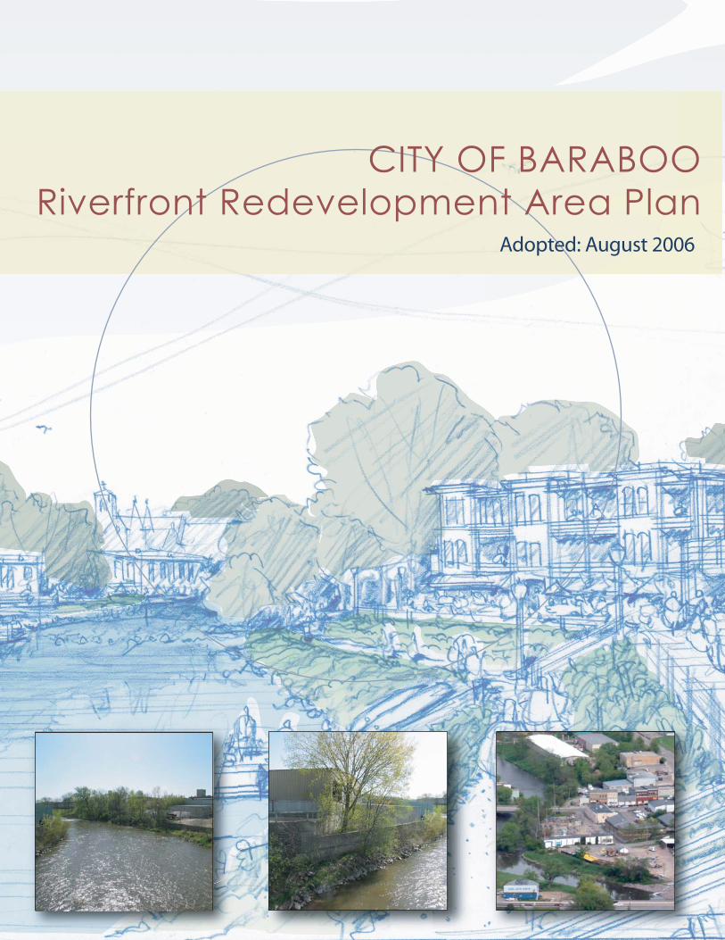
CITY OF BARABOORiverfront Redevelopment Area Plan
Adopted: August 2006
Baraboo Riverfront Redevelopment Area Plan
August 2006 1
Acknowledgements
Baraboo Economic Development Commission City Council Aleasha Anderson Joseph Black James Carter Al Dippel, Jr. Greg Lindner Patrick Liston Gregg McArthur Jerry McCammond Michael Palm Phil Wedekind
Patrick Liston, Mayor Jerry McCammond, Council President Ann Burke Michael Cone Olaf Kivioja Brian Loeffelholz Betty Marquardt Eugene Robkin Brett Topham Phil Wedekind
City Staff Planning Assistance Provided by: Edward Geick, City Administrator Beany Koschoreck, Executive Assistant 135 4th Street Baraboo, WI 53913 (608) 355-2715
Community Development Authority Pat Hamilton, Executive Director
Vandewalle & Associates 120 East Lakeside Street Madison, WI 53715 (608) 255-3988 www.vandewalle.com Joy Stieglitz, AICP, Principal in Charge Jeff Maloney, Project Manager/Lead Designer Brian Vandewalle, AICP, Economic Expert Rob Gottschalk, AICP, RLA, Design Expert Dean Proctor, AIA, Design Expert Ellen Hall, Communications Manager Anita Claypatch, Design Intern
Baraboo Riverfront Redevelopment Area Plan
August 2006 2
Table of Contents
Acknowledgements ...................................................................................................................1
Table of Contents........................................................................................................................2
Introduction .................................................................................................................................3 Planning Purpose ...............................................................................................................................................3 Planning Boundary ............................................................................................................................................4
Map 1: Planning Area....................................................................................................................................4 Planning Process ................................................................................................................................................5
Opportunities Analysis................................................................................................................6 Regional Market Influences..............................................................................................................................6
Map 2: Regional Market Influences .................................................................................................................8 Market Niche ......................................................................................................................................................9
Map 3: Market Niche...................................................................................................................................10 Preservation and Redevelopment Analysis ..................................................................................................12
Map 4: Preservation & Redevelopment ..........................................................................................................14 Riverfront Concept Plan.................................................................................................................................15
Map 5: Riverfront Concept ............................................................................................................................18
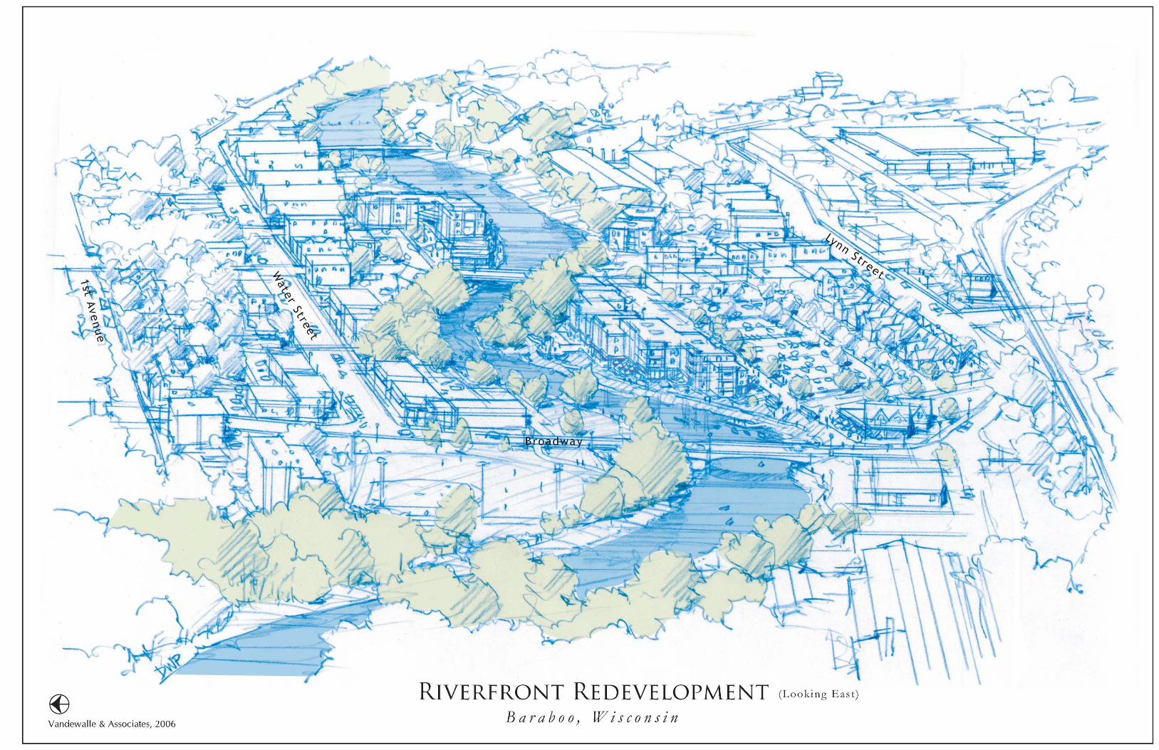
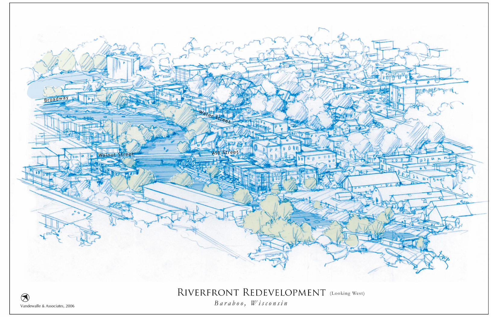
Riverfront Redevelopment Area Plan (see Map on page 23) .............................................19 Development Recommendations: .................................................................................................................19
Map 6: Riverfront Redevelopment Area .........................................................................................................23 Figure 1: Riverfront Redevelopment (Looking East) .......................................................................................24 Figure 2: Riverfront Redevelopment (Looking West).......................................................................................25
Riverfront Redevelopment Area Plan – Detailed Sites (see Map on page 29) ..................26 Alliant Energy Site (Expanded) .....................................................................................................................26 Onyx Site...........................................................................................................................................................28 Co-op Country Partners Site ..........................................................................................................................28 Ash/Walnut Corridor......................................................................................................................................28
Map 7: Riverfront Redevelopment Area Plan- Detailed Sites .........................................................................29
Implementation ........................................................................................................................30 Implementation Strategy Overview...............................................................................................................30 Implementation Roles .....................................................................................................................................30
Figure 3: Implementation Tracks ...................................................................................................................32 Implementation Recommendations..............................................................................................................32 Project Implementation Phasing ...................................................................................................................33
Map 8: Implementation Phasing ....................................................................................................................34 Figure 4: Phasing Strategy .............................................................................................................................36
Baraboo Riverfront Redevelopment Area Plan
August 2006 3
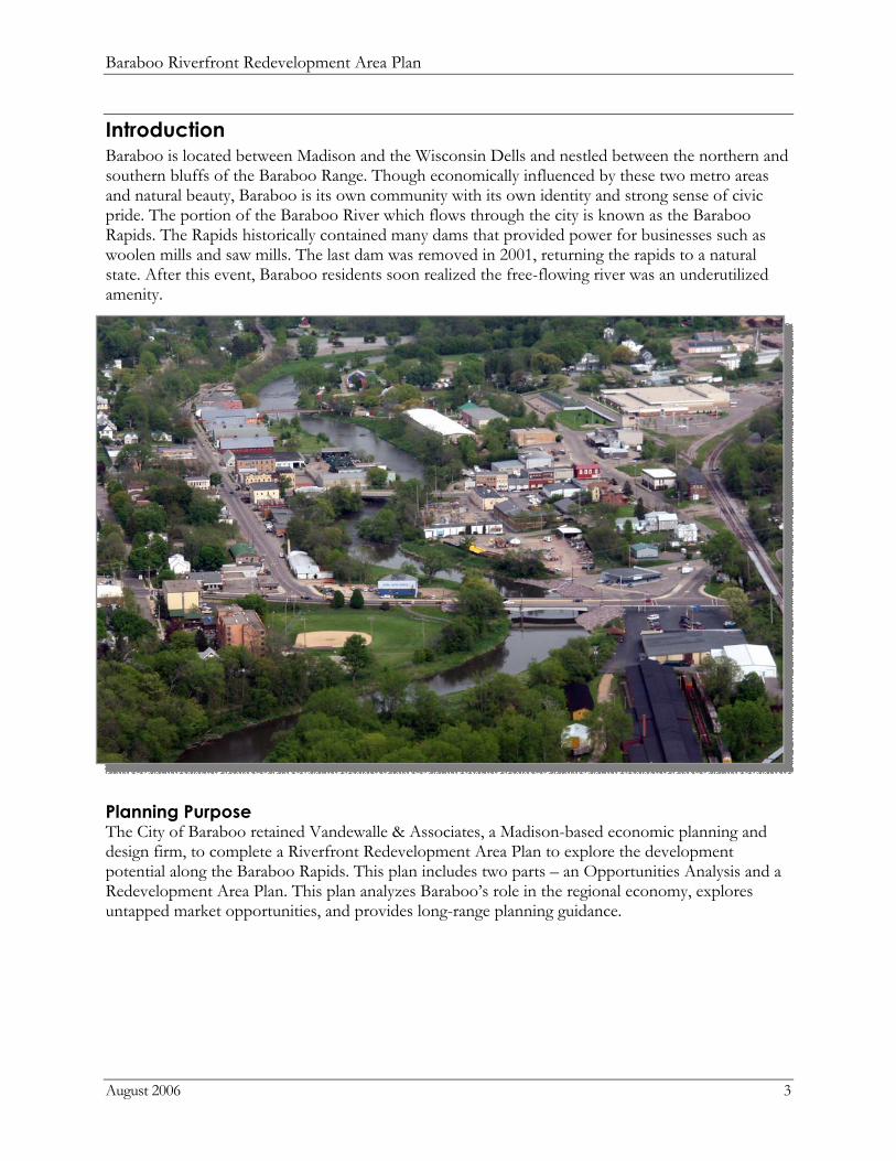
Introduction Baraboo is located between Madison and the Wisconsin Dells and nestled between the northern and southern bluffs of the Baraboo Range. Though economically influenced by these two metro areas and natural beauty, Baraboo is its own community with its own identity and strong sense of civic pride. The portion of the Baraboo River which flows through the city is known as the Baraboo Rapids. The Rapids historically contained many dams that provided power for businesses such as woolen mills and saw mills. The last dam was removed in 2001, returning the rapids to a natural state. After this event, Baraboo residents soon realized the free-flowing river was an underutilized amenity.
Planning Purpose The City of Baraboo retained Vandewalle & Associates, a Madison-based economic planning and design firm, to complete a Riverfront Redevelopment Area Plan to explore the development potential along the Baraboo Rapids. This plan includes two parts – an Opportunities Analysis and a Redevelopment Area Plan. This plan analyzes Baraboo’s role in the regional economy, explores untapped market opportunities, and provides long-range planning guidance.
Baraboo Riverfront Redevelopment Area Plan
August 2006 4
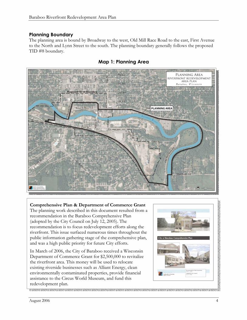
Planning Boundary The planning area is bound by Broadway to the west, Old Mill Race Road to the east, First Avenue to the North and Lynn Street to the south. The planning boundary generally follows the proposed TID #8 boundary.
Map 1: Planning Area
Comprehensive Plan & Department of Commerce Grant The planning work described in this document resulted from a recommendation in the Baraboo Comprehensive Plan (adopted by the City Council on July 12, 2005). The recommendation is to focus redevelopment efforts along the riverfront. This issue surfaced numerous times throughout the public information gathering stage of the comprehensive plan, and was a high public priority for future City efforts.
In March of 2006, the City of Baraboo received a Wisconsin Department of Commerce Grant for $2,500,000 to revitalize the riverfront area. This money will be used to relocate existing riverside businesses such as Alliant Energy, clean environmentally contaminated properties, provide financial assistance to the Circus World Museum, and fund this redevelopment plan.
Baraboo Riverfront Redevelopment Area Plan
August 2006 5
Planning Process
Background Research Vandewalle & Associates reviewed a series of planning documents relevant to the riverfront area, including:
City of Baraboo Comprehensive Plan, 2005 A Brief History of the Dams of the Baraboo River, 2004 Sauk County Highway 12 Corridor Growth Management Plan, 2003 Baraboo Rapids Strategic Plan, 2002
Stakeholder Interviews, Site Assessment & Steering Committee Kick-Off Meeting On April 12, 2006, Vandewalle & Associates participated in a day-long kick-off meeting. Activities included stakeholder interviews, a visual site assessment, and a kick-off meeting with the project steering committee, Baraboo Economic Development Commission (BEDC).
Vandewalle & Associates conducted eleven interviews with various community stakeholders to learn the local economic trends, private property plans, and citizens’ future vision for the riverfront. Interviewees included groups of civic leaders, business owners, city and county staff, parties with vested interest in the Baraboo River, and large property owners in the planning area.
Vandewalle & Associates conducted a visual assessment of the study area to analyze existing site conditions and verify base map information. During the steering committee kick-off meeting, generalized stakeholder comments were discussed. Also, BEDC members provided initial ideas for the redevelopment of the riverfront.
Draft Opportunities Analysis Presentation On May 16, 2006, Vandewalle & Associates presented draft redevelopment opportunities at a joint BEDC/Plan Commission meeting. BEDC, the Plan Commission, and citizens provided feedback on the initial opportunities.
Final Opportunities Analysis and Draft Redevelopment Area Plan Presentation On June 5, 2006, Vandewalle & Associates presented the revised Opportunities Analysis incorporating comments from the previous steering committee meeting. At the same meeting, Vandewalle & Associates presented the draft Riverfront Redevelopment Area Plan. BEDC and the public provided feedback on the draft plan.
Final Presentation One July 11, 2006, Vandewalle & Associates presented the final Opportunities Analysis and Draft Redevelopment Area Plan to BEDC and the City Council.
Baraboo Riverfront Redevelopment Area Plan
August 2006 6
Opportunities Analysis
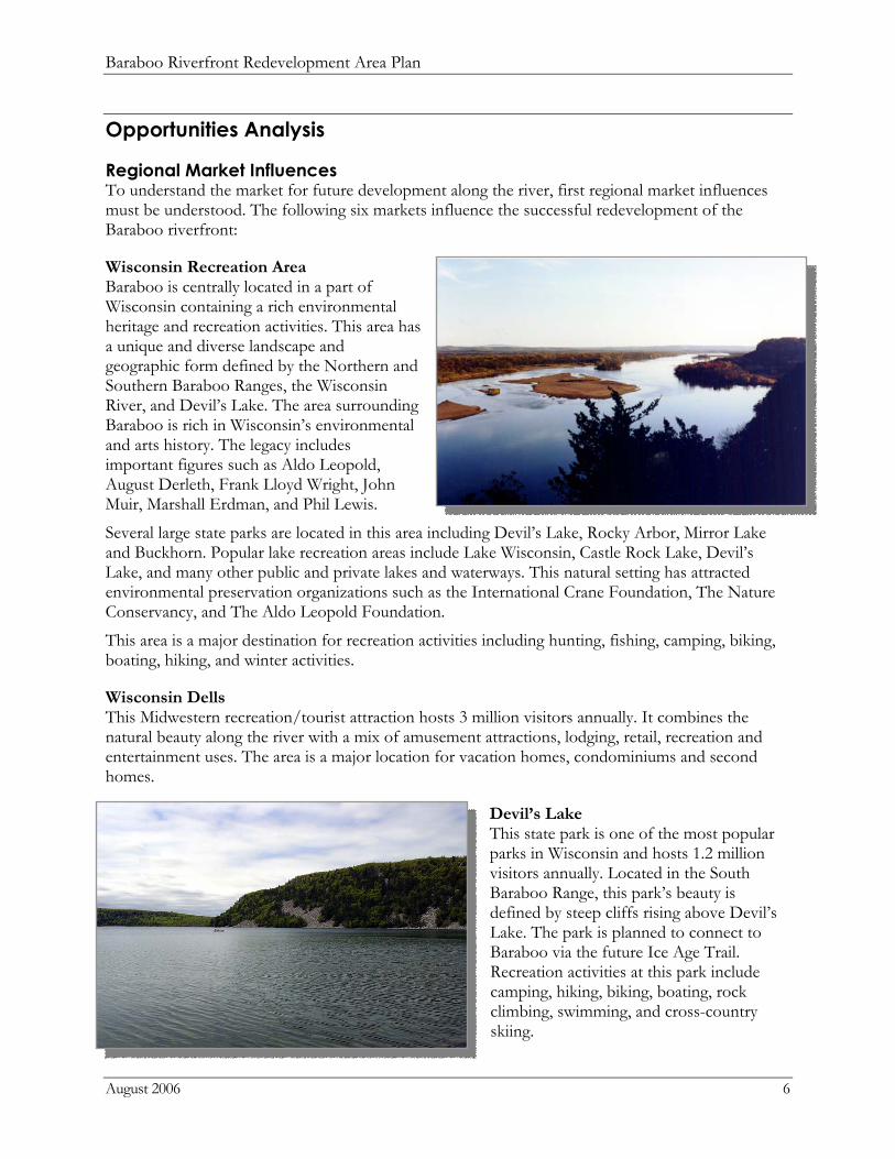
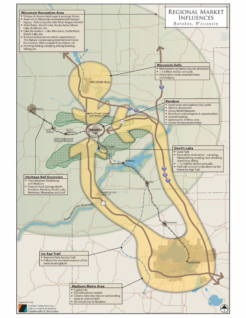
Regional Market Influences To understand the market for future development along the river, first regional market influences must be understood. The following six markets influence the successful redevelopment of the Baraboo riverfront:
Wisconsin Recreation Area Baraboo is centrally located in a part of Wisconsin containing a rich environmental heritage and recreation activities. This area has a unique and diverse landscape and geographic form defined by the Northern and Southern Baraboo Ranges, the Wisconsin River, and Devil’s Lake. The area surrounding Baraboo is rich in Wisconsin’s environmental and arts history. The legacy includes important figures such as Aldo Leopold, August Derleth, Frank Lloyd Wright, John Muir, Marshall Erdman, and Phil Lewis.
Several large state parks are located in this area including Devil’s Lake, Rocky Arbor, Mirror Lake and Buckhorn. Popular lake recreation areas include Lake Wisconsin, Castle Rock Lake, Devil’s Lake, and many other public and private lakes and waterways. This natural setting has attracted environmental preservation organizations such as the International Crane Foundation, The Nature Conservancy, and The Aldo Leopold Foundation.
This area is a major destination for recreation activities including hunting, fishing, camping, biking, boating, hiking, and winter activities.
Wisconsin Dells This Midwestern recreation/tourist attraction hosts 3 million visitors annually. It combines the natural beauty along the river with a mix of amusement attractions, lodging, retail, recreation and entertainment uses. The area is a major location for vacation homes, condominiums and second homes.
Devil’s Lake This state park is one of the most popular parks in Wisconsin and hosts 1.2 million visitors annually. Located in the South Baraboo Range, this park’s beauty is defined by steep cliffs rising above Devil’s Lake. The park is planned to connect to Baraboo via the future Ice Age Trail. Recreation activities at this park include camping, hiking, biking, boating, rock climbing, swimming, and cross-country skiing.

Baraboo Riverfront Redevelopment Area Plan
August 2006 7
Madison Metro Area This capital city is home to a major state university and approximately 500,000 people. Located 45 minutes south of Baraboo, the Madison Metro Area is accessible from USH 12 and I39/90/94. Citizens embark on day trips throughout southwest Wisconsin to explore small towns, the driftless area, recreation opportunities, state parks, the Wisconsin Dells, and seasonal activities & festivals.
Ice Age Trail The Ice Age Trail, being planned by the National Park Service, follows the route of the terminal Moraine during the last glaciations. In the Baraboo area, the trail route is planned from Devil’s Lake to the north side of the riverfront redevelopment area, through downtown, and then west toward Highway 12. The trail will connect to the planned riverwalk.
Heritage Rail Excursion Train This planned passenger train will travel between Madison and Reedsburg. It will host both day and seasonal trips, such as one focusing on autumn colors. The leisurely train ride will stop in the following locations: Lodi, Waunakee, Merrimac, Devil’s Lake, Baraboo, North Freedom and Rock Springs.
City of Baraboo In addition to regional market influences, the City of Baraboo has its own characteristics which are attractive for quality development, including its historic downtown/square, small town atmosphere and natural setting. The City of Baraboo has its own unique identity, separate from the nearby Wisconsin Dells, and its citizens take great pride in this strong community. Finally, the citizens feel an opportunity exists to redevelop the riverfront, which would connect the Circus World Museum to downtown Baraboo.
Baraboo Riverfront Redevelopment Area Plan
August 2006 9
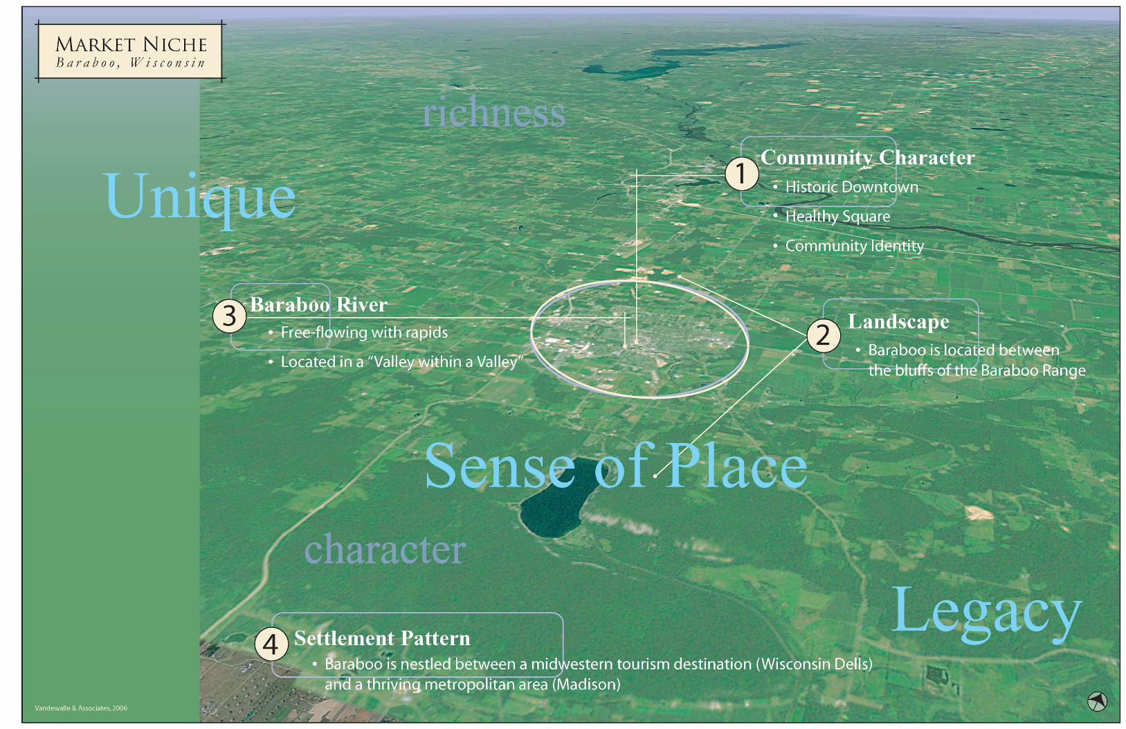
Market Niche Concentrating on the market niche sets the foundation for place-based economic development and successful redevelopment. New uses should relate to, and build upon, the amenities Baraboo has to offer.
Characteristics Four characteristics of Baraboo form the base of its market niche:
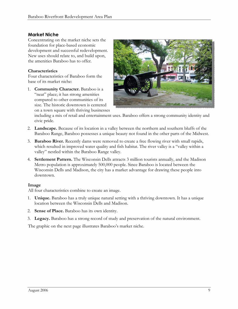
1. Community Character. Baraboo is a “neat” place; it has strong amenities compared to other communities of its size. The historic downtown is centered on a town square with thriving businesses including a mix of retail and entertainment uses. Baraboo offers a strong community identity and civic pride.
2. Landscape. Because of its location in a valley between the northern and southern bluffs of the Baraboo Range, Baraboo possesses a unique beauty not found in the other parts of the Midwest.
3. Baraboo River. Recently dams were removed to create a free flowing river with small rapids, which resulted in improved water quality and fish habitat. The river valley is a “valley within a valley” nestled within the Baraboo Range valley.
4. Settlement Pattern. The Wisconsin Dells attracts 3 million tourists annually, and the Madison Metro population is approximately 500,000 people. Since Baraboo is located between the Wisconsin Dells and Madison, the city has a market advantage for drawing these people into downtown.
Image All four characteristics combine to create an image.
1. Unique. Baraboo has a truly unique natural setting with a thriving downtown. It has a unique location between the Wisconsin Dells and Madison.
2. Sense of Place. Baraboo has its own identity.
3. Legacy. Baraboo has a strong record of study and preservation of the natural environment.
The graphic on the next page illustrates Baraboo’s market niche.
Baraboo Riverfront Redevelopment Area Plan
August 2006 11
Market Opportunities Related to the Market Niche While the Market Niche provides the foundation for place-based economic development, the following are major market opportunities that are guided by the market niche.
1. Riverfront Residential Provides a central downtown place for
people to live adjacent to water Accommodates all housing markets:
young professionals desiring to be near downtown and riverfront activities, Madison transplants, and aging baby boomers.
2. Riverwalk Entertainment/Retail Capitalizes on the river as an asset Adds activities to complement
downtown and the Circus World Museum
Orients restaurants to the river Creates building access to the river and
riverwalk Hosts four season activities (e.g. ice rink)
3. Range View Housing Provides a new housing neighborhood near the downtown and riverfront Captures views of the area’s natural attractions Serves as a “window” to the Southern Baraboo Range
4. Lodging Establishes an urban hotel on the
river/riverwalk Accessible from Hwy 12, Wisconsin
Dells, Madison, and Devil’s Lake Features rooms that overlook the river
5. Riverwalk Creates trails along both sides of the
river Restores the river edge with native
vegetation Ensures public access to the river Orients land uses and activities to the
river
6. Employment - Knowledge Worker The newly created riverfront market will drive some niche office users Offers employment downtown or along river Generates office space above the first stories of mixed use buildings Establishes another level of economic development
Baraboo Riverfront Redevelopment Area Plan
August 2006 12
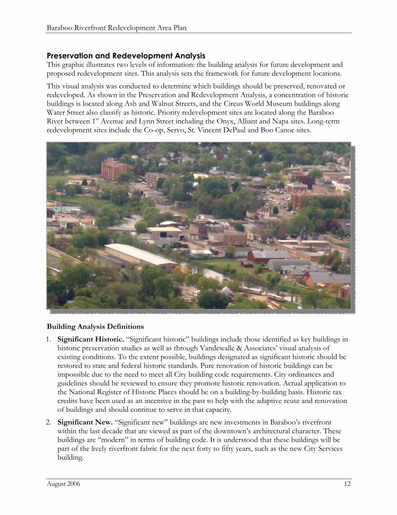
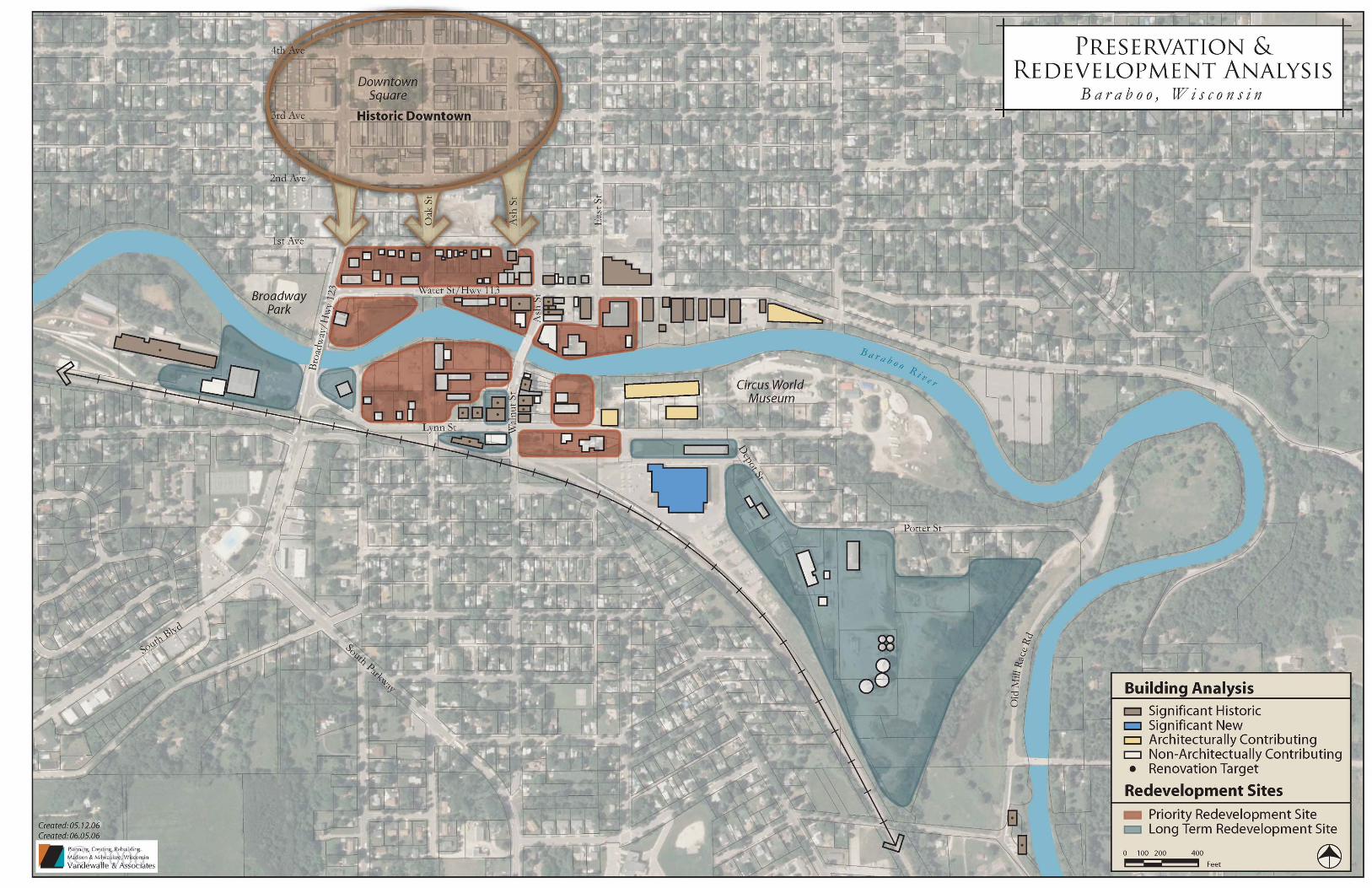
Preservation and Redevelopment Analysis This graphic illustrates two levels of information: the building analysis for future development and proposed redevelopment sites. This analysis sets the framework for future development locations.
This visual analysis was conducted to determine which buildings should be preserved, renovated or redeveloped. As shown in the Preservation and Redevelopment Analysis, a concentration of historic buildings is located along Ash and Walnut Streets, and the Circus World Museum buildings along Water Street also classify as historic. Priority redevelopment sites are located along the Baraboo River between 1st Avenue and Lynn Street including the Onyx, Alliant and Napa sites. Long-term redevelopment sites include the Co-op, Servo, St. Vincent DePaul and Boo Canoe sites.
Building Analysis Definitions
1. Significant Historic. “Significant historic” buildings include those identified as key buildings in historic preservation studies as well as through Vandewalle & Associates’ visual analysis of existing conditions. To the extent possible, buildings designated as significant historic should be restored to state and federal historic standards. Pure renovation of historic buildings can be impossible due to the need to meet all City building code requirements. City ordinances and guidelines should be reviewed to ensure they promote historic renovation. Actual application to the National Register of Historic Places should be on a building-by-building basis. Historic tax credits have been used as an incentive in the past to help with the adaptive reuse and renovation of buildings and should continue to serve in that capacity.
2. Significant New. “Significant new” buildings are new investments in Baraboo’s riverfront within the last decade that are viewed as part of the downtown’s architectural character. These buildings are “modern” in terms of building code. It is understood that these buildings will be part of the lively riverfront fabric for the next forty to fifty years, such as the new City Services building.
Baraboo Riverfront Redevelopment Area Plan
August 2006 13
3. Architecturally Contributing. The category “architecturally contributing” represents properties that are not necessarily significant historic or significant new, but are adjacent to, across the street from, or in the view corridors of the aforementioned categories. In terms of architectural design standards, renovations and/or reuse of these properties should be in harmony with the buildings around them. These buildings appear structurally sound and functional.
4. Non-architecturally Contributing. Buildings designated non-architecturally contributing may be solid buildings that neither contribute to nor detract from the upcoming phase of redevelopment.
5. Renovation Targets. Renovation targets are buildings that have been identified as those that are the most important for immediate renovation and adaptive reuses. Most likely, these buildings are currently underutilized and developers should be recruited to renovate them.
Redevelopment Sites 1. Priority redevelopment sites are defined as sites recommended to redevelop in 0-5 years.
These sites include large property owners such as Onyx and Alliant, properties currently owned by the City, and sites important to the successful redevelopment of the riverfront area.
2. Long-term redevelopment sites will likely redevelop after 5 years and after priority redevelopment sites. These sites may require existing businesses to relocate to more appropriate areas of the City, which will require time and cooperation with the City. Some businesses in long-term redevelopment sites may be appropriate uses for the riverfront area, but would be better served in an alternative building configuration.
The map on the next page illustrates the building analysis and redevelopment site locations.
Baraboo Riverfront Redevelopment Area Plan
August 2006 15
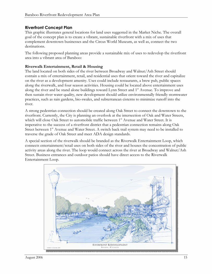
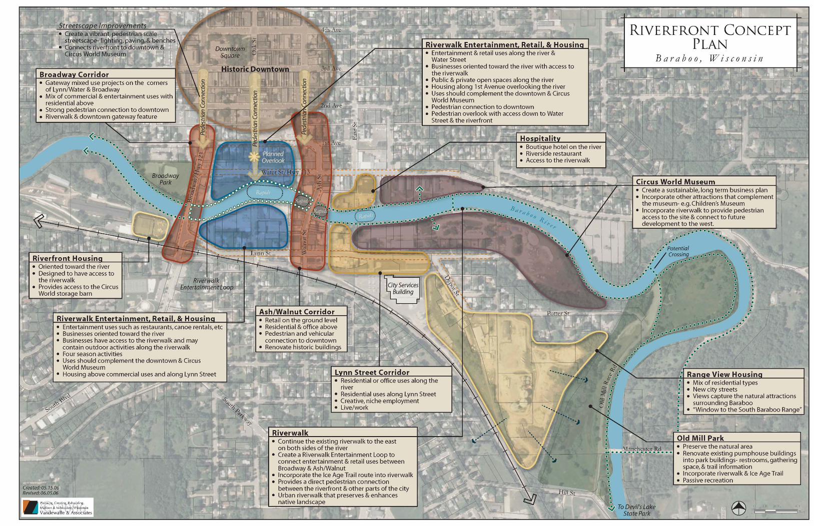
Riverfront Concept Plan This graphic illustrates general locations for land uses suggested in the Market Niche. The overall goal of the concept plan is to create a vibrant, sustainable riverfront with a mix of uses that complement downtown businesses and the Circus World Museum, as well as, connect the two destinations.
The following proposed planning areas provide a sustainable mix of uses to redevelop the riverfront area into a vibrant area of Baraboo:
Riverwalk Entertainment, Retail & Housing The land located on both sides of the river between Broadway and Walnut/Ash Street should contain a mix of entertainment, retail, and residential uses that orient toward the river and capitalize on the river as a development amenity. Uses could include restaurants, a brew pub, public spaces along the riverwalk, and four season activities. Housing could be located above entertainment uses along the river and be stand alone buildings toward Lynn Street and 1st Avenue. To improve and then sustain river water quality, new development should utilize environmentally friendly stormwater practices, such as rain gardens, bio-swales, and subterranean cisterns to minimize runoff into the river.
A strong pedestrian connection should be created along Oak Street to connect the downtown to the riverfront. Currently, the City is planning an overlook at the intersection of Oak and Water Streets, which will close Oak Street to automobile traffic between 1st Avenue and Water Street. It is imperative to the success of a riverfront district that a pedestrian connection remains along Oak Street between 1st Avenue and Water Street. A switch back trail system may need to be installed to traverse the grade of Oak Street and meet ADA design standards.
A special section of the riverwalk should be branded as the Riverwalk Entertainment Loop, which connects entertainment/retail uses on both sides of the river and houses the concentration of public activity areas along the river. The loop would connect across the river at Broadway and Walnut/Ash Street. Business entrances and outdoor patios should have direct access to the Riverwalk Entertainment Loop.
Baraboo Riverfront Redevelopment Area Plan
August 2006 16
Broadway Corridor Gateway projects on the corners of Lynn/Water Streets and Broadway will provide first impressions of the riverfront redevelopment. These projects should contain a mix of retail, entertainment, and residential uses. High quality architecture and site design will set precedent to the redevelopment character of sites to the east. Other buildings along Broadway should contain a mix of commercial uses with residential above and have a strong pedestrian connection to downtown, which will make the corridor walkable and welcoming.
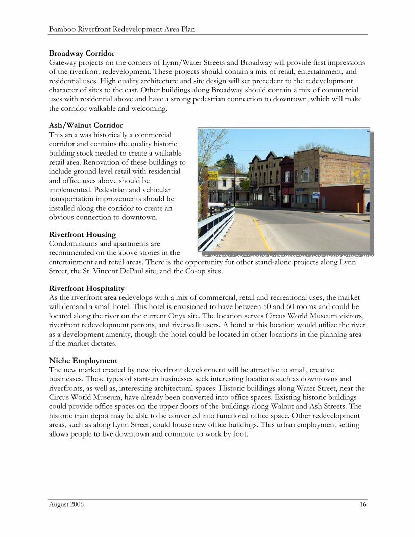
Ash/Walnut Corridor This area was historically a commercial corridor and contains the quality historic building stock needed to create a walkable retail area. Renovation of these buildings to include ground level retail with residential and office uses above should be implemented. Pedestrian and vehicular transportation improvements should be installed along the corridor to create an obvious connection to downtown.
Riverfront Housing Condominiums and apartments are recommended on the above stories in the entertainment and retail areas. There is the opportunity for other stand-alone projects along Lynn Street, the St. Vincent DePaul site, and the Co-op sites.
Riverfront Hospitality As the riverfront area redevelops with a mix of commercial, retail and recreational uses, the market will demand a small hotel. This hotel is envisioned to have between 50 and 60 rooms and could be located along the river on the current Onyx site. The location serves Circus World Museum visitors, riverfront redevelopment patrons, and riverwalk users. A hotel at this location would utilize the river as a development amenity, though the hotel could be located in other locations in the planning area if the market dictates.
Niche Employment The new market created by new riverfront development will be attractive to small, creative businesses. These types of start-up businesses seek interesting locations such as downtowns and riverfronts, as well as, interesting architectural spaces. Historic buildings along Water Street, near the Circus World Museum, have already been converted into office spaces. Existing historic buildings could provide office spaces on the upper floors of the buildings along Walnut and Ash Streets. The historic train depot may be able to be converted into functional office space. Other redevelopment areas, such as along Lynn Street, could house new office buildings. This urban employment setting allows people to live downtown and commute to work by foot.

Baraboo Riverfront Redevelopment Area Plan
August 2006 17
Other Recommendations
1. Circus World Museum. The Circus World Museum has played an important role in Baraboo’s heritage and downtown vitality. New development along the riverfront should supply additional visitors to the museum. The Circus World Museum, should develop a sustainable, long-term business plan with the cooperation of all interested parties to ensure the museum continues to be a lively activity anchor of Downtown Baraboo. The museum grounds could incorporate other complementing attractions, such as a children’s museum. The riverwalk should be incorporated into the site to allow pedestrian access into the site and connect the Circus World Museum to future riverfront development.
2. Old Mill Park. The natural areas along Old Mill Race Road should be preserved to create a passive recreation park. The riverwalk should continue through this park, connect to the Ice Age Trail, and continue on to Devil’s Lake State Park. The existing pump house buildings could be renovated into park buildings containing restrooms, trail information, and a gathering space. A public canoe launch would complement the other launches along the Baraboo River.
3. Pedestrian Connections. The riverwalk provides east/west connections between riverfront uses. North/south connections also need to be strengthened for successful redevelopment. Streetscape improvements are recommended between the downtown and the riverfront, located along Broadway, Oak Street, Ash Street, Walnut Street, Water Street and Lynn Street. Improvements should include a consistent palette of pedestrian-scale street lights, benches, trash receptacles, light pole banners, improved sidewalks, designated cross walks and improved street curbs where needed.
The map on the next page illustrates the riverfront redevelopment concept.
Baraboo Riverfront Redevelopment Area Plan
August 2006 19
Riverfront Redevelopment Area Plan (see Map on page 23) The Riverfront Redevelopment Area Plan builds upon the ideas proposed in the Riverfront Concept Plan and provides detailed recommendations. Also land uses are recommended for each property within the study area.
Development Recommendations: 1. Downtown Streetscape Connection: Install streetscape improvements between the downtown
and planning area, along Broadway, Oak Street and Ash Street. Improvements include a consistent design of paving, pedestrian-scale lighting, benches, light pole banners, and trash receptacles.
2. New Building: Construct a new commercial building on the west edge of the Civic Center property. This building will continue the street face of buildings between the downtown and the riverfront, and will provide a wind break in the winter. The result is a more pedestrian friendly connection between the downtown and the riverfront. This building may contain residential on the above floors if sufficient parking is provided.
3. High-Density Residential Project: Parcels should be combined to create a large condominium project. This project may contain a variety of housing styles with views of the river.
4. Commercial Corners: The corners where Water Street intersects with Broadway and Ash Street should be reserved for commercial uses on the ground levels. This could be a variety of retail, entertainment or office uses. Parking limitations will determine the amount of commercial space at these locations.
5. Public Overlook and Pedestrian Connection: The City of Baraboo is currently planning a public overlook at the southern end of Oak Street, which will result in the closure of Oak Street between 1st Avenue and Water Street. A pedestrian pathway should be maintained in this location to allow people to walk between the downtown and the riverfront redevelopment area.
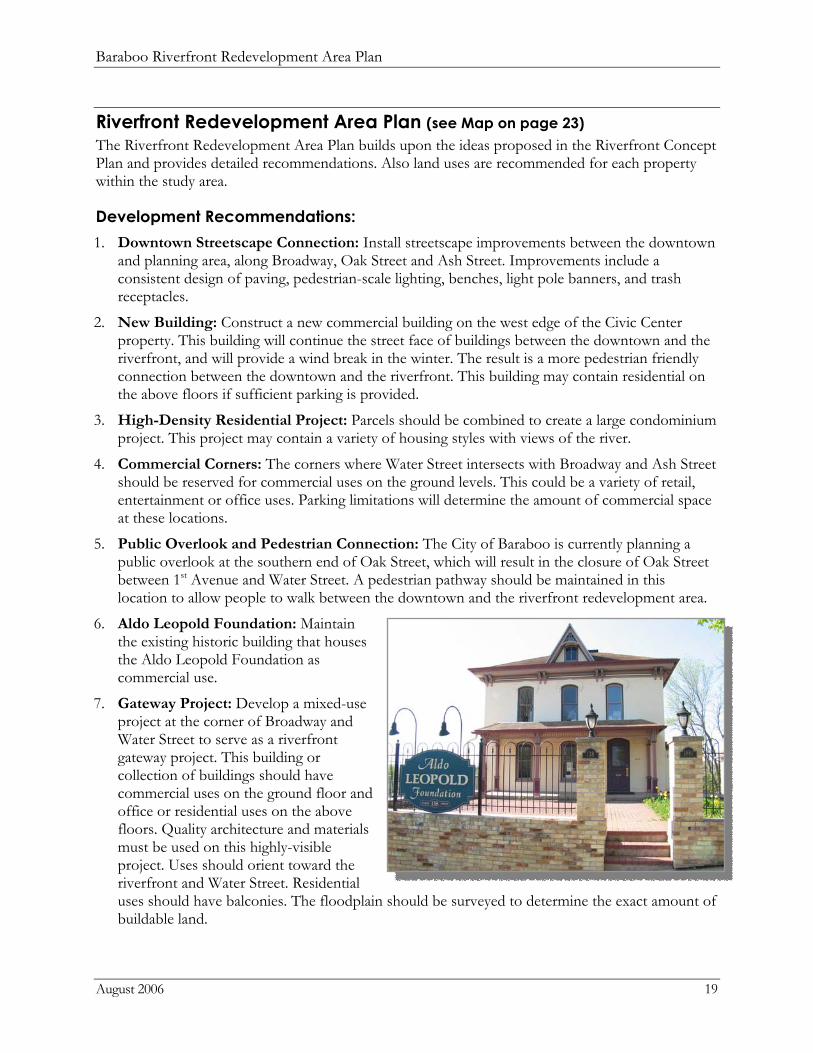
6. Aldo Leopold Foundation: Maintain the existing historic building that houses the Aldo Leopold Foundation as commercial use.
7. Gateway Project: Develop a mixed-use project at the corner of Broadway and Water Street to serve as a riverfront gateway project. This building or collection of buildings should have commercial uses on the ground floor and office or residential uses on the above floors. Quality architecture and materials must be used on this highly-visible project. Uses should orient toward the riverfront and Water Street. Residential uses should have balconies. The floodplain should be surveyed to determine the exact amount of buildable land.
Baraboo Riverfront Redevelopment Area Plan
August 2006 20
8. Public Park A public park is proposed at the terminus of Oak Street to provide public access to the Baraboo River. This park will be connected to the riverwalk and on direct axis with the pedestrian path to downtown.
9. Riverwalk West
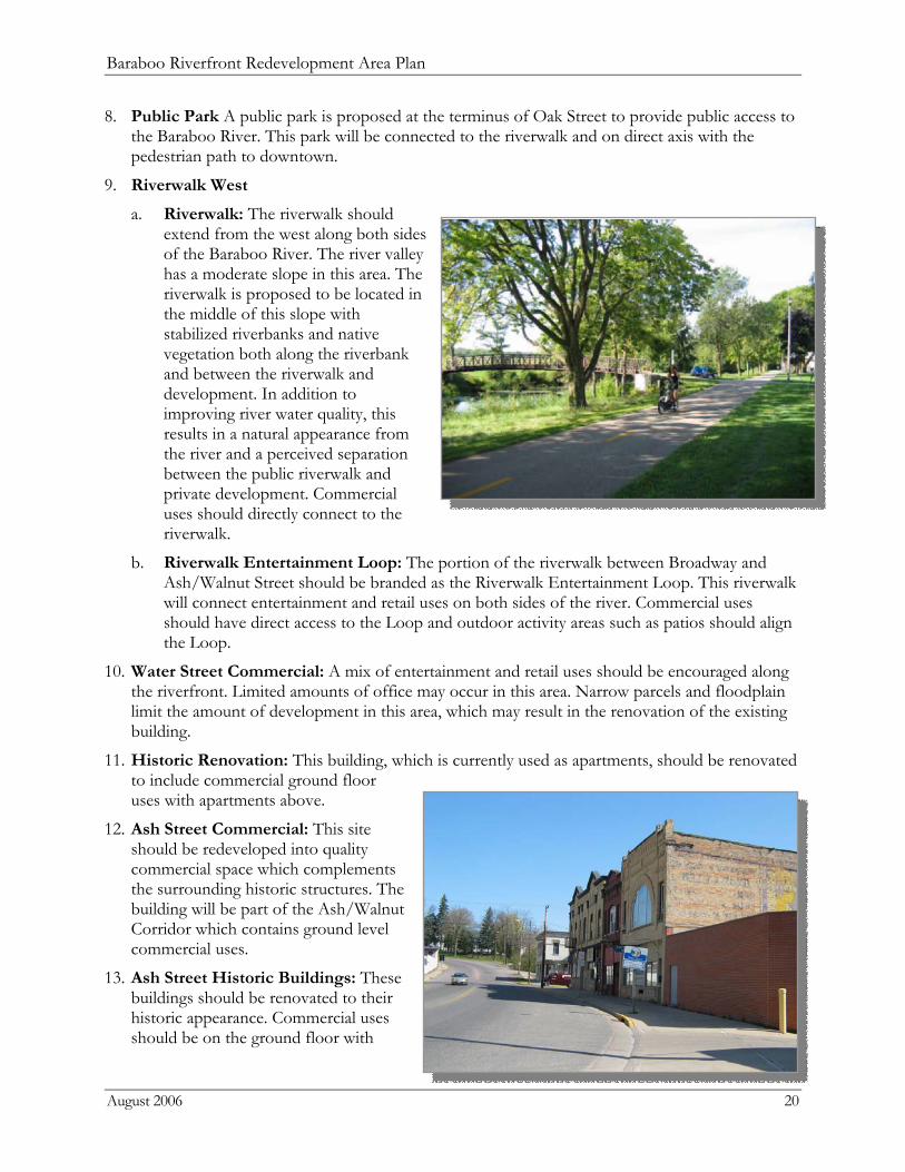
a. Riverwalk: The riverwalk should extend from the west along both sides of the Baraboo River. The river valley has a moderate slope in this area. The riverwalk is proposed to be located in the middle of this slope with stabilized riverbanks and native vegetation both along the riverbank and between the riverwalk and development. In addition to improving river water quality, this results in a natural appearance from the river and a perceived separation between the public riverwalk and private development. Commercial uses should directly connect to the riverwalk.
b. Riverwalk Entertainment Loop: The portion of the riverwalk between Broadway and Ash/Walnut Street should be branded as the Riverwalk Entertainment Loop. This riverwalk will connect entertainment and retail uses on both sides of the river. Commercial uses should have direct access to the Loop and outdoor activity areas such as patios should align the Loop.
10. Water Street Commercial: A mix of entertainment and retail uses should be encouraged along the riverfront. Limited amounts of office may occur in this area. Narrow parcels and floodplain limit the amount of development in this area, which may result in the renovation of the existing building.
11. Historic Renovation: This building, which is currently used as apartments, should be renovated to include commercial ground floor uses with apartments above.
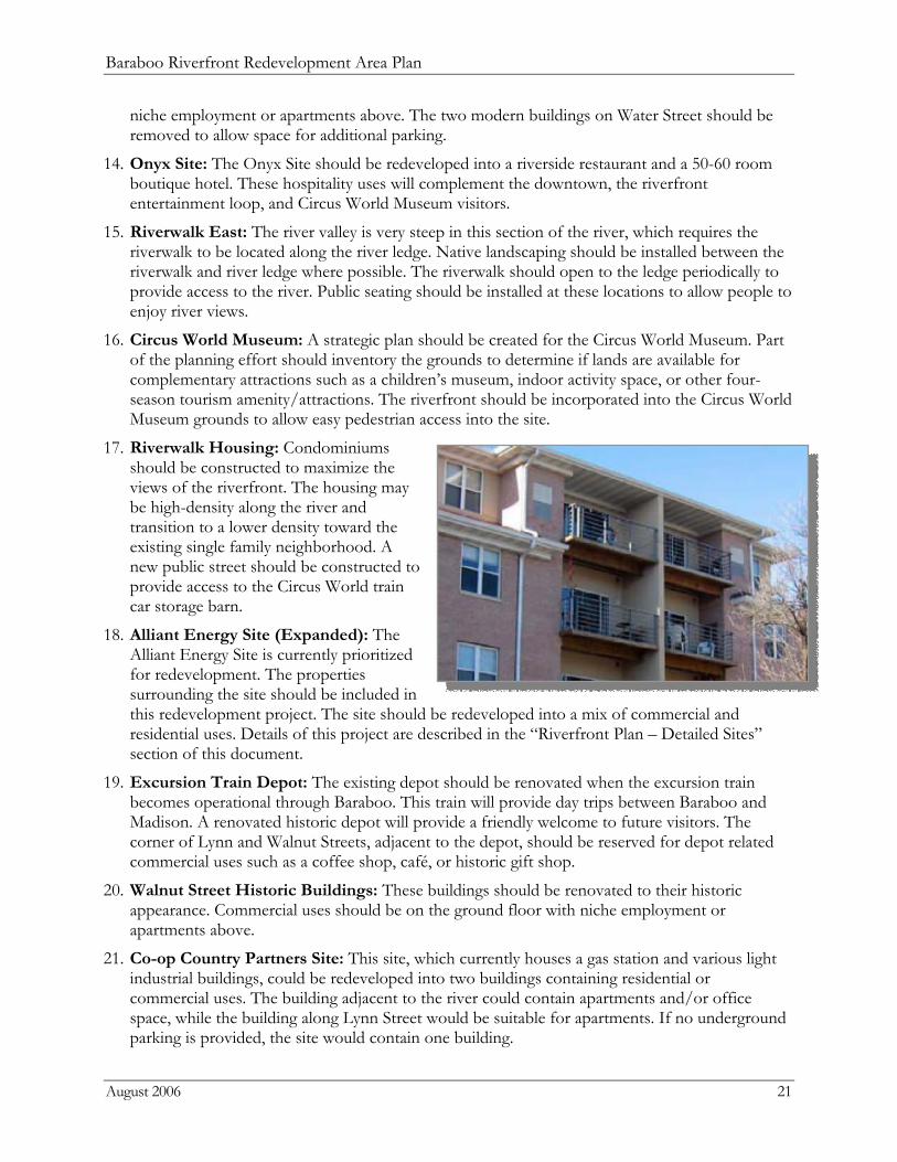
12. Ash Street Commercial: This site should be redeveloped into quality commercial space which complements the surrounding historic structures. The building will be part of the Ash/Walnut Corridor which contains ground level commercial uses.
13. Ash Street Historic Buildings: These buildings should be renovated to their historic appearance. Commercial uses should be on the ground floor with
Baraboo Riverfront Redevelopment Area Plan
August 2006 21
niche employment or apartments above. The two modern buildings on Water Street should be removed to allow space for additional parking.
14. Onyx Site: The Onyx Site should be redeveloped into a riverside restaurant and a 50-60 room boutique hotel. These hospitality uses will complement the downtown, the riverfront entertainment loop, and Circus World Museum visitors.
15. Riverwalk East: The river valley is very steep in this section of the river, which requires the riverwalk to be located along the river ledge. Native landscaping should be installed between the riverwalk and river ledge where possible. The riverwalk should open to the ledge periodically to provide access to the river. Public seating should be installed at these locations to allow people to enjoy river views.
16. Circus World Museum: A strategic plan should be created for the Circus World Museum. Part of the planning effort should inventory the grounds to determine if lands are available for complementary attractions such as a children’s museum, indoor activity space, or other four-season tourism amenity/attractions. The riverfront should be incorporated into the Circus World Museum grounds to allow easy pedestrian access into the site.
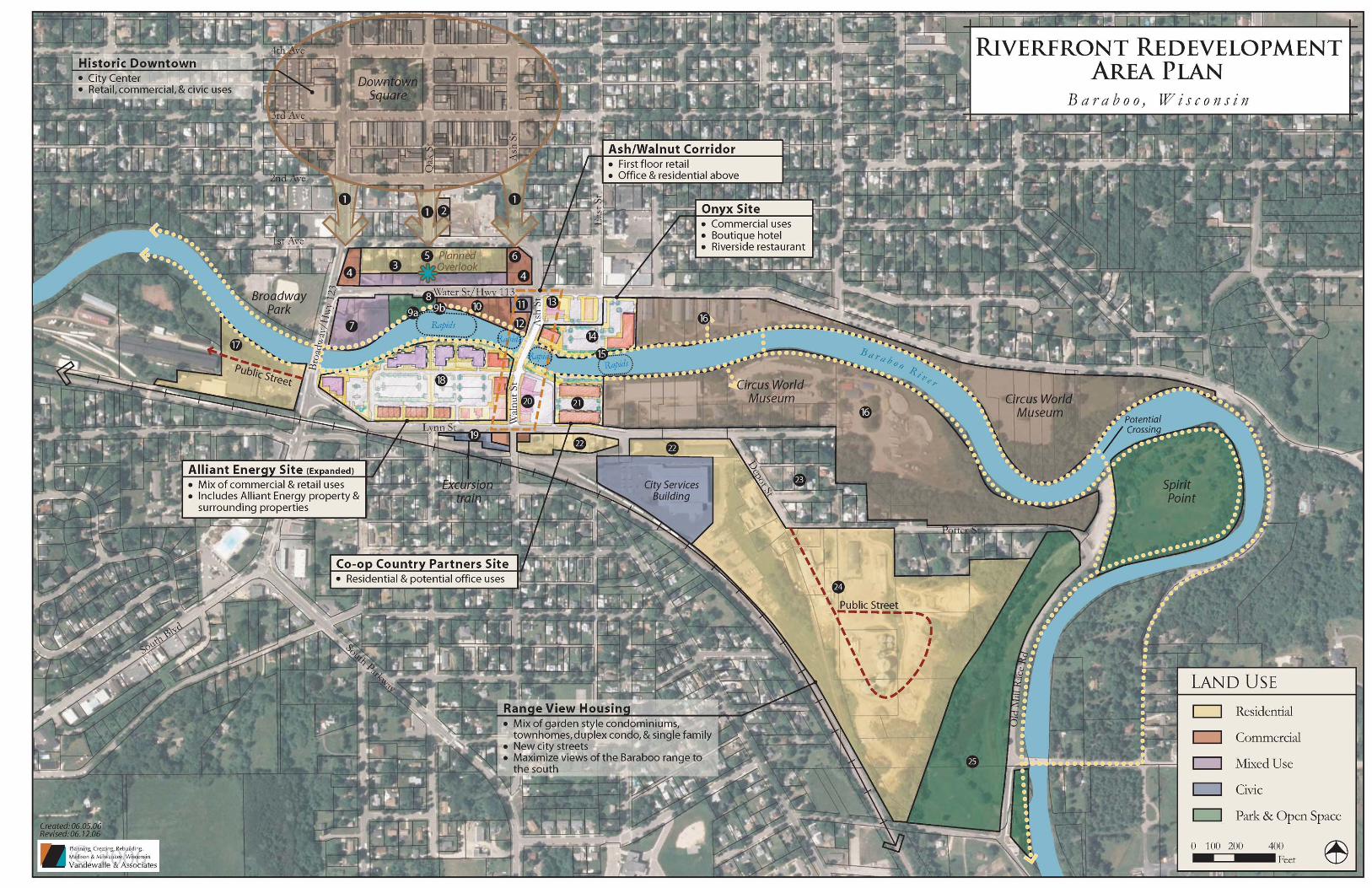
17. Riverwalk Housing: Condominiums should be constructed to maximize the views of the riverfront. The housing may be high-density along the river and transition to a lower density toward the existing single family neighborhood. A new public street should be constructed to provide access to the Circus World train car storage barn.
18. Alliant Energy Site (Expanded): The Alliant Energy Site is currently prioritized for redevelopment. The properties surrounding the site should be included in this redevelopment project. The site should be redeveloped into a mix of commercial and residential uses. Details of this project are described in the “Riverfront Plan – Detailed Sites” section of this document.
19. Excursion Train Depot: The existing depot should be renovated when the excursion train becomes operational through Baraboo. This train will provide day trips between Baraboo and Madison. A renovated historic depot will provide a friendly welcome to future visitors. The corner of Lynn and Walnut Streets, adjacent to the depot, should be reserved for depot related commercial uses such as a coffee shop, café, or historic gift shop.
20. Walnut Street Historic Buildings: These buildings should be renovated to their historic appearance. Commercial uses should be on the ground floor with niche employment or apartments above.
21. Co-op Country Partners Site: This site, which currently houses a gas station and various light industrial buildings, could be redeveloped into two buildings containing residential or commercial uses. The building adjacent to the river could contain apartments and/or office space, while the building along Lynn Street would be suitable for apartments. If no underground parking is provided, the site would contain one building.

Baraboo Riverfront Redevelopment Area Plan
August 2006 22
22. Lynn Street Residential: The strip of land between the City Services building and Lynn Street should be redeveloped into residential as a long-term project. Housing styles may be apartments or townhomes and orient toward Lynn Street.
23. Single Family Homes: The area between the Circus World Museum and the proposed range view housing should remain as single-family residential.
24. Range View Housing: Spectacular views of the Southern Baraboo Range and Devil’s Lake bluffs can be seen from the Co-op and City-owned sites. This area should be redeveloped into a higher and better use. A mix of residential housing types should be located on the site. This may include garden-style condominiums, townhomes, duplex condos and single family homes. Higher density residential should be located along the southern edge of the site to maximize views to the south. The existing Co-op should be relocated to an industrial location of Baraboo. New public streets will need to be constructed to provide access into the site.
25. Old Mill Park: This natural lowland was once a mill run, and should be preserved as a public natural area. The riverwalk should extend through this site and connect to the Ice Age Trail, which links to Devil’s Lake State Park. The existing pump house buildings should be renovated into park buildings containing restrooms and trail information. A banquet/gathering space could be constructed to rent to the public as funds become available.
Baraboo Riverfront Redevelopment Area Plan
August 2006 26
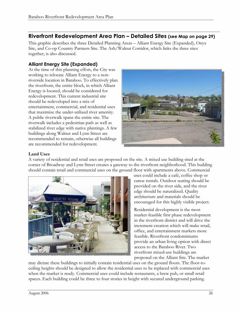
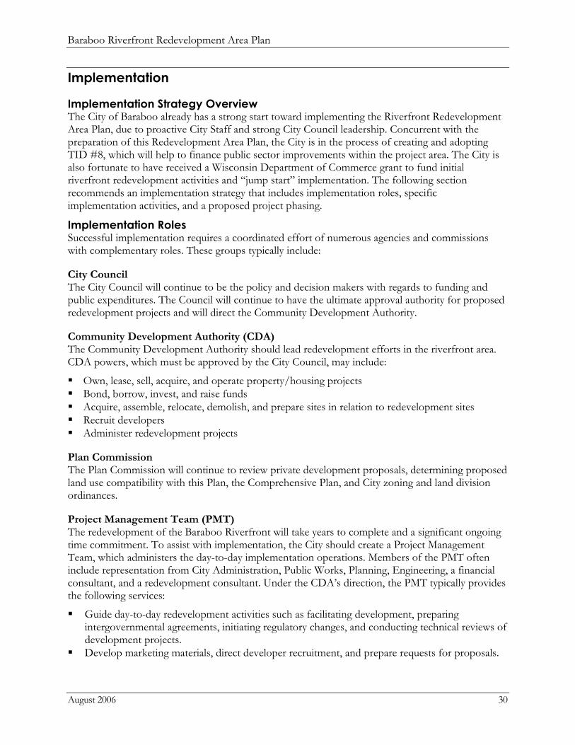
Riverfront Redevelopment Area Plan – Detailed Sites (see Map on page 29) This graphic describes the three Detailed Planning Areas – Alliant Energy Site (Expanded), Onyx Site, and Co-op Country Partners Site. The Ash/Walnut Corridor, which links the three sites together, is also discussed.
Alliant Energy Site (Expanded) At the time of this planning effort, the City was working to relocate Alliant Energy to a non-riverside location in Baraboo. To effectively plan the riverfront, the entire block, in which Alliant Energy is located, should be considered for redevelopment. This current industrial site should be redeveloped into a mix of entertainment, commercial, and residential uses that maximize the under-utilized river amenity. A public riverwalk spans the entire site. The riverwalk includes a pedestrian path as well as stabilized river edge with native plantings. A few buildings along Walnut and Lynn Street are recommended to remain, otherwise all buildings are recommended for redevelopment.
Land Uses A variety of residential and retail uses are proposed on the site. A mixed use building sited at the corner of Broadway and Lynn Street creates a gateway to the riverfront neighborhood. This building should contain retail and commercial uses on the ground floor with apartments above. Commercial
uses could include a café, coffee shop or canoe rentals. Outdoor seating should be provided on the river side, and the river edge should be naturalized. Quality architecture and materials should be encouraged for this highly visible project.
Residential development is the most market-feasible first phase redevelopment in the riverfront district and will drive the increment creation which will make retail, office, and entertainment markets more feasible. Riverfront condominiums provide an urban living option with direct access to the Baraboo River. Two riverfront mixed-use buildings are proposed on the Alliant Site. The market
may dictate these buildings to initially contain residential uses on the ground floors. The floor-to-ceiling heights should be designed to allow the residential uses to be replaced with commercial uses when the market is ready. Commercial uses could include restaurants, a brew pub, or small retail spaces. Each building could be three to four stories in height with secured underground parking.
Baraboo Riverfront Redevelopment Area Plan
August 2006 27
The individual units should orient toward the river and balconies should be constructed on all sides of the buildings. Condominiums that are not on the riverside should overlook open space amenities.
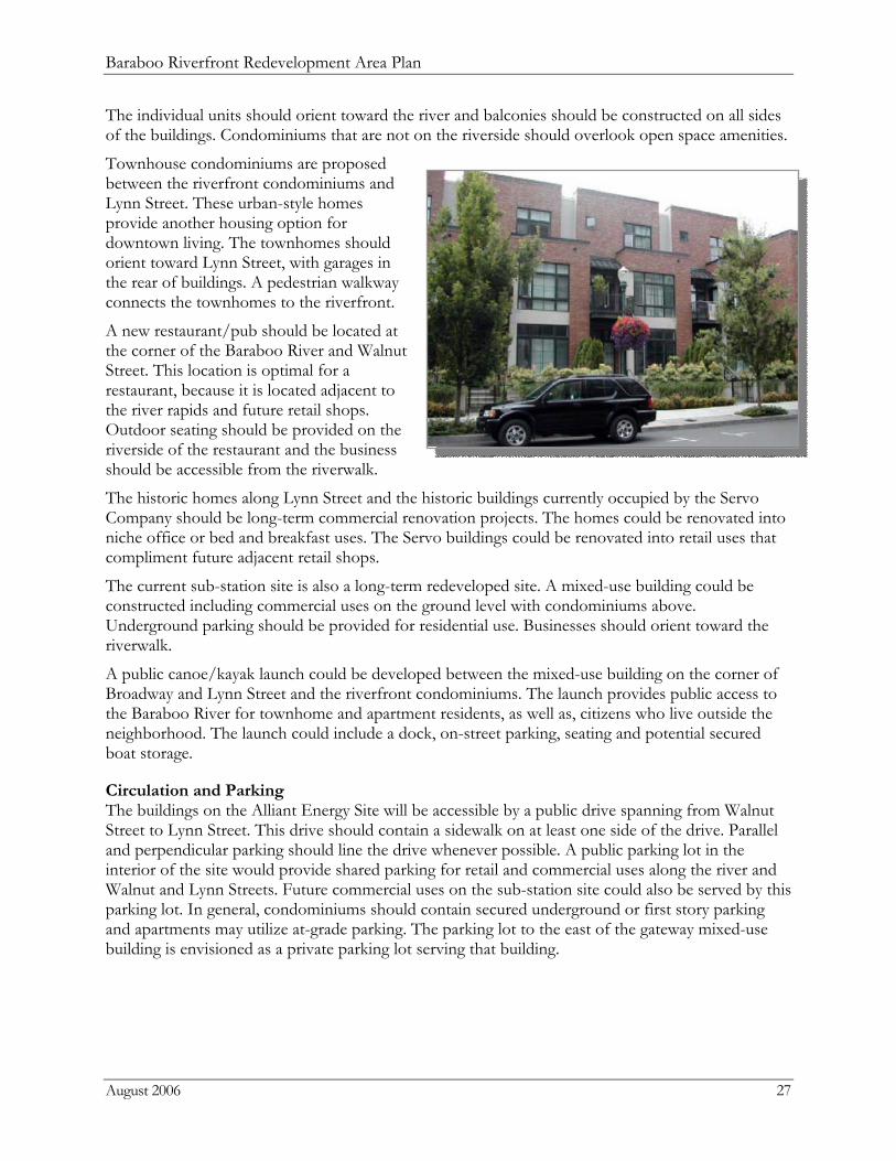
Townhouse condominiums are proposed between the riverfront condominiums and Lynn Street. These urban-style homes provide another housing option for downtown living. The townhomes should orient toward Lynn Street, with garages in the rear of buildings. A pedestrian walkway connects the townhomes to the riverfront.
A new restaurant/pub should be located at the corner of the Baraboo River and Walnut Street. This location is optimal for a restaurant, because it is located adjacent to the river rapids and future retail shops. Outdoor seating should be provided on the riverside of the restaurant and the business should be accessible from the riverwalk.
The historic homes along Lynn Street and the historic buildings currently occupied by the Servo Company should be long-term commercial renovation projects. The homes could be renovated into niche office or bed and breakfast uses. The Servo buildings could be renovated into retail uses that compliment future adjacent retail shops.
The current sub-station site is also a long-term redeveloped site. A mixed-use building could be constructed including commercial uses on the ground level with condominiums above. Underground parking should be provided for residential use. Businesses should orient toward the riverwalk.
A public canoe/kayak launch could be developed between the mixed-use building on the corner of Broadway and Lynn Street and the riverfront condominiums. The launch provides public access to the Baraboo River for townhome and apartment residents, as well as, citizens who live outside the neighborhood. The launch could include a dock, on-street parking, seating and potential secured boat storage.
Circulation and Parking The buildings on the Alliant Energy Site will be accessible by a public drive spanning from Walnut Street to Lynn Street. This drive should contain a sidewalk on at least one side of the drive. Parallel and perpendicular parking should line the drive whenever possible. A public parking lot in the interior of the site would provide shared parking for retail and commercial uses along the river and Walnut and Lynn Streets. Future commercial uses on the sub-station site could also be served by this parking lot. In general, condominiums should contain secured underground or first story parking and apartments may utilize at-grade parking. The parking lot to the east of the gateway mixed-use building is envisioned as a private parking lot serving that building.
Baraboo Riverfront Redevelopment Area Plan
August 2006 28
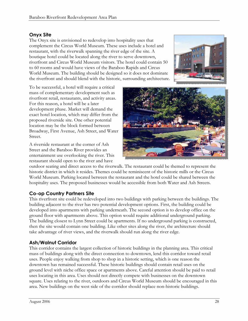
Onyx Site The Onyx site is envisioned to redevelop into hospitality uses that complement the Circus World Museum. These uses include a hotel and restaurant, with the riverwalk spanning the river edge of the site. A boutique hotel could be located along the river to serve downtown, riverfront and Circus World Museum visitors. The hotel could contain 50 to 60 rooms and would have views of the Baraboo Rapids and Circus World Museum. The building should be designed so it does not dominate the riverfront and should blend with the historic, surrounding architecture.
To be successful, a hotel will require a critical mass of complementary development such as riverfront retail, restaurants, and activity areas. For this reason, a hotel will be a later development phase. Market will demand the exact hotel location, which may differ from the proposed riverside site. One other potential location may be the block formed between Broadway, First Avenue, Ash Street, and Water Street.
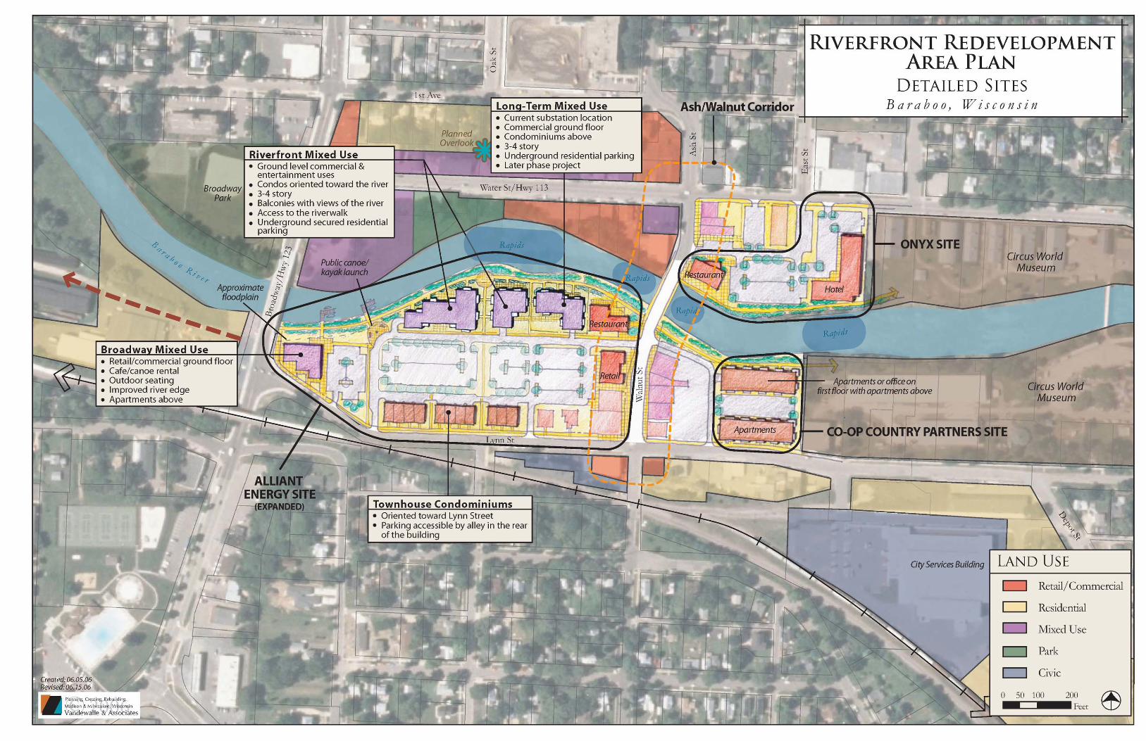
A riverside restaurant at the corner of Ash Street and the Baraboo River provides an entertainment use overlooking the river. This restaurant should open to the river and have outdoor seating and direct access to the riverwalk. The restaurant could be themed to represent the historic district in which it resides. Themes could be reminiscent of the historic mills or the Circus World Museum. Parking located between the restaurant and the hotel could be shared between the hospitality uses. The proposed businesses would be accessible from both Water and Ash Streets.
Co-op Country Partners Site This riverfront site could be redeveloped into two buildings with parking between the buildings. The building adjacent to the river has two potential development options. First, the building could be developed into apartments with parking underneath. The second option is to develop office on the ground floor with apartments above. This option would require additional underground parking. The building closest to Lynn Street could be apartments. If no underground parking is constructed, then the site would contain one building. Like other sites along the river, the architecture should take advantage of river views, and the riverwalk should run along the river edge.
Ash/Walnut Corridor This corridor contains the largest collection of historic buildings in the planning area. This critical mass of buildings along with the direct connection to downtown, lend this corridor toward retail uses. People enjoy walking from shop to shop in a historic setting, which is one reason the downtown has remained successful. These historic buildings should contain retail uses on the ground level with niche office space or apartments above. Careful attention should be paid to retail uses locating in this area. Uses should not directly compete with businesses on the downtown square. Uses relating to the river, outdoors and Circus World Museum should be encouraged in this area. New buildings on the west side of the corridor should replace non-historic buildings.
Baraboo Riverfront Redevelopment Area Plan
August 2006 30
Implementation
Implementation Strategy Overview The City of Baraboo already has a strong start toward implementing the Riverfront Redevelopment Area Plan, due to proactive City Staff and strong City Council leadership. Concurrent with the preparation of this Redevelopment Area Plan, the City is in the process of creating and adopting TID #8, which will help to finance public sector improvements within the project area. The City is also fortunate to have received a Wisconsin Department of Commerce grant to fund initial riverfront redevelopment activities and “jump start” implementation. The following section recommends an implementation strategy that includes implementation roles, specific implementation activities, and a proposed project phasing.
Implementation Roles Successful implementation requires a coordinated effort of numerous agencies and commissions with complementary roles. These groups typically include:
City Council The City Council will continue to be the policy and decision makers with regards to funding and public expenditures. The Council will continue to have the ultimate approval authority for proposed redevelopment projects and will direct the Community Development Authority.
Community Development Authority (CDA) The Community Development Authority should lead redevelopment efforts in the riverfront area. CDA powers, which must be approved by the City Council, may include:
Own, lease, sell, acquire, and operate property/housing projects Bond, borrow, invest, and raise funds Acquire, assemble, relocate, demolish, and prepare sites in relation to redevelopment sites Recruit developers Administer redevelopment projects
Plan Commission The Plan Commission will continue to review private development proposals, determining proposed land use compatibility with this Plan, the Comprehensive Plan, and City zoning and land division ordinances.
Project Management Team (PMT) The redevelopment of the Baraboo Riverfront will take years to complete and a significant ongoing time commitment. To assist with implementation, the City should create a Project Management Team, which administers the day-to-day implementation operations. Members of the PMT often include representation from City Administration, Public Works, Planning, Engineering, a financial consultant, and a redevelopment consultant. Under the CDA’s direction, the PMT typically provides the following services:
Guide day-to-day redevelopment activities such as facilitating development, preparing intergovernmental agreements, initiating regulatory changes, and conducting technical reviews of development projects.
Develop marketing materials, direct developer recruitment, and prepare requests for proposals.
Baraboo Riverfront Redevelopment Area Plan
August 2006 31
Work closely with local real estate developers and brokers, and conduct regional searches as necessary for higher profile projects.
Distribute marketing information and field inquiries from potential developers. Provide legal advice in negotiating development agreements, preparing documents for the
acquisition or sale of property, and ensuring compliance with statutory and ordinance requirements.
Manage the design, bidding, and construction of public improvements such as street, utility, and stormwater upgrades.
Monitor the construction of private developments to ensure compliance with approved site plans, building plans, and development agreements.
Provide TIF management including: advise on long-term debt financing and execute borrowings; evaluate the financial soundness, business plans and tax increment impacts of projects seeking development assistance or requiring public improvements; audit the TID #8 financial statements; and prepare the annual compliance report.
Continually evaluate the financial condition of TID #8 and satisfy all governmental reporting requirements for the district.
Provide regular reports to the City Council regarding meetings held with potential developers. Revise and update the Riverfront Redevelopment Area Plan, as needed.
Baraboo Economic Development Commission (BEDC) BEDC has been the advisory committee reviewing the development of this Riverfront Redevelopment Area Plan. With a strong commitment to redevelopment in the area, and considerable knowledge of the Baraboo business and development community, BEDC will continue to serve as the first point of discussion of redevelopment projects in the area as implementation proceeds. Working closely with the PMT, BEDC will review initial proposals and concept plans for projects as they are proposed, paying close attention to the proposals’ use, design and compatibility with the vision for the Riverfront Corridor outlined in this plan. BEDC will recommend changes to these considerations if inconsistent with the Plan and will forward concepts on to the Plan Commission for further scrutiny and consistency with the City’s Codes and Ordinances as plans are finalized for approval by City Council. BEDC will also serve as a conduit to the general public regarding the overall implementation activities in the Riverfront Corridor.
Other Public Agencies Other groups or agencies that will play a role in redevelopment success are the Wisconsin Department of Transportation (WisDOT), the Wisconsin Department of Natural Resources (WisDNR), the U.S. Army Corps of Engineers, and the Citizens for Waterfront Revitalization (CWR). WisDOT will be involved with all improvements made to Highway 113 and Highway 123. All environmental planning efforts, such as those related to the Baraboo Rapids or potentially contaminated sites, must be coordinated with WisDNR. All floodplain and floodway issues related to the Baraboo Rapids must be coordinated with the U.S. Army Corps of Engineers. The Citizens for Waterfront Revitalization has played an imperative role in the riverfront redevelopment process, spearheading public awareness, and creating the original vision for the future riverfront. CWR members contain vast knowledge of the Baraboo Rapids and history of the riverfront. It is important that this group continue to be involved in future implementation activities and that their knowledge be utilized.
Baraboo Riverfront Redevelopment Area Plan
August 2006 32
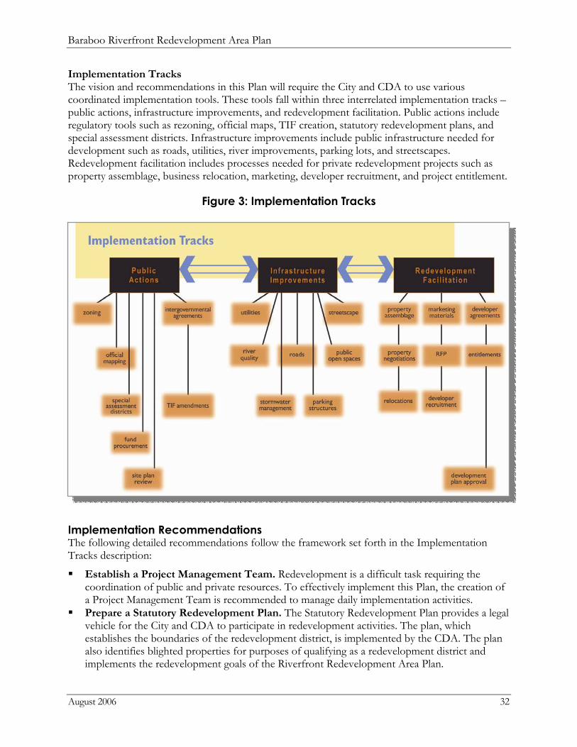
Implementation Tracks The vision and recommendations in this Plan will require the City and CDA to use various coordinated implementation tools. These tools fall within three interrelated implementation tracks – public actions, infrastructure improvements, and redevelopment facilitation. Public actions include regulatory tools such as rezoning, official maps, TIF creation, statutory redevelopment plans, and special assessment districts. Infrastructure improvements include public infrastructure needed for development such as roads, utilities, river improvements, parking lots, and streetscapes. Redevelopment facilitation includes processes needed for private redevelopment projects such as property assemblage, business relocation, marketing, developer recruitment, and project entitlement.
Figure 3: Implementation Tracks
Implementation Recommendations The following detailed recommendations follow the framework set forth in the Implementation Tracks description:
Establish a Project Management Team. Redevelopment is a difficult task requiring the coordination of public and private resources. To effectively implement this Plan, the creation of a Project Management Team is recommended to manage daily implementation activities.
Prepare a Statutory Redevelopment Plan. The Statutory Redevelopment Plan provides a legal vehicle for the City and CDA to participate in redevelopment activities. The plan, which establishes the boundaries of the redevelopment district, is implemented by the CDA. The plan also identifies blighted properties for purposes of qualifying as a redevelopment district and implements the redevelopment goals of the Riverfront Redevelopment Area Plan.
Baraboo Riverfront Redevelopment Area Plan
August 2006 33
Create Design Guidelines and a River Corridor Overlay Zoning District. Detailed design guidelines should be created to present a unified vision for the riverfront redevelopment area. The guidelines should describe the architectural style, materials and height of proposed buildings. Building placement on the site, and site amenities should be described in the guidelines. Stormwater management standards should also be included in the guidelines, and encourage environmentally friendly practices to improve river water quality. These rules for development should be included in a River Corridor Overlay District, which will set uniform design standards for the riverfront. These standards are in addition to those applicable to the underlying base zoning. The overlay zoning district may also include the design review process for development proposals within the overlay district, as well as, the City agencies responsible for the review.
Undertake a District-wide Marketing Initiative. The CDA is encouraged to create a marketing initiative establishing a brand that reflects the riverfront transformation from an industrial area to mixed use, entertainment neighborhood. This marketing initiative should describe the mixed-use vision for the newly accessible riverfront and explain planned public improvements, such as the riverwalk. Marketing materials could include printed and electronic media formats that celebrate the riverfront transformation and would then be used to recruit developers that invest private capital in the project area.
Seek Additional Grants for Implementation. The City of Baraboo has received a Wisconsin Department of Commerce grant for activities such as property acquisition and business relocation. The CDA, with the aid of the PMT, should seek additional grant money for public improvements, brownfield assessment and clean-up, historic preservation and streetscape improvements.
Make Zoning Decisions that are consistent with the Vision of this Plan. Based on further evaluation by the PMT, certain properties may need to be rezoned to assure that future redevelopment projects are consistent with the vision of this Plan. The City Council and Plan Commission must be vigilant in its review of rezoning requests, conditional use permits, and site plans to assure that incremental decisions all lead to the vision.
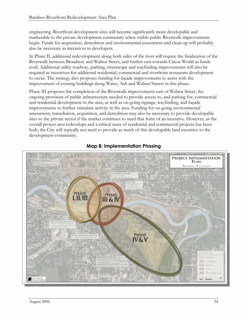
Project Implementation Phasing The Project Phasing Graphic on the following page and Phasing Table on page 36, depict the Development Increment Assumptions that are anticipated to occur in several phases over the next fifteen years. Estimated Costs of Public Improvements associated with these redevelopment project assumptions are also listed. These development assumptions and cost estimates were prepared based upon the proposed mix of uses in the vision set forth in this Redevelopment Area Plan. At the time these estimates and assumptions were developed, a developer(s) for the proposed redevelopment projects had not yet been identified. The cost estimates were also not confirmed by engineering design studies. Therefore, further refinement of these assumptions and cost estimates is expected to occur throughout the process of implementation, and estimates are subject to change based upon economic and market conditions in the City of Baraboo.
Although the redevelopment projects are subject to market forces, the phasing graphic and table still provide a blueprint for the City of Baraboo to utilize as it begins the process of using TID #8 to bond for public improvements that will be necessary to induce development to occur in the project area. For example, in order for Phase I redevelopment (at least one residential and one commercial development project) to occur, this phasing strategy recommends that the City undertake initial utility, roadway, and streetscape improvements in the district, as well as provide significant initial investment along the riverfront itself such as river bank stabilization, riverwalk design, and
Baraboo Riverfront Redevelopment Area Plan
August 2006 34
engineering. Riverfront development sites will become significantly more developable and marketable to the private development community when visible public Riverwalk improvements begin. Funds for acquisition, demolition and environmental assessment and clean-up will probably also be necessary as incentives to developers.
In Phase II, additional redevelopment along both sides of the river will require the finalization of the Riverwalk between Broadway and Walnut Street, and further east towards Circus World as funds avail. Additional utility roadway, parking, streetscape and wayfinding improvements will also be required as incentives for additional residential, commercial and riverfront restaurant development to occur. The strategy also proposes funding for façade improvements to assist with the improvement of existing buildings along Water, Ash and Walnut Streets in this phase.
Phase III proposes the completion of the Riverwalk improvements east of Walnut Street, the ongoing provision of public infrastructure needed to provide access to, and parking for, commercial and residential development in the area, as well as on-going signage, wayfinding, and façade improvements to further stimulate activity in the area. Funding for on-going environmental assessment, remediation, acquisition, and demolition may also be necessary to provide developable sites to the private sector if the market continues to need that form of an incentive. However, as the overall project area redevelops and a critical mass of residential and commercial projects has been built, the City will typically not need to provide as much of this developable land incentive to the development community.
Map 8: Implementation Phasing
Baraboo Riverfront Redevelopment Area Plan
August 2006 35
Phases IV and V anticipate the final public improvements necessary to provide residential development pads along Depot Street-extended into the proposed Range View Housing area. This area, designated for a mix of residential housing types, is anticipated to develop following the completion of the mixed use area between Broadway and Walnut Streets along the Riverfront, and the public improvements necessary to complete these projects include roadways, utilities and potentially some assistance with acquisition, relocation, and environmental work in the area. It should be noted, however, that although the phasing strategy anticipates this area developing later since the market may be somewhat reliant on the timing and success of redevelopment along the riverfront first, the City should not be discouraged from pursuing this redevelopment project sooner. To the contrary, the City should co-market both the riverfront and range view areas simultaneously, developing marketing materials for the entire Riverfront Redevelopment Area to familiarize prospective developers along the river with the potential for residences in the range view area that will support the commercial projects along Water, Walnut and Lynn Streets.
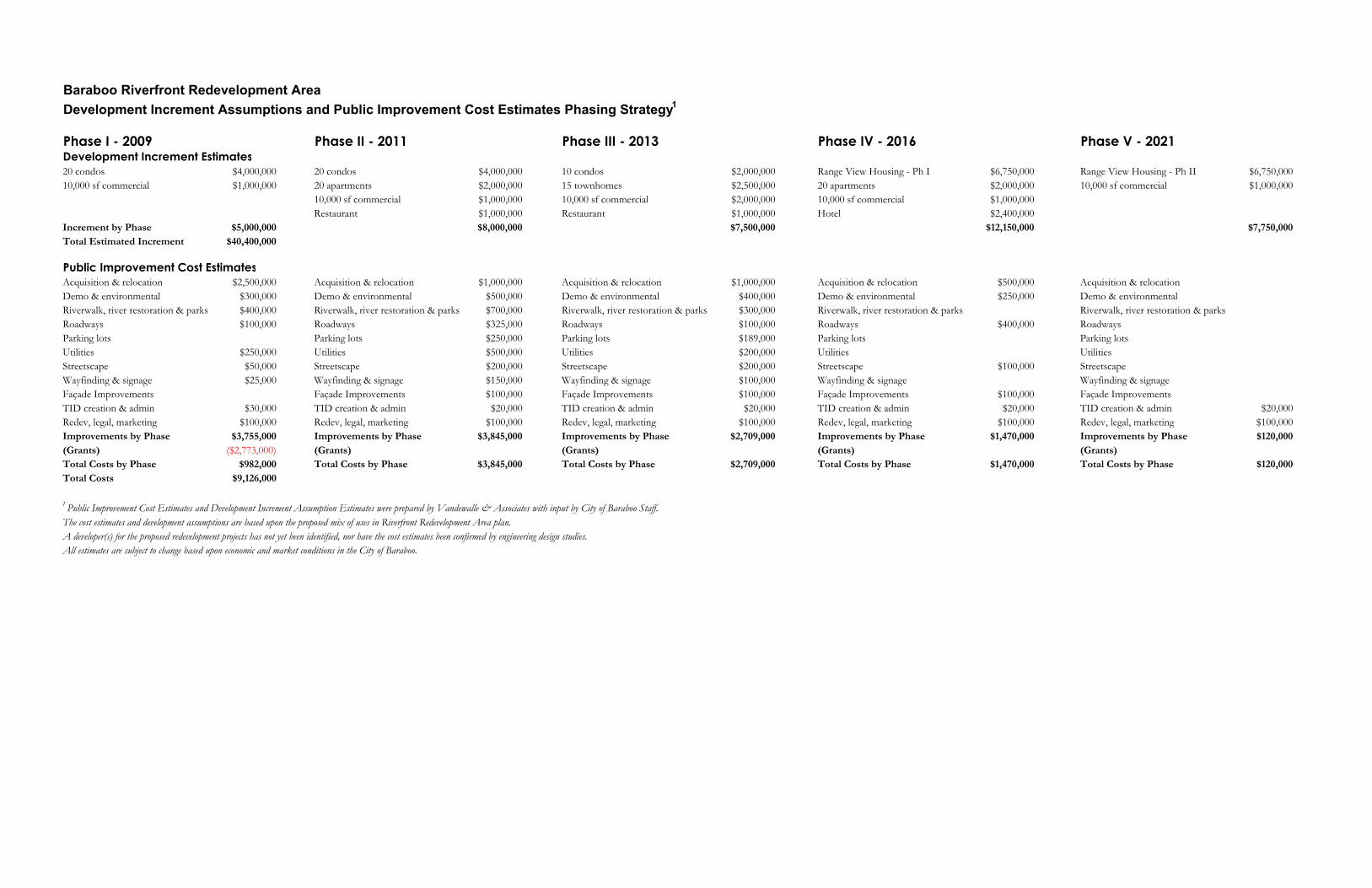
Baraboo Riverfront Redevelopment AreaDevelopment Increment Assumptions and Public Improvement Cost Estimates Phasing Strategy1
Phase I - 2009 Phase II - 2011 Phase III - 2013 Phase IV - 2016 Phase V - 2021Development Increment Estimates20 condos $4,000,000 20 condos $4,000,000 10 condos $2,000,000 Range View Housing - Ph I $6,750,000 Range View Housing - Ph II $6,750,00010,000 sf commercial $1,000,000 20 apartments $2,000,000 15 townhomes $2,500,000 20 apartments $2,000,000 10,000 sf commercial $1,000,000
10,000 sf commercial $1,000,000 10,000 sf commercial $2,000,000 10,000 sf commercial $1,000,000Restaurant $1,000,000 Restaurant $1,000,000 Hotel $2,400,000
Increment by Phase $5,000,000 $8,000,000 $7,500,000 $12,150,000 $7,750,000Total Estimated Increment $40,400,000
Public Improvement Cost EstimatesAcquisition & relocation $2,500,000 Acquisition & relocation $1,000,000 Acquisition & relocation $1,000,000 Acquisition & relocation $500,000 Acquisition & relocation Demo & environmental $300,000 Demo & environmental $500,000 Demo & environmental $400,000 Demo & environmental $250,000 Demo & environmentalRiverwalk, river restoration & parks $400,000 Riverwalk, river restoration & parks $700,000 Riverwalk, river restoration & parks $300,000 Riverwalk, river restoration & parks Riverwalk, river restoration & parks Roadways $100,000 Roadways $325,000 Roadways $100,000 Roadways $400,000 Roadways Parking lots Parking lots $250,000 Parking lots $189,000 Parking lots Parking lotsUtilities $250,000 Utilities $500,000 Utilities $200,000 Utilities Utilities Streetscape $50,000 Streetscape $200,000 Streetscape $200,000 Streetscape $100,000 StreetscapeWayfinding & signage $25,000 Wayfinding & signage $150,000 Wayfinding & signage $100,000 Wayfinding & signage Wayfinding & signageFaçade Improvements Façade Improvements $100,000 Façade Improvements $100,000 Façade Improvements $100,000 Façade ImprovementsTID creation & admin $30,000 TID creation & admin $20,000 TID creation & admin $20,000 TID creation & admin $20,000 TID creation & admin $20,000Redev, legal, marketing $100,000 Redev, legal, marketing $100,000 Redev, legal, marketing $100,000 Redev, legal, marketing $100,000 Redev, legal, marketing $100,000Improvements by Phase $3,755,000 Improvements by Phase $3,845,000 Improvements by Phase $2,709,000 Improvements by Phase $1,470,000 Improvements by Phase $120,000(Grants) ($2,773,000) (Grants) (Grants) (Grants) (Grants) Total Costs by Phase $982,000 Total Costs by Phase $3,845,000 Total Costs by Phase $2,709,000 Total Costs by Phase $1,470,000 Total Costs by Phase $120,000Total Costs $9,126,000
1 Public Improvement Cost Estimates and Development Increment Assumption Estimates were prepared by Vandewalle & Associates with input by City of Baraboo Staff. The cost estimates and development assumptions are based upon the proposed mix of uses in Riverfront Redevelopment Area plan. A developer(s) for the proposed redevelopment projects has not yet been identified, nor have the cost estimates been confirmed by engineering design studies.All estimates are subject to change based upon economic and market conditions in the City of Baraboo.