Embed Size (px)
Citation preview

Rural Area Face to Metropolitan City (Case Study: Barito Kuala, South Kalimantan, Indonesia) (7628)
SrI Karina Bangun (Indonesia) and Louis Marrou (France)
FIG Working Week 2015
From the Wisdom of the Ages to the Challenges of the Modern World
Sofia, Bulgaria, 17-21 May 2015
1/15
Baltarural Area Face to Metropolitan City (Case Study: Barito Kuala,
South Kalimantan, Indonesia)
Sri Karina BANGUN, Indonesia, Louis MARROU, France
Keywords: Land Management, Territorial Development, Spatial, Littoral
SUMMARY
Barito Kuala is a district located in South Kalimantan, Indonesia. This district is categorized
as one of the underdeveloped districts in South Kalimantan Province by the Ministry of Rural
Development, Republic of Indonesia. This district is located on the coast of the great river,
called Barito, with an average width of 500 m and a length of about 900 km. Since 2008, the
river has become the main transport coal for exportation. Besides the Barito River, there are
many other small rivers that cross the area, so the Barito Kuala become fertile and is an area
that has the largest agriculture income in the province of South Kalimantan. Besides having a
wide area of agriculture (49% of the total area, in 2007), the total area of forest is its second
largest area, which is 18% of its total area, followed later plantations (10%), reeds (9% ),
housing (3%), and other (11%, including rivers, ponds and bush). In 2011, the total area of
forest has 81% decreased from 2007, along with the expansion of plantation area (companies
and individuals) who gained 82% from 2007. On the other hand, the addition of nearly 5x
wide shrub fold, the addition of 50% extensive settlement, and 3% decreased of agriculture
land area. These facts indicate that land use changes very quickly in Barito Kuala.
The first part of this paper contains a preliminary study / literature based on books, papers and
internet sources about the Barito Kuala district such as geographical location, its potential,
demography, and a bit about its history. In the main chapter the author will show a
comparison of land-use change in Barito Kuala district from 2007 until 2011. At the end
chapter, the author describes the development issue that will be carried out in Barito Kuala,
which became a part of the development Metropolitan Town, South Kalimantan called
"Banjarbakula" and the urgency need of Urban System Information Management in Barito
Kuala.

Rural Area Face to Metropolitan City (Case Study: Barito Kuala, South Kalimantan, Indonesia) (7628)
SrI Karina Bangun (Indonesia) and Louis Marrou (France)
FIG Working Week 2015
From the Wisdom of the Ages to the Challenges of the Modern World
Sofia, Bulgaria, 17-21 May 2015
2/15
BARITO KUALA AND ITS CHALANGE TO MODERN WORLD
Sri Karina BANGUN, Indonesia, Louis MARROU, France
1. INTRODUCTION
The longest history obtained is based on the life of Carl Bock, an expeditor Danish, who is
sent to archipelago Malaise in 1878, tells of his journey down the Barito River. According to
the story, Muarabahan is an important trading port and strategic location. The location is at
the junction of the River Barito, Kapuas, and Kahayan. The city is visited by residents around
the interior of Borneo. They carry an assortment of items using a rowboat to transact there. In
its development, Muarabahan no longer a port of transit for the transportation of merchandise.
Muarabahan name was then changed into Marabahan. And on January 4, 1960 with the Act
(Act) No. 27 of 1959 is set to be Marabahan Barito Kuala district capital [1]. Distance from
Marabahan to Banjarmasin, South Kalimantan provincial capital city, is about 56 kilometers.
Formerly transportation in this area can only be passed through the river with the distance of
2-3 days. Now that distance inland are all within one and a half hours by road and across the
Barito River.
The origin of Barito Kuala is Bakumpai rate (in Dutch called Becompaijers / Bekoempaiers).
Bakumpai tribe is a term for the people who inhabit the Barito River watershed [2]. Bakumpai
derived from the word ba (interpreted as have, in traditional languange) and kumpai which
means it is grass. From this title, it is understood that these tribes inhabit the region which has
a lot of grass.
In 1937, Barito Kuala Transmigration process begins, by putting as many as 95 heads of
household who are from East Java [8]. In 1970, Barito Kuala still a very sparsely populated
area and has the natural potential resources which are not in use, so the government launched
another program transmigration, called Barambai Transmigration, which is a tidal
transmigration project. The project is located 1.5 km west of the Barito, then the project is
located Barambai village. Since then, the variation rates inhabit in this district (Java, Madura, and
Bali). The development process of transmigration area seemed to slow, ranging between 20-30
years from the opening of the transmigration area. In 2008, Barito Kuala was chosen to be one
of the areas designated to implement the Integrated Urban Independent Program based on Law
Number 15 Year 1997 on Transmigration by Indonesia Government. This program is
mentioned as an effort to develop Transmigration Development Area (TDA) into new growth
centers, and support the growth centers that already exist. To support these program Barito
Kuala district government has made a Regulation No. 6 of 2008 on Integrated Urban
Independent that sets an area of 51.945 hectares in six regions of the Barito Kuala District, ie.
Mandastana, Jejangkit, Belawang, Overseas Bedauh, Barambai, and Cerbon. During its
development, the regulation was revised again to include part of Marabahan and others
region.
Rural Area Face to Metropolitan City (Case Study: Barito Kuala, South Kalimantan, Indonesia) (7628)
SrI Karina Bangun (Indonesia) and Louis Marrou (France)
FIG Working Week 2015
From the Wisdom of the Ages to the Challenges of the Modern World
Sofia, Bulgaria, 17-21 May 2015
3/15
1.1 Geographical Location
Barito Kuala district located at the west of the province of South Kalimantan with boundaries;
in the nord by Hulu Sungai Utara and Tapin district, the south by Java Sea, in the east by
Banjar and Banjarmasin district, while the west is bordered by the Kapuas district of Central
Kalimantan Province. This district is flanked by two major rivers, the Barito River and
Kapuas River which empties into the Java Sea. In addition, hundreds of small rivers winding
like a snake-link is the source of most of its citizens livelihood.
Based on the complexity of the character, this area is an estuary, a place where fresh water
(from river) meets with sea water. This area is a fertile region, there are many different types
of flora and fauna unique because the environment provides many nutrients. As a result of a
meeting area between fresh water and sea water, so it is a brackish water with salinity levels
ranging from 0-35 ppt (parts per thousand) [4].
The surface of Barito Kuala is 240,891.15 hectares or 7.99 percent of the total for the
province of South Kalimantan. Barito Kuala district covering 17 district which has 200
villages. The widest region called Tabunangen is 22.874 ha (9.5% from surface total of Barito
Kuala), then Marabahan region, the capital district, covering an area of 18, 623 ha (7.8%),
Bakumpai regions covers an area of 17,885 ha (7.4%). The smallest region, called Belawang
region, covers 8,347 ha (3.47%). Most of the population is concentrated in villages along the
main roads, canal, and along the main rivers for fishing. Because it is a tidal areas,
communities generally rely on agriculture for a living, and also the fishermen.
Villages located in the Barito Kuala is divided into two categories, namely urban village and
rural villages. Determination of the classification of rural and urban areas using a scoring
method that is carried out by the Central Statistics Agency (BPS). Variable population
density, percentage of agricultural households and access to public facilities, is used as a
consideration in determining whether the status of a village as rural or urban. Based on these
variables, then in Barito Kuala there are 186 rural villages and 14 urban villages, as shown
table below :

Rural Area Face to Metropolitan City (Case Study: Barito Kuala, South Kalimantan, Indonesia) (7628)
SrI Karina Bangun (Indonesia) and Louis Marrou (France)
FIG Working Week 2015
From the Wisdom of the Ages to the Challenges of the Modern World
Sofia, Bulgaria, 17-21 May 2015
4/15
No District Capital District Area (ha) Number of Village
Rural Urban Total
1 Tabunganen Tabunganen 22874.925 14 0 14
2 Tamban Purwosari 17343.879 14 2 16
3 Mekarsari Tamban Raya 14813.463 9 0 9
4 Anjir Pasar Anjir Pasar 10570.708 15 0 15
5 Anjir Muara Anjir Muara 8793.7708 15 0 15
6 Alalak Handil Bakti 9971.1634 11 7 18
7 Mandastana Sei Puntik 10042.153 14 0 14
8 Belawang Belawang 8347.4501 13 0 13
9 Wanaraya Sido Mulyo 17056.695 13 0 13
10 Barambai Barambai 13715.82 11 0 11
11 Rantau Badauh Sungai Gampa 12749.296 9 0 9
12 Cerbon Bantuil 16128.448 8 0 8
13 Bakumpai Lepasan 17885.002 9 0 9
14 Marabahan Marabahan Kota 18623.812 5 4 9
15 Tabukan Tabukan Raya 15713.375 10 1 11
16 Kuripan Rimbun Tulang 13197.264 9 0 9
17 Jejangkit Jejangkit Pasar 13063.932 7 0 7
Table 1. District, Capital District, Area and Number of Village in Barito Kuala Region
Barito Kuala is a wetland topography, where most of its territory surrounded by the river and
swamp which is a tidal marsh. This condition causes the soil contains peat (peatland), comes
from the remnants of the low marsh plants. The level of soil acidity reached pH 3-5, so that
the ground water in this place can not be directly consumed by the public, because it contains
iron and sulfur compounds, or commonly referred to as the firit solution. Barito kuala is in
topographic lowland area (Blanket) with a height of 0.2 to 3 meters above sea level. As it is a
lowland area, almost all of Barito Kuala area’s grows the Galam forest, that can be used as a
building material, woven mats, baskets and so on.
Geologically, this area is a lowland which are compiled by alluvium sediment (fomed in
Holocene), separated by meander rivers, then forming spacious marshes. Alluvial sediment
available in this area can be divided into two, namely:
Unit older alluvium (Qal), consisting of gravel, sand, silt and clay.
Unit younger alluvium (Qa), consisting of silty fine sand, silt clay, clay, mud and peat.
Peatland development in Barito Kuala massively made in 1969 to 1970, known as the opening
project tidal rice fields. Barito Kuala’s transmigration farmer had a habit to burn the peat for
opening the new rice fields. Unfortunately, the farmers are not equipped with the sufficient
knowledge in managing the land, so that peatlands have been opened and provided for the
livelihood of the transmigration has quickly degraded. After a fire, the peatlans turned into
Rural Area Face to Metropolitan City (Case Study: Barito Kuala, South Kalimantan, Indonesia) (7628)
SrI Karina Bangun (Indonesia) and Louis Marrou (France)
FIG Working Week 2015
From the Wisdom of the Ages to the Challenges of the Modern World
Sofia, Bulgaria, 17-21 May 2015
5/15
water scarce region and has the very high acidity of soil and water (pH 3.5 - 4.0), this causes
the productivity of surrounding waters decrease [5]. Based on the analysis done by
Muhammad Noor, 2001, that the fish in the degradation area that suffered degradation are
smaller and fewer.
1.2 Potential of Barito Kuala
As a region which is largely influenced by tidal marsh, directly and indirectly from the sea
surface. At high tide the river floods the marshes surrounding the stricken area and at low tide
the waters back into the river, so that the swamp areas are washed. This can reduce the acidity
of the soil and can be used to agricultural purposes. Appropriate agricultural crops are rice,
maize and cassava, and also perennials plant as well like coconut, cloves, coffee, orange,
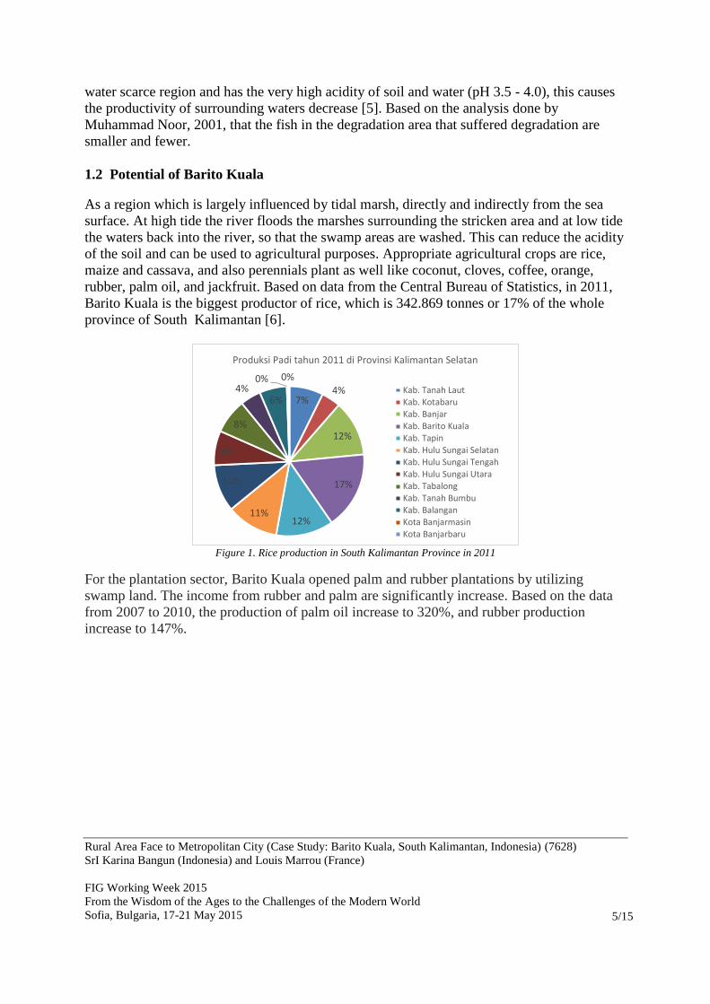
rubber, palm oil, and jackfruit. Based on data from the Central Bureau of Statistics, in 2011,
Barito Kuala is the biggest productor of rice, which is 342.869 tonnes or 17% of the whole
province of South Kalimantan [6].
Figure 1. Rice production in South Kalimantan Province in 2011
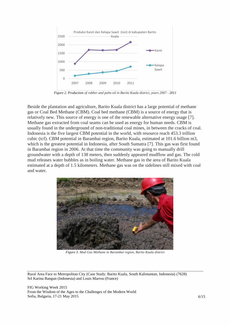
For the plantation sector, Barito Kuala opened palm and rubber plantations by utilizing
swamp land. The income from rubber and palm are significantly increase. Based on the data
from 2007 to 2010, the production of palm oil increase to 320%, and rubber production
increase to 147%.
7% 4%
12%
17%
12% 11%
10%
8%
8%
4% 6%
0% 0%
Produksi Padi tahun 2011 di Provinsi Kalimantan Selatan
Kab. Tanah Laut
Kab. KotabaruKab. Banjar
Kab. Barito Kuala
Kab. TapinKab. Hulu Sungai Selatan
Kab. Hulu Sungai Tengah
Kab. Hulu Sungai Utara
Kab. Tabalong
Kab. Tanah BumbuKab. Balangan
Kota Banjarmasin
Kota Banjarbaru
Rural Area Face to Metropolitan City (Case Study: Barito Kuala, South Kalimantan, Indonesia) (7628)
SrI Karina Bangun (Indonesia) and Louis Marrou (France)
FIG Working Week 2015
From the Wisdom of the Ages to the Challenges of the Modern World
Sofia, Bulgaria, 17-21 May 2015
6/15
Figure 2. Production of rubber and palm oil in Barito Kuala district, years 2007 - 2011
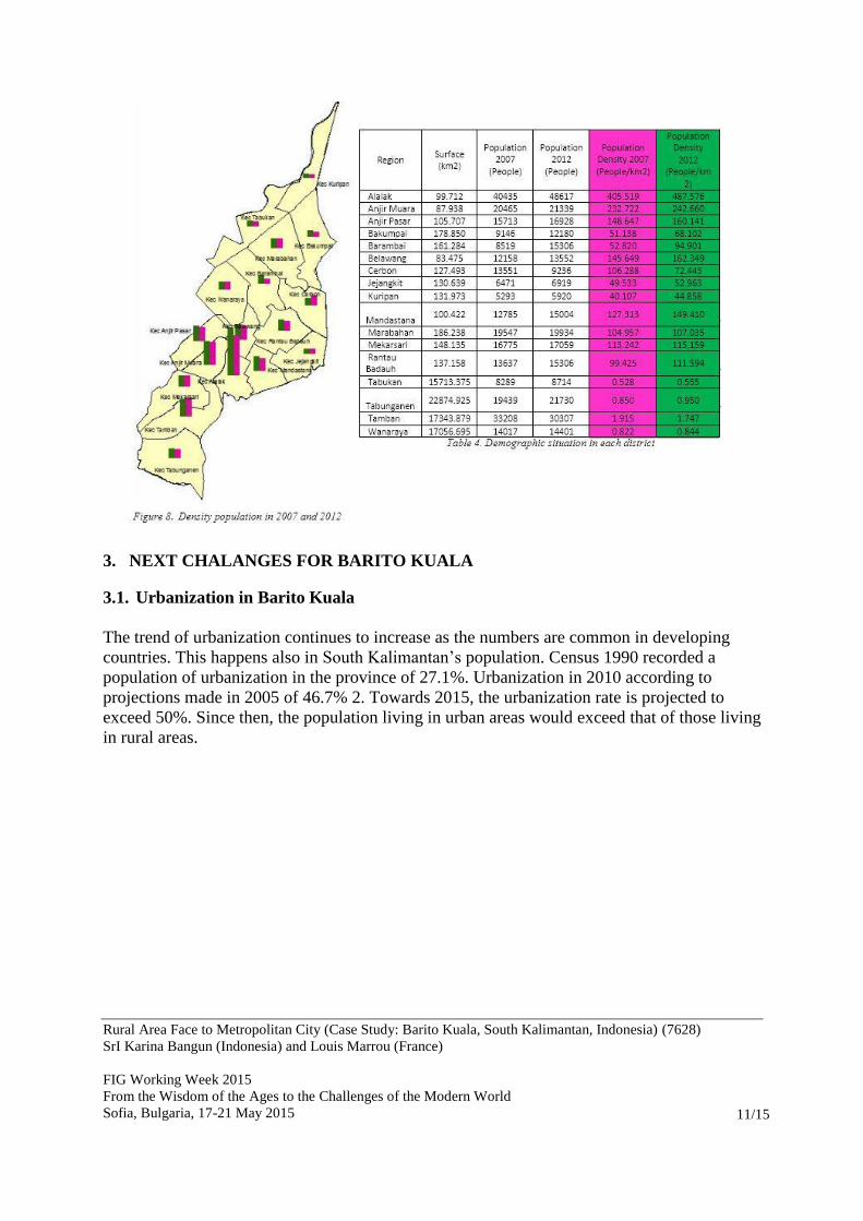
Beside the plantation and agriculture, Barito Kuala district has a large potential of methane
gas or Coal Bed Methane (CBM). Coal bed methane (CBM) is a source of energy that is
relatively new. This source of energy is one of the renewable alternative energy usage [7].
Methane gas extracted from coal seams can be used as energy for human needs. CBM is
usually found in the underground of non-traditional coal mines, in between the cracks of coal.
Indonesia is the five largest CBM potential in the world, with resource reach 453.3 trillion
cubic (tcf). CBM potential in Barambai region, Barito Kuala, estimated at 101.6 billion m3,
which is the greatest potential in Indonesia, after South Sumatra [7]. This gas was first found
in Barambai region in 2006. At that time the community was going to manually drill
groundwater with a depth of 138 meters, then suddenly appeared mudflow and gas. The cold
mud releases water bubbles as in boiling water. Methane gas in the area of Barito Kuala
estimated at a depth of 1.5 kilometers. Methane gas was on the sidelines still mixed with coal
and water.
Figure 3. Mud Gas Methane in Barambai region, Barito Kuala district
0
500
1000
1500
2000
2500
2007 2008 2009 2010 2011
Produksi Karet dan Kelapa Sawit (ton) di kabupaten Barito Kuala
Karet
KelapaSawit

Rural Area Face to Metropolitan City (Case Study: Barito Kuala, South Kalimantan, Indonesia) (7628)
SrI Karina Bangun (Indonesia) and Louis Marrou (France)
FIG Working Week 2015
From the Wisdom of the Ages to the Challenges of the Modern World
Sofia, Bulgaria, 17-21 May 2015
7/15
1.3 Demography
The origin of Barito Kuala community is Bakumpai rate (in Dutch called Becompaijers /
Bekoempaiers) or Dayak Bakumpai who live along the banks of Barito River, in South
Kalimantan. Based on the census results, conducted by Central Bureau of Statistics, in 2000,
there is about 20.609 peoples of Bakumpai rate in South Kalimantan province, the most
population is in Barito Kuala district, about 18.892 peoples (7%) of the total population in that
year in Barito Kuala. This shows that the population of Barito Kuala is already a mixture of
different regions as transmigration results. The yearly population in the region of Barito Kuala
from 2006 - 2012 is like the table below:
Name 2006 2007 2008 2009 2010 2011 2012
Tabunganen 19127 19439 19193 19389 19143 21781 21730
Tamban 36258 33208 31680 32021 31115 30156 30307
Mekarsari 17175 16775 17022 17201 16312 16935 17059
Anjir Pasar 15596 15713 15789 15956 15388 16857 16928
Anjir Muara 18980 20465 20267 20480 19456 22073 21339
Alalak 39027 40435 41696 42111 51403 47982 48617
Mandastana 13346 12785 13011 13147 14012 14117 15004
Belawang 12323 12158 13017 13151 12717 13424 13552
Wanaraya 13402 14017 14224 14361 12407 14194 14401
Rantau Badauh 10882 13637 13761 13901 14132 16450 15306
Cerbon 7298 13551 8644 8731 8403 9178 9236
Barambai 14077 8519 14768 14921 13971 15283 15306
Bakumpai 8847 9146 9016 9106 9321 12535 12180
Marabahan 19445 19547 19783 19988 18907 19054 19934
Tabukan 8225 8289 8283 8379 8097 8583 8714
Kuripan 5771 5293 5380 5431 5316 5885 5920
Jejangkit 7273 6471 6798 6869 6047 7839 6919
TOTAL 267052 269448 272332 275143 276147 292326 292452 Table 2. Evaluation of the population in Barito Kuala district 2006 - 2012
The largest population of Barito Kuala is in the capital region, Marabahan, while the smallest
population in Kuripan region. In 2007, there was a reduction in the population of the
Barambai, this is due to fear of society to live in the area since the discovery of mudflow and
gas from the ground in 2006, the community moved to Cerbon region, resulting the high
addition of the population in Cerbon. The residents of Barambai region started back in place
after the government announced that the gas in Barambai is harmless.

Rural Area Face to Metropolitan City (Case Study: Barito Kuala, South Kalimantan, Indonesia) (7628)
SrI Karina Bangun (Indonesia) and Louis Marrou (France)
FIG Working Week 2015
From the Wisdom of the Ages to the Challenges of the Modern World
Sofia, Bulgaria, 17-21 May 2015
8/15
2. BARITO KUALA 2007 – 2011
In this section, we describe about the land use change in Barito Kuala within 4 years. The data
used are the 2007 land use data, land use data in 2011 which was the result of satellite image
interpretation of Landsat ETM 7. The data were analyzed using ArcGIS software.
Characteristics Barito estuary are as follows:
Projected coordinate system: WGS 1984 Zone 50 S
Universal transverse Mercator projection (UTM)
As noted above, that most of the Barito Kuala is an area of agriculture, plantations and forests.
Annexes 1 shows the use of the land in 2007, and the annexes 2 shows the use of the land in
2011. The overall presentation of land-use cover is like figure 4. It is seen that nearly 50% of
land area in Barito Kuala is paddy, followed by reeds, forests, plantations, housing, rivers,
swamps, ponds, and others. The biggest change that occurred in 2007 to 2011 are changes in
forest cover, reeds, and plantations.
Figure 4. Percent’s of land use changement in Barito Kuala
Forests in Barito Kuala Region also called swamp forest or Galam, because it is dominated by
Galam wood species (Melaleuca cajuputi). This species, grows naturally and is a form of
adaptation to the environment swamps, freshwater, which generally have a low pH (3-5) and
less fertile. Forest Galam is a breath of life for some people, Galam forest produce which is
the construction material in wetlands, the source of materials base for the wood industry and
is a source of people's livelihood.
There are two types of forest in Barito Kuala district, which is a type of homogeny forest and
grove. Homogeny forest is a forest with one specify plants. In general, homogeny forests are
created with a specific purpose, such as for reforestation, afforestation, or expansion of
industrial purposes. Grove is covered with a dense forest by a wide variety of plants. Grove is
found in wide areas in the world and serves as a reservoir of carbon dioxide (carbon dioxide),
animal habitats, and soil conservers, and is one of the aspects most important terrestrial
biosphere.
- 10,00 20,00 30,00 40,00 50,00
Reeds
Grove
Homogeny Forest
Individual Plantation
Big Plantation
Housing
Swamp Land
Paddy field
Rivers
Fishpond
Autre fields
% Land Use Changement in Barito Kuala District
2012 2007

Rural Area Face to Metropolitan City (Case Study: Barito Kuala, South Kalimantan, Indonesia) (7628)
SrI Karina Bangun (Indonesia) and Louis Marrou (France)
FIG Working Week 2015
From the Wisdom of the Ages to the Challenges of the Modern World
Sofia, Bulgaria, 17-21 May 2015
9/15
The changement of homogeny forest and grove area in Barito Kuala district is like the table
below:
No Land Use
Area (Ha) Land use Changement
Year
2007 Year 2012 Area (Ha)
Changement
(%)
1 Grove 21,746.53 6,917.47 -14,829.06 -68.19
2 Homogeny Forest 21,223.85 1,093.15 -20,130.70 -94.85
Table 3. Grove and Homogeny Forest in 2007 and 2011
From the table, within a period of 5 years, it is seen that grove were reduced by 68.18% or
14.829 ha. And homogeny forests were reduced by 94.85% or 20.130 ha. In Barambai district,
Wanaraya, Anjir Markets and Mekarsari all woods are completely change. Homogeny forest
in Kuripan district and Cerbon also disappear. Some homogeny forest is still in the
Tabunganen district.
The diminution of forest area in Barito Kuala, along with the increasing of plantation land
(palm and rubber). Since 2009, the National Land Agency has issued some permits of
plantation use (leasehold) to a large companies. In addition, conversion of forests to
plantations is also done by local people for individual’s plantation. Figure 6 shows the change
of plantation area in Barito Kuala district. Some groves and homogeny forest area has been
converted to plantations (both individuals and companies). The biggest change occurred in the
northern part of Barito Kuala Region, Tabukan district, Marabahan, Kuripan, Bakumpai, and
the most southern part of the district of Barito Kuala which Tamban district and Tabunganen
districts (Figure 5).
Not only is the forest has been replaced, but the swamps area can be converted into
plantations. Swamp area is reduced as much as 5.173,82 hectares or 75% from 2007, almost
all parts of the swamp have been converted to plantations. In 2007, there is still a swamp area
Figure 6. Repartition of Big plantation and Individual
Plantatation in Barito Kuala in 2007 and 2011 Figure 5. Grove and Homogeny Forest in Barito Kuala

Rural Area Face to Metropolitan City (Case Study: Barito Kuala, South Kalimantan, Indonesia) (7628)
SrI Karina Bangun (Indonesia) and Louis Marrou (France)
FIG Working Week 2015
From the Wisdom of the Ages to the Challenges of the Modern World
Sofia, Bulgaria, 17-21 May 2015
10/15
located in Kuripan district and Bakumpai, but in 2011, has almost no swamps anymore,
everything has been turned into plantations.
In terms of the distribution of the settlement, it appears that the change of land to settlement
mostly located in the eastern part of the Barito Kuala Region, namely Wanaraya district,
Alalak, Cerbon, Rantau Badauh, Mandastana and Tamban. The largest addition of the
residential area is in Cerbon district, about 729.4 hectares or an increase of as much as 3.5
times more than in 2007 (202.86 ha), but from presentation of settlement area in 2007 to
2011, Jejangkit district has the largest percentage, 524% (from 50.48 ha in 2007 to 315.215 ha
in 2011). The widest districts of settlement area is Wanaraya district, 31 hectares in 2011,
which is a smallest settlement extensive, 1% of the breadth in 2007.
Figure 7.Residual Percentage of Housing Extension in 2007 and 2011 in every Region (Ha)
Table 4. Percentage of housing area every region in 2007 and 2011
Meanwhile, when compared to the population density of each district in 2011, it appears that
the most populous district is Alalak district, followed Anjir Muara, Tamban, Belawang, and
Mandastana and so on, as displayed in Figure 8. There are two districts were reduced density
its population, Cerbon district and Tamban.
Rural Area Face to Metropolitan City (Case Study: Barito Kuala, South Kalimantan, Indonesia) (7628)
SrI Karina Bangun (Indonesia) and Louis Marrou (France)
FIG Working Week 2015
From the Wisdom of the Ages to the Challenges of the Modern World
Sofia, Bulgaria, 17-21 May 2015
11/15
3. NEXT CHALANGES FOR BARITO KUALA
3.1. Urbanization in Barito Kuala
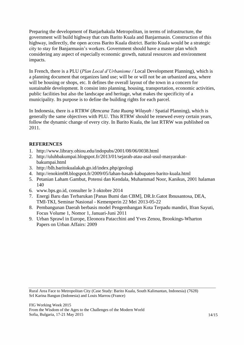
The trend of urbanization continues to increase as the numbers are common in developing
countries. This happens also in South Kalimantan’s population. Census 1990 recorded a
population of urbanization in the province of 27.1%. Urbanization in 2010 according to
projections made in 2005 of 46.7% 2. Towards 2015, the urbanization rate is projected to
exceed 50%. Since then, the population living in urban areas would exceed that of those living
in rural areas.
Rural Area Face to Metropolitan City (Case Study: Barito Kuala, South Kalimantan, Indonesia) (7628)
SrI Karina Bangun (Indonesia) and Louis Marrou (France)
FIG Working Week 2015
From the Wisdom of the Ages to the Challenges of the Modern World
Sofia, Bulgaria, 17-21 May 2015
12/15
Urbanization regencies / cities in South Kalimantan in 2010
The process of urbanization that occurred in Barito Kuala is not as urbanization in the
traditional sense. In the traditional sense, Urbanization has always been perceived in
demographic terms, that is, as the increase is in the number of people living in the urban
areas. Most commentaries on Urbanization are based on this demographic perspective (Devas
and Rakodi 1993; World Bank 2000; United Nations 2000). The process of urbanization in
Barito Kuala is more inclined to something called the urban sprawl (Lim 1987) or urban
expansion. However, the fact remains that as urban areas expand outwards and incorporate
surrounding non-urban land to the make way for industrial or housing development,
Urbanization is taking place (Obudho and Obudho1994).
“Urban sprawl is usually defines as the spreading of a city and its suburbs over rural land at
the fringe of an urban area.”
Many reasons underlying the phenomenon of urban sprawl ranging from the behavior of
people who prefer to live in suburban areas, assuming the price of land is cheap and
affordable and healthy air conditions are not heavily contaminated as downtown. Then the
existence of the Spatial Plan (Spatial) is believed to still be implemented in achieving spatial
pro-environment. Too many social and economic interests to be implemented by the local
government, so that in fact affect the implementation of Spatial neglect is causing
environmental functions.
There are several reasons why Barito Kuala is interesting, first, strategic location on the
eastern side, close to the city of Banjarmasin, coupled with the establishment of the Barito
bridge which can shorten the travel time Banjarmasin-Barito Kuala (which had its 3-4 days to
1-2 hours), in addition, in term of Banjarbakula Metropolitan, the government will build a
highway that would pass through this district. Second, the saturation of residential area in
Banjarmasin makes workers prefer to live in a rural area nearby, associated with the rising
price of land in the city, so that the purchasing power is reduced. Land in rural areas tend to

Rural Area Face to Metropolitan City (Case Study: Barito Kuala, South Kalimantan, Indonesia) (7628)
SrI Karina Bangun (Indonesia) and Louis Marrou (France)
FIG Working Week 2015
From the Wisdom of the Ages to the Challenges of the Modern World
Sofia, Bulgaria, 17-21 May 2015
13/15
be less expensive compared to urban areas. Third, Barito Kuala is located along the Barito
River that became the main transport for coal exports since the enactment of legislation
banning the transportation of coal by road. Plus, when viewed spatially, in this district there
are non-residential area that is large enough to be built.
The process of city expansion creates urbanization in the sub-urban and rural. In Barito Kuala
characterized by:
Agricultural area turned into residential areas (Alalak, Mandastana, Cerbon);
Vacant land into a new settlement through Transmigration program (Barambai, etc.);
Opening of the plantation, which creates new jobs;
Increasing of the population on the Barito river coast as a consequence of increasing
coastal activity.
This urbanization process, must be immediately followed by the readiness of the government
to determine the availability of land that is up-to-dates, precise, continuous and could
represent natural environment. Spatial (locationally referenced) information has become
indispensable for Barito Kuala, interm of its development, planning and management. The
increasing importance of spatial information has been due to spatial data capture (especially
satellite remote sensing), management (utilizing GIS and database tools) and access (witness
the growth in web mapping), as well as the development of analytical techniques such as high
resolution mapping of urban environments. This shows the urgency of a spatial tools, where
this system can be used as a tool for the government in making policies in spatial direction.
3.2. Barito Kuala to the Metropolitan
The land use changement in Barito Kuala is very fast. The process of urbanization began to
appear in the districts located close to Banjarmasin, the capital city of South Kalimantan
Province. At least three district has been cited by Ministry of Public Works to be built the
residential area. The first, in Alalak districts, closest district to Banjarmasin, this district in
2013 will be built several housing to accommodate the settlement shortage in Banjarmasin.
Then Mandastana district, the district extensive for housing development in Alalak district
and also the district where the program of independent transmigration city is being
implemented, and Marabahan district which is the capital of Barito Kuala district even though
in Marabahan, the housing construction grows slowly.
Barito Kuala currently included in the government program on the formation of a new
metropolitan city in South Kalimantan, which is named “City Metropolitan Banjarbakula”. It
is certain that there will be massive changes occur in Barito Kuala, while Barito Kuala is
categorized the Backward District in 2011, became part of the City Metropolitan. In this case
of course the Barito Kuala Region will be facing new challenges both in terms of
environmental, ecological, economic, infrastructure, followed by rapid changes in land use
and social problems.
Rural Area Face to Metropolitan City (Case Study: Barito Kuala, South Kalimantan, Indonesia) (7628)
SrI Karina Bangun (Indonesia) and Louis Marrou (France)
FIG Working Week 2015
From the Wisdom of the Ages to the Challenges of the Modern World
Sofia, Bulgaria, 17-21 May 2015
14/15
Preparing the development of Banjarbakula Metropolitan, in terms of infrastructure, the
government will build highway that cuts Barito Kuala and Banjarmasin. Construction of this
highway, indirectly, the open access Barito Kuala district. Barito Kuala would be a strategic
city to stay for Banjarmasin’s workers. Government should have a master plan which
considering any aspect of especially economic growth, natural resources and environment
impacts.
In French, there is a PLU (Plan Local d’Urbanisme / Local Development Planning), which is
a planning document that organizes land use; will be or will not be an urbanized area, where
will be housing or shops, etc. It defines the overall layout of the town in a concern for
sustainable development. It consist into planning, housing, transportation, economic activities,
public facilities but also the landscape and heritage, what makes the specificity of a
municipality. Its purpose is to define the building rights for each parcel.
In Indonesia, there is a RTRW (Rencana Tata Ruang Wilayah / Spatial Planning), which is
generally the same objectives with PLU. This RTRW should be renewed every certain years,
follow the dynamic change of every city. In Barito Kuala, the last RTRW was published on
2011.
REFERENCES
1. http://www.library.ohiou.edu/indopubs/2001/08/06/0038.html
2. http://uluhbakumpai.blogspot.fr/2013/01/sejarah-atau-asal-usul-masyarakat-
bakumpai.html
3. http://blh.baritokualakab.go.id/index.php/geologi
4. http://enokim08.blogspot.fr/2009/05/lahan-basah-kabupaten-barito-kuala.html
5. Petanian Laham Gambut, Potensi dan Kendala, Muhammad Noor, Kanikus, 2001 halaman
140
6. www.bps.go.id, consulter le 3 oktobre 2014
7. Energi Baru dan Terbarukan [Panas Bumi dan CBM], DR.Ir.Gatot Ibnusantosa, DEA,
TMI-TKI, Seminar Nasional - Kemenperin 22 Mei 2013-05-22
8. Pembangunan Daerah berbasis model Pengembangan Kota Terpadu mandiri, Ifran Sayuti,
Focus Volume 1, Nomor 1, Januari-Juni 2011
9. Urban Sprawl in Europe, Eleonora Patacchini and Yves Zenou, Brookings-Wharton
Papers on Urban Affairs: 2009

Rural Area Face to Metropolitan City (Case Study: Barito Kuala, South Kalimantan, Indonesia) (7628)
SrI Karina Bangun (Indonesia) and Louis Marrou (France)
FIG Working Week 2015
From the Wisdom of the Ages to the Challenges of the Modern World
Sofia, Bulgaria, 17-21 May 2015
15/15
BIOGRAPHICAL NOTES
Sri Karina BANGUN completed her Bachelor Degree in Institute Bandung of Technology,
Indonesia, majoring Geodesy and Geomatic Engineering, in 2004. Two years after, she had an
opportunity to continue her Master Degree in La Rochelle University, France, majoring
Environment and Coastal Area. In 2008, after completed her master degree, she was back to
her institution, Land National Agency, currently change to Ministry of Spatial Planning. Her
passion to take PhD program realized in 2014 when she was accepted as a scholarship PhD
Candidate in La Rochelle University. She is now in her first year of her doctoral program
about development territorial and spatial planning in Barito Kuala, South Kalimantan,
Indonesia.
CONTACT
Sri Karina BANGUN
CNRS / Univesite de La Rochelle
UMR 7266 LIENSs
2, Olympic Gouges
La Rochelle
FRANCE