Embed Size (px)
Citation preview
0
8
Ef-
terår
L I T E H A U Z A p S
Ballast Water Discharges in Denmark
Kristina Kern
Frank Stuer-Lauridsen
I
Contents
Summary
Preface
1. Background ...................................................................................................................... 1
2. Objectives ........................................................................................................................ 1
3. Data compiling for ballast water discharge projection ....................................................... 1
4. Gollasch Model from Germany ......................................................................................... 2
4.1. How to use the model? .............................................................................................. 3
4.2. Results and discussion ................................................................................................ 4
4.2.1. Quantity of discharged ballast water estimated with Gollasch model ........................ 4
4.2.2. Need for data ............................................................................................................... 6
5. Simple estimation of ballast water discharge in Denmark .................................................. 7
5.1. Data evaluation ......................................................................................................... 7
5.1.1. Loaded and unloaded goods in Danish ports ............................................................... 7
5.1.2. Cargo ship types ........................................................................................................... 8
5.2. Estimate of ballast water discharge based on cargo statistics ...................................... 9
5.3. Comparing cargo based estimation and Gollasch model .............................................. 9
6. Assessment of ballast water discharge data that are not readily available ......................... 10
6.1. Scope of data collection by questionnaire .................................................................. 10
6.2. Estimation of discharged ballast water from Ship-to-ship operations .......................... 12
7. Risk assessment of discharged ballast water in Danish waters .......................................... 13
7.1.1. Discharged ballast water in Danish waters separated into North Sea / Baltic Sea .... 14
7.2. Risk assessment criteria ............................................................................................ 17
II
7.2.1. Salinity criterion ......................................................................................................... 17
7.2.2. Temperature zone ...................................................................................................... 18
7.2.3. Duration ..................................................................................................................... 19
7.3. Risk assessment of ballast water origin ...................................................................... 20
7.3.1. Results of risk assessment for Baltic Sea .................................................................... 20
7.3.2. Results of risk assessment North Sea ......................................................................... 25
8. Options and recommendations ........................................................................................ 28
9. Bibliography .................................................................................................................... 29
10. APPENDIX Questionnaire assessment ............................................................................. 32
10.1. Generation of ballast water data via questionnaires .................................................. 32
10.2. The experience from Port of Rotterdam ..................................................................... 32
10.3. How to cover important Danish ports with a questionnaire ........................................ 33
10.4. How to generate data by questionnaire ..................................................................... 36
III
List of Table
TABLE 1: THE ESTIMATED QUANTITY OF DISCHARGED BALLAST WATER DERIVED FROM A SIMPLE CARGO BASED
MODEL VS. GOLLASCH MODEL .................................................................................................
TABLE 2: CALL OF CARGO AND CRUISER SHIPS ON MAJOR DANISH PORTS BY TYPE OF VESSEL IN 2007. ............. 4
TABLE 3: THE QUANTITY OF DISCHARGED BALLAST WATER RESULTING FROM INTERNATIONAL TRAFFIC DERIVED
FROM SIMPLE CARGO BASED ESTIMATION AND THE GOLLASCH MODEL. ......................................... 9
TABLE 4: STS OPERATION OVER THE YEARS 2004 TO 2007 (SOEFARTSSTYRELSEN, 2008) ........................... 13
TABLE 5: AMOUNT OF DISCHARGED BALLAST WATER IN DANISH PORTS IN 2007, SEPARATED INTO ORIGIN AND
RECEIVER REGION. ............................................................................................................. 16
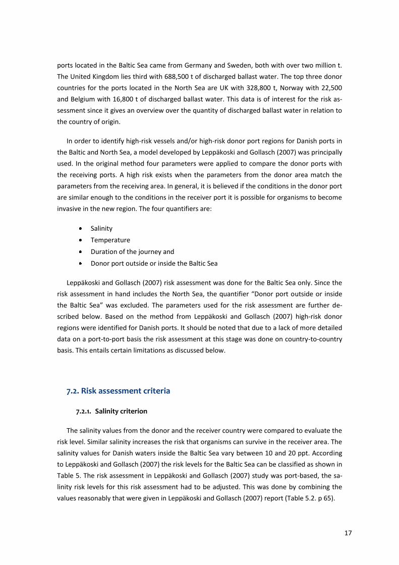
TABLE 6: CLASSIFICATION OF SALINITY RISK LEVELS FOR THE BALTIC SEA .................................................... 18
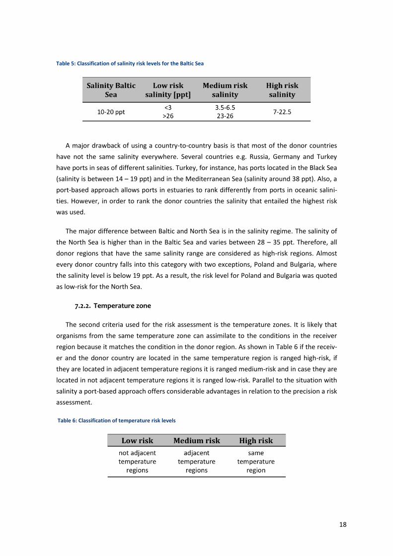
TABLE 7: CLASSIFICATION OF TEMPERATURE RISK LEVELS ........................................................................ 18
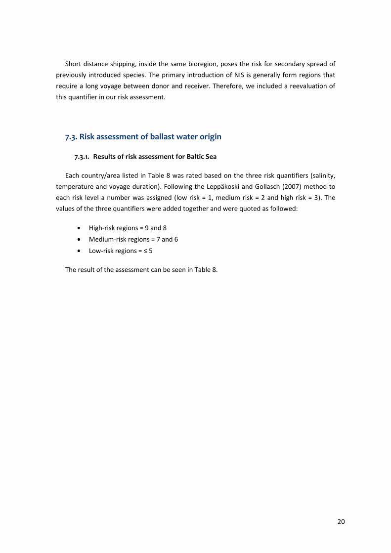
TABLE 8: CLASSIFICATION OF DURATION RISK LEVELS .............................................................................. 19
TABLE 9: COUNTRIES ORDERED BY RISK LEVELS FOR BALTIC SEA ............................................................... 21
TABLE 10: LIST OF NIS FOUND IN THE BALTIC SEA ................................................................................. 22
TABLE 11: LIST OF COUNTRIES AND THEIR RISK LEVELS FOR BALTIC SEA AFTER CHANGING THE DURATION
CRITERIA. THE NUMBER IN BRACKETS SHOWS THE NEW CALCULATED TOTAL RISK. ......................... 24
TABLE 12: LIST OF COUNTRIES ORDERED BY RISK LEVELS FOR NORTH SEA. ................................................. 25
TABLE 13: LIST OF NIS FOUND IN THE NORTH SEA ................................................................................ 26
TABLE 14: LIST OF COUNTRIES AND THEIR RISK LEVELS FOR NORTH SEA AFTER CHANGING THE DURATION
CRITERIA. THE NUMBER IN BRACKETS SHOWS THE NEW CALCULATED TOTAL RISK. ......................... 26
TABLE 15: THE NUMBER OF CARGO VESSELS AND VESSEL SIZE CALLED ON THE FIVE SELECTED PORTS DURING A
PERIOD OF THREE MONTH IN 2007 (SKIB221). ..................................................................... 37
TABLE 16: SHIP THAT SHOULD RETURN ACCEPTABLE QUESTIONNAIRES WITH 8 % OR 15 % FEEDBACK,
RESPECTIVELY. ................................................................................................................... 37
IV
List of Figures
FIGURE 1: USING GOLLASCH MODEL: TRADE AND SHIPPING CHARACTERISTICS FOR DENMARK 2007 ............... 3
FIGURE 2: GOLLASCH APPLICATION: SUMMARY OF THE RESULTS ................................................................ 4
FIGURE 3: GOLLASCH APPLICATION: THE CALLS OF VESSELS IN DANISH PORTS WERE ENTERED INTO COLUMN B
FOR EACH VESSEL TYPE. THE C TO I COLUMNS RESULT FROM THE APPLICATION. .............................. 5
FIGURE 4: GOLLASCH APPLICATION: THE RESULTS CORRECTED FOR DWT ERROR. ......................................... 5
FIGURE 5: CALL OF DIFFERENT TYPE OF VESSELS ON DANISH PORTS IN 2007. THE NUMBERS REPRESENT THE CALL
OF SHIPS. ........................................................................................................................... 8
FIGURE 6: STS OPERATIONS AREAS ACCORDING TO MAERSK BROKERS (2009) .......................................... 12
FIGURE 7: NUMBER OF INVASIVE SPECIES FOUND IN DANISH WATERS SINCE PRE 1900 (NOBANIS). ............. 14
FIGURE 8: MAP OF THE BORDER BETWEEN NORTH SEA AND BALTIC SEA IS MARKED WITH A DASHED LINE FROM
SKAGEN TO GOTHENBURG. (ATTILIOS AT EN.WIKIPEDIA, 2005) ................................................ 15
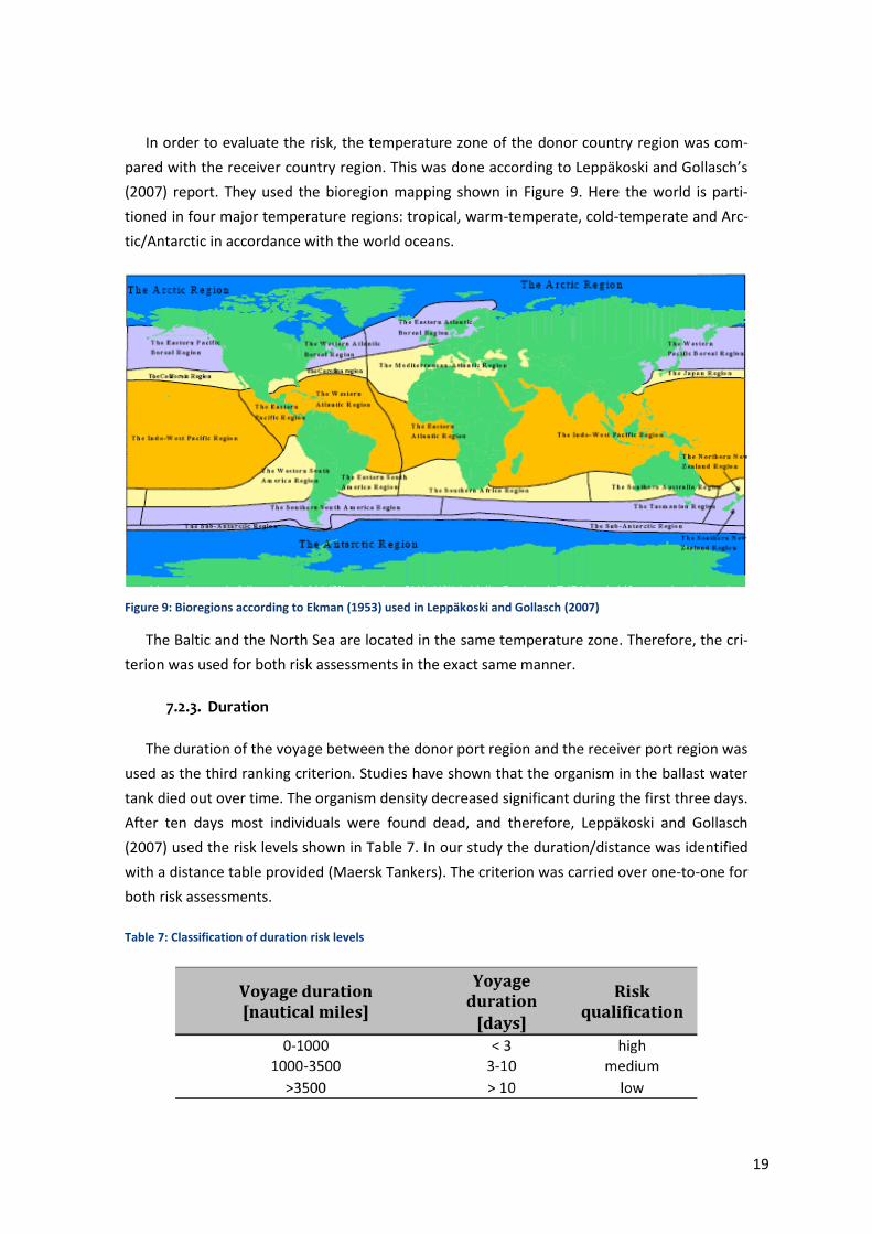
FIGURE 9: BIOREGIONS ACCORDING TO EKMAN (1953) USED IN LEPPÄKOSKI AND GOLLASCH (2007) ........... 19
FIGURE 10: LEFT: PERCENTAGE OF CALL OF CARGO VESSELS ON DANISH PORTS ARRANGED BY VESSEL SIZE IN
2007. RIGHT: PERCENTAGE OF MAXIMUM GT CAPACITY IN 2007 ............................................. 34
FIGURE 11: DANISH PORTS AND NUMBER OF SHIPS BY VESSEL SIZE VISITING THE RESPECTIVE PORT. ALL PORTS
HAD AT LEAST ONE CALL OF A VESSEL IN THE RANGE BETWEEN 10000 – 24999 GT IN 2007. ........ 35
FIGURE 12: THE THROUGHPUT, LOADED GOODS TOTAL AND LOADED GOODS IN INTERNATIONAL TRAFFIC FOR SIX
HIGH VOLUME SELECTED HARBOURS. .................................................................................... 36
V
The following abbreviations were used in this report:
GT Gross Tonnage, a measure of internal volume of the ship
DWT Deadweight Tonnage, is the sum of the weights or masses of cargo, fuel, fresh wa-
ter, ballast water, provisions, passengers and crew
AIS Automatic Information System
NIS Non-indigenous Invasive Species
STS Ship-to-Ship
VLCC Very Large Crude Carrier
IMO The International Maritime Organization
MAS Maritime Association Service
SOK Admiral Danish Fleet (Søværnets Operative Kommando)
Summary
The study aimed at addressed the discharge of ballast water in Denmark with an identifica-
tion and prioritization of the risk for release of Non-indigenous Invasive Species (NIS). The falls
in two sections: the first on methods to estimate the volume discharged and methods to im-
prove the base data; and the second on the identification and prioritization of the deballasted
water.
The results of the simple model based on cargo statistics in comparison with the result from
the more advanced Gollasch model are shown in the table below:
The estimated quantity of discharged ballast water derived from a simple cargo based model vs. Gollasch model
Discharged ballast water from international traffic (t)
Simple estimation Gollasch model
8,112,600 9,823,099
Estimated discharge from Ship-to-Ship operations (t)
1,100,000
Obviously, more precision would be achieved with more detailed data obtained directly
from ports on key data, e.g. deadweights and ballast capacity. At a cost such data can be gen-
erated by using a questionnaire or via commercial databases on port traffic. A questionnaire
may also provide the direct discharged volumes and a measure of and ballast-to-cargo ratio. If
a questionnaire is preferred over data obtained from commercial suppliers the following five
ports are recommended for a survey: Port of Fredericia, Port of Aarhus, Statoil-havnen, Port of
Copenhagen and Port of Esbjerg. In the five selected ports 7,552 calls of cargo vessels bigger
than 1,500 GT were recorded in 2007.
The Ship-to-Ship operations in Danish waters adds more than 1.1 million tons ballast water
in Danish water estimated from data reported to Danish authorities. There is no readily availa-
ble data on the origins of the vessels arriving in ballast to the loading buoys.
The tentative risk assessment based on a previous approach shows that the salinity and
temperature criteria appear to contribute to relevant risk ranking, but the duration criteria
does not. This criterion weighs in short duration of travel, but it is clear from origin of the inva-
sive species occurring in the Baltic Sea that longer travels from North America and Asia are the
biggest contributors to NIS. This is also the case for the North Sea. It may be considered to
adapt a modification of the criterion giving more weight to longer travels.
With the data at hand at this point it is only possible to perform the risk assessment based
on countries. To use data on a port-to-port base is possible and that will produce a clearer a
more detailed risk assessment.
Preface
The authorities of Denmark are preparing for the ratification of the IMO Ballast Water Con-
vention and the present project deals with the estimation of ballast water discharges in Danish
waters. It was carried out under contract from the Danish Agency for Spatial and Environmen-
tal Planning (BLST).
The study was initiated in February 2009 and completed in June 2009. It was followed by a
steering group comprising mr. Ulrik Berggreen, mr. Torben Wallach, and ms. Cristina Nissen all
from BLST and ms. Clea Henrichsen from the Danish Maritime Agency. Dr Frank Stuer-
Lauridsen participated as the representative of the contractor.
The kind assistance from Dr Stephan Gollasch with the model is greatly appreciated. A
number of people in the Danish Shipping community have extended their help in locating and
interpreting publically available data and we would like to thank all of them here.
1
1. Background
Ballast water is pumped into a ship’s ballast tanks to stabilize it when it unloads cargo or is
travelling with low load or empty. The water quality therefore reflects that of the harbour
from where it is pumped and it may contain plant and animal species native to the port of
origin or even pathogens that are transported in the ships ballast water tanks from Port A to
Port B. The discharge of ballast water with non-indigenous species have led to a number of
occurrences where the species new to the local environment have proliferated and have be-
come invasive and destructive to both the ecology and the economy.
The threat of unmanaged ballast water to the ecological balance and the biodiversity of
the seas in 2004 led the International Maritime Organization (IMO) to adopt an international
agreement calling for mandatory treatment of ballast water: The International Convention for
the Control and Management of Ships’ Ballast Water. In March 2009 18 parties have ratified
the Convention, which enters into force when at least 30 states representing 35 % of the world
merchant shipping tonnage have ratified. Denmark has not yet ratified the Convention and
presently, discharge of ballast water is not regulated in Denmark although a voluntary agree-
ment exists between the Danish Shipowner’s Association and the Ministry of Environment.
2. Objectives
The present report seeks to provide an estimate of the ballast water discharges in Danish
waters based on available data and to evaluate to options for providing additional data. The
following methods were investigated in this report.
Evaluation using a questionnaire method as used in the port of Rotterdam
Ballast water discharges modeled by the method of Stephan Gollasch.
A simple estimation based on available data was used to calculate the amount of
discharged ballast water in Denmark.
The findings of the latter are used for a preliminary risk assessment of the discharged bal-
last water in Denmark.
3. Data compiling for ballast water discharge projection
Information on a merchant vessel’s ballast water management is not necessarily collected
or stored except onboard the ship itself, and vessels calling on Danish ports are not obligated
to report how much ballast water they carry on board, where it was taken in or which volume
2
is discharge when goods are loaded. Therefore, it is not possible to draw information from a
central information system regarding ballast water discharge in Danish waters, and to provide
an estimate of the volume of discharged ballast water one has to either generate new data or
base an evaluation on proxy data.
Data related to ballast water was compiled through a broad internet-survey, telephone in-
terviews and e-mail correspondence with a number of actors in the area. In Denmark the na-
tional agency for statistics StatBank Denmark (Danmarks Statistik, 2009) had relevant data
publically available. On their homepage detailed information can be found under the category
“Transport”. All databases starting with SKIB contain information relevant to shipping. Among
others, Søfartsstyrelsen, Søværnets Operative Kommando, Danmarks Rederiforening, Helcom,
Farvandsvæsenet and Maersk Brokers were also contacted for information.
4. Gollasch Model from Germany
Stephan Gollasch (1996) developed a well-known model to estimate ballast water discharge
for Germany. It is based on key data on ship types, number of calls, deadweight, ballast water
capacity etc. collected in a large German study. The basic approach is to characterize the type
of ships with respect to ballast water, multiply with the total number of calls and identify the
proportion from international traffic, the latter being important for risk assessment purposes.
The model is used here to approximate the volume of discharged ballast water in Danish
ports1. The input data for the application of the model was collected from Danish Bureau of
Statistics (Danmarks Statistik) by using their online databases, which throughout the study are
referred to with their abbreviations SKIB1012, SKIB413, SKIB234 and SKIB4215 and their full
name in a footnote.
The model has previously been used on Danish conditions by Janne Sanderhoff (2002) in
her master thesis, but since then the model has been modified and the former study also in-
cluded ferry traffic, which outnumbers cargo traffic considerably in Denmark.
1 The kind assistance from Stephan Gollasch during this study is greatly appreciated 2 SKIB101: Call of vessels, passengers and throughput of goods in traffic ports by seaport
and unit 3 SKIB41: Transport of goods over Danish ports by unit 4 SKIB23: Call of cargo ships and cruiser ships on major Danish ports by seaport and type of
vessel 5 SKIB421: Throughput of goods in Danish ports by seaport and unit
3
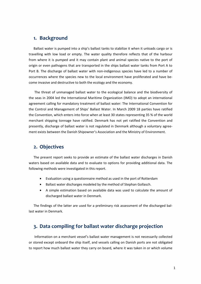
4.1. How to use the model?
The model is available as a Microsoft Excel application6, and the user must fill in a number
of required data. In the first datasheet the national trade and shipping characteristics are en-
tered. The proportions of export/import and international/domestic traffic were calculated
and filled into the designated fields, and to produce a result that relates to cargo vessels only,
goods transported by ferries and ferry traffic was excluded from the calculation. The trade and
shipping characteristics for cargo vessels for Denmark in 2007 result from database SKIB427.
The percentages of both characteristics are based on the throughput in tons. The Gollasch
application is shown in Figure 1.
Figure 1: Using Gollasch model: Trade and shipping characteristics for Denmark 2007
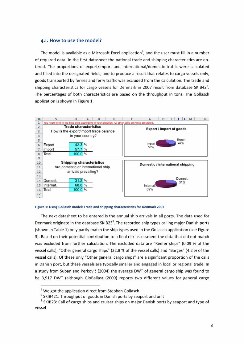
The next datasheet to be entered is the annual ship arrivals in all ports. The data used for
Denmark originate in the database SKIB238. The recorded ship types calling major Danish ports
(shown in Table 1) only partly match the ship types used in the Gollasch application (see Figure
3). Based on their potential contribution to a final risk assessment the data that did not match
was excluded from further calculation. The excluded data are “Reefer ships” (0.09 % of the
vessel calls), “Other general cargo ships” (22.8 % of the vessel calls) and “Barges” (4.2 % of the
vessel calls). Of these only “Other general cargo ships” are a significant proportion of the calls
in Danish port, but these vessels are typically smaller and engaged in local or regional trade. In
a study from Suban and Perkovič (2004) the average DWT of general cargo ship was found to
be 3,917 DWT (although GloBallast (2009) reports two different values for general cargo
6 We got the application direct from Stephan Gollasch. 7 SKIB421: Throughput of goods in Danish ports by seaport and unit 8 SKIB23: Call of cargo ships and cruiser ships on major Danish ports by seaport and type of
vessel
4
17,000 DWT and 8,000 DWT). However, it was not possible to determine a more specific size
of “Other general cargo ships” in Denmark without a considerable effort and since the ballast
water contribution is small it was decided to allow these vessels to remain excluded.
Table 1: Call of cargo and cruiser ships on major Danish ports by type of vessel in 2007.
4.2. Results and discussion
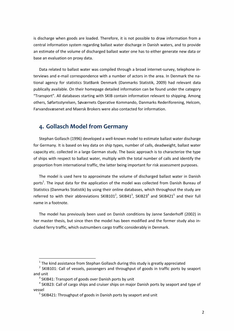
4.2.1. Quantity of discharged ballast water estimated with Gollasch model
The total quantity of discharged ballast water in Danish waters estimated with the Gollasch
model adds up to 14,23 million t for the year 2007. According to the trade and shipping cha-
racteristics 69 % of the discharged ballast water came from foreign origins. Therefore, the
quantity of discharged ballast water resulting from international traffic totals 9,823,099 t.
Figure 2: Gollasch application: Summary of the results
5
Figure 3: Gollasch application: The calls of vessels in Danish ports were entered into column B for each vessel type. The C to I columns result from the application.
The results show that the lion’s share of the discharged ballast water is expected to come
from tankers. The total quantity discharged from tankers is 13.85 million tons. This is approx-
imately 97 % of the estimated total ballast water volume from international trade. Stephan
Gollasch pointed out that the original model has a minor error in DWT estimation,9 which has
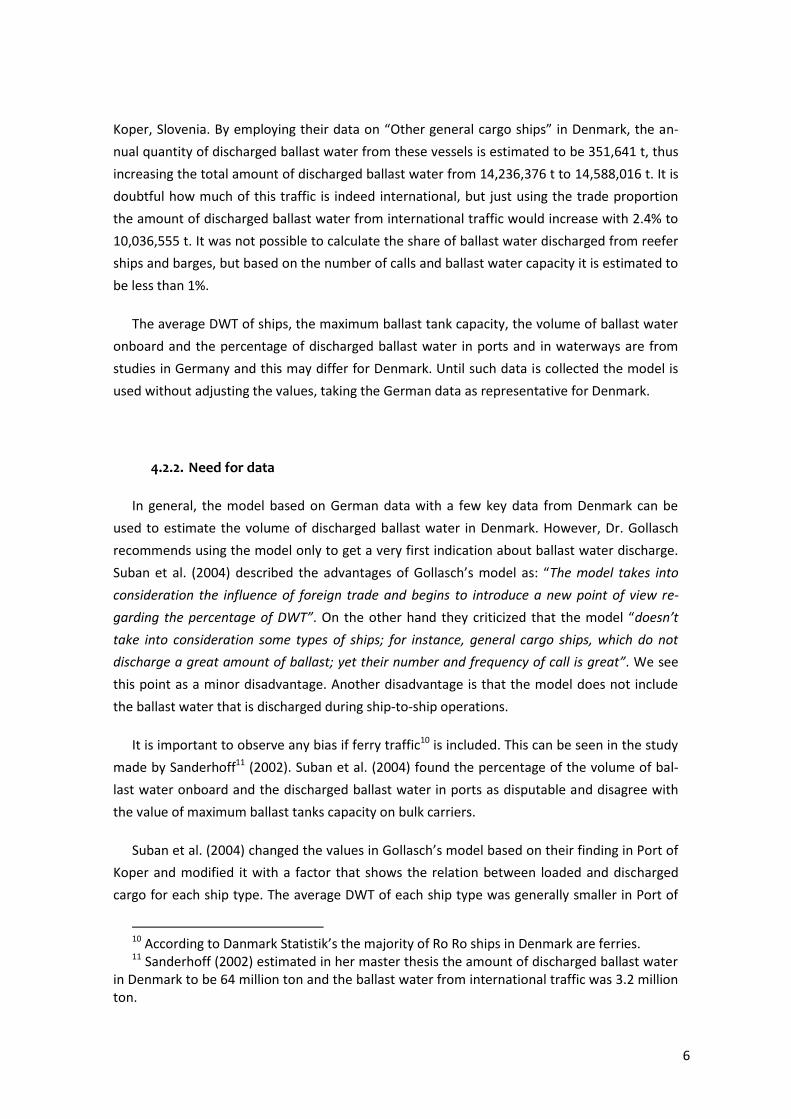
been corrected in the ballast water estimates presented here in Figure 3 and Figure 4.
Figure 4: Gollasch application: The results corrected for DWT error.
Because reefer ships, other general cargo ships and barges were excluded actual discharges
could be higher, as mentioned earlier. The number of calls made by these ship types adds up
to 5545 calls in 2007. This is 27 % of the total number of calls made by cargo ships in the same
year, while 22.8 % originate from general cargo ships. Using the same model and facing the
same problem Suban et al. (2004) added general cargo ships based on actual data from Port of
9 Stephan Gollasch reported, that a factor of 2.8 should be excluded because DWT is al-
ready expressed in tons. In consequence of omitting it, the columns “Discharged ballast water in waterways *t+”, “Total volume of ballast water discharged *t+”and “Discharged ballast water of foreign origin in *t+” was recalculated.
6
Koper, Slovenia. By employing their data on “Other general cargo ships” in Denmark, the an-
nual quantity of discharged ballast water from these vessels is estimated to be 351,641 t, thus
increasing the total amount of discharged ballast water from 14,236,376 t to 14,588,016 t. It is
doubtful how much of this traffic is indeed international, but just using the trade proportion
the amount of discharged ballast water from international traffic would increase with 2.4% to
10,036,555 t. It was not possible to calculate the share of ballast water discharged from reefer
ships and barges, but based on the number of calls and ballast water capacity it is estimated to
be less than 1%.
The average DWT of ships, the maximum ballast tank capacity, the volume of ballast water
onboard and the percentage of discharged ballast water in ports and in waterways are from
studies in Germany and this may differ for Denmark. Until such data is collected the model is
used without adjusting the values, taking the German data as representative for Denmark.
4.2.2. Need for data
In general, the model based on German data with a few key data from Denmark can be
used to estimate the volume of discharged ballast water in Denmark. However, Dr. Gollasch
recommends using the model only to get a very first indication about ballast water discharge.
Suban et al. (2004) described the advantages of Gollasch’s model as: “The model takes into
consideration the influence of foreign trade and begins to introduce a new point of view re-
garding the percentage of DWT”. On the other hand they criticized that the model “doesn’t
take into consideration some types of ships; for instance, general cargo ships, which do not
discharge a great amount of ballast; yet their number and frequency of call is great”. We see
this point as a minor disadvantage. Another disadvantage is that the model does not include
the ballast water that is discharged during ship-to-ship operations.
It is important to observe any bias if ferry traffic10 is included. This can be seen in the study
made by Sanderhoff11 (2002). Suban et al. (2004) found the percentage of the volume of bal-
last water onboard and the discharged ballast water in ports as disputable and disagree with
the value of maximum ballast tanks capacity on bulk carriers.
Suban et al. (2004) changed the values in Gollasch’s model based on their finding in Port of
Koper and modified it with a factor that shows the relation between loaded and discharged
cargo for each ship type. The average DWT of each ship type was generally smaller in Port of
10 According to Danmark Statistik’s the majority of Ro Ro ships in Denmark are ferries. 11 Sanderhoff (2002) estimated in her master thesis the amount of discharged ballast water
in Denmark to be 64 million ton and the ballast water from international traffic was 3.2 million ton.
7
Koper than in Gollasch’s investigation and the maximum ballast tank capacity was in most of
the cases bigger. Furthermore, ship types relevant for Port of Koper were included. Suban et
al. (2004) compared the numbers of estimated discharged ballast calculated with and without
the modification for the years 1998 to 2002. The results showed that the calculated quantity of
discharged ballast water after the modification was approximately 30 percent of the quantity
calculated without modifications.
5. Simple estimation of ballast water discharge in Denmark
In the next section it is shown how cargo data available in Danmarks Statistik was used to
calculate the quantity of discharged ballast water in Danish waters resulting from international
traffic with a simple estimation. While the model of Gollasch requires many different data, the
estimation uses the amount of loaded goods to assess the amount of discharged ballast water.
We believe this simple approach can easily be transferred to other countries.
5.1. Data evaluation
Generally, it must be noticed that ferries were excluded from further investigation. Ferries call
ports very frequently, i.e. have a strong influence in port statistics, and they do not carry large
amounts of ballast water. Also, the data used are solely from the international traffic, which is
justified by the fact that Denmark is a small country with little domestic traffic.
5.1.1. Loaded and unloaded goods in Danish ports
In order to calculate the amount of discharged ballast water in Denmark an inventory of the
available data was carried out, and it was evaluated which data can be used for the calcula-
tion. Among other things, Danmark Statistik provides the information about the amount of
loaded and unloaded goods for major Danish ports by seaport and in total. The amount of
loaded goods is the key data for the estimation of discharged ballast water.
On annual average, the quantity of unloaded goods in a port is typically higher than the
quantity of loaded goods in Denmark (SKIB42112). This reflects that Denmark is a country that
imports rather that exports goods. However, from a net import of goods it cannot be con-
cluded that there is no ballast water discharged into Danish waters, since every loading opera-
tion may lead to the discharge of a certain volume of ballast water.
12 SKIB421: Throughput of goods in Danish ports by seaport and unit
8
Data on the nature of the operation, i.e. whether a ships loads, unloads or perform both
operations, which are of obvious importance for the ballast water management, is not part of
the statistics. Thus, as no specific data are available the assumption is made that all loaded
cargo results in a ballast water discharge as a worst-case scenario.
5.1.2. Cargo ship types
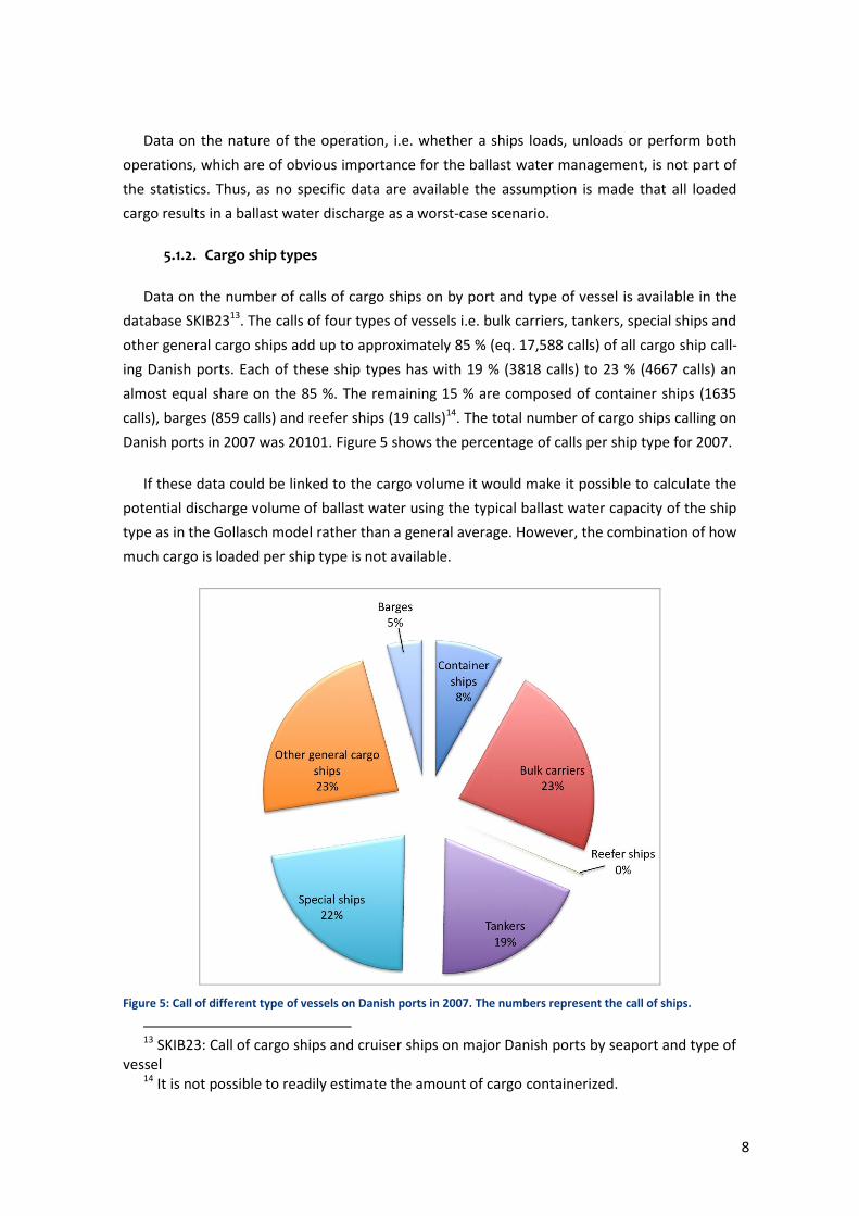
Data on the number of calls of cargo ships on by port and type of vessel is available in the
database SKIB2313. The calls of four types of vessels i.e. bulk carriers, tankers, special ships and
other general cargo ships add up to approximately 85 % (eq. 17,588 calls) of all cargo ship call-
ing Danish ports. Each of these ship types has with 19 % (3818 calls) to 23 % (4667 calls) an
almost equal share on the 85 %. The remaining 15 % are composed of container ships (1635
calls), barges (859 calls) and reefer ships (19 calls)14. The total number of cargo ships calling on
Danish ports in 2007 was 20101. Figure 5 shows the percentage of calls per ship type for 2007.
If these data could be linked to the cargo volume it would make it possible to calculate the
potential discharge volume of ballast water using the typical ballast water capacity of the ship
type as in the Gollasch model rather than a general average. However, the combination of how
much cargo is loaded per ship type is not available.
Figure 5: Call of different type of vessels on Danish ports in 2007. The numbers represent the call of ships.
13 SKIB23: Call of cargo ships and cruiser ships on major Danish ports by seaport and type of
vessel 14 It is not possible to readily estimate the amount of cargo containerized.
9
5.2. Estimate of ballast water discharge based on cargo statistics
A number of studies have shown that 30 to 40 percent of a ship’s DWT can be carried as
ballast water (Leppäkoski & Gollasch, 2007; Walters, 1996; Shipping Federation of Canada,
2004; GloBallast, 2009). The average DWT of each ship type calling on Danish ports is a key
requirement for estimation of the concomitant ballast water capacity of the ship type, but this
is not available in public statistics. Instead, it was assumed as an approximation that any load-
ing operation would result in a ballast water discharge of 30 % of the cargo loaded in Danish
ports gives a representative number of discharged ballast water.
In Denmark the total amount of loaded goods in 2007 was 27,042,000 t in international
traffic (SKIB42115). Using 30% deballasted water volume for each tonne of cargo taken onboard
the total amount of discharged ballast water resulting from international traffic in Danish ports
is estimated at 8,112,600 t for the year 2007.
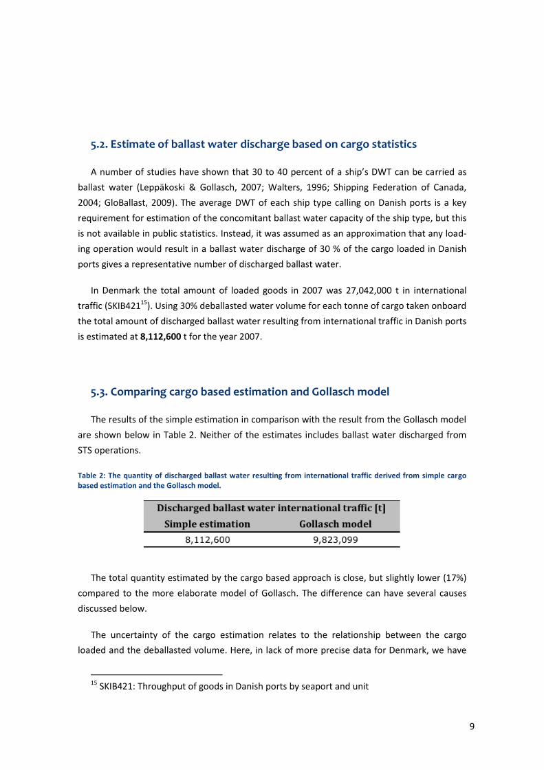
5.3. Comparing cargo based estimation and Gollasch model
The results of the simple estimation in comparison with the result from the Gollasch model
are shown below in Table 2. Neither of the estimates includes ballast water discharged from
STS operations.
Table 2: The quantity of discharged ballast water resulting from international traffic derived from simple cargo based estimation and the Gollasch model.
The total quantity estimated by the cargo based approach is close, but slightly lower (17%)
compared to the more elaborate model of Gollasch. The difference can have several causes
discussed below.
The uncertainty of the cargo estimation relates to the relationship between the cargo
loaded and the deballasted volume. Here, in lack of more precise data for Denmark, we have
15 SKIB421: Throughput of goods in Danish ports by seaport and unit
10
chosen an average of 30% based on the dataset used in the model of Gollasch developed for
Germany. However, Suban et al. (2004) showed in their study from the Port of Koper in Slove-
nia, that adjusting the average DWT of each ship type and the maximum ballast tank capacity
to the actual vessels in the smaller port led to a significant lower ballast water volume.
Sanderhoff (2002) stated in her master thesis that the average DWT in the Gollasch model
is higher than the actual average DWT of ships visiting Denmark, and with that in mind in may
be prudent to develop a more detailed dataset, if one intend to employ the Gollasch model for
Danish conditions. Such data would also make it possible to develop a more precise model
based on cargo estimates and the more detailed data can be obtained from directly from ports
with a questionnaire or via commercial databases monitoring port traffic.
A similar modification of the model for Denmark would require gathering the data of the
average DWT, the maximum ballast water capacity, the volume of ballast water onboard and
the percentage of discharged ballast water in ports and waterways for all ship types that are
relevant. It should be kept in mind that it takes a large effort to collect and evaluate these
types of data. The data would be available either directly at the ports or via commercial data-
bases. The calculation and consequently the amount of discharged ballast water, however, will
become more exact as much more data is available.
6. Assessment of ballast water discharge data that are not
readily available
From the previous sections it is shown that more detailed data on ship type, deadweights,
loaded amounts etc. would improve the precision of the estimates and eventually their appli-
cability for a risk assessment of ballast water discharge. Here, we present the scope using a
brief questionnaire and an estimation of discharged ballast water from Ship-to-Ship (STS) op-
erations.
6.1. Scope of data collection by questionnaire
A good source of information on ballast water is obviously the vessels themselves, and to
obtain data one may perform a survey of ballast water management on vessels in Danish main
harbours via a questionnaire, such as the survey on ballast water that was carried out in Port
of Rotterdam in 2007-2008 by Royal Haskoning (2008). To collect a data set of a similar stan-
11
dard as the Dutch a range of requirements would have to be met in Denmark (please see Ap-
pendix 1 for details).
In a Danish exercise with a questionnaire approach obviously only ports that are represent-
ative and important for the ballast water discharge in Denmark should be taken into consider-
ation. In order to detect the high-risk ports with regard to discharged ballast water, following
information was of interest:
Cargo vessels were investigated because cargo vessels discharge more ballast water
compared to passenger vessels
Larger vessels carry more ballast water than the smaller vessels
Vessels involved in long distance traffic potentially have a higher risk of carrying
non-indigenous species
Amount of goods loaded and unloaded as an indicator for ballast water discharge
Amount of loaded goods in international traffic as an indicator for ballast water dis-
charge from potentially high risk regions
The vessels less than 1499 GT have only a share of 10 % of the discharged ballast water and
since it is assumed that these vessels are mostly used in domestic traffic and short sea traffic,
such vessels can be excluded. Five ports are recommended for a survey by questionnaire: Port
of Fredericia, Port of Aarhus, Statoil-havnen, Port of Copenhagen16 and Port of Esbjerg. In the
five selected ports 7,552 calls of cargo vessels bigger than 1,500 GT were recorded in 2007,
excluding cruise ships. To meet at least the same standard the survey in Denmark should in-
clude at least a period of three month in the five ports in order to produce representative re-
sults.
The questionnaires should be handed over to the ship’s captain or substitute by a repre-
sentative of the Harbour Master Division, the Danish Maritime Authority, a responsible organi-
zation, an agent or similar, who will go on board the ship calling one of the selected ports.
16 A commercial co-operation exists between the ports of Copenhagen (Denmark) and
Malmo (Sweden), but the data presented are solely from the Port of Copenhagen
12
6.2. Estimation of discharged ballast water from Ship-to-ship operations
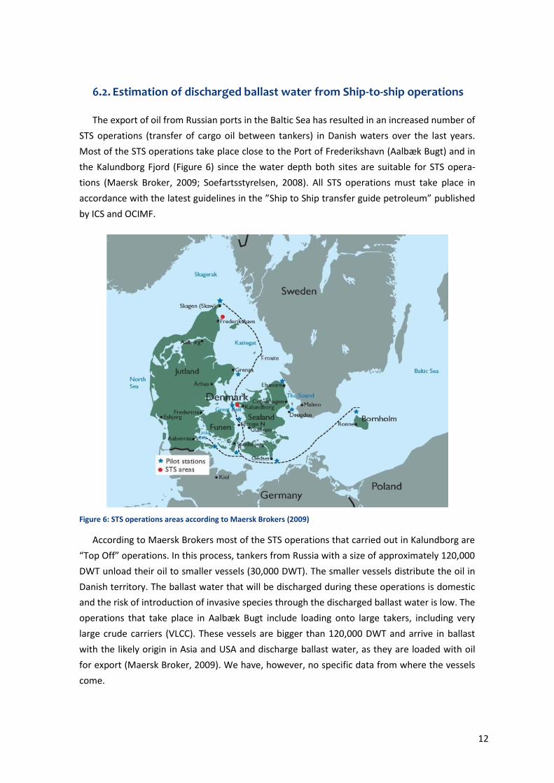
The export of oil from Russian ports in the Baltic Sea has resulted in an increased number of
STS operations (transfer of cargo oil between tankers) in Danish waters over the last years.
Most of the STS operations take place close to the Port of Frederikshavn (Aalbæk Bugt) and in
the Kalundborg Fjord (Figure 6) since the water depth both sites are suitable for STS opera-
tions (Maersk Broker, 2009; Soefartsstyrelsen, 2008). All STS operations must take place in
accordance with the latest guidelines in the ”Ship to Ship transfer guide petroleum” published
by ICS and OCIMF.
Figure 6: STS operations areas according to Maersk Brokers (2009)
According to Maersk Brokers most of the STS operations that carried out in Kalundborg are
“Top Off” operations. In this process, tankers from Russia with a size of approximately 120,000
DWT unload their oil to smaller vessels (30,000 DWT). The smaller vessels distribute the oil in
Danish territory. The ballast water that will be discharged during these operations is domestic
and the risk of introduction of invasive species through the discharged ballast water is low. The
operations that take place in Aalbæk Bugt include loading onto large takers, including very
large crude carriers (VLCC). These vessels are bigger than 120,000 DWT and arrive in ballast
with the likely origin in Asia and USA and discharge ballast water, as they are loaded with oil
for export (Maersk Broker, 2009). We have, however, no specific data from where the vessels
come.
13
According to the Maritime Assistance Service (MAS) all operations where a quantity below
5,000 m3 was transferred count as bunker operations. All operations where more than 5,000
m3 were transferred are considered as STS operations. During bunker operations ballast water
discharge is not expected. Therefore, information about bunker operations was excluded. The
data for this was derived from Søværnets Operative Kommando (SOK).
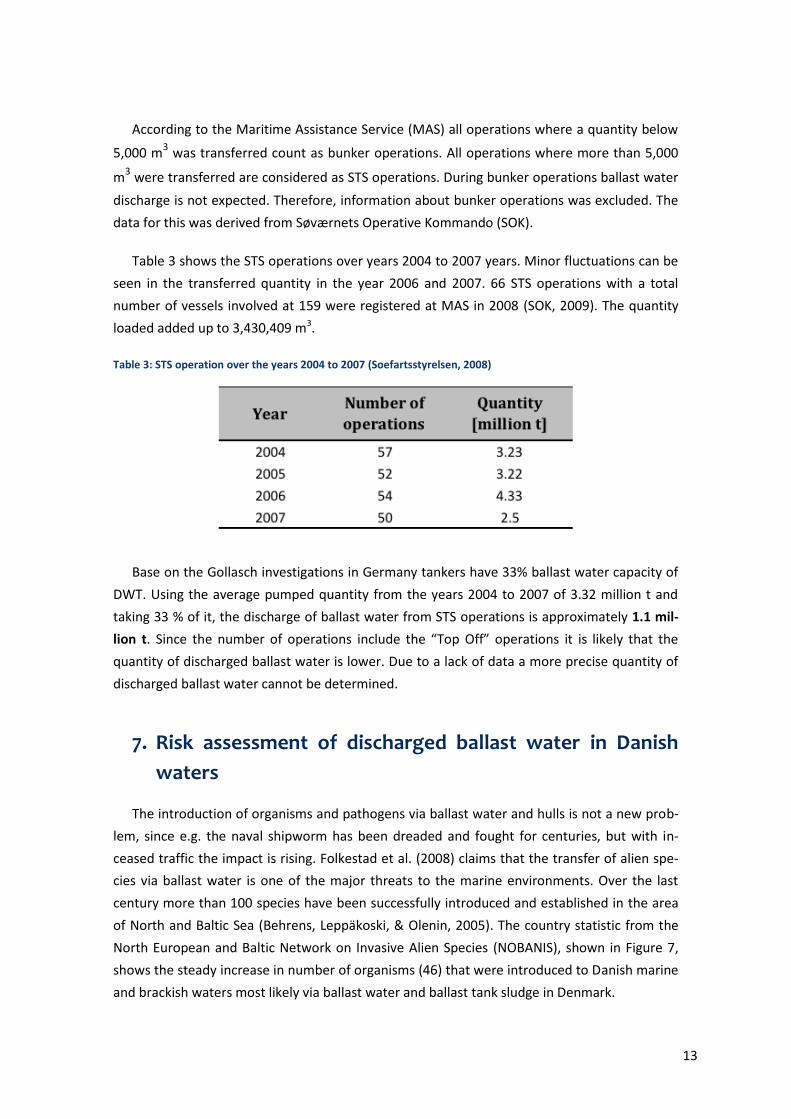
Table 3 shows the STS operations over years 2004 to 2007 years. Minor fluctuations can be
seen in the transferred quantity in the year 2006 and 2007. 66 STS operations with a total
number of vessels involved at 159 were registered at MAS in 2008 (SOK, 2009). The quantity
loaded added up to 3,430,409 m3.
Table 3: STS operation over the years 2004 to 2007 (Soefartsstyrelsen, 2008)
Base on the Gollasch investigations in Germany tankers have 33% ballast water capacity of
DWT. Using the average pumped quantity from the years 2004 to 2007 of 3.32 million t and
taking 33 % of it, the discharge of ballast water from STS operations is approximately 1.1 mil-
lion t. Since the number of operations include the “Top Off” operations it is likely that the
quantity of discharged ballast water is lower. Due to a lack of data a more precise quantity of
discharged ballast water cannot be determined.
7. Risk assessment of discharged ballast water in Danish
waters
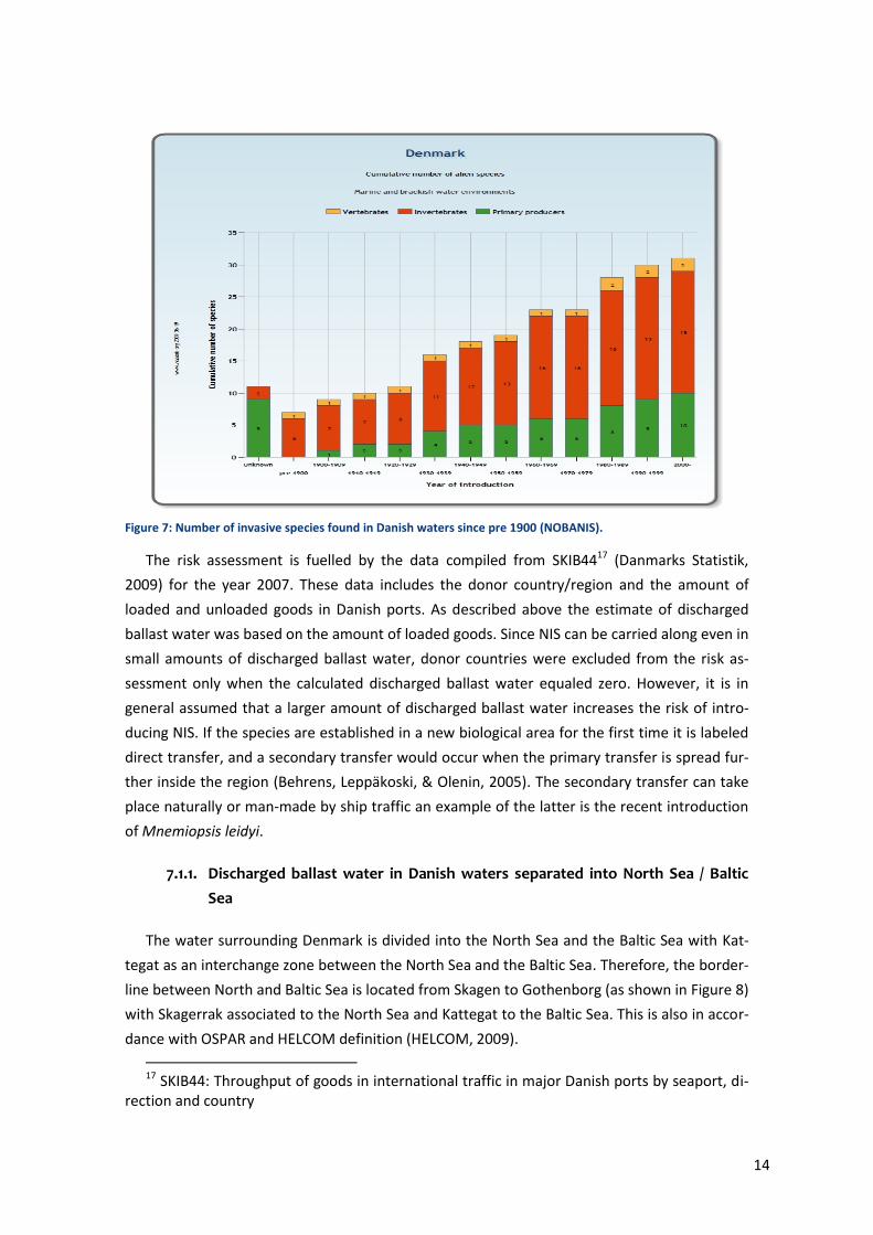
The introduction of organisms and pathogens via ballast water and hulls is not a new prob-
lem, since e.g. the naval shipworm has been dreaded and fought for centuries, but with in-
ceased traffic the impact is rising. Folkestad et al. (2008) claims that the transfer of alien spe-
cies via ballast water is one of the major threats to the marine environments. Over the last
century more than 100 species have been successfully introduced and established in the area
of North and Baltic Sea (Behrens, Leppäkoski, & Olenin, 2005). The country statistic from the
North European and Baltic Network on Invasive Alien Species (NOBANIS), shown in Figure 7,
shows the steady increase in number of organisms (46) that were introduced to Danish marine
and brackish waters most likely via ballast water and ballast tank sludge in Denmark.
14
Figure 7: Number of invasive species found in Danish waters since pre 1900 (NOBANIS).
The risk assessment is fuelled by the data compiled from SKIB4417 (Danmarks Statistik,
2009) for the year 2007. These data includes the donor country/region and the amount of
loaded and unloaded goods in Danish ports. As described above the estimate of discharged
ballast water was based on the amount of loaded goods. Since NIS can be carried along even in
small amounts of discharged ballast water, donor countries were excluded from the risk as-
sessment only when the calculated discharged ballast water equaled zero. However, it is in
general assumed that a larger amount of discharged ballast water increases the risk of intro-
ducing NIS. If the species are established in a new biological area for the first time it is labeled
direct transfer, and a secondary transfer would occur when the primary transfer is spread fur-
ther inside the region (Behrens, Leppäkoski, & Olenin, 2005). The secondary transfer can take
place naturally or man-made by ship traffic an example of the latter is the recent introduction
of Mnemiopsis leidyi.
7.1.1. Discharged ballast water in Danish waters separated into North Sea / Baltic
Sea
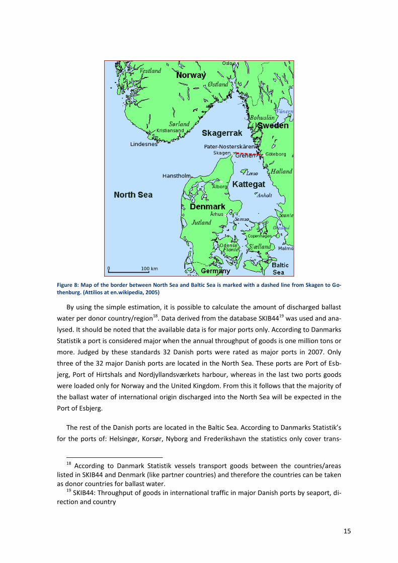
The water surrounding Denmark is divided into the North Sea and the Baltic Sea with Kat-
tegat as an interchange zone between the North Sea and the Baltic Sea. Therefore, the border-
line between North and Baltic Sea is located from Skagen to Gothenborg (as shown in Figure 8)
with Skagerrak associated to the North Sea and Kattegat to the Baltic Sea. This is also in accor-
dance with OSPAR and HELCOM definition (HELCOM, 2009).
17 SKIB44: Throughput of goods in international traffic in major Danish ports by seaport, di-
rection and country
15
Figure 8: Map of the border between North Sea and Baltic Sea is marked with a dashed line from Skagen to Go-thenburg. (Attilios at en.wikipedia, 2005)
By using the simple estimation, it is possible to calculate the amount of discharged ballast
water per donor country/region18. Data derived from the database SKIB4419 was used and ana-
lysed. It should be noted that the available data is for major ports only. According to Danmarks
Statistik a port is considered major when the annual throughput of goods is one million tons or
more. Judged by these standards 32 Danish ports were rated as major ports in 2007. Only
three of the 32 major Danish ports are located in the North Sea. These ports are Port of Esb-
jerg, Port of Hirtshals and Nordjyllandsværkets harbour, whereas in the last two ports goods
were loaded only for Norway and the United Kingdom. From this it follows that the majority of
the ballast water of international origin discharged into the North Sea will be expected in the
Port of Esbjerg.
The rest of the Danish ports are located in the Baltic Sea. According to Danmarks Statistik’s
for the ports of: Helsingør, Korsør, Nyborg and Frederikshavn the statistics only cover trans-
18 According to Danmark Statistik vessels transport goods between the countries/areas
listed in SKIB44 and Denmark (like partner countries) and therefore the countries can be taken as donor countries for ballast water.
19 SKIB44: Throughput of goods in international traffic in major Danish ports by seaport, di-rection and country
16
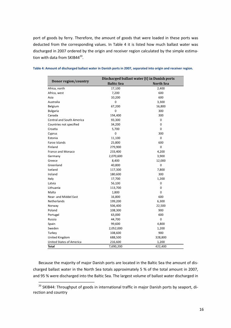
port of goods by ferry. Therefore, the amount of goods that were loaded in these ports was
deducted from the corresponding values. In Table 4 it is listed how much ballast water was
discharged in 2007 ordered by the origin and receiver region calculated by the simple estima-
tion with data from SKIB4420.
Table 4: Amount of discharged ballast water in Danish ports in 2007, separated into origin and receiver region.
Because the majority of major Danish ports are located in the Baltic Sea the amount of dis-
charged ballast water in the North Sea totals approximately 5 % of the total amount in 2007,
and 95 % were discharged into the Baltic Sea. The largest volume of ballast water discharged in
20 SKIB44: Throughput of goods in international traffic in major Danish ports by seaport, di-
rection and country
17
ports located in the Baltic Sea came from Germany and Sweden, both with over two million t.
The United Kingdom lies third with 688,500 t of discharged ballast water. The top three donor
countries for the ports located in the North Sea are UK with 328,800 t, Norway with 22,500
and Belgium with 16,800 t of discharged ballast water. This data is of interest for the risk as-
sessment since it gives an overview over the quantity of discharged ballast water in relation to
the country of origin.
In order to identify high-risk vessels and/or high-risk donor port regions for Danish ports in
the Baltic and North Sea, a model developed by Leppäkoski and Gollasch (2007) was principally
used. In the original method four parameters were applied to compare the donor ports with
the receiving ports. A high risk exists when the parameters from the donor area match the
parameters from the receiving area. In general, it is believed if the conditions in the donor port
are similar enough to the conditions in the receiver port it is possible for organisms to become
invasive in the new region. The four quantifiers are:
Salinity
Temperature
Duration of the journey and
Donor port outside or inside the Baltic Sea
Leppäkoski and Gollasch (2007) risk assessment was done for the Baltic Sea only. Since the
risk assessment in hand includes the North Sea, the quantifier “Donor port outside or inside
the Baltic Sea” was excluded. The parameters used for the risk assessment are further de-
scribed below. Based on the method from Leppäkoski and Gollasch (2007) high-risk donor
regions were identified for Danish ports. It should be noted that due to a lack of more detailed
data on a port-to-port basis the risk assessment at this stage was done on country-to-country
basis. This entails certain limitations as discussed below.
7.2. Risk assessment criteria
7.2.1. Salinity criterion
The salinity values from the donor and the receiver country were compared to evaluate the
risk level. Similar salinity increases the risk that organisms can survive in the receiver area. The
salinity values for Danish waters inside the Baltic Sea vary between 10 and 20 ppt. According
to Leppäkoski and Gollasch (2007) the risk levels for the Baltic Sea can be classified as shown in
Table 5. The risk assessment in Leppäkoski and Gollasch (2007) study was port-based, the sa-
linity risk levels for this risk assessment had to be adjusted. This was done by combining the
values reasonably that were given in Leppäkoski and Gollasch (2007) report (Table 5.2. p 65).
18
Table 5: Classification of salinity risk levels for the Baltic Sea
A major drawback of using a country-to-country basis is that most of the donor countries
have not the same salinity everywhere. Several countries e.g. Russia, Germany and Turkey
have ports in seas of different salinities. Turkey, for instance, has ports located in the Black Sea
(salinity is between 14 – 19 ppt) and in the Mediterranean Sea (salinity around 38 ppt). Also, a
port-based approach allows ports in estuaries to rank differently from ports in oceanic salini-
ties. However, in order to rank the donor countries the salinity that entailed the highest risk
was used.
The major difference between Baltic and North Sea is in the salinity regime. The salinity of
the North Sea is higher than in the Baltic Sea and varies between 28 – 35 ppt. Therefore, all
donor regions that have the same salinity range are considered as high-risk regions. Almost
every donor country falls into this category with two exceptions, Poland and Bulgaria, where
the salinity level is below 19 ppt. As a result, the risk level for Poland and Bulgaria was quoted
as low-risk for the North Sea.
7.2.2. Temperature zone
The second criteria used for the risk assessment is the temperature zones. It is likely that
organisms from the same temperature zone can assimilate to the conditions in the receiver
region because it matches the condition in the donor region. As shown in Table 6 if the receiv-
er and the donor country are located in the same temperature region is ranged high-risk, if
they are located in adjacent temperature regions it is ranged medium-risk and in case they are
located in not adjacent temperature regions it is ranged low-risk. Parallel to the situation with
salinity a port-based approach offers considerable advantages in relation to the precision a risk
assessment.
Table 6: Classification of temperature risk levels
19
In order to evaluate the risk, the temperature zone of the donor country region was com-
pared with the receiver country region. This was done according to Leppäkoski and Gollasch’s
(2007) report. They used the bioregion mapping shown in Figure 9. Here the world is parti-
tioned in four major temperature regions: tropical, warm-temperate, cold-temperate and Arc-
tic/Antarctic in accordance with the world oceans.
Figure 9: Bioregions according to Ekman (1953) used in Leppäkoski and Gollasch (2007)
The Baltic and the North Sea are located in the same temperature zone. Therefore, the cri-
terion was used for both risk assessments in the exact same manner.
7.2.3. Duration
The duration of the voyage between the donor port region and the receiver port region was
used as the third ranking criterion. Studies have shown that the organism in the ballast water
tank died out over time. The organism density decreased significant during the first three days.
After ten days most individuals were found dead, and therefore, Leppäkoski and Gollasch
(2007) used the risk levels shown in Table 7. In our study the duration/distance was identified
with a distance table provided (Maersk Tankers). The criterion was carried over one-to-one for
both risk assessments.
Table 7: Classification of duration risk levels
20
Short distance shipping, inside the same bioregion, poses the risk for secondary spread of
previously introduced species. The primary introduction of NIS is generally form regions that
require a long voyage between donor and receiver. Therefore, we included a reevaluation of
this quantifier in our risk assessment.
7.3. Risk assessment of ballast water origin
7.3.1. Results of risk assessment for Baltic Sea
Each country/area listed in Table 8 was rated based on the three risk quantifiers (salinity,
temperature and voyage duration). Following the Leppäkoski and Gollasch (2007) method to
each risk level a number was assigned (low risk = 1, medium risk = 2 and high risk = 3). The
values of the three quantifiers were added together and were quoted as followed:
High-risk regions = 9 and 8
Medium-risk regions = 7 and 6
Low-risk regions = ≤ 5
The result of the assessment can be seen in Table 8.
21
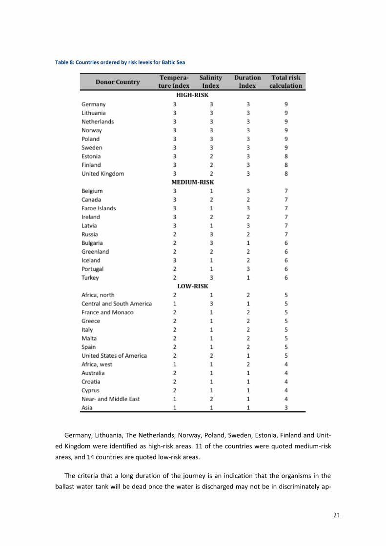
Table 8: Countries ordered by risk levels for Baltic Sea
Germany, Lithuania, The Netherlands, Norway, Poland, Sweden, Estonia, Finland and Unit-
ed Kingdom were identified as high-risk areas. 11 of the countries were quoted medium-risk
areas, and 14 countries are quoted low-risk areas.
The criteria that a long duration of the journey is an indication that the organisms in the
ballast water tank will be dead once the water is discharged may not be in discriminately ap-
22
plicable. It is obviously true that the longer a journey last the less likely is the survival of an
organism chosen at random, thus the risk of discharge of viable species with ballast water is
higher for short journeys. In areas where little intra-bioregional seaborne transport has oc-
curred previously, the short journeys e.g. from estuary to estuary, may be of great concern.
However, in the two water masses of interest from a Danish point of view, the North Sea and
the Baltic Sea, the journeys of short duration occur in within areas that have been subject to
intense sea transport for more than a thousand years. It is in our opinion only likely that the
organisms that could spread on hulls, on deballasted materials or in deadwater on short jour-
neys have already spread and are therefore considered native species today even though they
may not always have been so.
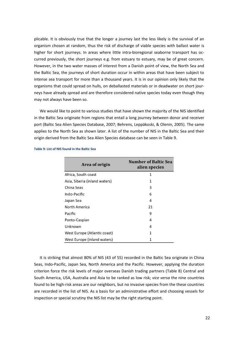
We would like to point to various studies that have shown the majority of the NIS identified
in the Baltic Sea originate from regions that entail a long journey between donor and receiver
port (Baltic Sea Alien Species Database, 2007; Behrens, Leppäkoski, & Olenin, 2005). The same
applies to the North Sea as shown later. A list of the number of NIS in the Baltic Sea and their
origin derived from the Baltic Sea Alien Species database can be seen in Table 9.
Table 9: List of NIS found in the Baltic Sea
It is striking that almost 80% of NIS (43 of 55) recorded in the Baltic Sea originate in China
Seas, Indo-Pacific, Japan Sea, North America and the Pacific. However, applying the duration
criterion force the risk levels of major overseas Danish trading partners (Table 8) Central and
South America, USA, Australia and Asia to be ranked as low risk; vice versa the nine countries
found to be high-risk areas are our neighbors, but no invasive species from the these countries
are recorded in the list of NIS. As a basis for an administrative effort and choosing vessels for
inspection or special scrutiny the NIS list may be the right starting point.
23
It underlines our point that a long duration not automatically results in a low risk. On the
contrary, one may expect that the few organisms, which do indeed survive a long journey, are
robust and have the potential to invade the new area under the right circumstances. We do
acknowledge the specific problems exists when traffic takes place from river to river or estuary
to estuary, and the need for additional risk assessment in such cases, but for our purpose of
national assessment we do propose a slightly amended approach and reevaluated the quan-
tifier “duration”. All countries that were quoted with 1 for a low risk were now quoted with 3
and vice versa thus giving weight to long durations. The countries with the status 2 were not
exchanged.
The new values of the three quantifiers were added together and were quoted as followed:
High-risk regions = 9 and 8
Medium-risk regions = 7 and 6
Low-risk regions = ≤ 5
The new ranking can be seen in Table 10.
24
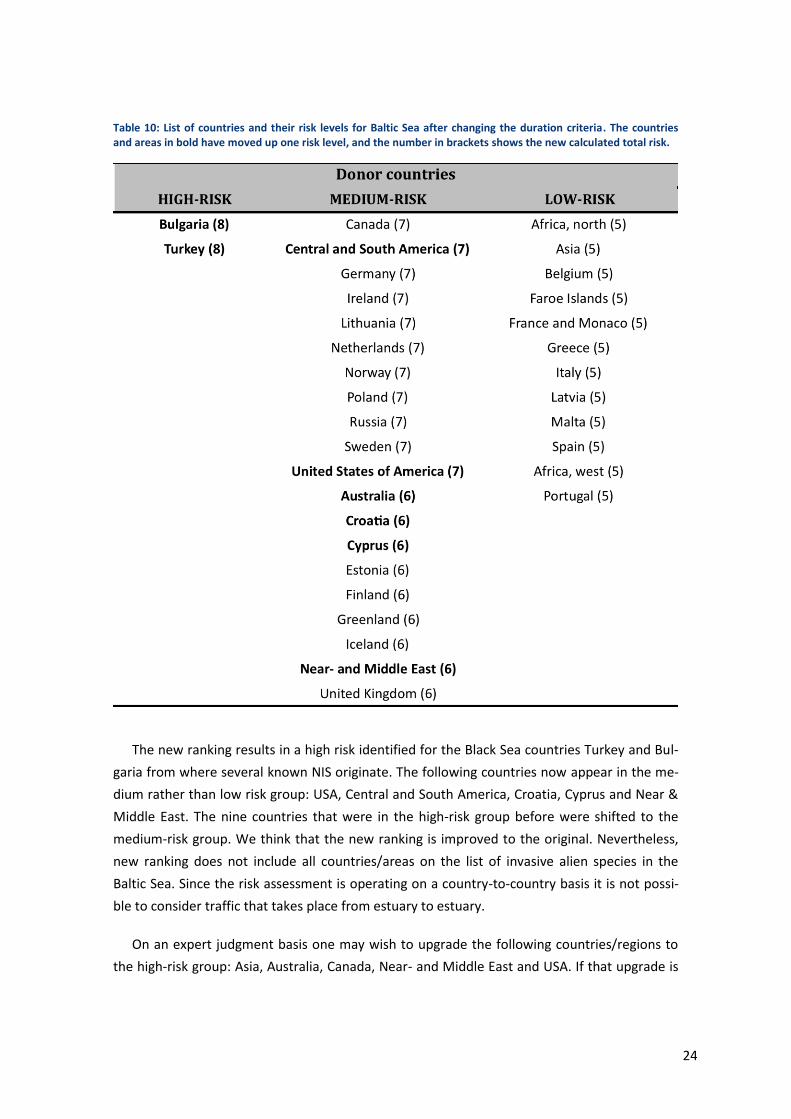
Table 10: List of countries and their risk levels for Baltic Sea after changing the duration criteria. The countries and areas in bold have moved up one risk level, and the number in brackets shows the new calculated total risk.
The new ranking results in a high risk identified for the Black Sea countries Turkey and Bul-
garia from where several known NIS originate. The following countries now appear in the me-
dium rather than low risk group: USA, Central and South America, Croatia, Cyprus and Near &
Middle East. The nine countries that were in the high-risk group before were shifted to the
medium-risk group. We think that the new ranking is improved to the original. Nevertheless,
new ranking does not include all countries/areas on the list of invasive alien species in the
Baltic Sea. Since the risk assessment is operating on a country-to-country basis it is not possi-
ble to consider traffic that takes place from estuary to estuary.
On an expert judgment basis one may wish to upgrade the following countries/regions to
the high-risk group: Asia, Australia, Canada, Near- and Middle East and USA. If that upgrade is
25
included, the ballast water discharged for vessels coming from the high-risk countries/regions
would then add up to 546,600 t in 2007.
7.3.2. Results of risk assessment North Sea
The North Sea risk assessment was undertaken as described above. The rating for the quan-
tifier “Salinity” was adjusted due to different salinity ranges than in the Baltic Sea. The quan-
tifiers “Duration” and “Temperature zone” were employed in a similar way to the Baltic Sea
risk assessment. The values of the three quantifiers were added together and were quoted as
followed:
High-risk regions = 9 and 8
Medium-risk regions = 7 and 6
Low-risk regions = ≤ 5
The results are given in Table 11 for the risk model.
Table 11: List of countries ordered by risk levels for North Sea.
26
According to the risk assessment 11 of the 25 countries/areas are in the high-risk group.
The following countries belonging to this category: Belgium, Faroe Islands, Germany, Ireland,
Netherlands, Norway, Sweden, United Kingdom, Canada, Iceland and Portugal. As it can be
seen in Table 11 11 countries are quoted medium-risk regions, and three countries are quoted
low-risk regions. As mentioned before, the quantifier “Duration of the voyage” should be chal-
lenged. The list of NIS found in the North Sea, shown in Table 12, displays that the NIS origi-
nate mainly far away from the North Sea ( AeT umweltplanung, 2009; Behrens, Leppäkoski, &
Olenin, 2005; DAISIE, 2009).
Table 12: List of NIS found in the North Sea
A recalculation similar to the one for the Baltic Sea was performed. The new ranking is
shown in

27
Table 13.
28
Table 13: List of countries and their risk levels for North Sea after changing the duration criteria. The countries and areas in bold have moved up one risk level, and the number in brackets shows the new calculated total risk.
The new ranking shows five instead of 11 countries in the high-risk group. Canada and Icel-
and are the two countries that remained in the high-risk category. All the other countries
moved to medium-risk group. The following three countries shifted to the high-risk segment:
Australia, Cyprus and the United States of America. One country (Poland) is now low-risk. Ac-
cording to the list of NIS shown in Table 12 following countries/regions are in a high-risk class:
Asia, Australia, Canada, Near- and Middle East and USA. Except for Asia and Near- and Middle
East, these countries/regions now match with the countries/regions from the high-risk group
found in the risk assessment. Asia and Near- and Middle East should be added to the high-risk
class. If the regions are added, the amount of discharged ballast water coming from the high-
risk countries/regions totals in 14,100 t.
29
8. Options and recommendations
The evaluation of two different procedures to estimate the discharged ballast water in
Denmark showed that with a simple estimation based on cargo statistics and a ballast-to-cargo
ratio of 30% it is possible to estimate the volume of discharged ballast water in Denmark.
The amount estimated by the simple cargo based method was 8.1 million ton and the esti-
mate provided by the alternative method was 9.8 million ton based on German data adjusted
partially for Danish conditions. With a very simple calculation based on cargo statistics it is
considered a success to arrive at estimates within less than 20% deviation.
None of the methods include ship-to-ship operations in Danish waters, which were esti-
mated based on from data reported to the Danish authorities. The amount of discharged bal-
last water resulting from STS operations was estimated at 1.1 million ton on the base of the
average pumped quantity in 2004 to 2007.
This brings the total discharged ballast water amount to 9.2 million ton or 10.9 million ton
depending on the estimation method used.
Both estimates would benefit from a more detailed set of base data. To modify the estima-
tion and model for Denmark, data of the average DWT, the maximum ballast water capacity,
the volume of ballast water onboard and the percentage of discharged ballast water in ports
and waterways for selected ship types have to be collected. The information can be obtained
from commercial databases or directly at the ports via a questionnaire.
The origin of cargo, i.e. the donor countries/regions, was rated high-risk, medium-risk or
low-risk for two Danish water bodies, the North Sea and the Baltic Sea, according to three cri-
teria: salinity, temperature and duration of voyage. A risk assessment scheme that reflects the
existing risk as given by the origin of current invasive species is proposed. The country-to coun-
try base risk assessment is a good first indicator, but it aims broadly and lacks in detail. With-
out port-to-port data the identification of high risk vessels with respect to discharge of ballast
water and the Danish port in which they trade is possible only at the present level. Additional
information to allow risk assessment on a port-to-port base can be obtained from either com-
mercial databases on via a questionnaire exercise.
30
9. Bibliography
AeT umweltplanung. (2009, January). aquatic-aliens.de. Retrieved April 2009, from
http://www.aquatic-aliens.de/index.htm
Attilios at en.wikipedia. (2005). Wikimedia Commons. Retrieved June 2009, from
http://commons.wikimedia.org/wiki/File:Carte_Skagerrak-Kattegat2.png
Baltic Sea Alien Species Database. (2007, November). Baltic Sea Alien Species Database. (D.
Daunys, Editor) Retrieved April 2009, from http://www.corpi.ku.lt/nemo/mainnemo.html
Behrens, H. L., Leppäkoski, E., & Olenin, S. (2005). Ballast Water Risk Assessment Guidelines
for the North Sea and Baltic Sea. Oslo: Nordic Innovation Centre.
DAISIE. (2009). Delivering Alien Invasive Species Inventories for Europe. Retrieved April
2009, from http://www.europe-aliens.org/index.jsp
Danmarks Statistik. (2009). StatBank Denmark. Retrieved February 4, 2009, from
statistikbanken: http://www.statistikbanken.dk/statbank5a/default.asp?w=1280
Data Analysis Australia. (2009). Data Analysis Australia. Retrieved May 2009, from
Response Rates: http://www.daa.com.au/analytical-ideas/response-rates/
Ekman, S. (1953). Zoogeography of the Sea. London: Sigwick & Jackson Ltd.
Folkestad, A., Nygaard, K., Molvær, J., Oug, E., Kaste, Ø., Kroglund, T., et al. (2008).
Knowledge status and gaps for the North Sea – focusing on discharges. Norwegian Institute for
Water Research, Department of Control, Water and International Affairs. Oslo: SFT.
GloBallast. (2009). GloBallast Paartnerships. Retrieved Feb 2009, from The Problem:
http://globallast.imo.org/index.asp?page=problem.htm&menu=true
Gollasch, S. (1996). Untersuchungen des Arteintrages durch den internationalen
Schiffsverkehr unter besonderer Berücksichtigung nichtheimischer Arten. Dissertation,
Hamburg.
GraphicMaps.com. (n.d.). World Atlas Travel. Retrieved June 2009, from North Sea:
http://www.worldatlas.com/aatlas/infopage/northsea.gif
Grænselandsportalen. (2008, August). Grænselandsportalen. Retrieved May 2009, from
Admininstration og infrastruktur:
31
http://www.grenzlandportal.dk/default.asp?objtype=artikel2&func=showdetail&id=3081&ilan
guage=dansk&menuItem=menuItemA_a_5581_a_&curMenu=A
HELCOM. (2009). The nature of the Baltic Sea. Retrieved 04 15, 2009, from Helsinki
Commission - Baltic Marine Environment Protection Commission:
http://www.helcom.fi/environment2/nature/en_GB/nature/
ihk-schleswig-holstein. (n.d.). Unternehmensdatenbank . Retrieved January 29, 2009, from
ihk-schleswig-holstein: http://www.ihk-schleswig-
holstein.de/Ressourcen/startApplication.jsp?applicationId=fit
Leppäkoski, E., & Gollasch, S. (2007). Risk assessment and management scenarios for
ballast water mediated species introductions into the Baltic Sea (Vol. 2). Aquatic Invasion.
Maersk Broker. (2009). Ship-To-Ship operations. Retrieved April 2009, from Maersk Broker:
http://www.maerskbroker.com/default.asp
Maersk Tankers. (n.d.). Retrieved March 2009, from Distance Table:
http://www.maersktankers.com/crude/toolbox/distance/distance.asp
Maritimes Cluster Schleswig-Holstein. (2008). (A. Kasch, & M. Heinrichsen, Eds.) Kiel: A+I
Verlag GmbH.
NOBANIS. (n.d.). North European and Baltic Network on Invasive Alien Species. Retrieved
May 2009, from http://www.nobanis.org/default.asp
Royal Haskoning. (2008). Ballast water quantities Port of Rotterdam Ballast water intake
and discharge February 2008. Final Report, Rotterdam.
Sanderhoff, J. (2002). Speciale del 1: Akvatiske organismer i skibes ballastvand, Speciale del
2: En introduktionsvej for fremmede arter til Danmark . Master Thesis, Aarhus.
Shipping Federation of Canada. (2004, September). shipfed.ca. Retrieved May 2009, from
http://www.shipfed.ca/eng/library/fed_presentations/20040922BW.ppt
Soefartsstyrelsen. (2008, June). Søfartsstyrelsen. Retrieved April 2009, from Overførsel af
lastolie i danske farvande: www.soefartsstyrelsen.dk/SiteCollectionDocuments/CMR/Fakta-
om-STS-operationer.pdf
SOK. (2009, March 25). Pers. communication with Frank Espersen.
Suban, V., David, M., & Perkovič, M. (2004). Models for Defining the Quantity of Discharged
Ballast in the Recent Past. 8th International Conference on Traffic Science. Portoroz.
32
Walters, S. (1996). Ballast water, hull fouling and exotic marine organism introductions via
ships - A Victorian study. Environment Protection Authority .
WTSH. (n.d.). (W. u.-H. GmbH, Producer) Retrieved January 29, 2009, from Maritim-Report:
www.wtsh.de
33
10. APPENDIX Questionnaire assessment
10.1. Generation of ballast water data via questionnaires
A good source of information on ballast water is obviously the vessels themselves, and to
obtain data one may perform a survey of ballast water management on vessels in Danish main
harbours via a questionnaire.
The advantages of a questionnaire are:
Information is collected directly from the source
Information can be collected with a high degree of specificity from a carefully se-
lected group
The disadvantages of a questionnaire are:
Often it is labour intensive or one faces a high risk of a low return rate
Feedback data might not be representative
Questionnaires are standardised in a “one size fits all” format so there is little pos-
sibility to cover and clarify questions that participants might misinterpret
10.2. The experience from Port of Rotterdam
A survey on ballast water was carried out in Port of Rotterdam in 2007-2008 by Royal
Haskoning (2008). The aim of the questionnaire in Rotterdam was slightly different from the
present study’s, since it was to obtain an estimate of where in the port how much ballast wa-
ter was taken in and discharged. The information was collected with a voluntary questionnaire
that contained questions concerning the vessels particulars, ballast water intake and dis-
charge, the ballast water capacity and other remarks. The questionnaires were handed over
onboard to the ship’s captain, the Port of Rotterdam Authority (Harbour Master Division), Port
State Control or the Regional Pilots Cooperation Rotterdam-Rijnmond. Based on the returned
(acceptable) questionnaires weighted average ballast water intake and discharged quantities
per ship type and size21 were calculated. The relation between GT and ballast water in-
take/discharge was not presented or can be derived from the report. In order to be able to
21 ForIndivdual ship size cannot be indentified the ship size since the following categories
were used: GT ≤ 20,000; GT > 20,000 and ≤ 60,000; GT > 60,000.
34
calculate the total amounts of intake and discharge ballast water for a period of one or 12
month, respectively the following information was collected:
Total number of ships visiting in February, based on ship type
Total number of ships visiting in a 12 month period, based on ship types
In the one-month period (February 2008) the number of ships, visiting the Port of Rotter-
dam, was 2,409. In comparison the number of reported calls during the 12-month period
(March 2007 to March 2008) was 37,151. The quantity of total ballast water intake amounted
to 6.12 million m3 and the total discharged ballast water quantity to 2.76 million m3 in Febru-
ary 2008. These numbers were multiplied with 12.62 to obtain the quantity for a 12-month
period. The results of the ballast water intake and discharge quantity were a worst-case calcu-
lation. For practical reasons the assumption was made that ballast water was taken in or dis-
charged only in the harbour basins and not during the voyage.
It should be kept in mind that the Rotterdam questionnaire was voluntary, and the re-
turned acceptable questionnaires (187) represented approximately 8 % of the total number of
vessels calling on the port of Rotterdam during the investigation period. In this specific case,
the results of the questionnaire were considered representative for the Port of Rotterdam.
10.3. How to cover important Danish ports with a questionnaire
In a Danish exercise with a questionnaire approach obviously only ports that are represent-
ative and important for the ballast water discharge in Denmark should be taken into consider-
ation. In order to detect the high-risk ports with regard to discharged ballast water, following
information was of interest:
Cargo vessels were investigated because cargo vessels discharge more ballast water
compared to passenger vessels
Larger vessels carry more ballast water than the smaller vessels
Vessels involved in long distance traffic potentially have a higher risk of carrying
non-indigenous species
Amount of goods loaded and unloaded as an indicator for ballast water discharge
Amount of loaded goods in international traffic as an indicator for ballast water dis-
charge from potentially high risk regions
35
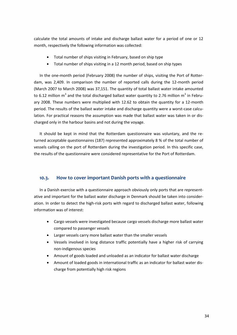
The data derived from the database SKIB22122 (Danmarks Statistik, 2009) shows how many
calls of cargo vessels on Danish ports were made with regard to the vessel size in GT. The data
includes all calls made in Danish ports in 2007, regardless if they were domestic or interna-
tional. By looking at the numbers of the calls it is clearly evident that up to 45 % of the calls
were made by vessels with less than 1499 GT. Due to their size, these vessels are rather used
for short distance journeys which means that these vessels are used in the domestic traffic.
The remaining 55 % are composed of vessels bigger than 1500 GT, whereas vessels with 5000 –
9999 GT take with 40 % the biggest fraction. It is assumed that these vessels are used for long
distance voyages and/or are oceangoing and therefore relevant in terms of transporting ballast
water over longer distances. The distribution is shown in the left side of Figure 10. To calculate
the maximum GT capacity of each fraction, the number of calls for each fraction was multiplied
with the value of the upper bound of the fraction. The right side of Figure 10 shows the distri-
bution of the maximum GT capacity.
Figure 10: Left: Percentage of call of cargo vessels on Danish ports arranged by vessel size in 2007. Right: Percen-tage of maximum GT capacity in 2007
Figure 10 (right panel) shows that vessels less than 1499 GT are responsible for approx-
imately 10 % of the total GT capacity. These vessels presumably have only a share of 10 % of
the discharged ballast water and since it is assumed that these vessels are mostly used in do-
mestic traffic and short sea traffic, all vessels with less than 1499 GT can be excluded.
The distribution of vessel size and call of vessels per port is presented in Figure 11.
22 SKIB221: Call of vessels on Danish ports by seaport, type of vessel and gross tonnage (GT)
36
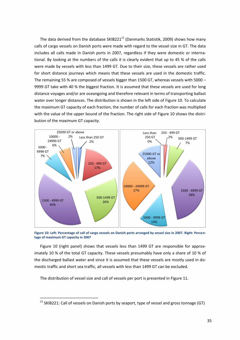
Figure 11: Danish ports and number of ships by vessel size visiting the respective port. All ports had at least one call of a vessel in the range between 10000 – 24999 GT in 2007.
13 of the shown harhours (Københavns Havn, Fredericia Havn, Århus Havn, Esbjerg Havn,
Statoil-havnen, Enstedværkets Havn, Stigsnæsværkets Havn, Asnæsværkets Havn, Aabenraa
Havn, Frederikshavn Havn, Kalundborg Havn, Rønne Havn, Nyborg Havn) had calls of vessels
larger than 25,000 GT in 2007. Vessels larger than 10,000 GT carried 40 % of the transported
goods in Denmark (shown in Figure 10). This information was used to select the harbours that
were further examined. Six ports i.e. Port of Esbjerg, Entstedværkets Havn, Port of Copenha-
gen, Statoil-havnen, Port of Aarhus and Port of Fredericia became apparent as the ports with
the highest risk potential judged from the number of calls of larger vessels. Due to the fact that
ballast water is discharged only from ships that load cargo, the quantity of loaded goods was
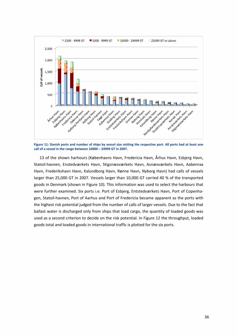
used as a second criterion to decide on the risk potential. In Figure 12 the throughput, loaded
goods total and loaded goods in international traffic is plotted for the six ports.
37
Figure 12: The throughput, loaded goods total and loaded goods in international traffic for six high volume se-lected harbours.
The throughput of these six harbours sums up to 67 % of the total throughput in Denmark
for 2007. Furthermore, these six ports were responsible for roughly 75 % of the loaded goods
total and the loaded goods in international traffic, respectively in Denmark in the same year.
The port Enstedvækets Havn was disregarded because almost 90 % (2,526,000 t) of the loaded
goods were coal (SKIB45123) transported domestically and distributed to Danish power plants
(Grænselandsportalen, 2008). Therefore, it is assessed that the discharged ballast water would
origin from domestic waters and is not of interest. The other five ports are considered to be of
importance for a questionnaire.
10.4. How to generate data by questionnaire
According to the data from SKIB7224 (Danmarks Statistik, 2009) the quantities of goods in
ports do vary not much with the season. Therefore, it should be possible to conduct a repre-
sentative inventory over a select period, e.g. a month or quarterly period.
23 SKIB451: Throughput of goods in Danish ports in national traffic by seaport, direction and
type of goods 24 SKIB72: Throughput of goods in major Danish seaports by seaport, direction and type of
goods
38
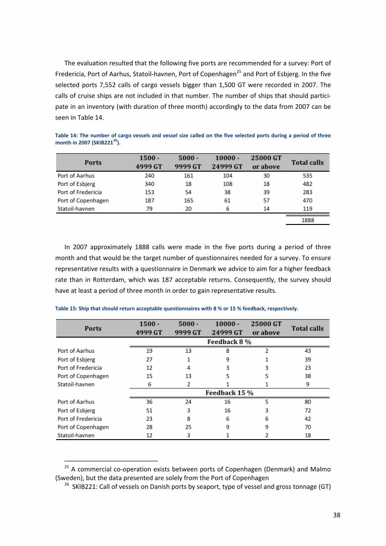
The evaluation resulted that the following five ports are recommended for a survey: Port of
Fredericia, Port of Aarhus, Statoil-havnen, Port of Copenhagen25 and Port of Esbjerg. In the five
selected ports 7,552 calls of cargo vessels bigger than 1,500 GT were recorded in 2007. The
calls of cruise ships are not included in that number. The number of ships that should partici-
pate in an inventory (with duration of three month) accordingly to the data from 2007 can be
seen in Table 14.
Table 14: The number of cargo vessels and vessel size called on the five selected ports during a period of three month in 2007 (SKIB221
26).
In 2007 approximately 1888 calls were made in the five ports during a period of three
month and that would be the target number of questionnaires needed for a survey. To ensure
representative results with a questionnaire in Denmark we advice to aim for a higher feedback
rate than in Rotterdam, which was 187 acceptable returns. Consequently, the survey should
have at least a period of three month in order to gain representative results.
Table 15: Ship that should return acceptable questionnaires with 8 % or 15 % feedback, respectively.
25 A commercial co-operation exists between ports of Copenhagen (Denmark) and Malmo
(Sweden), but the data presented are solely from the Port of Copenhagen 26 SKIB221: Call of vessels on Danish ports by seaport, type of vessel and gross tonnage (GT)
39
The numbers in Table 15 show that a feedback of 8 % yields approximately 150 replies. In
order to reduce risk of misleading or biased a target of 250 replies may be used. A low re-
sponse rate, however, does not automatically mean that the results are biased as long as the
non-respondent are not different from the respondent (Data Analysis Australia, 2009)
The questionnaires should be handed over to the ship’s captain or substitute by a repre-
sentative of the Harbour Master Division, the Danish Maritime Authority, a responsible organi-
zation an agent or similar, who will go on board the ship calling one of the selected ports. Since
a mandatory response is not possible collection of the questionnaires is very important and it
maybe required to call the responsible persons and press for the return of the questionnaires
or to offer a reward for returned questionnaires. The questionnaire design can also influence
the response rate. In order to increase the response rate the length and complexity of the
survey should be minimized. Ensure that the questions are not ambiguous and have clear in-
structions and only ask what is necessary.