Embed Size (px)
Citation preview

September 2014 – Version 0.1 — 3 —
Contents
Executive summary ..................................................................................................... 5
1. Introduction ......................................................................................................... 7
2. Vision ..................................................................................................................... 8
3. Objectives and principles ................................................................................... 9
3.1 Council objectives ..................................................................................................................................10 3.2 Bicycle strategy objectives ....................................................................................................................10 3.3 Timeframe of the Ballarat Cycling Strategy........................................................................................11 3.4 Overarching principles for cycling in Ballarat ....................................................................................11 3.5 Council's role: .........................................................................................................................................13
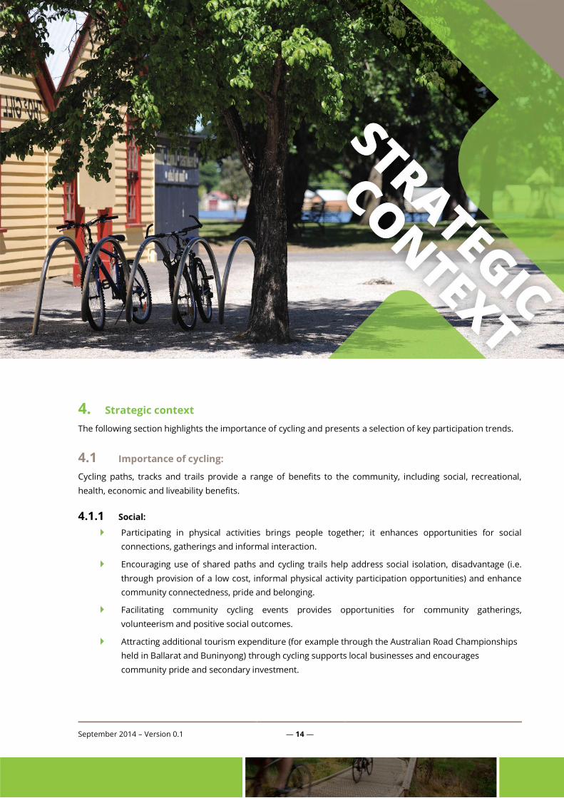
4. Strategic context ............................................................................................... 14
4.1 Importance of cycling: ...........................................................................................................................14 4.2 Cycling participation trends .................................................................................................................16
5. Ballarat Bicycling Strategy – The Local Context ........................................... 21
5.1 Background reports and research: .....................................................................................................22 5.2 Planning for population growth ..........................................................................................................27 5.3 City of Ballarat participation data - Super Tuesday reports.............................................................30
6. How will we get there? ..................................................................................... 33
6.1 On-road routes: .....................................................................................................................................34 6.2 Off-road routes: .....................................................................................................................................35 6.3 Mountain Bike trails (MTB): ..................................................................................................................36 6.4 Support infrastructure: .........................................................................................................................36 6.5 Programs and services: .........................................................................................................................37 6.6 Partnerships and collaborations: ........................................................................................................38 6.7 Resourcing: .............................................................................................................................................38 6.8 Evaluation: ..............................................................................................................................................41
7. Conclusions ........................................................................................................ 44
APPENDIX A: Link between Council objectives and strategy outcomes............ 45
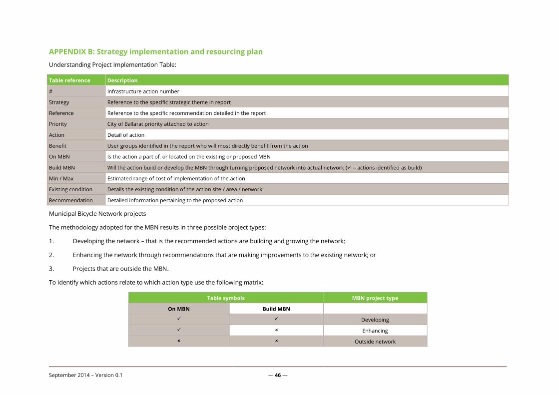
APPENDIX B: Strategy implementation and resourcing plan ............................. 46
Appendix C: Infrastructure guidelines and standards ......................................... 57

September 2014 – Version 0.1 — 4 —
List of tables Table 1: Relevant Council objectives ..................................................................................................10
Table 2: Principles used to guide strategy development ..................................................................12
Table 3: Background research summary ............................................................................................27
Table 4: Busiest commuter routes ......................................................................................................31
Table 5: Indicative costs of implementation ......................................................................................39
Table 6: MBN - Indicative costs of implementation ...........................................................................39
List of figures Figure 1: Strategic framework for the development of the Ballarat Cycling Strategy .......................9
Figure 2: Top 5 physical activities of Victorian adults ........................................................................17
Figure 3: Adult participation in cycling / BMX ....................................................................................18
Figure 4: Adult cycling / BMXing by age ..............................................................................................19
Figure 5: Ballarat's population growth (2013 - 2038) .........................................................................28
Figure 6: Population growth trends by Ballarat suburb ....................................................................29
Figure 7: Surf Coast signage encouraging courteous shared trail behaviour ..................................37
Figure 8: Spatial representation of implementation activities .........................................................40
Figure 9: Spatial representation of MBN implementation developing / building activities ............41
Figure 10: Spatial representation of MBN implementation enhancing activities ............................42

September 2014 – Version 0.1 — 5 —
Executive summary
The Ballarat Bicycle Strategy analyses a range of factors and influences before recommending a series of
practical projects to be delivered across the municipality over the next short, medium and longer terms.
The strategy has been developed as part of a broader suite of sport and recreation strategies. The
predominance, level of participation and anticipated growth in cycling within the Ballarat community warranted
cycling being considered as a ‘stand-alone’ strategy. To this end, this strategy can be read as a stand-alone
document, or in conjunction with the City of Ballarat’s Recreation Strategy (2014).
This strategy articulates a vision for cycling in Ballarat. The vision is further developed into a series of objectives
and principles which have been used to guide the development of the strategy. The objectives of this strategy
have been linked to the broader City of Ballarat Council objectives of planning for growth, managing assets,
promoting a healthy lifestyle and promoting accessibility and inclusion. The role of Council in delivering the
strategy is also detailed.
The strategy assesses the broader context in which bicycling is developing and the factors influencing bicycling
in Australia. The benefits of bicycling to the community from a social, recreational, health, economic and
liveability perspective are identified and examined.
The key participation-related trends are also identified and examined from the perspectives of both adults and
children. The implications of these participation trends are identified for consideration in the formulation of the
strategy’s recommendations.
A detailed examination of bicycling within the local context has also been undertaken. This includes an
extensive review of key strategies and policies, as well as local development plans and influences. There has
been extensive consultation with key stakeholders undertaken as part of the formation of these strategies and
accompanying background materials. A draft strategy was released for public comment. All submissions were
reviewed and the strategy amended to take these submissions.
Relevant implications and planning considerations are identified throughout this document.
The critical issue of Ballarat’s growing population is examined and implications assessed. Research from ‘Super
Tuesday’ is examined and the results utilised in the formulation of the final recommendations and strategies.
From this analysis, a series of recommendations have been developed, mapped, prioritised, costed and
reconciled to Ballarat’s Municipal Bicycle Network.
Recommendations for the cycling network have been presented under the sub-headings of on-road routes, off-
road routes, mountain bike trails, support infrastructure, programs and service and partnerships and
collaborations. Resourcing and evaluation have been considered and discussed.
September 2014 – Version 0.1 — 6 —
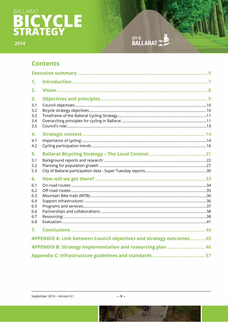
The strategy recommends 43 specific actions, which are prioritised and costed as follows:
Priority Number Min$ (000’s) Max $ (000’s)
High 8 660 790
Medium 21 1,910 2,140
Low 12 780 971
Total 41 $3,350 $3,901
Develop Municipal Bike Network 22 2,040 2,349
Enhance Municipal Bike Network 10 595 672
Non-Municipal Bike Network 9 715 880
Total 41 $3,350 $3,901
September 2014 – Version 0.1 — 7 —
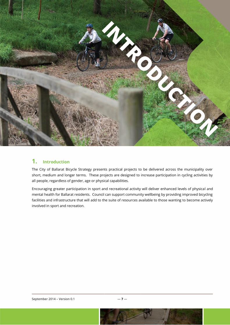
1. Introduction
The City of Ballarat Bicycle Strategy presents practical projects to be delivered across the municipality over
short, medium and longer terms. These projects are designed to increase participation in cycling activities by
all people, regardless of gender, age or physical capabilities.
Encouraging greater participation in sport and recreational activity will deliver enhanced levels of physical and
mental health for Ballarat residents. Council can support community wellbeing by providing improved bicycling
facilities and infrastructure that will add to the suite of resources available to those wanting to become actively
involved in sport and recreation.

September 2014 – Version 0.1 — 8 —
2. Vision
The vision for the Ballarat Cycling Strategy is:
To make Ballarat a more cycling friendly environment that caters for all types of cyclist.
Ballarat will provide first class cycling facilities for all members of the community regardless of gender, age, ability and
cultural background and we will promote the benefits of a healthy, active lifestyle for all residents.
Well planned and varied cycling facilities will make Ballarat a destination for others in the region for play, fun and
competition.
Over the longer term Ballarat will be a world regarded and internationally recognised bicycling destination.
September 2014 – Version 0.1 — 9 —
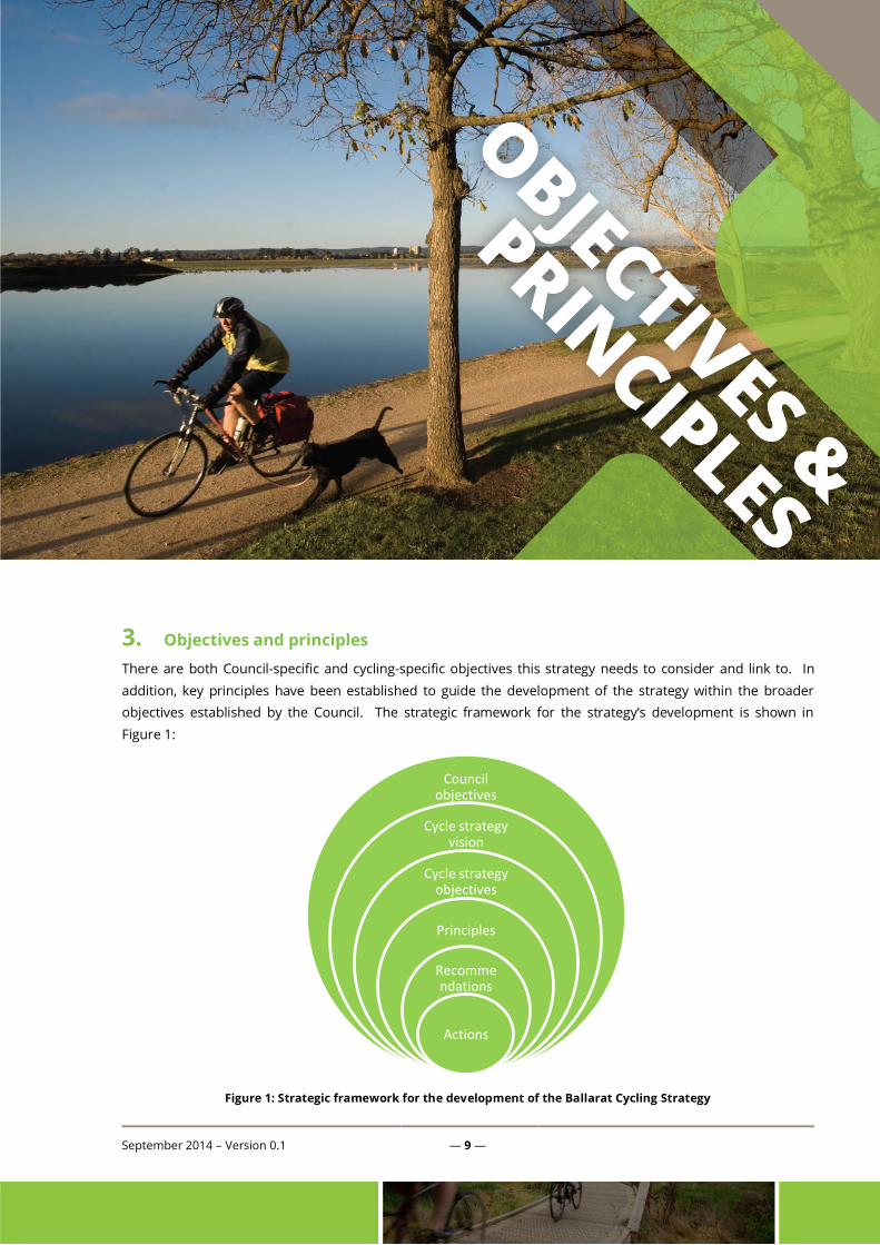
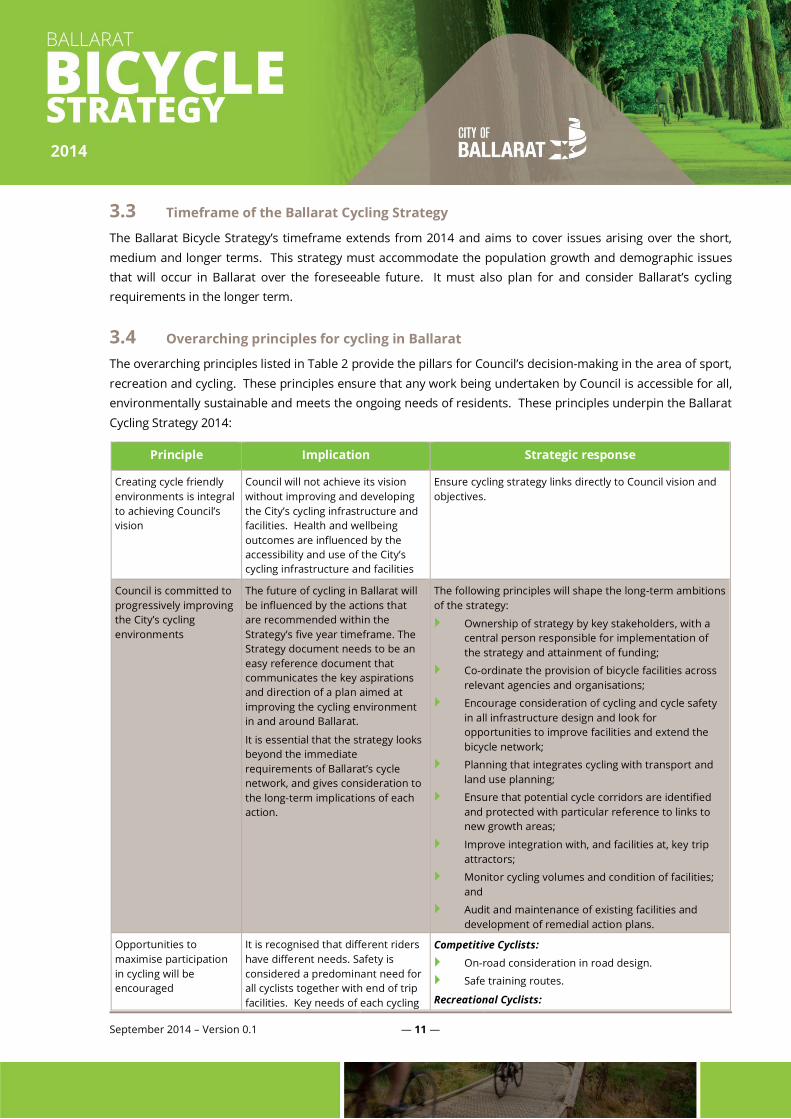
3. Objectives and principles
There are both Council-specific and cycling-specific objectives this strategy needs to consider and link to. In
addition, key principles have been established to guide the development of the strategy within the broader
objectives established by the Council. The strategic framework for the strategy’s development is shown in
Figure 1:
Figure 1: Strategic framework for the development of the Ballarat Cycling Strategy
Council objectives
Cycle strategy vision
Cycle strategy objectives
Principles
Recommendations
Actions

September 2014 – Version 0.1 — 10 —
3.1 Council objectives
Relevant Council objectives for the cycling strategy are outlined in Table 1:
Theme Objective Rationale for inclusion in bicycle strategy
Growth and
development
Planning for growth Number and type of bicycle infrastructure and facilities need to reflect City
needs now and into the future.
Managing our assets Assessing and improving bicycle infrastructure and facilities are critical to
the objectives of improving access to leisure and recreational facilities and
reducing the City’s infrastructure renewal gap.
Provides opportunities for increases in a range of tourism and event
markets.
People and
communities
Promoting healthy lifestyle Cycling is one of the most popular physical activities for Victorian adults.
Promoting accessibility and
inclusion
The useability and accessibility of bicycle infrastructure and facilities across
all age groups and areas goes to the objective of accessibility and inclusion.
Table 1: Relevant Council objectives
There is a clear link between the need to continually assess the suitability of the City’s bicycle infrastructure and
facilities and Council objectives.
3.2 Bicycle strategy objectives
The cycling-specific objectives that need to be delivered through this strategy are:
Through cycling, increase participation in physical activity and recreation by Ballarat residents to
achieve National Physical Activity Guidelines;
Cater for all cyclists, including different skill levels, cycling types and usage patterns;
Build on the existing cycle infrastructure to provide a comprehensive, integrated network of on-road
and off-road paths, tracks and trails;
Enhance connectivity between central amenities and transport opportunities, together with
connections to new growth areas;
Improve the safety and amenity of Ballarat’s cycle network;
Integration of cycling with transport and land use planning;
Improved coordination of cycling facilities and infrastructure provision across Council and relevant
external organisations;
Provide a basis for increases in recreational and event tourism; and
Providing ongoing support to a range of cycling events, activities and encourage community
participation.
September 2014 – Version 0.1 — 11 —
3.3 Timeframe of the Ballarat Cycling Strategy
The Ballarat Bicycle Strategy’s timeframe extends from 2014 and aims to cover issues arising over the short,
medium and longer terms. This strategy must accommodate the population growth and demographic issues
that will occur in Ballarat over the foreseeable future. It must also plan for and consider Ballarat’s cycling
requirements in the longer term.
3.4 Overarching principles for cycling in Ballarat
The overarching principles listed in Table 2 provide the pillars for Council’s decision-making in the area of sport,
recreation and cycling. These principles ensure that any work being undertaken by Council is accessible for all,
environmentally sustainable and meets the ongoing needs of residents. These principles underpin the Ballarat
Cycling Strategy 2014:
Principle Implication Strategic response
Creating cycle friendly
environments is integral
to achieving Council’s
vision
Council will not achieve its vision
without improving and developing
the City’s cycling infrastructure and
facilities. Health and wellbeing
outcomes are influenced by the
accessibility and use of the City’s
cycling infrastructure and facilities
Ensure cycling strategy links directly to Council vision and
objectives.
Council is committed to
progressively improving
the City’s cycling
environments
The future of cycling in Ballarat will
be influenced by the actions that
are recommended within the
Strategy’s five year timeframe. The
Strategy document needs to be an
easy reference document that
communicates the key aspirations
and direction of a plan aimed at
improving the cycling environment
in and around Ballarat.
It is essential that the strategy looks
beyond the immediate
requirements of Ballarat’s cycle
network, and gives consideration to
the long-term implications of each
action.
The following principles will shape the long-term ambitions
of the strategy:
Ownership of strategy by key stakeholders, with a
central person responsible for implementation of
the strategy and attainment of funding;
Co-ordinate the provision of bicycle facilities across
relevant agencies and organisations;
Encourage consideration of cycling and cycle safety
in all infrastructure design and look for
opportunities to improve facilities and extend the
bicycle network;
Planning that integrates cycling with transport and
land use planning;
Ensure that potential cycle corridors are identified
and protected with particular reference to links to
new growth areas;
Improve integration with, and facilities at, key trip
attractors;
Monitor cycling volumes and condition of facilities;
and
Audit and maintenance of existing facilities and
development of remedial action plans.
Opportunities to
maximise participation
in cycling will be
encouraged
It is recognised that different riders
have different needs. Safety is
considered a predominant need for
all cyclists together with end of trip
facilities. Key needs of each cycling
Competitive Cyclists:
On-road consideration in road design.
Safe training routes.
Recreational Cyclists:
September 2014 – Version 0.1 — 12 —
Principle Implication Strategic response
group are identified in the adjacent
column.
On and off-road infrastructure supportive of all
levels of cyclist.
Signs to amenities and transport opportunities.
Supporting facilities including water fountains and
cycle parking.
Safe routes.
Commuter Cyclists:
On and off-road infrastructure supportive of all
levels of cyclist.
Direct connections from residential areas to
employment centres.
Good end of trip facilities at place of work.
Safe routes.
Tourism Cyclists:
On and off-road infrastructure with clear legible
signage to amenities and tourism attractions.
Useful and easily accessible information.
Supporting facilities including water fountains, cycle
parking and cycle shops/hire.
Safe routes.
Novice Cyclists:
Off-road cycling opportunities with safe negotiation
of conflict locations with vehicles.
Access to safe cycling information.
Supporting facilities including water fountains and
cycle parking.
Safe routes
Further development of
partnerships in cycling
with relevant agencies
and community groups
will be critical to
achieving the vision.
Council will foster partnerships with
relevant government agencies and
community groups to help facilitate
infrastructure provision and cycling
participation opportunities.
Council will play a key role in advocating to VicRoads for
improvements to the on-road cycling network.
Council will advocate to V/Line and public transport
providers for improved end of trip facilities and improved
options for travelling with bicycles.
Council will continue to support local cycling clubs, groups
and community participation opportunities.
Priorities and staged
implementation of
improvement initiatives
will reflect community
needs and the City's
resource capacity.
Council resource allocation will be
guided by the prioritised
implementation plan.
Recommendations reflect community needs as identified
in previous consultation activities.
Resource allocation will be subject to Council's annual
budget deliberation process.
Opportunities to attract external grants and funding will be
explored where appropriate.
Table 2: Principles used to guide strategy development

September 2014 – Version 0.1 — 13 —
3.5 Council's role:
Council's role in the provision and support of cycling initiatives is varied and complex. At varying stages,
Council may be responsible for:
Asset management, development and maintenance;
Planning authority;
Tourism and economic development;
Referral agency;
Partner / leader;
A shared responsibility with parents, schools and children to improve bicycle education, awareness
or safety;
Advocacy and working collaboratively for positive change and outcomes;
Enforcer / compliance;
Direct service provision, e.g. programs and events;
Communications, marketing, education; and
Health promotion.
There may be opportunities for improved collaboration and coordination between Council departments
towards common goals and strategic directions for cycling. This could be assisted by identifying a single
Council officer (i.e. champion) with responsibility for overseeing cycling initiatives and overall implementation of
this strategy.
September 2014 – Version 0.1 — 14 —
4. Strategic context
The following section highlights the importance of cycling and presents a selection of key participation trends.
4.1 Importance of cycling:
Cycling paths, tracks and trails provide a range of benefits to the community, including social, recreational,
health, economic and liveability benefits.
4.1.1 Social:
Participating in physical activities brings people together; it enhances opportunities for social
connections, gatherings and informal interaction.
Encouraging use of shared paths and cycling trails help address social isolation, disadvantage (i.e.
through provision of a low cost, informal physical activity participation opportunities) and enhance
community connectedness, pride and belonging.
Facilitating community cycling events provides opportunities for community gatherings,
volunteerism and positive social outcomes.
Attracting additional tourism expenditure (for example through the Australian Road Championships
held in Ballarat and Buninyong) through cycling supports local businesses and encourages
community pride and secondary investment.
September 2014 – Version 0.1 — 15 —
4.1.2 Recreational
Provision of a diverse range of cycling infrastructure (e.g. on-road, off-road, mountain bike tracks
etc.) provides a low cost, informal physical activity participation opportunity for residents and
visitors.
Cycling trails are an accessible form of recreation. Trail-based recreation is generally free, self-
directed and available to all people, all day, every day. Good quality, accessible trails encourage
physical activity and improved health.
Cycling consistently ranks in the top ten most popular physical activities undertaken by Victorian
adults and children. Many off-road trails are also used for walking, which is the most popular
physical activity undertaken for exercise, fitness or relaxation. Development of walking and cycling
infrastructure will facilitate opportunities for increased physical activity participation.
4.1.3 Health benefits:
Cycling can help to reduce physical inactivity and improve personal health and wellbeing outcomes.
There is a range of mental and physical health benefits associated with regular contact with nature
and participation in physical activities, including (but not limited to) reduced incidences of:
Cardio vascular disease;
Cardiopulmonary disease;
Obesity;
Diabetes;
High blood pressure;
Anxiety; and
A range of mental illnesses.
4.1.4 Economic:
Cycling can support economic growth and help generate jobs. It is a cost-effective form of transport
that can help reduce delays on roads and public transport networks.
Tourism and events built around cycling add to the economic output of the region and the firms that
service these industries.
Off-road cycling trails play an important role in nature-based and recreational tourism. Trails
encourage visitors to stop, stay longer and increase their spend.
Commercial trail-based businesses, including guiding services, equipment and passenger transport
and equipment hire, create local jobs and provide opportunities to package and promote regional
products to establish destination experiences.
Trail-based events, such as mountain-bike competitions and adventure races, are gaining in
popularity and can attract significant visitor numbers to regional locations. Competitors and their
September 2014 – Version 0.1 — 16 —
families, spectators and organisers can boost the demand for accommodation, food and beverage,
and other services.
The direct gross cost of physical inactivity to the Victorian budget was estimated at $375 million per
year in 2007; furthermore, the economic cost of mental illness in Australia is estimated to be
approximately $20 billion per year, which includes the costs from loss of productivity and absence
from the workforce. Regular participation in physical activity has been shown to improve mental
and physical health (Source: Draft Victorian Trail Strategy 2013-2023, September 2013, p12).
4.1.5 Environment and liveability:
Quality trail networks can help create attractive places to live and visit.
Walking and cycling are relatively cheap modes of transport.
Well-planned trail networks can make it easier for people to move around, granting an alternative to
the use of private cars (providing environmental benefits).
Trails also provide a low impact means of travelling through the landscapes and play an important
role in connecting people with nature.
Cycling can also contribute to a healthier environment by helping to reduce air pollution, noise and
greenhouse gas emissions (Source: Draft Victorian Trail Strategy 2013-2023, September 2013, p12).
4.2 Cycling participation trends
According to Victoria’s Cycling Strategy Cycling into the Future 2013–23, there has been significant growth in
cycling over the last ten years, with the number of people cycling for recreational purposes growing by 2.6 per
cent per annum between 2001 and 2011. The total number of people in Victoria cycling at least once a year for
exercise and recreation has increased by around 30 per cent during the same period. Other notable
participation data from the Cycling into the Future strategy includes:
Victoria has an enviable cycling record, with some 19 per cent of Victorians riding a bike in a typical
week and up to 42 per cent over the course of a year.
Access to a bike is not a barrier to cycling for most Victorians. Almost two out of three households in
Victoria own a bike. For the last 10 years in a row, more bikes have been sold in Australia than cars.
In regional centres, including Ballarat, around 1.1 per cent of people cycle to work.
In support of this information, a selection of cycling participation data has been sourced from:
Australian Bureau of Statistics (ABS) Adult Participation in Sport and Physical Recreation, Australia,
2011-12 – Victoria.
Participation in Exercise, Recreation and Sport (ERASS Children’s Report 2010).
September 2014 – Version 0.1 — 17 —
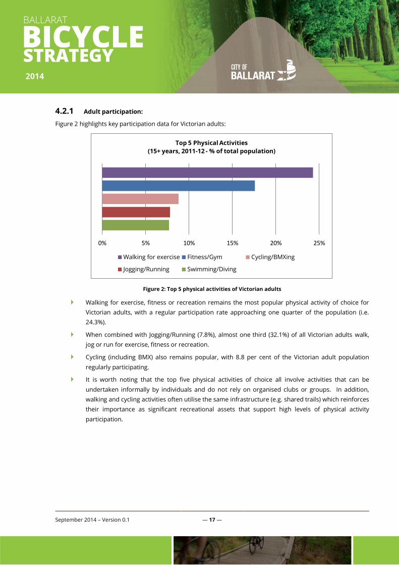
4.2.1 Adult participation:
Figure 2 highlights key participation data for Victorian adults:
Figure 2: Top 5 physical activities of Victorian adults
Walking for exercise, fitness or recreation remains the most popular physical activity of choice for
Victorian adults, with a regular participation rate approaching one quarter of the population (i.e.
24.3%).
When combined with Jogging/Running (7.8%), almost one third (32.1%) of all Victorian adults walk,
jog or run for exercise, fitness or recreation.
Cycling (including BMX) also remains popular, with 8.8 per cent of the Victorian adult population
regularly participating.
It is worth noting that the top five physical activities of choice all involve activities that can be
undertaken informally by individuals and do not rely on organised clubs or groups. In addition,
walking and cycling activities often utilise the same infrastructure (e.g. shared trails) which reinforces
their importance as significant recreational assets that support high levels of physical activity
participation.
0% 5% 10% 15% 20% 25%
Top 5 Physical Activities
(15+ years, 2011-12 - % of total population)
Walking for exercise Fitness/Gym Cycling/BMXing
Jogging/Running Swimming/Diving
September 2014 – Version 0.1 — 18 —
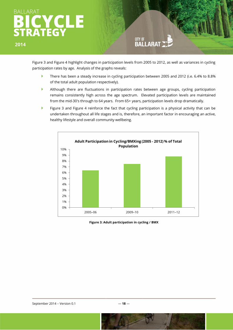
Figure 3 and Figure 4 highlight changes in participation levels from 2005 to 2012, as well as variances in cycling
participation rates by age. Analysis of the graphs reveals:
There has been a steady increase in cycling participation between 2005 and 2012 (i.e. 6.4% to 8.8%
of the total adult population respectively).
Although there are fluctuations in participation rates between age groups, cycling participation
remains consistently high across the age spectrum. Elevated participation levels are maintained
from the mid-30's through to 64 years. From 65+ years, participation levels drop dramatically.
Figure 3 and Figure 4 reinforce the fact that cycling participation is a physical activity that can be
undertaken throughout all life stages and is, therefore, an important factor in encouraging an active,
healthy lifestyle and overall community wellbeing.
Figure 3: Adult participation in cycling / BMX
0%
1%
2%
3%
4%
5%
6%
7%
8%
9%
10%
2005–06 2009–10 2011–12
Adult Participation in Cycling/BMXing (2005 - 2012) % of Total
Population

September 2014 – Version 0.1 — 19 —
Figure 4: Adult cycling / BMXing by age
4.2.2 Children's participation:
The most popular term participation physical activities for children (5-14 years) in 2010, were:
Walking (including to school) (52.1%);
Cycling (including to school) (48.1%);
Swimming (37.8%);
Active play (24.7%);
Outdoor football (16.5%);
Dance (13.7%);
Gymnastics (13.2%);
Tennis (10.6%);
Basketball (9.7%); and
Australian Rules Football (8.7%).
0%
2%
4%
6%
8%
10%
12%
14%
15–17 18–24 25–34 35–44 45–54 55–64 65 and over
Participation of Adults Cycling/BMXing by Age (2011-2012)
% of total population
September 2014 – Version 0.1 — 20 —
The term participation rate is the number of children who participated in the activity at least once in the
previous school term, expressed as a percentage of the population in the same group.
Walking and cycling were the most popular activities regardless of gender, although boys tended to prefer
cycling, whereas girls preferred walking.
For males, activities with the highest term participation rates were cycling (52.0%) and walking
(48.7%).
For females, activities with the highest term participation rates were walking (55.8%) and cycling
(44.0%).
Similar to adults, participation varied with age; however, cycling, swimming and walking maintained the highest
term participation rates across all age groups.
The term participation rate for walking increased with age, from 47.3 per cent among 5 to 7 year olds
to 54.3 per cent among 8 to 10 year olds and 54.1 per cent among 11 to 14 year olds.
Cycling participation was highest among 8 to 10 year olds (56.0%), decreasing to 40.1 per cent
among 11 to 14 year olds.
September 2014 – Version 0.1 — 21 —
5. Ballarat Bicycling Strategy – the local context
Ballarat is a unique regional city, offering a diverse and plentiful range of sports, recreational and aquatic assets
for the enjoyment and recreation of its residents and those of the broader region. To ensure the quality and
access to the cycling infrastructure and facilities are enhanced, this cycling strategy must reflect the specific
issues that Ballarat faces now and in the future. These issues must be considered in the context of Ballarat’s
existing cycling assets.

September 2014 – Version 0.1 — 22 —
5.1 Background reports and research:
The following section provides a summary of key background documents, consultation outcomes and research
material that have helped inform the Cycling Strategy. Key documents reviewed include, but are not limited to:
Victoria's Cycling Strategy: Cycling into the future 2013–23.
Victoria’s Trails Strategy 2013–23 (Draft).
Crossing Borders Tracks and Trails project (2013).
City of Ballarat Bike Scope 2012 Report, Analysis and Recommendations.
City of Ballarat Super Tuesday Reports 2012 & 2013.
City of Ballarat Super Tuesday Bicycle Commuter Survey 2011.
VicRoads Municipal Bike Network (2005) and upgraded as part of this project.
Document / Reference
Source
Key extracts and planning considerations:
Cycling into the
Future 2013–23,
Victoria’s Cycling
Strategy, December
2012, and
Victoria’s Cycling
Action Plan 2013
and 2014.
Cycling into the Future 2013–23 aims to grow and support cycling in Victoria. It aims to
make it easier for more people to cycle and to make it safer for people who already ride.
This strategy recognises the important role that cycling plays in Victoria; as part of the
transport system, as an enjoyable recreation activity, a healthy form of exercise and a
tourism drawcard.
Six strategic directions have been identified to help build our understanding of cycling
and encourage more people to consider cycling:
1. Build evidence – build a stronger evidence base for the Victorian Government to
make more informed decisions.
2. Enhance governance and streamline processes – clarify accountability and
improve co-ordination, planning and delivery.
3. Reduce safety risks – reduce conflicts and risks to make cycling safer.
4. Encourage cycling – help Victorians feel more confident about cycling and make
cycling more attractive.
5. Grow the cycling economy – support opportunities to grow and diversify
Victoria’s economy through cycling.
6. Plan networks and prioritise investment–plan urban cycling networks to improve
connectivity and better target investment in urban networks, regional trails and
specialist cycle sport infrastructure.
Cycling into the Future 2013–23 is accompanied by a series of Action Plans. The plans
will set out priority actions for the short term to deliver the strategy’s objectives. The
first Action Plan will run for two years.
The Victorian Cycling Action Plan 2013 and 2014 focuses on getting the fundamentals
right and building a foundation across the Victorian Government for stronger co-
ordination, streamlined processes and better evidence.
The Ballarat–Skipton Rail Trail is recognised as a significant local recreational /
community track. Its ongoing development and promotion is supported.
There are no specific actions or strategies identified in the Action Plan directly related to
the City of Ballarat. The six broad strategic actions contained in Cycling into the Future
2013-2023 could also be applied as a framework for the City's latest Cycling Strategy.
Victoria’s Trails
Strategy 2013–23
The Goldfields Track has been identified as a State Significant Trail. The trail is described
as follows:
September 2014 – Version 0.1 — 23 —
Document / Reference
Source
Key extracts and planning considerations:
(Draft Report Sept
2013)
This 210-kilometre trail runs from Mount Buninyong through Ballarat, Creswick,
Daylesford and Castlemaine, finishing in Bendigo. It targets the reasonably fit and
skilled mountain bikers, with some short track options for the novice. Further
investment in track maintenance is required for the trail to become a significant
tourism product.
Council may need to consider opportunities to upgrade and enhance the Goldfields
Track experience through Ballarat, including options to leverage tourism experiences,
recreational use and connections to other trail networks.
The overarching objectives of the Victorian Trails Strategy have relevance to the City of
Ballarat at a local level, specifically to:
Improve quality,
Increase awareness,
Develop complementary experiences, and
Understand market needs and motivations.
Crossing Borders
Tracks and Trails
project (2013).
The Crossing Borders Tracks and Trails project was a joint initiative of Hepburn Shire
Council, Ballarat City Council, Macedon Ranges Shire Council, Central Goldfields Shire
Council, Department of Planning and Community Development and Department of
Transport.
The project involved the assessment of four individual trail projects and the
development of individual Action Plans to guide the steps required to achieve future
implementation. The four projects were:
The Ballarat - Maryborough Heritage Trail, which aims to provide an on-road
cycling connection utilising (predominantly) back-country roads between
Maryborough to Ballarat (via Creswick and other small towns);
The Daylesford to Macedon Ranges Rail Trail, linking Daylesford to Woodend
utilising a combination of rail corridor and (where required) alternative routes;
The Black Hill Mountain Bike (MTB) Park (e.g. municipal MTB Park); and
Creswick Trails initiative, which includes a combination of mountain bike trails,
shared trails and walking paths throughout the Creswick forest.
Three of the four projects have direct relevance to the City of Ballarat, the exception
being the Daylesford - Macedon Ranges Rail Trail.
The Creswick Trails initiative, whilst outside the City's municipal boundary, is
acknowledged as it has the potential (if fully developed) to provide a high-standard
mountain bike facility and tourism attraction which is currently lacking in Ballarat.
The proposed Ballarat - Maryborough Heritage Trail should be relatively easy to
implement as the proposed route utilises existing roads and trails, therefore consistent
signage/branding across all three affected LGA's is largely all that is required. However,
the connection from Creswick to Ballarat proposes use of the Goldfields Track and it
requires significant works to make it more suitable for cycling between these towns.
The proposed MTB Park will add a significant attraction for local riders and address an
important recreation facility gap.
Municipal Bicycle
Networks (MBNs)
MBNs are networks of local cycling routes in metropolitan Melbourne and in regional
Victoria:
The local council is the custodian of each MBN and has the primary responsibility
for managing its development.
In many regional cities and towns, VicRoads and local councils have worked
September 2014 – Version 0.1 — 24 —
Document / Reference
Source
Key extracts and planning considerations:
together to develop a set of Priority Bicycle Routes (PBRs). These routes are a
subset of the relevant MBN and provide the main linkages for bicycle travel within
each city and town.
There are 36 cities and towns in regional Victoria that have bicycle maps showing
existing and proposed on-road and off-road bicycle routes (of which Ballarat is
one)
Planned infrastructure must reconcile to the Ballarat’s MBN. The latest map available1
from VicRoads has been updated during this project and is used to guide
implementation and recommendations (refer Figure 9and Figure 10).
Extensive consultation with VicRoads has been undertaken as part of this strategy’s
formation.
City of Ballarat Bike
Scope 2012 Report,
Analysis and
Recommendations.
The report contains data collected through Bicycle Network Victoria’s Ballarat City
Council Bike Scope survey, conducted between Thursday 15 November to Monday 17
December 2012. There were 549 responses to the survey. A selection of key findings is
presented below:
The Low Intensity Recreation category received the highest response count, and 142
people indicated that they do this for most of their riding. As such, there is a strong need
to provide adequate facilities for a large number of recreational riders who ride in /
through Ballarat. Additionally, the findings highlight that there are opportunities to
develop the network in the High and Low Intensity Transport categories in the City of
Ballarat.
The findings indicated that the respondents from Ballarat were mostly male (70%) and
aged between 35-49 (40%).
The majority of respondents (19%) ride three days a week.
Twenty per cent of respondents indicated that they ride between five and 20km per
week, with a further 22 per cent riding between 50 and 100km per week.
The main reason for riding in the City of Ballarat is for the purpose of health and fitness
(83%). Spending time outdoors was also a strong motivator (46%). Riding to work scored
40 per cent and riding to shops scored 13 per cent.
Respondents indicated that the most popular destinations for riders within the City of
Ballarat were Lake Wendouree (20% / 328 responses), Buninyong (6.9% / 114 responses)
Yarrowee River trail (5% / 89 responses) and Ballarat CBD (5% / 85 responses).
A similar proportion of riders prefer to ride off-road (36%) and on-road (34%).
Suggested improvements (as perceived by respondents) to on-road routes included:
Wendouree Parade (13% / 105 responses)
Improve surface
Add / improve bike lane / path
Sturt Street (10% / 80 responses)
Add / improve bike lane / path
Improve safety
Main Road (10% / 77 responses)
1 http://www.vicroads.vic.gov.au/NR/rdonlyres/9CD5220B-DA8A-4FF4-BC41-FB054511850C/0/map_w1Ballarat.pdf
September 2014 – Version 0.1 — 25 —
Document / Reference
Source
Key extracts and planning considerations:
Add / improve bike lane / path
Improve surface
Gillies Street (5% / 41 responses)
Add / improve bike lane / path
Access / crossings / link / more direct route
Suggested improvements (as perceived by respondents) to off-road routes included:
Yarrowee River Trail (13% / 77 responses)
Improve surface / drainage
Improve access / linkage
Ballarat Skipton Rail Trail (12% / 72 responses)
Improve surface / drainage
Improve access / linkage
Canadian Creek Trail (12% / 71 responses)
Improve access / linkage
Improve signage
Improve surface / drainage
Lake Wendouree Trail (5% / 32 responses)
Add / improve bike lane
Improve surface / drainage
Suggested priority missing links included:
The trail along Geelong Road, ending at Jones Street (near Damascus College)
needs better linkage south towards the University and north towards Recreation
Road.
The connection between the Yarrowee Creek trail in the south and the Goldfields
Track in the north along Peel Street
The lack of bike lanes on Sturt Street, particularly between Learmonth and Gillies
streets
Connections between off-road trails in Victoria Park and the Wendouree Lake trail
Unfinished off-road trail between Macarthur Park Estate and Miner’s Rest town
centre
Recommendations developed by Bicycle Network Victoria include:
It is recommended that the City of Ballarat increases the level of investment in on-
road riding infrastructure (particularly increase in the amount of physical
separation on-road is a priority).
Continued investment in the shared off-road path network and its connectivity.
Investment in on-street bike parking.
September 2014 – Version 0.1 — 26 —
Document / Reference
Source
Key extracts and planning considerations:
Identify key intersections that can be improved for riders as an intrinsic part of its
investment program (for advice on designing roundabouts with bike riders in
mind, see https://www.bicyclenetwork.com.au/general/bike-futures/42527/ and
https://www.bicyclenetwork.com.au/general/bike-futures/42528/)
Continue to collect data on rider numbers but also seek rider feedback on planned
investments in the form of ‘before’ and ‘after’ evaluations.
Bicycle Network
Victoria: Planning
Checklist for Cycling
and Practice Note
(2012)
In 2012 Bicycle Network Victoria released the Planning Checklist for Cycling and
associated Practice Note. The practice note focuses on three requirements of an
effective cycling network:
Connectivity to destinations- providing cycling routes that connect to destinations
Permeability of the suburb - providing a choice of direct routes across a suburb
and to local destinations
Quality of infrastructure - providing the correct cycling infrastructure to the target
population, their trip purpose and the places they want to go.
BiXE 2011: The
Bicycle Expenditure
Index for Local
Government 2011 –
2012 Financial Year,
Bicycle Network
Victoria.
The City of Ballarat’s BiXE rating for 2011 is $7.92.
This is above the Regional Zone BiXE rating council average for 2011, which is $5.96.
The City of Ballarat is commended for having participated in Super Tuesday Bike Count in
2011.
The City of Ballarat has opportunities to invest in bike infrastructure, such as:
Improve connections from Federation University to Sovereign Hill and the city
centre
Connect the Ballarat – Skipton Rail Trail to central Ballarat and linking to Ballarat
and Wendouree stations
City of Ballarat CBD
Strategy.
Relevant objectives include:
Maximise connectivity to surrounding areas.
Encourage access to and within the CBD by walking and cycling.
Relevant specific actions include:
Improve cyclist amenities, including high quality end of trip facilities at key
locations such as the railway station, supermarkets and the University. This
includes bicycle lockers, vertical storage and change/shower facilities.
Provide more bicycle parking racks throughout the CBD, including undercover
facilities.
Investigate possibility of installation of ‘Parkiteer’ style bike parking and shower
facilities in Central Square car park.
Provide drinking fountains, seating and shade at popular bicycle parking locations
(e.g. Central Square, University buildings, coffee shops in Sturt Street).
Actively promote the provision of change facilities and bicycle storage at CBD
businesses to encourage people to ride to work (i.e. through policy requirements,
working collaboratively for changes to the building code).
Provide information to cyclists about routes and location of amenities (e.g. station).
Require major developments to provide adequate bicycle parking and shower
facilities.
Other actions include:
Improve access to bicycles, particularly bicycles tailored to Ballarat’s terrain.
Increase the availability of hire bicycles and folding bicycles in the CBD.
Promote the option of motorised bikes.
Consider developing a sharing system as bicycle use increases and the
September 2014 – Version 0.1 — 27 —
Document / Reference
Source
Key extracts and planning considerations:
network develops.
Introduce a system to regularly monitor bicycle and pedestrian use in the CBD
similar to a ‘Bicycle Account’.
Establish targets and measurement tools for effective monitoring
Victoria Park – A
Vision (2013)
Victoria Park –
Summer Criterium
Racing
Victoria Park South
and Ballarat
Livestock Selling
Centre Precinct Plan
(2007)
Recreation in general and cycling in particular are key activities undertaken in Victoria
Park
There is expected to be an increase in cycling-related activities in the park
Existing cycling paths are highly valued
There is an opportunity to develop cycling criterium events in multiple locations
throughout the park
Some remediation and improvement works of trials and roads would be needed if the
park’s cycling options are to be fully exploited for criterium events.
Ballarat West
Growth Area Plan
(2009)
On-road and off-road routes to be established
Disused rail reserves / corridors to be utilised for cycling connectivity (linking the area to
the current site of the Ballarat Saleyards)
Cycling should be encouraged as a mode of transport
The road network should provide the opportunity for bicycle use with main roads to
provide a dedicated bicycle lane. This should apply to present and future arterial roads
and sub-arterial roads.
Utilise water courses and lineal parks for the provision of dedicated cycle paths (possibly
along Winter Creek)
Table 3: Background research summary
5.2 Planning for population growth
Ballarat is experiencing a period of high population growth rates. The City’s growth profile is expected to
continue into the foreseeable future. The City of Ballarat’s Strategic Planning Unit is actively identifying and
planning for future new communities and business activity. These plans must continue to consider the need
for cycling assets and participation of local residents.
Fundamental to the planning and provision of new residential growth areas is ensuring connectivity within and
external to any new development through the provision of appropriate on-road and off-road paths, tracks and
trails. This would maximise physical activity participation opportunities through walking and cycling as it
improves social integration and community wellbeing. Infrastructure development, urban design and
streetscapes must have regard to relevant standards (refer to appendices) and ensure future growth areas are
well connected to existing cycling networks and key destinations.

September 2014 – Version 0.1 — 28 —
5.2.1 Ballarat’s population trends
Ballarat's population is expected to grow in several demographics, including in particular:
Families with school-aged children;
Regional and rural home leavers and University students;
Retirees and seniors from western Victoria and Melbourne; and
New arrivals and refugees from overseas.
Figure 5 shows the population growth projections and helps to identify future works under this Strategy and
how future cycling infrastructure would benefit the Ballarat community.
Figure 5: Ballarat's population growth (2013 - 2038)
Forecasts show that by 2018 an additional 7,500 people will reside in Ballarat and by 2038 this number will
increase to over 40,000. The breakdown of this growth by suburb is shown in Figure 6.
-
20,000
40,000
60,000
80,000
100,000
120,000
140,000
160,000
2013 2018 2023 2028 2033 2038
Ballarat Population Forecast (2013 - 2038)
Ballarat's Population
Number of additional
residents
September 2014 – Version 0.1 — 29 —
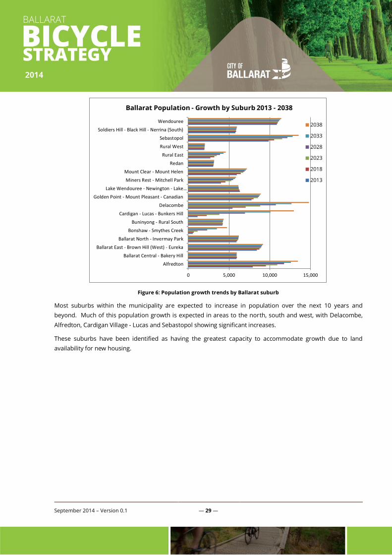
Figure 6: Population growth trends by Ballarat suburb
Most suburbs within the municipality are expected to increase in population over the next 10 years and
beyond. Much of this population growth is expected in areas to the north, south and west, with Delacombe,
Alfredton, Cardigan Village - Lucas and Sebastopol showing significant increases.
These suburbs have been identified as having the greatest capacity to accommodate growth due to land
availability for new housing.
0 5,000 10,000 15,000
Alfredton
Ballarat Central - Bakery Hill
Ballarat East - Brown Hill (West) - Eureka
Ballarat North - Invermay Park
Bonshaw - Smythes Creek
Buninyong - Rural South
Cardigan - Lucas - Bunkers Hill
Delacombe
Golden Point - Mount Pleasant - Canadian
Lake Wendouree - Newington - Lake…
Miners Rest - Mitchell Park
Mount Clear - Mount Helen
Redan
Rural East
Rural West
Sebastopol
Soldiers Hill - Black Hill - Nerrina (South)
Wendouree
Ballarat Population - Growth by Suburb 2013 - 2038
2038
2033
2028
2023
2018
2013

September 2014 – Version 0.1 — 30 —
5.2.2 Implications for Ballarat Cycling Strategy
The rapid growth in the City’s population has significant implications for the cycling strategy, including (but not
limited to):
Connectivity between growth areas (Delacombe, Alfredton, Cardigan Village - Lucas and Sebastopol)
and established residential areas and/or activity centres;
Improving connectivity and linkages between Ballarat and existing ‘satellite suburbs’ of Buninyong,
Miners Rest and Learmonth;
Balance facility and infrastructure needs between growth areas and established residential areas
and/or activity centres;
Co-ordination of the provision of bicycling facilities across relevant agencies and organisations;
Encouraging consideration of cycling and cycling safety in all relevant infrastructure design;
Integration of cycle planning and safety into transport and land use planning;
Identifying clear responsibilities for cycling-related actions and activities within City of Ballarat,
including commitment to longer-term resourcing;
Ensuring potential cycle corridors are identified and protected, with particular reference to links to
new growth areas; and
Ensure future planning of extensions to the Municipal Bike Network integrates with future growth
areas across the City.
5.3 City of Ballarat Participation Data - Super Tuesday Reports
Super Tuesday is Australia's biggest visual bike count conducted by Bicycle Network Victoria. It is designed to
measure bike commuter flows in the morning peak (7am–9am). The count aims to establish an accurate
annual benchmark for bicycle commuter numbers. The City of Ballarat has participated in the Super Tuesday
bike count in 2011, 2012 and 2013. Separate evaluation reports have been prepared by Bicycle Network
Victoria for each of the three years; however, the section below provides a selection of key findings from the
latest report (2013) and compares results from previous years.
September 2014 – Version 0.1 — 31 —
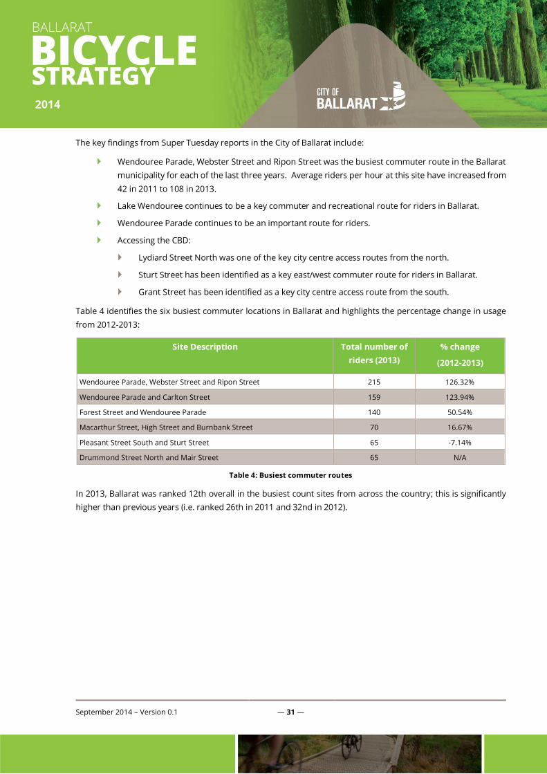
The key findings from Super Tuesday reports in the City of Ballarat include:
Wendouree Parade, Webster Street and Ripon Street was the busiest commuter route in the Ballarat
municipality for each of the last three years. Average riders per hour at this site have increased from
42 in 2011 to 108 in 2013.
Lake Wendouree continues to be a key commuter and recreational route for riders in Ballarat.
Wendouree Parade continues to be an important route for riders.
Accessing the CBD:
Lydiard Street North was one of the key city centre access routes from the north.
Sturt Street has been identified as a key east/west commuter route for riders in Ballarat.
Grant Street has been identified as a key city centre access route from the south.
Table 4 identifies the six busiest commuter locations in Ballarat and highlights the percentage change in usage
from 2012-2013:
Site Description Total number of
riders (2013)
% change
(2012-2013)
Wendouree Parade, Webster Street and Ripon Street 215 126.32%
Wendouree Parade and Carlton Street 159 123.94%
Forest Street and Wendouree Parade 140 50.54%
Macarthur Street, High Street and Burnbank Street 70 16.67%
Pleasant Street South and Sturt Street 65 -7.14%
Drummond Street North and Mair Street 65 N/A
Table 4: Busiest commuter routes
In 2013, Ballarat was ranked 12th overall in the busiest count sites from across the country; this is significantly
higher than previous years (i.e. ranked 26th in 2011 and 32nd in 2012).
September 2014 – Version 0.1 — 32 —
5.3.1 Participation trends: planning implications:
A number of potential planning implications for the City of Ballarat Cycling Strategy can be derived from an
assessment of the participation trends, in particular:
Demand for cycling participation opportunities are likely to continue to increase associated with the
growing popularity of the activity;
Encouraging cycling participation through appropriate infrastructure and service provision will
facilitate 'whole of life' physical activity participation opportunities and, therefore, contribute to long-
term community health and wellbeing;
The high levels of participation in walking and cycling reinforces the importance of shared paths and
trails as key recreational assets;
There is a significant drop-off in cycling participation from around age 10 through to early 20's.
Opportunities to encourage ongoing cycling participation amongst late primary, teenagers and
young adults may need to be explored;
There has been a significant increase in commuter cycling within the City over the last three years
(according to Super Tuesday results). Wendouree Parade and the surrounding Lake Wendouree
precinct continue to be the busiest riding locations. Ongoing enhancement of cycling infrastructure
in this area will provide the greatest benefit and encourage increased participation and safety;
Lydiard, Stuart and Grant streets should be the focus of investment to encourage cycling access to
the CBD;
Ongoing participation in the Bicycle Network Victoria's Super Tuesday program is encouraged in
order to monitor ongoing changes in cycling behaviour and usage patterns; and
Integration with VicRoads Municipal Bike Network.
September 2014 – Version 0.1 — 33 —
6. How will we get there?
The following section outlines the key recommendations for the Cycling Strategy and includes a prioritised five-
year implementation framework.
Recommendations for the cycling network are presented under the following sub-headings:
1. On-road routes;
2. Off-road routes;
3. Mountain Bike trails;
4. Support infrastructure;
5. Programs and services; and
6. Partnerships and collaborations.

September 2014 – Version 0.1 — 34 —
6.1 On-road routes:
1. Improve connections from Federation University and Buninyong to the city centre (i.e. improved safety
and bike lane provision along Main Road).
2. Connect the Ballarat – Skipton Rail Trail to central Ballarat and linking to Ballarat and Wendouree stations.
3. Upgrade connections (i.e. improve safety and bike lane provision) to the CBD, including Lydiard, Sturt and
Grant streets.
4. Enhance provision along Wendouree Parade (i.e. surface and bike lane improvements) and surrounding
Lake Wendouree area as the City's premier cycling destination. Explore options for a designated bike lane
around the lake, separated from vehicle traffic (this would also allow greater separation of pedestrians
and cyclists who currently use the walking trail).
5. Improve bike lane provision (and intersection crossings) along the length of Gillies Street (both sides),
including connection to Wendouree Parade, schools, recreation facilities, Victoria Park and Macarthur Park
/ Alfredton residential growth areas.
6. Address gaps in the trail along Geelong Road, ending at Jones Street (near Damascus College), i.e. better
linkage south towards the University and north towards Recreation Road.
7. Undertake improvements to cycling facilities in Victoria Park and of trails and tracks connecting with the
park.
8. Connect key activity centres to the CBD and other growth areas, specifically the Ballarat West Growth
Area.
9. Complete a study into Sturt Street to identify and model potential further options for the bicycle network
that considers needs of all users (retailers, bicycle, pedestrian, parking etc.).
September 2014 – Version 0.1 — 35 —
6.2 Off-road routes:
1. Support improvements to the Goldfields Track, particularly between Ballarat and Creswick, to
accommodate a wider range of cycling (i.e. capable of accommodating hybrid bikes, not just mountain
bikes).
2. Connect the Ballarat – Skipton Rail Trail to central Ballarat and linking to Ballarat and Wendouree stations
(may be a combination of on-road and off-road routes).
3. Inspect the Yarrowee River Trail to identify priorities for surface upgrades and drainage improvements.
Consider opportunities to improve access, linkages and connections to surrounding residential areas and
key destinations along the route.
4. Inspect the Canadian Creek Trail to identify priorities for surface upgrades and drainage improvements.
Consider opportunities to improve access, linkages and connections to surrounding residential areas and
key destinations along the route.
5. Ensure future public open space acquisition and development incorporates adequate provision for shared
trail infrastructure within natural creek, river and waterway corridors, including connections to existing
trail networks and residential areas.
6. Ensure off-road routes are planned for within growth zones, including Ballarat West. Ensure off-road
connections from growth zones to other activity centres are also considered in planning and development
of growth zones, including the townships of Miners Rest and Learmonth.
7. Address identified priority missing links, including:
The connection between the Yarrowee Creek trail in the south and the Goldfields Track in the north
along Peel Street.
Connections between off-road trails in Victoria Park and the Lake Wendouree trail.
Unfinished off-road trail between Macarthur Park Estate and Miner’s Rest town centre.

September 2014 – Version 0.1 — 36 —
6.3 Mountain Bike trails (MTB):
1. Upgrade and enhance the Black Hill Mountain Bike tracks, facilities and infrastructure to reinforce the site
as the City's only designated Mountain Bike Park (refer to the Crossing Borders Tracks and Trails 2013
project report, i.e. total project cost estimated at approximately $700,000, spread over three stages, Stage
1 = $218,000).
2. Utilise the Crossing Borders Report and Black Hill Masterplan to further develop BMX and off road riding
in the Black Hill and surrounding area.
3. Support Hepburn Shire and community efforts to establish a comprehensive network of MTB trails in the
forest surrounding Creswick (including connections to the Goldfields Track and on to Ballarat, linking with
the Yarrowee River Trail and proposed Black Hill MTB Park).
6.4 Support infrastructure:
1. Audit existing locations and scope of public bicycle parking across the City in order to identify possible
gaps in provision and priorities for future installations (priorities for future installations should focus on
key destinations, including shopping precincts, public transport hubs and community facilities).
2. Ensure sufficient and appropriate bicycle parking and support infrastructure is included in the planning
and development of new growth areas, with a focus on the Ballarat West Growth Zone over the short
term.
3. Further develop the Buninyong bike precinct as a destination for cycling in Ballarat and the State.
4. Undertake a feasibility study into the development of a BMX facility in the Ballarat West Growth Zone.
5. Implement drainage and surface treatment improvements in Victoria Park to upgrade the designated
criterium course to improve overall safety, standard and capacity for additional club and event usage.
6. Consider options through undertaking a feasibility study to establish a sealed community bicycle
education/training facility in Victoria Park associated with the criterium course (subject to demand
assessment and site master plan).
7. Support establishment of the proposed Ballarat - Maryborough Heritage Trail through appropriate
signage and way finding as required.
8. Implement a program to standardise off and on road signage, stencilling and line marking (where
appropriate) and to improve visibility, user safety, awareness and etiquette for shared trail users (refer to
signage examples below).
9. Include all bicycle related infrastructure on Council’s asset registers and ensure correct maintenance of
the information so that it can be used in future programs that enhance and maintain the infrastructure.
10. Undertake an analysis of bicycle infrastructure related maintenance spend and develop a formulae that
makes sufficient provision to ensure the upkeep of bicycle related infrastructure across the network
through asset replacement, renewal and maintenance.

September 2014 – Version 0.1 — 37 —
Figure 7: Surf Coast signage encouraging courteous shared trail behaviour
6.5 Programs and services:
1. In partnership with other providers (e.g. cycling clubs, Bicycle Network Victoria, local schools etc.), explore
options to implement a range of programs and promotional initiatives that encourage cycling
participation, particularly targeting 10-24 year olds, as this age group has the highest drop off in lifelong
participation.
2. Work with local schools to promote physical activity participation opportunities, bike safety and
awareness active transport and links to existing sporting club, groups and activities. This may include the
appointment of an active transport staff member to work with user groups and other stakeholders.
3. Establish a cycle tourism guide for the City, including associated maps and promotional material.
Consider options for development of a Smartphone Application for use by residents and visitors.
4. Review and upgrade the suite of promotional material currently utilised by the City, particularly Visitor
Information Centre material and website content. Investigate options to establish interactive web content
(e.g. ridewithgps.com) incorporating route mapping, key features and relevant user information (e.g.
difficulty rating, characteristics, topography, way finding, etc.).
5. Work in partnership with relevant community groups and stakeholders (e.g. VicRoads, Bicycle Network
Victoria, Cycling Victoria and local cycling clubs) to resource and deliver multi-pronged bike safety
campaigns.

September 2014 – Version 0.1 — 38 —
6. As part of any future review of the City's Events Strategy, explore opportunities to attract and support at
least one additional marquee cycling event each year other than the existing Road Cycling Championships
in the City (this could consider road cycling and/or mountain biking).
7. Develop mapping tools, internet and communication applications that promote use of the network, make
accessing and using it easier.
8. Consider the future acquisition of appropriate land for the community, such as disused railway lines, that
can further enhance the connectivity of Ballarat’s bicycle network.
6.6 Partnerships and collaborations:
1. Continue to participate in the Bicycle Network Victoria's Super Tuesday program in order to monitor
ongoing changes in cycling behaviour and usage patterns.
2. Work with VicRoads to scope and implement improvement or development requirements to meet
Municipal Bike Network status for designated routes, including (but not limited to) provision of line
marking, stencilling, rumble strips and signage (as appropriate).
3. Advocate to VicRoads for regular maintenance of road verges along the designated Municipal Bike
Network, including repair of pot holes, crumbling edges and cleaning debris.
4. Develop an open active transport working group to ensure there remains an open and continual flow of
communication between stakeholders and Council.
5. Local businesses and traders can play an important role in promoting a cycling friendly culture. There are
a number of international examples of local councils working with bicycle interest groups and local
traders to support cycling (e.g. link to the Bike Friendly Business Program in Canada
http://www.biketoworkmetrovan.ca/B4B). Council should work with Bicycle Network Victoria and local
trader associations (or similar) to explore opportunities to establish a Bike Friendly Business Program for
the City.
6. Work with existing partners and sponsors to ensure the existing Australian Cycling Championship held in
Ballarat and Buninyong continues to grow as an event of national and international significance.
6.7 Resourcing:
All recommendations have been developed paying heed to the following considerations:
Council's financial capacity to implement capital initiatives;
Opportunities for partnerships, collaboration and external funding to support capital initiatives;
Implementing relatively low cost initiatives that are likely to positively influence participation or
address known gaps ('pick the low hanging fruit’ first and maximise 'bang for the buck');
Community priorities;
Distribution of investment and initiatives across the City; and
September 2014 – Version 0.1 — 39 —
Initiatives that support, expand and/or build on the existing cycling network, or existing programs
and services.
A five-year implementation framework, together with indicative costs, has been developed to help guide future
resource allocation, and is included as an appendix to this report.
The location of the implementation actions is shown diagrammatically in Figure 8. Estimated implementation
costs are shown in Table 5:
Priority Number Min$
(000’s)
Max $
(000’s)
High 8 660 790
Medium 21 1,910 2,140
Low 12 780 971
Total 41 $3,350 $3,901
Table 5: Indicative costs of implementation
The same schedule of works can be allocated across the MBN as detailed in Table 6. MBN related projects have
been allocated on the basis that they are further:
1. Developing the network – that is the recommended actions are building and growing the network;
2. Enhancing the network through recommendations that are making improvements to the existing network;
or
3. Projects that are outside the MBN
Priority Number Min$
(000’s)
Max $
(000’s)
Develop Municipal Bike Network 22 2,040 2,349
Enhance Municipal Bike Network 10 595 672
Non-Municipal Bike Network 9 715 880
Total 41 $3,350 $3,901
Table 6: MBN - Indicative costs of implementation
These projects are spatially represented in Figure 9 (developing / building network) and Figure 10 (enhancing
network).

September 2014 – Version 0.1 — 40 —
Figure 8: Spatial representation of implementation activities
September 2014 – Version 0.1 — 41 —
Figure 9: Spatial representation of MBN implementation developing / building activities
September 2014 – Version 0.1 — 42 —
Figure 10: Spatial representation of MBN implementation enhancing activities

September 2014 – Version 0.1 — 43 —
6.8 Evaluation:
Overall recommendations should be reviewed annually, as part of the annual budget process, to ensure short-
term recommendations remain relevant and achievable. A more comprehensive review of the strategy should
be undertaken after five years to assess the overall status of implementation, ongoing relevance of
recommendations, changes in priorities and to identify new initiatives or opportunities.
Public accountability is an important component of the overall evaluation process, therefore opportunities to
update the community on implementation progress and involvement in reviewing annual implementation
priorities may need to be explored.
Monitoring changes in behaviour over an extended period of time is a critical component of evaluation. Aside
from the Super Tuesday reports, there is a lack of empirical data regarding levels of use of specific paths, tracks
and trails; however, collection of usage data via in situ counters, monitoring or survey measures, are
problematic in terms of resource requirements and external influences (e.g. weather, time of day, time of year,
etc.).
In the absence of empirical data, it is therefore suggested that evaluation incorporates opportunities for
community feedback and input. This may be via Council's municipal-wide LGA satisfaction survey and/or other
mechanisms. Therefore, evaluation may include a simple annual question (e.g. “How satisfied are you with the
provision of cycling paths, track and trails within the City?”), and more detailed questions as part of the five-year
review of the strategy. Critical questions to consider as part of the five-year review include:
Do you currently participate in cycling for exercise, transport or relaxation? (i.e. establish baseline
participation rate for future comparisons).
What prevents you from participating in cycling?
Does the current range of cycling PATHS, TRAILS and FACILITIES available in the City meet your
needs?
Does the current range of cycling PROGRAMS and SERVICES available in the City meet your needs?
Other opportunities to collect and record usage data, satisfaction and economic impacts should also be
considered; this may include club membership trends, number and attendance at specified events, evaluation
of the economic impact of significant cycling events and use of tourism trails.

September 2014 – Version 0.1 — 44 —
7. Conclusion
The Ballarat Bicycle Strategy has been developed paying heed to a range of existing Council planning
documents that influence preferred directions including (but not limited to) the previous Bike Strategy (2008),
Recreation Strategy (2013), Bicycle Network Victoria Reports and Council Plan (2013-2017), to name a few.
Extensive consultations were undertaken in the formulation of these planning strategies.
This strategy responds to the high value placed on cycling opportunities by the community by providing clear
priorities and guidelines for future action. The range of social, recreational, health, economic and
environmental benefits of cycling are acknowledged. Creating cycle friendly environments within the City is
seen as critical to achieving Council's stated vision, including supporting a variety of physical activity
participation opportunities.
Establishing realistic and achievable recommendations, considering the resource capacity of the City and key
stakeholders, has been a key focus of the strategy. Priorities have taken into account VicRoad’s Municipal
Bicycle Network and opportunities to achieve effective results within this framework. Hence, a combination of
capital initiatives are supported by recommendations targeting behaviour change, community safety and
awareness, facilitating participation opportunities and improved coordination of resources.
Finally, public accountability will be integral to ensuring effective ongoing relationships with community
stakeholders. Therefore, the evaluation section outlines a number of recommended actions to ensure
transparency, focus and the fostering of ongoing involvement of community and key stakeholders.

September 2014 – Version 0.1 — 45 —
APPENDIX A: Link between Council objectives and strategy outcomes
Resourcing
Recommended action areas
On-road routes Off-road routes Mountain Bikes Support infrastructure Programs and servcies Partnerships and
collaborations Evaluation
Bicycle Strategy Objectives
Through cycling, increase
participation in physical activity and
recreation by Ballarat residents to
achieve National Physical Activity
Guidelines
Cater for all cyclists, including different skill levels, cycling types and usage
patterns
Build on the existing cycle infrastructure
to provide a comprehensive,
integrated network of on-road and off-road paths, tracks
and trails
Enhance connectivity between central
amenities and transport
opportunities, together with
connections to new growth areas
Improve the safety and amenity of Ballarat’s cycle
network
Integration of cycling with transport and land use planning
Improved coordination of
cycling facilities and infrastructure
provision across Council and relevant
external organisations
Provide a basis for increases in
recreational and event tourism
Providing ongoing support to a range of
cycling events, activities and
encourage community
participation.
Council Objectives
Planning for growth Managing assets Promoting healthy lifestyles Promoting accessibility and inclusion
September 2014 – Version 0.1 — 46 —
APPENDIX B: Strategy implementation and resourcing plan
Understanding Project Implementation Table:
Table reference Description
# Infrastructure action number
Strategy Reference to the specific strategic theme in report
Reference Reference to the specific recommendation detailed in the report
Priority City of Ballarat priority attached to action
Action Detail of action
Benefit User groups identified in the report who will most directly benefit from the action
On MBN Is the action a part of, or located on the existing or proposed MBN
Build MBN Will the action build or develop the MBN through turning proposed network into actual network ( = actions identified as build)
Min / Max Estimated range of cost of implementation of the action
Existing condition Details the existing condition of the action site / area / network
Recommendation Detailed information pertaining to the proposed action
Municipal Bicycle Network projects
The methodology adopted for the MBN results in three possible project types:
1. Developing the network – that is the recommended actions are building and growing the network;
2. Enhancing the network through recommendations that are making improvements to the existing network; or
3. Projects that are outside the MBN.
To identify which actions relate to which action type use the following matrix:
Table symbols MBN project type
On MBN Build MBN
Developing
Enhancing
Outside network
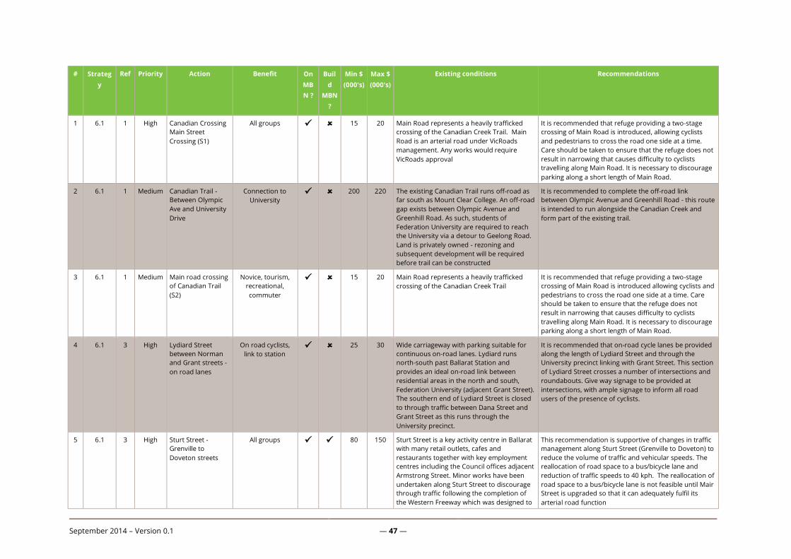
September 2014 – Version 0.1 — 47 —
# Strateg
y
Ref Priority Action Benefit On
MB
N ?
Buil
d
MBN
?
Min $
(000's)
Max $
(000's)
Existing conditions Recommendations
1 6.1 1 High Canadian Crossing
Main Street
Crossing (S1)
All groups 15 20 Main Road represents a heavily trafficked
crossing of the Canadian Creek Trail. Main
Road is an arterial road under VicRoads
management. Any works would require
VicRoads approval
It is recommended that refuge providing a two-stage
crossing of Main Road is introduced, allowing cyclists
and pedestrians to cross the road one side at a time.
Care should be taken to ensure that the refuge does not
result in narrowing that causes difficulty to cyclists
travelling along Main Road. It is necessary to discourage
parking along a short length of Main Road.
2 6.1 1 Medium Canadian Trail -
Between Olympic
Ave and University
Drive
Connection to
University 200 220 The existing Canadian Trail runs off-road as
far south as Mount Clear College. An off-road
gap exists between Olympic Avenue and
Greenhill Road. As such, students of
Federation University are required to reach
the University via a detour to Geelong Road.
Land is privately owned - rezoning and
subsequent development will be required
before trail can be constructed
It is recommended to complete the off-road link
between Olympic Avenue and Greenhill Road - this route
is intended to run alongside the Canadian Creek and
form part of the existing trail.
3 6.1 1 Medium Main road crossing
of Canadian Trail
(S2)
Novice, tourism,
recreational,
commuter
15 20 Main Road represents a heavily trafficked
crossing of the Canadian Creek Trail
It is recommended that refuge providing a two-stage
crossing of Main Road is introduced allowing cyclists and
pedestrians to cross the road one side at a time. Care
should be taken to ensure that the refuge does not
result in narrowing that causes difficulty to cyclists
travelling along Main Road. It is necessary to discourage
parking along a short length of Main Road.
4 6.1 3 High Lydiard Street
between Norman
and Grant streets -
on road lanes
On road cyclists,
link to station 25 30 Wide carriageway with parking suitable for
continuous on-road lanes. Lydiard runs
north-south past Ballarat Station and
provides an ideal on-road link between
residential areas in the north and south,
Federation University (adjacent Grant Street).
The southern end of Lydiard Street is closed
to through traffic between Dana Street and
Grant Street as this runs through the
University precinct.
It is recommended that on-road cycle lanes be provided
along the length of Lydiard Street and through the
University precinct linking with Grant Street. This section
of Lydiard Street crosses a number of intersections and
roundabouts. Give way signage to be provided at
intersections, with ample signage to inform all road
users of the presence of cyclists.
5 6.1 3 High Sturt Street -
Grenville to
Doveton streets
All groups 80 150 Sturt Street is a key activity centre in Ballarat
with many retail outlets, cafes and
restaurants together with key employment
centres including the Council offices adjacent
Armstrong Street. Minor works have been
undertaken along Sturt Street to discourage
through traffic following the completion of
the Western Freeway which was designed to
This recommendation is supportive of changes in traffic
management along Sturt Street (Grenville to Doveton) to
reduce the volume of traffic and vehicular speeds. The
reallocation of road space to a bus/bicycle lane and
reduction of traffic speeds to 40 kph. The reallocation of
road space to a bus/bicycle lane is not feasible until Mair
Street is upgraded so that it can adequately fulfil its
arterial road function

September 2014 – Version 0.1 — 48 —
# Strateg
y
Ref Priority Action Benefit On
MB
N ?
Buil
d
MBN
?
Min $
(000's)
Max $
(000's)
Existing conditions Recommendations
take through traffic from Ballarat CBD.
6 6.1 3 High Sturt Street -
Doveton to
Pleasant streets
All groups 75 80 The existing carriageway generally consists of
2x4 metre wide traffic lanes with significant
parking widths with shoulders between
parked vehicles and the through
carriageway. Traffic signals at intersections,
however, do not have advance stop lines for
cyclists. Corridor provides an opportunity to
link outer western residential areas with
central areas including a strong east-west
connection to the lake and Victoria Park. A
number of schools and colleges are also
located along the length of Sturt Street.
It is recommended that through traffic lanes are reduced
to 3.5 metres and parking bays are reduced to
accommodate 2 metre wide shoulders/bicycle lanes to
either side of the carriageway. Introduce advance bicycle
stop lines at Doveton, Dawson, Drummond and Pleasant
Street intersections with Sturt Street. This section of
Sturt Street is an arterial road under the management of
VicRoads. Any works would need VicRoads approval.
Provision of bicycle head start boxes will require changes
to line-marking as well as to traffic signal detector loops
7 6.1 3 High Sturt Street -
Pleasant and Gillies
streets
All groups 20 25 Local service roads run parallel either side of
Sturt Street providing a low speed lightly
trafficked link suitable for shared use by
vehicles and cyclists. Traffic signals at
intersections, however, do not have advance
stop lines for cyclists. Corridor provides an
opportunity to link outer western residential
areas with central areas, including a strong
east-west connection to the lake and Victoria
Park. A number of schools and colleges are
also located along the length of Sturt Street.
Provide direct paths and dropped kerbing for cyclists to
link with traffic signal crossing at Pleasant Street.
Upgrade traffic signals at Sturt Street/Pleasant Street to
include bicycle symbols within traffic lights to allow
cyclists to ride across the crossing. Place on-road bicycle
symbols to carriageway surface indicating shared use of
side road between motor vehicles and cyclists.
Reduction in speed limits to 40 kph would further
reinforce a safe environment for novice cyclists. This
section of Sturt Street is an arterial road under the
management of VicRoads. Any works would need
VicRoads approval.
8 6.1 3 Medium Sturt Street (Gillies
Street westbound)
All groups 50 65 A local service road run parallel to the
southern side of Sturt Street providing a low
speed lightly trafficked link suitable for
shared use by vehicles and cyclists. Road is
not continuous for motorists with short
closures along its lengths, which keeps traffic
volumes low along much of the length of the
road; however, there are some busy sections.
Corridor provides an opportunity to link
outer western residential areas with central
areas including a strong east-west
connection to the lake and Victoria Park. A
number of schools and colleges are also
located along the length of Sturt Street.
An on-road route (Option A) can be developed to the
southern side of Sturt Street or an off-road path (Option
B) to the northern side of Sturt Street, or both. Option A
involves a formal route along a parallel service road with
bicycle symbols applied intermittently to the carriageway
surface to raise the awareness of the route as a bicycle
corridor and as a reminder to motorists of the presence
of cyclists. Improved connections across Gilles Street
through provision of direct paths linking side roads and
the crossing facilities. Upgrade traffic signals at Sturt
Street/Gilles Street to include bicycle symbols within
traffic lights to allow cyclists to ride across the crossing.
This section of Sturt Street is an arterial road under the
management of VicRoads. Any works would need
VicRoads approval.
9 6.1 3 Medium Eyre Street
between Russell
Novice, students
and commuter 100 110 The route provides a parallel east-west on
road route. Traffic levels are relatively low
It is recommended that an on-road route is provided
along Eyre Street linking with proposed cycle lanes along
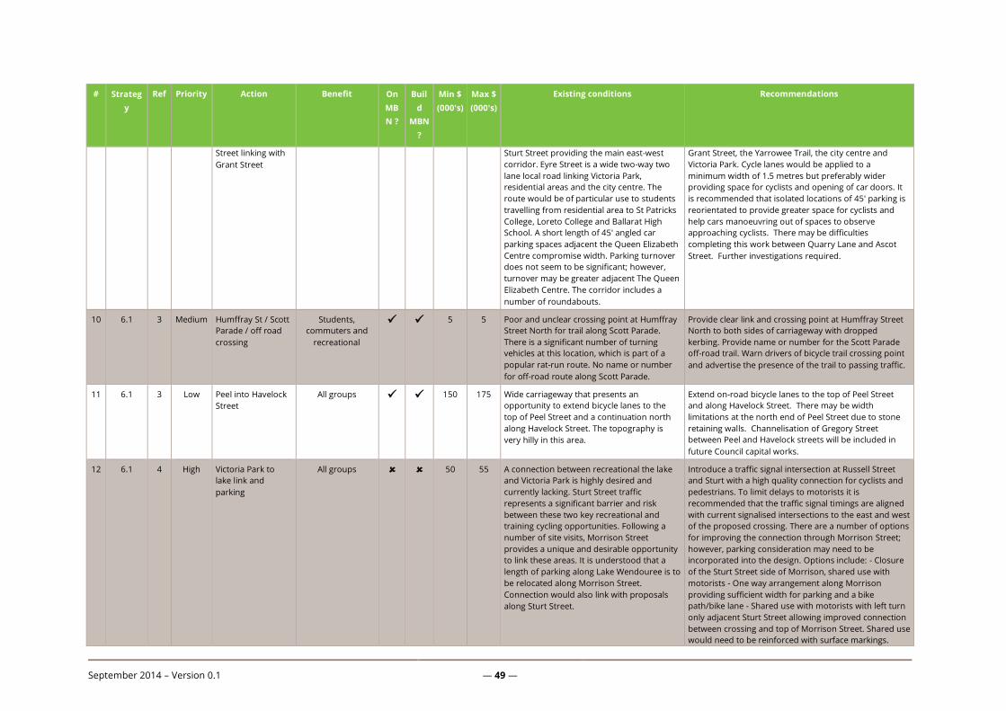
September 2014 – Version 0.1 — 49 —
# Strateg
y
Ref Priority Action Benefit On
MB
N ?
Buil
d
MBN
?
Min $
(000's)
Max $
(000's)
Existing conditions Recommendations
Street linking with
Grant Street
Sturt Street providing the main east-west
corridor. Eyre Street is a wide two-way two
lane local road linking Victoria Park,
residential areas and the city centre. The
route would be of particular use to students
travelling from residential area to St Patricks
College, Loreto College and Ballarat High
School. A short length of 45' angled car
parking spaces adjacent the Queen Elizabeth
Centre compromise width. Parking turnover
does not seem to be significant; however,
turnover may be greater adjacent The Queen
Elizabeth Centre. The corridor includes a
number of roundabouts.
Grant Street, the Yarrowee Trail, the city centre and
Victoria Park. Cycle lanes would be applied to a
minimum width of 1.5 metres but preferably wider
providing space for cyclists and opening of car doors. It
is recommended that isolated locations of 45' parking is
reorientated to provide greater space for cyclists and
help cars manoeuvring out of spaces to observe
approaching cyclists. There may be difficulties
completing this work between Quarry Lane and Ascot
Street. Further investigations required.
10 6.1 3 Medium Humffray St / Scott
Parade / off road
crossing
Students,
commuters and
recreational
5 5 Poor and unclear crossing point at Humffray
Street North for trail along Scott Parade.
There is a significant number of turning
vehicles at this location, which is part of a
popular rat-run route. No name or number
for off-road route along Scott Parade.
Provide clear link and crossing point at Humffray Street
North to both sides of carriageway with dropped
kerbing. Provide name or number for the Scott Parade
off-road trail. Warn drivers of bicycle trail crossing point
and advertise the presence of the trail to passing traffic.
11 6.1 3 Low Peel into Havelock
Street
All groups 150 175 Wide carriageway that presents an
opportunity to extend bicycle lanes to the
top of Peel Street and a continuation north
along Havelock Street. The topography is
very hilly in this area.
Extend on-road bicycle lanes to the top of Peel Street
and along Havelock Street. There may be width
limitations at the north end of Peel Street due to stone
retaining walls. Channelisation of Gregory Street
between Peel and Havelock streets will be included in
future Council capital works.
12 6.1 4 High Victoria Park to
lake link and
parking
All groups 50 55 A connection between recreational the lake
and Victoria Park is highly desired and
currently lacking. Sturt Street traffic
represents a significant barrier and risk
between these two key recreational and
training cycling opportunities. Following a
number of site visits, Morrison Street
provides a unique and desirable opportunity
to link these areas. It is understood that a
length of parking along Lake Wendouree is to
be relocated along Morrison Street.
Connection would also link with proposals
along Sturt Street.
Introduce a traffic signal intersection at Russell Street
and Sturt with a high quality connection for cyclists and
pedestrians. To limit delays to motorists it is
recommended that the traffic signal timings are aligned
with current signalised intersections to the east and west
of the proposed crossing. There are a number of options
for improving the connection through Morrison Street;
however, parking consideration may need to be
incorporated into the design. Options include: - Closure
of the Sturt Street side of Morrison, shared use with
motorists - One way arrangement along Morrison
providing sufficient width for parking and a bike
path/bike lane - Shared use with motorists with left turn
only adjacent Sturt Street allowing improved connection
between crossing and top of Morrison Street. Shared use
would need to be reinforced with surface markings.
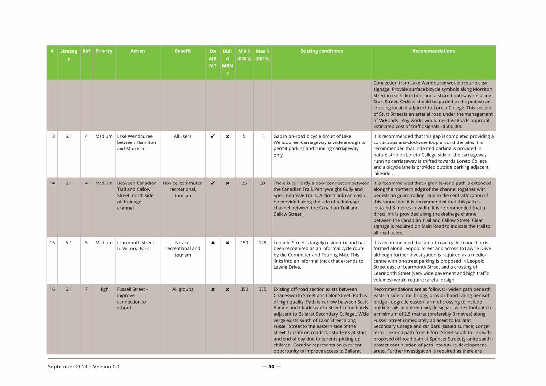
September 2014 – Version 0.1 — 50 —
# Strateg
y
Ref Priority Action Benefit On
MB
N ?
Buil
d
MBN
?
Min $
(000's)
Max $
(000's)
Existing conditions Recommendations
Connection from Lake Wendouree would require clear
signage. Provide surface bicycle symbols along Morrison
Street in each direction, and a shared pathway on along
Sturt Street. Cyclists should be guided to the pedestrian
crossing located adjacent to Loreto College. This section
of Sturt Street is an arterial road under the management
of VicRoads. Any works would need VicRoads approval.
Estimated cost of traffic signals - $500,000.
13 6.1 4 Medium Lake Wendouree
between Hamilton
and Morrison
All users 5 5 Gap in on-road bicycle circuit of Lake
Wendouree. Carriageway is wide enough to
permit parking and running carriageway
only.
It is recommended that this gap is completed providing a
continuous anti-clockwise loop around the lake. It is
recommended that indented parking is provided in
nature strip on Loreto College side of the carriageway,
running carriageway is shifted towards Loreto College
and a bicycle lane is provided outside parking adjacent
lakeside..
14 6.1 4 Medium Between Canadian
Trail and Callow
Street, north side
of drainage
channel
Novice, commuter,
recreational,
tourism
25 30 There is currently a poor connection between
the Canadian Trail, Pennyweight Gully and
Specimen Vale Trails. A direct link can easily
be provided along the side of a drainage
channel between the Canadian Trail and
Callow Street.
It is recommended that a granite/sand path is extended
along the northern edge of the channel together with
pedestrian guard-railing. Due to the central location of
this connection it is recommended that this path is
installed 3 metres in width. It is recommended that a
direct link is provided along the drainage channel
between the Canadian Trail and Callow Street. Clear
signage is required on Main Road to indicate the trail to
all road users.
15 6.1 5 Medium Learmonth Street
to Victoria Park
Novice,
recreational and
tourism
150 175 Leopold Street is largely residential and has
been recognised as an informal cycle route
by the Commuter and Touring Map. This
links into an informal track that extends to
Lawrie Drive.
It is recommended that an off-road cycle connection is
formed along Leopold Street and across to Lawrie Drive
although further investigation is required as a medical
centre with on-street parking is proposed in Leopold
Street east of Learmonth Street and a crossing of
Learmonth Street (very wide pavement and high traffic
volumes) would require careful design.
16 6.1 7 High Fussell Street -
improve
connection to
school
All groups 350 375 Existing off-road section exists between
Charlesworth Street and Lalor Street. Path is
of high quality. Path is narrow between Scott
Parade and Charlesworth Street immediately
adjacent to Ballarat Secondary College.. Wide
verge exists south of Lalor Street along
Fussell Street to the eastern side of the
street. Unsafe on roads for students at start
and end of day due to parents picking up
children. Corridor represents an excellent
opportunity to improve access to Ballarat
Recommendations are as follows: - widen path beneath
eastern side of rail bridge, provide hand railing beneath
bridge - upgrade eastern arm of crossing to include
holding rails and green bicycle signal - widen footpath to
a minimum of 2.5 metres (preferably 3 metres) along
Fussell Street immediately adjacent to Ballarat
Secondary College and car park (sealed surface) Longer
term: - extend path from Elford Street south to link with
proposed off-road path at Spencer Street (granite sand) -
protect continuation of path into future development
areas. Further investigation is required as there are
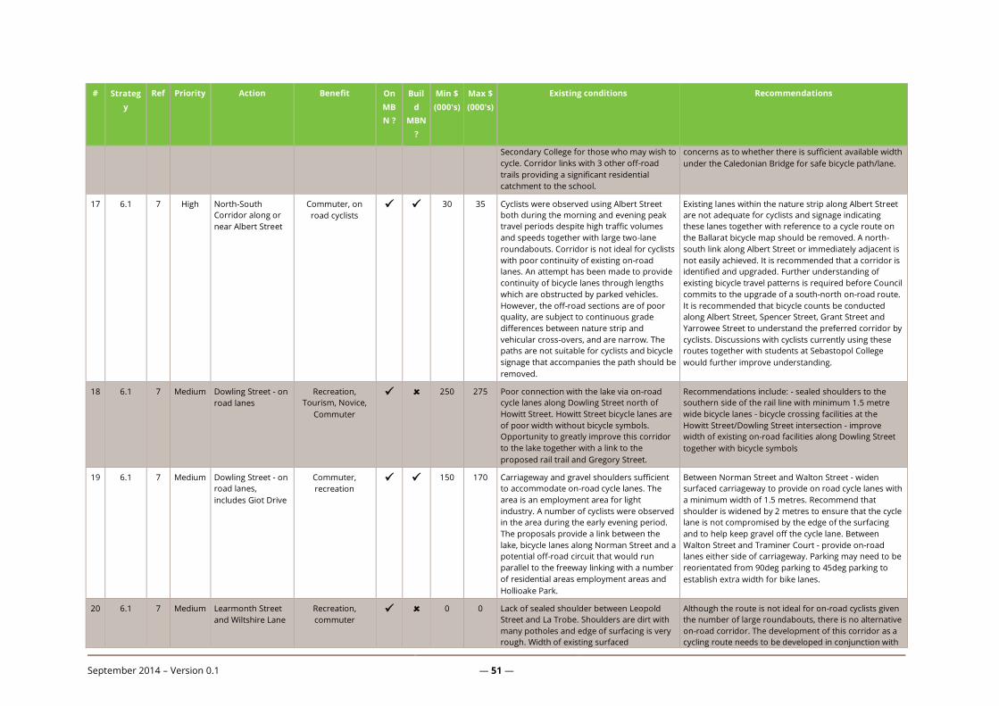
September 2014 – Version 0.1 — 51 —
# Strateg
y
Ref Priority Action Benefit On
MB
N ?
Buil
d
MBN
?
Min $
(000's)
Max $
(000's)
Existing conditions Recommendations
Secondary College for those who may wish to
cycle. Corridor links with 3 other off-road
trails providing a significant residential
catchment to the school.
concerns as to whether there is sufficient available width
under the Caledonian Bridge for safe bicycle path/lane.
17 6.1 7 High North-South
Corridor along or
near Albert Street
Commuter, on
road cyclists 30 35 Cyclists were observed using Albert Street
both during the morning and evening peak
travel periods despite high traffic volumes
and speeds together with large two-lane
roundabouts. Corridor is not ideal for cyclists
with poor continuity of existing on-road
lanes. An attempt has been made to provide
continuity of bicycle lanes through lengths
which are obstructed by parked vehicles.
However, the off-road sections are of poor
quality, are subject to continuous grade
differences between nature strip and
vehicular cross-overs, and are narrow. The
paths are not suitable for cyclists and bicycle
signage that accompanies the path should be
removed.
Existing lanes within the nature strip along Albert Street
are not adequate for cyclists and signage indicating
these lanes together with reference to a cycle route on
the Ballarat bicycle map should be removed. A north-
south link along Albert Street or immediately adjacent is
not easily achieved. It is recommended that a corridor is
identified and upgraded. Further understanding of
existing bicycle travel patterns is required before Council
commits to the upgrade of a south-north on-road route.
It is recommended that bicycle counts be conducted
along Albert Street, Spencer Street, Grant Street and
Yarrowee Street to understand the preferred corridor by
cyclists. Discussions with cyclists currently using these
routes together with students at Sebastopol College
would further improve understanding.
18 6.1 7 Medium Dowling Street - on
road lanes
Recreation,
Tourism, Novice,
Commuter
250 275 Poor connection with the lake via on-road
cycle lanes along Dowling Street north of
Howitt Street. Howitt Street bicycle lanes are
of poor width without bicycle symbols.
Opportunity to greatly improve this corridor
to the lake together with a link to the
proposed rail trail and Gregory Street.
Recommendations include: - sealed shoulders to the
southern side of the rail line with minimum 1.5 metre
wide bicycle lanes - bicycle crossing facilities at the
Howitt Street/Dowling Street intersection - improve
width of existing on-road facilities along Dowling Street
together with bicycle symbols
19 6.1 7 Medium Dowling Street - on
road lanes,
includes Giot Drive
Commuter,
recreation 150 170 Carriageway and gravel shoulders sufficient
to accommodate on-road cycle lanes. The
area is an employment area for light
industry. A number of cyclists were observed
in the area during the early evening period.
The proposals provide a link between the
lake, bicycle lanes along Norman Street and a
potential off-road circuit that would run
parallel to the freeway linking with a number
of residential areas employment areas and
Hollioake Park.
Between Norman Street and Walton Street - widen
surfaced carriageway to provide on road cycle lanes with
a minimum width of 1.5 metres. Recommend that
shoulder is widened by 2 metres to ensure that the cycle
lane is not compromised by the edge of the surfacing
and to help keep gravel off the cycle lane. Between
Walton Street and Traminer Court - provide on-road
lanes either side of carriageway. Parking may need to be
reorientated from 90deg parking to 45deg parking to
establish extra width for bike lanes.
20 6.1 7 Medium Learmonth Street
and Wiltshire Lane
Recreation,
commuter 0 0 Lack of sealed shoulder between Leopold
Street and La Trobe. Shoulders are dirt with
many potholes and edge of surfacing is very
rough. Width of existing surfaced
Although the route is not ideal for on-road cyclists given
the number of large roundabouts, there is no alternative
on-road corridor. The development of this corridor as a
cycling route needs to be developed in conjunction with

September 2014 – Version 0.1 — 52 —
# Strateg
y
Ref Priority Action Benefit On
MB
N ?
Buil
d
MBN
?
Min $
(000's)
Max $
(000's)
Existing conditions Recommendations
carriageway is does not allow much space for
cyclists and the corridor is used by a
relatively high proportion of heavy vehicles.
The corridor has a number of large
roundabouts and is not ideal for cyclists.
Lanes can be widened and improved
between La Trobe and Whitelaw Avenue.
the proposed adjacent growth area. Depending on the
residential nature of this environment under future
growth proposals, it is recommended that either
separate off-road links are created adjacent the
roundabouts or the roundabouts are tightened with
over-run areas. It is also recommended that: - a shoulder
with bicycle lanes between Leopold Street and La Trobe
Street, and - that bicycle lanes are widened to a
minimum of 1.5 metres between La Trobe Street and
Whitelaw Avenue through the re-application of surface
markings.
21 6.1 7 Medium Learmonth Road
(c237) from Ring
Road to Miners
Rest
Recreation,
competitive and
commuter
0 0 The existing on-road bike lane commences at
the intersection with Howitt Street and
continues as far as Ring Road. Miners Rest is
located approximately 4-5km to the north or
Ring Road, and is connected directly by
Learmonth Road. Further residential
development is proposed at Miners Rest.
Continue the on-road cycle route on Learmonth Road as
far as Miners Rest. Ballarat - Maryborough Road
(Learmonth and Howe Street) is an arterial road under
the management of VicRoads. Any on-road works would
require VicRoads approval and funding.
22 6.1 7 Medium Giot Drive,
between Gillies and
Dowling Streets
Recreational,
commuter,
students
175 185 Giot Drive provides one vehicular lane in
either direction with ample width (including
nature strip) for provision of an on-road cycle
lane or off-road Ballarat Secondary College
(Wendouree Campus) is located mid-section.
Both on-road and off-road facilities can be provided. A
preference would be off-road provision given the
potential to complete a northern recreational circuit and
a safe link to Ballarat Secondary College. Bicycle lane
provided on south side. Shoulder sealing required on
north side.
23 6.1 7 Medium Between rail line
and Midland
Highway from the
Western Freeway
to Howitt Street
Novice,
recreational and
commuter
400 420 Dirt path runs along this corridor, clear
evidence of use by pedestrians. Good
continuity of path crossing Heinz Lane,
Norman Street and Howitt. Opportunity to
provide a north-south link towards Ballarat
Station and the city centre. Off-road path
would intersect with a number of proposed
bicycle corridors together with existing
corridors along Norman Street and the
eastern length of Howitt Street.
It is recommended that a 2.5-3.0 metre path is
developed linking with the city centre and the train
station via Doveton Crescent. Two stage crossings are
recommended at Norman Street and Howitt Street to
assist cyclists to cross the road. It is suggested that the
splitter islands for the roundabout at Heinz Lane are
used as a crossing.
24 6.1 7 Medium Off road between
Ballarat -
Carngham Rd and
Glenelg Highway
Novice,
recreational and
commuter
0 0 Opportunity to provide an off-road north-
south bicycle trail through recreational fields
and existing greenfield area to the mid of an
industrial area. The trail would link work
places with existing and future residential
areas.
Protect corridor through greenfield area ensuring future
developments allow a clear and direct path for cyclists.
Provide north-south trail as industrial/work area is
developed and expanded. To be provided as part of
Developer Contribution Scheme (DCP).
25 6.1 7 Medium Wildlife Park Novice, 0 0 Warrenheip Trail extends as far as Richards Connect Warrenheip Trail with the proposed off-road

September 2014 – Version 0.1 — 53 —
# Strateg
y
Ref Priority Action Benefit On
MB
N ?
Buil
d
MBN
?
Min $
(000's)
Max $
(000's)
Existing conditions Recommendations
between Fussell
Street and Richards
Street
recreational,
tourism and
commuter
Street to the northern edge of the Wildlife
Park.
bicycle path extension along Fussell Street. It is
recommended that an on-road connection is made
along Richards Street and along Eureka Street.
Consideration needs to be given to good safe
connections between on and off road corridors enabling
good clear connection with Fussell Street and Ballarat
Secondary College.
26 6.1 7 Medium Sparrow Ground
Reserve
Novice,
recreational,
tourism, students
150 175 Off-road road trail ends mid Sparrow Ground
Reserve.
Connect trail through to Fussell Street to connect with
proposed off-road trail
27 6.1 7 Medium La Trobe Street and
Ross Creek Road
Novice,
recreational,
tourism
0 0 The proposed route would follow a creek
through the proposed western growth area.
Introduce off-road north-south path as part of
development proposals. DCP funded
28 6.1 7 Medium Dyson Drive,
between Sturt
Street and Glenelg
Highway
Novice,
recreational,
tourism
0 0 This site is located within the western growth
area. The corridor would run parallel to a
proposed north-south arterial road.
Introduce an off-road cycle lane from Sturt Street to La
Trobe Street. As the development area expands, the
route should be continued southwards connecting to the
Glenelg Highway. Coordinate with developers to
encourage cycle planning in their proposals. Develop as
part of the construction of the Ballarat Western Link
Road.
29 6.1 7 Low Tait Street
(currently being
done in stages)
Commuter,
recreational 0 0 Sufficient opportunity exists to extend the
on-road bicycle lanes on Sutton Street south
along Tait Street.
It is recommended that the extension of this corridor
should coincide with future developments to the south
of the city. Currently being progressively incorporated
into Council capital works in Tait Street.
30 6.1 7 Low Chisholm Street
and eastern end of
Howitt Street
Novice,
recreational,
commuter
250 275 Carriageway ranges between 10-13 metres in
width. Howitt Street length east of Havelock
Street is 10 metres in width without shoulder
parking. Chisholm Street has a carriageway
width of 12-13 metres, allowing parallel
parking to either side of the carriageway. A
very narrow bicycle lane is provided to both
sides of the carriageway.
A suitable link for novice and recreational link
31 6.1 7 Low Ballarat -
Carngham Road
Recreational 50 55 This recommendation relates to the section
of La Trobe Street running between Wiltshire
Lane and Sutton Street. Beyond Sutton
Street, (running east) the road provides a
formal on-road cycle lane towards the city
centre. However, between Wiltshire Lane and
Sutton Street, La Trobe Street is wide, but
does not provide any cycle lanes. There is
significant width along this section, and car
There is sufficient space to provide cycling lanes in both
directions, and it is recommended to provide lanes of
1.5-2.0 metres in width. This will provide a useful
connection between the existing on-road cycle lanes on
Pleasant Street, Gillies Street and Wiltshire Lane. La
Trobe Street is an arterial road under the management
of VicRoads. Any works would require VicRoads
approval. Shoulders have been sealed, meaning only
line-marking required.

September 2014 – Version 0.1 — 54 —
# Strateg
y
Ref Priority Action Benefit On
MB
N ?
Buil
d
MBN
?
Min $
(000's)
Max $
(000's)
Existing conditions Recommendations
parking running on both sides.
32 6.1 7 Low Forest Street to
Howitt Street
Recreational,
competitive,
commuter,
students
50 60 Relatively narrow carriageway with wide
shoulders that can easily accommodate on-
road bicycle lanes. Link is a final length of
bicycle lane connecting with Wendouree
Parade.
Provide indented parking to one side of the carriageway
and provide 1.5 metre wide bicycle lanes either side of
carriageway. Install advanced stop lines for bicycles to
the northern and southern approach of the Forest
Street/Howitt Street intersection. Provide high standard
sheltered bicycle parking at boat house at bottom of
Forest Street. A shelter would provide a higher standard
of amenity than regular parking facilities and is
preferred.
33 6.1 7 Low Heinz Lane,
between Doveton
Street North and
the Western
Freeway
Recreational,
commuter 150 170 Heinz Lane currently has a short length of
on-road cycle lanes. The road reserve would
allow for the continuation of this provision as
far as residential areas adjacent the Midland
Highway.
Introduce an on-road cycle lane to produce a link onto
Doveton Street North - which will provide a direct
commuter route to the town centre. This project may
require the widening of the controlled level crossing,
which has previously been costed by VicTrack at approx.
$500,000.
34 6.1 7 Low Beyond Eureka
Street and
Navigators Road
towards
Warrenheip and
the Western
Highway and
Buninyong
Recreational,
competitive 100 200 This route has been highlighted as a well-
used cycle route, but lacks a formal cycle
path and is unsealed.
The long term goal of this recommendation is to achieve
an additional recreational/touring circuit; the Yankee Flat
Road circuit. The following is recommended: - shoulder
widening and sealed surfacing - line marking – signage
Council will need to develop and co-ordinate the route
alongside the Moorabool Shire Council. The final stage
of the provision of sealed bicycle lanes in Eureka Street
to Yankee Flat Road is expected to be completed prior to
30 June 2015.
35 6.2 3 Medium East west link
Winter Street and
Sebastopol Street
Recreation,
Tourism, Novice,
Commuter
85 110 Sebastopol Street is a local residential road
with low traffic volumes. The corridor
represents an opportunity to complete an
east-west corridor between new residential
growth areas in the west and the Yarrowee
Trail.
In order to upgrade this corridor, the following is
recommended - provide refuge crossing adjacent Winter
Street assisting cyclists linking with Sebastopol Street -
change priority of intersection at Ascot Street giving east-
west priority to cyclists - potential road closure of
Sebastopol Street to western side of Drummond Street
with bicycle bypass to assist cyclists crossing into the
eastern length of Sebastopol Street and reduce through
traffic. - apply bicycle symbol road markings to
carriageway surface to assist way-finding and inform
drivers of shared use between motorists and cyclists.
Further investigation is required to confirm the scope of
works.
36 6.2 3 Medium Whitelaw Avenue
and Rubicon Street
off-road
Novice, commuter,
recreational 120 140 Corridor presents an east-west link along
wide verges primarily through residential
areas linking with the Yarrowee Trail. To the
Recommendations include: - Provide off-road path to
northern side of West End, ensure continuity of off-road
path through future residential developments. - Provide

September 2014 – Version 0.1 — 55 —
# Strateg
y
Ref Priority Action Benefit On
MB
N ?
Buil
d
MBN
?
Min $
(000's)
Max $
(000's)
Existing conditions Recommendations
west of Wiltshire Lane, the corridor ends
within a new housing development. Road
widths do not allow for an on-road corridor.
off-road path along southern side of Whitelaw Road,
install table top crossings of side streets to assist
continuity for cyclists. - install off-road path along
northern side of Rubicon Street - upgrade path between
end of Rubicon Street and the Yarrowee Trail, it is
recommended that this link is a sealed surface due to
gradient of path The development of the corridor
requires appropriate crossing facilities at major roads
and signage indicating the name and number of route
and connection with the Yarrowee Trail to the city
centre.
37 6.2 3 Medium Yarrowee Trail at
Chisholm Street
Novice,
recreational 30 35 Off-road trail crosses carriageway to the
bottom of the hill along Chisholm Street.
Down-hill traffic was observed to be
travelling fairly fast towards the bottom of
the hill.
A two-stage crossing would greatly improve crossing
conditions for novice/young cyclists using the Yarrowee
Trail allowing individuals to cross the carriageway one
lane at a time. The crossing should be complimented by
advance signage. The signage will act as a traffic calming
measure, as well as informing and advertising the off-
road cycle route. A right turn hatched area to be used as
a central crossing island. Traffic calming management
measures are required on approach. A detailed
assessment is required to consider the safety
implications.
38 6.2 4 High Canadian Trail Link
with Warrenheip
Gully and
Pennyweight Gully
Trail
All groups 30 40 There is currently a poor connection between
the Canadian Trail, Pennyweight Gully and
Specimen Vale Trails. A direct link can easily
be provided along the side of a drainage
channel between the Canadian Trail and
Callow Street.
It is recommended that a granite/sand path is extended
along the northern edge of the channel together with
pedestrian guard railing. Due to the central location of
this connection it is recommended that this path is
installed 3 metres in width. It is recommended that a
direct link is provided along the drainage channel
between the Canadian Trail and Callow Street. Clear
signage is required on Main Road to indicate the trail to
all road users.
39 6.2 5 Low Morgan Street Novice, commuter,
recreational 10 12 East-west corridor through new residential
areas with wide verges to the south side of
the carriageway. Road widths do not allow
for on-road lanes.
A path is recommended either the northern or southern
side of Morgan Street with an improved crossing
location at Albert Street/Midland Highway and a path
linking with the Yarrowee Trail. A southern path is
favoured at this stage; however, a more detailed
assessment is required to understand the cost and ease
of implementation. Extend Yarrowee Trail south along
existing walking track. Further investigation required at
this stage.
40 6.2 5 Low Southern side of
Western Freeway
Novice,
recreational, 10 12 Planting reserve to the southern side of the
Western Freeway. Opportunity to connect
It is recommended that Council develop an off-road trail
to the southern side of the Western Freeway to a width
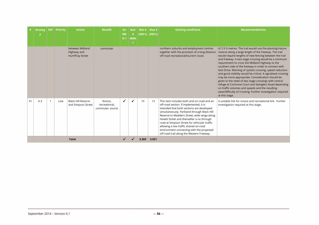
September 2014 – Version 0.1 — 56 —
# Strateg
y
Ref Priority Action Benefit On
MB
N ?
Buil
d
MBN
?
Min $
(000's)
Max $
(000's)
Existing conditions Recommendations
between Midland
Highway and
Humffray Street
commuter northern suburbs and employment centres
together with the provision of a long distance
off-road recreational/tourism route.
of 2.5-3 metres. The trail would use the planting/nature
reserve along a large length of the freeway. The trail
would require lengths of new fencing between the trail
and freeway. A two stage crossing would be a minimum
requirement to cross the Midland Highway to the
southern side of the freeway in order to connect with
Giot Drive. Warning of cyclists crossing, speed reduction
and good visibility would be critical. A signalised crossing
may be more appropriate. Consideration should be
given to the need of two stage crossings with central
refuge at Cochrane Court and Swinglers Road depending
on traffic volumes and speeds and the resulting
ease/difficulty of crossing. Further investigation required
at this stage.
41 6.3 1 Low Black Hill Reserve
and Simpson Street
Novice,
recreational,
commuter, tourist
10 12 This item includes both and on-road and an
off-road section. If implemented, it is
intended that both sections are developed
simultaneously. Parkland through Black Hill
Reserve to Maddern Street, wide verge along
Howitt Street and thereafter a no through
road at Simpson Street for vehicular traffic
allowing a low traffic shared on-road
environment connecting with the proposed
off-road trail along the Western Freeway.
A suitable link for novice and recreational link. Further
investigation required at this stage.
Total 3,365 3,921
September 2014 – Version 0.1 — 57 —
Appendix C: Infrastructure guidelines and standards
(For advice on designing roundabouts with bike riders in mind, refer to
https://www.bicyclenetwork.com.au/general/bike-futures/42527/ and
https://www.bicyclenetwork.com.au/general/bike-futures/42528/)
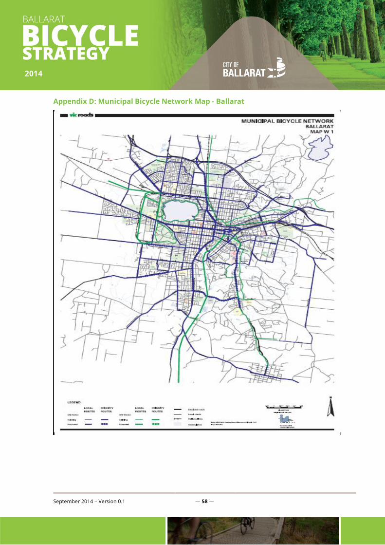
September 2014 – Version 0.1 — 58 —
Appendix D: Municipal Bicycle Network Map - Ballarat