Embed Size (px)
Citation preview

Background ReportGuidance for Roadway Safety Data to Support the Highway Safety Improvement Program
FHWA-SA-11-39 June 2011
http://safety.fhwa.dot.gov
BackgroundReport:GuidanceforRoadwaySafetyDatatoSupporttheHighwaySafetyImprovementProgram
ii
Notice
This document is disseminated under the sponsorship of the U.S. Department of Transportation in the interest of information exchange. The U.S. Government assumes no liability for the use of the information contained in this document.
The U.S. Government does not endorse products or manufacturers. Trademarks or manufacturers’ names appear in this report only because they are considered essential to the objective of the document.
Quality Assurance Statement
The Federal Highway Administration (FHWA) provides high-quality information to serve Government, industry, and the public in a manner that promotes public understanding. Standards and policies are used to ensure and maximize the quality, objectivity, utility, and integrity of its information. FHWA periodically reviews quality issues and adjusts its programs and processes to ensure continuous quality improvement.
BackgroundReport:GuidanceforRoadwaySafetyDatatoSupporttheHighwaySafetyImprovementProgram
iii
AcknowledgementsThe project team would like to thank the following individuals who served as members on the Federal Highway Administration (FHWA) Office of Safety Technical Working Group for this effort. Their contributions helped shape the guidance that States will be receiving on the fundamental roadway safety data elements to support their Highway Safety Improvement Programs.
Office of Safety Technical Working Group
Robert Pollack, FHWA Office of Safety
Jeff Miller, FHWA Office of Safety
Mike Griffith, FHWA Office of Safety
Erin Kenley, FHWA Office of Safety
Ed Rice, FHWA Office of Safety
Lincoln Cobb, FHWA Office of Safety Research and Development
Ray Krammes, FHWA Office of Safety Research and Development
Joe Hausman, FHWA Office of Highway Policy Information
Greg Schertz, FHWA Federal Lands
Christine Thorkildsen, FHWA New York Division
Greg Piland, FHWA Illinois Division
Jerry Roche, FHWA Iowa Division
David Harkey, University of North Carolina Highway Safety Research Center
Forrest Council, University of North Carolina Highway Safety Research Center
BackgroundReport:GuidanceforRoadwaySafetyDatatoSupporttheHighwaySafetyImprovementProgram
iv
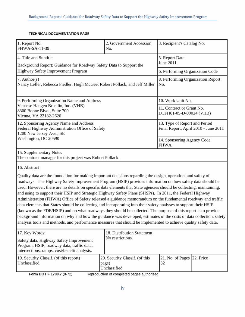
TECHNICAL DOCUMENTATION PAGE
1. Report No. FHWA-SA-11-39
2. Government Accession No.
3. Recipient's Catalog No.
4. Title and Subtitle
Background Report: Guidance for Roadway Safety Data to Support the Highway Safety Improvement Program
5. Report Date June 2011
6. Performing Organization Code
7. Author(s) Nancy Lefler, Rebecca Fiedler, Hugh McGee, Robert Pollack, and Jeff Miller
8. Performing Organization Report No.
9. Performing Organization Name and Address Vanasse Hangen Brustlin, Inc. (VHB) 8300 Boone Blvd., Suite 700 Vienna, VA 22182-2626
10. Work Unit No.
11. Contract or Grant No. DTFH61-05-D-00024 (VHB)
12. Sponsoring Agency Name and Address Federal Highway Administration Office of Safety 1200 New Jersey Ave., SE Washington, DC 20590
13. Type of Report and Period Final Report, April 2010 - June 2011
14. Sponsoring Agency Code FHWA
15. Supplementary Notes The contract manager for this project was Robert Pollack.
16. Abstract
Quality data are the foundation for making important decisions regarding the design, operation, and safety of roadways. The Highway Safety Improvement Program (HSIP) provides information on how safety data should be used. However, there are no details on specific data elements that State agencies should be collecting, maintaining, and using to support their HSIP and Strategic Highway Safety Plans (SHSPs). In 2011, the Federal Highway Administration (FHWA) Office of Safety released a guidance memorandum on the fundamental roadway and traffic data elements that States should be collecting and incorporating into their safety analyses to support their HSIP (known as the FDE/HSIP) and on what roadways they should be collected. The purpose of this report is to provide background information on why and how the guidance was developed, estimates of the costs of data collection, safety analysis tools and methods, and performance measures that should be implemented to achieve quality safety data.
17. Key Words:
Safety data, Highway Safety Improvement Program, HSIP, roadway data, traffic data, intersections, ramps, cost/benefit analysis.
18. Distribution Statement No restrictions.
19. Security Classif. (of this report) Unclassified
20. Security Classif. (of this page) Unclassified
21. No. of Pages 32
22. Price
Form DOT F 1700.7 (8-72) Reproduction of completed pages authorized
BackgroundReport:GuidanceforRoadwaySafetyDatatoSupporttheHighwaySafetyImprovementProgram
v
BackgroundReport:GuidanceforRoadwaySafetyDatatoSupporttheHighwaySafetyImprovementProgram
vi
AcronymsAADT Annual Average Daily Traffic
CFR Code of Federal Regulations
DOT Department of Transportation
EMS Emergency Medical Services
FDE/HSIP Fundamental Data Elements for HSIP
FHWA Federal Highway Administration
FMCSA Federal Motor Carrier Safety Administration
GIS Geographic Information System
HCM Highway Capacity Manual
HPMS Highway Performance Monitoring System
HSIP Highway Safety Improvement Program
HSM Highway Safety Manual
IHSDM Interactive Highway Safety Design Model
LIDAR Light Detection and Ranging
LRS Location Referencing System
MIRE Model Inventory of Roadway Elements
MIRE MIS MIRE Management Information Systems
NCHRP National Cooperative Highway Research Program
NHS National Highway System
NHTSA National Highway Traffic Safety Administration
SAFETEA-LU The Safe, Accountable, Flexible, Efficient Transportation Equity Act: A Legacy for Users
SHSP Strategic Highway Safety Plan
TRB SHRP 2 Transportation Research Board Strategic Highway Research Program 2
TRCC Traffic Records Coordinating Committee
TWG Technical Working Group
U.S. United States
BackgroundReport:GuidanceforRoadwaySafetyDatatoSupporttheHighwaySafetyImprovementProgram
vii
TableofContents
Executive Summary ........................................................................................................................ 1
Introduction ..................................................................................................................................... 5
Use of Safety Data in the HSIP....................................................................................................... 6
Model Inventory of Roadway Elements ......................................................................................... 7
Relational Statewide Location Referencing System ....................................................................... 8
Fundamental Data Elements for HSIP ............................................................................................ 8
Resources on Data Collection Methodologies .............................................................................. 12
Data Collection Costs ................................................................................................................... 13
Potential Funding Sources ............................................................................................................ 16
Safety Tools and Methods ............................................................................................................ 16
Highway Safety Manual ........................................................................................................... 17
SafetyAnalyst ............................................................................................................................ 18
Interactive Highway Safety Design Model ............................................................................... 18
AASHTO's NCHRP Series 500 Data and Analysis Guide ....................................................... 19
Performance Measures .................................................................................................................. 19
Summary ....................................................................................................................................... 20
References ..................................................................................................................................... 21
Appendix A: FDE/HSIP Element Data Dictionary ...................................................................... 23
BackgroundReport:GuidanceforRoadwaySafetyDatatoSupporttheHighwaySafetyImprovementProgram
viii
TableofTables
Table 1. FDE/HSIP Elements. ........................................................................................................ 2
Table 2. FDE/HSIP Elements ....................................................................................................... 10
Table 3. Summary of Average Data Collection Costs in Addition to HPMS Requirements (2010 U.S. Dollars) ................................................................................................................................. 15
Table 4. Data Analysis Tools by Analysis Procedures. ................................................................ 17
TableofFigures
Figure 1. Example of GIS Network in Missouri that Allows for Linkages with Data for Safety Analysis.……………………………………………..……………………………..…….……..…8
BackgroundReport:GuidanceforRoadwaySafetyDatatoSupporttheHighwaySafetyImprovementProgram
1
ExecutiveSummary
Quality data are the foundation for making important decisions regarding the design, operation, and safety of roadways. While crash data have been a consistent element of highway safety analysis, in recent years there has been an increased focus on the combination of crash, roadway and traffic data to make more precise and prioritized safety decisions. By incorporating roadway and traffic data into safety analysis procedures, States can better identify safety problems and prescribe solutions to support their Highway Safety Improvement Programs (HSIP) and implement their Strategic Highway Safety Plans (SHSP).
A new generation of safety analysis tools and methods has been developed to help identify safety issues and provide recommendations for improvements. These safety analysis tools, such as the Highway Safety Manual (HSM), SafetyAnalyst, and the Interactive Highway Safety Design Model (IHSDM) all require quality roadway, traffic, and crash data to achieve the most accurate results. Integrating roadway and traffic data together with crash data can help agencies to make decisions that are fiscally responsible and to improve the safety of the roadway for all users.
Title 23 - Code of Federal Regulations, Part 924 on the Highway Safety Improvement Program (23 CRF 924) provides information on how safety data should be used (1). However, there are no details on specific roadway and traffic data elements that State agencies should be collecting, maintaining, and using to support their HSIPs and SHSPs. In 2011, the Federal Highway Administration (FHWA) Office of Safety released a guidance memorandum on the fundamental data elements that States should be collecting and incorporating into their safety analyses to support their HSIP and on what roadways they should be collected. The purpose of this report is to provide background information on why and how the guidance was developed, estimates of the costs of data collection, safety analysis tools and methods, and performance measures that should be considered and implemented to achieve quality safety data.
At a minimum, States should have a common relational location referencing system (i.e., geographic information system, linear referencing system, etc.) for all public roads. With the ability to locate crashes, States will be able to identify high crash locations on all public roads in the State. As States expand their inventories, this common relational referencing system will enable States to link these locations with roadway and traffic data.
Once a statewide location referencing system is in place, States should move towards collecting a set of fundamental roadway inventory data elements necessary to support an HSIP on all public roads. Recognizing that this may not be feasible for all States, States should prioritize collecting these elements on Federal-aid roads first and then expand to non-Federal-aid roads. Federal-aid roads include the National Highway System (NHS) and all functional systems excluding rural minor collectors and locals.
These fundamental data elements for HSIP (FDE/HSIP), as determined by an expert Technical Working Group (TWG), are shown in Table 1.

BackgroundReport:GuidanceforRoadwaySafetyDatatoSupporttheHighwaySafetyImprovementProgram
2
Table 1. FDE/HSIP Elements.
FDE/HSIP Elements Definition
Roadway Segment
Segment ID* Unique segment identifier.
Route Name* Signed numeric value for the roadway segment.
Alternate Route Name* The route or street name, where different from route number.
Route Type* Federal-aid/NHS route type.
Area Type* The rural or urban designation based on Census urban boundary and population.
Date Opened to Traffic The date at which the site was opened to traffic.
Start Location* The location of the starting point of the roadway segment.
End Location* The location of the ending point of the roadway segment.
Segment Length* The length of the segment.
Segment Direction Direction of inventory if divided roads are inventoried in each direction.
Roadway Class* The functional class of the segment.
Median Type The type of median present on the segment.
Access Control* The degree of access control.
Two-Way vs. One-Way Operation*
Indication of whether the segment operates as a one- or two-way roadway.
Number of Through Lanes* The total number of through lanes on the segment. This excludes turn lanes and auxiliary lanes.
Interchange Influence Area on Mainline Freeway
The value of this item indicates whether or not a roadway is within an interchange influence area.
AADT* The average number of vehicles passing through a segment from both directions of the mainline route for all days of a specified year.
AADT Year* Year of AADT.
Intersection
Intersection ID A unique junction identifier.
Location Location of the center of the junction on the first intersecting route (e.g., route-milepost).
Background Report: Guidance for Roadway Safety Data to Support the Highway Safety Improvement Program
3
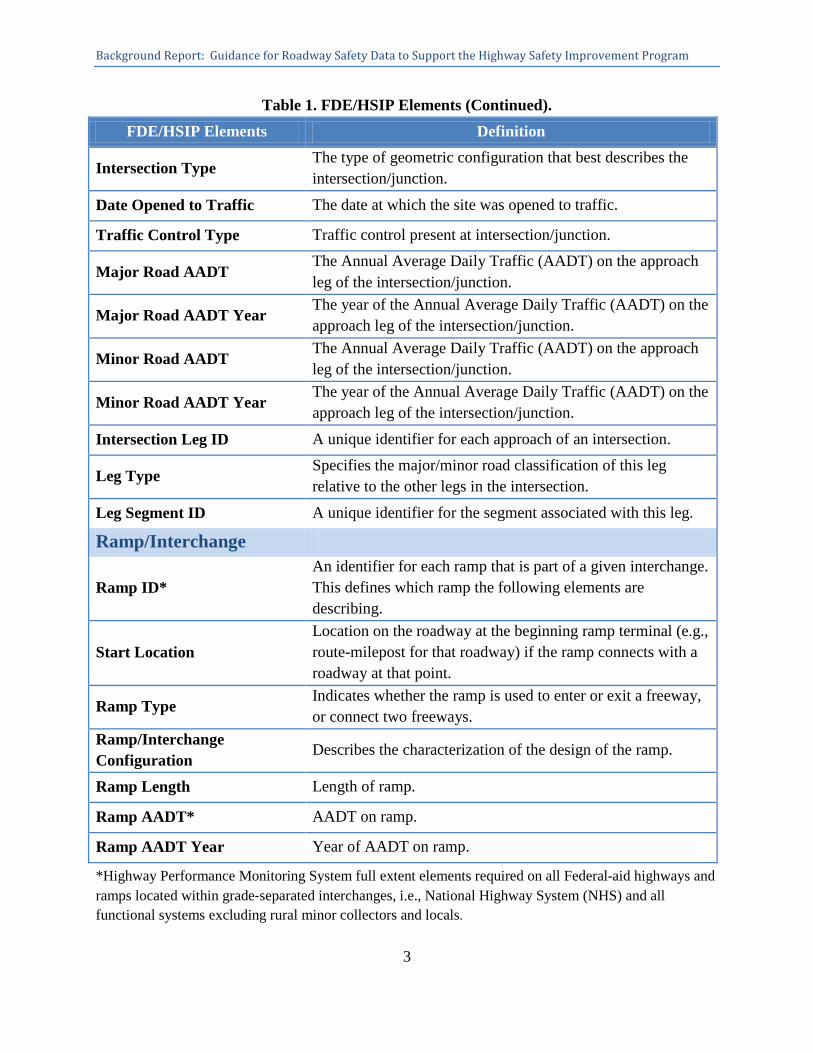
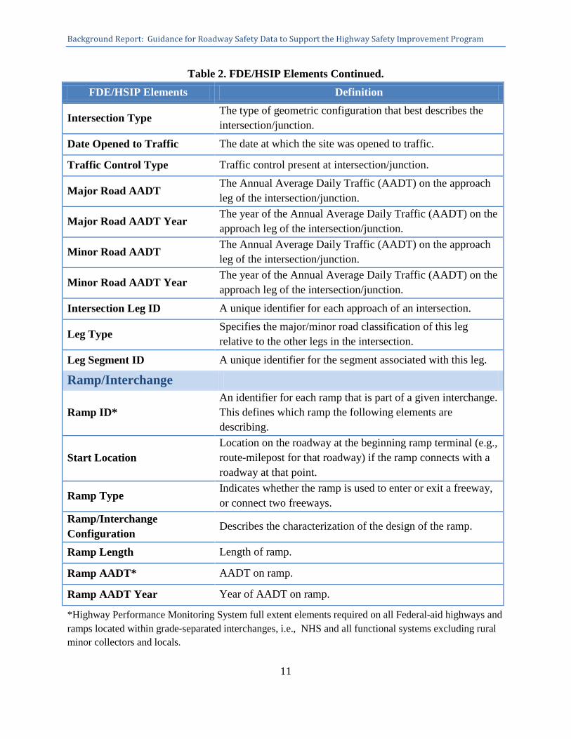
Table 1. FDE/HSIP Elements (Continued). FDE/HSIP Elements Definition
Intersection Type The type of geometric configuration that best describes the intersection/junction.
Date Opened to Traffic The date at which the site was opened to traffic.
Traffic Control Type Traffic control present at intersection/junction.
Major Road AADT The Annual Average Daily Traffic (AADT) on the approach leg of the intersection/junction.
Major Road AADT Year The year of the Annual Average Daily Traffic (AADT) on the approach leg of the intersection/junction.
Minor Road AADT The Annual Average Daily Traffic (AADT) on the approach leg of the intersection/junction.
Minor Road AADT Year The year of the Annual Average Daily Traffic (AADT) on the approach leg of the intersection/junction.
Intersection Leg ID A unique identifier for each approach of an intersection.
Leg Type Specifies the major/minor road classification of this leg relative to the other legs in the intersection.
Leg Segment ID A unique identifier for the segment associated with this leg.
Ramp/Interchange
Ramp ID* An identifier for each ramp that is part of a given interchange. This defines which ramp the following elements are describing.
Start Location Location on the roadway at the beginning ramp terminal (e.g., route-milepost for that roadway) if the ramp connects with a roadway at that point.
Ramp Type Indicates whether the ramp is used to enter or exit a freeway, or connect two freeways.
Ramp/Interchange Configuration
Describes the characterization of the design of the ramp.
Ramp Length Length of ramp.
Ramp AADT* AADT on ramp.
Ramp AADT Year Year of AADT on ramp.
*Highway Performance Monitoring System full extent elements required on all Federal-aid highways and ramps located within grade‐separated interchanges, i.e., National Highway System (NHS) and all functional systems excluding rural minor collectors and locals.
Background Report: Guidance for Roadway Safety Data to Support the Highway Safety Improvement Program
4
These are based on the elements needed to apply the HSM roadway safety management procedures (Part B) using network screening analytical tools (such as SafetyAnalyst), are a subset of Model Inventory of Roadway Elements (MIRE), and duplicates many of the elements that States already collect for the Highway Performance Monitoring System (HPMS) on the full extent of Federal-aid roadways.
While the FDE/HSIP were selected in part based on the basic data requirements of existing tools such as such as the HSM and related SafetyAnalyst, they are not exclusive to these tools. FHWA recognizes that many States are developing analysis tools in-house that will help to support their HSIPs. The FDE/HSIP are a basic set of elements an agency would need to conduct effective enhanced safety analysis independent of the specific analysis tools used or methods applied. All States should be moving towards using analysis tools and having the FDE/HSIP available to utilize these tools, regardless of whether they are the tools developed through federal efforts or they are developed in-house.
Background Report: Guidance for Roadway Safety Data to Support the Highway Safety Improvement Program
5
Introduction
In 2009, 33,808 people died in motor vehicle traffic crashes in the United States. According to the U.S. Department of Transportation, the total societal cost of crashes exceeds $230 billion annually (2). The Safe, Accountable, Flexible, Efficient Transportation Equity Act: A Legacy for Users (SAFETEA-LU), which was signed into law on August 10, 2005, established the Highway Safety Improvement Program (HSIP) as a core Federal-aid program. The overall objective of the HSIP is to significantly reduce the occurrence of and the potential for fatalities and serious injuries resulting from crashes on all public roads. A major stipulation of the program is that “The HSIP shall include a data driven [Strategic Highway Safety Plan] SHSP and the resulting implementation through highway safety improvement projects” (1). Safety data are not limited to crash data only. A comprehensive traffic records system necessary to support a robust safety program includes crash, roadway, traffic, vehicle, driver, citation and adjudication, and injury control/emergency medical services (EMS) data.
Title 23 - Code of Federal Regulations, Part 924 on the Highway Safety Improvement Program (23 CRF 924) provides information on how safety data should be used (1). However, there are no details on specific data elements that State agencies should be collecting, maintaining, and using to support their HSIPs and SHSPs. In 2011, the Federal Highway Administration (FHWA) Office of Safety released a guidance memorandum on the fundamental roadway and traffic data elements that States should be collecting and incorporating into their safety analyses to support their HSIP and on what roadways they should be collected. The purpose of this report is to provide background information on why and how the guidance was developed, estimates of the costs of data collection, safety analysis tools and methods, and performance measures that should be considered and implemented to achieve quality safety data.
Quality data are the foundation for making important decisions regarding the design, operation, and safety of roadways. In recent years, there has been an increased focus on the roadway and traffic components of traffic records systems. By incorporating roadway and traffic data into safety analysis procedures, States can better identify safety problems and prescribe solutions to support their HSIP and implement their SHSP.
A new generation of safety analysis tools and methods has been developed to help identify safety problems and to determine needed improvements. These safety analysis tools include the Highway Safety Manual (HSM), SafetyAnalyst, and the Interactive Highway Safety Design Model (IHSDM). These tools require quality roadway, traffic, and crash data to achieve the most accurate results. Using roadway and traffic data together with crash data can help agencies to make decisions that are fiscally responsible and to improve the safety of the roadways for all users.

Background Report: Guidance for Roadway Safety Data to Support the Highway Safety Improvement Program
6
Use of Safety Data in the HSIP
The overall objective of the HSIP is to significantly reduce the occurrence of fatalities and serious injuries resulting from crashes on all public roads. FHWA established a formalized HSIP process to ensure that the HSIP is carried out in an organized, systematic manner where the greatest benefits are achieved. The 23 CFR Part 924 states that “The HSIP shall include a data-driven SHSP and the resulting implementation through highway safety improvement projects.” Further, it defines a SHSP as “a comprehensive, data-driven safety plan developed, implemented, and evaluated in accordance with 23 U.S.C. 148”(1).
The formalized HSIP process consists of three major components—planning, implementation, and evaluation—and addresses the role of safety data in the HSIP. Additional language from 23 CFR 924 on how data are to be used in the HSIP for each of these components includes:
§ 924.9 Planning
(a) The HSIP planning process shall incorporate:
(1) A process for collecting and maintaining a record of crash, roadway, traffic and vehicle data on all public roads including railway-highway grade crossings inventory data that includes, but is not limited to, the characteristics of both highway and train traffic.
(2) A process for advancing the State’s capabilities for safety data collection and analysis by improving the timeliness, accuracy, completeness, uniformity, integration, and accessibility of the State’s safety data or traffic records.
(3) A process for analyzing available safety data.
§ 924.11 Implementation
(d)…In addition, up to two percent of the section 130 funds apportioned to a State may be used for compilation and analysis of safety data for the annual report to the FHWA Division Administrator required under § 924.15(a).
§ 924.13 Evaluation.
(a) The HSIP evaluation process shall include the evaluation of the overall HSIP and the SHSP. It shall:
(i) Ensure the accuracy and currency of the safety data (1).

Background Report: Guidance for Roadway Safety Data to Support the Highway Safety Improvement Program
7
While 23 CFR 924 provides guidance on how safety data should be used, there is no additional detail on the specific data elements that State and local agencies should be collecting, maintaining, and using to support their HSIP and the development and implementation of their SHSPs.
Model Inventory of Roadway Elements
MIRE, the Model Inventory of Roadway Elements, is a listing of recommended roadway inventory and traffic elements important to safety management (3). MIRE is intended as a guideline to help transportation agencies improve their roadway and traffic data inventories. It provides a basis for a standard of what can be considered a good/robust data inventory and helps agencies move towards the use of performance measures (which will be discussed in detail in subsequent sections).
There are a total of 202 elements that comprise the MIRE listing. These elements are divided among three broad categories: roadway segments, roadway alignment, and roadway junctions. Examples of the MIRE data elements include:
• Roadway classification.
• Paved surface characteristics.
• Number and type of travel lanes.
• Shoulder, median, and roadside descriptors.
• Curve and grade information.
• Traffic control devices.
• Intersection features.
• Interchange and ramp descriptors.
• Pedestrian and bicyclist facilities.
• Traffic volumes.
There are many benefits to State and local transportation agencies expanding their inventories through the collection of MIRE elements. Having these additional data can help identify where the safety problems are, what those problems are, and how best to treat them. The MIRE Version 1.0 Report as well as additional information on MIRE, can be found at http://www.mireinfo.org.
The FHWA is now engaged in the next step in the MIRE development effort—testing the feasibility of a MIRE Management Information System (MIRE MIS). The MIRE MIS effort will involve working with pilot agencies to collect MIRE data and incorporate the data into their
Background Report: Guidance for Roadway Safety Data to Support the Highway Safety Improvement Program
8
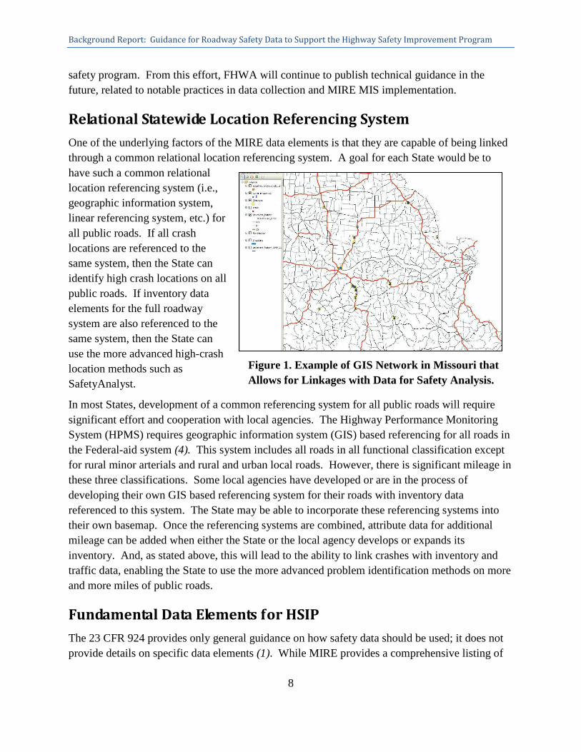
Figure 1. Example of GIS Network in Missouri that Allows for Linkages with Data for Safety Analysis.
safety program. From this effort, FHWA will continue to publish technical guidance in the future, related to notable practices in data collection and MIRE MIS implementation.
Relational Statewide Location Referencing System
One of the underlying factors of the MIRE data elements is that they are capable of being linked through a common relational location referencing system. A goal for each State would be to have such a common relational location referencing system (i.e., geographic information system, linear referencing system, etc.) for all public roads. If all crash locations are referenced to the same system, then the State can identify high crash locations on all public roads. If inventory data elements for the full roadway system are also referenced to the same system, then the State can use the more advanced high-crash location methods such as SafetyAnalyst.
In most States, development of a common referencing system for all public roads will require significant effort and cooperation with local agencies. The Highway Performance Monitoring System (HPMS) requires geographic information system (GIS) based referencing for all roads in the Federal-aid system (4). This system includes all roads in all functional classification except for rural minor arterials and rural and urban local roads. However, there is significant mileage in these three classifications. Some local agencies have developed or are in the process of developing their own GIS based referencing system for their roads with inventory data referenced to this system. The State may be able to incorporate these referencing systems into their own basemap. Once the referencing systems are combined, attribute data for additional mileage can be added when either the State or the local agency develops or expands its inventory. And, as stated above, this will lead to the ability to link crashes with inventory and traffic data, enabling the State to use the more advanced problem identification methods on more and more miles of public roads.
Fundamental Data Elements for HSIP
The 23 CFR 924 provides only general guidance on how safety data should be used; it does not provide details on specific data elements (1). While MIRE provides a comprehensive listing of
Background Report: Guidance for Roadway Safety Data to Support the Highway Safety Improvement Program
9
roadway and traffic data elements, it may not be feasible for States to collect all of the 200+ MIRE elements and integrate them into their existing programs. State and local departments of transportation (DOTs), particularly highway safety agencies, are facing increasing demands and decreasing resources.
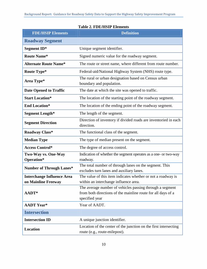
In order to address the States’ safety data improvements challenges, the FHWA held a series of information gathering sessions and convened a Technical Working Group (TWG) to determine the roadway and traffic data elements that States should be collecting, what States are capable of collecting given the current economic environment, and the importance of using roadway and traffic data in the safety analysis process. Based on these efforts, a set of elements was determined to be the fundamental roadway inventory data elements necessary to support a State’s HSIP. This set of data elements is hereafter referred to as the Fundamental Data Elements for HSIP (FDE/HSIP). These are based on the elements needed to apply HSM roadway safety management (Part B) procedures using network screening analytical tools (such as SafetyAnalyst), are a subset of MIRE, and duplicate many of HPMS full extent elements that States are already required to collect on Federal-aid Highways. The FDE/HSIP are comprised of roadway segment, intersection, and ramp elements as shown in Table 2.
Background Report: Guidance for Roadway Safety Data to Support the Highway Safety Improvement Program
10
Table 2. FDE/HSIP Elements FDE/HSIP Elements Definition
Roadway Segment Segment ID* Unique segment identifier.
Route Name* Signed numeric value for the roadway segment.
Alternate Route Name* The route or street name, where different from route number.
Route Type* Federal-aid/National Highway System (NHS) route type.
Area Type* The rural or urban designation based on Census urban boundary and population.
Date Opened to Traffic The date at which the site was opened to traffic.
Start Location* The location of the starting point of the roadway segment.
End Location* The location of the ending point of the roadway segment.
Segment Length* The length of the segment.
Segment Direction Direction of inventory if divided roads are inventoried in each direction.
Roadway Class* The functional class of the segment.
Median Type The type of median present on the segment.
Access Control* The degree of access control.
Two-Way vs. One-Way Operation*
Indication of whether the segment operates as a one- or two-way roadway.
Number of Through Lanes* The total number of through lanes on the segment. This excludes turn lanes and auxiliary lanes.
Interchange Influence Area on Mainline Freeway
The value of this item indicates whether or not a roadway is within an interchange influence area.
AADT* The average number of vehicles passing through a segment from both directions of the mainline route for all days of a specified year
AADT Year* Year of AADT.
Intersection Intersection ID A unique junction identifier.
Location Location of the center of the junction on the first intersecting route (e.g., route-milepost).
Background Report: Guidance for Roadway Safety Data to Support the Highway Safety Improvement Program
11
Table 2. FDE/HSIP Elements Continued. FDE/HSIP Elements Definition
Intersection Type The type of geometric configuration that best describes the intersection/junction.
Date Opened to Traffic The date at which the site was opened to traffic.
Traffic Control Type Traffic control present at intersection/junction.
Major Road AADT The Annual Average Daily Traffic (AADT) on the approach leg of the intersection/junction.
Major Road AADT Year The year of the Annual Average Daily Traffic (AADT) on the approach leg of the intersection/junction.
Minor Road AADT The Annual Average Daily Traffic (AADT) on the approach leg of the intersection/junction.
Minor Road AADT Year The year of the Annual Average Daily Traffic (AADT) on the approach leg of the intersection/junction.
Intersection Leg ID A unique identifier for each approach of an intersection.
Leg Type Specifies the major/minor road classification of this leg relative to the other legs in the intersection.
Leg Segment ID A unique identifier for the segment associated with this leg.
Ramp/Interchange
Ramp ID* An identifier for each ramp that is part of a given interchange. This defines which ramp the following elements are describing.
Start Location Location on the roadway at the beginning ramp terminal (e.g., route-milepost for that roadway) if the ramp connects with a roadway at that point.
Ramp Type Indicates whether the ramp is used to enter or exit a freeway, or connect two freeways.
Ramp/Interchange Configuration
Describes the characterization of the design of the ramp.
Ramp Length Length of ramp.
Ramp AADT* AADT on ramp.
Ramp AADT Year Year of AADT on ramp.
*Highway Performance Monitoring System full extent elements required on all Federal-aid highways and ramps located within grade‐separated interchanges, i.e., NHS and all functional systems excluding rural minor collectors and locals.
Background Report: Guidance for Roadway Safety Data to Support the Highway Safety Improvement Program
12
The TWG determined that a primary goal should be to collect these 38 FDE/HSIP on all public roads. However, if a State does not have the resources to undertake the collection of all FDE/HSIP on all public roads, it is recommended as a first priority that these elements be collected on all Federal-aid highways. Federal-aid highways comprise approximately 25 percent of the Nation’s roadways and account for approximately 75 percent of fatalities (5,6). By collecting data on Federal-aid highways, States will be targeting the roadways on which a large portion of crashes occur.
Once the FDE/HSIP are collected on Federal-aid highways, States should collect the FDE/HSIP on non-Federal-aid highways. If collecting these data along all non-Federal-aid highways at one time is not feasible, the State should determine a methodology for prioritizing its collection efforts, which could be based on the following:
• Urban or rural.
• County/District.
• Functional class.
• Traffic volume.
These are just examples; each State should determine which methodology is most appropriate for its individual circumstances. A data dictionary of the elements, including the corresponding MIRE element(s), is included in Appendix A.
Resources on Data Collection Methodologies
The FHWA Office of Safety is currently developing several resources that can provide additional information and assistance. Through the MIRE initiative, FHWA is releasing a report entitled Exploring MIRE Element Data Collection Mechanisms (7). This research will provide an overview of:
• The MIRE elements States are already collecting.
• Supplemental data sources that could be used to obtain MIRE data elements – including pavement management systems, sign management systems, and other asset inventories.
• Information on existing and emerging data collection technologies and their potential for use in collecting MIRE data elements (of which the FDE/HSIP are a subset). These include satellite imagery, light detection and ranging (LIDAR), and applications of keyhole markup language and geobrowsers such as Google Earth and Bing.
Background Report: Guidance for Roadway Safety Data to Support the Highway Safety Improvement Program
13
FHWA will also be releasing a MIRE Data Collection Manual as a guidebook for use by State and local agencies to learn innovative methods for collecting MIRE data. It is imperative that the MIRE data elements be collected properly and consistently. The MIRE Data Collection Manual will describe how to collect and record MIRE data elements, and provide a process for post-processing of data.
In addition to these FHWA resources, the National Cooperative Highway Research Program (NCHRP) released Syntheses 367: Technologies for Improving Safety Data, which explores technologies for the acquisition, processing, and overall management of crash, roadway inventory, and traffic operations data (8). While it is not specific to the MIRE elements, there is still information in the report that States may find useful.
The report can be found online at http://onlinepubs.trb.org/onlinepubs/nchrp/nchrp_syn_367.pdf.
Data Collection Costs
The FHWA Office of Safety recognizes that collecting additional data elements and incorporating them into an existing safety program requires financial resources. States will be concerned about the additional cost to collect these 38 FDE/HSIP. Therefore, FHWA conducted an analysis to estimate the cost to develop a relational location referencing system and collect the FDE/HSIP on all public roads.
The additional costs that States would incur are the costs to collect what is not already being collected through HPMS or not already being collected through other efforts. At the time of this analysis, FHWA did not know the extent of data collection practices for all States beyond HPMS requirements. In order to accommodate a range of data collection practices among the States, the methodology for the analysis was conservatively based on the assumption that all data collection beyond HPMS requirements would be new collection. Therefore, this analysis of the additional cost to States is most likely greater than the actual cost that would be incurred. Individual cost estimates would vary by the circumstances in each State.
A location referencing system is already required under HPMS for all Federal-aid highways. In addition, 16 of the 38 FDE/HSIP are also already required for collection under the HPMS for the full extent of Federal-aid highways (4). Full extent accounts for all Federal‐aid highways and ramps located within grade‐separated interchanges (i.e., NHS and all functional systems excluding rural minor collectors and locals). Table 12 indicates which of the 38 FDE/HSIP HPMS full extent elements are.
Background Report: Guidance for Roadway Safety Data to Support the Highway Safety Improvement Program
14
A summary of the additional costs identified include the following three sets of data elements:
1. A common relational location referencing system.
- Additional costs would only be incurred on all non-Federal-aid roadways, since HPMS currently requires this for Federal-aid highways.
2. The 22 FDE/HSIP that are not required under HPMS.
- Additional costs would only be incurred on Federal-aid roadways since the remaining 16 of the total FDE/HSIP are already required for HPMS on Federal-aid highways.
3. The complete 38 FDE/HSIP.
- Additional costs would be incurred on all non-Federal-aid highways, since HPMS does not require data collection of these elements on non-Federal-aid roadways.
In order to conduct the analysis, costs were obtained from 12 data collection vendors from around the country. Costs were obtained from the vendors on a per mile basis along segments, a per intersection basis for intersections, and a per ramp basis for ramps. The costs for developing a location referencing system were estimated per mile. For the case of traffic counts on segments, an estimate of one count per mile was used to estimate the per mile cost. These costs included data collection and reduction for integration into a State’s existing system.
Vendors were identified based on the list of vendors involved in the North Carolina and the Transportation Research Board Strategic Highway Research Program 2 (TRB SHRP2) data collection rodeos which were both conducted in 2008. These rodeos were conducted to test the capabilities of roadway data collection technologies. Many of the rodeo vendors only collected roadway inventory elements and not traffic counts, so the project team also identified several companies that collect traffic counts to obtain cost estimates. The (non-traffic) roadway elements are collected using different methods than the traffic data, and, therefore, the costs for each were calculated separately.
The majority of vendors indicated they would use digital data collection vans to collect the (non-traffic) roadway inventory data. For traffic count data, vendors provided cost estimates based on 48-hour classification counts for segment traffic data, peak hour manual counts for intersections, and technology similar to segment counts to collect ramp data. The costs provided were averaged to develop estimates. A summary of the data collection costs is shown in Table 3.
Background Report: Guidance for Roadway Safety Data to Support the Highway Safety Improvement Program
15
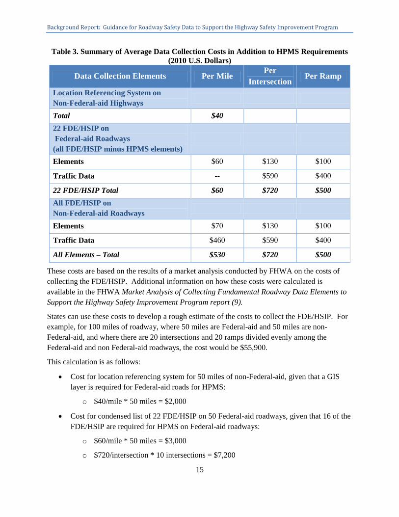
Table 3. Summary of Average Data Collection Costs in Addition to HPMS Requirements (2010 U.S. Dollars)
Data Collection Elements Per Mile Per
Intersection Per Ramp
Location Referencing System on Non-Federal-aid Highways
Total $40 22 FDE/HSIP on Federal-aid Roadways (all FDE/HSIP minus HPMS elements)
Elements $60 $130 $100
Traffic Data -- $590 $400
22 FDE/HSIP Total $60 $720 $500 All FDE/HSIP on Non-Federal-aid Roadways
Elements $70 $130 $100
Traffic Data $460 $590 $400
All Elements – Total $530 $720 $500
These costs are based on the results of a market analysis conducted by FHWA on the costs of collecting the FDE/HSIP. Additional information on how these costs were calculated is available in the FHWA Market Analysis of Collecting Fundamental Roadway Data Elements to Support the Highway Safety Improvement Program report (9).
States can use these costs to develop a rough estimate of the costs to collect the FDE/HSIP. For example, for 100 miles of roadway, where 50 miles are Federal-aid and 50 miles are non-Federal-aid, and where there are 20 intersections and 20 ramps divided evenly among the Federal-aid and non Federal-aid roadways, the cost would be $55,900.
This calculation is as follows:
• Cost for location referencing system for 50 miles of non-Federal-aid, given that a GIS layer is required for Federal-aid roads for HPMS:
o $40/mile * 50 miles = $2,000
• Cost for condensed list of 22 FDE/HSIP on 50 Federal-aid roadways, given that 16 of the FDE/HSIP are required for HPMS on Federal-aid roadways:
o $60/mile * 50 miles = $3,000
o $720/intersection * 10 intersections = $7,200
BackgroundReport:GuidanceforRoadwaySafetyDatatoSupporttheHighwaySafetyImprovementProgram
16
o $500/ramp * 10 ramps = $5,000
Cost for complete list on 50 miles of non-Federal-aid roadways:
o $530/mile * 50 miles = $26,500
o $720/intersection * 10 intersections = $7,200
o $500/ramp * 10 ramps =$5,000
Please note these are conservative estimates that assume there is no existing roadway information other than HPMS. Individual estimates would vary by the circumstances in each State. FHWA has developed a spreadsheet tool to help States better estimate the cost to collect FDE/HSIP. This spreadsheet takes into account collection costs spread over a specified time frame, ongoing costs to maintain the additional data, and other factors involved in the collection and maintenance of data. It also provides States an estimate of how many fatalities and injuries would need to be reduced in order to exceed the data collection costs.
PotentialFundingSources
There are several funding sources available to help support the collection of roadway safety data. The FHWA, the National Highway Traffic Safety Administration (NHTSA), and the Federal Motor Carrier Safety Administration (FMCSA) all have multiple funding mechanisms available to support the collection of roadway safety data.
Through HSIP, FHWA provides federal funding to States for the purpose of reducing traffic fatalities and serious injuries on all public roads through the implementation of infrastructure-related highway safety improvements. Since roadway data are crucial in evaluating infrastructure programs, these funds can be used for data collection.
Each State should contact their FHWA Division Office for additional information on available funding sources. Contact information for the FHWA Divisions Offices can be found at http://www.fhwa.dot.gov/about/field.cfm.
The U.S. DOT Traffic Records Coordinating Committee (TRCC) website provides information on federal funding sources for traffic safety data activities and can be found at http://www.dottrcc.gov/funding_sources/.
The information provided in this section does not imply funding through any one source is guaranteed; rather, it presents potential sources of funding that States may be able to utilize to improve their data inventories.
SafetyToolsandMethodsA new generation of safety analysis tools and methods have been developed to help identify safety issues and provide recommendations for improvements, including the HSM,
BackgroundReport:GuidanceforRoadwaySafetyDatatoSupporttheHighwaySafetyImprovementProgram
17
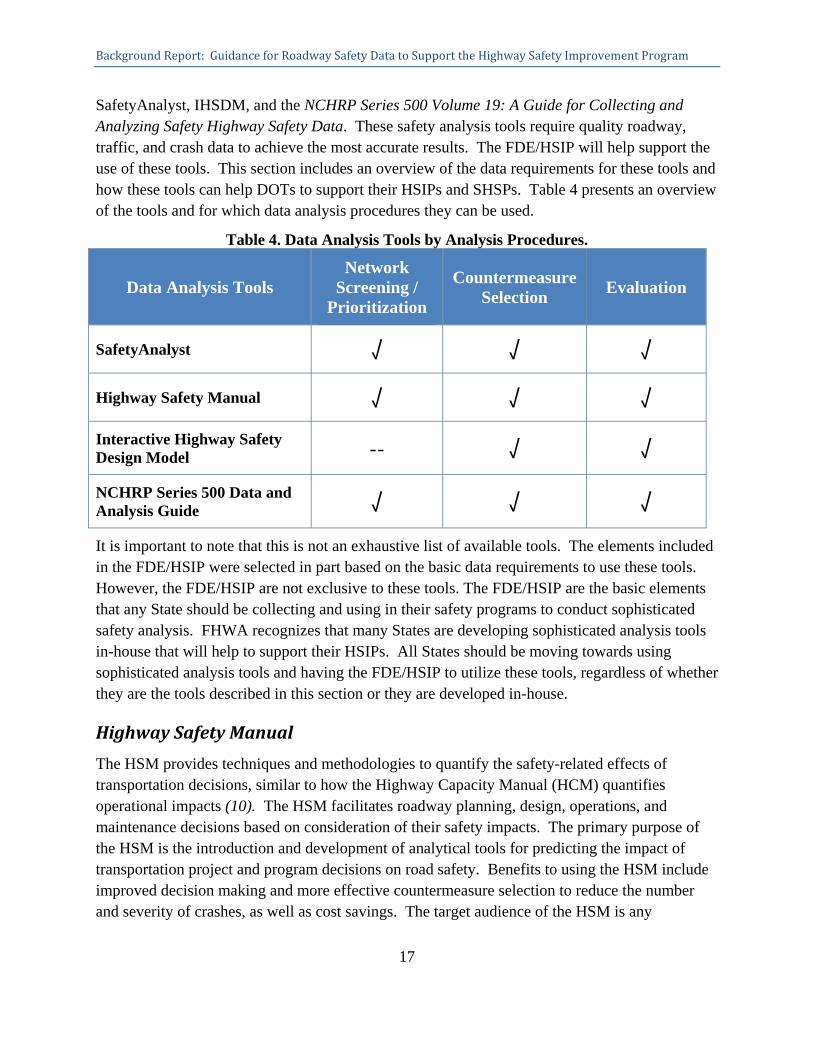
SafetyAnalyst, IHSDM, and the NCHRP Series 500 Volume 19: A Guide for Collecting and Analyzing Safety Highway Safety Data. These safety analysis tools require quality roadway, traffic, and crash data to achieve the most accurate results. The FDE/HSIP will help support the use of these tools. This section includes an overview of the data requirements for these tools and how these tools can help DOTs to support their HSIPs and SHSPs. Table 4 presents an overview of the tools and for which data analysis procedures they can be used.
Table 4. Data Analysis Tools by Analysis Procedures.
Data Analysis Tools Network
Screening / Prioritization
Countermeasure Selection
Evaluation
SafetyAnalyst √ √ √
Highway Safety Manual √ √ √
Interactive Highway Safety Design Model -- √ √
NCHRP Series 500 Data and Analysis Guide √ √ √
It is important to note that this is not an exhaustive list of available tools. The elements included in the FDE/HSIP were selected in part based on the basic data requirements to use these tools. However, the FDE/HSIP are not exclusive to these tools. The FDE/HSIP are the basic elements that any State should be collecting and using in their safety programs to conduct sophisticated safety analysis. FHWA recognizes that many States are developing sophisticated analysis tools in-house that will help to support their HSIPs. All States should be moving towards using sophisticated analysis tools and having the FDE/HSIP to utilize these tools, regardless of whether they are the tools described in this section or they are developed in-house.
HighwaySafetyManual
The HSM provides techniques and methodologies to quantify the safety-related effects of transportation decisions, similar to how the Highway Capacity Manual (HCM) quantifies operational impacts (10). The HSM facilitates roadway planning, design, operations, and maintenance decisions based on consideration of their safety impacts. The primary purpose of the HSM is the introduction and development of analytical tools for predicting the impact of transportation project and program decisions on road safety. Benefits to using the HSM include improved decision making and more effective countermeasure selection to reduce the number and severity of crashes, as well as cost savings. The target audience of the HSM is any
BackgroundReport:GuidanceforRoadwaySafetyDatatoSupporttheHighwaySafetyImprovementProgram
18
transportation professional, including State and local transportation agency personnel, engineering consultants, etc.
The HSM is divided into four parts:
Part A: Introduction, Human Factors, and Fundamentals.
Part B: Roadway Safety Management Process.
Part C: Predictive Method.
Part D: Crash Modification Factors.
There are three primary categories of data that are required for the HSM: crash data, roadway characteristics data, and traffic data. More information on the HSM can be found at http://www.highwaysafetymanual.org/Pages/default.aspx.
SafetyAnalyst and the IHSDM are software implementations of the HSM and are discussed in further detail in the subsequent sections.
SafetyAnalyst
SafetyAnalyst is a software implementation of Part B of the HSM (11). It is a stand-alone set of software tools used to identify and manage a system-wide program of site-specific highway safety issues and recommended improvements. It uses state-of-the-art safety management approaches and incorporates a cost-effective analysis to help guide the decision-making process to identify specific safety improvements that involve physical modifications of the highway system. SafetyAnalyst is beneficial in helping highway agencies to get the most safety benefit from each dollar spent on a project. The software includes six different tools: Network Screening, Diagnosis, Countermeasure Selection, Economic Appraisal, Priority Ranking, and Countermeasure Evaluation.
The minimum set of data elements required to use SafetyAnalyst includes the following: roadway segment characteristics, intersection characteristics, ramp characteristics, exposure data, and crash data. More information on SafetyAnalyst can be found at http://www.safetyanalyst.org/.
InteractiveHighwaySafetyDesignModel
The IHSDM is a stand-alone collection of software analysis tools used to evaluate the safety and operational effects of geometric designs on highways and implements Part C of the HSM (12). The IHSDM is a decision-support tool that gives explicit, quantitative evaluations on existing and proposed geometric designs. The intended users of the tool include highway project managers, designers, and traffic and safety reviewers in State and local highway agencies, and
BackgroundReport:GuidanceforRoadwaySafetyDatatoSupporttheHighwaySafetyImprovementProgram
19
consulting firms. There are six evaluation modules: Policy Review, Crash Prediction, Design Consistency, Intersection Review, Traffic Analysis, and Driver/Vehicle. The Crash Prediction Module estimates the frequency and severity of crashes that can be expected on a roadway based on geometric and traffic conditions. This model can evaluate rural two-lane highways, rural multilane highways, and urban and suburban arterials. The benefits of the IHSDM are that the results not only help users to make decisions to improve the safety performance of their roadways, but the results also justify and defend geometric design decisions.
Data requirements to use the IHSDM include roadway, traffic, and crash data. Specific data requirements will depend on which safety module is used. More information can be found at http://www.fhwa.dot.gov/research/tfhrc/projects/safety/comprehensive/ihsdm/index.cfm.
AASHTO'sNCHRPSeries500DataandAnalysisGuide
Volume 19: A Guide for Collecting and Analyzing Safety Highway Safety Data, part of the NCHRP Report 500 Series, is a guide to assist State and local agency users in locating and analyzing safety data as part of their safety efforts (13). The purpose of the Guide is to provide a basic three-stage procedure for use in developing an emphasis area plan, as well as define data-related procedures that will guide the user in selecting potential treatments and target strategies.
At a minimum, crash data are required to develop a safety plan. The guide discusses other data that are useful in addition to crash data, providing descriptions of the major data types, and where the data might be found if not readily available in the user’s jurisdiction. More information on this guide and the other guides in the NCHRP 500 Series can be found at http://safety.transportation.org/guides.aspx?cid=40.
PerformanceMeasures
Performance measures are fundamental in helping Federal, State, and local agencies to assess the quality of their data systems. As States expand their roadway data inventories by collecting the FDE/HSIP, they should review their current performance measures (if any exist) and implement additional performance measures to achieve quality data. This should be considered not just for roadway data but for all traffic data systems. NHTSA has identified 61 model performance measures to assess the core State traffic records data systems. The performance measures assess the quality characteristics of timeliness, accuracy, completeness, uniformity, integration, and accessibility.
Timeliness reflects the span of time between the occurrence of an event and entry of information into the appropriate database.
Accuracy is the degree to which the data are error-free, satisfy internal consistency checks, and do not exist in duplicate within a single database.
Completeness reflects the number of records that are missing from the database.

BackgroundReport:GuidanceforRoadwaySafetyDatatoSupporttheHighwaySafetyImprovementProgram
20
Uniformity reflects the consistency among the files and records in a database.
Integration is the ability of records in a database to be linked to a set of records in another database.
Accessibility reflects the ability of users to successfully obtain desired data (14).
These attributes are based on the core characteristics of data systems and are intended to help monitor and improve the quality of data in an agency’s traffic record systems. The NHTSA Report entitled Model Performance Measures for State Traffic Records Systems (14) documents specific performance measures for each of the core traffic safety data systems—crash, vehicle, driver, roadway, citation/adjudication, and EMS/injury surveillance. It discusses the key features of the model performance measures and the performance measure criteria. Details are included on how each of the six performance attributes (timeliness, accuracy, completeness, uniformity, integration, and accessibility) are measured for the different data systems. Additional information can be found at: http://www-nrd.nhtsa.dot.gov/Pubs/811441.pdf.
Summary
Quality data are the foundation for making important decisions regarding the design, operation, and safety of roadways. By incorporating roadway and traffic data into safety analysis procedures, States can better identify safety problems and prescribe solutions to support their HSIPs and implement their SHSPs.
The FHWA understands that States and local DOTs are facing increasing demands and decreasing resources. This report provides background information on specific safety data elements that are fundamental to support HSIP, resources on how to collect those elements, and how much it will cost to collect these data. A new generation of safety analysis tools and methods is being developed to help identify safety issues and provide recommendations for improvements. These safety analysis tools all require quality roadway, traffic, and crash data to achieve the most accurate results. Using roadway and traffic data together with crash data can help agencies to make decisions that are fiscally responsible and to improve the safety of the roadways for all users.
This report aims to provide States a framework for moving forward in collecting safety data, incorporating them into their HSIPs, and, ultimately, achieving the goal of reducing fatalities and serious injuries on the Nation’s roadways. FHWA will continue to work with its partners in States, other Federal agencies, and the research community to update the current understanding and state of practice as more information is available and better methods are developed.
BackgroundReport:GuidanceforRoadwaySafetyDatatoSupporttheHighwaySafetyImprovementProgram
21
References
1. Federal Highway Administration, Federal-Aid Policy Guide, Title 23 - Code of Federal Regulations, Subchapter J – Highway Safety. Accessed online June 16, 2011, http://www.fhwa.dot.gov/legsregs/directives/cfr23toc.htm.
2. Federal Highway Administration, Facts & Statistics. Accessed May 10, 2011, http://safety.fhwa.dot.gov/facts_stats/.
3. Lefler, N; F. Council; D. Harkey; D. Carter; H. McGee; and M. Daul. Model Inventory of Roadway Elements - MIRE, Version 1.0. Federal Highway Administration, FHWA-HRT-10-048, Washington DC, October 2010.
4. Federal Highway Administration, Office of Highway Policy Information, Highway Performance Monitoring System, http://www.fhwa.dot.gov/policyinformation/hpms.cfm.
5. Federal Highway Administration, Highway Statistics 2009, Table HM-220, Washington, D.C., January 2011. Accessed online June 17, 2011, http://www.fhwa.dot.gov/policyinformation/statistics/2009/index.cfm.
6. National Highway Traffic Safety Administration, Fatality Analysis Reporting System Encyclopedia, Washington, D.C. Accessed online June 17, 2011, http://www‐fars.nhtsa.dot.gov/.
7. Malella, et al., MIRE Element Data Collection Mechanisms. Federal Highway Administration, publication pending.
8. Ogle, J.H. Technologies for Improving Safety Data, NCHRP Synthesis 367, Transportation Research Board, Washington, D.C., 2007.
9. Lefler, N; R. Fiedler; H. McGee; R. Pollack; and J. Miller. Market Analysis of Collecting Fundamental Roadway Data Elements to Support the Highway Safety Improvement Program, Federal Highway Administration, FHWA-SA-11-40, publication pending.
10. American Association of State Highway and Transportation Officials, Highway Safety Manual, http://www.highwaysafetymanual.org/.
11. American Association of State Highway and Transportation Officials, SafetyAnalyst, http://www.safetyanalyst.org/.
12. Federal Highway Administration, Interactive Highway Safety Design Model, http://www.fhwa.dot.gov/research/tfhrc/projects/safety/comprehensive/ihsdm/index.cfm.
13. National Cooperative Highway Research Program, Volume 19: A Guide for Collecting and Analyzing Safety Highway Safety Data, http://safety.transportation.org/guides.aspx?cid=40.

BackgroundReport:GuidanceforRoadwaySafetyDatatoSupporttheHighwaySafetyImprovementProgram
22
14. National Highway Traffic Safety Administration, Model Performance Measures for State Traffic Records Systems, Report No. DOT HS 811 411, Washington, D.C., February 2011.
BackgroundReport:GuidanceforRoadwaySafetyDatatoSupporttheHighwaySafetyImprovementProgram
23
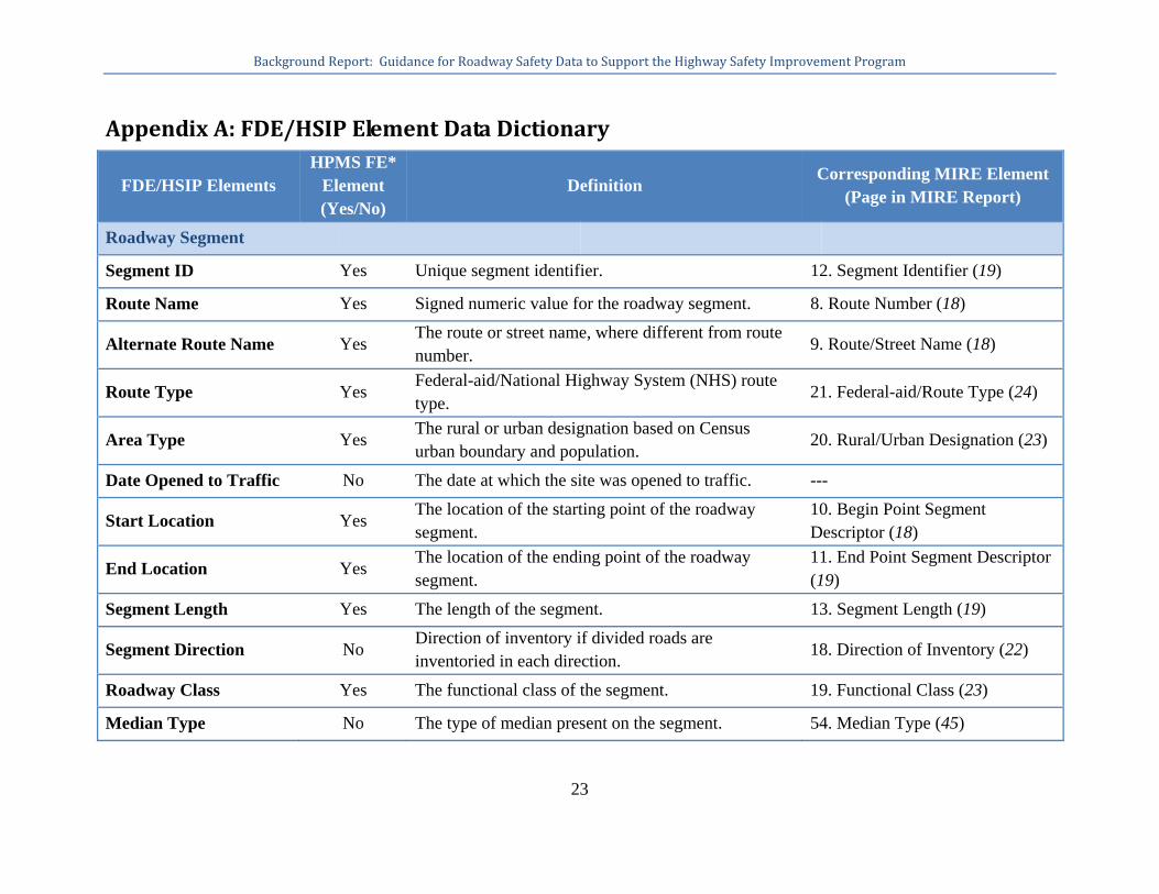
AppendixA:FDE/HSIPElementDataDictionary
FDE/HSIP Elements HPMS FE*
Element (Yes/No)
Definition Corresponding MIRE Element
(Page in MIRE Report)
Roadway Segment
Segment ID Yes Unique segment identifier. 12. Segment Identifier (19)
Route Name Yes Signed numeric value for the roadway segment. 8. Route Number (18)
Alternate Route Name Yes The route or street name, where different from route number.
9. Route/Street Name (18)
Route Type Yes Federal-aid/National Highway System (NHS) route type.
21. Federal-aid/Route Type (24)
Area Type Yes The rural or urban designation based on Census urban boundary and population.
20. Rural/Urban Designation (23)
Date Opened to Traffic No The date at which the site was opened to traffic. ---
Start Location Yes The location of the starting point of the roadway segment.
10. Begin Point Segment Descriptor (18)
End Location Yes The location of the ending point of the roadway segment.
11. End Point Segment Descriptor (19)
Segment Length Yes The length of the segment. 13. Segment Length (19)
Segment Direction No Direction of inventory if divided roads are inventoried in each direction.
18. Direction of Inventory (22)
Roadway Class Yes The functional class of the segment. 19. Functional Class (23)
Median Type No The type of median present on the segment. 54. Median Type (45)

Background Report: Guidance for Roadway Safety Data to Support the Highway Safety Improvement Program
24
Access Control Yes The degree of access control. 22. Access Control (25)
Two-Way vs. One-Way Operation
Yes Indication of whether the segment operates as a one- or two-way roadway.
91. One/Two-Way Operations (64)
Number of Through Lanes
Yes The total number of through lanes on the segment. This excludes turn lanes and auxiliary lanes.
31. Number of Through Lanes (30)
Interchange Influence Area on Mainline Freeway
No
The value of this item indicates whether or not a roadway is within an interchange influence area. (This can be derived from MIRE Elements 197 & 201.)
197. Location Identifier for Roadway at Beginning Ramp Terminal (136) 201. Location Identifier for Roadway at Ending Ramp Terminal (139)
AADT Yes The average number of vehicles passing through a segment from both directions of the mainline route for all days of a specified year
79. Annual Average Daily Traffic (AADT) (60)
AADT Year Yes Year of AADT. 80. AADT Year (60)
Intersection
Intersection ID No A unique junction identifier. 120. Unique Junction Identifier (84)
Location No Location of the center of the junction on the first intersecting route (e.g. route-milepost). (This can be derived from MIRE Elements 122 & 123.)
122. Location Identifier for Road 1 Crossing Point (85) 123. Location Identifier for Road 2 Crossing Point (85)
Intersection Type No The type of geometric configuration that best describes the intersection/junction.
126. Intersection/Junction Geometry (87)
Traffic Control Type No Traffic control present at intersection/junction. 131. Intersection/ Junction Traffic Control (93)

Background Report: Guidance for Roadway Safety Data to Support the Highway Safety Improvement Program
25
Major Road AADT No The Annual Average Daily Traffic (AADT) on the approach leg of the intersection/junction.
140. Approach AADT (98)
Major Road AADT Year
No The year of the Annual Average Daily Traffic (AADT) on the approach leg of the intersection/junction.
141. Approach AADT Year (99)
Minor Road AADT No The Annual Average Daily Traffic (AADT) on the approach leg of the intersection/junction.
140. Approach AADT (98)
Minor Road AADT Year
No The year of the Annual Average Daily Traffic (AADT) on the approach leg of the intersection/junction.
141. Approach AADT Year (99)
Intersection Leg ID No A unique identifier for each approach of an intersection.
139. Unique Approach Identifier (98)
Leg Type No Specifies the major/minor road classification of this leg relative to the other legs in the intersection. (This can be derived from MIRE Element 140).
140. Approach AADT (98)
Leg Segment ID No A unique identifier for the segment associated with this leg.
---
Ramp/Interchange
Ramp ID Yes An identifier for each ramp that is part of a given interchange. This defines which ramp the following elements are describing.
186. Unique Ramp Identifier (129)
Date Opened to Traffic No The date at which the site was opened to traffic. ---
Start Location No Location on the roadway at the beginning ramp terminal (e.g. route-milepost for that roadway) if the ramp connects with a roadway at that point.
197. Location Identifier for Roadway at Beginning Ramp Terminal (136)
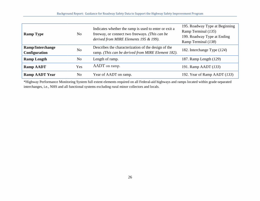
Background Report: Guidance for Roadway Safety Data to Support the Highway Safety Improvement Program
26
Ramp Type No Indicates whether the ramp is used to enter or exit a freeway, or connect two freeways. (This can be derived from MIRE Elements 195 & 199).
195. Roadway Type at Beginning Ramp Terminal (135) 199. Roadway Type at Ending Ramp Terminal (138)
Ramp/Interchange Configuration
No Describes the characterization of the design of the ramp. (This can be derived from MIRE Element 182). 182. Interchange Type (124)
Ramp Length No Length of ramp. 187. Ramp Length (129)
Ramp AADT Yes AADT on ramp. 191. Ramp AADT (133)
Ramp AADT Year No Year of AADT on ramp. 192. Year of Ramp AADT (133)
*Highway Performance Monitoring System full extent elements required on all Federal-aid highways and ramps located within grade‐separated interchanges, i.e., NHS and all functional systems excluding rural minor collectors and locals.