Embed Size (px)
Citation preview

Water Sharing Plan for the Hunter Regulated River Water Source
Background document

Water Sharing Plan for the Hunter Regulated River Water Source – Background Document
Published by the NSW Department of Primary Industries, Water
Water Sharing Plan for the Hunter Regulated River Water Source Background Document
First published March 2017
More information
Rural Water Planning
www.dpi.nsw.gov.au
Cover image: Hunter Regulated River, upstream of Russell Island, courtesy of Fergus Hancock
© State of New South Wales through the Department of Trade and Investment, Regional Infrastructure and Services, 2017. You may copy, distribute and otherwise freely deal with this publication for any purpose, provided that you attribute the NSW Department of Primary Industries as the owner.
Disclaimer: The information contained in this publication is based on knowledge and understanding at the time of writing (March 2017). However, because of advances in knowledge, users are reminded of the need to ensure that information upon which they rely is up to date and to check currency of the information with the appropriate officer of the Department of Primary Industries or the user’s independent adviser.

Water Sharing Plan for the Hunter Regulated River Water Source – Background Document
3 | NSW DPI Water, March 2017
Contents Introduction .......................................................................................................................... 6
Why are water sharing plans being prepared? ....................................................................6
Replacement of first round water sharing plans ..................................................................7
A water sharing plan for the Hunter Regulated River ........................................................ 8
Vision ..................................................................................................................................8
Objectives ...........................................................................................................................8
Environmental .................................................................................................................8
Economic ........................................................................................................................8
Social and cultural ...........................................................................................................8
Area to which the plan applies ............................................................................................9
Policy and planning framework ......................................................................................... 10
The Water Management Act 2000 ....................................................................................10
Access Licence Dealing Principles ....................................................................................10
National Water Initiative ....................................................................................................10
Natural Resource Commission targets ..............................................................................11
Catchment Action Plans ....................................................................................................11
Water planning policies and guidelines .............................................................................12
Protecting basic landholder rights ..................................................................................12
Protecting town water supply access .............................................................................12
Protecting Aboriginal values ..........................................................................................12
Description of plan area ..................................................................................................... 13
Catchment description ......................................................................................................13
Water management structures ..........................................................................................13
Land use and community profile .......................................................................................14
Aboriginal heritage and values ..........................................................................................14
Early European settlement and land use ...........................................................................14
Climate .............................................................................................................................15
Instream values ................................................................................................................17
River flows ........................................................................................................................17
Groundwater .....................................................................................................................20
Entitlement and water use.................................................................................................20
Change in entitlement and water use since 2004 ..........................................................21
Local water utility requirements .....................................................................................21
The process of developing the water sharing plan .......................................................... 22
Role of the technical and interagency panels ....................................................................22

Water Sharing Plan for the Hunter Regulated River Water Source – Background Document
4 | NSW DPI Water, March 2017
State Interagency Panel ................................................................................................22
Hunter Regulated River Working Group ........................................................................22
Interagency Regional Panel ..........................................................................................22
Consultation and public exhibition .....................................................................................23
Key changes incorporated in the 2016 Plan ..................................................................... 24
Minimum daily flows ......................................................................................................24
Environmental Water Allowance ....................................................................................24
Increase of supplementary window used to calculate available water............................24
Introduction of a five year rolling average limit on supplementary water extraction ........24
AWD announcement decoupled from supplementary water tally ...................................25
Increased carryover for General Security and High Security access licences ................25
Dealing rules for conversion of Major Utility access licences removed ..........................25
Clarification of dealings for Management Zone 3 ...........................................................25
Adaptive management ....................................................................................................... 26
Amendment provisions .....................................................................................................26
Monitoring, evaluation and reporting .................................................................................26
Broad changes to reflect changes to the Act, policy and drafting protocols....................27
Performance indicators .....................................................................................................27
Plan review .......................................................................................................................27
Glossary .............................................................................................................................. 28
References .......................................................................................................................... 30
Appendix 1: NSW Government Gazette No 56 of 1 July 2016 page 1918 .........................31
Appendix 2: Overview map of the Hunter Regulated River ................................................32
Appendix 3: Overview map of management zones ...........................................................33
Appendix 4: Overview map of trading zones .....................................................................34
Appendix 5: Water usage during the life of the 2004 plan .................................................35
Appendix 6: IRP and Working Group membership ............................................................38
Appendix 7: Summary of key issues raised during public exhibition and response ...........39
Appendix 8. Comparison of 2004 Plan rules with 2016 Plan rules .....................................48

Water Sharing Plan for the Hunter Regulated River Water Source – Background Document
5 | NSW DPI Water, March 2017
Tables Table 1: Major storages in the Hunter catchment ............................................................................. 13
Table 2: Flow reference points used in the Hunter Plan ................................................................... 18
Table 3: Total entitlement at plan commencement ........................................................................... 20
Table 4: Hunter Interagency Regional Panel-membership ............................................................... 38
Table 5: Hunter Regulated River Working Group-membership ......................................................... 38
Figures Figure 1: Average annual rainfall in the Hunter catchment (1961-1990) ........................................... 16
Figure 2: Mean monthly rainfall across Hunter Catchment ............................................................... 16
Figure 3: Daily and annual stream flows in the Hunter River at Singleton ......................................... 18
Figure 4: Daily and annual stream flows in the Hunter River at Muswellbrook .................................. 19
Figure 5: Daily and annual stream flows in the Hunter River at Greta ............................................... 19

Water Sharing Plan for the Hunter Regulated River Water Source – Background Document
6 | NSW DPI Water, March 2017
Introduction Water sharing plans are being progressively developed for rivers and groundwater systems across New South Wales following the introduction of the Water Management Act 2000 (WMA 2000). These plans protect the health of our rivers and groundwater while also providing water users with perpetual access licences, equitable conditions, and increased opportunities to trade water through separation of land and water.
The first round of water sharing plans commenced on 1 July 2004. The development of these plans resulted in around 80 per cent of the water use in NSW being managed under the WMA 2000. By the end of 2012, over 95 per cent of all water extracted in NSW was covered by a water sharing plan. By the end of 2016 it is anticipated that all extraction in NSW will be covered by a water sharing plan.
Water sharing plans help to maintain the health of river and groundwater systems while providing water users with access to water, equitable conditions and opportunities for water trading by separating water licences from land tenure.
The Water Sharing Plan for the Hunter Regulated River Water Source (the Plan) covers the regulated Hunter River below Glenbawn and Glennies Creek Dams, and downstream to the tidal limit of the Hunter Estuary.
This document provides background to the development of the rules in the water sharing plan. It includes information on the purpose of the plan and the policy framework that supports it, a description of the plan area including land and water use, and the process of developing the various water sharing rules in the plan. This document is part of a range of material available specifically on the plan including:
• the Water Sharing Plan for the Hunter Regulated River Water Source - a legal instrument written in its required statutory format;
• A rules summary sheet providing an overview of the water sharing rules; and • Updates for Stakeholders – newsletter style updates that were issued during the plan
development to engage stakeholders throughout the process. These materials and general information on the water sharing planning process can be found in the water sharing plans section of the NSW Department of Primary Industries Water (DPI Water) website www.water.nsw.gov.au.
Why are water sharing plans being prepared? Expansion of water extraction across NSW in the 20th century has placed most valleys and many aquifers at or close to the limit of sustainable water extraction. This has seen increasing competition between water users (towns, farmers, industries and irrigators) for access to water. This has also placed pressure on the health and biological diversity of our rivers and aquifers.
In December 2000, the NSW parliament passed the Water Management Act 2000 (WMA 2000) which has the overall objective of “sustainable and integrated management of the State’s water” (DLWC 2001). Water sharing plans play a major role in achieving this objective by providing a legal basis for sharing water between the environment and consumptive water users.
Under the WMA 2000, water sharing plans must protect water sources and their dependent ecosystems, and must protect the basic rights of landholders to extract water. In this way, environmental water and basic landholder rights are afforded priority over licensed water extractions. Among licensed water users, priority is given to local water utilities and major utilities, and licensed stock and domestic use, ahead of commercial purposes such as irrigation and other industries.

Water Sharing Plan for the Hunter Regulated River Water Source – Background Document
7 | NSW DPI Water, March 2017
Water sharing plans also recognise the economic benefits that commercial users such as irrigation and industry can bring to a region. When a plan commences, access licences held under the Water Act 1912 are converted to access licences under the WMA 2000 which separates the water licences from land tenure. This facilitates the trade of access licences and encourages more efficient use of water resources. It also allows new industries to develop as water can move to its highest value use.
In conjunction with the WMA 2000, water sharing plans also set rules so that commercial users can continue to operate productively. In general, commercial licences under the WMA 2000 are granted in perpetuity, providing greater commercial security of water access entitlements. Water sharing plans define the access rules for commercial users for 10 years providing all users with greater certainty regarding sharing arrangements.
Water sharing plans benefit water users by providing:
• greater certainty by setting water sharing arrangements for a 10 year period; • clear trading and access rules which will help foster trading; and • greater security with existing water licences converted to perpetual water access
licences under the WMA 2000.
Replacement of first round water sharing plans The Water Sharing Plan for the Hunter Regulated River Water Source was among the first water sharing plans that commenced in NSW in 2004.
Water sharing plans are in force for a period of ten years from commencement, after which the Minister for Lands and Water determines if a plan is to be replaced with a new plan or, on the recommendation of the Natural Resources Commission (NRC) under Section 43A of the Water Management Act 2000 (the Act), extended, without change, for a further ten years.
When reviewing the plans the NRC and DPI Water undertook joint consultation and collected submissions from stakeholders on the performance of the first round of water sharing plans. The NRC used this consultation to inform their recommendation to the Minister on whether the water sharing plans should be replaced or extended. DPI Water used this process to examine whether the plan rules were appropriate, practical to implement and to identify if there were any ways to improve the plans’ outcomes. Both the NRC and DPI Water recommended that all first round water sharing plans be replaced. After reviewing reports provided by the NRC and DPI Water, the Minister supported the replacement of the first round water sharing plans which expired in 2014. Although the plans were required to be replaced prior to July 2015 an extension was granted to allow for sufficient consultation to be undertaken and the plans were replaced in July 2016.
Changes to the provisions of the Water Sharing Plan for the Hunter Regulated River Water Source have been informed from a number of sources including: changes to policy, updates to legislation, updated data, outcomes of audits, and stakeholder requests. As provisions in the plan area have been operating for over a decade, and the initial plan was developed in close consultation with stakeholder groups, DPI Water has been keen to avoid unnecessary changes and instead focussed on improving provisions based on the information sources listed above.

Water Sharing Plan for the Hunter Regulated River Water Source – Background Document
8 | NSW DPI Water, March 2017
A water sharing plan for the Hunter Regulated River Vision To provide for the health and improvement of the water source and water-dependent ecosystems.
To encourage productive and economically efficient use of water.
To provide social and cultural benefits to urban and rural communities resulting from the sustainable and efficient use of water.
Objectives
Environmental To maintain and enhance the condition of the water source and dependent ecosystems.
To contribute to the maintenance and enhancement of downstream processes and habitats and water quality of the water source and downstream water sources.
Strategies for achieving this include:
• manage extraction within the long-term average annual extraction limit (LTAAEL)
• maintain hydrological connectivity and mitigate alterations to the natural flow regimes in this water source by ensuring that a minimum end-of-system flow is maintained, and by ensuring daily extraction from uncontrolled flows is limited to approximately 50% and annual extraction of water from uncontrolled flows is limited to 30%
• contribute to the management of critical environmental events and support of environmental processes by maintaining an environmental water allowance
• minimising the impact of water delivery releases from Glenbawn Dam water storage and Glennies Creek water storage on the environment
Economic To support viable and sustainable water-dependent industries over the long term.
To encourage economic efficiency in the management and use of water.
Strategies for achieving this include:
• provide a stable and predictable framework for sharing water, including individual account management rules and defined access licences categories with defined priority of access
• a long-term extraction limit and rules for managing extractions that recognises different climatic conditions in different years
• provide opportunities for market-based trading of water within environmental and system constraints
Social and cultural To foster the social and cultural benefits of the sustainable and efficient use of water.
To recognise spiritual, social, customary and economic values of water to Aboriginal people.
Strategies for achieving this include:
• provide water for basic human needs including domestic and stock purposes
• provide opportunities for Aboriginal people to access water

Water Sharing Plan for the Hunter Regulated River Water Source – Background Document
9 | NSW DPI Water, March 2017
• support water-dependent Aboriginal cultural values with use of the environmental water allowance to support environmental assets and water–dependent Aboriginal cultural values
• minimise the impact of water delivery on the community by observing water delivery rules and channel capacity constraints
Area to which the plan applies This Plan applies to the Hunter Regulated River Water Source within the Hunter Water Management Area, which is defined in the NSW Government Gazette No 56 of 1 July 2016 page 1918 (Appendix 1).
An overview map of the Hunter Regulated River is shown in Appendix 2.
The water source is divided into five management zones:
• Zone 1A Hunter River from Glenbawn Dam to Goulburn River Junction • Zone 1B Hunter River from Goulburn River Junction to Glennies Creek Junction • Zone 2A Hunter Rive from Glennies Creek Junction to Wollombi Brook Junction • Zone 2B Hunter River from Wollombi Brook Junction to the downstream limit of the
water source • Zone 3A Glennies Creek
An overview of the management zones is shown in Appendix 3. The Plan defines trading zones for access licence dealings:
• Trading Zone 1 • Trading Zone 2 • Trading Zone 3
An overview map of Plan trading zones is shown in Appendix 4.
Water Sharing Plan for the Hunter Regulated River Water Source – Background Document
10 | NSW DPI Water, March 2017
Policy and planning framework A number of national, state and regional plans and policies guided the development of the Plan, including the:
• Water Management Act 2000 (WMA 2000) • Access Licence Dealing Principles Order 2004 • National Water Initiative • Natural Resource Commission state-wide targets • Water planning policies and other considerations
The Water Management Act 2000 The WMA 2000 is based on the concept of ecologically sustainable development i.e. managing current development so that it will not threaten the availability of resources for future generations. The WMA 2000 recognises the need to allocate water for the environmental health of our rivers and groundwater systems, while also providing licence holders with more secure access to water and greater opportunities to trade water through the separation of water access from land title.
Water sharing plans are the main tool through which the WMA 2000 achieves its objective. The major changes required to water management have meant that the WMA 2000 has been progressively implemented, and the Water Act 1912 progressively phased out as water sharing plans commence.
The latest copy of the WMA 2000 is available from the NSW government legislation website.
Access Licence Dealing Principles The Access Licence Dealing Principles Order 2004 (the Dealing Principles) is consistent with the WMA 2000 and provides a framework and guidance for the undertaking of water dealings including trade. The Dealing Principles require that dealings consider:
• impacts on water sources • impacts on indigenous, cultural, heritage or spiritual matters • impacts on water users • maximising social and economic benefits
The Dealing Principles specify rules for different dealing types, including:
• conversion of access licence to new category • subdivision of access licences • consolidation of access licences • assignment of rights under access licences • change of water source • amendment of extraction component of access licence • assignment of water allocations between access licences • interstate transfer dealings • interstate assignment of water allocations • nomination of water supply works
Water sharing plans must be consistent with the Dealing Principles, and may put additional rules in place such as restricting trade into a particular area due to its environmental values or hydrologic stress.
National Water Initiative The National Water Initiative (NWI) was signed by the Council of Australian Governments (COAG) in June 2004. Through the NWI, governments across Australia, including NSW, have agreed on actions to achieve a more cohesive national approach to managing,

Water Sharing Plan for the Hunter Regulated River Water Source – Background Document
11 | NSW DPI Water, March 2017
measuring, planning, pricing and trading water. The NWI recognises the continuing need to increase the productivity and efficiency of Australia’s water use, whilst servicing rural and urban communities, and ensuring the health of river and groundwater systems.
Until the end of 2014 the NWI was implemented and monitored by the National Water Commission. Its responsibility for assessing each state’s progress with the NWI and providing independent advice to the Commonwealth Government has now been taken over by the Commonwealth Productivity Commission.
Natural Resource Commission targets The Natural Resource Commission (NRC) was established in 2003 to provide the NSW Government with independent advice on natural resource management issues. To achieve this, the NRC has developed a Standard for Quality Natural Resource Management, along with 13 state-wide targets for natural resource management which have been embedded in the NSW State Plan. The standard is designed to apply to natural resource management at all scales including at the state, regional, catchment and local level.
As with the NWI, the NRC’s standard requires the use of the best available knowledge, use of appropriate information management systems, delivery of integrated outcomes, engagement of the community and regular monitoring, measuring, evaluation and reporting to specify how delivery of the targets is progressing. The NRC reviews water sharing plans against this standard and its associated targets. In 2013 the NRC reviewed the 31 water sharing plans that were due to expire in 2014 and provided advice to the Minister for Primary Industries. A further seven water sharing plans were reviewed by the NRC in 2015.
In 2012 the NRC reviewed the state-wide standard and targets, including monitoring, evaluation and reporting arrangements in NSW. They recommended five new state-wide targets that provide a sharper focus on the key long-term issues of concern to the Government and community and revised the monitoring, evaluation and reporting strategy to support the implementation of the new targets.
Catchment Action Plans Catchment Action Plans are statutory, non-regulatory plans that were previously prepared by the state’s catchment management authorities under the Catchment Management Authorities Act 2003 (now repealed). In January 2014 the NSW Government established Local Land Services and transferred the functions of catchment management authorities into this new organisation to provide agricultural support, natural resource management and emergency management to rural communities through a single organisation. The Hunter Local Land Services is responsible for continuing the delivery of natural resource management programs in the Hunter catchment, including the development of a catchment action plan.
Each Local Land Services jurisdiction has developed a Catchment Action Plan 2023, which is a 10-year strategic plan that sets the direction for the sustainable use and care of the natural resources in their region. The implementation of water sharing plans is one of the key strategies to be implemented in supporting land and water managers to maintain or improve the condition of priority freshwater, marine, estuarine and groundwater resources.

Water Sharing Plan for the Hunter Regulated River Water Source – Background Document
12 | NSW DPI Water, March 2017
Water planning policies and guidelines Since commencement of the WMA 2000 a number of policies and guidelines have been developed in response to specific water management issues which need to be considered during the development of water sharing plans.
These policies and guidelines directly influence the planning process of water sharing rules.
Protecting basic landholder rights Under the WMA 2000, basic land holder rights (BLR) are made up of domestic and stock rights, harvestable rights and native title rights. Water may be extracted under these rights without the need for a water access licence; although where groundwater is accessed under a domestic and stock right, the bore must still be approved by DPI Water.
The WMA 2000 requires that water sharing must protect BLR. The plan does this by identifying the volumes required for domestic, stock and native title rights at the start of the plan and taking these requirements into consideration when designing the rules for licensed water extraction. The access rules for licensed extraction do not apply to BLR due to the higher priority of access for those users.
There were no native title rights at plan commencement, however the plan allows for these rights should they be activated during the plan’s ten year term.
The plan provides an estimate of the water requirements for BLR, noting that these rights may increase during the life of the plan. The plan cannot limit or restrict these rights, but the WMA 2000 provides for restrictions on BLR through the development of mandatory guidelines.
Protecting town water supply access Under the WMA 2000, extractions for town water supply are afforded a higher priority than extractions for commercial purposes such as irrigation. Water sharing plans recognise this priority by ensuring that a full share of water is allocated for annual town water supplies except where exceptional drought conditions prevent this. Local water utilities such as local councils are issued with local water utility access licences. The WMA 2000 allows for temporary trade but not permanent trade between local water utility access licences.
Protecting Aboriginal values Aboriginal people have a spiritual, customary and economic relationship with land and water that provides an important insight into natural resource management. The NSW Government established the Aboriginal Water Initiative (AWI) in 2012 to facilitate effective engagement with Aboriginal communities in the water sharing process and ensure that measurable Aboriginal water outcomes are achieved. The AWI aims to build Aboriginal peoples’ capacity to participate as water users, protect their rights to water, maintain a healthy environment and take full advantage of economic opportunities.
Water sharing plans recognise the importance of rivers and groundwater to Aboriginal cultures. The plans allow Aboriginal communities to apply for a water access licence for cultural purposes as well as community development licences. An Aboriginal Cultural Access Licence is to be used for manufacturing traditional artefacts, hunting, fishing, gathering, recreation and for cultural and ceremonial purposes. An Aboriginal Cultural Access Licence can also be used for drinking, food preparation, washing and watering domestic gardens. These licences are limited to 10 ML/yr per application. .
For further information refer to Our Water Our Country, An information manual for Aboriginal people and communities about the water reform process which is available from the DPI Water website www.water.nsw.gov.au.

Water Sharing Plan for the Hunter Regulated River Water Source – Background Document
13 | NSW DPI Water, March 2017
Description of plan area Catchment description The Plan area is located in the Hunter catchment on the central east coast of NSW (see Appendix 2). The catchment drains an area of approximately 17,500 km². The Hunter River rises in the Mount Royal Range north east of Scone and travels approximately 450 km to the sea at Newcastle.
The largest tributary of the Hunter River is the Goulburn River which accounts for 40% of the catchment area but contributes only 23% of its flow. The Goulburn River begins at Ulan near Mudgee and flows east to join the Hunter River near Denman. The Paterson and Williams River rise in the Barrington Tops and drain the higher rainfall area, north-east of the catchment, with both rivers flowing south into the Hunter estuary. The southern side of the Hunter is drained by a number of streams, the largest being the Wollombi Brook.
The Hunter Estuary links the various rivers. The upper half of the estuary, known as the Hunter Tidal Pool, is fresh to brackish. Extraction from the tidal pool supports agricultural activities, as well as stock and domestic watering. During times of low river flows, salinity levels increase in this area of the estuary due to reduced flushing. The lower half of the estuary varies between brackish to sea water depending on flow conditions. The Hunter Estuary includes the Ramsar listed Hunter Estuary Wetlands Site.
Water management structures The major water storages within the Hunter catchment are set out in Table 1. Glenbawn, Glennies and Lostock dams provide bulk water to licence holders via releases into rivers below the dams or via pipelines to Scone and Singleton.
Chichester, and Grahamstown dams, and Seaham weir provide reticulated water to the Lower Hunter. Lake Liddell and Plashett Reservoir are filled primarily with water pumped from the Hunter River by AGL Macquarie for power generation.
Table 1: Major storages in the Hunter catchment
Dam Capacity (ML) Spillway Capacity (ML/day)
Authority Major Use
Glenbawn Dam 750,000 + 120,000 flood
storage
466,000 495,000 aux
Water NSW Regulation of flows for river downstream
Glennies Creek Dam 283,000 157,000 Water NSW Regulation of flows for river downstream
Lostock Dam 20,000 247,000 Water NSW Regulation of flows for river downstream
Chichester Dam 22,000 207,000 Hunter Water Reticulated water supply
Grahamstown Reservoir 132,000 4,300 Hunter Water Reticulated water supply
Seaham Weir 16,900 57,000 Hunter Water Reticulated water supply
Liddell Cooling Water Dam 148,000 18,000 AGL Macquarie Cooling water
Plashett Reservoir 65,000 5,300 AGL Macquarie Power generation

Water Sharing Plan for the Hunter Regulated River Water Source – Background Document
14 | NSW DPI Water, March 2017
Land use and community profile The Hunter catchment supports a variety of major industries including power generation, coal mining, heavy industry, agriculture and associated businesses and infrastructure. A number of large water storages have been constructed to support these industries. Glenbawn, Glennies Creek and Lockstock Dams store water and regulate river flows for use by irrigation, town water supply, industrial use and power generation. Chichester and Grahamstown dams serve as domestic water storages for urban centres in the lower Hunter and Lake Liddell as cooling storage for the Liddell and Bayswater coal fired power stations. The Port of Newcastle has been operating commercially for over two centuries and is key to the export of the coal that is mined in the area. Exports through the Port of Newcastle account for 14 per cent of Australia’s total exports sent to international markets (DoP 2006).
National Parks and other protected areas: Wollemi, Barrington Tops, Goulburn River and Yengo National Parks, Port Stephens Great Lakes Marine Park, parts of the Greater Blue Mountains world heritage area, Munghorn Gap and Manobalai Nature Reserves and numerous smaller areas of national park estate, areas of state forest, Hunter estuary wetlands, Hunter Wetlands National Park and the Hunter Estuary Wetlands Ramsar site.
The major urban areas of the catchment include Newcastle, Maitland, Nelson Bay, Cessnock, Singleton, Muswellbrook, Murrurundi, Denman, Merriwa, Raymond Terrace and Dungog. The population of the Hunter region is currently growing by 6400 people per year and this rate is expected to be maintained over the next 15 years. Population growth has been focussed on the coastal areas, particularly Newcastle, Lake Macquarie and Port Stephens with people attracted by the combination of economic opportunity, affordability and the lifestyle benefits of the surrounding rural and coastal landscapes (DoP 2006).Currently, there is approximately 670,000 people living in the Hunter Region (LLS 2016).
Aboriginal heritage and values The Awabakal are the traditional owners of land from the Hunter River in the north to Tuggerah Lake in the south. The Awabakal were people of the coast, estuaries, lakes and wetlands, but also had an attachment to the rugged sandstone country of the Sugarloaf and Watagan Ranges. They lived on fishing and gathering of shellfish, as well as hunting animals and collecting fruits and tubers (Lake Macquarie City Council 2015a).
Belmont Lagoon is a place of cultural and spiritual significance being the site of a major annual corroboree and the subject of a traditional story about the formation of the lagoon (Lake Macquarie City Council 2015b). Jewells Swamp near Redhead provided a rich food source including emus, waterbirds, kangaroos, shellfish and fruit from the burrawang palms which were roasted and pounded. Middens in the area provide evidence of thousands of years of Aboriginal occupation (Lake Macquarie City Council 2015c).
The Worimi are the traditional owners of the Great Lakes and Port Stephens area between the Hunter and the Manning rivers. The landscape includes an abundance of Aboriginal cultural sites including burials, campsites and middens. Traditionally, the Worimi people used the beaches to travel between the northern and southern parts of their country. The area known as Stockton Bight has a special significance because it retains a large amount of cultural history. The Worimi people manage the Stockton Bight area (known as Worimi Conservation Lands) through a joint agreement with NSW National Parks and Wildlife Service (OEH 2014).
Early European settlement and land use The presence of coal in the Hunter Valley was discovered in 1797 and the settlement of Newcastle was established at the mouth of the Hunter River in 1804. It operated as a penal

Water Sharing Plan for the Hunter Regulated River Water Source – Background Document
15 | NSW DPI Water, March 2017
colony for 20 years with prisoners employed in coal mining and timber cutting. The Hunter Valley was opened to free settlers in 1820 (HO and DUAP 1996).
Since European settlement there have been major changes to the Hunter River catchment. These include clearing of native vegetation for agricultural and mining activities, and larger more destructive flood events due to loss of vegetation, and overstocking in the early stages of settlement. In some cases this has resulted in erosion of stream beds and banks, and wider and shallower streams in some areas.
Climate The Hunter catchment’s climate is highly variable with periods of severe drought and flood. The catchment sits in a transitional zone between the winter dominated rainfall in the south and summer dominated rainfall in the north. There can be periods of both wet winters and summers or periods of dry summers and winters. Rainfall ranges from 620mm to 1600mm per year depending on the location within the catchment. Average annual rainfall for the Hunter catchment is shown in Figure 1.
The Hunter region is characterised by mid-latitude westerly winds and high pressure systems that alternate with cold fronts during winter. Winter conditions are drier than summer (particularly the months of July and August), with gusty westerly winds a principle feature of August. South-easterly winds dominate during summer, however north-easterly sea breezes also occur and provide a cooling effect as far inland as Scone (McCauley 2006).
The Upper Hunter Valley suffers from extended periods of below average rainfall. The 1930s/1940s drought was considered the worst drought on record and the basis of water supply planning. During that drought the Hunter River stopped flowing at Singleton for more than six months.
The Lower Hunter Valley is influenced more by coastal rain and suffers from short sharp droughts like the one in 1980. One significant climate factor that affects the Hunter Valley’s rainfall is East Coast Lows (ECL). These storm events develop over the Tasman Sea close to the NSW coast and can intensify rapidly overnight. ECLs are driven by the temperature gradient between the Tasman Sea air and cold air in the high levels of the atmosphere over Australia. In June 2007, an east coast low resulted in the bulk carrier Pasha Bulker running aground. Rainfall induced by ECL and related weather systems has been identified as important events that generate significant inflows into major storages along coastal NSW (Speer et al 2009).
The rainfall data shown in Figure 2 is sourced from the Bureau of Meteorology weather stations and is used in the Integrated Quantity and Quality Model1 (IQQM).
1 IQQM is used to assess the impacts of different management strategies. The models have been developed to simulate the major hydrological processes in river valleys along with relevant management rules.

Water Sharing Plan for the Hunter Regulated River Water Source – Background Document
16 | NSW DPI Water, March 2017
Figure 1: Average annual rainfall in the Hunter catchment (1961-1990)
Figure 2: Mean monthly rainfall across Hunter Catchment
Source: Bureau of Meteorology

Water Sharing Plan for the Hunter Regulated River Water Source – Background Document
17 | NSW DPI Water, March 2017
Instream values The Hunter Regulated River has undergone extensive modification. In general it has been assessed as having low to medium instream value. There are some medium and high value areas, particularly in the upper regions of the regulated river. The regulated river has generally low diversity and no vital habitat value except for the important wetlands in the estuary that it feeds.
The Kooragang Wetland and the Hunter Wetlands Centre Australia are listed under the Ramsar Convention for international ecological importance. These wetlands support three species that are nationally and internationally listed – the estuary stingray (Dasyatis fluviorum), green and gold bell frog (Litoria aurea) and Australasian bittern (Botaurus poiciloptilus). They also support 112 species of waterbirds, 45 species of migratory birds listed under international agreements, and regularly support 1% of the population of the eastern curlew and red-necked avocet.
The sub-catchments of the Hunter Regulated River are generally considered as under medium or high environmental stress. They have relatively poor bank condition, bed condition and riparian vegetation. The Hunter River has been subject to deposition of eroded materials and this has resulted in shallowing and widening of the channel. This has been exacerbated through loss of riparian vegetation through clearing. Riparian vegetation is important as it both stabilises river banks and adds large woody debris to the river which provides complexity and aids formation and maintenance of pools. This sedimentation also leads to less refuges (pools) being available for aquatic organisms during low flow or drought periods. Some small areas of riparian river red gum forest occur in the middle reaches of the river.
Freshwater algal blooms have been recorded frequently in the middle section of the Hunter River, since a large outbreak was reported in 1994. Substantial reductions in total discharge, smaller floods and summer flows are suspected of increasing the prevalence of diatom blooms (NOW 2011).
River flows The Hunter Water Management Area has more than 50 stream monitoring gauges, a number of which are used as flow reference points within the water sharing plan. Average annual flow in the Hunter River varies from 396,200 ML at Liddell (210083) at the top of the system to 692,400 ML at Greta (210064) at the end of the system (Table 2).
There has been a gradual decline in annual flows at Singleton and in the catchment as a whole, since the early 1950s (see Figure 3). Annual stream flows were the lowest on record for the whole catchment in the early 1980s with only 64,250 ML at Muswellbrook in 1981 (Figure 4) and 45,500 ML at Greta in 1980 (Figure 5).
Drought affected much of the catchment during 2002-2006 with only 53,000 ML recorded at Greta, the end of system gauge, in 2006.
Very high annual flows occurred during the early to mid-1950s. High annual flows were also recorded in the early to mid-1970s. The largest annual flow in recent times was in 2007.
Peak flows have reduced considerably over the past 25 years in part due to reduced rainfall events and cessation of river bank vegetation clearing in river beds and banks. In some cases peak flows and travel times have almost halved, particularly at the lower end of the catchment. For example, the 1971 flood peak at Greta was estimated to have peaked at over 350,000 ML/day. The June 2007 flood peaked at almost 100,000 ML/day less and was almost one meter higher on the gauge.

Water Sharing Plan for the Hunter Regulated River Water Source – Background Document
18 | NSW DPI Water, March 2017
Table 2: Flow reference points used in the Hunter Plan
Gauge number Location Mean Annual Flow (ML) Data Collected Since
210039 Belltrees 119,000 1999
210002 Muswellbrook 285,400 1913
210083 Liddell 396,200 1969
210044 Middle Falbrook 69,090 1956
210001 Singleton 794,100 1913
210064 Greta 692,400 1968
Figure 3: Daily and annual stream flows in the Hunter River at Singleton
NSW Office of Water HYPLOT V133 Output 22/02/2016
Period 104 Year 01/01/1913 to 01/01/2017 1913-2017
210001 141.00 2 Month Maximum Discharge (ML/d) B
210001 151.00 1 Year Total Discharge (ML) B
0
250000
500000
750000
1000000
1250000
50000
1050000
2050000
3050000
4050000
5050000
6050000
1913-22 1923-32 1933-42 1943-52 1953-62 1963-72 1973-82 1983-92 1993-02 2003-12

Water Sharing Plan for the Hunter Regulated River Water Source – Background Document
19 | NSW DPI Water, March 2017
Figure 4: Daily and annual stream flows in the Hunter River at Muswellbrook
NSW Office of Water HYPLOT V133 Output 22/02/2016
Period 56 Year 01/01/1961 to 01/01/2017 1961-2017
210002 141.00 1 Month Maximum Discharge (ML/d) B
210002 151.00 1 Year Total Discharge (ML) B
0
50000
100000
150000
200000
250000
300000
0
200000
400000
600000
800000
1000000
1961-70 1971-80 1981-90 1991-00 2001-10
Figure 5: Daily and annual stream flows in the Hunter River at Greta
NSW Office of Water HYPLOT V133 Output 22/02/2016
Period 49 Year 01/01/1968 to 01/01/2017 1968-2017
210064 141.00 1 Month Maximum Discharge (ML/d) B
210064 151.00 1 Year Total Discharge (ML) B
0
100000
200000
300000
400000
0
500000
1000000
1500000
2000000
2500000
3000000
1968-77 1978-87 1988-97 1998-07
Water Sharing Plan for the Hunter Regulated River Water Source – Background Document
20 | NSW DPI Water, March 2017
Groundwater Groundwater extraction in the Hunter catchment is managed through a number of water sharing plans including the Water Sharing Plan for the North Coast Fractured and Porous Rock Groundwater Sources, the Water Sharing Plan for the North Coast Coastal Sands Groundwater Sources, and the Water Sharing Plan for the Hunter Unregulated and Alluvial Water Sources.
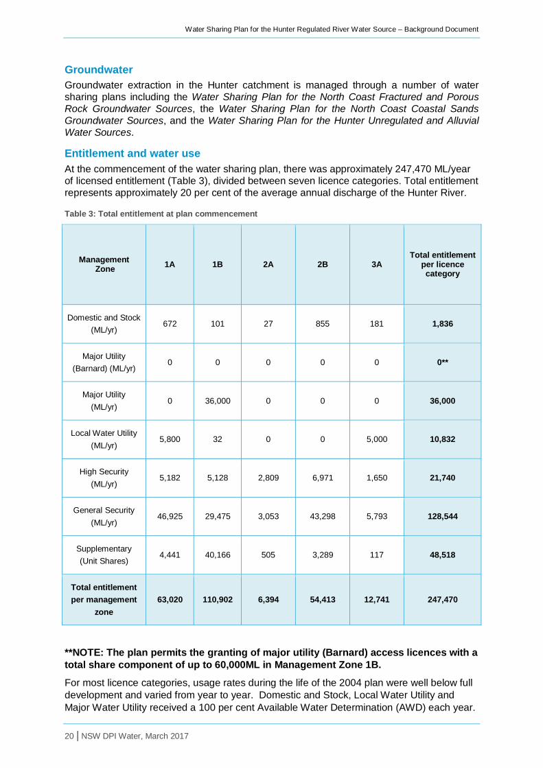
Entitlement and water use At the commencement of the water sharing plan, there was approximately 247,470 ML/year of licensed entitlement (Table 3), divided between seven licence categories. Total entitlement represents approximately 20 per cent of the average annual discharge of the Hunter River.
Table 3: Total entitlement at plan commencement
Management Zone 1A 1B 2A 2B 3A
Total entitlement per licence category
Domestic and Stock (ML/yr)
672 101 27 855 181 1,836
Major Utility (Barnard) (ML/yr)
0 0 0 0 0 0**
Major Utility (ML/yr)
0 36,000 0 0 0 36,000
Local Water Utility (ML/yr)
5,800 32 0 0 5,000 10,832
High Security (ML/yr)
5,182 5,128 2,809 6,971 1,650 21,740
General Security (ML/yr)
46,925 29,475 3,053 43,298 5,793 128,544
Supplementary (Unit Shares)
4,441 40,166 505 3,289 117 48,518
Total entitlement per management
zone 63,020 110,902 6,394 54,413 12,741 247,470
**NOTE: The plan permits the granting of major utility (Barnard) access licences with a total share component of up to 60,000ML in Management Zone 1B.
For most licence categories, usage rates during the life of the 2004 plan were well below full development and varied from year to year. Domestic and Stock, Local Water Utility and Major Water Utility received a 100 per cent Available Water Determination (AWD) each year.

Water Sharing Plan for the Hunter Regulated River Water Source – Background Document
21 | NSW DPI Water, March 2017
For General Security and High Security licences, full entitlement was available each year except for 2006/2007. The AWD for Supplementary licences was highly varied from year to year. For further information regarding water usage and AWD’s throughout the life of the 2004 plan see Appendix 5 . Information can also be found on the NSW Water Register which can be found at www.water.nsw.gov.au.
Change in entitlement and water use since 2004 There have been small changes in licensed entitlement since the original water sharing plan commenced in 2004. These changes have occurred due to the lag in converting licences from the Water Act 1912 to the Water Management Act 2000 following plan commencement. Several licences with minimal entitlement have also been cancelled, and others have been subject to dealings. New licence category A new licence category, Major Utility (Barnard) access licence, was created to bring the current operation of the Barnard Scheme, which was provided for via rules in the plan, fully into the licensing framework. Under the scheme, water is transferred from the Barnard River covered by the Water Sharing Plan for the Lower North Coast Unregulated and Alluvial Water Sources, to Glenbawn Dam in the Water Sharing Plan for the Hunter Regulated River.
The Barnard Scheme has been operational since the 1980s, having only been used once to date. Entitlement under this licence category is not included in the calculation of the long term average annual extraction limit. Transmission, storage and evaporation losses of ‘Barnard’ water are borne by the licence holder, and not any other user. Change in use Since the 2004 plan commenced, a number of sleeper licences were activated, due to growth in coal mining.
The facilitation of trade allowing water to move to its highest beneficial use has resulted in mining operations buying general security entitlement on the market and a contraction in general security licences held for irrigation purposes.
Local water utility requirements The Upper Hunter Shire Council, Muswellbrook Shire Council, and Singleton Council have local water utility entitlements, supplying town water for Muswellbrook, Jerrys Plains and Singleton respectively. At plan commencement, share components for local water utility access was estimated to be 10,832 ML/year. Local councils also hold town water supply entitlement under the Water Sharing Plan for the Hunter Unregulated and Alluvial Water Sources which is used to supply other townships in the Hunter Water Management Area including Murrurundi, Denman, Casillis, Aberdeen and Gresford.

Water Sharing Plan for the Hunter Regulated River Water Source – Background Document
22 | NSW DPI Water, March 2017
The process of developing the water sharing plan This section describes the panels involved in the development of the plans and outlines the process of developing the replacement Water Sharing Plan for the Hunter Regulated River Water Source. DPI Water is responsible for implementing the WMA 2000, including developing water sharing plans for the state’s water resources. DPI Water established interagency panels to assist with the development of water planning policies and water sharing plans. The role of each of these panels is discussed below.
The Water Sharing Plan for the Hunter Regulated River Water Source was initially prepared based onthe deliberations of the DPI Water Working Group and the Interagency Regional Panel and feedback from stakeholders during targeted consultation.
The draft plan was then publicly exhibited throughout the plan area. Feedback received during the public exhibition period was considered by the DPI Water Working Group and the Interagency Regional Panel in finalising the plan.
Role of the technical and interagency panels The preparation of the Hunter Regulated River water sharing plan was guided by three panels:
• the State Interagency Panel • the Hunter Working Group • the Hunter Interagency Regional Panel
The role of each of these panels is discussed below.
State Interagency Panel The State Interagency Panel has responsibility for strategic direction of water planning in NSW. It ensures adequate resources from each agency are available and that various policy and statutory requirements of relevant NSW Government agencies are met. The Panel also has the role of making water sharing decisions in cases where regional panels cannot reach agreement or where an issue has broader state-wide significance.
The Panel is chaired by DPI Water and includes representatives from DPI Water, Office of Environment and Heritage, Local Land Services, DPI Agriculture, and DPI Fisheries. DPI Water is responsible for the overall project management.
Hunter Regulated River Working Group The Hunter Regulated River Working Group (Working Group) is an internal panel comprising of a range of officers representing the various functions of DPI Water such as planning, policy, licensing, compliance, hydrometrics and environmental protection. The Working Group is responsible for initial review of submissions, collation of information, issues identification and development of recommendations to be considered by the Interagency Regional Panel. Membership for this group is detailed in Appendix 6.
Interagency Regional Panel The Hunter Interagency Regional Panel (IRP) includes representatives from the DPI Water, Office of Environment and Heritage, DPI Agriculture, and DPI Fisheries. Hunter Local Land Services and Water NSW hold observer roles on the panel. Membership for this group is detailed in Appendix 6.
The key responsibilities of the IRP include:
• consideration of Working Group recommendations • endorsing rules for inclusion in the draft and final plan • provide expert advice on potential impacts and benefits of proposed rules

Water Sharing Plan for the Hunter Regulated River Water Source – Background Document
23 | NSW DPI Water, March 2017
• assist with engagement of stakeholders during targeted consultation and public exhibition
• review stakeholder submissions and consider appropriate rule changes
Consultation and public exhibition During the development of water sharing plans, rules may undergo targeted consultation with water users and specific interest groups before the plan is drafted. Targeted consultation is informal consultation held with key stakeholders to test the suitability of the proposed water sharing rules and obtain feedback on the rule’s potential impacts. Targeted consultation was held with AGL Macquarie, Hunter Water Users Association, Hunter environmental groups, the Lower Hunter Agricultural Water Users Association, and NSW Mining. The purpose of these meetings was to present in detail the issues that have been identified, options considered to address the identified issues, the analysis completed to determine preferred options, and to seek feedback from users regarding the suitability of the preferred option. This was an iterative process between DPI Water and the Plan stakeholders.
A formal public exhibition was held from 5 August to 14 September 2015. The draft Plan was placed on display during this period at Muswellbrook Library, Singleton Library and Maitland City Library with a public information session also held at Muswellbrook Library. All resources available were also available from the www.water.nsw.gov.au website and from the DPI Water Newcastle office.
Submissions were required to be made in writing and submitted prior to the exhibition closing date. Comments and enquiries made at the public meetings were noted. A total of nine submissions were received. A summary of the key issues raised and the response can be seen in Appendix 7.

Water Sharing Plan for the Hunter Regulated River Water Source – Background Document
24 | NSW DPI Water, March 2017
Key changes incorporated in the 2016 Plan The key changes made in the replacement plan and supporting rationale are described here. For a more detailed comparison of 2004 to 2016 plan rules, see Appendix 8.
Minimum daily flows Stakeholders indicated a wish for introduction of ‘dry condition’ minimum daily flow targets with the objective of setting flow targets to reflect prevailing climate. The 2004 Plan rules maintain flows at the 95th percentile level at Liddell and Greta flow monitoring gauges. Analysis has shown that maintaining these targets during dry sequences means flows are kept at a higher level than would have occurred naturally and therefore may be delivering perverse environmental outcomes. Further, the analysis has shown that due to the level of accuracy within which Water NSW can deliver water orders, water is often delivered in excess of required targets.
The Belltrees flow gauge (upstream of Glenbawn Dam) was identified as a good indicator of catchment inflow patterns and correlates well with the Liddell and Greta flow gauges during dry sequences. Progressive reduction in targets, (95th, 96th, 97th…) were considered, but determined as operationally inefficient. In light of this analysis, it was determined that the dry condition rule would be triggered when flows at the Belltrees gauge are at or below the 95th percentile for a consecutive two week period.
A trigger to move from the ‘dry condition’ rule back to the ‘normal’ rule was then required. An investigation of catchment conditions following a supplementary event was undertaken. This analysis showed that following a supplementary event in any river reach, flows above the 95th percentile were maintained at Belltrees for a considerable period, making it an appropriate trigger to move back to ‘normal’ flow rules.
Two key benefits of this change were identified. Firstly, water is maintained in the dam for slightly longer when entering a drought, and natural drying occurs which improves ecological conditions.
Environmental Water Allowance An objective of the 2004 plan was to recognise the importance of traditional water rights for Aboriginal people. This was achieved through the native title provisions and access licences for Aboriginal cultural purposes. The 2016 Plan expands the Environmental Water Allowance (EWA) to include maintenance and improvement of environmental assets and environmental functions of Aboriginal cultural significance.
Increase of supplementary window used to calculate available water This change was requested by stakeholders, and reflects increased pumping capacity by AGL Macquarie. This allows greater flexibility in supplementary water licence holders’ ability to access flows from individual events whilst retaining current limits on extraction from supplementary water in the longer term. This is likely to reduce extraction pressure on smaller supplementary events or early flows in larger events as AGL Macquarie can more efficiently use their increased pump capacity during larger supplementary events.
Introduction of a five year rolling average limit on supplementary water extraction This change is to provide individual flexibility in managing response to climatic variability across years. It removes barriers to trade in supplementary water allocations (small account balances due to incremental AWDs). It maintains current levels of average extraction whilst increasing range of flows used in calculation of water available for extraction.
Water Sharing Plan for the Hunter Regulated River Water Source – Background Document
25 | NSW DPI Water, March 2017
AWD announcement decoupled from supplementary water tally To reduce the complexity of the AWD process, and to address concerns raised in submissions regarding operational efficiency of incremental AWDs, the AWD announcement is now decoupled from the supplementary water tally. This will allow for easier access to flows continuing over two water years.
Increased carryover for General Security and High Security access licences An increase in the General Security Access Licence carryover limit from 10 per cent of entitlement to 25 per cent of entitlement with no forfeiture was requested by stakeholders. Modelling showed an increase of 25 per cent has no significant impact on long term reliability of water access for all access licence categories. This increase, together with the removal of the forfeiture rules, provides increased flexibility for General Security Access Licence holders to make informed business decisions in light of the climatic outlook.
In accordance with the priority of licence categories stated in the WMA 2000, 25 per cent carryover was also introduced for High Security Access Licences. Analysis showed that little water would be carried over from one year to the next due to close to full development.
Dealing rules for conversion of Major Utility access licences removed This change was implemented to correct an error in the drafting of the 2004 Plan. As a specific purpose access licence, dealings are not permitted. Specific purpose licences must be surrendered when no longer required for the purpose for which they are granted.
Clarification of dealings for Management Zone 3 The inclusion of net volumetric limits for dealings involving licensed entitlement and water allocations in this management zone improve the efficiency in assessing when dealings are permitted. The 2004 Plan did not set numerical limits for Management Zone 3, but did require assessment of adverse impacts on the reliability of supply. The proposed limit simplifies this assessment and removes ambiguity.

Water Sharing Plan for the Hunter Regulated River Water Source – Background Document
26 | NSW DPI Water, March 2017
Adaptive management Adaptive management refers to the practice of change in response to new information such as monitoring or some other improvement in understanding. In the case of water sharing plans, such information could include socio-economic studies, hydrological modelling, ecological studies and information about Aboriginal cultural values.
Amendment provisions Adaptive management is a requirement of both the WMA 2000 and the National Water Initiative, and has been allowed for during the life of this plan through the inclusion of amendment provisions. These provisions allow some aspects to be changed during the life of the plan. The Water Sharing Plan for the Hunter Regulated River Water Source includes specified amendments that may be made to the plan during its 10 year period of operation. Standard amendments that apply to all water sharing plans include:
• changes to water sources, management zones or trading zones
• creation of new or additional flow classes in water sources where management zones are changed
• amending requirements for extraction metering or record keeping
• updating information in Schedules or deleting them if no longer required
• floodplain harvesting
• protection of water-dependent Aboriginal cultural assets
The plan also includes a number of amendments that are specific to the Hunter Regulated River Water Source. This includes provisions which all for:
• the revision of the maximum volume that may be held in the account of a major utility (Barnard) access licence
• inter and intra valley transfers required to reflect changes to the Hunter Valley water supply network
Monitoring, evaluation and reporting Monitoring, evaluation and reporting are key components to adaptive management. DPI Water has developed a Monitoring, Evaluation and Reporting Framework in collaboration with key stakeholders. The framework conforms to NSW and Commonwealth Government guidelines for monitoring, evaluation and reporting, and demonstrates an adaptive management approach to water planning required under the principles of the WMA 2000.
The evaluation framework aims to inform the community of the outcomes of water sharing plans, and to collate the results of various legislatively required evaluations and relevant knowledge to inform the review of the water sharing plans. The framework will assess the inputs, outputs and outcomes of the water sharing plans and their operations.
The assessment will consider:
• the process of plan development (appropriateness)
• the performance of the plan during operation (efficiency)
• the socio-economic, environmental and cultural outcomes of the plan (effectiveness)
The main strategies in place to assist in evaluating water sharing plans include:
• assessment of performance indicators (using an Environmental Flows Monitoring and Modelling program)

Water Sharing Plan for the Hunter Regulated River Water Source – Background Document
27 | NSW DPI Water, March 2017
• an audit of plans
• review of each plan at the end of its 10 year term
Broad changes to reflect changes to the Act, policy and drafting protocols Without changing the intent of the plan, a number of provisions have been redrafted. These include:
• restructuring and simplification of the objectives framework to provide a clearer internal logic within the plan
• grouping of rules in the plan (eg. planned environmental water provisions have been moved to system operation rules as this is the key mechanism for ensuring that the outcomes sought by the rules are met)
• mandatory conditions
• update to the amendments provisions.
Performance indicators Part 2 of the Plan includes a number of performance indicators. These include ecological condition, economic benefits, and social and cultural use of water. It is not practical to monitor all issues in the water source, therefore monitoring will be undertaken for specific issues. The actual procedure for monitoring each indicator may change over the period of the plan as improved methods are developed.
In order to assess performance indicators and plan objectives, DPI Water has established a monitoring and evaluation program which is designed to make the results of environmental flow studies more transferable between water sources and to develop more generic relationships between flow, hydraulics and ecological responses. This will enable a more efficient and effective evidence based approach to support monitoring and evaluation of water sharing plans in NSW.
Plan review At the end of the plan’s 10 year life the Minister may, on recommendation from the Natural Resources Commission (under section 43A of the WMA 2000), extend the plan for another 10 years or replace the plan. An extension does not allow for any changes to the plan. If any changes are proposed then a replacement water sharing plan needs to be prepared.
The WMA 2000 requires that when deciding whether to extend or replace an existing water sharing plan, the Minister must consider:
• the most recent audit of the water sharing plan conducted under section 44
• a report from the Natural Resources Commission prepared within the previous five years, on the extent to which the water sharing plan has contributed to relevant state-wide natural resource management standards and targets or the relevant Local Land Services catchment action plan.
Under the WMA 2000 a water sharing plan may be extended for 24 months past the expiry date of the plan to allow for a replacement plan to be prepared.

Water Sharing Plan for the Hunter Regulated River Water Source – Background Document
28 | NSW DPI Water, March 2017
Glossary Many of the terms in this document are defined in the WMA 2000 and are therefore not redefined here. However, there are some terms not included in the legislation that are defined below to assist with understanding the water sharing plan.
Alluvial, alluvium: Sediment deposited by a stream of running water, in particular along riverbeds or floodplains.
Aquifer: An underground layer of water-bearing permeable rock or unconsolidated materials (gravel, sand, silt or clay) from which groundwater can be usefully extracted. The volume of water stored in an aquifer, the rate at which water can recharge, the volume of water extracted from it, and the rate at which water can move through the aquifer are all controlled by the geologic nature of the aquifer.
Conversion factor: The adjustment factor that is to be applied to share components when they are cancelled and reissued in a different water source and vice versa, or as a different category. It is designed to allow movement of water from one water source to another or from one licence category to another whilst minimising the impacts on third parties of such movements. These impacts result in that the value of a unit of share component (in terms of the average water allocations) that result from it may vary from one water source to another or from one licence category to another.
Ecological values: The intrinsic or core attributes associated with naturalness, diversity, rarity and special features, but excluding representativeness used to classify water sources for apportioning water management rules.
Extraction of water: Removal of water from a river for off-stream storage or consumptive use.
Flow classes: The range of daily flow rates in a river which provides the framework for sharing water on a daily basis.
Flow gauge: A device used to measure the height of a river, from which the flow in the river can be calculated.
Flow reference point: The site from which the flow data is calculated to determine the rates associated with a flow class and then to implement the daily access rules during the life of the plan.
Groundwater: The water beneath the earth’s surface that has filtered down to the zone where the earth or rocks are fully saturated.
Long-term average annual extraction limit (LTAAEL): The target for total extractions (under all water access licences plus an estimate of BLR within an EMU) which is used to assess whether growth-in-use has occurred. The actual annual extractions (metered plus estimated) are averaged over a fixed period of time defined by the water sharing plan when comparing with the LTAAEL. If the fixed period of time is greater than one water year, then in any one water year, extractions can exceed the LTAAEL without triggering a growth-in-use response.
Macro water sharing plans: Plans which apply to a number of water sources across catchments or different types of aquifers. The macro planning process is designed to develop broader-scale plans covering most of the remaining water sources in NSW.
Management zone: An area within a water source used for defining the location of applicability of water sharing rules, but secondary to the water source. A management zone is more likely to be designated where local dealing restrictions are in place or where ‘cease-to-pump’ rules for works approvals apply.

Water Sharing Plan for the Hunter Regulated River Water Source – Background Document
29 | NSW DPI Water, March 2017
Pools: Lentic water bodies (standing water), including anything falling within the definition of a “lake” found in the Dictionary of the WMA 2000, except for tidal pools and estuaries.
Riparian: Relating to or living or located on the bank of a natural watercourse, such as a river or stream.
Water sharing plan: A plan made under the WMA 2000, which sets out the rules for sharing water between the environment and water users within whole or part of a water management area or water source
Water year: The 12 months running from 1 July to 30 June.

Water Sharing Plan for the Hunter Regulated River Water Source – Background Document
30 | NSW DPI Water, March 2017
References DLWC 2001, Water Management Act 2000 – What it means for NSW. Department of Land and Water Conservation, Sydney
DoP 2006, Lower Hunter Regional Strategy 2006-2031. Department of Planning, Newcastle.
Great Lakes Shire Council 2007, Great Lakes Council Heritage Study. Great Lakes Council and NSW Heritage Office
Heritage Office (HO) and Department of Urban Affairs and Planning (DUAP) 1996, Regional Histories: Regional Histories of New South Wales, Sydney
Lake Macquarie City Council 2015a, Lake Macquarie History Project, Aboriginal people in Lake Macquarie. Viewed 6 Mar 2015 http://history.lakemac.com.au/page-local-history.aspx?pid=1087&vid=20&tmpt=narrative&narid=3604
Lake Macquarie City Council 2015b, Lake Macquarie History Project, Belmont Lagoon – Aboriginal Heritage. Viewed 6 Mar 2015 http://history.lakemac.com.au/page-local-history.aspx?pid=1087&vid=20&tmpt=narrative&narid=3945
Lake Macquarie City Council 2015c, Lake Macquarie History Project, Jewells Swamp – Aboriginal Heritage.Viewed 6 Mar 2015 http://history.lakemac.com.au/page-local-history.aspx?pid=1087&vid=20&tmpt=narrative&narid=3947
LLS 2016, Hunter Local Strategic Plan 2016-2021, Hunter Local Land Services,
McCauley, A 2006. Vegetation Survey and Mapping of the Hunter, Central and Lower North Coast Region of NSW. A report prepared for the Hunter-Central Rivers Catchment Management Authority by the HCCREMS team at the Environment Division of Hunter Councils Inc., NSW
NOW 2011, Environmental flow response and socio-economic monitoring, Hunter Valley, Central and Lower North Coast - progress report 2010, NSW Office of Water, Sydney.
OEH 2014, Worimi Conservation Lands Draft Plan of Management. Office of Environment and Heritage, Sydney.
Speer, M.,Wiles, P., and Pepler, A. 2009 Low pressure systems off New South Wales coast and associated hazardous weather: establishment of a database, Australian Meteorological and Oceanographic Journal 58, 29-39.

Water Sharing Plan for the Hunter Regulated River Water Source – Background Document
31 | NSW DPI Water, March 2017
Appendix 1: NSW Government Gazette No 56 of 1 July 2016 page 1918

Water Sharing Plan for the Hunter Regulated River Water Source – Background Document
32 NSW DPI Water, March 2017
Appendix 2: Overview map of the Hunter Regulated River

Water Sharing Plan for the Hunter Regulated River Water Source – Background Document
33 NSW DPI Water, March 2017
Appendix 3: Overview map of management zones

Water Sharing Plan for the Hunter Regulated River Water Source – Background Document
34 NSW DPI Water, March 2017
Appendix 4: Overview map of trading zones

Water Sharing Plan for the Hunter Regulated River Water Source – Background Document
35 NSW DPI Water, March 2017
Appendix 5: Water usage during the life of the 2004 plan
Domestic and Stock licence
2004/05 2005/06 2006/07 2007/08 2008/09 2009/10 2010/11 2011/12 2012/13 2013/14 2014/15 2015/16
Total share component
1,840 1,833 1,891 1,853 1,851 1852 1,847 1,848 1,858 1,843 1,844 1,836
AWD (%) 100 100 100 100 100 100 100 100 100 100 100 100
Water made available (ML)
1,737 1,800 1,820 1,841 1,845 1851 1,847 1,846 1,840 1,843 1,843 1,836
Usage (ML) 1,033.8 1,052.2 980.1 630.8 496.5 630.6 525.9 298.8 378.1 465.7 358.8 306.3
Local Water Utility licence
2004/05 2005/06 2006/07 2007/08 2008/09 2009/10 2010/11 2011/12 2012/13 2013/14 2014/15 2015/16
Total share component
10,832 10,832 10,832 10,832 10,832 10,832 10,832 10,832 10,832 10,832 10,832 10,832
AWD (%) 100 100 100 100 100 100 100 100 100 100 100 100
Water made available (ML)
10,832 10,832 10,832 10,832 10,832 10,832 10,832 10,832 10,832 10,832 10,832 10,832
Usage (ML) 6,957.6 7,798.6 6,510.4 5,675.2 5,937.2 6,364.3 6,149.1 5,632.6 6,615.2 7,107.6 6,517.8 6,692.5

Water Sharing Plan for the Hunter Regulated River Water Source – Background Document
36 NSW DPI Water, March 2017
Major Water Utility licence
2004/05 2005/06 2006/07 2007/08 2008/09 2009/10 2010/11 2011/12 2012/13 2013/14 2014/15 2015/16
Total share component
36,000 36,000 36,000 36,000 36,000 36,000 36,000 36,000 36,000 36,000 36,000 36,000
AWD (%) 100 100 100 100 100 100 100 100 100 100 100 100
Water made available (ML)
36,000 36,000 36,000 36,000 36,000 36,000 36,000 36,000 36,000 36,000 36,000 36,000
Usage (ML) 35,987.2 35,063.5 35,591.5 7,734.1 19,321 37,787.2 23,202.2 32,051 28,401.7 30,688.3 30,162.4 27,007.9
Regulated River (General Security) licence
2004/05 2005/06 2006/07 2007/08 2008/09 2009/10 2010/11 2011/12 2012/13 2013/14 2014/15 2015/16
Total share component
133,014 130,523 136,837 131,972 128,968 129,160 129,949 130,335 129,846 129,153 129,945 129,633
AWD (ML/share) 1 1 0.35 1 1 1 1 1 1 1 1 1
Water made available (ML)
128,172 128,502 44,932.7 128,543.5 128,544 128,544 128,544 128,294 128,544 128,544 128,574 128,544
Usage (ML) 65,424.5 91,001.6 28,173.3 19,177 32,274.4 52,867.7 35,674 13,525.4 47,269.2 54,749.9 43,660 40,228.6

Water Sharing Plan for the Hunter Regulated River Water Source – Background Document
37 NSW DPI Water, March 2017
Regulated River (High Security) licence
2004/05 2005/06 2006/07 2007/08 2008/09 2009/10 2010/11 2011/12 2012/13 2013/14 2014/15 2015/16
Total share component
22,000 21,869 21,760 21,741 21,740 22,499 21,740 22,061 21,740 21,740 23,237 21,740
AWD (ML/share)
1 1 0.92 1 1 1 1 1 1 1 1 1
Water made available (ML)
21,861 21,741 20,006.3 21,659.9 21,740 22,140 21,740 21,740 21,740 21,740 23,237 21,740
Usage (ML) 9,026.8 13,067.8 16,012.5 8,225.5 6,703.4 8,260.1 6,700.4 4,158.9 7,181.7 6,735.4 3,914.4 3,301.4
Supplementary Water licence
2004/05 2005/06 2006/07 2007/08 2008/09 2009/10 2010/11 2011/12 2012/13 2013/14 2014/15 2015/16
Total share component
48,680.22 48,520.52 48,639.52 48,520.52 48,520.52 48,675.32 48,520.52 48,520 48,520.52 48,520.52 48,667.62 48,800.62
AWD (ML/share) 0.2 0.3 0.3 1.9 1.3 0.2 1.3 1.9 1 0.5 0.4 0.8
Water made available (ML)
9,709.5 14,559.6 14,559.6 92,208.4 63,091.6 9,706.4 63,089.2 92,208.4 48,533 24,266.4 19,425 38,817.8
Usage (ML) 2,443.1 9,043.1 9,968.3 64,410.5 45,047 7,227.4 43,238.6 56,616 32,423.1 15,637 14,812.9 29,805.4

Water Sharing Plan for the Hunter Regulated River Water Source – Background Document
38 NSW DPI Water, March 2017
Appendix 6: IRP and Working Group membership
Table 4: Hunter Interagency Regional Panel-membership
Name Agency Role
Eddie Harris DPI Water Chair/Agency Representative
Glenda Briggs DPI Agriculture Agency Representative
Susan Rowe DPI Agriculture Agency Representative
Scott Carter DPI Fisheries Agency Representative
Peter Evans Office of Environment and Heritage
Agency Representative
Callaghan Cotter Hunter Local Land Services Observer
John Nankivell Water NSW Observer
Sri Sritharan Water NSW Observer
Table 5: Hunter Regulated River Working Group-membership
Name Agency Role
Jeanine Murray DPI Water Plan Coordinator
Bethany Hanson Plan Support
Nick Milton Plan Support
Chayna Moldrich Plan Writer
Eddie Harris Water reform advice
Simon Mitrovic Ecological Performance
Mark Simons Plan Evaluation
Ken Harris Plan Evaluation
Hannah Grogan Licensing
Bruce Westbrook Licensing
Valerie Masterton Socio-economics support
Lisa Pobre GIS support
Abi Javam Hydrological support
Perlita Arranz Hydrological support
Lee Garnham Hydrometrics support

Water Sharing Plan for the Hunter Regulated River Water Source – Background Document
39 NSW DPI Water, March 2017
Appendix 7: Summary of key issues raised during public exhibition and response Summary of the issues raised during targeted consultation and public exhibition and the justification for the final plan rule.
Issue raised Draft WSP rule Final WSP rule Justification
Environmental water
A two week period of flows at the Belltrees gauge is insufficient to indicate dry conditions.
A supplementary announcement should not be used as a trigger for returning to current minimum daily flow target rules.
Access to water by General Security (GS) and High Security (HS) during low allocation could unnaturally extend periods of low flow.
Trigger for “dry condition” minimum daily flow rules.
No change to draft. Analysis concluded that there is a good correlation between supplementary announcements and improvement in catchment inflows.
The use of the Belltree gauge as a trigger for the end of dry flow condition rules was considered by the IRP, but not adopted due to concern that this was not operationally practical could result in constant changing between normal and dry condition rules.
The new dry condition (minimum daily flow) rules better reflect natural catchment conditions and will reduce in artificial wetting.
GS and HS licences should not be allowed to access uncontrolled flows without debit, as a trade-off for increased carry over, or when dry condition rules are in place.
Access by GS and HS when dry condition rules are in place.
No change to draft. Under current plan rules, GS and HS licence holders may access uncontrolled flows without debit to their water account when allocations are low.
Uncontrolled flow access was a negotiated outcome made through deliberations of the original water management committee who developed the 2004 plan. This rule was made in recognition of the importance of access under these circumstances for economic reasons. It was important to maintain this intent in the replacement plan and the introduction of a dry condition minimum daily flow rule should be viewed in the context of the benefits, both environmentally and economically, that the new rule provides.

Water Sharing Plan for the Hunter Regulated River Water Source – Background Document
40 NSW DPI Water, March 2017
Issue raised Draft WSP rule Final WSP rule Justification
Environmental water
The increase in carryover for HS and GS licences could impact on the Environmental Water Account (EWA) reserves.
The EWA provisions should only be set aside for the current water year.
The 20,000ML provision has no science behind it and has not yet been used. Further investigations are needed with a subsequent reduction in the EWA if necessary.
20,000 ML/year is held in storage for the EWA. The EWA is provided for the current and following water year.
No change to draft Environmental water and water carried over are provided for ahead of new licensed allocations first in the resource allocation. DPI Water analysis indicates that proposed increases in carry over will not impact on the reliability of the EWA provisions.
The plan rules confirm that the EWA reserves will be set aside for two years. In years where the EWA is not fully utilised, this rule provides additional security for other entitlement holders in future years. The final plan rules aim to remove previous ambiguity around the application of the provisions for the EWA. Changes align with legal advice on the intention/operation of the EWA rules and represent no change to the current operation of these provisions.
The basis of the current 20,000 ML/year EWA volume is acknowledged. Reduction of the EWA would result in a change to the bulk access regime and is unlikely to be supported by the Minister for Primary Industries, Lands and Water or the Minister for the Environment.

Water Sharing Plan for the Hunter Regulated River Water Source – Background Document
41 NSW DPI Water, March 2017
Issue raised Draft WSP rule Final WSP rule Justification
Environmental water
Defined triggers are needed for EWA releases, as well as more explicit rules around the process for using the EWA.
The EWAG should include representation from the Environmental Protection Agency (EPA), the Commonwealth and Aboriginal people.
Consideration of the database of Aboriginal cultural assets is needed to inform EWA release decisions.
Specific cultural heritage entitlement or allowance should be established within the EWA, Any further expansion of the use of EWA should be accompanied by an increase in the EWA volume.
Rules should be expanded to include watering of the Hunter Floodplain Red Gum Woodland ecological community.
EWA releases and governance
The Environmental Contingency Allowance will be renamed Environmental Water Account (EWA) to improve consistency in terminology across the State.
The purposes for which the EWA may be used have been expanded to include supporting environmental assets and functions of Aboriginal cultural significance.
EWA use remains linked to purposes specified in the plan, rather than specific triggers for releases.
The intent of other aspects of Planned Environmental Water managed by the WSP has not been changed.
The Environmental Water Advisory Group (EWAG) which is convened and managed by OEH provides advice on how the EWA should be used.
No change to draft The establishment of specific triggers for the use of EWA in the plan would unnecessarily limit the potential use of the EWA when required.
Membership of the EWAG across the state is managed by the Office of Environment and Heritage (OEH).
DPI Water, or other agencies and organisations can provide advice to the EWAG on water dependent cultural values and assets to inform use of the EWA. .
DPI Water is exploring opportunities to enhance Aboriginal cultural flows across all WSPs. Such changes are outside the scope of the current replacement plan process.
The uses of the EWA in the current and draft plan are broad. The current draft watering plan includes watering of the Hunter Floodplain Red Gum community. DPI Water believes that this fits within the plan rules for EWA use.

Water Sharing Plan for the Hunter Regulated River Water Source – Background Document
42 NSW DPI Water, March 2017
Issue raised Draft WSP rule Final WSP rule Justification
Supplementary water and Available Water Determinations (AWD)
Changes to the AWD process could increase the rate of extraction and total extract in any one year at the expense of the environment and non-extractive uses.
Supplementary AWDs No change to draft Unlike other licence categories, the AWD for supplementary water does not automatically translate into a right to extract water. This can only happen if there is an announced supplementary event. Changes to these rules are aimed at addressing an administrative inefficiency with the current rules and will not of itself increase extraction by these users.
A three year rolling average would be more appropriate, as it is in line with other WSPs, and would provide greater control on extraction in an individual year, or from an isolated flood event during extreme and prolonged dry conditions.
Five year rolling average limit on supplementary extraction
No change to draft In the development of options for the rolling limit on supplementary extractions, DPI Water considered different periods. Using information on AWDs and water use from 2004/5 to 2012/13 (the duration of the 2004 plan), it was concluded that a three year rolling average would restrict access compared to the current rules. Daily and annual limits on supplementary water extraction are unchanged.
A 24 hour (or greater) passing flow rule is needed for supplementary announcements.
The implementation of the 50% limit on extraction of daily flow at a reach level could have a cumulative effect as flows pass down the system, with resultant erosion in the protection of uncontrolled flows.
Supplementary announcements
No change to draft The IRP considered increasing the period of the “first flush” of a supplementary event from 12 to 24 hours. The IRP recommended that the current rules be retained due to anecdotal evidence that in practice protection of initial flows is greater than the 12 of an event due to individual licence holder’s decisions to delay pumping in order to avoid pump damage due to turbid water often with high salt loads. Additionally, studies completed on dissolved carbon delivery – a critical nutrient to primary production – found it to be highest in the first 12 hours of an event.
Application of the 50% limit on daily flow extraction at a reach level in the draft plan does not represent a change from current plan rules. In practice this cumulative erosion of the 50% limit on extraction from uncontrolled flows is not significant.

Water Sharing Plan for the Hunter Regulated River Water Source – Background Document
43 NSW DPI Water, March 2017
Issue raised Draft WSP rule Final WSP rule Justification
Supplementary water and Available Water Determinations (AWD)
The potential impact on downstream wetlands (in the estuary) is not adequately understood. Further changes to the supplementary access rules may be needed or active river management rules be introduced to address any impacts
Changes to threshold flows for calculation of water available during uncontrolled flows / supplementary events
No change to draft Submissions appear to confuse the increase in the limit for calculating supplementary access in each event with increases in supplementary water extraction. There is no change in total licenced supplementary entitlement. A 30% annual total extraction limit during uncontrolled / supplementary events is retained, and a 50% daily limit on extraction within each reach used for supplementary announcements is also retained. DPI Water modelling of the package of change indicated marginal changes in long term flows to the estuary.
The limit on total extraction (30%) from uncontrolled flows should be extended to apply to extraction by GS and HS licence holders when allocations are low and a supplementary event has not been announced. These provisions should be extended to major utility access licences.
Access by GS and HS to uncontrolled flows
No change to draft The extension of this limit was explored with DPI Water policy team during the drafting of the replacement plan. No change to current provisions were however made as they represented a reduction in reliability of access to water for these licence categories which was outside the scope of the replacement process. These provisions are aimed at ensuring the priority of access across licence holders is maintained – without such provisions, it would be possible for supplementary licence holders to access water, whilst no allocations are available to GS and HS. The suggestion that the provisions be extended to major utility does not acknowledge the higher resource allocation requirements for this licence (AWD of 100% where possible).

Water Sharing Plan for the Hunter Regulated River Water Source – Background Document
44 NSW DPI Water, March 2017
Issue raised Draft WSP rule Final WSP rule Justification
Rules for account management – carry over of unused allocations
The introduction of carry over for HS licences seems excessive.
Concern about the potential for increased carry over provisions to result in unintended growth in use during wet years.
HS and GS licences can carry over up to 25% of allocation (0.25ML/share) with the account capped at 100% of share component.
No change to draft. Increasing the carryover for these licence categories will allow greater flexibility for licence holders to plan their business activities particularly when approaching a dry sequence. It will also address the unintended consequence of current rules which encouraged inefficient use of water i.e. “use it or lose it” mentality.
Analysis by DPI Water showed proposed changes to HS carry over would not adversely impact other licence categories. Largely due to the high levels of current use of available water, potential carryover volumes are relatively small compared to the total entitlement in the water source.
Carryover will not ensure GS and HS access to water during extreme dry periods, but it will provide water users the ability to manage their own risk coming into a drought.
New Major Utility (Barnard) access licence
The maximum 200% of entitlement carryover is not appropriate; a maximum account limit of 60,000 ML/year instead should be used.
A major utility (Barnard) access licence may be granted with a share component of up to 30,000 ML/yr. The maximum volume that may be held in that account at any time is 200% of the share component.
The maximum water allocation that can be carried over from one water year to the next is equal to the water remaining in the account from the previous water year, net of losses.
A major utility (Barnard) access licence may be granted with a share component of up to 60,000 ML/yr. The maximum volume that may be held in that account at any time is 100% of the share component.
The maximum water allocation that can be carried over from one water year to the next is equal to the water remaining in the account from the previous water year, net of losses.
The access licence account limit and entitlement is 60,000 ML/year. The water requirements under this licence is accounted are excluded from the long-term average annual extraction limit (LTAAEL) and account for against the LTAAEL in the Lower North Coast Plan as the water is physically transferred from the Lower Barnard River Water Source

Water Sharing Plan for the Hunter Regulated River Water Source – Background Document
45 NSW DPI Water, March 2017
Issue raised Draft WSP rule Final WSP rule Justification
Dealing Rules
The conversion of licences is an inefficient, inaccurate and inequitable means on managing access to licences with differing reliability of supply. Conversions should not be permitted, carry over of HS water not be allowed and that water requirements be more broadly reviewed as part of the plan replacement process.
Conversion of licences No change to draft Ministerial approval is required for conversion factors to be implemented. Should the Minister determine that a conversion factor be implemented, the factor would be determined to ensure no third party impacts.
Other
The change in use of unregulated flows and aquifers in the resource assessment process should be reflected and included in background information regarding the water source. The WSP framework and aquifer interference policy does not adequately address, prevent and mitigate the potential impacts of open cut mining on the Hunter system. The aquifer interference and extraction from the hard rock aquifer should be licensed under the WMA, an evaluation of state of the Hunter river and a cumulative impact assessment of mining on water in the Hunter.
Interaction with unregulated and groundwater resources
No change to draft New information on active use of unregulated river and aquifer access licences, tributary inflows, etc was built into the updated IQQM base case. Ongoing changes to dam inflows are built into the resource assessment process. Potential impacts of mining are addressed in the current WSP and broader planning framework via the environmental impact assessment process, requirements for mines to hold access licences for groundwater interception, and linking of highly connected groundwater systems to surface water AWDs (as managed in the Hunter Unregulated and Alluvial WSP). Changes in resource availability in the regulated river WSP arising from greater use of unregulated river access and aquifer interference licences by mines is reflected in the resource assessment process (and in the DPI modelling analysis of the proposed changes to rules in draft regulated river plan).
The WSP for the North Coast Fractured and Porous Rock Groundwater Sources manages the licensing of water extraction from the hard rock water sources in the Hunter Catchment under the WMA.

Water Sharing Plan for the Hunter Regulated River Water Source – Background Document
46 NSW DPI Water, March 2017
Issue raised Draft WSP rule Final WSP rule Justification
Other
There is concern regarding potential impacts of draft uncontrolled flow/ supplementary access and dry condition rules on the HSTS. Proposed changes to supplementary announcements could reduce dilution / flushing flows between the Liddell gauge and Glennies Creek and exacerbate water quality issues in this reach of the river.
Impact on the Hunter Salinity Trading Scheme (HSTS) and water quality
No change to draft Modelling by DPI Water indicates that the potential reduction in river flow is not expected to be significant, and therefore not a significant barrier to discharge.
No detrimental impact on the scheme arising from proposed changes in supplementary access rules are anticipated.
There is concern about the potential for the package of changes proposed in the draft plan to lead to a growth in water use, particularly in light of the increased importance of the mining industry as a Hunter Regulated River water user.
Growth in use No change to draft Modelling of the potential impact of the proposed package of changes to plan rules indicated that there was no significant growth in water use. Change in water use patterns during the current plan was highlighted as a much more significant issue. Mitigation of these changes is outside the scope of the replacement plan.
The structure of the 2004 WSP objectives is preferred as they specifically acknowledge the balance between the management of the river system, environmental values and condition (e.g. Salinity) and individual water uses.
Plan objectives No change to draft The structure of the plan objectives, strategies and performance indicators reflect a change across to all WSPs outside the Murray Darling Basin. They were developed in response to insights arising from the NRC and DPI Water’s evaluation of the 2004 plans. The changed structure provides greater clarity on how strategies, and performance indictors link to plan objectives.

Water Sharing Plan for the Hunter Regulated River Water Source – Background Document
47 NSW DPI Water, March 2017
Issue raised Draft WSP rule Final WSP rule Justification
Other
There is concern about unintended consequences for irrigators, the Ramsar wetland sites in the estuary and environmental values broadly, particularly in light the change in water use patterns arising from increased water usage by the mining industry. A new category of licence is needed with separate access rules for water use by mining.
Impact of package rules on environmental values
No change to draft One of the principles that underpins the national water reform agenda (COAG and NSW) and is embedded in the Water Management Act (WMA) is that water is separated from land to allow it to move to its highest productive use The WMA moved away from the proliferation of purpose based licence categories. The suggestion that mining be subject to a new category of licence with different access rules is inconsistent with the intent and implementation of these reforms.

Water Sharing Plan for the Hunter Regulated River Water Source – Background Document
48 NSW DPI Water, March 2017
Appendix 8. Comparison of 2004 Plan rules with 2016 Plan rules Vision, Objectives, Strategies and Performance Indicators
Vision, Objectives,
Strategies, and Performance
Indicators
2004 Vision - provide for a healthy water source, water dependent ecosystems and equitable sharing of water.
2016 Vision, objectives, strategies and performance indicators have been updated providing greater ability to evaluate future plan performance. An acknowledgement of traditional owners of this country.
Planned Environmental Water
Planned Environmental
Water
2004 Planned environmental water is water in excess of the long-term average annual extraction limit (LTAAEL). No more than 50% of total daily flow can be extracted. No more than 70% of total annual flow can be extracted from uncontrolled flows or during supplementary water events. An annual Environmental Contingency Allowance (ECA) of 20,000 ML/year is held storage. The ECA may be use to assist in the management of events such as algal blooms and chemical spills, and to provide flows at critical times for fish migration and stony bed scouring. The system is operated so flows at the Liddell and Greta flow monitoring gauges does not fall below seasonally adjusted 95th percentile flows.
2016 Environmental Contingency Allowance renamed as Environmental Water Allowance. The intent of other aspects of PEW have not been changed. New dry condition (minimum daily flow) rules to better reflect when dry conditions prevail and to better reflect natural flow variability in the river. EWA now supports environmental assets and functions of Aboriginal cultural significance. EWA is provided for the current and following water year.
Requirements for water
Basic Landholder
Rights (BLR)
2004 Domestic and Stock (5,515 ML/year) Zone 1: 2,592 ML/year Zone 2: 2,375 ML/year Zone 3: 548 ML/year Native Title Rights (0 ML/year)
2016 No change in entitlement. River Reaches defined in the 2004 Plan have been names Management Zones. River Reaches are not used in the 2016 Plan. New Management Zones 1A Hunter River from Glenbawn Dam to Goulburn River Junction 1B Hunter River from Goulburn River Junction to Glennies Creek Junction 2A Hunter River from Glennies Creek Junction to Wollombi Brook Junction 2B Hunter River from Wollombi Brook Junction to Oakhampton Rail Bridge 3A Glennies Creek

Water Sharing Plan for the Hunter Regulated River Water Source – Background Document
49 NSW DPI Water, March 2017
Domestic and Stock (5,515 ML/year) Zone 1A: 1,628 ML/year Zone 1B: 964 ML/year Zone 2A: 141 ML/year Zone 2B: 2,334 ML/year Zone 3A: 548 ML/year Native Title Rights (0 ML/year)
Domestic and Stock Licenses
2004 Domestic and Stock Access Licences (1,738 ML/year) Management Zone 1: 725 ML/year Management Zone 2: 827 ML/year Management Zone 3: 186 ML/year
2016 Management Zones have been redefined. Several new licences were issued since plan commencement. Domestic and Stock Access Licences (1,836 ML/year) Zone 1A: 672 ML/year Zone 1B: 101 ML/year Zone 2A: 27 ML/year Zone 2B: 855 ML/year Zone 3A: 181 ML/year
Major Utility
2004 The estimate of water required under the Major Utility Access Licence in this water source is 36,000 ML/year.
2016 No change to entitlement. New management zone. Major Utility Access Licences (36,000 ML/year) Zone 1B: 36,000 ML/year
Major Utility (Barnard)
2004 Licence category did not exist.
2016 A new ‘Major Utility (Barnard)’ licence category to bring the current operation of the AGL Macquarie Barnard Scheme, provided for in the 2004 plan, into the current licensing framework. The access licence account limit and entitlement is 60,000 ML/year, noting that water requirements under this licence are excluded from the LTAAEL as this water is physically transferred from the Lower Barnard River Water Source into Glenbawn Dam. The water is accounted for against the LTAAEL in the Lower North Coast Plan. Transmission and evaporation losses are born by AGL Macquarie so that these losses do not impact other access licence holders .
Local Water Utility
2004 Local Water Utility Access Licences (10,832 ML/year) Scone/Aberdeen: 2,000 ML/year Muswellbrook: 3,250 ML/year Denman: 550 ML/year Singleton: 5,000 ML/year Jerry’s Plains: 32 ML/year

Water Sharing Plan for the Hunter Regulated River Water Source – Background Document
50 NSW DPI Water, March 2017
2016 Management Zones have been redefined. Local Water Utility Access Licences (10,832 ML/year) Zone 1A: 5,800 ML/year Zone 1B: 32 ML/year Zone 2A: 0 ML/year Zone 2B: 0 ML/year Zone 3A 5,000 ML/year
High Security
2004 High Security Access Licences (22,159 ML/year) Zone 1: 10,378 ML/year Zone 2: 10,016 ML/year Zone 3: 1,765 ML/year
2016 Management Zones have been redefined. Changes in licensed entitlement due to final conversion of licences from Water Act 1912 to Water Management Act 2000 and cancellation of several low entitlement licences. High Security Access Licences (21,740 ML/year) Zone 1A: 5,182 ML/year Zone 1B: 5,218 ML/year Zone 2A: 2,809 ML/year Zone 2B: 6,971 ML/year Zone 3A: 1,650 ML/year
General Security
2004 General Security Access Licences (130,026 ML/year) Zone 1: 75,035 ML/year Zone 2: 47,078 ML/year Zone 3: 6,050 ML/year
2016 Management Zones have been redefined. Several licences were suspended or cancelled since plan commencement and conversion of licences from Water Act 1912 to Water Management Act 2000 was completed resulting in a slightly reduced total estimate General Security Access Licences (128,544 ML/year) Zone 1A: 46,925 ML/year Zone 1B: 29,475 ML/year Zone 2A: 3,053 ML/year Zone 2B: 43,298 ML/year Zone 3A: 5,793 ML/year
Supplementary Water
2004 Supplementary Water Access Licences (49,000 ML/year)
2016 Management Zones have been redefined. The 2004 estimate was calculated prior to plan commencement, and therefore prior to Supplementary Water Access Licences being issued. Following completion of licence conversion the current volume of water under Supplementary Water Access Licences is slightly less.

Water Sharing Plan for the Hunter Regulated River Water Source – Background Document
51 NSW DPI Water, March 2017
Supplementary Access Licences (48,518 ML/year) Zone 1A: 4,441 ML/year Zone 1B: 40,166 ML/year Zone 2A: 505 ML/year Zone 2B: 3,289 ML/year Zone 3A: 117 ML/year
System operation rules
Environmental Water
Allowance
2004 An annual Environmental Contingency Allowance (ECA) of 20,000 ML/year is held in storage. The ECA is used to assist in management of events including algal blooms and chemical spills, and to provide flows at critical times for fish migration and stony bed scouring.
2016 EWA ECA is now termed Environmental Water Allowance (EWA). Resource assessment clarified EWA is held for the current and following water year. Unused EWA is not carried over to the next year. Cultural use EWA may be used for servicing environmental assets or functions of Aboriginal cultural significance. Governance clarified The Minister holds responsibility for the use of EWA and takes advice from the Environmental Water Advisory Group (formed by the Office of Environment and Heritage).
Minimum Daily Flow
2004 The system must be operated to ensure flows at Liddell and Greta flow monitoring gauges does not fall below seasonally adjusted 95th percentile flows.
2016 New dry condition rule Existing minimum daily flow targets are retained. When flow at the Belltrees monitoring gauge drops below the seasonally adjusted 98th percentile flow for more than 2 weeks, flow targets for the Liddell and Greta flow monitoring gauges are now reduced to respective seasonally adjusted 98th percentile flows. Normal flow targets resume upon an announcement of a supplementary event in any reach of the water source. Compliance criteria clarified New rules created regarding WaterNSW assessment of compliance with minimum daily flows, recognising operational difficulties delivering a specified flow target. The new rules reflect current practices included in the WaterNSW works approval to improve transparency in water management practices in the Hunter.
Priority of extractions
2004 Excludes supplementary water access licences. Where water orders have been placed, the order of priority for licenced extraction:
1. domestic and stock access 2. major utility access 3. local water utility access
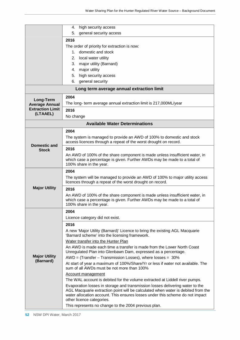
Water Sharing Plan for the Hunter Regulated River Water Source – Background Document
52 NSW DPI Water, March 2017
4. high security access 5. general security access
2016 The order of priority for extraction is now:
1. domestic and stock 2. local water utility 3. major utility (Barnard) 4. major utility 5. high security access 6. general security
Long term average annual extraction limit
Long-Term Average Annual Extraction Limit
(LTAAEL)
2004 The long- term average annual extraction limit is 217,000ML/year
2016 No change
Available Water Determinations
Domestic and Stock
2004 The system is managed to provide an AWD of 100% to domestic and stock access licences through a repeat of the worst drought on record.
2016 An AWD of 100% of the share component is made unless insufficient water, in which case a percentage is given. Further AWDs may be made to a total of 100% share in the year.
Major Utility
2004 The system will be managed to provide an AWD of 100% to major utility access licences through a repeat of the worst drought on record.
2016 An AWD of 100% of the share component is made unless insufficient water, in which case a percentage is given. Further AWDs may be made to a total of 100% share in the year.
Major Utility (Barnard)
2004 Licence category did not exist.
2016 A new ‘Major Utility (Barnard)’ Licence to bring the existing AGL Macquarie ‘Barnard scheme’ into the licensing framework. Water transfer into the Hunter Plan An AWD is made each time a transfer is made from the Lower North Coast Unregulated Plan into Glenbawn Dam, expressed as a percentage. AWD = (Transfer – Transmission Losses), where losses = 30% At start of year a maximum of 100%/Share/Yr or less if water not available. The sum of all AWDs must be not more than 100% Account management The WAL account is debited for the volume extracted at Liddell river pumps. Evaporation losses in storage and transmission losses delivering water to the AGL Macquarie extraction point will be calculated when water is debited from the water allocation account. This ensures losses under this scheme do not impact other licence categories. This represents no change to the 2004 previous plan.

Water Sharing Plan for the Hunter Regulated River Water Source – Background Document
53 NSW DPI Water, March 2017
Local Water Utility
2004 The system is managed to provide an AWD of 100% to local water utility access licences through a repeat of the worst drought on record.
2016 An AWD of 100% of the share component is made unless insufficient water, in which case a percentage is given. Further AWDs may be made to a total of 100% share in the year.
High Security
2004 The system is managed to provide an AWD of 0.75 ML/unit share for the current and following year. AWDs must take into account water requirements for environmental water, basic landholder rights and higher priority access licences.
2016 An AWD can be made once provisions are made for all higher licences (PEW, BLR, D&S, LWU, MU, Barnard, HS & GS carryover plus losses for each). An AWD of 0.75ML/share is made at the start of the water year unless insufficient water. If an AWD is less than 0.75 at the start of water year, then other AWDs can be made up to a total of 1ML/share. For each 0.01ML/Share increase there must also be water to provide GS licences with 0.02ML/Share, so that by the time HS is at 100% allocation GS will be 50%). Maximum AWD is 1ML/Share/Yr if water is available.
General Security
2004 AWDs for General Security Access Licences are made after water requirements for environmental water, basic landholder rights and higher priority access licences are met, and there is sufficient water for an AWD of 0.75 for High Security Access Licences for the current and following water year. AWDs for General Security will be calculated as 0.01 for every 0.02 increase in the AWD for High Security Access Licences above 0.75 until 1 ML/unit share for High Security is met.
2016 No change? An AWD can only be made once provisions are made for all higher licences (PEW, BLR, D&S, LWU, MU, Barnard, 0.75ML/share for HS for current year and following year, HS & GS carryover plus losses for each). For each 0.01 ML/Share increase for HS above 0.75ML/share, GS receive 0.02ML/Share. The sum of AWDs must be no more than 1ML/Share/Yr.
Supplementary Water
2004 The annual high flow tally and annual supplementary tally are used to set AWDs. Incremental increases to the Supplementary Water AWD announcement are made, in accordance with an equation intended, to limit total annual extraction to 30% of moderate to high flows.
2016 The AWD announcement is now decoupled from the Supplementary Water Tally. At the start of the water year the annual high flow tally is set to zero and the AWD is set to 1ML/Share. Further AWDs can be made in increments of up to1ML/Share, dependant on value of the current High Flow Tally ….ie when wetter conditions prevail. Extraction is subject to supplementary announcements per event. The annual high flow tally is used to calculate water available per event, ensuring no more than 30% of annual moderate to high flows are extracted. This rule allows for better operational efficiency.

Water Sharing Plan for the Hunter Regulated River Water Source – Background Document
54 NSW DPI Water, March 2017
Rules for granting access licences
Granting of Access
Licences
2004 The water source is embargoed for the application of access licences with the exception of the following: high Security (Aboriginal cultural) with a maximum limit of 10 ML/yr per licence, high security (Research), and specific purpose access licences including local water utility and domestic and stock access licences.
2016 Embargo of a water source is no longer a feature of the Water Management Act 2000 and regulations. In response references to embargos were removed from the Plan. Licence category High Security (Research) no longer exists so embargos were removed from the Plan. Specific purpose access licences may be granted provided the share and extraction components, as assessed by the Minister, are the minimum required to meet the proposed use. An Aboriginal cultural subcategory licence may be granted, providing the share component is less than 10 ML/year.
Rules for managing access licences (Water allocation account management)
Overview
2004 Carryover is not permitted for following access licences: domestic and stock, local water utility, high security and supplementary. General order of priority for licenced extraction:
1. domestic and stock 2. major utility 3. local water utility 4. high security 5. general security
2016 High Security now has carryover. General order of priority for extraction is now: 1. domestic and stock 2. local water utility 3. major utility (Barnard) 4. major utility 5. high security access 6. general security
Domestic and Stock
2004 Carryover is not permitted.
2016 No change Account maximum is 100% of share component at any one time with no carryover into the next water year.
Major Utility
2004 May carryover 32,400 ML/year (90% of licensed entitlement) provided Glenbawn has 25% capacity over that needed for conservation needs less dead storage.

Water Sharing Plan for the Hunter Regulated River Water Source – Background Document
55 NSW DPI Water, March 2017
2016 No change to carryover. When Glenbawn dam spills (to maintain airspace or for safety reasons) then WAL holders lose their stored or carried over water as spill, or may order and extract rather than loose. MU Water spills (licence holder either takes or loses) 4th.
Can extract up to the lesser of: ~ carryover in account ~ spill volume – (Barnard extractions + losses + GS extractions + HS extractions)
Major Utility (Barnard)
2004 Licence category did not exist.
A new ‘Major Utility (Barnard)’ licence category created to bring the current operation of the AGL Macquarie Barnard Scheme, provided for in the 2004 plan, into the licensing framework. The account is capped at 100% at any one time (60,000ML). The entire balance may be carried over to the following water year. Allocation taken is assessed as (water ordered + evaporation losses from Glenbawn + transmission losses in transport to client extraction pumps). When Glenbawn dam spills (to maintain airspace or for safety reasons) then WAL holders lose their stored or carried over water as spill, or may order and extract rather than loose. MU(B) Water spills (licence holder either takes or loses) 1st. If spill is greater than (Barnard account balance – evaporation) AGL Macquarie must take or loose the water. Can extract up to the lesser of: ~ (current balance of account – evaporation losses from Glenbawn) ~ volume spilled
High Security
2004 Carryover is not permitted.
2016 May now carryover up to 25% of allocation (0.25ML/Share) with the account capped at 100% of share component. Allocation taken is assessed as the greater of water extracted and water ordered. If during the water year the AWD increases to 1ML/Share then water taken as uncontrolled flows is debited to the licence holder’s account. Sum of AWDs in a water year is limited to 1ML/Share. When Glenbawn dam spills (to maintain airspace or for safety reasons) then WAL holders lose their stored or carried over water as spill, or may order and extract rather than loose. HS Water spills (licence holder either takes or loses) 3rd.
Can extract up to the lesser of: ~ carryover in account ~ spill volume – (Barnard extractions + losses + GS extractions) When Glennies dam spills (to maintain airspace or for safety reasons) then GS water spills 2nd after GS ~ carryover in account ~ spill volume – GS extractions
General Security
2004 Carryover of 10% permitted subject to a forecast AWD of 0.5 or greater in the subsequent water year.

Water Sharing Plan for the Hunter Regulated River Water Source – Background Document
56 NSW DPI Water, March 2017
2016 May now carryover up to 25% of allocation (0.25ML/Share) with the account capped at 100% of share component. Allocation taken is assessed as the greater of water extracted and water ordered. If during the water year HS AWD increases to 1ML/Share then the water taken (as uncontrolled flows) is debited to the licence holder’s account. When Glenbawn dam spills (to maintain airspace or for safety reasons) then WAL holders lose their stored or carried over water as spill, or may order and extract rather than loose. GS Water spills (licence holder either takes or loses) 2nd.
Can extract up to the lesser of: ~ carryover in account ~ spill volume – (Barnard + losses) When Glennies dam spills (to maintain airspace or for safety reasons) then GS water spills (licence holder either takes or loses) 1st. Can extract up to the lesser of: ~ carryover in account ~ spill volume
Supplementary Water
2004 No upper limit on water allocation accounts. Carryover is not permitted.
2016 No change to carryover rules. Now, in any 5 consecutive years total water assigned or taken must be no more than (5 x Share Component x 1ML/Unit Share) + assigned allocation. Without this the increased limit used to calculate available water from supplementary and uncontrolled flows (from 2,400 ML/day to 7,200 ML/day) would result in unintended growth in use. Allocation taken is assessed as the greater of water extracted or water ordered. Extraction is only allowed if uncontrolled flows are in excess of that needed for BLR, the environment and higher priority licence holders, and if total volume extracted for all licence types is no more than 50% of river reach inflows. Total extractions for supplementary, GS & HS must be no more than 19% of the annual High Flow Tally. This ensures total take of uncontrolled flows no more than 30% of annual river reach inflows.
Daily access rules
Access to uncontrolled
flows
2004 If a supplementary event is announced then high security and general security access licence holders may access uncontrolled flows if the sum of AWDs for the licence category is less than 1ML/Unit Share and flow is sufficient. If flow is insufficient, but still satisfies minimum daily flows, BLR and higher priority licences, then general security licence holders may access uncontrolled flows (when sum of AWDs is less than 0.75ML/Unit Share). Access to uncontrolled flows is shared in proportion to unit shares held. Water taken is not debited to the water allocation account.
2016 2004 Plan River Reaches become Management Zones in the 2016 Plan. 2004 Plan Management Zones become Trading Zones in the 2016 Plan. River Reaches are not used in the 2016 Plan.

Water Sharing Plan for the Hunter Regulated River Water Source – Background Document
57 NSW DPI Water, March 2017
Extraction under
Supplementary Water access
licences
2004 Supplementary licence holders may take water if announced for a River Reach and provided flow reference point targets are met for 12 consecutive hours and required water has been taken by all other access licences and BLR. Extraction is managed to ensure total daily extraction including BLR does not exceed 50% of Reach inflow. Supplementary water announcements are made in accordance with the supplementary water tally and the AWD. Incremental AWD rules linked to the high flow tally and supplementary tally and the formula in the plan for calculating AWDs act to limit the annual supplementary extraction to approximately 30%
2016 Limits are retained (no extraction in first 12 hours, <50% of daily flows, <30% of cumulative annual flow at Greta flow reference point), and are now decoupled from AWD announcements. Limits are considered by the Minister when making supplementary announcements. The flow limit at Greta used to calculate available supplementary water has been increased from 2,400 ML/day to 7,200 ML/day in consideration of more efficient practices by AGL Macquarie and spreading of demand across a wider range of flows by all licence holders. AGL Macquarie may take supplementary flows when WaterNSW staff are unavailable and no announcement has been made, provided limits on extraction are met. This improves transparency in water management.
Dealing Rules
Licensed entitlement and assignment of
water allocation dealings
2004 Share component and dealings limited in Management Zone 1 to 81,000 ML. Allocation dealings from Zones 2 or 3 into Management Zone 1 is restricted. Allocation dealings from Zones 1 or 2 into Management Zone 3 is restricted. Dealings in or out of the water source and interstate dealings are prohibited.
2016 2004 Plan River Reaches become Management Zones in the 2016 Plan. 2004 Plan Management Zones become Trading Zones in the 2016 Plan. River Reaches are not used in the 2016 Plan. The water allocation dealings limit for Trading Zone 1 is now 78,408 ML, reflecting zone water requirements. Trading Zone 3 now has a limit of 20,000 ML on share component and water allocation dealings. These limits help maintain reliability of supply by balancing demand on major storages. There is no longer a need to asses each trade for impact on reliability of supply. The method used to determine volume limits for Management Zones 1 and 3 is common. There are no changes to dealing rules for Management Zone 2.
Conversion of access licence
category
2004 A Major Utility Access Licence may be cancelled if no longer required, and a High Security Access Licence issued for the same volume of unit shares. A General Security or High Security Access Licence may be cancelled and a Major Utility Access Licence issued subject to a conversion factor. A General Security Access Licence may be converted to a High Security Access Licence, or the reverse, subject to a conversion factor.
2016 Specific purpose licences must be cancelled if no longer required. Conversion between General Security and High Security access licences are

Water Sharing Plan for the Hunter Regulated River Water Source – Background Document
58 NSW DPI Water, March 2017
permitted, subject to a conversion factor. No other conversions are permitted.
Mandatory Conditions
Access licences and works approvals
2004 All access licences have mandatory conditions in regards to use of the water, share component, extraction component, AWDs, account management, nominated supply works and so on.
2016 Mandatory conditions have been updated and include requirements for access Licences without a meter/logger to maintain a logbook (held for 5yrs). Other licence types may also be required to maintain a log book. Requirements for measurement of water taken under licence have been clarified. Major Water Utility licence holders must maintain a documented water efficiency management plan. HS & GS & Supplementary access licence holders must submit water extraction figures to minister if asked. Repetitions of elements of the Water Management Act 2000 have been removed.
Amendment of this plan
Increase in Management Zone 1 limit
2004 The Minister may raise the 81,000ML limit in Management Zone 1 following assessment of possible environmental impacts, assessment of impacts to water allocation, and consultation with licence holders and the Minister for the Environment.
2016 Analysis of Management Zone 1 water use patterns indicate no additional orders can be accommodated without impacting bulk water supply. Consequently the amendment provision has been removed.
Other amendments
2004 Amendment provisions included for water source boundaries, recovery of planned environmental water, floodplain harvesting, and the Macquarie Generation Barnard Reserve Scheme.
2016 Amendment provisions updated in line with current practice whilst retaining the original intent. New amendments provisions are included for inter-valley transfers, mandatory conditions for recording water taken, construction & decommissioning of water supply works, water supply works, water-dependent Aboriginal cultural assets and native title claims.