Embed Size (px)
Citation preview

INSTITUTE OF GEOLOGICAL SCIENCES
Natural Environment Research Council
0 Marple
SJ 98
SJ 97
' Macclesfield
SJ 96 Bosley
SK 08
B Whaley Bridge
SK 07 0 Buxton
-
SK 06
0 Crown copyright 1 9 8 1 ISBN 0 11 884177 7"
SK 18
.Castleton
oTideswell
SK 17
Monyash 0
SK 16
Mineral Assessment Report 77
The limestone and dolomite resources of the country around Buxton, Derbyshire
Description of 1 :25 000 sheet SK 07 and parts of SK 06 and 08
D. J . Harrison
Contributor N. Aitkenhead
London Her Majesty's Stationery Office 1981
The first twelve reports on the assessment of British mineral resources appeared in the Report series of the Institute of Geological Sciences as a subseries. Report 13 and subsequent reports appear as Mineral Assessment Reports of the Institute.
Report 30 describes the procedure for assessment of limestone resources, and reports 26 and 47 describe the limestone resources of particular areas.
Details of published reports appear at the end of this report.
Any enquiries concerning this report may be addressed to Head, Industrial Minerals Assessment Unit, Institute of Geological Sciences, Keyworth, Nottingham NG12 5GG.
The asterisk on the cover indicates that part of sheets adjacent to the one cited are described in this report.
PREFACE National resources of many industrial minerals may seem so large that stocktaking appears unnecessary, but the demand for minerals and for land for all purposes is intensifying and it has become increasingly clear in recent years that regional assessments of resources of these minerals should be undertaken. The publication of information about the quantity and quality of deposits over large areas is intended to provide a comprehensive factual background against which planning decisions can be made.
Consultative Committee recommended that limestone should be investigated, and, following a feasibility study initiated in 1970 by the Institute and funded by the Department of Education and Science, the Industrial Minerals Assessment Unit (formerly the Mineral Assessment Unit) began systematic surveys in 1972. The work is now financed by the Department of the Environment and is being undertaken with the cooperation of members of the British Quarrying and Slag Federation.
This report describes the limestone and dolomite resources of some 50 km2 of country around Buxton, Derbyshire, shown on the accompanying 1 :25 000 resource map. The assessment was conducted by D. J. Harrison with the assistance of F. C. Cox, J. R. Gozzard, D. McC. Bridge, R. W. Gatliff, J. T. Dove, H. Mathers, T. W. Waterhouse, Mrs S. P. Grant and Mrs M. E. Hill.
The assessment is based on a geological survey at the 1 : 10 560 scale by I. P. Stevenson and N. Aitkenhead (for dates of survey, see map in pocket). Dr Aitkenhead also contributed the account of the geology. Chemical analyses were carried out by A. E. Davis and A. N. Morigi of the Institute’s Analytical Chemistry Unit. The G-EXEC data-base management system was used to obtain most of the statistical data and support for this was provided by G. G. Baxter of the Computer Unit. K. S. Siddiqui of the Petrology Unit carried out X-ray diffraction analyses of the insoluble residues, while M. Mitchell of the Palaeontology Unit identified key fossils.
for negotiating access to land for drilling. The ready cooperation of land owners, tenants and quarrying companies in this work is gratefully acknowledged.
The interdepartmental Mineral Resources
J. W. Gardner, CBE, (Land Agent) was responsible
G. M. Brown Director Institute of Geological Sciences Exhibition Road London SW7 2DE
1 March 1981

CONTENTS
Summary 1 Introduction 1 Description of the district 3 Topography 3 Geology 3 Dinantian rocks 3 Structure 10 Lead-zinc mineralisation 10
Assessment of resources 10 Procedures 10 Field survey 10 Laboratory programme 10 Classification 11
Woo Dale Limestones 11 Bee Low Limestones 14 Monsal Dale Limestones 17 Eyam Limestones 18
IMAU site data 19 Horizontal sections 19
Results 11
The map 19
Notes on carbonate resources 19 Appendix A: Classification, terminology and glossary 22 Appendix B: Explanation of format for borehole logs 24 Appendix C: Records of boreholes and sections 26 References 108
PLATES Steep-sided hills associated with the apron-reef limestones at the south-western margin of the Dinantian outcrop, Earl Sterndale 6 Thick-bedded Bee Low Limestones with clay wayboards, Hillhead Quarry 6 Miller’s Dale Limestones with Dove Holes Tuff, Holderness Quarry 7 Dark, thin-bedded Monsal Dale Limestones overlying pale, thick-bedded Bee Low Limestones, Buxton Quarry 7 Dolerite intrusion, Waterswallows Quarry 7
FIGURES Map showing the location of the district 2 Distribution of the major quarries at the time of the survey 4 Topography 5 Generalised section of the exposed Dinantian rocks 8 Distribution of the volcanic rocks 9 Structure of the Dinantian rocks 9 Vertical sections of the Dinantian rocks 11 Distribution of chert at outcrop 17 Histogram showing the distribution of aggregate impact values for limestones 17
10 Summary of limestone resources 19 11 Explanation of symbols used on the graphical
12 Distribution of data points 26 logs 24
MAP The limestone and dolomite resources of the country around Buxton, Derbyshire In pocket
TABLES 1 Classification of limestones by purity with some
2 Rock colours defined by limiting reflectance possible industrial uses 1
percentages with reference to three filters and MgC03 standard 10
3 Chemistry of the Woo Dale Limestones (including Woo Dale Dolomites) 12
4 Variation in major oxides in the Woo Dale Limestones (including Woo Dale Dolomites) 12
5 Colour distribution by formation 13 6 Summary of powder reflectance results for very high
7 Insoluble residue mineralogy determined by X-ray
8 Variation of aggregate impact value within each
9 Chemistry of the Chee Tor Rock 15 10 Chemistry of the Miller’s Dale Limestones 15 11 Chemistry of the Bee Low Limestones
1 2 1 6 Chemistry of the apron-reef limestone 13 Chemistry of the Monsal Dale Limestones 18 1 4 1 8 Chemistry of the Eyam knoll-reef limestones 15 Classification of limestones (based on Folk,
purity rocks 13
diffractometry 13
formation 14
(undivided) 16
1959) 22
iii


The limestone and dolomite resources of the country around Buxton, Derbyshire Description of 1 :25 000 sheet SK 07 and parts of SK 06 and 08
D. J. HARRISON
STJMMARY INTRODUCTION
The study of borehole cores and samples from quarries and natural exposures, together with information from the records and geological maps of the Institute of Geological Sciences, forms the basis of the assessment of limestone and dolomite resources near Buxton, Derbyshire.
The limestones are classified on their calcium carbonate content, and the accompanying 1 :25 000 resource map shows the distribution of the categories of limestone recognised at outcrop. Horizontal sections, constructed from the borehole data and from a knowledge of the regional geology, indicate the categories likely to be encountered at depth. As limestone purity in this district is stratigraphically controlled, most of the boundaries between categories coincide with geological boundaries. Accordingly, the geology, the carbonate resources, and the chemical and mechanical character of each formation is described in turn.
Bibliographical reference HARRISON, D. J . 198 1. The limestone and dolomite resources of the country around Buxton, Derbyshire. Description of 1 :25 000 sheet SK 07 and parts of SK 06 and 08. Miner. Assess. Rep. Inst. Geol. Sci., No. 77.
If it is desired to refer to the part of the report written by the contributor, the citation in the text should be in the form ‘Aitkenhead, pp. 3 - in Harrison, 1981’; the bibliographical reference shown above should appear in the list of references.
Author and contributor D. J . Harrison, MSc, MIMM Institute of Geological Sciences, Keyworth, Nottingham NG12 5GG N. Aitkenhead, BSc, PhD Institute of Geological Sciences, Ring Road Halton, Leeds LS15 8TQ
The demand for raw materials has lead to growth in the limestone quarrying industry and, although production has fallen slightly in recent years, national production in 1978 was 66.4 million tonnes (Institute of Geological Sciences, 1980) and 23 per cent of this output was from the Carboniferous Limestone in Derbyshire. However, these rocks also give rise to impressive scenery and, in consequence, a large part of their outcrop is included within the Peak District National Park. If the amenity value of the region is to be preserved and it is also to continue to supply industry with essential raw materials, then detailed information on the nature of the limestone resources is needed to ensure that land-use and mineral planning is carried out against a factual geological background. The provision of such information relating to the physical and chemical characteristics of the limestones is the objective of the present survey.
The methods of assessment were developed from a feasibility study and embody the most cost-effective procedures for assessing limestone resources on a regional scale (Cox and others, 1977). The materials for study have been obtained from cored boreholes, natural sections and quarry faces. In addition the survey has benefited from the cooperation of members of the minerals industry who have made available numerous borehole logs and chemical data.
Most boreholes were drilled to a depth of at least 100 m and the petrological, mineralogical, chemical and certain of the physical properties of all samples have been determined in the laboratory. Conventional geological nomenclature (see Table 15) has been used
Table 1 Classification of limestones by purity with some possible industrial uses
Catogory CaC03 percentage
Equivalent CaO
Possible uses
1 Very high purity
2 High purity
3 Medium purity
4 Low purity
5 Impure
>98.5
>97 to <98.5
>93.5 to < 97
>85 to <93.5 <85
>55.2
>54.3 to <55.2
X2.4 to <54.3
>47.6 to <52.4 <47.6
Steel, glass, rubber, plastics, paint, whiting
Iron, ceramics, Portland cement, sugar
Paper, animal feeding stuffs, agriculture
Aggregates
Natural cement, mineral wool
Note CaC03 content is only one of several chemical specifications governing end-use; silica, iron, sulphur, and certain trace elements may be as important in some applications.
1

-8
Figure 1 Map showing the location of the district.
for technical descriptions, ensuring compatibility of their calcium carbonate (CaC03) content so that the between this report and the geological literature; a relation between limestone category and possible end glossary is appended. The rocks are classified in terms use may be deduced (Table 1).
2
Detailed results are set out in this report and its appendices, but the accompanying resource map is more generalised. In the horizontal sections, the vertical distribution of the limestone categories is inferred by extrapolation from a knowledge of the surface geology augmented by the results from the boreholes.
DESCRIPTION OF THE DISTRICT
Most of the district*, including the limestone outcrop, is situated in Derbyshire, but small areas of Staffordshire and Cheshire are also included; it also lies partly within the Peak District National Park (Figure 1). Road and rail communications with the surrounding conur- bations, especially Manchester, are good. The popu- lation is scattered through several towns and villages, but Buxton is the commercial, administrative, social and tourist centre of the area. Chapel en le Frith is the home of the large Ferodo works. However, the local economy is based largely on pastoral farming and on the mineral extractive and manufacturing industries. Formerly, limestones were worked in small quarries for local use in building, walling and lime-burning, but in recent years larger quarries (Figure 2), have been developed to produce raw materials for the construction, chemical, glass-making and metallurgical industries. In one quarry dolerite is quarried for use as a crushed-rock aggregate.
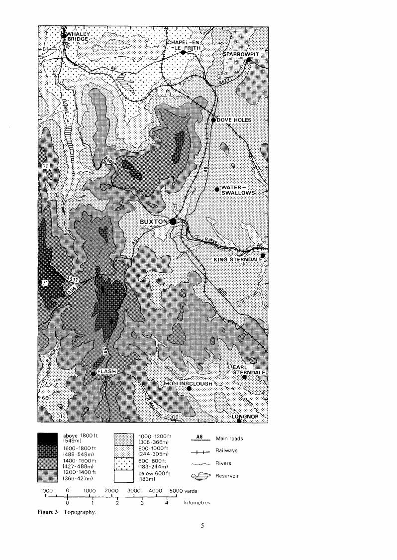
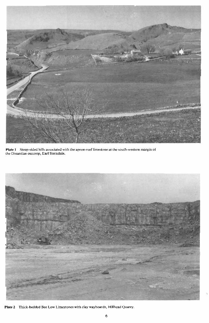
TOPOGRAPHY In the east of the district limestones and associated igneous rocks form an undulating plateau which ranges in elevation from 1100 ft (335 m) to over 1400 ft (427 m) south of Buxton and is characterised by pale-coloured drystone walls, treeless pastures and karst features. The plateau is dissected deeply by the gorge of the River Wye and its tributary dry valleys of Cunning Dale, Woo Dale and Deep Dale (Figure 3). Between Earl Sterndale and Harpur Hill the plateau is marked by several limestone escarpments, whereas the southern margin is characterised by apron-reef limestones forming steep outward-dipping slopes and the serrated peaks of Chrome Hill and Parkhouse Hill (Plate 1). Locally the quarrying of limestone and dolerite has modified the scenery.
To the north, west and south of the limestone plateau the country is underlain by sandstones and shales of Namurian (‘Millstone Grit’) and Wesphalian (‘Lower Coal Measures’) age, producing marked dip- and scarp- slope topography. The scarps rise to over 1800 ft (549 m) above OD and are drained by numerous brooks which flow in deeply incised valleys. The escarpments are locally wooded; the highest moorlands are peat- covered and gritstone walls are characteristic. The headwaters of the rivers Dove and Manifold, draining the slopes below Axe Edge Moor, flow in a south- easterly direction, the Dove producing a broad, symmetrical valley.
* In this report, the word ‘district’ is used to denote the area depicted on the accompanying resource map.
GEOLOGY This general account is based mainly on geological in- vestigations which are to be detailed in the forthcoming Buxton Memoir (Aitkenhead and others, in preparation).
Most of the district is underlain by sedimentary rocks of Carboniferous age but pre-Carboniferous rocks are probably represented by altered volcanic rocks, possibly of Precambrian age, encountered in a borehole [0987 72471 at Woo Dale between a depth of 243.2 m and its base at 312.0 m (Cope, 1973). Gravity anomalies suggest that basement rock may lie at broadly comparable depths throughout the district.
The Carboniferous sequence begins with a thick limestone succession of Dinantian age, popularly referred to as the ‘Carboniferous Limestone’. The lime- stones are interbedded with a few volcanic deposits and are overlain by mudstones and sandstones of Namurian age.
The geological structure, which controls the distribution of the different rock outcrops in the district, is largely the result of earth movements that were in part contemporaneous with sedimentation, but which took place mainly towards the end of the Carboniferous period. Lead-zinc mineralisation, which is extensively developed in these rocks elsewhere in Derbyshire, is of only minor importance in this district.
Drift deposits are largely restricted to alluvial deposits in the bottoms of a few narrow valleys and to brown clayey silt (head) that occurs as small patches in a few of the deeper hollows. Head is also thinly spread over many of the more gentle slopes and also tends to fill solution-widened joints and fissures in the limestones.
Dinantian Rocks The limestones of the district consist mainly of the calcareous skeletons of marine animals and plants, broken and comminuted by wave and current action, mixed in varying proportions with lime mud, and later cemented by calcite spar. Sedimentation took place in a shallow tropical sea, the products of which are now referred to as the limestones of the Derbyshire ‘shelf’ province. However, beyond the margins of the present Dinantian outcrop deeper-water conditions prevailed, at least when the upper part of the sequence was being deposited. The resultant lateral transition of limestone types is especially evident in the south-west of the outcrop, where the shelf-limestones pass into an apron- reef complex that marks the top part of a former steep submarine slope leading down to the ‘off-shelf’ or ‘basin’ province, now hidden beneath an unconform- able cover of Namurian sediments. Volcanism was most active during the later part of the Dinantian, and resulted in the presence of extensive clays, tuffs and lavas interbedded with the higher limestones.
The sequence in the district is about 690 m thick, but the lowest 274 m is known only from boreholes. Local unconformities occur in the sequence, particularly in the higher limestones where they lie near the margins of the shelf and where considerable thickness variations result. These variations may reflect localised minor earth movements during deposition, possibly associated with volcanic activity, and possibly also widespread changes in sea level.
The limestones are subdivided into faunal zones (Figure 4) on the basis of either their coral-brachiopod or their goniatite-bivalve fossil assemblages. The zonal
3

79
78
77
76
75
74
73
72
KEY
Carboniferous Limestone .......... ..........
Working quarry
Major non- working quarr y
_----___ Peak District
PDNP National Park -------- Major roads
tW+l#H+ Railways
0 1 2 km
66 y ...... .....
Longnor 05 06 07 08 09
Figure 2 Distribution of the major quarries at the time of the survey.
4
*AydemSodoL ~JIIS!~
SaJlawol ly P E Z 1 0 t i P
I I I 1 r I'I SPJeA 000s OOOP OOOE oooz OOOL 0 OOOb
i
i
Plate 1 Steep-sided hills associated with the apron-reef limestone at the south-western margin of the Dinantian outcrop, Earl Sterndale.
i
i.
Plate 2 Thick-bedded Bee Low Limestones with clay wayboards, Hillhead Quarry.
6

Plate 3 Miller's Dale Limestones with Dove Holes Tuff, Holderness Quarry.
-_
I
Plate 4 Dark, thin-bedded Monsal Dale Limestones overlying pale, thick- bedded Bee Low Limestones, Buxton Quarry. 1
Plate 5 Dolerite intrusion, Waterswallows Quarry.
7

boundaries are subject to minor revision as more fossils are discovered, and they do not exactly coincide with the boundaries of named formations. However, current stratigraphic practice (George and others, 1976; Ramsbottom and Mitchell, 1980) divides the Dinantian rocks into seven stages; of these only the Holkerian, Asbian and Brigantian are represented in this district.
Woo Dale Limestones The Holkerian Stage is rep- resented in this district by the Woo Dale Limestones (S2) which crop out in three anticlinal inliers: in and around Woo Dale; in the dry valleys west of Harpur Hill; and in the area north-west of High Edge and south-west of Harpur Hill. The characteristic Woo Dale Limestone lithofacies consists of thinly bedded, dark brown and dark grey fine-grained limestones with some buff-grey and pale grey beds. The lithologies are similar to those found elsewhere in Derbyshire in shelf limestones of the same age, but the beds are generally darker than corre- sponding limestones exposed in the Via Gellia [262 5641, Cromford (Cox and Harrison, 1980). The limestones are chert-free but many of the darker beds contain thin mudstone partings; locally they are dolomitised. Approximately 100 m of the Woo Dale Limestones is
2
2
a 2
I- z
m
2
2 m
a v,
2 9 K Y Y A 0 I
Figure 4
unconformity
knol l - reef(K) unconformity .
knoll-reef (K)
Upper M i l l e r s Dale Lava (El ) . local unconform - i t y Mil ler’s Dale Limestones(MD) w i th Dove Holes Tuff (2). Lower Miller‘s Dale Lava (61).
Chee Tor Rock (Cl Apron- reef (Rap)
Woo Dale Dolomites
E Y A M L I M E S T O N E S
M O N S A L D A L E L I M E S T O N E S
B E E L O W L I M E S T O N E S
W O O D A L E L I M E S T O N E S
Generalised section of the exposed Dinantian rocks.
exposed, of which the lowest 30 m is dolomitised and is so lithologically distinct in Woo Dale [097 7251 that it forms a mappable unit known as the Woo Dale Dolomites. A further 272 m of these dolomites with bands of dolomitised limestone was proved in the Woo Dale Borehole; the basal beds have been assigned to the earliest VisCan but may even be of late Tournaisian age (Cope, 1979).
Bee Low Limestones The top beds of the Woo Dale Limestones are included, on faunal grounds, in the Asbian Stage, to which the Bee Low Limestones (Dl) also belong. The Bee Low Limestones (Plate 2) are mainly pale grey, massive, chert-free limestones, with beds up to 10 m thick in the middle and lower parts of the formation (Stevenson and Gaunt, 1971). Dispersed throughout the sequence are a number of beds, up to about 0.5 m in thickness, of reddish brown to greenish grey clay, probably representing intermittent wide- spread falls of volcanic ash.
Between Dove Holes, Harpur Hill and Hindlow Station the Bee Low Limestones contain the Lower Miller’s Dale Lava, the beds below being termed the Chee Tor Rock and those above the Miller’s Dale Limestones.
No single borehole or natural section has proved the full thickness of the Bee Low Limestones in the district but they are estimated to be about 183 m thick in the north and between 168 and 192 m in the south. The Chee Tor Rock is estimated to range from about 115 to 122 m, and the Miller’s Dale Limestones from 19 m in the south to 43 m near Dove Holes.
The Lower Miller’s Dale Lava and the Dove Holes Tuff(P1ate 3) are the two major units of volanic rock in the Bee Low Limestones. The former has a long outcrop, and probably extends at depth to the western margin of the limestone outcrop between Buxton and Dove Holes (Figure 5) ; its maximum proved thickness is 29.9m south-east of Peak Dale [093 7671. The Dove Holes Tuff has a narrow outcrop extending for about 2 km in the vicinity of Dove Holes. It lies about 15 m above the base of the Miller’s Dale Limestone and has a maximum thickness of about 1.8 m.
Along the south-west margin of the outcrop of the Bee Low Limestones there is a lateral passage of these beds first into a narrow discontinuous algal reef and then into steeply dipping fore-reef limestones which together constitute an apron-reef.
Monsal Dale Limestones The Brigantian Stage is rep- resented in the district by the Monsal Dale Limestones (D2) and Eyam Limestones (P2). The Monsal Dale Limestones crop out discontinuously around the western periphery of the limestone outcrop and also in a few small outliers west of Hindlow. The discontinuous and incomplete nature of the outcrop results from the combined effects of an apparently localised uncon- formity at the base of the overlying Eyam Limestones and a more general unconformity at the base of the Namurian shales. It is estimated that about 90 m of Monsal Dale Limestones is present south of Dove Holes and about 110 m in the south-west near Turncliff [047 6981. The Upper Miller’s Dale Lava, which is ex- tensively developed at or near the base of the formation in adjacent districts to the east, occurs only in one small outlier at Fox Low [067 7121.
The Monsal Dale Limestones (Plate 4) are more variable in colour, bedding and texture than the Bee
8

Low Limestones, and contain chert at some levels. The lowest beds in the succession usually consist of dark, clay-rich, pyritous and thinly bedded limestones ranging in thickness from about 6.1 m around Dove Holes to 10.1 m at Stoop Farm [064 6811 in the south. A few knoll-reefs are present in the upper part of these dark limestones and in the lower part of the succeeding sequence which is predominantly pale in this area. The knolls consist of mainly pale grey massive micritic to granular limestone associated in some cases with coarsely crinoidal limestone.
Eyam Limestones The Eyam Limestones have a narrow outcrop about 2.4 km long in the vicinity of Brook House, north of Buxton, and hereabouts lie, apparently with strong unconformity, on Miller’s Dale Limestones. They are about 35 m thick and have similar lithological characteristics to the basal dark limestones of the Monsal Dale Limestones; small knoll-reefs are present west of Fairfield Common.
I I I I 1
Scale (- ‘\
0 1 2 3 km ‘--. 1 I I I
05 09 1 I I I I I I
Figure 5 Distribution of volcanic rocks.
The lavas, tuffs, and clay wayboards already mentioned are the products of volcanic activity that continued intermittently over much of the shelf and surrounding basin province during late Dinantian times. In the shelf province, the volcanic rocks were erupted onto a limestone surface that lay close to sea level.
The locations of the eruptive centres are uncertain; a vent for the Dove Holes Tuff may well lie near its outcrop, but beneath younger rocks. Another eruptive centre probably lay not far to the east of the area of Monk’s Dale. Two basalt dykes exposed in Great Rocks Dale [0974 7565 and 0995 75061 may have acted as feeders during the fissure eruptions that were probably responsible for the Upper and Lower Miller’s Dale lavas.
The only other intrusive igneous rock in the area is the dolerite forming the Waterswallows Sill (Plate 5 ) , which reaches a thickness of about 24 m in Waterswallows Quarry. It appears, on the basis of radiometric dating, to have been intruded in later Carboniferous times, and is thus appreciably younger than, and not directly related to, the extrusive igneous rocks (Stevenson and others, 1970).
I I I I I
- Normal fault, tick on downthrow side
- ----Margin of Dinantian limestone
- I I I I
05 09 I I I I I
Figure 6 Structure of the Dinantian rocks.
9

Structure The Dinantian limestones were folded and faulted by earth movements which took place intermittently over a long period of time, but most intensely at the end of the Carboniferous Period. Viewed regionally, the area lies along the crest of the Derbyshire Dome, the broad uplift that produced the limestone outcrop of the Peak District. In detail, however, there is no single anticlinal culmination.
The structure contours shown in Figure 6 indicate the presence of three separate gentle anticlines trending between NNW - SSE and WNW - ESE. Flanking dips are generally less then lo", except near the western margin of the limestone outcrop where they are rather steeper. To the south-west of these structures, two tighter north - south anticlines lie south of Buxton and dips are steeper, generally between 10" and 20" on the flanks of the Greensides Syncline and up to 50" on the western flank of the Countess Cliff Anticline.
Fault trends are predominantly west - east in the east of the district and NNW - SSE in the south-west, the largest individual throw being along the Cronkston Fault which has a maximum vertical displacement of about 213 m. Many of the small fractures, however, have displacements that are large enough to have an effect on quarrying.
Lead-zinc mineralisation At various times after the end of the Carboniferous Period certain faults, fractures and cavity systems in the DerbyshireBtaffordshire limestone outcrop became the host for sulphide ores and associated calcite-baryte- fluorite gangue minerals.
The present district falls outside the main orefield,
The recovery of cores exceeded 95 per cent, but some difficulties were encountered with clay bands. Cores from three commercial boreholes were also made available and additional material was obtained by use of a portable Minuteman drill and a MK 8 Edeco Strata- drill operated by Institute staff. These drills recovered small-diameter core from eight boreholes drilled to a maximum depth of 15 m. Samples were collected at one- metre intervals from quarries and natural exposures and these were supplemented by an extensive collection of spot samples.
Laboratory programme Lithological, petrological and mineralogical deter-
minations of the limestones were made using a combination of microscopical and staining techniques applied to sawn and etched rock surfaces and thin sections. Additional data on the non-carbonate mineralogy of the limestones were determined by X-ray diffraction analysis of the acid-insoluble residues. The method suffered from problems of mineral grain orientation and grain size, and positive mineral identifi- cation was, in some cases, difficult. However, 142 residues were selected for X-ray diffraction analysis, and the mineralogical data obtained are shown in Table 7.
Table 2 Rock colours defined by limiting reflectance percentages with reference to three filters and a MgC03 standard.
Colour Reflectance percentage Wavelength Wavelength wavelength - -
which lies to the east, and the few minor veins and scrins 660 nm 530 nm 470 nm (see Glossary) near the northern and south-western Pale grey >35 >26 >24 borders of the district which have been worked in the Mid-grey past are economically insignificant. However, it is Dark grey common to find considerable amounts of calcite
35- 15 26- 12 24- 1 1 <15 < 12 <11
associated with fault breccias and minor quantities of other gangue minerals and sulphides are also present locally.
ASSESSMENT OF RESOURCES
The assessment is based on a field survey which provided samples for study in the laboratory and the data for interpretation. The procedures adopted are similar to those used in other reports on the assessment of resources (Cox and others, 1977).
PROCEDURES
Field survey The number of boreholes required to assess the limestones of the district was determined with the aid of up-to-date 1 : 10 560 geological maps, and with reference to natural exposures and quarry sections. Core from a borehole drilled in 1971 at the feasibility stage of the project was available and a further five boreholes were drilled to complete the survey. The initial borehole was drilled to a depth of 60 m and continuous cores of at least 74 mm diameter were obtained. The remaining five boreholes wet-e drilled to depths ranging from 100 to 130 m and provided continuous cores of 47 mm diameter. These boreholes were drilled by contractors using trailer-mounted rigs and waterflush techniques.
In order to measure the colour of the rocks objectively, tri-colour reflectance values were obtained using an EEL reflectance spectrophotometer. The measurements were taken on sawn, acid-etched rock surfaces and the values recorded have been used in correlating boreholes and sections. Three colours, pale grey, mid-grey and dark grey, are defined by reference to three filters (wavelengths 660, 520, and 470 nm re- spectively) and a MgC03 standard (Table 2). The colour of a rock powder is important if it is to be used as a whitening agent, or, in an end-use where the colour of the manufactured product is important. Hence, tri- colour reflectance values were determined for powdered samples (<63 micrometres particle size) of the very high purity limestones in each formation.
Chemical analyses for major and trace elements were performed by the Analytical Chemistry Unit of the Institute on samples from borehole cores and exposures. Analyses were made using direct electron excitation X-ray spectrophotometry for Ca, Mg, Si, Al, Na, K, S, Sr, P, F and Fe; other elements were determined by atomic absorption spectrophotometry and As by colorimetry (Roberts and Davis, 1977).
A primary classification of the rocks, based on carbonate content, was achieved by measuring the amount of the acid-insoluble residue (Cox and others, 1977).
10

In order to assess the likely performance of the rocks as aggregates all samples were subjected to the Aggregate Impact Value (AIV) test, BS 812 (British Standards Institution, 1975).
Classification The two methods of classification chosen for use in this report are based on petrology and on calcium carbonate (CaC03) content. The former is used to describe the rocks in lithological terms, but the latter is preferred to depict them on the assessment map and for use in the description of resources. The relationship between the five categories adopted, their CaC03 contents and possible end uses are shown in Table 1 .
06 NE 9s m
RESULTS The results are here described by reference to the geological formations, rather than under headings relating to chemical or physical properties which were appropriate for other surveys (Cox and Bridge, 1977; Cox and Harrison, 1980).
WOO DALE LIMESTONES These rocks occur in three anticlinal inliers totalling 2.52 km2 of outcrop. Normally this formation consists of limestones with minor dolomitisation.
Petrography The limestones are biomicrites, bio- pelsparites and pelsparites, with comparatively rare
07 NE43
. .. . , 0 , @..,
t
,... :.: ..... . . . . . . . , .. ... _:.:: Dark Limestone - - Brachiopod She1 Is 0 0 Crinoid Debris :::: Pellets and Peloids = = Encrusting Atgae
@ e Foraminifera 0". Calctspheres J J Corals 0 * Birdseye Structures 1\11 Dolomitised Limestone x No Data
Tuff
Clay Wayboard A * Algae (Dasycladaceae)
07 SE 27 Example of Borehole Registration Number
Figure 7 Vertical sections of the Dinantian rocks.
11

biosparites. Fossil clasts are usually finely comminuted to lutite or fine to medium arenite size, are well sorted, and are commonly encrusted by algae. The facies varies from very fine, poorly fossiliferous biomicrites and micrites, to biopelsparites. The former contain calcispheres and foraminifera as the dominant allochems, whereas the latter contain algae, algae- encrusted bioclasts, brachiopod debris and foraminifera. Laminated beds and cross-bedding have been recorded. A band of micritic rocks with birdseye structures occurs between 10 and 20 m below the top of the formation (Figure 7).
Dolomitisation The available data show that the degree of dolomitisation of the Woo Dale Limestones is variable throughout the district. The amount of dolo- mitisation is usually minor but in Woo Dale [097 7251 the lowest 30 m seen is extensively dolomitised and has been mapped as the Woo Dale Dolomites. A 24.60 m section (07 SE4s) in Woo Dale reveals a mixed sequence of dolomite and dolomitised limestone with rare limestone beds; the proportions of dolomite and dolomitised limestone are about equal. In contrast to the secondary dolomites of the Wirksworth - Monyash districts of Derbyshire, the dolomitisation of the Woo Dale Limestones of the Buxton district is strati- graphically controlled and took place at an early diagenetic stage. Where the alteration is extreme, the original textures are destroyed and the dolomite is buff- grey in colour, with a granular and vuggy texture. In thin section, the original limestone features are replaced by an interlocking mosaic of dolomite crystals.
Insoluble residues The Woo Dale Limestones give insoluble residue values which are generally less than 1.5% and the rocks are therefore classified as very high purity carbonates. The mean insoluble residue value (Table 3) from 562 samples of Woo Dale Limestones is 0.88%; exceptionally a value of 74.60% was recorded from a sample containing tuffaceous material at 124 m depth in borehole 07 SE 39.
Chemical analyses The high-grade character of the Woo Dale Limestones is confirmed by their chemical analyses (Table 3). Calcium oxide values are generally greater than 55.0%, except when the limestones are significantly dolomitised. Table 4 illustrates the
variation in GaO, M g 8 and Fez03 content in analyses of Woo Dale Limestones from borehole and section samples. Magnesium values are shown to be variable and usually less than 0.6%, but they are higher than those for the other formations. Pure dolomite contains 21.85% Mg8, and most commercial dolomites have between 20.75 and 21.70% MgO. One sample from a natural section (07 §E 4s) in Woo Dale was within these limits, but three others from the same section contained only 1.18, 17.40 and 0.90% MgO, respectively. In a correlation matrix produced for the Woo Dale Limestones, MgO shows a positive correlation with Fe203, suggesting that the dolomite contains some iron in the lattice. The iron values are generally high with a maximum value of 4. 18% in the Woo Dale Dolomites of 07 SE 4s.
Table 3 Chemistry of the Woo Dale Limestones (including Woo Dale Dolomites)
Insoluble residue CaO MgO §io2
NaaO K20 so3 Loss at 1050°C F SrO
A1203
P205
MnO CU Pb Zn Fez03 As
Maximum value we Yo 74.60 56.00 21 -00 2.20 0.64 0.03 0.16 0.62 0.04
47.51 0.03 0.13
PPm 2500
15 15
1 m 11800
2
Minimum value wt Yo 0.10
32.80 0.27 0.00 0.W 0.00 0.00 0*00 0.00
43.23 0.00 0.00
PPm 10 0 0 0
60 0
Mean
W t Yo 0.88
53.71 1.70 0.21 0.08 0.01 0.03 0.17 0.01
4 4 * 12 0,Ol 0.03
PPm 343
3 2
36 1117.
1
Standard deviation wt Yo 3.41 4.70 4.00 0.35 0.11 0.01 0.03 0.19 0.01 0.74 0.01 0.03
PPm 486
3 4
130 1945
1
~-
~-
Note The insoluble residue data were obtained from 562 samples. The chemical data were obtained from 58 analyses, except for those for As which were obtained from 12 analyses.
Table 4 Variation in major oxides in the Woo Dale Limestones (including Woo Dale Dolomites)
Borehole/ Number percentage by weight parts per million Section of ca0 number analyses MgO Fez03
Max Min Mean Standard Max Rain Mean Standard Max Min Mean Standard
06NE 10 9 06NW 1s 1 07 SE2S 4 07 SE4S 4 07 SE6S 3 07 SE9S 2 07 SE 12s 7 07 SE 13s 1 07 SE27 1 07 SE 32 4 07 SE49 9 07 SE 50 8 07SE51 5
value 55.80 55.10 55.50 54.60 55.20 54.40 55.90 55.30 55.80 56.30 55.80 55.40 55.10
value 55.50 55.10 54.50 32.00 55 .OO 54.40 54.50 55.30 55.80 54.10 52.20 39.60 54.10
deviation value 55.70 0.13 0.42
55.20 0.45 0.54 43.76 11.86 21.00 55.10 0.12 0.42 54.40 0.00 0.48 55.10 0.53 0.84
55.10 - 0.27
55.30 - 0.37 55.80 - 0.44 55.70 1.04 2.29 54.90 1.07 1.65 50.50 5.79 14.40 54.50 0.39 0.61
value 0.29 0.35 0.27 0.27 0.32 0.45 0.90 18.12 0.33 0.37 0.48 0.48 0.37 0.61 0.37 0.37 0.44 0.44 0.37 0.94 0.36 0.58 0.45 4.33 0.33 0.45
deviation 0.05
0.09 10.59 0.05 0.00 0.19
-
- -
0.91 0.41 4.88 0.11
value 400 200
3900 11800
240 2500 1500 200
1OO0 3000 2400 8100 1300
value 100 200 80
600 100 540 150 200
1000 400 60
260 400
deviation 244 133 200 -
1253 1777 3675 5423 193 81
1520 1386 559 553 200 -
1000 - 1150 1237 748 740
2441 2624 620 390
12

Silica has a low mean relative to the other formations, confirming the absence of widespread silicification within these beds. Alumina values are low but values as high as 0.64% are recorded in clay-rich limestones. Sodium and potassium are virtually absent in these rocks, but KzO has a very strong positive correlation with alumina, indicating the presence of K-rich clay minerals in some limestones. Sulphur is present in minor amounts in limestones from all formations and the mean value of 0.17% from the Woo Dale Limestones is similar to that for the others. The sulphur is commonly associated with lead in galena, which occurs as a localised hydrothermal mineralisation. Phosphorus, fluorine, strontium, copper, zinc and arsenic and virtually absent, although an anomalous maximum value of 1000 ppm zinc was recorded from a sample of the Woo Dale Dolomites at 2 m depth in section 07 SE 4s. The sample yielded an insoluble residue of 2.70% and the maximum MnO value for the formation, of 2500 ppm. Clearly the sample is mineralised and optical examination of the insoluble residue revealed a major proportion of an unidentified ore mineral. Manganese oxide, with a relatively high mean value of 343 ppm, and usually occurring in pyrolusite, has been recorded petrologically throughout these limestones. The loss-on-ignition values (at 1050°C) are at their highest in analyses of the Woo Dale Limestones, and the strong positive correlation of loss-on-ignition with MgO indicates that the high loss values occur in dolomitised samples.
Colour The limestones are predominantly mid-grey (Table 5 ) but contain a considerable proportion of dark grey and a limited number of pale grey beds. The dark colour of these limestones is characteristic of this formation in the Buxton district, but is unlike that of limestones of equivalent age and similar facies found in districts of the east (Cox and Bridge, 1977; Cox and Harrison, 1980) which are predominantly pale grey in colour .
Table 5 Colour distribution by formation
Formations and subdivisions percentages Pale Mid- Dark grey* grey* grey*
EYAM LIMESTONES Knoll-reef facies 8 92 0
MONSAL DALE LIMESTONES 2 77 21 BEE LOW LIMESTONES Apron-reef facies 2 90 8 Miller's Dale Limestones 6 93 1 Chee Tor Rock 34 62 1 Bee Low Limestones (undivided) 37 61 2
WOO DALE LIMESTONES 11 61 28
---
* See Table 2 for definition
The colours of powders prepared from the Woo Dale Limestones are relatively dark with a mean reflectance value of 73% at a wavelength of 660 nm (Table 6). They are also variable, as shown by the high standard deviation, and range from 48% to 93 (7'0 reflectance at 660 nm. This is in marked contrast to the mean reflectance values obtained for the Woo Dale Limestones in the Wirksworth district (Cox and
Harrison, 198O), and the Monyash district (Cox and Bridge, 1977) where mean values of 86% and 81 (70
respectively, were recorded.
Table 6 Summary of powder reflectance results for very high purity rocks (CaC03 exceeds 98.5 per cent)
Formations and subdivisions Mean reflectance percentages (and standard deviations) 660nm 520nm 470nm
EYAM LIMESTONES Knoll-reef facies 84(7) 80(9) 78 (9) MONSAL DALE
---
LIMESTONES 77(6) 69(6) 67(6) BEE LOW LIMESTONES Apron-reef facies 81 ( 5 ) 76 (6) 75 (6) Miller's Dale Limestones 79(4) 73 ( 5 ) 71 ( 5 ) Chee Tor Rock 83 (4) 79 ( 5 ) 77 ( 5 ) Bee Low Limestones (undivided) 86 ( 5 ) 81 ( 5 ) SO(6)
WOO DALE LIMESTONES 73 (8) 66 (9) 64 (9)
The darker limestones contain minor amounts of clay, occurring as thin partings, stylolitic coatings, as streaks or in disseminated form. A 1.66 m bed of tuff recorded in commercial borehole 07 SE 39 [0904 74831 at a depth of 123.10 m is estimated to be 19.75 m below the base of the Bee Low Limestones. This tuff is not seen at outcrop or in any other section or borehole across the district, but traces of blue and ochreous clay approximately 23 m below the base of the Bee Low Limestones in borehole 07 SE 50 [0854 73281, and traces of pyrite at similar levels in borehole 07 SE 51 LO822 71 361 and natural section 06 NW 1s [0492 69721 , may be manifestations of this localised volcanic event. The major non-carbonate minerals in the Woo Dale Limestones are clay minerals and, secondarily, quartz. The quartz occurs as euhedral crystals which are usually
Table 7 Insoluble residue mineralogy determined by X-ray diffractometry
Mineral Number of samples in which mineral was identified Monsal Dale Bee Low Woo Dale and Eyam Limestones Limestones Limestones (90)" (43)* (9) *
Quartz 9 84 29 Muscovite 4 50 25 Mixed-layer clay 6 38 9 Illite 4 18 20 Kaolinite 2 30 4 Smectite 0 4 1 Chlorite 1 7 1 Goethite 0 0 3 Feldspar 1 3 2 Pyrite 1 1 0 Baryte 0 0 1 Fluorite 0 4 1
* Number of samples analysed.
13

widely scattered throughout the beds, although local concentrations tend to increase the insoluble residue value. X-ray diffraction analysis of the acid-insoluble residues reveals a varied mineralogy (Table 7). Some boreholes and sections contain veinlets of baryte, calcite and pyrite, but the contamination of the limestone is restricted.
Fracture spacing and aggregate impact value Details for most boreholes and natural sections are shown graphically in Appendix C. The Woo Dale Limestones are characteristically well bedded with fracture-spacing values (as defined by Franklin and others, 1971) of 200 to 1000 mm. The mean aggregate impact value of 22 (Table 8), with a range of values from 17 to 26, is similar to the results obtained from limestones of the other formations. However, the values for a limited number of Woo Dale Dolomite samples are significantly higher, which suggests that they are not as suitable for use as aggregates.
Table 8 Variation of aggregate impact value within each formation
Formation (and number of samples tested)
Monsal Dale and Eyam Limestones (8)
Bee Low Limestones ( 1 60)
Limestones (54)
Dolomites (3)
Woo Dale
Woo Dale
Aggregate Impact Value Maximum Minimum Mean Standard value value deviation - --
24 20 22 1.2
29 16 22 2.2
26 17 22 2.1
34 25 29 4.2
BEE LOW LIMESTONES (including Chee Tor Rock and Miller’s Dale Limestones) These rocks, with a surface outcrop of 45 km2, form about 90% of the limestone outcrop. The formation is of considerable economic importance as it provides most of the limestone quarried in the district. The beds are lithologically uniform and the lithofacies developed are typical of those of an open-marine shelf depositional environment.
CHEE TOR ROCK Petrography The Chee Tor Rock and equivalent beds occuring below the horizon of the Lower Miller’s Dale Lava are typically pale grey, massively bedded, calcarenites. Bioclastic and peloidal limestones containing a well sorted, spar-cemented, allochemical framework, make up much of the sequence. Crinoids, brachiopods, pellets and peloids, and dasycladacean algae are the dominant allochems, but corals, oncolites and algal-encrusted bioclasts are common at some horizons. Bioturbated and mottled beds are recorded. The lowest beds, some 10 m thick, are usually relatively thinly bedded and fine-grained, and contain darker, micritic beds similar to those in the underlying Woo Dale Limestones. Clay wayboards (see Glossary) occur throughout the sequence and are valuable aids in correlating the many natural, quarry and borehole sections studied (Figure 7).
Insoluble residues Euhedral authigenic quartz crystals predominate among the non-carbonate minerals; at certain horizons they are concentrated and form a significant source of impurity. This is particularly evident in the limestones immediately below the Lower Miller’s Dale Lava which are seen in borehole 07 NE 43 [0751 76771 to be enriched in quartz euhedra within a 3-m bed. This enrichment is also seen in a 5-m bed of limestone beneath the lava in a quarry section (07 NE 5s) at Smalldale [0959 77001 and beneath clay wayboards, which are taken to represent the lateral equivalent of the lava (Figure 7) at Hillhead Quarry [0701 69561, Grinlow Quarry [0458 72331 and Bee Low Quarry [0910 79291. Pyrite enrichment is also commonly recorded in the beds immediately below the volcanic horizons. The other non-carbonate minerals recorded from the formation are shown in Table 7.
Colour The limestones of the Chee Tor Rock are much paler in colour than the underlying Woo Dale Limestones and they are commonly described as uniformly pale grey. However, only about one third of the samples tested are pale grey; in fact mid-grey colours predominate (Table 5). Dark grey limestones are recorded locally from samples of the lowest beds.
LOWER MILLER’S DALE LAVA The Lower Miller’s Dale Lava is an olivine-basalt, which is usually amygdaloidal, with vesicles filled with calcite and chlorite. It is commonly weathered to clay at its upper surface.
MILLER’S DALE LIMESTONES The Miller’s Dale Limestones and equivalent beds occurring above the horizon of the Lower Miller’s Dale Lava are lithologically similar to the Chee Tor Rock. Minor differences are a general reduction in pelletal and peloidal material with a corresponding increase in comminuted shell and crinoid debris, a generally less massive character and a predominantly mid-grey colour (Table 5). The lower 10 to 15 m of strata are richly fossiliferous with a coral/brachiopod fauna. The beds between the Lower Miller’s Dale Lava and the Dove Holes Tuff were intersected by borehole 07 NE 43 and are exposed in Holderness Quarry [0834 78 161. These beds contain abundant quartz euhedra and the limestones immediately adjacent to the volcanics are mineralised with pyrite and silicified calcite veinlets. The Miller’s Dale Limestones overlying the tuff also contain authigenic quartz as the dominant non- carbonate mineral, but pyritisation and silicification, in the form of silicified veinlets, silicified bioclasts and euhedral quartz crystals, are particularly prevalent in the 8 m of strata above the tuff.
APRON-REEF COMPLEX The Bee Low Limestones pass laterally at the south-west margin and at the extreme northern margin of the limestone outcrop into an apron-reef complex of limestones. The fore-reef limestones sampled in sections 06 NE 14s [0837 67 151 and 08 SE 1s [0990 8 1261 are mid-grey, unbedded or poorly bedded, sparsely fossiliferous, micritic limestones. Communities of brachiopods occur in situ, and bryozoan colonies and geopetal cavities are common. The reef limestones are characteristically very fine grained but bands of crinoid debris of rudite grade occur within the fore-reef lime- stones at Tor Top [0990 81261. Apron-reef limestones
14

contain a small proportion of dark grey beds (Table 5 ) similar to those recorded in the Wirksworth district (Cox and Harrison, 1980). A section (06 NE 8s) at Aldery Cliff shows the gradual transition from reef to shelf facies in the Bee Low Limestones. The clay wayboards of the shelf rocks are not seen in the equiv- alent marginal reef facies. In the apron-reef limestones, clay is the dominant non-carbonate mineral and euhedral quartz crystals are relatively rare.
Insoluble residues Insoluble residue values are generally less than 1070 for samples of all limestones of Asbian age, except for samples from silicified or pyritised beds. Accordingly, the Bee Low Limestones formation and its members contain uniformly high- grade limestones with the exception of those beds associated with the volcanic horizons in the Dove Holes area.
Chemistry The chemistry of the Bee Low Limestones is summarised in Tables 9 to 12 which show that, overall, the formation is chemically uniform, although, in detail, there is some variation between the Chee Tor Rock (Table 9) and the Miller’s Dale Limestones (Table
The Chee Tor Rock has a mean CaO value of 55.05%, an insoluble residue of 0.78% and silica 0.53%. In contrast, the Miller’s Dale Limestones have a mean CaO value of 54.21 070 but residue and silica mean values are 2.63 070 and 1.93 070 respectively. There is also some variation in chemistry within these members, although sodium, potassium, phosphorus, fluorine, strontium, copper, lead, zinc and arsenic are virtually absent in both the Chee Tor Rock and Miller’s Dale Limestones.
Chemical analyses of the Chee Tor Rock (see Appendix C) typically show high CaO values; the anom- alously low CaO values recorded at 50 m depth in
10).
Table 9 Chemistry of the Chee Tor Rock
Maximum Minimum Mean Standard value value deviation wt 070 wt 07.0 wt Yo wt%
Insoluble residue 20.30 0.00 0.78 1.17 CaO 56.00 52.10 55.05 0.85 MgO 1.27 0.16 0.29 0.15 Si02 3.69 0.00 0.53 0.67 A120 3 2.26 0.00 0.13 0.35 Nan0 0.04 0.00 0.01 0.01 K20 0.44 0.02 0.05 0.07 so3 0.83 0.00 0.18 0.21
Loss at 1050°C 44.01 41.48 43.64 0.44 F 0.08 0.00 0.01 0.01 SrO 0.16 0.00 0.04 0.04
PPm PPm PPm PPm MnO 700 30 140 126 c u 15 0 3 3 Pb 20 0 2 5 Zn 40 0 10 6 Fez03 4400 90 435 764 As 2 0 1 1
- ~-
P205 0.04 0.00 0.01 0.01
- ~-
Note The insoluble residue data were obtained from 449 samples. The chemical data were obtained from 50 analyses, except for those for As which were obtained from 10 analyses.
borehole 07 SE 39, at 19 m depth in borehole 07 SE 27 and at 35 m depth in borehole 07 SE 39 are from samples contaminated by clay wayboard material. Each of these three samples yield insoluble residue, silica, alumina, Fe203, SO3 and K2O values that are much higher than those typical of the Chee Tor Rock. All other samples from the Chee Tor Rock have CaO values which lie between 54 and 56%, A1203 values up to 0.2070, and Fez03 values which are generally less than 0.05%. Silica is present in variable amounts depending on the concentration of authigenic quartz crystals, but it is only rarely that the Si02 content is as high as 1 .O or 1.5%. SO3 values are usually less than 0.05%, but higher values in the range 0.30% to 0.50% are recorded. Sulphur shows an affinity with iron, copper, lead, and zinc although the trace element values are always low. The Chee Tor Rock is uniformly low in MgO through- out the district, unlike the underlying Woo Dale Limestones. The mean MgO value is 0.29V0, but in one sample, at 31 m depth in section 07 SE IS, the MgO value reaches 1.27%. Manganese occurs in small but variable amounts, having a maximum of 700 ppm and a mean value of 140 ppm.
Thirteen analyses of Miller’s Dale Limestones indicate that these beds are less chemically pure than the Chee Tor Rock, being marginally poorer in CaO and richer in silica. The silicification, though patchy, is most intense in the beds between the Dove Holes Tuff and Lower Miller’s Dale Lava, and a sample taken from these rocks at 89 m depth in borehole 07 NE 43 had a very high insoluble residue content (8.90%), and a silica value of 7.02%. The CaO value of 51.60% in the same sample was the minimum for these beds. The same sample gave the maximum Fe203 value of 0.29%, due to the presence of pyrite, weathered to limonite, in the strata immediately above the Lower Miller’s Dale Lava. Of the 13 samples analysed, only 3 contained more than 2.5% silica and more than half of the remaining analyses contained less than 1070 silica.
Table 10 Chemistry of the Miller’s Dale Limestones
Maximum Minimum Mean Standard value value deviation wt 07.0 wt 07.0 wt 07.b wt07.0
Insoluble residue 11.60 0.40 2.63 2.53 CaO 55.50 51.60 54.21 1.10 MgO 0.30 0.19 0.26 0.04 Si02 7.02 0.3 1 1.93 2.04 A1203 0.10 0.00 0.06 0.02 Nan0 0.02 0.00 0.01 0.01 K20 0.04 0.02 0.03 0.01 so3 0.29 0.03 0.13 0.09 P205 0.06 0.01 0.02 0.01 Loss at 1050°C 44.60 40.55 42.75 1.24 F 0.02 0.00 0.00 0.01 SrO 0.15 0.00 0.04 0.06
PPm PPm PPm PPm MnO 850 90 294 227 c u 10 0 5 2 Pb 50 0 13 21 Zn 100 10 24 24 Fe203 2900 100 594 721 As 6 6 6 -
- ~-
- --
Note The insoluble residue data were obtained from 102 samples. The chemical data were obtained from 13 analyses, except for those for As which were obtained from one analysis.
15

MgO and A1203 values are consistenly low, as are the remaining major and trace elements, although the Miller’s Dale Limestones sampled are marginally richer in iron, manganese, copper, lead and zinc than the Chee Tor Rock.
For the areas where the lava is absent and the Bee Low Limestones have not been subdivided, the rock chemistry has been determined from 115 samples (Table 11). Most of the analyses are of samples from beds that are laterally equivalent to the Chee Tor Rock, and not surprisingly, their chemistry is very similar. The for- mation typically contains limestones with high CaO values and only small proportions of magnesia, silica, alumina, SO3 and Fe203. Sodium, potassium, phos- phorus, fluorine, strontium, manganese, copper, lead, zinc and arsenic are virtually absent. The rocks are also chemically uniform across the district and only minor variations are found in the major- and trace-element chemistry.
Relatively low CaO values are associated with lime- stones that are enriched in silica, for example at 12 m depth in section 07 NE 6s, where values of 52.40% CaO and 3.42% Si02 reflect the presence of abundant quartz crystals in the beds beneath a clay wayboard. The lowest CaO values recorded are from the section 06 NE 9s in Buxton Quarry [084 6901, where 39 m of Bee Low Limestones is exposed beneath the base of the Monsal Dale Limestones. Five analyses from these beds give mean values of 54.10% CaO, 1.15% SiOz and 0.07% Fe2O3. The Bee Low Limestones exposed in Buxton Quarry are the lateral equivalent of the Miller’s Dale Limestones. The maximum alumina value of 1.16% is recorded at 34 m in section 07 SE 7s at Harpur Hill Quarry [064 7061 where the strata are also laterally equivalent to the Miller’s Dale Limestones. The same sample also gives the maximum K 2 0 value indicating the presence of K-rich clay minerals, and further, gives a high Fe203 value of 0.43%, which corresponds with the
Table I1 Chemistry of the Bee Low Limestones (undivided)
Maximum Minimum Mean Standard value value deviation wt Yo wt Yo wt Yo wtvo
Insoluble residue 5.80 0.10 0.70 0.53 CaO 56.10 52.40 55.41 0.83 MgO 0.63 0.15 0.27 0.09 S i 0 2 3.51 0.00 0.43 0.59 A1203 1.16 0.00 0.09 0.14 Nan0 0.25 0.00 0.01 0.02 K z 0 0.16 0.00 0.03 0.02 so3 0.67 0.00 0.18 0.17
Loss at 1050°C 44.95 41.80 43.59 0.45 F 0.06 0.00 0.01 0.01 SrO 0.14 0.00 0.02 0.03
PPm PPm PPm PPm MnO 700 40 119 93 c u 35 0 5 4 Pb 90 0 6 10 Zn 40 0 11 7 Fez03 31 100 70 713 2937 As 6 0 1 2
- --
P205 0.33 0.00 0.02 0.04
- --
Note The insoluble residue data were obtained from 895 samples. The chemical data were obtained from 115 analyses, except for those for As which were obtained from 20 analyses.
16
lithological description of hematite-stained fissures at this level; this is probably equivalent to the horizon of the Dove Holes Tuff. Two analyses from the section 06 NE 10s at Tor Rock [066 6803 contained anomalously high phosphorus concentrations of 0.19% and 0.33%, and the same samples contained relatively high fluorine contents of 0.04% and 0.06%, suggesting the occurrence of fluorapatite, Ca~F(P04)3, within the limestones.
The chemistry of the apron-reef limestones is shown separately in Table 12 and is very similar to that of the equivalent shelf limestones. A sample at 10 m depth in the section 08 SE 1s gave the maximum phosphorus value of 0.23% and the maximum fluorine value of 0.02070, which again suggests the presence of fluorapatite, possibly occurring in fish teeth, bones or scales.
Powder colour The whitest limestone powders in the district are produced from the Chee Tor Rock and from the equivalent beds of the Bee Low Limestones, which give mean reflectance values for a wavelength of 660 nm, of 83% and 86% respectively, with only small variations in powder colour. The highest reflectance values (see Appendix C) of very high purity Bee Low Limestones are given by the limestone powders from Hillhead Quarry [070 6961, Hindlow Quarry [095 6781 and Grinlow Quarry [046 7231. High reflectance values were also recorded from limestone powders of the Chee Tor Rock in borehole 07 SE 39 [090 7481, and Cowdale Quarry [080 7221. Powders of Miller’s Dale Limestones are noticeably darker (Table 6) than those of the Chee Tor Rock. Measurements of the powder colour of the apron-reef facies of the Bee Low Limestones gave reflectance values which, for a wavelength of 660 nm, varied between 89% and 68% with a mean of 81 070. These values are similar to those given by the apron-reef limestones of the Wirksworth district (Cox and Harrison, 1980).
Table 12 Chemistry of the apron-reef limestone
Maximum Minimum Mean Standard value value deviation wt Yo wt Yo wt Yo wtY0
Insoluble residue 2.20 0.40 1.03 0.42 CaO 55.60 54.30 55.02 0.52 MgO 0.50 0.27 0.36 0.10 Si02 1.51 0.05 0.72 0.62 A1203 0.11 0.00 0.04 0.05 Nan0 0.03 0.00 0.01 0.01 K 2 0 0.04 0.02 0.03 0.01 so3 0.13 0.04 0.09 0.04 P205 0.23 0.01 0.08 0.09
- ~-
Loss at 1050°C 43.96 43.10 43.54 0.35 F 0.02 0.00 0.01 0.01 SrO 0.08 0.00 0.03 0.03
PPm PPm PPm PPm - --
MnO 550 150 262 165 c u 5 0 2 2 Pb 10 10 2 4 Zn 20 0 14 5 Fez03 1300 90 495 476 As 0 0 0 -
Note The insoluble residue data were obtained from 35 samples. The chemical data were obtained from 5 analyses, except for those for As which were obtained from one analysis.

4- Chert locality
05
Figure 8 Distribution of chert at outcrop.
Fracture spacing values The massively bedded Bee Low Limestones give fracture spacing values of between 500 and 3500 mm, but values less than 500 mm are associated with the lower beds above the Woo Dale Limestones. The apron-reef limestones are also massively bedded or unbedded, and fracture spacing commonly falls between 800 and 2000 mm.
Aggregate impact values The aggregate impact values for the Bee Low Limestones (Table 8) are closely similar
16 18 20 22 24 26 28 30
A I V
Figure 9 Histogram showing the distribution of aggregate impact values for limestones.
to those of the Woo Dale and Monsal Dale limestones, suggesting that they are equally competent, irrespective of age and lithofacies. Samples of dolerite from the Waterswallows Sill [085 7481 give an aggregate impact value of 19, indicating the suitability of the dolerite for use as roadstone.
MONSAL DALE LIMESTONES These limestones occupy a relatively small area of 3.0 km2 in narrow, marginal outcrops and in several outliers south of Buxton. The full thickness of this formation has not been proved but the lowest 40 m was sampled in borehole 07 NE 43 [0751 76771. Information from this borehole and from natural and quarry sections (06 NE 9s, 07 NE IS, 07 NE 7s, 07 SW s) and shallow boreholes (06 NE MI, 07 NE E3, 07 SW El ) shows the Monsal Dale Limestones to be highly variable.
The lowest 10.56 m of the formation proved in borehole 07 NE 43 is thinly bedded and predominantly dark grey or mid-grey in colour, clay-rich and pyritous, and forms a distinctive basal subdivision to the formation. Some chert (Figure 8) has been recorded from these rocks which are mainly biosparites of variable grain size. They include beds rich in foraminifera, including Saccammfnopsis, together with a basal unit, containing abundant algae-encrusted bioclasts, representing the Lower Girvanella Band. Knoll-reefs of mid-grey, coarsely bioclastic micritic and spar-rich limestones are developed locally within, and just above, the dark limestones.
The dark limestones are succeeded by predominantly mid-grey, more thickly bedded limestones which are highly fossiliferous, with bioclasts of variable grain size supported in a spar or micritic matrix. Brachiopods and
17

foraminifera are the dominant allochems, but crinoid, peloid, algal and bryozoan debris is common.
The Upper Miller’s Dale Lava, petrographically similar to the Lower Miller’s Dale Lava, lies at or near the base of this formation in adjacent districts, but is absent over much of the district except for a small outlier [066 7131 near Harpur Hill.
Insoluble residue values The content of insoluble residues is more variable in the Monsal Dale Limestones than in the Bee Low and Woo Dale Limestones. Residue values of over 8% are recorded from the basal strata, but values in the range 2% to 3% are more common. The overlying limestones give low, but variable, insoluble residue values except where the localised occurrence of chert increases the residue content.
Clay wayboards are recorded and the darker limestones also contain disseminated clay, but the most commonly occurring impurities are silicified bioclasts and euhedral quartz crystals.
Chemistry The chemical data on the Monsal Dale Limestones are derived from the analysis of 11 samples taken from sections 06 NE 9s, 07 NE IS, and 07 NE 7s, and from borehole 07 NE 43 (Table 13). These data are not fully representative because they come only from the lowest 40 m of the formation. The basal, dark- coloured, clay-rich limestones have higher silica, alumina, magnesia, potash and manganese values, and lower CaO values than are typical of the overlying beds of the Monsal Dale Limestones. Phosphorus and fluorine are relatively high in the basal strata, but the maximum values are found in samples from section 07 NE IS at Barmoor Quarry [088 7991, where stratigraphically higher beds give mean values of 0.33% phosphorus and 0.05% fluorine. This suggests that the local accumulation of fluorapatite is similar to that found in the rocks of Asbian age exposed in sections 06 NE 10s and 08 SE S.
Table 13 Chemistry of the Monsal Dale Limestones
Maximum Minimum Mean Standard value value deviation wt To wt 070 wt 070 wt%
Insoluble residue 8.40 0.50 1.72 1.18 CaO 55.30 53.50 54.37 0.62 MgO 0.61 0.30 0.41 0.09 Si02 2.32 0.36 1.11 0.68 A1203 0.36 0.02 0.16 0.12 Na2O 0.02 0.00 0.01 0.01 K 2 0 0.09 0.02 0.05 0.02 SO3 0.33 0.04 0.16 0.09 P205 0.54 0.01 0.15 0.16 Loss at 1050°C 43.63 42.18 43.08 0.49 F 0.09 0.00 0.03 0.03 SrO 0.14 0.00 0.05 0.05
PPm PPm PPm PPm MnO 730 30 250 210 c u 5 0 3 2 Pb 20 0 8 7 Zn 30 10 14 6 Fez03 3000 200 915 892 As 1 1 1 -
- ~-
- ~-
Note The insoluble residue data were obtained from 66 samples. The chemical data were obtained from 11 analyses, except for those for As which were obtained from one analysis.
Trace elements are present at very low background levels, supporting the observation of the unmineralised nature of the limestones in this part of Derbyshire. The maximum iron value of 0.30% is recorded from the basal dark limestones which contain small amounts of pyrite and limonite.
Powder colour The powder colour of the very high purity samples of the Monsal Dale Limestones is slightly darker than those typical of the Bee Low Limestones (Table 6).
Fracture spacings and aggregate impact values The Monsal Dale Limestones and the overlying Eyam Lime- stones are more thinly bedded than the Woo Dale and Bee Low Limestones, with fracture spacings of 150 to 400 mm. However, the localised knoll-reefs are more massive, with fracture spacing values in excess of 1000 mm. The aggregate impact values are similar to those for the other formations (Table 8 and Figure 9).
EYAM LIMESTONES The Eyam Limestones occupy a total area of 0.4 km2 and have a maximum exposed thickness of some 35 m, but the total thickness present has not been proved. A shallow borehole (07 NE E2) at Brookhouse Farm [0697 75 181 proved nearly 15 m of these beds and a natural section 07 SE 3s [0673 74841 south of Brookhouse Farm exposes a total of 13.29 m of Eyam Limestones, of which the basal 11 m is knoll-reef lime- stone. The knoll-reef limestones are massive, mid-grey, micritic limestones which are highly fossiliferous with brachiopod, crinoid, algal and bryozoan bioclasts of variable grain size. However, the greater part of the Eyam Limestones consists of dark grey, thinly-bedded, cherty and clay-rich limestones which include biopel- sparites and biomicrites; crinoid, brachiopod and coral debris of coarse arenite to medium rudite grain size is abundant in some beds, and bioclasts are commonly silicified.
Table 14 Chemistry of the Eyam knoll-reef Limestones
Maximum Minimum value value wt 070 wt Yo
Insoluble residue 1.80 0.30 CaO 55.30 54.80 MgO 0.41 0.30 Si02 0.68 0.26 A1203 0.05 0.04 Nan0 0.02 0.01 K n 0 0.03 0.03 so3 0.14 0.13 P205 0.05 0.03 Loss at 1050°C 43.90 43.77 F 0.04 0.01 SrO 0.05 0.00
PPm PPm MnO 290 280 c u 0 0 Pb 0 0 Zn 10 10 Fez03 600 230 As - -
Note The insoluble residue data were obtained from 13 samples. The chemical data were obtained from two analyses.
18

The Eyam Limestones produce high insoluble residue values due to the presence within the beds of nodular and bedded chert, clay minerals, silicified bioclasts and authigenic quartz. However, the residue values are variable and some beds, particularly the chert-free knoll-reefs, contain less than 1.5% non-carbonate minerals. Chemical analyses of the high-grade knoll- reef limestones of section 07 SE 3s (Table 14) show the limestones to contain high values of CaO and small amounts of silica, magnesia, sulphur and iron. Alumina, sodium, potassium, phosphorus, fluorine, strontium and the trace elements are virtually absent.
A limited number of limestone powders were pre- pared from the knoll-reef limestones and these gave a mean reflectance value, at a wavelength of 660 nm, of 84%, which is similar to the values obtained from equivalent knoll-reefs in the Wirksworth district (Cox and Harrison, 1980).
THE MAP The resource assessment map is folded into the pocket at the end of this report. The base map is the Ordnance Survey 1 :25 000 outline edition in grey. Geological data are restricted to those most likely to have a bearing on the working of limestone and dolomite: these include faults and other structural information which are shown in red and major geological boundaries in green. An alternation of red and black dashes indicates the line of a mineral deposit. Drift is shown by black ornament.
The purity of limestone is indicated on the resource map by shades of blue which demonstrate the average purity at the surface. Purity values were determined at the sample points by calculation of the mean, standard deviation and confidence limits for the 95% probability level, assuming the Student’s t distribution for each ten metres represented. The mean and positive confidence limit were summed to give a value which when subtract- ed from one hundred, gave a conservative (worst) estimate of the calcium carbonate content for each thickness increment. This value was used to determine the category of limestone according to the classification in Table 1. This information was then combined with carbonate data from spot samples and any additional field observations (for example, presence or absence of chert), thus indicating the mean composition of the surface limestone in a regional fashion.
Areas of dolomite and of partial dolomitisation are indicated in green and by green dots respectively.
IMA U site data At the site of each borehole or extensive natural section, the purity and other properties of the limestone are indi- cated in a tablet. The right half of the tablet shows the insoluble residue value to a maximum of 10% for each metre of strata. Where natural sections are recorded Ordnance Datum is given for the highest stratigraphical horizon collected.
Horizontal sections Sections have been drawn to show the relationships of the various limestone categories. These sections are based directly upon borehole information, the structure as determined from field evidence, and the relationship of the various categories of limestone to the known stratigraphy. They are therefore an interpretation using all the available data and should be treated only as a guide to the likely distribution of purity at depth. In
particular, there is insufficient evidence to permit illustration of the depth of dolomitisation.
Zigzag lines have been used diagrammatically to indicate the approximate position of a lateral passage between limestone units and do not necessarily indicate precise boundaries.
NOTES ON CARBONATE RESOURCES The Dinantian rocks of the district occupy an area of 52.08 km’, comprising 49.10 km’ of limestone, 0.22 km2 of dolomite and 2.76 km’ of basalt, dolerite and tuff. The carbonate resources comprise: 39.05 km’ of very high purity limestone, 3.14 km2 of high purity limestone, 0.22 km’ of medium purity limestone, 2.93 km2 of undivided very high purity to medium purity limestone and 1.07 km’ of low purity limestone; additionally 2.69 km’ of very high purity limestones are identified as limestones affected by dolomitisation and there are 0.22 km’ of dolomite.
Over most of the district carbonate purity is directly related to stratigraphic formation, the Woo Dale Limestones and Bee Low Limestones being character- istically very high purity mineral, whereas the Monsal Dale Limestones and Eyam Limestones are generally of a lower and more variable purity. Exceptionally the Miller’s Dale Limestones of the Dove Holes-Batham Gate area are affected by their proximity to the Lower Millers’ Dale Lava and Dove Holes Tuff (Figure lo), and are, therefore downgraded to the low purity category.
I I I I I I I I I
60
76
76
74
7:
70
68
66
Area underlain by limestones of variable purity with Interbedded volcanic rocks
Area underlam by a constderable
Scale 1 2 3 km
02 04 06 08 1 I I I I 1 I I I
Figure 10 Summary of limestone resources.
19

The Woo Dale Limestones, both at outcrop and in borehole cores, are affected by dolomitisation but sig- nificant thicknesses of dolomite are found only in the vicinity of Woo Dale. These Woo Dale Dolomites contain as much limestone and dolomitised limestone as dolomite with the result that the MgO values vary between 0.90 and 21 .OO%. Beds of dolomite and dolo- mitised limestone and, more commonly, incipient dolo- mitisation and patchy dolomitisation adjacent to fractures and fissures, are found throughout the Woo Dale Limestones of the district, resulting in the relatively high MgQ values which are characteristic of the limestones of this formation. The Woo Dale Limestones containing high MgQ concentrations are shown on the map. The overall effects of dolomitisation are, however, at a minor level and the Woo Dale Limestones are everywhere a uniform deposit of very high purity limestone. The chief impurities are clay minerals, occurring mainly in disseminated form, and euhedral quartz crystals, although the latter are more common in the overlying Bee Low Limestones. Impurities rarely total more than 1 % of the rock. The thin bed of tuff in borehole 07 SE 39 is the sole record of igneous rock in the Woo Dale Limestones of this district.
The overlying Bee Low Limestones, however, contain two units of volcanic rock, the Lower Miller’s Dale Lava and Dove Holes Tuff. Additionally, the formation is intruded by a dolerite mass which forms the Water- swallows Sill. These igneous rocks occur in a sequence of predominantly very high purity limestones of uniform chemistry which rarely contain more than 1% of non-carbonate minerals. Consequently the Bee Low Limestones are of great commercial importance, as evidenced by the number of large quarries which work the formation. The highest-grade limestones are found throughout the Chee Tor Rock and equivalent strata; the beds above the Lower Miller’s Dale Lava contain more impurities in the form of quartz euhedra, silicified bioclasts and clay and the limestone category commonly varies between very high purity and medium purity. In the type area for the Dove Holes Tuff, however, the Miller’s Dale Limestones are extensively silicified both above and below the tuff (Figure lo), so that the limestones are downgraded to the low purity category. This alteration is most intense in the strata immediately above the tuff where the limestones contain over 8% silica and pyrite. The area of Miller’s Dale Limestones between Batham Gate and Buxton is poorly exposed and borehole information is restricted to one shallow hole at Batham Gate, but, from the limited information available, purity is variable, although in most cases the limestones contain more than 98.5% CaCQ3. The upper beds of the Bee Low Limestones equivalent to the Miller’s Dale Limestones are of variable purity but are predominantly very high purity limestones.
Clay wayboards occur throughout the limestones of Asbian age but are not considered a significant source of impurity as they are readily removed during the quarrying process. The limestones immediately below such clay wayboards are, however, commonly enriched in euhedral quartz crystals and, more rarely, pyrite, but alteration is usually localised and rarely totals more than 3% of the rock. Similar silicification and pyritisation affect the limestones to a maximum depth of 5 m below the Lower Miller’s Dale Lava in the Dove Holes-Upper End area. Few mineral veins occur in this district and the limestones are therefore largely
uncontaminated by lead, copper, zinc and associated elements.
The Monsal Dale Limestones are generally less pure and more lithologically and chemically variable than the underlying beds, although the limestones usually contain more than 97% CaCQ3 and commonly more than 98.5% CaC03. A considerable area of very high purity Monsal Dale Limestones is indicated in the syncline between High Edge and Hillhead Quarry though this is affected by contamination from clay in sink-holes and joints. The basal strata are usually dark in colour and clay-rich and exceptionally these lime- stones contain over 8% non-carbonate minerals although insoluble residues of 2 to 3% are more common; consequently the beds are categorised as high or medium purity limestones. A little chert is recorded locally and phosphorus and fluorine values are marginally higher in these argillaceous beds. The succeeding beds are generally high purity limestones although chert is recorded (Figure 8) at the shelf margin north of Barmoor [086 7971. Silicified bioclasts and quartz euhedra are the major impurities. Locally, small areas of knoll-reef limestone, developed near the base of the formation, are very pure, containing over 98.5% CaCQ3, but they are restricted to a maximum thickness of about 20 m.
The overlying Eyam Limestones, which rest uncon- formably on Miller’s Dale Limestones in narrow, marginal outcrops just to the north of Buxton, are usually cherty and contain argillaceous beds and beds rich in silicified bioclastic debris. The overall content of non-carbonate minerals in the limestones is therefore high, averaging over 8% of the rock, but it is variable and some beds contain less than 1 .5% non-carbonate material. The knoll-reefs developed at the base of the formation are chert-free and are uniformly very high purity limestones, but they do not exceed some 15 m in thickness.
Irrespective of formation, the limestones have similar aggregate impact values and the mean values obtained fall within the range of values yielded by limestones used as aggregates. However, the dolomites and dolomitised limestones of the Woo Dale Dolomites are softer and porous, and have aggregate impact values high enough to preclude most aggregate usages.
The whitest limestonespowders are given by the Chee Tor Rock and equivalent strata, and the limestone powders from the Bee Low Limestones at Hillhead Quarry, Hindlow Quarry and Grinlow Quarry gave particularly high tricolour reflectance values.
The Dinantian rocks of the district are folded into gentle anticlines and synclines although the folds are sharper south of Buxton. The dips at the western margins of the outcrop are relatively steep but those on the limestone plateau around Green Fairfield and King Sterndale average 5 ” . The resulting outcrop pattern is further complicated by normal faulting which predominantly trends E-W north of Buxton and NNW-SSE south of Buxton. The displacement on the faults is liable to be significant to quarrying operations, whereas the affects of folding are likely to be minimal.
Overburden is usually less than a few metres thick, but fairly large areas of head conceal the limestones at the western margin near Burbage, and on the limestone plateau south of Buxton. Thin deposits of alluvium occur in the valleys of Brook Bottom, Wye Dale, Deep Dale, Back Dale, Horseshoe Dale, Dove Holes Dale and Peak Dale.
20
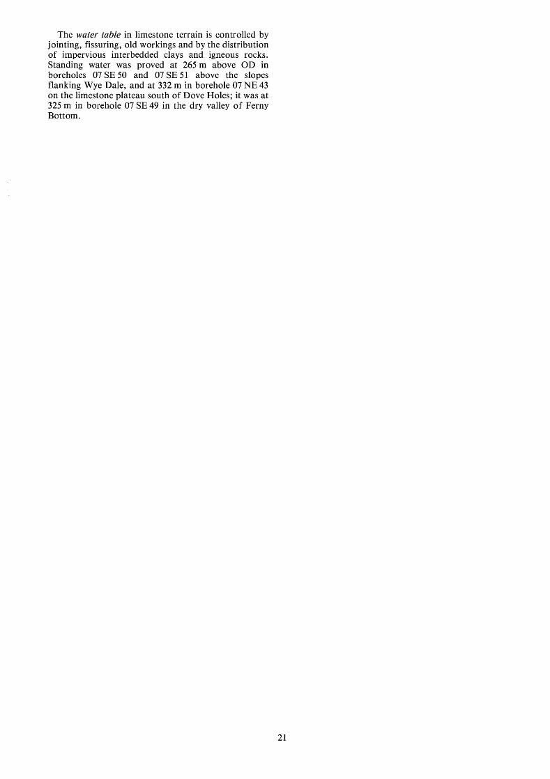
The water table in limestone terrain is controlled by jointing, fissuring, old workings and by the distribution of impervious interbedded clays and igneous rocks. Standing water was proved at 265 m above OD in boreholes 07 SE 50 and 07 SE 51 above the slopes flanking Wye Dale, and at 332 m in borehole 07 NE 43 on the limestone plateau south of Dove Holes; it was at 325 m in borehole 07 SE 49 in the dry valley of Ferny Bottom.
21

APPENDIX A
CLASSIFICATION, TERMINOLOGY AND GLOSSARY
CLASSIFICA TION The petrographic classification of limestone by Folk (1959; 1962) is widely accepted and is used in this report in a slightly modified form. The classification is summarised in Table 15.
allochem grains and matrix. Allochem grains are discrete bodies that have been subjected to some degree of transportation: they include fossils and fossil fragments, oolites, intraclasts and pellets. The matrix is subdivided on grain size into: microcrystalline ooze (less than 4 micrometres*) termed micrite, a slightly coarser crystalline fabric (4 to 16 micrometres) termed microspar, and crystalline calcite cement or spar (greater than 16 micrometres).
Limestones are also classified by reference to the mean grain size of the allochems into calcirudites (greater than 1 mm), calcarenites (1 to 0.062 mm) and calcilutites (less than 0.062 mm). A grain size term may be incorporated into the main rock as a suffix, for example biosparrudite.
The pure mineral dolomite, CaMg(C03)2, contains 21.9% MgO and 30.4% CaO (or 54.3% CaCO3). Rocks containing dolomite are classified as follows:
Clastic limestones consist of two basic components, namely
10 to 49.9% Dolomitic limestone 50 to 89.9% Calcitic dolomite 90% and above Dolomite
In the first category, the use of Folk terminology is not precluded, for example, Biosparite Dolomitic.
TERMINOLOGY The nomenclature of the major rock types is set out in Table 15. If a rock contains more than 25% of allochems which are not mentioned in the main rock name, these are used to qualify the rock name and have an initial capital letter, for example, Crinoid biosparite. Subordinate diagnostic allochems may also qualify the main rock name; these are dif€erentiated by the use of a small initial letter, for example, algae Crinoid biosparite.
Table 15 Classification of limestones (based on Folk, 1959).
I LIMESTONES
In the records which follow, however, a more formal version of the nomenclature is used, the qualifiers following the grain- size name in descending order of abundance. The example above is thus cited as Biosparite Crinoid algae.
GLOSSARY Allochem A collective term for one of several varieties of discrete and organised carbonate aggregates, such as fossil fragments, oolites and pellets that serve as the coarser framework grains in most mechanically deposited limestones. Anticline An arch fold, the core of which contains the stratigraphically older rocks. Argillaceous rocks Detrital sedimentary rocks that contain clay- or silt-grade material. Authigenic Referring to those constituents that came into existence with or after the formation of the host rock. Bioclasts Broken fragments of organic skeletal material. Calcarenite A limestone consisting predominantly (more than 50 per cent) of detrital calcite particles of sand size (0.062 to 1 mm). Calcilutite A limestone consisting predominantly (more than 50 per cent) of detrital particles of silt and/or clay size (less than 0.062 mm). Calciaudite A limestone consisting predominantly (more than 50 per cent) of detrital calcite particles larger than sand size (greater than 1 mm). Euhedral A term applied to grains displaying fully developed crystal form. Facies The sum of all the primary lithological and palae- ontological characteristics exhibited by a sedimentary rock, from which its origin and environment of formation may be inferred. Gangue A mineral in a vein other than an ore mineral. Geopetal Pertaining to any rock feature that indicates the relation of top to bottom during, or shortly after, sedimentation; particularly horizontally bedded infillings in the bottom of a cavity. Hydrothermal Pertaining to heated water, to the action of heated water or to the products of the action of heated water.
> lo% Allochems Allochemical Rocks
cement > ooze > microcrystalline sparry
calcite cement
T
n - 2 o m m g ; E lntramicrite
lntrasparite 1 1 (rare) ;+ I I
Biomicrite
cn
<lo% Allochems Microcrystalline Rocks
1-10% allochems T ic
Intraclasts: lntraclastic
micrite (rare)
Oolites: Oolitic micrite
(rare)
Fossils: Fossiliferous
Micrite
Pellets:
Pelletiferous
Micrite
:1 YO allochems
Micrite
1
i i
* 1 micrometre is metres; the term micrometre replaces micron.
22
Inlier A limited area of older rocks completely surrounded by younger rocks. Intraclast Material created by penecontemporaneous erosion within a basin of deposition. lntraformational A term applied to rocks or structural features which occur between two sets of defined strata. It implies temporary change in the condition of sedimentation. Micrite Semi-opaque crystalline matrix component of limestones consisting of carbonate mud whose crystals have diameters of less than 4 micrometres. Outlier A limited area of younger rocks surrounded by older rocks. Pellet A ovoid grain composed of micrite. Many, but not all, pellets are of faecal origin. Peloid A grain composed of micrite or microspar. This term does not imply any particular mode of origin. Rake A body of ore and gangue minerals disposed vertically between two walls of rock. The main type of mineral vein in the Peak District. Reverse fault A fault with a major dip-slip component in which the hanging wall is on the upthrow side. Scrin A mineralised joint. Sparite Transparent crystalline matrix component of limestones consisting of calcite having diameters that exceed 10 micrometres. Strike The direction of trend that a structural surface takes as it intersects the horizontal. Stylolite An irregular suture-like boundary developed in some limestones. Syncline A trough fold, the core of which contains stratigraphically younger rocks. Unconformable Describes strata that are separated from underlying rocks by a surface that represents a significant break in sedimentation. Vug A cavity in a rock. Wayboard An old mining term used commonly in Derbyshire to describe a discrete and deleterious thin rock bed, usually of clay.
23

APPENDIX B
EXPLANATION OF FORMAT FOR BOREHOLE LOGS
The following list is arranged in the same order as data on the borehole records. The numbered paragraphs below also correspond with the annotations on the first record (Appendix C). 1 The Registration Number This consists of two statements:
1 The number of the 1:25 OOO sheet on which the borehole lies, for example SK 07
2 The quarter of the 1 :25 OOO sheet on which the borehole lies and its number in a series for that quarter, for example NE 43. Thus the full Registration Number is SK 07 NE 43.
Collected sections are registered in a similar manner using a separate series of numbers, suffixed by the letter s, for example SK 07 NE IS. This is abbreviated to 07 NE 1s in the text. 2 The National Grid reference All National Grid references in this publication lie within the 100-km square SK unless otherwise stated. Grid references for borehole sites and section limits are given to eight figures (that is, accurate to within 10 m). In the text, six-figure grid references are used for more approximate locations. 3 Location Borehole and section locations are referred to the nearest named locality on the 1 :25 000 base map. 4 Surface level The surface level at the borehole site is given in metres above Ordnance Datum. For collected sections surface level is taken to be the stratigraphical top of the sampled sequence.
Superficial deposits Allochemical symbols
Made ground
Carbonate sediments
n Limestone
Dolomite
Non - carbonate
V V Bryozoa
- Peloids . . . . . . Corals
a a Brachiopods and undifferentiated bivalve shells
0 0 Crinoid debris
** Birdseye structures
,, Calcispheres
A A Algae (mainly Dasycladaceae 1
ococ Algae (encrusting forms including Girvanella )
0
H Clay and clay wayboard i9 L$ Gastropods
a a lntraclasts
Extrusive igneous rocks @ 0 Foraminifera
Fl A A
Basalt
Tuff
I 1 1 1 I Dolomltised llmestone or disseminated dolomlte
Q t z Euhedral quartz crystals
SI Slliceous materlal
Fe Pyrite
Additional lithological data
. . . . . . . . . . . . . . . . . . . . . . . . . . . . . I. . . . . . . . ::::::::::::::: Dark limestone : reflectance of red light ( 660 nm 15 % . . . . . . . . . . . . . . . . . . . . . . . . . . . . . . . . . . . . . I I I Mottled limestone m m
1:: I
Mineralised limestone (galena, baryte)
0
0 Nodular chert
/-/ ff Joints
Lithological junction
gradational lithological junction
X gap in data
Figure 11 Explanation of symbols used on the graphical logs.
24
5 Type of drill and date of drilling The drilling machines which have been used in this survey are listed below: Flushing agent Type of rig Water Edeco Stratadrill 36 Water Edeco Stratadrill Mk8-portable drill Water Minute-man-portable drill
The type of machine, diameter of core produced and the month and year of the completion of the borehole are given.
Descriptive borehole log 6 The limestone formational names are listed. 7 Each major rock type is subdivided, where possible, using the rock classification and nomenclature explained in Appendix A, and followed by a brief description. 8 Depth The figures given relate to depths to the base of the lithologies described in the log.
Graphical borehole log 9 Major rock types are represented on a graphical log and diagnostic lithologies are shown using an ornamental overprint. A complete list of symbols is given in Figure 11. 10 Energy (sorting) index (Plumley and others, 1962) In the column representing energy (sorting) index the shaded intervals highlight carbonate lithologies which exhibit textural and compositional properties characteristic of moderate to strongly agitated water conditions at the time of deposition. 11 Colour The percentage reflectance of red light (peak wavelength of 660 nm) from the flat, acid-etched rock surface and from powder pellet samples are shown graphically. A white magnesium carbonate standard with a reflectance value of 100% was used to calibrate the spectrophotometer.
Mechanical properties 12 For most boreholes and sections, the fracture spacing index (If) is measured in millimetres and plotted on a logarithmic scale. 13 For most boreholes and sections, the aggregate impact value (AIV) is determined for 10-m aggregated samples, and plotted on a linear scale. 14 Insoluble residue data Residue values are expressed as weight percentages.
Classification into categories by carbonate content. The overall purity of a limestone, averaged over consecutive
10-m intervals of depth, is stated using the following system (see also Table 1):
Category Composition (Yo CaC03) 1 Very high purity >98.5 2 High purity 97.0-98.5 3 Medium purity 93.5-97.0 4 Low purity 85.0-93.5 5 Impure <85.0 15 Chemical data Where available, chemical data are shown in tabular form for each borehole on the pages following the borehole logs.
Rapid instrumental and chemical methods of analysis were used. The table below shows estimated 95 per cent confidence limits for results on the very high, high and medium purity (>93.5% CaC03) limestones, together with the determination limits below which the accuracy is uncertain. The detection limits, which are also shown are the concentrations of each element reproducibly measurable above the instrumental background signal. For impure limestones, the accuracy is uncertain because of inter-element interference effects. Some results may therefore lie outside the tolerances obtainable using standard or referee chemical methods of analysis.
Estimated confidence Lower limit of Detection limits at the 95% accurate limit probability level determination (k 070) (Om (To)
CaO 0.8 50 - SO3 0.10 0.01 0.01 Nan0 0.02 0.02 0.02 F 0.10 0.05 0.03 Si02 0.10 0.10 0.02 MgO 0.14 0.10 0.02 A1203 0.10 0.10 0.01 K20 0.02 0.02 0.01 Fez03 0.12 0.10 0.05 SrO 0.04 0.20 0.10
Loss at 0.15 - - 1050°C
P205 0.02 0.05 0.02
PPm PPm PPm c u 10 3 1 Pb 10 3 1 Zn 20 5 2 MnO 20 10 3 Fe203* 20 10 3 As 2 2 1 * Acid-insoluble.
25
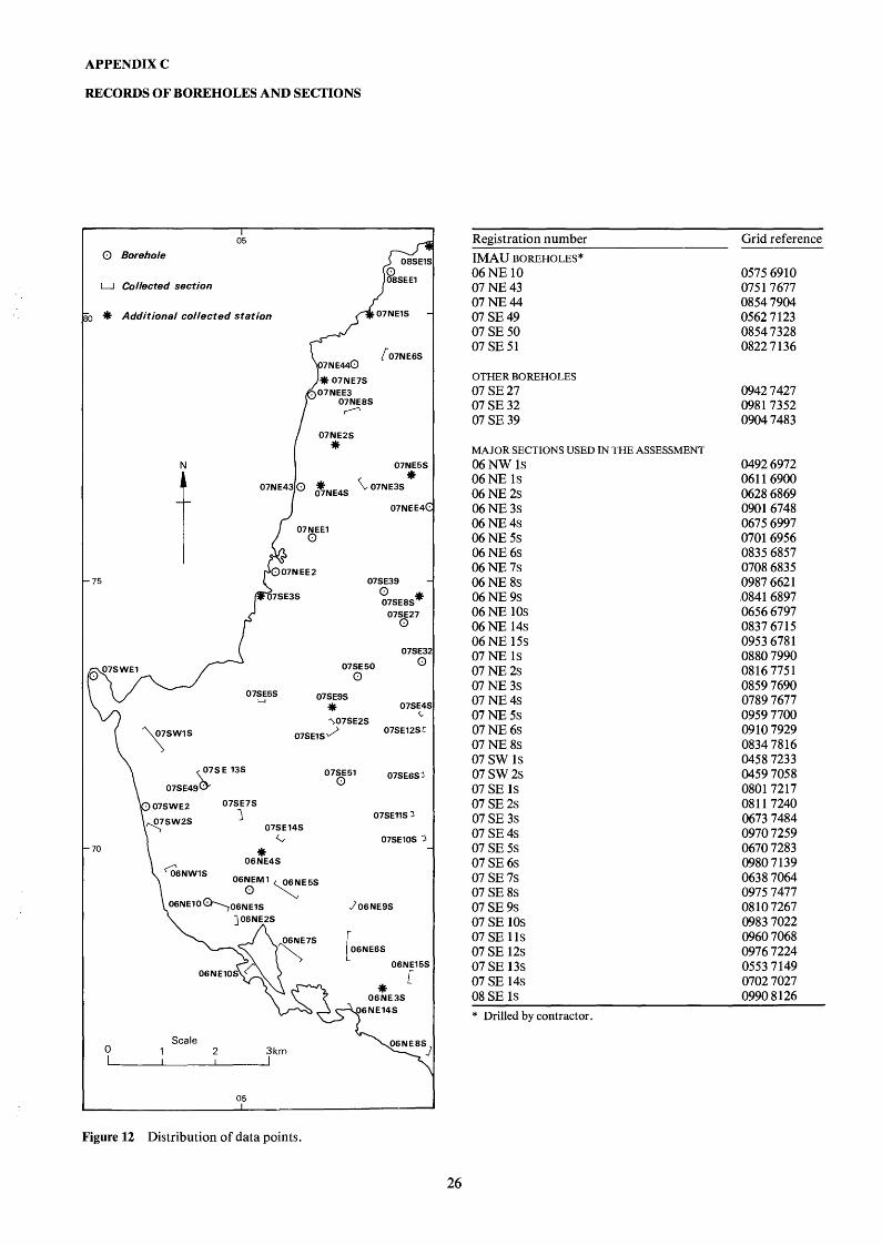
APPENDIX C
RECORDS OF BOREHOLES AND SECTIONS
0 Borehole
I 05
U Collected section
1 * Additional collected station 07NElS
f 07NE6S 7 N E 4 4 0
N
75
07NE5S
O7NEE4(
07SE39
i w 07EE5S
07SE27 0
07SE3
07SE50 0 0
07SE9S * 07SE4 L
07SE12SC 307SE2S
07SE1 S
\ r E 1 3 s
07SE51 07SE6S3 07SE49
0
07SE7S
1 07SE14S
G Y
07SE11S 3
07SElOS 3
\ A 06NE4S ‘ 06NWlS O 6 E M 1 y E 5 S
06NE10%06NE1S 706NE9S
06N E 06NE15S
06NE3S
0 1 2 3 km Scale \ 06NE8S
05 I
Figure 12 Distribution of data points.
Registration number IMAU BOREHOLES* 06 NE 10 07 NE 43 07 NE 44 07 SE 49 07 SE 50 07 SE 51
OTHER BOREHOLES 07 SE 27 07 SE 32 07 SE 39
MAJOR SECTIONS USED IN THE ASSESSMENT 06 NW 1s 06 NE 1s 06 NE 2s 06 NE 3s 06 NE 4s 06 NE 5s 06 NE 6s 06 NE 7s 06 NE 8s 06 NE 9s 06 NE 10s 06 NE 14s 06 NE 15s
07 NE 2s 07 NE 3s 07 NE 4s 07 NE 5s 07 NE 6s 07 NE 8s 07 SW 1s 07 SW 2s 07 SE 1s 07 SE 2s 07 SE 3s 07 SE 4s 07 SE 5s 07 SE 6s 07 SE 7s 07 SE 8s 07 SE 9s 07 SE 10s 07 SE 11s 07 SE 12s 07 SE 13s 07 SE 14s 08 SE 1s
07 NE 1s
Grid reference
0575 6910 0751 7677 0854 7904 0562 7 123 0854 7328 0822 7 136
0942 7427 0981 7352 0904 7483
0492 6972 061 1 6900 0628 6869 0901 6748 0675 6997 0701 6956 0835 6857 0708 6835 0987 662 1 ,0841 6897 0656 6797 0837 67 15 0953 6781 0880 7990 0816 7751 0859 7690 0789 7677 0959 7700 0910 7929 0834 7816 0458 7233 0459 7058 0801 7217 081 1 7240 0673 7484 0970 7259 0670 7283 0980 7 139 0638 7064 0975 7477 08 10 7267 0983 7022 0960 7068 0976 7224 0553 7149 0702 7027 0990 8 126
~
* Drilled by contractor.
26

CHEMICAL ANALYSES
Depth* percentages parts per million (m) CaO SO3 NazO F Si02 MgO A1203 K z 0 SrO Pz05 Loss at Cu Pb Zn MnO As Fez03
1050°C SK 06 NW 1s 0492 6972
7.00 55.00 0.42 29.00 55.00 0.67 55.00 55.10 0.67 71.00 55.10 0.62
SK 06 NE 10 0575 6910 1.00 56.10 0.05 5.00 56.20 0.05
10.00 55.60 0.04 14.00 55.40 0.04 20.00 55.60 0.06 25.00 55.80 0.08 30.00 55.80 0.08 33.00 55.70 0.06 39.00 55.50 0.07 44.00 55.50 0.06 50.00 55.80 0.07 54.00 55.80 0.07 60.00 55.70 0.05
SK 06 NE 1s 0611 6900 3.00 55.20 0.08 5.00 55.30 0.07 6.00 55.60 0.07
10.00 55.70 0.08 13.00 55.90 0.06 15.00 55.30 0.06 16.00 56.00 0.06 18.00 55.60 0.05 21.00 55.80 0.05 23.00 55.90 0.07 30.00 55.70 0.07 31.00 55.80 0.07 33.00 55.30 0.05 34.00 55.90 0.07 35.00 55.90 0.06 39.00 55.30 0.03
SK 06 NE 2s 0628 6869 5.00 55.50 0.08 9.00 55.40 0.10
19.00 55.60 0.10
SK 06 NE 3s 0901 6748 2.00 55.50 0.05 5.00 55.60 0.07 9.00 55.50 0.08
13.00 55.40 0.10
SK 06 NE 4s 0675 6997 4.00 54.10 0.02
10.00 56.10 0.00 19.00 54.40 0.22
SK 06 NE 5s 0701 6956 3.00 55.80 0.08
11.00 55.80 0.10 19.00 55.50 0.08 24.00 55.30 0.08 29.00 55.00 0.08 39.00 55.70 0.09 53.00 55.60 0.11 65.00 55.60 0.11 76.00 55.60 0.10 89.00 56.10 0.13
103.00 55.80 0.12 113.00 55.60 0.08
SK 06 NE 6s 0835 6857 2.00 55.30 0.13
27.00 55.50 0.10 35.00 55.50 0.09 54.00 55.30 0.00 69.00 55.40 0.05
The Frith, Harpur Hill 0.00 0.00 0.01 0.17 0.06 0.03 0.00 0.01 0.00 0.01 0.70 0.51 0.09 0.04 0.02 0.02 0.00 0.00 0.09 0.34 0.05 0.03 0.01 0.02 0.00 0.00 0.32 0.27 0.13 0.05 0.01 0.01
High Edge, Buxton 0.02 0.00 0.02 0.27 0.01 0.01 0.02 0.01 0.00 0.00 0.03 0.28 0.00 0.01 0.04 0.01 0.00 0.00 0.00 0.25 0.00 0.01 0.00 0.00 0.00 0.00 0.00 0.28 0.00 0.00 0.03 0.00 0.00 0.01 0.00 0.42 0.00 0.01 0.03 0.00 0.01 0.01 0.00 0.38 0.01 0.01 0.02 0.00 0.00 0.01 0.03 0.42 0.04 0.01 0.00 0.00 0.00 0.01 0.00 0.33 0.00 0.01 0.01 0.00 0.00 0.00 0.00 0.30 0.00 0.00 0.00 0.00 0.00 0.00 0.09 0.29 0.07 0.01 0.01 0.00 0.00 0.00 0.00 0.33 0.00 0.00 0.01 0.00 0.01 0.00 0.00 0.31 0.00 0.01 0.00 0.00 0.00 0.01 0.00 0.35 0.00 0.00 0.01 0.00
High Edge, Buxton 0.01 0.00 0.31 0.23 0.03 0.01 0.00 0.00 0.00 0.00 0.05 0.23 0.01 0.01 0.00 0.00 0.00 0.00 0.23 0.23 0.10 0.01 0.00 0.00 0.00 0.00 0.14 0.22 0.01 0.01 0.00 0.00 0.00 0.00 0.11 0.20 0.00 0.00 0.00 0.00 0.00 0.00 0.12 0.30 0.08 0.04 0.01 0.00 0.00 0.00 0.05 0.30 0.03 0.01 0.03 0.00 0.00 0.00 0.06 0.25 0.02 0.01 0.00 0.00 0.00 0.00 0.06 0.23 0.04 0.01 0.00 0.00 0.00 0.00 0.05 0.27 0.04 0.01 0.00 0.00 0.00 0.00 0.03 0.31 0.04 0.01 0.00 0.00 0.00 0.00 0.03 0.27 0.00 0.00 0.00 0.00 0.00 0.00 0.50 0.27 0.00 0.01 0.00 0.00 0.00 0.00 0.02 0.29 0.00 0.01 0.01 0.00 0.00 0.00 0.01 0.29 0.01 0.01 0.00 0.00 0.25 0.00 0.02 0.24 0.00 0.01 0.00 0.00
High Edge, Buxton 0.01 0.00 0.25 0.20 0.01 0.02 0.00 0.01 0.01 0.01 0.07 0.21 0.04 0.03 0.02 0.01 0.01 0.00 0.34 0.20 0.24 0.06 0.03 0.01
Jericho Quarry, Earl Sterndale 0.02 0.01 0.04 0.18 0.03 0.03 0.08 0.03 0.01 0.01 0.10 0.19 0.01 0.03 0.06 0.03 0.01 0.00 0.02 0.18 0.02 0.03 0.03 0.02 0.04 0.01 0.08 0.27 0.11 0.06 0.03 0.02
Hill head Quarry 0.00 0.00 0.05 0.25 0.06 0.02 0.00 0.02 0.00 0.00 0.12 0.27 0.04 0.02 0.01 0.01 0.00 0.00 0.13 0.26 0.04 0.02 0.00 0.01
Hill head Quarry 0.02 0.00 0.00 0.16 0.00 0.02 0.06 0.02 0.02 0.00 0.06 0.21 0.01 0.03 0.13 0.02 0.01 0.00 0.25 0.17 0.01 0.02 0.06 0.02 0.02 0.00 0.46 0.16 0.13 0.04 0.08 0.02 0.01 0.00 0.96 0.18 0.38 0.03 0.03 0.02 0.02 0.00 0.34 0.15 0.01 0.03 0.04 0.02 0.01 0.00 0.24 0.16 0.01 0.02 0.05 0.02 0.04 0.00 0.39 0.21 0.02 0.04 0.04 0.02 0.01 0.00 0.21 0.16 0.01 0.02 0.03 0.02 0.01 0.01 0.14 0.22 0.01 0.02 0.06 0.03 0.04 0.00 0.24 0.23 0.06 0.05 0.14 0.02 0.01 0.00 0.11 0.21 0.05 0.03 0.07 0.02
Harley 0.02 0.02 0.15 0.34 0.07 0.04 0.05 0.01 0.01 0.00 0.15 0.20 0.04 0.03 0.01 0.00 0.02 0.00 0.08 0.19 0.03 0.03 0.04 0.00 0.00 0.00 0.11 0.20 0.08 0.03 0.00 0.01 0.02 0.02 0.10 0.26 0.01 0.03 0.00 0.01
43.87 44.95 44.00 43.65
43.90 43.95 43.91 44.28 44.08 43.99 43.93 43.93 43.95 43.86 44.00 43.98 43.98
43.77 43.89 43.81 43.86 43.85 43.90 43.97 43.69 43.68 43.75 43.75 43.75 43.52 44.02 43.93 43.95
43.82 43.97 43.72
44.10 43.85 43.88 43.91
43.84 43.89 43.68
43.64 43.72 43.72 43.69 43.75 43.56 43.76 43.70 43.28 44.00 43.83 43.94
43.97 43.80 43.85 43.95 43.91
5 5 5 5
5 30
5 5
10 5 5 5 5
15 5 5 5
5 5 5 5 5 5 5 5 5 5 5 5 5 5 5 5
0 0 0
0 0 5 0
5 5 5
0 5 0 5 0 0 0 0 0 0 0 0
0 0 5
35 5
10 10 10 10
0 15 0 0
15 0 0 0 0 0 0
15 0
0 0 0
10 10 0
10 0
10 10 0 0 0
10 10 10
0 0
10
0 0 0 0
10 0
10
0 0 0
10 0 0 0 0 0
10 0 0
0 0 0 0 0
10 10 10 10
10 20 10 10 10 10 10 10 10 10 10 10 10
10 15 15 15 10 10 10 10 10 10 10 10 10 10 10 10
10 10 20
0 0
10 0
10 0
10
10 10 10 50 10 10 10 0 0
40 10 0
20 10 10 10 40
80 70 90
100
90 90 90
100 90
110 80
110 110 160 90
170 110
90 70 70 70 70 50 50 50 50 50 60 70 50 60 60 70
50 70 60
60 50 70 40
120 80
120
60 70 80
120 70 80 80 60 80
120 40 40
160 50 40 40
300
200 200 400 200
200 300 200 300 400 400 200 200 300 400 100 100 100
300 200 200 200 100 200 100 100 200 100 200 100 100 200 200 100
120 290 320
80 110 150 200
200 200 200
80 70
100 420 120 80
280 120 170 800 130 80
210 220 150 310
2500
27

CHEMICAL ANALYSES
Depth* percentages parts per million (m) CaO so3 NazO F Si02 MgO A1203 K z 0 SrO Pz05 Lossat Cu Pb Zn MnO As Fez03
1050" C SK 06 NE 7s 0708 6835
1.00 56.40 0.30 12.00 56.90 0.38 21.00 57.10 0.28 32.00 57.10 0.29 43.00 57.10 0.30 46.00 57.00 0.17 61.00 56.30 0.16 70.00 56.20 0.34 77.00 56.40 0.21
SK 06 NE 8s 0987 6621 4.00 55.30 0.04
12.00 55.60 0.07 21.00 56.00 0.07 33.00 55.10 0.09 47.00 55.60 0.05
SK 06 NE 9s 0841 6897 2.00 54.20 0.08 7.00 53.50 0.11
12.00 53.50 0.04 19.00 54.00 0.06 30.00 54.80 0.04 40.00 54.50 0.03 47.00 53.60 0.04
SK 07 NE 43 3.00 53.60 0.33
12.00 54.20 0.23 21.00 53.80 0.20 30.00 54.20 0.17 39.00 54.50 0.19 42.00 54.20 0.17 54.00 54.10 0.29 61.00 53.80 0.20 71.00 53.80 0.10 83.00 53.70 0.17 89.00 51.60 0.14
119.00 53.70 0.05 125.00 54.40 0.00
SK 07 NE 44 6.00 55.80 0.04
25.00 55.70 0.04 39.00 55.00 0.09 47.00 55.30 0.03 67.00 55.80 0.04 87.00 55.50 0.05 95.00 55.70 0.04
100.00 55.40 0.03
SK 06 NE 10s 0656 6797 4.00 54.80 0.14 9.00 54.80 0.15
16.00 55.40 0.15
SK 06 NE 14s 0837 6715 5.00 54.70 0.13
15.00 54.30 0.11 26.00 55.00 0.1 1
SK 06 NE 15s 0953 6781 9.00 55.10 0.44
23.00 54.70 0.39 42.00 54.80 0.30 57.00 55.40 0.41 61.00 55.10 0.50
SK 07 NE 1s 0880 7990 3.00 55.30 0.07 7.00 55.30 0.04
10.00 54.80 0.15
SK 07 NE 2s 0816 7751 2.00 55.30 0.05 8.00 55.20 0.04
SK 07 NE 3s 0859 7690 7.00 55.60 0.05
14.00 55.20 0.05
Dowel Dale 0.00 0.01 1.26 0.30 0.1 1 0.00 0.02 0.65 0.26 0.06 0.00 0.02 0.17 0.19 0.05 0.00 0.00 0.15 0.21 0.08 0.00 0.03 0.72 0.31 0.07 0.00 0.00 0.07 0.21 0.06 0.00 0.00 0.75 0.39 0.47 0.00 0.02 0.33 0.34 0.08 0.00 0.00 0.90 0.35 0.10
Aldery Cliff, Earl Sterndale 0.01 0.00 0.33 0.27 0.00 0.01 0.01 0.49 0.50 0.00 0.01 0.01 0.20 0.44 0.00 0.01 0.01 0.37 0.58 0.07 0.00 0.00 0.03 0.39 0.00
Buxton Quarry 0.01 0.03 1.44 0.42 0.18 0.02 0.04 2.08 0.61 0.36 0.01 0.01 3.51 0.37 0.06 0.02 0.01 0.13 0.27 0.01 0.01 0.00 0.70 0.30 0.03 0.00 0.00 1.00 0.48 0.08 0.00 0.00 2.10 0.38 0.06
0.00 0.02 1.08 0.40 0.25 0.00 0.00 0.52 0.32 0.05 0.00 0.01 1.20 0.43 0.20 0.00 0.00 0.57 0.36 0.08 0.00 0.03 1.54 0.40 0.32 0.00 0.00 0.31 0.29 0.05 0.00 0.01 1.19 0.30 0.06 0.00 0.00 1.37 0.26 0.05 0.00 0.00 0.83 0.28 0.05 0.00 0.00 1.26 0.28 0.10 0.00 0.01 7.02 0.19 0.09 0.00 0.00 1.53 0.23 0.12 0.00 0.00 0.05 0.26 0.06
0.01 0.00 0.35 0.31 0.06 0.01 0.01 0.14 0.30 0.04 0.01 0.01 0.96 0.43 0.48 0.00 0.00 0.49 0.34 0.08 0.01 0.01 0.25 0.37 0.06 0.00 0.00 0.18 0.30 0.02 0.01 0.01 0.43 0.32 0.01 0.01 0.00 1.04 0.31 0.01
Tor Rock, Hollinsclough 0.00 0.04 0.22 0.35 0.13 0.01 0.02 1.07 0.32 0.10 0.01 0.06 0.34 0.32 0.16
Glutton Dale, Glutton 0.01 0.00 1.22 0.29 0.06 0.00 0.01 1.51 0.29 0.11 0.01 0.01 0.64 0.32 0.03
Hindlow Quarry 0.00 0.00 0.20 0.23 0.06 0.00 0.01 0.64 0.21 0.51 0.00 0.00 0.47 0.22 0.07 0.00 0.00 0.15 0.22 0.07 0.00 0.03 0.70 0.23 0.07
Barmoor Quarry, Sparrowpit 0.02 0.04 0.36 0.39 0.02 0.02 0.03 0.37 0.37 0.02 0.02 0.09 0.75 0.50 0.16
Perseverance Quarry, Doveholes 0.01 0.01 0.24 0.22 0.01 0.01 0.01 0.56 0.23 0.02
Perseverance Quarry, Doveholes 0.01 0.03 1.00 0.22 0.02 0.01 1.01 1.13 0.21 0.01
0.04 0.00 0.01 0.03 0.00 0.01 0.02 0.00 0.10 0.03 0.00 0.01 0.03 0.01 0.02 0.03 0.00 0.03 0.11 0.00 0.02 0.03 0.00 0.06 0.03 0.00 0.06
0.02 0.04 0.03 0.02 0.08 0.01 0.02 0.08 0.01 0.03 0.06 0.01 0.02 0.07 0.01
0.05 0.04 0.01 0.09 0.05 0.13 0.03 0.03 0.02 0.03 0.01 0.01 0.03 0.02 0.01 0.03 0.00 0.01 0.03 0.03 0.00
0.06 0.02 0.22 0.02 0.03 0.02 0.05 0.04 0.02 0.03 0.03 0.02 0.08 0.02 0.24 0.02 0.01 0.01 0.02 0.04 0.02 0.03 0.02 0.01 0.02 0.00 0.01 0.04 0.01 0.01 0.03 0.04 0.01 0.04 0.00 0.04 0.02 0.01 0.02
0.03 0.07 0.00 0.02 0.11 0.01 0.1 1 0.06 0.00 0.03 0.07 0.00 0.03 0.08 0.00 0.02 0.06 0.00 0.02 0.07 0.00 0.02 0.09 0.00
0.05 0.02 0.19 0.04 0.02 0.04 0.06 0.05 0.33
0.04 0.02 0.06 0.04 0.00 0.07 0.03 0.00 0.04
0.03 0.00 0.01 0.04 0.00 0.02 0.03 0.00 0.01 0.04 0.00 0.02 0.04 0.00 0.02
0.03 0.14 0.21 0.03 0.10 0.23 0.04 0.12 0.54
0.02 0.07 0.01 0.03 0.06 0.00
0.02 0.06 0.01 0.02 0.06 0.00
28
43.20 43.25 43.16 43.19 43.34 43.53 43.32 43.51 43.19
43.80 43.96 43.92 43.92 43.92
43.32 42.92 42.17 43.95 43.63 43.46 42.86
42.37 43.39 43.23 43.44 42.76 43.53 43.18 44.60 43.34 43.13 40.55 42.91 43.98
43.76 43.86 43.59 43.73 43.74 43.71 43.68 43.33
43.68 43.48 43.56
43.29 43.10 43.67
43.78 43.49 43.62 43.78 43.53
43.63 43.63 42.98
43.86 43.67
43.48 43.32
5 5 5 5 5 5 5 5 5
0 0 0 0 0
0 5 0 0 5 5 0
5 5 5 5 5 5 5 5 5 5
10 5 5
0 5 5 5 5 5 5 5
5 5 5
5 0 0
5 5 5 5 5
0 0 0
0 0
5 0
10 10 0
10 10 10 10 10 10
0 10 10 0 0
0 10 0 0 0 0 0
10 0
20 10 10 0
50 50 10 10 50 0
10
0 90 0
20 10 20 10 40
0 0 0
0 0 0
10 10 40 10 10
20 10 0
0 0
10 0
10 10 10 10 10 10 20 10 20
10 20 0
10 10
10 20 10 10 20 20 20
10 10 30 10 20 10 30 30 30 20
100 10 10
10 20 0
20 10 20 10 20
20 10 30
10 10 10
10 10 10 10 10
20 10 0
10 10
10 10
570 150 140 130 110 110 140 120 110
210 160 170 140 160
80 120 140 100 110 130 280
350 200 530 120 730 190 430 480 500 400 850 700 340
80 150 80
170 150 130 150 210
110 100 100
240 150 180
90 100 160 80 80
200 300 200
220 170
270 130
570 150 140 130 110 110 140 120 110
90 210 140 140 70
320 400 200 270 500 800
1300
1000 200
2100 200
3000 200 300 700 400 300
2900 200 200
300 900 700 500 600
1000 500 700
470 330 600
370 240 300
200 400 500 200 200
570 610 590
160 200
330 410

CHEMICAL ANALYSES -
Depth* percentages parts per million (m) CaO so3 Na2O F Si02 MgO A1203 K 2 0 SrO P205 Lossat Cu Pb Zn MnO As Fe203
1050" C SK 07 NE 4s 0789 7677
1.00 54.80 0.03 8.00 55.50 0.04
11.00 55.20 0.05
SK 07 NE 5s 0959 7700 1.00 55.00 0.04 8.00 55.20 0.04
20.00 55.20 0.03
SK 07 NE 6s 0910 7929 12.00 52.40 0.46 20.00 55.30 0.56 30.00 55.10 0.56 40.00 54.80 0.51 50.00 55.10 0.50 60.00 55.30 0.51 70.00 54.80 0.45
SK 07 NE 7s 0791 7871 4.00 54.70
SK 07 NE 8s 0834 7816 3.00 55.20
14.00 53.60 30.00 55.70 40.00 53.50
SK 07 SW 1s 0458 7233 2.00 53.70 0.25
12.00 55.10 0.15 17.00 53.70 0.05 29.00 56.00 0.25 42.00 54.20 0.20 49.00 56.10 0.32 63.00 56.70 0.20
SK 07 SW 2s 0459 7058 10.00 54.00 20.00 55.40 30.00 54.60 40.00 55.70 51.00 55.20 60.00 55.10 70.00 55.20
SK 07 SE 27 0942 7427 10.00 55.20 0.34 19.00 52.40 0.44 30.00 54.50 0.41 42.00 54.40 0.45 55.00 56.30 0.37 65.00 56.10 0.36 77.00 55.80 0.34
SK 07 SE 32 0981 7352 10.00 56.00 0.42 20.00 56.10 0.28 30.00 56.30 0.40 40.00 56.00 0.44 50.00 56.30 0.46 62.00 54.10 0.47 80.00 56.20 0.36
SK 07 SE 39 0904 1483 15.00 55.10 0.52 24.00 54.90 0.46 35.00 52.50 0.59 50.00 52.10 0.83 60.00 55.00 0.69 80.00 54.70 0.44
107.00 55.00 0.60 115.00 52.20 0.62 130.00 54.50 0.44
Victory Quarry, Lower Bibbington 0.02 0.02 2.45 0.29 0.08 0.04 0.15 0.02 0.01 0.64 0.20 0.00 0.02 0.14 0.02 0.01 0.86 0.26 0.04 0.03 0.13
Smalldale Quarry, Smalldale 0.01 0.02 1.74 0.16 0.00 0.02 0.05 0.00 0.00 0.35 0.21 0.00 0.02 0.05 0.00 0.00 0.40 0.18 0.07 0.03 0.05
Bee Low Quarry, Dove Holes 0.00 0.00 3.42 0.24 0.07 0.03 0.03 0.00 0.00 0.17 0.23 0.05 0.03 0.00 0.00 0.00 0.09 0.23 0.06 0.03 0.00 0.00 0.00 0.46 0.25 0.13 0.06 0.01 0.00 0.00 0.00 0.20 0.05 0.03 0.00 0.00 0.00 0.00 0.23 0.05 0.03 0.00 0.00 0.01 0.31 0.44 0.22 0.07 0.03
Railway Cutting, Dove Holes 0.01 0.01 2.32 0.30 0.08 0.03 0.00
Holderness Quarry, Dove Holes 0.01 0.00 0.30 0.28 0.05 0.03 0.00 0.02 0.00 3.82 0.25 0.06 0.03 0.00 0.01 0.00 0.41 0.25 0.07 0.03 0.00 0.02 0.00 4.64 0.21 0.06 0.03 0.00
Grinlow Quarry, Buxton 0.00 0.01 1.61 0.30 0.09 0.03 0.02 0.00 0.00 0.37 0.28 0.06 0.02 0.01 0.00 0.00 1.53 0.23 0.12 0.04 0.00 0.00 0.00 0.13 0.20 0.07 0.03 0.00 0.00 0.00 0.63 0.17 0.08 0.03 0.00 0.00 0.03 0.11 0.20 0.07 0.03 0.00 0.00 0.01 0.09 0.19 0.11 0.03 0.00
Anthony Hill, Harpur Hill 0.01 0.01 1.09 0.43 0.39 0.08 0.00 0.02 0.01 0.20 0.40 0.12 0.04 0.00 0.00 0.00 1.05 0.29 0.10 0.03 0.00 0.01 0.00 0.31 0.31 0.07 0.03 0.00 0.02 0.01 0.33 0.34 0.09 0.04 0.00 0.03 0.02 0.53 0.63 0.16 0.04 0.00 0.01 0.01 0.45 0.33 0.05 0.03 0.00
Orient Lodge, Cowlow, Green Fairfield 0.00 0.01 0.72 0.27 0.11 0.04 0.00 0.00 0.01 1.98 0.32 0.95 0.16 0.03 0.00 0.03 0.29 0.21 0.11 0.05 0.00 0.00 0.00 0.33 0.28 0.19 0.06 0.01 0.01 0.00 0.00 0.27 0.06 0.03 0.01 0.00 0.00 0.06 0.28 0.06 0.03 0.00 0.01 0.00 0.37 0.44 0.16 0.06 0.00
Tunstead Quarry, Green Fairfield 0.01 0.00 0.00 0.35 0.07 0.03 0.02 0.00 0.00 0.00 0.32 0.08 0.03 0.01 0.03 0.00 0.00 0.35 0.06 0.04 0.03 0.00 0.01 0.01 0.66 0.07 0.03 0.03 0.00 0.01 0.01 0.43 0.09 0.04 0.02 0.01 0.01 0.18 2.29 0.09 0.03 0.02 0.01 0.01 0.00 0.37 0.05 0.03 0.02
Green Bank, Green Fairfield 0.00 0.00 0.57 0.22 0.08 0.03 0.01 0.00 0.00 0.33 0.24 0.07 0.04 0.00 0.00 0.01 1.75 0.32 0.65 0.15 0.04 0.00 0.05 3.69 0.43 2.26 0.44 0.04 0.00 0.00 0.19 0.29 0.13 0.05 0.01 0.00 0.00 0.19 0.29 0.08 0.04 0.03 0.00 0.00 0.01 0.50 0.05 0.03 0.02 0.00 0.01 0.43 1.65 0.27 0.08 0.03 0.00 0.00 0.11 0.59 0.11 0.04 0.02
0.06 0.01 0.02
0.01 0.00 0.00
0.02 0.02 0.02 0.01 0.01 0.01 0.01
0.05
0.03 0.03 0.03 0.03
0.01 0.01 0.04 0.01 0.01 0.01 0.01
0.1 1 0.04 0.04 0.03 0.03 0.03 0.03
0.01 0.02 0.02 0.02 0.01 0.01 0.01
0.01 0.01 0.01 0.01 0.01 0.01 0.01
0.01 0.01 0.02 0.02 0.01 0.01 0.02 0.02 0.02
42.83 43.68 43.61
43.10 43.81 43.74
42.19 43.78 43.87 43.65 43.88 43.94 43.85
42.18
42.99 41.04 42.60 40.67
42.65 43.21 42.97 43.25 43.01 43.52 43.20
43.14 43.35 42.86 43.26 43.21 43.28 43 .OS
43.44 42.58 43.68 43.73 43.84 43.90 43.75
43.97 43.94 43.94 44.09 43.96 44.29 44.02
43.55 43.69 42.85 41.48 43.83 43.83 44.08 44.08 43.97
5 0 5
0 0 0
5 5 5 5 5 5 5
5
5 5 5 5
5 5 5 5 5 5 5
5 5 5 5 5 5 5
15 5
10 5 5
15 5
5 5 5 5 5 5 5
5 5 5 5 5 5 5 5 5
0 0 0
0 0 0
10 10 20 10 0 0
10
0
0 10 0 0
10 10 0 0
30 20 10
0 0 0 0
10 0 0
10 0
20 0 0 0 0
10 0
20 0 0
10 0
0 10 10 10 0 0
10 10 10
20 10 20
10 10 10
10 10 10 10 10 10 10
10
10 20 10 10
10 10 10 10 10 10 10
10 10 10 10 10 10 10
20 10 40 10 10 30 20
10 10 10 20 20 20 10
10 10 20 20 10 10 20 50
140 90
280
390 160 100
140 130 190 90
100 100 90
190
170 100 90
100
120 120 700 180 140 150 160
120 100 110 70 50
120 70
280 180 500 120 130 330 220
110 100 130 160 3 90 960 330
150 150 150 90
110 100 130 440
40 320
- 410 6 100 - 820
- 110 - 90 0 110
- 300 - 200 - 300 - 300 - 200 - 200 - 500
- 200
- 600 - 400 - 200 - 400
- 500 - 400 - 200 - 1700 - 300 - 400 - 400
- 600 - 200 - 200 - 200 3 200 - 300 - 300
- 700 - 600 - 500 - 400 - 200 - 300 - lo00
- 200 - 400 - 300 - 400 - 600 - 3000 - 600
- 200 - 200 - 3500 - 4400 - 300 - 300 -400 - 2400 - 700
29

CHEMICAL ANALYSES
Depth* percentages parts per million (m) CaO so3 Na2O F Si02 MgO A1203 K20 SrO P205 Lossat Cu Pb Zn MnO As Fez03
1050°C
SK 07 SE 49 0562 1123 11.00 55.00 0.08 29.00 55.00 0.08 51.00 55.10 0.10 62.00 55.20 0.03 81.00 55.50 0.04 93.00 55.80 0.03
100.00 55.50 0.04
SK 07 SE 50 0854 7328' 2.00 55.80 0.01
11.00 55.40 0.08 20.00 53.50 0.1 1 38.00 50.10 0.05 51.00 54.80 0.01 76.00 43.70 0.00 93.00 52.40 0.01
109.00 54.30 0.00 115.00 39.60 0.00
SK 07 SE 51 0822 7136 7.00 54.90 0.09
15.00 54.80 0.17 32.00 55.10 0.30 38.00 55.10 0.14 51.00 54.50 0.05 64.00 54.20 0.19 80.00 54.40 0.34 95.00 54.10 0.29
SK 07 SE 1s 0801 7217 2.00 55.80 0.00
10.00 55.00 0.01 17.00 55.60 0.02 23.00 55.20 0.03 28.00 55.70 0.02 31.00 54.50 0.03 40.00 55.10 0.02 45.00 55.10 0.03 50.00 55.70 0.01
SK 07 SE 2s 0811 7240 2.00 55.40 0.01
12.00 55.20 0.04 16.00 55.40 0.03 25.00 54.50 0.06 30.00 55.40 0.09 35.00 55.50 0.07
SK 07 SE 3s 0693 7484 3.00 54.80 0.14
10.00 55.30 0.13
SK 07 SE 4s 0970 7259 2.00 53.20 0.02
12.00 35.00 0.00 19.00 32.00 0.00 22.00 54.60 0.04
SK 07 SE 5s 0670 7283 3 .OO 55.0 0.03 6.00 55.1 0.02
13.00 55.3 0.03
SK 07 SE 6s 0980 7139 2.00 55.30 0.13
27.00 55.50 0.10 35.00 55.50 0.09 54.00 55.30 0.00 69.00 55.40 0.05
SK 07 SE 7s 0638 7064 5.00 56.20 0.24 7.00 54.10 0.44
21.00 56.00 0.45 29.00 56.30 0.33 34.00 53.80 0.36 45.00 56.70 0.31 50.00 57.00 0.23
Ferny Bottom, Harpur Hill 0.00 0.00 0.29 0.49 0.04 0.03 0.03 0.00 0.01 0.02 0.78 0.51 0.36 0.11 0.04 0.00 0.01 0.01 0.68 0.53 0.15 0.05 0.05 0.00 0.00 0.00 0.34 0.37 0.15 0.03 0.08 0.01 0.01 0.00 0.01 0.39 0.00 0.02 0.10 0.00 0.01 0.00 0.00 0.36 0.00 0.02 0.07 0.01 0.01 0.01 0.02 0.38 0.00 0.02 0.09 0.01
Bailey Flat, Green Fairfield 0.00 0.00 0.24 0.25 0.00 0.02 0.08 0.01 0.01 0.01 0.20 0.45 0.07 0.03 0.09 0.01 0.02 0.00 0.22 1.81 0.11 0.04 0.04 0.02 0.02 0.00 0.16 4.69 0.07 0.03 0.01 0.00 0.00 0.05 0.74 0.01 0.02 0.07 0.00 0.02 0.00 2.20 8.70 0.00 0.01 0.00 0.00 0.00 0.00 2.37 0.00 0.02 0.00 0.01 0.01 0.01 0.07 1.48 0.00 0.03 0.07 0.00 0.02 0.00 0.05 14.40 0.01 0.01 0.00
King Sterndale, Buxton 0.00 0.00 0.27 0.28 0.08 0.03 0.00 0.01 0.00 0.00 0.45 0.37 0.24 0.04 0.03 0.01 0.00 0.01 0.70 0.32 0.07 0.03 0.01 0.01 0.00 0.02 0.44 0.39 0.10 0.03 0.02 0.01 0.00 0.00 0.27 0.43 0.08 0.02 0.01 0.01 0.00 0.00 0.13 0.50 0.10 0.03 0.01 0.01 0.00 0.00 0.06 0.33 0.04 0.02 0.00 0.01 0.00 0.01 0.10 0.61 0.12 0.03 0.02 0.01
Cowdale Quarry, King Sterndale 0.01 0.01 0.27 0.18 0.00 0.03 0.06 0.02 0.01 0.01 0.37 0.22 0.00 0.03 0.03 0.02 0.01 0.00 0.07 0.24 0.03 0.03 0.08 0.02 0.01 0.00 0.00 0.21 0.01 0.02 0.10 0.02 0.01 0.00 0.08 0.23 0.02 0.03 0.04 0.01 0.04 0.00 1.07 1.27 0.21 0.30 0.04 0.02 0.01 0.00 0.02 0.34 0.00 0.02 0.11 0.02 0.01 0.00 0.32 0.31 0.01 0.02 0.11 0.02 0.01 0.00 0.03 0.30 0.02 0.03 0.08 0.02
Cowdale Quarry, Wye Dale 0.02 0.01 0.01 0.21 0.01 0.02 0.10 0.02 0.01 0.01 0.00 0.28 0.01 0.02 0.08 0.01 0.01 0.00 0.00 0.32 0.01 0.02 0.10 0.01 0.02 0.03 1.09 0.51 0.64 0.16 0.06 0.01 0.02 0.01 0.27 0.54 0.15 0.06 0.13 0.01 0.01 0.01 0.10 0.42 0.03 0.03 0.13 0.01
Brook House 0.02 0.04 0.68 0.41 0.05 0.03 0.05 0.03 0.01 0.01 0.26 0.30 0.04 0.03 0.00 0.05
Woo Dale, King Sterndale 0.01 0.00 0.02 1.18 0.01 0.02 0.00 0.02 0.01 0.00 0.00 17.40 0.01 0.01 0.03 0.00 0.01 0.00 0.01 21.00 0.01 0.01 0.00 0.02 0.01 0.00 0.01 0.90 0.01 0.02 0.01 0.00
Gas Works, Buxton 0.00 0.00 0.99 0.27 0.03 0.03 0.00 0.00 0.00 0.00 1.18 0.25 0.02 0.04 0.00 0.00 0.01 0.00 0.17 0.26 0.11 0.04 0.02 0.00
Deep Dale, Chelmorton 0.02 0.02 0.15 0.34 0.07 0.04 0.05 0.01 0.01 0.00 0.15 0.20 0.04 0.03 0.01 0.00 0.02 0.00 0.08 0.19 0.03 0.03 0.04 0.00 0.00 0.00 0.11 0.20 0.08 0.03 0.00 0.01 0.02 0.02 0.10 0.26 0.01 0.03 0.00 0.01
Harpur Hili Quarry, Buxton 0.00 0.01 0.72 0.20 0.06 0.03 0.00 0.01 0.02 0.01 0.56 0.28 0.09 0.04 0.00 0.02 0.01 0.02 1.33 0.29 0.08 0.03 0.01 0.01 0.00 0.00 0.36 0.30 0.08 0.03 0.00 0.01 0.00 0.03 1.73 0.39 1.16 0.16 0.01 0.01 0.00 0.00 0.53 0.21 0.09 0.03 0.00 0.01 0.00 0.01 0.32 0.23 0.12 0.04 0.00 0.02
43.87 43.51 43.72 43.84 44.02 43.86 43.86
43.62 43.93 44.25 44.71 44.05 44.34 44.47 44.25 46.59
43.40 43.62 43.34 43.63 43.78 43.85 43.69 44.08
43.83 43.75 43.93 43.90 43.68 43.54 43.95 43.95 43.96
44.01 44.01 43.95 43.23 43.90 44.08
43.77 43.90
43.73 47.12 47.51 44.11
43.51 43.49 43.94
43.97 43.80 43.85 43.95 43.91
43.05 43.31 42.98 43.76 42.97 43.15 43.19
5 0 0 120 - 240 5 0 20 310 - 810 5 0 0 410 - 530 5 10 20 130 1 810 0 0 0 70 - 130 0 0 0 70 - 100 0 0 0 7 0 - 6 0
0 0 10 80 - 140 5 10 10 110 0 260 5 0 20 210 - 770 5 0 70 1600 - 4600 0 0 20 410 - 1300 0 0 90 2500 - 12000 0 0 20 640 - 1700 5 0 20 400 0 960 0 0 40 1700 - 1700
5 0 0 60 - 2 0 0 5 0 0 8 0 -400 5 10 10 110 - 300 5 10 10 90 - 400 5 0 0 210 - 400 5 10 10 120 - 1300 5 0 0 3 3 0 -400 0 0 0 330 - 600
0 10 30 0 10 30 0 10 40 0 10 40 0 10 50 0 10 120 0 0 60 0 10 50 0 10 40
- 100 1 100 -90 - 90 0 90 - 430 - 120 - 120 - 140
0 0 10 60 - 120 0 0 10 90 - 400 0 0 10 60 - 80 0 0 60 770 0 3200 0 0 20 120 - 460 0 0 30 210 - 570
0 0 10 280 - 230 0 0 10 290 - 600
5 0 1000 2500 - 11800 0 0 50 660 - 1700 0 0 30 340 - 1200 0 0 20 350 1 600
5 0 10 150 - 200 0 0 10 130 0 300 5 0 20 110 - 280
0 0 20 160 - 210 0 0 10 50 - 220 5 0 10 40 2 150
35 0 10 40 - 310 0 0 40 300 - 2500
5 10 10 140 - 600 5 0 10 130 - 600 5 10 10 210 - 400 5 0 10 530 - 800 5 0 10 200 - 4300 5 10 10 190 - 1500 5 10 10 170 - 500
30

CHEMICAL ANALYSES
Depth* percentages parts per million (m) CaO SO3 Nan0 F Si02 MgO A1203 K20 SrO P205 Lossat Cu Pb Zn MnO As Fez03
1050°C
SK 07 SE 8s 0975 7477 3 .00 55.40 0.04 6.00 55.60 0.03
16.00 55.40 0.05
SK 07 SE 9s 0810 7267 2.00 54.40 0.15
12.00 54.40 0.13
SK 07 SE 10s 0983 7022 2.00 55.40 0.09
14.00 55.10 0.10 18.00 54.90 0.10
SK 07 SE 11s 0960 7068 5 .OO 54.50 0.51
11.00 54.60 0.52
SK 07 SE 12s 0976 7224 8 .OO 55.20 0.12
12.00 55.10 0.12 28.00 55.70 0.05 37.00 55.90 0.05 40.00 54.80 0.10
SK 07 SE 13s 0553 7149 10.00 54.80 0.48 20.00 55.20 0.50 39.00 55.30 0.60
SK 07 SE 14s 0702 7027 5 .OO 55.60 15.00 54.80
SK 08 SEls 0990 8126 10.00 55.20
Tunstead Quarry 0.01 0.01 0.29 0.25 0.03 0.03 0.07 0.01 0.01 0.01 0.55 0.22 0.02 0.02 0.07 0.01 0.01 0.00 0.20 0.25 0.06 0.03 0.07 0.01
Ashwooddale Quarry, King Sterndale 0.02 0.00 0.48 0.48 0.24 0.07 0.02 0.04 0.02 0.02 0.48 0.48 0.24 0.08 0.01 0.02
Horseshoe Dale, King Sterndale 0.01 0.00 0.55 0.31 0.05 0.03 0.07 0.01 0.01 0.00 0.27 0.33 0.06 0.04 0.03 0.01 0.02 0.08 0.80 0.33 0.04 0.03 0.01 0.01
Back Dale, King Sterndale 0.00 0.01 0.38 0.54 0.11 0.05 0.02 0.01 0.03 0.02 0.55 0.60 0.09 0.04 0.02 0.02
Topley Pike Quarry 0.02 0.00 0.13 0.79 0.04 0.03 0.06 0.00 0.02 0.03 0.72 0.74 0.36 0.11 0.06 0.00 0.01 0.00 0.05 0.39 0.00 0.02 0.04 0.00 0.01 0.01 0.09 0.37 0.00 0.02 0.08 0.00 0.01 0.00 0.54 0.84 0.11 0.05 0.03 0.00
Grinlow Plantation, Harpur Hill 0.00 0.00 0.31 0.26 0.23 0.06 0.02 0.01 0.00 0.00 0.00 0.25 0.06 0.03 0.01 0.02 0.00 0.01 0.06 0.37 0.09 0.04 0.02 0.02
Railway Cutting, Harpur Mill 0.01 0.01 0.17 0.26 0.15 0.04 0.00 0.03 0.01 0.00 2.07 0.20 0.06 0.03 0.00 0.03
Tor Top, Sparrowpit 0.03 0.02 0.05 0.43 0.05 0.03 0.00 0.23
43.84 0 43.65 0 43.92 5
43.77 0 44.46 0
43.70 0 43.90 0 43.70 5
43.83 10 43.73 5
44.06 0 43.60 0 43.97 0 43.98 0 43.83 0
43.63 5 43.86 5 43.86 5
43.15 5 41.80 5
43.56 5
0 0 0
0 0
0 0 0
10 10
0 0 0 0 5
10 0 0
10 0
0
0 10 10
20 10
10 10 10
10 10
20 70 10 10 40
20 10 10
20 10
130 90
100
420 280
70 50 40
320 10
60 230 240 130 280
110 80 70
200 130
20 550
- 240 - 300 0 190
- 2500 - 540
- 190 0 270 - 130
- 400 - 200
- 240 - 1300 1 220 - 150 - 1100
- 300 - 200 - 200
- 800 - 200
- 500 *Represents the depth below the surface of the mid-point of the sample.
31

10
20
30
40
50
60
70
80
LITHOLOGY COLOUR - etched
--e powder
M SORTING
+ O
q . . . . . . . . . E . . " .
. . E ..e.
50 1c -
i
1 i
I
\
! /
I i i
!
I
!
! I I
I I i i
! ! ! ! i I !
i I
.i
{
.).
I '. \ i i i i j
i i l !
MECHANICAL PROPERTIES
FRACTURE INDEX (If.mm1.
0 50 100 500 1 - IO0
06 NW IS INSOLUBLE
DATA RESIDUE PURITY
A.I.V.
10 10 20 30 40 0 5 10 15
1 r 0
10
20
30
40
50
60
70
80
32

SK 06 NW 1s' 0492 6972* The Frith Surface level + 400.80 m 4 May 1977
Thickness Depth
D, (Bee Low Limestones)6 Biosparite Crinoid 7 , buff-grey, coarse arenite, well sorted
Pelsparite, buff-grey; medium arenite algae-corroded bioclasts and pelletal debris, well sorted, scattered quartz euhedra
moderate sorting
well sorted
arenite, moderate sorting
arenite pelletal and finely comminuted bioclasts, locally common dasycladacean algae, well sorted
Biosparite Crinoid, coarse arenite,
Biopelsparite algae, grey, fine arenite,
Biosparite Crinoid, buff-grey, coarse
Biopelsparite Algae, buff-grey; fine
Gap Biosparite Crinoid, buff grey, coarse arenite, occasional quartz euhedra Biopelsparite algae; fine arenite to fine rudite crinoid, algae encrusted shell debris, Koninckopora, foraminifera and pelletal material, well sorted
Pelsparite, buff-grey mottled, very fine arenite, well sorted, sporadic quartz euhedra
Gap Biopelsparite algae, medium arenite,
Gap well sorted, scattered quartz euhedra
Biopelsparite algae, medium arenite, well sorted
Gap Biosparite, buff-grey; fine arenite to medium rudite crinoid, shell, foraminifera and pelletal material, moderate to good sorting, scattered quartz euhedra
arenite, well sorted Pelsparite Algae, mid-grey, coarse
Gap Biosparite Pellet, pale grey, fine arenite, well sorted, scattered quartz euhedra
Gap Biosparite Pellet, pale grey, fine
Gap arenite, well sorted
Pelsparite Algae, grey, coarse arenite, moderate to good sorting
Biosparite, pale grey, fine arenite, sporadic rudite crinoid and brachiopod debris, moderate to good sorting
Pelsparlutite, buff-grey, lutite and very fine arenite bioclasts, sporadic coarser algae-like structures and calcispheres, patchy limonite staining
well sorted Biopelsparite, buff-grey, fine arenite,
Gap Biosparite Crinoid Pellet, buff-grey, fine arenite to fine rudite, moderate sorting, scattered quartz euhedra
Biopelsparite Foraminifera, grey, fine arenite, well sorted
Biosparite Crinoid Pellet, buff-grey, medium arenite, moderate sorting, patchily silicified bioclasts
m
2.50
2.00
1 .oo 1 .oo 1 .oo
2.00 1 .oo 4.00
m
2.50
4.50
5.50
6.50
7.50
9.50 10.50
14.50
2.00 16.50
1.00 17.50 1.00 18.50
1.00 19.50 2.00 21.50
1.00 22.50 2.00 24.50
8.00 32.50
1.00 33.50 1.00 34.50
1.00 35.50 3.00 38.50
1.00 39.50 1.00 40.50
1.00 41.50
3.00 44.50
2.00 46.50
1.00 47.50 1.00 48.50
2.00 50.50
1.00 51.50
2.00 53.50
Biopelsparite, grey, fine arenite, well sorted, rare quartz euhedra, patchy limonite staining
Biosparite Crinoid, mid-grey, fine arenite to coarse rudite bioclasts, poorly sorted
Biopelsparite, grey, fine arenite, well sorted
Biosparite Crinoid, mid-grey, fine arenite to coarse rudite bioclasts, poorly sorted
Pelsparite Crinoid algae, pale grey, fine arenite, well sorted, silicified colonial coral 64 m
S, (Woo Dale Limestones) Pelsparite, grey; very fine arenite, occasional fine rudite algae-encrusted shell debris, crinoid and dasycladacean algal debris, well sorted, some quartz euhedra, rare silicified biclasts
Section completed at 84.50 m
1.00 54.50
1.00 55.50
1.00 56.50
4.00 60.50
5.00 65.50
19.00 84.50
33

06 NE 10 INSOLUBLE
LITHOLOGY COLOUR RESIDUE PURITY - etched DATA .-- powder
M SORTING
a 0
A o c
' A
oc 0
......... ......... .... ... ...... .0: . . . . . . U A . . . w . . 0 e A 0 . . . . . . . .
t ........ .:.:.A.;.:.;ii:.pc.... ..................
8". . ". . . ". * ". ......... .........
=.; := : . . . . . . . . . . . . . . . ." . . . . . I . . . .e.. ......... ......... .......... .......... .......... ........... . . . . . .a. . .". . . . . . . . . . . . . . . P . . . 1 \ : . . . . I
a , . . . " . .
oc . . . . a . . .
a . . 'U . U . . .
1 i i i i i i i i i \ .i
i ! '.
I
I
i i i
!
!
i i i i i
I
\.
I
! , .
I
I . ! i i i
! i i i i i i ! !
i
0
10
20
0
0
34

SK 06 NE 10 0575 6910 High Edge Surface level + 418.80 m March 1971
Thickness Depth m m
D, (Bee Low Limestones) Openhole, lime silt soil 1.00 1.00 Biosparite, pale grey; medium arenite crinoid, Koninckopora, foraminifera and encrusting algal debris, fractured and jointed 5.96-6.95 m
Pelsparite, fine arenite, sporadic medium and coarse arenite foraminifera and crinoid debris, well sorted
and Koninckopora debris, locally laminated
medium arenite
Biopelsparite; fine arenite crinoid, shell
Biosparite Crinoid Algae, medium grey,
11.73 12.73
2.59 15.32
2.84 18.16
0.93 19.09
S, (Woo Dale Limestones) Pelsparite, fine arenite, well sorted. Mid-grey 20.10-21.20 m. Locally laminated with abundant algae- corroded and encrusted bioclasts
Biopelsparite Brachiopod, mid-grey, medium arenite
Biosparite, fine arenite, well sorted Pelsparite, fine arenite, laminated,
Micrite, dark grey, occasional birdseye
Pelsparite, dark grey; fine arenite algae-
well sorted
structures
encrusted pelletal and shell debris, well sorted
algae-encrusted bioclasts, sporadic oncolites, well sorted
Pelsparite, mid to dark grey, fine to medium arenite, locally laminated, well sorted
Biopelsparite; fine arenite algae- encrusted bioclasts, oncolites, foraminifera and rare brachiopod and dasycladacean algal debris, well sorted
Pelsparite, mid to dark grey, fine arenite locally laminated, well sorted
Biosparite Algae Pellet, pale grey; fine arenite oncolite, algae-encrusted bioclasts, pellet and brachiopod debris, well sorted. Dolomitised 55.35-57.60 m
Biosparite Pellet Algae; very fine arenite
Borehole complete 40.50 m
2.47 21.56
1.83 23.39 0.61 24.00
2.03 26.03
1.37 27.40
4.05 31.45
1.55 33.00
5.37 38.37
8.13 46.50
4.6 51.66
9.34 60.50
35

06 NE 1s
LITHOLOGY COLOUR
- etched .-- powder
M SORTING
I 50 1oc
\ i
*\
i
i i i '. i j I i. I i i i .i ! !
! ! !
i
! .I.
! i L
SK 06 NE IS 0611 6900
MECHANICAL lNSoLUBLE PROPERTIES RESIDUE PURITY
DATA
I
A.I.V.
!O 30 -
High Edge - -
Surface level + 462 m July 1974
Dl (Bee Low Limestones) Biosparite, pale grey, medium arenite, patchy hematite staining
Gap Biosparite, buff-grey, fine arenite, moderate sorting, patchy hematite staining
Biopelsparite, buff-grey, fine arenite, well sorted
Biosparite, buff-grey; medium arenite to fine rudite brachiopod and crinoid debris, poorly sorted. Patchy hematite staining
Gap Biosparite, medium arenite, some rudite crinoid and brachiopod debris, trace hematite staining
Gap Biosparite foraminifera, buff-grey; medium arenite foraminifera and comminuted bioclasts, poorly sorted
Biosparite algae foraminfera, buff-grey, medium arenite, well sorted. Trace hematite staining
Biosparite, buff-grey; fine arenite shell and crinoid, debris, well sorted
Biosparite Algae, buff-grey, medium arenite, common dasycladacean algae and algae-encrusted bioclasts. Well sorted
Thickness m
0.40 1.60
2.50
1 .oo
1 S O 1.22
4.98 1.60
0.70
1 .OO
3 .OO
Depth m
0.40 2.00
4.50
5.50
7.00 8.22
13.20 14.80
15.50
16.50
19.50
3.00 22.50
Biosparite Foraminifera, buff-grey; medium arenite foraminifera, crinoid, coral and brachiopod debris, moderate to good sorting. Patchy hematite staining adjacent to fractures and fissures
Biosparite Crinoid algae, pale grey, medium arenite, well sorted
Gap Biosparite Algae, buff-grey, very fine arenite, common Koninckopora, moderate sorting. Scattered small quartz euhedra 1.20
Biopelsparite crinoid algae, buff-grey, coarse arenite, poorly sorted 1 .oo
Biosparite, pale grey medium arenite, moderate sorting 1 .OO
Biosparite, grey-brown; medium arenite crinoid, foraminifera, shell and dasycladacean algae debris, moderate to good sorting 6.10
Base of section 41.60 rn
8.00 30.50
1.40 31.90 0.40 32.30
33.50
34.50
35.50
41.60
36

IE 2s
.-. powder M SORTING A.I.V.
SK 06 NE 2s 0628 6869 High Edge Surface level + 442.55 m July 1974
Thickness Depth m m
D, (Bee Low Limestones) Biosparite Brachiopod, medium grey mottled; medium arenite shell, crinoid, foraminifera and coral debris. Moderate sorting. Patchy hematite staining
Biosparite, pale grey; medium arenite, sporadic rudite crinoid debris, moderate sorting
Biosparite, buff-grey, mottled, medium arenite, well sorted
Biosparite, pale grey; medium arenite comminuted crinoid, brachiopod, foraminifera and gastropod debris, moderate to good sorting
arenite intraclasts, well sorted
well sorted
grey-brown coarse arenite, locally cross-bedded, well sorted
Pelsparite brachiopod, buff-grey; coarse
Biosparite, pale grey, medium arenite,
Biosparite Foraminifera bryozoa,
Gap Biosparite, buff-grey; fine arenite shell, crinoid, foraminifera, bryozoan and coral debris, well sorted. Trace hematite staining
2.50 2.50
1.00 3.50
1.00 4.50
2.00 6.50
1.00 7.50
1.00 8.50
0.55 9.05 6.49 15.54
4.90 20.44
Section completed at 20.44 m
37

06 NE 3s MECHANICAL PROPERTIES
INSOLUBLE
DATA RESIDUE PURITY
SK 06 NE 3s 0901 6748 Jericho Quarry Surface level + 364.01 m September 1974
Thickness m
D , (Bee Low Limestones) Biosparite algae, pale grey; abundant fine arenite comminuted bioclastic debris, commonly algae-encrusted. Moderate sorting 2.50
Pelsparite, grey-brown mottled, fine arenite, very well sorted 1.07
Biosparite Algae, pale grey; fine to medium arenite algae-encrusted bioclasts, moderate sorting. Locally common Koninckopora 1.93
Pelsparite, buff-grey, fine arenite, very well sorted.\ Irregular, eroded base 2.20
Biosparite, pale grey; coarse arenite brachiopod and crinoid debris, rare coral. Moderate sorting 1 .oo
Biopelsparite, pale grey, coarse arenite, moderate sorting 1 .oo
Biopelsparite Foraminifera algae, grey- brown; fine arenite pellet, foraminifera and Koninckopora debris. Well sorted. Locally common colonial coral 2.51
Section completed at 13.01 m
Depth m
2.50
3.57
5.50
7.70
9.50
10.50
13.01
38
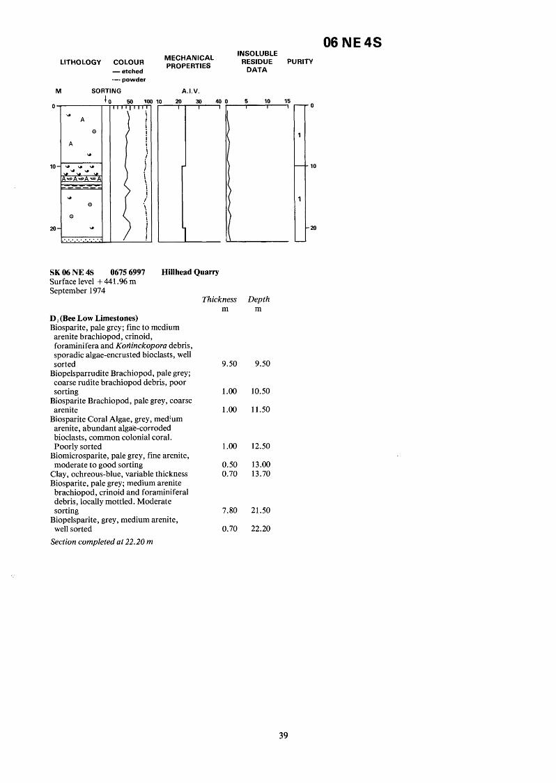
LITHOLOGY COLOUR - etched --. powder
M SORTING +
SK 06 NE 4s 0675 6997 Surface level + 441.96 m September 1974
MECHANICAL PROPERTIES
I 20
A.I.V.
30 40 -
Hillhead Quarry
D, (Bee Low Limestones) Biosparite, pale grey; fine to medium arenite brachiopod, crinoid, foraminifera and Koriinckopora debris, sporadic algae-encrusted bioclasts, well sorted
Biopelsparrudite Brachiopod, pale grey; coarse rudite brachiopod debris, poor sorting
Biosparite Brachiopod, pale grey, coarse arenite
Biosparite Coral Algae, grey, medium arenite, abundant algae-corroded bioclasts, common colonial coral. Poorly sorted
moderate to good sorting Biomicrosparite, pale grey, fine arenite,
Clay, ochreous-blue, variable thickness Biosparite, pale grey; medium arenite brachiopod, crinoid and foraminiferal debris, locally mottled. Moderate sorting
Biopelsparite, grey, medium arenite, well sorted
Section completed at 22.20 m
06 NE 4s INSOLUBLE
DATA RESIDUE PURITY
5 10 15 w
Thickness Depth m m
9.50 9.50
1.00 10.50
1.00 11.50
1.00 12.50
0.50 13.00 0.70 13.70
7.80 21.50
0.70 22.20
I 0
10
20
39

LITHOLOGY COLOUR MECHANICAL PROPERTIES - etched .-. powder
FRACTURE INDEX M SORTING
0
10
20
30
40
50
60
70
8(
go
100
0 . . . 0
U a
0 .. . A a . . . u u w u . . Q . . @ *
u F.. f E
Q u
a 0
a
50 lo( - ! i i i ! i
! I
i I i
!
.i
!
!
\ I ! !
\ j
i i i ! ! !
1
1
1 I '. i i
I
I
1 I
I j
i \
i / i i \.
I .i \
I /
.i
(If.mm).
D 50 100 500' - M I 01
-
L
A.I.V.
1 20 30 40 I
1
-
06 NE 5s INSOLUBLE
RESIDUE PURITY DATA
5 10 15 0 I I I
I
1
3
1
1
1
1
1
1
1
1
10
20
30
40
50
60
70
80
90
100
40
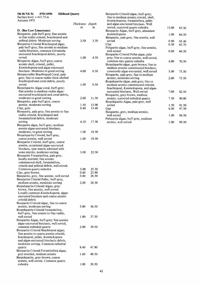
SK 06 NE 5s 0701 6956 Hillhead Quarry Surface level +415.75 m Autumn 1975
D I (Bee Low Limestones) Biosparite, pale buff-grey; fine arenite to fine rudite crinoid, brachiopod and pelletal debris. Moderate sorting
Biosparite Crinoid Brachiopod algae, pale buff-grey; fine arenite to medium rudite bioclasts, common Girvanella encrusted brachiopod debris, poorly sorted
arenite shell, crinoid, pellet, Koninckopora and algae-encrusted bioclasts. Moderate to good sorting
Biosparrudite Brachiopod Coral, pale grey; fine to coarse rudite thick-shelled brachiopod and coral debris, poorly sorted
Biopelsparite Algae coral, buff-grey; fine arenite to medium rudite algae- encrusted brachiopod and coral debris, moderate to good sorting
arenite, moderate sorting
Biosparite Algae, buff-grey; coarse
Biosparite, pale buff-grey, coarse
Clay, grey Biosparite, pale grey; fine arenite to fine rudite crinoid, brachiopod and foraminiferal debris, moderate sorting
Biosparite algae, buff-grey; medium arenite algae-encrusted bioclasts, moderate, to good sorting
Biopelsparite Crinoid, buff-grey, coarse arenite, well sorted
Biosparite Crinoid, buff-grey, coarse arenite, occasional algae-encrusted bioclasts, spar matrix admixed with some micrite, moderate sorting
Biosparite Foraminifera, pale grey, locally mottled; fine arenite comminuted shell, foraminifera, crinoid and pelletal debris, well sorted. Common quartz euhedra
Clay, grey-brown Biosparite, grey, fine arenite, well sorted Biosparite Crinoid Pellet, buff-grey, medium arenite, moderate sorting
Biopelsparite Crinoid Algae, grey- brown, fine arenite, well sorted. Locally common Koninckopora, algae- encrusted bioclasts and coarse arenite crinoid debris
Biosparite Crinoid algae, fine to coarse arenite, moderate sorting
Biopelsparite Crinoid foraminifera, buff-grey, fine arenite to fine rudite, well sorted
Biosparite Algae, buff-grey; fine arenite algae-encrusted bioclasts, well sorted, common euhedral quartz
Biosparite Crinoid Brachiopod algae; fine arenite to coarse arenite crinoid, brachiopod, pellet, Koninckopora and algae-encrusted bioclastic debris, moderate sorting. Common euhedral quartz
Biosparite Crinoid Foraminifera algae, grey mottled, medium arenite
Biopelsparite, grey-brown, coarse arenite, well sorted. Common quartz euhedra
Thickness m
3.50
1 .oo
4.00
1 .oo
2.00
1 S O 0.40
4.10
1 .oo 1 .oo
Depth m
3.50
4.50
8.50
9.50
11 S O
13.00 13.40
17.50
18.50
19.50
3.00 22.50
3.00 25.30 0.60 25.90 0.60 26.50
2.00 28.50
3.00 36.50
1.00 37.50
2.00 39.50
8.40 47.90
1.60 49.50
1.00 50.50
41
Biosparite Crinoid algae, buff-grey; fine to medium arenite crinoid, shell, Koninckopora, foraminifera, pellet and algae-encrusted bioclasts. Well sorted, scattered quartz euhedra
Biosparite Algae, buff-grey, abundant Koninckopora
Biosparite, pale grey, fine arenite, well sorted
Clay Pelsparite algae, buff-grey, fine arenite,
Biosparite Crinoid Pellet algae, pale well sorted
grey; fine to coarse arenite, well sorted, common tiny quartz euhedra
Biopelsparite algae, grey-brown; fine to medium arenite comminuted bioclasts, commonly algae-encrusted, well sorted
arenite, moderate sorting
medium arenite comminuted crinoid, brachiopod, Koninckopora, and algae- encrusted bioclasts. Well sorted
Biosparite, grey-brown, medium arenite, scattered euhedral quartz
Biopelsparite Algae, pale grey, well sorted
Gap Biosparite, grey, medium arenite,
Pelsparite algae, buff-grey, medium
Biosparite, pale grey, fine to medium
Biopelsparite algae, pale grey; fine to
well sorted
arenite, well sorted
13 .OO
1 .oo 0.90 0.30
0.80
4.00
3 .OO
2.00
7.00
7.50
1 S O 6.00
1 .oo 1 .oo
63.50
64.50
65.40 65.70
66.50
70.50
73.50
75.50
82.50
90.00
91 S O 97.50
98.50
99.50
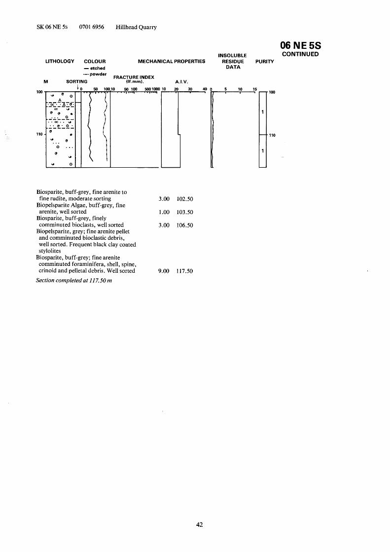
SK 06 NE 5s 0701 6956 Hillhead Quarry
100
110
LITHOLOGY COLOUR MECHANICAL PROPERTIES - etched
A.I.V.
0 2 0 3 0 40 1
-
Biosparite, buff-grey, fine arenite to fine rudite, moderate sorting 3.00 102.50
Biopelsparite Algae, buff-grey, fine arenite, well sorted 1 .OO 103.50
Biosparite, buff-grey, finely comminuted bioclasts, well sorted 3.00 106.50
Biopelsparite, grey; fine arenite pellet and comminuted bioclastic debris, well sorted. Frequent black clay coated stylolites
comminuted foraminifera, shell, spine, crinoid and pelletal debris. Well sorted 9.00 117.50
Biosparite, buff-grey; fine arenite
Section completed at I 17.50 m
06 NE 5s INSOLUBLE CONTINUED
RESIDUE PURITY DATA
5 10 15 I I d
d 100
110
42


LITHOLOGY COLOUR - etched .-. powder
M SORTING 4
O w Qtz.
0
10-
20- 0 e
0 e
0 0
1 - 0 I
u . . . . . . . . .
MECHANICAL PROPERTIES
v A.I.V.
J
06 NE 6s INSOLUBLE
DATA RESIDUE PURITY
-0
-1 0
.20
' 30
840
50
60
44

SK 06 NE 6s 0835 6857 Harley Surface level + 41 3.90 m September 1974
Thickness m
Depth m
D, (Bee Low Limestones) Biomicrosparite, grey, mottled; medium arenite comminuted brachiopod and crinoid debris
Gap Biomicrosparite, pale grey, mottled,
Gap Biomicrosparite, pale grey, medium
Biosparite, buff-grey; medium arenite
medium arenite
arenite
brachiopod and crinoid clasts, moderate sorting
Biomicrite, buff-grey, mottled; medium arenite brachiopod, crinoid and foraminifera debris
Gap Biomicrosparite, buff-grey, medium
Gap Biomicrosparite, buff-grey, medium
Gap Biosparite, buff-grey, medium arenite Gap Biosparite, buff-grey; coarse arenite
arenite
arenite
brachiopod and crinoid debris, moderate to good sorting
Gap Biomicrosparite, buff-grey, medium
Gap Biosparite, pale buff-grey; medium
arenite, locally common Koninckopora
arenite crinoid, foraminifera, dasycladacean algae and shell debris, moderate sorting
Biomicrosparite, buff-grey, medium to coarse arenite bioclasts
Gap Biomicrosparite, buff-grey; medium to coarse arenite crinoid and comminuted bioclastic debris, moderate sorting
Gap Biopelsparite, buff-grey, medium to coarse arenite, very well sorted, patchy limonite staining
Section completed at 69.70 m
2.86 16.14
2.86 19.00
1.60 1.70
20.60 22.30
1.20 23.50
5.00 28.50
1 S O 3.71
30.00 33.71
35.00 36.17
1.29 1.17
1.30 1.03 1 .OO 1.56
37.47 38.50 39.50 41.06
0.94 7.75
42.00 49.85
4.30 4.10
54.15 58.25
2.20 60.45
3.10 1.60
63.55 65.15
1.75 1 .OO
67.90 68.90
0.80 69.70
45

06 NE 7s
LITHOLOGY COLOUR - etched --. powder
M SORTING i
20
U .. .
50
. .0. .. U. ------ . . . . . .
Q Q
. . . . . - . . . . . .
. Q ...
. a C . ' U . . . . . . . . . . . . . . . . . .
g 80
MECHANICAL PROPERTIES
I 20
A.I.V.
30 40 n 0 r
INSOLUBLE
DATA RESIDUE PURITY
2
- 4 0
1
- -20
1
- -3c
1
--
1
--
1
I I 60
-70
-80
46

SK 06 NE 7s 0708 6835 Surface level + 386.5 m September 1974
Biosparite, buff-grey; very fine arenite comminuted bioclasts, rare oncolites, well sorted. Common tiny quartz euhedra
Pelsparite, buff-grey; fine arenite corroded pellets and brachiopod debris, well sorted
Gap Pelsparite, buff-grey; coarse arenite algae encrusted bioclasts and pelletal material, well sorted. Common quartz euhedra
Koninckopora, well sorted
Sporadic quartz euhedra
Brachiopod, buff-grey; coarse arenite pelsparite intraclasts, crinoid and brachiopod debris, fine arenite pelletal and finely comminuted algae-corroded bioclasts, poorly sorted
occasional quartz euhedra
sorted
Biopelsparite, medium arenite, rare
Pelsparite, fine arenite, well sorted.
Biopelsparite Intraclast Crinoid
Pelsparite, fine arenite, well sorted,
Biopelsparite, medium arenite, well
Pelsparite, fine arenite, well sorted Biopelsparite Crinoid, grey-brown, medium arenite, well sorted. Siliceous stylolites
Biosparite Crinoid Pellet, grey-brown, coarse arenite, well sorted
Section completed at 80.60 m
Thickness m
Depth m
2.39 62.89
D, (Bee Low Limestones) Biopelsparite Brachiopod, buff-grey; fine arenite pelletal and comminuted bioclastic debris, common rudite brachiopods (Dseptosa), common silicified stylolites
Biosparite Pellet, buff-grey, fine arenite, patchy limonite staining
Pelsparite, buff-grey; fine arenite algae-corroded bioclasts, well sorted
Biosparite Crinoid, buff-grey, fine to medium arenite, patchy silicification
Biosparite, buff-grey, fine arenite, well sorted
Biomicrite crinoid, buff-grey; common fine rudite crinoid debris, moderate sorting
Pelsparite, fine arenite, very well sorted Biosparite Crinoid, buff-grey, locally mottled, coarse arenite
Biosparite, pale grey; fine arenite comminuted bioclasts, well sorted
Gap Biosparite Crinoid, buff-grey; fine arenite to fine rudite bioclasts, spar matrix admixed with micrite, patchy limonite staining
comminuted shell, crinoid, spine, dasycladacean algae, foraminifera and pelletal debris. Patchy limonite and pyrolusite staining
Pelsparite, buff-grey, fine to medium arenite, well sorted
Biosparite, pale buff-grey; fine arenite comminuted bioclasts, occasional coarse arenite crinoid and algae-corroded brachiopod debris. Occasional limonite stained fractures and clay coated stylolites
Pelsparite brachiopod, mid-grey; fine arenite pelletal debris, scattered rudite algae-encrusted brachiopod debris, well sorted
Biosparite, pale grey; fine arenite
Gap Biosparite algae, pale buff-grey, fine arenite, moderate to good sorting, some quartz euhedra
Biopelsparite Algae Brachiopod coral, buff-grey, mottled, fine arenite to medium rudite, clay coated stylolites, moderate sorting
Gap Biosparite, pale buff-grey, fine arenite, sporadic rudite brachiopods (0. septosa), patchy limonite staining
Biopelsparite Algae Brachiopod Coral, mid grey, fine arenite, common rudite oncolites and algae-encrusted brachiopod debris
well sorted
occasional rudite brachiopod (0. septosa) and crinoid debris, moderate to good sorting
sporadic quartz euhedra
Biosparite Pellet, buff-grey, fine arenite,
Biopelsparite Brachiopod, fine arenite,
Pelsparite, fine arenite, very well sorted,
2.31 1.66
65.20 66.86
1 S O
1 .OO
2.80
1.70
2.50
1 S O
2.50
5.30
7.00
9.50
2.64
0.86
2.14
69.50
70.36
72.50
2.00 1 .OO
11 S O 12.50
1 .OO 73.50
1.06 74.56 2.00 14.50
0.94 0.70
75.50 76.20 0.70
3.80 15.20 19.00
1.80
2.60
78.00
80.60 3.50 22.50
6.00 28.50
2.00 30.50
8.00 38.50
1.00 39.50 1.80 41.30
3.20 44.50
0.80 45.30 0.50 45.80
2.00 47.80
0.45 48.25
2.87 51.12
5.38 56.50
4.00 60.50
47

06 NE 8s LITHOLOGY COLOUR MECHANICAL PROPERTIES - etched --- powder
M SORTING (If.rnrn). FRACTURE INDEX
0
10
20
30
40
50
........ ........... ............. =J U I
A ..... ..... ..... A '
..... ..... ..... e
50 1M v i ! I
i i
I
I
/'
i i \
i
\ ./*
i j
I i
i i
\. ! !
i
i
i
I
I
I '. \ ! i \ i !
3 50 100
T A.I.V.
J
0 r
INSOLUBLE
DATA RESIDUE PURITY
0
-10
'20
t30
40
50
48
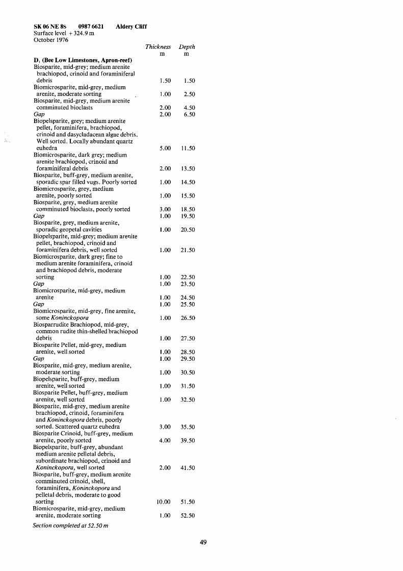
SK 06 NE 8s 0987 6621 Aldery Cliff Surface level + 324.9 m October 1976
Thickness Depth m m
D, (Bee Low Limestones, Apron-reef) Biosparite, mid-grey; medium arenite brachiopod, crinoid and foraminiferal debris
arenite, moderate sorting
comminuted bioclasts
Biomicrosparite, mid-grey, medium
Biosparite, mid-grey, medium arenite
Gap Biopelsparite, grey; medium arenite pellet, foraminifera, brachiopod, crinoid and dasycladacean algae debris. Well sorted. Locally abundant quartz euhedra
arenite brachiopod, crinoid and foraminiferal debris
sporadic spar filled vugs. Poorly sorted
arenite, poorly sorted
comminuted bioclasts, poorly sorted
Biomicrosparite, dark grey; medium
Biosparite, buff-grey, medium arenite,
Biomicrosparite, grey, medium
Biosparite, grey, medium arenite
Gap Biosparite, grey, medium arenite,
Biopelsparite, mid-grey; medium arenite sporadic geopetal cavities
pellet, brachiopod, crinoid and foraminifera debris, well sorted
Biomicrosparite, dark grey; fine to medium arenite foraminifera, crinoid and brachiopod debris, moderate sorting
Gap Biomicrosparite, mid-grey, medium
Gap Biomicrosparite, mid-grey, fine arenite,
Biosparrudite Brachiopod, mid-grey,
arenite
some Koninckopora
common rudite thin-shelled brachiopod debris
arenite, well sorted Biosparite Pellet, mid-grey, medium
Gap Biosparite, mid-grey, medium arenite, moderate sorting
Biopelsparite, buff-grey, medium arenite, well sorted
Biosparite Pellet, buff-grey, medium arenite, well sorted
Biosparite, mid-grey, medium arenite brachiopod, crinoid, foraminifera and Koninckopora debris, poorly sorted. Scattered quartz euhedra
arenite, poorly sorted
medium arenite pelletal debris, subordinate brachiopod, crinoid and Koninckopora, well sorted
Biosparite, buff-grey, medium arenite comminuted crinoid, shell, foraminifera, Koninckopora and pelletal debris, moderate to good sorting
Biomicrosparite, mid-grey, medium arenite, moderate sorting
Biosparite Crinoid, buff-grey, medium
Biopelsparite, buff-grey, abundant
1.50 1.50
1.00 2.50
2.00 4.50 2.00 6.50
5.00 11.50
2.00 13.50
1.00 14.50
1.00 15.50
3.00 18.50 1.00 19.50
1.00 20.50
1.00 21.50
1.00 22.50 1.00 23.50
1.00 24.50 1.00 25.50
1.00 26.50
1.00 27.50
1.00 28.50 1.00 29.50
1.00 30.50
1.00 31.50
1.00 32.50
3.00 35.50
4.00 39.50
2.00 41.50
10.00 51.50
1.00 52.50
Section completed at 52.50 m
49
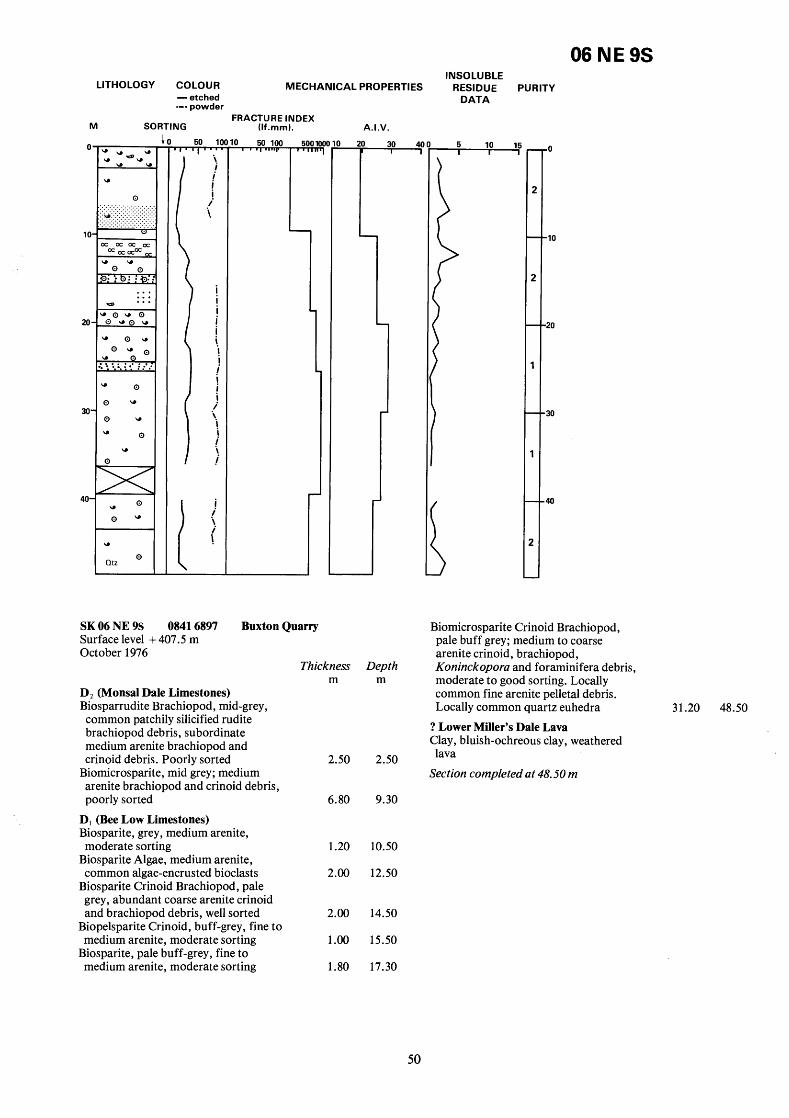
LITHOLOGY COLOUR MECHANICAL PROPERTIES - etched --- powder
M SORTING (If.rnrn). FRACTURE INDEX
50 1( T
\
I i i i i.
! ! i i i ! j i
I
I
I
I i i i i i i j
i i i i 1
I
SK 06 NE 9s 0841 6897 Surface level + 407.5 m October 1976
0 50 100 v
I
Buxton Quarry
0
L
L
A.I.V.
Thickness m
D2 (Monsal Dale Limestones) Biosparrudite Brachiopod, mid-grey, common patchily silicified rudite brachiopod debris, subordinate medium arenite brachiopod and crinoid debris. Poorly sorted 2.50
Biomicrosparite, mid grey; medium arenite brachiopod and crinoid debris, poorly sorted 6.80
D, (Bee Low Limestones) Biosparite, grey, medium arenite,
Biosparite Algae, medium arenite,
Biosparite Crinoid Brachiopod, pale
moderate sorting 1.20
common algae-encrusted bioclasts 2.00
grey, abundant coarse arenite crinoid and brachiopod debris, well sorted 2.00
Biopelsparite Crinoid, buff-grey, fine to medium arenite, moderate sorting 1 .OO
Biosparite, pale buff-grey, fine to medium arenite, moderate sorting 1.80
Depth m
2.50
9.30
10.50
12.50
14.50
15.50
17.30
06 NE 9s INSOLUBLE
RESIDUE PURITY DATA
5 10 15 I I 1
-0
-10
-20
*30
' 4 0
Biomicrosparite Crinoid Brachiopod, pale buff grey; medium to coarse arenite crinoid, brachiopod, Koninckopora and foraminifera debris, moderate to good sorting. Locally common fine arenite pelletal debris. Locally common quartz euhedra 31.20 48.50
? Lower Miller's Dale Lava Clay, bluish-ochreous clay, weathered lava
Section completed at 48.50 m
50

06 NE 10 S INSOLUBLE
LITHOLOGY COLOUR MECHANICAL PROPERTIES RESIDUE PURITY
- etched '-' Powder FRACTURE INDEX
M SORTING (If.mm). A.I.V.
A "
O A
e
0 "
A
U .- rr.n rr.=.~ ............... .............. ------ u ....
0 ::::
e
50 100
SK 06 NE 10s 0656 6797 Tor Rock Surface level + 403.9 m October 1976
Thickness Depth m m
D, (Bee Low Limestones) Biosparite, grey, locally mottled; medium arenite brachiopod, crinoid, foraminifera and rare dasycladacean algae, coral and gastropod debris. Moderate sorting
Biopelsparite, grey, medium arenite, well sorted
Biosparite, grey; medium arenite crinoid, brachiopod, foraminifera and sporadic pelletal and calcisphere debris. Moderate sorting
11.50 11.50
1.00 12.50
6.50 19.00
DATA
Section completed at 19.00 m
51

06 NE 14 S
LITHOLOGY COLOUR
M so lR1
- etched .--powder
rlNG 50 1( -
i
.! i
j ! *\ i
!
I
\ i i i
MECHANICAL PROPERTIES
A.I.V.
7 20
-
INSOLUBLE
DATA RESIDUE PURITY
5 10 15 -
SK 06 NE 14s 0837 6715 , Glutton Dale Surface level + 286.5 m October 1976
Thickness Depth m m
D, (Bee Low Limestones-Apron-reef) Micrite, grey, rare calcispheres,
foraminifera and spines, matrix predominantly micrite with patchy spar, rare ‘reef’ brachiopods and geopetal cavities 30.00 30.00
Section completed at 30.00 m
52


06 NE 15s
LITHOLOGY COLOUR - etched .-- powder
M SORTING
50 W
0 W
0
50 1OC
T 1
! ! ! I i i i i j
'j
i i i i i i i i
I
I i
1
I i i I 1 i \ !
i
I i
i ! ! i i i i i i i i i i i i
INSOLUBLE MECHANICAL RESIDUE PURITY PROPERTIES
A.I.V.
I 2t 7
30 40 - DATA - 5 10 15 I
IO
20
30
40
50
60
54

SK 06 NE 15s 0953 6781 Surface level + 409.7 m October 1976
D, (Bee Low Limestones) Biosparite, buff-grey; medium arenite brachiopod, crinoid and foraminiferal debris, moderate sorting, scattered quartz euhedra
coarse arenite crinoid debris
coarse arenite crinoid and brachiopod debris, some foraminifera, moderate sorting
Clay, grey
Biosparite Crinoid, buff-grey, frequent
Biosparite, pale grey; medium to
Biosparite Algae, grey, abundant algae-encrusted bioclasts, moderate to good sorting
rare rudite brachiopods
arenite, good sorting
patchy pyrolusite staining
medium arenite to medium rudite bioclasts, poorly sorted
Biosparite, pale grey; medium arenite brachiopod, crinoid, foraminifera and Koninckopora, well sorted
Biosparite Crinoid, pale grey, medium to coarse arenite, poor sorting
Biomicrosparite, grey, mottled, medium arenite
Biosparite, grey, fine to medium arenite, poor sorting
Biopelsparite, grey, fine to coarse arenite, well sorted
Biosparite, grey mottled, medium arenite, poor sorting. Bioclasts predominantly brachiopod, crinoid, foraminifera and dasycladacean algae debris. Thin ochreous clay 38.8 m, 55.8 m and 56.3 m
Biosparite Crinoid, grey, medium arenite, moderate sorting
Biomicrosparite, grey; fine to medium arenite bioclasts, sporadic colonial coral, moderate to good sorting
Biosparite, pale grey, medium arenite,
Biopelsparite, pale grey, fine to coarse
Biosparite, pale grey, medium arenite,
Biosparrudite Crinoid, buff-grey;
Section completed at 69.00 rn
Thickness Depth m m
2.50 2.50
4.00 6.50
8.30 14.80 0.08 14.88
0.62 15.50
1.00 16.50
1.00 17.50
1.00 18.50
1.00 19.50
8.00 27.50.
3.00 30.50
3.00 33.50
1.00 34.50
1.00 35.50
22.00 57.50
3.00 60.50
8.50 69.00
55

07 NE 43
LITHOLOGY COLOUR - etched --. powder
M SORTING or u ... e . *
... e ... *
k. . . .-- . . . .:. . . . ...;...
oC " Qtz
Qtz a
uQtz,"'u ... ... u ...
cc * ' A ..
80-
.... I
rp)
v u 0 ...
rp)
.... a . u . .
A u.*' * Qtz .?, . r + t + + + + ++++if+ + + + + + + + + + + + + + + + + + + + + +
+ + + + + + + + + + + + + + + + - I - + + + + + + + + + + + + + + + + + +
100 + + + + + + +
+
X
MECHANICAL PROPERTIES
1 21 1
A. I .V.
30 4( I
x
INSOLUBLE
DATA RESIDUE PURITY
I 5 10 v
i >
X
10
20
30
40
50
60
70
80
90
100
56

SK 07 NE 43 0751 7677 Peak House
Surface level + 355.22 m Edeco Stratadrill 36, waterflush, 47 mm diameter January 1977
D2 (Monsal Dale Limestones) Openhole Biosparite, mid-grey; fine arenite to fine rudite, frequent silicified bioclasts, common flecks of pyrite weathered to limonite
Biopelsparite Brachiopod foraminifera, pale grey, medium arenite, poorly sorted; patchily silicified shell debris
Biosparite Brachiopod , medium arenite, moderate to good sorting
Clay, ochreous-brown Biosparite Brachiopod, buff-grey, common patchily silicified rudite brachiopods, abundant fine arenite comminuted bioclasts
Biosparrudite Brachiopod, grey-brown, poorly sorted
Biomicrudite Brachiopod, common silicified brachiopod debris
Biosparite Pellet Foraminifera, grey- brown, medium arenite, well sorted
Biosparrudite Brachiopod Pellet, grey- brown, common quartz euhedra
Biosparite Pellet, grey-brown; medium to coarse arenite crinoid and brachiopod debris, patchily silicified, moderate to good sorting
Clay, ochreous-brown Biopelsparite, grey-brown, fine to
Biosparite, grey-brown; fine arenite to medium arenite, well sorted
coarse rudite bioclasts and pelletal debris, moderate to good sorting
Biomicrite Brachiopod, buff-grey, fine arenite to coarse rudite, poorly sorted
Pelsparite, buff-grey, fine arenite, very well sorted
Biosparite Pellet Foraminifera, buff- grey; medium arenite patchily silicified bioclasts, moderate to good sorting
grey-brown locally mottled to mid grey; fine arenite foraminifera, crinoid and brachiopod debris, sporadic fragments of bryozoa and coral; common Coelosporella 24.90-25.10 m, 27.74-29.20m; scattered ostracods and Saccaminopsis. Moderate to good sorting
Some silicified bioclasts; patchy disseminated black clay
Pelsparite, grey-brown, fine arenite, very well sorted, occasional silicified bioclasts and flecks of pyrite
medium grey-brown; fine to coarse arenite patchily silicified bioclasts, locally abundant disseminated clay
Biopelsparite, mid-grey, very fine arenite, scattered quartz euhedra
Biosparite Foraminifera bryozoa,
Biosparite Foraminifera bryozoa,
Thickness m
1.40
1.75
2.05
1.30 0.55
1.15
0.30
0.93
1.13
1.01
1.52 0.04
0.89
1.45
0.95
0.70
1.23
10.87
10.87
1.20
1.10
0.62
Depth m
1.40
3.15
5.20
6.50 7.05
8.20
8.50
9.43
10.54
11.55
13.07 13.1 1
14.00
15.45
16.40
17.10
18.33
29.20
29.20
30.40
31 S O
32.12
4.99 37.11
2.90 40.01
Biosparite, grey-brown to dark grey, fine arenite, sporadic coarse arenite crinoid and brachiopod debris, common quartz euhedra, some silicified bioclasts, occasional patchy disseminated clay, pyrite and limonite. Abundant Saccammopsis 35.55-35.75m, rare fragments of bryozoa
Biosparite Foraminifera Bryozoa, mid-grey, fine arenite, occasional flecks of pyrite, patchy bioclastic silicification. Well sorted
Biosparite Algae Pellet, grey-brown; fine arenite to fine rudite shell, crinoid, Coelosporella, foraminifera and pelletal debris, commonly encrusted with Girvanella. Well sorted 0.95
D, (Miller’s Dale Limestones) Pelsparite Algae Brachiopod, grey- brown to buff-grey, fine arenite, sporadic algae encrusted rudite brachiopod debris. Well sorted 3.24
coarse arenite, locally common Coelosporella, scattered quartz euhedra, poorly sorted 5.41
Coelosporella, moderate to good sorting 2.79
Biosparite, calcite mineralised, limonite and pyrolusite stained 2.62
Biopelsparite Brachiopod algae, buff-grey; fine arenite pelletal debris, fine arenite to medium rudite brachiopod and crinoid debris, locally algae-encrusted, rare Koninckopora. Common quartz euhedra, some patchily silicified brachiopod debris and silicified calcite veinlets
Biosparite Brachiopod Pellet, coarse arenite, common quartz euhedra
Biopelsparite Brachiopod algae, medium buff-grey; medium arenite bioclasts, occasionally algae-encrusted, scattered Coelosporella and Koninckopora, well sorted. Frequent quartz euhedra, some silicified calcite veins. Common flecks of pyrite and limonite and silicified stylolites
Biosparite Brachiopod Pellet, buff-grey,
Biopelsparite, locally common
71.80-72.16
(Dove Holes Tuff) Tuff, blue-grey, large angular fragments of limestone and weathered igneous rock, pyritous
(Miller’s Dale Limestones) Biopelsparite algae, medium buff-grey, fine to medium arenite, well sorted, frequent quartz euhedra and silicified calcite veinlets and limonite staining in upper 0.15 m. Sporadic large patches of quartz euhedra 2.90
Clay, ochreous 0.09
40.96
44.20
49.61
52.40
55.02
6.98 62.00
1.98 63.98
8.18 72.16
1.59 73.75
76.65 76.74
57

SK 07 NE 43 0751 7677 Peak House
07 NE 43 INSOLUBLE CONTINUED
LITHOLOGY COLOUR MECHANICAL RESIDUE PURITY - etched PROPERTIES DATA --- powder
M SORTING A.I.V.
100.
110-
120-
130.
+++++++i + + + + + + + . I + + + + + + + . I + + + + + + + - I + + + + + + + . I + + + + + + + . I + + + + + + + - I + + + + + + + . I + + + + + + + - I + + + + + + + - I + + + + + + + . I + + + + + + + - I +++++++i + + + + + + + - I + + + + + + + . I + + + + + + + . I + + + + + + + . I + + + + + + + . I + + + + + + + - I + + + + + + + j
e - A . ...
Qtz - ..-- .... A . .
- a .... .. m A
... . . .. A -
11.98 88.72 0.12 88.90
Biopelsparite, buff-grey, fine to medium arenite, well sorted, lithology variable between biopelsparite and biosparite, colonial coral 80.40 m, 82.65-82.77m, rare fragments of bryozoa
Clay, ochreous Biopelsparite, grey-brown; coarse arenite shell, crinoid, foraminifera, and pelletal debris commonly Girvanella encrusted, sporadic Koninckopora, well sorted. Common large patches of quartz euhedra, sporadic cubes of pyrite, weathered to limonite 2.19 91.09
(Lower Miller’s Dale Lava) Clay, ochreous with fragments of
Basalt, dark grey-green, amygdaloidal, weathered lava 0.41 91.50
weathered in upper 1.8 m 25.30 116.80
(Chee Tor Rock) Biopelsparite algae, buff-grey; fine to medium arenite pellet, foraminifera, shell and Koninckopora debris, well sorted
Mottled 126.26-126.55 m. Common quartz euhedra, some pyrite in upper 0.05 m. Sporadic, locally common, black clay and silicified stylolites
Borehole complete at 130.10 m
13.30 130.10
1 0 0
110
1 20
130
58


0
10
20
30
40
50
60
70
80
90
100
LITHOLOGY COLOUR - etched .-- powder
SORTING
L
i \ i
j
! !
i .i
\ ! j
I
I
I
! i i i i ! i i i i i i i i i i .i
i
.i
I
I
\
\.
I
I i i i .i
.i ! j \.
.i
i
\
I
1. \. i .i
j
I \
! \ i .i \ i ! .i ! ! !
\.
i !
!
I
.i
i I
MECHANICAL PROPERTIES
A.I.V.
P 40 0
07 NE 44 INSOLUBLE
RESIDUE PURITY DATA
- 5 10
60

SK 07 NE 44 0854 7904 Bee Low Quarry Surface level + 354.40 m Edeco Stratadrill 36, waterflush, 47 mm diameter January 1977
Thickness m
D, (Bee Low Limestones) Openhole, topsoil 0.35 Biosparite, pale grey, fine arenite, well sorted 0.10
Biopelsparite Algae, buff-grey; medium arenite comminuted bioclasts, Koninckopora and algae-encrusted bioclasts. Well sorted. Scattered quartz euhedra 1.30
Biosparite Pellet. buff-grey, locally mottled, medium arenite 2.21
Biopelsparite Algae; coarse arenite Koninckopora algae-encrusted bioclasts and pelletal material, sporadic rudite crinoid debris, locally common foraminifera. Stylolitic 6.98-9.47 m. Locally hematite and limonite stained, scattered quartz euhedra
Biopelsparite Algae, grey-brown; fine to coarse arenite pellet, dasycladacean algal, shell, foraminifera and crinoid debris. Variable lithology biosparite- biopelsparite-pelsparite. Well sorted. Scattered quartz euhedra, patchy limonite and pyrolusite staining. Sporadic rudite crinoid and brachiopod debris
arenite, some clay coated and silicified stylolites, well sorted
Biosparite Foraminifera, grey, mottled 44.18-48.72, sporadic quartz euhedra, clay coated stylolites and limonite staining
Pelsparite Algae, grey, fine arenite, locally abundant Koninckopora, locally laminated, sporadic algae- encrusted brachiopod debris
Biopelsparite Algae; fine arenite comminuted bioclastic and peloidal
Biopelsparite Foraminifera, medium
Biopelsparite Algae Crinoid, sporadic algae-encrusted bioclasts, well sorted, scattered quartz euhedra
Gap Depth Biopelsparite Algae Crinoid, coarse
m arenite, some flecks of ore mineral, patchy limonite staining
0.35 Gap
0.45 arenite, moderate to good sorting. Colonial coral 91. 10m, 93.70-93.90 m. Calcite mineralised, fractured and fissured 92.78 m-100.00 m. Some silicified calcite veinlets and stylolites.
Biosparite Crinoid Pellet algae, coarse
1.75 Patchy limonite staining
.96 Borehole complete at 100.00 m
8.29 12.25
24.67 36.92
6.42 42.34
6.38 48.72
2.13 50.85
debris, sporadic rudite crinoid and brxhiopod debris
Biosparite Pellet Foraminifera algae, grey, locally mottled, fine arenite, some calcispheres, ostracods and fragments of bryozoa, well sorted. Sporadic clay-coated stylolites and flecks of pyrite and limonite. Locally common quartz euhedra
Pelsparite Algae, grey, medium arenite, very well sorted. Bioclasts and pellets commonly algae-encrusted
Biosparite Pellet Foraminifiera, grey; medium arenite comminuted crinoid, brachiopod, foraminifera, pellet and spine debris, well sorted
Biopelsparite, buff grey; fine arenite to fine rudite clasts, well sorted, colonial coral 69.58-70.08 m. Scattered quartz euhedra
Biosparite, grey, mottled 72.89-73.30 m, medium arenite, well sorted, sporadic quartz euhedra, patchy limonite staining
Biopelsparite Foraminifera, grey, medium arenite, well sorted. Locally common crinoid and dasycladacean algal debris. Clay-infilled fissures 79.09-79.52 m
3.19 54.04
10.22 64.26
1.41 65.67
3.33 69.00
3.64 72.64
1.81 74.45
6.07 80.52
61
4.13 84.65 0.52 85.17
1.94 87.11 0.51 87.62
12.38 100.00

LITHOLOGY COLOUR - etched .-- powder
M SORTING
SK 07 NE IS 0880 7990 Surface level + 353.5 1 m September 1974
07 NE IS INSOLUBLE
DATA MECHANICAL PROPERTIES RESIDUE PURITY
FRACTURE INDEX (If.rnrn). A.I.V.
Barmoor Quarry
Thickness Depth m m
I' 10
D, (Monsal Dale Limestones) Pelsparite, grey-brown, thinly-bedded, fine arenite, very well sorted. Patchily silicified bioclasts
Biopelsparite, grey-brown; medium arenite crinoid, algae-corroded shell and pelletal debris. Well sorted. Patchily silicified bioclasts, scattered quartz euhedra
Pelsparite, grey-brown, fine arenite, laminated. Well sorted. Sporadic influxes of medium arenite crinoid and brachiopod debris. Scattered quartz euhedra
Section completed at IO. 20 m
0.90 0.90
1.70 2.60
7.60 10.20
07 NE 2s INSOLUBLE
LITHOLOGY COLOUR MECHANICAL PROPERTIES RESIDUE PURITY - etched DATA e-. powder
FRACTURE INDEX M SORTING (If.mrn). A.I.V.
SK 07 NE 2s 0816 7751 Perseverance Quarry Surface level + 339.05 m October 1976
Thickness Depth m m
D, (Chee Tor Rock) Biosparite, pale grey; medium arenite brachiopod, crinoid and foraminiferal debris, moderate sorting. Some pyrolusite staining 8.00 8.00
Section completed at 8.00 m
62

LITHOLOGY COLOUR MECHANICAL PROPERTIES - etched --- powder
FRACTURE INDEX M SORTING (If.rnrn). A.I.V.
INSOLUBLE 07 NE 3s RESIDUE PURITY
W
i 50 30 40 n
~ ~ ~~
SK 07 NE 3s 0859 7690 Perseverance Quarry Surface level + 330.77 m October 1976
Thickness Depth m m
D, (Chee Tor Rock) Biosparite, pale grey; fine to coarse arenite crinoid, brachiopod, foraminifera and dasycladacean algae, moderate sorting. Sporadic quartz euhedra and pyrolusite staining.
Thin ochreous clay 4.20-4.40 m variable thickness), 5.57-5.90 m. Common rudite brachiopods (0. septosa) and corals 6.57 m
Clay Biopelsparite, pale grey; medium arenite crinoid, brachiopod and pelletal debris. Well sorted
6.85 6.95 0.10 6.95
0.55 7.50
DATA
5 10 15 -
Biosparite, grey, medium arenite, moderate sorting. Scattered quartz euhedra 5.00
Biosparite Pellet, grey, mottled; medium arenite brachiopod, crinoid and pelletal material, moderate to good sorting 1 .OO
crinoid, brachiopod, foraminifera and pelletal debris, moderate sorting. Scattered quartz euhedra 3.55
Biosparite, pale grey; medium arenite
Section completed at 17.05 m
07NE4S INSOLUBLE
LITHOLOGY COLOUR MECHANICAL PROPERTIES RESIDUE PURITY
- etched
.-.powder FRACTURE INDEX M SORTING (1f.rnrn). A.1.V
1 0 50 101 0 d l t l l ~ l l ~ ~ ------- ........
! ...................... '. A "
........ ........ -------*
.................... Y
0 * I
\ i
I i i
B 10 -
7 50 100 5001000
7 SK 07 NE 4s 0789 7677 Victory Quarry Surface level + 362.4 m October 1976
D, (Miller's Dale Limestones) Biosparite, buff-grey, mottled; medium arenite brachiopod crinoid and foraminiferal debris, moderate sorting
arenite bioclastic and pelletal material, frequent quartz euhedra
Biosparite, buff-grey, mottled, medium arenite. Thin clay 2.80 m
Biosparite Pellet, buff-grey, medium
Thickness m
0.50
1 .OO
2.00
DATA
Biopelsparite, grey, medium arenite, well sorted. Common rudite brachiopods 4.0 to 4.70 m 2.00
Depth Biosparite, grey; fine to medium arenite m brachiopod, crinoid and foraminiferal
debris 6.50
Section completed at 12.0 m 0.50
1 S O
3 S O
12.50
13.50
17.05
5.50
12.00
63

LITHOLOGY COLOUR
- etched --- powder
M SORTING
SK 07 NE 5s 0959 7700 Surface level + 322.20 m October 1976
07 NE5S INSOLUBLE
MECHANICAL PROPERTIES RESIDUE PURITY
FRACTURE INDEX (If.rnm).
0 50 100 500 ' - 0
Smalldale Quarry
D, (Chee Tor Rock) Biosparite, pale grey, medium arenite, moderate to good sorting. Common quartz euhedra
Biopelsparite, pale grey; coarse arenite crinoid brachiopod, foraminiferal and pelletal debris. Moderate to good sorting
Biosparite, pale grey, medium arenite, common quartz euhedra
Biopelsparite Brachiopod, buff-grey, medium arenite, moderate sorting
Biosparite, pale grey, medium arenite, moderate sorting
Biosparite algae, pale grey; medium arenite bioclasts, occasional algae-corroded shell debris, well sorted
Biosparite, pale grey, medium arenite, moderate sorting
Biomicrosparite, pale grey, mottled, medium arenite
Biosparite, grey; fine arenite comminuted bioclasts, well sorted
Biopelsparite, pale grey; medium arenite brachiopod, crinoid and foraminiferal debris, well sorted
Section completed at 23.00 m
20 7
Thickness m
2.50
1 .OO 2.00
1 .oo
11.00
1 .oo
1 .oo
1 .oo
2.00
0.50
A.I.V.
30 40 n
Depth m
2.50
3.50
5.50
6.50
17.50
18.50
19.50
20.50
22.50
23 .OO
DATA
, G
10
20
64


07NE6S LITHOLOGY COLOUR
- etched .-. powder
M SORTING
50 1 T
1 ! i !
\
I
\ 1 \ 1 !
\ i
j i
i j ! i '. !
'. i
'. ! ! !
!
.i
I
j
i '. ! !
!
I
I I !
I I ! ! !
I
!
MECHANICAL PROPERTIES
21 1
A.1.V
INSOLUBLE
DATA RESIDUE PURITY
0
IO
20
30
40
50
60
70
66

SK 07 NE 6s 0910 7929 Bee Low Quarry Biopelsparite, buff-grey; fine arenite Surface level + 404.23 m comminuted shell, foraminifera, May 1977 dasycladacean algae, calcisphere and
Thickness Depth pelletal debris, well sorted, some m m quartz euhedra
D, (Bee Low Limestones) Biosparite, pale grey; fine to medium arenite comminuted crinoid, foraminifera and occasional Koninckopora and pelletal debris. Well sorted. Common quartz euhedra
Clay, bluish-grey on potholed surface. Variable thickness
Pelsparite Brachiopod algae, grey- brown, fine arenite, sporadic rudite brachiopods, well sorted. Abundant quartz euhedra
Biopelsparite, buff-grey, fine arenite, well sorted
Biosparite, buff-grey, fine arenite, well sorted, common quartz euhedra
Biopelsparite, pale grey, fine arenite, well sorted, common quartz euhedra
Biosparite, pale grey, fine arenite, well sorted
Biopelsparite, buff-grey; medium arenite algae-encrusted bioclasts and pelletal material, well sorted. Scattered quartz euhedra
Biosparite, buff-grey, common foraminifera and calcispheres
Biopelsparite, pale grey; fine to medium arenite comminuted bioclasts and pelletal debris, well sorted. Common quartz euhedra
coarse arenite bioclasts, well sorted, sporadic Koninckopora, common quartz euhedra
comminuted crinoid, shell, Koninckopora, foraminifera and pelletal debris, well sorted. Scattered quartz euhedra
Biosparite; medium arenite bioclastic and subordinate pelletal debris, rare quartz euhedra
Biopelsparite, fine arenite, well sorted, scattered quartz euhedra
Biopelsparite Algae, buff-grey; coarse arenite pellet and dasycladacean algae debris, well sorted
Biosparite, pale grey, very fine arenite, well sorted
Biopelsparite Algae Crinoid, buff-grey, coarse arenite, well sorted
Gap Biosparite, pale grey, very fine arenite, well sorted
Biopelsparite Algae Crinoid, pale grey, fine arenite, well sorted
Biosparite, pale grey, fine arenite, well sorted. Rare quartz euhedra
Biopelsparite Algae Crinoid, pale, fine arenite, well sorted
Biosparite, pale grey; fine to coarse arenite crinoid and brachiopod debris, subordinate Koninckopora, algae- encrusted bioclasts and pelletal material, well sorted
Biosparite, pale grey; very fine to
Biopelsparite, grey-brown; fine arenite
Section completed at 71.30 rn
7.80 7.80
0.70 8.50
1.00 9.50
1.00 10.50
3.00 13.50
2.00 15.50
2.00 17.50
2.00 19.50
1.00 20.50
5.00 25.50
7.00 32.50
5.00 37.50
4.40 41.90
1.20 43.10
3.40 46.50
1.00 47.50
1.00 48.50 1.00 49.50
1.30 50.80
3.70 54.50
2.00 56.50
1.00 57.50
8.00 65.50
5.80 71.30
67
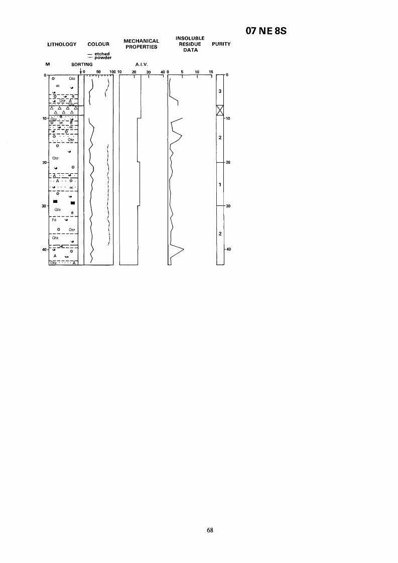
07 N E 8s LITHOLOGY COLOUR
- etched .-e powder
M SORTING
50 1
\ i i i
I ! i \ i '. I
1 !
I I !
*\ i ! i i
00
MECHANICAL lNSoLUBLE PROPERTIES RESIDUE PURITY
DATA
A.I.V.
10 20
J
30 40 0 5 10 15 n
68

SK 07 NE 8s 0834 7816 Holderness Quarry Surface level + 353.67 m May 1977
Thickness Depth m m
D, (Miller’s Dale Limestones) Biosparite, grey, fine to medium arenite bioclasts, well sorted, scattered quartz euhedra
brachiopod, foraminifera and crinoid debris
arenite, well sorted, Common quartz euhedra
well sorted. Abundant quartz euhedra
Biomicrite, mid-grey; medium arenite
Biosparite Algae, grey-brown, fine
Biopelsparite, grey, medium arenite,
4.50 4.50
1.00 5.50
1.00 6.50
0.60 7.10
(Dove Holes Tuff) Tuff
(Miller’s Dale Limestones) Biopelsparite, medium arenite, well sorted, abundant quartz euhedra
Biomicrite, medium arenite, moderate to good sorting
Biopelsparite Brachiopod algae, pale grey; coarse arenite algae-corroded shell and crinoid debris, well sorted. Common quartz euhedra
Biosparite Brachiopod Crinoid algae, pale grey, medium arenite, well sorted, common quartz euhedra
Biopelsparite, medium arenite, well sorted, common quartz euhedra
Biosparite Crinoid Brachiopod, grey; coarse arenite brachiopod and crinoid debris, well sorted. Common quartz euhedra
arenite pellet, dasycladacean algae, crinoid and brachiopod debris, well sorted. Rare quartz euhedra. Thin clay at 23.50 m
comminuted bioclasts, well sorted, common quartz euhedra. Mottled 28.50-29.50 m
Biopelsparite, mid-grey; fine arenite pelletal and comminuted shell, crinoid, foraminiferal debris. Well sorted. Patchy limonite staining common quartz euhedra
Biosparite, grey; fine arenite bioclasts, well sorted, patchy limonite staining, common quartz euhedra. Thin clay 36.30-38.90 m
arenite algae-encrusted brachiopod, crinoid, pellet and dasycladacean algal debris, well sorted, frequent quartz euhedra
Biopelsparite Algae, buff-grey; coarse arenite pellet and algae-corroded shell and crinoid debris, subordinate Koninckopora and foraminifera, well sorted. Scattered quartz euhedra, patchy limonite staining
Biopelsparite Algae, grey; medium
Biosparite, grey; medium arenite
Biosparite Algae, buff-grey; coarse
Section completed at 43.50 rn
2.10 9.20
1.30 10.50
1.00 11.50
1.00 12.50
1.00 13.50
2.00 15.50
7.00 22.50
4.00 26.50
5.90 32.40
2.10 34.50
5.00 39.50
3.00 42.50
1.00 43.50
69

07 sw IS LITHOLOGY COLOUR - etched
--a powder
M SORTING
0
10
20
30'
40,
50 *
60,
o a 0 1 I
.. - . .
i i j ! i i i i i i i i i i i i i i i i. i i i i i i
,"' -. '. I i i
i I
1
i j ! i \ 1 \
i i i i i i 1 I i i !
0 '
T
1
INSOLUBLE MECHANICAL PROPERTIES RESIDUE PURITY
FRACTURE INDEX (1f.mt-n).
I O 50 100 5001C v
DATA
A.I.V.
I 20 30 400 6 10
L
1 I
0
10
20
30
40
50
60
70
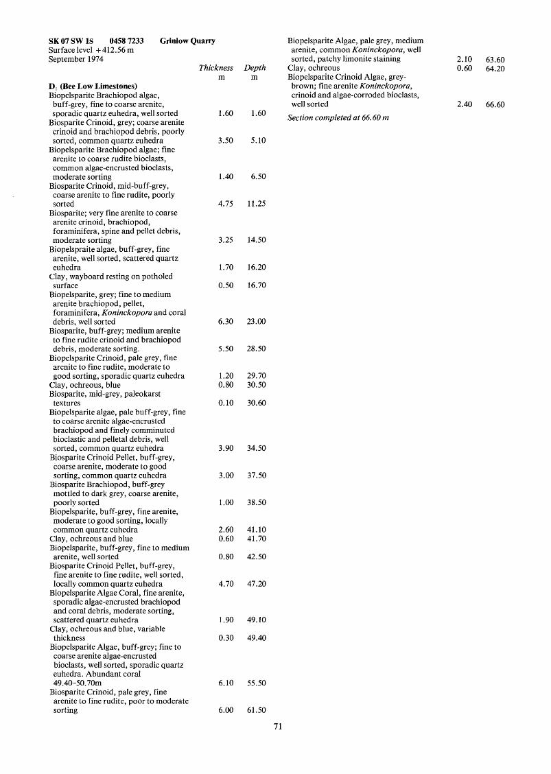
SK 07 SW 1s 0458 7233 Grinlow Quarry Surface level + 412.56 m September 1974
Thickness Depth m m
D, (Bee Low Limestones) Biopelsparite Brachiopod algae, buff-grey, fine to coarse arenite, sporadic quartz euhedra, well sorted 1.60 1.60
Biosparite Crinoid, grey; coarse arenite crinoid and brachiopod debris, poorly sorted, common quartz euhedra 3.50 5.10
Biopelsparite Brachiopod algae; fine arenite to coarse rudite bioclasts, common algae-encrusted bioclasts, moderate sorting
coarse arenite to fine rudite, poorly sorted
Biosparite; very fine arenite to coarse arenite crinoid, brachiopod, foraminifera, spine and pellet debris, moderate sorting
arenite, well sorted, scattered quartz euhedra
surface
arenite brachiopod, pellet, foraminifera, Koninckopora and coral debris, well sorted
Biosparite, buff-grey; medium arenite to fine rudite crinoid and brachiopod debris, moderate sorting.
Biopelsparite Crinoid, pale grey, fine arenite to fine rudite, moderate to good sorting, sporadic quartz euhedra
Biosparite Crinoid, mid-buff-grey,
Biopelspraite algae, buff-grey, fine
Clay, wayboard resting on potholed
Biopelsparite, grey; fine to medium
Clay, ochreous, blue Biosparite, mid-grey, paleokarst
Biopelsparite algae, pale buff-grey, fine textures
to coarse arenite algae-encrusted brachiopod and finely comminuted bioclastic and pelletal debris, well sorted, common quartz euhedra
Biosparite Crinoid Pellet, buff-grey, coarse arenite, moderate to good sorting, common quartz euhedra
Biosparite Brachiopod, buff-grey mottled to dark grey, coarse arenite, poorly sorted
Biopelsparite, buff-grey, fine arenite, moderate to good sorting, locally common quartz euhedra
Clay, ochreous and blue Biopelsparite, buff-grey, fine to medium
Biosparite Crinoid Pellet, buff-grey, arenite, well sorted
fine arenite to fine rudite, well sorted, locally common quartz euhedra
Biopelsparite Algae Coral, fine arenite, sporadic algae-encrusted brachiopod and coral debris, moderate sorting, scattered quartz euhedra
Clay, ochreous and blue, variable thickness
Biopelsparite Algae, buff-grey; fine to coarse arenite algae-encrusted bioclasts, well sorted, sporadic quartz euhedra. Abundant coral 49.40-50.70m
arenite to fine rudite, poor to moderate sorting
Biosparite Crinoid, pale grey, fine
1.40 6.50
4.75 11.25
3.25 14.50
1.70 16.20
0.50 16.70
6.30 23.00
5.50 28.50
1.20 29.70 0.80 30.50
0.10 30.60
3.90 34.50
3.00 37.50
1.00 38.50
2.60 41.10 0.60 41.70
0.80 42.50
4.70 47.20
1.90 49.10
0.30 49.40
6.10 55.50
6.00 61.50
Biopelsparite Algae, pale grey, medium arenite, common Koninckopora, well sorted, patchy limonite staining 2.10 63.60
Clay, ochreous 0.60 64.20 Biopelsparite Crinoid Algae, grey- brown; fine arenite Koninckopora, crinoid and algae-corroded bioclasts, well sorted 2.40 66.60
Section completed at 66.60 m
71

07 sw 2s LITHOLOGY COLOUR
- etched SORTING --- powder
M 4 0
10
20
30
40
50
60
70
ao
cc . . . . . E
0 U I
, " I
50 IC v
j 1 \
\ i i i
i
i i i i \ i i i
i
1 i i
i. I
i i i i i j
i i
i
! !
I i i
1
i
I
i i
i i
1
f 1
i i !
MECHANICAL PROPERTIES
A.I.V.
INSOLUBLE
DATA RESIDUE PURITY
1
0
10
20
30
40
50
60
70
80
72

SK 07 SW 2s 0459 7058 Anthony Hill Surface level + 398.77 m May 1977
D2 (Monsal Dale Limestones) Biosparite, dark grey; fine to coarse arenite crinoid, shell and foraminiferal debris, moderate sorting, some quartz euhedra
D, (Bee Low Limestones) Pelsparite Algae, buff-grey; very fine arenite oncolite, foraminifera, calcisphere and pelletal debris, well sorted, scattered quartz euhedra
Gap Biosparite, buff-grey; fine to coarse arenite shell, crinoid and spine debris, moderate sorting. Patchy hematite staining
Biopelsparite, mid-grey, fine arenite, well sorted, sporadic quartz euhedra, patchy hematite staining
mid-grey; rudite crinoid and brachiopod debris, subordinate arenite pelletal and finely comminuted bioclastic debris, poorly sorted
poorly sorted, scattered quartz euhedra
to medium rudite, poorly sorted
sorting, sporadic quartz euhedra and silicified stylolites
Biosparrudite Brachiopod Crinoid,
Biomicrudite Brachiopod, buff-grey,
Biosparrudite Crinoid, pale grey, fine
Biosparite, coarse arenite, moderate
Gap Biosparrudite Crinoid, grey-brown; fine rudite crinoid, shell, foraminifera and pelletal debris poorly sorted
Biosparite, grey, sporadic quartz euhedra
Biosparrudite Crinoid Brachiopod, grey, fine rudite, scattered quartz euhedra
Gap Biosparrudite Crinoid Brachiopod, grey, coarse rudite, rare coral, shell debris occasionally algae-encrusted, poorly sorted. Scattered quartz euhedra, shells patchily silicified
Gap Biosparrudite Crinoid Brachiopod, mid-grey, locally common foraminifera, shell debris patchily silicified
Biopelsparite, mid-grey, fine arenite, well sorted
Gap Biosparrudite Crinoid Brachiopod, grey, poorly sorted, scattered quartz euhedra
Gap Biopelsparite, mid-grey, medium arenite, well sorted, scattered quartz euhedra
grey, poorly sorted Biosparrudite Crinoid Brachiopod,
Gap Biosparrudite Crinoid Brachiopod, pale grey, some patchily silicified bioclasts
Thickness m
2.50
2.00 1 .oo
9.00
3 .OO
3 .OO
4.00
4.00
2.00 1 .oo
7.00
4.00
2.00 2.00
10.00 1 .oo
2.00
2.00 1 .oo
2.00 1 .OO
1 .OO
1 .OO 1 .oo
3 .OO
Depth m
2.50
4.50 5.50
14.50
17.50
20.50
24.50
28.50
30.50 31 .SO
38.50
42.50
44.50 46.50
56.50 57.50
59.50
61 .SO 62.50
64.50 65.50
66.50
67.50 68.50
73 .SO
73
Biosparite Brachiopod Crinoid, coarse arenite, moderate sorting, common quartz euhedra, patchily silicified bioclasts 2.00 73.50
rudite, sporadic quartz euhedra, bioclasts patchily silicified 4.00 77.50
Biosparite Crinoid Brachiopod, coarse arenite, moderate sorting, scattered quartz euhedra and silicified bioclasts 2.00 79.50
Gap 2.00 81.50 Biosparrudite Crinoid Brachiopod, grey, fine rudite, moderate sorting 4.00 85.50
Section completed at 85.50 rn
Biosparrudite Crinoid Brachiopod, fine

07 SE 27
1c
20
30
40
50
60,
70-
80
90.
LITHOLOGY COLOUR - etched --- powder
M SORTING
. . . . . . . . . . u -
.. . . .
. . * 0 u . . . *
. . . .
50 m
i i .!
i i i I
i '. ! ! \
i i i i i i i i i i i i i i i
i i i i i i i i i i i
i i i
i i i i 1 ! '. i i i i i i i i
I
i \
I
j \
I
INSOLUBLE
DATA RESIDUE PURITY
5 10 -0
.lo
20
30
40
50
io
'0
10
IO
74

SK 07 SE 27 0942 7427 Orient Lodge Surface level + 348.42 m IC1 Tunstead Prospecting August 1954
D, (Chee Tor Rock) Openhole Biosparite, pale grey, medium arenite,
Biosparite, grey, fine arenite, scattered
Pelsparite, pale grey, fine arenite,
Biosparite, pale grey, fine arenite,
scattered quartz euhedra
quartz euhedra
sporadic quart euhedra
well sorted Gap Pelsparite, pale grey, fine arenite,
Clay, tuffaceous Biosparite, pale grey, fine arenite, well sorted
Biosparite Pellet; fine arenite pelletal, spine and foraminiferal debris
Biosparite, pale grey; fine arenite brachiopod, crinoid and Koninckopora debris
well sorted sporadic quartz euhedra
Clay Biosparite, pale grey, medium arenite Clay Biopelsparite, pale grey, fine arenite,
Biopelsparite, grey; fine arenite well sorted
crinoid, foraminifera, brachiopod and pelletal debris, scattered quartz euhedra
Biomicrite, pale grey, fine arenite Biosparite Brachiopod, pale grey to grey; fine arenite brachiopod, crinoid, foraminifera, pelletal debris, some quartz euhedra
Pelsparite, pale grey, fine arenite, laminated well sorted. Sporadic Koninckopora and crinoid debris
Biopelsparite, pale grey, fine arenite, common foraminifera
Clay Biopelsparite, pale grey, fine arenite Biosparite Foraminifera, grey; medium arenite foraminifera, pellets, spines, crinoid and Koninckopora. Well sorted
Biosparite Crinoid, pale grey, medium arenite
Biomicrite, buff-grey, very fine arenite, pelletal, well sorted
Clay Pelsparite, pale grey, fine arenite, common dasycladacean algae
Gap Biosparite Crinoid Foraminifera, pale grey, fine arenite
Pelsparite, pale grey, fine arenite, becoming darker at 62.90 m
Biosparite Crinoid Foraminifera, grey, medium arenite
Biosparite Pellet, fine arenite, medium grey
Pelsparite, pale grey, fine arenite, sporadic Koninckopora and bryozoa, locally common quartz euhedra
Mudstone
Thickness m
1 S O
0.70
1.70
0.30
1.70 1.10
2.60 0.10
2.20
1.20
1.80 0.10 3.90 0.20
2.05
0.60 0.95
10.80
5.50
3.50 0.10 2.90
3.10
7.00
4.20 0.10
1.10 0.75
0.60
1.65
1.29
0.06
5.85 0.10
Depth m
1 S O
2.20
3.90
4.20
5.90 7.00
9.60 9.70
11.90
13.10
14.90 15.00 18.90 19.10
21.15
21.75 22.70
33.50
39.00
42.50 42.60 45.50
48.60
55.60
59.80 59.90
61 .OO 61.75
62.35
64.00
65.29
65.35
71.20 71.30
S, (Woo Dale Limestones) Pelsparite, pale grey, fine arenite, sporadic dasycladacean algae and encrusting algae, well sorted
Pelsparite Algae, dark grey, common algae, medium arenite, well sorted, patchily dolomitised 76.30-76.90 m
Micrite, medium grey Pelsparite Algae, pale grey, medium arenite, well sorted
Biosparite Pellet, pale grey; fine and very fine arenite pellet and comminuted shell, crinoid and dasycladacean algal debris, well sorted
Pelsparite, dark grey, well sorted, patchily dolomitised
Pelsparite Algae, pale grey, fine arenite, well sorted, trace dolomitisation
well sorted
common encrusting-algae and dasycladacean algae
arenite, locally containing streaks and disseminations of clay
Biosparite, dark grey, fine arenite,
Pelsparite Algae, pale grey, fine arenite,
Biomicrosparite Pellet, dark grey, fine
Borehole completed at 91.00 m
5.00 76.30
2.60 78.90 0.10 79.00
0.80 79.80
5.80 85.60
0.30 85.90
2.00 87.90
1.20 89.10
0.50 89.60
1.40 91.00
75

M 0
10
20
30
40
50
60
70,
80,
LITHOLOGY COLOUR ~~~~~!~~
50 11 v
i i i i i i i i i i i i i i i i i i I i i i i i .i I i i
i i
/*
i. i i
\
i
i i l- i.
i i i \
j
.I* ! i i '\ i i "*
! I I i
I I
i \ i i
D A.I.V.
1 30 4 I
07 SE 32 INSOLUBLE
RESIDUE PURITY DATA
v 5 10 '
>
- 0
1
--lo
1
-- 20
1
-- 30
1
-- 40
1
-- 50
1
-- 60
2
-- 70
1
-- 80
1
-
16

SK 07 SE 32 0981 7352 Tunstead Quarry Surface level + 342.58 m IC1 Tunstead Prospecting July 1954
Thickness Depth m m
D, (Chee Tor Rock) Biopelsparite Algae crinoid, pale grey,
fine to medium arenite, some fine rudite crinoid debris, scattered Koninckopora and Girvanella- encrusted bioclasts, sporadic very fine arenite spines and calcispheres. Well sorted. Rare quartz euhedra, some clay-coated stylolites and limonite staining. Thin parting of grey muddy limestone 31.38-32.43 m. Rare coral 32.06 m, 32,27 m. Becoming darker towards base 34.30 34.30
S, (Woo Dale Limestones) Biomicrite Calcisphere, mid grey-brown and buff-grey, very fine arenite, well sorted. Patchily dolomitised in beds up to lm in thickness
Cavity Biomicrite Calcisphere Cavity Biomicrite Calcisphere, mid grey-brown and buff-grey, very fine arenite, calcisphere, pellets and foraminifera, well sorted. Frequent birdseye structures 49.85-50.33 m. Dolomitic 50.68-51.80 m. Darker limestones contain minor amounts of black disseminated clay
Cavity Biopelsparite, mid grey-brown, very fine and fine arenite, sporadic algae- encrusted shell debris, oncolites, foraminifera, and rare Koninckopora, well sorted. Dolomitic, 59.47-60.30 m, and locally below 31.18 85.46
8.65 43.05 0.90 43.95 0.43 44.38 0.71 45.19
8.44 53.63 0.65 54.28
Borehole complete at 85.46 m
77

07 SE 39
I
1(
2c
30
40
50
60.
70
80
90,
100
M SORTING-
- etched PROPERTIES ---powder
5 0 1 n-inl-n
I I
i i
I -1
1 !,
1 I i i i i !
I
i
i i i j
i i \ .i \. i / I / \ i *\
j
i i i i /
I i i
I
\
!
I
\
\
i i
i
i
i
I' \ i 2
A.I.V.
T D A T A
5 10 - I
1
> )
>
>
>
>
-0
-1 0
-20
.30
40
50
60
70
BO
30
00
78

SK 07 SE 39 0904 7483 Green Bank Surface level + 358.90 m IC1 Tunstead Prospecting September 1947
Thickness Depth m m
D, (Chee Tor Rock) Topsoil 0.20 0.20 Clay, brown 0.36 0.56 Biosparite Algae, pale grey to buff- grey; fine arenite, comminuted crinoid, Koninckopora, foraminifera, spine, shell and pelletal debris, occasional rudite crinoid debris, moderate to good sorting. Common quartz euhedra 7.36 7.92
Clay, ochreous 0.14 8.06 Biopelsparite Algae, grey-brown to buff-grey; fine arenite comminuted bioclasts, sporadic Koninckopora and algae-encrusted bioclasts. Well sorted, common quartz euhedra
Biosparite, buff-grey, fine to coarse arenite, moderate to good sorting
Biopelsparite Algae Crinoid, buff-grey; fine arenite pelletal, and comminuted crinoid, brachiopod and Koninckopora debris, bioclasts commonly algae-corroded and encrusted, well sorted. Frequent quartz euhedra 6.19 17.67
grey, fine arenite to fine rudite, moderate sorting 3.05 20.72
fine arenite foraminifera, Koninckopora, spine, crinoid and brachiopod debris, sporadically Girvanella encrusted, very well sorted Some clay lined and patchily silicified stylolites
Biosparite Algae Pellet, buff-grey, medium arenite, moderate sorting
Biopelsparite, buff-grey, fine arenite, sporadic rudite brachiopod and crinoid debris, well sorted. Common quartz euhedra, some silicified stylolites and black clay coated stylolites 41.89 73.73
Pelsparite Algae, grey-brown, medium arenite, very well sorted 0.60 74.33
well sorted. Scattered quartz euhedra, some silicified stylolites 11.70 86.03
Clay, ochreous with blue-grey streaks 0.10 86.13 Biopelsparite Crinoid, buff-grey, fine to medium arenite, well sorted, patchy limonite staining, scattered quartz euhedra 5.94 92.07
Clay, ochreous with limestone fragments 0.36 92.43
Biosparite Crinoid Algae, pale buff-
Biopelsparite, grey-brown to buff-grey;
,'.. Biopelsparite, buff-grey, fine arenite,
1.48 9.54
1.94 11.48
7.79 28.51
3.33 31.54
79

SK 07 SE 39 0904 7483 Green Bank
INSOLUBLE MECHANICAL RESIDUE PURITY
07 SE 39 CONTINUED
LITHOLOGY COLOUR - etched e-. powder
M SORTING 1
I * I
.= . . . " .
PROPERTIES
A.I.V.
P
Biopelsparite Crinoid Algae, buff-grey; fine to medium arenite, occasional rudite brachiopod debris, bioclasts commonly algae-encrusted, sporadic oncolites
S , (Woo Dale Limestones) Biosparite, dark grey, very fine arenite, frequent streaks and disseminated black clay
Biopelsparite calcisphere, grey-brown and buff-grey; very fine arenite foraminifera, calcispheres and pelletal material. Well sorted
Biopelsparite calcisphere, dark grey, very fine arenite, some black disseminated clay, locally common algal structures
Biomicrite calcisphere, buff-grey to grey-brown, very fine arenite, well sorted. Locally dark grey, sparry, patchily dolomitised from 114.18-1 14.38 m. Frequent birdseyes in lower 2.5 m
Biopelsparite, grey-brown, fine to coarse arenite, well sorted
Dolomite, yellow-grey, fine grained, vuggy
Biopelsparite, grey brown, fine to coarse arenite calcispheres, spines, oncolites, foraminifera and shell and crinoid debris, sporadic quartz euhedra
Biosparite, dark grey, arenite bioclasts, abundant disseminated clay
Tuff, pale grey, fine grained, weathered, pyritous
DATA
5 10 15
T- I L r
,100
.110
120
130
Biopelsparite, dark grey to mid-grey, fine arenite, well sorted. Sporadic quartz euhedra and streaks of black clay
10.92 103.35 Pelsparite calcisphere, mid-grey, very fine arenite, well sorted
arenite, well sorted, local patchy o. 14 103.49 dolomitisation. Locally dark grey,
disseminated black clay 131.95-132.29 m, 133.41-133.65 m
Biopelsparite calcisphere, mid-grey, fine
Borehole complete at 134. I7 m 0.79 104.28
9.50 113.78
4.67 118.45
0.99 119.44
0.91 120.35
2.51 122.86
0.24 123.10
1.66 124.76
3.69 128.45
1.27 129.72
4.45 134.17
80


07 SE 49
M 0
10
20
30
40
50
60
70
80
90
100
LITHOLOGY COLOUR
- etched --- powder SORTING
...... A
oc .....
>==x=: ............. 'R. . . . . . . . . ............$... ..
.... a: -----. . . . . . . . . . . . . . . . . . . . . . . . . . . . . . . . . . . L e..' . . . . . . . . . .D..
. . . . . . . . 0 0 . . -.-.- - -.. ............. ............ .* .,'+,. ,.,. p' . .
. . . . 0
U
. . . . . . . . . . . . . . . . . . . . . . . . . . . . . . . . . . . . .!l.l!.:. e . . .
02
. . . . .. . . . . . . . . . . . . . . . . . . . . . . . . . . . . . . . . . . . . . . . . . . . . . . ............ ............. ............ ............. ............ ............. ............
0
;. ;. ,' i I., 1 ;. ;.:. ;.:. :. ; U . . . .
a
. . . o c A
50 11 m
i
I I i i i i. i i i i i i. i i i i i i !
I i i i i i i i.
1 i i i i i i i i i i ! ! I i i
j
i i i i.
I
\
i
I
I
\ i i i i t i i -! i i: ! ! !
i
I
I
I
I
I
10
MECHANICAL PROPERTIES
A.I.V.
20 30 0 40
INSOLUBLE RESIDUE PURITY
DATA
- 5 10 no
.lo
I20
30
- 40
50
60
70
80
90
100
82

SK 07 SE 49 0562 7123 Ferny Bottom Surface level + 327.57 m Edeco Stratadrill 36, waterflush, 47 mm diameter November 1976
Sz (Woo Dale Limestones) Openhole Biopelsparite Algae; fine arenite to fine rudite pelletal and comminuted bioclastic debris, commonly Girvanella-encrusted. Moderate to good sorting
Biomicrite calcisphere, buff-grey, very fine arenite, well sorted
Biopelsparite Algae, buff-grey, fine to medium arenite, common Koninckopora, well sorted
Biomicrite Calcisphere, buff-grey, very fine arenite, well sorted
Biopelsparite Algae, buff-grey, fine arenite, well sorted
Biomicrite Calcisphere, buff-grey, very fine arenite, common quartz euhedra, well sorted
Gap-no core recovery Biopelsparite Algae, pale buff-grey to grey-brown; fine arenite foraminifera, crinoid, pelletal, brachiopod, and Koninckopora debris, commonly Girvanella-encrusted. Well sorted
fine arenite, sporadic birdseye structures
Biopelsparite, medium buff-grey, fine arenite, well sorted
Biomicrite Calcisphere Algae, buff grey to mid-grey, fine arenite, sporadic birdseye structures and algae, well sorted
Biopelsparite Algae, buff-grey, fine arenite, well sorted
Biomicrite Calcisphere Algae, pale grey, very fine arenite, some fine rudite algal structures, sporadic birdseye structures, locally laminated. Well sorted. Pisolitic 18.98-19.56 m
Gap-probably clay-infilled fissure Biomicrite, buff-grey, abundant birdseye structures, well sorted
Pelsparite, buff-grey, fine arenite, sporadic Koninckopora, very well sorted
Biomicrite Calcisphere, buff-grey; very fine arenite calcispheres, pellets and foraminifera, sporadic birdseye structures and algal structures, well sorted. Frequent blue grey clay partings 28.60-29.35 m
Biopelsparite Algae Brachiopod, buff- grey; fine arenite to fine rudite algae- encrusted bioclasts, well sorted
Biomicrite Calcisphere, mid-grey, very fine arenite, well sorted, some birdseye structures
Biopelsparite, buff-grey to grey-brown, sporadic Koninckopora, bioclasts commonly Girvanella-encrusted, well sorted
Biomicrite Calcisphere, buff-grey, very fine arenite, some birdseye structures and algal structures, well sorted; fractured, clay-infilled fissure 35.67-36.22 m, baryte/calcite vein 37.09-37.58 m
Biomicrite calcisphere, pale grey, very
Thickness m
1.10
1.90
0.09
0.71
0.20
0.16
0.32 0.52
4.33
0.81
0.92
2.88
0.98
6.56 0.60
0.10
2.66
4.48
Depth m
1.10
3.00
3.09
3.80
4.00
4.16
4.48 5.00
9.39
10.20
11.12
14.00
14.98
21.54 22.14
22.24
24.90
29.38
1.82 31.20
2.41 33.61
0.50 34.11
3.55 37.66
Biopelsparite Brachiopod Algae, grey- brown, fine arenite to fine rudite, moderate to good sorting
Biomicrite Calcisphere, grey-brown; very fine arenite calcispheres and foraminifera, frequent quartz euhedra. Well sorted
Biopelsparite Algae, grey, well sorted Biomicrite Algae Calcisphere, well
Biopelsparite Brachiopod Algae, sorted
grey-brown fine arenite to medium rudite, moderate sorting
Biomicrite Algae Calcisphere, grey- brown, very fine arenite, common algae, common quartz euhedra, well sorted
Biopelsparite Algae Brachiopod, mid- dark grey, well sorted, some clay partings
sorted
sorted
brown, well sorted
birdseye structures, thin calcite, baryte and pyrite veinlets
Biosparite Calcisphere Foraminifera, buff-grey, well sorted
Biomicrite Brachiopod Crinoid Algae, buff-grey; fine arenite to fine rudite algae-encrusted bioclasts, poor sorting
Biomicrite Calcisphere, dark grey, well
Biosparite Calcisphere, buff-grey, well
Biopelsparite Calcisphere Algae, grey
Biomicrite Calcisphere, sporadic
Biopelsparite, mid-grey, well sorted Biomicrite, mid-grey, very fine arenite, well sorted
Biosparite Calcisphere, buff-grey, fine arenite, well sorted
Biomicrite Crinoid Brachiopod Algae, buff-grey; fine arenite to medium rudite Girvanella-encrusted bioclasts, poor sorting
Biosparite Crinoid, coarse arenite, good sorting
Clay, black Biomicrite, buff-grey; very fine arenite calcispheres, foraminifera and pelletal debris, well sorted. Patchily dolomitised
grey; fine arenite to fine rudite brachiopod, crinoid, calcisphere, foraminifera and Koninckopora debris, locally thickly-encrusted with algae; good sorting. Some black clay partings
Biomicrite Calcisphere, grey-brown, very fine arenite, well sorted
Biopelsparite Algae Brachiopod Crinoid, dark grey to grey-brown; medium arenite algae-encrusted bioclasts, well sorted. Patchy dolomitisiation mainly restricted to fissures and fractures; some clay partings. Fissured core, ochreous clay in fill 96.70-98.60 m
Biopelsparite Algae, buff grey to mid
Borehole complete a t 100.00 m
3.20 40.86
2.54 1.02
0.52
1.34
1.22
0.80
0.46
1.42
0.39
1.41
0.52
1.25 0.21
0.19
0.35
2.70
0.90 0.10
1.85
7.58
0.94
3 1.43
43.40 44.42
44.94
46.28
47.50
48.30
48.76
50.18
50.57
51.98
52.50
53.75 53.96
54.15
54.50
57.20
58.10 58.20
60.05
67.63
68.57
100.00
83

07 SE 50
c
1C
2(
3a
40
50
60
70
a0
90
100
INSOLUBLE
DATA LITHOLOGY COLOUR " p ~ ~ ~ ~ ~ ~ ~ & L RESIDUE PURITY
- etched --- powder
M SORTING
o n * IIII
... ...
rrfb?Ii ?I i 6 H l
pjj:fj [fl 11 . . . . . . . . . . . . . . . . . . . . . . . . . . . " . . .
Ill1
. . . . o A
. . . . . . ...... !i?..'.. ... * ..
. Q . . ...... I;!! . . . A
1 50 1 lll-ml- I 2 1
A.I.V.
0 r
30 40 0 5 10 l! -- J r
1
1
1
1
1
1
2
?
I
I
j. -1 0
- 20
- 30
- 40
- 50
- 60
- 70
- a0
- 90
- 100
84

SK 07 SE 50 0854 7328 Bailey Flat, Green Fairfield Surface level + 337.69 m Edeco Stratadrill 36, waterflush, 47 mm diameter December 1976
Openhole, topsoil
D, (Chee Tor Rock) Biopelsparite Crinoid algae; medium arenite crinoid, brachiopod, pelletal and Koninckopora, debris, well sorted
Biosparite Crinoid Algae, medium arenite, moderate to good sorting
Biopelsparite Algae Crinoid, medium arenite, well sorted
S2 (Woo Dale Limestones) Biopelsparite Crinoid Calcisphere, buff- grey, fine arenite, well sorted
Pelsparite Algae calcisphere, fine arenite, laminated, very well sorted
Biopelsparite Crinoid Algae, buffgrey, laminated; fine arenite to fine rudite crinoid, foraminifera calcisphere, Koninckopora and algae encrusted bioclasts, well sorted
Biomicrite Calcisphere, well sorted, occasional birdseye structures
Biopelsparite Algae calcisphere, mid-grey to buff-grey, fine arenite, some disseminated black clay 8.75-9.01 m
structures
buff-grey, medium arenite, well sorted. Rare colonial and encrusting coral
birdseye structures
mid-grey, fine arenite, common quartz euhedra, some disseminated black clay
Biomicrite, buff-grey, frequent quartz euhedra, common clay and limonite stained fissures, some birdseye structures
Biopelsparite Calcisphere, grey, abundant very fine arenite calcispheres, rare rudite brachiopod debris, bioclasts locally algae encrusted. Well sorted, common quartz euhedra, common disseminated clay 14.61-16.83 m, common dolomite rhombs 15.10-15.7 m, 16.31-16.83 m
well sorted
arenite, well sorted. Frequent birdseye structures 19.57-20.00 m, locally common rudite brachiopod debris 20.15-21.25 m, common algal structures 20.26-20.40 m. Abundant dolomite rhombs 19.70-20.00 m, 24.68-25.35 m
well sorted
common disseminated clay
very well sorted
arenite, patchy dolomitisation
Micrite, buff-grey, abundant birdseye
Biopelsparite Algae Crinoid, pale
Biomicrite, mid-grey, abundant
Biosparite Calcisphere Foraminifera,
Biopelsparite, mid-grey, fine arenite,
Biomicrite calcisphere, buff-grey, fine
Biopelsparite, grey-brown, fine arenite,
Biomicrite, mid-grey, fine arenite,
Pelsparite, mid-grey, very fine arenite,
Biomicrite Calcisphere, buff-grey, fine
Thickness m 0.70
2.05
1.15
0.40
0.57
0.58
1.24
0.52
1 .so 0.11
1.98
0.60
1.70
0.40
3.03
1.57
6.95
0.15
0.32
0.62
1.96
Depth m 0.70
2.75
3.90
4.30
4.87
5.45
6.69
7.21
9.01
9.12
11.10
11.70
13.40
13.80
16.83
18.40
25.35
25.50
25.82
26.44
28.40
Biopelsparite, buff-grey; fine arenite calcispheres, foraminifera, pelletal debris and Koninckopora, well sorted. Patchy dolomitisation, rare streaks of clay
Biomicrite Calcisphere, buff-grey, very fine arenite, patchily dolomitised
Biopelsparite, mid-grey, fine arenite, well sorted
Biomicrite Calcisphere, dark grey, very fine arenite, well sorted, sporadic streaks of clay, scattered quartz euhedra
Pelsparite, dark grey, very fine arenite, very well sorted
Biomicrite Calcisphere foraminifera, mid-grey, fine arenite, well sorted. Common streaks of clay, patchily dolomitised
Biopelsparite, grey, very fine arenite, well sorted, patchily dolomitised
Biomicrite Calcisphere, dark grey, fine arenite, common streaks and disseminated black clay, patchy dolomitisation. Dolomite, 40.10-40.30 m, 40.56-40.91 m
Biopelsparite, mid-grey, very fine arenite, locally laminated, patchily dolomitised
Dolomite, buff-grey, finely granular, vuggy
Biopelsparite, mid-grey, fine arenite, common dolomite rhombs
Dolomite, yellow-grey, granular, vuggy Biopelsparite, mid-grey, fine arenite, common dolomite rhombs
Dolomite, yellow-grey, granular, vuggy
Biopelsparite, mid-grey, fine arenite, common dolomite rhombs
Biomicrite Algae, buff-grey, fine arenite, well sorted
Biopelsparite, grey-brown, fine arenite, occasional rudite brachiopod debris
Biomicrite, buff-grey, occasional bands of coarse arenite pellets
Dolomite, grey, granular, vuggy Biopelsparite Brachiopod Algae Crinoid, grey, coarse arenite, scattered dolomite rhombs in upper 0.4 m, patchy limonite staining
Dolomite, grey, granular, vuggy Biopelsparite Brachiopod Crinoid Algae, dark grey, very fine arenite, well sorted. Frequent dolomite rhombs, vuggy porosity locally developed
Dolomite, yellow-brown, vuggy, granular
Biopelsparite, dark grey, dolomitised Dolomite, yellow-brown, vuggy,
Biopelsparite, dark grey, fine arenite, granular
well sorted. Frequent dolomite rhombs, some black clay partings and disseminated clay
Dolomite, buff-grey, granular, vuggy Biopelsparite, dark grey, fine arenite,
Dolomite, grey, granular, vuggy Biopelsparite, dark grey, medium
Dolomite, grey, granular, vuggy
dolomitised
arenite, frequent dolomite rhombs
4.85
0.83
0.79
0.65
0.73
2.15
1.25
1.26
3.55
0.27
1.14 0.69
0.48
0.86
0.20
0.23
0.87
0.53 0.15
5.08 0.63
33.25
34.08
34.87
35.52
36.25
38.40
39.65
40.91
44.46
44.73
45.87 46.56
47.04
47.90
48.10
48.33
49.20
49.73 49.88
54.96 55.59
5.24 60.83
1.17 62.00 0.72 62.72
0.81 63.53
1.33 64.86 0.45 65.31
0.17 65.48 1.62 67.10
0.57 67.67 1.18 68.85
85

SK 07 SE 50 0854 7328 Bailey Flat, Green Fairfield
LITHOLOGY COLOUR ~ ~ ~ ~ # f ~ L
- etched --a powder
M SORTING
100
110
11 m
*'. ! ! ! i i I \ i i '.
L
A.I.V.
20 30 40 7
Biopelsparite, dark grey; fine arenite shell, crinoid, Koninckopora, foraminifera and algae-encrusted bioclastic and pelletal debris; patchily dolomitised
vuggy
dolomite rhombs
vuggy
patchily dolomitised
Dolomite, yellow-brown, granular,
Biopelsparite, dark grey, abundant
Dolomite, yellow-brown, granular,
Biopelsparite, dark grey, fine arenite,
Dolomite, yellow-grey, vuggy, granular Biopelsparite Crinoid, dark grey, fine arenite, locally common rudite crinoid and brachiopod debris, abundant dolomite rhombs
Biopelsparite Algae Crinoid Bryozoa, buff-brown, fine arenite to medium rudite, scattered dolomite rhombs
Dolomite, grey-yellow, granular, vuggy Biopelsparite Algae Crinoid, mid-grey, abundant dolomite rhombs, common clay-lined stylolites 98.30-98.40 m, 100.30-100.40 m
Dolomite, grey-brown, granular, vuggy Biopelsparite Algae Crinoid Brachiopod, mid-grey, fine arenite to coarse rudite, moderate sorting, patchily dolomitised
Dolomite, grey, vuggy, granular Biopelsparite Algae Crinoid Brachiopod, mid-grey, patchily dolomitised
Dolomite, grey, vuggy, granular Biosparite Crinoid Algae Brachiopod, dark grey to mid-grey, fine arenite to coarse rudite, patchily dolomitised
Dolomite, grey, vuggy, granular Biopelsparite, fine arenite to coarse rudite, some clay-coated stylolites, common dolomite rhombs
Dolomite, grey, vuggy, granular
4.55
2.10
0.43
1.37
0.40 1.82
10.54
6.26 0.41
3.76 1.79
2.02 0.43
5.67 1.91
1.55 1.96
1.38
INSOLUBLE
DATA RESIDUE PURITY
5 10 15 -
i 100
110
07 SE 50 (cont.)
Biosparite, mid-grey; fine arenite to fine rudite crinoid and brachiopod debris, moderate sorting; patchy dolomitisation
73'40 Borehole complete at 118.40 m 75.50
75.93
77.30
77.70 79.52
90.06
96.32 96.73
100.49 102.28
104.30 104.73
110.40 112.31
113.86 115.82
117.20 0.49 117.69
0.71 118.40
86


07 SE 51 INSOLUBLE
LITHOLOGY COLOUR MECHANICAL RESIDUE PURITY - etched PROPERTIES --- powder
M SORTING
50 10 1
.... U
cc
A . . . . . . e
a: .....
. . e * - A '
7.ZETFG. u 'cc *
=e2 - --- L 1 L t l L a , - = = E E 5
... 0: ~
0 0 o A
0 . 50- 0
4 0 0 A = I O Z ? . 5 = =
0 . 0 A
----- 3 ----- ::: kCOO
e 0." . . . . . . . . . . . . . . . . . . . . . . . . . . . . . . . . . . . . . . . . . . . . . ............... 60- ............................ :::::: ........ ......... ................ ..,.. .......... . :: :'.'.'.'.'A:.:.::::
..,* :,.,.. 0: : " ' "
. . . . . . . . . . . . . . . . . . . . . . . . . . . . . .*.:.:.: . . . . . . .
. . . . . . . . . . . . ~ ; . . ooo. .-:.,A:i.
0% ; -4- a ~ ~ ~ . . ~ ~
a: . . - . -
.... - 0 ....
.... U a:
! i I
! i
1 i i i i .! I i i i i i i i i i i i i i
i i i i
i 1 i
1
\
\
\
A.1.V
30 1
I
DATA
0 5 10 I I I -0
,lo
20
30
40
50
io
'0
10
10
Do
88

SK 07 SE 51 0822 7136 King Sterndale Surface level + 344.07 m Edeco Stratadrill 36, waterflush, 47 mm diameter November 1976
Openhole-topsoil
D, (Chee Tor Rock) Biosparite crinoid, pale grey, coarse
Biopelsparite Algae, pale grey; medium arenite, moderate sorting
arenite pellets and algae encrusted brachiopod, crinoid, foraminifera and Koninckopora debris, well sorted. Locally common fine rudite crinoid and brachiopod debris 2.82-5.36 m, 7.82-9.81 m. Some coral
Pelsparite Algae, buff-grey, fine arenite, common Koninckopora and algae- encrusted bioclasts, very well sorted. Sporadic quartz euhedra
Mudstone, ochreous Biopelsparite Algae, grey; fine arenite bioclasts, sporadic rudite thick-shelled brachiopod debris encrusted with algae, moderate to good sorting. Patchily silicified bioclasts 14.78-15.16 m. Clay-coated stylolite 15.02 m
coarse arenite crinoid, brachiopod, foraminifera, spine, pellet and Koninckopora debris. Well sorted. Locally patchily silicified bioclasts adjacent to black clay-coated stylolites
Biopelsparite, pale grey, medium arenite, scattered quartz euhedra and patchily silicified bioclasts. Well sorted
Pelsparite Algae, grey, fine arenite, frequent Koninckopora, well sorted, rare flecks of limonite after pyrite
Biopelsparite Algae, grey-brown; fine arenite to fine rudite bioclasts, moderate to good sorting
Biopelsparite Algae Spine Foraminifera, grey-brown, fine arenite, well sorted
Biopelsparite Algae, buff-grey; coarse arenite Girvanella-encrusted bioclasts, moderate to good sorting. Common quartz euhedra, patchily limonite stained
Biosparite Pellet Algae, buff-grey, coarse arenite, well sorted
Biopelsparite Algae, buff-grey, medium arenite, well sorted, fissured, iron- stained
Pelsparite Algae, buff-grey, very fine arenite, well sorted
Biosparite Pellet, pale to mid-grey;
S, (Woo Dale Limestones) Biomicrite Spine Calcisphere, buff- grey, very fine arenite, well sorted
Pelsparite, grey to grey-brown, very fine arenite, well sorted
Biomicrite Calcisphere Spine, buff-grey, very fine arenite, well sorted
Pelsparite Algae, grey to mid-grey; very fine arenite pelletal and foraminifera and calcisphere debris, sporadic oncolites and Koninckopora, common fine rudite crinoid debris 41.05-42.50 m. Well sorted
Thickness m 0.80
0.41
9.99
3.56 0.02
1.41
1.81
6.00
2.50
1.40
1.10
3.09
1.01
2.14
0.75
1.45
0.39
0.33
5.80
Depth m 0.80
1.21
11.20
14.76 14.78
16.19
18.00
24.50
27.00
28.40
29.50
32.59
33.60
35.74
36.49
37.94
38.33
38.66
44.46
Biomicrite calcisphere, dark grey, very fine arenite, well sorted. Black clay- coated stylolites and fissures, common quartz euhedra
Biopelsparite, dark grey, well sorted, locally common dolomite rhombs
Biomicrite, buff-grey, very fine arenite, well sorted
Pelsparite algae calcisphere, buff-grey to dark grey, very fine arenite, well sorted, common euhedra and dolomite rhombs
Biomicrite Calcisphere, grey, very fine arenite, occasional birdseye structures and algal structures, some black clay-coated stylolites, rare flecks of pyrite
Biosparite Calcisphere, grey-brown, very fine arenite, well sorted
Biomicrite Calcisphere, buff-grey, sporadic birdseyes and algal structures, some dolomite rhombs and black- coated fissures
Biopelsparite Calcisphere, buff-grey, very fine arenite, well sorted
Biomicrite Calcisphere, buff-grey, very fine arenite, well sorted, some quartz euhedra and black clay-coated stylolites. Dark grey, disseminated black clay 58.70-58.96 m, 61.32-61.78 m, 64.88-65.08 m. Abundant birdseye structures 61.69-61.88 m, 62.46-62.62 m
Pelsparite, buff-grey to mid-grey, fine arenite, well sorted
Biomicrite calcisphere, dark grey; very fine arenite pellet, calcisphere and foraminiferal debris, well sorted. Abundant dolomite rhombs 70.22-70.46 m
arenite, well sorted, dark grey with disseminated clay and clay partings in lower 0.24 m
well sorted, patchy dolomitisation, some clay-coated fissures
arenite pellet, Koninckopora and Girvanella encrusted bioclasts, very well sorted. Sporadic dolomite rhombs. Thin clay (0.03 m) at base
Biomicrite Calcisphere, buff-grey, very fine arenite, well sorted, common quartz euhedra, some mudstone partings
Biopelsparite Algae, buff-grey, fine to coarse arenite, well sorted
Biomicrite, buff-grey, very fine arenite, frequent quartz euhedra, common black clay partings, limonite staining and weathered dolomite
Biopelsparite, buff-grey, fine arenite, well sorted
Biomicrite Calcisphere, mid-grey, very fine arenite, well sorted
Biopelsparite Calcisphere, mid-grey, coarse arenite, well sorted. Common rudite crinoid debris 91.48-92.57 m
Biomicrite Calcisphere, mid-grey, very fine arenite, well sorted
Biopelsparite, grey-brown, very fine and coarse arenite, well sorted
Biopelsparite, mid-grey, very fine
Biomicrite, buff-grey, very fine arenite,
Biopelsparite Algae, buff-grey, very fine
0.68
0.24
0.50
1 .OO
45.14
45.38
45.88
46.88
5.00 51.88
0.33 52.21
3.27
1.55
55.48
57.03
9.37 66.40
1.65 68.05
2.65 70.70
1.99
3.15
72.69
75.84
5.60 81.44
1.66 83.10
4.40 87.50
0.46 87.96
1.61 89.57
0.97 90.54
2.61 93.15
0.58 93.73
0.99 94.72
89
SK 07 SE 5 1 0822 7136 King Sterndale
Biomicrite, dark-grey, very fine arenite, well sorted; common black clay streaks and partings 0.38 95.10
Biopelsparite, dark-grey to mid-grey, fine arenite locally common algae- encrusted rudite brachiopod and crinoid debris, moderate to good sorting 4.90 100.00
Borehole complete at 100.00 m
90

07 SE IS LITHOLOGY COLOUR MECHANICAL - etched PROPERTIES
a-. powder
M SORTING J
I
\ i i
I
1
i i
! i i i i i i i i
i
I
I
i i i i i
i i i i i !
I
I
j I ! I \ ! '* ! ! j \
IO n
A.I.V.
30 40 m
SK 07 SE IS 0801 7217 Cowdale Quarry Surface level + 314.35 m September 1974
INSOLUBLE
DATA RESIDUE PURITY
5 10 15 -
D, (Chee Tor Rock) Biosparite, buff-grey; fine to medium arenite comminuted brachiopod, crinoid, foraminifera and dasycladacean algae debris, subordinate peloidal material, well sorted. Sporadic quartz euhedra
Biosparite Foraminifera, buff-grey; medium arenite comminuted bioclasts, common foraminifera, well sorted
Biosparite algae, buff-grey, medium arenite, some Koninckopora
Biosparite Crinoid, buff-grey, coarse arenite
Biopelsparite, buff-grey; fine to coarse arenite brachiopod, crinoid, coral, foraminifera, Koninckopora and pelletal debris, well sorted
Biosparite, buff-grey, medium arenite, moderate sorting
Biosparlutite, buff-grey; very fine arenite and lutite bioclasts, very well sorted, occasional rudite corals
Thickness m
11 S O
7.00
2.00
0.50
4.50
1.80
1.20
Depth m
11.50
18.50
20.50
21 .OO
25.50
27.30
28.50
0
10
20
30
40
50
Biosparite algae, grey-brown, fine arenite bioclasts, sporadic Koninckopora and algae encrusted shell debris, well sorted
Biosparite Crinoid, medium arenite, moderate sorting
Biosparite foraminifera, fine arenite, well sorted
Biosparite Crinoid, buff-grey; coarse arenite crinoid, foraminifera, shell, Koninckopora, pellet and bryozoan debris, well sorted
Biosparite Algae; fine arenite algae- encrusted bioclasts, Koninckopora, crinoid, shell, foraminifera, coral and pelletal debris. Well sorted
Section complete at 51.15 m
3.00 31.50
4.00 35.50
1.00 36.50
4.45 40.95
10.20 51.15
91
07SE2S LITHOLOGY COLOUR
- etched .-. powder
M SORTING
I ... * I l l lS i
. o
MECHANICAL PROPERTIES
FRACTURE INDEX (If.mml.
D 50 100 5001( -
L
--I-+!+ A.I.V.
SK 07 SE 2s 0811 7240 Cowdale Quarry/Wye Dale . Surface level + 306.87 m
September 1974
D, (Chee Tor Rock) Biosparite algae, pale grey; medium arenite crinoid and algae encrusted brachiopod debris, locally current sorted
Bimicrosparite algae, pale grey, very fine arenite, some algal nodules and laminations
Biosparite algae, pale grey, medium arenite, bioclasts commonly algae- encrusted, sporadic Koninckopora, moderate to good sorting
Biomicrosparite, mid-grey; fine arenite oncolitic debris, crinoid, dasycladacean algae and foraminiferal material, laminated, well sorted
Biomicrite, fine arenite, common foraminifera, well sorted
S, (Woo Dale Limestones) Biosparite algae, mid-grey; medium arenite bioclasts, moderate sorting
Biopelsparite, dark grey, very fine arenite, well sorted
Biopelsparite algae, buff-grey; medium arenite algae-encrusted bioclasts, moderate to good sorting
Pelsparite, mid-grey, very fine arenite, well sorted
Biopelsparite algae, mid-grey; fine arenite algae-encrusted bioclasts, Koninckopora and pelletal material, well sorted
Thickness m
3.50
2.00
5.00
2.00
1 .OO
0.73
1.40
1.25
0.90
0.73
Depth m
3.50
5.50
10.50
12.50
13.50
14.23
15.63
16.88
17.78
18.51
92
0 r
INSOLUBLE
DATA RESIDUE PURITY
- 5 10 15
>
Biosparite Brachiopod Calcisphere, mid-grey, fine arenite to fine rudite bioclasts, moderate sorting
Biosparite Calcisphere Foraminifera, dark grey, fine to medium arenite bioclasts, well sorted
buff-grey; lutite to fine arenite pellet and bioclastic debris, well sorted
Biomicrite, buff-grey, fine to medium arenite, well sorted
Biosparite Dolomitised, mid-grey; fine to medium arenite bioclasts, abundant dolomite rhombs
calcisphere, brachiopod and foraminifera debris
Micrite, pale buff-grey, patchy limonite staining
Biosparite Calcisphere Algae, mid-grey; very fine arenite to fine rudite bioclasts, moderate to good sorting
Biomicrite Calcisphere, mid-grey; fine arenite calcisphere, foraminifera and finely comminuted shell debris, locally patchily dolomitised and sporadic black clay partings in darker beds, well sorted
Micrite, grey-brown, frequent birdseye structures, well sorted
Biomicrite, mid grey-brown; abundant lutite and very fine arenite calcispheres and indeterminate comminuted bioclasts, well sorted
Micrite, buff-grey, locally common birdseye structures, some patchily silicified dolomite rhombs
Section complete at 36.90 m
Biopelsparite Calcisphere Algae,
Biosparite, mid-grey; fine arenite
0.99 19.50
0.61 20.11
1.65 21.76
0.74 22.50
1.00 23.50
1.03 24.53
0.97 25.50
0.58 26.08
4.42 31.50
1.00 32.50
1.00 33.50
3.40 36.90
LITHOLOGY COLOUR MECHANICAL PROPERTIES - etched --e powder
FRACTURE INDEX M SORTING (If.mm). A.I.V.
SK 07 SE 3s 0673 7484 Brook House Surface level + 328.89 m September 1974
Thickness Depth m m
P, (Eyam Limestones) Biosparite, dark grey-brown; coarse arenite brachiopod and crinoid debris, rare coral, moderate sorting, common disseminated clay
very abundant medium arenite Saccaminopsis, very well sorted
Biomicrite Foraminifera, dark grey, 1.68 1.68
0.34 2.02
(Eyam Limestone-Knoll-reef) Biomicrosparrudite Brachiopod, mid- grey; coarse arenite to coarse rudite brachiopod and crinoid debris, poorly sorted
Biomicrite, pale grey, medium arenite, moderate to good sorting. Occasional coarse arenite crinoid and brachiopod debris, sporadic rudite laminated and convoluted algal structures
Biomicrite, pale grey, medium to coarse arenite brachiopod and crinoid debris, sporadic bryozoa rare coral. Massive
Section complete at 13.29 m
1.58 3.60
1.90 5.50
7.79 13.29
07 SE 3s INSOLUBLE
DATA RESIDUE PURITY
93

07 SE 4s INSOLUBLE
DATA RESIDUE PURITY
5 10 15
MECHANICAL PROPERTIES LITHOLOGY COLOUR
- etched .-. powder
SORTING A.I.V. M & 10
-
0 I
i 0
10
20
1 1
I I I I I I I IIII I
SK 07 SE 4s 0970 7259 Surface level + 241.64 m September 1974
Thickness m
Depth m
S I (Woo Dale Dolomite) Dolomite, buff-grey, granular, vuggy,
Biomicrite Dolomitised, dark grey; original texture destroyed
medium arenite brachiopod, crinoid and foraminiferal debris, abundant dolomite rhombs
Dolomite, buff-grey, granular, sporadic spar filled vugs
Biomicrite Dolomitised, dark grey; medium arenite brachiopod and crinoid debris, abundant dolomite rhombs
Dolomite, pale grey, granular Biomicrite Dolomite, dark grey,
Dolomite, pale grey, granular Biomicrite Dolomite, dark grey, medium arenite
Dolomite, grey, sporadic spar filled vugs
Biomicrite Dolomitised, dark grey, occasional arenite brachiopod and crinoid debris, abundant dolomite rhombs
arenite crinoid moulds
some arenite bioclasts
brachiopod, crinoid and foraminiferal debris, moderate to good sorting
Biomicrite Dolomitised, dark grey, sporadic arenite bioclasts, abundant dolomite rhombs
medium arenite
Dolomite, pale buff-grey, rare medium
Biomicrite Dolomitised, dark grey,
Biomicrite, mid-grey; medium arenite
Section complete at 24.60 rn
2.75 2.75
1 S O
2.25
4.25
6.50
2.25 1 S O
8.75 10.25
11.75 12.75
1 S O 1 .oo
0.75 13.50
3 .oo 16.50
1 .oo 3 .oo
1 .oo
17.50
20.50
21 S O
2.00 23.50
1.10 24.60
94
07SE5S LITHOLOGY COLOUR
- etched .-. powder M SORTING
0 -
10 - e
SK 07 SE 5s 0607 7283 Surface level + 293.72 m September 1974
MECHANICAL lNSoLUBLE PROPERTIES RESIDUE PURITY
DATA
A.I.V. 10 20
c
Gas Works, Buxton
D, (Chee Tor Rock) Biosparite, pale grey; medium arenite brachiopod, crinoid, Koninckopora; subordinate peloid debris, moderate sorting. Sporadic quartz euhedra
Biosparite Algae, pale grey, medium arenite, abundant Koninckopora
Biosparite, pale grey, medium arenite, moderate sorting
Section complete at 13.90 m
Thickness m
12.50 12.50
1.00 13.50
0.40 13.90
Depth m
- 0
- 10
95

07 SE 6s LITHOLOGY COLOUR MECHANICAL PROPERTIES
.-. powder - etched
FRACTURE INDEX M SORTING
0.
10 '
20 '
30.
40,
L. 50 10 v i
j i i ! ! .i
r ! j !
!
\
\
\
I I
* / *
\. ! ! i i
! '. !
I
x ). i j
(If.mm).
0 50 100 500 11 - 1
\
A.I.V.
1 20 30 40 I
L
-l
SK 07 SE 65 0980 7139 Deep Dale Surface level + 301 m September 1974
Thickness Depth m m
Dl (Chee Tor Rock) Biosparite, buff-grey, lightly mottled; fine arenite comminuted crinoid, shell, foraminifera and occasional Koninckopora, well sorted. Rare rudite bioclasts and coral; sporadic algae- encrusted bioclasts. Some quartz euhedra 20.17 20.17
S, (Woo Dale Limestones) Biopelsparite, mid buff-grey, fine arenite, sporadic Koninckopora and calcispheres, well sorted. Some quartz euhedra 1.33 21.50
Biosparite Algae Pellet, mid-buff-grey; fine arenite dasycladacean pellet, calcisphere and finely comminuted bioclastic debris, sporadic fine rudite brachiopod and crinoid debris, well sorted 1.04 22.54
Biopelsparite, mid-grey, fine arenite, well sorted, some quartz euhedra 0.96 23.50
Biosparite Algae Pellet, grey-brown, fine to coarse arenite, moderate sorting 1.00 24.50
Biosparite Crinoid Brachiopod, buff- grey; coarse arenite crinoid and algae-corroded brachiopod debris, poorly sorted 1.00 25.50
0 *
\ L
INSOLUBLE
DATA RESIDUE PURITY
5 10 15 I I 1
x Biopelsparite, buff-grey; fine to coarse arenite brachiopod, crinoid, pellet, foraminifera, and encrusting algal debris. Well sorted
arenite crinoid, brachiopod, foraminifera, spine, pellet and calcisphere debris, moderate to good sorting
fine to medium arenite, pelletal debris, frequent Koninckopora, well sorted. Sporadic quartz euhedra
Biosparite, buff-grey, medium to coarse
Pelsparite Algae, mid-buff-grey;
Gap Pelsparite Algae, mid-grey, lightly mottled, frequent quartz euhedra
Pelsparite Algae, mid-grey, medium Gap
arenite, sporadic oncolites, calcispheres and coral, poorly sorted
Biosparite calcisphere, buff-grey, fine arenite, frequent calcispheres, well sorted
Pelsparite Algae, mid-buff-grey, fine arenite algae-encrusted bioclasts, Koninckopora and pelletal debris, well sorted, common quartz euhedra
Section complete at 47.60 m
3.00 28.50
2.00 30.50
4.00 34.50 1.26 37.56
0.50 36.26 7.44 43.70
0.80 44.50
2.00 46.50
1.10 47.60
96


07 SE 7s INSOLUBLE
LITHOLOGY COLOUR !Ep::!& RESIDUE PURITY
- etched DATA .-. powder
M SORTING A.I.V.
50 100 10
I i i i i. i I i i !
'. .\ i !
! i
'\. ! !
i i
'. .i
I I !
!
20 7
30 40 0 5 10 15
7 >
0
10
20
30
40
50
98

SK 07 SE 7s 0638 7064 Hargur Hill Quarry Surface level + 434.6 m September 1974
Thickness Depth m m
D, (Bee Low Limestones) Biosparite Brachiopod algae, buff-grey; fine arenite to fine rudite algae- encrusted brachiopod debris, crinoid, foraminifera, spine and pelletal material, poorly sorted
Pelsparite, pale buff-grey, fine to medium arenite, very well sorted
Biosparite, buff-grey; coarse arenite, moderate sorting
Pelsparite, pale buff-grey, fine to medium arenite, well sorted
Biosparite Crinoid Brachiopod, grey- brown; fine arenite to fine rudite crinoid, brachiopod, Koninckopora, pelletal and algae-encrusted bioclasts, poor to moderate sorting
Biosparrudite Brachiopod Algae, pale buff-grey; fine arenite to medium rudite algae-encrusted brachiopod debris, poorly sorted. Sporadic coral. Locally laminated
Biosparite Crinoid, buff-grey; very fine arenite to medium rudite bioclasts, moderate sorting
buff-grey, mottled to mid-grey, fine arenite to fine rudite, poorly sorted. Scattered quartz euhedra
buff-grey, coarse arenite
mid-grey, fine arenite to medium rudite, poorly sorted
Pelsparite Algae, buff-grey, fine arenite, well sorted
Biosparite Pellet algae, buff-grey, fine arenite, well sorted
Biosparite Crinoid, mid-grey, coarse arenite, moderate sorting
Biosparite, buff-grey mottled, fine to coarse arenite, moderate sorting
Biosparite Pellet algae, grey-brown; fine arenite to fine rudite algae- encrusted brachiopod debris, subordinate crinoid debris, moderate to good sorting, patchy hematite staining
Biosparite Brachiopod Crinoid algae, buff-grey, fine arenite to fine rudite, variable sorting
Biosparite Coral, algae, buff-grey, fine arenite, moderate sorting
Biopelsparite Algae Coral Brachiopod, buff-grey, fine arenite bioclasts thickly encrusted with algae
Biosparite Coral Algae Pellet, buff- grey, fine arenite to medium rudite, poor sorting
Biomicrite Crinoid, buff-grey, fine arenite to fine rudite, moderate sorting
buff-grey very fine arenite to coarse rudite, poorly sorted
Biomicrite Crinoid Brachiopod,
Biosparite Crinoid Foraminifera,
Biosparite Crinoid Brachiopod algae,
Biosparite Brachiopod Algae Coral,
2.50 2.50
1.00 3.50
3.40 6.90
1.00 7.90
11.90 19.80
1.40 21.20
1.30 22.50
2.00 24.50
1.00 25.50
2.50 28.00
1.50 29.50
1.00 30.50
2.00 32.50
1.32 33.82
4.68 38.50
6.00 44.50
1.00 45.50
1.00 46.50
1.00 47.50
1.00 48.50
1.92 50.42
Base of section 50.42 rn
99

07 SE 8s
LITHOLOGY COLOUR
- etched .-. powder
SORTING
INSOLUBLE
DATA RESIDUE PURITY
FRACTURE INDEX (If.mm). A.I.V.
10 50 100 5001000 10 20 30 400 5 10 15
10
SK 07 SE 8s 0975 7477 Surface level + 354.42 m October 1976
Thickness Depth m m
D, (Chee Tor Rock) Biosparite, pale grey; medium arenite crinoid and brachiopod debris, moderate to good sorting
Biopelsparite, pale grey, fine to medium arenite, well sorted
Biosparite, grey mottled, medium arenite, moderate sorting
Biosparite, pale grey; medium arenite brachiopod, crinoid, foraminifera and Koninckopora debris, moderate sorting, scattered quartz euhedra
Gap Biosparite, grey; fine to medium arenite bioclastic debris, moderate to good sorting
Section completed at 18.50 m
1.50 1.50
1.00 2.50
3.00 5.50
2.00 7.50 2.00 9.50
9.00 18.50
100

07SE9S LITHOLOGY COLOUR
INSOLUBLE MECHANICAL PROPERTIES RESIDUE PURITY
- etched
'-.powder FRACTURE INDEX M SORTING (If.mm).
DATA
A.I.V.
SK 07 SE 9s 0810 7267 Ashwooddale Quarry Surface level + 263.3 m
Thickness Depth m m
S, (Woo Dale Limestones) Biosparite, dark grey, medium arenite crinoid, brachiopod, foraminifera and calcisphere debris, well sorted
Biomicrite, grey, rare fine arenite bioclasts, occasional birdseye structures, common quartz euhedra
Biosparite, mid-grey, medium arenite, moderate to good sorting
Micrite, grey, occasional birdseye structures, common quartz euhedra
Biomicrite, dark grey; fine arenite foraminifera and calcispheres
Biomicrite gastropod, mid-grey occasional gastropod debris
Biosparite, buff-grey, medium arenite, common calcisphere debris, scattered quartz euhedra
1.00 2.50
2.00 4.50
1.00 5.50
2.00 7.50
1.00 8.50
1.50 1.50
3.50 12.00
Section complete at 12.00 m
101

M 0
10
20
LITHOLOGY COLOUR
10 ' 5 0 1
SK 07 SE 10s
00
0983 7022 Surface level + 3 13.05 m October 1976
07 SE 10s INSOLUBLE
MECHANICAL PROPERTIES RESIDUE PURITY
FRACTURE INDEX (If.rnrn1.
10 50 100 5001000
7
1 I
L
Horseshoe Dale
DATA
A.I.V.
1 Thickness
m D, (Chee Tor Rock) Biosparite Foraminifera, pale grey; fine to medium arenite foraminifera, crinoid and brachiopod debris, well sorted 2.20
Biosparite, grey; medium arenite foraminifera, shell, crinoid, and Koninckopora debris, moderate sorting 3.30
algae-encrusted shell debris 1 .OO
brachiopcd, crinoid, foraminifera and Koninckopora debris, well sorted 8.00
bioclasts, moderate sorting 7.50
Biosparite algae, grey, common
Biosparite, grey; medium arenite
Biosparite, buff-grey; fine arenite
Section complete at 22.00 m
30 40 0 n-
I
Depth m
2.20
5.50
6.50
14.50
22.00
5 10 15
102

07 SE 11s INSOLUBLE
DATA LITHOLOGY COLOUR ~ & ~ ~ ~ ~ ~ & L RESIDUE PURITY
- etched -.powder
M SORTING A.I.V.
10
- - Y Y --L..
::::
U L
SK 07 SE 11s 0960 7068 Back Dale Surface level + 276.93 m October 1976
Thickness m
D, (Chee Tor Rock) Biosparite, grey; medium arenite brachiopod, crinoid, Koninckopora and foraminifera debris, moderate sorting, scattered, quartz euhedra 2.90
S, (Woo Dale Limestones) Biomicrite, dark grey, fine to medium arenite, common birdseye structures, moderate sorting 0.60
Biopelsparite, mid-grey, fine to medium arenite, well sorted 1 .oo
Biomicrite, dark grey, moderate sorting 1 .oo
Biosparite, grey, fine to medium arenite, poorly sorted 2.00
Biosparite Algae, mid-grey, common algae-encrusted bioclasts 1 .OO
Biomicrite, dark grey; medium arenite brachiopod, crinoid, foraminifera and calcisphere debris 4.50
Section complete at 13.00 m
Depth m
2.90
3.50
4.50
5.50
7.50
8.50
13.00
i 10
103

07 SE 12s
M
LITHOLOGY COLOUR
- etched 1-- powder
MECHANICAL l ~ ~ ~ ~ ~ ~ E PUR,TY PROPERTIES DATA
A.I.V. 0 IO 20 30 4 0
I
5 10 1 v
x
>
SB 07 SE 12s 0976 7224 Topley Pike Quarry Surface level + 310.47 m October 1976
Thickness m
S2 (Woo Dale Limestones) Biomicrosparite, dark grey, fine to medium arenite, scattered quartz euhedra, well sorted 1 S O
medium arenite pelletal and bioclastic debris, well sorted 2.00
Biosparite, mid-grey, medium arenite, well sorted 4.00
Biomicrite, dark grey, locally common calcispheres, common birdseye structures 3 .OO
Biomicrosparite Calcisphere, mid-grey, fine arenite, well sorted 1 .oo
Biomicrite, dark grey, medium arenite, patchily dolomitised 2.00
Biomicrosparite, dark grey, medium arenite, well sorted 2.00
Gap 7.00 Biomicrosparite, dark grey; fine to medium arenite calcisphere and foraminifera debris 1 .OO
Biomicrite calcisphere, mid-grey, fine to medium arenite, well sorted, sporadic dolomite rhombs 3 .oo
Biosparite Algae, grey; fine to medium arenite oncolites and comminuted bioclasts, moderate sorting 2.10
Biopelsparite, dark grey; fine to
Depth m
1 S O
3.50
7.50
10.50
11 S O
13.50
15.50 22.50
23 S O
26.70
28.80
15 -
1
- - 10
2
- 20
1
-- 30
1
-- 40
2
A
Biomicrite, dark grey, fine arenite,
Biomicrite Dolomitised, dark grey,
Biomicrosparite, dark grey, fine
Biomicrite Dolomitised, dark grey,
Biomicrosparite, dark grey, fine arenite Biosparite, pale grey, fine to medium
Biomicrosparite, dark grey, fine to
common disseminated clay
common dolomite rhombs
arenite, well sorted
common dolomite rhombs
arenite, moderate sorting
medium arenite, locally disseminated clay
Biosparite, dark grey, abundant coral, gastropod, pellet and shell debris 39.80-40.80 m, moderate sorting. Patchily dolomitised, locally disseminated clay
Biomicrosparite, pale grey, medium arenite, sporadic quartz euhedra
Biosparite, dark grey; medium arenite bioclastic and foraminiferal debris
Section complete at 45.50 m
2.70 31.50
1.00 32.50
2.00 34.50
1.00 35.50 1.00 36.50
1.00 37.50
2.00 39.50
4.00 43.50
1.00 4.50
1.00 45.50
104

07 SE 13s LITHOLOGY COLOUR
PROPERTIES - etched .-- powder
SORTING ,o (1f.mrn). FRACTURE INDEX
M t o 50 loa
SK 07 SE 13s 0553 7149 Surface level + 368.86 m May 1977
D, (Bee Low Limestones) Biosparite, pale grey, fine arenite,
Biopelsparite, pale grey, fine arenite, well sorted
well sorted Gap Biosparite Crinoid, medium arenite, occasional rudite crinoid debris, common arenite comminuted shell, foraminifera, pellet, crinoid and dasycladacean algae debris. Moderate to good sorting
Biosparite Foraminifera, fine arenite, well sorted, locally common quartz euhedra
Biopelsparite, buff-grey, coarse arenite, well sorted
Biosparite Crinoid; coarse arenite crinoid, brachiopod, dasycladacean algae and foraminiferal debris, moderate to good sorting
Gap Biosparite Crinoid, occasional algae-
Gap Biopelsparite; fine arenite comminuted
encrusted and corroded bioclasts
foraminifera, crinoid, shell and calcisphere debris, well sorted
Gap Biosparite, fine arenite, well sorted
INSOLUBLE RESIDUE
DATA PURITY
L
Grinlow Plantation
Thickness Depth m m
1.50 1.50
1.00 2.50 1.00 3.50
6.00 9.50
8.00 17.50
1.00 18.50
1.00 20.50 1.00 21.50
1.00 22.50 1.00 23.50
4.00 27.50 4.40 31.90 0.60 32.50
-
1
--lo
1
-- 20
1
- 30
1
- 40 d
Pelsparite algae; medium arenite pellet and algae-encrusted bioclasts, well sorted, common quartz euhedra
Gap Biopelsparite algae, coarse arenite, locally common Koninckopora, moderate sorting
Gap
S2 (Woo Dale Limestones) Pelsparite, mid-grey, fine arenite, locally algae-laminated, sporadic coral, calcispheres and Koninckopora, well sorted
Section complete at 41.30 m
1.00 33.50 1.00 34.50
1.00 35.50 1.00 36.50
4.80 41.30
105

07 SE 14s INSOLUBLE
DATA LITHOLOGY COLOUR ~~~~~!~~ RESIDUE PURITY
- etched ._.powder A.I.V.
M 0
+ 0 50 10010 20 30 40 I I
10
20
+ + + + + + I +
SK 07 SE 14s 0702 7027 Railway cutting, Hillhead Surface level + 371.08 m May 1977
D, (Miller’s Dale Limestones) Biosparite, pale grey, fine arenite,
Biopelsparite Algae, coarse arenite, moderate sorting
frequent oncolites, common quartz euhedra
Biopelsparite, medium arenite, well sorted
Biosparite Coral, pale grey, fine arenite, common rudite coral
Biopelsparite, buff-grey, medium arenite, moderate to good sorting
Biosparite, fine arenite Biopelsparite Algae, buff-grey, fine arenite, common oncolites, well sorted
Biosparite Coral, pale grey, coarse arenite, poorly sorted
Biopelsparite, buff-grey, fine arenite, well sorted, some quartz euhedra
Biosparite Crinoid, medium arenite, well sorted. Common quartz euhedra
Biopelsparite Crinoid, coarse arenite, common quartz euhedra, well sorted
Biosparite Crinoid, coarse arenite, sporadic quartz euhedra
Biopelsparite Foraminifera, pale grey, medium to coarse arenite, sporadic quartz euhedra, well sorted
Gap
(Lower Miller’s Dale Lava) Basalt, weathered, amygdaloidal
Section complete at 21.40 m
Thickness Depth m m
1.50 1.50
1.00 2.50
1.00 3.50
1.00 4.50
1.00 5.50 0.70 6.20
2.30 8.50
1.70 10.20
3.20 13.50
1.00 14.50
1.00 15.50
2.00 17.50
3.00 20.50 0.90 21.40
0
90
20
106

08 SE IS LITHOLOGY COLOUR
- etched --. powder
SORTING 50 11
i
I
SK 08 SE 1S 0575 6910 Surface level + 327.03 m June 1977
MECHANICAL PROPERTIES
INSOLUBLE
DATA RESIDUE PURITY
A.I.V. 10 -
J L
20 1
30 40 0 5 10 15
Tor Top
Dl (Bee Low Limestones, Apron-reef) Biomicrite Bryozoa, grey; arenite bryozoa, rare calcispheres, sporadic geopetal cavities, moderate sorting
Biosparrudite Crinoid Brachiopod, grey, medium rudite, rare fragments of bryozoa, poor sorting, some clay partings
Biomicrudite Crinoid, grey, medium rudite, rare coral and bryozoa, poorly sorted, rare patchy silicification, rare flecks of bitumen
Biopelsparite Crinoid bryozoa, buff- grey; arenite and rudite crinoid, comminuted bioclastic and pelletal debris, poorly sorted
common rudite bryozoa and crinoid debris, occasional geoptal cavities, poorly sorted
Biomicrudite Crinoid bryozoa, gley, rudite-sized bioclasts, poorly sorted, patchy limonite staining
Biomicrite Bryozoa, grey, sporadic bryozoan debris, rare bivalves, poorly sorted, patchy limonite staining
Biosparudite Bryozoa, buff-grey,
i
Section complete at 14.10 m
I Thickness
m
1 S O
4.00
3.00
1 .oo
1 .oo
2.00
1.60
Depth m
1 S O
5.50
8.50
9.50
10.50
12.50
14.10
107

REFERENCES
AITKENHEAD, N., CHISHOLM, J. I., and STEVENSON, I. P. In preparation. Geology of the country around Buxton, Leek and Bakewell. Mem. Geol. Surv. G.B. Sheet 11 1 .
BRITISH STANDARDS INSTITUTION. 1975. British Standard 812. Methods for sampling and testing of mineral aggregates, sands and fillers. Parts I and 3. (London: British Standards Institution.)
COPE, F. W. 1973. Woo Dale Borehole near Buxton, Derbyshire. Nature, London, Vol. 243,29-30.
- 1979. The age of the volcanic rocks in the Woo Dale Borehole, Derbyshire. Geol. Mag., Vol. 116,3 19-320.
Cox, F. C., and BRIDGE, D. McC. 1977. The limestone and dolomite resources of the country around Monyash, Derbyshire. Description of 1:25 000 resource sheet SK 16. Miner. Asses. Rep. Inst. Geol. Sci., No. 26.
assessment of limestone resources. Miner. Assess. Rep. Inst. Geol. Sci., No. 30.
- and HARRISON, D. J. 1980. The limestone and dolomite resources of the country around Wirksworth, Derbyshire. Description of parts of sheets SK 25 and 35. Miner. Assess. Rep. Inst. Geol. Sci., No. 47.
FOLK, R. L. 1959. Practical petrographic description of limestones. Bull. Am. Assoc. Pet. Geol., Vol. 43, No. 1 ,
- - and HULL, J. H. 1977. A procedure for the
1-38. - 1962. Spectral subdivision of limestone types. In
Classification of carbonate rocks: a symposium. HAM, W. E. (Editor). (Tulsa, Oklahoma: American Association of Petroleum Geologists.)
FRANKLIN, J. A., BROCH, E., and WALTON, G. 1971. Logging the mechanical character of rock. Trans. Inst. Min. Metall., Ser. A, Vol. 80, 1-9.
PRENTICE, J. E., RAMSBOTTOM, W. H. C., SEVASTOPULO, G. D., and WILSON, R. B. 1967. A correlation of Dinantian rocks in the British Isles. Spec. Rep. Geol. SOC. London. No. 7,87 pp.
INSTITUTE OF GEOLOGICAL SCIENCES. 1979. United Kingdom Mineral Statistics 1978. (London: HMSO.)
PLUMLEY, W. J., RISLEY, G. A., GRAVES, R. W., and KALEY, M. E. 1962. Energy index for limestone interpretation and classification. In Classification of carbonate rocks: a symposium. HAM, W. E. (Editor). (Tulsa, Oklahoma: American Association of Petroleum Geologists.)
RAMSBOTTOM, W. H. C., and MITCHELL, M. 1980. The recognition and division of the Tournaisian Series in Britain. J. Geol. SOC. London, Vol. 137,61-63.
limestone survey samples by direct electron excitation X-ray spectrometry. Rep. Inst. Geol. Sci., No. 77/3.
STEVENSON, I. P., HARRISON, R. K., and SNELLING, N. J. 1970. Potassium-argon age determinations of the Waterswallows Sill, Buxton, Derbyshire. Proc. Yorkshire Geol. SOC., Vol. 37, pp. 45-4-47.
- and GAUNT, G. D. 1971. Geology of the country around Chapel-en-le-Frith. Mem. Geol. Sum. G.B., Sheet 99.
GEORGE, T. N., JOHNSON, G. A. L., MITCHELL, M.,
ROBERTS, J. L., and DAVIS, A. E. 1977. Analysis of
108

The following reports of the Institute relate particularly to bulk mineral resources
Reports of the Institute of Geological Sciences
Assessment of British Sand and Gravel Resources I The sand and gravel resources of the country south-east of Norwich, Norfolk: Resource sheet TG 20. E. F. P. Nickless. Report 71/20 ISBNO 11 880216 X E1.15 2 The sand and gravel resources of the country around Witham, Essex: Resource sheet TL 81. H. J. E. Haggard. Report 72/6 ISBN 0 11 880588 6 E1.20 3 The sand and gravel resources of the area south and west of Woodbridge, Suffolk: Resource sheet TM 24. R. Allender and S. E. Hollyer. Report 72/9 ISBN 0 11 880596 7 E1.70 4 The sand and gravel resources of the country around Maldon, Essex: Resource sheet TL 80. J. D. Ambrose. Report 7311 ISBN 0 11 880600 9 E1.20 5 The sand and gravel resources of the country around Hethersett, Norfolk: Resource sheet TG 10. E. F. P. Nickless. Report 73/4 ISBN 0 11 880606 8 E1.60 6 The sand and gravel resources of the country around Terling, Essex: Resource sheet TL 71. C. H. Eaton. Report 73/5 ISBN 0 11 880608 4 E1.20 7 The sand and gravel resources of the country around Layer Breton and Tolleshunt D’Arcy, Essex: Resource sheet TL 91 and part of TL 90. J. D. Ambrose. Report 73/8 ISBN 0 11 880614 9 E1.30 8 The sand and gravel resources of the country around Shotley and Felixstowe, Suffolk: Resource sheet TM 23. R. Allender and S. E. Hollyer. Report 73/13 ISBN 0 11 880625 4 E1.60 9 The sand and gravel resources of the country around Attlebridge, Norfolk: Resource sheet TG 1 1. E. F. P. Nickless. Report 73/15 ISBNO 11 880658 0 E1.85 10 The sand and gravel resources of the country west of Colchester, Essex: Resource sheet TL 92. J. D. Ambrose. Report 7416 ISBN 0 11 880671 8 E1.45 11 The sand and gravel resources of the country around Tattingstone, Suffolk: Resource sheet TM 13. S.E. Hollyer. Report 74/9 ISBN 0 11 880675 0 E1.95 12 The sand and gravel resources of the country around Gerrards Cross, Buckinghamshire: Resource sheet SU 99, TQ 08 and TQ 09. H. C. Squirrell. Report 74/14 ISBN 0 11 8807102 E2.20
Mineral Assessment Reports
13 The sand and gravel resources of the country east of Chelmsford, Essex: Resource sheet TL 70. M. R. Clarke. ISBN 0 11 880744 7 E3.50 14 The sand and gravel resources of the country east of Colchester, Essex: Resource sheet TM 02. J. D. Ambrose. ISBN 0 11 880745 5 E3.25 15 The sand and gravel resources of the country around Newton on Trent, Lincolnshire: Resource sheet SK 87. D. Price. ISBN 0 11 880746 3 23.00 16 The sand and gravel resources of the country around Braintree, Essex: Resource sheet TL 72. M. R. CLarke. ISBN 0 11 880747 1 E3.50 17 The sand and gravel resources of the country around Besthorpe, Nottinghamshire: Resource sheet SK 86 and part of SK 76. J. R. Gozzard. ISBN 0 11 880748 X E3.00
18 The sand and gravel resources of the Thames Valley, the country around Cricklade, Wiltshire: Resource sheet SU 09/19 and parts of SP 00/10. P. R. Robson. ISBN 0 11 880749 8 E3.00 19 The sand and gravel resources of the country south of Gainsborough, Lincolnshire: Resource sheet SK 88 and part of SK 78. J. H. Lovell. ISBN 0 1 1 880750 I E2.50 20 The sand and gravel resources of the country east of Newark upon Trent, Nottinghamshire: Resource sheet SK 85. J. R. Gozzard. ISBN 0 11 880751 X E2.75 21 The sand and gravel resources of the Thames and Kennet Valleys, the country around Pangbourne, Berkshire: Resource sheet SU 67. H. C. Squirrell. ISBN 0 11 880752 8 E3.25 22 The sand and gravel resources of the country north-west of Scunthorpe, Humberside: Resource sheet SE 81. J. W. C. James. ISBNO 11 880753 6 E3.00 23 The sand and gravel resources of the Thames Valley, the country between Lechlade and Standlake: Resource sheet SP 30 and parts of SP 20, SU 29 and SU 39. P. Robson, ISBN 0 11 881252 1 E7.25 24 The sand and gravel resources of the country around Aldermaston, Berkshire: Resource sheet SU 56 and SU 66. H. C. Squirrell. ISBN 0 11 881253 X E5.00 25 The celestite resources of the area north-east of Bristol: Resource sheet ST 68 and parts of ST 59,69,79,58,78,68 and 77. E. F. P. Nickless, S. J. Booth and P. N. Mosley. ISBN 0 11 881262 9 E5.00 26 The sand and gravel resources of the country around Monyash, Derbyshire: Resource sheet SK 16. F. C. Cox and D. McC. Bridge. ISBN 0 11 881263 7 E7.00 27 The sand and gravel resources of the country west and south of Lincoln, Lincolnshire: Resource sheets SI( 95, SK 96 and SK 97. I. Jackson. ISBN 0 11 884003 7 E6.00 28 The sand and gravel resources of the country around Eynsham, Oxfordshire: Resource sheet SP 40 and part s f SP 41. W. J. R. Harries. ISBNO 11 884012 6 E3.00 29 The sand and gravel resources of the country south-west of Scunthorpe, Humberside: Resource sheet SE 80. J. H. Lovell. ISBN 0 11 884013 4 E3.50 30 Procedure for the assessment of limestone resources. F. C. Cox, D. McC. Bridge and J. H. Hull. ISBN 0 11 884030 4 E1.25 3 1 The sand and gravel resources of the country west of Newark upon Trent. Nottinghamshire: Resource sheet SK 75. D. Price and P. J. Rogers. ISBNO 11 884031 2 E3.50 32 The sand and gravel resources of the country around Sonning and Henley: Resource sheet SU 77 and SU 78. H. C. Squirrell. ISBN 0 11 884032 0 E5.25 33 The sand and gravel resources of the country north of Gainsborough: Resource sheet SK 89. J. R. Gozzard and D. Price. ISBN 0 11 884033 9 E4.50 34 The sand and gravel resources of the Dengie Peninsula, Essex: Resource sheet TL 90, etc. M. B. Simmons. ISBNO 11 884081 9 $3.00
35 The sand and gravel resources of the country around Darvel: Resource sheet NS 53,63, etc. E. F. P. Nickless, A. M. Aitken and A. A. McMillan. ISBN 0 11 884082 7 E7.00

36 The sand and gravel resources of the country around Southend-on-Sea, Essex: Resource sheet TQ 78/79 etc. S. E. Hollyer and M. B. Simmons. ISBN 0 1 1 884083 5 E7.50 37 The sand and gravel resources of the country around Bawtry, South Yorkshire: Resource sheet SK 69. A. R. Clayton. ISBN 0 1 1 884053 3 E5.75 38 The sand and gravel resources of the country around Abingdon, Oxfordshire: Resource sheet SU 49,59, SP 40,50. C. E. Corser. ISBN 0 1 1 884084 5 E5.50 39 The sand and gravel resources of the Blackwater Valley (Aldershot) area: Resource sheet SU 85,86, parts SU 84,94, 95,96. M. R. Clarke, A. J. Dixon and M. Kubala ISBN 0 1 1 884085 1 E7.00 40 The sand and gravel resources of the country west of Darlington, County Durham: Resource sheet NZ 11,21. A. Smith. ISBN 0 1 1 884086 X E5.00 41 The sand and gravel resources of the country around Garmouth, Grampian Region: Resource sheet NJ 36. A. M. Aitken, J. W. Merritt and A. J. Shaw. ISBN 0 1 1 884090 8 E8.75 42 The sand and gravel resources of the country around Maidenhead and Marlow: Resource sheet SU 88, parts SU 87, 97,98. P. N. Dunkley. ISBNO 1 1 884091 6 E5.00 43 The sand and gravel resources of the country around Misterton, Nottinghamshire: Resource sheet SK 79. D. Thomas and D. Price. ISBN 0 1 1 884092 4 E5.25 44 The sand and gravel resources of the country around Sedgefield, Durham: Resource sheet NZ 32. M. D. A. Samuel. ISBN 0 1 1 884093 2 E5.75 45 The sand and gravel resources of the country around Brampton, Cumbria: Resource sheet NY 5 5 , part 56. I. Jackson. ISBN 0 1 1 884094 0 E6.75 46 The sand and gravel resources of the country around Harlow, Essex: Resource sheet TL 41. P. M. Hopson. ISBN 0 1 1 884107 6 E9.50 47 The limestone and dolomite resources of the country around Wirksworth, Derbyshire: Resource sheet SK 25, part 35. F. C. Cox and D. J. Harrison ISBN 0 1 1 884108 4 E15.00 48 The sand and gravel resources of the Loddon Valley area: Resource sheet SU 75,76, parts 64,65,66 and 74. M. R. Clarke, E. J. Raynor and R. A. Sobey. ISBN 0 1 1 884109 2 E8.75 49 The sand and gravel resources of the country around Lanark, Strathclyde: Resource sheet NS 94, part 84. J. L. Laxton and E. F. P. Nickless. ISBN 0 1 1 8841 12 2 E1 1 .OO 50 The sand and gravel resources of the country around Fordingbridge. Hampshire: Resource sheet SU 1 1 and parts of SU 00, 01, 10,20 and 21. M. Kubala. ISBN 0 1 1 884111 4 E7.75 5 1 The sand and gravel resources of the country north of Bournemouth, Dorset: Resource sheet SU 00, 10,20, SZ 09, 19 and 29. M. R. Clarke. ISBN 0 1 1 8841 10 6 E9.75 52 The sand and gravel resources of the country between Hatfield Heath and Great Waltham, Essex: Resource sheet TL 51 and61. R. J. Marks. ISBN 0 1 1 884113 0 E8.00 53 The sand and gravel resources of the country around Cottenham, Cambridgeshire: Resource sheet TL 46 and 47. A. J. Dixon. ISBN 0 1 1 8841 14 9 E9.25
54 The sand and gravel resources of the country around Huntingdon and St Ives, Cambridgeshire: Resource sheets TL 16, 17,26,27, 36 and 37. R. W. Gatliff. ISBN 0 1 1 8841 15 7 E8.75 55 The sand and gravel resources of the country around Ipswich, Suffolk: Resource sheet TM 14. R. Allender and S. E. Hollyer. ISBN 0 1 1 8841 16 5 E10.00 56 Procedure for the assessment of the conglomerate resources of the Sherwood Sandstone Group. D. P. Piper and P. J. Rogers. ISBN 0 1 1 884143 2 E1.25 57 The conglomerate resources of the Sherwood Sandstone Group of the country around Cheadle. Staffordshire: Resource sheet SK 04. P. J. Rogers, D. P. Piper and T. J. Charsley. ISBN 0 1 1 884144 0 E7.75 58 The sand and gravel resources of the country west of Peterhead, Grampian Region: Resource sheet NK 04 and parts of NJ 94 and 95, NK 05,14 and 15. A. A. McMillan and A. M. Aitken. ISBN 0 1 1 884145 9 E12.00 59 The sand and gravel resources of the country around Newbury, Berkshire: Resource sheet SU 46 and 57, parts of SU 36,37 and 47. J. R. Gozzard. ISBN 0 1 1 884146 7 not yetpriced 60 The sand and gravel resources of the country south-west of Peterborough, in Cambridgeshire and east Northamptonshire: Resource sheet TL 09 and 19 and SP 98 and TL 08. A. M. Harrisson. ISBN 0 1 1 884147 5 E15.50 61 The sand and gravel resources of the country north of Wrexham, Clwyd: Resource sheet SJ 35 and part of SJ 25. P. N. Dunkley. ISBN 0 1 1 884148 3 E1 1.75 62 The sand and gravel resources of the country around Dolphinton, Strathclyde Region, and West Linton, Borders Region: Resource sheet NT 04 and 14, and parts of NT 05 and 15. A. A. McMillan, J. L. Laxton and A. J. Shaw. ISBNO 1 1 884149 1 E8.00 63 The sand and gravel resources of the valley of the Douglas Water, Strathclyde: Resource sheet NS 83 and parts of NS 82, 92 and 93. A. J. Shaw and E. F. P. Nickless. ISBN 0 1 1 884150 5 E1 1 SO 64 The sand and gravel resources of the country between Wallingford and Goring, Oxfordshire: Resource sheet SU 68 and part of SU 58. C. E. Corser. ISBN 0 1 1 884151 3 not yetpriced 65 The sand and gravel resources of the country around Hexham, Northumberland: Resource sheet NY 86 and 96. J. H. Lovell. ISBN 0 1 1 884152 1 E7.50 66 The sand and gravel resources of the country west of Chelmsford, Essex: Resource sheet TE 60. P. M. Hopson. ISBN 0 1 1 884153 X E8.50 67 The sand and gravel resources of the country around Hatfield and Cheshunt, Hertfordshire: Resource sheet TL 20 and 30, and parts of TQ 29 and 39. J. R. Gozzard. ISBN 0 1 1 884167 X flO.OO 68 The sand and gravel resources of the country north-east of Halstead, Essex: Resource sheet TL 83. R. J. Marks and J. W. Merritt. ISBN 0 1 1 884168 8 E13.25 69 The sand and gravel resources of the country around Welwyn Garden City, Hertfordshire: Resource sheet TL 1 1 and 21. J. R. Gozzard. ISBN 0 1 1 884169 6 $30.50 70 The sand and gravel resources of the country east of Harrogate, North Yorkshire: Resource sheet SE 35. D. L. Dundas. ISBN 0 1 1 884170 7 E9.50

71 The sand and gravel resources of the country around Heme1 Hempstead, St Albans and Watford: Resource sheet TL 00 and 10, and parts of TQ 09 and 19. W. J. R. Harries, S. E. Hollyer and P. M. Hopson. ISBN 0 11 884171 8 not yetpriced 72 The sand and gravel resources of the country around Bury St Edmunds, Suffolk: Resource sheet TL 86. M. P. Hawkins. ISBN 0 11 884172 6 E10.50 73 The sand and gravel resources of the country between Ely and Cambridge, Cambridgeshire: Resource sheet TL 56,57. A. R. Clayton. ISBN 0 11 884 173 4 E9.50 74 The sand and gravel resources of the country around Blaydon, Tyne and Wear: Resource sheet NZ 06, 16. J. R. A. Giles. ISBN 0 11 884174 2 E10.50 75 The sand and gravel resources of the country around Stokesley, North Yorkshire: Resource sheet NZ 40,50 and parts 41, 51. R. G. Crofts. ISBN 0 11 884175 0 not yetpriced 76 The sand and gravel resources of the country around Ellon, Grampian Region: Resource sheets NJ 93 with parts of NJ 82,83 and 92, and NK 03 with parts of NK 02, and 13. J . W. Merritt . ISBN 0 11 884176 9 E15.00 77 The limestone and dolomite resources of the country around Buxton, Derbyshire: Resource sheet SK 07 and parts of SK 06 and 08. D. J. Harrison. ISBN 0 11 884177 7 E13.50
77/22 Sand and gravel resources of the Dumfries and Galloway Region of Scotland. I. B. Cameron. ISBN 0 11 884021 5 E1.20 78/1 Sand and gravels of the Lothian Region of Scotland. A. D. McAdam. ISBN 0 11 884042 8 E1 .OO 78/8 Sand and gravel resources of the Highland Region. W. Mykura, D. L. Ross and F. May. ISBN 0 11 884050 9 E3.00
Reports of the Institute of Geological Sciences
Other Reports
69/9 Sand and gravel resources of the inner Moray Firth. A. L. Harrison and J. D. Peacock. ISBN 0 11 880106 6 35p 70/4 Sands and gravels of the southern counties of Scotland. G. A. Goodlet. ISBN 0 11 880105 8 90p 72/8 The use of resources of moulding sand in Northern Ireland. R. A. OLD. ISBN 0 11 881594 0 30p 73/9 The superficial deposits of the Firth of Clyde and its sea lochs. C. E. Deegan, R. Kirby, I. Rae and R. Floyd. ISBN 0 1 1 880617 3 95p 77/1 Sources of aggregate in Northern Ireland (2nd edition). I. B. Cameron. ISBN 0 11 881279 3 70p 77/2 Sand and gravel resources of the Grampian Region. J. D. Peacock and others. ISBN0 11 881282 3 80p 77/5 Sand and gravel resources of the Fife Region. M. A. E. Browne. ISBN 0 11 884004 5 60p 77/6 Sand and gravel resources of the Tayside Region. I. B. Paterson. ISBN 0 11 884008 8 E1.40 77/8 Sand and gravel resources of the Strathclyde Region. I. B. Cameron and others. ISBN 0 11 884028 2 E2.50 77/9 Sand and gravel resources of the Central Region, Dd 696428 K8 Scotland. M. A. E. Browne. ISBN 0 11 884016 9 E1.35 Typeset for the Institute of Geological Sciences by 77/19 Sand and gravel resources of the Borders Region, Scotland. A. D. McAdam. Printed in England for Her Majesty’s Stationery Office by ISBN 0 11 884025 8 E1 .OO Commercial Colour Press, London E7
Willsons Printers (Leicester) Limited.