Embed Size (px)
Citation preview
The designations employed and the presentation of material in this publicationdo not imply the expression of any opinion whatsoever on the part of the Foodand Agriculture Organization of the United Nations concerning the legal statusof any country, territory, city or area or of its authorities, or concerning thedelimitation of its frontiers or boundaries.
Staff and consultants of Project FireFight South East Asia prepared thispublication. The analyses and assessments contained herein do not necessarilyreflect the views of Project FireFight South East Asia, the Worldwide Fund forNature (WWF) and The World Conservation Union (IUCN).
All rights reserved. No part of this publication may be reproduced, stored in aretrieval system, or transmitted in any form or by any means, electronic,mechanical, photocopying or otherwise, without the permission of the copyrightowner. Applications for such permission, with a statement of the purpose andextent of the reproduction, should be addressed to the Senior Forestry Officer,Food and Agriculture Organization of the United Nations, Regional Office forAsia and the Pacific, 39 Phra Atit Road, Bangkok, Thailand.
Cover photos:
Background picture:
Eucalyptus plantation in Congo by Takeshi Toma, CIFOR, Indonesia
Four small pictures from left to right:Efforts to extinguish fires in East Kalimantan, Indonesia, in 1998 WWF-Cannon/WWFIndonesiaForest fires in Kinabaangan in Sabah, Malaysia, in 1998 WWF-Cannon/WWF MalaysiaHaze from fires in Kuala Lumpur, Malaysia, in 1998 WWF-Cannon/WWF MalaysiaForest fire in Costa Rica by Stephen Homer, ACDI-CIDA
Large picture:Sungai Manau Jambi, Kerinci National Park, Indonesia, by Alain Compost
For copies of the proceedings, write to:
Patrick B. DurstSenior Forestry OfficerFAO Regional Office for Asia and the Pacific39 Phra Atit RoadBangkok 10200ThailandTel: (66-2) 697 4000Fax: (66-2) 697 4445Email: [email protected]
FAO & FireFight South East Asia 2002ISBN 974-7946-29-7
Communities in flames:proceedings of an international conference on community involvement in fire management
Edited by
Peter Moore, David Ganz, Lay Cheng Tan, Thomas Entersand Patrick B. Durst
Food and Agriculture Organization of the United NationsRegional Office for Asia and the Pacific
Bangkok, Thailand2002
RAP PUBLICATION 2002/25


iii
Foreword
Decentralisation and devolution are dominant concepts in contemporary discussions on naturalresource policy and management throughout the world. In forestry, decentralised governance andgranting greater decision-making authority to local people has a long history. Recently, innovativeand progressive policies and legislation have strengthened and formalised what in many locationswere previously informal institutional arrangements for managing local forests.
There are several factors driving these trends toward increased participation of localstakeholders in forestry. In some cases, greater decentralisation and devolution is arising from a realization that central governments often lack the capacity to manage forests effectively. In manyplaces, governments are themselves advocates of increased partnership with local people,recognising that their own forest management resources are inadequate. In other areas, local stakeholders are simply asserting their roles more aggressively than in the past. In nearly allinstances, when local people are given a meaningful stake in forest management decision-making,there is a demonstrated improvement in the way forest resources are managed.
As global concern over the fate of the world’s forests has grown generally, so too has specificconcern over the frequency and intensity of forest fires, which have increased dramatically as a result of human activities in recent years. The major forest fires of 1997 and 1998 in Asia andelsewhere around the globe inflicted enormous ecological damage and human suffering. A positiveresult, however, has been an awakening of world attention to the challenges of fire management inthe modern era. To some, the massive fires of the 1990s were viewed not just as a local emergency,but rather as a human-induced planetary disaster that should never to be allowed to occur again.
Since the widespread fires of the late 1990s, numerous agencies and organizations havesupported various fire prevention, suppression and management initiatives. These efforts haveindicated that no single actor, whether government or civil society, can independently solve theserious social, economic and ecological challenges associated with uncontrolled forest fires.Importantly, it is now increasingly recognized that, in many countries, local communities can playsignificant positive roles in fire management, particularly when working in close collaborationwith formal forest and fire management authorities.
In developing appropriate community-based forest fire management systems, much can belearned from the lessons gained in decentralising and devolving forest management. Nevertheless,important differences between managing fires and managing forests exist, and care must be taken inadopting institutional arrangements, approaches, tools and methods designed for different purposes.
Information on involving communities in fire management is still scarce, widely scatteredand only slowly emerging. The Communities in flames proceedings provides long-awaited and first-hand insights into community-based forest fire management. The strength of the publicationlies in the diversity of the contributions and the recognition that the role that communities canplay is not overstated. Other stakeholders, including the government and the private sector, mustalso play a substantial role in forest fire management.
We hope that this publication will prove useful to those responsible for formulating and implementing fire management policies and programs in better understanding the key issues and challenges of involving local people as effective partners in managing forest fires.
He ChangchuiFAO Regional Representativefor Asia and the PacificBangkok, Thailand

v
Preface
Large-scale fires throughout the world in recent times have demonstrated the social, economic and ecological costs of uncontrolled fires and have received unprecedented coverage in theinternational media. To combat the negative impacts, national and international agencies havecalled for improvement in controlling forest fires.
Unfortunately, government responses to forest fires have tended to focus on suppression and costly technological solutions to fight fires. Contrary to alleviating forest fire problems, they haveoften increased the scale and magnitude of forest fires, and ignored the positive dimensions of fireincluding the social and ecological benefits of smaller, prescribed burns. These conventionalmeasures are increasingly being questioned as the number of forest fires increases.
In addition, decreasing governmental budgets to sustain suppression management regimes haveled many agencies to explore more proactive approaches in combating fires before they occur. Overthe last decade, there have been calls to revisit traditional forest fire management regimes, whichemphasise prescribed burning and prevention. These have been seen as more effective in temperingunwanted fires, more beneficial to local ecosystems and less costly in the long term.
In December 2000, Project FireFight South East Asia and the Regional Community ForestryTraining Center (RECOFTC) organized a regional workshop on community-based firemanagement (CBFiM). The workshop concluded that successful CBFiM strategies and experiences should be shared with government agencies to combat the persistent paradigm thatsuppression and enforcement are the only effective ways to manage fires.
The Communities in flames conference was organized to serve that purpose. The objectivesof conference were to:
♦ expose forestry departments/fire control agencies to alternative approaches to forest firemanagement, which promote the participation of local communities in planning, andmanaging their own forest fires regimes (within the context of past/traditional practicesand their socio-economic needs of local communities);
♦ examine the approaches and elements for promoting these alternatives to civil society(including identifying fire research needs, forest policy amendments, legal and regulatory structures and appropriate strategies for socialising CBFiM); and
♦ collect examples of the approaches taken by communities worldwide to manage and usetheir fires as a resource, and to further clarify and analyse the potential to capture theopportunities which these alternatives have to offer.
These objectives were pursued through the presentation and discussion of high-quality casestudies and analytical papers from around the world. The conference was targeted to present a synthesis of lessons learned from CBFiM and its benefits in mitigating fires. Among the 120participants were individuals and representatives of organizations that have extensive knowledgeand experience of CBFiM, including a strong local non-governmental organizational presence.Representatives from forestry departments and other governmental agencies involved with land-use planning, disaster management and fire control also participated in large numbers. Academicsand researchers, directly or indirectly involved in fire management-related issues such as land-useplanning, shifting cultivation and air quality, were also active participants.
vi
Acknowledgements
Project FireFight South East Asia, a global initiative of the World Conservation Union (IUCN)and the World Wide Fund for Nature (WWF), was the lead organizer of the Communities inflames international conference. In all aspects of planning, organizing and conducting theconference, the Project worked closely with the Regional Community Forestry Training Center(RECOFTC) and the Food and Agriculture Organization of the United Nations (FAO). Essentialsupport for planning and undertaking the conference and field trips came from local communitiesand non-governmental organizations in collaboration with the German Agency for Technical Co-operation (GTZ)’s Integrated Forest Fire Management Project, the Provincial Government of EastKalimantan and the District Government of Balikpapan, which hosted the event. The Ministry of Forestry of the Government of Indonesia, the FAO, the European Union and the United StatesDepartment of Agriculture Forest Service provided financial resources and other support.
The efforts of the many individuals were co-ordinated and channelled by three committees,whose contributions were essential to the conference’s success and are gratefully acknowledged:
Steering Committee:
♦ Wahjudi Wardojo Ministry of Forestry, Indonesia
♦ Peter Moore Project FireFight South East Asia
♦ David Ganz FAO/RECOFTC, Bangkok, Thailand
National Organizing Committee:
♦ Dicky Simorangkir Project FireFight South East Asia
♦ Benni Sormin FAO, Jakarta, Indonesia
♦ Hartmut Abberger GTZ Integrated Forest Fire Management Project
♦ Soedarmo and Sumantri Ministry of Forestry, Indonesia
Local Organizing Committee:
♦ Provincial Government of East Kalimantan, Indonesia
♦ District Government of Balikpapan, Indonesia
♦ GTZ Integrated Forest Fire Management Project
Editorial Committee:
♦ Bob Fisher RECOFTC, Bangkok, Thailand
♦ Cecilia Danks Watershed Research and Training Center, Hayfork,California, United States
♦ Greg Hill Department of Science, Information Technology andEducation, University of the Northern Territory,Darwin, Australia
♦ Thomas Enters FAO, Bangkok, Thailand
♦ Willistra Danny Fire Control Directorate, Ministry of Forestry,Indonesia
♦ Yvonne Everett Department of Natural Resources Planning and Interpretation, Humboldt State University, Arcata,California, United States
vii
Abbreviations
BMG Badan Meteorologi dan Geofisika
BPS Badan Pusat Statistik
CBFFM Community-based Forest Fire ManagementCBFiM Community-based Fire Management
CIFOR Center for International Forestry Research
CVA Capacity and Vulnerability Analysis
DEPHUT Departemen Kehutanan
DoF Directorate of Forestry (Namibia)
ENSO El Niño Southern Oscillation
FFPMP Forest Fire Prevention Management Project
FMUs Fire Management Units
FPAs Fire Protection Associations
FAO Food and Agriculture Organization of the United Nations
FSC Forest Safe Council
GEF Global Environment Facility
GFMC Global Fire Monitoring Center
GGFP Gambian-German Forestry Project
GIS Geographic Information System
GPS Geographic Positioning System
GTZ German Agency for Technical Co-operation
HLS Household livelihood security
HPH Hak Penguasaan Hutan
HTI Hutan Tanaman Industri
ICRAF International Centre for Research in Agroforestry
IFM Integrated Fire Management
IFFM Integrated Forest Fire Management
IGB Integrated green belt
ITCs Information and Training Centres
IUCN The World Conservation Union
JFM Joint Forest Management
Kanitab Kader Tani Menetap
KBDI Keetch Byram Drought Index
KWNP Kiang West National Park
MPTS Multipurpose tree species
NFFP Namibia-Finland Forestry Program
NFTs Nitrogen-fixing tree species
NGOs Non-governmental organizations
NOAA National Oceanic Atmosphere Administration
NTFPs Non-timber forest products
PCA Participatory Communication Approaches
PLA Participatory Learning and Action
PMDH Pembangunan Masyarakat Desa Hutan

viii
PULK Pertanian Usaha Lahan Kering
R Rand
RECOFTC Regional Community Forestry Training Center
RFD Royal Forest Department (Thailand)
RMT Rangeland Management Team
Rp Rupiah
RT Rukun tetangga
SA South Africa
SALT Sloping Agricultural Land Technology
SOPs Standard Operating Procedures
TAC Technical Advisory Committee
UNESCO United Nations Educational, Scientific, and Cultural Organization
USFS United States Department of Agriculture Forest Service
VFDs Volunteer Fire Departments
VFFPC Village Forest Fire Prevention Committee
WWF World Wide Fund for Nature
ix
Table of contents
Foreword iii
Preface v
Acknowledgements vi
Abbreviations vii
Living with fire: summary of Communities in flames international conference
David Ganz and Peter Moore 1
Community involvement in fire management: cases and recommendations for community-basedfire management in Thailand
Pearmsak Makarabhirom, David Ganz and Surin Onprom 10
Learning across borders: community-based fire management - Kalimantan to California
Judith Mayer 16
Community-based fire management, land tenure and conflict:
insights from Sumatra, Indonesia
S. Suyanto, Grahame Applegate and Luca Tacconi 27
Community participation in integrated forest fire management:
experiences from Africa, Asia and Europe
Johann G. Goldammer, Peter G.H. Frost, Mike Jurvélius, Evelien M. Kamminga,
Teri Kruger, Soo Ing Moody and Manuel Pogeyed 33
The development of a community-based approach for an integrated
forest fire management system in East Kalimantan, Indonesia
Hartmut M. Abberger, Bradford M. Sanders and Helmut Dotzauer 53
Experiences in community forest fire control in Viet Nam
Ha Thi Linh 66
Forest and fire suppression in East Kalimantan, Indonesia
Chandradewana Boer 69
Extinguishing the 1998 forest fires and subsequent coal fires in the
Sungai Wain Protection Forest, East Kalimantan, Indonesia
Gabriella Fredriksson 74
Community-based disaster management as a response to increased risks to
disaster with emphasis on forest fires
Johan Kieft and Aspian Nur 81
x
Review of the participatory forest fire prevention programmes
in Jambi and West Kalimantan, Indonesia
Masahiro Otsuka, Sumantri, Kuspriyadi and Syaharuddin 90
Why don’t they come and discuss together? Community-initiated
stakeholder co-ordination on forest fire management in rural Gambia
Kebba Sonko, Saikou Samateh, Kanimang Camara and Clemens Beck 101
Forest fire in the context of territorial rights in northern Thailand
Atchara Rakyutidharm 112
Fire in miombo woodlands: a case study of Bukombe District Shinyanga, Tanzania
Nssoko Edwin 117
Traditional community-based fire management among the Mizo shifting cultivators
of Mizoram in northeast India
V.T. Darlong 119
Community participation in fire management planning: a case from California, USA
Yvonne Everett 125
Communities in flames 1
Living with fire: summary of Communities in flamesinternational conference
David Ganz and Peter Moore
1. IntroductionDisturbance is present in all natural ecosystems, and management of forests must take intoaccount the chance of natural disturbance by a variety of agents, including fire induced byhumans. Fire is a ubiquitous disturbance factor in both space and time, and it cannot be ignored.However, not all fire is harmful. In some cases, fire is essential for forest regeneration; in others itdestroys forests and has serious adverse social and economic consequences. It is important todifferentiate between harmful and beneficial fires. At the same time, it is important to recognisethat most fires are neither entirely good nor entirely bad.
Local communities are often blamed for harmful forest fires, whether they have started thesefires or not. Consequently, fire and forest management institutions tend to perceive localcommunities as the problem rather than as part of the solution. Since local people have the mostto lose in the event of a harmful fire, they should clearly be involved in mitigating unwantedforest fires. Papers presented at the recently convened international conference, Communities inflames, highlighted that local communities can and do manage fires in many situations and formany different reasons. The conference provided insights into what kinds of community-basedfire management (CBFiM) are being practiced around the world. It also presented the challengesand opportunities for CBFiM, the potential catalysts for it to reach the ground, and the necessarynext steps for promoting CBFiM on national and regional scales.
A major issue addressed during the conference was the importance of land/resource tenuresecurity and incentives for successful CBFiM. The consensus was that incentives need to focus onpeople and organizational structures rather than on equipment or legal constructs. Another insightwas that communities cannot provide the complete solution in dealing with harmful forest fires. Communities have a role to play, but should not shoulder the entire burden for fighting fires.Respect for communities and their involvement in fire management was identified as a crucial factor in establishing a balanced approach to forest fires.
Communities in flames was a first step in collecting examples of CBFiM and raisingawareness of this issue. The attendance of over 120 people from 21 countries, and the discussionand contributions they provided, were strong endorsements of the view that communities can and do play an important role in the management of fires. There was significant diversity representedin the various community-based approaches presented. For CBFiM to progress, it must embracethis diversity and draw out similarities from the different community situations in which it is found. To better characterise CBFiM, it is clear that further understanding is needed. This papersummarises the reports presented at the international conference, provides an overview of CBFiM, and elaborates the key issues related to CBFiM.
2. BackgroundRecent large-scale fires throughout the world have demonstrated the high social, economic and ecological costs of uncontrolled fires. Unfortunately, government responses to forest fires havetended to focus on suppression and costly technological solutions to fight fires. Contrary toalleviating the problems, these solutions have often increased the scale and magnitude of forest fires. Furthermore, they have largely ignored the human dimensions of fire and the positive social and ecological benefits of smaller prescribed and managed fires. As the number of forest firesappeared to increase, conventional suppression measures have increasingly come under question.Thus, many agencies have started to explore more proactive approaches in combating fires,including more effective prevention activities. The search for improved approaches has led tocalls for revisiting traditional forest fire management regimes that emphasise prescribed burning
2 Communities in flames
and prevention. Many of these systems and approaches are seen to be more effective in temperinguncontrolled burns, more beneficial to local ecosystems and more cost efficient in the long term.
Analysis of the role of indigenous use of fire in forest management and conservationconducted in 1998 indicated that relevant, high quality information (published or unpublished) oncommunity involvement in fire management was rare (Jackson and Moore, 1998). Moreover, the authors were surprised that many of the participants at an international workshop where the results were presented argued that communities did not have any role to play in managing forestfires, and were in fact considered only in negative terms as igniters of fires.
In response to these findings, Project FireFight South East Asia and the Regional CommunityForestry Training Center (RECOFTC) sought to outline the information available and assess theinterest in CBFiM. In December 2000, the two organizations began a dialogue on CBFiM byholding a regional workshop in Bangkok, Thailand. The workshop suggested two parallelstrategies:
First of all, it is still clear that more examples of successful CBFiM are neededfrom in and around the region to combat the dominant paradigm that suppression,prevention and enforcement are the only effective ways to manage fire. The second and parallel strategy is awareness raising that is necessary and critical to give CBFiM credibility in the eyes of scientists, development workers,government officers, policymakers and civil society (Ganz et al., 2001).
Due to the widespread interest in the Bangkok workshop and its report, Project FireFight andRECOFTC sought a larger audience to address these two parallel strategies. The result wasCommunities in flames: an international conference on community involvement in firemanagement, convened 25-28 July 2001, in Balikpapan, Indonesia. The conference was organizedby Project FireFight in close collaboration with the Ministry of Forestry of Indonesia, the Foodand Agriculture Organization of the United Nations (FAO), and the German Agency for Technical Co-operation (GTZ)-supported Integrated Forest Fire Management Project.
The Community in flames conference focused on highlighting successful CBFiM strategies,in part to combat the persistent perception that suppression and enforcement are the only effectiveways to manage fire. To promote greater awareness of actual experiences, plenary and workinggroups were used to examine the approaches and elements of successful CBFiM (includingidentifying fire research needs, forest policy reforms, legal and regulatory restructuring and appropriate strategies for socialising CBFiM). The conference further sought to identifyopportunities for further collaboration.
3. Key points from the conferenceThe development and implementation of fire management strategies need to include evaluation of how, when and why local communities use and manage forest fires. In this conference, examplesof fire prevention and suppression were contrasted with beneficial uses of managed fires forcontrolling weeds, reducing the impact of pests and diseases, and generating income from non-timber forest products (NTFPs). The impacts of fires on forests, positive or negative, depend on the fire regime that is suitable for the ecology of the forest type under management. People who live in localities where fires burn will often know the local conditions and many of thecomponents of this fire regime.
In the Communities in flames conference, examples were given of how local people can anddo apply this traditional knowledge when they use and manage fires. The key points of the conference are summarised below to stimulate discussions on defining the context of communities, their role in fire management, and the mechanisms that will be needed to facilitatetheir inclusion in national fire management policies.
Communities in flames 3
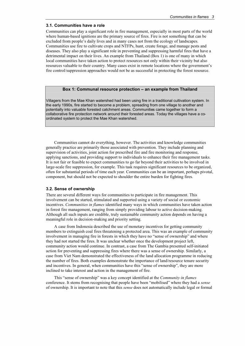
3.1. Communities have a roleCommunities can play a significant role in fire management, especially in most parts of the worldwhere human-based ignitions are the primary source of fires. Fire is not something that can beexcluded from people’s daily lives and in many cases not from the ecology of landscapes.Communities use fire to cultivate crops and NTFPs, hunt, create forage, and manage pests and diseases. They also play a significant role in preventing and suppressing harmful fires that have a detrimental impact on their lives. An example from Thailand (Box 1) is one of many in whichlocal communities have taken action to protect resources not only within their vicinity but alsoresources valuable to their country. Many cases exist in remote locations where the government’sfire control/suppression approaches would not be as successful in protecting the forest resource.
Box 1: Communal resource protection – an example from Thailand
Villagers from the Mae Khan watershed had been using fire in a traditional cultivation system. In the early 1990s, fire started to become a problem, spreading from one village to another and potentially into valuable forested catchment areas. Communities came together to form a collaborative fire protection network around their forested areas. Today the villages have a co-ordinated system to protect the Mae Khan watershed.
Communities cannot do everything, however. The activities and knowledge communitiesgenerally practice are primarily those associated with prevention. They include planning andsupervision of activities, joint action for prescribed fire and fire monitoring and response,applying sanctions, and providing support to individuals to enhance their fire management tasks. It is not fair or feasible to expect communities to go far beyond their activities to be involved inlarge-scale fire suppression, for example. This task requires significant resources to be organized,often for substantial periods of time each year. Communities can be an important, perhaps pivotal, component, but should not be expected to shoulder the entire burden for fighting fires.
3.2. Sense of ownershipThere are several different ways for communities to participate in fire management. Thisinvolvement can be started, stimulated and supported using a variety of social or economicincentives. Communities in flames identified many ways in which communities have taken actionin forest fire management, ranging from simply providing labour to active decision-making.Although all such inputs are credible, truly sustainable community action depends on having a meaningful role in decision-making and priority setting.
A case from Indonesia described the use of monetary incentives for getting communitymembers to extinguish coal fires threatening a protected area. This was an example of communityinvolvement in managing fire in forests in which they have no “sense of ownership” and wherethey had not started the fires. It was unclear whether once the development project left,community action would continue. In contrast, a case from The Gambia presented self-initiatedaction for preventing and suppressing fires where there was a sense of ownership. Similarly, a case from Viet Nam demonstrated the effectiveness of the land allocation programme in reducingthe number of fires. Both examples demonstrate the importance of land/resource tenure securityand incentives. In general, when communities have this “sense of ownership”, they are moreinclined to take interest and action in the management of fire.
This “sense of ownership” was a key concept identified at the Community in flamesconference. It stems from recognising that people have been “mobilised” where they had a senseof ownership. It is important to note that this sense does not automatically include legal or formal
4 Communities in flames
ownership and does not only apply purely to land or tenure security. In some areas of the UnitedStates, Germany, New Zealand and Australia, land ownership and resource access rights do notdirectly result in a “sense of ownership” of the fire management issue. In one case fromCalifornia, community concerns about fire management were ignored by state and federalgovernment agencies until the community took collective action to demonstrate their “sense of ownership” of public lands. The comfort and ability to make decisions about fire and its management is often based in this concept of “sense of ownership”. Conversely, the absence of this sense or the destruction of it through circumstance or third party action may eliminate localpeople’s interest and motivation to be involved in fire management.
The existence of incentives is a factor that appears to be intimately associated with this“sense of ownership”. The provision of some sort of benefit, formally or traditionally, appears tobe a key element in the active participation of communities in management of fires. Some incentives are short term and costly, but necessary. Others may be longer term and lower cost, butalso very worthwhile. A closer analysis of these incentives and their outputs is necessary. It wasclear that incentives in Africa and Asia have some similarities in design, but are different in termsof outputs and relative levels of success.
In the past, cases of CBFiM have been assessed as successful by only a segment of society.“For whom is CBFiM successful?” is an important question that emerged during the keynoteaddresses (Box 2) and numerous other times at the conference. The benefits may also be shortterm in nature and highly specific. Benefits may accrue to only a segment of the community. Or, they may be beneficial to the community, but not to stakeholders outside the community. There is a clear need to be explicit about who benefits and how impacts accrue. In most cases, the users of fire benefit while others (e.g. urban dwellers, transport and tourism industry) perceive fire to be largely negative. It will be necessary to fully assess community needs and uses of fire as well as the appropriate conditions and strategies for CBFiM success. In these aspects, it is important toclearly understand what is meant by “community” and “community-based” approach.
Box 2: Keynote addresses
William Jackson (Global Co-ordinator, The World Conservation Union [IUCN]’s ForestConservation Program) introduced the premise that community participation is not just labour supporting fire prevention and suppression but is rather local people managing fire in terms of their own needs.
Somsak Sukwong (Executive Director, RECOFTC) stated that the success of community-based fire management should be measured on the basis of its appropriateness for meeting the community’s needs and management objectives.
3.3. Context of “community” and “community-based” within CBFiMThere is a large body of knowledge on, and examination of, the definition of communities andcommunity-based approaches in other fields such as anthropology, community-based forestmanagement and other disciplines of the social sciences. This material should be considered and incorporated in the evolution of an understanding of communities in the context of fire. Indeed,many of the lessons learned from community involvement in forest management are directlyrelevant to CBFiM and it would be wise for advocates to recognise this and avoid re-discoveringand duplicating existing information and understanding. CBFiM proponents maintain that thereare potential and important linkages among CBFiM, land-use planning, natural resource management and overall community development processes. CBFiM cannot functionindependently from these other processes.
Communities in flames 5
The context of communities is central. Brazil, Indonesia and, to a lesser extent, the Congo Basin can be identified as “frontier” situations where rapid change and development are takingplace and natural resources are being heavily used. In time, the change processes will slow downfor various reasons and conditions should stabilise. At present, the rapid and profound change is a major influence. Conversely, the circumstances in Mongolia, parts of China and East Africa arecharacterised by low population densities and consequently a different context for communityinvolvement with fire. Other countries have varying conditions and complex circumstancesrequiring careful assessment and comprehensive analysis.
The term “community” in the context of CBFiM could be taken broadly to include ahousehold, a group of households, a settlement, or a group of settlements. Generally, a singlehousehold is not considered a community. For example, under the land allocation programme inViet Nam, the household is an important functional unit for encouraging community forest -including fire - management. Within a well-defined community, sub-groups or other stakeholdersmay also have different interests in how fire is managed (Box 3). All of these sub-groups arestakeholders and their uses of fire should be considered when developing CBFiM.
Box 3: The importance of “community” - an example from East Kalimantan
The community living around Sungai Wain Protection Forest has 14 sub-groups. Each of thesesub-groups will likely have varying knowledge and experience with fire management or perhaps none at all. Some have noted that new migrants to East Kalimantan are partially responsible for some of the harmful fires because they watched and mimicked neighbours clearing land with firewithout an understanding of fire as a management tool in their new surroundings.
The term “community-based” in the context of CBFiM is much more than community labourin fighting fires. It is also important to recognise that community “involvement” covers a widespectrum of situations, from potentially forced participation in an activity (coercion) to free and willing participation in actions developed by the actors themselves (empowerment). The emphasis of “community-based” is sometimes focused on community involvement alone; at other times,CBFiM has been recognised and supported by external agencies (governments, non-governmentorganizations [NGOs], projects and others). This may include support to an existing indigenoussystem by formalising, modifying, or otherwise elaborating on it, or instituting new systems.
3.4. Indigenous knowledge - justified emphasis or overstated?Investigations on communities and their interaction with their environment have often uncoveredsignificant information, knowledge and wisdom on natural resource management. Firemanagement is no exception and the value of this community memory is enormous. There are,however, some caveats with respect to traditional knowledge. One critical understanding is that traditional knowledge is not always recognised as dynamic knowledge. The information and itsapplication change through time, as do the conditions and circumstances in which it is used.Notably the traditional approaches may progressively be lost as the world moves through a periodof change and communication unlike any other in history.
Traditional or local knowledge itself is insufficient to ensure sound, effective fire management.Institutional structures - both within and beyond the community - and the capacity to apply theknowledge are needed. While pertinent, timely and appropriate knowledge about fires is useful, it will be of little use without the community institution to organize and direct the application of theknowledge. Integration of traditional approaches into a fire management system will need a concertedeffort by all stakeholders to build constructive partnerships that recognise the importance of attitudestowards fire, roles in decision-making and securing incentives for balanced fire management.

6 Communities in flames
Varying emphasis has been placed on identifying indigenous practices for using fire as a management tool. The conference recognised that communities often possess much knowledge about fire. However, the context for fire on the landscape is dynamic, for the same reasons that ecosystemsand social systems are dynamic. Fires are becoming a problem in parts of the world where historicallythey were never considered a problem. Shifting population, changing land-use patterns, globalisationand (potentially) global warming are just a few factors that are changing the demographics andecological circumstances in which fires seem to be occurring more often. In addition to a greaterfrequency of events, fires have been reaching greater sizes than previously experienced. If CBFiM isto be culturally sensitive, sustainable and responsive to a community’s socio-economic needs, thenlocal-level information and experiences need to be examined and understood.
There are cases that demonstrate the use of fire can be sustainable in agricultural, pastoral or agro-pastoral systems. Many of these sustainable systems have depended on locally basedknowledge being passed on from generation to generation. The erosion of fire-related communityknowledge has taken place through the dislocation of people from their traditional settings and byyounger generations disassociating themselves from the elders holding the knowledge. Increasesin population, or in some cases relocation policies, can also change the sustainability of local firemanagement systems. In cases from India (Box 4), Indonesia and Thailand, traditionalagricultural practices have been eroded by shifting demographics, both from the young moving tourban centres for work as well as from relocation policies intended, in part, to reduce populationpressures on the resources. As a result, many sustainable fire management systems are being lostand there is an urgent need to document CBFiM approaches and their indigenous practices.
Box 4: The impact of changing demographics on traditional agricultural practices – an example from northeast India
Modern Mizo society has replaced the traditional practices of jhumming or shifting cultivation. In a typical village in which 50 percent now depend on the jhumming, its role has been weakened inthe society and consequently undermined CBFiM approaches. In this part of India, there has been a gradual transfer of responsibility for fire to government agencies, and as a result of limitedresources, fire has become a problem where once it was part of daily life and subsistence.
In contrast, some knowledge may be valid and highly useful but not traditional. Spontaneousand forced migrant communities may develop sound approaches in dealing with fire in their newsettings. There are also examples where such communities have not adapted appropriately and fire becomes a problem for the local environment and landscape. In some cases, this misapplicationhas led to social conflict between groups. Clear examination of who holds the knowledge used inmanaging fire is necessary. This can be difficult to determine. In the case of the Sungai WainProtection Forest (Box 3), less than 20 percent of the local population was originally from East Kalimantan and the community contained 14 different ethnic groups. Communities are also notstatic and traditional knowledge may not have originated in the locality where it is observed.Without careful identification of its origin, fire knowledge may also be associated with the wrongethnic or sub-group. Transferring lessons between communities, in different provinces, nations or regions and establishing principles and common elements of CBFiM will be delayed andconfused if the source of fire management knowledge is unclear.
4. The way forwardTo transfer lessons between communities, in different provinces, nations, and regions, there is a need for improved education and training which recognise the technical and organizationalcapacity of communities in managing fire, historically and culturally. Integral to this education
Communities in flames 7
and training is the need to evaluate the effectiveness of community-based approaches withconsistency and rigor. It is especially necessary to enhance awareness of fire management issues and the effectiveness of CBFiM approaches to those external agencies that do not yet recogniseand support it. A communications strategy has been suggested to facilitate this process.
4.1. CommunicationsCase studies are useful and many of those presented at the Communities in flames conferencewere well prepared. However, the concepts, ideas and principles should be widely shared throughcommunications and advocacy to stimulate adoption and organizational change. The conferenceprovided a stronger base of materials for convincing stakeholders about the role of CBFiM inbalanced forest and natural resource management. There is sufficient information and understanding for communications and advocacy to commence. Proponents should not simplyadvocate CBFiM’s merits to those already convinced of its value, but rather should aim atpersuading non-believers to accept the role of CBFiM. A target audience accessible to many ofthe conference participants are those being trained at universities in forestry, natural resource management, rural planning and development. These disciplines needed to be exposed to theperspectives of the community on fire, both as a specific topic and as examples of howcommunities can be sensible stakeholders in natural resource planning and management.
The papers and case studies presented at the Communities in flames conference will offer a solid foundation for increased advocacy related to CBFiM. A fact sheet on CBFiM will also beprepared and widely circulated to provide a summary of the understanding and messages from the conference, and as an initial exposure to CBFiM for those who have not yet encountered it. The Communities in flames participants numbering more than 120 people from over 20 countries(from a wide range of donors, governments, government agencies, international and local NGOs, projects, academic institutions and the private sector) make up a formidable cadre of advocates forCBFiM. Many are already members of networks and fora that operate worldwide and encompassthe full range of communities, natural resource management, forestry and development. The combination of the products of the conference and the scope of the participants’ interests and professional contacts provides a strong opportunity for the key messages of the conference to be heard around the world at both field and policy-making levels.
As people clarify and contribute to the body of knowledge on communities and fire, thepotential exists for identifying general models of CBFiM for others to experiment with and adapt.The starkly different contexts and the wide range of human, economic, political and ecologicalcircumstances sound a warning of caution for transferring lessons. The “community” of localpeople, academics, government officials, project staff, individuals who work in donor agenciesand NGOs has to clearly frame how to transfer lessons effectively. The challenge is to learnlessons and identify common principles from within the diversity of experiences and situations.
It is also valuable to identify the lessons inherent in failures. In many cases, efforts to buildawareness and promote CBFiM actions have been difficult and the experiences negative. Whycertain efforts fail, and the options for coping with failure, are potentially just as important as compilation of success stories.
4.2. A typology for CBFiMDespite the efforts of the Communities in flames conference to document cases from around theworld, there is still a clear need for further enhancement and documentation on the different levelsof community participation in fire management.
At the conference, the need to develop a typology or characterisation of communities and their approaches to manage fire was identified (Box 5). The need to frame the concepts while atthe same time remaining flexible creates a challenging tension. It is essential to ensure that anycategories arising from such analysis and synthesis do not become “boxes” into whichcommunities are placed, labelled and from which they have difficulty extracting themselves. A major emphasis emerging from the conference papers was one of diversity, unique circumstances
8 Communities in flames
and varying context. The placement of elements into a typology that is flexible would enableclearer and more effective dissemination of the diverse approaches of CBFiM (where it exists, itsstrengths and the need for particular forms of incentives, support or motivation).
Box 5: The need for a typology
Cases from The Gambia and the Western United States demonstrate the need for a typology.These cases provide interesting similarities in the use of multi-stakeholder fora to discuss fire management systems but within very different socio-political and biophysical contexts. The Gambia, having adopted principles of community forestry, and the Western United States, with its strong private property rights regime, are dynamically different circumstances for CBFiM. Atypology as a mechanism to systematically identify elements of difference and those held in common will support the effective transfer of lessons among communities and the development of principles for CBFiM.
The blending of understanding and information about elements that are important (successes,failures, and key factors) should be considered at the wider scale. To identify the “system”elements that enable (or prevent) CBFiM, the broader aspects at the system or programme levelmust be evaluated. These include the policies, laws, macro-economic intentions (and the institutions that represent them) and their implementation. A review of these elements from beyond the community level is needed to support the points for discussion, lobbying and advocacy with stakeholders at the system or programme level (e.g. government agencies, nationalgovernments, donors, NGOs). This improved understanding at the wider system scale should alsocreate the opportunity to identify where, and perhaps how, communities can be connected to otherlevels of local, provincial and national governments and international actors.
5. SummaryFire cannot be ignored as a factor in forestry, natural resource management and developmentactivities. The Communities in flames conference underscored the fact that people around theworld are concerned to different degrees about fire. Fire is not something that can be excludedfrom their daily lives and, in many cases, not from the ecology of landscapes. The connectionbetween communities and fire is often based on economy (livelihoods, commercial activities andimpacts) and in the longer term, also on public health. A clear examination of communities, theirapproaches to manage fire and the other stakeholders in fire issues is necessary to promoteCBFiM at higher levels. This will serve as the basis for clarifying objectives for constructivedialogue between interested parties on how to manage fire in the landscape.
The dynamic nature of the world and its changing actors was evident during the conference.No single actor, whether government or civil society, can solve the serious social, economic andecological threats from forest fires. It is essential that constructive partnerships are formed and stakeholders work together with NGOs, governments, the private sector and communities.
The Communities in flames conference was a first step in developing awareness of the role of communities in managing fire. It identified many ways in which communities have taken actionin forest fire management and the need to give credibility to this role, but not to overstate it. In addition, the conference suggested possible approaches that might be necessary to move beyondisolated examples to broader implementation based on system elements. These system elementsmay be useful to local, provincial and national governments as well as international actors as theyseek more cost-effective alternatives to managing fire in an increasingly fire prone-world.

Communities in flames 9
ReferencesGanz, D., Moore, P.F. & Shields, B.J. (2001). Report of an International Workshop on:
Community-based Fire Management. Organized by RECOFTC and Project FireFight SouthEast Asia, Kasetsart University, Bangkok, Thailand, 6-8 December 2000.
Jackson, W.J. & Moore, P.F. (1998). The role of indigenous use of fire in forest management andconservation. International Seminar on Cultivating Forests: Alternative Forest ManagementPractices and Techniques for Community Forestry. Regional Community Forestry TrainingCenter, Bangkok, Thailand.
10 Communities in flames
Community involvement in fire management: cases and recommendations for community-based fire management in Thailand
Pearmsak Makarabhirom, David Ganz and Surin Onprom1
AbstractFires are not new to the landscapes of Thailand. In general, wherever there are people, there arefires, as the two have been culturally linked for centuries. In rural areas, people have used fire as aland preparation tool, for promoting annual grasses for grazing livestock, to facilitate mushroomand bamboo cultivation, and to assist in hunting and land clearing. Such land management has generated benefits to some people and costs to others.
Fire management in Thailand is a community issue that needs to be addressed by a community-based approach. This paper reviews some of the local knowledge, experiences andlessons learned from those working with community-based fire management in Thailand to synthesise the current knowledge base and summarise some key points.
1. Introduction
“In the old days during the dry season, community leaders would mobilisefire prevention activities by striking a gong three times a year; once in late January, once in late February and once in the middle of April. This gongsignalled to the community to take collective action to manage the fuels in areas in and around the community to protect itself from forest fires. Today,collective action rarely occurs due to weak community leadership and thegovernment’s insistence that it has the sole responsibility to manage forestfires.” (Senior villager of Ban Pabong, Moo 1, Mae Hong Son Province.)
People and fire have been culturally linked in Asia for centuries. Communities in Thailandhave long been engaged in fire management. Fires in Thailand have many causes and impacts dueto people’s forest and land uses. They can spread from paddy fields to the forest, from the forestto the paddy fields, or from the paddy fields or forests into villages and vice versa.
Traditional knowledge of fire management is clearly manifested in Thailand. People haveprotected their communities from fire by digging fire lines around homes and temples. Backfiresare also used to stop approaching fires. Villagers are aware of the potential fire damages and havecontrolled the spread of fire to minimise destruction of community assets.
In 1998, forest fires occurred across Thailand destroying thousands of hectares in Huay Kha Khaeng, Khao Yai, Dong Yai, Mae Wong, Phu Kradeung, Phu Rua and Phru To Daeng. Thesefires, coupled with the haze from other fires in the region, affected many people. The latest fire episode has caused major concerns at every level of society and changed people’s view of rural people in Thailand from being victims of circumstances to being the cause of these fires.
The latest El Niño episode has triggered the preparation of many governmental and inter-governmental plans for regional programmes to prevent and control forest fires and haze in SouthEast Asia. In Thailand, the results of these actions are confusing and often misinterpreted. The government has decided that farmers must inform the local authorities before burning cropresidues in their paddy fields. Cabinet-level decisions were amended because burning for land clearing was identified as a potential cause of forest fires (Makarabhirom, 1998). In addition, a
1 Regional Community Forestry Training Center (RECOFTC), Bangkok, Thailand.

Communities in flames 11
Royal Forest Department (RFD) official proposed that the drafted Community Forest Bill(currently being processed in the Parliament) should not be passed. He claimed that communityforestry would perpetuate some of the causes of fires and, to prevent forest fires, no one should bepermitted to stay in or around protected areas.
These arguments have led to hostile debates and increased conflicts between the governmentand villagers. Organizations supporting community-based natural resource management areconcerned about the widespread misperceptions and misrepresentations. This paper reviews localknowledge, experience and lessons learned about community-based fire management (CBFiM) inThailand. It synthesises the current knowledge base and clarifies some misrepresented and poorlyunderstood issues.
2. Fire, rural life and misperceptionsFire is a universal tool used in forest management, particularly in site preparation, control of pestsand diseases, and the reduction of fuel loads. Such practices also represent a potential cause of large-scale forest fires. Poor villagers living in and around forests have little choice but to use fires for:
♦ land preparation for crop production;
♦ promotion of mushrooms such as hed poa (Astraeus hygrometricus);
♦ promotion of leaf growth of species like pak waan (Melientha suavis);
♦ cultivation and promotion of bamboo or grass shoots such as phai paa (Bambusaarundinaceae) and phai pek (Arundinaria purilla);
♦ promotion of seed germination of species such as teak (Tectona grandis);
♦ hunting wildlife such as wild pig (Sus scrofa), barking deer (Muntiacus muntjak), lan (Varanus bengalensis) and wild fowl;
♦ managing growth of a grass called yaa mai guard (Thysanolaene maxima) for theproduction of brooms (an activity undertaken by community groups in Nan Province); and
♦ promotion of yaa ka (Imparata cylindrica), which is commonly used for makingthatched roofs.
Some 40 years ago, many Thai development policies identified rural communities as a causeof forest fires. Since that time, communities have been blamed for forest destruction anddegradation. Yet, they are the ones affected most by the loss of the forest resources that theydepend on. Over the decades, traditional and cultural practices have been replaced and eroded byeconomic development and the introduction of commercial farming. This has resulted in the lossof indigenous knowledge of and community responsibility for fire management, transferring theonus to the government instead. The consequence of this detachment is that fire is no longerregarded as a useful tool, but rather a danger to the communities.
Since many communities have adopted various unsustainable practices, fire has moreharmful effects. In highland communities, these effects are more apparent due to higher fireintensities. At mid to high elevations, the fire risk is greater as high fuel loads, steep slopes and prevailing climatic conditions make fire behaviour unpredictable. Highland communities faceintense fires in demanding terrain, thus requiring more elaborate fire management approaches.
The rapid expansion of agricultural development into previously forested highland areas haschanged fire management from being a community concern to a nation-wide issue. The use of slash-and-burn cultivation to produce export crops is widely practised and has resulted in poorly managedfires. Since the introduction of “high-tech” intensive agricultural production systems, many highlandvillages have changed their tenurial systems from collective ownership to more individualarrangements, which have contributed significantly to regulatory problems. The abandonment ofrotational shifting cultivation practices also makes fire management more difficult.
Traditional uses of fire and forest resources have changed considerably with altered land-usepatterns and resource scarcity. In the past, some of the highland groups in Northern Thailand (e.g.Karen and Lua) practised rotational shifting cultivation. They had secure rights over the land that they

12 Communities in flames
farmed, felt close to the land and the forests, and returned back to the same land after long fallowperiods. Today, the government has assumed ownership, which in general has resulted in unclear landand resource security. When a fire breaks out, highland communities make no attempts to control it, as they have lost resource tenure and access. In addition, communities find it increasingly difficult toimpose rules and regulations on outsiders because no tenure agreements with government counterpartsare included in present regulations. This land tenure insecurity, and not the rotational shiftingcultivation system per se, has increased forest fire problems in highland communities.
More uncontrolled fires are also occurring in Thailand due to climatic changes and fuel accumulation in dry dipterocarp forests. The villagers realize that uncontrolled fire destroys notonly physical components of the ecosystem, but impacts also on social systems. Many communityrelationships disintegrate due to problems associated with fire events (Anan Duangkaewruan,1999). For example, the social structure of the Mae Tha community in Chiang Mai Provincebroke down after a large fire that brought on drought and social problems, forcing the villagers tosearch for off-farm employment. In the Silalang Sub-district of Nan Province, permanent cropproduction and burning of the forest also led to drought and crop failures (Sathaporn, 1999).
The causes of forest fires continue to be debated. Some people argue that monocultures or inappropriate agricultural production is the main cause. Others point to poaching and recreationalfires. All these activities cause forest fires and in looking for solutions the emphasis should not be on how fires start but what the underlying causes are and why fires are started.
The villagers’ dependence on forest resources, particularly non-timber forest products(NTFPs), is the main reason for burning the forest. They believe that fires stimulate the growth of mushrooms and wild vegetables. Unsustainable development and government policies haveperpetuated their forest dependence by changing land-use patterns and imposing restrictionswithout an adequate analysis of potential impacts on local livelihoods. Impacts of alternative firemanagement approaches should be analysed, and communities and the authorities should be informed of the costs and benefits of fire on forest resources and the appropriate ways to controlfire (Nugen, 1999).
3. Community-based fire management: rationale and developmentMany academics, policy makers and development workers are debating whether communities arecapable of managing forest fire. The academic community has supported CBFiM by clearlystating that the community is the key to the survival of forests through integrating indigenousknowledge, conservation values and sustainable livelihoods. Managing the forest with the fullinvolvement of community members is more effective for managing fire if it is an entrenchedsocial responsibility in the first place (Chamarik and Santasombut, 1994; Wasee, 1996; Sukwong,1998; Ganz et al., 2001).
Many communities have strong traditions that help enhance forest richness – biological and cultural diversity – through innovative means of forest fire management and integrated forest management. After all, it is in their best interest to manage the forest and forest fires to meet theirlivelihood needs. They realize that short-term solutions like fire lines – if they are well maintained– can only provide protection against fire itself. They cannot stop people from setting fires. Thisimplies that forest fire management requires the long-term commitment and co-operation not onlyof community members but also those of outsiders. One example of this broader approach is establishing networks of communities that share similar problems (Box 1).
Opportunities for CBFiM exist all over Thailand. At present the financial resources devotedto fire prevention and suppression are not spent effectively. Although the budget for governmentalfire management and the number of Forest Protection Units have increased, forest fire occurrences have also escalated. If implemented on a large scale, CBFiM is likely to improveforest management and reduce costs to the government.
Communities in flames 13
Box 1: The forest fire management network of Mae Khan Watershed
Villagers of Mae Khan Watershed have long been using indigenous knowledge to manage fire aspart of their rotational shifting cultivation system. In the early 1990s, fires increasingly spreadoutside the village. In response, villagers developed a collaborative fire protection plan for the whole village. As time passed, fires began to encroach on the village. As a solution, the villagersapproached neighbouring communities to set up a collaborative fire protection network around the forest areas. Now, the concerned villages co-ordinate their efforts in community-based forest firemanagement for protecting the watershed.
For CBFiM to be effective, three fundamental components need to be understood:
♦ ecology and forest fire behaviour, particularly forest fire regimes;
♦ the community, particularly its needs and the behaviour of its members; and
♦ the relationships between fire and the community.
A fundamental understanding of fire ecology is necessary as communities are managing fire– or ought to be managing fire – within a certain fire regime that is suitable for the ecology of the forest type under forest management. A situational analysis at the village level is necessary toconsolidate critical information on opportunities for and constraints to implementing CBFiM. This analysis considers the natural, political and socio-economic environment. The integration ofinformation about the fire regime, the variety of stakeholders and the situational analysis into anoperational plan is the basic premise of decentralised fire management. The Thai governmentshould take the leadership in CBFiM in the region and ensure that the modernisation of forest firemanagement in Thailand is based on sound knowledge.
4. Forest fire management: a call for collective planningFire management is part of forest management planning. This has been evident in the Mae Tha community of Chiang Mai, Na Pho Nue village of Ubon Ratchatani, Ka Lor community of Yala and Rom Pho Tong village of Chasoengsao (Box 2). Forest management requires a plan that considers and provides for community benefits. Similarly, proper fire management calls for a fire management plan that responds to community needs. For example, if the community relies onmushrooms or young grasses for its livestock, or has fruit trees that need to be protected, then annual prescribed burns should promote the growth of mushrooms or young grasses, whileensuring that the fruit trees are not destroyed.
Box 2: Collaborative fire management in Ban Rom Pho Tong, Eastern Region
Fire management planning and activities are part of Rom Pho Tong Village’s community forestmanagement plan. In 1995, a community forestry development programme was prepared, followed bya management plan in 1997. The villagers co-operated with the local Forest Fire Control Unit to trainvillage forest fire volunteers. Forest fires still occur but are less likely to cause substantial damage.
In 1998, the Community Forestry committee started to extend its fire management network to the neighbouring communities of Ban Khao Klui Mai and Ban Sam Pran. A few months later, the networkreached 20 villages around the eastern forest. During monthly network meetings, the forest fire situation in each village is discussed together with other development and conservation activities. A self-motivated forest fire network has been initiated as a result of the meetings and the collective action on forest fire management.

14 Communities in flames
As several cases indicate, there are strong linkages between CBFiM and other developmentand conservation activities. CBFiM should be considered a component of land-use planning andnatural resource management. Rather than taking on an independent identity, it should be an integral part of an overall community capacity-building process.
5. Promoting participation in fire management: a four-step processStep 1. Agreeing on common objectives and a collaborative management planIn fire management, clear objectives are necessary. They must address all actors with vestedinterests in the forest area with regard to:
♦ where to control fires;
♦ where to burn; and
♦ what methods to use.
Clear and agreed upon objectives avoid misunderstandings and frequent jurisdictionalproblems. If the villagers request that local organizations should take charge of fire management,then the Fire Control Units should provide information and training to all actors to raise awareness of the roles and responsibilities of each member of the community.
Step 2. Managing the budget by local authoritiesFire management costs money. Many problems and obstacles (e.g. the lack of equipment, budgetsand personnel) restrict government agencies from collaborating with communities to manage fireeffectively. To remedy this situation, communities must be informed about financial problems and ask for the support of local organizations such as sub-district councils and the localadministration. Alternative and innovative funding mechanisms need to be sought at the locallevels. Financial systems that will show how CBFiM can be effective while reducing costs shouldbe encouraged.
Step 3. Supporting information for fire managementMany villagers are interested in information on the effects of fire on the production of mushroomsand other NTFPs. Unfortunately current research on such issues is very weak. Credible researchand the timely dissemination of appropriate technologies are needed to influence the adoption ofimproved practices.
Step 4. Shifting from protection and suppression to managementForest fire management in Thailand has been centralised within one government department.Recent valuable experiences in CBFiM and collaborative fire management with other governmentprojects are disregarded. Research potentially leading to improved fire management is ignoredand community involvement in decision-making is difficult to promote. The followingrecommendations can help improve fire management:
♦ Increase community involvement in forest fire management
♦ Adjust existing laws and policies, as appropriate, to enhance community involvement infire management
Policies and laws need to promote collaborative management and the co-operationbetween people and government agencies
♦ Search for alternative ecologically sound forest fire management
Improved forest management is required for managing forest fires, especially inwatershed areas.
Communities in flames 15
♦ Analyse forest fire management experiences to identify opportunities for improvedcommunity collaboration
Participatory analyses are necessary to investigate the forest fire situation, which willaid in collaborative planning and applying religious rites – such as forest ordinations –to raise people’s awareness to conserve forests, and assist in enrichment tree planting,natural forest restoration and fire management activities.
♦ Provide technical knowledge on fire management
Technical knowledge on fire management should be extended to all actors. Trainingshould be provided not only to highland but also to the foothill and lowlandcommunities who also use fire in land-use practices.
♦ Conduct research to support management decision processes
Greater efforts should be placed on understanding the effects of fire on forest products.If alternatives are found to manage NTFPs that villagers depend on and information is adequately disseminated, then a reduction in the number of fires may follow.
♦ Develop local networks to support fire management
Encourage the establishment and development of local groups and organizations in eachcommunity for the planning and implementation of fire management. If theseorganizations (e.g. village committees or groups of teachers, youth and women) canwork together with the officials at the community level, then fires will be managedefficiently.
These seven recommendations are based on the principle that “fire management is the jointduty of all people and organizations to plan.” Therefore, it is necessary that the communities,officials and non-governmental organizations plan how to manage fire together. The co-operationof the communities is absolutely necessary as they can develop and implement fire protectionmethods faster and more effectively than outsiders (Sathaporn, 1998). Local communities haveclear understanding of local conditions and circumstances important for successful firemanagement.
ReferencesAnan Duangkaewruan. (1999). Personal communication.
Chamarik & Santasombut (eds.). (1994). Community forest in Thailand: development trend. Copy No. 1. Local Development Institute, Bangkok.
Ganz, D. J., Moore, P. & Shields, B. (eds.). (2001). Workshop report, International Workshop on Community Based Fire Management, December 6-8, 2000, RECOFTC Training andWorkshop Report Series, 2001/3. Bangkok.
Makarabhirom, Pearmsak. (1998). Forest fire management and globalisation: lesson learned andrecommendations. Community Forest Newsletter 5 (10): 4-12. RECOFTC, Bangkok.
Nugen. (1999). In Summary of a National Seminar on Participatory Forest Fire Management,held at RECOFTC 9-10 February 1999, RECOFTC, Bangkok.
Sathaporn. (1999). In Summary of a National Seminar on Participatory Forest Fire Management,held at RECOFTC 9-10 February 1999. RECOFTC, Bangkok.
Sukwong, Somsak. (1998). Local culture “Khao Mor Kang Mor” for fighting forest fire. In Community Forest Newsletter 5 (10): 13-15. RECOFTC, Bangkok.
Wasee. (1996). Community forestry development in Thailand. RECOFTC, Bangkok. pp. 27-34.
16 Communities in flames
Learning across borders: community-based firemanagement – Kalimantan to California
Judith Mayer1
AbstractCommunities in very different places are initiating participatory fire management planningprocesses. This paper raises questions about the effectiveness of transferring experiences from one place to another, based on recent examples from northern California, USA, and West Kalimantan,Indonesia. Reforming approaches to fire management is both politically and technicallychallenging. Vastly different political and administrative systems, and unequal technologicalcapabilities make many apparently sensible approaches unworkable in the foreseeable future.Transferring some practices and assumptions may actually endanger ecosystems and people,demanding that planners “first, do no harm”. Despite demands for caution, in Kalimantan andCalifornia there is a growing consensus that participatory and collaborative initiatives offer themost promising approaches to effective fire management.
1. What is at stake?During the past decade, wildfires, more extensive and intense than any in historical memory, havedevastated large areas of both Kalimantan and California. Fire has become one of the foremostconcerns of rural communities in both locations, and to people alarmed about the future ecologicalintegrity. Communities initiated new approaches to solving fire problems in Kalimantan andCalifornia, in response to their own local concerns, to ensure that their interests would be represented in the face of pressure and neglect from distant governments and commercialinterests. Many of these efforts on opposite sides of the globe share common features. Yet, some of their issues also deviate sharply, due to differing causes and contexts of fires. Community-based fire management initiatives have developed local, regional and landscape-scale planning toprevent future wildfire catastrophes, locally appropriate rules for burning practices for “legitimate” purposes, procedures for containing or suppressing fires that are out of control and recommendations for broader policy changes to reflect local interests.
New approaches in fire management are often modelled on systems that appear to workelsewhere. Most people assume that they can learn useful lessons from experiences ofcommunities in places far from our own. Yet, we must be cautious in transferring lessons orapproaches from one location to another. Differences in fire ecology, politics and administration,technology, culture and other factors may invalidate our assumptions about fire management for that other place. How can we know which aspects of fire management systems developedelsewhere will work in our own contexts, and which will be ineffective, or even harmful? Few tools help us test the appropriateness of models for locations that they were not designed for.
This paper raises questions about the effectiveness of transferring experiences from one placeto another. Recent examples of involving communities in fire management in northern California,USA, and West Kalimantan, Indonesia, provide interesting insights (Figure 1). The work innorthern California draws mainly on experiences from Trinity County, associated with the effortsof the Trinity County Fire Safe Council, a consortium of local, state, and federal governmentalagencies, and non-governmental citizens bodies. The work in West Kalimantan draws largely on work supported by the U.S. National Science Foundation, and in conjunction with a fire researchproject by the Center for International Forestry Research (CIFOR), the International Centre for Research on Agroforestry (ICRAF), the United Nations Educational, Scientific, and Cultural
1 Virginia Polytechnic Institute and State University, Department of Urban Affairs and Planning,Blacksburg, Virginia 24061, USA, email: [email protected]

Communities in flames 17
Organization (UNESCO), the United States Department of Agriculture Forest Service (USFS), theU.S. Agency for International Development, Yayasan Pancur Kasih and Yayasan Dian Tama.
Figure 1: Location of study sites
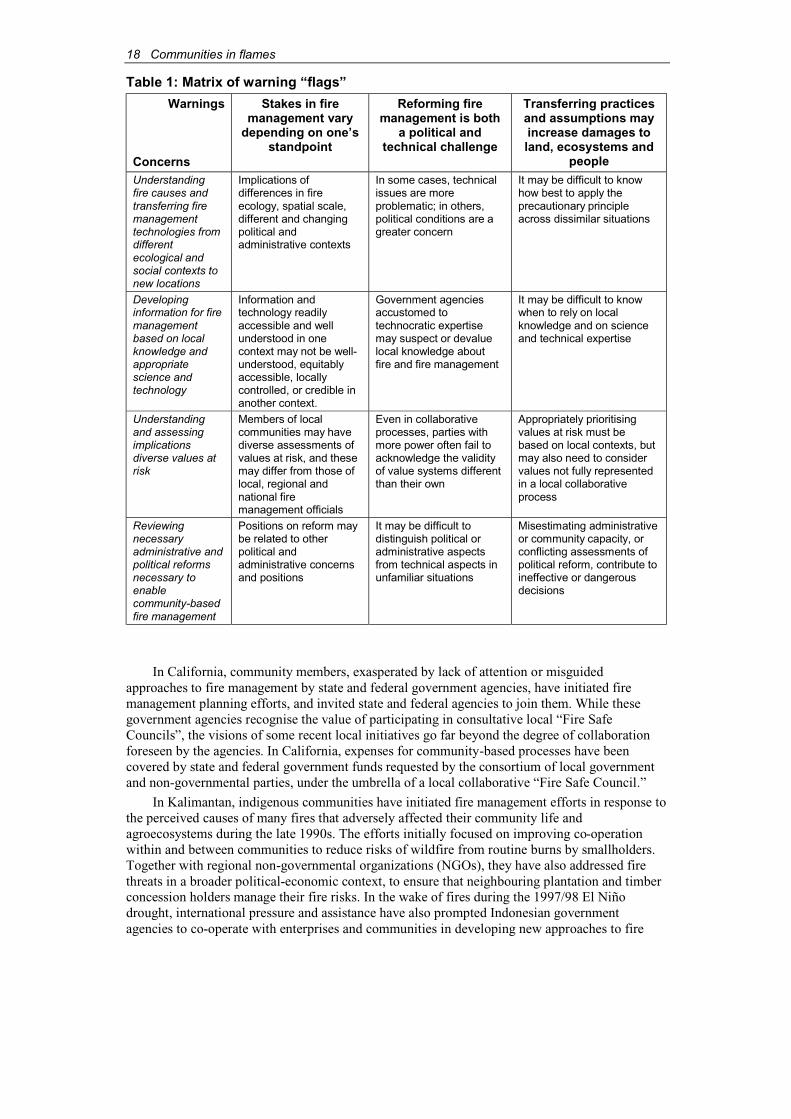
This paper also highlights the potential of cross-regional lessons, and warns of dangers oftransferring models or assumptions, with four areas of concerns:
♦ understanding fire causes and transferring fire management technologies from differentecological and social contexts to new locations;
♦ developing information for fire management based on local knowledge and appropriatescience and technology;
♦ understanding and assessing diverse values at risk; and
♦ reviewing necessary administrative and political reforms to enable community-basedfire management.
In comparing and applying lessons of and approaches to community involvement in fire management, it is necessary to consider:
♦ Stakes in fire management vary, depending on one’s standpoint.
♦ Reforming approaches to fire management is both a political and a technical challenge.
♦ Transferring some practices and assumptions may increase damage to land, ecosystemsand people.
Combining the four concerns with the three notes of caution generate a matrix that raiseswarning “flags” to indicate the appropriateness and limitations of transferring knowledge (Table 1).
18 Communities in flames
Table 1: Matrix of warning “flags”
Warnings
Concerns
Stakes in fire management vary
depending on one’s standpoint
Reforming fire management is both
a political and technical challenge
Transferring practices and assumptions mayincrease damages to land, ecosystems and
peopleUnderstandingfire causes andtransferring firemanagementtechnologies fromdifferentecological andsocial contexts tonew locations
Implications ofdifferences in fireecology, spatial scale,different and changingpolitical andadministrative contexts
In some cases, technicalissues are moreproblematic; in others,political conditions are agreater concern
It may be difficult to knowhow best to apply theprecautionary principleacross dissimilar situations
Developinginformation for firemanagementbased on localknowledge andappropriatescience andtechnology
Information andtechnology readilyaccessible and wellunderstood in onecontext may not be well-understood, equitablyaccessible, locallycontrolled, or credible inanother context.
Government agenciesaccustomed totechnocratic expertisemay suspect or devaluelocal knowledge aboutfire and fire management
It may be difficult to knowwhen to rely on localknowledge and on scienceand technical expertise
Understandingand assessingimplicationsdiverse values atrisk
Members of localcommunities may havediverse assessments ofvalues at risk, and thesemay differ from those oflocal, regional andnational firemanagement officials
Even in collaborativeprocesses, parties withmore power often fail toacknowledge the validityof value systems differentthan their own
Appropriately prioritisingvalues at risk must bebased on local contexts, butmay also need to considervalues not fully representedin a local collaborativeprocess
Reviewingnecessaryadministrative andpolitical reformsnecessary toenablecommunity-basedfire management
Positions on reform maybe related to otherpolitical andadministrative concernsand positions
It may be difficult todistinguish political oradministrative aspectsfrom technical aspects inunfamiliar situations
Misestimating administrativeor community capacity, orconflicting assessments of political reform, contribute toineffective or dangerousdecisions
In California, community members, exasperated by lack of attention or misguidedapproaches to fire management by state and federal government agencies, have initiated fire management planning efforts, and invited state and federal agencies to join them. While thesegovernment agencies recognise the value of participating in consultative local “Fire SafeCouncils”, the visions of some recent local initiatives go far beyond the degree of collaborationforeseen by the agencies. In California, expenses for community-based processes have been covered by state and federal government funds requested by the consortium of local governmentand non-governmental parties, under the umbrella of a local collaborative “Fire Safe Council.”
In Kalimantan, indigenous communities have initiated fire management efforts in response tothe perceived causes of many fires that adversely affected their community life andagroecosystems during the late 1990s. The efforts initially focused on improving co-operationwithin and between communities to reduce risks of wildfire from routine burns by smallholders.Together with regional non-governmental organizations (NGOs), they have also addressed fire threats in a broader political-economic context, to ensure that neighbouring plantation and timberconcession holders manage their fire risks. In the wake of fires during the 1997/98 El Niñodrought, international pressure and assistance have also prompted Indonesian governmentagencies to co-operate with enterprises and communities in developing new approaches to fire

Communities in flames 19
management. In West Kalimantan, most initiatives have focused on emergency fire suppression,rather than tackling the underlying causes of fires (Dinas Kehutanan, 2000). Provincial plans appear to assume that recent Indonesian forest law reforms have adequately addressed these basic issues. The roles envisioned for local communities in most of West Kalimantan’s officiallysupported initiatives have taken many cues from other countries’ traditional firefighting systems,offering Indonesia a combination of technical, financial and institutional assistance.
2. Understanding fire causes and transferring fire management technologiesMost northern California forest fires are ignited by lightning. A few are bona fide humanaccidents, and a very small number are ignited by arsonists. Most fires of concern originate as natural consequences of an ecosystem adapted to periodic low-intensity fires that recyclenutrients, germinate seeds and generate ecosystems. Fire extent and intensity have beenaggravated by a century of logging and fire suppression, creating volatile “fuel ladders” that turnground fires into destructive crown fires.
Very few wildfires in northern California originate from deliberate burning. By contrast,virtually all West Kalimantan fires are set by people, and for purposes whose legitimacy is contested. In Kalimantan, burning slash is a defining feature of subsistence shifting cultivationand smallholder agroforestry. Yet, most fires of concern during the 1990s originated from landclearing for extensive government-licensed plantations (CIFOR et al., 2001), although such commercial burning was made illegal in 1995.
The fundamental differences in fire causes and contexts limit the potential of transferring firemanagement approaches. Improving fire suppression alone will not solve regional fire problemsin either Kalimantan or California. However, effective fire management in northern Californiaultimately depends on improving vegetation management to restore more natural fire regimes and reduce the risks of catastrophic fire. In West Kalimantan, developing consensus about responsibleand legitimate uses of fire, and collaborative approaches to controlling wildfires appear to be thebest options for improving fire management.
3. Developing appropriate fire management informationIn both Kalimantan and California, there is general agreement among the marginalised ruralcommunities involved in forest management that local knowledge provides effective guidance in identifying and communicating their fire concerns, and in planning responses to address theseconcerns. Useful local knowledge adds to the understanding of specific dynamics of fire within a complex local landscape. It also enhances comprehension of how community members are ableand motivated to manage fire for their own, and their neighbours’, safety and well-being, for ecological integrity, and in response to broader concerns.
Comparable processes in Kalimantan and California include compiling narratives thatexplain causes, dynamics and impacts of past fires to local people, scientists, government agencyrepresentatives and business people. Community-based planning initiatives in both locationsfocus on how to reduce fire threats with the help of maps.
3.1. Fire narrativesIn both Kalimantan and California, community-based fire management efforts have captured local knowledge by compiling knowledgeable community members’ stories of past fire events. Thesemay include details of locations and causes of fires, extent of damages, how fires spread throughthe landscape, successes and failures to contain or extinguish fires, changes to the local landscape,and impacts on community life. Such narratives indicate a range of local understandings of theecological and social or institutional causes of fires, and generate discussions about specificmeasures that could prevent, contain, or suppress future fires.
20 Communities in flames
In West Kalimantan, until recently, oral histories of fires often provide the only accounts of past fires affecting land to which the community has customary rights. In communities where customary rules for burning and sanctions for fire damage still apply, community leaders and customary law functionaries can recall fire events for a generation or more, including locationsand seasons of wildfires, areas and directions to which fires spread, property and natural assetsburned, who started the fires, local responses, sanctions applied for negligent burning, currentuses and conditions of previously burnt lands, and whether fire-use behaviour changed as a result.Villagers can point to consequences of these fires in their community’s landscape, and can markmany of these details on maps. In recent cases, some narratives have complemented sparserecords kept by plantation and timber companies, and even sparser police reports of suspectedarson. Some oral reports have also contradicted company records. The extent to which theserecords and memories do NOT intersect indicates that communities, companies and governmentmay each see blank spots on their mental “fire maps” of areas beyond their immediate concern.
In California, state and federal government land management agencies and local firedepartments have long kept detailed records of fire events. Knowledgeable people’s detailedmemories of fire events including ignition, movements through the landscape, weather and responses are essential for assessing future fire risks and planning for fire management. Equallyimportant is information on rationales behind past pre-fire planning and landscape/vegetationtreatments (e.g. shaded fuel breaks, firebreaks, prescribed burning, backburning, provision of water points, conditions of roads used for emergency access). This is particularly significant as many measures are effective only if they are maintained over long periods, and over extensiveareas of the landscape. Many government staff responsible for fire suppression and preventionprogrammes are transferred to new assignments too frequently. This weakens institutionalmemory, and makes detailed local knowledge by long-term residents even more important.
3.2. MappingIn both Kalimantan and California, one of the most effective tools for extracting and analysinginformation about fires, fire prevention and responses from personal narratives and officialrecords is to present the information on thematic maps. Many types of information important foridentifying and reducing fire risks are indicated on these maps (Table 2). In Kalimantan andCalifornia, recent community-based resource mapping, initiated by NGOs rather than state agencies, have helped to empower marginalised communities to improve management of the localnatural resources. Community organizers have adopted mapping technologies previouslymonopolised by powerful central governments and resource corporations, to develop alternativemaps that reflect local communities’ understandings of their landscapes and resources (Alcornand Royo, 2000). They have also used maps to have their rights to land and resources recognised.
In Kalimantan, mapping aimed at improving fire management has included information onfire history, community members’ assessment of fire risks, priorities for fire protection based on current and projected land and resource uses and values, and proposed priorities for reducing firehazards. Collaborating with NGOs and researchers in participatory mapping processes has alsogiven communities access to technologies including geographic information systems (GIS) and global positioning system (GPS) to improve map quality and accelerate map production.Communities also benefit from information gathered through remote sensing imagery, includinglocations of “hot spots”, vegetation changes, “burn scars” and other changes in their regionallandscape. Community organizers and researchers hope that fire maps developed throughparticipatory processes will help raise community members’ awareness of fire hazards, and openup opportunities for constructive dialog and joint planning with government agencies,neighbouring communities, and plantation and timber corporations. If constructive dialogue fails,some community advocates hope that their greater access to legal remedies, anticipated withpolitical reform in Indonesia, will help them press suit against companies that have negligently orillegally used fire to clear land, and support communities in their struggle for legal recognition of customary land and resource rights. Maps produced through participatory processes are crucial insupporting both processes.
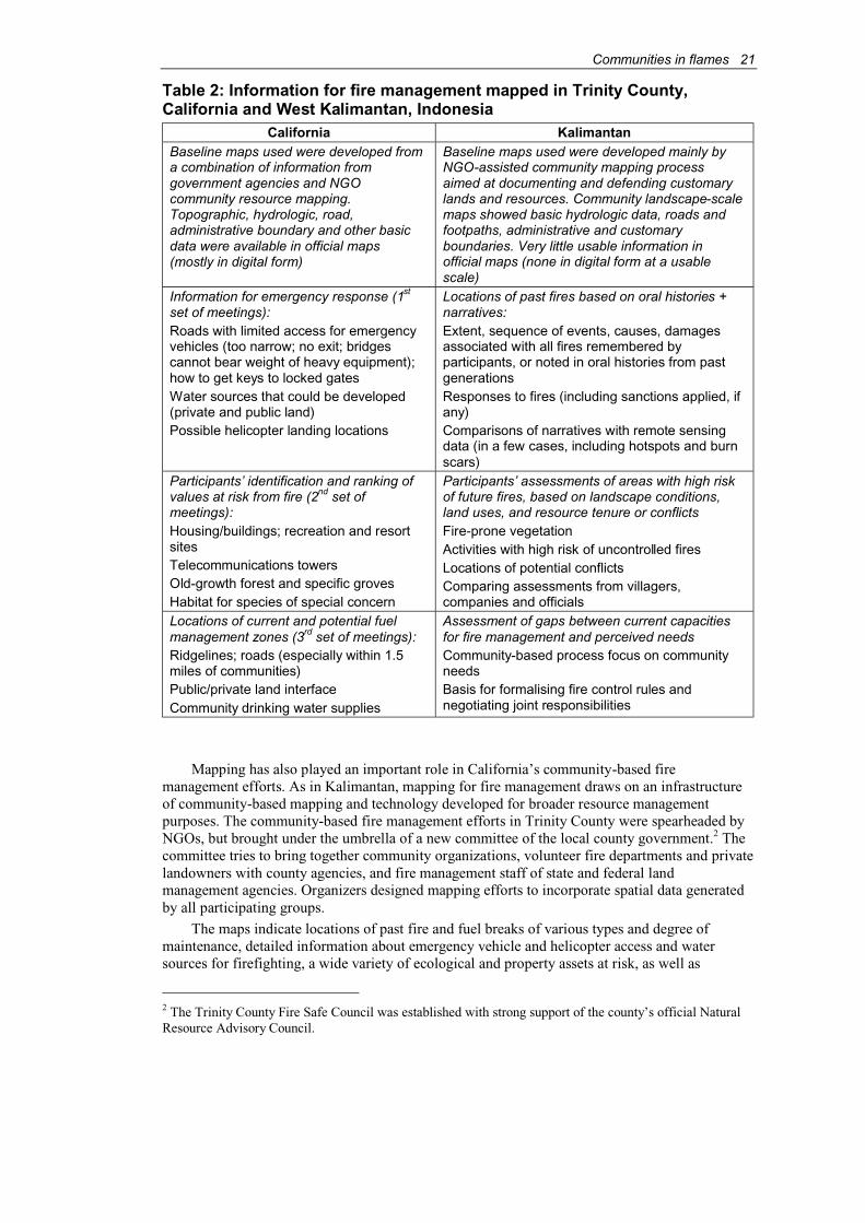
Communities in flames 21
Table 2: Information for fire management mapped in Trinity County,California and West Kalimantan, Indonesia
California KalimantanBaseline maps used were developed froma combination of information fromgovernment agencies and NGOcommunity resource mapping.Topographic, hydrologic, road, administrative boundary and other basicdata were available in official maps(mostly in digital form)
Baseline maps used were developed mainly byNGO-assisted community mapping processaimed at documenting and defending customarylands and resources. Community landscape-scalemaps showed basic hydrologic data, roads and footpaths, administrative and customaryboundaries. Very little usable information in official maps (none in digital form at a usable scale)
Information for emergency response (1st
set of meetings):Roads with limited access for emergencyvehicles (too narrow; no exit; bridges cannot bear weight of heavy equipment); how to get keys to locked gatesWater sources that could be developed(private and public land)Possible helicopter landing locations
Locations of past fires based on oral histories + narratives:Extent, sequence of events, causes, damagesassociated with all fires remembered byparticipants, or noted in oral histories from past generationsResponses to fires (including sanctions applied, ifany)Comparisons of narratives with remote sensing data (in a few cases, including hotspots and burnscars)
Participants’ identification and ranking of values at risk from fire (2nd set of meetings):Housing/buildings; recreation and resortsitesTelecommunications towersOld-growth forest and specific grovesHabitat for species of special concern
Participants’ assessments of areas with high riskof future fires, based on landscape conditions, land uses, and resource tenure or conflictsFire-prone vegetationActivities with high risk of uncontrolled firesLocations of potential conflictsComparing assessments from villagers,companies and officials
Locations of current and potential fuel management zones (3rd set of meetings):Ridgelines; roads (especially within 1.5 miles of communities)Public/private land interfaceCommunity drinking water supplies
Assessment of gaps between current capacitiesfor fire management and perceived needsCommunity-based process focus on communityneedsBasis for formalising fire control rules and negotiating joint responsibilities
Mapping has also played an important role in California’s community-based firemanagement efforts. As in Kalimantan, mapping for fire management draws on an infrastructureof community-based mapping and technology developed for broader resource managementpurposes. The community-based fire management efforts in Trinity County were spearheaded byNGOs, but brought under the umbrella of a new committee of the local county government.2 The committee tries to bring together community organizations, volunteer fire departments and privatelandowners with county agencies, and fire management staff of state and federal landmanagement agencies. Organizers designed mapping efforts to incorporate spatial data generatedby all participating groups.
The maps indicate locations of past fire and fuel breaks of various types and degree of maintenance, detailed information about emergency vehicle and helicopter access and water sources for firefighting, a wide variety of ecological and property assets at risk, as well as
2 The Trinity County Fire Safe Council was established with strong support of the county’s official Natural Resource Advisory Council.

22 Communities in flames
jurisdictional and administrative boundaries. Maps also show participants’ recommendations of priority projects and activities for fire prevention (especially vegetation treatments).
There are many significant differences in the ways that local knowledge is generated and used in fire management (Box 1). In California, many long-term residents of fire-prone rural regions have professional experience and training in fire management techniques, and are familiarwith the way government agencies work to suppress and prevent fires, as staff or contractors for land management agencies, commercial loggers, landowners and members of local volunteer fire departments. Counting on this knowledge, participants in the Trinity County community-basedfire planning process hope that by collaborating with state and federal agencies to developcoherent plans for fire management, these agencies that normally respond to fire emergencieswould uphold local priorities even in emergency situations (TCRCD and WRTC, 2000).
Box 1: Questions to help define significant differences for information based onlocal knowledge
♦ What is considered to be legitimate “local knowledge”?
♦ Who has obtained it? How?
♦ Who initiates efforts to gather or generate information useful for fire management?
♦ Who controls this information, and how does this affect its use?
♦ Who uses it?
♦ For what specific purposes? For what purposes is it not used?
♦ Who respects it? Who disparages it?
♦ Who “owns” technology or records used to compile and interpret local knowledge?
♦ Who communicates information to whom? Through what means? When?
♦ Who “owns” the right to communicate information?
♦ Who decides which information will be communicated? Which will be withheld?
In contrast to California, few local community members in West Kalimantan are familiarwith, and trusted by, government agencies or companies involved in fire management. Manygovernment-supported fire management efforts tend to disparage indigenous experiences and knowledge of controlled burning for shifting cultivation under customary rules, and responses to escaped fire using simple local technologies. Even government-sponsored efforts to involvecommunities in fire management continue to portray long-standing indigenous communities and their agricultural practices either as fire risk factors (swidden fires, or arson against companyassets), or as free or cheap labour to fight fires (Dinas Kehutanan, 2000). In some cases, officiallysupported participatory measures also see community monitoring as a source of reports of companies’ illegal burning. However, less attention is paid to threats to community assets posed by corporate activities than threats to company assets or protected areas by smallholders.
Experienced staff, equipment, trained community members and local familiarity with uses of community-generated maps and plans formed a basis for fire mapping and planning efforts. In California, fire mapping could start with accurate, high-resolution topographic maps produced by the federal government. In West Kalimantan, on the other hand, government topographic maps ofareas where NGO-assisted fire management mapping efforts focus are unreliable. Bothtopographic and land-use maps available to the public (as opposed to military maps) are at a scaletoo coarse to be useful. Base maps used in fire mapping had been produced by villagers withNGO help, and had been intended largely to defend customary lands and resource rights againstexpropriation for exploitation by government-licensed concession holders.
Communities in flames 23
In both places, the processes of identifying significant past fire events, locating them on basemaps, and linking them with as much data as could be collected about each fire were analogous.They both grew out of previous involvement with community-based resource mapping, andmistrust that distant and plodding official fire planning processes would accurately reflectcommunity priorities and values. Yet, differences in their level of detail and variety of data on baseline maps were enormous. The sources of data were also dissimilar. Whereas governmentbaseline maps and fire data were readily provided to the California process (much of it in digitalform), in West Kalimantan regional government and forestry agencies both lacked useful data, and were suspicious of NGO-assisted community mapping.
4. Understanding and assessing diverse values at risk from fireCommunity-based fire management processes consider threats to direct resource values, lesstangible cultural values, commercial assets, various types of private and common property andnumerous ecological functions. The California state government’s approach is generally toidentify these assets, acknowledge disagreements about the ranking of values among participantsin the planning processes, and eventually address protection of a very wide range of values, from employment in logging and real estate to wildlife habitat, with priorities for specific projects and programmes. This statewide process had not yet been applied to Trinity County (CalCBF et al.,1996) before the locally based participatory process began. The Trinity process was in partdesigned as a local alternative to the statewide “top-down” asset assessment approach. Localpeople were concerned that it would undervalue the remote forest region’s fire protection needs,compared to those of more urban areas.
In California, identifying priority fire management programmes and projects early ensures that legally required environmental impact assessments and administrative approvals arecompleted in time, so that projects can proceed with a local workforce without delay as soon as funds become available. Yet, some critics insist that most purported fire management treatments,including thinning for fuel reduction, and “salvage logging” in previously burned or pest infested areas, are just excuses to continue logging where logging would otherwise be prohibited for environmental reasons.
Collaborative community-based resource planning in northern California emerged in the mid-1990s in the wake of the “timber wars”, which had pitted environmentalists against loggers ina battle over values that would form the region’s future landscape. A remarkable feature of thefire planning priority process developed in Trinity County is its incorporation of a wide range ofvalues. Overcoming polarisation involves developing a consensual sense of a “community of place”3 where economic prosperity and community welfare can be based on protecting andrestoring “forest health”. Vegetation treatment for fire management and ecosystem restorationmay create jobs that are needed because of the declining logging industry.
In West Kalimantan, community efforts also try to balance conflicting values, althoughcompared to California, indigenous communities embarking on fire management appear to be less polarised in terms of values, especially concerning their own interests relative to governmentpolicies on land rights, agroforestry practices and fire uses. The most serious rifts appear to be between indigenous communities and commercial plantations, logging and mining companies, and new settlements on customary lands. As communities organize themselves to reduce fire risksthrough consensual processes and mutual assistance, many village residents are annoyed thatblame for the late 1990s fires is still so easily cast at shifting cultivators, despite evidence that the most serious of the West Kalimantan wildfires were associated with commercial land clearing (CIFOR et al., 2001). Numerous villages have codified and reinforced customary sanctions aimed at reducing wildfire risks since the 1990s fires, with relatively little government support. Many
3 “Community of place” and “forest health” are terms often used in describing motivations underlyingrecent movements for increased community control of local natural resources in the United States, corresponding to widespread developments in “civic environmentalism”.

24 Communities in flames
call for the government to act decisively and stop illegal burning for plantation expansion rather than threaten to prohibit burning by indigenous shifting cultivators using traditional safeguards.
A conflict of values is also expressed in the implicit devaluation of the relatively fire-resistant landscapes that indigenous agroforestry is forming in the long term. Government-licensed plantations continue to expropriate customary village lands. Local governments havelargely failed to enforce prohibitions imposed by executive order in 1995 against land clearing bycommercial burning. As smallholders plant more perennial tree crops, land is withdrawn fromshifting cultivation cycles, which reduces the need for burning. Through much of WestKalimantan today, smallholders have integrated indigenous shifting cultivation with relativelyhigh-value agroforestry production. Both recently planted and generations-old forest gardens arethe focus of many community efforts to protect customary territory from wildfire. Many villagerscontributing to fire management initiatives believe that to protect their area from fire they have to defend their customary land rights and village customary territory against encroachment by commercial plantations! For the regional NGOs assisting villages in fire management, expandingfrom land rights advocacy to fire management is a strategic move.
When plantation and timber companies began working with the regional government todevelop new systems and procedures to mobilise their capacities for firefighting, localcommunities were seen either as sources of fire risk or cheap labour for the companies’firefighting crews. Although the regional government and several aid projects have includedvillagers in firefighting training, and provincial fire suppression plans intend to provide trainingfor farmers’ groups, no provincial plans have provided for local communities’ input toformulating fire policies. New provincial fire suppression institutions follow an extremelyhierarchical model (Dinas Kehutanan, 2000). Whether such a model to mobilise firefightingcapacity in a regional emergency is compatible with consensual village-level fire managementinitiatives has yet to be tested.
5. Reviewing necessary reforms to enable community-based firemanagementAdministrative and more fundamental political reforms would contribute to the potential successof emerging community-based fire management. Movements to gain political support for forest and watershed management regimes that are more responsive to local needs are taking place inKalimantan and California.
Recognising that it is more cost-effective to prevent than to fight unwanted fires, it makessense for governments to assist community-based fire management. Demonstrating the value of local knowledge for fire management provides a strong argument for governments to provide financial and technical resources, in a credible “political space” to support collaborative firemanagement. Successful community-based fire management calls for government recognition oflocal planning and values to guide emergency fire responses. Unfortunately, such governmentsupport is still rare in California and Kalimantan. Community-based initiatives occupy only a tenuous place in broader forest management, and are not yet integrated with governmentfirefighting institutions and procedures.
Yet the differences in political and administrative contexts in California and Kalimantanmake it problematic to compare political and administrative reforms much further. Since most of the land in California is managed by the national Forest Service, administrative reform to supportcommunity-based fire management would include taking ongoing collaborative processes moreseriously, and prioritising resultant projects and programmes for government financial support. It would also mean eliminating the bias toward huge projects to enable small-scale local contractorsto compete. Emergency fire crews mobilised by the USFS (to fight fires on federal land) and theCalifornia Department of Forestry and Fire Protection (to fight fires on private and state land)should become accustomed to consultative operations. Some of this change requires financialassistance; much of it calls for a change in attitudes.
In Kalimantan, a more open attitude from the government toward the capacities of localcommunities, recognition of indigenous land-use and forest management systems, and of local
Communities in flames 25
decision-making institutions are priorities. It is just as important to incorporate local communities’fire management capacities into the newly implemented fire suppression action plans. Recentreforms of the Indonesian forestry law, which strengthen community positions relative tocorporations and the state, would help support community-based fire and forest management. OtherIndonesian reforms focusing on devolution of authority and revenue collection from the central tothe provincial governments may facilitate broad-based fire management. However, devolution mayalso provide irresistible incentives for regional politicians to exploit every possible source ofrevenue for the short-term, rather than conserving natural resources for the long term. Funds forinvestment in a decentralised fire management system, calling for substantial early investment forbenefits in an uncertain future, would be scarce in this case.
6. Problems in comparing and transferring practicesCommunity-based fire management initiatives in northern California and West Kalimantan shareseveral similarities. Yet, the many differences seriously limit opportunities to transfer approachesdirectly without any adaptations. It is particularly important to increase our understanding of how various actors’ stakes in fire management are likely to differ across contexts – not only betweenvastly different locations, but also across different spatial scales and institutional levels.
In assessing where and when approaches can be successfully transferred from one place toanother, the following act as a guide:
♦ Reforming approaches to fire management is both politically and technically challenging.Vastly different political and administrative systems, and unequal technological capabilitiesmay make many apparently sensible approaches unworkable in the foreseeable future.
In California and West Kalimantan, the similarities in approach to planning, using narratives,mapping and prioritising systems appear to be remarkable. However, the levels of technology and uses to which maps or other tools can be applied are limited by very differentcharacteristics in the two locations. Although the processes may be congruent in some ways,it is misleading to assume that they will lead to the same kind of planning andimplementation opportunities.
♦ Transferring some practices and assumptions may endanger the land, ecosystems andpeople. In attempting to “transfer” practices from one place to another, how can the precautionary principle, “First, do no harm,” be applied?
There has been some controversy over whether it is more important to know the history ofunderlying causes of fires, or whether it may be enough to understand the more immediatecauses of fires. If one assumes that a build-up of fuel loads will eventually result in a fire,then it is not particularly important to understand causes and contexts for specific ignitionevents. This rationale may make sense in California, where fire is a natural part of an ecological cycle, and fuel build-up through fire suppression set the scene for the almostinevitable fire. However, it would be dangerous to apply the same rationale to Kalimantan.Where fires are largely anthropogenic, understanding the circumstances of specific fire events is crucial, since if no fire is lit, no fire will burn. By overlooking fire origins in Kalimantan, opportunities to prevent fires by addressing the intentions of people startingfires will be lost. Asking “What do we gain by making a particular set of assumptions?” and “What do we lose by not making other assumptions?” may allow us to translate assumptionsand approaches more carefully.
Processes of community-based fire management can create opportunities for improvingunderstanding among local communities, land and resource management agencies andcommercial enterprises. Successful community-based approaches are in the best interest ofeveryone hoping to eliminate unwanted fire. In both Kalimantan and California, there is a growing consensus, among people who believe that both people and valuable ecosystems are atrisk from present courses of action, that the most promising approaches to sustainable forest and natural resource management lie in such joint management initiatives.

26 Communities in flames
AcknowledgementsThe research on which this paper is based was undertaken with financial support of the U.S. National Science Foundation, in conjunction with Virginia Polytechnic Institute and StateUniversity. Additional institutional support has been provided by the Center for InternationalForestry Research, with sponsorship from the Indonesian Institute of Sciences (LIPI).Collaborative work was undertaken in California with the Watershed Research and TrainingCenter (with thanks to Yvonne Everett), Trinity County Resource Conservation District, and theTrinity County Fire Safe Council. In West Kalimantan, collaborative partners included YayasanPancur Kasih, Yayasan Dian Tama, and participants in community-based fire managementinitiatives in Sanggau and Ketapang. This research is greatly indebted to all participants incommunity-based fire management processes in West Kalimantan, and in Trinity County,California.
ReferencesAlcorn, J.B. & Royo, A.G. (eds.). (2000). Indigenous social movements and ecological resilience:
lessons from the Dayak of Indonesia. (Authors J. Bamba, S. Masiun, and I. Natalia)Biodiversity Support Program, Washington, DC, Publication number 99. Also online at URLhttp://www.bsponline.org/bsp/publications/.
CalCBF, CDF & CalRA. (1996). California fire plan: a framework for minimising costs and losses from wildland fires. California State Board of Forestry, California Department of Forestry and Fire Protection California Resources Agency. CalCDF, California.
CIFOR, ICRAF, USAID & USFS. (2001). The underlying causes and impacts of fires in Southeast Asia, West Kalimantan site reports. Center for International Forestry Research,International Centre for Research on Agroforestry, United States Agency for InternationalDevelopment and United States Department of Agriculture Forest Service. CIFOR, Bogor,Indonesia Also online at http://www.cifor.cgiar.org/fire-project/index
Dinas Kehutanan. (2000). Rencana mobilisasi sumber daya penanggulangan kebakaran hutan dan lahan (Fire suppression mobilisation plan) (Draft 5). Propinsi Kalimantan Barat. DinasKehutanan Propinsi Kalimantan Barat.
TCRCD & WRTC. (2000). Recommendations on Trinity County values at risk from fire and pre-fire fuels treatment opportunities drawn from community meetings 1999/2000 (Draft). Trinity County Resource Conservation District and Watershed Research and Training Center, California.
Communities in flames 27
Community-based fire management, land tenure and conflict: insights from Sumatra, Indonesia
S. Suyanto, Grahame Applegate and Luca Tacconi1
AbstractA collaborative research project involving the Center for International Forestry Research(CIFOR), International Centre for Research in Agroforestry (ICRAF), United States Departmentof Agriculture Forest Service and the European Commission found that community-based firemanagement in parts of Indonesia can have both positive and negative impacts on the forestenvironment, and can lead to short- and long-term changes in income. This paper examines two examples from Lampung Province in southern Sumatra, Indonesia, where communities managefire in different forest types to increase income generation, but without a conscious effort to maintain environmental services or achieve biodiversity conservation. In Sekincau, located in a national park, communities manage forest fire to facilitate the establishment of coffee gardens in the residual understorey or in open areas. Based on knowledge of fire behaviour, communitiesoften encourage fire to escape from adjacent areas and burn in previously illegally logged forest.Fires are also managed to prevent damage to adjacent coffee gardens. This suggests that the community knows how to manage fire to meet specific objectives.
In Menggala in the vast swamps of east Lampung Province, the traditional communities usefire as a tool for burning organic matter to prepare the ground for “traditional swamp ricecultivation” (sonor) during extended dry periods. The fires burn large areas of swamp forest well beyond the boundaries required for rice production. The fires have facilitated the regeneration andexpansion of areas of Melaleuca cajuputi, a fast-growing species that responds positively to disturbance. The regenerating forests are harvested for domestic consumption and supplementingincome through the production and sale of charcoal, poles and sawn timber.
1. IntroductionLarge-scale fires and associated smoke are an increasing problem in Indonesia and surroundingcountries. Major fires occurring in the El Niño years 1982/83, 1987, 1991, 1994, and 1997/98 (Dennis, 1999) burned huge forest areas and caused significant economic losses, both in Indonesia where most fires occurred, and in neighbouring countries. The economic costs of the 1997/98 fires in Indonesia have been estimated to exceed US$9 billion, with carbon emissionshigh enough to elevate Indonesia to one of the largest polluters in the world (ADB and Bappenas,1999; Barber and Schweithelm, 2000). There are several underlying causes for the fires. If theyare not addressed, unwanted fires will continue to burn in many parts of Indonesia with theensuing negative impacts on the forest environment. The fires also generate large amounts ofemissions from the burning of peat soils and the resultant smoke and haze have led to cross borderproblems (Applegate et al., 2001; ADB and Bappenas, 1999).
As research on underlying causes of fire in Indonesia has indicated (Applegateet al., 2001),perverse policy and institutional incentives (e.g. inappropriate land-use allocation, lack of tenuresecurity) and external forces (e.g. demographic changes) have influenced the communities’ use oftheir knowledge of fire behaviour in sustaining their livelihoods. Therefore, it is understandable thatcommunity-based fire management is considered by many to be an important approach to addressthe problem of recurring fires and their related negative impacts. However, documented knowledgeabout the conditions under which this approach may work is limited (Ganzet al., 2001).
1 S. Suyanto, International Centre for Research in Agroforestry, Southeast Asian Region ResearchProgramme, Bogor, Indonesia.Grahame Applegate, Center for International Forestry Research, Bogor, Indonesia.Luca Tacconi, Center for International Forestry Research, Bogor, Indonesia.
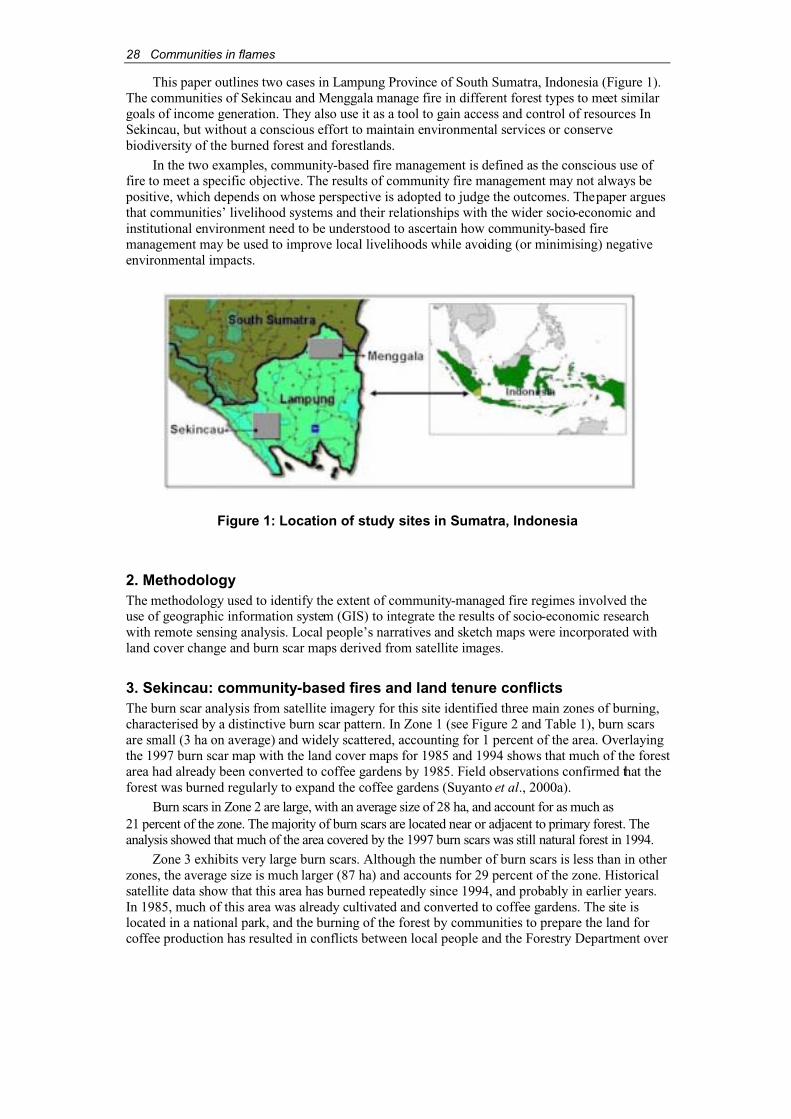
28 Communities in flames
This paper outlines two cases in Lampung Province of South Sumatra, Indonesia (Figure 1). The communities of Sekincau and Menggala manage fire in different forest types to meet similargoals of income generation. They also use it as a tool to gain access and control of resources In Sekincau, but without a conscious effort to maintain environmental services or conservebiodiversity of the burned forest and forestlands.
In the two examples, community-based fire management is defined as the conscious use of fire to meet a specific objective. The results of community fire management may not always be positive, which depends on whose perspective is adopted to judge the outcomes. The paper arguesthat communities’ livelihood systems and their relationships with the wider socio-economic and institutional environment need to be understood to ascertain how community-based fire management may be used to improve local livelihoods while avoiding (or minimising) negativeenvironmental impacts.
Figure 1: Location of study sites in Sumatra, Indonesia
2. MethodologyThe methodology used to identify the extent of community-managed fire regimes involved the use of geographic information system (GIS) to integrate the results of socio-economic researchwith remote sensing analysis. Local people’s narratives and sketch maps were incorporated with land cover change and burn scar maps derived from satellite images.
3. Sekincau: community-based fires and land tenure conflictsThe burn scar analysis from satellite imagery for this site identified three main zones of burning, characterised by a distinctive burn scar pattern. In Zone 1 (see Figure 2 and Table 1), burn scarsare small (3 ha on average) and widely scattered, accounting for 1 percent of the area. Overlayingthe 1997 burn scar map with the land cover maps for 1985 and 1994 shows that much of the forestarea had already been converted to coffee gardens by 1985. Field observations confirmed that the forest was burned regularly to expand the coffee gardens (Suyanto et al., 2000a).
Burn scars in Zone 2 are large, with an average size of 28 ha, and account for as much as 21 percent of the zone. The majority of burn scars are located near or adjacent to primary forest. Theanalysis showed that much of the area covered by the 1997 burn scars was still natural forest in 1994.
Zone 3 exhibits very large burn scars. Although the number of burn scars is less than in otherzones, the average size is much larger (87 ha) and accounts for 29 percent of the zone. Historicalsatellite data show that this area has burned repeatedly since 1994, and probably in earlier years.In 1985, much of this area was already cultivated and converted to coffee gardens. The site islocated in a national park, and the burning of the forest by communities to prepare the land forcoffee production has resulted in conflicts between local people and the Forestry Department over
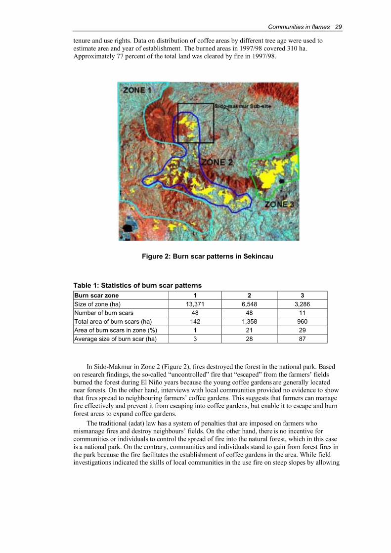
Communities in flames 29
tenure and use rights. Data on distribution of coffee areas by different tree age were used to estimate area and year of establishment. The burned areas in 1997/98 covered 310 ha.Approximately 77 percent of the total land was cleared by fire in 1997/98.
Figure 2: Burn scar patterns in Sekincau
Table 1: Statistics of burn scar patternsBurn scar zone 1 2 3Size of zone (ha) 13,371 6,548 3,286Number of burn scars 48 48 11Total area of burn scars (ha) 142 1,358 960Area of burn scars in zone (%) 1 21 29Average size of burn scar (ha) 3 28 87
In Sido-Makmur in Zone 2 (Figure 2), fires destroyed the forest in the national park. Basedon research findings, the so-called “uncontrolled” fire that “escaped” from the farmers’ fieldsburned the forest during El Niño years because the young coffee gardens are generally located near forests. On the other hand, interviews with local communities provided no evidence to showthat fires spread to neighbouring farmers’ coffee gardens. This suggests that farmers can managefire effectively and prevent it from escaping into coffee gardens, but enable it to escape and burn forest areas to expand coffee gardens.
The traditional (adat) law has a system of penalties that are imposed on farmers who mismanage fires and destroy neighbours’ fields. On the other hand, there is no incentive forcommunities or individuals to control the spread of fire into the natural forest, which in this caseis a national park. On the contrary, communities and individuals stand to gain from forest fires in the park because the fire facilitates the establishment of coffee gardens in the area. While field investigations indicated the skills of local communities in the use fire on steep slopes by allowing
30 Communities in flames
the prevailing winds to fan the fires into forest areas, many individuals denied that their landclearing activities were a cause of fires. Many insisted that they were very careful in managingfires when clearing the land. Most survey respondents blamed the forest fires on accidents from the campfires and discarded cigarette butts of illegal loggers.
The demographic composition in the study site is heavily influenced by migration from Javaand Javanese communities from established settlements in Lampung. People moved to the areabecause of hardships and poor livelihood opportunities elsewhere. The positive initial evaluationsfrom “pioneers” and increased family incomes from growing coffee have persuaded manyfamilies to relocate. Although land tenure is uncertain, because most of the coffee gardens arelocated inside the national park, “private” land tenure in the park is gradually becoming more secure. Farmers feel that the government will not take their land away because their community isestablished and developed with roads and other public services. The feeling of secure land tenurehas increased during the “reformation” period (mid-1998 to the present). Confrontation with the authorities is less likely compared with the past when government authorities often tried to evictthe coffee growers from the park.
The research results indicate a strong relationship between fire and deforestation. Theestablishment of coffee gardens using fire for site preparation is most active in areas where naturalforest is still relatively abundant. Also, judging from the proximity of the burned forest areas andyoung coffee gardens, it is most likely that the fire spread during land preparation activitiesoutside forest areas to the natural forest. The analyses therefore suggest that there may be two types of fires in this area: those that are managed and thosethat are allowed to burn uncontrolled.The managed fires come from the activities of smallholders for forest clearing, while uncontrolledfires can also occur in natural forest as a result of escaped fires from land clearing and illegallogging inside the national park.
4. Menggala: fire and traditional “sonor” rice cultivationThe second study site is located in the swamp areas in eastern Lampung Province. During the El Niño years of 1997/98, this area was characterised by burned swamps. The villagers of the Mesujicommunity are the main residents who manage fire for the production of swampland rice or“sonor”. The Mesuji people came from South Sumatra to Lampung in the early 1900s, andbrought with them the sonor technology. Over the last 10 years, farmers have practised the sonorsystem in each of the very dry years of 1987, 1991, 1994 and 1997. These years coincided with the El Niño phenomenon. According to the chief of the Mesuji people, thousands of hectares ofswamp forest were burned and cultivated under the sonor system in 1997, with most householdscultivating approximately 5 ha each (Suyanto et al., 2000b).
The Mesuji people live along the rivers, which are dominant features in this area. Their mainlivelihood is fishing and sonor. They also harvest gelam trees (Melaleuca spp.) from the swampforest for house construction and for sale. Under the sonor system, farmers plant rice only after aconsiderable drought, usually associated with an El Niño event. A 5- to 6-month dry period ensuresthat the water table is low enough for the successful burning of swamp forest. The fire removes theorganic matter and provides an ash bed, which facilitates the early growth of the young riceseedlings. Characteristically, the Mesuji communities burn the swamp in September and October.Although land preparation requires relatively little labour inputs, shortage of labour for harvestinghas been a problem. Therefore, many seasonal workers from transmigration areas are under contractto assist in the harvest. The traditional owners and labourers share the harvest equally. Thisgenerous payment highlights the severe labour shortages in the area, even to the point that some ricefields could not be harvested in 1997. Average yield per hectare under the sonor system is 4 metrictonnes of unhulled rice, which is almost double the yield of the non-sonor farming system.
The communities only set out to burn as much swamp forest as they require for the sonorproduction, but make no conscious effort to control the fires, which burn beyond the designatedarea. The desirable characteristic of the sonor system is its extremely low labour demand. Following the burning of the swamps and the sowing of the rice seeds, the farmers usually returnto the field only after the harvest 6 months later. By this time, the water table has risen to levels
Communities in flames 31
where it is necessary to travel through the fields by boat. Following the harvest, the forest areasare fallowed for 3 to 4 years (depending on the dry season cycles). During this period, the swampforests, often dominated by gelam trees, regenerate and occupy the site.
The sonor practice is a community-based fire management approach that uses fire to prepareland, rather than one that aims to control the spread of fires. One of the side benefits of the sonorsystem is the development of Melaleuca spp., a fast growing, light-demanding species with awide range of end uses. Preliminary investigations suggest that the vast swamp ecosystem southof the Musi River, an area including the study site, have been largely converted from primaryswamp forests to grasslands and Melaleuca-dominated forests following logging and transmigration site developments. The repeated fires over a short time span of less than 25 yearshave altered the forest resource, which is now dominated in many places by Melaleuca cajuputi.
This “new” forest provides the raw materials for pole, sawn timber and charcoal industriesoperated informally by local people and migrants. The operations appear to extend over a vastarea and sustain the livelihoods of many people. Observations suggest that the Melaleuca spp.regeneration is perhaps largely a feature of disturbed freshwater swamp forests. The issue of modified peat swamps therefore needs to be examined more closely. With the potential of generating new income from the resource, research will be undertaken to determine the social andbiophysical aspects of community-based forest management of this resource and the judicious useof fire by the communities to promote regeneration and sustained productivity.
5. ConclusionsCommunity-based fire management is defined in the paper as the conscious use of fire to meet a specific objective. From the perspective of a community, or an individual, the objective could bethe maintenance of livelihoods. This may involve clearing forest to plant coffee or rice, or to secure rights to the land, which may have negative impacts on the environment. Whether localcommunities consider such impacts as negative depends to a large extent on the effects on theirlivelihoods. Environmental changes that have global, but not local-level, impacts are unlikely to mean much to local communities. The ignorance of local communities about localisedenvironmental changes that may affect their livelihoods needs also to be addressed. If in specificcases the use of fire has these unrecognised effects, it could be possible to reduce the occurrenceand/or the extent and intensity of the fires while benefiting local communities.
For organizations promoting the use of community-based fire management, the objective offire management could be the reduction of the negative impacts of fires on the local and globalenvironment. These organizations need to recognise that their definition of negative impacts maydiffer from the communities’ perspectives.
It is obvious that introducing community-based fire management demands detailed knowledgeof environmental impacts, communities’ livelihood systems and their relationships with the widersocio-economic and institutional environment. This requires research on existing livelihood systems(e.g. environmental sustainability, economic opportunities) and ways of improving them, the policyand institutional environments affecting livelihoods and environmental management, and therelationships between rural livelihoods and the corporate sector.
ReferencesApplegate, G., Chokkalingam, U. & Suyanto, S. (2001). The underlying causes and impacts of
fires in South-east Asia. Final Report. CIFOR, ICRAF and USFS, Bogor, Indonesia.
ADB & Bappenas (1999). Causes, extent, impact and costs of 1997/98 fires and drought. Finalreport, Annex 1 and 2. Planning for fire prevention and drought management project. AsianDevelopment Bank TA 2999-INO. Fortech, Pusat Pengembangan Agribisnis, MargulesPöyry, Jakarta, Indonesia.

32 Communities in flames
Barber, C.V. & Schweithelm, J. (2000). Trial by fire. Forest fires and forestry policy in Indonesia’s era of crisis and reform. World Resources Institute (WRI), Forest FrontiersInitiative. In collaboration with WWF-Indonesia and Telapak Indonesia Foundation,Washington D.C, USA.
Dennis, R.A. (1999). A review of fire projects in Indonesia 1982-1998. Center for InternationalForestry Research, Bogor, Indonesia.
Ganz, D., Moore, P. & Shields, B. (2001). International Workshop on Community Based FireManagement. RECOFTC Training and Workshop Report Series 2001/1. RECOFTC,Bangkok, Thailand.
Suyanto, S., Dennis, R.A., Kurniawan, I., Stolle, F., Maus, P. & Applegate, G. (2000a). Theunderlying causes and impacts of fires in South-east Asia. Site 1. Sekincau, LampungProvince, Indonesia. Project Report. CIFOR, ICRAF and USFS, Bogor, Indonesia.
Suyanto, S., Dennis, R.A., Ruchiat, Y., Kurniawan, I., Stolle, F., Maus, P. & Applegate, G. (2000b). The underlying causes and impacts of fires in South-east Asia. Site 2. Menggala,Lampung Province, Indonesia. Project Report. CIFOR, ICRAF and USFS, Bogor, Indonesia.
AcknowledgementsThe research on which this paper is based is supported by the USDA Forest Service, the EuropeanCommission, CIFOR and ICRAF. We would like to thank Thomas Tomich for providing insightfulcomments, and we are grateful to Ronna Dennis, Iwan Kurniawan and Christoph Feldkötter forproviding valuable additions to the GIS analysis. We thank Mufti Mubarak, Ade Herdiana, YayatRuchiat and Andi Erman for their excellent fieldwork. Finally, we especially thank respondents inall village communities for their co-operation and patience during our interviews.
Communities in flames 33
Community participation in integrated forest firemanagement: experiences from Africa, Asia and Europe
Johann G. Goldammer, Peter G.H. Frost, Mike Jurvélius, Evelien M. Kamminga, Teri Kruger, Soo Ing Moody and Manuel Pogeyed1
AbstractThe consequences of increasing application of fire in land-use practices and land-use change and the subsequent outbreaks of large wildfires in the tropics and neighbouring regions during the 1980s and 1990s have led to the development of several fire management programmes in Asiaand Africa. The “Integrated Forest Fire Management” (IFFM) projects are based on the assumption that communities can successfully incorporate fire usage into sustainable land use and vegetation management systems. The IFFM concept was first applied in Indonesia and Namibia. Other countries such as Mongolia, Ethiopia and Guatemala are also interested in building IFFMcapacities. The Fire Ecology Research Group/Global Fire Monitoring Center (GFMC) hassupported the design of IFFM projects, especially using the concept of Round Tables on Fire Management for defining the participatory approach in fire management. The GFMC in association with the UN International Strategy for Disaster Reduction (ISDR) is promotingcommunity participation as a measure for prevention of fire disasters.
1. IntroductionThe majority of wildfires in developing countries of the tropics and subtropics, and in temperate-boreal countries in transition, are caused by human activities usually associated with land-usepractices and changes. Many land-use systems in these regions are vulnerable to wildfires. The property, health and welfare of people in these areas are negatively affected by direct and indirectconsequences of fire and air pollution. Active involvement of the local people has therefore been recognised as a condition for the successful implementation of fire management programmes,especially at the interfaces between wildlands, managed systems and residential areas.
During the 1980s and 1990s, several technical co-operation projects were implemented in developing countries, funded bilaterally or supported by international organizations (e.g. the Food andAgriculture Organization of the United Nations (FAO) and the World Bank). Many projects wereimplemented in partnership with national institutions responsible for the prevention and control offorest fires, often designated as “Forest Fire Control” or “Forest Fire Prevention and Control” projects,with a purely technical approach to reduce fire hazard and improve fire suppression capabilities. Thisresulted predominantly in working with and through government agencies. Local people, who use firein land-use systems and/or are major agents of wildfires, and who are also directly and adversely affected by wildfires, were not involved in project activities. There was little or no recognition of localpeople as important actors and stakeholders.
1 Johann G. Goldammer, Global Fire Monitoring Center, Fire Ecology Research Group, Max PlanckInstitute for Chemistry, c/o Freiburg University, P.O.Box, D-79085 Freiburg, Germany, email: [email protected];Peter G.H. Frost, Institute of Environmental Studies, University of Zimbabwe, P.O. Box MP 167, MountPleasant, Harare, Zimbabwe, email: [email protected] Jurvélius, Suonotkontie 3.G.85, FIN - 00630 Helsinki, Finland, email: [email protected] M. Kamminga, c/o Directorate of Forestry, Private bag 5558, Oshakati, Namibia, email: [email protected] Kruger, Santam/Cape Argus Ukuvuka: Operation Firestop, Goldfields Education Centre, KirstenboschBotanical Gardens, Newlands, Cape Town, 7700, South Africa, email: [email protected] Ing-Moody, P.O. Box 534, Twisp, Washington 98856, U.S.A., email: [email protected] L. Pogeyed, Department of Environment and Natural Resources, Cordillera Administrative Region,80 Diego Silang Street, 2600 Baguio City, Philippines, email:[email protected]

34 Communities in flames
The underlying concept of Integrated Forest Fire Management (IFFM), also referred to asCommunity-based Forest Fire Management (CBFFM), is to better integrate fire and people into land-use and vegetation management systems. The approach is based on the following considerations:
♦ Reasons: fire is a spatially and temporally disperse phenomenon. It is difficult to have acentralised control system, particularly in developing countries. Responsibility for fire management must be brought closer to those who benefit both from the use of fire andfrom having more control.
♦ Objectives: rational, ecologically compatible, sustainable and safe use of fire is veryimportant. With few exceptions, complete disuse of fire is undesirable.
♦ Impediments: defining responsibility (or “the community”), the need for complementarypolicy and legislative changes, identifying and supplying technical and other supportneeded to enable communities assume a central role in fire management are some of the difficulties encountered.
♦ Entry points: possibilities include definition of mechanisms, methods and policyinstruments (e.g. incentives) to encourage communities to assume control and “ownership” over fire management.
Definition and design of IFFM approaches clearly depend on the complex configuration of local cultural, social, economic, political and environmental conditions. However, a dialogue andnegotiation process among all stakeholders, from local to national levels, must first be established.IFFM objectives can be successfully realized only if all stakeholders involved in fire managementagree on a distribution of responsibilities, decision-making power and resources. The process of negotiation and consensus building requires careful consideration of different perspectives and also the pluriformity of the legal context. Existing rules are often of different and sometimescontradictory origins (e.g. laws and administration rules governed by centralised legislation,traditional rules that may not be legally recognised, or weakening influence of traditional structures due to increasing cultural intermix (migration) or other impacts of globalisation).
To overcome possible conflicts and deadlocks, a combination of bottom-up and top-downapproaches in defining the appropriate integrated fire management strategy seems to be mosteffective to build consensus among stakeholder groups at different levels. In the past decade theFire Ecology Research Group2 and the Global Fire Monitoring Center (GFMC) have chosen both approaches to support the development of national IFFM programmes. Several “National RoundTables on Fire Management” were held in co-operation with the German Agency for TechnicalCo-operation (GTZ) and international partners, including:
♦ In the aftermath of the extended fire and haze episodes of the 1980s, the first nationallong-term strategic fire management plan was prepared in Indonesia at the InternationalWorkshop on Long-term Integrated Forest Fire Management in Indonesia (Bappenas,1992; Goldammer, 1993). This first national round table involved most stakeholders in fire management and the international donor community. It resulted in a concerted approach in building fire management capabilities in the country, leading to the IFFMproject by the GTZ in co-operation with the Fire Ecology Research Group, the largest-ever international co-operative fire management project.3
♦ In 1999, the Namibia-Finland Forestry Program (NFFP) also convened a national round table on fire management, which recommended a multi-stakeholder approach in firemanagement with particular emphasis on the involvement of regional stakeholders and local communities. The IFFM approach of NFFP, its successes and limitations, as well as the results of the round table are discussed further in this paper.
2 Based at the Max Planck Institute for Chemistry, c/o Freiburg University, Germany.3 For the community component of project, see Abberger et al. in this publication.

Communities in flames 35
♦ After the large forest fires in Ethiopia in 2000 and the successful international responseto the emergency (Goldammer, 2000), the government called for a National Round Table on Fire Management in September 2000. It was recognised that Ethiopia, currently a country without any fire management capacities, would build its future programme on the basis of community involvement (Ministry of Agriculture, 2001).
In other countries no formal national round tables have been held prior to launching an IFFMprogramme. However, in these cases in-depth investigations at the community level were conducted to define the role of community participation in fire management, for example:
♦ In Mongolia, a survey was conducted to investigate the underlying causes of increasedoccurrence of wildfires in the steppe and forest ecosystems.
♦ In Guatemala, a local IFFM forum was convened in 2001 to address communityinvolvement in the lowland rainforests of Petén. Experience gained in the Guatemalaforum and in the four pilot communities is to be discussed at the national level in 2002.
2. Fire management in AfricaThe organizational arrangements and procedures of national and local fire management systemsvary from country to country. In the following sections examples are given from Namibia,Zambia, Côte d’Ivoire and South Africa. General recommendations for fire management in Africaare also available from various publications (FAO, 1999; Goldammer and de Ronde, 2001).
2.1. NamibiaIn 1996, the Forestry Department of the Ministry of Environment and Tourism selected EastCaprivi Region (north-eastern Namibia) as the pilot area for the NFFP to develop a model forcommunity-based forest fire control (Jurvélius, 1999; Kamminga, 2001). The pilot area consistsof 1.2 million ha of Namibia’s best forest resources and belongs to the sub-tropical region. Mostof the area is communal land, but a significant part is state forest, national park and wildlife conservation area. Although the pilot area falls within the Kalahari sand zone, the forests aremoderately productive because of the relatively high rainfall (700 mm). Prior to the beginning of the project, 70-80 percent of woodlands in the pilot region used to burn each year and almost all fires were anthropogenic in nature.
NFFP was launched on basis of the 1996 Namibia Forestry Strategic Plan. The first phasewas implemented from 1997 to 2001. The fire component, “Pilot Project for Forest Fire Control”,was modified to IFFM in 1998 to emphasise that fire is a suitable land management tool, if carefully timed and used (Goldammer, 2001).
One objective of the IFFM was to assist the government in formulating a national fire policyand regional fire management plan for East Caprivi. The main objective according to the projectdocument, however, was “the implementation of an applicable model for integrated forest firemanagement, implemented by Namibians”. The major outputs included:
♦ Improved efficiency and effectiveness of the Directorate of Forestry (DoF) and other agencies and stakeholders implementing applicable IFFM activities in the field.
♦ Development of national guidelines and forest fire policy.
♦ Changed attitudes and behaviour of general public towards the use of fire and burning,and its detrimental effects to the environment in Caprivi.
IFFM adopted the following strategies:
♦ Support for public relations and extension activities for forest fire prevention within thegovernment.
♦ At the community level, training and mobilisation of community members towardsimproved fire control and subsidised cutline construction and maintenance.
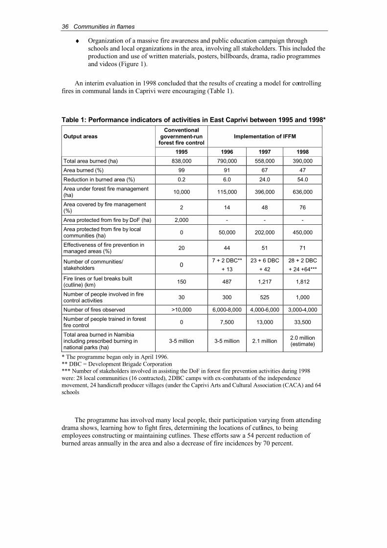
36 Communities in flames
♦ Organization of a massive fire awareness and public education campaign through schools and local organizations in the area, involving all stakeholders. This included the production and use of written materials, posters, billboards, drama, radio programmesand videos (Figure 1).
An interim evaluation in 1998 concluded that the results of creating a model for controllingfires in communal lands in Caprivi were encouraging (Table 1).
Table 1: Performance indicators of activities in East Caprivi between 1995 and 1998*
Output areasConventional
government-runforest fire control
Implementation of IFFM
1995 1996 1997 1998
Total area burned (ha) 838,000 790,000 558,000 390,000
Area burned (%) 99 91 67 47
Reduction in burned area (%) 0.2 6.0 24.0 54.0
Area under forest fire management(ha) 10,000 115,000 396,000 636,000
Area covered by fire management(%) 2 14 48 76
Area protected from fire by DoF (ha) 2,000 - - -
Area protected from fire by localcommunities (ha) 0 50,000 202,000 450,000
Effectiveness of fire prevention in managed areas (%) 20 44 51 71
Number of communities/stakeholders 0
7 + 2 DBC**
+ 13
23 + 6 DBC
+ 42
28 + 2 DBC
+ 24 +64***
Fire lines or fuel breaks built(cutline) (km) 150 487 1,217 1,812
Number of people involved in firecontrol activities 30 300 525 1,000
Number of fires observed >10,000 6,000-8,000 4,000-6,000 3,000-4,000
Number of people trained in forestfire control 0 7,500 13,000 33,500
Total area burned in Namibiaincluding prescribed burning in national parks (ha)
3-5 million 3-5 million 2.1 million 2.0 million(estimate)
* The programme began only in April 1996.** DBC = Development Brigade Corporation*** Number of stakeholders involved in assisting the DoF in forest fire prevention activities during 1998were: 28 local communities (16 contracted), 2DBC camps with ex-combatants of the independencemovement, 24 handicraft producer villages (under the Caprivi Arts and Cultural Association (CACA) and 64schools
The programme has involved many local people, their participation varying from attendingdrama shows, learning how to fight fires, determining the locations of cutlines, to beingemployees constructing or maintaining cutlines. These efforts saw a 54 percent reduction ofburned areas annually in the area and also a decrease of fire incidences by 70 percent.

Communities in flames 37
Figure 1: Examples of fire prevention posters in Namibia

38 Communities in flames
During the high-risk fire season (April-November) in 1999, about 1,500 villagers were engaged in controlling wildfires in northeastern Namibia. In addition, some 1,000 teachers and30,000 students received basic fire education.
In 1998, a survey examining local people’s experiences in controlling fires in theircommunities showed that the positive effects of better fire control on the natural resource basewere widely recognised (Virtanen, 1998), as can be affirmed by:
♦ improved condition of plants and trees;
♦ more forest products (e.g. fruits, nuts) as food supplements;
♦ increased numbers of wildlife;
♦ increased availability of grasses, thatch and other building materials;
♦ more fodder for livestock;
♦ less diseases among livestock;
♦ absence of livestock or crops destroyed by fire in the pilot villages; and
♦ increased income from sales of grasses, animals, and other products.
The survey also concluded that the government should transfer the responsibility and authority for fire protection to local people. The Namibian administration has forbidden the use offire and this is still the situation today. The new Draft Forest Bill, however, delegates fire management responsibilities and authority to the traditional authorities. This will hopefullyempower the local communities to assume ownership over fire control and management, a crucialfactor for the sustainability of IFFM activities.
A recent assessment of the IFFM programme in terms of its impact on rural livelihoods in East Caprivi showed that the negative effects or “costs” of wildfires and the benefits of improvedfire control on local people’s livelihoods are difficult to quantify (Kamminga, 2001). Costs andbenefits vary among different segments of the population and are also site specific. They depend on the general natural resource situation (e.g. alternative resources when certain areas are burned), local access rules (tenure), intensity of the land-use system, and other options available to individual households.
This complex relationship between the costs and benefits of IFFM activities is one reasonwhy mobilising local volunteers to maintain cutlines has proven to be difficult, especially whenareas are utilised for collective grazing. Land tenure is a crucial factor for communityparticipation in fire management activities. In addition, the selected fire control techniques mustbe appropriate for the specific land-use system. The woodlands of East Caprivi are used for grazing. Labour intensive techniques such as firebreaks are not economically justified from the farmers’ perspective and subsidies will always be necessary (Kamminga, 2001). Some lessonslearned from implementing the IFFM model are:
♦ IFFM’s concept of community participation differs from that of the local people. Forexample, IFFM relies on the community to volunteer partially for the cutline work. The pay is relatively low in comparison to the food-for-work system. However, the cutline workers expect commercial wages. This discrepancy endangers future social and economic sustainability of the firebreaks. A clear understanding and agreement about the work and payment among all parties must be clarified right from the beginning.
♦ Providing employment in an isolated and remote area saddled with political instability,considerable unemployment, and one of the highest HIV/AIDS infection rates in the country is very effective in alleviating poverty. This should be considered an objectivein itself. Proper wages should be paid.
♦ Pressure on local IFFM staff to provide employment is high. Nevertheless, cutlinesshould only be constructed in communities with high risks of wildfires. Resourcesshould therefore be allocated according to priorities based on objective, verifiable andtransparent criteria. Strict supervision is necessary.

Communities in flames 39
♦ Recruitment of labourers should favour the poorest categories of people, in particularfemale heads of households and married males, to help meet the basic needs of theirfamilies. Women should be allowed to work on cutlines closest to the village, while men can work further away in the bush.
♦ Recruitment of young male school leavers for subsidised cutline work can help to occupy the otherwise idle boys and also provide them with work experience, discipline,technical skills, etc. Emphasis must be on recruiting youngsters from the pooresthouseholds.
♦ To reduce competition with other household labour demands, cutline work should not coincide with the agricultural season.
♦ More frequent and timely payment of cutline work is crucial for optimising benefits to the target groups. Poor women, in particular, need immediate, or at least regular, income (Kamminga, 2001).
2.1.1. National Guidelines on Forest Fire Management in NamibiaAfter an earlier proposal to call a National Round Table on Fire Management (Goldammer, 1998) and in accordance with the recommendations of the Round Table in 1999 (Goldammer, 2001), the IFFM assisted the government to prepare the National Guidelines on Forest Fire Management in Namibia (Jurvélius, 2001). The guidelines strongly encouraged community participation in forestfire protection programmes.
2.2. ZambiaWidespread and uncontrolled burning is common during the dry season in the Western Provinceof Zambia, destroying large areas of rangelands, woodlands and forests. Some fires are starteddeliberately by livestock owners seeking to promote a green flush for their animals, by rodent hunters clearing vegetation to catch their prey more easily, by people creating firebreaks around their homesteads or seeking to improve visibility, or by individuals playing with fire. The fires are also ignited by people clearing land for cultivation, smoking out beehives, making charcoal,cooking or trying to keep warm. The uncontrolled fires can spread accidentally from their sourcesinto the surrounding bush where they usually burn themselves out some distance away, oftencrossing into a different vegetation type (Frost, 1992a).
Whereas the lowlands seem to be able to sustain regular burning, many of the woodlands are beginning to show signs of damage from too frequent and intense fires. This is exacerbated bytimber extraction, which is opening up the woodland canopy and allowing more light to reach theherbaceous layer, thereby promoting increased production of grass and fire-resistant shrubs that fuelthe fires. Fires kill the more fire-sensitive trees and suppress the regrowth of the more resistantspecies. This is preventing the re-establishment of the woodland canopy, which would suppressherbaceous production and reduce fuel loads, fire frequency and intensity (Gambiza et al., 2000).
Besides being illegal, the widespread and uncontrolled use of fire poses a number of potentialproblems for resource managers. For example, shortages of fodder for livestock towards the end ofthe dry season may more than offset any benefits derived from having access to smaller amounts ofhigher quality forage. Progressive declines in woodland cover and productivity, destruction oftimber, fuelwood, thatching grass and other resources on which many peopleof the WesternProvince depend are other issues to be considered (Jeanes and Baars, 1991; Frost, 1992b).
Researchers and agricultural extension workers seeking to enhance cattle production in theWestern Province recognised the benefits of burning to produce a green flush of grass for cattle. Theyalso acknowledged that frequent and extensive burning was reducing the amount of forage for cattlein the late dry season. Consequently, the Rangeland Management Team (RMT) of the LivestockDevelopment Programme, a joint Dutch-Zambian initiative, commissioned a review of the existinginformation and insights on savannah burning, to provide a framework for the development andimplementation of a revised policy on burning, if one was needed. The review considered thefollowing aspects (Frost, 1992b):

40 Communities in flames
♦ fire regimes of the Western Province;
♦ ecological aspects of fire in southern African savannah ecosystems, including beneficialand adverse effects;
♦ fire behaviour and the factors affecting the behaviour;
♦ the use of fire in rangeland and woodland management;
♦ legal provisions for burning; and
♦ a synthesis outlining the framework for an enhanced fire policy in the Western Province.
The review was followed by a draft policy for fire management (Frost, 1992a), which wassubsequently adopted and implemented at the provincial level.
2.2.1. Fire management policyA proposed policy of planned and controlled burning of selected rangelands in the WesternProvince sought to trade-off the need for an adequate supply of suitable fodder throughout the dryseason and the needs of other users to derive benefits from the natural resources (Frost, 1992a).The policy also implicitly recognised that the current use of fire followed traditional practices,and that it would be impossible to ban its use completely, as shown by the failure of the policy at that time. The revised policy therefore aims to maximise the benefits and minimise the drawbacksassociated with the use of fire.
People generally use fire as a tool to manage natural resources. To satisfy divergent needs,conflicting objectives have to be considered (e.g. burning may improve fodder quality but is alsolikely to diminish the availability of thatch grass and timber). Any attempt to institute controlledburning within a community needs to be broad-based and address the reasons why people use fire,the benefits to be gained through its use and the consequences of changing the pattern of use. Inshort, a strategy for prescribed burning had to be developed within a broader land-use and resource-management programme.
Prescribed burning requires decisions on where, when and how to burn, what preparations areneeded to control the fire, and co-ordinated actions to control the spread of the fire. Co-operativemanagement of the post-fire regrowth is equally important. Burning for the production of highquality fodder should be confined to vegetation types, mostly the lowland moist grasslands, wheresustained dry season regrowth of the grasses could be expected, even when grazed. In contrast, latedry season fires in the upland woodlands should be avoided by planning burns early in the dry seasonwhen they do not conflict with the interests of other forest users (Frost, 1992a).
To ensure success of controlled burning, community members must be party to decisions on theneed for burning and its control. They must be responsible for determining which areas can beburned, when, how, and by whom. They must also be able to delegate these responsibilities. The essential role of technical assistance is to facilitate decision-making by the community, not to dictatethe decisions.
An implementation strategy was therefore proposed to involve the community in the planning and implementation, and to integrate controlled burning into an overall land-use and resource management programme. The strategy addresses the following questions:
♦ What level of control is required to achieve the expected benefits and to restrict potentialdetrimental effects of burning?
♦ Who should be responsible for exercising control?
♦ How can responsibility be instituted?
♦ How much and what kind of technical advice is required to support controlled burning?
♦ What is the most appropriate framework for promoting the implementation strategy?
Communities in flames 41
The RMT initiated a series of district-level workshops between December 1993 and June1994 to promote the revised policy and to recommend an action plan. Workshops were held in five of the six districts of the province (Sesheke, Senanga, Kaoma, Lukulu and Kalabo).4
Although the workshops were initiated by the RMT, the meetings were officially held underthe auspices of the local district council and chaired by the council chairman. Workshopparticipants included district councillors, members and representatives of the Barotse RoyalEstablishment, farmers, local officials of government departments, and other interested parties.
There was general agreement at the workshops that current burning practices were not beneficial because vegetation was destroyed, resulting in the loss of natural resources and exposedsoil that is prone to erosion. These negative effects were blamed on uncontrolled and uncoordinated burning, coupled with the fire users’ lack of technical knowledge.
All the workshops strongly recommended greater community involvement through theirtraditional leaders, together with government officials such as Natural Resources and ForestryOfficers, in decisions on the use and control of fire. Responsibility for controlling burning used to bevested in traditional leaders (e.g. chiefs, indunas, and headmen). Violators of the local laws wereprosecuted in traditional courts. Current legislation makes no direct provision for communitycontrol. Other suggestions on improving current burning practices included educating villagers onthe responsible use of fire, introducing financial incentives and improving fire control.
Resource management entails considerable costs that may become onerous for poor rural people. In general, they only invest in natural resource management if they expect a clearimprovement in their livelihoods or if it will reverse a situation that threatens their livelihoods.Experience elsewhere in southern Africa suggests that for community-based natural resourcemanagement institutions to be both functional and robust, they need to fulfil most of the followingcriteria (Murphree, 1991):
♦ Those who manage the resources must have a vested interest in the outcome. Thismeans that the resource managers must be the landholders and primary beneficiaries.
♦ There must be a close and proportional link between management inputs and benefits.
♦ The benefits must be tangible and immediate.
♦ There should be local autonomy in decision-making, both in regard to management andthe distribution of benefits.
♦ The resource user group should be small enough to be cohesive and to lower transactioncosts, but not so small that it becomes exclusive and wholly self-serving.
♦ The leadership must be accountable, transparent and broadly representative of the community it serves.
♦ Responsibility at different scales should be nested to give effect to the principle of subsidiarity.
♦ The boundaries of the management units should be distinct and exclusive (although thisrequirement may be difficult to implement because there is often considerable overlapbetween adjacent communities in the areas from which they obtain common-poolresources).
♦ Political and administrative boundaries of these management units should coincide broadly with the biophysical ones.
2.3. Côte d’IvoireAfter the El Niño of 1982/83 and the extended wildfires of 1983, forest and bush fire controlbecame an important priority of the environmental protection policy of the government of Côted’Ivoire (Anon, 1996). In 1986, a National Committee of Forest Protection and Bush Fire Control
4 The Mongu District Council declined hosting a workshop, and it would be necessary to identify andaddress the source of its reservations.

42 Communities in flames
was formed. Personnel of the Forest Service filled the positions of the General Secretariat and the Presidency of the National Committee. These bodies co-ordinated the participation of 14 ministries involved in national programmes. The task of the committee was to raise the awarenessof the damage caused by fires, the need for fire prevention and techniques for extinguishing fires.In total, 1,500 village committees, 57 local committees and 32 regional committees were createdto decentralise the task of fire control during the last ten years. These committees, consisting of elected members, a secretary and a president, raised consciousness of fire threats and informed the public about fire prevention. The office of the Secretary General and the regional divisionsprovided advice and monitored the forest fire situation at the national level. The committeesreceive monthly payments during the four months of the dry season. The remuneration is inverselyproportional to the size of the area affected by fire as shown below (Oura, 1999):
♦ F CFA 500,000 (US$1,000) per month per committee for 0 ha burned;
♦ F CFA 400,000 (US$800) per month for less than 5 ha burned;
♦ F CFA 200,000 (US$500) per month for less than 10 ha burned; and
♦ F CFA 50,000 (US$100) per month for less than 20 ha burned.
The average annual cost of surveillance is about F CFA 3,000 (US$7) per ha per year forforest plantations and F CFA 1,000 (US$2) per ha for natural vegetation.
2.4. South Africa: Ukuvuka: Operation Firestop CampaignCrisis can lead to dramatic reactions, encouraging people to co-operate in new and creative ways.As shocked residents of the Western Cape Province, South Africa, watched their mountains burn inJanuary 2000, the thought in every mind was that something urgent had to be done to prevent suchdevastation from occurring again (Figure 2). Their response was speedy, dynamic and powerful.People shared a vision of maximum fire protection and restored ecological integrity, giving theirtime willingly to translate this vision into a business plan that would find resources and co-ordinatehow various authorities would act (Kruger, 2001). The aptly named “Ukuvuka: Operation FirestopCampaign” (Ukuvuka is a Xhosa word meaning “to wake up”) brings together representatives ofgovernment, private enterprise and the media in a partnership unprecedented in South Africa.
Figure 2: A community in South Africa damaged by spreading wildland fire
Communities in flames 43
Public sector members of the initiative include Working for Water Programme representingthe national government, the Western Cape Government, South Africa (SA) National Parks, theSouth Peninsula Municipality, the City of Cape Town and the Cape Metropolitan Council that hascommitted Rand (R) 30 million to the Campaign. Other public sector organizations arecontributing staff support and expertise.
Major private sector funds have come from Santam (with R20 million, believed to be thelargest single donation ever made to a South African environmental project), Cape Argus (R5.5million), Nedbank (R5 million) and Total (R4 million). In addition, local companies and theWorld Wide Fund for Nature (WWF) South Africa have offered free services, ranging from theproduction of advertising materials to legal assistance.
The Campaign’s activities are governed by a Board, managed by a steering committee and overseen by independent trustees of the Ukuvuka Trust Fund. The Campaign does not carry out ecological restoration work itself but co-ordinates and funds projects under the control of SA National Parks or the local authority, the City of Cape Town.
The Campaign aims to significantly reduce the risk of damage and danger from wildfires in the Cape Peninsula. The first key objectives are to:
♦ control invasive alien plants; and
♦ rehabilitate fire-damaged areas.
Secondary key objectives are to:
♦ create employment, training and poverty relief for disadvantaged people;
♦ protect the most vulnerable communities from fire; and
♦ promote co-operation and social cohesion among communities.
Thirdly, institutions will be assisted to:
♦ implement integrated fire management plans; and
♦ manage the urban edge.
The Campaign has a four-year mandate, started in February 2000, to achieve its goals. It places great emphasis on an effective communication and education programme, and an accountable administration. The Campaign hopes to be a role model for similar projects elsewherein the country by passing on lessons learned.
2.4.1. Working with the land and its plantsSince early 2000, the focus is on clearing alien plants and rehabilitating public land. After the fires,emergency measures to stabilise burned slopes are top priorities. The spectre of post-fire floodingand mudslides is a major concern after similar events in Glencairn and Fish Hoek the previous year.The City of Cape Town identified 34 high-risk sites, and by the end of June 2000 numerous anti-erosion structures, including silt curtains, sandbags and stone gabions, had been constructed.
Helped by a below average rainfall, this operation was a resounding success. Now, the Campaign is developing community-based nurseries to produce indigenous species.
The long term, and more substantial, problem is the presence of invasive alien vegetation. Todate, some 750 tree and 8,000 other plant species have been imported to South Africa for use ascrops, timber, firewood, barriers, or for ornamental purposes. Most cause no harm, but 198 species have been declared weeds and invasive species. Uncontrolled, these aggressive plants tend to reproduce rapidly and consume billions of litres of water each year. Urbanisation, agricultureand forestry have already occupied almost one third of the 90,000 km2 Cape Floral Kingdom, and what remains (mostly in mountainous areas) is threatened by invasive alien plants. Indeed, theseplants are the single greatest threat to the floral kingdom.
44 Communities in flames
The City of Cape Town has a long history of destroying invasive alien plants. Currently the Cape Peninsula National Park commits more than R10 million annually on an eradicationprogramme. Water conservation is justification enough for a war against weeds, but reducing fuel loads in the event of a fire is another important factor. The intensity of uncontrolled wildfiresincreases substantially when fire-prone aliens take root among the indigenous plants. The fuelload increases and densely invaded areas become impenetrable to firefighters, multiplying the riskof disaster.
Since March 2000, more than 1,000 ha of alien plants have been cleared withCampaign funds,and a firebreak is being created along the 200 km boundary of the Cape PeninsulaNational Park.
What this means for landownersExisting regulations require landowners to get rid of invasive alien plants, and the laws are becoming much tougher. It is in everyone’s interests to deal with these plants as quickly aspossible: the longer they are ignored, the more invasive they become and the more costly to eradicate. The Campaign’s extension officers are available to identify invasive trees and plants,help find suitable contractors and oversee the clearing operation.
Some stands of alien trees have special appeal because of their historical or cultural significance, or their recreational use. They will be spared, or phased out gradually. Forestry,responsible for a sizeable percentage of alien infestation, will continue in the Peninsula, butplantations will be managed accordingly. Nevertheless, some carefully controlled woodlots of alien species may be grown to provide firewood to poor communities.
It is important to remember that not all alien plants are undesirable – only those deemed to bea problem. The Campaign is trying to explain the threat to the rich indigenous vegetation and the increased fire risk to the public and private landowners.
2.4.2. Working with communities and individualsEmployment and trainingOne Campaign key objective is to create jobs for as many disadvantaged people as possible.Fortunately, eradicating alien invasive vegetation is very labour intensive, and cutting down treesis only the first step. The job is not complete until all the unwanted plants have been removed or burned, and careful follow-up clearing done to prevent regrowth – usually over several years. Oneperson from each household is on contract at any one time in this activity, to ensure income to asmany families as possible. Once people have acquired skills, they can gain further employment in the private sector.
Protecting the most vulnerable social groups from firePart of the Campaign’s mission is to empower disadvantaged people to protect their families andcommunities. Residents of informal settlements may not be affected by a mountain blaze, but theyare always at risk from fire. Their shacks are often built of highly combustible materials and are usually clustered close together. When fire strikes one of these densely populated communities, it is often impossible to contain the resulting inferno and hundreds can lose their homes.
The Campaign’s target area includes five disadvantaged, fire-prone communities: ImizamoYethu, Hout Bay fishing village, Ocean View, Masiphumelele and Red Hill. Two vulnerablesatellite areas on the Cape Flats, Joe Slovo and Silver City, will also receive help. In 2000, 30 percent of reported fire incidents in informal settlements in the Cape Town municipal area and 60 percent of all dwellings destroyed occurred in Joe Slovo. Working in partnership with disastermanagement and community volunteers, the Campaign has distributed 4,800 buckets, whistlesand informative posters in Joe Slovo. The effectiveness of a swift response to an alarm whistle to control a fire, using buckets of sand and water were also demonstrated.
In each of these vulnerable areas, training in firefighting techniques, interventions to provide fire hydrants and hardened tracks that can be used as access roads and firebreaks are underway or

Communities in flames 45
being investigated. Youth groups have been established to act as information officers. Fire andaccess breaks between homes are still needed in some areas – a step that calls for sensitivenegotiation as, inevitably, some homes will have to be relocated to create the necessary space.
Promoting co-operation between communitiesThe Campaign has also conducted a study to identify private properties at risk, and it is workingwith the local authority to advise property owners about how best to fireproof their homes.Affluent people usually have fire insurance and the means to either fight a blaze or flee byvehicles. In these cases, the Campaign encourages landowners to manage their propertiesresponsibly, join forces to reduce the risk of fire and flooding, and contribute financially to projects in the public interest. Informal settlement dwellers, on the other hand, generally havefewer choices, no insurance and very little control over their environment. Assistance from the Campaign can help to organize them, improve their fire protection capacities and enhance their responsiveness to neighbouring communities in need.
2.4.3. Working with institutionsFire management plansAn integrated fire management plan is vital if the various authorities are to co-ordinate and streamline their firefighting activities. The Veld and Forest Fires Act (1998) has provision for FireProtection Associations (FPAs). The Ukuvuka: Operation Firestop Campaign is funding the appointment of a facilitator to establish an FPA in the Peninsula. Its primary tasks will be to help maintain firebreaks and to supervise volunteer firefighting groups and a rapid response system.While the FPA directs the practical operations, the Campaign’s input will focus on education, firefighting training, disaster planning and the provision of equipment.
Living on the edgePeople who choose to live on the mountain slopes, enjoying the beauty and advantages of theadjoining natural environment, are vulnerable to fires. They must accept responsibility for protectingtheir immediate surroundings. There is a need for firebreaks, erosion control and fireproofing ofproperties along the urban fringe. The Campaign is supporting the efforts of hack groups and natureclubs with planning, mapping, training, equipment and plants. As public awareness grows, it ishoped that landowners, apart from clearing alien plants and replacing them with indigenous species(many of which have fire-repellent properties), will participate in these efforts.
2.4.4. CommunicationTo help the Campaign achieve its objectives, there must be awareness, environmental education, community enthusiasm and goodwill, pressure from insurance companies and banks, and (wherenecessary) legal enforcement by authorities. Campaign activities are already being widelypublicised in the media. School children will soon be exposed to an educational programme that will increase their knowledge about invasive alien plants and their link to fire and itsconsequences. Already, Campaign workers and partners sport eye-catching T-shirts, and publicityinitiatives include banners, bumper stickers and advertisements to inform the public of the Ukuvuka: Operation Firestop Campaign drive.
The Campaign is a huge undertaking, but fortunately it has the enthusiastic support of various authorities, generous funding from the private sector, and a high level of co-operation andcommitment from landowners. It is also a campaign that aims to facilitate a fundamental shift in the mindset of Capetonians; a shift that will ultimately be apparent throughout South Africa as the success of this ambitious project is duplicated elsewhere in the country.
Lessons have been learned, and although the Ukuvuka: Operation Firestop Campaign wasborn out of devastation and despair, its legacy will be immensely rich: rehabilitated and protectednatural assets, and safer, more empowered communities.
46 Communities in flames
3. Fire management in Asia3.1. IndiaIn India, Joint Forest Management (JFM) committees have been established at the village level to involve people in forest protection and conservation. At present there are 36,165 JFM committeesthroughout the country, covering an area of more than 10.24 million ha (Bahuguna and Singh, 2001; Kumar, 2001). The committees also have been given responsibilities to protect the forestsfrom fires. For this purpose, the Modern Forest Fire Control plan is being revised and JFM isbeing made an integral component of the forest fire prevention strategy. Use of aircraft andhelicopters has not been cost effective in the fire management programme and the Air OperationWing is being closed down. For emergency purposes, however, a provision for hiring aircraft for transporting crews and water is being maintained. The Government of India has issued nationalforest fire prevention and control guidelines. Salient features of the guidelines include identification of vulnerable areas on maps, creation of a data bank on forest fires, establishment of a fire forecasting system, provisions for a crisis management group, involvement of JFMcommittees, and efficient enforcement of legal provisions.
3.2. PhilippinesThe Mountain Province in the Cordillera of Luzón, Philippines, is a fire-prone area. The dipterocarpstands are located along creeks and rivers mostly in the eastern part of the province, particularly inthe municipality of Paracelis and Natonin. Pine forests are the major forest vegetation covering53,767 ha, while the mossy forest covers about 37,200 ha. The pine forest with its open crown andgrassy understorey provides high fuel loads during the dry season. A region-wide Forest FireManagement project, implemented from 1987 to 1989 has determined that 99 percent of forest firesare caused by human activities, such as slash-and-burn agriculture (kaingin), debris and garbageburning, arson, and other indiscriminate use of fire. This situation gave rise to the “No Fire BonusPlan”, which intends to involve local people in fire prevention(Pogeyed, 1998).
To motivate and encourage participation in the implementation of forest conservation/protectionmeasures against fires, the programme’s goals are to:
♦ organize and strengthen community members to enable them to work towards a commonendeavour;
♦ strengthen the political will of the community and the Local Government Units towards theconservation/protection of the forest resource; and
♦ incorporate forest conservation/protection initiatives into development efforts at thecommunity level.
To achieve these goals, the specific objectives are set as follows:
♦ limit/prevent, if not totally eradicate, the occurrence of forest wildfires in every community(barangay) of the province;
♦ regulate the use of fire by farmers through the issuance of permits to burn;
♦ monitor and record the occurrences of fire in each barangay regularly; and
♦ continuously investigate the causes of fires and recommend policies to concerned agenciesfor implementation.
Part of the implementation strategy is to mobilise all barangay communities to participate in theNo Fire Bonus Plan. The provincial government of Mountain Province will establish a committee toselect barangays for the plan and to facilitate the awarding of projects to winningbarangays.
Participating barangays that have not incurred any forest fire during the dry season or otherforest destruction, such as illegal logging and occupation in forestlands, shall be awardeddevelopment projects worth 200,000 pesos (about US$4,000). The programme shall adopt a community-based approach in identification, planning and implementation projects. The projects
Communities in flames 47
shall include, but not be limited to, environment-related activities such as garbage disposal, waterimpounding schemes and erosion control. A total of 124barangays from the municipalities of Barlig,Bauko, Besao, Bontoc, Sabangan, Sadanga, Sagada and Tadian have been proposed as thebeneficiaries of this programme (Pogeyed, 1998).
3.3. MongoliaForests and grasslands play an important role in Mongolia’s economic development. Forestscover around 12.5 million ha or 8.1 percent of the Mongolia’s total land area, consisting mostly of larch (Larix sibirica), pine (Pinus sylvestris), birch (Betula platyphylla), cedar (Pinus sibirica),spruce (Picea spp.) and saxaul (Haloxylon ammodendron). Grasslands cover 70 percent of the country. It is assumed that most of today’s steppe vegetation ison former forest sites that have beendegraded by fire. Forest fire statistics from 1963 to 1997 reveal that the majority of fires occurred within the central and eastern parts of the forested area. This can be attributed to thepredominance of fire susceptible pine and larch stands. Moreover, economic activity is much higher here than in other parts of the country. Extreme fire seasons are caused by long droughtsand fires are common from April to July under such conditions. The average fire season usuallyhas two peaks: one from March to mid-June accounting for 80 percent of all fires, the other isduring September and October and accounts for 5 to 8 percent of all fires. In summer, fires are rare (only 2 to 5 percent) because of heavy rains (Valendik et al., 1998).
The increase in the number of wildfires since the mid-1990s corresponds to changes in socialconditions. Current unemployment rates in rural areas can be as high as 80 to 90 percent. The lossof income has forced many people to resort to logging, fuelwood collection, haymaking, huntingand fishing, and, most importantly, the collection of non-timber forest products (deer antlers, pine nuts, berries, herbs and grasses). Use of natural resources for both personal consumption and saleis often seen as the only option for survival (Ing, 1999a, 1999b, 2000).
The urban population is also dependent on natural resources, dramatically increasingpressures on the environment and protected areas. Accentuating such pressures on natural areas isintensified migration as people move about looking for alternatives. The return to traditional livestock herding, as a preference to unemployment, is a major reason for rural migration. A direct result of these pressures is the increasing potential for anthropogenic wildfire occurrencesthrough intensive natural resource utilisation and rangeland preparation. The inexperience and carelessness of urban dwellers might also inadvertently have started wildfires.
An average of 50-60 forest fires and 80-100 steppe fires occur annually in Mongolia, andabout 95 percent of such fires are caused by human activities. The winters and springs from 1996 to 1998 were extremely dry and without snow in most areas. From late February to early June of these years, Mongolia witnessed large-scale forest and steppe fires that devastated large areas.Twenty-nine people died, 82 were injured and 11,700 livestock were killed. Also, 218 familyhouses, 1,066 communication facilities, 750 fences and 26.3 million ha of pasture and forestburned (Wingard and Erdenesaikhan, 1998; Wingard and Moody, 2000).
3.3.1. A decentralised fire management approachUntil recently, the Civil Defence, a branch of the military, was responsible for fire-relatedactivities in Mongolia. It maintained all training, equipment and personnel with virtually no support to local communities. With the downfall of the communist regime in the 1990s and the stagnating economy, the centralised firefighting system collapsed. Perhaps the single mostimportant contributor to the increase in fire spread was the grounding of the Aerial Patrol Service.
In 1969 the Mongolian Fire Protection and Aerial Patrol Service was established to provideearly detection and rapid initial attack on fires, based on a Soviet-style aerial detection and airborne firefighting programme. The Service was staffed by 200 to 300 smokejumpers and helicopter rappellers, including a fleet of helicopters for helitack and tactical aerial support. The aerial forces operated out of seven bases distributed throughout the fire-prone regions of northernMongolia. Smokejumpers on routine aerial patrols detected a high percentage of the fires and
48 Communities in flames
handled approximately 90 percent of the suppression workload. In the early 1990s, when the communist government and Soviet financial support abruptly disappeared, the Mongolian aerial programme sharply declined. At present, the country cannot afford to maintain and fly their aerialpatrol aircraft. The decline of the aerial programme through the mid-1990s resulted in a “fire suppression void” and greatly contributed to the horrendous losses experienced in the 1996 and1997 fires.
Immediately following the 1996 fires, Mongolia received assistance from internationalorganizations. The German government initiated an Emergency Fire Aid project in the northern andeastern parts of the country between October and December 1996. The Mongolian government hassince been working to find long-term solutions to improve fire management. In a first step, theparliament passed a law designed to organize and improve firefighting efforts at all levels.
In February of 1998, the German and Mongolian governments signed an agreement to startan Integrated Fire Management (IFM) Project to be implemented over three years (1997-2000). A primary task of the project was the establishment of a fire management plan compatible with the protected area goals and the responsibilities of the local communities. Fire Management Units(FMUs) in the local communities received professional training and hand tools suitable for theregional conditions. Information and Training Centres (ITCs) provided the necessaryinfrastructure for fire prevention activities, management information, training, dispatch and fieldorganization.
IFM, like other community-based programmes, focuses on flexible, pragmatic approachesdesigned to support local people’s role in resource management. Specifically it entailstheapplication of modern wildland fire technologies and practices at the community level. The IFMproject strengthened local capacities to effectively address fire prevention, pre-suppression andsuppression by helping to organize co-operative efforts between protected area staff and local andnational administrations responsible for fire management, and by including all stakeholders in theplanning and implementation of fire management activities. Additional goals include establishingthe necessary infrastructure, providing in-country and overseas training.
In the summer of 1998, the IFM project began pilot activities in the buffer zone communitiessurrounding the Khan Khentii Special Protected Area– one of the more seriously affected areasby the 1996 fires. Specifically targeted were the potential multipliers including ITC extensionofficers, educators, protected area rangers and key community persons. This co-operative effort resulted in the development of the following educational materials:
♦ a fire prevention curriculum for school children;
♦ fire prevention videos;
♦ ranger’s handbooks to be used as an outreach tool in remote areas;
♦ colouring books for small children; and
♦ a fire mascot to deliver the prevention message.
The central focus of pre-suppression work has been the drafting of a fire management planfor the protected area administration and local communities. Suppression goals include:
♦ establishment of fire management crews;
♦ provision of equipment; and
♦ development of a locally run “Fire Training Programme” adapted to Mongolianconditions of fuels, fire behaviour and available suppression resources and logistics.
In the spring of 1998, six soum (district) governors in the protected area buffer zone formedfor each soum a 15-person FMU (or suppression crews). Each crew consists of a crew boss,assistant crew boss and thirteen volunteers. The crew is jointly managed through a Memorandumof Understanding between the local community and the protected area administration. The projectalso identified equipment to match the fuel conditions. Starting in March 1999, the IFM project
Communities in flames 49
assisted Mongolian fire specialists in developing a series of training materials. The trainingprogrammes were adapted from existing Mongolian training schemes and the basic courses usedto train American wildland firefighters. Approximately one half of the course was conducted in the field, including “practice fires” for mop-up and a live-fire exercise.
4. Germany: integrated fire and landscape managementPage and Goldammer (2000) investigated how prescribed burning by local communities can maintain the traditional open meadow vegetation structures on slopes that are threatened by secondary succession in Germany.
The history of wine cultivation in the Kaiserstuhl area, located in the Rhine valley in the State of Baden-Württemberg, dates back to the 8th Century. Farmers grew wine on terraces built on the hilly terrain. Although bushes and trees dominated the natural vegetation cover in the area,vineyard slopes have distinct meadow-like grassland. Until World War II, these ecosystems weremaintained by mowing and occasional burning to retain the openness of the landscape,particularly to prevent shading of vineyards and to produce hay for cattle. After the war, wine growing became a major economic activity, while animal husbandry decreased in importance. Asthe farmers no longer needed hay to feed their cattle, they began to burn the slopes in the winter to suppress the growth of bush and tree species.
In 1975, following the Federal German nature conservation law, Baden-Württembergimposed a ban of open burning (broadcast burning) of vegetation. Since then the slopes werecultivated only under certain circumstances. This led to secondary succession with an increasinginvasion and expansion of bush and trees into these areas. Habitats for many plants and animalspecies that favour open grasslands were lost because of ecosystem changes.
The slopes in the old historical vineyards were only up to 8 m long. With the consolidationand restructuring of farmland property in the 1960s and 1970s, slopes of up to 40 m long and with over 100 percent inclination were constructed. Except for the initial establishment of grass on the slopes, no human intervention has taken place in the area. Today, both the new and the historicalslopes serve to let secondary succession run its course. Given the size of the area (4 km2 only in the central part of Kaiserstuhl), a major investment of time and money is required to maintain the traditional grass-dominated open structures by cutting and/or mowing, or by prescribed burning asan alternative.
4.1. Objectives of the prescribed burning projectA research project was initiated to determine whether prescribed burning of small plots in late winter could be used to maintain and promote the traditional open vegetation structure, the habitats and occurrences of typical and characteristic animal and plant species in Kaiserstuhl. A survey of the attitudes and possible involvement of the local farmers was part of the research(Page et al., 2000; Weiher et al., 2000).
Discussions with different groups involved in agriculture, viticulture and landscapemanagement in the region (farmers, municipality, governmental and non-governmental natureconservation organizations) revealed conflicting views on the potential application of prescribedburning. While farmers and local municipalities unanimously supported the use of prescribed fire as a tool to suppress succession, the governmental and non-governmental nature conservationbodies were concerned about the negative impact of burning on the environment. To create a common discussion platform to address conflicting views and to develop a mutually acceptableand harmonised management strategy, a “Round Table on Slope Management in the KaiserstuhlArea” was held.
A strategic paper, “Model for the future development of the vineyard slopes in the Kaiserstuhl area” was produced, recommending that existing open vegetation structures should be maintained by using different management practices including prescribed burning. For the firsttime in Central Europe, prescribed burning as a tool for landscape management was accepted as a valid practice. Details on how fire should be (re-)introduced in the future include:

50 Communities in flames
♦ Prescribed burning will be restricted to the winter season (between November and February) under specifically defined weather conditions.
♦ Areas to be burned have to be small – not more than half a slope on one section of land (often, but not necessarily, under the same ownership; the absolute maximum width is50 m on an individual slope) – and cannot be adjacent to each other. A mosaic of burned and unburned plots is a vital prerequisite for re-colonising threatened or endangeredfauna, particularly arthropods.
♦ The owner of the slope is responsible for the management of the burns. Anyone canobtain a permit for prescribed fires, but participation in an information and training programme is mandatory.
During the winter of 2000/2001, a prescribed burning programme was implemented in onemunicipality (Figure 3). Based on the positive results and experience gained in communityparticipation, the programme shall be extended to include the whole Kaiserstuhl from the winter of 2001/2002.
After a six-year test period, an efficiency control project will be carried out to validatewhether prescribed burning under the responsibility of local communities can accomplish thedesired goals.
Figure 3: Prescribed burning in Germany
5. Conclusions and outlookA number of projects representing a broad range of social, economic and environmentalconditions have been reviewed in this paper to introduce IFFM/CBFFM projects or approaches. Insome countries, the involvement of communities in fire management is well established. In others,recent project proposals have defined approaches that are specifically designed to meet localconditions. Clearly, there are many forms and degrees of community involvement.

Communities in flames 51
Despite many socio-cultural differences, it seems that the basic principles of communityparticipation are rather similar throughout the various regions. Most importantly, however, is the question whether theoretical concepts of participatory approaches in fire management andsuccessfully established pilot projects or “show cases” have led to sustainable improvement oflivelihoods of local populations and to improved ecosystem stability and productivity.
When participation consists mainly of providing paid labour, the sustainability of such systems is fully dependent on continuous external funds. This is a problem for many countries.IFFM/CBFFM approaches that build upon existing social structures and involve traditionalleadership may be less dependent on such financial support and therefore are likely to be moresocially and economically sustainable. However, creating an enabling environment (e.g. appropriatechanges in legislation) and awareness raising and extension support will always be required.
Despite the experiences in IFFM/CBFFM, further understanding of the concept of communityparticipation and inter-cultural exchanges of experience and practices are necessary. The process ofinternational co-operation in IFFM/CBFFM will hopefully help to stimulate this development.
To promote the IFFM/CBFFM approach, the GFMC jointly with the UN InternationalStrategy for Disaster Reduction (ISDR) prepared the UN 2000 World Disaster ReductionCampaign that addressed community participation in fire management (ISDR, 2000). An international concerted programme in conjunction with IUCN/WWF Firefight and an earlierGlobal Environment Facility (GEF) proposal by the GFMC that will consequently follow up theconcept of fire disaster reduction through community involvement is highly recommended.
ReferencesAnon. (1996). Wildfires: situation and actions. International Forest Fire News No. 14: 18-19.
Bahuguna, V.K., & Singh, S. (2001). The forest fire situation in India. International Forest FireNews No. 26: 23-27.
Bappenas. (1992). International Workshop on Long-term Integrated Forest Fire Management inIndonesia, Bandung, 17-18 June 1992. Badan Perencanaan Pembangunan Nasional, Jakarta.
FAO. (1999). Report of the working group on Africa. In Proceedings, FAO Meeting on PublicPolicies Affecting Forest Fires, pp. 215-217. FAO Forestry Paper 138. Food and AgricultureOrganization of the United Nations, Rome.
Frost, P.G.H. (1992a). A draft policy for fire management in the rangelands of the WesternProvince of Zambia. LDP, DVTCS, Department of Agriculture, Mongu, Zambia.
Frost, P.G.H. (1992b). A policy framework for fire management in the Western Province of Zambia. LDP, DVTCS, Department of Agriculture, Mongu, Zambia.
Gambiza, J., Bond, W., Frost, P.G.H. & Higgins, S. (2000). A simulation model of miombowoodland dynamics under different management regimes. Ecological Economics 33: 353-368.
Goldammer, J. (1993). Long-term national integrated forest fire management programme initiated atBandung. International Forest Fire News No. 8: 9-12.
Goldammer, J. (1998). Development of a national fire policy and guidelines on fire managementin Namibia. Fire Ecology and Biomass Burning Research Group, Freiburg University,Freiburg, Germany.
Goldammer, J.G. (2000). The Ethiopia fire emergency between February and April 2000.International Forest Fire News No. 22: 2-8.
Goldammer, J.G. (2001). Namibia Round Table on Fire, Windhoek, 10-11 November 1999. International Forest Fire News No. 25: 57-72.
Goldammer, J.G. & de Ronde, C. (eds.). (2001). Fire management handbook for Subsahara Africa.SPB Acad. Publ., The Hague, The Netherlands.
Ing, S. K. (1999a). The social conditions of fire. A sociological study of the affects and effects ofwildfire on the Batschireet and Mongonmort regions of Mongolia. Magisterarbeit (MS thesis),Philosophische Fakultäten, Universität Freiburg (mit H. Schwengel). Freiburg, Germany.
52 Communities in flames
Ing, S.K. (1999b). The social conditions of wildfire in Mongolia. International Forest Fire NewsNo. 21: 75-80.
Ing, S.K. (2000). Community-based wildfire management in Mongolia. International Forest FireNews No. 23: 57-60.
ISDR (UN International Strategy for Disaster Reduction) (2000). Disaster prevention, educationand youth. The specific case of wildfires. UN 2000 World Disaster Reduction Campaign.Educational kit produced by UN ISDR, Geneva - San José.
Jeanes, K.W. & Baars, R.M.T. (1991). The vegetation ecology and rangeland resources WesternProvince, Zambia. Volume I: Main Report. LDP, DVTCS, Department of Agriculture,Mongu, Zambia.
Jurvélius, M. (1999). Namibia: reduction in fire incidents in East Caprivi. International ForestFire News No. 21: 24-27.
Jurvélius, M. (2001). National guidelines on forest fire management in Namibia. Final draft, 31 March 2001. Namibia-Finland Forestry Programme, Integrated Forest Fire Management(IFFM), Windhoek. International Forest Fire News No. 25: 73-102.
Kamminga, E.M. (2001). Impact of the Integrated Forest Fire Management Program on rural livelihoods in East Caprivi Region, Namibia. Namibia-Finland Forestry Program, March2001. Also published in International Forest Fire News No. 25: 39-57.
Kruger, T. (2001). Santam/Cape Argus Ukuvuka Operation Firestop.International Forest FireNews No. 25: 111-114.
Kumar, C. (2001). Community involvement in forest fire prevention and control: lessons fromJoint Forest Management (JFM), India. International Forest Fire News No. 26: 28-31.
Ministry of Agriculture (Ethiopia) with GTZ and GFMC. (eds.). (2001). Proceedings, Round TableConference on Integrated Forest Fire Management in Ethiopia, 19-20 September 2000, AddisAbaba, Ethiopia. Ministry of Agriculture, Addis Ababa, Ethiopia.
Murphree, M.W. (1991). Communities as institutions for resource management. CASS Occasional Paper NRM. Centre for Applied Social Studies, University of Zimbabwe.
Oura, B. 1999. Management and prevention of forest fires in Côte d’Ivoire. SODEFOR’s ForestFire Protection Programme. International Forest Fire News 20: 50-56.
Page, H. & Goldammer, J.G. (2000). Fire history of Central Europe: implications for prescribedburning in landscape management and nature conservation. Paper presented at BALTEXFIRE 2000 (http://www.uni-Freiburg.de/fireglobe/programmes/natcon/natcon.htm).
Page, H., Rupp, L., Wiessner, S. & Goldammer, J.G. (2000). Forschungsvorhaben “Feuerökologieund Feuer-Management auf ausgewählten Rebböschungen im Kaiserstuhl” (Research Project“Fire ecology and fire management on selected vineyard slopes in the Kaiserstuhl”).FinalReport to the Ministry for Rural Space, Baden-Württemberg, Stuttgart, Germany.
Pogeyed, M. (1998). The Philippines. No Fire Bonus Plan Program of Mountain Province.International Forest Fire News No. 18: 52-56.
Valendik, E.N., Ivanova, G.A., Chuluunbator, Z.O. & Goldammer, J.G. (1998). Fire in forestecosystems of Mongolia. International Forest Fire News No. 19: 58-63.
Virtanen, K. (1998). Survey on attitudes to forest fires: East Caprivi, Namibia, MSc thesis,University of Wolverhampton, Wolverhampton, U.K.
Weiher, J.O., Schraml, U., Page, H. & Goldammer, J.G. (2000). Feuer in der Landschaftspflege.Analyse eines Interessenkonflikts aus sozialwissenschaftlicher Sicht. Naturschutz undLandschaftsplanung 32: 250-253.
Wingard, J.R. & Erdenesaikhan, N. (1998). The German – Mongolian Technical CooperationGTZ Integrated Fire Management Project Khan Khentii Protected Area, Mongolia. International Forest Fire News No. 19: 64-66.
Wingard, J.R. & Moody, W. (2000). Integrated fire management: the Mongolia experience.International Forest Fire News No. 23: 16-21.

Communities in flames 53
The development of a community-based approach for an integrated forest fire management system in East Kalimantan, Indonesia
Hartmut M. Abberger, Bradford M. Sanders and Helmut Dotzauer1
AbstractEvery 3-5 years, El Niño-driven severe forest and land fires have occurred in East Kalimantan, Indonesia. In 1997/98, approximately 5.2 million ha were burned, affecting 25 percent of the entire province. During the last 20 years, fire prevention and suppression efforts have been limitedand ineffective. Since 1994, the Integrated Forest Fire Management (IFFM) project has been supporting the provincial forestry department in developing a comprehensive fire managementapproach that includes prevention, information and suppression. An important aspect of thisapproach is the co-operation among agencies, the private sector and local communities. Thispaper focuses on the basic strategy and contents of a community-based fire management (CBFiM) system at the village level. Extension, training and technical support for village fire crews are planned to benefit the entire community. In addition, environmental education programmes aredesigned to increase public awareness of the negative impacts of wildfires. The Fire InformationUnit supports CBFiM by providing information on fire occurrence, fire danger criteria and firerisk maps, while the Fire Operation Unit trains village fire crews. The provincial and district firecentres are the hubs of a governmental fire management organization. The role of these firecentres in promoting CBFiM is discussed.
1. IntroductionEvery 3-5 years since the early 1980s, severe vegetation fires driven by El Niño SouthernOscillation (ENSO) have been reported in East Kalimantan, Indonesia (Goldammer et al., 1996;Barber and Schweithelm, 2000). The worst ever-recorded wildfire occurred in 1997/98, whichthreatened the health of thousands of people in the province, partly interrupted sea and airbornetransportation, and caused huge economic and ecological damage. Many reports have studied theimpacts of vegetation fires in East Kalimantan and other Indonesian provinces (Goldammer et al.,1996; Hinrichs, 2000; Mayer, 1989; Schindele et al., 1989; Bappenas, 1999; Barber and Schweithelm, 2000; Schweithelm, 1999; State Ministry for Environment of the Republic ofIndonesia and UNDP, 1998).
Most fires in East Kalimantan are human-induced. Only in very limited areas, burning coalseams, mostly ignited by previous fires, have some significance in causing wildfires. A largenumber of fires are the result of forest conversion for industrial plantations and escaped small-scale agricultural fires. Fire is the least expensive land-clearing method, and for most of the smallholders the only one available. Many local people are upland farmers who use fire to cleartheir land, but they have also experienced damage and losses due to wildfires.2
1 Hartmut M. Abberger, ECO Consult, Integrated Forest Fire Management Project (IFFM), Jln. Harmonika,Perkantoran Dinas Kehutanan, Samarinda 75001, Indonesia, email: [email protected] M. Sanders, ECO Consult, Integrated Forest Fire Management Project (IFFM), Jln. Harmonika,Perkantoran Dinas Kehutanan, Samarinda 75001, Indonesia, email: [email protected] Dotzauer, Deutsche Gesellschaft für Technische Zusammenarbeit GTZ, Integrated Forest FireManagement Project (IFFM), Jln. Harmonika, Perkantoran Dinas Kehutanan, Samarinda 75001, Indonesia,email: [email protected] Assumptions are derived from interviews with villagers in fire-affected areas (unpublished), and also fromMayer (1989).

54 Communities in flames
The Integrated Forest Fire Management Project (IFFM), jointly implemented by theprovincial forestry service, Dinas Kehutanan, under the Departemen Kehutanan (DEPHUT -Department of Forestry of the Indonesian Ministry of Forestry) and the German Agency forTechnical Co-operation (GTZ), is developing fire management capacities in East Kalimantan. Theparticipation of local communities is fundamental to fire management concepts. Past experienceshave shown that fire management can only be implemented successfully in a vast province likeEast Kalimantan, with limited access and infrastructure, if local communities participate. At thesame time, this approach is directed towards community development, with a self-help focus.
2. The fires in East Kalimantan2.1. Past and recent fire eventsLowland tropical rainforests are normally thought to be free of natural fire because of theirmoist environment. However, carbon dating of soil charcoal in East Kalimantan indicates thatancient fires occurred between 350 and 17,500 years ago (Goldammer and Seibert, 1990). Thisgenerally corresponds with the possible development of a more arid climate in the area between15,000 and 18,000 years ago. These ancient fires are thought to be ignited when lightningstruck exposed coals seams and through anthropogenic fire use. However, since the present wet,rainforest climate stabilised about 7,000 to 10,000 years ago, fires of the past 350 to 1,280 yea rsmay be attributed to the combined effects of periodic droughts and human activities(Goldammer et al., 1996).
The large wildfires in the past 20-30 years are attributed to extreme drought (coinciding withENSO) and numerous escaped fires originating from slash-and-burn land-clearing activities such as swidden agriculture and forest conversion. The first comprehensively recorded and evaluatedlarge-scale forest fires in East Kalimantan were those in 1982/83, which affected an area of 3.2 million ha, of which 2.7 million ha were tropical rainforests (Schindele et al., 1989).Significant fire events also occurred in 1987, 1991/92, 1993/94 and 1997/98 coinciding withprolonged droughts triggered by the ENSO phenomenon.
In 1997/98, the 12-month drought in East Kalimantan provided prime conditions for large-scale wildfires. At the peak of the event, National Oceanic Atmosphere Administration(NOAA) satellites recorded more than 2,000 “hot spots” in the province. 3 Despite internationalsupport, the situation was uncontrollable and far beyond the existing firefighting capacity in theprovince. Approximately 5.2 million ha of natural forests, plantations, agricultural land, bush-and grassland were burned, affecting a quarter of the entire province (Hoffmann et al., 1999;Siegert et al., 2001).
2.2. Fire causesWhile most of the fires in the province are anthropogenic, glowing coal layers near the surface arealso a potential wildfire source. Personal observations and interviews with villagers suggest thathuman-caused fires sweeping through the area often ignite such coal seams. Once lighted, theseseams increase future fire risks by smouldering for a long time in an already degradedenvironment.
Until the mid-1990s, local communities were believed to be the main cause of wildfires inthe province. Satellite observations and field reports during the 1997/98 fires helped to changethis perception. In many cases, fires were used to clear land for large-scale oil palm plantations(Barber and Schweithelm, 2000). In addition, recent research indicates that shifting cultivation by
3 Satellites operated by NOAA’s National Environmental Satellite, Data and Information Service(NESDIS). The prime customer for the satellite data is NOAA’s National Weather Service, which uses thedata to forecast weather for television, radio and advisory services. For fire detection, two infrared channelsof the Advanced Very High Resolution Radiometer (AVHRR) sensor onboard of the NOAA satellites are used. Reference: www.noaa.gov/satellites.html.

Communities in flames 55
traditional Dayak communities is not a significant cause of wildfires.4 Long traditions, customsand extensive knowledge normally prevent the irresponsible or uncontrolled use of fire in suchcommunities (Aspiannur et al., 1997; Colfer, 2001; Colfer and Dudley, 1993; Vayda, 1999).Nevertheless, information gathered from several villages in the Samarinda-Balikpapan andmiddle-Mahakam areas revealed that some accidental wildfires are caused by escaped shiftingcultivation fires mainly started by farmers from non-indigenous ethnic groups (Abberger andBeebe, 1999; Aspiannur and Baraq, 1999; Colfer, 2001).
In addition, fires are sometimes lit to reduce land values. Obviously, land is assessed at lower values if covering trees or plants are destroyed (Vayda, 1999; Gönner, 1999).
Arson was a frequent cause of fires in 1997/98. In some areas, fire was used as a weapon inland-use conflicts between communities and concession or plantation companies (Abberger andBeebe, 1999; Nicolas, 1999). In other areas, people living within or adjacent to protected areasburned the forest in retaliation for being denied access and use of the forests (Aspiannur and Baraq, 1999). Gönner (1999) also reported disputes between families within a single community,which might have led to arson. Further examples of intentionally set fires were for hunting turtlesin the swamp forests in the middle Mahakam area (Hoffmann et al., 1999; Jepson et al., 1998;Vayda, 1999) and fires lit to mask illegal logging (Vayda, 1999). Other wildfire causes reportedby locals and concession staff include abandoned cooking fires in the forest, discarded cigarettesand burning garbage.
3. The IFFM fire management approach in East Kalimantan: an introductionEstablished in 1994, the IFFM project works to develop and strengthen provincial and local firemanagement capacities in East Kalimantan. The project consists of the three technical sections –Fire Information, Fire Prevention and Fire Operations – which elaborate concepts, modules and training aimed at institutionalising fire management at provincial and district levels.
The provincial fire management organization in Samarinda, located at Dinas Kehutanan, iscurrently being inaugurated. It is designed to support fire management activities in EastKalimantan by identifying “hot spot” locations; producing fire danger-rating indices, fire riskmaps and materials for prevention campaigns; supporting training and fire-suppression methodsto all involved agencies and institutions. In addition, the provincial organization provides training,co-ordination and advice to develop local fire centres in the districts.
Local fire centres at 10 district forest offices as well as Kutai and Kayan Mentarang NationalParks are currently being established and equipped with a wide variety of firefighting equipmentincluding pumps, hand tools, vehicles, personal safety equipment, computers and office items.The centres are the core of a fire management organization at the district level. They are designedto establish and provide co-operative assistance, guidance and services in fire prevention,operations and information. They are to co-ordinate and directly support fire management effortsin the field, partly with their own firefighting crews, but also in co-operation with local communities and concession holders. The participation of local communities is essential for the success of fire management in East Kalimantan. Local fire centres provide information, materials,training and techniques to protect community land (homes, gardens, fields, forests) from fire. Localfire centre staff assists village leaders and/or extension workers in identifying and acquiringappropriate firefighting equipment and advise on techniques of proper fire use and control. At thesame time, it is hoped that local communities will support the fire centres and concessions inpreventing and fighting forest fires.
4 The term Dayak is a collective name for traditional (indigenous) communities in Indonesian and MalaysianBorneo. In East Kalimantan, they consist of 9 major groups- Kenyah, Punan, Bahau, Benuaq, Bentian,Tunjung, Lundayeh, Penehing and Dayak Pasir- and make up 20 percent of the province’s population.
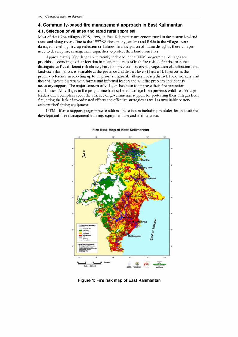
56 Communities in flames
4. Community-based fire management approach in East Kalimantan4.1. Selection of villages and rapid rural appraisalMost of the 1,264 villages (BPS, 1999) in East Kalimantan are concentrated in the eastern lowlandareas and along rivers. Due to the 1997/98 fires, many gardens and fields in the villages weredamaged, resulting in crop reduction or failures. In anticipation of future droughts, these villagesneed to develop fire management capacities to protect their land from fires.
Approximately 70 villages are currently included in the IFFM programme. Villages areprioritised according to their location in relation to areas of high fire risk. A fire risk map thatdistinguishes five different risk classes, based on previous fire events, vegetation classifications andland-use information, is available at the province and district levels (Figure 1). It serves as theprimary reference in selecting up to 15 priority high-risk villages in each district. Field workers visitthese villages to discuss with formal and informal leaders the wildfire problem and identifynecessary support. The major concern of villagers has been to improve their fire protectioncapabilities. All villages in the programme have suffered damage from previous wildfires. Villageleaders often complain about the absence of governmental support for protecting their villages fromfire, citing the lack of co-ordinated efforts and effective strategies as well as unsuitable or non-existent firefighting equipment.
IFFM offers a support programme to address these issues including modules for institutionaldevelopment, fire management training, equipment use and maintenance.
Figure 1: Fire risk map of East Kalimantan
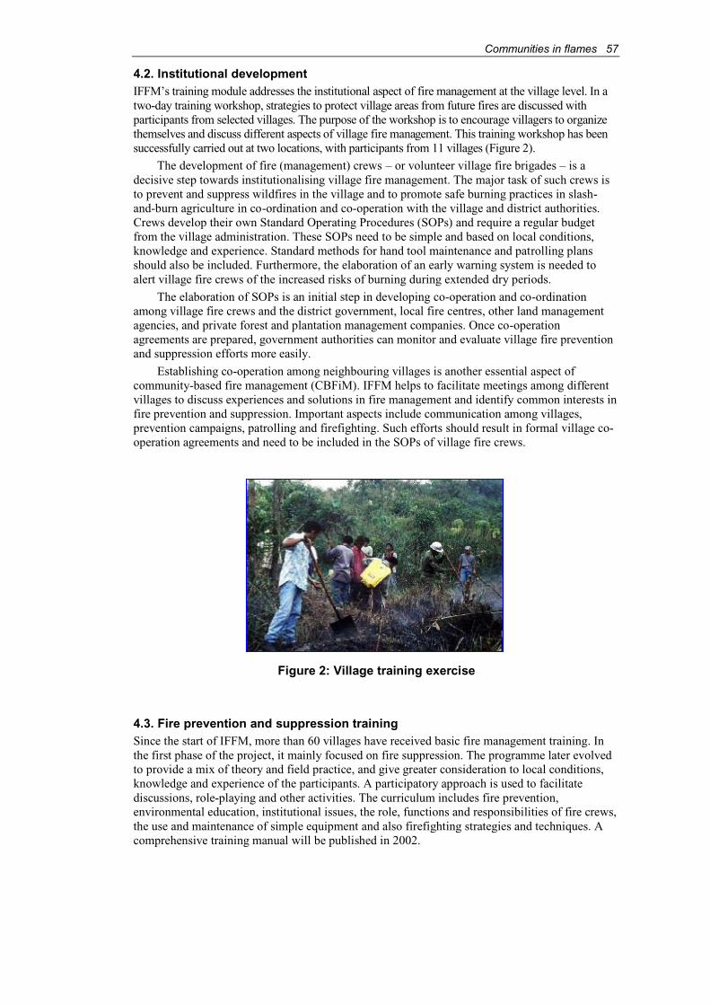
Communities in flames 57
4.2. Institutional developmentIFFM’s training module addresses the institutional aspect of fire management at the village level. In a two-day training workshop, strategies to protect village areas from future fires are discussed with participants from selected villages. The purpose of the workshop is to encourage villagers to organizethemselves and discuss different aspects of village fire management. This training workshop has beensuccessfully carried out at two locations, with participants from 11 villages (Figure 2).
The development of fire (management) crews – or volunteer village fire brigades – is a decisive step towards institutionalising village fire management. The major task of such crews isto prevent and suppress wildfires in the village and to promote safe burning practices in slash-and-burn agriculture in co-ordination and co-operation with the village and district authorities.Crews develop their own Standard Operating Procedures (SOPs) and require a regular budgetfrom the village administration. These SOPs need to be simple and based on local conditions,knowledge and experience. Standard methods for hand tool maintenance and patrolling plansshould also be included. Furthermore, the elaboration of an early warning system is needed toalert village fire crews of the increased risks of burning during extended dry periods.
The elaboration of SOPs is an initial step in developing co-operation and co-ordinationamong village fire crews and the district government, local fire centres, other land managementagencies, and private forest and plantation management companies. Once co-operationagreements are prepared, government authorities can monitor and evaluate village fire preventionand suppression efforts more easily.
Establishing co-operation among neighbouring villages is another essential aspect ofcommunity-based fire management (CBFiM). IFFM helps to facilitate meetings among differentvillages to discuss experiences and solutions in fire management and identify common interests infire prevention and suppression. Important aspects include communication among villages,prevention campaigns, patrolling and firefighting. Such efforts should result in formal village co-operation agreements and need to be included in the SOPs of village fire crews.
Figure 2: Village training exercise
4.3. Fire prevention and suppression trainingSince the start of IFFM, more than 60 villages have received basic fire management training. In the first phase of the project, it mainly focused on fire suppression. The programme later evolvedto provide a mix of theory and field practice, and give greater consideration to local conditions,knowledge and experience of the participants. A participatory approach is used to facilitatediscussions, role-playing and other activities. The curriculum includes fire prevention,environmental education, institutional issues, the role, functions and responsibilities of fire crews,the use and maintenance of simple equipment and also firefighting strategies and techniques. A comprehensive training manual will be published in 2002.
58 Communities in flames
A five-day “Training of Trainers” approach has been designed for extension workers,forestry staff, crew bosses and community leaders, who have already passed the basic firemanagement training. Two training sessions have been carried out successfully in 2001.Supporting training manuals and materials are being prepared.
4.4. Firefighting equipment at the community levelEquipment traditionally used to fight fires consists of simple hand tools like machetes, woodenrakes and small bamboo hand-pumps. When nothing else is available, banana leaves or a bundleof wooden sticks are used to fight fires. Generally, such equipment is effective in fighting grassfires or safeguarding small “slash-and-burn” fires, but it is unsuitable for “hot” wildfires likethose in 1997/98.
To elaborate a standard for firefighting at the community level, hand tools have beenintroduced and evaluated during training. Hand tools have to be suitable for local conditions. Theyhave to be light and their dimensions have to fit the people who use them. The backpack pump, thePulaski (two-function hoe) and the McLeod (two-function rake) are the most favoured tools.Additionally, the fire swatter, useful to fight grass fires, is well accepted. IFFM has assembled “toolboxes” to support village fire crews of 15 to 20 members. More than 100 hand toolboxes are beinghanded over to communities in close co-operation with the district forestry services and the localgovernments on condition that the villages have officially established fire crews and drafted SOPs.In addition, suitable storage rooms have to be provided, which can also serve as village fire(management) posts. In the future, one task assigned to local fire centre staff will be the support ofvillage crews in maintaining and repairing their firefighting hand tools.
4.5. Further incentives to support CBFiMThe provision of training and hand tools by IFFM are initial incentives to support villages inbuilding their capacities in wildfire prevention. To further develop CBFiM and eventuallyenhance the sustainability of such efforts, continuous support by the government is needed. Once a village develops a fire management organization, the village fire crew needs official recognitionby the district and provincial governments to receive administrative, financial, organizational,educational and legal support. Apart from these basic steps, further incentives are necessary. For example, successful wildfire prevention and suppression might be rewarded with villageinfrastructure and income-generating programmes.
5. Fire information – potential benefits for local communities and theirnecessary contributionThe IFFM supports the Fire Information Unit of the provincial fire management organization byproviding fire danger-rating information through drought index calculation, weather forecastsincluding El Niño predictions, satellite-based hot spot data and fire risk mapping (Figure 3). Such information is the foundation of fire management planning and has been made available at the national, provincial and district levels. It remains, however, unclear how this information canreach villages in fire risk areas and be translated into essential details for fire prevention orsuppression in the field.
5.1. Early warning systemThe Keetch Byram Drought Index (KBDI), introduced and applied by IFFM and calculated by thegovernmental meteorological service – Badan Meteorologi dan Geofisika (BMG) – for the province, is the basic tool for an early warning system for fire.5 The index is input into a fire danger-rating matrix that describes four fire danger classes as low, moderate, high and extreme.
5 IFFM adapted the KBDI, used in some states in the US, to East Kalimantan conditions. See Deeming(1995) and Weidemann (2002).
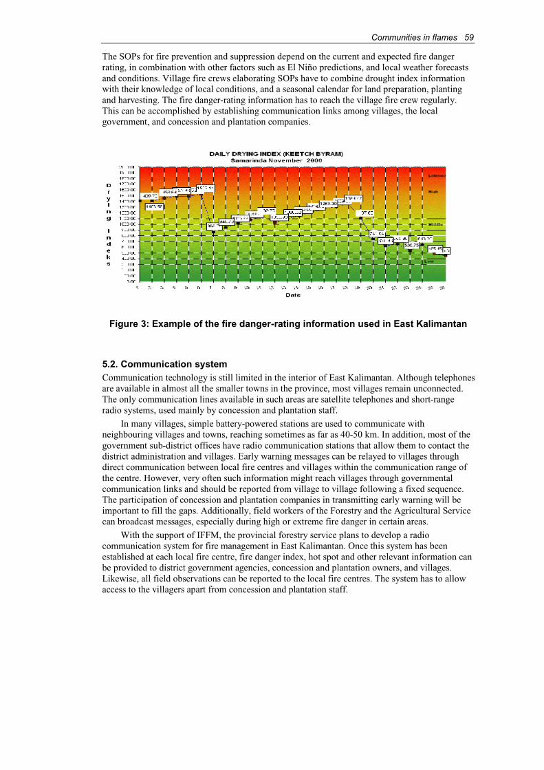
Communities in flames 59
The SOPs for fire prevention and suppression depend on the current and expected fire dangerrating, in combination with other factors such as El Niño predictions, and local weather forecastsand conditions. Village fire crews elaborating SOPs have to combine drought index informationwith their knowledge of local conditions, and a seasonal calendar for land preparation, plantingand harvesting. The fire danger-rating information has to reach the village fire crew regularly.This can be accomplished by establishing communication links among villages, the local government, and concession and plantation companies.
Figure 3: Example of the fire danger-rating information used in East Kalimantan
5.2. Communication systemCommunication technology is still limited in the interior of East Kalimantan. Although telephonesare available in almost all the smaller towns in the province, most villages remain unconnected.The only communication lines available in such areas are satellite telephones and short-rangeradio systems, used mainly by concession and plantation staff.
In many villages, simple battery-powered stations are used to communicate withneighbouring villages and towns, reaching sometimes as far as 40-50 km. In addition, most of the government sub-district offices have radio communication stations that allow them to contact thedistrict administration and villages. Early warning messages can be relayed to villages throughdirect communication between local fire centres and villages within the communication range of the centre. However, very often such information might reach villages through governmentalcommunication links and should be reported from village to village following a fixed sequence.The participation of concession and plantation companies in transmitting early warning will beimportant to fill the gaps. Additionally, field workers of the Forestry and the Agricultural Servicecan broadcast messages, especially during high or extreme fire danger in certain areas.
With the support of IFFM, the provincial forestry service plans to develop a radiocommunication system for fire management in East Kalimantan. Once this system has beenestablished at each local fire centre, fire danger index, hot spot and other relevant information canbe provided to district government agencies, concession and plantation owners, and villages.Likewise, all field observations can be reported to the local fire centres. The system has to allowaccess to the villagers apart from concession and plantation staff.
60 Communities in flames
5.3. Village fire risk sketch-mappingOne of the tasks of a village fire crew is to sketch-map fire hazards and determine fire risk areasbased on previous fires and the knowledge of local conditions in relation to existing vegetationtypes and land use. A sketch-map is an elementary instrument for the elaboration of SOPs incombination with determining the village fire crew’s response area for firefighting. Additionalinformation such as village posts, water reservoirs and equipment locations should be included.
Village fire risk sketch-maps can become a valuable information source for the provincialand district fire centres by adding more specific details from such maps into district fire riskmaps, digitally produced by the provincial fire centres. They will also support the provincial fire centre in setting up a database of fire relevant information such as available firefighting resources in the province, which includes village fire management efforts.
5.4. Hot spot information and early detectionHot spot data might be useful as early fire detection information and therefore can support initialresponse efforts, assuming that they reach government or concession fire crews in time. The usefulness of hot spot data for village fire crews, however, is questionable. Villagers may havealready spotted a fire before hot spot data are available. In addition, hot spot data or co-ordinatesare useful for village fire crews only if they are translated into descriptions of estimated firelocations, since Geographic Positioning System (GPS) tools are not easily available. The partiesthat potentially benefit most from hot spot data might be concession/plantation companies andgovernment agencies. Normally, the provincial fire centre would evaluate hot spots in combination with land-use information, based on government land-use maps, and send dailyreports to local fire centres, which then inform companies and district government agencies aboutfires in their respective areas.
6. Environmental education as part of CBFiMFrom the beginning, IFFM has been continuously designing fire prevention materials and carryingout campaigns in various forms together with government agencies, non-governmentalorganizations (NGOs) and other institutions to directly or indirectly support CBFiM in East Kalimantan. Dozens of campaigns – with hundreds of participating villagers – were carried out in the past years within the framework of village extension work to raise awareness on the negativeimpacts of uncontrolled fires and the importance of CBFiM (Table 1). Additionally, IFFM hasdisseminating information on fire prevention to teachers, government extension workers, NGOs, university students and others, and distributed thousands of leaflets, posters, stickers, and fireprevention comics at seminars, workshops and training events. Such activities are aimed atsupporting and encouraging potential “community agents” to help spread the fire preventionmessage to as many people as possible.
Most households in East Kalimantan have access to radio transmissions and to a large extentalso to television and newspapers. Consequently, the co-operation with the mass media has beenintense from an early stage of the project. It resulted in numerous newspaper campaigns,interviews, television talk shows, and television and radio coverage of fire prevention campaigns.A future goal will be to integrate early warning information into the daily weather news for the province, particularly in high and extreme fire danger situations. IFFM also has been co-operatingwith an Indonesian television star (Kak Seto) to promote the Indonesian fire prevention mascot“Si Pongi” (Figure 4). Together, various marketable Si Pongi items have been produced, a theatreshow for children designed and carried out, and a music cassette produced. Recently, Si Pongi hasbecome a regular attraction in a national children’s television show that is watched by millions ofchildren all over Indonesia.
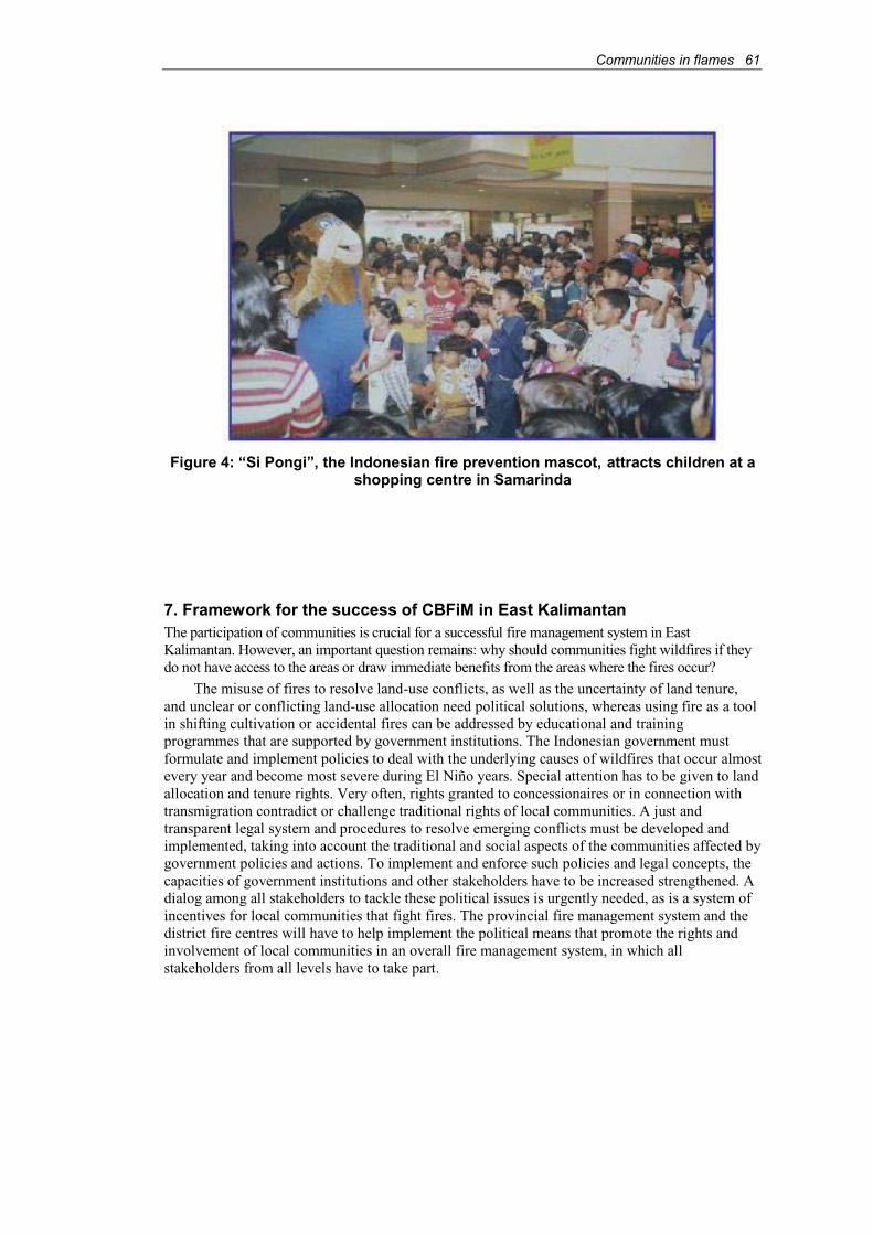
Communities in flames 61
Figure 4: “Si Pongi”, the Indonesian fire prevention mascot, attracts children at ashopping centre in Samarinda
7. Framework for the success of CBFiM in East KalimantanThe participation of communities is crucial for a successful fire management system in East Kalimantan. However, an important question remains: why should communities fight wildfires if theydo not have access to the areas or draw immediate benefits from the areas where the fires occur?
The misuse of fires to resolve land-use conflicts, as well as the uncertainty of land tenure,and unclear or conflicting land-use allocation need political solutions, whereas using fire as a toolin shifting cultivation or accidental fires can be addressed by educational and trainingprogrammes that are supported by government institutions. The Indonesian government must formulate and implement policies to deal with the underlying causes of wildfires that occur almost every year and become most severe during El Niño years. Special attention has to be given to land allocation and tenure rights. Very often, rights granted to concessionaires or in connection withtransmigration contradict or challenge traditional rights of local communities. A just andtransparent legal system and procedures to resolve emerging conflicts must be developed and implemented, taking into account the traditional and social aspects of the communities affected bygovernment policies and actions. To implement and enforce such policies and legal concepts, the capacities of government institutions and other stakeholders have to be increased strengthened. A dialog among all stakeholders to tackle these political issues is urgently needed, as is a system ofincentives for local communities that fight fires. The provincial fire management system and thedistrict fire centres will have to help implement the political means that promote the rights and involvement of local communities in an overall fire management system, in which allstakeholders from all levels have to take part.
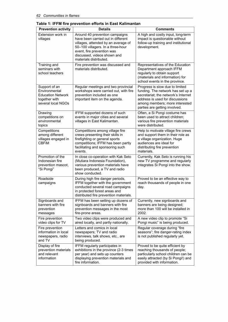
62 Communities in flames
Table 1: IFFM fire prevention efforts in East KalimantanPrevention activity Details Comments
Extension work in villages
Around 40 prevention campaignshave been carried out in differentvillages, attended by an average of 50–100 villagers. In a three-hourevent, fire prevention was discussed, videos shown and materials distributed.
A high and costly input, long-termimpact is questionable without follow-up training and institutionaldevelopment.
Training and seminars with school teachers
Fire prevention was discussed and materials distributed.
Representatives of the EducationDepartment approach IFFM regularly to obtain support(materials and information) for school events in the province.
Support of an EnvironmentalEducation Networktogether with several local NGOs
Regular meetings and two provincialworkshops were carried out, with fire prevention included as one important item on the agenda.
Progress is slow due to limitedfunding. The network has set up a secretariat; the network’s Internetaddress is used for discussionsamong members; more interested parties are getting involved.
Drawingcompetitions on environmentaltopics
IFFM supported dozens of suchevents in major cities and severalvillages in East Kalimantan.
Often, a Si Pongi costume hasbeen used to attract children; various fire prevention materialswere distributed.
Competitionsamong differentvillages engaged in CBFiM
Competitions among village fire crews presenting their skills in firefighting or general sportscompetitions; IFFM has been partlyfacilitating and sponsoring suchevents.
Help to motivate village fire crewsand support them in their role asa village organization. Huge audiences are ideal for distributing fire preventionmaterials.
Promotion of the Indonesian fireprevention mascot,“Si Pongi”
In close co-operation with Kak Seto(Mutiara Indonesia Foundation), various prevention materials have been produced, a TV and radio show conducted.
Currently, Kak Seto is running his new TV programme and regularlyintegrates Si Pongi into the show.
Roadsidecampaigns
During high fire danger periods,IFFM together with the governmentconducted several road campaignsin protected forest areas and distributed fire prevention materials.
Proved to be an effective way to reach thousands of people in one day.
Signboards and banners with firepreventionmessages
IFFM has been setting up dozens of signboards and banners with fire prevention messages in the most fire-prone areas.
Currently, new signboards and banners are being designed; more than 100 will be installed in 2002.
Fire prevention video clips for TV
Two video clips were produced and aired locally, and partly nationally.
A new video clip to promote “Si Pongi music” is being produced.
Fire prevention information in local newspapers, radioand TV
Letters and comics in local newspapers; TV and radiointerviews, talk shows, etc., are being produced.
Regular coverage during “fireseasons”; fire danger-rating indexis not published regularly yet.
Display of fire prevention materials and relevant information
IFFM regularly participates in exhibitions in the province (2-3 times per year) and sets up countersdisplaying prevention materials and fire information.
Proved to be quite efficient byreaching thousands of people; particularly school children can be easily attracted (by Si Pongi!) and provided with information.
Communities in flames 63
8. ConclusionsCBFiM is still in an early stage of implementation in East Kalimantan, although components suchas extension and training have been part of fire management involving village communities since the beginning of IFFM. The programme aims at integrating village communities into wildfireprevention and suppression efforts. Its success very much depends on two crucial issues. Firstly,CBFiM has to be part of community development processes that benefit local communities.Secondly, provincial and district governments have to support such community efforts.
The community’s interest in protecting their land from fire is the basic entry point for the development of CBFiM in East Kalimantan. Providing training and equipment, and facilitatingefforts to establish a village organization strengthen the capacities of village communities in fireprevention and suppression, and therefore, are directed at communities’ self-help approach.Various long-term educational measures and campaigns have to accompany and support CBFiM processes as early as possible. CBFiM will commence only after a village organization has beenestablished.
Whether CBFiM can support fire management beyond the protection of community land in thefuture, i.e. by suppressing fires in concessions or protected forests, will very much depend on thenecessary support given to village fire crews from the provincial and district governments, and theprivate sector. Thus, the co-operation among these three key players will be crucial to prevent large-scale wildfires in the future. It is, however, inappropriate if local communities are only regarded as a source of forest firefighting workers. The success of CBFiM will depend on how the governmenttries to address the underlying causes of fire such as land disputes that are partly triggered by thenational government’s neglect of traditional community forest rights in the first place.
Another important aspect is the development of suitable regulations limiting the (mis-)use of fire. Large-scale forest conversion with the use of fire has to be prohibited, while on the otherhand, small-scale forest conversion by shifting cultivators should be permitted, i.e. by theintroduction of burning permits. Such regulations are part of CBFiM’s framework and must be enforced by the government. In turn, village fire crews together with their village administrationcan introduce a reporting system for fire use in their respective villages, through which theywould implement existing government regulations.
CBFiM in East Kalimantan has to build on the willingness and motivation of villagecommunities to contribute to fire prevention and suppression. The approach has already shown some promising results in certain areas. It is hoped that CBFiM might become the key to preventand suppress wildfires more successfully in East Kalimantan in the future.
ReferencesAbberger, H.M. & Beebe, G.S. (1999). Fire protection and pre-suppression strategy for the PT.
Limbang Ganeca Concession, KLI Group. IFFM Doc. No. 13 (Working doc.). IntegratedForest Fire Management Project, Samarinda, East Kalimantan, Indonesia.
Aspiannur & Baraq, M. (1999). Beberapa sebab kebakaran hutan dan lahan di hutan wisata BukitSoeharto Tahun 1997-1998. In IFFM Doc. No. 14. Integrated Forest Fire ManagementProject, Samarinda, East Kalimantan, Indonesia.
Aspiannur, Ubang, B. & Abberger, H.M. (1997). Metode traditional pembersihan lahan pada salah satu suku Dayak di Kalimantan Timur. IFFM Doc. No. 10. Integrated Forest Fire Management Project, Samarinda, East Kalimantan, Indonesia.
Bappeda & BPS. (1999). Kalimantan Timur dalam angka (East Kalimantan in numbers).Kerjasama Bappeda Propinsi Kalimantan Timur dengan Badan Pusat Statistik PropinsiKalimantan Timur, Indonesia.
Bappenas (National Development Planning Agency). (1999). Causes, extent, impact, and costs of the 1997/98 fires and drought. Final report. Asian Development Bank Technical AssistanceGrant TA 2999-INO. Planning for Fire Prevention and Drought Management Project,Jakarta, Indonesia.
64 Communities in flames
Barber, C.V. & Schweithelm, J. (2000). Trial by fire. Forest fires and forestry policy inIndonesia’s era of crisis and reform. World Resources Institute, USA.
BPS. (1999). Statistik penduduk Kalimantan Timur. Badan Pusat Statistik Propinsi Kalimantan Timur, Samarinda, Indonesia.
Colfer, C.J.P. (2001). Fire in East Kalimantan. A panoply of practices, views and [discouraging]effects. Borneo Research Bulletin, Volume 32.
Colfer, C.J.P. & Dudley, R.G. (1993). Shifting cultivators of Indonesia: marauders or managers ofthe forest. Rice production and forest use among the Uma’ Jalan of East Kalimantan. Foodand Agriculture Organization of the United Nations, Rome, Italy.
Deeming, J.E. (1995). Development of a fire danger rating system for East Kalimantan Indonesia.IFFM Report No. 2. Integrated Forest Fire Management Project, Samarinda, East Kalimantan, Indonesia.
Goldammer, J.G. & Seibert, B. (1990). The impacts of droughts and forest fires on tropicallowland rain forest of East Kalimantan. In Goldammer, J.G. (ed.). Fire in the Tropical Biota.Ecosystem Processes and Global Challenges. Springer Verlag, Heidelberg. pp. 11-31.
Goldammer, J.G., Seibert, B. & Schindele, W. (1996). Fire in dipterocarp forests. In Schulte, A. and Schoene D. (eds.). Dipterocarp forest ecosystems. Towards sustainable management.World Scientific, Singapore.
Gönner, C. (1999). Conflicts and fire causes in a district of Kutai Regency, East Kalimantan, Indonesia. In Vayda, P. (ed.) Finding causes of the 1997-98 Indonesian forest fires:problems and possibilities. WWF Indonesia Forest Fire Project, Jakarta, Indonesia.
Hinrichs, A. (2000). Financial losses due to the 1997/8 fires in HPH areas of East Kalimantan.SFMP 30.11.00. Samarinda, East Kalimantan, Indonesia.
Hoffmann, A.A., Hinrichs, A. & Siegert, F. (1999). Fire damage in East Kalimantan in 1997/8related to land use and vegetation classes: satellite radar inventory results and proposals forfurther actions. IFFM/SFMP/GTZ, Integrated Forest Fire Management project, Samarinda,East Kalimantan, Indonesia.
Jepson, P., Momberg, F. & van Noord, H. (1998). Trade in reptiles from the middle MahakamLake area, East Kalimantan, Indonesia with evidence of a causal link to the forest fires. Bio-Regional Management and Integrated Park Management Project. Technical Memorandum 3.WWF Indonesia/EPIQ/USAID, Jakarta, Indonesia.
Mayer, J.H. (1989). Socioeconomic aspects of the forest fire 1982/83 and the relation of local communities towards forestry and forest management in East Kalimantan. FR-Report No. 9.German Forest Service (DFS), Feldkirchen, Germany.
Nicolas, M.V.J. (1999). Fire management in the logging concessions and plantation Forests of Indonesia. In Suhartoyo, H. and Toma, T. (eds.). Impacts of fire and human activities onforest ecosystems in the tropics. Proceedings of the 3rd International Symposium on Asian Tropical Forest Management, 20-23 September 1999. Samarinda (Pusrehut SpecialPublication No.8. Tropical Forest Research Center, Mulawarman University and JapanInternational Cooperation Agency, Samarinda, Indonesia.
Schindele, W., Thoma, W. & Panzer, K. (1989). The forest fire 1982/83 in East Kalimantan. Part1: The fire, the effects, the damage and technical solutions. German Forest Service (DFS), Feldkirchen, Germany.
Schweithelm, J. (1999). The fire this time: an overview of Indonesia’s forest fire in 1997/1998.WWF Indonesia Forest Fire Project, WWF Indonesia, Jakarta, Indonesia.
Siegert, F., Rücker, G., Hinrichs, A. & Hoffmann, A.A. (2001). Increased damage from fires inlogged forests during droughts caused by El Niño. Nature Vol 414, 22 November 2001,www.nature.com.
State Ministry for Environment of the Republic of Indonesia and UNDP. (1998). Forest and landfires in Indonesia. Volume I: Impacts, factors and evaluation. Jakarta, Indonesia.

Communities in flames 65
State Ministry for Environment of the Republic of Indonesia & UNDP. (1998). Forest and landfires in Indonesia. Volume II: Plan of action for fire disaster management. Jakarta, Indonesia.
Vayda, P. (1999). Finding causes of the 1997-98 Indonesian forest fires: problems and possibilities. WWF Indonesia Forest Fire Project, Jakarta, Indonesia.
Weidemann, D. (2002). Development and extension of a fire danger rating system for theProvince of East Kalimantan/Indonesia. Final report. Integrated Forest Fire ManagementProject, Samarinda, East Kalimantan, Indonesia.
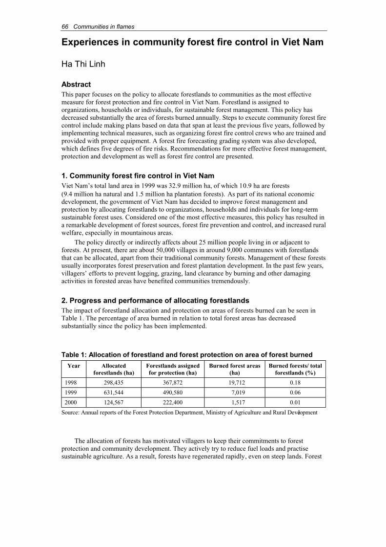
66 Communities in flames
Experiences in community forest fire control in Viet Nam
Ha Thi Linh
AbstractThis paper focuses on the policy to allocate forestlands to communities as the most effectivemeasure for forest protection and fire control in Viet Nam. Forestland is assigned to organizations, households or individuals, for sustainable forest management. This policy hasdecreased substantially the area of forests burned annually. Steps to execute community forest firecontrol include making plans based on data that span at least the previous five years, followed byimplementing technical measures, such as organizing forest fire control crews who are trained andprovided with proper equipment. A forest fire forecasting grading system was also developed, which defines five degrees of fire risks. Recommendations for more effective forest management,protection and development as well as forest fire control are presented.
1. Community forest fire control in Viet NamViet Nam’s total land area in 1999 was 32.9 million ha, of which 10.9 ha are forests(9.4 million ha natural and 1.5 million ha plantation forests). As part of its national economicdevelopment, the government of Viet Nam has decided to improve forest management and protection by allocating forestlands to organizations, households and individuals for long-termsustainable forest uses. Considered one of the most effective measures, this policy has resulted in a remarkable development of forest sources, forest fire prevention and control, and increased ruralwelfare, especially in mountainous areas.
The policy directly or indirectly affects about 25 million people living in or adjacent to forests. At present, there are about 50,000 villages in around 9,000 communes with forestlandsthat can be allocated, apart from their traditional community forests. Management of these forestsusually incorporates forest preservation and forest plantation development. In the past few years, villagers’ efforts to prevent logging, grazing, land clearance by burning and other damagingactivities in forested areas have benefited communities tremendously.
2. Progress and performance of allocating forestlandsThe impact of forestland allocation and protection on areas of forests burned can be seen inTable 1. The percentage of area burned in rela tion to total forest areas has decreasedsubstantially since the policy has been implemented.
Table 1: Allocation of forestland and forest protection on area of forest burned
Year Allocatedforestlands (ha)
Forestlands assignedfor protection (ha)
Burned forest areas(ha)
Burned forests/ total forestlands (%)
1998 298,435 367,872 19,712 0.18
1999 631,544 490,580 7,019 0.06
2000 124,567 222,400 1,517 0.01
Source: Annual reports of the Forest Protection Department, Ministry of Agriculture and Rural Development
The allocation of forests has motivated villagers to keep their commitments to forestprotection and community development. They actively try to reduce fuel loads and practisesustainable agriculture. As a result, forests have regenerated rapidly, even on steep lands. Forest
Communities in flames 67
cover also increased, forest products have multiplied, watersheds are protected, soil erosion isreduced, the natural environment has improved, and in particular, incidences of forest fires have decreased. All these outcomes have helped satisfied the objectives of Viet Nam’s 5 MillionHectare Reforestation Programme.
Community-based forest protection has partially met villagers’ subsistence demands for forestproduct (e.g. firewood, timber, bamboo for construction, fruits, medicine and fodder). Villagerscould even derive income from forest products, and did not have to rely on payments from thegovernment, thus saving the state an average of VND 50,000/ha/per year in forest protection fees.
The government is concerned about forest fires. Important legislation has been enacted tofacilitate forest fire control activities in Viet Nam. Community forest fire control is carried out according to the steps outlined below:
Step 1: Forest fire control plans are made based on fire data from at least the previous fiveyears. The data are analysed according to:
♦ Causes of the fire.
♦ Timing of the fire (is it influenced by climate and time of day?)
♦ Location of the fire (marked on maps.)
The plans should include:
♦ objectives;
♦ relevant legislation;
♦ maps showing forest fire location and vulnerable areas;
♦ warning schedules;
♦ charts summarising forest control programmes;
♦ human resources for forest fire control (e.g. communities, forest rangers, army, police);and
♦ development of community education programmes on forest fire control.
Some measures for minimising forest fire risks include asking households to sign on forforest protection, and compiling feedback from the field.
Step 2: Implement technical measures:a. Organize and prepare forest fire control crews, including local forest rangers, to help
People’s Committees at all levels plan and set up Forest Fire Control Steering Committees to be chaired by the Chairperson or Vice Chairperson of People’sCommittees. Representatives from other relevant agencies are members of the SteeringCommittees. These Committees help authorities at all levels direct, supervise and monitorforest fire control activities, especially in fire-prone areas, during the dry seasons.
During high fire risk period and in fire-prone areas, the following teams should be set up:
♦ Forest fire control teams of two or three members who are forest protection staff(forest rangers); and
♦ Voluntary forest protection teams at the local level comprising 15-30 people mobilisedfrom the armed and police forces, and workers of agroforestry enterprises. The teamsare equipped with firefighting equipment and trained in appropriate techniques.Together with forest rangers, they patrol and safeguard forest areas regularly.
Communities living near the forests protect forests in accordance with community customsand traditions. In some places, they have initiated a common village fund for forest protection(e.g. Yen Bai Province). In others, social organizations and households work together todevelop community forests and organize forest protection (e.g. Cao Bang Province).
68 Communities in flames
b. Annually, the District Forest Protection Departments assist forest owners in forest fireprevention and control during the dry seasons. A forest-fire forecasting grading systemwas developed and posted on large signboards at key fire-prone areas as follows:
♦ Grade 1: Safe, conditions not likely to start a fire.
♦ Grade 2: Fair, conditions likely to start a fire.
♦ Grade 3: Alert, dry weather conditions likely to start a fire.
♦ Grade 4: Dangerous, lengthy dry weather conditions very likely to start a fire.
♦ Grade 5: Extremely dangerous, lengthy dry weather conditions extremely likely to start and spread a fire quickly.
In addition to involving communities in fire prevention and control, Viet Nam has alsocreated firebreaks, including green belts.
3. RecommendationsTo strengthen forest management, protection and development as well as forest fire management,further attention should be paid to the following issues:
♦ Develop policies to encourage community involvement in forest protection andmanagement. This is a key strategy for forest protection in general and for forest fire control in particular. As long as people understand and see the benefits, they will have asense of ownership and take more responsibility for forest and fire management.
♦ Empower communities to manage, utilise and protect forests.
♦ Allocate forestland, especially customary land used and managed by communities andforests with no clear ownership.
♦ Alleviate poverty and hunger, improve knowledge of people in rural and mountainousareas, and invest in infrastructure (electricity, roads, schools, health clinics, potablewater and irrigation in mountainous areas) in collaboration with other developmentprogrammes.
♦ Develop policies on investment, tax, food security and human resource development.
♦ Develop models of forest management and protection at communal and village levels, carry out the signing of inter-household, inter-village commitments to forest protection,especially during the dry seasons when the risk of forest fire is extremely high.
♦ Increase dissemination of information and invest in education to improve the awarenessof local people living in forests, establish forest fire control teams and provideappropriate equipment and tools.
♦ Strengthen management capacity to direct the enforcement of the Law on ForestProtection and Management at various levels.
♦ Set up a mechanism to notify communities about forest fires and mobilise firefightingteams and tools.
♦ During high risk periods, Steering Committees and Management Boards of forest fire control have to establish guidelines on:
⇒ on-site directives;
⇒ on-site fire control teams;
⇒ on-site tools and equipment; and
⇒ on-site logistics.
♦ Increase co-operation among agencies, and provide guidelines and directives on zoning forpermanent agriculture to minimise slash-and-burn practices, a major cause of forest fire.
Communities in flames 69
Forest and fire suppression in East Kalimantan, Indonesia
Chandradewana Boer1
AbstractThe 1982/83 fire in East Kalimantan destroyed about 3.5 million ha of forest. Forest fires occuralmost every year, however each event is specific in intensity and extent. The 1997/98 fire wasdeclared a national disaster, since it affected more than 5 million ha of forest in East Kalimantanalone. Intensive logging activities also increased the susceptibility of the forest.
Indigenous knowledge can help protect tropical forest. To minimise the negative impact of fireand to develop fire prevention techniques, it is important to make use of indigenous knowledge and combine it with scientific knowledge of fire behaviour and fire management technologies.
1. IntroductionIntensive logging activities in East Kalimantan have turned its forests into a fire hazard, and forestfires are occurring more frequently. From 1982/83 to 1997/98, fires have decreased not only EastKalimantan’s forest cover but also the quality of the forest. This affects the environmental functionsof the forest and casts great impacts on the economy, culture and health of society.
Forest protection has become very important to the future of forest resources. In particular,the decentralisation of power and responsibility has made it possible for local people to exhaustnatural resources more easily. Such exploitation interrupts the process of secondary successionand prevents the tropical forests of Kalimantan to reach its climax condition.
People living at the forest margins rely on traditional local knowledge and skills to protect theforest against fire. Their success depends on the community’s attachment to the forest. The questionremains whether traditional knowledge and skills alone are sufficient to manage the forest today.
2. Forest protection2.1. Forest protection from fireIn 1982/83, fires destroyed about 3.5 million ha of tropical forests in East Kalimantan. Eightypercent were logged-over areas (Lennertz and Panzer, 1983). After the forest f ires in 1982/83,1991/92 and 1993/94, an El Niño event that lasted 12 months exacerbated major fires in 1997/98,burning approximately 5 million ha or 25 percent of the forests in the province. Almost2.3 million ha of Hak Penguasaan Hutan (HPH – forest concession) areas (56 HPH and ex-HPH),0.4 million ha in forest reserves, 0.9 million ha in Hutan Tanaman Industri (HTI – industrialtimber plantation) areas (30 HTI) and 0.7 million ha in other plantation areas burned. Of the27 ex-HPH concessionaires, only 7 were not burned. Two ex-HPH areas – P.T. Alas Kusuma(5,863 ha) and ex-HPH P.T. Astrini (11,669 ha) – were completely destroyed.
The smoke and haze from the forest fires affected the health of people nationally andregionally, and lead to serious criticism of Indonesia by neighbouring countries. This causedtension and disturbed international relationships. The fires also destroyed the habitats of wildanimals, and forced some species (e.g. the orangutans ( Pongo pygmaeus)), to move into theplantation areas (Ngatimna, 2001). Many mangrove forests, as the original habitat of endemicfauna such as bekantan (Nasalis larvatus), were also damaged. Moreover, underground coalseams pose an additional threat should they catch fire.
Efforts to protect plantation forests have been undertaken, although they were not verysuccessful judging from the recurring fires. Table 1 shows examples of efforts to prevent andcontrol forest fires in the HPH or HTI areas.
1 Staff of Forestry Faculty of Mulawarman University, Samarinda, Indonesia.
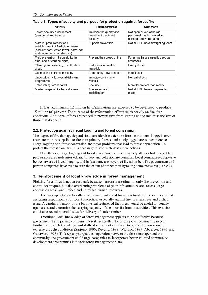
70 Communities in flames
Table 1. Types of activity and purpose for protection against forest fireActivity Purpose/target Comment
Forest security procurement(personnel and training)
Increase the quality andquantity of the forestsecurity
Not optimal yet, althoughpersonnel has increased in number and were trained
Material procurement andestablishment of firefighting team(security post, watch tower, patrol car,and communication devices)
Support prevention Not all HPH have firefighting team
Field prevention (firebreak, bufferstrip, pools, warning signs)
Prevent the spread of fire Forest paths are usually used asfirebreaks
Clearing and cleaning of cultivationareas
Reduce inflammablematerials
Hardly done
Counselling to the community Community’s awareness Insufficient
Undertaking village establishmentprogramme
Increase communitywelfare
No real effects
Establishing forest patrol Security More theoretical than realityMaking maps of fire hazard areas Prevention and
socialisationNot all HPH have comparablemaps
In East Kalimantan, 1.5 million ha of plantations are expected to be developed to produce15 million m3 per year. The success of the reforestation efforts relies heavily on fire -freeconditions. Additional efforts are needed to prevent fires from starting and to minimise the size ofthose that do occur.
2.2. Protection against illegal logging and forest conversionThe degree of fire damage depends to a considerable extent on forest conditions. Logged -overareas are more susceptible to fire than primary forests, and newly logged areas even more so.Illegal logging and forest conversion are major problems that lead to forest degradation. Toprotect the forest from fire, it is necessary to stop such destructive actions.
Nonetheless, illegal logging and forest conversion occur extensively all over Indonesia. Theperpetrators are rarely arrested, and bribery and collusion are common. Local communities appear tobe well aware of illegal logging, and in fact some are buyers of illegal timber. The government andprivate companies have tried to curb the extent of timber theft by taking some measures (Table 2).
3. Reinforcement of local knowledge in forest managementFighting forest fires is not an easy task because it means mastering not only fire prevention andcontrol techniques, but also overcoming problems of poor infrastructure and access, large concession areas, and limited and untrained human resources.
The overlap between forestland and community land for agricultural production means thatassigning responsibility for forest protection, especially against fire, is a sensit ive and difficultissue. A careful inventory of the biophysical features of the forest would be useful to identifyopen areas and determine the carrying capacity of the areas for human activities. This exercisecould also reveal potential sites for delivery of stolen timber.
Traditional local knowledge of forest management appears to be ineffective becausegovernmental and private company interests generally take priority over community needs.Furthermore, such knowledge and skills alone are not sufficient to protect the forest underextreme drought conditions (Sarjono, 1990; Devung, 1999; Widjono, 1989; Abberger, 1996; andGunawan, 1998). To keep a synergistic co-operation between the forest manager and thecommunity, the government could urge companies to incorporate better-tailored communitydevelopment programmes into their forest management plans.

Communities in flames 71
Table 2. Types of activity and purpose for protection against illegal logging and forest clearing
Types of Activity Purpose/target Comment
Confiscation of illegally felled trees Law enforcement Not effective
Confiscation of chainsaws Law enforcement Not effective and tends tocreate conflicts
Safeguarding forest protection teamoperation
Law enforcement Efficient enough
Inventory and monitoring of the activities of illegal cultivators
Data collection Hardly done
Providing information (about theadvantages of forest, law, socialisation ofborder regulation)
Socialisation Impact yet to be felt
PMDH* village establishment andcommunity forest
Welfare improvement Needs to be continued andmonitored
Generating employment Community involvement Limited job opportunitiesStationing forest security patrols Security Operational difficultiesCo-ordination with relevant security andenforcement departments and institutions
Co-ordination Sometimes disappointing
Use of signboards prohibiting illegallogging and cultivation
Prevention No impact yet
* PMDH = Pembangunan Masyarakat Desa Hutan (Village Community Development Programme)
Another important factor that threatens the forests is the low incomes of rural communities inEast Kalimantan. Poor farmers are found in all provinces. Almost 90 percent of them, bothindigenous and migrant, settle in forested areas and depend on the surrounding natural resources fortheir daily needs. This has contributed to forest degradation. Moreover, the forest will continue to beexploited when illegal brokers continue to buy timber and other forest products. Unless this greatdisparity between the poor and powerful is resolved, forestdegradation will continue.
Efforts to control shifting cultivation include transmigration policies, dryland cultivation(Pertanian Usaha Lahan Kering – PULK), permanent cultivator cadres (Kader Tani Menetap –Kanitab), resettlement of isolated tribes and HPH for forest village establishment. However, these efforts have not achieved the desired results – shifting cultivation and forest conversion persist. Inaddition, communities have settled in ex-HPH or conservation areas, such as the Kutai National Park.
4. Community forestry as a strategy for forest and land protectionThe forests in East Kalimantan consist mainly of secondary logged-over and fire-affected areas.Without community participation in forest management and fire prevention, deforestation and forestdegradation will continue with negative impacts on forest dwellings and forest margin communities.
Therefore, those involved in forest protection should be knowledgeable of the area to be protected, despite constraints such as poor accessibility and inconsistent monitoring of fire risks especially during droughts. The following factors need to be considered in planning forest protection.
4.1. Dividing the forest area into smaller units for more effective forest protectionProtecting the extensive forests of East Kalimantan is a classic problem for Indonesian forestry.Dividing the forests into more manageable units is in line with the Decree of Director General ofForest Cultivation No. 220/1997. According to this decree, a system can be established with anAdministrator who controls 40,000-50,000 ha, Administrator Assistants who oversee 4,000-5,000 ha each, and Heads of Forest Resort who are responsible for 1,000-2,500 ha. Smaller areas enable the participation of local people in protecting that area from fire. Since a major problemthat led to communal conflicts is poorly demarcated boundaries, clear and well-definedadministration of smaller units will significantly improve fire prevention.
72 Communities in flames
4.2. Sharing forest products in consultation with local communitiesForest management tends to exclude the local population from, and deprive them of, forestresources. By applying a profit sharing system, the community’s reliance on the forest can begradually reduced. This can be integrated with other activities such as establishing forest villagecommunities, increasing the role of the community in protecting the territory and developingcommunity awareness. In this way, the community will feel more attached to the forest and bewilling participants of fire prevention activities.
4.3. Implementing integration programmes for newcomers to the communityAnother common problem is the conflicts between indigenous communities and migrants.Transmigrants usually have few skills or knowledge of their new environment, and may use fireinappropriately. Unless well-planned integration arrangements are implemented, long-timeresidents will not accept newcomers. The conflicts are in fact the results of a misguided ruraldevelopment programme.
4.4. Enforcing the law at all levels of societyWeak law enforcement is a sensitive issue that has to be overcome slowly. If not implementedappropriately, the community will resent the forestry department and will not co -operate in any ofits programmes. Incentive systems may more appropriately be substituted for sanctions that are sometimes illegally practised today. The intentional destruction of forest resources bycommunities is a good indicator of their dissatisfaction and animosity.
4.5. Establishing policy and raising awareness of the community’s role inconserving tropical forestThere are still forest inhabitants whose daily lives depend on traditional knowledge, and theirskills should not be ignored. The transfer of local knowledge from one generation to the next is uncertain. Therefore, local traditional knowledge should be integrated with contemporarytechniques for forest management in East Kalimantan. Research and analyses on how thisknowledge can be applied in conserving tropical forest is needed.
4.6. Securing sufficient funds for forest protectionPutting out small fires is easier than extinguishing big ones, and preventing forest fires in the firstplace is preferable to suppression. However, funding for these activities is limited. Therefore,sufficient financial resources should be sourced and set aside to deal with forest fires before theybecome unmanageable.
4.7. Rehabilitating burned forest areas through natural succession processLarge-scale reforestation programmes are usually attempted to rehabilitate burned forest areas.Their success, however, depends on how well the plants grow. The situation is even moreprecarious if salvage cutting is carried out, as is commonly practiced. Allowing the burned foreststo regenerate on their own and letting natural succession follow its course is an alternative thatshould be considered.
5. ConclusionsIndigenous knowledge has a long history of forest management. Community-based fire management therefore should incorporate indigenous knowledge. Combining local knowledgeand skills with modern firefighting technologies is an optimum solution for forest fire preventionand suppression.
Communities in flames 73
Institutional strengthening at the local level is essential. Qualified and trained people are needed to integrate contemporary knowledge and traditional skills. Local communities should beinvolved in maintaining and managing forest resources. They should also be given the opportunityto participate in forest protection. Without their involvement and knowledge, it will be difficult toensure the success of fire management.
ReferencesAbberger, H.M. (1996). Land use systems and slash and burn methods of Buginese communities
in the Bukit Soeharto Area (A case study). IFFM Doc. No. 7. Integrated Forest Fire Management Project, Samarinda, East Kalimantan, Indonesia.
Devung, S. (1999). Potensi kegiatan perladangan berpindah sebagai salah satu penyebab kebakaranhutan di Kalimantan Timur. Paper presented at Fire Suppression and EnvironmentalManagement Training, PPLH Unmul-Bapedal Pusat, Samarinda, 26 April-8 May 1999.
Gunawan, P. (1998). Kajian faktor ekternal dan faktor internal yang berpotensi sebagai penyebabkebakaran hutan pada areal reboisasi di Tahura Bukit Suharto. Thesis. Untag Samarinda,Indonesia.
Lennertz, R. & Panzer, K.F. (1983). Preliminary assessment of the drought and forest fire damagein East Kalimantan. Transmigration Areas Development Project (TAD), German Agency forTechnical Cooperation, Eschborn, Germany.
Ngatimna. (2001). Study on the damage of Acacia mangium stand and the presence of orangutan(Pongo pygmaeus) at P.T. Surya Hutani Jaya, East Kalimantan. Master thesis. MulawarmanUniversity, Samarinda, Indonesia.
Sarjono, A.M. (1999). Aspek sosial-budaya kebakaran hutan di Kalimantan Timur. Paperpresented at Fire Suppression and Environmental Management Training, PPLH Unmul-Bapedal Pusat, Samarinda, 26 April-8 May 1999.
Widjono AMZ, R.H. (1989). Sistem perladangan masyarakat Dayak. An article in the Manuntung,25 September 1989. Samarinda, Indonesia.
74 Communities in flames
Extinguishing the 1998 forest fires and subsequent coal fires in the Sungai Wain Protection Forest, East Kalimantan, Indonesia
Gabriella Fredriksson1
AbstractDuring the 1997/98 El Niño drought, the Sungai Wain Protection Forest in East Kalimantan,Indonesia, caught fire in early March 1998. Fires entered the 10,000 ha primary forest reserve fromthe neighbouring INHUTANI I logging concession and subsequently from agricultural areas in oraround the reserve. The Sungai Wain Protection Forest (Hutan Lindung) is the last patch of primaryforest between Balikpapan and Samarinda with a large number of rare and endangered wildlifespecies. The area was established as a reserve in 1934. Since 1992 the forest has been used as anorangutan reintroduction site and various long-term research projects have been carried out in thereserve. It has also served as a water catchment for the oil industry in Balikpapan, the second largestrefinery in Indonesia, since 1947.
In theory, responsibility for forest fire management of a protection forest falls under theregional forestry department. In reality, however, firefighting is not a high priority for thedepartment’s staff. When the fires broke out in the reserve, other research and project staff in thearea recruited up to 80 local people per day for two months to construct firebreaks and extinguishthe fires. Villagers were paid daily wages and provided with food and other essentials. About 40percent of the reserve was saved.
Seventy-three coal fires were further located in approximately 5,000 ha of burned forest.Again, local villagers were recruited. Two and a half years later, 61 coal fires had been put out, 8had gone out by themselves and 4 still need to be extinguished. In addition, a firebreak was madearound the whole reserve during the 1999 dry season.
1. IntroductionThe rapid disappearance of natural forests due to conversion to agricultural land, poormanagement practices, illegal logging and a lack of law enforcement in East Kalimantan (Rijksenand Meijaard, 1999), underlines the importance of protecting the few remaining pristine forestareas. The Sungai Wain Protection Forest is the last primary forest area remaining betweenBalikpapan and Samarinda, the two major cities in the province. Established as a rese rve in 1934by the Sultan of Kutai, it contains a large number of rare and endangered species and has been a reintroduction site for orangutans from the Wanariset Orangutan Reintroduction Project since1992. The area has served as a water catchment for Bal ikpapan and the oil industry since 1947,and extensive research has been carried out in the reserve over the last 10 years (Fredriksson andde Kam, 1999).
2. The fires of 1998During the 1997/98 El Niño drought, the Sungai Wain Protection Forest caught fire in earlyMarch 1998. The fires originated in the adjacent INHUTANI I logging concession and spread tosurrounding areas (Figure 1). Despite existing communication services, the fires were notreported, and subsequent fires entered the reserve from neigh bouring agricultural areas.
1 c/o Tropenbos-Kalimantan Project, P.O. Box 270, Balikpapan 76110, Kalimantan Timur, Indonesia,email: [email protected]
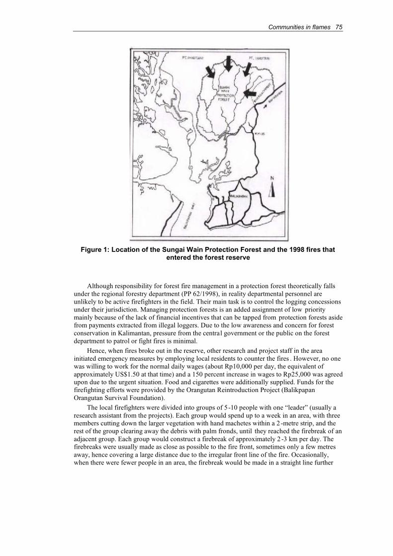
Communities in flames 75
Figure 1: Location of the Sungai Wain Protection Forest and the 1998 fires thatentered the forest reserve
Although responsibility for forest fire management in a protection forest theoretically fallsunder the regional forestry department (PP 62/1998), in reality departmental personnel are unlikely to be active firefighters in the field. Their main task is to control the logging concessionsunder their jurisdiction. Managing protection forests is an added assignment of low prioritymainly because of the lack of financial incentives that can be tapped from protection forests asidefrom payments extracted from illegal loggers. Due to the low awareness and concern for forestconservation in Kalimantan, pressure from the central government or the public on the forestdepartment to patrol or fight fires is minimal.
Hence, when fires broke out in the reserve, other research and project staff in the area initiated emergency measures by employing local residents to counter the fires . However, no onewas willing to work for the normal daily wages (about Rp10,000 per day, the equivalent ofapproximately US$1.50 at that time) and a 150 percent increase in wages to Rp25,000 was agreedupon due to the urgent situation. Food and cigarettes were additionally supplied. Funds for thefirefighting efforts were provided by the Orangutan Reintroduction Project (BalikpapanOrangutan Survival Foundation).
The local firefighters were divided into groups of 5-10 people with one “leader” (usually a research assistant from the projects). Each group would spend up to a week in an area, with threemembers cutting down the larger vegetation with hand machetes within a 2 -metre strip, and therest of the group clearing away the debris with palm fronds, until they reached the firebreak of anadjacent group. Each group would construct a firebreak of approximately 2 -3 km per day. Thefirebreaks were usually made as close as possible to the fire front, sometimes only a few metres away, hence covering a large distance due to the irregular front line of the fire. Occasionally,when there were fewer people in an area, the firebreak would be made in a straight line further

76 Communities in flames
away from the fire front, and back fires would be lit to burn the vegetation between the firebre akand fire front. Eventually a continuous firebreak was made, surrounding the unburned forest corein the reserve. Each group was equipped with basic firefighting equipment (machete, broomsmade from palm leaves, entrenching tools or cangkul), cooking and camping equipment, food(rice and noodles) and other essentials. The leaders were each given a compass and a communication radio (ICOM V-68), on loan from the research projects. Work continuedthroughout the day and night until the fires were under control. Another two weeks were spentchecking the firebreaks and ensuring that no remaining embers caused a new fire.
Workers from the oil refineries and PERTAMINA provided no assistance to the firefightingefforts even though the forest reserve has been a water catchment area for the oil industry for thelast 54 years. PERTAMINA is the biggest state-owned oil company in Indonesia and has freelyoperated in the field with virtually no payments to the local governments for environmentalservices (e.g. the supply of fresh water). The impacts of forest fires on the catchment area and theconsequent environmental damages are not well understood or recognised, and responsibilities arenot shared among the various institutions that might have an interest in the forest.
3. Coal seam firesShortly after the forest fires had been extinguished, a burning coal seam was discovered in theburned forest. Having expended so much effort to put out the surface fires, the firefighting teamsdecided that the coal seam fire must also be extinguished. Funds from the Orangutan ReintroductionProject and USAID project collaborating with the Ministry of Mines, focussing on the coal fireproblems in Indonesia (Sumatra and Kalimantan), were secured to continue the activity.
More burning coal seams were detected, until a total of 73 were identified in 5,000 ha of burned forest. (Figure 2). All coal fires started near small streams where coal layers are found at thesoil surface. From there the fires spread underground depending on thicknessof the coal layer, depthand available oxygen. Some coal fires had moved more than 300 m during the course of two years,leaving behind large areas devoid of trees, which had all died due to the heat damaging the rootsystems. The remaining seams that are still burning are relatively large in size (up to 1,000 m2).
Figure 2: Burned and unburned forest and location of coal seams

Communities in flames 77
Again the local communities were hired to extinguish the coal fires. Initially, a group ofabout 20 people received daily wages, but eventually was given a “lumpsum” payment forworking on a certain number of coal seams identified earlier. The number of people soondecreased to eight. A contract was signed by the leader who was appointed by the group, and allremaining financial and logistical matters were arranged among the group members.
Pumps, hoses and other small equipment were provided. Manual labour was used to put out thecoal fires with the assistance of water pumps (Wajax) and hoses borrowed from the German Agencyfor Technical Co-operation (GTZ)’s Integrated Forest Fire Management (IFFM) project in Samarinda.First, the coal seam at the front line would be dug out and isolated from the coal layer. Occasionallythis would mean digging 8 m into the soil. The burning coal embers would be hosed down and excesssoil would be washed away. Then, the burning middle section of the coal seam would be extinguishedby digging out the remaining burning coal layers. The biggest problem encountered was a shortage ofwater or a water source that were too distant.
The effort to extinguish the coal fires is ongoing. A total of 61 coal fires have been put out,8 went out by themselves, and 4 still need to be extinguished. A separate independent team hasverified that the burning coal seams have been adequately extinguished.
4. Fire prevention: experience from 1999In August and September 1999, during the height of the dry season, a firebreak was made aroundthe entire reserve boundary to prevent the entry of fires. Again about 30 people from surroundingvillages were employed and divided into small groups (7-10 people). People were paid the“normal” daily wages (then about Rp15,000 per day or US$2). Each group was equipped with a handheld communication radio, food and camping supplies.
5. Discussion of firefighting/control activities5.1. Community involvementThe forest fires were put out after six weeks of firefighting. Another two weeks were spentchecking on the remaining embers and firebreaks. Villagers considered firefighting in a protec tionforest to be the responsibility of the local forestry department, and hence were not willing to helpfight fires without being paid higher wages.
According to the ethnic composition of the communities living close to the Sungai WainProtection Forest, and assuming that Dayaks, Pasirese and Banjarese are native inhabitants ofKalimantan, less than 20 percent of the people are from East Kalimantan. Since most inhabitantsare migrants from other islands, it is likely that they have little sense of ownersh ip of the forests.Especially when they are not allowed to collect wood or other forest products (although theycontinue to do so at the risk of being caught), the economic impact of a fire in the reserve, is lesssignificant to them. Another explanation for their disinterest in fire suppression or prevention isthe poor understanding about the direct and indirect consequences of forest fires.
5.2. Ministry of Forestry (non) involvementThe local forestry department is under little pressure to promote fore st conservation practices,partially because these are low priority issues to the regional constituency and the higher echelonsat the Ministry of Forestry. There is also an enormous lack of awareness of the negativeenvironmental impacts of forest loss, whether due to over-harvesting or forest fires.
The local forestry department seems to be sufficiently equipped and staffed, at least in thesmall Balikpapan municipality, for firefighting activities. Large numbers of firefighting tools andadditional equipment (e.g. pumps and vehicles) have been distributed to the local forestrydepartments by the IFFM-GTZ project in East Kalimantan. It is, however, quite probable that thecentral government did not allocate sufficient funds to the provincial forestry depar tment (TK I) and even less to the regional forestry department (TK II) for fighting forest fires for extendedperiods of time.
78 Communities in flames
5.3. PERTAMINA (non) involvementThe PERTAMINA refineries in Balikpapan have been using water from the Sungai WainProtection Forest since 1947. One reason the company provided no assistance during thefirefighting activities could perhaps be traced to an ignorance of environmental functions andprocesses. Water pumped from the reserve is stored in a lake at the edge of the forest.PERTAMINA might be unaware of the impact of forest fires on the catchment area and the watersupply to the lake, and thus was not concerned enough to take action. Secondly, the companydenies responsibility for the entire catchment area, claiming to be responsible for only 3 hacovering the lake and its immediate surroundings.
5.4. INHUTANI involvementThe fires originated from the INHUTANI I logging concession bordering the reserve. The causeof the fires in INHUTANI I (and also other concession/plantation areas) could not be determineddue to the absence of hard evidence. Arson to destroy proof of embezzlement of funds has beensuggested as one possibility. These fires then spread beyond the intended boundaries due theseverity of the drought, compounded by inadequate preparation of firebreaks.
No logging concessionaires and plantation owners have been made accountable for the fires that spread from their concession areas, making it very difficult to tackle the underlying causes ofthe 1997/98 fires in East Kalimantan. In 2001, a new government regulation (PP 4/2001) statedthat any person responsible for commercial activities that can affect the environment (e.g. concessionaires or plantation owners) will be responsible for the occurrence of forest and lan dwildfires in that site and shall be obliged to conduct mitigation. Although the effectiveness of thisregulation in punishing offenders has yet to be tested, at least it provides an avenue for victimswho seek compensation.
6. Coal seam firesExtinguishing coal seam fires is a demanding task that lasted more than 3 years. Various schemesof organization and payment were tested. Paying daily wages and supplying food and equipmentresulted in poor performances. Agreeing on a “lumpsum” payment for a number of seams seemedto improve productivity, although this only seems to work if there is sufficient respect betweenthe leaders and workers, and among the workers themselves.
7. Firebreaks during the 1999 dry seasonDuring the 1999 dry season, local villagers were employed to assist in making a firebreak aroundthe reserve in August and September at a time when people were burning their swiddens next tothe reserve. These areas were highly flammable, as they were damaged by the 1998 fires andcontained high fuel loads.
Although there was a high fire risk in 1999, the firebreak effectively prevented fires fromentering the reserve, even in high-risk encroachment areas. Making the firebreaks also paved theway for outreach programmes towards the local communities to help reduce the risk of fires andraise awareness of the effects of fires and danger posed by uncontrolled burning. Farmers werealso asked to report burning of their swiddens so that people making the firebreaks could preventthe fires from spreading.

Communities in flames 79
8. Cost estimateThe total direct costs of putting out the fires, extinguishing coal fires and making a firebreak in1999 was about US$33,700 (Table 1).
Table 1: Costs of firefighting activities in the Sungai Wain Forest ReserveActivity Cost in US$ (US$1 = Rp10,000)Firefighting 9,002.50Fighting coal seam fires 21,337.75Making firebreaks 3,376.50Total 33,716.75
9. ConclusionsThe main problem of the fires in the Sungai Wain Forest Reserve was the unwillingness by anygovernment organization to take responsibility for forest fire management. The lack of co-ordination or collaboration among the various organizations during the emergency also hamperedthe efforts. Other problems were mainly logistical and relatively easy to solve. Sometimes,travelling to the fires required an 8-hour walk from the village but people were quite willing tospend a month sleeping in the forest, eating only rice and noodles if they were being paid andcigarettes were available, as long as everybody received the same treatment.
Key factors for the successful firefighting efforts in Sungai Wain in 1998 were:
♦ commitment and desire of a few individuals working in the reserve to control and putout fires;
♦ sufficient funds to pay people to work under arduous conditions for extended periods oftime;
♦ clear, strong leadership and co-ordination;
♦ ability of the co-ordinator to motivate people; and
♦ availability of communication equipment from the research projects in the reserve, making co-ordination of firefighting efforts more efficient.
It is also far more cost effective to actively prevent fires from entering the forest than puttingout fires or subsequent coal fires. Another positive aspect of making a firebreak during the heightof the dry season was raising the awareness among farmers to ensure that fires do not spread fromtheir burning fields.
The firefighting activities in the Sungai Wain reserve during the 1998 fires depended heavilyon the commitment of a few individuals and their ability to secure funds. To overcome t heseweaknesses in the future, a large effort has been made to establish a multi -stakeholdermanagement unit for the reserve, with an “independent” executive committee, responsible for themanagement of the reserve, including firefighting. Government and donor funds will bechannelled directly to the management unit to carry out all necessary activities. Clear action planswill be prepared for emergencies, with a main focus on fire prevention.
ReferencesFredriksson, G.M. & de Kam, M. (1999). Strategic plan for the conservation of the Sungai Wain
Protection Forest, East Kalimantan. Ministry of Forestry and Estate Crops -TropenbosKalimantan Project.
Rijksen, H.D. & Meijaard, E. (1999). Our vanishing relative: the status of wild orangutans at theclose of the twentieth century. Tropenbos and Kluwer.

80 Communities in flames
AcknowledgementsI would like to thank the people who helped to put out the fires and make the firebreaks. I am alsograteful to those who came forward with funds for the various activities: the BalikpapanOrangutan Survival Foundation, WWF-Netherlands, Al Whitehouse and USAID. The Wajaxwater pump and hoses borrowed from the IFFM-GTZ project, and the latest pump from the CDK(Dinas Kehutanan-Balikpapan) were very much appreciated and proved invaluable in thefirefighting efforts. I would also like to acknowledge Timbull’s help in producing the mapdrawings. Finally, my gratitude goes to Lembaga Ilmu Pengetahuan Indonesia (LIPI), BalaiPenelitian Kehutanan (BPK)-Samarinda and the Tropenbos-Kalimantan Project for theirsponsorship and support for my sun bear research in the Sungai Wain Protection Forest.

Communities in flames 81
Community-based disaster management: a response to increased risks to disaster with emphasis on forest fires
Johan Kieft1 and Aspian Nur2
AbstractEast Kalimantan has become increasingly vulnerable to forest fires in the last two decades. Most of the burning is caused by human activities aggravated by the El Niño Southern Oscillation (ENSO). The forest fires have seriously affected the livelihoods of people relying on the forests and manyhouseholds are now less secure after the 1997/98 forest fires.
In response, CARE has developed a humanitarian approach to community forest fire managementbased on disaster management concepts. Disaster management incorporates community developmentwith disaster/emergency responses. CARE’s programme consists of six clusters of activities, i.e.participatory action and learning, training in disaster management, building local emergency responsecapacity, improving land-use mapping, organizing stakeholder planning workshops and establishingstakeholder forums on disaster management at the sub-district level.
Initial assessments highlighted the communities’ fatalistic attitudes about their situation.CARE’s attempts to engage the communities in designing and implementing activities have provento be a successful start of the project. Training in disaster management was effective in developinginitial links between communities and other stakeholders, as well as establishing a common visionabout disaster management.
Disaster management has great potential in dealing with increased vulnerability to forest fires. One of its strong points is the flexibility of the programme that allows communities to adapt activitiesto suit their socio-cultural traditions and needs, and to integrate them into village development plans.It is equally important to expose stakeholders to existing international standards of entitlements to emergency assistance.
1. IntroductionOver the last two decades, East Kalimantan has become increasingly vulnerable to forest fires.Although forest fires are common occurrences in Kalimantan since pre-historic times (Brookfield etal., 1995), the impact of recent fires is much worse and widespread than those recorded at the beginning of the colonial period. The 1997/98 forest fires were among the most destructive. Theydamaged 9.8 million ha of forests, of which 5.2 million ha were located in East Kalimantan.
According to Goldammer (1997) and the World Bank (2001), almost all the burning was relatedto human activities aggravated by the El Niño Southern Oscillation (ENSO). The World Bank estimated that only 1 percent of forest fires was due to natural causes while large-scale land clearancewas responsible for 34 percent, shifting and permanent agriculture for 17 percent, arson for 14 percent and transmigration for 1 percent of the occurrences. The fires in 1997 caused a total loss of US$9.3 billion for Indonesia, including US$7.9 billion of socio-economic costs and US$1.4 billionfor carbon emissions and environmental damages.
CARE’s assessments (2001a and 2001b) show that most of the affected communities are stilltrying to recover from the disasters. Many farmers are reporting repeated crop failures since 1997.The forest fires and drought were obvious reasons for the losses in 1997, but since 1998, plagues and floods, among others, are the main cause of the failures. More than 81 percent of the farmers lost at least some perennial crops, one of their most important assets, and the degree of damage can be seen in Table 1.
1 Regional Programme Manager, Agriculture and Natural Resources (ANR), CARE-East Kalimantan, Indonesia.2 Project Manager, CARE East Kalimantan, Indonesia.
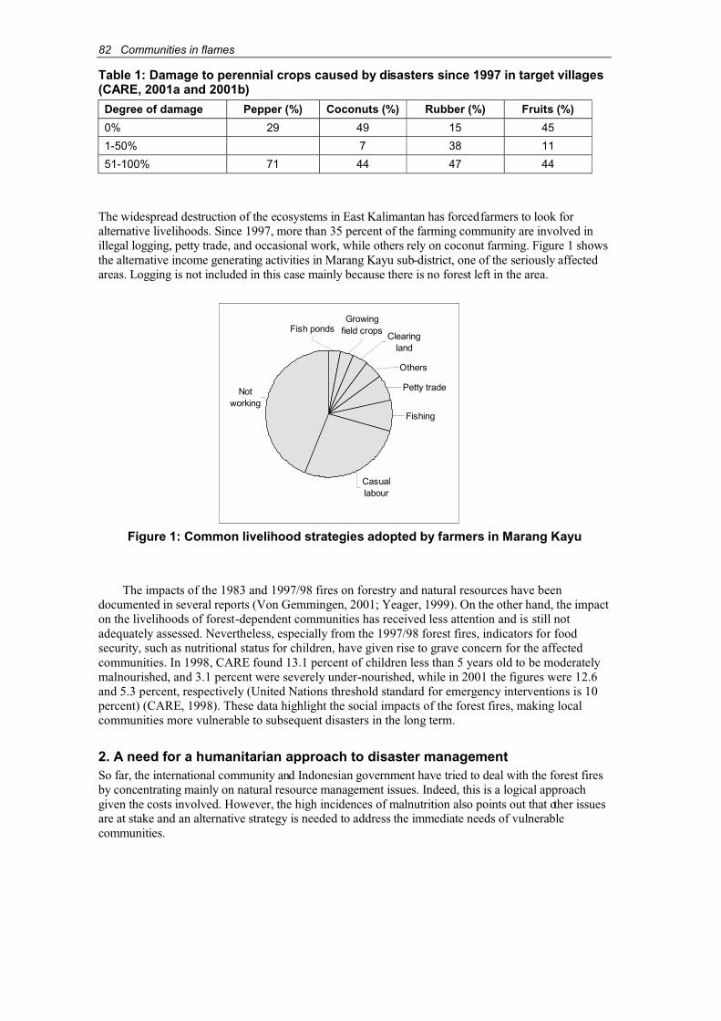
82 Communities in flames
Table 1: Damage to perennial crops caused by disasters since 1997 in target villages(CARE, 2001a and 2001b)
Degree of damage Pepper (%) Coconuts (%) Rubber (%) Fruits (%)
0% 29 49 15 45
1-50% 7 38 11
51-100% 71 44 47 44
The widespread destruction of the ecosystems in East Kalimantan has forcedfarmers to look foralternative livelihoods. Since 1997, more than 35 percent of the farming community are involved inillegal logging, petty trade, and occasional work, while others rely on coconut farming. Figure 1 showsthe alternative income generating activities in Marang Kayu sub-district, one of the seriously affectedareas. Logging is not included in this case mainly because there is no forest left in the area.
Figure 1: Common livelihood strategies adopted by farmers in Marang Kayu
The impacts of the 1983 and 1997/98 fires on forestry and natural resources have beendocumented in several reports (Von Gemmingen, 2001; Yeager, 1999). On the other hand, the impacton the livelihoods of forest-dependent communities has received less attention and is still not adequately assessed. Nevertheless, especially from the 1997/98 forest fires, indicators for foodsecurity, such as nutritional status for children, have given rise to grave concern for the affectedcommunities. In 1998, CARE found 13.1 percent of children less than 5 years old to be moderatelymalnourished, and 3.1 percent were severely under-nourished, while in 2001 the figures were 12.6and 5.3 percent, respectively (United Nations threshold standard for emergency interventions is 10percent) (CARE, 1998). These data highlight the social impacts of the forest fires, making local communities more vulnerable to subsequent disasters in the long term.
2. A need for a humanitarian approach to disaster managementSo far, the international community and Indonesian government have tried to deal with the forest firesby concentrating mainly on natural resource management issues. Indeed, this is a logical approachgiven the costs involved. However, the high incidences of malnutrition also points out that other issuesare at stake and an alternative strategy is needed to address the immediate needs of vulnerablecommunities.
Notworking
Fish pondsGrowing
field cropsClearing
land
Others
Petty trade
Fishing
Casuallabour

Communities in flames 83
In response to this urgency, CARE is developing a household livelihood security (HLS)-basedapproach to disaster management in East Kalimantan. The project aims to facilitate the establishmentof integrated and functional structures for disaster preparedness and the adoption of local-leveldisaster mitigation measures, including the adoption of environmentally sustainable land-usemanagement techniques.A prerequisite for the success of the project is to actively involve allstakeholders and raise their awareness. Therefore, CARE networks with local communities, theprivate sector (e.g. concessionaires, mining and other resource extraction companies, plantationcompanies), governments (especially at village and sub-district levels) and local non-governmentalorganizations (NGOs). It also assists communities to improve or establish effective linkages withthese organizations and companies.
3. A theoretical framework for disaster managementMany humanitarian agencies have a dichotomous approach to emergency recovery and developmentefforts. They have emergency staff who respond specifically to disasters and development staff whostep in once the crisis is under control. However, in the 1980s, experiences of major relief anddevelopment agencies have convinced them that emergency and development programmes areintertwined.
A second factor that plays a role in changing perceptions of effective assistance is the increasingemphasis on livelihood security for households affected by disasters. Calamities are the main threat to this security and reducing the communities’ vulnerability to such hardships is a crucial response.
Based on these insights and through intensive discussions, disaster management has evolved tomerge rescue and development plans, and several sophisticated approaches have been formulated.Within the context of disaster management, development is defined as a process that reducesvulnerabilities and increases capacities. For further clarity, vulnerabilities are generally defined as long-term factors that affect the ability of a community to respond to events or make it susceptible to calamities. They contribute to a disaster’s severity, impede effective responses, are present beforedisaster strikes and remain long after the event is over. In this respect, vulnerabilities differ fromneeds, which arise from the crisis and are often short term in nature (e.g. the need for relief foodsupplies immediately after a forest fire). Vulnerabilities to forest fires, however, are more enduringand have intensified in recent years because of increased conflicts, a lack of law enforcement, andpoor natural resource management.
Nonetheless, their vulnerabilities, most communities still have capacities to rebuild their lives.From a disaster management’s point of view, capacities are strengths on which future development can be built.
During disasters, the community’s vulnerabilities are more pronounced than their capacities.Recognising the vulnerabilities and capacities of the affected population is essential for designingand implementing an effective disaster response. To identify these capacities and vulnerabilities, a Capacity and Vulnerability Analysis (CVA) matrix (Table 2) can be used to examine three aspects of information:
♦ Physical factors: what productive resources, skills and hazards (e.g. land, environment,health, skills and labour, infrastructure, food, housing, capital and technologies) are available?
♦ Social organization: what are the relationships among and organization of the communities(e.g. formal political structures and informal systems such as decision making, establishingleadership or organizing various socio-economic activities)? When prejudice or conflict is present in a community, social and organizational vulnerabilities are inevitable.
♦ Attitudes: how does the community view its ability to adapt to changes? Strengths andweaknesses can make a significant difference in the communities’ ability to rebuild and improve their material base and social institutions. A community is psychologically more vulnerable when its people feel victimised, fatalistic and dependent.

84 Communities in flames
Table 2: Capacity and vulnerability analysis matrixVulnerabilities Capacities
Physical factors Geographical calamities (floods,earthquake)Economic misfortunes (drought)Poverty (insufficient resources)Lack of infrastructurePoor health
Skills to be productiveAccess to productive resources(land, forest, sea, capital, etc.)Technologies (agro-forestry/sustainable land management)Adequate infrastructureGood health
Social organization Division according to religion, ethnicity, language, class or castePrejudiceConflictIneffective community organization
Social coping mechanism:family, group, community and/or area wide organizations
Attitudes SuperstitionFatalism (feeling that nobodysupports them).Dependence on external support
Fighting spiritReligion*Sense of purpose
*Religion can have a positive impact on attitudes, but can also divide the community and create conflict.
In general there are two different disaster management models:
♦ The cyclic model in which emergency, recovery, development (preparedness, mitigation)and early warning are executed progressively, with each phase having its own particularapproach(es).
♦ Expand and contract model in which all aspects of disaster management are addressedsimultaneously, albeit with varying degrees of emphasis. For example, during the onset of adisaster, emphasis would be on emergency management and early warning but recoveryand mitigation are taken into account as well.
CARE has adopted the “expand and contract” model for its disaster management programmes.
4. Disaster management for forest fires: the CARE DISPRE (DISasterPREparedness) approachCARE has implemented the project in East Kalimantan for one year and has received positivefeedback from local communities and other stakeholders. Although the project targets fire-proneforest communities, it does not focus on forest fires per se. Instead, it seeks to reduce vulnerabilitiesof communities to disasters in general, as the recurrence of other disasters (e.g. rat infestation, floods)poses a higher risk to these communities in comparison to forest fires.
CARE’s approach is based on the following principles:
♦ Involving local stakeholders:
Involvement of a full range of local stakeholders is essential to reduce vulnerability. The private sector is still the main land users in the most affected areas. The private companies are an important factor in forest fires as well as major providers of relief assistance toaffected communities. Improved planning in both development and relief is only possible ifthese stakeholders are involved.
Communities in flames 85
♦ Integrating disaster management and development:
The project facilitates the integration of disaster mitigation and preparedness into thecommunity’s development processes, in line with the Indonesian government’s villagedevelopment plans.
♦ Strengthening the community’s capacity:
The project aims to re-establish and strengthen existing social and organizational capacitieswithin the communities. Increasing the confidence of people to overcome theirvulnerability is a major focus.
♦ Utilising an integrated media approach:
An integrated media approach comprises communication avenues such as participatorycommunication approaches (PCA), participatory workshops, community leaders’ training,posters, and radio talk shows.
The CARE disaster management approach consists of the following activities (Figure 2):
♦ Participatory learning and action (PLA) is the core strategy to facilitate the integration ofdisaster management into village development plans and to infuse in the villagers a sense ofownership of the process. Participants set their own targets and indicators for each activitythey implement. The initial PLA-derived findings then serve as a baseline that allowscommunities to monitor their progress. PLA has proven to be effective in re-establishingsocial structures that have been under pressure as a result of the disasters. PLA activitieslinked to natural resource management, such as constructing firebreaks, planting trees andconverting wasteland into arable land, reinforce existing social structures and increasecommunity self-confidence.
The communities are able to adjust the PLA programmes to suit their own socio-culturalenvironment. This is important in East Kalimantan given that the project involves sevenvillages with four different ethnic groups (Dayak, Bugis, Javanese and Kutai). Each grouphas its own traditional way of farming. Most of the Bugis rely on coconut trees, the Dayakand Kutai are mainly rice swamp farmers with some perennial crops, and the Javanese are transmigrants growing rubber trees in a former nucleus estate scheme. Hence, the needs ofeach ethnic group can differ significantly.
♦ Training in disaster management aims to develop common knowledge among the differentstakeholders. The training methodology attempts to link disaster management conceptswith the participants’ local experiences and focuses on increasing understanding of the different aspects of disaster management, such as:
! Different models of disaster management.
! Terminology used in disaster management. Most participants are unfamiliar with theterminology, such as vulnerability, capacity, hazard and risk.
! Different phases of disaster management including preparedness, mitigation, earlywarning, emergency management and recovery.
! Conflict resolution as a tool in disaster mitigation.
! Emergency management in line with the SPHERE international humanitarian standards(SPHERE, 1998). These standards are currently acknowledged as basic rights for those in need of assistance. During training, the standards are explained and participantsexplore how they can be integrated into community-level initiatives.
! CVA as a tool to integrate disaster management into village development plans.Participants develop their own disaster management strategy based on CVA.
♦ Development of local capacity in emergency response involves training in fire repression,establishment of granaries to mitigate food shortages during emergencies (a very successfuleffort in Dayak villages) and indigenous rainwater storage techniques to avoid flood-relatedcontamination in flood-prone areas.
86 Communities in flames
♦ Vision mapping of the villages is used to facilitate village-level integration of disastermanagement into village development planning. It is also used to develop links betweencommunities and other stakeholders, and as a planning tool for communitiesto effectivelydevelop land-use plans to reduce the risk of forest fires for the next five years.
♦ After the vision mapping has been finalised, workshops are organized to prepare disastermanagement plans that include:! Development of local mechanisms to integrate disaster management into existing village
and sub-district development plans.! Assessment of locally available capacity and ways to strengthen it.
! Incorporation of SPHERE (1998) standards into local emergency response mechanisms.
! Establishment of functional fora that bring together major stakeholders.
♦ Stakeholder fora at the sub-district level focus on broader issues other than forest fires as experience has shown that the destruction caused by forest fires significantly increasesother hazards such as flooding and rat infestation of crops.
5. Initial experiencesDuring the first year, the project has focussed on strengthening the existing social structures in thevillages. It has re-established farmer groups through PLA programmes. Some resultant activitieswere not directly linked to disaster management but allowed the communities to begin building upthe necessary capacity to underpin effective disaster management.
5.1. PLAMany of the participating communities were fatalistic at the start of the project. They had basicallyabandoned their agricultural activities and were relying on alternative incomes and illegal logging.The project initiated the PLA process to motivate them to take a more positive approach inovercoming their misfortunes. Activities currently assisted by the project include:
♦ Banana relay-planting with rubber cultivation:From their experiences in fighting forest fires, the farmers found that planting banana trees as firebreaks in rubber plantations was effective in stopping the fires and provided themwith extra income. Based on their recommendations, the project assists the communities to develop this technology.
♦ Formulating contracts for leasing land:
Contracts for lease of land facilitate better land-use planning between the more establishedsettlers and recent (spontaneous) migrants. In the Dayak villages, land has traditionally beenviewed as a common good with certain limited user rights after the land was first cleared.However, recent socio-economic changes have significantly decreased land availability. Themore established Dayak groups claimed ownership to all the land they cultivated in the past.As a result, new Dayak migrants have access only to smaller plots. Land is left fallow and jealousy has led to increasing incidents of arson. The project introduced the concept of leasing land that allows the original claimants to retain their rights but also enables newarrivals to grow perennials such as rubber and fruit trees. The trees belong to the claimantsbut the harvests are shared by both parties.
♦ Cultivating productive firebreaks:
Another attempt is to establish permanent firebreaks around the villages, rubber plantationsand homegardens with crops producing minimum biomass, such as onions. This can help toprotect recently established perennials from fire outbreaks, especially from the alang-alang(Imperata cylindrica) areas.
Communities in flames 87
♦ Organizing forest fire brigades:
In some communities, villagers are interested in organizing fire brigades based on existingsocial organizations (e.g. farmer associations). The project facilitates training and assistscommunities to extend the brigades’ responsibilities to include early warning efforts.
♦ Establishing paddy fields on burned peat swamps:
The area was previously under coconut cultivation following traditional Buginese land clearance and water management systems. Drought and subsequent peat fires have destroyed the coconut plantations. Growing paddy will help to prevent further burning and re-establish livelihoods of affected villagers.
5.2. Disaster management trainingThe disaster management training curriculum is based on experiences from other countries asIndonesia focuses mainly on internally displaced people and complex disasters, and not on disastermanagement. The curriculum aims to provide tools to participants to help them analyse and learnfrom their experiences. This has proved to be a successful strategy. Activities initiated by the traininginclude:
♦ Assisting communities to deal with other stakeholders:
One example is a mining company that wants to dig a flood control channel but lacks thecapacity to plan with the affected communities. Another is an oil palm plantation thatintends to reduce fire vulnerability by supporting neighbouring communities to improve their land-use practices. CARE assists these communities in collaborating and co-operatingwith such companies to avoid negative impacts and reduce risks.
♦ Supporting local NGOs interested in developing disaster management programmes:
All interested and active local NGOs are invited to the training sessions and CARE helps them to develop programmes with communities in disaster management.
♦ Promoting conflict resolution:
Conflict occurs at different levels, both horizontally and vertically. Examples are conflictsover resources within a community, among communities and between communities andother stakeholders. During stakeholder sessions, participants are asked to explore differentoptions for collaboration (e.g. partnerships, co-operatives) that should address the rootcauses of the forest fires as well as enhance local capacity to sustainably manage theirresources.
6. Preliminary conclusionsMany lessons can be learned and preliminary conclusions drawn from the project even though it has been operating for just over a year, for example:
♦ In East Kalimantan more attention needs to be paid to the impact of disasters on HLS.
♦ The private sector, especially major companies that compete with the local communities fornatural resources, exerts considerable impact – positive and negative – on the livelihoods ofthese communities in East Kalimantan. CARE tries to involve the private sector in community disaster management activities whenever feasible, and to assist thecommunities in advocating their interests to these companies. Training exposes the companies’ community development staff to disaster management concepts and facilitatescommunication in a neutral setting. Such training sessions enable the incorporation of localcommunities’ needs into the company plans and the integration of disaster management,including conflict management, into their development activities.

Figure 2: CARE’s disaster management programme
Village maps based onPRA maps developed
by Digital SketchMethod
Disastermanagement
training
Appropriate land use+ water/health management based
on communities’ need andpotentials
PLA: design,implementation,
monitoring/evaluation ofinterventions
Vision maps of howstakeholders can reduce
their vulnerabilities
Facilitation of disastermanagement plans
Improved lanreducing risk tImproved wahealth quality
vulnerabil
Disastermanagement
plans bystakeholders
F
meby
PRA
Communities
Stakeholders
The process is strengthened by a media campaign that focuses on different aspects of the approach.
88…
Com
mun
ities
infla
mes

Communities in flames 89
♦ The fatalistic attitudes of communities in disaster-prone areas are often not taken intoaccount, yet they are a major vulnerability. To be successful in disaster management,building up the confidence of the communities cannot be overlooked.
♦ Disaster management initiatives need to be integrated into community developmentactivities to be effective. In fact, disaster management should be a thread runningthrough community development planning in disaster-prone areas.
♦ Socio-cultural differences create divergent perceptions of land tenure and agriculturalpractices. This needs to be considered in disaster management. Activities have to enablethe various ethnic groups to strengthen their capacities and reduce their vulnerabilitieswithin their unique cultural frameworks.
♦ Training on humanitarian standards, such as the SPHERE standards, has been found toincrease community members’ understanding of their entitlements for emergencyassistance. This helps the communities to better understand their rights and request forassistance especially when they no longer are able to cope on their own.
ReferencesBrookfield, H., Potter, L. & Byron, Y. (1995). In place of the forests: environmental and socio-
economic transformation in Borneo and the Eastern Malay Peninsula. United NationsUniversity Press, New York/Tokyo/Paris.
CARE. (1998). Kutai nutrition report. Unpublished.
CARE. (2001a). Laporan baseline survey. Unpublished.
CARE. (2001b). Unpublished baseline data.
SPHERE. (1998). The Sphere Project: humanitarian charter and minimum standards in disasterresponse. Website: http://www.sphereproject.org
Von Gemmingen, G. (2001). Justifikasi rehabilitasi hutan dan lahan: deforestrasi di KalimantanTimur akhibat kebakaran, over exploitasi, konversi dan illegal logging p17-32. In KK-RHL,Prosiding Semiloka: Rehabilitasi hutan dan lahan: Peluang dan tantangan dalam pembangunandaerah keberlanjutan Samarinda: KK-RHL/BRLKT Mahakam dan Berau/SFMP-GTZ.
World Bank. (2001). Indonesia: environment and natural resource management in a time oftransition. World Bank, Washington, D.C.
Yeager, C.P. (1999). Fire impacts on vegetational diversity and abundance in Kalimantan,Indonesia during 1997/1998. WWF-Indonesia report, Jakarta.
AcknowledgementsThe authors want to thank Bud Crandal (Country Director CARE International in Indonesia), LiseSchofield (Senior Programme Co-ordinator) and Hadi Sutjipto (Emergency Team Leader) fortheir support and comments on earlier drafts of this paper.

90 Communities in flames
Review of the participatory forest fire preventionprogrammes in Jambi and West Kalimantan, Indonesia
Masahiro Otsuka1, Sumantri, Kuspriyadi and Syaharuddin2
AbstractThe participatory forest fire prevention programmes of the Forest Fire Prevention ManagementProject (FFPMP) have been implemented with farmer groups using different models in Jambi andWest Kalimantan. Both programmes aim at intensive fuel load management and fire control bycultivating green belts on community land around the forests and promoting permanent agriculture.The FFPMP will follow up with monitoring and technical assistance during the proposed secondphase to increase farmers’ participation in its fire prevention programmes.
At the Jambi site, the integrated green belt (IGB) incorporates a wire fence, a ditch, rows of various tree species and inner agricultural land. Farmers fenced approximately 15 km of the areaand dug a ditch 9 km in length. Tree rows reached more than 10 km in length and 5-30 m in width.Perennial crops such as areca nut, albizia, rambutan, durian, citrus and coconut were planted. Wirefences were effective to keep out wild boars, boost productivity and reduce fuel loads on theirfenced land. However, the farmers’ knowledge of seedling production, land preparation withoutburning, crop planting and protection are limited. Alternative fencing technologies to replace thecostly wire fences have to be considered.
At the West Kalimantan site, alley cropping or sloping agricultural land technology (SALT) istested with nitrogen-fixing trees (NFTs), other trees and annual crops. A small number of farmersplanted alleys and hedgerows with NFTs, but could not weed and prune according to schedule dueto labour shortages.
1. IntroductionThe Forest Fire Prevention Management Project (FFPMP) has initiated participatory programmesin Jambi and West Kalimantan Provinces, Indonesia. The programmes aim to achieve long-termforest fire prevention based on local communities’ active participation in planning, implementationand evaluation. Most of the wildfires are caused by human activities in and around forests.
This paper reviews the implementation of the participatory programmes, outputs andconstraints, and offers recommendations for future fire prevention activities.
2. Jambi site2.1. Site conditionA pilot programme for community-based forest fire prevention is implemented at Rantau RasauDesa and Sungai Rambut Villages, Rantau Rasau Sub-district, Tanjung Jabung District, JambiProvince (Figure 1). Both villages are situated along the boundary of Berbak National Park thatprotects one of the most important lowland swamp forests in Indonesia. Inhabitants consist of localMalay migrants (mainly at Sungai Rambut), and Javanese and Buginese migrants (mainly at RantauRasau Desa). The riverside has been settled mainly by the Malays since the end of the nineteenthcentury, and the inland by the Javanese and Buginese since the 1960s. The settlements are wellorganized with canals and ditches in most areas, divided into administrative units calledneighbourhood associations (rukun tetangga - RT).
By and large, the Malay live on rice farming and freshwater fisheries, while the other ethnicgroups depend on subsistence and cash crop agriculture. Many people have exploited the forests fortimber, fish and wildlife to supplement their incomes. An elementary school was built, but public
1 Japan International Cooperation Agency Expert, FPPMP2 Project staff at FFPMP

Communities in flames 91
utilities, such as water supply, electricity, telephone and gas are still unavailable. The governmenthas provided credit to both communities through its Presidential Funds for Under-developedVillages programme.
Figure 1: Project site in Jambi
2.2. Concept of participatory Integrated Green BeltThe integrated green belt (IGB) aims to protect the forests of the national parks from wildfires and agricultural land from wild boars by encouraging farmers to intensify land management. The IGB isestablished along the boundaries of existing agricultural fields close to the park boundaries withfarmers’ participation. The IGB basically consists of a wire fence, a ditch, tree rows and agriculturalland (Figure 2). The wire fence is effective in keeping out wild boars, while the ditch stops groundfires and secures water for initial fire suppression. Tree rows are expected to control surface firesand obstruct the passage of wild boars, besides increasing agricultural productivity.

92 Communities in flames
Suitable tree species need to be selected for effective fire prevention in terms of fuel load control and fire resistance, and to provide farmers with non-timber products. The selected species should grow easily on the wet and peat soils. Therefore, in the initial green belt design, the FFPMPrestricted tree species selection to two criteria, i.e. for fire prevention and easy growth. Throughcommunity consultations, three of the farmers’ preferred species that met the project’s initial needswere selected – areca nut (Areca catechu L.), albizia (Paraserianthes falcataria) and lamtoro(Leucaena leucocephala). Areca nut is planted along the wire fence for support after existingwooden props have decayed. Albizia yields valuable timber in a short period while effectivelyforming hedgerows. Lamtoro is preferred by some farmers for its multipurpose functions, includingsoil improvement and fodder production.
At the second stage, other promising species, based on farmers’ requests and reportrecommendations, were tested for their effectiveness in preventing fire. Fruit trees and multipurpose tree species (MPTS) were planted inside the fence, such as durian (Durio zibethinus),rambutan (Nephelium lappaceum) and melinjo (Gnetum gnemon). On the farmers’ own initiative,demonstration plots were established to test these new tree crops within the fenced community land.The green belt is being expanded at both sides of the fence with the selected tree species.
The fire resistance of these tree crops needs to be tested during the trials. The farmers noticedthat the bark of the trunk of the areca nut is thick enough to help the tree withstand fire. The longbranches of the albizia can effectively inhibit the growth of ground cover, outweighing the vulnerability of its trunks to fires. Lamtoro is quite similar to albizia, but its trunk is more resistantto fire. Durian, rambutan and melinjo are generally resistant to fire because of their long branchesand high moisture content in their trunks.
The immediate benefit of the IGB is its effective protection of community land and forest fromwildfires. However, the farmers also expect the IGB to reduce inflammable undergrowth andenable the cultivation of annual and perennial crops. The FFPMP provides materials andencourages farmers to participate actively in green-belt activities.
During the course of the project, the farmers found that it was difficult to adhere to the originalconcept of planting in rigid lines to align the green belt with the fence. In response, the programmewas modified and farmers were encouraged to cultivate according to topography and soil conditions(Figure 3).
2.3. Inputs for the establishment of the IGBTo motivate farmers to participate in the FFPMP, a number of incentives were provided. TheFFPMP procured wire netting and some props, which the farmers used to construct fences in thedesignated areas. In total, 16.1 ton, or 15.3 km, of wire netting and 7,480 props were required(Table 1). The total cost of the wire fence amounted to approximately Rp9,000 per metre. More wire and props were needed at Sungai Rambut because of the inexperience of the local farmers inconstructing wire fences. Migrant farmers extended the existing 4 km ditch at Rantau Rasauthemselves, but some farmers at Sungai Rambut requested hired help because they were untrainedin such construction work. In total, a 9 km ditch was dug (Table 1).
The FFPMP also distributed seedlings (half of which were purchased in Jambi) to participatingfarmers to speed up the establishment of the IGB (Tables 2 and 3). The cost of providing the seedlingswas about Rp1,600 per tree. Areca nut (38 percent) was the farmers’ most preferred tree species,followed by coconut (11 percent), rubber (7 percent), albizia (7 percent), citrus (6 percent), melinjo (4percent), rambutan (3 percent) and durian (2 percent). Areca nut was most popular because of its abilityto yield higher profits, easier cultivation even on wet soils, and good fire resistance. Coconut and rubberare common commercial crops at the site. Although they are vulnerable to fire, the farmers are expectedto protect them from fire. Albizia is a lucrative source of timber and firewood. Some farmers are fond ofcitrus and other fruit trees even though they require special care.
Initially, the FFPMP produced seedlings of areca nut, albizia and lamtoro at a nursery in eachvillage. However, the farmers were unable to manage the nurseries and skilled labourers had to be hired. The FFPMP has also supplied construction materials for a base camp and tower, and fertilizers for fruit trees and other tree crops.
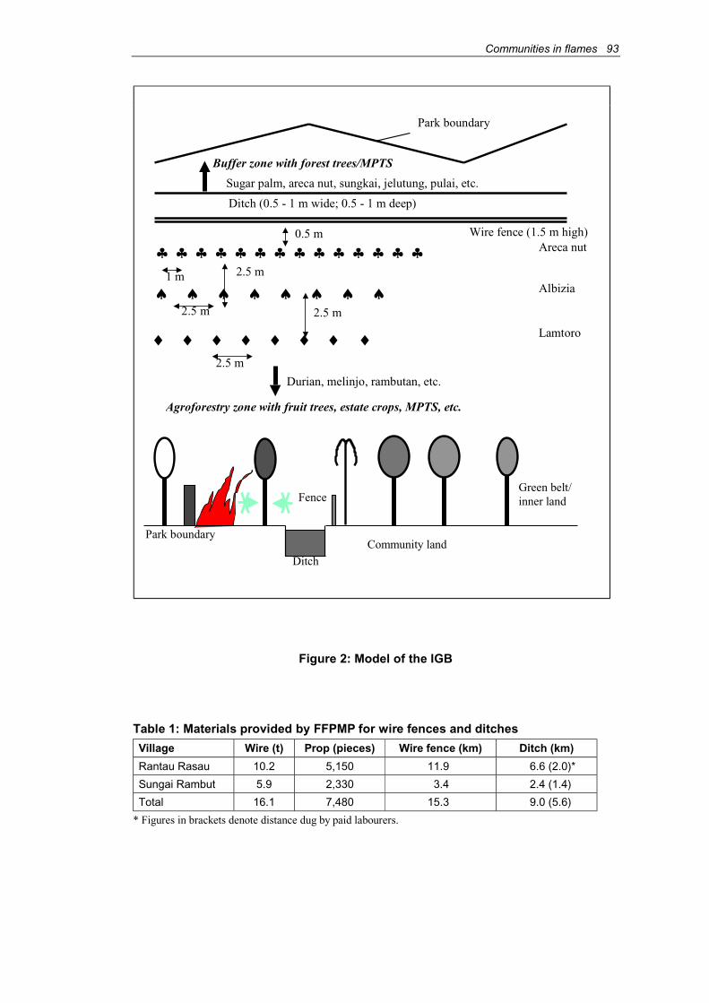
Communities in flames 93
Figure 2: Model of the IGB
Table 1: Materials provided by FFPMP for wire fences and ditches
Village Wire (t) Prop (pieces) Wire fence (km) Ditch (km)
Rantau Rasau 10.2 5,150 11.9 6.6 (2.0)*
Sungai Rambut 5.9 2,330 3.4 2.4 (1.4)
Total 16.1 7,480 15.3 9.0 (5.6)
* Figures in brackets denote distance dug by paid labourers.
♠ ♠ ♠ ♠ ♠ ♠ ♠ ♠
♣ ♣ ♣ ♣ ♣ ♣ ♣ ♣ ♣ ♣ ♣ ♣ ♣ ♣
Ditch (0.5 - 1 m wide; 0.5 - 1 m deep)
Park boundary
Wire fence (1.5 m high)Areca nut
Albizia
Lamtoro
0.5 m
2.5 m2.5 m
Durian, melinjo, rambutan, etc.
Sugar palm, areca nut, sungkai, jelutung, pulai, etc.
Buffer zone with forest trees/MPTS
Agroforestry zone with fruit trees, estate crops, MPTS, etc.
♦ ♦ ♦ ♦ ♦ ♦ ♦ ♦2.5 m
1 m
Park boundary
Ditch
Fence
Community land
Green belt/inner land
2.5 m

94 Communities in flames
Figure 3: Modification of planting patterns of the IGB
Table 2: Number of seedlings provided by FFPMP
Village 1997 1998 1999 2000 Total
R. Rasau 8,711 56,691 20,303 44,098 129,803
S. Rambut 2,989 49,369 13,018 19,149 84,525
Total 11,700 106,060 33,321 63,247 214,328
Target area (ha) 15 72 50 88 225
Table 3: Number of seedlings produced by the nursery and provided by FFPMP
Village Production Provision
Rantau Rasau 61,000 53,000
Sungai Rambut 54,000 46,000
Total 115,000 109,000
----------- Areca nut ---------
----------- Coconut ---------
Rice,Soybeans
----------- Areca nut ----------
Rice
Rice
Rice
250
Wire fence, Wire fence,
--- Breadfruit, Durian,
----------- Areca nut -------------------- Albizia ---------
----------- Lamtoro -------------------- Durian ---------
----------- Rambutan -------------------- Durian ---------
----------- Rambutan -------------------- Citrus ---------
----------- Citrus ----------
----------- Coconut ---------
----------- Coconut ---------
------------M
elinjo
------------M
elinjo
------------M
elinjo
--------------R
ubber
--------------R
ubber
--------------R
ubber
--------------R
ubber
--------------R
ubber
Pattern 1 Pattern 2
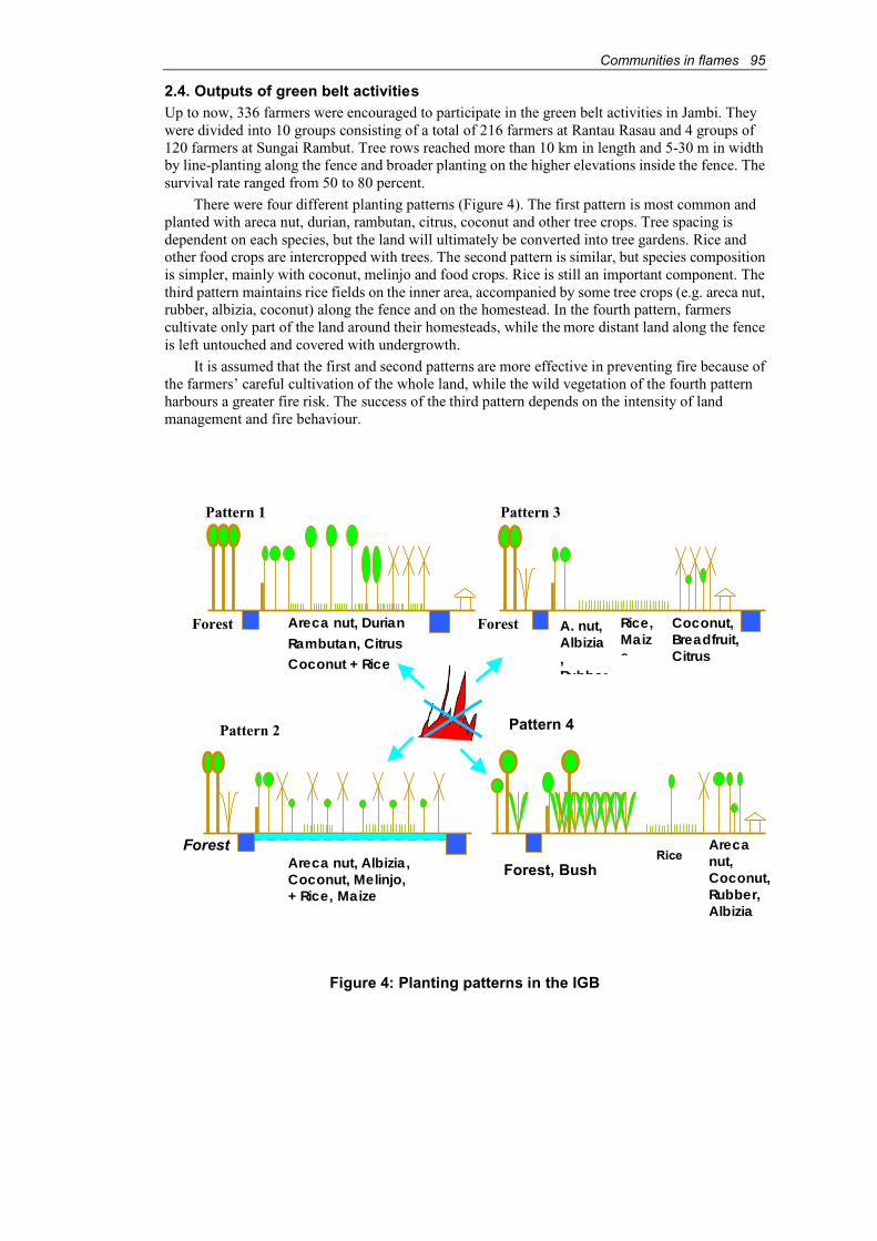
Communities in flames 95
2.4. Outputs of green belt activitiesUp to now, 336 farmers were encouraged to participate in the green belt activities in Jambi. Theywere divided into 10 groups consisting of a total of 216 farmers at Rantau Rasau and 4 groups of 120 farmers at Sungai Rambut. Tree rows reached more than 10 km in length and 5-30 m in widthby line-planting along the fence and broader planting on the higher elevations inside the fence. Thesurvival rate ranged from 50 to 80 percent.
There were four different planting patterns (Figure 4). The first pattern is most common andplanted with areca nut, durian, rambutan, citrus, coconut and other tree crops. Tree spacing is dependent on each species, but the land will ultimately be converted into tree gardens. Rice and other food crops are intercropped with trees. The second pattern is similar, but species compositionis simpler, mainly with coconut, melinjo and food crops. Rice is still an important component. Thethird pattern maintains rice fields on the inner area, accompanied by some tree crops (e.g. areca nut,rubber, albizia, coconut) along the fence and on the homestead. In the fourth pattern, farmerscultivate only part of the land around their homesteads, while the more distant land along the fenceis left untouched and covered with undergrowth.
It is assumed that the first and second patterns are more effective in preventing fire because of the farmers’ careful cultivation of the whole land, while the wild vegetation of the fourth patternharbours a greater fire risk. The success of the third pattern depends on the intensity of landmanagement and fire behaviour.
Figure 4: Planting patterns in the IGB
Pattern 1
Forest Areca nut, DurianRambutan, CitrusCoconut + Rice
Pattern 2
ForestAreca nut, Albizia,Coconut, Melinjo,+ Rice, Maize
Rice,Maize
Forest A. nut,Albizia,Rubber
Coconut,Breadfruit,Citrus
Forest, Bush
Pattern 4
RiceArecanut,Coconut,Rubber,Albizia
Pattern 3

96 Communities in flames
Major impacts of the IGB have been a decrease of wild boar damage (from 28.6 times per month in 1995 to 15.0 times per month in 1999) and a reduction in the use of fire for clearing land.However, more farmers resorted to herbicides for the land preparation and weeding (Table 4). Alternative land management technologies have to be sought to avoid their heavy reliance on herbicides. However, the farmers’ capabilities in land improvement and crop protection (e.g.mounding, terracing, manual weeding and fertilization) are seriously limited.
Many farmers search for alternative employment. Their land is left fallow and overgrown withweeds, which often impede the growth of newly planted trees. Moreover, frequent flooding, causedby accelerating deforestation in upland areas and illegal logging in the vicinity, has severely damagedthe tree crops. The farmers have noted the presence of acid water and soils in flooded areas.
Despite the farmers’ growing interest in tree crops labour shortage and environmental factorshave affected the growth of the tree crops.
Table 4: Changes in land preparation practices
1995 1999Landpreparationpractices Farmers (%) Frequency/year Farmers (%) Frequency/year
Burning 8 13 0 0
Herbicides 45 85 73 135
Examples of green belt establishment in Jambi
Basic structure of the IGB Areca nut
Extension of the IGB Transport of seedlings
Communities in flames 97
3. West Kalimantan siteThe participatory fire prevention programme at the West Kalimantan site applies alley cropping orsloping agricultural land technology (SALT) to establish permanent farming systems on shiftingcultivation areas. It is also implementing long-term fire prevention and control, which are newconcepts to the pilot site and other parts of Kalimantan.
3.1. Site conditionThe pilot site is located in a hilly area adjacent to a protection forest at Landau Beringin Sub-village,Nanga Pintas Village, Nanga Pinoh Sub-district, Sintang District in West Kalimantan Province.The inhabitants are local Dayak who have close community bonds, although modern cash economyis gradually penetrating the area. Shifting cultivation with short bush-fallow rotations (3-7 years) isstill a common practice. The vegetation is burned, and the land planted with upland rice, with maize,peanuts and other food crops. After the rice harvest, the land is fallowed to allow growth of newvegetation. Cultivating degraded fallow land is difficult where only Imperata spp. can grow.Consequently, more farmers have started to encroach on protection forests for crop production.
In recent years, farmers have become more interested in permanent farming around theirsettlements to provide a more stable environment for the family, and enable their children to go toschool. Some community members participate in government-sponsored semi-irrigated ricefarming on the lower floodplains. Although trials indicated that double cropping of rice is possible,experiments are still at an early stage. There is still a great demand for improved dryland farming toraise crop yields and overcome resource degradation from short-fallow shifting cultivation.
3.2. Green belt model in West KalimantanThe green belt in this site is modelled after SALT or contour cropping of nitrogen-fixing treespecies (NFTs) (Figure 5). Hedgerows of leguminous shrubs are established at intervals of 4-5 m along contour lines on the sloping land. The most promising species are kemelandingan (Leucaenaleucocephala), gamal (Gliricidia sepium), turi (Sesbania grandiflora) and Flemingia congesta.Gamal has been observed to be resistant to fires in the plantations of Perum Perhutani (State ForestCorporation) in Central Java. Kemelandingan may be less fire-resistant and more susceptible to psyllid pests. The spacing of the shrubs should be about 25 cm to form live fences for soilimprovement. Taller NFTs are introduced to the surrounding dryland, such as calliandra(Calliandra calothyrsus), lamtoro merah (Acacia villosa), johar (Cassia siamea) and secang(Caesalpinia sappan), together with MPTS such as candlenut (Aleurites moluccana) under variousplanting arrangements.
The FFPMP decided to introduce a wide variety of tree species to reduce the risk of failure.Farmers are encouraged to grow upland rice and secondary food crops (palawija) continuouslybetween the hedgerows of NFTs. Several cover crops can be planted on the fallow land after theharvest to restore soil fertility and limit growth of inflammable vegetation.
NFTs can be easily propagated from seeds. They can survive in poor-quality soil withoutfertilizers, but require pruning after the first year to reduce the negative effect of shading on agricultural crops. Farmers are requested to prune older plants up to 25-50 cm in height and mulchthe alleys to control soil erosion and provide organic matter to the soil. NFTs capable of providingfirewood and fodder are favoured.
3.3. Inputs by the projectEight species of NFTs and some cover crops were distributed by the FFPMP to the participatingfarmers. The farmers also received 3,800 tree seedlings as an initial incentive for participation,including areca nut, banana and rubber, together with food crops such as soybeans, peanuts, corn andginger. At the nursery, about 138,000 seedlings of calliandra, kemelandingan, gamal, turi and joharwere produced to replace dead trees on the pilot dryland. Some farming tools weremade available,including shears and saws, to ease pruning at the initial stage. The FFPMP also constructed acommunity hall – managed by the community – as a base camp for consultations and fieldwork.

98 Communities in flames
Figure 5: Green belt model for West Kalimantan site
3.4. Outputs: orientation and progressPrior to implementation of the programme, project staff distributed technical manuals on alleycropping to government staff, local leaders and others. After conducting planting trials of NFTs around the site, the FFPMP helped to prepare the land and sow NFT seeds on selected plots locatedon sloping land along the village road to facilitate crop management and enhance the demonstrationeffect. By October 1999, two plots of approximately 7.5 ha had been planted with kemelandingan,gamal and turi in 26 hedgerows, amounting to 1.9 km in length.
Eleven out of 82 households participated in the initial stage. Community leaders assisted and supervised the daily activities, supported by regular technical assistance in cropping technologiesfrom the FFPMP. Using the “A-frame” – a simple field instrument to lay out contour lines – farmersmade holes about 25 cm apart and 4-5 cm deep along the contours, and put 4 or 5 seeds of apredetermined species into each hole.
4 - 5 mCover crops
Forest
Multipurpose treesCandle nut , rubber, …
Nitrogen-fixing trees(Leucaena leucocephala, Gliricidia sepium, ...)
Uplandrice

Communities in flames 99
Three of the farmers have developed more than 30 rows (2,200 m) in three pilot plots (9 ha) inone block, planted with kemelandingan, gamal, Flemingia, johar, calliandra, turi and lamtoromerah. Johar, calliandra and turi were highly resistant to weeds during their early stages of growthand grew very well, whereas kemelandingan and gamal did poorly because they suffer more from weed competition.
These farmers replanted over 10,000 seedlings and sowed 15 kg of alternative seeds on theirland. The NFTs should have been pruned before they reached 3 m in height. However, pruning wasdelayed due to labour shortages. The alleys should be weeded before pruning the NFTs for effectivemulching, which is also time consuming. Initially, the FFPMP provided farmers with food crops asan incentive to carry out the weeding.
Alley with Cassia siamea
4. Conclusions and recommendationsAt the Jambi site, farmers actively participated in IGB activities hoping to prevent fires on theirland and forest in the long term. Despite witnessing the advantages and benefits of IGB, the farmersare still unable to adopt IGB’s land management and crop protection strategies because of a shortage of financial resources. Small-scale farmers or forest product gatherers cannot afford thelengthy wait for benefits to materialize. Long-term forest fire prevention through afforestation was a primary objective of the FFPMP, while the farmers expected quick cash returns or other financialincentives from participating in the project. The FFPMP tried to balance both needs through theIGP programme. However, there is still a gap between the short-term needs of the farmers and the long-term objective of the project.
Participatory forestry is expected to achieve successful afforestation and rural development.Still, farmers frequently participate in project activities only if direct incentives are providedbecause of the high labour inputs and long gestation periods. In addition, the farmers’ livingconditions, land-use systems and limited capacities are often overlooked during project planning.
To increase adoption rates of sound and effective firebreaks on community land, approacheswill have to become more flexible and incorporate more bottom-up and self-reliant planning. Othereconomic activities that capitalize on the farmers’ experiences should also be integrated (e.g.agriculture, fisheries and other land-related occupation). However, low-input technologies,particularly for land preparation and crop protection, must be pursued to sustain these activities.Alternative fencing methods (e.g. hedgerows with fast-growing trees) are essential to replace thecostly wire fences.
100 Communities in flames
Resource gatherers may be more agreeable to tree planting and forest restoration, butcommunities are not allowed to utilize park forests for personal uses because park authorities areconcerned about further forest degradation. Agroforestry systems can be developed for agriculturallands if appropriate technical assistance, particularly for seedling production and tree protection, is provided to participating farmers. To ensure success of the programme, farmers have to be betterorganized, and ethnic and gender issues should receive more attention.
In the West Kalimantan site, the new alley-cropping trial has high potential for long-term fire prevention and permanent agriculture, but continuous support is still needed to improve the activities. Recommendations for future implementation include the following:
♦ Schedule and carry out land preparation, NFT sowing, weeding and pruning, properly toensure optimal growth of NFTs.
♦ Ensure steady supplies of NFT seeds or seedlings within the village by allowing some of the trees to mature.
♦ Regulate alleys and land uses for effective soil protection.
♦ Promote the programme to other farmers through the experience and success of pioneerfarmers.
Field staff and facilitators are indispensable for participatory evaluation and follow-up activities.The FFPMP will continue to monitor the alley-cropping trials and offer technical assistance tofarmers through participatory research during the second phase. Other farmers are still reluctant totake on the laborious tasks of alley cropping. They are not convinced by the success of the trials, andcontinue to practise shifting cultivation. Nevertheless, they are envious of the three active farmerswho are expected to facilitate technology transfer to other farmers, based on their experience.
AcknowledgmentsGratitude is extended to all experts, counterparts, field staff, assistants and other personnel for theirkind co-operation and advice on FFPMP programmes, especially to Siswanto (Former Director of Forest Protection, Ministry of Forestry), Djoko Setijono (Director of Forest Fire Control, Ministryof Forestry), Hideki Miyakawa (Former Team Leader of FFPMP-JICA) and Kazuyuki Morita(Team Leader of FFPMP-JICA).
Communities in flames 101
Why don’t they come and discuss together? Community-initiated stakeholder co-ordination on forest fire management in rural Gambia
Kebba Sonko, Saikou Samateh, Kanimang Camara and Clemens Beck1
AbstractThis paper examines the approaches of a rural Gambian community to forest fire management.Community forestry has given local communities the opportunities, but also the responsibility, ofmanaging forests and protecting them from forest fires. The community described has beensuccessful in implementing various fire prevention strategies. It has protected not only theirforest, but also adjacent forestlands from ravaging fires. However, these achievements have beenthreatened by the lack of fire management in Kiang West National Park that borders the community forest of the village. The community’s Forest Committee has now approachedvillages surrounding the National Park and invited authorities of Forestry and the National Park toa round-table meeting with the objective of involving all concerned stakeholders in local forest fire management.
1. IntroductionThe Gambia is the smallest country in continental Africa (Figure 1) with an area of approximately11,000 km2, a population of more than 1.4 million and a population growth rate of about 3 percentper annum. With more than 120 inhabitants per km2, The Gambia is one of the most denselypopulated African countries. About 50 percent of the population above 15 years old are literate.
With an annual per capita income of about US$300, the country is one of the least developedin the world (FAO, 2000 estimates; CIA, 2001). The climate is of the Sudano-Sahelian type witha rainy season from June to October and a dry season from November to May. The averageannual rainfall is between 800 and 1,000 mm. Situated in the dry savannah region of sub-tropicalAfrica, the country is prone to bushfires.
The most important causes of bush and forest fires in The Gambia are hunting, wild honeycollection, land preparation, creation of new settlements and firewood collection. Other causesinclude oyster processing, palm wine tapping, and cooking in the open (Dampha et al., 2000).
2. The study area: Batelling in Kiang West DistrictBatelling is a comparatively small village of 27 compounds (households) with 366 inhabitants. It islocated in Kiang West District in the Lower River Division, about 150 km from Banjul. Batelling’straditional lands are bordered by the 11,000 ha Kiang West National Park (KWNP) to the north andwest, and by the 360 ha Brikama Forest Park in the south (Figure 2).
1 Kebba Sonko, Department of Forestry, 5 Muammar Al-Ghadafi Avenue, Banjul, The Gambia, email: [email protected] Samateh Department of Forestry, 5 Muammar Al-Ghadafi Avenue, Banjul, The Gambia, email: [email protected] Camara, National Consultancy on Forestry Extension Services and Training, P.O. Box 504,Banjul, The Gambia, email: nacogambia95@hotmailClemens Beck, Gambian-German Forestry Project (GGFP), P.O. Box 504, Banjul, The Gambia, email: [email protected]
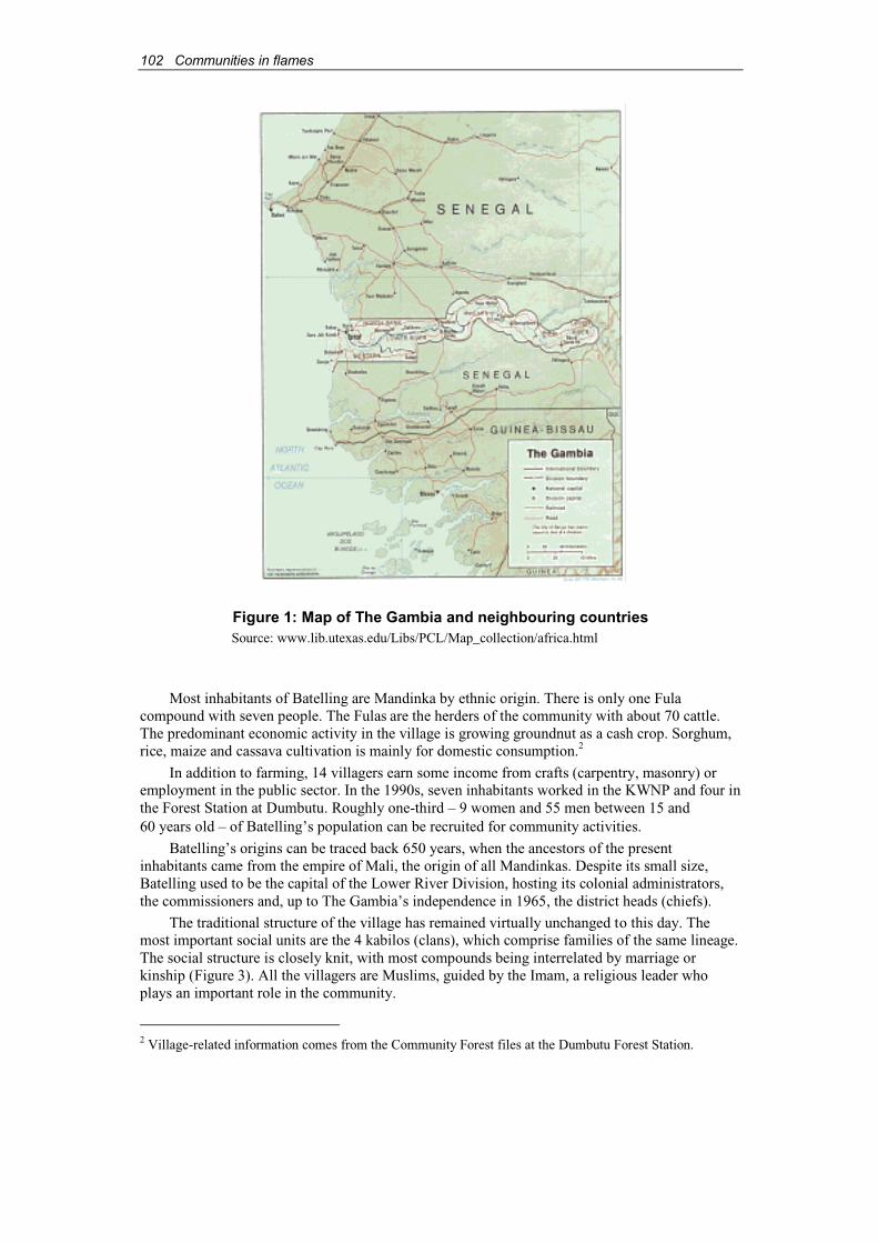
102 Communities in flames
Figure 1: Map of The Gambia and neighbouring countriesSource: www.lib.utexas.edu/Libs/PCL/Map_collection/africa.html
Most inhabitants of Batelling are Mandinka by ethnic origin. There is only one Fula compound with seven people. The Fulas are the herders of the community with about 70 cattle.The predominant economic activity in the village is growing groundnut as a cash crop. Sorghum,rice, maize and cassava cultivation is mainly for domestic consumption.2
In addition to farming, 14 villagers earn some income from crafts (carpentry, masonry) or employment in the public sector. In the 1990s, seven inhabitants worked in the KWNP and four inthe Forest Station at Dumbutu. Roughly one-third – 9 women and 55 men between 15 and60 years old – of Batelling’s population can be recruited for community activities.
Batelling’s origins can be traced back 650 years, when the ancestors of the presentinhabitants came from the empire of Mali, the origin of all Mandinkas. Despite its small size, Batelling used to be the capital of the Lower River Division, hosting its colonial administrators,the commissioners and, up to The Gambia’s independence in 1965, the district heads (chiefs).
The traditional structure of the village has remained virtually unchanged to this day. The most important social units are the 4 kabilos (clans), which comprise families of the same lineage.The social structure is closely knit, with most compounds being interrelated by marriage orkinship (Figure 3). All the villagers are Muslims, guided by the Imam, a religious leader who plays an important role in the community.
2 Village-related information comes from the Community Forest files at the Dumbutu Forest Station.
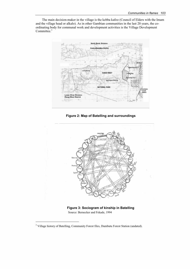
Communities in flames 103
The main decision-maker in the village is the kebba kafoo (Council of Elders with the Imamand the village head or alkalo). As in other Gambian communities in the last 20 years, the co-ordinating body for communal work and development activities is the Village DevelopmentCommittee.3
Figure 2: Map of Batelling and surroundings
Figure 3: Sociogram of kinship in BatellingSource: Bernecker and Fekade, 1994
3 Village history of Batelling, Community Forest files, Dumbutu Forest Station (undated).
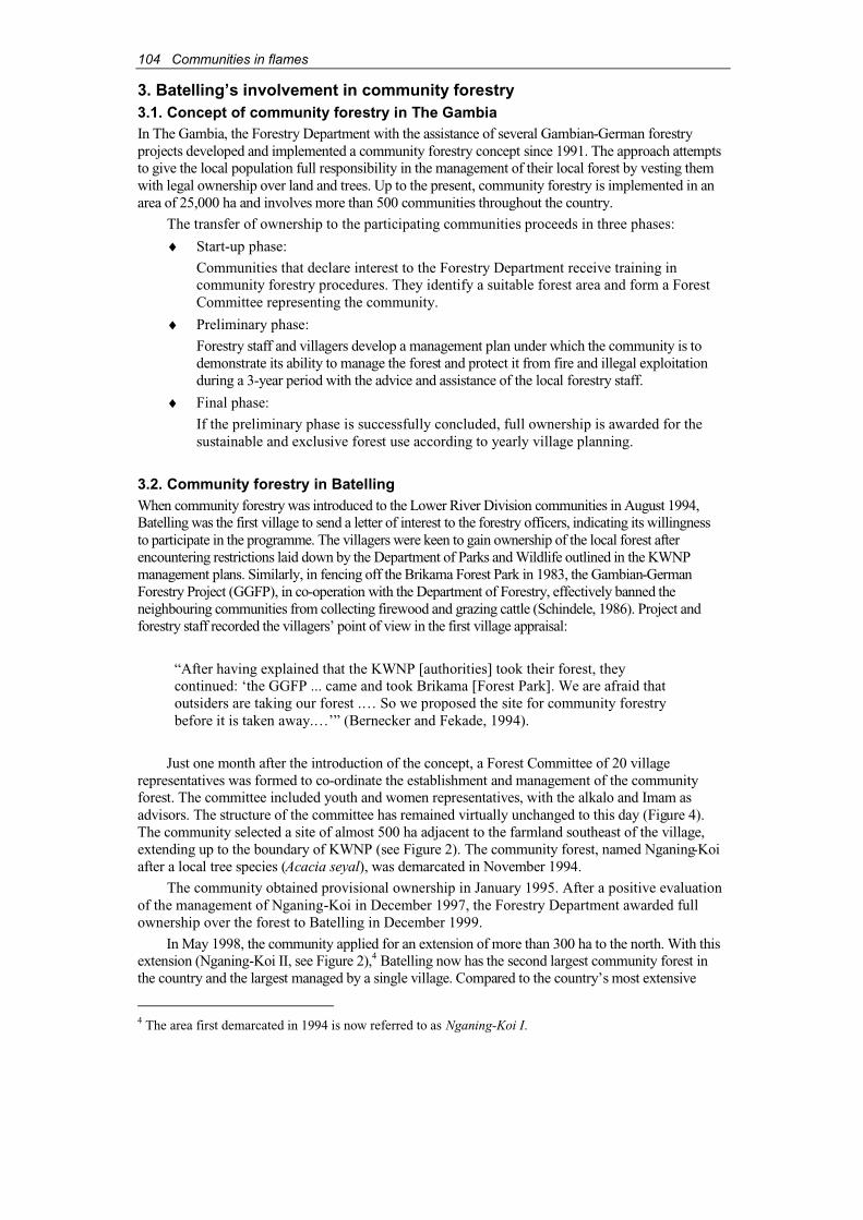
104 Communities in flames
3. Batelling’s involvement in community forestry3.1. Concept of community forestry in The GambiaIn The Gambia, the Forestry Department with the assistance of several Gambian-German forestryprojects developed and implemented a community forestry concept since 1991. The approach attemptsto give the local population full responsibility in the management of their local forest by vesting themwith legal ownership over land and trees. Up to the present, community forestry is implemented in anarea of 25,000 ha and involves more than 500 communities throughout the country.
The transfer of ownership to the participating communities proceeds in three phases:
♦ Start-up phase:
Communities that declare interest to the Forestry Department receive training in community forestry procedures. They identify a suitable forest area and form a Forest Committee representing the community.
♦ Preliminary phase:
Forestry staff and villagers develop a management plan under which the community is todemonstrate its ability to manage the forest and protect it from fire and illegal exploitationduring a 3-year period with the advice and assistance of the local forestry staff.
♦ Final phase:
If the preliminary phase is successfully concluded, full ownership is awarded for the sustainable and exclusive forest use according to yearly village planning.
3.2. Community forestry in BatellingWhen community forestry was introduced to the Lower River Division communities in August 1994,Batelling was the first village to send a letter of interest to the forestry officers, indicating its willingnessto participate in the programme. The villagers were keen to gain ownership of the local forest afterencountering restrictions laid down by the Department of Parks and Wildlife outlined in the KWNP management plans. Similarly, in fencing off the Brikama Forest Park in 1983, the Gambian-GermanForestry Project (GGFP), in co-operation with the Department of Forestry, effectively banned theneighbouring communities from collecting firewood and grazing cattle (Schindele, 1986). Project and forestry staff recorded the villagers’ point of view in the first village appraisal:
“After having explained that the KWNP [authorities] took their forest, theycontinued: ‘the GGFP ... came and took Brikama [Forest Park]. We are afraid that outsiders are taking our forest .… So we proposed the site for community forestrybefore it is taken away.…’” (Bernecker and Fekade, 1994).
Just one month after the introduction of the concept, a Forest Committee of 20 villagerepresentatives was formed to co-ordinate the establishment and management of the communityforest. The committee included youth and women representatives, with the alkalo and Imam as advisors. The structure of the committee has remained virtually unchanged to this day (Figure 4).The community selected a site of almost 500 ha adjacent to the farmland southeast of the village,extending up to the boundary of KWNP (see Figure 2). The community forest, named Nganing-Koiafter a local tree species (Acacia seyal), was demarcated in November 1994.
The community obtained provisional ownership in January 1995. After a positive evaluationof the management of Nganing-Koi in December 1997, the Forestry Department awarded fullownership over the forest to Batelling in December 1999.
In May 1998, the community applied for an extension of more than 300 ha to the north. With thisextension (Nganing-Koi II, see Figure 2),4 Batelling now has the second largest community forest inthe country and the largest managed by a single village. Compared to the country’s most extensive
4 The area first demarcated in 1994 is now referred to as Nganing-Koi I.

Communities in flames 105
community forest (≈ 1,300 ha), which is jointly managed by six villages, each similar in size toBatelling, the management capacity and aspirations of this small community are to be marvelled.
Forest fire prevention and suppression play an important role in the development and management of Batelling’s community forest. According to the villagers, “to stand against fires isthe primary objective” of all their management activities in Nganing-Koi.5 The ongoing forest fireprotection programme has been a prerequisite for receiving full ownership to the communityaccording to the 1998 community forest regulations. On the other hand, to be empowered as legalowners of “their” community forest and endowed with exclusive use rights are strong incentivesfor the community to protect and develop the Nganing-Koi in the long term.
4. Community-based fire management in Batelling4.1. Traditional fire managementAttempts to minimise the adverse effects of forest and bush fires have had some tradition at thecommunity level. “We have inherited protection from our forefathers” is a comment elicitedduring interviews with the Forest Committee. Even before their adoption of community forestry practices, the villagers of Batelling had relied on traditional fire management methods to protectthe forest areas they were using. In particular, they maintained firebreaks around forest patchescovered with elephant grass (Andropogon spp.) to stop fire intrusion. Villagers also scheduled prescribed burns at the beginning of the dry season, “early in the year when the grass was not verydry,” with some people to control the burn and others who followed to put out all unwanted fires.
Structure of Nganing-Koi Forest Committee
Women members:Naba JobartehNaba FattyJarra Sherifu SanyangKaddy Mansakunda SanyangAja Jonsaba SanyangSalimata SanyangMainding Sanyang
Patrolman:Bakary Dampha
Nursery attendant:Momodou Kaddy Sanyang
Members:Serinka SanyangOusman SanyangYafai MannehBakary Manjang Early controlled burning:
N'famara SannehLanding FattyEbrima Jammeh
Seed collection:Lang Jarju (Sanusi)Sandy Manka
AdvisorImam
Afang Yaya Mamburay
AdvisorAlkalo
Ndambung Sanyang
AdvisorAuditor
Alagie Bundu Sanyang
Vice-PresidentYaya Manka
SecretaryBakary Sanneh
TreasurerKaddy Yaya Sanyang
Women RepresentativeKaddy Sanyang
Women RepresentativeIsatou Sanyang
Women RepresentativeJarjunding Mamburay
Youth RepresentativeBakary Darbo
OrganiserLanding Fatty
Sales AgentEbrima Mamburay
OrganiserBakary Darboe
AssistantDemba Sanyang
PresidentN'famara Sanneh
Figure 4: Structure of Nganing-Koi Forest Committee
Still, fighting fires to save the forest was not a main objective of traditional fire management:“We used not to mind, we only put it out when it came close to the fields.”6 Nevertheless, whengiven the responsibility for managing their community forest, the villagers could draw on theirtraditional knowledge and experience for fire suppression. Furthermore, fire management
5 Comment from a Forest Committee member during an interview.6 Comment from villagers during interviews.
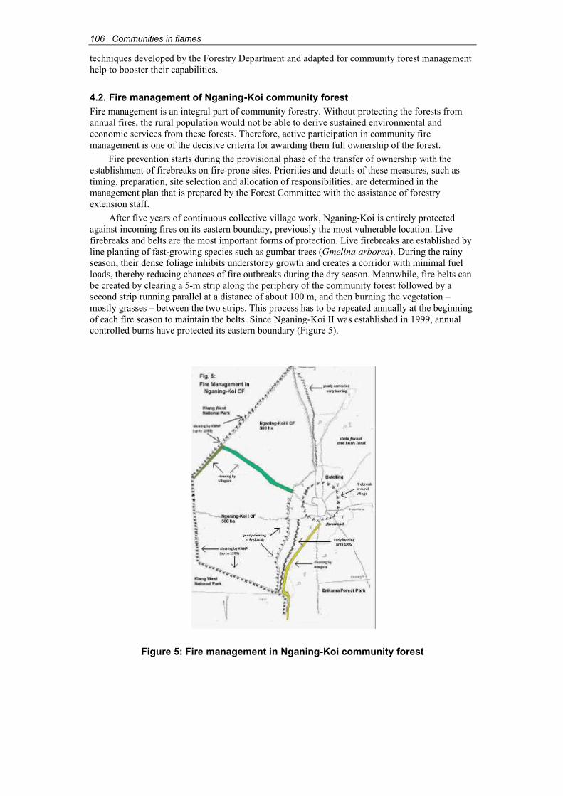
106 Communities in flames
techniques developed by the Forestry Department and adapted for community forest managementhelp to booster their capabilities.
4.2. Fire management of Nganing-Koi community forestFire management is an integral part of community forestry. Without protecting the forests fromannual fires, the rural population would not be able to derive sustained environmental and economic services from these forests. Therefore, active participation in community firemanagement is one of the decisive criteria for awarding them full ownership of the forest.
Fire prevention starts during the provisional phase of the transfer of ownership with the establishment of firebreaks on fire-prone sites. Priorities and details of these measures, such astiming, preparation, site selection and allocation of responsibilities, are determined in the management plan that is prepared by the Forest Committee with the assistance of forestryextension staff.
After five years of continuous collective village work, Nganing-Koi is entirely protectedagainst incoming fires on its eastern boundary, previously the most vulnerable location. Livefirebreaks and belts are the most important forms of protection. Live firebreaks are established byline planting of fast-growing species such as gumbar trees (Gmelina arborea). During the rainyseason, their dense foliage inhibits understorey growth and creates a corridor with minimal fuel loads, thereby reducing chances of fire outbreaks during the dry season. Meanwhile, fire belts canbe created by clearing a 5-m strip along the periphery of the community forest followed by a second strip running parallel at a distance of about 100 m, and then burning the vegetation –mostly grasses – between the two strips. This process has to be repeated annually at the beginningof each fire season to maintain the belts. Since Nganing-Koi II was established in 1999, annualcontrolled burns have protected its eastern boundary (Figure 5).
Figure 5: Fire management in Nganing-Koi community forest
Communities in flames 107
Apart from the technical approaches, by-laws enforced by the Forest Committee regulatecommunity forest management and fire prevention. Participation of able men and women in forestmanagement is mandatory. The use of fire in the community forest is prohibited, with the exceptionof controlled burning. Culprits are to be reported to the alkalo, who in turn is to inform the ForestryDepartment and the district chief. The latter will take punitive action according to the 1998 ForestAct. The by-laws also set out the procedures for punishment at the village level. The ForestCommittee is authorised to fine each guilty offender 300 Dalasis (about US$20) and withdraw his orher use rights to the community forest. For offenders under 17 years old, the Forest Committee willdetermine non-monetary forms of punishment, but there is no precedent yet.
Fire fighting to protect the community forest is mandatory under the existing by-laws:“Residents of Batelling have to participate actively in fire fighting. Offenders will be reported tothe alkalo to be fined by him.”7 The villagers also maintain “prevention is better than cure. Beforeit comes, we already have the area controlled burned.”8
The by-laws sanction the Forest Committee to raise awareness about the causes andconsequences of fires in local schools and among other communities along the River Gambiawhere fires are often started by fishermen. The Forest Committee is also responsible for enforcingthe laws. Four volunteers patrol the area to detect fires and other illegal forest activities such as felling of live trees and poaching.
The success of Batelling’s forest management, particularly their fire prevention activities,clinched them two prestigious prizes: in 1997, the first divisional prize from the NationalEnvironment Agency, and in 1999, the national award of CILSS (Permanent Inter-StateCommittee for Drought Control in the Sahel9). The prize money amounted to 20,000 Dalasis (about US$1,300).
4.3. Achievements of fire managementStatistics of fire incidences in the Lower River Division, and the Kiang West District in particular,point out that up to 90 percent of the local forests burn annually. This applies even to managedforest parks (Herbort, 1989) and many of the community forests in the area (Damphaet al., 2000).In comparison, since the Batelling community assumed responsibility for the management ofNganing-Koi community forest, only three major fires broke out in the area, namely in 1997, 2000and 2001, burning most of the community forest. These fires were related to the following incidents:
♦ An attempt to set fire to a python’s lair in a dead tree went out of control (1997).
♦ Arson in a neighbouring community forest, which succeeded after two thwartedattempts (2000).
♦ A campfire, allegedly started by fishermen, in an uninhabited area along the riverbankin the KWNP led to a major fire that burned for two days through the length of the park and entered Nganing-Koi community forest from the west (2001).
Three minor fires were detected early and suppressed through the spontaneous collective actionof the villagers. Even the more severe fires were fought collectively by the villagers with the help ofneighbouring communities and staff from the Departments of Parks and Wildlife, and Forestry.
5. Co-ordination of local stakeholders in fire managementThe KWNP is far bigger than other forest parks of The Gambia (up to 2,600 ha). Public accessand use of its natural resources are prohibited. The villagers of Batelling perceived this as a“breach of agreement” since the Park had been set up with the assistance of an internationally
7 Nganing-Koi by-laws of 1995, Community Forestry files, Dumbutu Station.8 Comment from a Forest Committee member in an interview.9 The CILSS comprises member countries Senegal, The Gambia, Mali, Niger, Chad, Burkina Faso, Guinea-Bissau, Mauritania and Cape Verde.
108 Communities in flames
funded project with the promise that neighbouring villages could use its resources. Subsequently,the communities resorted to “mass illegal exploitation”10 in the Park that once was accessible tothem (Bernecker and Fekade, 1994).
The National Park, although a “protected area” according to the Wildlife Act 1977, isaffected severely by annual forest fires (Gilbert et al., 1992). Except for Jarin Bolong, a tributaryof the River Gambia, the Park lacks any natural and artificial firebreaks and its road system is underdeveloped, which makes it difficult to access many sites.
According to a project-planning document, the firebreak system of the National Park isconcentrated in the south and southeast of its peripheries. In 1990, villagers from Batelling and neighbouring communities were contracted by “food-for-work” programmes to clear firebreaksnear their villages. When funding for these programmes ended, villagers’ participation declined(Gilbert et al., 1992). However, in recent years, villagers from Batelling were again contracted toclear firebreaks to be used as access roads by the KWNP staff.
A firebreak on the border between the KWNP and Nganing-Koi community forest used to be cleared until 1999, when funds were no longer available. The severe fire of 2001 entered the Nganing-Koi community forest through this overgrown area and destroyed Nganing-Koi I and II almost completely despite the community’s fire fighting attempts. The villagers of Batelling werefrustrated about their inability to protect their resources after having invested so much effort. The Imam, advisor to the Forest Committee, contended: “We inherited this forest from our ancestors.Now that we have attained ownership, there is a sabotaging factor that hinders the whole system.If the efforts we are doing are in vain, demotivation might be the result.”
Theoretically, mechanisms are in place to integrate the satellite villages of KWNP in itsmanagement, the most important being a Technical Advisory Committee (TAC) that was set up in 1992. The main purpose of the TAC is “to discuss the issues they see as critical to life in a ruralcommunity” (Gilbert et al., 1992). The influence of TAC on the management of the Park seems tobe limited, as evident from the Imam’s statement.
In fact, some community members alleged that arson by people dissatisfied with the currentset-up of KWNP could be the cause of some fires. In the meanwhile, according to the villagersinterviewed in Batelling, the lack of trust between the communities and the management ofKWNP makes it difficult to trace the culprit(s).
To end this stalemate, the Forest Committee of Batelling called a meeting of all concernedstakeholders in the area – the management of KWNP, Forestry Department and the villagesaround the Park “as far as where the fire came from” – to discuss a common approach in firemanagement. Meanwhile, the villagers wondered why it was up to them to take the initiative:“Why don’t the heads of Forestry and Wildlife come and sit together and discuss strategies before the communities initiate these things?”11
While the call for this meeting was well received by the other concerned villages “becausethis is a headache for everybody,” the people of Batelling were cautious in their expectations from the representatives of the Departments of Forestry, and Parks and Wildlife.
6. The local forum on the control of bushfiresThe communities were determined to use the proposed meeting as an opportunity to communicatetheir concerns to the relevant government agencies. The organizers from the Nganing-Koi ForestCommittee therefore did everything to ensure the participation of officers from the Departments ofParks and Wildlife, and Forestry. However, the scheduled meeting was cancelled when Departmentrepresentatives were not going to be present. The forum was finally held two months after the initialinvitation, with the participation of 33 members of five satellite villages and staff of the twodepartments. Unfortunately, the villagers were unable to meet the Directors of both departments.
10 Quoted from a forest committee member.11 Comment from a forest committee member.
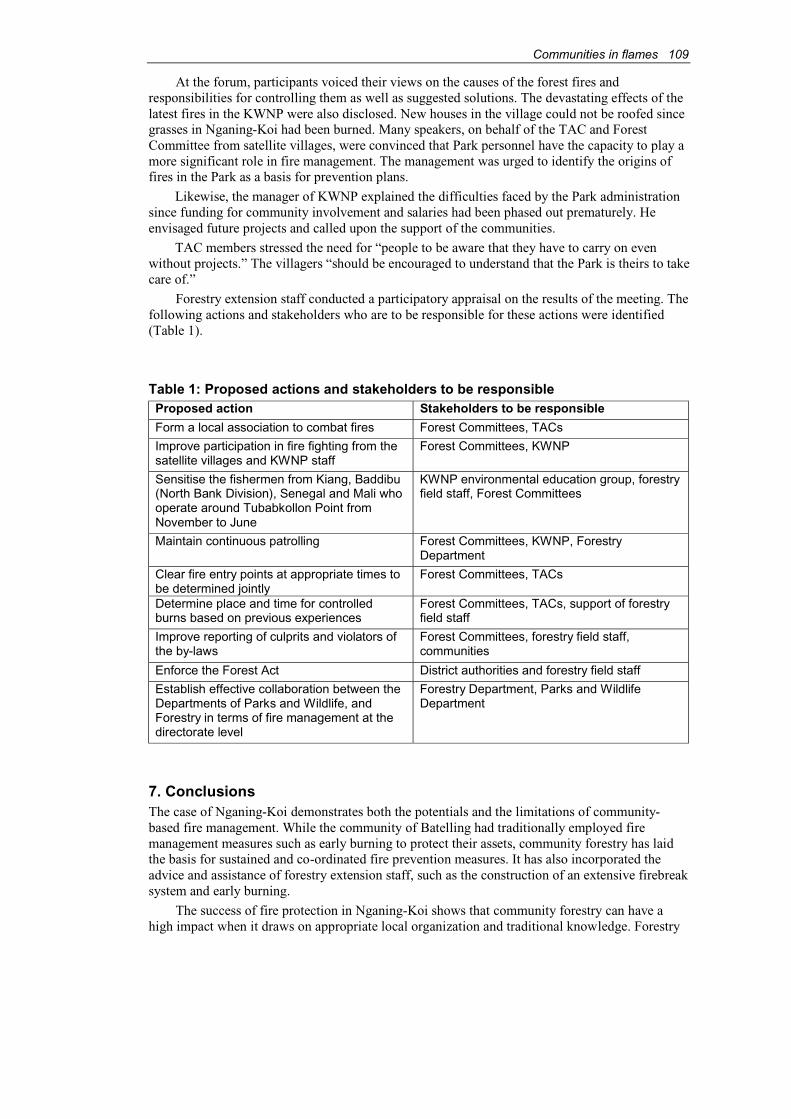
Communities in flames 109
At the forum, participants voiced their views on the causes of the forest fires andresponsibilities for controlling them as well as suggested solutions. The devastating effects of thelatest fires in the KWNP were also disclosed. New houses in the village could not be roofed since grasses in Nganing-Koi had been burned. Many speakers, on behalf of the TAC and ForestCommittee from satellite villages, were convinced that Park personnel have the capacity to play a more significant role in fire management. The management was urged to identify the origins offires in the Park as a basis for prevention plans.
Likewise, the manager of KWNP explained the difficulties faced by the Park administrationsince funding for community involvement and salaries had been phased out prematurely. Heenvisaged future projects and called upon the support of the communities.
TAC members stressed the need for “people to be aware that they have to carry on evenwithout projects.” The villagers “should be encouraged to understand that the Park is theirs to takecare of.”
Forestry extension staff conducted a participatory appraisal on the results of the meeting. The following actions and stakeholders who are to be responsible for these actions were identified(Table 1).
Table 1: Proposed actions and stakeholders to be responsibleProposed action Stakeholders to be responsible
Form a local association to combat fires Forest Committees, TACs
Improve participation in fire fighting from the satellite villages and KWNP staff
Forest Committees, KWNP
Sensitise the fishermen from Kiang, Baddibu(North Bank Division), Senegal and Mali who operate around Tubabkollon Point from November to June
KWNP environmental education group, forestryfield staff, Forest Committees
Maintain continuous patrolling Forest Committees, KWNP, ForestryDepartment
Clear fire entry points at appropriate times to be determined jointly
Forest Committees, TACs
Determine place and time for controlled burns based on previous experiences
Forest Committees, TACs, support of forestryfield staff
Improve reporting of culprits and violators of the by-laws
Forest Committees, forestry field staff,communities
Enforce the Forest Act District authorities and forestry field staff
Establish effective collaboration between the Departments of Parks and Wildlife, and Forestry in terms of fire management at the directorate level
Forestry Department, Parks and WildlifeDepartment
7. ConclusionsThe case of Nganing-Koi demonstrates both the potentials and the limitations of community-based fire management. While the community of Batelling had traditionally employed firemanagement measures such as early burning to protect their assets, community forestry has laidthe basis for sustained and co-ordinated fire prevention measures. It has also incorporated the advice and assistance of forestry extension staff, such as the construction of an extensive firebreaksystem and early burning.
The success of fire protection in Nganing-Koi shows that community forestry can have ahigh impact when it draws on appropriate local organization and traditional knowledge. Forestry

110 Communities in flames
extension officials should give high priority to these aspects in their village appraisals and consider them in the work plans with the villagers.
Ownership over Nganing-Koi has created a strong incentive for the community of Batellingto protect and develop their forest. The relationship with the Forestry Department has improved tothe extent that the community now even takes responsibility for fighting fires in forest areasbeyond their own boundary. This change of attitude has overcome former pitfalls of forestmanagement such as fencing off the adjacent National Park.
However, the example of KWNP also serves as a strong reminder that responsibilities for fire management cannot simply be passed down to communities. A single fire that had crossed intothe National Park, burning uncontrolled for several days, had rapidly destroyed the achievementsof years of fire prevention in Nganing-Koi.
The KWNP is a huge and in effect unmanaged zone in terms of fire control, lackingmechanisms to incorporate the stakes of neighbouring communities. The relationship of the parkmanagement with satellite villages has been limited to contract labour and paid employment.Envy among communities has been generated by the uneven and seemingly arbitrary recruitmentof paid labourers from different satellite villages. This relationship deteriorated further when financial support for communal workers’ salaries was withdrawn without prior notification.Villagers felt they were cheated out of their payments. It is therefore not surprising that communalwork for maintaining the firebreaks of KWNP came to a halt.
The villagers thought they should be paid for their work because of the lost rights over the Park and its natural resources. This is not entirely correct since they are allowed to collect grassfor domestic purposes. However, as it was revealed during the local forum, satellite communitieswere not told of this right by the park management, which leads to further misunderstandings.
The KWNP is a case in point for other nature parks and reserves that have restricted accessby the local population, offering (at best) financial compensation to them for being deprived of any benefits. This is especially grave in a case like Batelling where subsistence livelihoodsdepend on the supply of local natural products and where inefficient (yet exclusive) managementof these “protected” areas by state agencies can lead to detrimental events – such as forest fires –and severe hardship for the community.
The constructive outcome of the stakeholders’ meeting should not obscure the difficultiesfacing communities like Batelling in holding the relevant administrations responsible. TheDepartments of Forestry, and Parks and Wildlife did not show enough interest in addressing theproblem directly. To the villagers of Batelling, the stakeholders’ meeting was less a manifesto of self-empowerment or grassroots politics, but rather an act of despair to deal with the threat to their natural assets. Attending the meeting was more a goodwill gesture from the two departments withno commitment on their part to solve the problems.
On the other hand, for the forum to have taken place at all is remarkable. It has brought relevantstakeholders together, identified others such as seasonal fishermen, and developed key points ofaction. The proposal to commit the key groups in a regional association seems to be particularlypromising, corresponding in fact with a revision currently being foreseen in the Gambian forest policy.The new approach calls for a broader perspective on fire management planning at the local level,rather than at the regional scale which necessitates new planning procedures and new models ofcollective action (The Republic of The Gambia, 2001; Schindele, 2001).
ReferencesBernecker, K. & Fekade, W. (1994). Grassroots/Target group approaches in community forestry.
Gambian-German Forestry Project. Deutsche Gesellschaft für Technische Zusammenarbeit(GTZ), Eschborn, Germany.
CIA. (2001). The World Factbook: Gambia. Central Intelligence Agency, Washington, D.C. http://www.odei.gov/cia/publications/factbook/geos

Communities in flames 111
Dampha, A., Camara, K. & Beck, C. (2000). Management of forest fires through the involvementof local communities. Case study: The Gambia. Food and Agriculture Organization of theUnited Nations, Rome (in press).
FAO. (2000). Annual report 1999, by Heimo Mikkola, The Food and Agriculture Organization of the United Nations Representative in The Gambia. Banjul.
Gilbert, V.C., Camara, A. & Wilkie, D.S. (1992). Kiang West National Park IntegratedConservation and Development Project. Ministry of Natural Resources and the Environment(of The Gambia). Banjul, The Gambia.
Herbort, H. (1989). Savannenbrände in Westafrika: Ihre Auswirkungen und möglicheGegenmaßnahmen, dargestellt am Beispiel Gambias. Thesis, University of Kassel. Kassel,Germany.
Schindele, W. (1986). Survey and demarcation of forest parks in The Gambia. DeutscheForstinventur-Service for Deutsche Gesellschaft für Technische Zusammenarbeit (GTZ).Eschborn, Germany.
Schindele, W. (2001). Revision of the Gambian forest management concept. Some ideas and recommendations. Mission Report, Department of State for Fisheries, Natural Resources and the Environment/Deutsche Gesellschaft für Technische Zusammenarbeit/DeutscheForstservice GmbH. Eschborn, Germany.
The Republic of The Gambia. (2001). The Gambian forest management concept. Final draft.Forestry Department, Department of State for Fisheries, Natural Resources and theEnvironment. Banjul, The Gambia.
AcknowledgementsFirst-hand information for this study was gained from group interviews with the ForestCommittee of Nganing-Koi and from the documentation of village meetings. The authors aregrateful to Sisawo Sabally of Dumbutu Forest Station for assisting in the organization and thedocumentation of the relevant statements and visualisations. We furthermore appreciate theassistance of the Directorate of the Department of Parks and Wildlife in Abuko, which generouslysupplied us with background information. Finally, we are profusely thankful to the villagers ofBatelling, especially the Forest Committee, for their motivation and openness, without which thisdocumentation could not have been compiled.
112 Communities in flames
112
Forest fire in the context of territorial rights in northern Thailand
Atchara Rakyutidharm1
AbstractTerritorial rights are important for establishing the roles of those who should protect natural resources. Different property rights regimes may affect the characteristics of fires. This paper compares fires on land managed under a common property regime with fires on land owned andmanaged by the state. According to the definition of the Royal Forest Department (RFD), fire that occurs on communal land is not a forest fire because it is under “systematic” control, throughtraditional wisdom and knowledge, by the members of each community. The local people use firefor their daily household activities and to manage local ecosystems. Fires that occur on state landare classified as forest fires because they are assumed to be out of control and unwanted. The law claims all natural resources for the state, but in practice they are openly accessible to everyone.Thai people are barred from participating in forest management. As a result, they have no sense ofresource ownership and may use fire carelessly. Limited staff and budget are major constraints ofthe RFD’s forest fire control efforts. One way to improve fire management is to grantmanagement rights to local communities. Through legislation, the conflicts between the legal and traditional systems can be resolved, and co-operation between the state and the communityimproved to develop sustainable and equitable resource management systems.
1. Property regimes and the forest fire managementProperty rights are a key factor that determines resource use and influences behaviour of resourceusers. Property rights are also the main incentive for resource management (Libecap, 1989, cited in Suthawan Sathirawan, 1996).
Different property rights regimes may affect the characteristics of fires. This paper comparesfires on land managed under a common property regime with fires on land owned and managedby the state.
2. Fire management on common propertyCommunal land is an area controlled and managed through community institutions. The RoyalForest Department (RFD, 1996) defines forest fire as a fire that occurs [on forestland] for anyreason and in the absence of any control. So, a fire on communal land is not a “forest fire” underthis definition since it is under “systematic” control by the community. Local people use fire fortheir daily household activities and to manage local ecosystems even if the land is de jure state or public land. The RFD regards fires as “forest fires” when they occur on public land. This perception is misleading and based on a disregard for local knowledge and local management of resources.
2.1. Fire management in community forestsA community forest is used and managed by a community according to community rules and regulations. It can be classified into conservation forest and production forest. In northernThailand, the conservation forest is evergreen, dense and moist throughout the year. It is usually awatershed area and conserved. Sometimes it is also protected for religious and traditional beliefs.
1 Information and Policy Advocacy Department, Northern Development Foundation, 77/1 Moo 5, Suthep,Muang, Chiang Mai 50200 Thailand, email: [email protected]
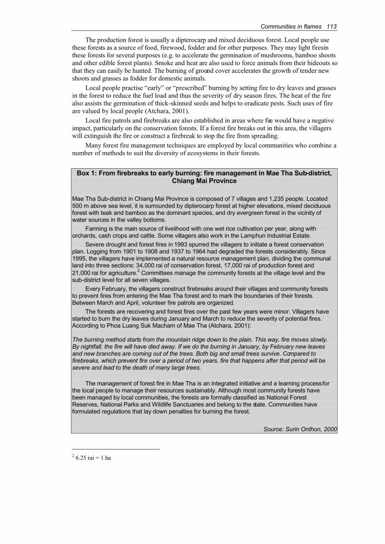
Communities in flames 113
The production forest is usually a dipterocarp and mixed deciduous forest. Local people usethese forests as a source of food, firewood, fodder and for other purposes. They may light firesinthese forests for several purposes (e.g. to accelerate the germination of mushrooms, bamboo shootsand other edible forest plants). Smoke and heat are also used to force animals from their hideouts sothat they can easily be hunted. The burning of ground cover accelerates the growth of tender new shoots and grasses as fodder for domestic animals.
Local people practise “early” or “prescribed” burning by setting fire to dry leaves and grassesin the forest to reduce the fuel load and thus the severity of dry season fires. The heat of the fire also assists the germination of thick-skinned seeds and helps to eradicate pests. Such uses of fireare valued by local people (Atchara, 2001).
Local fire patrols and firebreaks are also established in areas where fire would have a negativeimpact, particularly on the conservation forests. If a forest fire breaks out in this area, the villagerswill extinguish the fire or construct a firebreak to stop the fire from spreading.
Many forest fire management techniques are employed by local communities who combine a number of methods to suit the diversity of ecosystems in their forests.
Box 1: From firebreaks to early burning: fire management in Mae Tha Sub-district,Chiang Mai Province
Mae Tha Sub-district in Chiang Mai Province is composed of 7 villages and 1,235 people. Located500 m above sea level, it is surrounded by dipterocarp forest at higher elevations, mixed deciduousforest with teak and bamboo as the dominant species, and dry evergreen forest in the vicinity ofwater sources in the valley bottoms.
Farming is the main source of livelihood with one wet rice cultivation per year, along withorchards, cash crops and cattle. Some villagers also work in the Lamphun Industrial Estate.
Severe drought and forest fires in 1993 spurred the villagers to initiate a forest conservationplan. Logging from 1901 to 1908 and 1937 to 1964 had degraded the forests considerably. Since1995, the villagers have implemented a natural resource management plan, dividing the communalland into three sections: 34,000 rai of conservation forest, 17,000 rai of production forest and21,000 rai for agriculture.2 Committees manage the community forests at the village level and thesub-district level for all seven villages.
Every February, the villagers construct firebreaks around their villages and community foreststo prevent fires from entering the Mae Tha forest and to mark the boundaries of their forests.Between March and April, volunteer fire patrols are organized.
The forests are recovering and forest fires over the past few years were minor. Villagers havestarted to burn the dry leaves during January and March to reduce the severity of potential fires.According to Phoa Luang Suk Macham of Mae Tha (Atchara, 2001):
The burning method starts from the mountain ridge down to the plain. This way, fire moves slowly. By nightfall, the fire will have died away. If we do the burning in January, by February new leavesand new branches are coming out of the trees. Both big and small trees survive. Compared tofirebreaks, which prevent fire over a period of two years, fire that happens after that period will besevere and lead to the death of many large trees.
The management of forest fire in Mae Tha is an integrated initiative and a learning processforthe local people to manage their resources sustainably. Although most community forests havebeen managed by local communities, the forests are formally classified as National ForestReserves, National Parks and Wildlife Sanctuaries and belong to the state. Communities haveformulated regulations that lay down penalties for burning the forest.
Source: Surin Onthon, 2000
2 6.25 rai = 1 ha
114 Communities in flames
114
2.2. Fire management in agricultural fieldsMost agricultural fields belong to individual households. However, households remain bound to traditional rules and community management (e.g. rules of kinship and community irrigationmanagement organization). Hence the village organization continues to be the ultimate decision-making unit concerning land management.
People living in the forest have used fire to prepare agricultural land for thousands of years.Farmers usually burn at mid-day when winds are lighter to reduce the risk of fires spreading. Inorchards, farmers burn grass in piles to avoid damaging the fruit trees. The heat from the fire destroysseeds of weeds, insects and diseases. Burning breaks down the organic matter and enables plantedcrops and indigenous plants to establish themselves in the burned areas.
Alternatives to fire use are not readily available due to the limited resources and skills.Instead, local knowledge of appropriate fire use achieves the same objectives, as shown by theMae Pon Village, a Karen community in Chiang Mai Province.
Box 2: Local knowledge of appropriate fire use in rotational shifting cultivation inMae Pon Village, Chiang Mai Province
Mae Pon Village, Ban Luang Sub-district, Chom Tong District, Chiang Mai Province, is a Pakagayaw (Karen) community. It is situated between 600 and 1,000 m above sea level and comprises 74 households. The village is divided into four communities: Ban Mae Pon Nawk, Ban Huey Wak, Ban San Din Daeng and Ban Glang. Village members in Ban Mae Pon Nawk plant terraced wet rice fields while the rest relies on rotational slash-and-burn farming. All four villageshave orchards, practice livestock husbandry and work as labourers.
The Pakagayaw clear their fields in February. They cut only the branches of the large treesand fell smaller trees at waist level. They leave the vegetation to dry for 1-2 weeks and then burn them. The people who burn the fields must have knowledge of wind direction, slope, weather,environment and landscape. Households with adjacent fields usually help each other to build firebreaks and burn the fields together. Burning starts at the outer boundary and moves towardsthe centre of the fields, and from upland to lowland areas.
The Pakagayaw manage fire through traditional knowledge and wisdom. When the paddy in the field is about 30 cm tall, they carry out ceremonial offerings to the spirits and show respectand gratitude to Dtah Lu Me, the fire spirit. The Pakagayaw believe that all resources belong to the spirits, and as part of the natural world, humans are allowed to use these resources, but theymust only take what they need, or the spirits will punish them.
3. Management of fire in the state common property regimeAccording to the law, all natural resources are owned by the state. However, in practice, they are openly accessible to everyone. The state is not capable of managing and maintaining all thenatural resources, while local people are officially barred from participating in the managementprocesses, which contributes to resource degradation.
All fires that occur on state land are “forest fires” because they are assumed to be out ofcontrol and unwanted. Fires in the forest may be caused by agricultural practices as burning for hunting and gathering purposes. The root cause of forest fires is the absence of a feeling ofownership over the resources. As a result, people are careless about how they treat the environment. This contrasts with the use of fire in community forests, where fire is used carefullyto avoid damage to communal property. In the latter case, community members know each otherwell and are able to find the culprit responsible for the fire more easily.
A basic problem is a conflict over the interpretation of “fire”. The local people consider fireas a tool, controlled by traditional techniques, for managing resources. However, the provincialgovernor considers all these fires to be “forest fires” that spread and destroy ecological systems.

Communities in flames 115
The state rejects local knowledge and management techniques. Being confident of the legality ofits actions, it maintains that knowledge of appropriate fire use lies within its hands only.
The villagers’ interpretation of the causes of forest fires can be markedly different:
“The local RFD unit sets the fires themselves because if fire occurs they will get a larger budget.” - Gam Nan Anan Duang Gaiyo Ruen, Mae Tah Sub-district, Mae On District, Chiang Mai Province.
“Every year, fires spread from the RFD plantations. I think the staff do itthemselves because in the years that they do not have fire they get little money, but in the years they do have fire they get a lot of money.” - Duang Gaiyo Salee, Ban Mae Yah Noi, Ban Luang Sub-district, Chom Tawng District, Chiang MaiProvince.
RFD officials explained that the people mix up prescribed burning with wildfires. It isdifficult to confirm accusations. Since the state monopolises control over resources, the public is unable to evaluate or monitor what is happening. Forest fires on state-owned land are also caused by villagers’ malicious actions designed to anger officials. This is due to the generaldissatisfaction with the way RFD staff uses power to control resources and reflects the conflictbetween government and the community.
Although the state claims ownership over all natural resources, in practice it has limited staffand budget to implement proper management. For instance, in Doi Luang National Park, the numberof forest fires increased after the RFD relocated people from their forest village.
“The outsiders always start fire for hunting at the base of the hill and it then risesto the top. The RFD staff cannot take care of all of them. When the villagers were there, the outsiders were wary of the villagers. If the villagers saw a fire startinganywhere they would help to put it out immediately. In the past, villagers broughtthe cattle to graze in the forest and this also reduced the risk of fire from dry grass on the forest floor.” - Su Rueng Sa Forng, Ban Mae Tom, Wang Nueha District,Lampang Province.
“After the villagers were moved out, the officials did not have enough labour to suppress the fires. We have just nine people per unit and have only nine units. In1988, forest fires happened a lot and destroyed large areas of forest.” - An officialof Mae Hom Watershed Management Unit in Doi Luang National Park (BenjaSilarak, 1998).
The RFD spends a huge budget on public relations to encourage local people to share inprotecting the forest. This will not solve the problem because the state only assigns people the duty to take care of the forest but grants them no rights. As a result, local people feel they have no stake in the land and are not motivated to conserve the forest. As Somsak Sukwong (2000), theDirector of the Regional Community Forestry Training Center (RECOFTC), commented:
“If we want the villagers to grow the forest and protect it from forest fire it is not hard to do – simply allow the village members to manage the forest themselves. Wedo not utilise 100 percent of the forest community potential. If the villagersmanage the forest, they will utilise the full potential themselves.”
116 Communities in flames
116
4. ConclusionsSecure rights to natural resources are necessary conditions for establishing rules andresponsibilities in resource management. Presently, the law does not recognise community the traditional rights of local communities. They have their own community forestry managementsystems, including a forest fire management plan that works in harmony with the local ecologyand local traditions. The state must enact legislation that acknowledges these community rights, inaccordance with the Constitution. Through legislation, the conflicts be tween the legal and traditional systems can be resolved, and co-operation between the state and communitiesimproved to develop sustainable and equitable resource management systems.
ReferencesAtchara Rakyutidharm (ed.). (2001). The experience of forest fire management by local
communities. Northern Watershed Development by Community Organization Project, Northern Development Foundation, Chiang Mai.
Benja Silarak. (1998). Phacho behind the scene of success of failure. In Northern DevelopmentFoundation, The disguised murder on the conservation road. Chiang Mai.
RFD. (1996). Forest fire control report: northern forest fire control 1994-1996. Royal ForestDepartment, Bangkok.
Somsak Sukwong. (2000). Forest fire management. In Atchara Rakyutidharm (ed.), Forest firemanagement by local communities. Northern Watershed Development by CommunityOrganization Project, Northern Development Foundation, ChiangMai, pp. 1-20.
Surin Onthon. (2000). From fire break to early burning as local fire management system: a case study of Mae Tha Sub-district, Mae On District, Chiang Mai Province. In AtcharaRakyutidharm (ed.), Forest fire management by local communities. Northern WatershedDevelopment by Community Organization Project, Northern Development Foundation,Chiang Mai.
Suthawan Sathirawan (1996). The state of Thai studies: a critical survey on common propertyregime in Thailand. Thailand Research Fund, Bangkok.

Communities in flames 117
Fire in miombo woodlands: a case study of Bukombe District Shinyanga, Tanzania
Nssoko Edwin1
AbstractConcern about the environmental impact of forest fires in the Bukombe District in Tanzania hasbeen growing in the last two decades. Most in the district are caused by human activities. Theprotection of the miombo woodlands is hampered by a lack of fire management policies and legalinstruments to support fire prevention and suppression. Trained human resources are also limited.Local communities have their own management system and forest fire management that complement local ecology and traditions. It is therefore expedient to involve them in forestmanagement. The HASHI (Soil Conservation and Afforestation) Project together with the Forestand Beekeeping Division have organized joint forest management in selected locations where thevillagers are granted use rights to forest resources. The creation of local ownership has been a keyto the success of fire management.
1. IntroductionThe Bukombe District is located in northern Tanzania, with an area of about 10,500 km2. Duringthe last two decades, concern about the environmental impact of forest fires in the district hasbeen growing. The main natural vegetation in the district is composed of woodland and thick forest. More than 90 percent of all fires are caused by human activities such as:
♦ agriculture, especially farm preparation and shifting cultivation;
♦ logging;
♦ charcoal burning;
♦ hunting and collection of honey (smoke is used to drive animals from their hideouts and bees from their hives);
♦ arson; and
♦ traditional tribal fire uses.
Forest fire in the miombo woodland has resulted in significant damage to property and manylives have been lost. Even though fire is important for the regeneration and growth of the miombo woodlands, the uses of fire will always be controversial.
The major problems facing forest fire protection are age-old traditional attitudes, socio-economic activities and, to some extent, past national forest policies that dissociated the localcommunities from their traditional access and utilisation of the forests. The government used to be the custodian of such forests while local communities were barred from the resources. Forexample, the local villagers were not allowed to collect even firewood from the forest. Suchalienation induces local communities to be detached and indifferent to their environment. Hencethey do not care too much about the forest.
Efforts to combat forest fires in Tanzania, in general, are hindered by a lack of firemanagement policies and legal instruments to support fire prevention and suppression. Furthermore,technical and professional human resources are also inadequate at all levels. It is for that reason thata collective effort involving local communities in fire management should be encouraged.
1 Head of Fire Protection, Hashi Project, P.O. Box 797, Shinyanga, Tanzania, email: [email protected]

118 Communities in flames
The local communities have their own management systems and forest fire management that complement local ecology and traditions. For example, the Sukuma people traditionally constructa Ngitili (a Sukuma term meaning “enclosure”). This area within the village is closed off at the beginning of the wet season and opened during the dry season for grazing cattle. This traditionalpractise has protected many areas from fires. Therefore, joint forest management (JFM) effortsand strategies need to be implemented, considering that the government does not have sufficientresources to combat forest fires alone.
Due to inadequate funds and staff resources to protect the forests, the HASHI (Soil Conservation and Afforestation) Project and the Forest and Beekeeping Division have establishedJFM in selected villages where local communities are granted use rights. This provides villagersan incentive to manage and protect the forest against encroachment, illegal harvesting and fires.
2. MethodologyIn trying to involve local communities in forest fire management, the project focuses on:
♦ Education and publicity through interactive video shows, mobile extension teams,brochures, posters, calendars and radio programmes, to sensitise and empower thecommunities to prevent fires.
♦ Seminars, workshops and meetings at different levels to disseminate information.
♦ Formulation of by-laws on fire protection.
♦ Collaboration with village committees in management, planning, monitoring and extension services.
3. ConclusionsThe creation of local ownership at the village level has been a key to the success of fire management. To a large extent, JFM has changed the attitudes and behaviour of villagersregarding land use and fire management considerably. The number of forest fires is slowlydecreasing with time.
The new forest policy encourages private ownership of land and forests through JFM and community-based fire management that increase land tenure security. It is hoped that this will significantly decrease the incidence of wildfires in the miombo woodlands and improve forest and fire management.
Communities in flames 119
Traditional community-based fire management among the Mizo shifting cultivators of Mizoram in northeastIndia
V.T. Darlong1
AbstractThe tribes of northeast India practicing shifting cultivation or “jhumming” have unique and variedcommunity-based fire management traditions. The Mizos, living in Mizoram, have developedeffective and well-organized community-based fire management practices that revolve around shifting cultivation.
The foundation of this practice is the Village Council, a system of village communitygovernance. While the traditional fire management tools and techniques are simple, the strategiesrely on timely community response and participation. There are four categories of measures, i.e. regulatory, activity-oriented, preventive and punitive. The community regulates the period of jhum burning, defines roles for each of its members, prescribes preparation of fire lines in the jhum fields, and imposes penalties for causing forest fires.
Constrained by the dilemma of a society in transition and influenced by various factors, theeffectiveness of the Mizos’ fire management practices appears to have weakened in recent years.Increased incidences of forest fire have prompted government intervention and schemes aimed atpreventing and controlling forest fire. This shift from community-based to government-initiatedprogrammes highlights the erosion of “tlawmngaihna” – a community spirit that puts the common good above personal gains. Rather than seeking to replace such management practices, thegovernment should enhance the effectiveness of the traditional systems, supplement communityefforts and encourage maximum community involvement.
1. IntroductionIndia’s northeastern region, commonly known as the “land of seven sisters”, is a land of diverseethnic groups, tribes and culture. Shifting cultivation, locally known as “jhum” or “jhumming”,has been and continues to be a way of life for many of these tribes since time immemorial.Consequently, the tribes appreciate the role of fire and its uses in their traditional shiftingcultivation system. However, since the period for slash and burn generally coincides with the dry and windy months of the year, incidences of fires spreading beyond the boundaries of designatedplots into the adjoining forests are not uncommon. In extreme cases, such fires may even destroyentire villages or hamlets.
Years of experiences by different communities have led to the evolution of community-basedfire management practices that are rather specific to each tribe in northeast India. This paper discusses the traditional community-based fire management system of the Mizo shiftingcultivators in Mizoram. The role of state and central governments in fire management is brieflydiscussed to highlight the linkages and importance of forest fire management.
2. Mizoram: the land and its peopleMizoram, the “land of highlanders”, is one of the seven states of northeast India, with an area of 21,081 km2. It shares a boundary with Myanmar in the southeast and Bangladesh in the west(Figure 1). More than 98 percent of Mizoram is hilly and mountainous. The state enjoys amonsoon climate with an average rainfall of 2,640-3,900 mm annually.
1 Ministry of Environment & Forests, North-East Regional Office, Laitumkhrah, Upland Road, Shillong793 003, India, email: [email protected]
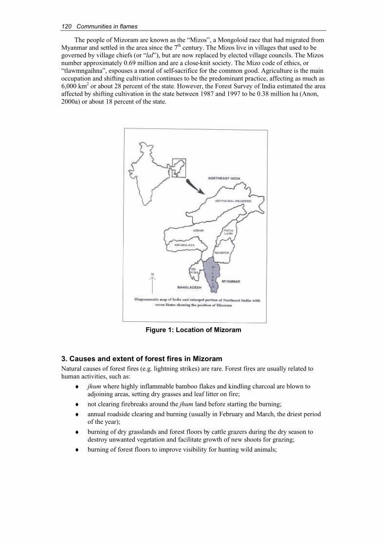
120 Communities in flames
The people of Mizoram are known as the “Mizos”, a Mongoloid race that had migrated from Myanmar and settled in the area since the 7th century. The Mizos live in villages that used to begoverned by village chiefs (or “lal”), but are now replaced by elected village councils. The Mizosnumber approximately 0.69 million and are a close-knit society. The Mizo code of ethics, or“tlawmngaihna”, espouses a moral of self-sacrifice for the common good. Agriculture is the main occupation and shifting cultivation continues to be the predominant practice, affecting as much as6,000 km2 or about 28 percent of the state. However, the Forest Survey of India estimated the areaaffected by shifting cultivation in the state between 1987 and 1997 to be 0.38 million ha (Anon, 2000a) or about 18 percent of the state.
Figure 1: Location of Mizoram
3. Causes and extent of forest fires in MizoramNatural causes of forest fires (e.g. lightning strikes) are rare. Forest fires are usually related to human activities, such as:
♦ jhum where highly inflammable bamboo flakes and kindling charcoal are blown to adjoining areas, setting dry grasses and leaf litter on fire;
♦ not clearing firebreaks around the jhum land before starting the burning;
♦ annual roadside clearing and burning (usually in February and March, the driest period of the year);
♦ burning of dry grasslands and forest floors by cattle grazers during the dry season to destroy unwanted vegetation and facilitate growth of new shoots for grazing;
♦ burning of forest floors to improve visibility for hunting wild animals;

Communities in flames 121
♦ careless prescribed burning and fire line layout and construction;
♦ charcoal-making in the forests; and
♦ cooking and camping by woodcutters and other forest users.
Preliminary results of recent surveys show that the extent of forest fire in Mizoram issignificant, though the areas affected fluctuate from year to year (Table 1).
Table I. Extent of forest fires in different forest divisions of Mizoram
Area affected (ha)Forest division 1995/96 1996/97 1997/98 1998/99
Aizawl 1 42 0 0
Champhai 13,040 5,715 0 3,458
Chhimtuipui 56 0 6 0
Darlawn 0 0 0 0
Kawrtha 142 0 0 0
Kolasib 50 3 2 0
Lunglei 708 84 41 95
Mamit 101 0 0 0
North Vanlaiphai 800 2 0 0
Thenzawl 7 0 0 0
Tlabung 0 0 0 0
Total 14,965 5,986 49 3,547
Source: Anon, 2000b
4. Traditional village institutions: precursor to community-based firemanagementControl and management of forest and jhum fire are joint responsibilities of individuals and the entire village. As jhumming has been an entrenched practice for the Mizos, the community hasevolved its fire management around this tradition. Whenever a forest fire is reported, the VillageCouncil President will immediately order the Village Crier (a village messenger or announcer) to alert the community, and anyone who hears the announcement is duty-bound to immediatelyproceed to the site to fight the fire. Labour is also divided across age and gender for jhum burning.
5. Traditional tools employed for community-based fire managementA Mizo prepared for fighting a forest fire will generally carry only a moderately long knife (chem or dao) and a bottle of drinking water in his cloth bag. He prefers to travel lightly, barefoot and clad in simple cotton clothing, so that he can move swiftly and climb trees to cut off branches for suppressing fires. He may even use drinking water to put out burning logs.
Fire extinguishers, buckets and spades are not suitable for the hilly terrain. They are not preferred by the local communities, except for extinguishing fires along roads or when houses areon fire. Occasionally, spades are also used to cover fires with soil cover as water is not alwayseasily available in hilly areas. Household containers, such as buckets and pots, are filled with water for extinguishing any kindling falling on rooftops and around the village compounds.Modern firefighting equipment is used only by the Fire Service Department.
122 Communities in flames
6. Techniques and strategies of community-based fire managementThe four categories of techniques and strategies for community-based fire management are regulatory, activity-oriented, preventive and punitive measures.
6.1. Regulatory measuresThe community as a whole determines the timing of jhum burning. Under the Mizoram(Prevention & Control of Fire in the Village Ram) Rules 1983, jhum burning can only be carriedout between 15 February and 15 March each year. Fires are generally in the late morning or earlyafternoon so that burning can be completed at the latest by early evening.
6.2. Activity-oriented measuresThis refers to the roles assigned to individual family members on the day of jhum burning and the activities of the entire village during a large-scale forest fire.
6.2.1. Roles of individual family members on the day of jhum burning♦ Role of male members: notify village authorities, immediate neighbours and those
having adjoining jhum fields about the date and likely time of burning. The male members will go to the field and start the fire, remain in the field until the burning iscompleted, and stay watchful for any forest fire in the vicinity of their field.
♦ Role of female members: store water for ready use in the event of fire in the vicinity of dwellings and remain watchful for wind-borne kindling falling on the thatch roofs.
♦ Role of younger members: stay alert on the thatch rooftops with water to douse off firecaused by wind-borne kindling from the burning jhum, and alert elders if they see a fire.
6.2.2. Community roles and actions during a forest fireJhum burning is always a busy period in a typical Mizo village. Traditionally, the entire community is involved, and every able-bodied member is expected to be available. All membersof the village will prepare for the different responsibilities assigned to them. This may include speedy preparation of fire lines in strategic locations. Nowadays, the community also seeks thehelp of the local government Fire Fighting Authority to control forest fires. Subsequently, the Village Fire Fighting Authority and the government may conduct an enquiry to determine the causes of fires and try to identify the culprits, if any.
6.2.3. Village Forest Fire Prevention CommitteeSince the introduction of the Mizoram (Prevention & Control of Fire in the Village Ram) Rules,every village must set up a Village Forest Fire Prevention Committee (VFFPC). The Committee nominates volunteers from amongst its members to be “Fire Watchers” who remain activeparticularly during the period of jhum burning.
6.3. Preventive measures♦ At the time of slashing the vegetation, a cleared corridor about 8-10 m wide is maintained
between the slashed vegetation and the adjoining forests. This creates fire lines in thejhum field itself, thereby preventing the spread of fire to adjoining forest areas.
♦ The villages are generally encouraged to maintain leafy trees and bushes, whosebranches could be used quickly for extinguishing fires, at the fringes of jhum fields andadjoining forest areas.
♦ A day or so prior to burning, an individual landowner, or a group of landowners with adjacent jhum fields, generally undertakes a careful “field excursion” to inspect the firelines, assess vulnerable points, and plan strategies for action in the event a fire escapes.

Communities in flames 123
♦ Penalties are generally imposed on individuals, or collectively on the entire community,for deliberately or accidentally causing forest fires.
! The Village Council imposes stiff penalties on individuals who cause a forest fire.The amount may vary according to the findings of the Village Fire FightingAuthority or confessions of such individuals. For example, the penalty for a deliberate misdemeanour is Rs5,000 (approximately US$100), while an accidentmay cost the offender half the amount. The money collected is channelled to the Village Welfare Fund.
! The penalty imposed on the community can be as high as Rs50,000 (US$1,000), but generally this amount varies depending on the cause of the fire, villagers’collective efforts in controlling the fire, level of damages, and other variables.
7. Recent interventions by the government and its role in fire management7.1. Role and programmes of the state governmentIncreasing incidence of jhum-related forest fires has prompted the Mizoram government to introduce the Mizoram (Prevention & Control of Fire in the Village Ram) Rules 1983 for effective prevention and control of forest fires. It has set up fire prevention committees at thevillage (headed by the Village Council President), district (headed by the Deputy Commissioner)and state (headed by the Chief Minister) levels, each with distinct duties and functions. While the village-level committees are to mobilise volunteers for fire watching and firefighting in eachvillage, the committees at the district and state levels mainly have advisory, supportive and co-ordinating functions. The state-level committee acts as the apex body for all the other committeesand also interacts with the central government on the matter.
In addition, there is the Fire Crisis Cell in the State Environment & Forest Departmentheaded by the Principal Chief Conservator of Forests. The Forest Department is the technical andnodal department that implements the “Fire Control Project” with funds from the centralgovernment.
The present fire protection and control scheme of the state government includes programmesfor fire prevention, fire detection, fire suppression, awareness raising, incentives and rewards to non-governmental organizations and village councils working in fire management, training in modern fire management, research and development, and compensation for accidental death ofany individual during the course of a firefighting operation.
7.2. Role of the central governmentThe central government, represented by the Ministry of Environment & Forests, provides funds to the state government to undertake fire management programmes. The activities include controlledburning, preparation of firebreaks, removal of fire hazards along roads and around plantationareas, and awareness/sensitisation programmes for fire management through meetings, seminars,poster campaigns, print media and electronic media. The central government also provides fundsfor firefighting equipment, special clothing for firefighters, vehicles, wireless communication equipment, and training.
8. Concluding remarksToday’s Mizo society is increasingly experiencing two major challenges in their fire managementefforts. Its traditional community-based fire management system is weakening. At the same time, there is a perceptible increase in the incidence and intensity of forest fires, which in turn is havingdirect impacts on the local environment.
The gradual degeneration of community-based fire management is influenced by a variety offactors. The modern Mizo society is in transition. Taking advantage of modern education and adoption of alternative sustainable land-use practices, many Mizo families no longer depend on jhumming. In a typical village, only about 50 percent of the families fully depend on shifting
124 Communities in flames
cultivation. The result of this transformation is that the community-based fire management systemcan no longer attract the services of many adult members of the village.
The traditional practices have also weakened because of increasing dependency on government-initiated fire management programmes. It is the perception of the people that the government Village Forest Fire Management Committees and the government-appointed FireWatchers are now responsible for fire control. The shift from community-based to government-initiated programmes also indicates the erosion of the community spirit of “tlawmngaihna”,particularly in important issues like forest fire management.
The other constraint to Mizo’s community-based fire management relates to the currentsystem of unregulated selection of sites for jhumming. Traditionally, areas for jhum plots were selected in blocks, whereby the community could easily watch over and control any spread of fire to adjoining areas collectively. Today, due to reduced land availability, plots are prepared wherever possible and in smaller parcels. This increases fire risks, and creates more problems for managing fires. Moreover, the majority of the shifting cultivation plots are bamboo forests, which calls for extreme caution, when burning jhum during the driest period of the season, to preventfire from escaping into the adjoining dried bamboo forests.
There is an urgent need to continue and intensify traditional community-based fire management systems among the Mizo society. Rather than substituting traditional systems, thegovernment should enhance the effectiveness of traditional practices, supplement community efforts and encourage maximum community involvement.
ReferencesAnon. (2000a). State of the Forest Report 1999. Forest Survey of India, Ministry of Environment
& Forests, Government of India, Dehradun, India.Anon. (2000b). Fire Protection Scheme for Mizoram. Department of Environment & Forests,
Government of Mizoram, Aizawl, India.
AcknowledgementsI am grateful to Shri Promode Kant, Regional Chief Conservator of Forests, Ministry of Environment & Forests, Shillong for his encouragement and advice. I am also thankful to Shri S.S. Patnaik, PCCF, Mizoram and Shri R. Vanchhong, Nodal Officer, Forest Department,Mizoram for extending all necessary support to complete this work.
Communities in flames 125
Community participation in fire management planning: a case from California, USA
Yvonne Everett1
AbstractThe ecological, social and economic costs of wildfires are escalating in the United States. Whilelightning-caused wildfires are a common phenomenon in much of the western United States,increasing population density at the wildland-urban interface has led to more anthropogeniccauses of fires. Several decades of fire suppression have resulted in high fuel loads, especially in the forests. Multiple land management jurisdictions add to the complexity of developing co-ordinated approaches to fire management. The catastrophic fires in the summer of 2000 highlighted the resulting vulnerability of communities and forests very clearly.
Residents of fire-prone communities are an under-utilised resource in efforts to addresscomplex problems in fire control and management. Local volunteer firefighters are often the firstto respond to wildfires. They possess valuable knowledge of place, fire history and fuel loading.Residents also have the most to gain from participating in community-level education, co-ordination, fuel-load reduction and other fire management efforts. This paper discusses aparticipatory research process developed to capture and prioritise residents’ recommendations for fire management as part of a county-wide community based fire planning effort in Trinity County,Northern California, USA. The process, in co-ordination with California state-level efforts to promote local “Fire Safe Councils”, has enabled Trinity County to begin systematic firemanagement planning and implementation across jurisdictional boundaries. The experiencegained may be of interest to other communities involved in landscape-scale fire managementplanning. The project is funded by the United States Forest Service Pacific Southwest ResearchStation and the California State Water Resources Control Board.
1. IntroductionIn November 2000, the Trinity County Fire Safe Council in Northern California completed thefirst phase in an ongoing effort to collaborate with government agencies and local citizens in developing and implementing a landscape-scale fire management plan. This paper describes the process beginning with a brief introduction of wildfire and fire management concerns in the western United States. Wildfire management is discussed as a cross-boundary phenomenon thatrequires co-ordination among a range of actors. The limited role of private citizens in firemanagement to date is highlighted. The effort increases this role through the participatoryresearch process undertaken by the Fire Safe Council in Trinity County.
2. Wildland fire in the western United StatesIn much of the western United States, including California, fire is a natural disturbance regime.Many ecosystems are adapted to periodic recurrence of wildfires that recycle nutrients and renewsystem functions. From a fire management standpoint, these fires reduce fuel loads. In the past,such wildfires were typically initiated by dry season lightning storms. Today, with growinghuman populations that have moved into wildland-urban interface areas, an increasing number of fires are anthropogenic, inadvertently caused for example, by discarded cigarettes or unattended campfires. Sometimes, wildfires are also caused by prescribed burns that get out of control, or byarsonists. From an ecological perspective, these fires occur at random and do not fit within a previous fire regime, to which flora and fauna have adapted. Instead, they serve to increase fire
1 Department of Natural Resources Planning and Interpretation, Humboldt State University, Arcata, CA95521, USA, email: [email protected]

126 Communities in flames
frequency. In addition, the economic impacts of wildfire are escalating as homes, vehicles and other assets at the wildland-urban interface are destroyed. Compounding the problem is the success of several decades of forest fire suppression policies that were intended to protect timber values and rural communities from fire. Widespread para-military scale efforts to put out everyfire as quickly as possible have led to unprecedented volumes of fuel so that many forested areasare tinderboxes waiting for a spark. The mix of these factors has resulted in an increase in catastrophic wildfires of a scale and intensity beyond the range of historic variability (Biswell,1989; Agee, 1993; Weatherspoon and Skinner, 1996).
Fire is a function of temperature, wind and fuels. Since people cannot control climate, reducing fuel loads through pre-fire treatments is the most promising method to influence wildfire behaviour (Agee et al., 2000). In the 11 western states of the United States, 55 percent of the landis federally owned and managed by one of several national land management agencies includingthe Bureau of Land Management, the United States Forest Service (USFS), the United States Fishand Wildlife Service, and the National Park Service (Loomis, 1993). One of the underlyingchallenges of reducing fuels is bringing together land managers – often a mix of private ownersand public agencies with different mandates – and affected communities to decide which treatments to apply and where.
The scale of the fires across the United States during the summer of 2000 - captured nationalattention and triggered new investments and interest - in fire management. Along with continued support for fire suppression efforts, there is a significant new focus on pre-fire fuel reduction. Asmanagers rush to implement programmes, one important source of information, expertise andground-level support that could be drawn upon more than in the past are local communities, thepeople who live in the fire zone.
3. Community involvement in fire management planning across jurisdictionsIn the United States, for the most part, public lands are the property of the people, managed by government agencies. Although the role of the general public in decision making for public landmanagement has been growing since the passage of major legislation that required publiccomment, such as the National Environmental Policy Act (1970) and the National ForestManagement Act (1976), most public land management efforts are hardly participatory or responsive to public input. Usually, federal and state-level government agencies involve the public in new forms of decision-making processes only because they are required to by law. Sometimes agency staff hope that by involving people in some steps of planning, opposition willbe voiced early enough to allow for adjustments in proposed activities, and law suits filed by citizens can be avoided. The motivation in such cases is political exigency rather than recognitionof the potential value of local experience, expertise and collaboration. Yet in many arenas of public land management, the people who live in the vicinities of these lands are potentiallysignificant actors. Consider the case of wildfire management.
Local citizens are not normally involved in fire suppression planning or pre-fire decision-making processes. The suppression of large wildfires incurs enormous costs, often in the tens of millions of dollars. On public lands, firefighting agencies go into a para-military attack mode. When a fire reaches a certain size and rate of spread, or goes beyond local capacity for suppression, national strike teams are brought in from outside the area. While local line officers,e.g. USFS District Rangers, are still in charge, in effect the “superior expertise” of the striketeams takes over the “command centre” of the fire suppression activities. As rapid decisions aremade regarding back-burning, bulldozing and other suppression activities, local citizens’knowledge, expertise and opinion are not typically factored into decisions. Yet, if site-specificinformation known to local residents (e.g. about unstable bridges, narrow roads, locked gates andwater sources on private land) were readily available, some fires might not escalate and resourcescould be saved. Volunteer Fire Departments (VFDs) are the first to respond in emergencies,including fire, in many rural areas. It is in the interest of public land managers to have well-trained and equipped VFDs and to maintain good communication. Local site-specific knowledge
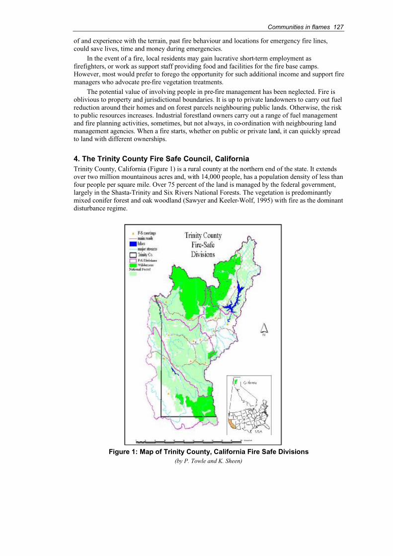
Communities in flames 127
of and experience with the terrain, past fire behaviour and locations for emergency fire lines,could save lives, time and money during emergencies.
In the event of a fire, local residents may gain lucrative short-term employment asfirefighters, or work as support staff providing food and facilities for the fire base camps.However, most would prefer to forego the opportunity for such additional income and support fire managers who advocate pre-fire vegetation treatments.
The potential value of involving people in pre-fire management has been neglected. Fire isoblivious to property and jurisdictional boundaries. It is up to private landowners to carry out fuelreduction around their homes and on forest parcels neighbouring public lands. Otherwise, the riskto public resources increases. Industrial forestland owners carry out a range of fuel managementand fire planning activities, sometimes, but not always, in co-ordination with neighbouring land management agencies. When a fire starts, whether on public or private land, it can quickly spreadto land with different ownerships.
4. The Trinity County Fire Safe Council, CaliforniaTrinity County, California (Figure 1) is a rural county at the northern end of the state. It extendsover two million mountainous acres and, with 14,000 people, has a population density of less than four people per square mile. Over 75 percent of the land is managed by the federal government,largely in the Shasta-Trinity and Six Rivers National Forests. The vegetation is predominantlymixed conifer forest and oak woodland (Sawyer and Keeler-Wolf, 1995) with fire as the dominantdisturbance regime.
Figure 1: Map of Trinity County, California Fire Safe Divisions(by P. Towle and K. Sheen)
128 Communities in flames
During the last two decades, the impact of wildfires has increased in the area. In 1987, firesburned 91,000 acres (36,827 ha)2 of the Trinity National Forest. The 1999 Big Bar Complex fire in Humboldt and Trinity Counties burned 125,000 acres (50,587 ha) of National Forest, HoopaValley Indian Reservation and private lands in 91 days. During that time air quality was so poorthat the people living in the town of Hoopa had to be evacuated. Suppression costs were estimatedat US$110 million (U.S. Forest Service, 2000).
In the county, fear of catastrophic fire that could repeat or be worse than these conflagrationsis growing. In mid-1998, the Trinity County Board of Supervisors’ Natural Resources AdvisoryCouncil appointed a sub-committee to address the issue of fire. This initiated the Trinity CountyFire Safe Council (FSC) that includes representatives from local VFDs, non-governmentalorganizations (NGOs), the county, state and federal land and fire management agencies and otherswho have signed a Memorandum of Understanding (MOU) to co-operate on fire managementplanning (MOU, 1998).
The FSC has embarked on a landscape analysis and strategic planning process for firemanagement in the county. The first steps taken in 1999 and 2000 were to increase local involvement and interest in fire management planning. The objective was to capture local and regional knowledge and expertise in fire management as effectively and efficiently as possible.Participatory research and community mapping methods were adapted to achieve this goal. Two local NGOs – the Trinity County Resource Conservation District and the Watershed Research andTraining Center – provided the team that led the effort, with funding from the USFS PacificSouthwest Research Station and the California State Water Resources Control Board.
5. Community mapping and participatory researchThe FSC team proceeded to work with community members to:
♦ gather and develop a geographic information system (GIS) with available spatial datafor the county that were pertinent to fire;
♦ identify local knowledge and spatial data relevant for emergency response;
♦ involve local residents and professionals to design a process for collecting community recommendations about fire management; and
♦ implement that process including gathering residents’ perception of values at risk,collating their recommendations for pre-fire treatments to protect these values, and helping participants systematically prioritise proposed activities.
5.1. Developing the GISData layers pertinent to fire management including topography, roads, hydrography, vegetationand past fire starts, were collated from sources such as the USFS, the Bureau of LandManagement, and the California Department of Forestry and Fire Protection. There had been no previous effort on this scale to integrate spatial data for the county. Once the data were compiled, useful base maps for information gathering with community members and for future fire management modelling could be generated.
5.2. Identifying local knowledge and mapping emergency response dataFrom November 1999 on, a series of 13 widely publicised community meetings were held in VFDhalls throughout the county to discuss the Fire Safe process and raise the local level of awarenessabout fire management issues ranging from needs of local VFDs to county, state and federal efforts. Furthermore, the FSC team wanted to identify local expertise in fire management thatcould be called upon later, and to gather site-specific information not found in the GIS. To ensurecomparability between meetings, the basic format for all meetings was the same with two or moremembers of the FSC team participating in each. At every meeting, the FSC team members
2 2.471 acre = 1 ha

Communities in flames 129
presented an overview of the Fire Safe effort and gathered participants around maps of the local terrain generated by the GIS. A computer with the GIS database was brought to each meeting sothat additional information could be accessed upon request. Participants added missinginformation by marking reference points on the maps and explaining issues of concern, whichwere subsequently noted. These data, of particular interest for local emergency responses,included water sources, unsafe bridges and roads, locked gates and other similar information.After each meeting, the FSC team entered the new data into the GIS database. Maps with the newinput were sent back to participants to verify that the information was accurate. Updated hard copies of the maps were left with the VFD in each participating community so that new information might be added and included in database updates regularly. The GIS was shared with local land management agencies and emergency respondents. The number of community participants in the meetings varied, but even where the turnout was low, it included a highproportion of VFD members and others with an active interest in fire management issues.
Figure 2: Emergency response data for the South Fork Division(by P. Towle and K. Sheen)

130 Communities in flames
5.3. Working with local residents and professionals to design a process for gathering community recommendations about fire managementA two-day planning meeting involving representatives of agencies and groups participating in theFSC was held in April 2000 to develop an appropriate process for gathering community input across the county. The FSC team hoped that by bringing together locally and regionallyrecognised experts to contribute their ideas to the process, a credible process for all concernedcould be established.
At the meeting, it was decided that in addition to the GIS and local emergency response data gathered during previous meetings, the most important input from residents would be to identify and prioritise key values at risk from wildfires in the local areas, and their recommendations for protection of these values. Values at risk identified included homes, water supplies, power and communications lines, rare or endangered species habitat, and prime recreation sites.3
Recommendations might include identifying locations for treating vegetation to reduce fire riskand hazard.
To make the best use of localised knowledge and staffing capability for meeting purposes,the county was divided into five sections. Evening and daytime meetings to maximise localattendance were held in central locations in each of these five areas, and discussion focused on the specific area in question.
Figure 3: Participants gathered around maps at the North Lake Meeting, May 16,2000 (photos by Carol Fall)
5.4. Organizing community meetings to identify values at risk and to prioritise pre-fire treatmentsAn evening and a day-time community-mapping meeting were held in each of the five divisionsof Trinity County in May 2000. Publicity to encourage broad participation was crucial. Everyonewho had attended earlier community meetings or who had been identified in the April meetingreceived a written invitation and many people were contacted directly by phone. In addition, themeetings were publicised in the local newspaper and several press releases about the fire planning process were published.
At the meetings, people gathered around maps of their locality to discuss ideas. As in theemergency response meetings, initial input on values at risk was captured on maps and in notestaken during the meetings as well as through on-location editing of the GIS data. In each case,there were several community members, often long-term residents, who were immediately able to
3 Note this process varies somewhat from the approach taken by California Department of Forestry and FireProtection (CDF) in the California Fire Plan where values at risk are pre-identified and ranked by CDF staff and community meetings are held to evaluate these proposals (CFP, 1996: p 24).
Communities in flames 131
contribute ideas. The FSC team typically would reconvene the following day with a smaller groupof participants (often retired firemen, USFS staff or VFD members) to review and consolidate thedata gathered earlier.
Once participants had identified which values were at risk from fire and where they were located,they were asked to make recommendations for landscape vegetation treatments to protect these values.Recommendations included creating 30-100 ft perimeters of defensible space around homes on privateland, and thinning from below and constructing shaded fuel breaks on public lands.
Finally participants worked together to prioritise projects. In an approach adapted from similar participatory prioritisation methodologies (e.g. Margoluis and Salafsky, 1998), criteria to evaluate proposals were defined and then ranked using a matrix approach. At each meeting,several criteria to evaluate the importance or relative priority of proposed activities werepresented and modified according to participants’ recommendations (Table 1). Each criterion wasdiscussed and thoroughly defined to ensure that all participants had a similar understanding of the valuation process. The resulting “scores” in the matrix were treated as indicative of relative valuesamong proposals. To avoid a false sense of quantitative valuation, all categories were weightedequally. The resulting prioritisation matrices for each meeting were presented with a detaileddescription of the process applied and CD ROMs with the GIS data sets in a draft final report to the FSC in January 2001 (Trinity County Fire Safe Council, 1999).
6. ResultsA number of additional recommendations emerged from the community involvement process.Federal land managers were strongly encouraged to co-ordinate across jurisdictional boundaries onfire and road management policy. Trinity County was encouraged to identify community safetyzones and escape routes in case of a catastrophic fire and to keep water tenders and other equipmentlocally available. Strong support for VFDs was advocated. All fire managers were encouraged totake a landscape-scale view of fire hazards and to co-ordinate treatments accordingly whileidentifying and focusing attention on critically important habitats for wildlife and on protecting oldgrowth forests. The agreed goal is to protect key values from catastrophic fires, reintroduce lowintensity fires, and reduce fuel loads – which incidentally will provide a continuous sourceofemployment for the county workforce (Trinity County Fire Safe Council, 1999).
7. ConclusionsThe recommendations have provided a basis for Trinity County NGOs and VFDs seeking funds forcarrying out more fuel reduction activities. A number of recommendations are due to beimplemented in 2001 (Baldwin, 2000). Co-ordinated planning meetings between FSC members andthe USFS were also held. Other FSC efforts are emerging in neighbouring counties. The report hasbeen distributed widely and has been a topic of discussion at national fire plan developmentmeetings. The Trinity County FSC is currently involved in developing an overall strategic plan forfire management in which community recommendations will play a significant guiding role.
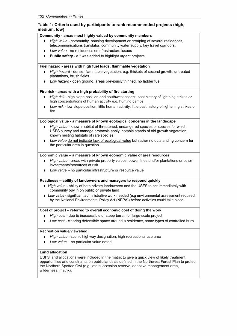
132 Communities in flames
Table 1: Criteria used by participants to rank recommended projects (high,medium, low)Community - areas most highly valued by community members
♦ High value - community, housing development or grouping of several residences,telecommunications translator, community water supply, key travel corridors;
♦ Low value - no residences or infrastructure issues♦ Public safety - a * was added to highlight urgent projects
Fuel hazard - areas with high fuel loads, flammable vegetation♦ High hazard - dense, flammable vegetation, e.g. thickets of second growth, untreated
plantations, brush fields♦ Low hazard - open ground, areas previously thinned, no ladder fuel
Fire risk - areas with a high probability of fire starting♦ High risk - high slope position and southwest aspect, past history of lightning strikes or
high concentrations of human activity e.g. hunting camps♦ Low risk - low slope position, little human activity, little past history of lightening strikes or
fire
Ecological value - a measure of known ecological concerns in the landscape♦ High value - known habitat of threatened, endangered species or species for which
USFS survey and manage protocols apply; notable stands of old growth vegetation,known nesting habitats of rare species
♦ Low value do not indicate lack of ecological value but rather no outstanding concern for the particular area in question
Economic value – a measure of known economic value of area resources♦ High value - areas with private property values, power lines and/or plantations or other
investments/resources at risk♦ Low value – no particular infrastructure or resource value
Readiness – ability of landowners and managers to respond quickly♦ High value - ability of both private landowners and the USFS to act immediately with
community buy in on public or private land♦ Low value - significant administrative work needed (e.g environmental assessment required
by the National Environmental Policy Act (NEPA)) before activities could take place
Cost of project – referred to overall economic cost of doing the work♦ High cost - due to inaccessible or steep terrain or large-scale project♦ Low cost - clearing defensible space around a residence, some types of controlled burn
Recreation value/viewshed♦ High value - scenic highway designation; high recreational use area♦ Low value – no particular value noted
Land allocationUSFS land allocations were included in the matrix to give a quick view of likely treatment opportunities and constraints on public lands as defined in the Northwest Forest Plan to protectthe Northern Spotted Owl (e.g. late succession reserve, adaptive management area, wilderness, matrix).
Communities in flames 133
ReferencesAgee, J.K. (1993). Fire ecology of the Pacific Northwest Forest. Island Press, Washington D.C.Agee, J.K., Bahro, B., Finney, M.A., Omi, P.N., Sapsis, D.B., Skinner, C.N., van Wagtendonk,
J.W. and Weatherspoon, C.P. (2000). The use of shaded fuelbreaks in landscape fire management. Forest Ecology and Management Vol. 127: 56-66.
Baldwin, K. (2000). East Fork Fire Management Plan. Report to the Trinity County ResourceConservation District. TCRCD Working Paper. Weaverville, California.
Biswell, H. (1989). Prescribed burning in California wildlands vegetation management Universityof California Press, Berkeley, California.
CDF. (1996). California Fire Plan. California Department of Forestry and Fire Protection,Sacramento, California.
Loomis, J.B. (1993). Integrated public lands management . Columbia University Press, New York.
Margoluis, R, & Salafsky, N. (1998). Measures of success. Island Press. Washington D.C.
MOU. (1998). Memorandum of Understanding for Participants in the Trinity County Fire SafeCouncil. Trinity County Fire Safe Council, Weaverville, California.
Sawyer, J.O. & Keeler-Wolf, T. (1995). A manual of California vegetation. California NativePlant Society. Sacramento, California.
Trinity County Fire Safe Council (1999). Report. Recommendations on Trinity County values at risk from fire and pre-fire fuels treatment opportunities drawn from community meetings1999/2000. Trinity County Resource Conservation District, Weaverville, California.
U.S. Forest Service. (2000). Six Rivers National Forest Megram Fire Information Sheet. Online at http://www.r5.fs.fed.us/sixrivers/fireinfo/fact_sheet.htm
Weatherspoon, C.P. & Skinner, C.N. (1996). Landscape-level strategies for forest fuelmanagement. Sierra Nevada Ecosystem Project: final report to Congress. Vol. IIAssessments and scientific basis for management options. University of California, Centersfor Water and Wildland Resources, Davis, California.
AcknowledgementsThe author wishes to thank the Trinity County residents who have participated in this effort and to acknowledge the tremendous work of the FSC planning team: Kenneth Baldwin, Noreen Doyas,Pat Frost, Kelly Sheen (GIS) and Phil Towle (GIS). The photos are by Carol Fall.