Embed Size (px)
Citation preview

B A B E S C HAnnual Papers on Mediterranean Archaeology
Supplement 24 — 2013
ÖSTErrEICHISCHESArCHäOlOGISCHES InSTITuT
Sonderschriften — Band 49
BABESCH FOunDATIOnStichting Bulletin Antieke Beschaving
InHAlTSVErZEICHnIS
Abbreviations
HAnS MEHlHOrnVorwort des Präsidenten der Frontinus-Gesellschaft
GIlBErT WIPlInGErVorwort und Einleitung
Awarding of the Frontinus-Medal
WOlFGAnG MErkEllaudatio to the Awarding of the Frontinus Medal to Signora Professore Fanny Del ChiccaAuditorium Vienna Water Company, October 21, 2011
FAnny DEl CHICCAAnswer to the laudatio
Eröffnungsvortrag
WOlFGAnG MErkElSextus Iulius Frontinus, ein moderner CEO der Wasserversorgung roms um 100 n.Chr.
Wien
WOlFGAnG BÖrnErHistorische Wasserleitungen in WienDas Webportal “Wien Kulturgut“ - Ein Fenster in die Vergangenheit Wiens
HAnS SAIlErThe Vienna Mountain Spring lines
Vorderer Orient und Kleinasien
CHrISTInE ErTElDas römische Wasserleitungsnetz von kanatha (Qanawat, Syrien)
kArl STrOBElDas Wassermanagement hethitischer und hellenistisch-römischer Zeit in Zentralanatolien
DEnnIS MurPHyThe Aqueduct of Elaiussa Sebaste in rough CiliciaWater Channels for today and yesterday
JulIAn rICHArD, MArC WAElkEnSA newly Discovered nymphaeum near the Stadium of Sagalassos (SW Turkey)
HAVVA İşkAn, n. OrHAn BAykAnneue Ergebnisse zur Wasserleitung von Patara/Türkei
IX
XI
XIII
3
7
11
23
35
47
55
71
85
93

GIlBErT WIPlInGErDer Değirmendere Aquädukt von Ephesos und seine Zukunft
rAlF krEInErDie Mühlen des Değirmendere Aquäduktes von Ephesos und des Aquäduktes von Anaia/kadikalesı (Türkei)Ein Zwischenbericht
InGE uyTTErHOEVEnrunning Water Aqueducts as Suppliers of Private Water Facilities in (Late) Roman Asia Minor
Westliche Provinzen – von der Römerzeit zur Neuzeit
luIS M. VIArTOlA, JAVIEr AnDrEu, MAríA J. PEréXThe roman Aqueductbridge of los Bañales (uncastillo, Spain)Structural Analysis
FErnAnDO ArAnDA GuTIérrEZ, MAríA EuGEnIA POlO GArCíA, JOSé luíS SánCHEZ CArCABOSO,ESPErAnZA AnDréS DíAZ, TrInIDAD nOGAlES BASArrATE, JOSé MAríA álVArEZ MArTínEZThe roman Water Supply Systems to Augusta Emerita
DIETrICH lOHrMAnnDrei große Aquädukte des Mittelalters (12.-13. Jahrhundert)Sevilla, Perugia, Waltham Abbey
JOSé MAnuEl DE MASCArEnHAS, PAul BEnOIT, kArInE BErTHIEr, JOSéPHInE rOuIllArD, VIrGOlInA JOrGEThe Aqueduct of Setúbal (Portugal)Characterization and Development as Heritage
DIETEr BISCHOPDie Wasserversorgung von Bremen vom Spätmittelalter bis in die Frühe neuzeit
ulrICH MOHrDie rannaleitung - seit 99 Jahren ein unverzichtbarer Bestandteil der Wasserversorgung vonnürnberg
Wassertürme
H. PAul M. kESSEnErA Pompeiian-type Water System in Modern Times
AnDrIJ kuTnyIHistorische Wasserversorgung in Buchara (usbekistan)
JEnS u. SCHMIDTWassertürme als Touristenattraktion
105
131
139
163
173
183
195
205
217
229
241
249

Südamerika
FrAnCISCO SAnTAnA, JOSé MAnuEl DE MASCArEnHAS, MárIO MEnDOnçA DE OlIVEIrA, VIrGOlInOFErrEIrA JOrGEThe Hydraulic Systems of the Convent of St. Anthony of Paraguaçu (Bahia, Brazil)
Anhang
Gül SürMElIHInDI, CEES PASSCHIErSinter AnalysisA Tool for the Study of Ancient Aqueducts
list of Participants and Authors
VII
259
269
287

The aqueduct of Elaiussa Sebaste provides anexcellent opportunity to study how ancient watersystems can be utilized in a modern environmentand to see how many of the technical problemsfaced by the ancient Romans are the same fortoday’s modern engineers. Visual representationof the aqueduct bridges along the route from theLamas Valley to Elaiussa will also help eliminateconfusion as these bridges have sometimes beenmisidentified in recent literature and internet websites.
HISTORY
Elaiussa Sebaste was founded by the Greeks some-time in the 2nd Century BC and existed in relativeobscurity until Archaelaus I of Cappadocia madeit the city his capital. He changed the name of thecity to ‘Sebaste’ around AD 18 in honor of hisbenefactor, the Emperor Augustus. After Archae -laus’ death, rule of the city passed to his sonArchaelaus II who continued to expand the city.Until his death in AD 36, when the emperor Cali -gula gave the kingdom to Antiochus IV of Comma -gene. The city became part of the Roman provinceof Cilicia in AD 72 and continued to prosper underRoman and Byzantine rule until the 7th centuryAD. Then it slowly sank back into obscurity untilthe coming of the Mameluke Turks in 1375 whenit was completely abandoned.
While the exact date for the aqueduct’s con-struction has not been firmly determined, it wasprobably constructed in the 1st century AD andsometime before the construction of the theater.Ongoing excavations of the ancient city under thedirection of Prof. Dr. Schneider and the Universitâdi Roma la Sapienza have found that the originalchannel had to be diverted to accommodate theconstruction of the theater.1
GEOGRAPHY AND GEOLOGY
Elaiussa Sebaste is located near the small town ofAyas and between the larger cities of Mersin and
Silifke along the south eastern Mediterraneancoast of Turkey. The city is situated at the base ofthe Taurus mountain range along a narrow rockycoastal strip. The Lamas River to the east of thecity provided a source of water not only forElaiussa but also for two other aqueducts locatedfarther up the valley supplying the ancient citiesof Olba and Diocaesarea.
The Lamas Valley and the coastal area east toElaiussa Sebaste lie to the southwest of BolkarDağ Mountain in the Miocene Adana Basin,within the Taurides tectonic belt.2 The Lamas val-ley extends into the area of the Mut Basin to thenorthwest, which is formed of Oligo cene andMiocene limestone and sedimentary formationsand is bounded to the east by the modern city ofMersin and to the west by Anamur.3
ROUTE OF THE AQUEDUCT
Water for the aqueduct was diverted from theLamas River at an elevation of only 100 meters bymeans of a ‘lateral intake’ with a sluice gate.4 Itwas then transported via a rock cut channel in thewest face of the limestone (karst) canyon wall (fig.1). The hand chiseled conduit appeared to average
71
The Aqueduct of Elaiussa Sebaste in RoughCiliciaWater Channels for today and yesterday
Dennis Murphy*
Fig. 1. Rock cut channel (photo author).
Edited Post-publication

roughly 1.3 meters high by 1.0 meters wide withlarge gallery windows to facilitate ventilation anddebris removal during construction. In compari-son, water today is taken by means of a modernpump station, part of a new hydroelectric genera-
tion system being built along the Lamas river. Twolarge metal pipelines start out following theremains of the old aqueduct channel and providewater to downstream villages as well as intenseagricultural use. Dr. Ahmet Uyan has performed a
72
Fig. 2. Aqueduct Route (photo Google Digtaglobe 2011, modification author).
detailed analysis of water uses and hydraulic watercalculations for the Lamas River.5
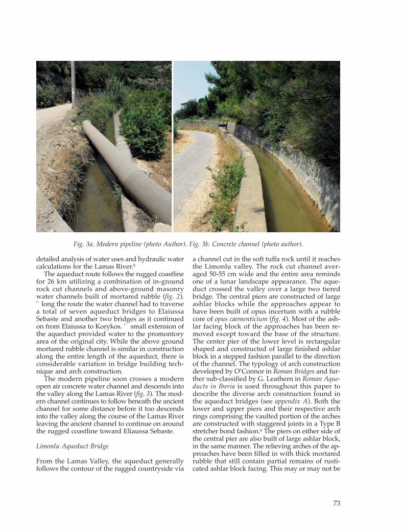
The aqueduct route follows the rugged coastlinefor 26 km utilizing a combination of in-groundrock cut channels and above-ground masonrywater channels built of mortared rubble (fig. 2).Along the route the water channel had to traversea total of seven aqueduct bridges to ElaiussaSebaste and another two bridges as it continuedon from Elaiussa to Korykos. A small extension ofthe aqueduct provided water to the promontoryarea of the original city. While the above groundmortared rubble channel is similar in constructionalong the entire length of the aqueduct, there isconsiderable variation in bridge building tech-nique and arch construction.
The modern pipeline soon crosses a modernopen air concrete water channel and descends intothe valley along the Lamas River (fig. 3). The mod -ern channel continues to follow beneath the ancientchannel for some distance before it too descendsinto the valley along the course of the Lamas Riverleaving the ancient channel to continue on aroundthe rugged coastline toward Eliaussa Sebaste.
Limonlu Aqueduct Bridge
From the Lamas Valley, the aqueduct generallyfollows the contour of the rugged countryside via
a channel cut in the soft tuffa rock until it reachesthe Limonlu valley. The rock cut channel aver-aged 50-55 cm wide and the entire area remindsone of a lunar landscape appearance. The aque-duct crossed the valley over a large two tieredbridge. The central piers are constructed of largeashlar blocks while the approaches appear tohave been built of opus incertum with a rubblecore of opus caementicium (fig. 4). Most of the ash-lar facing block of the approaches has been re -moved except toward the base of the structure.The center pier of the lower level is rectangularshaped and constructed of large finished ashlarblock in a stepped fashion parallel to the directionof the channel. The typology of arch constructiondeveloped by O’Connor in Roman Bridges and fur-ther sub-classified by G. Leathern in Roman Aque -ducts in Iberia is used throughout this paper todescribe the diverse arch construction found inthe aqueduct bridges (see appendix A). Both thelower and upper piers and their respective archrings comprising the vaulted portion of the archesare constructed with staggered joints in a Type Bstretcher bond fashion.6 The piers on either side ofthe central pier are also built of large ashlar block,in the same manner. The relieving arches of the ap -proaches have been filled in with thick mortaredrubble that still contain partial remains of rusti-cated ashlar block facing. This may or may not be
73
Fig. 3a. Modern pipeline (photo Author). Fig. 3b. Concrete channel (photo author).

evidence of subsequent repairs. There is a smallsection with a few short courses of ashlar block vis-ible on the west side of the bridge approach, sug-gesting that this side had been faced with finishedashlar block higher up although closer examina-tion is required. The top of the bridge is set withashlar slabs that would have served as the base forthe water channel. There are only a few large ash-lar blocks remaining today of the channel specusthat once crossed the top of this high bridge how-ever, the channel cut in limestone tuffa rock lead-ing up to the north eastern approach averagedapproximately 50 cm wide by 65-80 cm high whichwould give some indication of what the specusacross the bridge would have been. The waterchannel exits the west side of the bridge via a rockcut channel located below an area that is today cul-tivated with terraced orchards. Farther along, amodern irrigation channel intermittently followsthe general route of the ancient aqueduct, aroundthe Limonlu valley to the south west.
Tirtar Aqueduct Bridge
The ancient channel then continues to follow therugged coastline until it crosses the broad Tirtarvalley via a long combination one and two tieraqueduct bridge (fig. 5). The bridge is by far themost complex of all the aqueduct bridges employ -ing a variety of construction materials and severalinteresting arch construction techniques. The northeastern section of the aqueduct bridge begins asa single level bridge and is still in a good state ofpreservation. The lower half of the tall, rectangularpiers are constructed of opus incertum at the basewhich then supports the upper half of the piersthat are built of ashlar block or are faced with ash-lar which in turn supports the arch springing. Thefirst three intrados arches are inset on the piersand constructed of a single ring vault of cut stonevoussoirs in a Type A fashion composed of sepa-rate ribs where the joints are in line rather thanstaggered. One and sometimes two courses of
74
Fig. 4. Limonlu aqueduct bridge (photo author).

ashlar block extend horizontally from the archesinto the haunches. The ashlar block arches are thenoverlaid symmetrically by two thin courses offield stones. The haunches between the piers areconstructed of opus incertum with a rubble core.
The center piers of the aqueduct bridge gradu-ate to two levels built with a combination of opusincertum and ashlar block. The lower level archesare constructed of a vault composed of up to fourrings of thin cut field stone (not ashlar block) setin a Type A3 fashion, inset from the springing.7As the bridge once again graduates back fromtwo tiers back to a single tier on the south westernapproach, the intrados arch is built in a Type Bfashion of staggered jointed ashlar block formingthe vault. This relieving arch is then overlaid witha ring of thin field stones laid radially and toppedwith a thin horizontal layer of leveling stoneswhich give the appearance of a cornice. Anothertwo courses of thin radially laid field stones com-plete the arch construction (see inset picture in fig.5).8 The arches are very nicely designed and would
have presented an artistically imposing structurefor the ancient population.
Again, the approaches to the Tirtar Bridge areconstructed like the previous Limonlu Bridge withopus incertum and a rubble core. The channel overthe bridge is built of small cut field stone with aspecus of approximately 50 cm wide by 95 cm highwith a 4-6 cm coating of hydraulic plaster. The sidewalls of the channel averaged 55 cm thick.
Kumkuyu Aqueduct Bridge
From the Tirtar valley, the route of the ancientaqueduct next crosses the narrow Kumkuyu val-ley over another two level bridge (fig. 6). The twocentral piers of the lower span are constructed oflarge ashlar blocks. Cornices support the intradosarches composed of ashlar block as they rise fromthe springing. The haunches are also built of ash-lar block or may just be spandrel facing over arubble core. The upper level consists of three wellcrafted constructed spans. The piers are built of
75
Fig. 5. Tirtar aqueduct bridge (photo author).
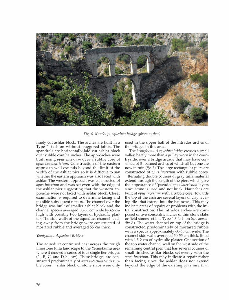
finely cut ashlar block. The arches are built in aType A fashion without staggered joints. Thespandrels are horizontally-laid cut ashlar blockover rubble core haunches. The approaches werebuilt using opus incertum over a rubble core ofopus caementicium. Construction of the easternapproach wall extends beyond the limit of thewidth of the ashlar pier so it is difficult to saywhether the eastern approach was also faced withashlar. The western approach was constructed ofopus incertum and was set even with the edge ofthe ashlar pier suggesting that the western ap -proache were not faced with ashlar block. Closerexamination is required to determine facing andpossible subsequent repairs. The channel over thebridge was built of smaller ashlar block and thechannel spe cus averaged 50-55 cm wide by 65 cmhigh with possibly two layers of hydraulic plas-ter. The side walls of the aqueduct channel lead-ing away from the bridge were constructed ofmortared rubble and averaged 55 cm thick.
Yemişkumu Aqueduct Bridges
The aqueduct continued east across the roughlimestone tuffa landscape to the Yemişkumu areawhere it crossed a series of four single tier bridges(A, B, C, and D below). These bridges are con-structed predominately of opus incertum with rub-ble cores. Ashlar block or stone slabs were only
used in the upper half of the intrados arches ofthe bridges in this area.
The Yemişkumu A aqueduct bridge crosses a smallvalley, barely more than a gulley worn in the coun -tryside, over a bridge arcade that may have con-sisted of 3 spanned arches of which all but one arenow in ruin (fig. 7). The large rectangular piers areconstructed of opus incertum with rubble cores.Alternating double courses of gray tuffa materialextend through the length of the piers which givethe appearance of ‘pseudo’ opus latericium layerssince stone is used and not brick. Haunches arebuilt of opus incertum with a rubble core. Towardsthe top of the arch are several layers of clay level-ing tiles that extend into the haunches. This mayindicate areas of repairs or problems with the ini-tial construction. The intrados arches are com-posed of two concentric arches of thin stone slabsor field stones set in a Type A3 fashion (see appen-dix B). The water channel on top of the bridge isconstructed predominately of mortared rubblewith a specus approximately 60-65 cm wide. Thechannel side walls averaged 50-55 cm thick, linedwith 1.5-2 cm of hydraulic plaster. One section ofthe top water channel wall on the west side of theremaining central pier, that has several courses ofsmall finished ashlar blocks set evenly with theopus incertum. This may indicate a repair ratherthan facing since the ashlar does not extendbeyond the edge of the existing opus incertum.
76
Fig. 6. Kumkuyu aqueduct bridge (photo author).

There is also evidence of sinter on the outside ofthe haunches be low the channel indicating prob-lems with water leakage. Further close examina-tion of the whole area is necessary.
Much more of the aqueduct channel in the coun -tryside is now constructed of mortared rubbleusing local tuffa stone and there is less in-ground,rock cut channel visible in the Yemişkumu area.Along the route of the aqueduct between Yemiş -kumu bridges (A) and (B) is an interesting sectionof the ancient channel that has been cut to accom-modate a small modern diversion channel that is
used to periodically transport water to irrigatenearby orchards. Here the channel is built abovethe ground with mortared rubble and stands as atribute to the ancient builders that it is still beingused today to transport water in places, even ifonly occasionally.
The route of the aqueduct continues along therugged coast line again crossing a small fertilevalley via the long, single level Yemişkumu B aque -duct bridge (fig. 8). Here the large rectangularpiers are built of opus incertum and are not muchbetter in quality than the rubble core itself in many
77
Fig. 7. Yemişkumu A aqueduct bridge (photo author).
Fig. 8. Yemişkumu B aqueduct bridge (photo author).

places. The ashlar block intrados arch is sup-ported on small flat ashlar cornices. Over theintrados is a symmetrical layer of thin, flat cut
ashlar stones with a single concentric arch of thinfieldstones inlaid radially. The haunches are con-structed of opus incertum with rubble cores. Thewater channel on top of the bridge is built of smallashlar blocks over a rubble core and laid on a bedof layered, mortared clay tiles. The channel specusaveraged 55-60 cm wide with 55-60 cm thick sidewalls lined with 2-4 cm of hydraulic plaster. Theapproaches were constructed of mortared rubble.
Along the route of the aqueduct between bridgesB and C, a small modern water pipeline uses theruined sub-structure of the old aqueduct in placesas a foundation support as it weaves its way amongthe orchards. A modern concrete irrigation chan-nel also follows the general route of the ancientaqueduct in some places where the ancient chan-nel can no longer be traced. Where the ancientaqueduct channel still exists to the east of the Ye -mişkumu C bridge, it is constructed above groundof mortared rubble with a specus averaging ap -proximately 55-58 cm wide by 70 cm high.
The aqueduct crosses another small gulley overthe Yemişkumu C aqueduct bridge (fig. 9). The onesmall remaining arch is supported on rubble corepiers. The intrados arch is built of ashlar block ina Type A fashion with a covering layer of thin cutfield stone. Two concentric arches of fieldstones arethen inset radially above the arch. The haunchesare built of opus incertum over a rubble core. Thewater channel above is constructed of mortaredrubble with a specus of approximately 55-58 cmwide and 70 cm high with channel walls that areapproximately 50-55 cm thick, again built ofmortared rubble.
Near the Yemişkumu C Bridge we find anotherfine example of the old and new together. Whereever possible, the modern farmers use the empty
78
Fig. 9. Yemişkumu C aqueduct bridge (photo author).
Fig. 10. Modern pipline in channel specus(photo author).
ancient aqueduct channel as an easy utility corri-dor for their water pipes (fig. 10). Both metal pipes(possibly for residential use) and plastic pipes forirrigation, can be found in the channel specus ofthe ancient aqueduct in many locations along theroute of the aqueduct.
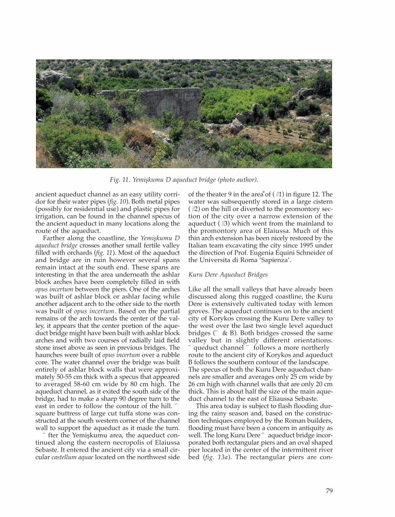
Farther along the coastline, the Yemişkumu Daqueduct bridge crosses another small fertile valleyfilled with orchards (fig. 11). Most of the aqueductand bridge are in ruin however several spansremain intact at the south end. These spans areinteresting in that the area underneath the ashlarblock arches have been completely filled in withopus incertum between the piers. One of the archeswas built of ashlar block or ashlar facing whileanother adjacent arch to the other side to the northwas built of opus incertum. Based on the partialremains of the arch towards the center of the val-ley, it appears that the center portion of the aque-duct bridge might have been built with ashlar blockarches and with two courses of radially laid fieldstone inset above as seen in previous bridges. Thehaunches were built of opus incertum over a rubblecore. The water channel over the bridge was builtentirely of ashlar block walls that were approxi-mately 50-55 cm thick with a specus that ap pearedto averaged 58-60 cm wide by 80 cm high. Theaqueduct channel, as it exited the south side of thebridge, had to make a sharp 90 degree turn to theeast in order to follow the contour of the hill. Asquare buttress of large cut tuffa stone was con-structed at the south western corner of the channelwall to support the aqueduct as it made the turn.
After the Yemişkumu area, the aqueduct con-tinued along the eastern necropolis of ElaiussaSebaste. It entered the ancient city via a small cir-cular castellum aquae located on the northwest side
of the theater 9 in the area of (#1) in figure 12. Thewater was subsequently stored in a large cistern(#2) on the hill or diverted to the promontory sec-tion of the city over a narrow extension of theaqueduct (#3) which went from the mainland tothe promontory area of Elaiussa. Much of thisthin arch extension has been nicely restored by theItalian team excavating the city since 1995 underthe direction of Prof. Eugenia Equini Schneider ofthe Universita di Roma ‘Sapienza’.
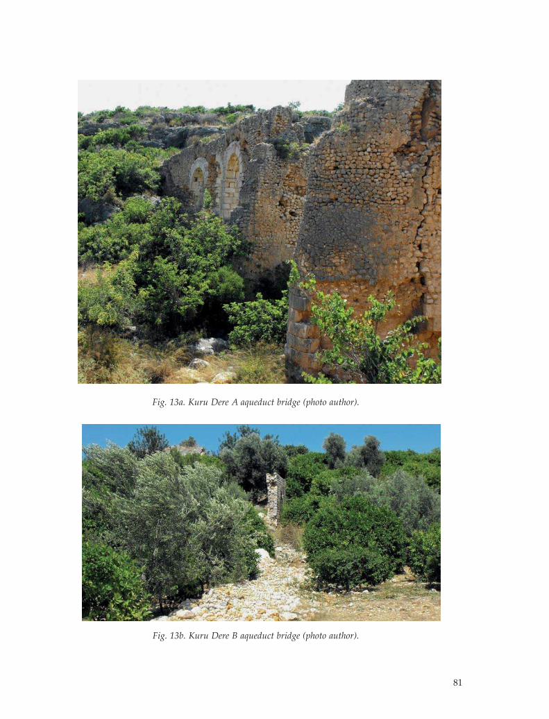
Kuru Dere Aqueduct Bridges
Like all the small valleys that have already beendiscussed along this rugged coastline, the KuruDere is extensively cultivated today with lemongroves. The aqueduct continues on to the ancientcity of Korykos crossing the Kuru Dere valley tothe west over the last two single level aqueductbridges (A & B). Both bridges crossed the samevalley but in slightly different orientations.Aqueduct channel A follows a more northerlyroute to the ancient city of Korykos and aqueductB follows the southern contour of the landscape.The specus of both the Kuru Dere aqueduct chan-nels are smaller and averages only 25 cm wide by26 cm high with channel walls that are only 20 cmthick. This is about half the size of the main aque-duct channel to the east of Eliaussa Sebaste.
This area today is subject to flash flooding dur-ing the rainy season and, based on the construc-tion techniques employed by the Roman builders,flooding must have been a concern in antiquity aswell. The long Kuru Dere A aqueduct bridge incor-porated both rectangular piers and an oval shapedpier located in the center of the intermittent riverbed (fig. 13a). The rectangular piers are con-
79
Fig. 11. Yemişkumu D aqueduct bridge (photo author).
*

structed of opus incertum with rubble cores andincorporated stepped buttresses in both the upand down stream directions. Seven courses of cutashlar blocks surround the rubble core of the ovalshaped pier at the lower level. Opus incertum wasused to finish the upper section of this pier. Theuse of buttresses and the curved ashlar block fac-ing reflects the increased concerns over flash flood -ing. There are few remains of the bridge on thenorth east side however three spans are intact onthe west end of the bridge. Here, the inside of thepiers and the intrados arch are faced with ashlarblock in a Type B staggered, stretcher bond fashion.Above the intrados arch is another ring course ofsmall ashlar block inset against the rubble coreand topped by a concentric ring of radially laidfield stone also inset against the rubble core. Aswith the other bridges, the haunches are con-structed of opus incertum over a rubble core.
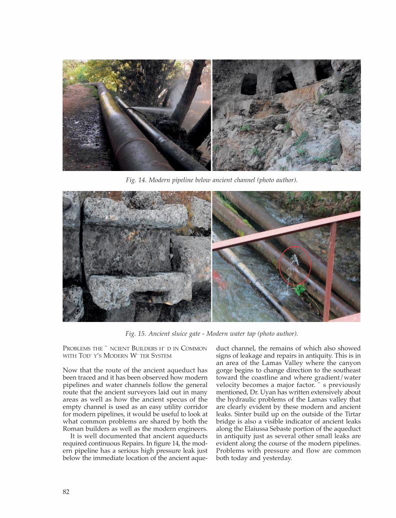
The Kuru Dere B aqueduct bridge crosses the val-ley a little farther to the south of bridge A. It toois about half the width of the previous bridges
found to the east of Eliaussa. It is constructed ofopus incertum of rough cut ashlar stone over a rub-ble core (fig. 13b). The channel specus narrowedto around 22-25 cm wide by approximately 25 cmhigh and the channel walls were only about 20 cmthick. Once again, near the east side of the KuruDere B bridge, the ancient aqueduct channel is usedas an easy utility corridor for an irrigation pipewhich supplies a modern drip irrigation systemused for cultivation. Much of this aqueduct bridgeis in ruins as it crosses the valley floor. On theother side of the dry river bed, the water channelwest of the bridge continued up the hill towardsKorykos over a high, solid wall constructed ofsmall rough cut ashlar blocks with a rubble core.Only a small rectangular opening in the west wallprovided a north-south pedestrian access. Otheraqueducts found in southern Turkey have usedsmall arched arcades in similar situations insteadof a solid wall so there is an interesting questionas to why the ancient builders chose this particu-lar method of construction.
80
Fig. 12. Urban route of the aqueduct (photo author).
81
Fig. 13a. Kuru Dere A aqueduct bridge (photo author).
Fig. 13b. Kuru Dere B aqueduct bridge (photo author).
PROBLEMS THE ANCIENT BUILDERS HAD IN COMMON
WITH TODAY’S MODERN WATER SYSTEM
Now that the route of the ancient aqueduct hasbeen traced and it has been observed how modernpipelines and water channels follow the generalroute that the ancient surveyors laid out in manyareas as well as how the ancient specus of theempty channel is used as an easy utility corridorfor modern pipelines, it would be useful to look atwhat common problems are shared by both theRoman builders as well as the modern engineers.
It is well documented that ancient aqueductsrequired continuous Repairs. In figure 14, the mod -ern pipeline has a serious high pressure leak justbelow the immediate location of the ancient aque-
duct channel, the remains of which also showedsigns of leakage and repairs in antiquity. This is inan area of the Lamas Valley where the canyongorge begins to change direction to the southeasttoward the coastline and where gradient/watervelocity becomes a major factor. As previouslymentioned, Dr. Uyan has written extensively aboutthe hydraulic problems of the Lamas valley thatare clearly evident by these modern and ancientleaks. Sinter build up on the outside of the Tirtarbridge is also a visible indicator of ancient leaksalong the Elaiussa Sebaste portion of the aqueductin antiquity just as several other small leaks areevident along the course of the modern pipe lines.Problems with pressure and flow are commonboth today and yesterday.
82
Fig. 14. Modern pipeline below ancient channel (photo author).
Fig. 15. Ancient sluice gate - Modern water tap (photo author).

There are several common engineering technol -ogies shared by both ancient and modern engineersthat can be observed by looking at the nearby Ol -ba Aqueduct which also took water further up -stream on the Lamas River.
An example of an ancient water tap is found justto the west end of the Olba aqueduct bridge. Thewater offtake is in the form of a sluice gate cutinto a section of the aqueduct channel which pro-vided water to a nearby ancient work center. To -day, modern water taps are also visible along manyparts of the modern pipelines as illustrated in theinset circle of figure 15. Modern sources have alsodocumented problems with illegal water taps onmodern pipelines in the Lamas Valley, somethingthat was also common in the ancient world.
As with many ancient fountains, the Nyphaeumat Olba stored water in a large cistern locatedunder the second platform of the fountain forpublic use.10 Modern residents living in a houseadjacent to the Nymphaeum today still dependupon the ancient cistern, even if it is now onlysupplied by rain water and not an aqueduct. Theauthor had the opportunity to photograph theresident in (fig. 16) after lowering a tin bucket intothe ancient cistern to take water for domestic use.Reuse of ancient cisterns for agricultural purposesis also very common throughout the greater Eli -aussa - Olba hinterland. In situations where thecapacity of the cistern is insufficient, it is verycommon to find new open air cisterns constructedwith plastic liners very near or even adjacent tothe ancient cisterns.
DISCUSSION
The ancient roman surveyors had a difficult taskto route the Elaiussa Sebaste aqueduct a distance
of approximately 26 kms over very rough terrainwhile maintaining an average drop of 2.8 metersper km. Their work has benefited modern engi-neers who still use the ancient channel as a util-ity corridor. Pipelines are found in the specus ofthe empty water channel and, in areas where thechannel specus no longer exists, the aqueductfoundation can sometimes be seen in use as asupport substructure for modern pipes supplyingboth residential and agricultural purposes. Today,mod ern builders experience many of the sameproblems that the ancient Romans did with waterline leaks and people today still use ancient cis-terns for daily residential water use, as well as forin tensive agricultural production. The aqueductof Eliaussa Sebaste truly has channels for todayand yesterday.
NOTES
* This paper and the Lamas River study has benefitedfrom discussions with Ũ. Öziş and Y. Arisoy howeverthe ideas expressed in this article and any errors are theauthors. The author also appreciates the very patienthelp provided by Yalçin Özdemir who was instrumen-tal in helping contact these scholars. The author is in -debted to L. Lancaster for her review and suggestionsconcerning arch construction and vaulting techniquesas well as Colin O’Connor for giving me permission touse his arch illustrations but again any errors are the
83
Fig. 16. Modern use of ancient cistern (photo author).
Appendix A. Coursing of Roman arch ribs: A: sepa-rate ribs, B: stretcher bond in vault, C: alternatestretchers and headers in face, D: double rib (courtesyColin O’Connor, Roman bridges, 1993, 172).

authors. I am also grateful for Annalisa Falcone’s infor-mation about the urban water system of Elaiussa Se -baste, Prof. Schneider’s kindness in showing me the ex -cavations on previous visits and Mehmet Bildirici’sinformation on Olba’s modern water uses. Special thanksis also due Kurt Drilling who enhanced the quality ofthe photographs in this article and Lance Haynes forhis many suggestions.
1 Schneider 2008, 9-20.2 Bozkurt 2000, viii, 113.3 Derman 2001, 1-6.4 Öziş 1996, 368; Personal correspondence with Y.
Özdemir.5 Uyan 2005, 1-173.6 O’ Connor 1993, 172. The type classification set forth in
Roman Bridges is used though out the paper to iden-tify the type of coursing employed in arch ribs (seeAppendix A). Also see Roman Aqueducts in Iberia byLeather who uses the same classifications and furtherbreaks down the types.
7 Leather, 2002, 23. The author further subdivides O’Con -ner’s arch classifications into sub-types 1-4.
8 Lancaster 2005, 86-90. See Concrete vaulted constructionin Imperial Rome. For similar styles of arches construc-tion as applied to arched barrel vaulting.
9 Schneider, E. 2008, 65. Personal conversations with A.Falcone.
10 Taşkiran 1997, 93; Bildirici 1994, 463-467. Personal con-versations about modern water use in the Olba area.
BIBLIOGRAPHY
Bildirici, M. 1994, Tarihi su Yapıları: Konya, Karaman, Niğde,Aksaray, Yalvaç, Side, Mut, Silifke, (Devlet Su İşleri 40),Ankara, 463-467.
Bozkurt, E (ed.) 2000, Tectonics and Magmatism in Turkeyand the Surrounding Area, London.
Derman, A. 2001, A Modern Study for Geopark Sites: MioceneMut Basin, MTA (Mineral Research & Exploration)General Directorate, Ankara.
Leather, G.M. 2002, Roman Aqueducts in Iberia, Garstang.Lancaster, L. 2005, Concrete Vaulted construction in Imperial
Rome, Cambridge.O’Connor, C. 1993, Roman Bridges, Cambridge.Schneider, E. 2008, A Port City Between East and West, E.
Sebaste, Istanbul.Öziş, Ũ.1996, Historical Water Schemes in Turkey, Water
Resources Development, Oxford, 367-368.Taşkiran, C. 1997, Silifke (Seleucia on Calycadnus) and
Environs, Ankara.Uyan, A. 2005, Lamas çayı üzerinde içme ve sulama amaçlı su
kullanım sistemlerinin değerlendirilmesi (Phd thesis),Adana, 1-173.
84
*


![[Frontinus, R.H. Rodgers (Ed.)] Frontinus de Aqua](https://img.pdfslide.us/doc/110x75/577cdb191a28ab9e78a75160/frontinus-rh-rodgers-ed-frontinus-de-aqua.jpg)

