Embed Size (px)
Citation preview

ArizonaLakes & Rivers

2
On October 18, citizens of the global community will join in World Water Monitoring Day (WWMD), aworldwide opportunity to positively impact the health of rivers, lakes, estuaries and otherwaterbodies. Volunteer monitoring groups, water quality agencies, students, and the general publicare invited to test four key indicators of water quality: temperature, pH, dissolved oxygen, andturbidity.
This brochure is a starting point to waters across Arizona. The Natural Resources ConservationService (NRCS) and its volunteer program, the Earth Team, are taking part in World WaterMonitoring Day. If you would like to get involved, contact NRCS at 602-280-8806 [email protected]. The Earth Team may be able to assist you or your organization inpurchasing water monitoring kits. You can also visit the World Water Monitoring Day web site athttp://www.worldwatermonitoringday.org/.
The U.S. Department of Agriculture (USDA) prohibits discrimination in all its programs and activities on the basis of race,color, national origin, sex, religion, age, disability, political beliefs, sexual orientation, and marital or family status. (Not allprohibited bases apply to all programs.) Persons with disabilities who require alternative means for communication ofprogram information (Braille, large print, audiotape, etc.) should contact USDA's TARGET Center at 202-720-2600 (voiceand TDD).
To file a complaint of discrimination write USDA, Director, Office of Civil Rights, Room 326-W, Whitten Building, 14th andIndependence Avenue, SW, Washington, DC 20250-9410 or call 202-720-5964 (voice or TDD). USDA is an equalopportunity provider and employer.

3
Arizona Lakes & Rivers
INDEXNorthern AZ Lakes............................................................6Alamo Lake.........................................................................6Ashurst Lake.......................................................................6Becker Lake........................................................................7Big Lake.............................................................................7Black Canyon Lake...............................................................7Chevelon Canyon Lake......................................................... 8Cholla Lake.........................................................................8Concho Lake.......................................................................8Crescent Lake..................................................................... 9Dead Horse Ranch Lake........................................................9Dogtown Lake.....................................................................9Earl Park Lake...................................................................10Fool Hollow Lake................................................................10Hawley Lake......................................................................11Kinnikinick Lake.................................................................11Lake Havasu..................................................................... 12Lake Mary.........................................................................12Lake Mead........................................................................ 13Lake Mohave.....................................................................13Lake Powell.......................................................................13Lee Valley Lake..................................................................14Little Ortega Lake..............................................................14Long Lake.........................................................................14Luna Lake.........................................................................15Lyman Lake...................................................................... 15Lynx Lake.........................................................................15Mexican Hay Lake..............................................................15Mormon Lake.................................................................... 16Nelson Reservoir................................................................16Pacheta Lake.....................................................................16Rainbow Lake....................................................................17Reservations Lake..............................................................17Rogers Lake......................................................................17Show Low Lake................................................................. 18Sunrise Lake.....................................................................18Tonto Lake........................................................................18Willow Springs Lake...........................................................18White Mountain Lake..........................................................19

4
Arizona Lakes & Rivers
Central AZ Lakes.............................................................19Apache Lake..................................................................... 19Bartlett Lake.....................................................................20Canyon Lake..................................................................... 20Horseshoe Lake.................................................................21Lake Pleasant ...................................................................21Martinez Lake .................................................................. 22Roosevelt Lake..................................................................22Saguaro Lake ...................................................................23Tempe Town Lake ............................................................. 24Upper Salt River................................................................ 25Southern AZ Lakes .........................................................25Dankworth Pond................................................................25Lake Arivaca..................................................................... 26Marijilda Creek.................................................................. 26Mittry Lake ...................................................................... 26Parker Canyon Lake........................................................... 27Patagonia Lake .................................................................27Pena Blanca Lake ............................................................. 28Post Creek........................................................................28Riggs Flat Lake .................................................................29Rose Canyon Lake ............................................................ 29Rucker Lake .....................................................................30San Carlos Lake ................................................................31Urban Lakes ...................................................................32PhoenixAlvord Lake ......................................................................32Canal Lake ...................................................................... 32Chaparral Lake..................................................................33Cortez Lake ..................................................................... 33Desert Breeze Lake............................................................34Desert West Lake ............................................................. 34Encanto Lake.................................................................... 35Kiwanis Lake ....................................................................35Papago Ponds ...................................................................35Red Mountain Lake ........................................................... 36Riverview Lake..................................................................36Steele Indian School Lake...................................................36Water Ranch Lake .............................................................37

5
Arizona Lakes & Rivers
TucsonKennedy Lake ...................................................................37Lakeside Park ...................................................................38Sahuarita Lake.................................................................. 38Silverbell Lake ..................................................................39PaysonGreen Valley Lakes ............................................................39Arizona Rivers ................................................................40Agua Fria River .................................................................40Big Sandy River ................................................................40Bill Williams River.............................................................. 40Black River ...................................................................... 40Blue River ........................................................................40East Verde River ...............................................................40Hassayampa River..............................................................40Little Colorado River ..........................................................40Salt River Mountains.......................................................... 41Salt River ........................................................................ 41Salt River Valley River........................................................ 41San Carlos River ...............................................................41San Francisco River ...........................................................41Santa Cruz River ...............................................................41Santa Maria River.............................................................. 42Verde River ......................................................................42White River ......................................................................42

6
Arizona Lakes & Rivers
Alamo Lake
NORTHERN ARIZONA LAKES
Lake description: Alamo Lake, located on theBill Williams River where the Big Sandy Riverand Santa Maria River come together, wascreated with the completion of Alamo Dam in1968. The Army Corps of Engineers designedthe earthen dam primarily for flood control.During flood events, the lake basin is capableof "capturing" large amounts of water in arelatively short time. The lake has beenrecorded rising 11 vertical feet in one night.Unusually high flows during the late 1970'sand through the 1980's have increased theaverage size of the lake.
Directions: Alamo Lake State Park is located 38 miles north of Wenden and US 60.From Wickenburg, take Hwy 60 west to Wenden. Turn north on the Alamo Lake accessroad and drive 38 miles to the park.
Ashurst Lake
Lake description: Ashurst Lake is a good placefor fishing with excellent views of the SanFrancisco Peaks. The campground has 25 singleunit sites, picnic tables, fire rings, cooking grills,drinking water, restrooms, and boat ramp on thelake’s west side.
Directions: From Flagstaff, drive south 19 mileson Forest Highway 3 (Lake Mary Road) then eastabout 4 miles on Forest Road 82E.
http://www.pr.state.az.us
http://www.eatstayplay.com

7
Arizona Lakes & Rivers
Becker Lake
Lake description: Becker Lake was created in 1880 byconstructing a dam at the head of an old oxbow of theLittle Colorado River. The lake is a shallow reservoirand is known for large rainbow trout.
Directions: Two miles northwest of Springerville, AZ,off US 60. Paved roads most of the way.
http://www.fishinaz.com
Big Lake
Lake description: Big Lake is a 500 acre lake located in theWhite Mountains at 9,000 feet elevation.
Directions: 19 miles southwest of Eager using Arizona 260and U.S. 273 either approaching from the east near Eagar orthe west near Sunrise Resort
Black Canyon Lake
Lake description: 7,100 feet elevation
Directions: Located 18 miles southwest of Heber, AZ on AZ 260, FR300 & FR86

8
Arizona Lakes & Rivers
Chevelon Canyon Lake
Lake description: The Chevelon Canyon Lake is anexcellent source for Brown Trout fishing located atopthe Mogollon Rim. Heavy snow occurs mid-Octoberthrough May in this area. A slightly difficult one-milehike is required to reach the lake.
Directions: Located 60 miles east of Payson off StateRoute 260
http://www.azgfd.gov
Cholla Lake
Lake description: Cholla Lake is the largest body of water in Northeastern Arizona.
Directions: Located eight miles west of Holbrook, 1 mile off I-40, Exit #277
Concho Lake
Lake description: Concho Lake is 60 acres at an elevation of 6,300 feet.
Directions: 10 miles west of St. Johns on Route 61.

9
Arizona Lakes & Rivers
Crescent Lake
Lake Description: Surrounded by forests and rolling meadows, Crescent Lake isknown for its brookies and rainbows. Lake is at 8,900 feet.
Directions: 41 miles southeast of Pinetop using Arizona 260 and 273. The road from260 to Crescent Lake is continually being improved.
Dead Horse Ranch Lake
Lake Description: Dead Horse Lake islocated in the Dead Horse Ranch State Park.In 1950, The Ireys family came to Arizonalooking for a ranch to buy. This particularranch happen to have a dead horse in theroad that caught the childrens’ attention.The family bought the ranch and named itDead Horse Ranch.
Directions: From Cottonwood, follow 89Anorthwesterly towards Clarkdale. Beforeentering Old Town, look for Dead Horse
State Park sign to right. Enter Park and follow signs to the lake.
Dogtown Lake
Lake Description: Dogtwon Lake got its name from the extensive prairie dog townsthat once inhabited this area south of Williams, AZ.
Directions: From Flagstaff, take I-40 west to Williams, turn south on 4th Street(County Road 73). Go 4 miles to FR 140, then go left for 3 miles to FR 132. Go leftagain and follow the signs.

10
Arizona Lakes & Rivers
Earl Park Lake
Lake Description: Elevation 8,200 feet
Directions: Located two miles east of AZ 473, just east of Hawley Lake
Fool Hollow Lake
Lake Description: Elevation 6,600 feet; Fool Hollow Lakeis 149 acres. The tiny town of Adair has long since beencovered by the lake, but it was Thomas Westly Adair whowas responsible for the name Fool Hollow. In 1885, Adairmoved into the area with the intention of farming. Thelocals joked that only a fool would try and farm the place.The name stuck.
Directions: From Payson, take SR 260 north (2 hours) toOld Linden Rd. Drive 0.6 miles to Fool Hollow Lake Rd.
From Mesa, take US 60 to Globe, then to Show Low.
http://www.pr.state.az.us

11
Arizona Lakes & Rivers
Hawley Lake
Lake Description: Hawley Lake is located onthe White Mountain Apache Indian Reservation.The lake is one of the prettiest lakes on thereservation and is accessible year-round.Hawley Lake requires fisherman to attain apermit from the White Mountain Apache Tribe.
Directions: Between Eager and Pinetop, lakeis accessed via Highway 260 towards ShowLow, then turn on Hwy. 473.
http://www.fishinaz.com
Kinnikinick Lake
Lake Description: Kinnikinick Lake is usually accessiblebetween the months of April and October. The San FranciscoPeaks can be seen on the horizon.
Directions: Drive 30 miles south of Flagstaff on ForestHighway 3 and turn east on FR 125. Follow this road 4 miles toFR 82 and turn southeast 5.5 miles to the campground. FH 3 ispaved, other FR's are graveled and suitable for passenger cars inmost weather. FR 82 is either snow covered or muddy in winterand is therefore closed.
http://www.fs.fed.us

12
Arizona Lakes & Rivers
Lake Havasu
Lake description: State park on the scenic shore of Lake Havasu, a 45-mile-long lakecreated by Parker Dam. Arguably the most popular water-lovers location in Arizona,Lake Havasu is home of the London Bridge.
Directions: Lake Havasu State Park is located in western Arizona along the Californiaborder. The park is 10 miles south from Lake Havasu City on State Highway 95 at 699London Bridge Rd., off Hwy. 95 & Industrial Blvd.
http://www.desertusa.com
Lake Mary (lower & upper)
Lake Description: Sometime's its a lake; sometimes it's not. Lower Lake Mary, thesmaller of Flagstaff's twin lakes, has a tendency to disappear during the long dry spellsthat periodically hit this area. Upper Lake Mary is the largest of Flagstaff's twin lakes.
Directions: (Lower) Drive 8 miles south from Flagstaff on Forest Highway 3(Upper) Drive 12 miles south from Flagstaff on Forest Highway 3

13
Arizona Lakes & Rivers
Lake Mead
Lake description: Three of America's four desertecosystems--the Mojave, the Great Basin, and the SonoranDeserts--meet in Lake Mead National Recreation Area. As aresult, this seemingly barren area contains a surprisingvariety of plants and animals, some of which may be foundnowhere else in the world.
Directions: From Flagstaff, take I-40 west forapproximately 145 miles to the US-93/Beale St. exit (exit48) toward AZ-66/Las Vegas/AZ-68. Turn right onto W
Beale St.//US-93 N. Continue to follow US-93 N. for approximately 70 miles.
Lake Mohave
Lake description: Long and narrow lake created by the Davis Dam.
Directions: Located 60 miles south of Hoover Dam, south of Lake Mead and just northof Bullhead City
Lake Powell
Lake description: Lake Powell stretches from the Glen Canyon Dam in Arizona up theColorado River through Utah, past the San Juan confluence to Hite for a total of 186miles. Including the numerous flooded canyons, Lake Powell has more than 2,000 milesof shoreline, 96 major side canyons, and is the second largest man-made lake in theU.S. The lake is located just north of Page, Arizona.
Directions (to Page): From Phoenix, approximately 140 miles north on I-17. Mergeonto I-40 E via exit 340A for 5.5 miles. Take the exit toward AZ-89/Page/Grand Canyonfor 0.2 miles. Turn left onto Country Club Dr/I-40 Blvd. for 0.4 miles. Merge onto US-89 N. for 128 miles.
http://www.americansouthwest.net

14
Arizona Lakes & Rivers
Lee Valley Lake
Lake description: Lee Valley Lake is a 45 acre lake, 9,400 feet elevation, and nearMt. Baldy Wilderness.
Directions Located one-mile west of Arizona 273, about halfway between Sunrise, AZand Big Lake
Little Ortega Lake
Directions Located east of St. Johns, AZ off of AZ 61
Long Lake
Lake description: Long Lake is the largest ofthree shallow lakes, the others being Soldier andSoldier Annex Lakes. All three lakes are located inopen grassland, dotted with volcanic rock, pinyonand juniper trees.
Directions: Drive 48 miles south of Flagstaff onForest Highway 3 (Lake Mary Road). Turn east(left) on FR 211. Follow FR 211 about 8 miles to FR82 then turn left (north) 12 miles to Long Lake.
Or from Phoenix going north on Hwy 87, turn west(left) on FR 211 about a quarter mile north of theBlue Ridge office (about milepost 300). Turn rightabout 3.5 miles at the FR 82 intersection and then12 miles to the lake.
(map)http://www.fs.fed.us

15
Arizona Lakes & Rivers
Luna LakeLake description: Seasonal restrictions preventingaccess within the confines of the Luna Lake Wildlife Areahave been implemented to safeguard nesting bald eaglesand waterfowl. Contact the Alpine Forest Service officeat (928) 339-4384 for more information.
Directions: Located three miles east of Alpine, AZ onHighway 180
http://www.azgfd.gov
Lynx LakeLake Description: 55-acre lake located in the ponderosa pines near Prescott
Directions: From Interstate 17, travel west on State Route 69 toward Prescott. Turnleft on Walker Road and follow sign to Lynx Lake.
Mexican Hay LakeLake Description: 164 acres, Mexican Hay Lake is at an elevation of 8,800 ft.Mexican Hay is a small, weedy lake - hence the name. A small boat, tube, or wadersare almost a necessity, since the shoreline is very brushy.
Directions: Located 15 miles southwest of Springerville, AZ using Arizona 260 & 273
Lyman LakeLake Description: Created as an irrigation reservoir by damming the Little ColoradoRiver, this 1,200-acre park encompasses the shoreline of a 1,500-acre reservoir at anelevation of 6,000 feet. It is fed by snowmelt from the slopes of Mount Baldy andEscudilla Mountain, the second and third highest mountains in Arizona. Water ischanneled into this river valley from a 790-square-mile watershed extending into NewMexico.
Directions: Lyman Lake State Park is located in eastern Arizona. The lake is one mileoff U.S. Highway 191, about 11 miles south of St. Johns, alternatively 18 miles north ofSpringerville.

16
Arizona Lakes & Rivers
Mormon Lake
Lake Description: Mormon Lake is the largest natural lake in Arizona and is located inFlagstaff at an elevation of 7,000 feet.
Directions: Drive south from Flagstaff 25 miles on Forest Highway 3 (Lake MaryRoad) to the Forest Road 90 intersection. Turn west on FR 90 and drive about 4 milesto the lake.
Nelson Reservoir
Lake Description: 100 acres
Directions: Located south of Springervilleon US 180. Travel east on SR 260 to ShowLow. Turn left at junction U.S. 60 throughShow Low to Springerville. Travel throughSpringerville to junction SR 180/666. Turnright onto SR 180/666 to Nutrioso. Travelapproximately 7 miles, lake is on the right.
Pacheta Lake
Lake Description: Pacheta Lake is 68 acres locatedat an elevation of 8,200 feet.
Directions: Located six miles southwest ofReservation Lake on Y20 or Y70
http://www.wmonline.com

17
Arizona Lakes & Rivers
Rainbow Lake
Lake Description: Rainbow Lake is 80 acres located at an elevation of 7,000 feet.
Directions: Located northwest of Pinetop-Lakeside, AZ, 1 block south of AZ 260(White Mountain Blvd.) using either Rainbow Lake Road or Lake View Raod
Reservation Lake
Lake Description: Reservation Lake is 280 acres at anelevation of 9,000 ft. and one of the three Greer lakes.
Directions: Located one mile north of Greer, AZ, 19 milessouth of AZ 260 using AZ 273 & FS 116
http://www.wmonline.com
Rogers Lake
Lake Description: During the winter of 1881, Henry Corey and Ralph Gaines stoleeight large gold bars (each bar was three feet long and four inches wide) from the TipTop Mine near Gillette, AZ. Next, the outlaws robbed a stagecoach near Flagstaff, AZof $25,000 in gold and silver coins. The pair returned to the lake and placed all oftheir loot in large wooden kegs, chipped a hole in the ice, and lowered the kegs intothe lake. Knowing that the sheriff was on his way, Corey and Gaines made a hastyretreat, leaving the treasure behind. Gaines was later killed and Corey was laterarrested and spent 24 years in prison. After his release, Corey returned to the lake insearch of the treasure, but it was never found. During dry times throughout the year,the dry lakebed areas of this low level lake can be easily searched. Rogers Lake canexpand to the size of 1600 acres.
Directions: Located approximately 12 miles southwest of Flagstaff on WoodyMountain Road

18
Arizona Lakes & Rivers
Show Low Lake
Lake Description: Show Low Lake is 100 acres andlocated at an elevation of 6,500 feet.
Directions: Located one mile off Arizona 260 in ShowLow, AZ on Show Low Lake Road
http://www.wmonline.com
Sunrise Lake
Lake Description: Sunrise Lake is located on the White Mountain Apache IndianReservation. The lake is 900 acres at an elevation of 9,100 feet. Indian FishingLicense & Recreation permits are required.
Directions: From Show Low, take SR 260 south to SR 273 and then the Sunrise exit.Follow signs.
Willow Springs Lake
Lake Description: Scenic 150 acre lake at 7,600 feet in elevation in the tallponderosa pines in the Mogollon Rim
Directions: From Payson, take SR 260 east to the top of the Mogollon Rim and watchfor signs. Drive time: approximately 2 hours from Phoenix
Tonto Lake
Directions: Located roughly 30 miles southeast of Fort Apache, AZ, using Y70 and Y40or access from Pacheta Lake using Y40

19
Arizona Lakes & Rivers
White Mountain Lake
Directions: Located southeast of Snowflake/Taylor, AZ. Take AZ 77 to White MountainLake Road.
CENTRAL ARIZONA LAKES
Apache Lake
Lake Description: Apache Lake islong and narrow and is the secondlargest Salt River Project lake.
Location: Take the Apache Trail for18 miles from Apache Junction pastCanyon Lake to Tortilla Flat.Another 15 miles, some of which isunpaved, brings you to yourdestination. Or, if you're comingfrom Globe, take Highway 88northwest about 35 miles toRoosevelt Dam, turn south alongthe Apache Trail (still Highway 88)about five miles to Apache Lake (65miles from Phoenix).
http://www.fishinaz.com

20
Arizona Lakes & Rivers
Bartlett Lake
Lake Description: 2.5 times largerthan Saguaro Lake (1,280 surfaceacres) and 3 times larger than CanyonLake (980 surface acres).
Location: Bartlett Lake is 48 miles NEof Phoenix. Bartlett and Horseshoe lakesare located in the Verde River Valley,roughly 30 miles north of Scottsdale.Take Carefree Hwy, Scottsdale or Pimaroads to Cave Creek Rd., and follow thesigns
http://www.fishinaz.com
From Central Phoenix: 51 north to Bell Road, right on Bell to Tatum Boulevard, left onTatum (North) until you reach Pinnacle Peak Road, right on Pinnacle Peak to Pima Road,left on Pima to Cave Creek Road, right on Cave Creek 5 miles to Bartlett Dam Road,right on Bartlett Dam 20 minutes to Bartlett Lake
From the West Valley: Take I-17 north to Carefree Highway, right on the CarefreeHighway, then left on Cave Creek Road, go through Cave Creek & Carefree about 8miles to Bartlett Dam Road, right on Bartlett Dam and in 20 minutes you will arrive atBartlett Lake
Canyon Lake
Lake Description: Canyon Lake is the third in a chain of four lakes created bydamming the flow of the river (Mormon Dam built in 1923-25). Apache Lake andRoosevelt Lake are upstream, and Saguaro Lake is downstream. Tortilla Creek andBoulder Creek flow into the lake. The main source of the lake's water is from the SaltRiver, which drains thousands of square miles of mountain watershed in eastern andcentral Arizona.
Location: Highway 60 to Apache Junction, turn North on Idaho Rd. to "The ApacheTrail" Highway 88, travel 16 miles NE on the paved Apache Trail; just past the secondone lane bridge.

21
Arizona Lakes & Rivers
Horseshoe Lake
Lake Description: Horseshoe Lake is located near Bartlett Lake. Like Bartlett, it isopen year-round. This lake is more difficult to get to of the two on the Verde River. Thelake also experiences major fluctuation by the Salt River Project in the summertimedue to the fact that water supply needs of Valley residents increases. SRP has beenknown to nearly drain the reservoir in summer.
Location: Horseshoe Lake is 22 miles east of Carefree and 10 miles north of BartlettLake.
From Carefree go 22 miles east to Bartlett Lake. Horseshoe Lake is 10 miles north ofBartlett Lake on the Verde River. It can be reached by a well-marked turnoff from theroad to Bartlett Lake.
From Fountain Hills drive north on Fountain Hills Boulevard which turns into McDowellMountain Road. Follow McDowell Mountain Road to Forest Drive in Rio Verde. Turn leftand drive to Rio Verde Drive. Turn left and follow Rio Verde Drive to Pima Road. Turnright and drive to Cave Creek Road. Turn right to Horseshoe Dam Road (FR 205). Turnright and follow the road to the well marked turnoff to Horseshoe Lake which is abouttwo miles before Bartlett Lake. Follow this road approximately 10 miles to the lake.Note that major parts of this road are not paved.
Lake Pleasant
Lake Description: The "Carl" Pleasant Dam, later renamed Waddell Dam, wasconstructed between 1926 and 1928, creating the upper portion of the Lake. At thistime it was the largest agricultural Dam in the world. The Dam stood 76 feet in heightand 2,160 feet in length. At 126 feet above streambed, its elevation was 1,601 feet. Itcreated a lake with 3,706 surface acres of water having a shoreline of 50 plus miles.The objective was to impound runoff waters, from the Agua Fria River and theBradshaw Mountains, for irrigation purposes.
Location: Lake Pleasant is located 15 miles west of I-17 (Black Canyon Freeway) onCarefree Highway (State Route 74) 30 miles north of Phoenix.

22
Arizona Lakes & Rivers
Martinez Lake
Lake Description: Martinez Lake is located on theColorado river 31 miles from Yuma. The river stretchesupstream 70 miles to Blythe, AZ and downstream 7 milesto the Imperial Dam. There are numerous canals andbackwater lakes that quadruple the shoreline.
Location: Located 45 minutes north of Yuma. FromYuma, take U.S. 95 North approximately 20 miles toMartinez Lake Road. Head west on Martinez Lake Roadapproximately 15 miles towards Fisher’s Landing.
http://www.fishinaz.com
Roosevelt Lake
Lake Description: Once the largest man-made lake in the world, Roosevelt Lake is thebiggest of the six Salt River Project lakes. Thelake covers more than 17,000 acres.
Roosevelt is created by the confluence of TontoCreek and the Salt River.
Location: Visitors can reach the lake via theApache Trail, 80 miles from Phoenix, or by a20-mile drive over the paved Highway 88 fromGlobe. The lake also may be reached from theBeeline Highway (State Route 87) via StateRoute 188.
http://www.americansouthwest.net

23
Arizona Lakes & Rivers
Saguaro Lake
Lake Description: Salt Riverlake closest to Phoenix
Location:Bush Highway northfrom U.S. Highway 60 to theSaguaro del Norte Recreation Siteturnoff.
Or travel Beeline Highway (StateRoute 87) from either the
McDowell Road turnoff in Mesa or from Shea Boulevard near Fountain Hills.
About eight miles after crossing the Verde River, turn right at signs indicating theSaguaro Lake Recreation Area.
From Mesa, exit US 60 at Bush Highway. Travel north 7 miles to Granite Reef Dam.
From Payson travel south on 87 about 60 miles and turn left on the Bush Highway (FR204). Travel past the Saguaro Lake Marina Road to the stocking sites. Follow the signsto Granite Reef, Phon D. Sutton, Blue Point Bridge and Water Users.
http://www.fountainhillsguide.com

24
Arizona Lakes & Rivers
Tempe Town Lake
Lake Description: Two mile lake, 1/4 mile wide in Tempe.
Directions: South Bank Access Direct access is available from the Red MountainFreeway (Loop 202) and other connecting freeway routes. From the Red MountainFreeway (exit south), motorists can access Rio Salado Parkway at Priest Drive, RuralRoad or McClintock Drive.
From Phoenix: Take the Loop 202 (Red Mountain Freeway) east to the Priest/CenterParkway exit. Exit north (left), cross the freeway overpass and turn east (right) onWashington Street. Look for the Marquee Theater on the south side of the road (it sitson the southwest corner of Mill Avenue and Washington Street). Enter the MarqueeTheater parking lot and travel south. The Operations Center is located under thefreeway in the parking lot. (Note: an additional entrance to the parking lot is located onMill Avenue, south of the Marquee Theater.)
From Mesa: Take the 101 (Pima Freeway) north to the 202 (Red Mountain Freeway).Take the 202 west to the Center Parkway exit. Exit south at Center Parkway and travelnorth to Washington Street and turn east (right). Look for the Marquee Theater on thesouth side of the road (it sits on the southwest corner of Mill Avenue and WashingtonStreet).
From Scottsdale: Take Scottsdale Road south - it turns into Rural Road at McKellips.Continue south to Curry Road and turn west (right). Turn south (left) at Mill Avenueand enter the parking lot just south of the Marquee Theater.
http://www.tempe.gov

25
Arizona Lakes & Rivers
Upper Salt River
Directions: North and East of Roosevelt LakeFrom Phoenix, take US 60 east to the Salt RiverCanyon Bridge, 40 miles northeast of Globe, Arizona.Turn west then north
http://www.fishinaz.com
SOUTHERN ARIZONA LAKES
Dankworth Pond
Lake Description: Dankworth Pond is a man madestructure originally used for commercial catfish farming.
Directions: Dankworth Pond is just a few miles south ofthe 366 exit on 191 south of Safford, AZ

26
Arizona Lakes & Rivers
Lake Arivaca
Lake Description: There are very few facilitiesat the lake, very hilly but with some nice areas tofish from shore. Don't eat the fish by order of theArizona Department of Environmental Quality.
Directions: About an hour from Tucson southtowards Nogales on I-19. Get off at the ArivacaAmado turnoff, then follow the road to the city ofArivaca. Follow the signs that point you southfrom town for the last few miles.
http://www.fishinaz.com
Marijilda Creek (Shannon Campground)
Lake Description: Shannon Campground is small and tucked away along the upperreaches of Marijilda Creek, a pleasant little brook that winds through a setting of talltrees and green grass. Elevation: 9,100'
Directions: From Safford, drive south 8 miles on US 191 to AZ 366. Turn right(southwest) onto 366 and drive 22 miles to the campground entrance on the right sideof the road.
Mittry Lake
Lake Description: 750 acres
Directions: Laguna Dam is approximately 15 milesnortheast of Yuma. From Yuma, take Highway 95 northto East Imperial Dam Road, then turn left (west) towardthe lake, following wildlife area signs.
http://www.fishinaz.com

27
Arizona Lakes & Rivers
Parker Canyon Lake
Lake Description: Parker Canyon Lake Dam wasconstructed by the Arizona Game and Fish Departmentin 1966 with revenue from fishing licenses.
USDA Forest Service Constructed & Maintains therecreation facilities at Parker Canyon Lake.
Directions: From Tucson, take I-10 eastapproximately 20 miles to State Route 83 (exit 281)and turn south 50 miles through Sonoita to ParkerCanyon Lake.
http://www.fishinaz.com
Patagonia Lake
Lake Description: At two and a half mileslong and 250 surface acres, Patagonia Lake ispopular for a variety of recreational activities,including water skiing, fishing, camping, picnicking, and hiking. Created by thedamming of Sonoita Creek, the lake is habitatfor bass, crappie, bluegill, and catfish, and isstocked with rainbow trout during the winter.
Directions: I-10 East to Hwy 83 South toHwy 82. Hwy 82, 7 miles past the town ofPatagonia.
http://www.pr.state.az.us

28
Arizona Lakes & Rivers
Pena Blanca Lake
Lake Description: Pena Blancameans “white rock” in Spanish.Named for the light-colored bluffsoverlooking the water. It issurrounded by Pena Blanca Canyon inthe Pajarito Mountain foothills. Thelake is a beautiful 49 acre lake and isat an elevation of 3,800 feet. PenaBlanca Lake was built in 1957, by theArizona Game and Fish Department.
Directions: From Nogalas, you canget to Pena Blanca Lake by takingInterstate 19 north for 8 miles up tothe Ruby Road exit. Then take the Pena Blanca/Ruby Road exit 12 left and head westto the lake. The drive over to the lake is approximately 10 miles.
Post Creek
Directions: In Graham, Arizona, Post Creek is on the wayup to Riggs Flat Lake on Mt. Graham. It's right off the road,just look for the sign on the east side of the road a fewmiles after the pavement ends.
http://www.fishinaz.com

29
Arizona Lakes & Rivers
Riggs Flat Lake
Lake Description: Riggs Lakeis located in a mixed coniferforest at 8,600 ft. elevation.Accessible facilities here includepaved parking, designatedparking spaces, pavedwalkways, an accessiblelakeshore edge (pier) forfishing, and a fish cleaningstation.
Directions: From Tucson, takeI-10 east 88 miles to US 191.Turn left (north) and drive 26miles to Swift Trail (AZ 366).Turn left and continue up themountain.
http://www.fishinaz.com
Roper Lake
Directions: Located just north of the 366 exit off 191 - 7 miles south of Safford, AZ
http://www.fishinaz.com

30
Arizona Lakes & Rivers
Rose Canyon Lake
Lake Description: Rose Canyon Lakeis the only lake in the Santa CatalinaDistrict that is managed for recreationalfishing. It is relatively small (6 acres),and is tucked away in a picturesquestand of mature ponderosa pines high onthe slopes of the Santa CatalinaMountains. The lake was drained andrenovated (drained and dredged) in2002.
Directions: From Tucson, drivenortheast on Tanque Verde Road to theCatalina Highway. Continue 17 miles intothe Santa Catalina Mountains to theRose Canyon Campground turnoff. Follow the access road through the campground tothe parking lot at the turnaround. From the parking lot, hike a quarter mile down tothe lake.
http://www.fishinaz.com

31
Arizona Lakes & Rivers
San Carlos Lake
Lake Description: Amajor storage facility ofirrigation water for fertiledownstream farmlands fromCoolidge and Florence toSacaton and Casa Grande.President Calvin Coolidgeand Will Rogers were bothon hand in 1930 for thededication of the dam withno water behind it. Rogerssaid after surveying theGila River that had shrunkto a tiny trickle and a lakebottom filled, not with
water, but with grazing cows, "If this was my lake, I’d mow it." It took half a centuryfor the lake to fill. Water levels range from fairly high to near empty driven bydownstream irrigation needs, water levels have dropped low enough to cause fish killsand risen high enough to set new high-water marks. The lake has been drawn to thedead-pool level nearly 20 times. It has been full – the largest body of water in Arizona,with 158 miles of shoreline and 19,500 acre-feet of water – on just three occasions.The 25-mile-long lake is relatively shallow with few drop offs. The main lake has amaximum depth of some 75 feet at the dam. Before the dam was built, mesquite andpalo verde trees covered what is now the lake bottom.
Directions: On the San Carlos Apache Indian Reservation 25 miles east of Globe 50miles west of Safford, AZ
http://www.fishinaz.com

32
ARIZONA URBAN LAKES
Arizona Lakes & Rivers
Alvord Lake
Lake Description: Big lake on thesouth side of town, Lots of people usethis lake for picnics and parties. Inrecent years Alvord has experiencedextremely low oxygen levels during thesummer months. Consequently it hasbeen necessary to cancel some catfishstockings. Alvord Lake is 25 acres, thelargest of Arizona's designated UrbanFishing Lakes.
Directions: Cesar Chavez Park is insouthwest Phoenix, at southwest cornerof 35th Avenue and Baseline Road
http://www.fishinaz.com
Canal Lake
Lake Description: Located just north of TempeTown lake. Quiet and lots of shade.
Directions: Canal Park in northwest Tempe,southwest corner of College Avenue (68thStreet) and McKellips Road
http://www.fishinaz.com
PHOENIX

33
Arizona Lakes & Rivers
Chaparral Lake
Lake Description: Nice big lake not far from the 101. Easy to find, plenty of birdsthanks to an island just for them.
Directions: Chaparral Park in west Scottsdale, northeast corner of Hayden andChaparral Roads
http://www.fishinaz.com
Cortez Lake
Lake Description: Nice small lake,right off I-17, and easy to find.
In 2000, Cortez Lake was drained,dredged and rebuilt. Thisrevitalization project by the City ofPhoenix included deepening the laketo 14 feet, reducing all shallow zones,adding fish habitat, and installing anaeration system. This project wasfunded by the Phoenix Parks andPreserve Initiative, passed by votersin 1999.
Directions: Cortez Park in northwestPhoenix, at northeast corner of 35th Avenue and Dunlap Avenue
http://www.fishinaz.com

34
Arizona Lakes & Rivers
Desert Breeze Lake
Lake Description: Small lake withplenty of places to fish.
Directions: Desert Breeze Park in westChandler, southwest of Ray Road andMcClintock Drive on Desert BreezeBoulevard
http://www.fishinaz.com
Desert West Lake
Lake Description: Nice small lake just a few blocks north of I-10 on the east end ofPhoenix.
Directions: Desert West Park in southwest Phoenix, at 63rd Avenue between VirginiaAvenue and Encanto Boulevard
http://www.fishinaz.com
35
Arizona Lakes & Rivers
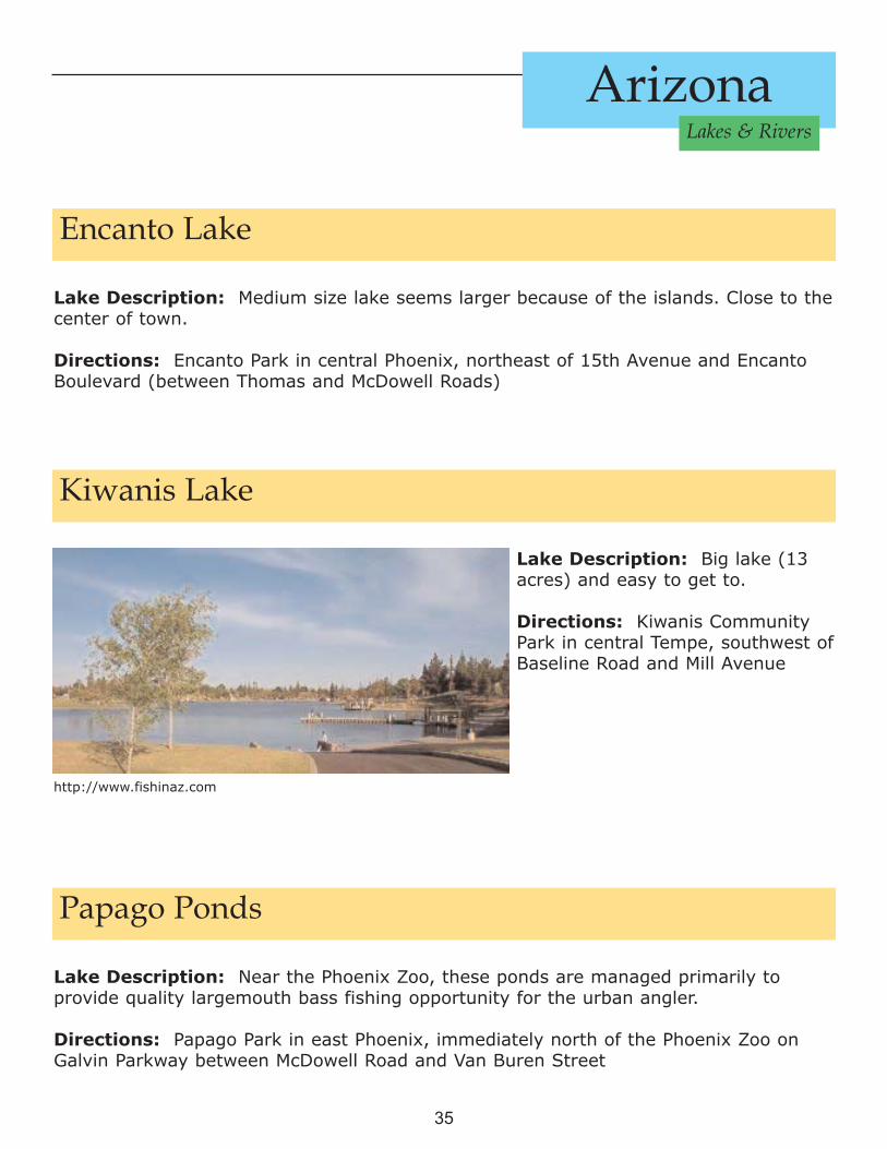
Encanto Lake
Lake Description: Medium size lake seems larger because of the islands. Close to thecenter of town.
Directions: Encanto Park in central Phoenix, northeast of 15th Avenue and EncantoBoulevard (between Thomas and McDowell Roads)
Kiwanis Lake
Lake Description: Big lake (13acres) and easy to get to.
Directions: Kiwanis CommunityPark in central Tempe, southwest ofBaseline Road and Mill Avenue
http://www.fishinaz.com
Papago Ponds
Lake Description: Near the Phoenix Zoo, these ponds are managed primarily toprovide quality largemouth bass fishing opportunity for the urban angler.
Directions: Papago Park in east Phoenix, immediately north of the Phoenix Zoo onGalvin Parkway between McDowell Road and Van Buren Street

36
Arizona Lakes & Rivers
Red Mountain Lake
Lake Description: Big lake on the northeast side of town.
Directions: Red Mountain Park in east Mesa,at southeast corner of Brown Road andSunvalley Boulevard (3/4 mile east of PowerRoad)
http://www.fishinaz.com
Riverview Lake
Lake Description: NIce small lake righton the 101 so it's easy to get to
Directions: Riverview Park in west Mesa,northwest corner of Dobson Road and 8thStreet
http://www.fishinaz.com
Steele Indian School Lake
Lake Description: 2.5 acres. Maximum depth 12 feet, average depth 8 feet.
Directions: Steele Indian School Park on the northeast corner of Indian School Roadand Central in downtown Phoenix. Park entrances are from 3rd Street north of IndianSchool or from Farrington Street (1 block north of Indian School Road) east off ofCentral Avenue.

37
Arizona Lakes & Rivers
Water Ranch Lake
Lake Description: This is just oneof a group of lakes at the WaterRanch. This is a great destination fora day of exploring and watchingwildlife.
Directions: Riparian Preserve atWater Ranch in north Gilbert, atsoutheast corner of Greenfield Roadand Guadalupe Road
http://www.fishinaz.com
ARIZONA URBAN LAKESTUCSON
Kennedy Lake
Lake Description: Size: 10acres, Depth: Maximum depth 12feet, average depth 8 feet.
Directions: J. F. Kennedy Park insouthwest Tucson, north of AioWay between La Cholla Boulevardand Mission Road.
http://www.fishinaz.com

38
Arizona Lakes & Rivers
Lakeside Park
Lake Description: Depth: Maximum depth 35 feet, average depth 15 feet. SPECIAL NOTE: In recent years Lakeside has experienced extremely low oxygen levelsduring the summer months. Consequently it has been necessary to cancel some catfishstockings. A state-of-the-art aeration system was installed by the City of Tucson in2002 to improve lake conditions for fish.
Directions: Chuck Ford-Lakeside Park in east Tucson, northwest corner of Stella Roadand Sarnoff Drive
http://www.fishinaz.com
Sahuarita Lake
Lake Description: Not too far from I-17, and with the new signs, it's not too hard tofind. Depth: Maximum depth 12 feet, average depth 7 feet.
Location:Take Sahuarita Road exit (exit 75) off Interstate 19 (Nogales Highway) andhead 1.0 miles east to La Villita Road. Take La Villita Road 1.2 miles north to the northshore of the lake.

39
Arizona Lakes & Rivers
Silverbell Lake
Lake Description: Nice size lake in North West Tucson. Easy access from I-10.
Location: Christopher Columbus Park in northwest Tucson, east of Silverbell Roadbetween Camino del Cerro and Grant Roads.
http://www.fishinaz.com
ARIZONA URBAN LAKESPAYSON
Green Valley Lakes
Lake Description: Green Valley Lakes consists of three urban lakes: Bunch River andTunnel Lakes. Upper lake 2 acres, middle lake 1 acre, and main lake 10 acres.Maximum depth of main lake 21 feet.
Location: Green Valley Park is in west Payson, AZ, on Main Street and Green ValleyRoad (one mile west of Beeline Highway 87).

40
Arizona Lakes & Rivers
ARIZONA RIVERSAgua Fria River: c.120 mi/193 km long, W Ariz., intermittent stream; rising 20 mi/32km ENE of Prescott; flows generally S to join Gila R. 16 mi/26 km W of Phoenix. NewWaddell Dam (300 ft/91 m high, 4,800 ft/1,463 m long; built 1992) forms L. Pleasant,30 mi/48 km NNW of Phoenix, used for irrigation and water storage from the CentralArizona Project. Hayden-Rhodes aqueduct crosses river 4 mi/6.4 km below (S of) dam.
Big Sandy River: c.80 mi/129 km long, Ariz.; formed by confluence of CottonwoodWash and Trout Creek, at small sect. of Hualapi Indian Reservation near Hualapai Peak,Mohave co., W Ariz.; flows S, past Wikieup, joining Santa Maria R. 43 mi/69 km ENE ofParker to form Bill Williams R.; intermittent. Hualapai Mts. to W.
Bill Williams River: c.40 mi/64 km long, W Ariz.; formed by confluence of Big Sandyand Santa Maria rivers near S tip of Hualpai Mts.; flows W through Alamo LakeReservoir to Havasu L. in Colorado R. on Calif. state line, just NE of Parker Dam. Formsboundary of La Paz (S) and Mohave (N) cos.
Black River: c.130 mi/209 km long, E Ariz.; rises SE of White Mts. in S part of Apacheco., c.15 mi/24 km S of Eager, in Apache-Sitgreaves Natl. Forest; flows SW then NW toWhite R., forming Salt R. c.40 mi/64 km NE of Globe. Black and Salt rivers formboundary bet. Fort Apache (N) and San Carlos (S) Indian reservations.
Blue River: c.65 mi/105 km long, Greenlee co., E Ariz.; rises near N.Mex. state linec.28 mi/45 km SSE of Eager; flows generally S through Apache-Sitgreaves Natl. Forestto San Francisco R. 12 mi/19 km NE of Clifton.
East Verde River: central Ariz.; rises at Mogollon Rim, S edge of Mogollon Mesa; flowsc.50 mi/80 km SW and W to Verde R. 37 mi/60 km S of Cottonwood. Entirely in TontoNatl. Forest.
Hassayampa River: intermittent stream, c.60 mi/97 km long, W central Ariz.; rises Sof Prescott, in Yavapai co., flows S, past Wickenburg, to Gila R., 8 mi/12.9 km WSW ofBuckeye. Crossed by Hayden-Rhodes Aqueduct, c.25 mi/40 km N of its mouth.
Little Colorado River: 315 mi/507 km long, largely in Ariz.; rises in SE Apache co., EAriz.; flows generally NW through Ariz., past St. Johns, Holbrook, and Winslow, alongPainted Desert, to Colorado R. in the Grand Canyon, in Grand Canyon Natl. Park, 70mi/113 km N of Flagstaff. Stream is dammed, forms Lyman L. (State Park), forirrigation 10 mi/16 km S of St. Johns.

41
Arizona Lakes & Rivers
Salt River Mountains: Maricopa co., S central Ariz., bet. Gila and Salt rivers, in S partof city of Phoenix, rise to 2,612 ft/796 m in W tip; 33°34'N 110°55'W. Include PhoenixSouth Mt. Park. Gila R. Indian Reservation to S.
Salt River: 200 mi/322 km long, in central Ariz.; formed in plateau region of E Ariz. byconfluence of Black and White rivers c.40 mi/64 km NE of Globe, where it forms, withBlack R., boundary bet. Fort Apache (N) and San Carlos (S) Indian reservations, then itflows generally W, to Gila R. 15 mi/24 km WSW of Phoenix, through Salt R. Canyonand Tonto Natl. Forest, where it passes through Theodore Roosevelt L. reservoir anddam, Apache L. (Horse Mesa Dam), Canyon L. (Mormon Flat Dam), and Saguaro L.(Stewart Mt. Dam), and through Granite Reef Dam, which diverts water to canals toirrigate Phoenix area, in close succession, then forms S boundary of Salt River IndianReservation, then flows past Mesa, Tempe, and Scottsdale, and through city of Phoenix,S of downtown. Sierra Ancha and Mazatzal mts. are N of river's mid-course; Salt RiverMts. S of lower course in Phoenix.
Salt River Valley: Maricopa co., central Ariz, at Phoenix. Irrigated region around thelower course of the Salt R., which rises in mt. streams near the Mogollon Rim of theMogollon Plateau and flows SW to join the Gila R. in S central Ariz. Native Americansused the Salt R. for irrigation here many cent. ago. In the 19th cent., Amer. settlersbegan irrigated farming in the valley, and the Mormons used some of the old NativeAmer. canals at Mesa, Ariz. The Salt River project, the 1st large irrigation schemeundertaken under the Federal Reclamation Act of 1902, is one of the most economicallysuccessful projects in N. Amer. It began in 1903 when construction started on theRoosevelt Dam in a canyon E of Phoenix. The dam, forming Roosevelt L. behind it,impounded enough water to irrigate fields for about 2 years even if no rain falls.
San Carlos River: c.40 mi/64 km long, SE Ariz.; formed by confluence of 2 forks nearGila Mts.; flows W and S, past San Carlos village, to San Carlos Reservoir (in Gila R.).Near Natanes Peak (7,590 ft/2,313 m) near Gila-Graham co. line, forms co. line to itsconfluence. Drains San Carlos Indian Reservation.
San Francisco River: c.160 mi/257 km long, in E Ariz. and W N.Mex.; rises in S partof Apache co., E Ariz., at Big Creek, Catron co.; flows E into N.Mex., then S and Wthrough Apache and Gila natl. forests, reentering Ariz. in Greenlee co., in Apache Natl.Forest, where it is joined by Blue R., from N, then S, joining Gila R. 7 mi/11.3 km SWof Clifton.
Santa Cruz River: Located in Arizona and Mexico; rises in Patagonia, SE Santa CruzMts., S Ariz.; flows S into Sonora, NW Mexico, then N, re-entering Ariz. near Nogalesand continuing N past Green Valley to Tucson, where it turns NW, passes S of CasaGrande joining Gila R. 20 mi/32 km S of Phoenix, in Gila R. Indian Reservation. Streamis intermittent. Used for irrigation in Pima co.

42
Arizona Lakes & Rivers
Santa Maria River: c.50 mi/80 km long, W central Ariz.; intermittent headstreamwhich rises near Sheridan Mt., Prescott Natl. Forest, mt. region W of Prescott in Yavapaico.; flows SW to point near S end of Hualapai Mts., where it joins Big Sandy R. to formBill Williams R.
Verde (vuhr-DEE) River: c.190 mi/306 km long; rises in Yavapai co., central Ariz. NWof Prescott; flows N as intermittent stream, then E and S, past Cottonwood, CampVerde, through Horseshoe L. and Bartlett reservoirs, joins Salt R. 23 mi/37 km ENE ofPhoenix. The valley supported early Native Amer. civilizations and is dotted with ruins,such as those at Tuzigoot Natl. Monument. Bartlett and Horseshoe dams are on theVerde R. Receives East Verde R. 22 mi/35 km SSE of Camp Verde.
White River: c.30 mi/48 km long, E Ariz.; formed in SW Apache co., W of White Mts.,in NE part of Fort Apache Indian Reservation; flows SW to Black R., forming Salt R. inGila co., c.40 mi/64 km NE of Globe.
ResourcesThis brochure is a starting point to identify waters across Arizona. Many sources exist to learn more,and here are just a few sources that can be found on the World Wide Web.
http://www.2az.ushttp://www.arizona-leisure.com/arizona-lakes.htmlhttp://www.arizonaland.com/html/http://www.azgfd.gov/outdoor_recreationhttp://www.azwhitemountains.net/outdoor-fishing-public.htmhttp://www.co.navajo.az.us/ParksRechttp://www.fishinaz.com/Lakes/http://www.fhnbaz.org/AZLakes.htmhttp://www.gf.state.az.us/http://www.legendsofamerica.com/AZ-Treasures7.htmlhttp://www.wmonline.com/attract/lakes.htm


![LAKE POWELL CLEANUP - Choctawhatchee Basin Alliance [Flyer] 1.pdf · St. Andrew Bay Resource Management Association LAKE POWELL CLEANUP OCEAN CONSERVANCY International Coastal Cleanup](https://img.pdfslide.us/doc/110x75/5ab7b0927f8b9ad5338be33d/lake-powell-cleanup-choctawhatchee-basin-flyer-1pdfst-andrew-bay-resource.jpg)