Embed Size (px)
Citation preview

Aviation Seminars 1
#3573. An aircraft departs an airport in the central standard time zone at 0845 CST for a 2-hour flight to an airport located in the mountain standard time zone. The landing should be at what coordinated universal time? Use fig.28.
A- 1345Z. C-1645Z.B- 1445Z.

Aviation Seminars 2
Sorry that is Incorrect.
Go Back and Try Again.

Aviation Seminars 3
That’s Right!!!
Next Question
Aviation Seminars 4
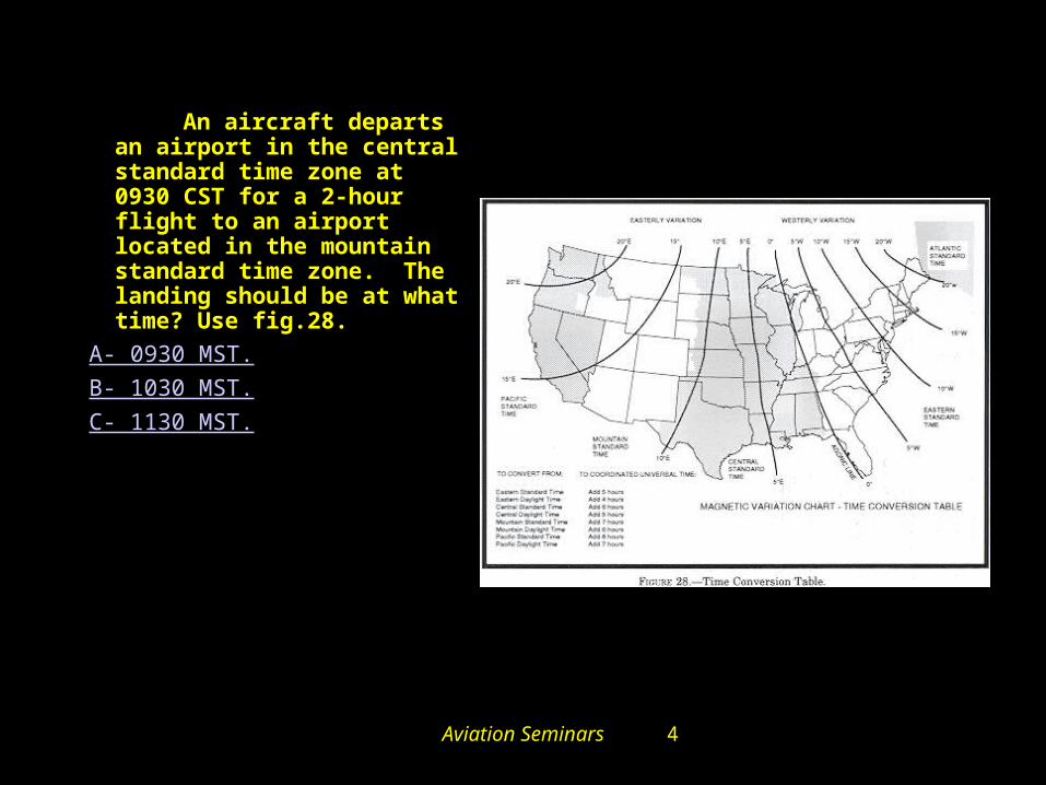
#3572. An aircraft departs an airport in the central standard time zone at 0930 CST for a 2-hour flight to an airport located in the mountain standard time zone. The landing should be at what time? Use fig.28.
A- 0930 MST.B- 1030 MST.C- 1130 MST.

Aviation Seminars 5
Sorry that is Incorrect.
Go Back and Try Again.

Aviation Seminars 6
That’s Right!!!
Next Question

Aviation Seminars 7
#3509. Of what value is the
Weather Depiction Chart
to the pilot?A- For determining general weather conditions on which to base flight planning.
B- For a forecast of cloud coverage, visibilities, and frontal activity.
C- For determining frontal trends and air mass characteristics.

Aviation Seminars 8
Sorry that is Incorrect.
Go Back and Try Again.

Aviation Seminars 9
That’s Right!!!
Next Question

Aviation Seminars 10
#3512. According to the Weather Depiction Chart, Figure 18, the
weather for a flight from southern Michigan to north Indiana is ceilings
A- 1,000 to 3,000 feet and/or visibility 3 to 5 miles
B- less than 1,000 feet and/or visibility less than 3 miles
C- greater than 3,000 feet and visibility greater than 5 miles

Aviation Seminars 11
Sorry that is Incorrect.
Go Back and Try Again.

Aviation Seminars 12
That’s Right!!!
Next Question

Aviation Seminars 13
#5429. The Surface Analysis Chart
depicts
A- frontal locations and expected movement, pressure centers, cloud coverage, and obstructions to vision at the time of chart transmission.
B- actual frontal positions, pressure patterns, temperature, dewpoint, wind, weather, and obstructions to vision at the valid time of the chart.
C- actual pressure distribution, frontal systems, cloud heights and coverage, temperature, dewpoint, and wind at the time shown on the chart.
Comm.
Aviation Seminars 14
Sorry that is Incorrect.
Go Back and Try Again.

Aviation Seminars 15
That’s Right!!!
Next Question

Aviation Seminars 16
#3460. A weather briefing that is provided when the information requested is 6 or more hours in
advance of the proposed departure time is
A- an outlook briefing.
B- a forecast briefing.
C- a prognostic briefing.

Aviation Seminars 17
Sorry that is Incorrect.
Go Back and Try Again.

Aviation Seminars 18
That’s Right!!!
Next Question

Aviation Seminars 19
#3522. What weather is forecast for the Florida area just ahead of the stationary
front during the first 12 hours? Use figure 20.
A- Ceiling 1,000 to 3,000 feet and/or visibility 3 miles to 5 miles with intermittent precipitation.
B- Ceiling 1,000 to 3,000 feet and/or visibility 3 miles to 5 miles with continuous precipitation.
C- Ceiling less than 1,000 feet and/or visibility less than 3 miles with continuous precipitation.

Aviation Seminars 20
Sorry that is Incorrect.
Go Back and Try Again.

Aviation Seminars 21
That’s Right!!!
Next Question
Aviation Seminars 22
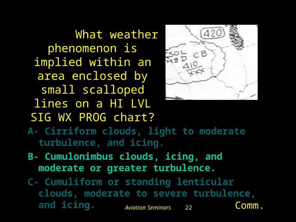
#5434. What weather phenomenon is implied within an area enclosed by small scalloped lines
on a HI LVL SIG WX PROG chart?
A- Cirriform clouds, light to moderate turbulence, and icing.
B- Cumulonimbus clouds, icing, and moderate or greater turbulence.
C- Cumuliform or standing lenticular clouds, moderate to severe turbulence, and icing.
Comm.

Aviation Seminars 23
Sorry that is Incorrect.
Go Back and Try Again.

Aviation Seminars 24
That’s Right!!!
Next Question
Aviation Seminars 25
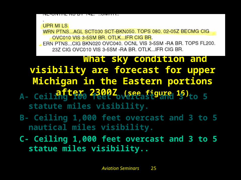
#3491. What sky condition and visibility are forecast for upper Michigan in the Eastern
portions after 2300Z (see figure 16)A- Ceiling 100 feet overcast and 3 to 5 statute miles
visibility.
B- Ceiling 1,000 feet overcast and 3 to 5 nautical miles visibility.
C- Ceiling 1,000 feet overcast and 3 to 5 statue miles visibility..

Aviation Seminars 26
Sorry that is Incorrect.
Go Back and Try Again.

Aviation Seminars 27
That’s Right!!!
Next Question

Aviation Seminars 28
#3494. To obtain a continuous transcribed weather briefing, including
winds aloft and route forecasts for a cross-country flight, a pilot should
monitor a
A- Transcribed Weather Broadcast (TWEB) and an ADF radio receiver.
B- VHF radio receiver tuned to an Automatic Terminal Information Service (ATIS) frequency.
C- regularly scheduled weather broadcast on a VOR frequency.
Aviation Seminars 29
Sorry that is Incorrect.
Go Back and Try Again.
Aviation Seminars 30
That’s Right!!!
Next Question

Aviation Seminars 31
TAFKMEM 121720Z 121818 20012KT 5SM HZ BKN030 PROB40 2022 1SM TSRA OVC008CB FM2200 33015G20KT P6SM BKN015 OVC025 PROB40 2202 3SM SHRA FM0200 35012KT OVC008 PROB40 0205 2SM –RASN BECMG 0608 02008KT NSW BKN012 BECMG 1012 00000KT 3SM BR SKC TEMPO 1214 1/2SM FG FM1600 VRB04KT P6SM NSW SKC =
#3481. Between 1000Z and 1200Z the visibility at KMEM is forecast to be
A- ½ statute mile. B- 3 statute miles. C- 6 statute miles.

Aviation Seminars 32
Sorry that is Incorrect.
Go Back and Try Again.

Aviation Seminars 33
That’s Right!!!
Next Question
Aviation Seminars 34
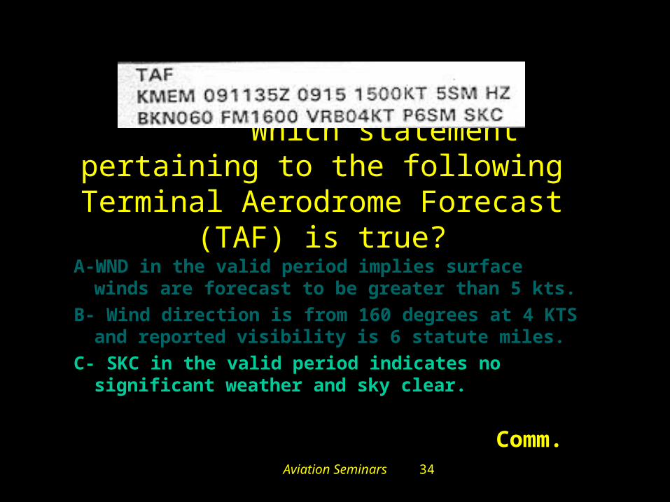
#5411. Which statement pertaining to the following Terminal Aerodrome
Forecast (TAF) is true?
A-WND in the valid period implies surface winds are forecast to be greater than 5 kts.
B- Wind direction is from 160 degrees at 4 KTS and reported visibility is 6 statute miles.
C- SKC in the valid period indicates no significant weather and sky clear.
Comm.

Aviation Seminars 35
Sorry that is Incorrect.
Go Back and Try Again.

Aviation Seminars 36
That’s Right!!!
Next Question
Aviation Seminars 37
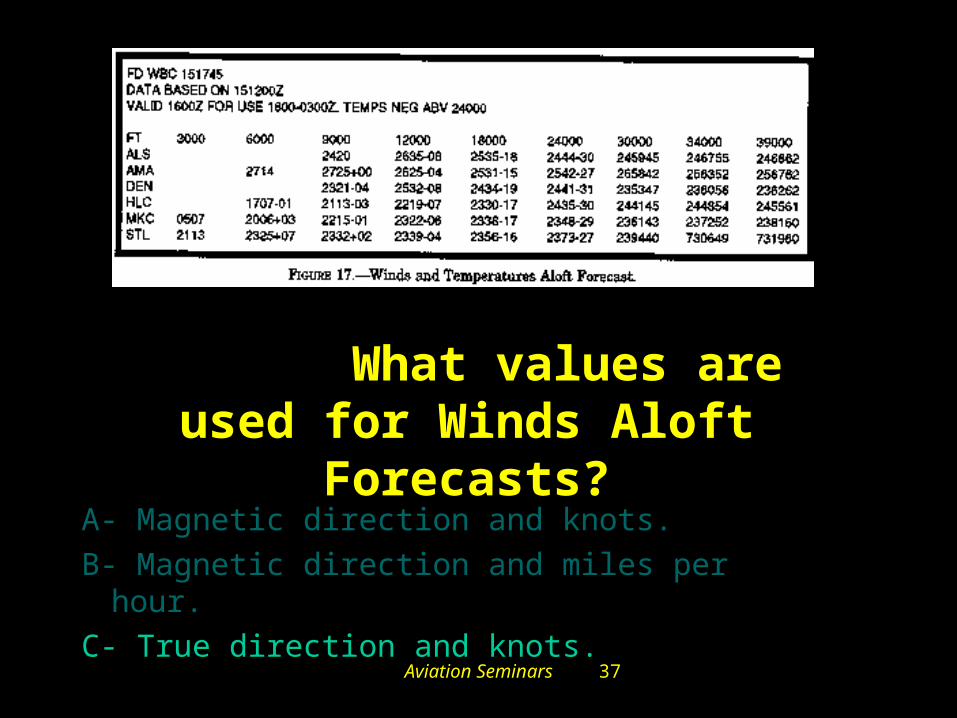
#3505. What values are used for Winds Aloft Forecasts?
A- Magnetic direction and knots.
B- Magnetic direction and miles per hour.
C- True direction and knots.
Aviation Seminars 38
Sorry that is Incorrect.
Go Back and Try Again.
Aviation Seminars 39
That’s Right!!!
Next Question
Aviation Seminars 40
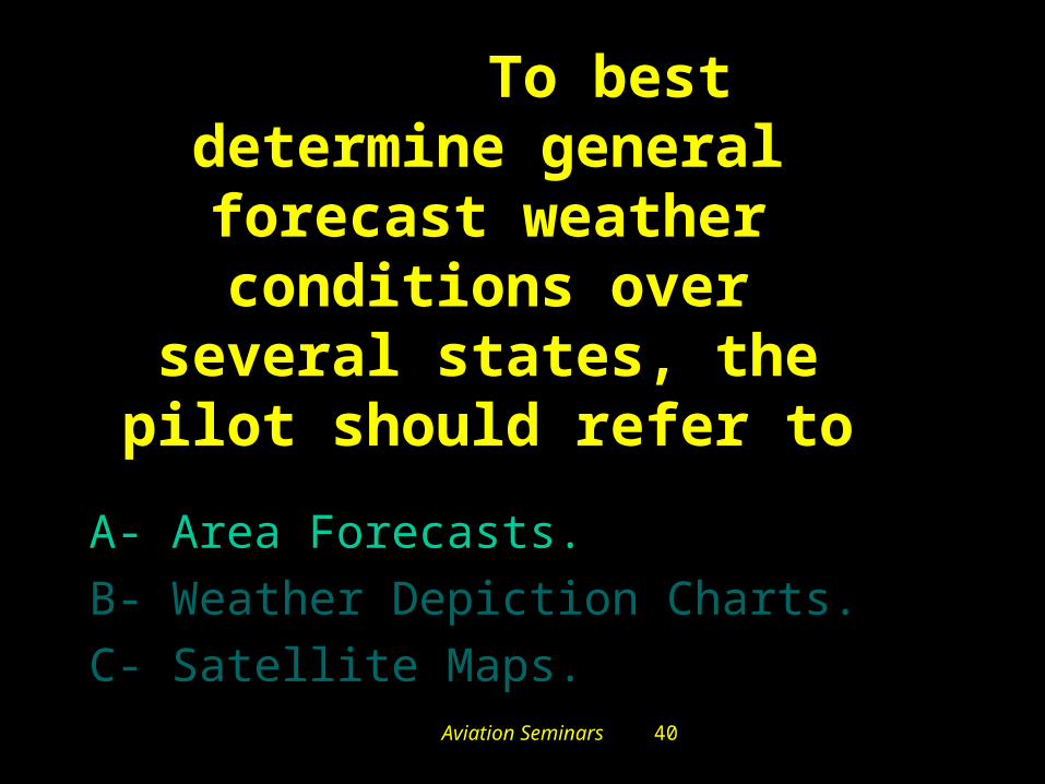
#3487. To best determine general forecast weather conditions over several states, the pilot should
refer to
A- Area Forecasts.
B- Weather Depiction Charts.
C- Satellite Maps.

Aviation Seminars 41
Sorry that is Incorrect.
Go Back and Try Again.

Aviation Seminars 42
That’s Right!!!
Next Question

Aviation Seminars 43
#3630. On what frequency can a
pilot receive Hazardous
Inflight Weather Advisory Service
(HIWAS) in the vicinity of area
1? (Fig 22. Upper left)
A- 117.1 MHz.
B- 118.0 MHz.
C- 122.0 MHz.

Aviation Seminars 44
Sorry that is Incorrect.
Go Back and Try Again.

Aviation Seminars 45
That’s Right!!!
Next Question

Aviation Seminars 46
#3497. SIGMET’s are issued as a warning of
weather conditions hazardous to which aircraft?
A- Small aircraft only.
B- Large aircraft only.
C- All aircraft.

Aviation Seminars 47
Sorry that is Incorrect.
Go Back and Try Again.

Aviation Seminars 48
That’s Right!!!
Next Question

Aviation Seminars 49
#3616. How should contact be established with an En Eoute Flight Advisory Service (EFAS) station, and what service should be expected.
A- Call EFAS on 122.2 for routine weather, current reports on hazardous weather, and altimeter settings.B- Call Flight Assistance on 122.5 for advisory service pertaining to severe weather.C- Call Flight Watch on 122.0 for information regarding actual weather and thunderstorm activity along proposed route.

Aviation Seminars 50
Sorry that is Incorrect.
Go Back and Try Again.

Aviation Seminars 51
That’s Right!!!
Next Question
Aviation Seminars 52
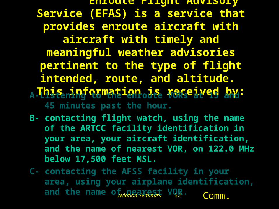
#5559. Enroute Flight Advisory Service (EFAS) is a service that provides enroute
aircraft with aircraft with timely and meaningful weather advisories pertinent to
the type of flight intended, route, and altitude. This information is received by:
A-Listening to the enroute VORs at 15 and 45 minutes past the hour.
B- contacting flight watch, using the name of the ARTCC facility identification in your area, your aircraft identification, and the name of nearest VOR, on 122.0 MHz below 17,500 feet MSL.
C- contacting the AFSS facility in your area, using your airplane identification, and the name of nearest VOR.
Comm.

Aviation Seminars 53
Sorry that is Incorrect.
Go Back and Try Again.

Aviation Seminars 54
That’s Right!!!
Next Question

Aviation Seminars 55
#3516. What type of weather is occurring in
the radar return?(See fig.
19.Area B) A- Continuous rain.B- Light to moderate rain
showers.C- Rain showers
increasing in intensity.

Aviation Seminars 56
Sorry that is Incorrect.
Go Back and Try Again.
Aviation Seminars 57
That’s Right!!!
Next Question
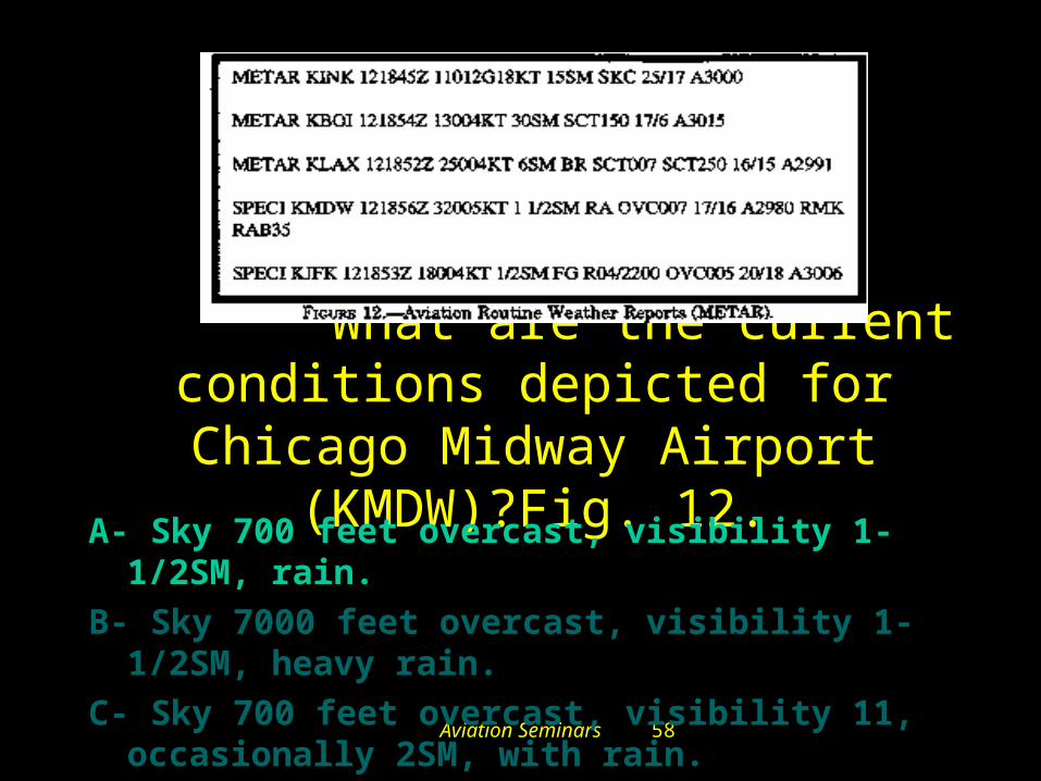
Aviation Seminars 58
#3467. What are the current conditions depicted for Chicago
Midway Airport (KMDW)?Fig. 12.A- Sky 700 feet overcast, visibility 1-1/2SM, rain.
B- Sky 7000 feet overcast, visibility 1-1/2SM, heavy rain.
C- Sky 700 feet overcast, visibility 11, occasionally 2SM, with rain.

Aviation Seminars 59
Sorry that is Incorrect.
Go Back and Try Again.

Aviation Seminars 60
That’s Right!!!
Next Question
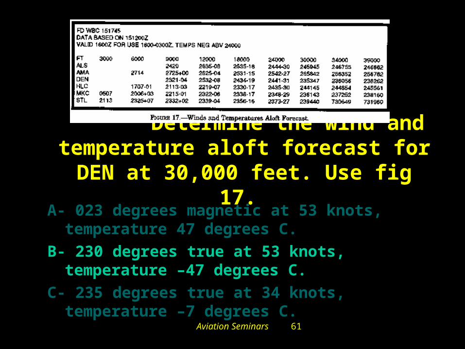
Aviation Seminars 61
#3502. Determine the wind and temperature aloft forecast for DEN at
30,000 feet. Use fig 17. A- 023 degrees magnetic at 53 knots, temperature
47 degrees C.
B- 230 degrees true at 53 knots, temperature –47 degrees C.
C- 235 degrees true at 34 knots, temperature –7 degrees C.

Aviation Seminars 62
Sorry that is Incorrect.
Go Back and Try Again.

Aviation Seminars 63
That’s Right!!!
Congratulations!!!
You have finished the review!!!