Embed Size (px)
Citation preview

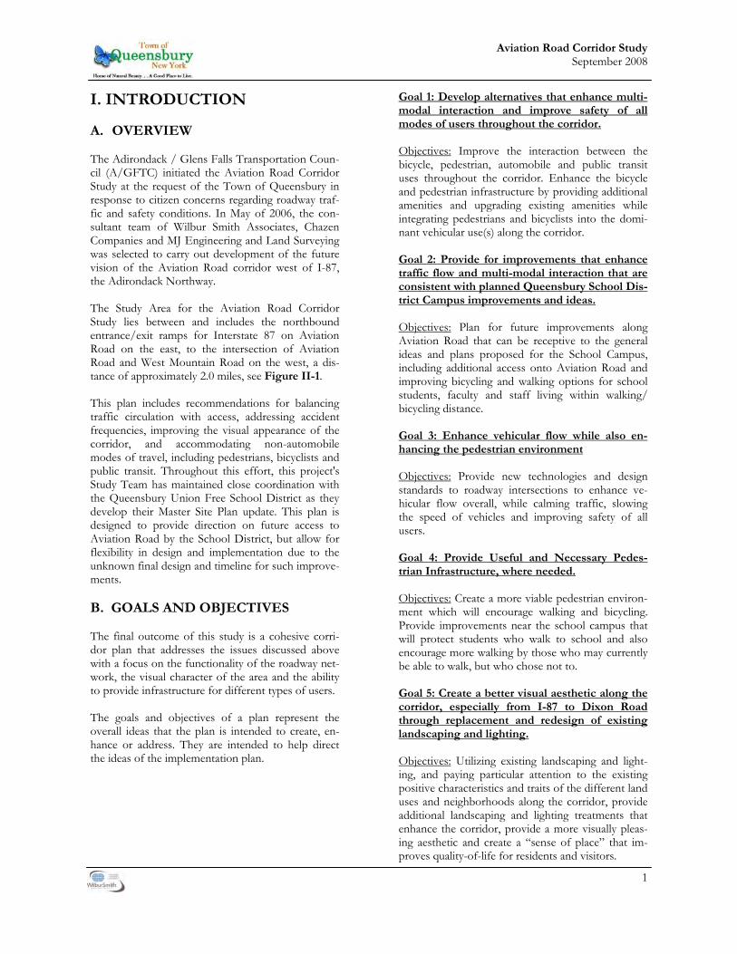
AVIATION ROAD CORRIDOR STUDY
TOWN OF QUEENSBURY, NY &
THE ADIRONDACK/GLENS FALLS TRANSPORTATION COUNCIL
FINAL REPORT
Wilbur Smith Associates The Chazen Companies
MJ Engineering & Land Surveying
September 2008

Aviation Road Corridor Study September 2008
This Page Intentionally Left Blank
TABLE OF CONTENTS
I. INTRODUCTION Goals and Objectives.................................................................................................................................................1 II. EXISTING CONDITIONS A. Aviation Road Corridor Study Area........................................................................................................3 B. Roadway Characteristics ...........................................................................................................................3 C. Transportation Network...........................................................................................................................5 D. Safety .........................................................................................................................................................13 E. Utilities ......................................................................................................................................................15 F. Land Use and Zoning .............................................................................................................................15 G. Environmental and Cultural Resources................................................................................................17 H. Transit .......................................................................................................................................................17 I. Other Existing Conditions .....................................................................................................................17 J. Conclusion................................................................................................................................................17 III. MANAGING FUTURE VEHICULAR, PEDESTRIAN AND BICYCLE TRAFFIC A. Expected Future Growth..........................................................................................................................18 B. Intersections................................................................................................................................................18 C. Roundabouts...............................................................................................................................................25 D. Bicycle and Pedestrian Safety...................................................................................................................34 E. Corridor Enhancements/Plan Elements................................................................................................35 IV. TRANSIT SERVICE GGFT & Queensbury School District........................................................................................................... .37 V. LIGHTING AND LANDSCAPING A. Overview...................................................................................................................................................38 B. The I-87 West Entrance/Exit Ramp to Midnight/Manor Drive .....................................................38 C. Manor/Midnight Drive to Potter/Fox Farm Road ............................................................................39 D. Potter/Fox Farm Road to West Mountain Road................................................................................40 VI. COST ESTIMATES ................................……………………………………………...….…......40 VII. IMPLEMENTATION A. Overview...................................................................................................................................................43 B. Tools and Techniques .............................................................................................................................43 C. Responsibility ...........................................................................................................................................43 D. Financing...................................................................................................................................................43
Tables Table II-1. Comparison of AM, Midday, and PM Two-way Peak Hour Traffic Volumes................ 9 Table II-2. LOS Criteria for Signalized Intersections ............................................................................10 Table II-3. LOS Criteria for Unsignalized Intersections .......................................................................11 Table II-4. Existing (2006) Level of Service for Signalized Intersections ...........................................11 Table II-5. Existing (2005) Level of Service for Unsignalized Intersections ......................................12 Table III-1 Future (2016) Intersection Level of Service (LOS) ............................................................19 Table III-2 Intersection and Segment Alternatives.................................................................................22 Table III-3. Future (2016) Level of Service for Roundabouts................................................................25 Table III-4 Roundabout Concept - Aviation Rd at School Driveway...................................................28 Table III-5 Roundabout Concept - Aviation Rd. at Manor Dr./Midnight Dr ...................................30 Table III-6 Roundabout Concept - Aviation Rd. at Dixon Rd./Farr Lane..........................................32 Table III-7 Alternative Transportation Facility Users ............................................................................34 Table IV-1 Cost Estimates - I-87 S.B. Ramp to Potter/Fox Farm Road Transportation.................40 Table IV-2 Cost Estimates - Potter/Fox Farm Road to West Mountain Road Transportation.......40 Table IV-3 Cost Estimates - I-87 S.B. Ramp to Midnight/Manor Drive Landscaping......................41 Table IV-4 Cost Estimates - Manor/Midnight Drive to Potter/Fox Farm Road Landscaping........41 Table IV-5 Cost Estimates - Potter/Fox Farm Road to West Mountain Road Landscaping............41 Table V-1 Implementation .......................................................................................................................46 Figures Figure II-1. Study Area Figure II-2. Aviation Road Characteristics Figure II-3. Existing (2006) AM Peak Hour Traffic Volumes Figure II-4. Existing (2006) Midday Peak Hour Traffic Volumes Figure II-5. Existing (2006) PM Peak Hour Traffic Volumes Figure II-6. Existing (2006) AM Peak Hour - Level of Service Figure II-7. Existing (2006) Midday Peak Hour - Level of Service Figure II-8. Existing (2006) PM Peak Hour - Level of Service Figure II-9 Land Use in the Study Area Figure III-1 Zoning Districts Figure III-2 Future (2016) Base AM Peak Hour Traffic Volumes Figure III-3 Future (2016) Base PM Peak Hour Traffic Volumes Figure III-4 Roadway Improvements Segment 1 Figure III-5 Roadway Improvements Segment 2 Figure III-6 Roadway Improvements Segment 3 Figure III-7 Roadway Improvements Segment 4 Figure III-8 Roundabout Conceptual Plan - Aviation Rd. at School Driveway Figure III-9 Roundabout Conceptual Plan - Aviation Rd. at Manor Dr./Midnight Dr Figure III-10 Roundabout Conceptual Plan - Aviation Rd. at Dixon Rd./Farr. Ln Figure IV-1 Landscape Improvements Segment 1 Figure IV-2 Landscape Improvements Segment 2 Figure IV-3 Landscape Improvements Segment 3 Figure IV-4 Landscape Improvements Segment Appendix Appendix A Accident Analysis Report Appendix B Representative Corridor Photos Appendix C Queensbury Union Free School District— Master Site Plan Appendix D Alternative Development Process Summary
THIS DOCUMENT IS FORMATTED FOR DOUBLE SIDED PRINTING
1
Aviation Road Corridor Study September 2008
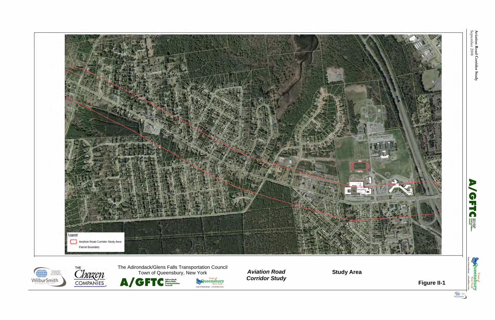
I. INTRODUCTION A. OVERVIEW The Adirondack / Glens Falls Transportation Coun-cil (A/GFTC) initiated the Aviation Road Corridor Study at the request of the Town of Queensbury in response to citizen concerns regarding roadway traf-fic and safety conditions. In May of 2006, the con-sultant team of Wilbur Smith Associates, Chazen Companies and MJ Engineering and Land Surveying was selected to carry out development of the future vision of the Aviation Road corridor west of I-87, the Adirondack Northway. The Study Area for the Aviation Road Corridor Study lies between and includes the northbound entrance/exit ramps for Interstate 87 on Aviation Road on the east, to the intersection of Aviation Road and West Mountain Road on the west, a dis-tance of approximately 2.0 miles, see Figure II-1.
This plan includes recommendations for balancing traffic circulation with access, addressing accident frequencies, improving the visual appearance of the corridor, and accommodating non-automobile modes of travel, including pedestrians, bicyclists and public transit. Throughout this effort, this project's Study Team has maintained close coordination with the Queensbury Union Free School District as they develop their Master Site Plan update. This plan is designed to provide direction on future access to Aviation Road by the School District, but allow for flexibility in design and implementation due to the unknown final design and timeline for such improve-ments. B. GOALS AND OBJECTIVES The final outcome of this study is a cohesive corri-dor plan that addresses the issues discussed above with a focus on the functionality of the roadway net-work, the visual character of the area and the ability to provide infrastructure for different types of users. The goals and objectives of a plan represent the overall ideas that the plan is intended to create, en-hance or address. They are intended to help direct the ideas of the implementation plan.
Goal 1: Develop alternatives that enhance multi-modal interaction and improve safety of all modes of users throughout the corridor. Objectives: Improve the interaction between the bicycle, pedestrian, automobile and public transit uses throughout the corridor. Enhance the bicycle and pedestrian infrastructure by providing additional amenities and upgrading existing amenities while integrating pedestrians and bicyclists into the domi-nant vehicular use(s) along the corridor. Goal 2: Provide for improvements that enhance traffic flow and multi-modal interaction that are consistent with planned Queensbury School Dis-trict Campus improvements and ideas. Objectives: Plan for future improvements along Aviation Road that can be receptive to the general ideas and plans proposed for the School Campus, including additional access onto Aviation Road and improving bicycling and walking options for school students, faculty and staff living within walking/bicycling distance. Goal 3: Enhance vehicular flow while also en-hancing the pedestrian environment Objectives: Provide new technologies and design standards to roadway intersections to enhance ve-hicular flow overall, while calming traffic, slowing the speed of vehicles and improving safety of all users. Goal 4: Provide Useful and Necessary Pedes-trian Infrastructure, where needed. Objectives: Create a more viable pedestrian environ-ment which will encourage walking and bicycling. Provide improvements near the school campus that will protect students who walk to school and also encourage more walking by those who may currently be able to walk, but who chose not to. Goal 5: Create a better visual aesthetic along the corridor, especially from I-87 to Dixon Road through replacement and redesign of existing landscaping and lighting. Objectives: Utilizing existing landscaping and light-ing, and paying particular attention to the existing positive characteristics and traits of the different land uses and neighborhoods along the corridor, provide additional landscaping and lighting treatments that enhance the corridor, provide a more visually pleas-ing aesthetic and create a “sense of place” that im-proves quality-of-life for residents and visitors.

2
Aviation Road Corridor Study September 2008
This Page Intentionally Left Blank
Aviation
Road C
orridor Stu
dy
September 2008
Aviation Road Corridor Study
The Adirondack/Glens Falls Transportation Council Town of Queensbury, New York
Figure II-1
Study Area

Avi
atio
n R
oad
Cor
rid
or S
tud
y Se
ptem
ber 2
008

3
Aviation Road Corridor Study September 2008
II. EXISTING CONDITIONS A. AVIATION ROAD CORRIDOR
STUDY AREA The Study Area for the Aviation Road Corridor Study lies between and includes the northbound entrance/exit ramps for Interstate 87 on Aviation Road on the east to the intersection of Aviation Road and West Mountain Road on the west, a dis-tance of approximately 2.0 miles. The Study also extends approximately 450 feet on either side of the roadway. Figure II-1 graphically depicts the Study Area. The larger traffic-contributing area, which was used to project future traffic volumes on the road, extends further to the north and south to include: • The land between Potter Road and Aviation Road; • The properties on either side of West Mountain Road north of Potter Road; and • The parcels along the numerous roadways north
of Aviation Road between the Interstate and West Mountain Road.
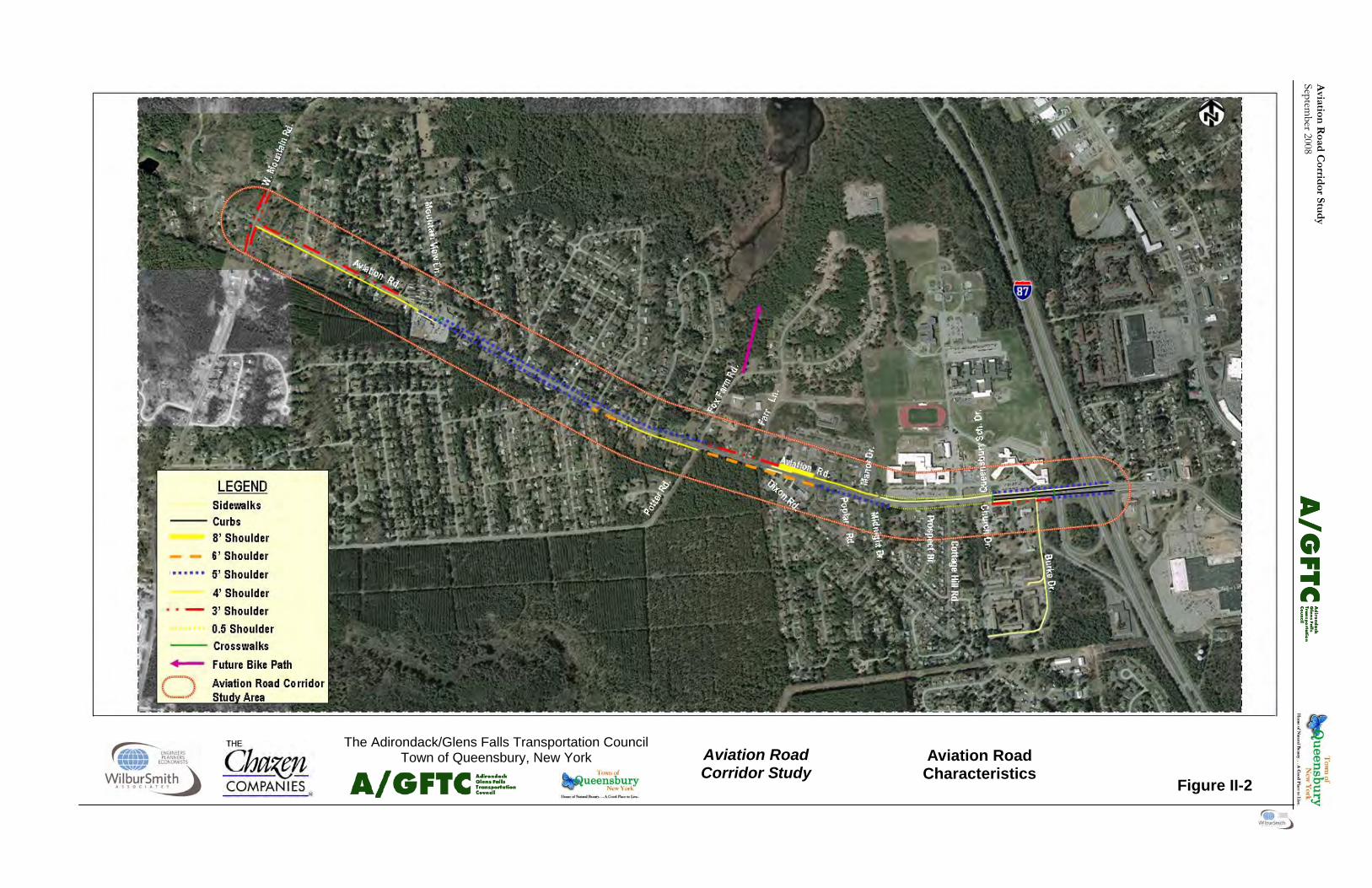
Traffic signals control vehicular and pedestrian traf-fic at two intersections – the two entrance/exit ramps for Interstate 87 and the entrance to the com-bined school parcels. Other important intersections are controlled by stop signs on the side streets. There are no stop signs on Aviation Road itself within the Study Area until it intersects with West Mountain Road, where Aviation Road has a stop sign with flashing red lights. West Mountain Road at this intersection is the through-road and therefore does not have a stop sign. B. ROADWAY CHARACTERISTICS 1. Travel Lanes Aviation Road consists of two 11 foot wide travel lanes, one in either direction, between West Moun-tain Road and Potter Road and two 12-foot wide travel lanes, one in either direction, between Potter Road to the western High School parking lot exit. East of this exit, the road widens to include a 12-foot wide center turning lane. This configuration contin-ues to the intersection with Burke Drive. East of Burke Drive, Aviation Road widens again to be a four lane road with a left turn center lane. Figure II-1 provides an overview of Aviation Road in the Study Area.
2. Paved Shoulders The paved shoulders along Aviation Road vary sig-nificantly through the Study Area. Figure II-2 high-lights these changes. From West Mountain Road to Mountain View Lane, the north shoulder is approxi-mately 3.5 feet in width, except in front of the mo-bile homes where the shoulder narrows to less than 1 foot and is essentially incorporated into the curb cut running the length of this frontage to Mountain View Lane. The south shoulder is approximately 4’ in width from West Mountain Drive to the western entrance to the Prospect School building. From the Prospect School building western entrance to Buena Vista Avenue, the south side paved shoulder widens to 5’ and on the north side from Mountain View Lane to Gilmore Avenue, the paved shoulder is also 5’. The paved south side shoulder at Buena Vista Avenue widens to 6’ and remains 6’ to Potter Road. From Gilmore Avenue to Fox Farm Road, the north side paved shoulder is 4’ wide and is adjacent to a 1’ wide paved concave drainage swale. Directly east of Potter Road, the north side paved shoulder is approximately three-feet wide, while the south side is six-feet wide. The north side paved shoulder widens to eight-feet wide in front of the new development east of the intersection with Dixon Road, but narrows again to four-feet east of the east-ern entrance to the Stewart’s Shops. The paved shoulders remain at approximately four-feet wide on the north side and five to six-feet wide on the south side to the intersection with Midnight Drive. East of this intersection, the paved shoulders gradually nar-row to approximately six inches wide on both sides of the travel lanes as the roadway widens to accom-modate the center turning lane. The paved shoulder widens again to five-feet on the north side and one to three-feet on the south side east of the signalized entrance to the school campuses. East of the school campus entrance drive, the paved shoulders stabilize at five-feet wide on both sides of the roadway to the eastern end of the Study Area.
Aviation Road at the School Driveway Intersection
4
Aviation Road Corridor Study September 2008
This Page Intentionally Left Blank
Aviation
Road C
orridor Stu
dy
September 2008
Aviation Road Corridor Study
The Adirondack/Glens Falls Transportation Council Town of Queensbury, New York
Figure II-2
Aviation Road Characteristics

Avi
atio
n R
oad
Cor
rid
or S
tud
y Se
ptem
ber 2
008
5
Aviation Road Corridor Study September 2008
3. Curbs Curbing lines the north side of the street east of the signaled entrance to the school campus to the I-87 overpass, as shown on Figure II-2. A curb also lines the south side of the street east of the entrance driveway to the Methodist Church to the I-87 over-pass. From these locations west, there are no curbs located along Aviation Road. 4. Sidewalks Figure II-2 shows the extent of sidewalks in the right-of-way in the Study Area. The eastern end of the Aviation Road right-of-way features sidewalks on both sides of the street. On the south side of the road, the sidewalk extends westward from the I-97 overpass to the signalized entrance to the school campus. The north side sidewalk continues further west to just west of the western exit from the high school parking lot. Both of these sidewalks are five-feet wide and in generally in good condition. There is a short section of sidewalk further west on the north side of the street in front of the new office building west of the Mountain View Commons and the single family residence to the west. This is bal-anced on the south side of the street by a sidewalk that runs from the intersection with Dixon Road to the eastern end of the shopping center, although the sidewalk has been covered with asphalt in front of the shopping center. The rest of the sidewalk on the south side of the street that is visible and the side-walk in front of the residence on the north side are old and in poor condition. The sidewalk in front of the new office building is new and in good condi-tion. It is separated by a single step from the older sidewalk to the west. There are no sidewalks west of the Dixon Road/Farr Lane and Aviation Road inter-section, however along the front of the Prospect School property, a sidewalk located approximately 25’ from the shoulder of Aviation Road serves as an entryway to the front of the building. 5. Crosswalks Five crosswalks cross Aviation Road – one between the Prospect School and the Child and Family Cen-ter, one east of the signalized school entrance, one west of Burke Drive, one on the west side of the southbound Interstate entrance/exit and one east of the of the eastern Interstate entrance/exit. Figure II-2 shows the location of these crosswalks. Cross-walks also link the sidewalks on the south side of the street on Burke Drive and the two Interstate en-trance/exit ramps.
C. Transportation Network 1. Study Area Intersections Signalized Intersections Aviation Road and I-87 SB On/Off Ramp The Aviation Road and I-87 SB On/Off Ramp is a three way signalized intersection at the eastern end of the study area. The I-87 SB on-ramp is a two-lane roadway oriented in the southbound direction with exclusive left and right turn lanes on Aviation Road, and forms the northbound approach of the intersec-tion. In the eastbound direction, Aviation Road has two lanes with a through lane and a shared through-right turn lane. In the westbound direction, Aviation Road has three lanes with an exclusive left turn lane, a shared left turn-through lane and a through lane. No parking is permitted on Aviation Road or the I-87 SB On/Off ramps at the intersection. The traffic signal at this intersection is coordinated with the I-87 NB On/Off ramps on the eastern side of the bridge that carries Aviation Road over I-87. Aviation Road and Queensbury School Drive/ Church Driveway The Aviation Road and Queensbury School Drive/ Church Driveway is a four way signalized intersection. In the southbound direction, the Queensbury School Drive has two lanes with a shared left turn-through lane and a shared through-right turn lane. In the northbound direction, the Church driveway has a single lane with shared left-through-right turn move-ments. In the eastbound direction, Aviation Road has two lanes with an exclusive left turn lane and a shared through-right turn lane. In the westbound direction, Aviation Road has a single lane with shared left-through-right turn movements. No park-ing is permitted on Aviation Road, Queensbury School Drive or the Church driveway at the intersec-tion. Unsignalized Intersections Aviation Road and Burke Drive The intersection of Aviation Road and Burke Drive is controlled by a stop sign on Burke Drive. Burke Drive is a two-way two-lane roadway which forms the southern leg of the intersection. In the northbound direction it has a single lane with shared left-right turn movements. In the eastbound direc-tion, Aviation Road has a single lane with shared through-right turn movements. In the westbound direction, Aviation Road has two lanes with an exclu-sive left turn lane and a through lane. No parking is permitted on either road at the intersection.
6
Aviation Road Corridor Study September 2008
Aviation Road and Cottage Hill Road The intersection of Aviation Road and Cottage Hill Road is controlled by a stop sign on Cottage Hill Road. Cottage Hill Road is a two-way two-lane road-way which forms the southern leg of the intersec-tion. In the northbound direction it has a single lane with shared left-right turn movements. In the east-bound direction, Aviation Road has a single lane with shared through-right turn movements. In the westbound direction, Aviation Road has a center left turn lane and a through lane. No parking is permit-ted on Aviation Road or Cottage Hill Road at the intersection. Aviation Road and Queensbury School Parking Driveway The Queensbury School parking driveway is a one-way one-lane roadway oriented in the northbound direction. In the eastbound direction, Aviation Road has a center left turn lane and a through lane. In the westbound direction, Aviation Road has a single lane with a shared through- right turn lane. No parking is permitted on Aviation Road or the School parking driveway at the intersection. Designated parking spaces are provided in the School parking lot. Aviation Road and Midnight Drive/Manor Drive The intersection of Aviation Road and Midnight Drive/Manor Drive is controlled by stop signs on Midnight Drive and Manor Drive. Midnight Drive and Manor Drive are two-way two-lane roadways oriented in the northbound and southbound direc-tions respectively. Midnight Drive and Manor Drive are located at an offset to each other geometrically. All approaches of this intersection have a single lane with shared left-through and right turn movements. No parking is allowed along Aviation Road, Mid-night Drive and Manor Drive at the intersection. Aviation Road and Dixon Road/Farr Lane The intersection of Aviation Road and Dixon Road/Farr Lane is controlled by stop signs on Dixon Road and Farr Lane. Dixon Road and Farr Lane are two-way two-lane roadways oriented in the northbound and southbound directions respectively. All ap-proaches of this intersection have a single lane with shared left-through and right turn movements. No parking is allowed along Aviation Road, Dixon Road or Farr Lane at the intersection. Dixon Road inter-sects with Aviation Road at an acute angle on the southeastern corner as Figure II-2 shows. The an-gle forces vehicles crossing or turning onto Aviation Road from Dixon Road to approach Aviation Road from an acute angle.
The center line of Dixon Road does not align with the center line of Farr Lane, creating additional problems in the interactions of the left turning vehicles from both Farr Lane and Dixon Road entering the intersection. Aviation Road and Potter Road/Fox Farm Road The intersection of Aviation Road and Potter Road/Fox Farm Road is controlled by stop signs on Potter Road and Fox Farm Road respectively. Potter Road and Fox Farm Road are two-way two-lane roadways oriented in the northbound and southbound direc-tions respectively. All approaches of this intersection have a single lane with shared left-through and right turn movements. No parking is allowed along Avia-tion Road, Potter Road or Fox Farm Road at the intersection. Aviation Road and Sylvan Avenue/Owen Avenue The intersection of Aviation and Sylvan Avenue/Owen Avenue is controlled by stop signs on Sylvan Avenue and Owen Avenue. Sylvan Avenue and Owen Avenue are geometrically off-set two-way two-lane roadways oriented in the northbound and southbound directions respectively. All approaches to this intersection have a single lane with shared left-through and right turn movements. There are no signs prohibiting parking, however parking is not permitted at the intersection on Aviation Road, Syl-van Avenue or Owen Avenue. Aviation Road and Westmore Avenue/Buena Vista Avenue The intersection of Aviation Road and Westmore Avenue/Buena Vista Avenue is controlled by stop signs on Westmore Avenue and Buena Vista Ave-nue. Both Westmore Avenue and Buena Vista Ave-nue are two-way two-lane roadways oriented in the northbound and southbound directions respectively. All approaches to this intersection have a single lane with shared left-through and right turn movements. There are no signs posted prohibiting parking, how-ever parking is not permitted at the intersection on Aviation Road, Westmore Avenue or Buena Vista Avenue. Aviation Road and Pinewood Avenue The intersection of Aviation Road and Pinewood Avenue is controlled by a stop sign on Pinewood Avenue. Pinewood Avenue is a two-way two-lane roadway oriented in the southbound direction. All approaches to this intersection have a single lane with shared left-through and right turn movements.
7
Aviation Road Corridor Study September 2008
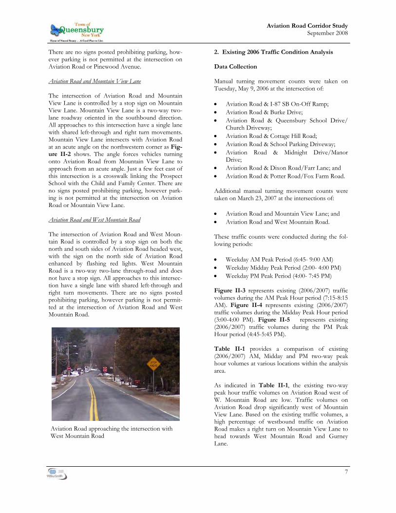
There are no signs posted prohibiting parking, how-ever parking is not permitted at the intersection on Aviation Road or Pinewood Avenue. Aviation Road and Mountain View Lane The intersection of Aviation Road and Mountain View Lane is controlled by a stop sign on Mountain View Lane. Mountain View Lane is a two-way two- lane roadway oriented in the southbound direction. All approaches to this intersection have a single lane with shared left-through and right turn movements. Mountain View Lane intersects with Aviation Road at an acute angle on the northwestern corner as Fig-ure II-2 shows. The angle forces vehicles turning onto Aviation Road from Mountain View Lane to approach from an acute angle. Just a few feet east of this intersection is a crosswalk linking the Prospect School with the Child and Family Center. There are no signs posted prohibiting parking, however park-ing is not permitted at the intersection on Aviation Road or Mountain View Lane. Aviation Road and West Mountain Road The intersection of Aviation Road and West Moun-tain Road is controlled by a stop sign on both the north and south sides of Aviation Road headed west, with the sign on the north side of Aviation Road enhanced by flashing red lights. West Mountain Road is a two-way two-lane through-road and does not have a stop sign. All approaches to this intersec-tion have a single lane with shared left-through and right turn movements. There are no signs posted prohibiting parking, however parking is not permit-ted at the intersection of Aviation Road and West Mountain Road.
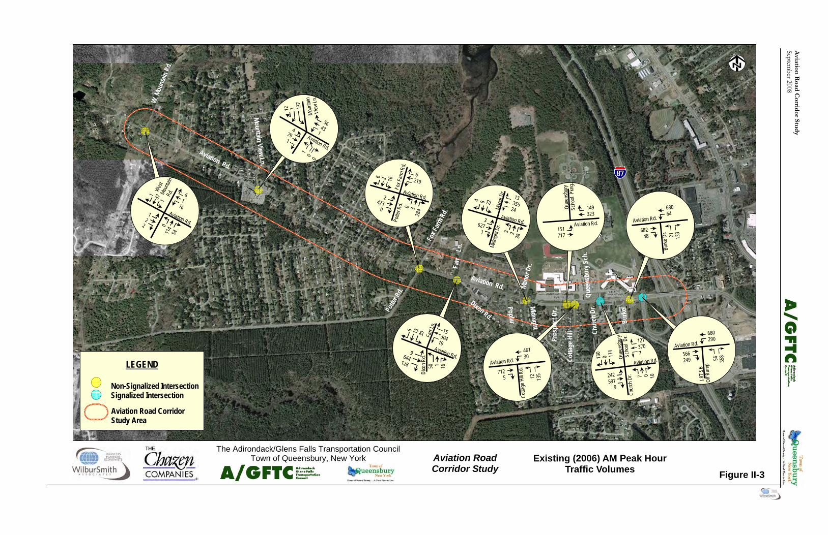
2. Existing 2006 Traffic Condition Analysis Data Collection Manual turning movement counts were taken on Tuesday, May 9, 2006 at the intersection of: • Aviation Road & I-87 SB On-Off Ramp; • Aviation Road & Burke Drive; • Aviation Road & Queensbury School Drive/ Church Driveway; • Aviation Road & Cottage Hill Road; • Aviation Road & School Parking Driveway; • Aviation Road & Midnight Drive/Manor Drive; • Aviation Road & Dixon Road/Farr Lane; and • Aviation Road & Potter Road/Fox Farm Road. Additional manual turning movement counts were taken on March 23, 2007 at the intersections of:
• Aviation Road and Mountain View Lane; and • Aviation Road and West Mountain Road. These traffic counts were conducted during the fol-lowing periods: • Weekday AM Peak Period (6:45- 9:00 AM) • Weekday Midday Peak Period (2:00- 4:00 PM) • Weekday PM Peak Period (4:00- 7:45 PM) Figure II-3 represents existing (2006/2007) traffic volumes during the AM Peak Hour period (7:15-8:15 AM). Figure II-4 represents existing (2006/2007) traffic volumes during the Midday Peak Hour period (3:00-4:00 PM). Figure II-5 represents existing (2006/2007) traffic volumes during the PM Peak Hour period (4:45-5:45 PM). Table II-1 provides a comparison of existing (2006/2007) AM, Midday and PM two-way peak hour volumes at various locations within the analysis area. As indicated in Table II-1, the existing two-way peak hour traffic volumes on Aviation Road west of W. Mountain Road are low. Traffic volumes on Aviation Road drop significantly west of Mountain View Lane. Based on the existing traffic volumes, a high percentage of westbound traffic on Aviation Road makes a right turn on Mountain View Lane to head towards West Mountain Road and Gurney Lane.
Aviation Road approaching the intersection with West Mountain Road

8
Aviation Road Corridor Study September 2008
This Page Intentionally Left Blank
Aviation
Road C
orridor Stu
dy
September 2008
12
7 137
4 79 1
Aviation Rd.
Moun
tain
View
Ln.
56 43 1
6 1
16
1 37
1
1 2
2 0 11
4 54
Aviation Rd.
Burk
e
Quee
nsbu
ry S
ch.
Chur
ch D
r.
Cotta
ge H
ill
Aviation Rd.
Farr
Ln.
Dixon Rd.
Potte
r Rd.
Fox F
arm R
d.
Mano
r Dr.
Poplar
Midnight
Pros
pect
Dr.
Non-Signalized Inter-section Signalized Intersection
LEGEND
Mountain View Ln.
W. M
ount
ain R
d.
Aviation Rd.
Aviation Road Corridor Study Area
21
133
680 64
682 48
Burke
Dr.
Aviation Rd.
56
358
680 290
566 249
Aviation Rd.
I-87 S
B Of
f Ram
p
127 370 7
130
0 174
242 597
9
7 0 10
Aviation Rd. Quee
nsbu
ry
Scho
ol D
r. Ch
urch
Dr. 12
13
5
461 30
712 5
Cotta
ge H
ill Rd
. Aviation Rd.
151 717
149 323
Aviation Rd.
Quee
nsbu
ry
Scho
ol P
kng.
13 355
24
4 8 22
3 627
1 3 2 38
Aviation Rd.
Mano
r Dr.
Midn
ight D
r.
Fox F
arm
Rd.
6 219
6 2 16
2 473
0 0 3 28
4
Aviation Rd.
Potte
r Rd.
Farr
Ln.
Aviation Rd.
15 304 19
6 13
30
50 1 16
9 644 128
Dixo
n Rd.
1 0 0
Aviation Road Corridor Study
The Adirondack/Glens Falls Transportation Council Town of Queensbury, New York
Non-Signalized Intersection Signalized Intersection
LEGEND
Aviation Road Corridor Study Area
Figure II-3
Existing (2006) AM Peak Hour Traffic Volumes
West
Moun
tain
Rd.

Avi
atio
n R
oad
Cor
rid
or S
tud
y Se
ptem
ber 2
008
Aviation
Road C
orridor Stu
dy
September 2008
Aviation Road Corridor Study
The Adirondack/Glens Falls Transportation Council Town of Queensbury, New York
Figure II-4
Existing (2006) Midday Peak Hour Traffic Volumes
Burk
e
Quee
nsbu
ry S
ch.
Chur
ch D
r.
Cotta
ge H
ill Rd
.
Aviation Rd.
Farr
Dixon Rd. Potte
r Rd.
Fox F
arm R
d.
Mano
r Dr.
Poplar
Midnight
Pros
pect
Dr.
Non-Signalized Inter-section Signalized Intersection
LEGEND
Mountain View Ln.
W. M
ount
ain R
d.
Aviation Rd.
Aviation Road Corridor Study Area
Fox F
arm
Rd.
15 316
227
2 2 7
2 262
1 3 0 15
2
Aviation Rd.
Potte
r Rd.
Farr
Ln.
Aviation Rd.
19 483 17
8 5 26
70 1 25
8 315 100
Dixo
n Rd.
32 530
30
4 5 33
4 366
1 6 22
Aviation Rd.
Mano
r Dr.
Midn
ight D
r.
Farr
Ln.
Aviation Rd.
19 483 17
8 5 26
70 1 25
8 315 100
Dixo
n Rd.
5 48
612 56
462 7
Cotta
ge H
ill
Aviation Rd.
10 469
29 554
Aviation Rd.
Quee
nsbu
ry
Scho
ol P
kng.
110 471
195
1 286
130 382
1
2 0 0
Aviation Rd.
Quee
nsbu
ry
Sch.
Dr.
Chur
ch D
r.
55
283
706 513
551 169
Aviation Rd.
I-87 S
B O
ff Ram
p
14
106
633 128
614 52
Burke
Dr.
Aviation Rd.
3 3 108
2 52 0
Aviation Rd.
Moun
tain
View
Ln.
80 95 1
18 13 45
4 99
5
1 7
1 4 84
32
Aviation Rd.
2 3 1
Non-Signalized Intersection Signalized Intersection
LEGEND
Aviation Road Corridor Study Area
West
Moun
tain
Rd.

Avi
atio
n R
oad
Cor
rid
or S
tud
y Se
ptem
ber 2
008
Aviation
Road C
orridor Stu
dy
September 2008
Aviation Road Corridor Study
The Adirondack/Glens Falls Transportation Council Town of Queensbury, New York
Figure II-5
Existing (2006) PM Peak Hour Traffic Volumes
Burk
e Dr.
Quee
nsbu
ry S
ch.
Chur
ch D
r.
Cotta
ge H
ill Rd
.
Aviation Rd.
Farr
Dixon Rd.
Potte
r Rd.
Fox F
arm R
d.
Mano
r Dr.
Poplar
Midnight
Pros
pect
Dr.
Mountain View Ln.
W. M
ount
ain R
d. Aviation Rd.
4 86
573 56
583 8
Cotta
ge H
ill
Aviation Rd.
10 591
23 554
Aviation Rd.
Quee
nsbu
ry
Sch.
Parkn
g
27 552
21
10
10
34
9 527
4 4 4 25
Aviation Rd.
Mano
r Dr.
Midn
ight D
r.
Farr
Ln.
Aviation Rd.
34 506 19
17
6 28
95 9 12
12 421 82
Dixo
n Rd.
Fox F
arm
Rd.
17 338
238
2 1 19
5 279
5 0 2 18
4
Aviation Rd.
Potte
r Rd.
Non-Signalized Inter-section Signalized Intersection
LEGEND
Aviation Road Corridor Study Area
4 70 0
Aviation Rd.
Moun
tain
View
Ln.
91 82 0
9 7
55
1 123
12
1 7
2 8 90
48
Aviation Rd.
1 1 0
874 586
521 178
Aviation Rd.
I-87 S
B Of
f Ram
p
742 193
585 30
Burke
Dr.
Aviation Rd.
18
114
138 528 1
127
0 171
1 0 0
Aviation Rd. Quee
nsbu
ry
Sch.
Dr.
Chur
ch D
r. 278 418
0 Non-Signalized Intersection Signalized Intersection
LEGEND
Aviation Road Corridor Study Area
131
308
W. Mo
untai
n R
d.
6 1 112

Avi
atio
n R
oad
Cor
rid
or S
tud
y Se
ptem
ber 2
008

9
Aviation Road Corridor Study September 2008
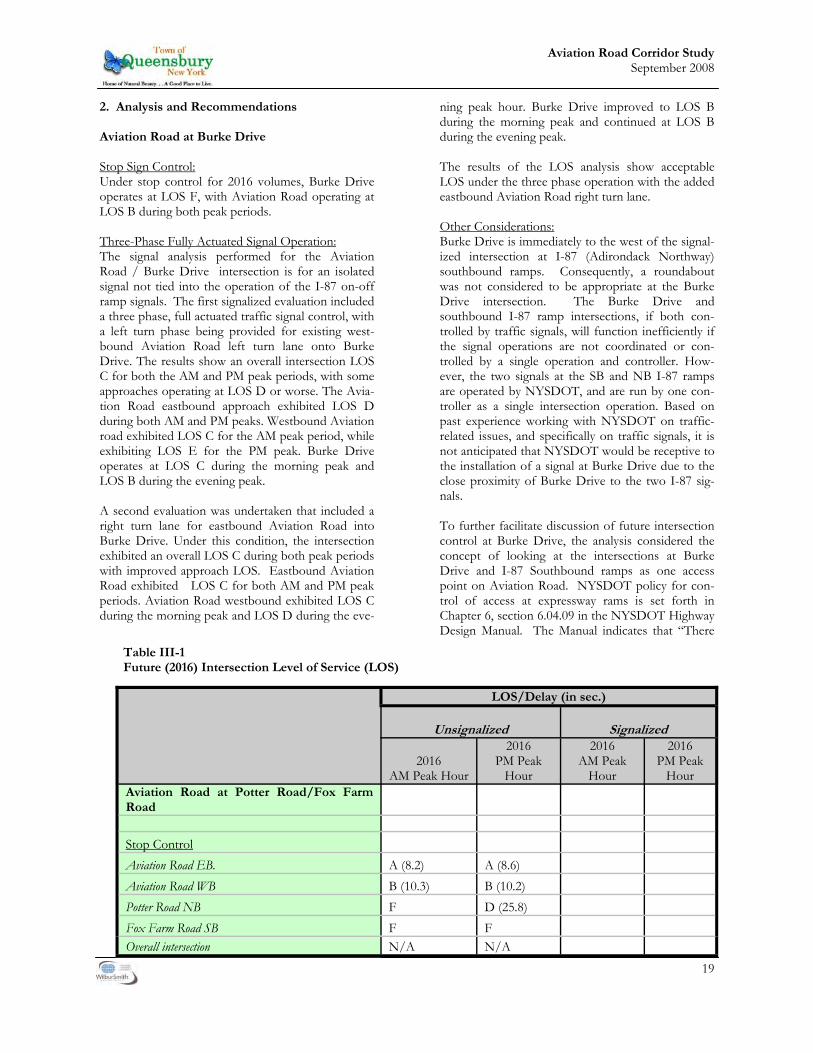
Table II-1 Comparison of AM, Midday and PM Two-way Peak Hour Traffic Volumes
Location
Existing (2006/2007) Peak Hour Traffic Vol-umes
AM Peak Hour
Midday Peak Hour
PM Peak Hour
Aviation Road West of Potter Road/Fox Farm Road 700 586 647 West of W. Mountain Road 7 30 26 W. Mountain Road * North of Aviation Road 164 211 236 South of Aviation Road 191 265 326 Mountain View Lane* North of Aviation Road 216 199 216 Potter Road South of Aviation Road 408 385 430 Fox Farm Road North of Aviation Road 35 28 46 Dixon Road South of Aviation Road 227 217 221 Farr Lane North of Aviation Road 74 67 104 Midnight Drive South of Aviation Road 76 64 68
Manor Drive
North of Aviation Road 52 84 94 Cottage Hill Road South of Aviation Road 182 116 166 Queensbury School Driveway North of Aviation Road 673 722 714 Burke Drive South of Aviation Road 266 300 355 I-87 SB On-off ramp South of Aviation Road 953 1020 1211 Aviation Road East of I-87 SB On-off ramp 1902 2053 2234 Source: Based on turning movement counts conducted on May 09, 2006. * Based on turning movements counts conducted March 23, 2007
10
Aviation Road Corridor Study September 2008
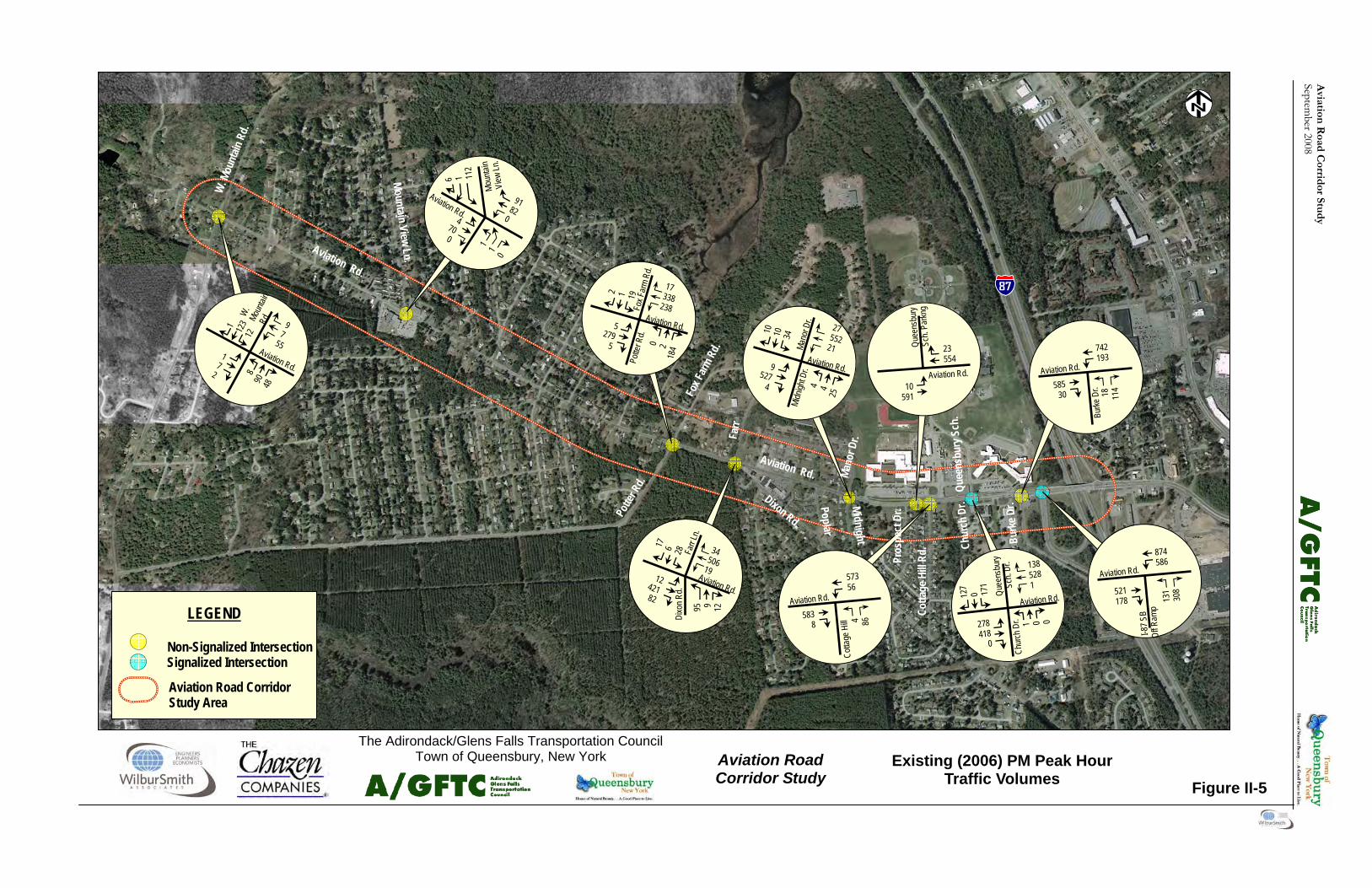
The existing (2006) two-way peak hour traffic vol-umes during the AM peak hour period on Aviation Road (West of Potter Road/Fox Farm Road), Potter Road, Dixon Road, Midnight Drive and Cottage Hill Road are higher than the Midday and PM peak hour periods. Queensbury School Drive experiences the highest volume during the Midday peak hour period. Fox Farm Road, Farr Lane, Manor Drive, Burke Drive, I-87 SB On-off ramp and Aviation Road (East of I-87 SB On-off ramp) experience the high-est volume during the PM peak hour period. In addition, Adirondack/Glens Falls Transportation Council provided Automatic Traffic Recorder (ATR) count data along Aviation Road. The ATR counts were conducted during the week of May 8 though May 12, 2006. The location of the count was near the signalized school access driveway. The Average Weekday Daily Traffic (AWDT) recorded on Avia-tion Road during that week was 11,833 vehicles per day. Capacity Analysis A study of capacity is important in determining the ability of a specific roadway, intersection, or freeway to accommodate traffic under various levels of ser-vice. Level of service (LOS) is a qualitative measure describing driver satisfaction with a number of fac-tors that influence the degree of traffic congestion. These factors include speed and travel time, traffic interruption, freedom of maneuverability, safety, driving comfort and convenience, and delay. In general there are six levels of service describing flow conditions. The highest, LOS A, describes a condition of free flow, with low volumes and high speeds. LOS B represents a stable traffic flow with operating speeds beginning to be restricted some-what by traffic conditions. LOS C, which is normally utilized for design purposes, describes a stable condi-tion of traffic operation. It entails moderately re-stricted movements due to higher traffic volumes, but traffic conditions are not objectionable to motor-ists. LOS D reflects a condition of more restrictive movements for motorists and influence of conges-tion becomes more noticeable. LOS E is representa-tive of the actual capacity of the roadway or intersec-tion and involves delay to all motorists due to con-gestion. The lowest, LOS F, is described as force flow and is characterized by volumes greater than the theoretical roadway capacity. Complete congestion occurs, and in extreme cases, the volume passing a given point drops to zero. This is considered as an unacceptable traffic operating condition.
For this analysis, level of service was performed for signalized and un-signalized intersections. The traffic analysis software Synchro 6 was used to determine the existing peak hour level of service at all the inter-sections along the analysis area. Tables II-2 and II-3 highlight the level of service criteria for signalized and un-signalized intersections respectively. The level of service criteria for signal-ized and un-signalized intersections is based on con-trol delay per vehicle measured in seconds. Level of service was determined for the study area intersections under existing (2006/2007) conditions during the weekday AM, Midday and PM peak hour conditions. The results of the analyses are presented in Table II-4 and Figures II-6, II-7, and II-8 for signalized intersections. There is queuing on Aviation Road and the School Drive during the drop-off times in the AM peak period. However, queuing occurs over a short period during the drop-off activity and does not carry over during the entire peak hour. The analysis reflects results over the peak hour period. Below is a list of findings from the level of service analysis of signalized intersections in the study area: Aviation Road and I-87 SB On-Off Ramp- This intersection operates at an overall LOS of C during the AM, Midday and PM peak hour periods. All ap-proaches of this intersection currently operate at LOS C during the AM, Midday and PM peak hour periods.
Table II-2: LOS Criteria for Signalized Intersections
LEVEL OF
SERVICE
CONTROL DELAY PER VEHICLE
(SECONDS) A ≤10 B >10 and ≤20 C >20 and ≤35 D >35 and ≤55 E >55 and ≤80 F > 80
Source: 2000 Highway Capacity Manual, Transportation Research Board

Aviation
Road C
orridor Stu
dy
September 2008
Aviation Road Corridor Study
The Adirondack/Glens Falls Transportation Council Figure II-6
Existing (2006) AM Peak Hour Level of Service

Avi
atio
n R
oad
Cor
rid
or S
tud
y Se
ptem
ber 2
008
Aviation
Road C
orridor Stu
dy
September 2008
Aviation Road Corridor Study
The Adirondack/Glens Falls Transportation Council Town of Queensbury, New York
Figure II-7
Existing (2006) Midday Peak Hour Level of Service
0 0
Burk
e Dr.
Quee
nsbu
ry S
ch. D
r.Ch
urch
Dr.
Cotta
ge H
ill Rd
.
Aviation Rd.
Farr
Ln.
Dixon Rd.Potte
r Rd.
Fox F
arm R
d.
Mano
r Dr.
Poplar Rd.
Midnight Dr. Pros
pect
Dr.
Mountain View Ln.
W. M
ount
ain R
d.Aviation Rd.
Non-Signalized IntersectionSignalized Intersection
LEGEND
Aviation Road CorridorStudy Area
Overall Intersection Level of Service
Non-Signalized IntersectionSignalized Intersection
LEGEND
Aviation Road CorridorStudy Area
Overall Intersection Level of ServiceOverall Intersection Level of Service
Non-Signalized Intersection
Signalized Intersection
LEGEND
Aviation Road CorridorStudy Area
Overall Intersection Level of Service
Non-Signalized Intersection
Signalized Intersection
LEGEND
Aviation Road CorridorStudy Area
Overall Intersection Level of Service
Overall Intersection Level of Service
Note: Overall LOS is not calculated for unsignalized intersections.

Avi
atio
n R
oad
Cor
rid
or S
tud
y Se
ptem
ber 2
008
Aviation
Road C
orridor Stu
dy
September 2008
Aviation Road Corridor Study
The Adirondack/Glens Falls Transportation Council Town of Queensbury, New York
Figure II-8
Existing (2006) PM Peak Hour Level of Service
Burk
e Dr.
Quee
nsbu
ry S
ch. D
r.Ch
urch
Dr.
Cotta
ge H
ill Rd
.
Aviation Rd.
Farr
Ln.
Dixon Rd.Potte
r Rd.
Fox F
arm R
d.
Mano
r Dr.
Poplar Rd.
Midnight Dr. Pros
pect
Dr.
Mountain View Ln.
W. M
ount
ain R
d.
Aviation Rd.
Non-Signalized IntersectionSignalized Intersection
LEGEND
Aviation Road CorridorStudy Area
Overall Intersection Level of Service
Non-Signalized IntersectionSignalized Intersection
LEGEND
Aviation Road CorridorStudy Area
Overall Intersection Level of ServiceOverall Intersection Level of Service
Non-Signalized Intersection
Signalized Intersection
LEGEND
Aviation Road CorridorStudy Area
Overall Intersection Level of Service
Non-Signalized Intersection
Signalized Intersection
LEGEND
Aviation Road CorridorStudy Area
Overall Intersection Level of Service
Overall Intersection Level of Service
Note: Overall LOS is not calculated for unsignalized intersections.

Avi
atio
n R
oad
Cor
rid
or S
tud
y Se
ptem
ber 2
008

11
Aviation Road Corridor Study September 2008
proaches operate at LOS B during the AM, Mid-day and PM peak hour periods.
• Aviation Road and Mountain View Lane/
School Driveway - The left turn movements on Aviation Road currently operate at LOS A dur-ing the AM, Midday and PM peak hour periods. The side-street approaches operate at LOS B during the AM, Midday and PM peak hour peri-ods.
• Aviation Road and Potter Road/Fox Farm
Road- The southbound approach of Fox Farm Road operates at LOS F during the AM and PM peak hour periods and at LOS E during the Midday peak hour period. All other approaches operate at LOS C or better during the AM, Mid-day and PM peak hour periods.
• Aviation Road and Dixon Road/Farr Lane- The
northbound approach of Dixon Road operates at LOS E and LOS F during the AM and PM peak hour periods and LOS D during the Mid-day peak hour. The southbound approach of Farr Lane operates at LOS E during the AM peak hour period. During the Midday and PM peak hour periods it operates at LOS D or bet-ter. All approaches of Aviation Road currently operate at LOS A during the AM, Midday and PM peak hour periods.
Aviation Road and Queensbury School Drive/ Church Driveway- This intersection operates at LOS C or better during the AM, Midday and PM peak hour periods. All approaches of this intersection currently operate at LOS C or better during the AM, Midday and PM peak hour periods. The results of the analyses are presented in Table II-5 and Figures II-6, II-7, and I-8 for unsignalized intersections. Below is a list of findings from the level of service analysis of unsignalized intersections in the analysis area: • Aviation Road and West Mountain Road - The
left turn movements on Aviation Road currently operate at LOS B during the AM, Midday and PM peak hour periods. The side-street ap-
Table II-3: LOS Criteria for Unsignalized Intersections
LEVEL OF
SERVICE
CONTROL DELAY PER VEHICLE
(SECONDS) A ≤10 B >10 and ≤15 C >15 and ≤25 D >25 and ≤35 E >35 and ≤50 F > 50
Source: 2000 Highway Capacity Manual, Transportation Research Board
Table II-4 Existing (2006) Level of Service for Signalized Intersections
Location Existing (2006) LOS/Delay (in sec.)
AM Peak Hour
Midday Peak Hour
PM Peak Hour
Signalized Aviation Road at I-87 SB On-Off ramp C (25.1) C (27.0) C (26.7) Aviation Road E.B. C (26.4) C (34.9) C (26.3) Aviation Road W.B. C (23.4) C (21.8) C (26.9) I-87 SB Off ramp N.B. C (26.5) C (26.6) C (26.5) Aviation Road at Queensbury School Drive/Church Driveway C (20.3) B (19.0) B (17.8) Aviation Road E.B. A (9.9) A (8.2) B (11.8) Aviation Road W.B. C (28.8) C (21.4) C (23.8) Church Driveway N.B. B (19.0) B (15.4) B (17.5) Queensbury School Drive S.B. C (26.3) C (25.4) B (19.9) Source: Wilbur Smith Associates

12
Aviation Road Corridor Study September 2008
Table II-5 Existing (2006/2007) Level of Service for Unsignalized Intersections
Location
Existing (2006/2007) LOS/Delay (in sec.)
AM Peak Hour
Midday Peak Hour
PM Peak Hour
Unsignalized Aviation Road at W. Mountain Road Left turn on W. Mountain Road N.B. B (10.2) B (10.3) B (10.6) Left turn on W. Mountain Road S.B. B (10.1) B (11.9) B (11.1) Aviation Road E.B. B (10.1) B (13.4) B (12.5) Aviation Road W.B. B (10.3) B (12.6) B (11.3) Aviation Road at Mountain View Ln./School Drive Left turn on Aviation Road E.B. A(7.5) A(7.6) A(7.6) Left turn on Aviation Road W.B. A(7.4) A(7.4) A(7.4) School Drive N.B. B(10.3) B(10.3) B(10.6) Mountain View Ln. S.B. B(11.7) B(11.9) B(11.1) Aviation Road at Potter Road/Fox Farm Road Left turn on Aviation Road E.B. A (7.7) A (8.0) A (8.1) Left turn on Aviation Road W.B. A (9.0) A (8.5) A (8.7) Potter Road N.B. C (20.6) B (11.9) B (12.6) Fox Farm Road S.B. F (65.1) E (37.7) F (72.9) Aviation Road at Dixon Road/Farr Lane Left turn on Aviation Road E.B. A (8.0) A (8.6) A (8.7) Left turn on Aviation Road W.B. A (9.7) A (8.3) A (8.7) Dixon Road N.B. E (41.9) D (29.6) F (77.2) Farr Lane S.B. E (36.5) C (23.9) D (28.7) Aviation Road at Midnight Drive/Manor Drive Left turn on Aviation Road E.B. A (8.2) A (8.9) A (8.7) Left turn on Aviation Road W.B. A (9.6) A (8.3) A (8.6) Midnight Drive N.B. C (19.5) B (14.9) C (17.2) Manor Drive S.B. F (51.3) E (36.0) E (38.2) Aviation Road at School Parking Driveway Left turn on Aviation Road E.B. A (9.3) A (9.1) A (9.0) Aviation Road at Cottage Hill Road Left turn on Aviation Road W.B. A (9.7) A (8.7) A (9.1) Cottage Hill Road N.B. D (28.1) B (14.8) C (17.0) Aviation Road at Burke Drive Left turn on Aviation Road W.B. B (10.4) B (10.3) B (10.4) Burke Drive N.B. F (97.8) F (50.7) F (264.0)
13
Aviation Road Corridor Study September 2008
• Aviation Road and Midnight Drive/Manor Drive- The southbound approach of Manor Drive operates at LOS E or worse during the AM, Midday and PM peak hour periods. All other approaches operate at LOS C or better during the AM, Midday and PM peak hour peri-ods.
• Aviation Road and School Parking Driveway-
The eastbound left turn movement on Aviation Road into the School Parking driveway currently operates at LOS A during the AM, Midday and PM peak hour periods.
• Aviation Road and Cottage Hill Road - The
Aviation Road westbound left turn at this inter-section currently operate at LOS A, while the Cottage Hill Road approach currently operates at LOS D or better during the AM, Midday and PM peak hour periods. Because through traffic does not have a stop sign, it was not evaluated
• Aviation Road and Burke Drive - The
northbound approach of Burke Drive currently operates at LOS F during the AM, Midday and PM peak hour periods. The left turn movement on the westbound approach of Aviation Road currently operates at LOS B during the AM, Midday and PM peak hour periods.
D. SAFETY 1. Crash Data Overview Crash data for Aviation Road for the five-year period from January 2000 to December 2005 provides valu-able information about the relative safety of the cor-ridor and the intersections, especially as related to other similar corridors and intersections around the State of New York.
The accident analysis considers six separate sections within the study area: • Segment 1 – West Mountain Rd/Butler Pond Rd to Mountain View Lane intersection; • Segment 2 – Mountain View Lane to Fox Farm Road/Potter Road intersection; • Segment 3 – Fox Farm Road/Potter Road to Dixon Road/Farr Lane intersection; • Segment 4 – Dixon Road/Farr Lane to Mid- night Drive/Manor Drive intersection; • Segment 5 – Midnight Drive/Manor Drive to Cottage Hill Road intersection; and • Segment 6 – Cottage Hill Road to Burke Drive
intersection. No analyses were completed for the portions of Aviation Road east of Burke Drive or west of West Mountain Road. The accident data includes non-reportable accidents, with some limited information available for these types. Appendix A provides more information on specific accident descriptions and collision diagrams. Segment 1 Segment 1, West Mountain Rd/Butler Pond Road to the Mountain View Lane intersection, was the scene of fifteen accidents during the five-year analy-sis period. Thirteen of these accidents occurred at the intersection of West Mountain Road with Avia-tion Road. This intersection was on the High Risk Rural Roads Accident Summary sent to NYSDOT Region 1 in November 2006. It was determined that drivers may find it difficult to judge the speed of approaching traffic on West Mountain Road when at a stop sign on Aviation Road. The accident rate for the West Mountain Road / Butler Road intersec-tion is 1.86 accidents per million entering vehicles (acc/MEV) compared to the expected statewide rate of 0.27 acc/MEV for similar facilities. This is 6.9 times the expected rate and may be caused by the difficulty in judging vehicle speed when turning onto West Mountain Road. The severity distribution of the accidents is normal. The accident rate for the Mountain View Lane inter-section is 0.14 acc/MEV compared to the expected statewide rate of 0.16 acc/MEV for similar facilities. A cluster of right-angle accidents is evident on this segment with eight of the fifteen total accidents in-volving right angle or left turns. Aviation Road/Burke Drive Intersection

14
Aviation Road Corridor Study September 2008
Segment 2 This segment, Mountain View Lane to the Fox Farm Road/Potter Road intersection, was the scene of 29 accidents for the five-year analysis period. Fifteen of those accidents were directly related to the intersec-tion of Fox Farm Road / Potter Road intersection with Aviation Road. A cluster of right-angle acci-dents were found in this segment with six located at the intersection and three related to the roadway to the west. The accident rate for the Fox Farm Road / Potter Road intersection with Aviation Road is 0.67 acc/MEV compared to the expected statewide rate of 0.27 acc/MEV for similar facilities. The accidents do not reveal any other significant patterns except that the accident rate is high for this location. The severity distribution of the accidents is normal. Segment 3 Ten accidents occurred in Segment 3, Fox Farm Road/Potter Road to the Dixon Road/Farr Lane intersection, seven of which were attributed to the Dixon Road/Farr Lane intersection, for the five-year analysis period. The accidents occur for a variety of reasons, with no one reason clearly standing out. The accident rate for the Dixon Road/Farr Lane intersec-tion with Aviation Road is 0.28 acc/MEV compared to the statewide expected rate of 0.27 acc/MEV for a four leg intersection with two-way stop control. The severity distribution of the accidents along this segment is normal. Five of the ten accidents were rear-end accidents of varying contributing factors. Segment 4 Segment 4, Dixon Road/Farr Lane to the Midnight Drive/Manor Drive intersection, was the scene of eighteen accidents. The accident rate for the Mid-night Drive/Manor Drive intersection with Aviation Road is 0.24 acc/MEV compared to the statewide expected rate of 0.27 acc/MEV for similar facilities. Six of eighteen accidents within the segment oc-curred at this intersection. Two of the accidents, one of which was at the intersection, involved bicyclists. Accident history shows the occurrence of six rear-end crashes, with four related to the linear portion of the segment west of the intersection and one at the intersection. Each of these occurred while a vehicle was stopped in traffic and struck from behind, and all of these accidents involved vehicles traveling east-bound on Aviation Road. Time of day does not ap-pear to be a contributing factor. The severity distri-bution of the accidents is normal.
Segment 5 Twelve accidents occurred in Segment 5, Midnight Drive/Manor Drive to the Cottage Hill Road inter-section, in the five year analysis period. Four of these were related to the intersection of Cottage Hill Road and Aviation Road. The accident rate for the intersection, 0.15 acc/MEV, was slightly less than the statewide expected rate for similar intersections of 0.16 acc/MEV. Four of the twelve crashes on this segment were rear-end types, all of which occurred while a vehicle was stopped in traffic and struck from behind. Three of these occurred while vehicles were traveling east on Aviation Road. The severity distribution of the accidents is normal. Segment 6 During the five-year analysis period, twenty one crashes occurred in Segment 6, Cottage Hill Road to the Burke Drive intersection. The accident rate for the Burke Drive intersection is 0.32 acc/MEV, slightly higher than the statewide expected rate of 0.29 acc/MEV for similar facilities. One of the acci-dents west of the intersection involved a bicyclist. Rear-end collisions are again the most predominant type of crash in this segment, but only one occurred at the intersection. The severity distribution of the accidents is normal. Accident Analysis The overall study area has a high number of rear-end, left turn and right angle accidents. Reviewing the accident descriptions revealed that many of the rear end accidents occurred while one vehicle was stopped in traffic, either turning or waiting for an-other vehicle to turn. The presence and close prox-imity of driveways, both commercial and residential, is a contributing factor to the number of rear end, left turn and right angle accidents. The accident rates for three of the six intersections were below the expected statewide averages. Two of the other intersections are considered high accident locations, and the remaining intersection is at ap-proximately the expected average rate. The West Mountain Road / Butler Pond Road intersection with Aviation Road accident rate of 1.86 acc/MEV is 6.9 times the expected statewide rate of 0.27 acc/MEV for similar facilities. The accident rate at the Fox Farm Road / Potter Road intersection with Aviation is 0.67 acc/MEV, which is 2.5 times the expected statewide rate of 0.27 acc/MEV. Both of these are four-way intersections with two-way stop control. The Burke Drive intersection with Aviation Road accident rate is 0.32 acc/MEV, which is just
15
Aviation Road Corridor Study September 2008
above the expected statewide rate of 0.29 acc/MEV for three-leg intersections with left turn lanes and five or more lanes under signal control. Pedestrians were not involved in the accidents re-ported during the five-year study period. Three of the ninety-two total accidents involved bicycles. One of the bicycle accidents occurred due to the bicyclist crossing Aviation Road at an unexpected location and not waiting for an appropriate gap in the traffic to cross. The other two accidents were the result of the bicycle traveling on the wrong side of the road and the drivers’ failure to notice the bicyclist. 2. Bicycle Facilities Portions of the Aviation Road Corridor have very wide shoulders that can easily accommodate bicy-clists. However, there are other portions, notably in front of the western portion of the school campus and along the modular homes adjacent to Mountain View Lane, where bicycling space is very limited. In these locations, the width of the paved shoulder is six inches and one foot or less, respectively. There are no shared use paths in the Aviation Road Corri-dor to accommodate bicyclists off-road. 3. Pedestrian Facilities Sidewalks in front of the school campus provide space for pedestrians that is separated from vehicular traffic lanes. Connections to other pedestrian facili-ties off-campus are limited to the crosswalk connec-tion to the sidewalk along Burke Drive. West of the campus area, pedestrians must walk in the grass adja-cent to the roadway or along the shoulder of the road. Even with a minimum paved shoulder width of three feet for the rest of the Study Area, this is not a particularly safe situation for pedestrians. E. UTILITIES Aviation Road has storm drains along both sides of the road. The inlets are typically several feet away from the current travel lanes. Municipal water lines service the properties along Aviation Road in the Study Area; the pipes lie in the Aviation Road right-of-way. Overhead utility poles line the south side of the roadway along the entire length of Aviation Road within the Study Area. Utility poles also line the north side of the road from Dixon Road to West Mountain Road. The poles are situated variable dis-tances off the edge of pavement, ranging from one- to twelve-feet away. A large phone switching center
sits in the southwest corner of the Aviation Road/Dixon Road/Manor Drive intersection and a con-crete utility building lies at the edge of the paved shoulder just west of the Prospect School western entrance. Fire hydrants are located at varying dis-tances from Aviation Road along the north side at several intersections. F. LAND USE AND ZONING Aviation Road in the Study Area supports a mix of land uses; Figure II-9 shows the land use in the Study Area. At the eastern end, the largest single land use is the School District Campus, which in-cludes a grade school on the northern portions of the parcel, a middle school close to Aviation Road on the east side of the campus, and the high school, which is situated close to Aviation Road on the west side of the campus. Parking lots lie between both secondary schools and the roadway itself. Two churches lie across the street east of the central sig-nalized entrance to the Campus. Single family resi-dences lie west of this intersection between the inter-section itself and a State Police headquarters oppo-site the western exit from the High School parking lot. Beyond the school and the State Police barracks westward to Poplar Lane are single and two-family residential units. West of Poplar Lane, the land uses switch to small offices on the south side and com-mercial uses of single family residential structures and a church on the north side. These uses transi-tion to retail commercial on the south side of the street further to the west to Dixon Road and mixed commercial uses on the north side of the road to Manor Drive. Single and two family residences line Aviation Road from Farr Lane to Fox Farm Road on the north; a forested area lines the south side of the road between Dixon and Potter Roads. West of Potter Road and Fox Farm Road, the land use is almost entirely single family until reaching just west of Crownwood Lane where the Prospect School, Child and Family Center and fire house are grouped together as a public ser-vice land use node. Just west of the Prospect School western entrance on the south side of Aviation Road is a concrete utility building. West of the Child and Family Center on the north side and the concrete utility building on the south side, the land use returns to single family residences to West Mountain Road.

16
Aviation Road Corridor Study September 2008
This Page Intentionally Left Blank

Aviation
Road C
orridor Stu
dy
September 2008
Aviation Road Corridor Study
The Adirondack/Glens Falls Transportation Council Town of Queensbury, New York
Figure II-9
Existing Land Use

Avi
atio
n R
oad
Cor
rid
or S
tud
y Se
ptem
ber 2
008
Aviation
Road C
orridor Stu
dy
September 2008
Aviation Road Corridor Study
The Adirondack/Glens Falls Transportation Council Town of Queensbury, New York
Figure III-1
Existing Zoning Districts

Avi
atio
n R
oad
Cor
rid
or S
tud
y Se
ptem
ber 2
008

17
Aviation Road Corridor Study September 2008
G. ENVIRONMENTAL AND CULTURAL RESOURCES There are minimal natural resources of concern in the Study Area. There is a large forested parcel within the study area that is a City of Glens Falls watershed property. There are no significant State or Federal wetlands with the Study Area, nor are there significant waterbodies, watercourses or steep slopes. Western Queensbury contains rare species such as the Karner Blue and Frosted Elfin butterflies as well as unique ecological communities. Locations of these natural resources, although not occurring di-rectly within the immediate corridor area, should be taken into account as access modifications to Avia-tion Road are considered. There are no historic re-sources, or structures or neighborhoods listed on or eligible to be listed on the National Register of His-toric Places. H. TRANSIT The Greater Glens Falls Transit (GGFT) provides fixed route and paratransit public transportation services in the greater Glens Falls area (Figure I-10). GGFT currently operates Routes 11 and 12 along Aviation Road. Both routes begin northbound ser-vice at Ridge Street Terminal in Glens Falls. Route 11 operates hourly along Glen Street (Rt 9) to Wal-Mart, with most routes turning onto Aviation Road to terminate at Aviation Mall. Route 12 also operates hourly along Glen Street (Rt 9) turning onto Avia-tion Road to service the John Burke apartments within the Study Area. Routes 11 and 12 operate from 6:30 AM until 6:00 PM on weekdays and com-bine to provide half-hourly service. Saturday sched-ules operate a similar level of service. The fare on all GGFT fixed route services is $1.00 per trip. GGFT previously provided on-demand services along Aviation Road beyond Burke Drive, but it was discontinued for lack of use.
I. OTHER EXISTING CONDITIONS Numerous signs line both sides of the roadway with no particular organization or common design to make comprehension easier. Mailboxes are also com-mon along Aviation Road, especially west of Potter Road/Fox Farm Road. Appendix B includes several images of the corridor showing the different types of signage currently posted with the Aviation Road Corridor. J. CONCLUSION The analysis of existing conditions on Aviation Road reveals several issues that should be addressed as part of future plans for the corridor, including: • Lack of turning lanes at roadways and heavily
used driveways; • Lack of adequate shoulders for bicycle use, • A disjointed sidewalk system; • High crash rates at the intersections of Aviation
Road with Fox Farm/Potter Roads and West Mountain Road;
• Alignment / LOS of the Aviation/Dixon/Farr Lane intersection;
• Minimal transit services or facilities; and • Failing or near failing levels of service on nu-
merous approaches to several intersections. Additionally, proposed changes relating to the access to the school campus, shown in Appendix C, may also impact future operations of this portion of Avia-tion Road.
Sidewalk segments properly required by the Town to be installed with newer development along Aviation Road contribute to the develop-ment of a complete sidewalk system
18
Aviation Road Corridor Study September 2008
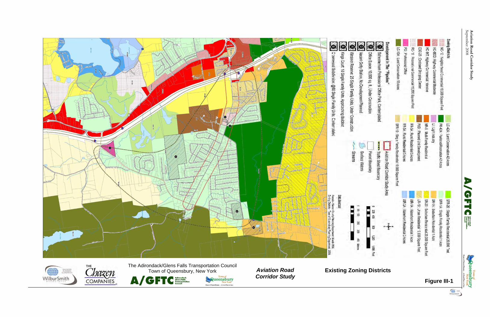
III. MANAGING FUTURE VEHICULAR, PEDESTRIAN
AND BICYCLE TRAFFIC A. FUTURE GROWTH AREAS In order to establish estimates of future traffic levels on Aviation Road, the study team examined the cur-rent traffic patterns and established the “traffic-shed” for Aviation Road. This is the area that can be expected to contribute traffic to Aviation Road on a regular basis. Figure III-1 shows the existing zon-ing in the corridor with the “traffic-shed” overlain. Figure III-1 also highlights proposed development that is being considered within the study area. The Study Team projected traffic volumes into the future using a standard growth rate, with the addition of additional traffic expected to be generated by the proposed developments, based on their size and land use. Figures III-2 and III-3 shows the future traf-fic projections for the corridor. These projections were advanced through 2016, the year selected as the ending date for the projections. The 2016 traffic projections became the basis of the future intersec-tion alternatives analysis presented in Section III. The LOS for the No Action condition projected to 2016 is included in Table III-1. It is combined with the future analysis of different future alternatives so that it is easy to compare the various options. These numbers were also used for the 2016 roundabout alternatives analysis, which Table III-3 presents. B. INTERSECTIONS 1. Overview As vehicular traffic continues to grow on Aviation Road, congestion at intersections will increase. There are several options that can be pursued to address this increase, including: • Adding additional traffic through and turn lanes at the intersections; • Adding stops signs; • Adding signals; or • Constructing roundabouts. Not all of these options are available or appropriate at each intersection. Warrants for either a stop sign or traffic signal must be met before these options can be exercised at an intersection. The addition of through or turning lanes at intersections is also, for
most cases, only acceptable on Aviation Road when used in conjunction with a stop sign or traffic signal. This section of the report describes the alternatives that were considered for each intersection and seg-ment. It then examines which options are appropri-ate for each intersection to address future conditions projected for 2016. It explores how the viable op-tions may change the future operations at the Avia-tion Road intersections under consideration. Table III-2 summarizes the different alternatives consid-ered for each intersection and segment. Figures III-4, III-5, III-6, and III-7 show the general loca-tion of the proposed roadway improvements along Aviation Road. Appendix D contains a more de-tailed discussion of the development of the various alternatives. The intersection analysis used the following parame-ters in the evaluation of traffic signals at the intersec-tions along the Aviation Road Corridor: • The traffic signals will operate in accordance to
the New York State Manual of Uniform Traffic Control Devices;
• The signals will be fully actuated signals, with all intersection approaches having vehicle detec-tion, consistent with NYSDOT policy;
• Signal phasing will provide one phase for Avia-tion Road traffic and one phase for side road traffic (a two phase operation) unless intersec-tion geometry or heavy conflicting vehicle movements indicate the need for analysis of additional phasing;
• Left turns will be allowed during the regular green phase for each roadway section;
• If exclusive left turn signaling is appropriate, based on the initial signalized analysis, left turns will also be allowed during the normal green phase; and
• Signal timing will be consistent with existing timing parameters, modified when required to accommodate additional signal operational phases.
The roundabout analysis assumed that each round-about would have only a single lane and a single ap-proach lane in each direction. Table III-3 provides a summary of the analysis.

Aviation
Road C
orridor Stu
dy
September 2008
Aviation Road Corridor Study
The Adirondack/Glens Falls Transportation Council Town of Queensbury, New York
Figure III-2
Future (2016) AM Peak Hour Traffic Volumes
15
8 237
5 131 1
Aviation Rd.
Moun
tain
View
Ln.
158 82 1
12 1 40
1 45
6
1 2
2 1 13
9 91
Aviation Rd.
Burk
e
Quee
nsbu
ry S
ch.
Chur
ch D
r.
Cotta
ge H
ill Rd
.
Aviation Rd.
Farr
Ln.
Dixon Rd. Potte
r Rd.
Fox F
arm R
d.
Mano
r Dr.
Poplar
Midnight
Pros
pect
Dr.
Mountain View Ln.
W. M
ount
ain R
d. Aviation Rd.
Non-Signalized Inter-section Signalized Intersection
LEGEND
Aviation Road Corridor
26
162
979 78
961 59
Burke
Dr.
Aviation Rd.
133
436
914 354
765 359
Aviation Rd.
I-87 S
B
Off R
amp
158
1 212
295 858
11
8 1 12
Aviation Rd. Quee
nsbu
ry
Sch.
Dr.
Chur
ch D
r. 15
165
707 37
998 6
Cotta
ge H
ill Rd
. Aviation Rd.
184 1004
182 539
Aviation Rd.
Quee
nsbu
ry
Scho
ol Pk
ng.
16 578
29
5 10
27
4 894
1 4 2 46
Aviation Rd.
Mano
r Dr.
Midn
ight D
r.
Fox F
arm
Rd.
7 387
155
7 2 20
2 682
1
1 4 35
1
Aviation Rd.
Potte
r Rd.
Farr
Ln.
Aviation Rd.
18 501 23
7 16
37
61 1 20
11 915 156
Dixo
n Rd.
1 0 0
Includes the following back-ground projects
•Professional Office Park •Office Space •Vacant Getty Station •Western Reserve Single Family •Kings Court Single Family •Crownwood Subdivision •Dunkin’ Donuts Restaurant
Note:
West
Moun
tain
Rd.
155 601 8

Avi
atio
n R
oad
Cor
rid
or S
tud
y Se
ptem
ber 2
008

Aviation
Road C
orridor Stu
dy
September 2008
Aviation Road Corridor Study
The Adirondack/Glens Falls Transportation Council Town of Queensbury, New York
Figure III-3 Future (2016) PM Peak Hour
Traffic Volumes
7 1 221
5 125 0
Aviation Rd.
Moun
tain
View
Ln.
181 125 0
16 8 87
1 150
25
1 8
2 10
110
88
Aviation Rd.
Burk
e
Quee
nsbu
ry S
ch.
Chur
ch
Cotta
ge H
ill
Aviation
Farr
Ln.
Dixon Potte
r Rd.
Fox F
arm
Mano
r Dr.
Poplar
Midnight
Pros
pect
Mountain View Ln.
W. M
ount
ain R
d. Aviation Rd.
22
139
1029 235
853 37
Burke
Dr.
Aviation Rd.
131
308
1140 714
720 272
Aviation Rd.
I-87 S
B
Off R
amp
168 769 1
155
1 208
339 650
1
1 1 1
Aviation Rd. Quee
nsbu
ry
Sch.
Dr.
Chur
ch D
r. 5 11
9
818 68
856 10
Cotta
ge H
ill Rd
. Aviation Rd.
12 865
28 795
Aviation Rd.
Quee
nsbu
ry
Scho
ol Pk
ng.
33 793
26
12
12
41
11 787
5 5 5 30
Aviation Rd.
Mano
r Dr.
Midn
ight D
r.
Fox F
arm
Rd.
21 507
310
2 1 23
6 487
6 1 2 23
9
Aviation Rd.
Potte
r Rd.
Farr
Ln.
Aviation Rd.
41 732 23
21
7 32
115 11
15
15 661 100
Dixo
n Rd.
1 1 0
Non-Signalized Inter-section
LEGEND
Aviation Road Corridor Study Area
Includes the following background projects
•Professional Office Park •Office Space •Vacant Getty Station •Western Reserve Single Family •Kings Court Single Family •Crownwood Subdivision •Dunkin’ Donuts Restaurant
West
Mounta
in Rd

Avi
atio
n R
oad
Cor
rid
or S
tud
y Se
ptem
ber 2
008
Aviation
Road C
orridor Stu
dy
September 2008
Aviation Road Corridor Study
The Adirondack/Glens Falls Transportation Council Town of Queensbury, New York
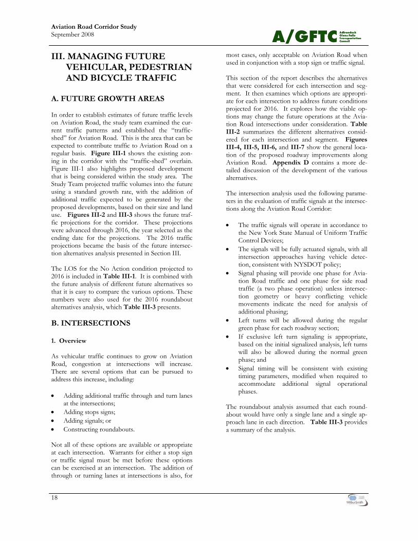
Figure III-4
Roadway Improvements Segment 1

Avi
atio
n R
oad
Cor
rid
or S
tud
y Se
ptem
ber 2
008
Aviation
Road C
orridor Stu
dy
September 2008
Aviation Road Corridor Study
The Adirondack/Glens Falls Transportation Council Town of Queensbury, New York
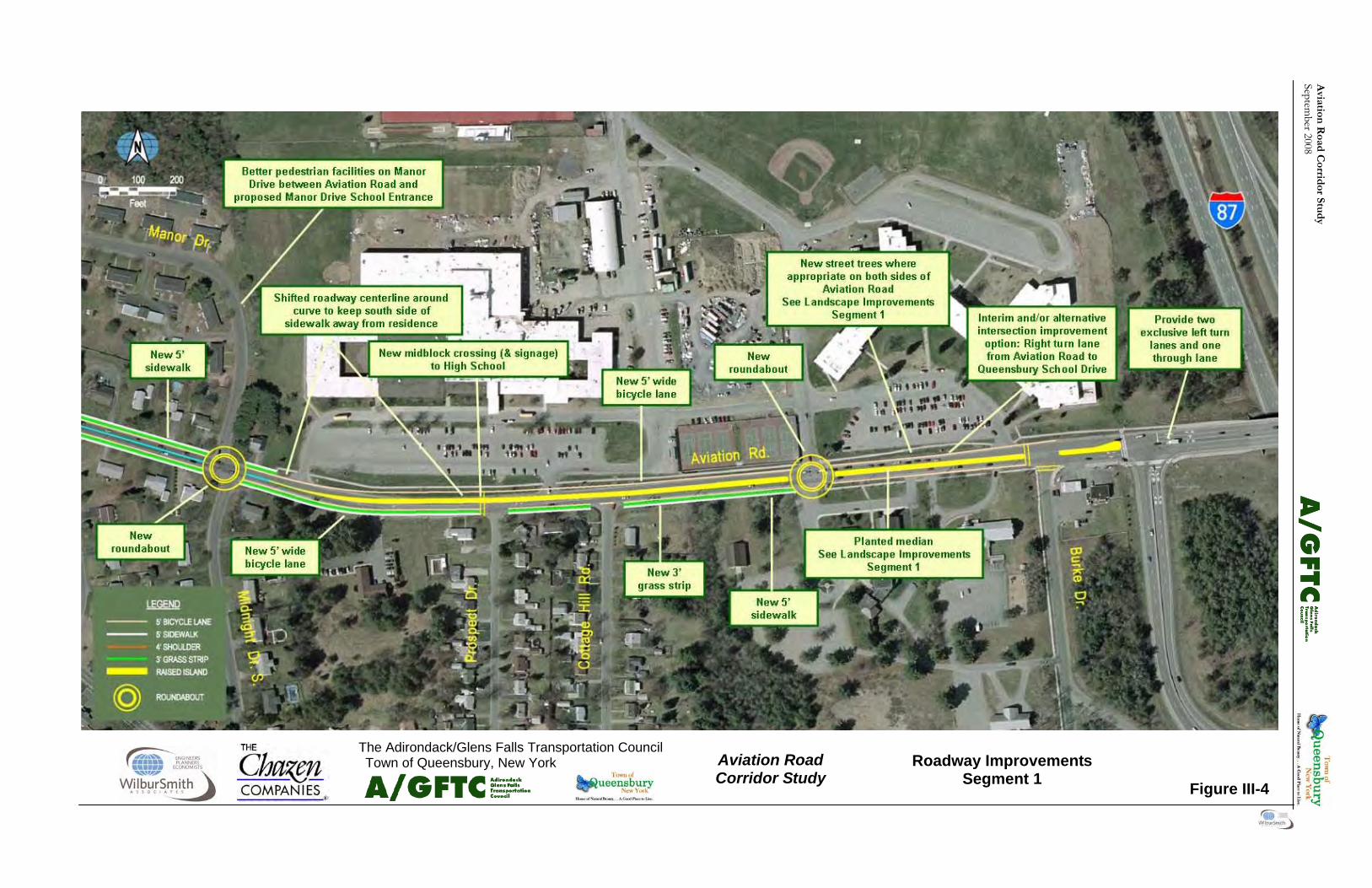
Figure III-5
Roadway Improvements Segment 2

Avi
atio
n R
oad
Cor
rid
or S
tud
y Se
ptem
ber 2
008

Aviation
Road C
orridor Stu
dy
September 2008
Aviation Road Corridor Study
The Adirondack/Glens Falls Transportation Council
Figure III-6
Roadway Improvements Segment 3

Avi
atio
n R
oad
Cor
rid
or S
tud
y Se
ptem
ber 2
008
Aviation
Road C
orridor Stu
dy
September 2008
Aviation Road Corridor Study
The Adirondack/Glens Falls Transportation Council Town of Queensbury, New York
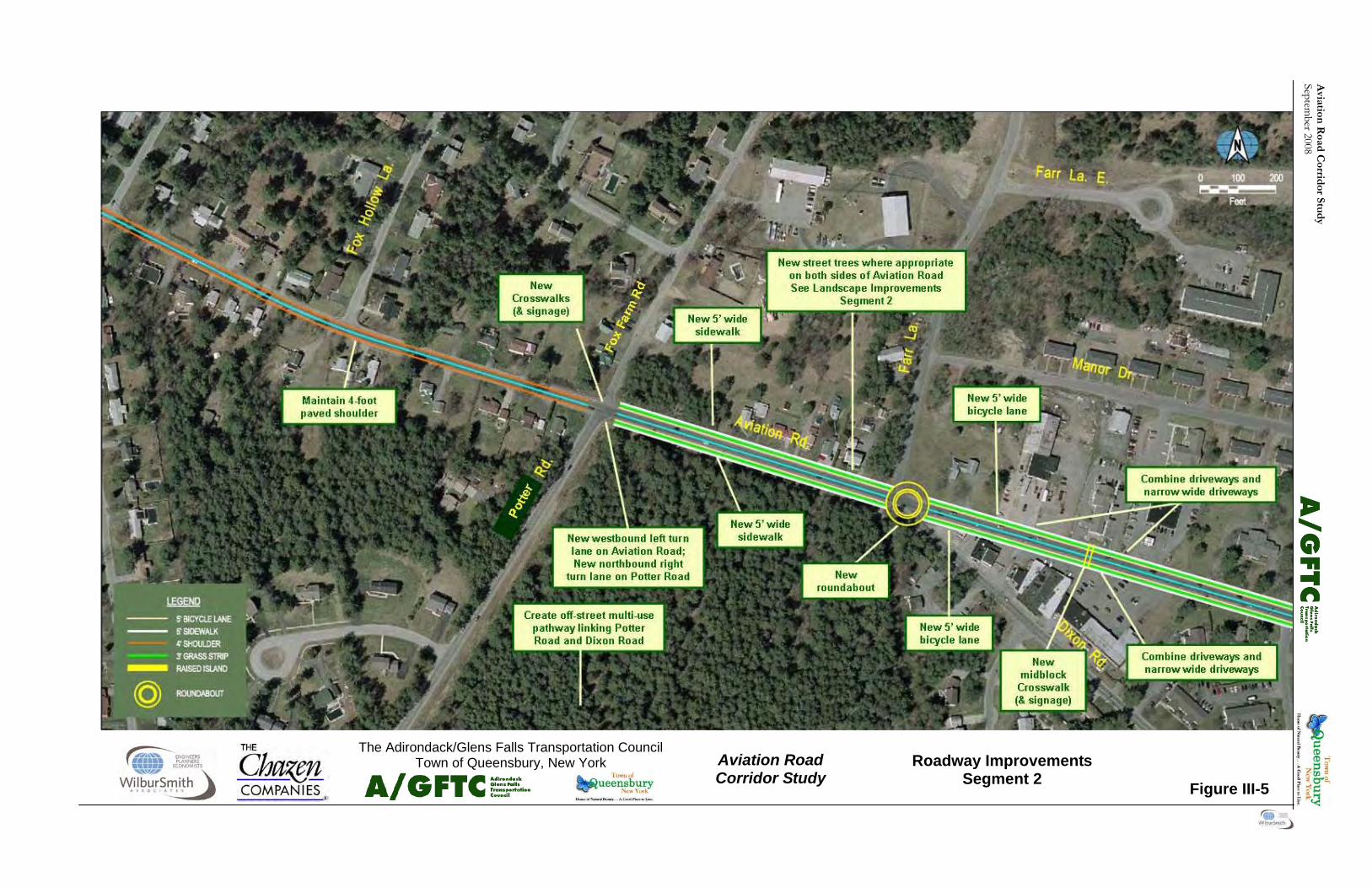
Figure III-7
Roadway Improvements Segment 4

Avi
atio
n R
oad
Cor
rid
or S
tud
y Se
ptem
ber 2
008
19
Aviation Road Corridor Study September 2008
2. Analysis and Recommendations Aviation Road at Burke Drive Stop Sign Control: Under stop control for 2016 volumes, Burke Drive operates at LOS F, with Aviation Road operating at LOS B during both peak periods. Three-Phase Fully Actuated Signal Operation: The signal analysis performed for the Aviation Road / Burke Drive intersection is for an isolated signal not tied into the operation of the I-87 on-off ramp signals. The first signalized evaluation included a three phase, full actuated traffic signal control, with a left turn phase being provided for existing west-bound Aviation Road left turn lane onto Burke Drive. The results show an overall intersection LOS C for both the AM and PM peak periods, with some approaches operating at LOS D or worse. The Avia-tion Road eastbound approach exhibited LOS D during both AM and PM peaks. Westbound Aviation road exhibited LOS C for the AM peak period, while exhibiting LOS E for the PM peak. Burke Drive operates at LOS C during the morning peak and LOS B during the evening peak. A second evaluation was undertaken that included a right turn lane for eastbound Aviation Road into Burke Drive. Under this condition, the intersection exhibited an overall LOS C during both peak periods with improved approach LOS. Eastbound Aviation Road exhibited LOS C for both AM and PM peak periods. Aviation Road westbound exhibited LOS C during the morning peak and LOS D during the eve-
ning peak hour. Burke Drive improved to LOS B during the morning peak and continued at LOS B during the evening peak. The results of the LOS analysis show acceptable LOS under the three phase operation with the added eastbound Aviation Road right turn lane. Other Considerations: Burke Drive is immediately to the west of the signal-ized intersection at I-87 (Adirondack Northway) southbound ramps. Consequently, a roundabout was not considered to be appropriate at the Burke Drive intersection. The Burke Drive and southbound I-87 ramp intersections, if both con-trolled by traffic signals, will function inefficiently if the signal operations are not coordinated or con-trolled by a single operation and controller. How-ever, the two signals at the SB and NB I-87 ramps are operated by NYSDOT, and are run by one con-troller as a single intersection operation. Based on past experience working with NYSDOT on traffic-related issues, and specifically on traffic signals, it is not anticipated that NYSDOT would be receptive to the installation of a signal at Burke Drive due to the close proximity of Burke Drive to the two I-87 sig-nals. To further facilitate discussion of future intersection control at Burke Drive, the analysis considered the concept of looking at the intersections at Burke Drive and I-87 Southbound ramps as one access point on Aviation Road. NYSDOT policy for con-trol of access at expressway rams is set forth in Chapter 6, section 6.04.09 in the NYSDOT Highway Design Manual. The Manual indicates that “There
LOS/Delay (in sec.)
Unsignalized
Signalized
2016 AM Peak Hour
2016 PM Peak
Hour
2016 AM Peak
Hour
2016 PM Peak
Hour Aviation Road at Potter Road/Fox Farm Road Stop Control Aviation Road EB. A (8.2) A (8.6) Aviation Road WB B (10.3) B (10.2) Potter Road NB F D (25.8) Fox Farm Road SB F F Overall intersection N/A N/A
Table III-1 Future (2016) Intersection Level of Service (LOS)

20
Aviation Road Corridor Study September 2008
2 Phase Operation Aviation Road EB. B (13.0) A (4.9) Aviation Road WB C (25.3) C (33.3) Potter Road NB C (21.7) B (13.9) Fox Farm Road SB B (16.2) D (48.4) Overall intersection B (19.1) C (21.9) 3 Phase Operation - Aviation Rd Left Turn Lanes and Potter Rd Right Turn Lane Aviation Road EB. C (29.3) C (21.6) Aviation Road WB B (11.2) B (12.9) Potter Road NB C (15.9) A (6.9) Fox Farm Road SB B (18.3) C (22.9) Overall intersection C (20.0) B (14.8) Aviation Road at Dixon Road/Farr Lane . Stop Control Aviation Road EB A (8.7) A (9.5) Aviation Road WB B (11.4) A (10.0) Dixon Road NB F F Farr Lane SB F F Overall intersection N/A N/A 3 Phase Operation Aviation Road EB D (42.0) Aviation Road WB B (10.5) Dixon Road NB D (53.3) Farr Lane SB D (54.5) Overall intersection C (32.8) 2 Phase Operation Aviation Road EB B (15.4) B (19.3) Aviation Road WB A (5.2) B (14.8) Dixon Road NB C (33.7) C (32.2) Farr Lane SB C (31.5) B (14.7) Overall intersection B (13.2) B (918.5)
LOS/Delay (in sec.)
Unsignalized
Signalized 2016
AM Peak Hour
2016 PM Peak
Hour
2016 AM Peak
Hour
2016 PM Peak
Hour
Table III-1 (Cont’d) Future (2016) Intersection Level of Service (LOS)
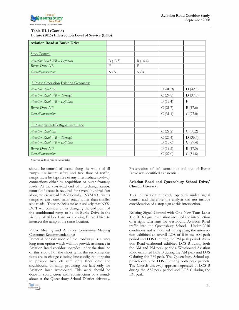
21
Aviation Road Corridor Study September 2008
should be control of access along the whole of all ramps. To insure safety and free flow of traffic, ramps must be kept free of any intermediate roadway connections either by acquisition or outer frontage roads. At the crossroad end of interchange ramps, control of access is required for several hundred feet along the crossroad.” Additionally, NYSDOT wants ramps to exist onto main roads rather than smaller side roads. These policies make it unlikely that NYS-DOT will consider either changing the end point of the southbound ramp to be on Burke Drive in the vicinity of Abbey Lane or allowing Burke Drive to intersect the ramp at the same location. Public Meeting and Advisory Committee Meeting Outcome/Recommendations: Potential consolidation of the roadways is a very long term option which will not provide assistance in Aviation Road corridor upgrades under the timeline of this study. For the short term, the recommenda-tions are to change existing lane configuration/paint to provide two left turn only lanes onto the southbound on-ramp, providing one lane only for Aviation Road westbound. This work should be done in conjunction with construction of a round-about at the Queensbury School District driveway.
Preservation of left turns into and out of Burke Drive was identified as essential. Aviation Road and Queensbury School Drive/ Church Driveway This intersection currently operates under signal control and therefore the analysis did not include consideration of a stop sign at this intersection. Existing Signal Control with One New Turn Lane: The 2016 signal evaluation included the introduction of a right turn lane for westbound Aviation Road traffic into the Queensbury School. Under 2016 conditions and a modified timing plan, the intersec-tion exhibited an overall LOS of B in the AM peak period and LOS C during the PM peak period. Avia-tion Road eastbound exhibited LOS B during both the AM and PM peak periods. Westbound Aviation Road exhibited LOS B during the AM peak and LOS C during the PM peak. The Queensbury School ap-proach exhibited LOS C during both peak periods. The Church driveway approach operated at LOS B during the AM peak period and LOS C during the PM peak.
Aviation Road at Burke Drive Stop Control
Aviation Road WB – Left turn B (13.5) B (14.4) Burke Drive NB F F Overall intersection N/A N/A 3 Phase Operation Existing Geometry Aviation Road EB D (40.9) D (42.6) Aviation Road WB – Through C (24.8) D (37.3) Aviation Road WB – Left turn B (12.4) F Burke Drive NB C (21.7) B (17.6) Overall intersection C (31.4) C (27.0) 3 Phase With EB Right Turn Lane Aviation Road EB C (29.2) C (30.2) Aviation Road WB – Through C (27.4) D (36.4) Aviation Road WB – Left turn B (10.6) C (29.4) Burke Drive NB B (19.5) B (17.5) Overall intersection C (27.0) C (31.8)
Table III-1 (Cont’d) Future (2016) Intersection Level of Service (LOS)
Source: Wilbur Smith Associates
22
Aviation Road Corridor Study September 2008
The draft Queensbury School District Campus Mas-ter Plan encourages the installation of a roundabout at this intersection. A roundabout would not have a new right turn lane on the westbound Aviation Road approach to the intersection. A roundabout at this intersection would operate at LOS A through 2016. Public Meeting and Advisory Committee Meeting Outcome/Recommendation: Construct a roundabout. Construction of the round-about must be done in conjunction with re-striping the intersection of Aviation Road and the I-87 (Adirondack Northway) southbound on-ramps. Aviation Road and Midnight Drive/Manor Drive The analysis of the Aviation Road intersection with Midnight and Manor Drives assumed that the cur-rent misalignment of the two side streets would re-main. Stop Sign Control: The analysis initially evaluated this intersection for 2016 conditions with just stop signs for Midnight Drive and Manor Drive. This analysis indicated LOS F for both Midnight Drive and Manor Drive ap-proaches during the morning and evening peak hours for 2016 volumes. Aviation Road operated at LOS A for eastbound and westbound traffic during both peak periods. Two Phase Signal Control: The analysis then evaluated the intersection under a two phase signal scenarios. This scenario allowed the two side roads to operate together under a common green signal phase. During the AM peak period, the intersection operated at an overall LOS B, with all approaches operating at LOS C or better. During the PM peak period, the intersection operated at an overall LOS A, with all approaches operating at LOS C or better. Eastbound Aviation road exhibits LOS B during the AM peak and LOS A during the PM peak period, while westbound operated at LOS A during both peak periods. Midnight Drive operated at LOS B during both AM and PM peak periods. Manor Drive operated at LOS C during both peak periods. Side Road Split Phasing Control: The analysis considered a second signal phasing sce-nario that included separate green phases for the two side roads in response to the minor offset alignment of Midnight Drive and Manor Drive with Aviation Road. During both the AM and PM peak periods, the intersection operated at an overall LOS B, with all approaches operating at LOS C or better. East-
bound Aviation Road exhibited LOS C during the AM peak period and LOS B during the PM peak period. Aviation road westbound operated at LOS B during both peak periods. Midnight Drive exhibited LOS B during both the AM and PM peak periods. Manor drive operated at LOS C during both peak periods. Roundabout: The draft Queensbury School District Campus Mas-ter Plan also encourages installation of a roundabout at this intersection. To operate properly, a round-about would need to be centered on Aviation Road between the existing Manor and Midnight Drive intersections. It would most likely require the acqui-sition of additional property, most likely the house on the northeast corner of Manor Drive and Avia-tion Road. The roundabout is projected to operate at LOS A for all approaches to the roundabout. Public Meeting and Advisory Committee Meeting Outcome/Recommendations: Construct a roundabout only in conjunction with the School District Campus Master Plan. Construct a roundabout only if conditions require it. This is a future option to be considered in conjunction with potential school campus access improvements. Aviation Road at Dixon Road/ Farr Lane Stop Sign Control: This intersection exhibited LOS F for both Dixon Road and Farr Lane approaches during the morning and evening peak hours under stop sign control and 2016 volumes. Aviation Road operated at LOS A for eastbound traffic during both peak periods and LOS B for westbound traffic during the morning peak hour and LOS A during the evening peak. The significant skew of the Dixon Road approach to Aviation Road creates operational concerns for the flow of side road traffic. In response to this concern, the analysis included two evaluations with the inter-section under signal control. Three Phase Signal Control: The first evaluation used a three phase operation, providing for separate movements for Dixon Road and Farr Lane. The results of this analysis show Aviation Road operating at LOS B for the west-bound approach, but at LOS D for the eastbound approach during the morning peak hour. Dixon Road operates at LOS D during the morning peak hour. Farr Lane will operate at LOS D during the morning peak. Due to LOS D for three of the four approaches, the analysis for the evening peak was not undertaken.
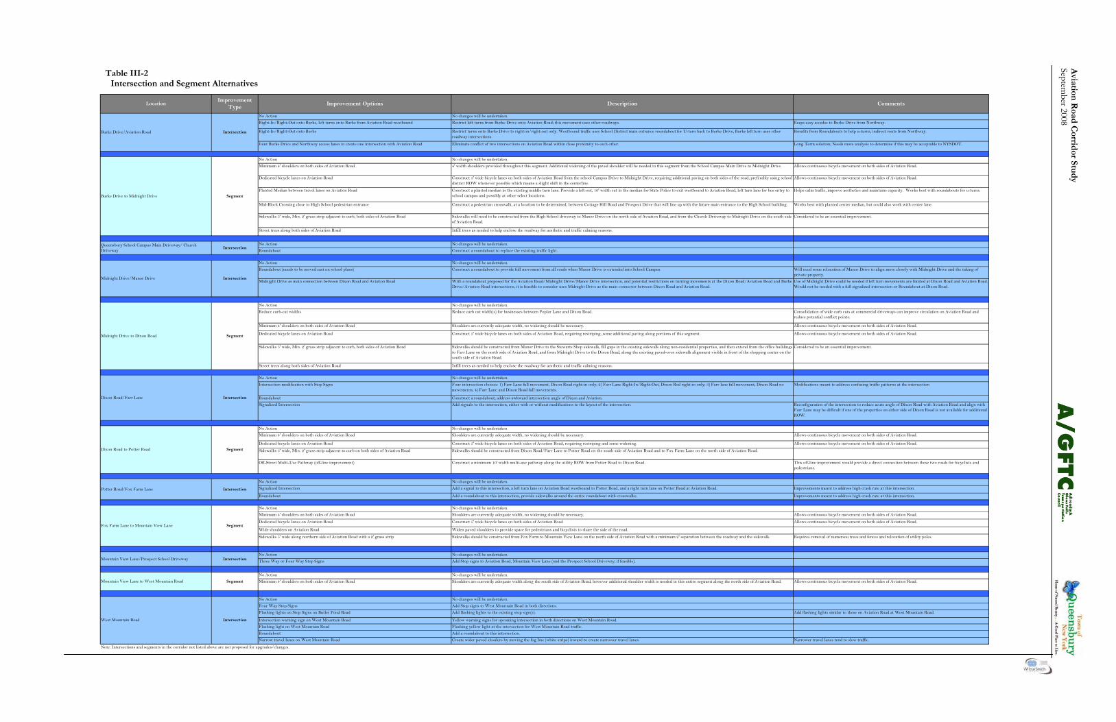
Aviation
Road C
orridor Stu
dy
September 2008
Table III-2 Intersection and Segment Alternatives
No Action
Right-In/Right-Out onto Burke, left turns onto Burke from Aviation Road westbound
Right-In/Right-Out onto Burke
Joint Burke Drive and Northway access lanes to create one intersection with Aviation Road
No Action
Minimum 4' shoulders on both sides of Aviation Road
Dedicated bicycle lanes on Aviation Road
Planted Median between travel lanes on Aviation Road
Mid-Block Crossing close to High School pedestrian entrance
Sidewalks 5' wide, Min. 2' grass strip adjacent to curb, both sides of Aviation Road
Street trees along both sides of Aviation Road
No Action
Roundabout
No Action
Roundabout (needs to be moved east on school plans)
Midnight Drive as main connection between Dixon Road and Aviation Road
No Action
Reduce curb-cut widths
Minimum 4' shoulders on both sides of Aviation Road
Dedicated bicycle lanes on Aviation Road
Sidewalks 5' wide, Min. 2' grass strip adjacent to curb, both sides of Aviation Road
Street trees along both sides of Aviation Road
No Action
Intersection modification with Stop Signs
Roundabout
No Action
Minimum 4' shoulders on both sides of Aviation Road
Dedicated bicycle lanes on Aviation Road
Sidewalks 5' wide, Min. 2' grass strip adjacent to curb on both sides of Aviation Road
Off-Street Multi-Use Pathway (off-line improvement)
No Action
Signalized Intersection
Roundabout
No Action
Minimum 4' shoulders on both sides of Aviation Road
Dedicated bicycle lanes on Aviation Road
Wide shoulders on Aviation Road
Sidewalks 5' wide along northern side of Aviation Road with a 2' grass strip
No Action
Three Way or Four Way Stop Signs
No Action
Minimum 4' shoulders on both sides of Aviation Road
No Action
Four Way Stop Signs
Flashing lights on Stop Signs on Butler Pond Road
Intersection warning sign on West Mountain Road
Flashing light on West Mountain Road
Roundabout
Narrow travel lanes on West Mountain Road
Add flashing lights similar to those on Aviation Road at West Mountain Road.
Dixon Road to Potter Road Segment
Construct a minimum 10' width multi-use pathway along the utility ROW from Potter Road to Dixon Road. This off-line improvement would provide a direct connection between these two roads for bicyclists and pedestrians.
Widen paved shoulders to provide space for pedestrians and bicyclists to share the side of the road.Fox Farm Lane to Mountain View Lane
Potter Road/Fox Farm Lane
No changes will be undertaken.
Allows continuous bicycle movement on both sides of Aviation Road.
Works best with planted center median, but could also work with center lane.
Mountain View Lane to West Mountain Road SegmentNo changes will be undertaken.
Sidewalks should be constructed from Fox Farm to Mountain View Lane on the north side of Aviation Road with a minimum 2' separation between the roadway and the sidewalk.
Sidewalks will need to be constructed from the High School driveway to Manor Drive on the north side of Aviation Road, and from the Church Driveway to Midnight Drive on the south side of Aviation Road.
Add signals to the intersection, either with or without modifications to the layout of the intersection.
Keeps easy accedss to Burke Drive from Northway.
Benefits from Roundabouts to help u-turns, indirect route from Northway.
Long Term solution; Needs more analysis to determine if this may be acceptable to NYSDOT.
Improvement Options Description Comments
Burke Drive to Midnight Drive
Intersection
Segment
No changes will be undertaken.
Construct a roundabout to replace the existing traffic light.
No changes will be undertaken.
No changes will be undertaken.
Queensbury School Campus Main Driveway/ Church Driveway
Intersection
IntersectionDixon Road/Farr Lane
Burke Drive/Aviation Road Intersection
Restrict left turns from Burke Drive onto Aviation Road; this movement uses other roadways.
Restrict turns onto Burke Drive to right-in/right-out only. Westbound traffic uses School District main entrance roundabout for U-turn back to Burke Drive, Burke left turn uses other roadway intersections.
No changes will be undertaken.
Eliminate conflict of two intersections on Aviation Road within close proximity to each other.
Location
No changes will be undertaken.
4' width shoulders provided throughout this segment. Additional widening of the paved shoulder will be needed in this segment from the School Campus Main Drive to Midnight Drive.
Segment
Improvement Type
Infill trees as needed to help enclose the roadway for aesthetic and traffic calming reasons.
Construct a planted median in the existing middle turn lane. Provide a left-out, 10' width cut in the median for State Police to exit westbound to Aviation Road, left turn lane for bus entry to school campus and possibly at other select locations.
Construct a pedestrian crosswalk, at a location to be determined, between Cottage Hill Road and Prospect Drive that will line up with the future main entrance to the High School building.
Construct 5' wide bicycle lanes on both sides of Aviation Road from the school Campus Drive to Midnight Drive, requiring additional paving on both sides of the road, preferably using school district ROW whenever possible which means a slight shift in the centerline.
Midnight Drive/Manor DriveWith a roundabout proposed for the Aviation Road/Midnight Drive/Manor Drive intersection, and potential restrictions on turning movements at the Dixon Road/Aviation Road and Burke Drive/Aviation Road intersections, it is feasible to consider uses Midnight Drive as the main connector between Dixon Road and Aviation Road.
Midnight Drive to Dixon Road
Infill trees as needed to help enclose the roadway for aesthetic and traffic calming reasons.
Shoulders are currently adequate width, no widening should be necessary.
Add a signal to this intersection, a left turn lane on Aviation Road westbound to Potter Road, and a right turn lane on Potter Road at Aviation Road.Intersection
Segment
No changes will be undertaken.
Shoulders are currently adequate width, no widening should be necessary.
Add a roundabout to this intersection, provide sidewalks around the entire roundabout with crosswalks.
No changes will be undertaken
Shoulders are currently adequate width, no widening should be necessary.
Sidewalks should be constructed from Dixon Road/Farr Lane to Potter Road on the south side of Aviation Road and to Fox Farm Lane on the north side of Aviation Road.
No changes will be undertaken.
Allows continuous bicycle movement on both sides of Aviation Road.
Helps calm traffic, improve aesthetics and maintains capacity. Works best with roundabouts for u-turns.
Reduce curb cut width(s) for businesses between Poplar Lane and Dixon Road.
Considered to be an essential improvement.
Use of Midnight Drive could be needed if left turn movements are limited at Dixon Road and Aviation Road. Would not be needed with a full signalized intersection or Roundabout at Dixon Road.
Consolidation of wide curb cuts at commercial driveways can improve circulation on Aviation Road and reduce potential conflict points.
Allows continuous bicycle movement on both sides of Aviation Road.
Considered to be an essential improvement.
Reconfiguration of the intersection to reduce acute angle of Dixon Road with Aviation Road and align with Farr Lane may be difficult if one of the properties on either side of Dixon Road is not available for additional ROW.
Allows continuous bicycle movement on both sides of Aviation Road.
Allows continuous bicycle movement on both sides of Aviation Road.
Improvements meant to address high crash rate at this intersection.
Improvements meant to address high crash rate at this intersection.
Allows continuous bicycle movement on both sides of Aviation Road.
Allows continuous bicycle movement on both sides of Aviation Road.
Construct a roundabout to provide full movement from all roads when Manor Drive is extended into School Campus. Will need some relocation of Manor Drive to align more closely with Midnight Drive and the taking of private property.
Sidewalks should be constructed from Manor Drive to the Stewarts Shop sidewalk, fill gaps in the existing sidewalk along non-residential properties, and then extend from the office buildings to Farr Lane on the north side of Aviation Road, and from Midnight Drive to the Dixon Road, along the existing paved-over sidewalk alignment visible in front of the shopping center on the south side of Aviation Road.
Allows continuous bicycle movement on both sides of Aviation Road.
Modifications meant to address confusing traffic patterns at the intersection
Allows continuous bicycle movement on both sides of Aviation Road.
Requires removal of numersou trees and fences and relocation of utility poles.
Note: Intersections and segments in the corridor not listed above are not proposed for upgrades/changes.
Construct 5' wide bicycle lanes on both sides of Aviation Road, requiring restriping, some additional paving along portions of this segment.
Signalized Intersection
Construct a roundabout; address awkward intersection angle of Dixon and Aviation.
Construct 5' wide bicycle lanes on both sides of Aviation Road, requiring restriping and some widening.
Construct 5' wide bicycle lanes on both sides of Aviation Road
Four intersection choices: 1) Farr Lane full movement, Dixon Road right-in only; 2) Farr Lane Right-In/Right-Out, Dixon Rod right-in only; 3) Farr lane full movement, Dixon Road no movements; 4) Farr Lane and Dixon Road full movements.
West Mountain Road
Create wider paved shoulers by moving the fog line (white stripe) inward to create narrower travel lanes. Narrower travel lanes tend to slow traffic.
Flashing yellow light at the intersection for West Mountain Road traffic.
Yellow warning signs for upcoming intersection in both directions on West Mountain Road.
Add a roundabout to this intersection.
Mountain View Lane/Prospect School Driveway
Add Stop signs to West Mountain Road in both directions.
IntersectionNo changes will be undertaken.
Add Stop signs to Aviation Road, Mountain View Lane (and the Prospect School Driveway, if feasible).
Intersection
No changes will be undertaken.
Shoulders are currently adequate width along the south side of Aviation Road, however additional shoulder width is needed in this entire segment along the north side of Aviation Road.
Add flashing lights to the existing stop sign(s).

Avi
atio
n R
oad
Cor
rid
or S
tud
y Se
ptem
ber 2
008
23
Aviation Road Corridor Study September 2008
Two-Phase Signal Operation: The second analysis considered a two phase opera-tion for this intersection. Under this scenario, during the morning peak hour eastbound Aviation Road operates at LOS B with westbound operating at LOS A. During the evening peak hour eastbound Aviation Road operates at LOS B and westbound operates at LOS B. Both Dixon Road and Farr Lane operate at LOS C during the morning peak hour. During the evening peak hour, Dixon road operates at LOS C and Farr Lane at LOS B. The results of the LOS analysis show acceptable LOS under the two phase signal operation. Roundabout: A roundabout at the Dixon Road Farr Lane intersec-tion with Aviation Road is projected to operate at LOS A for all approaches during both the AM and PM peak hours. Various locations for a roundabout could work at this intersection, although all of them would require the acquisition of additional property from adjacent property owners. Because the former gas station on the tight southeast corner is currently vacant and for sale, the analysis looked closely at whether acquisition of this parcel by the Town would facilitate the construction of a roundabout and reduce the right-of-way impacts on adjacent properties. The study indicates that the ac-quisition of this parcel does not limit impacts on other parcels. It actually has the opposite affect. The further to the east that the center of the round-about is situated along Aviation Road, the more land is needed from the parcel on the northeast corner of the intersection. Additionally, the layout of the needed right-of-way on the property is such that it removes much of the development potential of the site. This is because of the need to evenly distribute the access points from the intersecting streets, which locates the Farr Lane approach to the roundabout near the center of the property. The relocated Farr Lane would need to pass close to or through the existing house on the property. Even when rotating the access points counterclockwise to make the Farr Lane access point facing northwest rather than north, the disruption to the property is significant. For each of the layouts that try to use the former gas station site, the amount of right-of-way needed on the northeast corner is greater, and the location of the right-of-way more intrusive, than a layout that places the roundabout closer to the center of the existing intersection.
It appears that acquisition of the former gas station property will not facilitate easier implementation of a roundabout at this location. Public Meeting and Advisory Committee Meeting Outcome/Recommendations: Construct a roundabout. This is a high priority inter-section for this Study. Consideration of right-of-way needs and a right-of-way assessment should be un-dertaken as soon as possible. Aviation Road at Potter Road/ Fox Farm Road Stop Sign Control: The analysis evaluated this intersection for 2016 con-ditions under stop control for Potter Road and Fox Farm Road. As expected Potter Road and Fox Farm Road operates at LOS F in the morning peak hour, with Potter Road at LOS D and Fox Farm road at LOS F during the evening peak hour. Aviation road will operate at LOS A eastbound and LOS B west-bound during the morning and evening peak periods for 2016 volumes. The analysis also considered an additional option of maintaining a two way stop system on Potter and Fox Farm Roads, but adding a left turn lane on Avia-tion road for westbound traffic turning south onto Potter Road and a right turn lane on Potter Road for northbound traffic turning east onto Aviation Road. No additional LOS analysis was completed for this alternative, but it would address the largest reasons for the poor LOS performance in the stop sign con-trol analysis described above. This alternative also addresses one of the apparent reasons for the higher than normal crash rates at this intersection. Fully Actuated Signal Control: The analysis then evaluated this intersection under two phase, full actuated traffic signal control. The results show that Aviation Road will operate at LOS B on the eastbound approach and LOS C on the westbound approach during the morning peak pe-riod for 2016 volumes. During the evening peak hour eastbound Aviation Road operates at LOS A while westbound continues at LOS C. Potter Road will operate at LOS C during the morning peak hour and LOS B during the evening peak. Fox Farm Road will operate at LOS B during the morning peak pe-riod and LOS D during the evening peak. Overall, the intersection operated at LOS B during the AM peak and LOS C during the PM peak.
24
Aviation Road Corridor Study September 2008
Signal Control with Turn Lanes: The analysis included further evaluation that ana-lyzed the intersection under signal control with left turn lanes for Aviation Road and a right turn lane for northbound Potter Road approach. Under this signal operation eastbound Aviation Road operated at LOS C during both the AM and PM peak periods, while westbound operated at LOS B during both peak periods. Potter Road operated at LOS C during the AM peak period and LOS A during the PM peak period. Fox Farm Road exhibited LOS B during the AM peak period and LOS C during the PM peak period. The overall intersection operation exhibited LOS C for the AM peak period and LOS B for the PM peak period. Roundabout: The last part of the analysis examined a roundabout at this intersection. A roundabout would operate at LOS A through 2016. It would also require the addi-tion of additional right-of-way in order to be con-structed. Public Meeting and Advisory Committee Meeting Outcome/Recommendations: Provide a left turn lane from westbound Aviation Road to southbound Potter Road. Also provide a right turn lane from northbound Potter Road to eastbound Aviation Road. Crosswalks and appropri-ate signage should also be provided. If the proposed turn lanes do not solve the existing crash rate issue at this intersection, considering a roundabout at this location will be necessary. Aviation Road at Mountain View Lane Stop Sign Control: Traffic volumes at this intersection are not high enough to warrant a traffic signal. The analysis con-sidered adding a three way stop sign and maintaining the existing stop sign on Mountain View Lane with no stop sign on Aviation Road. The primary con-cern at the intersection is the interaction of side traf-fic from the school as well as Mountain View Lane with traffic on Aviation Road and the number of pedestrians associated with the Prospect School that cross Aviation Road. No significant change to exist-ing operations are anticipated through 2016. Public Meeting and Advisory Committee Meeting Outcome/Recommendations: No action is needed at this time or through this plan. Future issues at this intersection shall be addressed when deemed appropriate or necessary.
Aviation Road at West Mountain Road Traffic volumes at this intersection are not high enough to warrant a traffic signal. Because the con-cerns at this intersection are primarily safety related, the Study Team considered other methods of man-aging the traffic, including: • Maintaining the stops signs on both approaches of Aviation Road with the addition of flashers on both; • Installing four way stop signs; • Adding intersection warning signs on West Mountain Road; • Installing a roundabout; • Narrowing the lanes on West Mountain Road by moving the white fog line and widening the paved shoulders; and • Adding flashing yellow lights on West Mountain
Road.
Public Meeting and Advisory Committee Meeting Outcome/Recommendations: • Consider adding a black and yellow speed “warning” sign to West Mountain Road; • Add speed radar controlled signs on West Mountain Road; • Place flashing red lights on the top of the 2nd stop sign on Aviation Road on the eastbound side of Aviation Road; • Narrow the West Mountain Road travel lanes by moving the “fog line” toward the center of the road – making the lanes narrower and the shoul- der wider; and • Research potential road paint options for Avia-
tion Road to warn motorists of the stop ahead at the intersection with West Mountain Road.
Summary Each intersection exhibited an overall LOS of C or better for 2016 operating conditions under signal control with the operational or intersection configu-ration improvements noted above. The approaches to all intersections exhibited LOS C or better with the exception of Fox Farm Road during the PM peak period, eastbound Aviation Road at Burke Drive during the AM peak under exiting geometry, and westbound Aviation Road at Burke Drive during the PM peak under revised geometry – LOS D; and westbound Aviation Road at Burke Drive during the POM peak period under existing geometry – LOS E. It is noted that these locations were analyzed as iso-lated intersections.
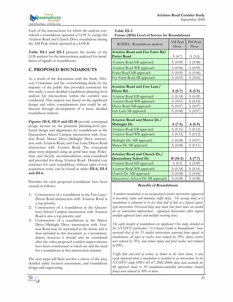
25
Aviation Road Corridor Study September 2008
Each of the intersections for which the analysis con-sidered a roundabout operated at LOS A, except the Aviation Road and Church Drive roundabout during the AM Peak which operated at a LOS B. Table III-1 and III-3 presents the results of the LOS analysis for the intersections analyzed for instal-lation of signals or roundabouts. C. PROPOSED ROUNDABOUTS As a result of the discussions with the Study Advi-sory Committee and the overwhelming desire by the majority of the public that provided comments for this study, a more detailed roundabout planning-level analysis for intersections within the corridor was conducted. This analysis was based on the significant design and safety considerations that could be ad-dressed through development of a more detailed roundabout analysis. Figures III-8, III-9 and III-10 provide conceptual design layouts on the potential planning-level pre-ferred design and alignments for roundabouts at the Queensbury School Campus intersection with Avia-tion Road, Manor Drive/Midnight Drive intersec-tion with Aviation Road, and Farr Lane/Dixon Road intersection with Aviation Road. The conceptual plans were prepared using an aerial base map. Pedes-trian and bicycle accommodations were considered and provided for along Aviation Road. Detailed cost estimates for each roundabout, without right-of-way acquisition costs, can be found as tables III-4, III-5 and III-6. Priorities for each proposed roundabout have been created as follows: 1) Construction of a roundabout at the Farr Lane/
Dixon Road intersection with Aviation Road is a top priority;
2) Construction of a roundabout at the Queens-bury School Campus intersection with Aviation Road is also a top priority; and
3) Construction of a roundabout at the Manor Drive/Midnight Drive intersection with Avia-tion Road may be warranted in the future and is thus included in this document as a recommen-dation, however it should only be considered after the other proposed corridor improvements have been constructed or ruled-out and the need for a roundabout at this intersection remains.
The next steps will likely involve a survey of the area, detailed utility location assessment, and roundabout design and engineering.
RODEL- Roundabout analysis AM Peak Hour
PM Peak Hour
Aviation Road and Fox Farm Rd/Potter Road A (4.7) A (5.0) Aviation Road EB approach A (0.09) A (0.08) Aviation Road WB approach A (0.06) A (0.09) Potter Road NB approach A (0.09) A (0.06) Fox Farm Road SB approach A (0.05) A (0.06)
Aviation Road and Farr Lane/Dixon Rd. A (8.7) A (5.5)
Aviation Road EB approach A (0.18) A (0.09) Aviation Road WB approach A (0.07) A (0.10) Dixon Road NB approach A (0.07) A (0.07) Farr Lane SB approach A (0.06) A (0.07)
Aviation Road and Manor Dr./Midnight Dr. A (7.4) A (6.9) Aviation Road EB approach A (0.15) A (0.12) Aviation Road WB approach A (0.12) A (0.12)
Midnight Dr. NB approach A (0.08) A (0.07) Manor Dr. SB approach A (0.08) A (0.11)
Aviation Road and Church Dr,/Queensbury School Dr. B (10.3) A (7.7) Aviation Road EB approach A (0.2) A (0.09) Aviation Road WB approach A (0.18) A (0.16) Church Dr. NB approach A (0.08) A (0.06) Queensbury School Dr. SB approach A (0.08) A (0.08)
Table III-3 Future (2016) Level of Service for Roundabouts
Benefits of Roundabouts A modern roundabout is an unsignalized circular intersection engineered to maximize safety and minimize traffic delay. The average delay at a roundabout is estimated to be less than half of that at a typical signal-ized intersection. Decreased delay may mean that fewer lanes are needed for an intersection improvement - signalized intersections often require multiple approach lanes and multiple receiving lanes. The safety benefits of roundabouts are significant. One study, detailed in the NYSDOT publication “A Citizens Guide to Roundabouts” dem-onstrated that of the 23 studied intersections converted from signals to roundabouts, all types of crashes were reduced by 39%, injury crashes were reduced by 76%, and serious injury and fatal crashes were reduced by 89%. Traffic flow and level of service, as shown in the chart above, is also vastly improved when a roundabout is installed at an intersection. In the NYSDOT study SPR C-01-47, 2002-2004, delay data available for 40 approach roads to 10 roundabout-controlled intersections showed delays were reduced by 50% or more.

26
Aviation Road Corridor Study September 2008
Aviation Road at School Driveway - Interim & Alternative Intersection Improvement Option Prior to the construction of a roundabout at the Queensbury School Drive (the main driveway be-tween the High School and Middle School) or in place of construction of a roundabout at the inter-section with Aviation Road should it not be devel-oped, a right turn lane from Aviation Road to the Queensbury School Drive is a potential option to facilitate traffic flow into the school property which without any intersection improvement will have a failing LOS condition in 2026. In order for a right turn lane to be constructed, the existing middle school driveway near Burke Drive must be closed. No ingress to the school campus can be provided between the Burke Drive intersec-tion with Aviation Road and Queensbury School Drive if a right turn lane is provided. Currently approximately 20% of the westbound trips through the intersection of Aviation Road and the Queensbury School Drive turn right into the school campus and as such, a right turn lane is justified solely from a volume perspective. In addition, since count information was not obtained for the number of right turns into the existing Middle School drive-way, when it is closed, the percentage of right turn traffic onto Queensbury School Drive from Aviation Road will likely increase, adding additional volume to the intersection and further solidifying the ration-ale for a right turn lane.
While the proposed right turn lane is justified and viable for traffic flow, it is not entirely consistent with the future roundabout design recommendation in this plan. A roundabout is the preferred intersec-tion improvement and assuming that the recommen-dation is implemented in the future, it will likely be necessary to remove some of the right turn lane improvements. However, during construction of the roundabout, the right turn lane has a high potential to be useful in the Maintenance and Protection of Traffic (MPT) by providing additional roadway width as a travel lane. A full engineering review of all other potential is-sues, such as property impacts, right-of-way, topog-raphy, drainage, and others should be conducted prior to design and construction of the right turn lane. A conceptual cost estimate is included in sec-tion VI– Cost Estimates.
A right turn only lane would be constructed between the existing travel lane(s) and school parking lot. This potential capacity expansion would need to be compatible with school im-provement plans and must ensure that sidewalk(s) be replaced should the existing concrete be removed.
27
Aviation Road Corridor Study September 2008
This Page Intentionally Left Blank

Avi
atio
n R
oad
Cor
rid
or S
tud
y Se
ptem
ber
2008
28
OR
PA
VER
S, A
S A
PP
RO
PR
IATE
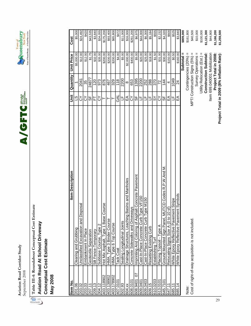
Avi
atio
n R
oad
Cor
rid
or S
tud
y Se
ptem
ber 2
008
29
Avi
atio
n R
oad
At S
choo
l Driv
eway
Con
cept
ual C
ost E
stim
ate
May
200
8
Item
No.
Item
Des
crip
tion
Uni
tQ
uant
ityU
nit P
rice
Cos
t20
1.06
Cle
arin
g an
d G
rubb
ing
LS1
$5,0
00.0
0$5
,000
203.
02U
ncla
ssifi
ed E
xcav
atio
n an
d D
ispo
sal
CY
2041
$12.
00$2
4,49
220
3.03
Emba
nkm
ent I
n Pl
ace
CY
35$1
2.00
$420
207.
11G
eote
xtile
Sep
arat
ion
SF24
877
$1.7
5$4
3,53
520
9.13
Silt
Fenc
e-Te
mpo
rary
FT12
0$3
2.00
$3,8
4030
4.12
Subb
ase
Cou
rse,
Typ
e 2
CY
973
$35.
00$3
4,05
540
3.11
8902
Hot
Mix
Asp
halt,
Typ
e 1
Base
Cou
rse
T87
6$2
00.0
0$1
75,2
0040
3.13
8902
HM
A, T
ype
3 Bi
nder
Cou
rse
T46
7$2
00.0
0$9
3,40
040
3.17
8902
HM
A, T
ype
6 To
p C
ours
eT
329
$200
.00
$65,
800
407.
0101
Tack
Coa
tG
AL11
8$4
.00
$472
502.
93Se
alin
g Lo
ngitu
dina
l Joi
nts
LF22
00$5
.00
$11,
000
604.
xxD
rain
age
Stru
ctur
es, L
each
ing
Basi
ns a
nd M
anho
les
EA8
$2,0
00.0
0$1
6,00
060
8.01
01C
oncr
ete
Side
wal
ks a
nd D
rivew
ays
CY
653
$400
.00
$261
,200
608.
9401
07
Impr
intin
g An
d C
olor
ing
of A
spha
lt C
oncr
ete
Pave
men
tSF
1395
$5.0
0$6
,975
609.
0401
Cas
t-In-
Plac
e C
oncr
ete
Cur
b Ty
pe V
F150
LF22
00$2
0.00
$44,
000
609.
0403
Cas
t-In-
Plac
e C
oncr
ete
Cur
b Ty
pe M
150
LF25
2$2
5.00
$6,3
0060
9.15
Res
ettin
g Ex
istin
g C
urb
LF28
8$1
8.00
$5,1
8461
0.02
03Es
tabl
ishi
ng T
urf
SY37
0$1
.50
$555
613.
0101
Plac
ing
Tops
oil -
Typ
e A
CY
72$3
1.00
$2,2
3264
5.71
01G
roun
d M
ount
ed S
ign
Pane
l, M
UTC
D C
odes
R,P
,W,A
nd M
.SF
144
$30.
00$4
,320
647.
11R
eloc
atin
g Si
gns
Size
A (0
to 1
0 sf
)EA
4$1
50.0
0$6
0068
5.11
Whi
te E
poxy
Ref
lect
ive
Pave
men
t Stri
peLF
1049
$0.5
0$5
2568
5.14
Whi
te E
poxy
Ref
lect
ive
Pave
men
t Sym
bols
EA24
$160
.00
$3,8
40Su
btot
al =
$809
,000
Not
e:C
ontin
genc
ies
(20%
) =$1
61,8
00C
ost o
f rig
ht-o
f-way
acq
uisi
tion
is n
ot in
clud
ed.
MPT
/ Con
stru
ctio
n Si
gns
(5%
) =$4
0,50
0Su
rvey
Ope
ratio
ns =
$10,
000
Util
ity R
eloc
atio
n (E
st.)
=$1
00,0
00C
onst
ruct
ion
Subt
otal
:$1
,121
,300
Item
699
.040
001
Mob
ilizat
ion
$44,
900
Proj
ect T
otal
in 2
008:
$1,1
66,2
00Pr
ojec
t Tot
al in
200
9 (8
% In
flatio
n R
ate)
:$1
,259
,500
Tab
le I
II-4
: Rou
nd
abou
t C
once
ptu
al C
ost
Est
imat
e
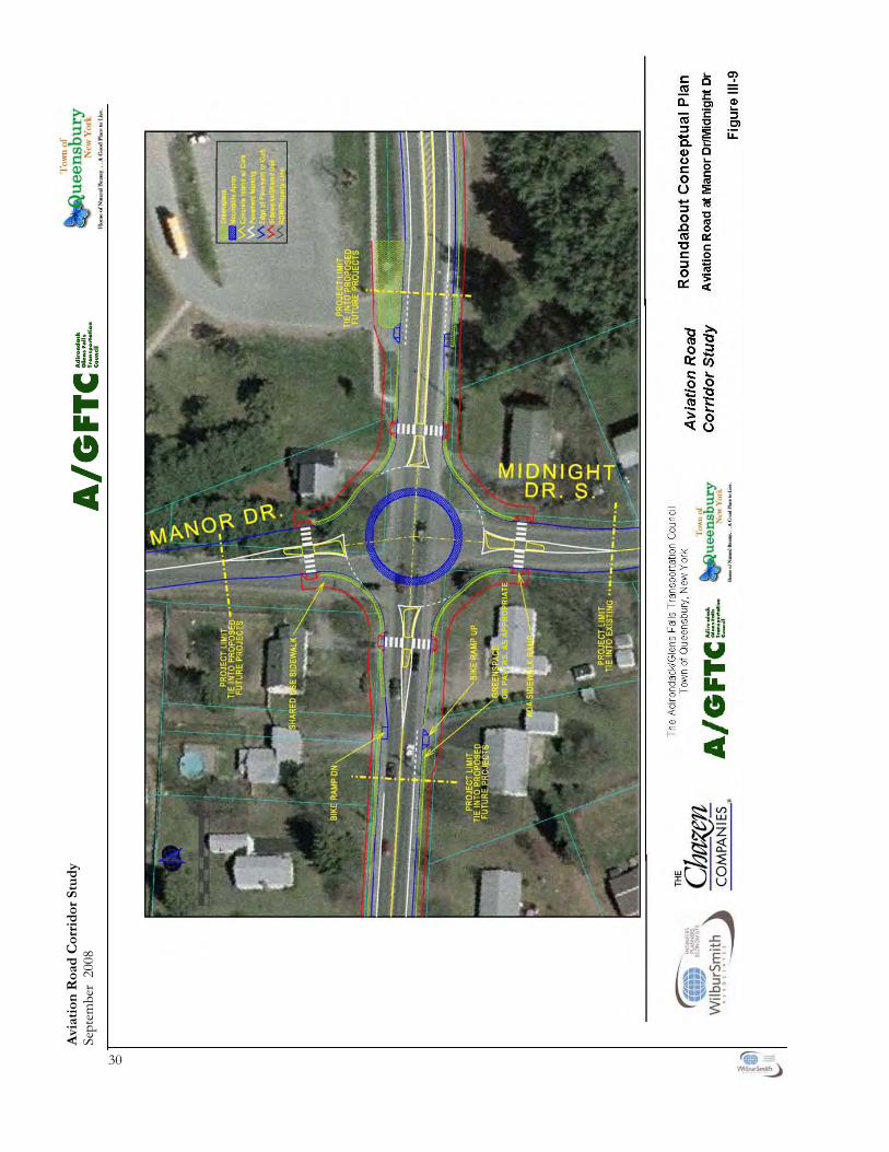
Avi
atio
n R
oad
Cor
rid
or S
tud
y Se
ptem
ber
2008
30
OR
PA
VER
S, A
S A
PP
RO
PR
IATE
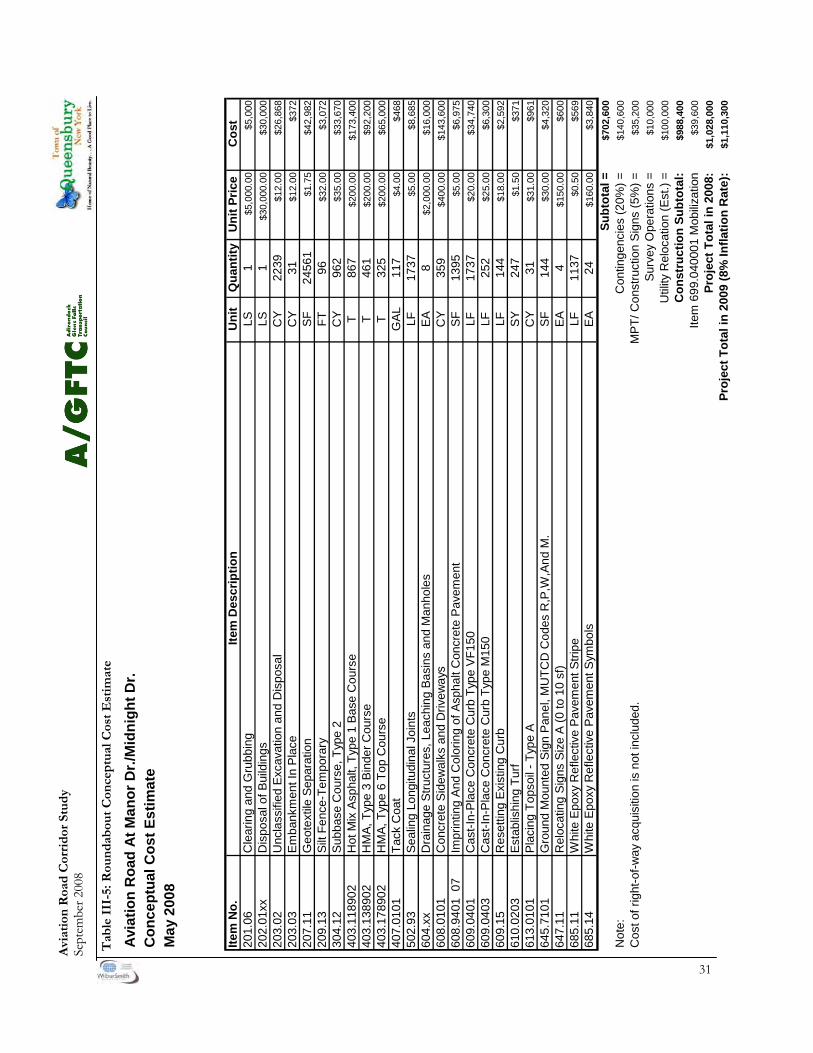
Avi
atio
n R
oad
Cor
rid
or S
tud
y Se
ptem
ber 2
008
31
Avi
atio
n R
oad
At M
anor
Dr./
Mid
nigh
t Dr.
Con
cept
ual C
ost E
stim
ate
Item
No.
Item
Des
crip
tion
Uni
tQ
uant
ityU
nit P
rice
Cos
t20
1.06
Cle
arin
g an
d G
rubb
ing
LS1
$5,0
00.0
0$5
,000
202.
01xx
Dis
posa
l of B
uild
ings
LS1
$30,
000.
00$3
0,00
020
3.02
Unc
lass
ified
Exc
avat
ion
and
Dis
posa
lC
Y22
39$1
2.00
$26,
868
203.
03Em
bank
men
t In
Plac
eC
Y31
$12.
00$3
7220
7.11
Geo
text
ile S
epar
atio
nSF
2456
1$1
.75
$42,
982
209.
13Si
lt Fe
nce-
Tem
pora
ryFT
96$3
2.00
$3,0
7230
4.12
Subb
ase
Cou
rse,
Typ
e 2
CY
962
$35.
00$3
3,67
040
3.11
8902
Hot
Mix
Asp
halt,
Typ
e 1
Base
Cou
rse
T86
7$2
00.0
0$1
73,4
0040
3.13
8902
HM
A, T
ype
3 Bi
nder
Cou
rse
T46
1$2
00.0
0$9
2,20
040
3.17
8902
HM
A, T
ype
6 To
p C
ours
eT
325
$200
.00
$65,
000
407.
0101
Tack
Coa
tG
AL11
7$4
.00
$468
502.
93Se
alin
g Lo
ngitu
dina
l Joi
nts
LF17
37$5
.00
$8,6
8560
4.xx
Dra
inag
e St
ruct
ures
, Lea
chin
g Ba
sins
and
Man
hole
sEA
8$2
,000
.00
$16,
000
608.
0101
Con
cret
e Si
dew
alks
and
Driv
eway
sC
Y35
9$4
00.0
0$1
43,6
0060
8.94
01 0
7Im
prin
ting
And
Col
orin
g of
Asp
halt
Con
cret
e Pa
vem
ent
SF13
95$5
.00
$6,9
7560
9.04
01C
ast-I
n-Pl
ace
Con
cret
e C
urb
Type
VF1
50LF
1737
$20.
00$3
4,74
060
9.04
03C
ast-I
n-Pl
ace
Con
cret
e C
urb
Type
M15
0LF
252
$25.
00$6
,300
609.
15R
eset
ting
Exis
ting
Cur
bLF
144
$18.
00$2
,592
610.
0203
Esta
blis
hing
Tur
fSY
247
$1.5
0$3
7161
3.01
01Pl
acin
g To
psoi
l - T
ype
AC
Y31
$31.
00$9
6164
5.71
01G
roun
d M
ount
ed S
ign
Pane
l, M
UTC
D C
odes
R,P
,W,A
nd M
.SF
144
$30.
00$4
,320
647.
11R
eloc
atin
g Si
gns
Size
A (0
to 1
0 sf
)EA
4$1
50.0
0$6
0068
5.11
Whi
te E
poxy
Ref
lect
ive
Pave
men
t Stri
peLF
1137
$0.5
0$5
6968
5.14
Whi
te E
poxy
Ref
lect
ive
Pave
men
t Sym
bols
EA24
$160
.00
$3,8
40Su
btot
al =
$702
,600
Not
e:C
ontin
genc
ies
(20%
) =$1
40,6
00C
ost o
f rig
ht-o
f-way
acq
uisi
tion
is n
ot in
clud
ed.
MPT
/ Con
stru
ctio
n Si
gns
(5%
) =$3
5,20
0Su
rvey
Ope
ratio
ns =
$10,
000
Util
ity R
eloc
atio
n (E
st.)
=$1
00,0
00C
onst
ruct
ion
Subt
otal
:$9
88,4
00Ite
m 6
99.0
4000
1 M
obiliz
atio
n$3
9,60
0Pr
ojec
t Tot
al in
200
8:$1
,028
,000
Proj
ect T
otal
in 2
009
(8%
Infla
tion
Rat
e):
$1,1
10,3
00
May
200
8
Tab
le I
II-5
: Rou
nd
abou
t C
once
ptu
al C
ost
Est
imat
e

Avi
atio
n R
oad
Cor
rid
or S
tud
y Se
ptem
ber
2008
32
OR
PA
VER
S, A
S A
PP
RO
PR
IATE

Avi
atio
n R
oad
Cor
rid
or S
tud
y Se
ptem
ber 2
008
33
Avi
atio
n R
oad
At D
ixon
Rd.
/Far
r Ln.
Con
cept
ual C
ost E
stim
ate
May
200
8
Item
No.
Item
Des
crip
tion
Uni
tQ
uant
ityU
nit P
rice
Cos
t20
1.06
Cle
arin
g an
d G
rubb
ing
LS1
$5,0
00.0
0$5
,000
202.
01xx
Dis
posa
l of B
uild
ings
LS1
$30,
000.
00$3
0,00
020
3.02
Unc
lass
ified
Exc
avat
ion
and
Dis
posa
lC
Y27
51$1
2.00
$33,
012
203.
03Em
bank
men
t In
Plac
eC
Y20
$12.
00$2
4020
7.11
Geo
text
ile S
epar
atio
nSF
3027
1$1
.75
$52,
974
209.
13Si
lt Fe
nce-
Tem
pora
ryFT
96$3
2.00
$3,0
7230
4.12
Subb
ase
Cou
rse,
Typ
e 2
CY
1173
$35.
00$4
1,05
540
3.11
8902
Hot
Mix
Asp
halt,
Typ
e 1
Base
Cou
rse
T10
56$2
00.0
0$2
11,2
0040
3.13
8902
HM
A, T
ype
3 Bi
nder
Cou
rse
T56
8$2
00.0
0$1
13,6
0040
3.17
8902
HM
A, T
ype
6 To
p C
ours
eT
396
$200
.00
$79,
200
407.
0101
Tack
Coa
tG
AL13
9$4
.00
$556
502.
93Se
alin
g Lo
ngitu
dina
l Joi
nts
LF13
07$5
.00
$6,5
3560
4.xx
Dra
inag
e St
ruct
ures
, Lea
chin
g Ba
sins
and
Man
hole
sEA
8$2
,000
.00
$16,
000
608.
0101
Con
cret
e Si
dew
alks
and
Driv
eway
sC
Y40
9$4
00.0
0$1
63,6
0060
8.94
01 0
7Im
prin
ting
And
Col
orin
g of
Asp
halt
Con
cret
e Pa
vem
ent
SF13
95$5
.00
$6,9
7560
9.04
01C
ast-I
n-Pl
ace
Con
cret
e C
urb
Type
VF1
50LF
1307
$20.
00$2
6,14
060
9.04
03C
ast-I
n-Pl
ace
Con
cret
e C
urb
Type
M15
0LF
252
$25.
00$6
,300
609.
15R
eset
ting
Exis
ting
Cur
bLF
96$1
8.00
$1,7
2861
0.02
03Es
tabl
ishi
ng T
urf
SY85
5$1
.50
$1,2
8361
3.01
01Pl
acin
g To
psoi
l - T
ype
AC
Y23
4$3
1.00
$7,2
5464
5.71
01G
roun
d M
ount
ed S
ign
Pane
l, M
UTC
D C
odes
R,P
,W,A
nd M
.SF
144
$30.
00$4
,320
647.
11R
eloc
atin
g Si
gns
Size
A (0
to 1
0 sf
)EA
4$1
50.0
0$6
0068
5.11
Whi
te E
poxy
Ref
lect
ive
Pave
men
t Stri
peLF
1263
$0.5
0$6
3268
5.14
Whi
te E
poxy
Ref
lect
ive
Pave
men
t Sym
bols
EA24
$160
.00
$3,8
40Su
btot
al =
$815
,200
Not
e:C
ontin
genc
ies
(20%
) =$1
63,1
00C
ost o
f rig
ht-o
f-way
acq
uisi
tion
is n
ot in
clud
ed.
MPT
/ Con
stru
ctio
n Si
gns
(5%
) =$4
0,80
0Su
rvey
Ope
ratio
ns =
$10,
000
Util
ity R
eloc
atio
n (E
st.)
=$1
00,0
00C
onst
ruct
ion
Subt
otal
:$1
,129
,100
Item
699
.040
001
Mob
ilizat
ion
$45,
200
Proj
ect T
otal
in 2
008:
$1,1
74,3
00Pr
ojec
t Tot
al in
200
9 (8
% In
flatio
n R
ate)
:$1
,268
,300
Tab
le I
II-6
: Rou
nd
abou
t C
once
ptu
al C
ost
Est
imat
e

34
Aviation Road Corridor Study September 2008
D. BICYCLE AND PEDESTRIAN SAFETY
1. Use and Need of Bicycle and Pedestrian Facilities Bicycle and pedestrian activity within Aviation Road has historically been significant, and there is a history of related fatalities. Planning and providing appro-priate facilities for such users is a significant part of this study. According to the Institute of Transportation Engi-neers document Design and Safety of Pedestrian Facilities, “[Pedestrian] Collision involvement rates (collisions per 100,000 population) are the highest for 5 to 9 year old males, which is related in part to their ten-dency to dart out into the street.” Pedestrian colli-sion involvement rates for older adults (Age 65+) are lower than that for most other groups likely due to their exercising more caution, however older pedes-trians are more vulnerable to serious injury or death when involved in a conflict with an automobile. With the high level of grade-school children walking to school and the small but significantly used mixed-use/commercial node in the middle of the corridor, walking and bicycling within the corridor by all age groups is common and expected to increase, espe-
cially if new and improved facilities are provided. Therefore, significant consideration and planning for the safety of bicyclists and pedestrians is a part of this study. 2. Projected Users Alternative transportation facilities, such as those for bicyclists and pedestrians, should be designed to accommodate a wide variety of potential users. Ta-ble III-7 below summarizes the needs of different potential users within the Aviation Road Corridor. While this table does not fit all types of users or their varying ability and comfort levels, it does provide a summary of the typical type of user and associated traits. With the Queensbury School District Campus lo-cated at the eastern end of the Aviation Road Corri-dor Study Area, there is already significant use in this area by grade-school children walking to school. With the exception of the area directly in front of the School Campus, there are no sidewalks for children to use to access the Campus from the surrounding neighborhoods. Subsequently, they either walk along the shoulder of Aviation Road and adjacent side-streets or in the lawn area of private property own-ers.
Type of User Destinations Ability Level
Comfort Level Comments
Pedestrian
Pre-School Very Close to Home Basic
Low to no other nearby vehicular traf-fic
Needs supervision and an isolated sidewalk or path
Grade School Close to Home Basic
Low nearby vehicular traffic levels accept-able
Separated sidewalks or paths preferred
High School/College, Adult Town-wide Intermediate
to Advanced
High nearby vehicular traffic levels poten-tially acceptable
None
Elderly Variable Variable Variable None Bicyclist
Basic 1-Mile Radius Variable Some adjacent vehicu-lar traffic volumes acceptable
Usually younger riders – only separated paths or very wide shoulders
Intermediate Town-wide Intermediate Variable Separated paths or 4-foot wide shoulders appropriate
Advanced Regional Advanced High adjacent vehicu-lar traffic volumes acceptable
Narrower shoulders and all types of facilities acceptable
Table III-7 Alternative Transportation Facility Users
35
Aviation Road Corridor Study September 2008
Current conditions are not considered adequate given the level of walking and bicycling, the prox-imity to schools and the existing traffic volumes. Proposed upgrades to the bicycle and pedestrian system should result in an increase in walking and bicycling activity and safety. The design and layout of future bicycle and pedestrian facilities therefore must be integrated into the section of the plan which pro-vides for traffic calming, roadway improvements, access management and vehicular flow along Avia-tion Road and with adjacent connecting roadways. The overall purpose of providing new and enhanced bicycle and pedestrian facilities along the Aviation Road Corridor would be to provide all age groups with a convenient, accessible pedestrian and bicycle link along a significantly traveled corridor. The recommended bicycle and pedestrian facilities are specifically intended to do the following: • Connect residential neighborhoods, commercial and institutional uses, with specific emphasis on accessing the Queensbury School District cam- pus in the eastern end of the corridor study area and the commercial areas in the center of the corridor; • Expand the availability of non-vehicular trans- portation connections; • Provide future connectivity to a growing re- gional bicycle and pedestrian facility network; and • Reduce the number of current and future vehicular trips along Aviation Road by providing an alternative for those parents that now drive their children to school. 3. Creating a Pedestrian-Friendly Environment Integration with Vehicular Improvements Designing the roadway corridor to provide effective interaction between different users requires develop-ing a corridor plan that takes into account realistic and achievable design criteria and traffic controls. For this study, safety criteria that has been consid-ered in the development of the overall corridor de-sign includes: • Controlling vehicular speeds throughout the corridor; • Minimizing potential conflict points between vehicles and pedestrians and bicyclists; • Reducing conflicting attention demands through improved design and clearer signage; • Ensuring adequate pedestrian walkway separa- tion from Aviation Road, with clear sight-lines at intersections to provide maximum visibility of
pedestrians crossing side streets; • Providing an aesthetic design consistent with the character of the corridor or corridor segment that enhances the “sense of place” letting users know that this segment of the corridor is used by several different modes of transportation; • Providing ADA compliant pedestrian facilities and upgrading existing non-compliant pedes- trian infrastructure; • Ensuring adequate vehicular flow along Avia- tion Road while providing for ample and safe cross-road access. E. CORRIDOR ENHANCEMENTS/PLAN ELEMENTS 1. Overview To address the community concerns and provide adequate non-vehicular facilities along the corridor, the study team developed several potential options for consideration by the public, Study Advisory Committee and town officials. 2. Corridor Segment Improvement(s) The potential bicycle and pedestrian related elements that were considered to enhance the bicycle and pe-destrian environment, discussed at the August 22, 2007 public meeting and then by the advisory com-mittee, included the following, listed by road seg-ment: Burke Drive to Midnight Drive Segment Op-tions • No Action; • Provide a minimum 4-foot shoulder on both sides of Aviation Road; • Provide dedicated bicycle lanes on Aviation Road; • Provide a planted median on Aviation Road between the travel lanes; • Provide a mid-block crossing & signage close to the proposed new High School Main entrance; • Provide a minimum 5-foot sidewalk with mini- mum 2-foot grass strip adjacent to the curb, along both sides of Aviation Road; and/or • Provide street trees along Aviation Road.
36
Aviation Road Corridor Study September 2008
Public Meeting and Advisory Committee Meeting Outcome/recommendation: • Provide a 5-foot wide bicycle lane on both sides of Aviation Road; • Develop the planted median in place of the ex isting center turn-lane; • Provide a mid-block crossing to the High School from the south side of Aviation Road; • Develop a 5-foot sidewalk with 2-foot minimum grass strip or hardscaping along the southern side of Aviation Road; • Expand the sidewalk system on the north side of Aviation Road, extending sidewalk east to the I-87 bridge and west to Manor Road; and/or • Provide street trees along both sides of Aviation Road where appropriate and needed. Midnight Drive to Dixon Road Segment Op-tions • No Action; • Reduce curb-cut widths; • Provide a minimum 4-foot shoulder on both sides of Aviation Road; • Provide dedicated bicycle lanes along Aviation Road; • Provide a minimum 5-foot sidewalk with mini- mum 2-foot grass strip or hardscaping adjacent to the curb, along both sides of Aviation Road; and/or • Provide street trees along Aviation Road. Public Meeting and Advisory Committee Meeting Outcome/Recommendation: • Implement access management for driveways, especially non-residential uses; • Provide 5-foot width bicycle lane on both sides of Aviation Road; • Provide a mid-block crossing & signage between non-residential uses; • Complete sidewalk system with 5-foot mini- mum width sidewalks and a 2-foot minimum width grass strip or hardscaping adjacent to the curb; and/or • Provide new street trees where needed. Dixon Road to Potter Road Segment Options • No Action; • Provide a minimum 4-foot shoulder on both sides of Aviation Road; • Provide dedicated bicycle lanes along Aviation Road;
• Provide a minimum 5-foot sidewalk with mini- mum 2-foot grass strip or hardscaping adjacent to the curb along both sides of Aviation Road; and/or • Develop an off-street multi-use pathway (off- line improvement). Public Meeting and Advisory Committee Meeting Outcome/Recommendation: • Provide a 5-foot width bicycle lane on both
sides of Aviation Road; and/or • Create an off-street multi-use pathway through
the City of Glens Falls property. Fox Farm Lane to Mountain View Lane Seg-ment Options • No Action; • Maintain a minimum 4-foot shoulder on both sides of Aviation Road; • Provide dedicated bicycle lanes along Aviation Road; and/or • Provide a minimum 5-foot sidewalk with mini- mum 2-foot grass strip or hardscaping adjacent to the curb, along both sides of Aviation Road. Public Meeting and Advisory Committee Meeting Outcome/Decision: • Maintain a minimum 4-foot shoulder on both
sides of Aviation Road (which already exists). Mountain View Lane to West Mountain Road Segment Options • No Action; or • Provide a minimum 4-foot shoulder on both sides of Aviation Road. Public Meeting and Advisory Committee Meeting Outcome/Decision: • Provide a minimum 4-foot shoulder on both
sides of Aviation Road (which will require wid-ening of most of the road by approximately 1 foot, with a short section near Mountain View Road needing to be widened by approximately 4 feet, most likely, on the north side where there is almost no shoulder now).
37
Aviation Road Corridor Study September 2008
IV. TRANSIT SERVICE & SCHOOL DISTRICT
BUSING POLICY A. GREATER GLENS FALLS TRANSIT
(GGFT) The GGFT provides public transportation options to the greater Glens Falls area, including the Aviation Road Corridor. Current service includes two routes that serve only the eastern end of the corridor. Route 12 serves the John Burke Apartments with multiple trips daily. GGFT has discussed, reviewed and considered the need for expanded public transit service in the corri-dor in the past. They have studied potential exten-sion of existing routes west toward neighborhoods near the Prospect School, but thus far, expansion of service has not been implemented due to low rider projections. With a general aging of the population and increased walkability of the corridor, it may be feasible in the future to reconsider expansion of bus service toward the western half of the Aviation Road Corridor. Potential ideas for expanded service include provid-ing a bus-stop at the Dixon Road/Farr Lane inter-section with Aviation Road, where a bus would then be able to easily turn around to head eastbound to-ward Glens Falls. With the potential for a round-about at this intersection and the existing mixed-use walkable nature of this section of the corridor, pro-viding a bus route and stop may be reasonable and feasible for GGFT. If adequate ridership was achieved with the expan-sion of service to this location, future expansion further westward may be possible. A likely location for a bus stop on the western half of the corridor would be at the Prospect School, and with appropri-ate permissions and planning, the school could be used as the turn-around point for service to this part of the corridor.
B. QUEENSBURY SCHOOL DISTICT BUS POLICY
The Queensbury School District has a busing policy that was most recently revised on May 3, 2005 and adopted in June of that same year. This policy is in-tended to provide “...a reasonably safe and economi-cal transportation system for District Students...who are eligible as authorized by the Board.” The policy has general criteria that are used to deter-mine eligibility for school district students. The pol-icy states the following: • All students in grades kindergarten through five
shall be transported, and shall not walk more than 0.5 miles to a pick up or drop off point; and
• All students in grades six through twelve resid-ing greater than 0.5 miles from the school will be transported, and shall not walk more than 0.5 miles to a pick-up or drop-off point.

38
Aviation Road Corridor Study September 2008
V. LIGHTING AND LANDSCAPING A. OVERVIEW The lighting and landscaping treatments proposed for Aviation Road are intended to create a more visually pleasing corridor and a “sense of place” that improves the quality of life for residents and visitors alike. To achieve this, three distinct treatments are proposed for the three segments of Aviation Road: • The I-87 west entrance/exit ramp to Manor/
Midnight Drive; • Manor/Midnight Drive to Potter/Fox Farm
Road; and • Potter/Fox Farm Road to West Mountain
Road. Figures IV-1, IV-2, IV-3, and IV-4 illustrate the improvements described below. B. THE I-87 WEST ENTRANCE/
EXIT RAMP TO MIDNIGHT/MANOR DRIVE
1. Overview Along this section of Aviation Road are some mature trees, especially in front of the church properties, and there are several small, immature trees planted in front of the school property. However, because of the width of the road and the spacing of the trees, the trees do not frame the road space or help create a pedestrian space on the sidewalk. The lack of a raised median, that would allow for tree planting, means that trees planted on both sides of the road will never create an overhead canopy. Gooseneck lamps placed on utility poles provide the only lighting. The scale and quality of this type of lighting are beneficial for vehicular traffic. However, they do little to pro-vide pedestrians with human scale lighting. 2. Roadway Improvements The roadway improvements proposed for this seg-ment provide the opportunity to add landscaping and lighting treatments to improve the visual quality of the corridor: • A 10 foot wide raised median in the middle of
Aviation Road; • Dedicated 5-foot wide bicycle lanes on both
sides of Aviation Road; • 5 foot wide sidewalks on both sides of Aviation
Road; • Grass strips (or pavers, if required) between the
bicycle lanes and the sidewalks; and • Two roundabouts, one at the entrance to the
school and church complexes and one at Mid-night Drive (the latter being a longer-term im-provement primarily linked to future school improvements).
3. Proposed Landscaping Improvements This section of roadway is in the greatest need of landscaping treatments to visually improve the corri-dor and create a sense of place. A formal and closely spaced arrangement of trees and light poles placed between the road and the sidewalk will reduce the scale of the road right-of-way and improve the sepa-ration between pedestrian and vehicular space. 4. Gateway Treatment A gateway treatment located just past the I-87 ramp would reinforce the sense of place. A decorative sign placed in the raised median will announce the “Town of Queensbury.” The sign would be lit in the evening and enhanced with plantings of perennials and annu-als for seasonal color. Closely spaced trees placed in the median and along the sidewalk reinforce the gateway by creating a canopy which gives visual scale and welcome shade. 5. Roundabouts Low growing accent plantings in the middle of the roundabouts will visually enhance the roundabout without compromising vehicle or pedestrian safety. Additional lighting will surround the roundabouts for nighttime safety. 6. Tree Planting and Grass Strips To create a more visually pleasing corridor, the pro-posed plan has large shade trees placed approxi-mately 35 feet apart on both sides of the road and within the proposed raised median. This spacing is close enough to form a continuous, arched canopy which creates a visually unifying feature for the mixed use corridor. Native tree species that are com-mon to the region are chosen to enhance the sense of place.
39
Aviation Road Corridor Study September 2008
The trees are placed in the grass strip between the road curb and the sidewalk. The benefit of planting trees close to the curb is their effect on the overall street scale. By extending the branch canopy over the street the immensity of the right-of-way is reduced. Placing the trees between the curb and the sidewalk also achieves a visual and psychological separation between vehicles and pedestrians. Existing mature trees should be preserved wherever it is possible to do so. Planting trees in the raised median is necessary for the trees to become an appropriately dominant element in the wide road space. The specific spacing of trees would be set with consideration of driver sight distances at intersections and driveways. And finally, overhead wires are another factor affect-ing tree placement and growth. Trees and overhead wires can co-exist where the wires are high enough. However selecting the proper tree to minimize the need for pruning, as well as correct pruning practices are needed to ensure healthy and attractive trees. Where overhead wires are very low, it may be best to avoid planting trees under them. Tree health in this type of exposed and often dry environment is affected by two major factors: good soil for root growth and ample water. The trees would be placed in close proximity to paved surfaces which have compacted sub-bases. Tree roots have difficulty penetrating these compacted materials. As a result trees often are stunted and unhealthy, expos-ing them to disease and other stresses. There are ways to mitigate this affect by using a specially for-mulated material as the sub-base for new paving surfaces in proximity to trees. Irrigation of trees and grass areas is recommended for good vegetative growth in these dry exposed sites. Without irrigation, the grass in these narrow strips often thins, leaving places for weeds to germinate and grow. This leads to an unkempt appearance. Without ample water, trees can be stunted and more likely to suffer from disease and extreme temperatures. 7. Lighting New pedestrian scale decorative light poles and lumi-naries will be placed along the sidewalks at regular intervals to enhance the evening visual ambience and safety. Overhead lighting is coordinated with the tree planting to achieve a beneficial integration of the two. The light poles are located to reinforce the vis-ual rhythm and pattern of the trees. The pole height chosen should take advantage of the tree branch structure’s ability to shield the luminaires without interfering with the ground lighting pattern.
C. Manor/Midnight Drive to Potter/Fox Farm Road
1. Existing Conditions This segment of Aviation Road is mixed use residen-tial and commercial. Mature evergreen and decidu-ous trees exist in a random pattern and varying dis-tance from the road. Some existing trees have been heavily pruned because of low overhead utility wires. Some commercial properties have been improved in the last ten years and new trees have been planted that will add considerably to the visual quality of the road when they mature. Street lighting is supplied by gooseneck lamps mounted on utility poles. 2. Roadway Improvements The roadway improvements proposed for this seg-ment provide the opportunity to add landscaping and lighting treatments to improve the visual quality of the corridor. The proposed roadway improve-ments are: • Dedicated five foot wide bicycle lanes on both
sides of Aviation Road; • A five foot wide sidewalks on both sides of
Aviation Road; • A grass strip (or pavers, if required) between the
bicycle lane and the sidewalk; and • One roundabout at the intersection of Dixon
and Aviation Roads. 3. Proposed Landscaping Improvements Roundabout Low growing accent plantings in the middle of the roundabout will visually enhance the roundabout without compromising vehicle or pedestrian safety. Additional lighting will surround the roundabout for nighttime safety. 4. Tree Planting and Grass Strip Since street trees exist in many locations—some mature and some newly planted—new trees will be added where needed to enhance the existing trees. Mature trees should be saved wherever possible. The goal is to achieve a visually attractive corridor that provides shade, provides vehicle and pedestrian separation, and is less formal than the segment from I-87 to Midnight/Manor Drive.

40
Aviation Road Corridor Study September 2008
5. Lighting The commercial properties in this segment have added their own lighting to enhance their visibility. No new lighting is proposed for the predominately residential areas. Additional lighting will surround the roundabouts for nighttime safety. D. Potter/Fox Farm Road to West
Mountain Road 1. Existing Conditions This section is predominantly residential. There are no sidewalks or bicycle lanes. The road shoulder is minimal. An attractive mixture of mature evergreen and deciduous trees exist along the road in a random pattern and varying distances from the road. Some existing trees have been heavily pruned because of low overhead utility wires. Some commercial proper-ties have been improved in the last ten years and new trees have been planted that will add considerably to the visual quality of the road when they mature. Street lighting is supplied by gooseneck lamps mounted on utility poles. 2. Road Improvements The roadway improvements proposed for this sec-tion are minimal and provide little opportunity to add landscaping and lighting treatments. The pro-posed roadway improvement consists of adding a four foot wide shoulder on both sides of Aviation Road. 3. Proposed Landscaping Improvements Tree Planting New shade trees will be placed in select locations currently lacking trees to enhance the varied tree canopy along Aviation Road. Existing healthy and mature trees will be saved where possible. 4. Lighting No new street lighting is proposed along this seg-ment.
VI. COST ESTIMATES The following are preliminary order of magnitude cost estimates for landscaping and road-related im-provements, except roundabouts which have sepa-rate cost estimates provided with the roundabout design sketches. These calculated without benefit of survey information. Costs could change significantly as the design is refined with benefit of a survey. Tables IV-1 and IV-2 show estimated costs for road-related recommended improvements. Tables IV-3, IV-4 and IV-5 show estimated costs for land-scape-related recommended elements.
Table IV-1 I-87 S.B. Ramp to Potter/Fox Farm Road Transportation-Related Cost Estimates
Roundabouts (excluding right-of-way acquisition) $3,638,100 Total: $4,434,210
Shoulder WideningFrom just west of the trailer park to West Mountain Road an additional 1’ of paving width is necessary to achieve 4’ wide shoulders. (1’ x 2200’)
$6,660
From Mountain View Lane to just west of the trailer park an additional 8’ of paving width is necessary to achieve 4’ wide shoulders. (8’ x 600’)
$14,400
Total: $21,000
Table IV-2 Potter/Fox Farm Road to West Mountain Road Transportation-Related Cost Estimates
Demolition/Removals Pavement removals in medians (to allow installation of curbing and trees)
$16,800
Bicycle Lane 5’ wide asphalt lane on both sides of road
$122,250
Sidewalks 5’ wide concrete sidewalks on both sides of road
$227,560
Curbing 6” wide granite curbing along both sides of road and around medians
$413,750
Pavement Markings crosswalks, bike lane, centerline, bike symbols, striping at medians
$15,750
Total: $796,110
Conceptual right-turn lane (at Queensbury School Driveway) (assumes 100’ storage, 100’ taper, excludes right-of-way acquisition) Pavement, Excavation, Striping $40,280 Contingencies (30%) $12,085 MPT (5%) $2,015 2008 Total: $54,380 Note: Add 9% inflation (per year) for future year dollars

41
Aviation Road Corridor Study September 2008
Other possible costs as survey information is ac-quired and design is refined:
Tree removals and pruning Sidewalk removal Light or utility pole re-location or removal Re-location or addition of drainage structures
and pipes Items not included in this cost estimate:
Costs increases due to inflation Contractor mobilization costs Design fees and other soft costs Traffic protection and maintenance Construction Inspection/ Oversight and Management Replacement or addition of road signage Right-of-Way Acquisition Costs
Aviation Road Right-of-Way Considerations Three entities have jurisdiction over Aviation Road within the study area - NYSDOT, Warren County and the Town of Queensbury. Aviation Road from I-87 west to Burke Drive is a state road, but at this point it becomes a Town road west to West Moun-tain Road. Warren County is responsible for West Mountain Road and would have jurisdiction over intersection improvements. It is recommended that the state-owned section of road remain the same width with sidewalks remain-ing in their current location or being built on the south side of Aviation Road within the existing paved area, therefore, the road right-of-way (ROW) will not be affected. From Burke Drive to its end at West Mountain Road, the current ROW is 50’. The recommendations of this study call for the widening of Aviation Road from Burke Drive to Manor/Midnight Drive through the addition of a 5’ bicycle lane on both sides of the road. It will need to be determined through a survey how these proposed road features will affect the ROW. This includes sidewalks, grass strips, bicycle lanes, travel lanes, shoulders, and median. The section of road from Manor Drive to Fox Farm/Potter Road should be able to incorporate the recommended features within the current 50’ ROW. The study recommends the addition of 4’ wide shoulders from Fox Farm/Potter Road to West Mountain Road. This work should be able to be ac-commodated except for the area from Mountain View Lane west to the edge of the mobile-home park on the north and the utility building on the south. In this area, the existing shoulder width is minimal and site constraints may create an issue that makes any road widening in this area difficult. Again, a survey of the roadway will assist in determining the actual site constraints more fully.
Table IV-3 I-87 S.B. Ramp to Midnight/Manor Drive Landscaping-Related Cost Estimates
Table IV-4 Manor/Midnight Drive to Potter/Fox Farm Road Landscaping-Related Cost Estimates
Tree Planting: as needed 24 trees (typical 2.5-3” DBH)
$14,400
Table IV-5 Potter/Fox Farm Road to West Mountain Road Landscaping-Related Cost Estimates
Gateway Signage Sign Lighting Accent Planting
$8,000 $2,000
$300 Tree Planting: sides of the road and in median 145 trees (typical 2.5-3” DBH)
$87,000
2 Roundabouts: shrub planting in the center of the circle 100 shrubs
$6,000
Grass Strip: sides of the road and median 32,000 SF of area for topsoil and seed ($4 per SF)
Hardscape Alternative: sides of the road and median 32,000 SF for brick or pavers ($15 per SF)
32,000 SF for stamped 4” thick concrete ($6 per SF)
$128,000
(Not calculated in total) $480,000 $192,000
Lighting 54 Poles and luminaries, conduit and wiring
$162,000
Drip Irrigation: in grass strip and median $45,000 Structural Soil: under sidewalks 1140 tons x $40 per ton
$45,600
Total: $484,900
Tree Planting: sides of the road as needed 32 trees (typical 2.5-3” DBH)
$19,200
1 Roundabouts shrub planting in the center of the circle 50 shrubs
$3,000
Grass Strip: between road and sidewalk on both sides 12,000 SF of area for topsoil and seed ($4 per SF)
Hardscape Alternative: sides of the road and median
12,000 SF for brick or pavers ($15 per SF) 12,000 SF for stamped 4” thick concrete ($6 per SF)
$48,000
(Not calculated in total) $180,000 $72,000
Lighting and Electrical: lights at roundabout 4 Light poles and luminaries, conduit and wiring
$12,000
Total: $82,200

42
Aviation Road Corridor Study September 2008
This Page Intentionally Left Blank

Aviation
Road C
orridor Stu
dy
September 2008
Aviation Road Corridor Study
The Adirondack/Glens Falls Transportation Council
Figure IV-1
Landscape Improvements Segment 1

Avi
atio
n R
oad
Cor
rid
or S
tud
y Se
ptem
ber 2
008

Aviation
Road C
orridor Stu
dy
September 2008
Aviation Road Corridor Study
The Adirondack/Glens Falls Transportation Council Town of Queensbury, New York
Figure IV-2
Landscape Improvements Segment 2

Avi
atio
n R
oad
Cor
rid
or S
tud
y Se
ptem
ber 2
008
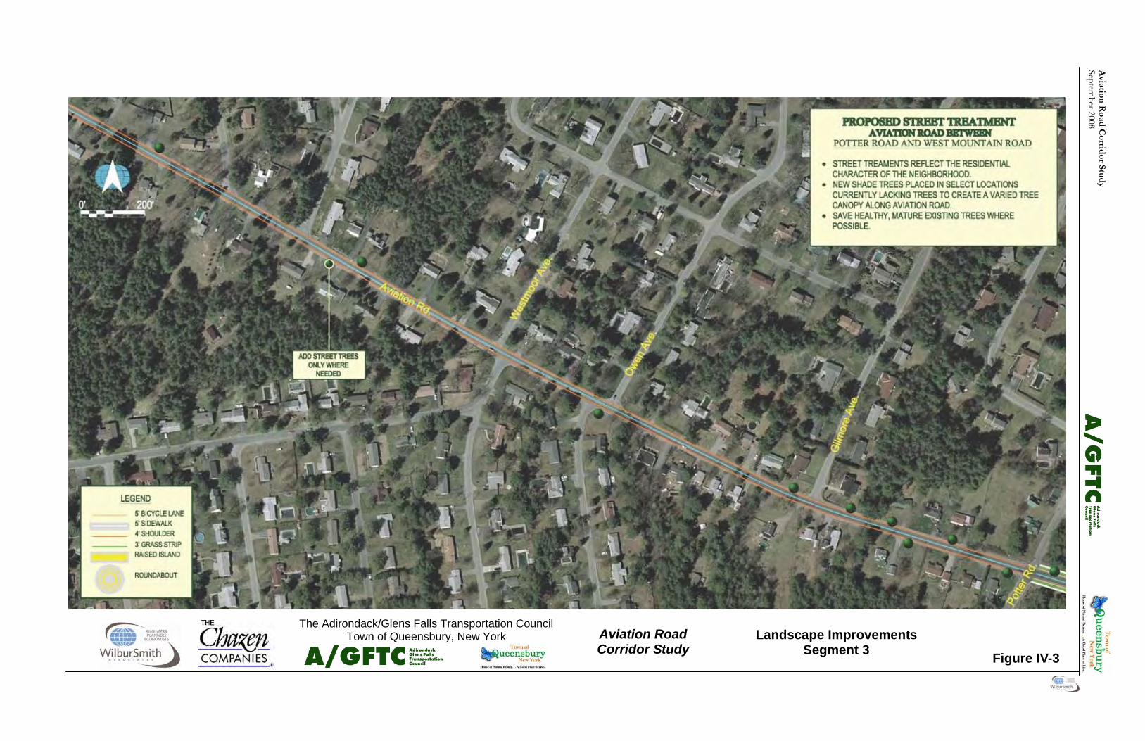
Aviation
Road C
orridor Stu
dy
September 2008
Aviation Road Corridor Study
The Adirondack/Glens Falls Transportation Council Town of Queensbury, New York
Figure IV-3
Landscape Improvements Segment 3

Avi
atio
n R
oad
Cor
rid
or S
tud
y Se
ptem
ber 2
008

Aviation
Road C
orridor Stu
dy
September 2008
Aviation Road Corridor Study
The Adirondack/Glens Falls Transportation Council Town of Queensbury, New York
Figure IV-4
Landscape Improvements Segment 4

Avi
atio
n R
oad
Cor
rid
or S
tud
y Se
ptem
ber 2
008

43
Aviation Road Corridor Study September 2008
VII. IMPLEMENTATION A. OVERVIEW This section of the plan describes the tools and tech-niques, responsible parties, and funding sources that can help implement the Plan’s recommendations. Table V-1 lists the recommendation as well as ap-propriate tools and techniques, responsibility, financ-ing and time frame. B. TOOLS AND TECHNIQUES 1. Transportation Improvement Program (TIP) Projects seeking to use federal transportation funds must be included on the A/GFTC’s Transportation Improvement Program (TIP). The TIP is a staged, multi-year capital program of transportation im-provements that implements planning process rec-ommendations. Conceptual recommendations, such as those included in this plan, if placed on the TIP, would be eligible to receive the funds necessary to finalize design and cost, identify and mitigate for resource impacts, acquire right-of-way, and con-struct. 2. NYSDOT Annual Program Aviation Road is partially a Town road and may not be fully eligible for this program, but annual NYS-DOT programs that might be used to implement the recommendations include annual pavement marking replacement and traffic signal retiming until such time as the recommended roundabout can be in-stalled. Other NYSDOT programs may be able to assist with continued monitoring of the corridor such as the traffic count program, analysis or im-provements of locations with safety concerns (such as the intersection with West Mountain Road), and pavement condition inventories. 3. Private/Voluntary Actions Some of the recommendations could depend on voluntary actions from private land owners. Exam-ples include providing an easement for a new side-walk or initiating individual agreements to share driveway access or connect adjacent parking, a prac-tice that already occurs between non-residential properties within the corridor.
C. RESPONSIBILITY This section, specifically Table V-1, identifies the partners most likely to be involved throughout im-plementation. It identifies the party who would lead the project and other partners who would be in-volved in different stages of implementation. Desig-nating a lead was based on ownership and authority to change regulations. D. FINANCING 1. Overview With the current uncertain funding times combined with the demands and needs of aging existing infra-structure and other projects needs, available funds for roadway projects are extremely competitive. Ad-ditionally, municipal budgets are stretched to provide the services and infrastructure expected by residents and businesses. Financial realities bring about genuine concern re-garding the ability of future projects and needs to obtain the necessary funding allocation to be carried through to completion. It is generally agreed by transportation professionals that under current fund-ing allocations, fiscal constraint regulations, and in-flation, if current highway spending levels were to be projected out into future years, available funds will not provide adequate investment to fully maintain, let alone enhance, the transportation system that exists today. In the 2008 NYSDOT publication Multimodal Invest-ment Needs & Goals For the Future it was stated that “The dilemma facing New York State’s transporta-tion infrastructure is being replicated across the country…A new policy framework for investing in our transportation infrastructure is needed to pre-serve the vital transportation network and to im-prove it for meeting the new demands of competing in the global economy. This new policy framework should allow us to overcome the deficiencies in our transportation assets and, more importantly, to make cost-effective investments that will support our transportation system.” Transportation projects in Queensbury are funded with federal, New York State, local, and private funds. In some cases, a project draws upon all of these sources.

44
Aviation Road Corridor Study September 2008
2. Federal Transportation Funding Surface Transportation Program (STP) funds have the most flexible uses of any federal transporta-tion funds. STP funds may be used for highway, transit, and non-motorized facility construction and improvements. Facilities must be classified by the A/GFTC and New York State as eligible for federal aid, although sidewalks on local roads which are not on the federal aid system may also be eligible for STP funding. Non-federal match requirement is 20 percent. Avia-tion Road is eligible. It should be noted that this funding source is extremely competitive. Transportation Enhancement Program funds are another source of federal funds. Enhancement funding may be used for a variety of non-highway related projects such as bike paths, sidewalks, and streetscapes. Enhancement Funds awards are made through a competitive process. Applications are submitted for review by the A/GFTC. The A/GFTC evaluates the applications within its planning area and identifies a short list of high priority pro-jects that NYS then uses to make its final selections. Enhancement projects require a 20 percent non-federal match. Safe Routes to School funds can be used to im-prove sidewalks or bicycle paths leading to schools within a 2 mile radius of a school. Since a good num-ber of students now use Aviation Road as their route to school and more could in the future if it included facilities that parents thought provided good protec-tion for their children, these improvements could potentially be funded through this source. Safe Routes to School applications are currently due yearly at the beginning of April and have been in limited supply. The Town of Queensbury and the Queensbury School District could work together to submit multi-party applications that benefit the Town and School District. Funding for this program is competitive and open to all municipalities, school districts and other eligible entities within NYSDOT Region 1. Past funding priority has been assigned to school districts that rely less on busing than the Queensbury School District. Transportation, Community and System Preser-vation Program (TCSP) This program provides grant funding to states, MPOs, local governments and tribal governments to: • Develop projects that integrate transportation,
community and system preservation plans and practices that improve the efficiency of the
transportation system in the U.S.; • Reduce environmental impacts of transporta-
tion; reduce the need for costly future public infrastructure investments;
• Ensure efficient access to jobs, services and centers of trade; and
• Examine community development patterns and identify strategies to encourage private sector development patterns and investments that sup-port these goals.
Other Federal Programs The Recreational Trails Program is available for trail projects for both motorized and non-motorized trails. These funds could be used for rail-trail and shared use paths (such as the recommended Dixon Road to Potter Road path). This is a matching grant program administered by the Office of Parks, Rec-reation and Historic Preservation. Funds are avail-able to non-profit organizations, municipal state and federal agencies, Indian tribal governments and other public agencies and authorities for the acquisition, development, rehabilitation and maintenance of trails and trail-related projects. MPOs have a Unified Planning Work Program which outlines how federal planning funds can be spent. Some of these funds could be used to ad-vance the planning for some of the specific recom-mended elements of the plan. Urbanized Area Formula Grants and Capital Invest-ment Grants for Transit are used for improving bicy-cle and pedestrian access to transit facilities. These funds could be used for the sidewalks, bicycle routes, shared use paths leading to Aviation Road/Burke Road to meet the current transit route or to more of Aviation Road if and when transit service is extended beyond Burke Road. The Transit Enhancement Activity Program pro-vides funds for pedestrian and bicycle access to tran-sit facilities, bicycle storage facilities and equipment for transporting bicycles on mass transportation ve-hicles. These funds could be used for the sidewalks, bicycle routes, shared use paths leading to Aviation Road/Burke Road to meet the current transit route or to more of Aviation Road if and when transit service is extended beyond Burke Road for transit stop facilities for pedestrians and bicyclists. 3. State Sources of Funding NYSDOT may completely fund and implement pro-jects on facilities it owns or assist locals in funding their non-federal match for projects using the Con-

45
Aviation Road Corridor Study September 2008
solidated Highway Improvement Program System (CHIPS) or Marchiselli funding. CHIPS provides support for improvements to roads with expected life spans of seven to ten years or more and is typi-cally used for pavement rehabilitation and bridge repairs. Marchiselli funding covers 75 percent of the local share of federally-funding projects leaving the local municipality responsible for 25 percent of the non-federal match (25 percent of 20 percent is 5 percent). State funding sources for transportation related pro-jects or services are available from State Agencies other than NYSDOT. For example, the Governor’s Traffic Safety Committee and the New York State Department of Health offer funding programs to support safety education that could be offered on the school campus adjacent to Aviation Road. Funds are also available for walking and bicycle trails from the New York State Office of Parks, Recreation and Historic Preservation (OPRHP), which could poten-tially assist with the off road trail between Dixon and Potter Road. State funding of transportation projects or services may also be provided through legislative member items from State Senate or Assembly representatives. These funding sources are also very competitive. 4. Local Sources of Funding A portion of the non-federal match will often come from local sources. If significant enough, these funds maybe identified in a municipal capital pro-gram. Smaller and less costly projects which do not use federal or State sources may be funded through a local highway public works or park department an-nual budget. Towns also have the option to establish special assessment tax districts that raise funds for specific purposes such as sidewalks or roadway re-pairs. The Town of Queensbury maintains a Capital Improvement Plan. This project should be listed on that plan. 5. Special Grants There are several special grant programs available for specific local transportation projects which become available from time to time. The Town should con-tact NYSDOT and AGFTC when they are looking for funding for specific purposes to see what is cur-rently available. 6. Public-Private Partnership Options As transportation needs have grown in recent years at a rate which has outpaced public funding availabil-
ity, particularly at the local level, innovative ap-proaches to paying for transportations projects have emerged. One such approach entails creative part-nerships between the public and private sectors. In New York State, these types of arrangements have often involved roadway intersections and capacity improvements associated with commercial develop-ments, as well as interchanges on area freeways. The common thread in any public-private partnership is that involved parties receive some benefit from their resource contribution. While these partnerships could not fund 100 percent of the Aviation Corridor Plan’s implementation, they could represent an im-portant piece of the overall funding framework. Options which could be explored in this regard in-cluded: • Identifying and working with business owners
and developers in the Corridor to co-underwrite the costs of access management, pedestrian or bicycle amenities, or landscaping; and
• Formation of a non-profit neighborhood group
focused on development of the bicycle and pe-destrian accommodations along Aviation Road and in the neighborhood.
This is not an exhaustive list of options for designat-ing public-private partnerships targeted at imple-menting the Corridor Plan. Other arrangements may be possible, and, in light of continuing constraints on public funding sources, the Town should aggres-sively pursue such arrangements to add another tool to the Town’s funding “toolkit.” 7. Private Development Sidewalks, bike paths, bike lanes, and streetscape improvements can be funded by developers within residential and commercial developments as long as the requirements have been incorporated into the subdivision or site plan regulations. It is easier to request and/or require these facilities from develop-ers if such improvements are generally detailed in a plan that supports, and provides a rationale for, the requested elements. 8. School Funding Sources Because the two proposed eastern roundabouts re-late to the updating of the Queensbury School Dis-trict Campus, there is the potential that the School District may be able to assist in securing grants or other funding for their construction.

46
Aviation Road Corridor Study September 2008
Act
ion
TIP
Tow
n A
ctio
nPr
ivat
e A
ctio
nTo
wn
of
Que
ensb
ury
Scho
ol
Dis
trict
Priv
ate
Fede
ral
STP
Enha
ncem
ent
SR2S
TCSP
Rec
Tra
ilsG
rant
s for
Tr
ansi
tLo
cal
Fund
ing
Scho
ol
Fund
ing
Spec
ial
Gra
nts
Urb
an
Fore
stry
G
rant
s
Publ
ic/
Priv
ate
Priv
ate
Dev
elop
. Im
med
iate
Shor
t Ter
m (1
-3
year
s)M
id T
erm
(4-
8 ye
ars)
Long
Ter
m
(Mor
e th
an 8
ye
ars)
B
urke
- M
idni
ght
Bik
e La
nes
xx
xx
xx
xx
xx
Side
wal
ksx
xx
xx
xx
xx
xCr
ossw
alks
xx
xx
xx
Cent
er M
edia
nx
xx
xx
xx
xx
Mid
nigh
t Rou
ndab
out
xx
xx
xx
xx
Scho
ol R
ound
abou
tx
xx
xx
xx
xSt
reet
Tre
esx
xx
xx
xx
xx
xx
xx
Ligh
ting
xx
xx
xx
Irrig
atio
nx
xx
xx
xx
xx
Mid
nigh
t -Po
tter
Bik
e La
nes
xx
xx
xx
xx
xSi
dew
alks
xx
xx
xx
xx
Cros
swal
ksx
xx
xx
xx
Dix
on R
ound
abou
tx
xx
xx
xPo
tter i
nter
sctio
n up
grad
esx
xx
xx
xSt
reet
Tre
esx
xx
xx
xx
xx
xx
xM
ulti-
Use
Pat
hx
xx
xx
xx
Pott
er -
Mou
ntai
n4
Ft S
houl
der
xx
xx
xx
Stre
et T
rees
xx
xx
xx
xx
xx
xx
Inte
rsec
tion
Sign
age
xx
xx
x
Too
ls o
r T
echn
ique
sR
espo
nsib
ility
Fina
ncin
g O
ptio
nsTi
min
g
Tab
le V
-1
Imp
lem
enta
tion
Mat
rix

First
Aviation Road Corridor Study September 2008
APPENDIX A ACCIDENT
ANALYSIS

Second
Aviation Road Corridor Study September 2008
This Page Intentionally Left Blank
Accident Analysis Report
Aviation Road Corridor Study
Town of Queensbury, Warren County
April 7, 2007
Prepared for:
Adirondack / Glens Falls Transportation Council, Fort Edward, N.Y.
Prepared by:
MJ Engineering and Land Surveying, P.C. 1533 Crescent Road Clifton Park, NY 12065 Phone: (518) 371-0799 Fax: (518) 371-0822

M.J. Engineering and Land Surveying, P.C. Accident Analysis
Sheet 1 of 3 Aviation Road Corridor Study 4/10/2007
Accident Analysis Summary
Aviation Road, Town of Queensbury, Warren County The project area has been broken up into six (6) segments for the purpose of this analysis:
1. West Mountain Rd / Butler Rd to Mountain View Lane intersection 2. Mountain View Lane to Fox Farm Road / Potter Road intersection 3. Fox Farm Road / Potter Road to Dixon Road / Farr Lane intersection 4. Dixon Road / Farr Lane to Midnight Dr / Manor Dr intersection 5. Midnight Dr / Manor Dr to Cottage Hill Road intersection 6. Cottage Hill Road to Burke Drive intersection
Accident data was collected for the five-year period from January 2000 to December 2005. The accident data includes non-reportable accidents, with some limited information available for these types. See Appendix A for accident descriptions and collision diagrams. The overall accident rate for the entire study area is 1.79 accidents per million vehicle kilometers (acc/MVkM). Aviation Road has been divided into two sections with different highway characteristics and land uses. The first section of Aviation Road is from the West Mountain Road / Butler Road intersection to east of the Midnight Drive / Manor Drive intersection, which consists of a two-lane, undivided two-way roadway servicing personal dwellings. The accident rate for this section is 1.84 acc/MVkM. The second section of Aviation Road is from east of the Midnight Drive / Manor Drive intersection to east of the Burke Drive intersection. This section consists of a three-lane section with left turn lanes at intersections and a continuous two-way left turn lane. This section of Aviation Road is mainly commercial to the south, with the Queensbury school campus to the north. The accident rate for this section is 3.02 acc/MVkM. The comparable expected statewide rate is 3.66 acc/MVkM for facilities similar to Aviation Road.
Segment No. 1 The first segment is from the intersection of West Mountain Road / Butler Road to the Mountain View Lane intersection and was the scene of 15 accidents during the five-year analysis period. Thirteen (13) of these accidents occurred at the intersection of West Mountain Road / Butler Road with Aviation Road. The severity distribution is normal. Seven (7) of the accidents were right angle due to drivers failing to yield the right-of-way to through vehicles. Three (3) accidents were classified as other collisions, which involved left turning vehicles failing to yield the right-of-way, and one (1) accident was a left-turn accident. The remaining two (2) accidents were non-reportable accidents. This intersection was on the High Risk Rural Roads Accident Summary sent to NYSDOT Region 1 on 11/21/06. It was determined that drivers may find it difficult to judge the speed of approaching traffic on West Mountain Road (CR 58) when at a stop control on the minor approaches. The accident rate for the West Mountain Road / Butler Road intersection is 1.86 accidents per million entering vehicles (acc/MEV) compared to the expected statewide rate of 0.27 acc/MEV for similar facilities. One (1) rear-end accident due to driver illness occurred between West Mountain Road and Mountain View Lane. One (1) non-reportable accident was attributed to the intersection of Mountain View lane. The accident rate for the Mountain View Lane intersection is 0.14 acc/MEV compared to the expected statewide rate of 0.16 acc/MEV for similar facilities. A cluster of right-angle accidents is evident on this segment with eight (8) of the fifteen (15) total accidents involving right angle or left-turn accidents.
M.J. Engineering and Land Surveying, P.C. Accident Analysis
Sheet 2 of 3 Aviation Road Corridor Study 4/10/2007
Segment No. 2 The second segment is from the intersection of Mountain View Lane to the Fox Farm Road / Potter Road intersection and was the scene of 29 accidents for the five-year analysis period. Fifteen (15) of the accidents were directly related to the intersection of Fox Farm Road / Potter Road with Aviation Road. The severity distribution of the accidents is normal. A cluster of right-angle accidents were found in this segment with six (6) located at the intersection and three (3) related to the roadway to the west. Four (4) of the six (6) intersection accidents were the result of drivers on the side street approaches failing to yield the right-of-way to the vehicles on the mainline route. The accident rate for the Fox Farm Road / Potter Road intersection is 0.67 acc/MEV compared to the expected statewide rate of 0.27 acc/MEV for similar facilities. The accidents do not reveal any other significant patterns except that the accident rate is high for this location.
Segment No. 3 The next segment of Aviation Road is from the Fox Farm Road / Potter Road intersection to the Dixon Road / Farr Lane intersection which was the scene of ten (10) accidents. Seven (7) of those accidents were contributed to the Dixon Road / Farr Lane intersection for the five-year analysis period. The severity distribution of accidents along this segment is normal. The accident rate for the Dixon Road / Farr Lane intersection is 0.28 acc/MEV compared to the expected statewide rate of 0.27 acc/MEV for four-leg intersections with two-way stop control. The severity distribution of the accidents is normal. Half of the accidents for this area, five (5) of the ten (10), were rear-end accidents with varying contributing factors. The remaining accidents consisted of two (2) left-turn, one (1) right angle and one (1) fixed object accident along with one (1) non-reportable accident.
Segment No. 4 The segment from the Dixon Road / Farr Lane intersection to the Midnight Drive / Manor Drive intersection with Aviation Road was the scene of a total of eighteen (18) accidents. The accident rate for the Midnight Drive / Manor Drive intersection is 0.24 acc/MEV compared to the expected statewide rate of 0.27 acc/MEV for four-leg intersections with two-way stop control. The severity distribution of the accidents is normal. Six (6) of the eighteen (18) segment accidents were attributed to the intersection. Two (2) of the accidents involved a bicyclist with one (1) of them occurring to the west of the intersection and one (1) at the intersection. The accidents were the result of vehicles striking the bicyclists while making turns. The only cluster of accidents in this location is the history of five (5) rear end accidents with four (4) related to the linear section west of the intersection and one (1) to the intersection. All of the rear end accidents occurred while vehicles were traveling east on Aviation Road at varying times of day. One (1) rear end accident was attributed to glare with the rest occurring while one vehicle was stopped in traffic and was struck from behind. One (1) of the accidents was also non-reportable.
Segment No. 5 This segment is from the Midnight Drive / Manor Drive intersection to the Cottage Hill Road intersection and was the scene of twelve (12) total accidents, four (4) of which were related to the Cottage Hill Road intersection. The accident rate for the Cottage Hill Road intersection is 0.15 acc/MEV compared to the expected statewide rate of 0.27 acc/MEV for four-leg intersections with two-way stop control. The severity distribution of the accidents is normal. Four (4) accidents related to the intersection and roadway to the west were non-reportable, therefore no accident type was available. Four (4) of the remaining eight (8) accidents were rear end type accidents with three (3) related to the roadway and one (1) related to the intersection. All of the rear end accidents

M.J. Engineering and Land Surveying, P.C. Accident Analysis
Sheet 3 of 3 Aviation Road Corridor Study 4/10/2007
occurred while a vehicle was stopped in traffic and struck from behind. Three of the four accidents occurred as vehicles traveled east on Aviation Road.
Segment No. 6 The last segment of the analysis is from the Cottage Hill Road intersection to the Burke Drive intersection, which was the scene of twenty-one (21) accidents. Ten (10) of the twenty-one (21) accidents were attributed to the Burke Drive intersection. The accident rate for the Burke Drive intersection is 0.32 acc/MEV compared to the expected statewide rate of 0.29 acc/MEV for a three-leg intersection with left turn lanes and five (5) or more lanes under signal control. The severity distribution of the accidents is normal. Five (5) of the accidents were of the non-reportable variety. Six (6) of the remaining fifteen (15) accidents and two (2) of the non-reportable accidents were rear end collisions. Only one (1) of the rear end accidents was related to the intersection and was a result of a vehicle being struck while stopped in traffic. One (1) accident located to the west of Burke Drive involved a bicycle, whose operator failed to yield the right-of-way to a vehicle traveling at an unsafe speed. The remaining accidents consisted of one (1) right angle, three (3) left turn, one (1) head on, one (1) overtake, and three (3) other collision accidents.
Overview The overall study area has a high number of rear-end, left turn and right angle accidents. Reviewing the accident descriptions revealed that many of the rear end accidents occurred while one vehicle was stopped in traffic, either turning or waiting for another vehicle to turn. The inclusion of a two-way left turn lane is one possible solution that could reduce the number of accidents in this area by removing the stopped vehicles from the thru lanes. The accident rates for three (3) of the six (6) intersections were below the expected statewide averages. The West Mountain Road / Butler Road intersection with Aviation Road accident rate of 1.86 acc/MEV is 6.9 times the expected statewide rate of 0.27 acc/MEV for similar facilities. The accident rate at the Fox Farm Road / Potter Road intersection with Aviation is 0.67 acc/MEV, which is 2.5 times the expected statewide rate of 0.27 acc/MEV. Both of these are four-way intersections with two-way stop control. The Burke Drive intersection with Aviation Road accident rate is 0.32 acc/MEV, which is just above the expected statewide rate of 0.29 acc/MEV for three-leg intersections with left turn lanes and five (5) or more lanes under signal control. The presence and close proximity of driveways, both commercial and residential, is a contributing factor to the number of rear end, left turn and right angle accidents. Utilizing traffic calming measures is one possible method to reduce speed in this area. Reducing the speed will increase the safety of the traveling public with respect to the Queensbury School campus, located on the north side of Aviation Road, and would allow more gap time for left turning movements. The installation of stop signs, a traffic signal or roundabout at a major intersection west of Cottage Hill Road would reduce the travel speeds in the study area. Pedestrians were not involved in any of the accidents reported during the five-year study period. Only three (3) of the ninety-two total accidents involved bicycles. One of the bicycle accidents occurred due to the bicyclist crossing Aviation Road at an unexpected location and not allowing sufficient gap time to cross. The other two accidents were the result of the bicycle traveling on the wrong side of the road and the drivers’ inability to notice the bicycle. The number of bicycle accidents and lack of pedestrian accidents does not reveal a problem with bicycle or pedestrian safety in the study area and no improvements are recommended beyond allowing sufficient shoulder width to allow for safe pedestrian and bicycle travel.

APPENDIX A
ACCIDENT DESCRIPTIONS AND COLLISION DIAGRAMS
AVIATION ROAD ACCIDENT SUMMARY TABLE
Non Reportable
Ukn
ow
n
Rear
En
d
West Mountain Rd / Butler Rd Intersection 7 1 3 2 13 4 6 1
Between West Mountain Rd / Butler Rd &
Mountain View Ln Intersections1 1 1
Mountain View Ln Intersection 1 1
Between Mountain View Ln & Fox Farm Rd /
Potter Rd Intersections3 1 3 1 3 3 14 6 5
Fox Farm Rd / Potter Rd Intersection 6 3 2 1 3 15 4 7 1
Between Fox Farm Rd / Potter Rd & Dixon Rd /
Farr Ln Intersections2 1 3 1 1
Dixon Rd / Farr Ln Intersection 1 2 3 1 7 2 5
Between Dixon Rd / Farr Ln & Midnight Dr /
Manor Dr Intersections 2 4 1 1 2 1 1 12 6 4
Midnight Dr / Manor Dr Intersection 1 1 1 2 1 6 3 2
Between Midnight Dr / Manor Dr & Cottage Hill
Rd Intersections 1 1 3 1 2 8 2 3 1
Cottage Hill Rd Intersection 1 1 2 4 2
Between Cottage Hill Rd & Burke Dr
Intersections 1 5 1 1 1 2 11 5 3
Burke Dr Intersection 3 1 1 3 2 10 3 4 1
Totals 19 14 23 4 1 3 2 1 1 15 19 3 105 39 40 4
Section
Rig
ht
An
gle
Head
On
An
imal
Oth
er
Overt
ake
Left
Tu
rn
Rear
En
d
Sid
esw
ipe
Bic
ycle
Fix
ed
Ob
ject
To
tal A
ccid
en
ts
Pro
pert
y D
am
ag
e
On
ly
Inju
ry a
nd
Pro
pert
y
Dam
ag
e
Pers
on
al In
jury

4/10/2007, SHEET 2 OF 7
NO. CONTR REF REF DIR DIR DIR DIR DIR
NO. DATE DAY TIME VEH SEVER* LC RC RSC WEATH FACT. MARK MARK ACC TYPE N S E W UNKN DESCRIPTION OF ACCIDENT
WEST MOUNTAIN RD / BUTLER RD INTERSECTION
1 5/18/01 FRI 18:30 2 NR 30040
2 6/24/01 SUN 16:00 2 PDO 1 1 2 2 7 30040 RIGHT-ANGLE 1 1 V1, WB ON AVIATION, FAILED TO YIELD R-O-W AT STOP SIGN AND STRUCK V2, NB ON WEST MOUNTAIN
3 10/28/01 SUN 10:13 2 PI 1 1 1 1 4, 69 30040 RIGHT-ANGLE 1 1 V1, SB ON WEST MOUNTAIN, WAS STRUCK BY V2, EB ON BUTLER, DUE TO OBSTRUCTED VIEW & INATTENTION
4 12/12/01 WED 08:15 2 NR 30040
5 1/18/03 SAT 16:55 2 PDO U 1 1 2 UNKN. 30040 COLLISION 1 1 V1, WB ON AVIATION, WAS MAKING A LEFT AND V2, NB ON WEST MOUNTAIN, WERE INVOLVED IN A COLLISION
6 5/23/03 FRI 12:45 2 PDO 1 1 1 2 7 30040 RIGHT-ANGLE 1 1 V1, WB ON AVIATION, FAILED TO YIELD R-O-W AT STOP SIGN AND STRUCK V2, NB ON WEST MOUNTAIN
7 1/28/04 WED 12:28 2 PI 1 1 4 4 7 30040 RIGHT-ANGLE 1 1 V1, EB ON BUTLER, FAILED TO YEILD R-O-W AT STOP SIGN AND STRUCK V2, NB ON WEST MOUNTAIN
8 4/7/04 WED 15:35 2 PI 1 2 1 1 4, 7 30040 RIGHT-ANGLE 1 1 V1, EB ON BUTLER, FAILED TO YEILD R-O-W AT STOP SIGN AND STRUCK V2, NB ON WEST MOUNTAIN
9 5/27/04 THU - 1 PDO 4 1 1 1 UNKN. 30040 OTHER 1 V1, NB ON WEST MOUNTAIN, WAS MAKING A LEFT AND COLLIDED W/ EARTH EMBANKMENT AND DITCH
10 7/3/04 SAT 13:54 2 PI, PDO 1 1 1 1 7 30040 RIGHT-ANGLE 1 1 V1, SB ON WEST MOUNTAIN, FAILED TO YEILD R-O-W TURNING LEFT STRIKING V2, NB ON WEST MOUNTAIN
11 7/13/05 MON 10:01 2 PI 1 1 1 2 7 30040 OTHER 1 1 V1, SB ON WEST MOUNTAIN, FAILED TO YEILD R-O-W TURNING LEFT STRIKING V2, NB ON WEST MOUNTAIN
12 7/19/05 TUE 05:09 2 PDO 1 1 1 1 UNKN. 30040 LEFT-TURN 1 1 V1, NB ON WEST MOUNTAIN, MAKING A LEFT FAILED TO YEIDL R-O-W AND STRUCK V2, EB ON BUTLER
13 10/20/05 THU 15:30 2 PDO 1 1 1 2 UNKN. 30040 RIGHT-ANGLE 1 1 V1, SB ON WEST MOUNTAIN, AND V2, WB ON AVIATION, WERE INVOLVED IN A RIGHT ANGLE COLLISION
WEST MOUNTAIN RD / BUTLER RD TO MOUNTIAN VIEW LANE INTERSECTION
14 9/24/02 TUE 17:00 2 PI 1 2 1 1 10 30040 30530 REAR-END 2 V1, WB ON AVIATION, WAS REAR ENDED BY V2, WB ON AVIATION, DUE TO ILLNESS
MOUNTIAN VIEW LANE INTERSECTION
15 1/11/02 FRI 22:50 3 NR 30532
MOUNTAIN VIEW LN TO FOX FARM RD / POTTER RD INTERSECTION
16 10/11/00 WED 14:00 2 PI 1 1 1 1 7 30532 30533 RIGHT-ANGLE 2 V1, SE, SLOWED TO MAKE LEFT TURN AND STRUCK V2, EB ON AVIATION
17 9/23/00 SAT 23:00 1 PI 4 1 U U 4, 17 30533 FIXED-OBJECT 1 V1, TRAVELING WB ON AVIATION RD, MAKING A LEFT TURN STRUCK A TREE
18 1/7/02 MON 08:50 1 NR 30533
19 3/20/02 WED 14:36 2 NR 30533
20 8/15/01 WED 18:00 2 PI 1 1 1 1 4 30534 30535 RIGHT-ANGLE 1 1 V1, NB, WAS BACKING INTO ROAD AND WAS STRUCK BY V2, EB ON AVIATION
21 10/21/03 TUE 21:00 1 PDO U U 10 10 UNKN. 30534 30535 ANIMAL 1 V1 STRUCK A DEER
22 10/10/00 TUE 18:00 1 PDO 3 1 2 2 64 30536 OTHER 1 V1, WB ON AVIATION, COLLISION WITH OBSTRUCTION OR DEBRIS
23 1/14/02 MON 17:18 2 NR 30536 30537
24 12/22/00 FRI 07:00 2 PDO 1 1 2 1 7, 62 30537 RIGHT-ANGLE 1 1 V1, SB LT ONTO AVIATION, FAILED TO YIELD R-O-W AT STOP SIGN DUE TO GLARE AND WAS STRUCK BY V2
25 9/9/03 TUE 07:15 2 PDO U 1 1 1 UNKN. 30537 COLLISION 1 1 V1, WB ON AVIATION, WAS STRUCK BY V2, SB ON OWEN WHILE SLOWING OR STOPPING
26 3/21/05 MON 07:18 2 PDO 1 1 1 2 5, 7 30538 LEFT-TURN 1 1 V1, WB ON AVIATION, WAS STRUCK BY V2, EB ON AVIATION, WHILE MAKING A LEFT TURN
27 7/24/02 WED 14:06 1 PI 1 1 1 1 13 30538 30489 FIXED-OBJECT 1 V1, WB ON AVIATION, STRUCK A UTILITY POLE
28 1/3/03 FRI 17:43 2 PI 4 1 4 4 66 30538 30489 COLLISION 1 1 V1, EB ON AVIATION, SLID AND STRUCK V2, WB ON AVIATION
29 1/29/04 THU 16:57 1 PI 4 1 4 1 66 30538 30489 FIXED-OBJECT 1 V1, EB ON AVIATION, WAS OVERTAKING AND STRUCK A UTILITY POLE
AVIATION ROAD ACCIDENT SUMMARY DESCRIPTIONS
* - SEVERITY OF THE ACCIDENT: PI = PERSONAL INJURY, PDO = PROPERTY DAMAGE ONLY AND NR = NON-REPORTABLE
4/10/2007, SHEET 3 OF 7
NO. CONTR REF REF DIR DIR DIR DIR DIR
NO. DATE DAY TIME VEH SEVER* LC RC RSC WEATH FACT. MARK MARK ACC TYPE N S E W UNKN DESCRIPTION OF ACCIDENT
AVIATION ROAD ACCIDENT SUMMARY DESCRIPTIONS
FOX FARM RD / POTTER RD INTERSECTION
30 10/27/00 FRI 19:00 2 PDO 4 1 1 1 7 30489 RIGHT-ANGLE 1 1 V1, SB ON FOX FARM, STARTING IN TRAFFIC FAILED TO YIELD R-O-W AND STRUCK V2, WB ON AVIATION
31 11/19/00 SUN 14:00 2 PI 1 1 1 2 7, 40 30489 RIGHT-ANGLE 1 1 V1, NB ON POTTER, GOING STRAIGHT FAILED TO YIELD R-O-W AND STRUCK V2, EB ON AVIATION
32 5/15/01 TUE 13:17 2 PDO 1 1 1 1 7 30489 RIGHT-ANGLE 1 1 V1, WB ON AVIATION, GOING STRAIGHT WAS STRUCK BY V2, NB ON POTTER, WHO FAILED TO YIELD R-O-W
33 6/8/01 FRI 20:00 2 PI 3 1 1 1 7 30489 RIGHT-ANGLE 1 1 V1, SB ON FOX FARM, GOING STRAIGHT FAILED TO YIELD R-O-W AND STRUCK V2, EB ON AVIATION
34 7/18/01 WED 11:00 2 PDO 1 1 1 2 40 30489 REAR-END 2 V1, NB ON POTTER, STOPPED IN TRAFFIC WAS STRUCK BY V2, NB ON POTTER
35 11/23/01 FRI 14:55 2 NR 30489
36 11/24/01 SAT 15:15 0 NR 30489
37 3/9/02 SAT 20:53 1 NR 30489
38 11/6/02 WED 21:00 2 PDO U U U U UNKN. 30489 RIGHT-ANGLE 1 1 V1, EB ON AVIATION, COLLIDED WITH V2, NB ON POTTER, WHO WAS SLOWED OR STOPPING
39 1/14/03 TUE 08:30 2 PI, PDO 1 1 2 1 7 30489 LEFT-TURN 1 1 V1, WB ON AVIATION, FAILED TO YIELD R-O-W WHILE MAKING A LEFT STRUCK V2, EB ON AVIATION
40 12/5/03 FRI 13:05 2 PDO U U U U UNKN. 30489 COLLISION 2 V1 WAS AVOIDING AN OBJECT ON ROAD AND COLLIDED WITH V2
41 11/24/04 WED - 2 PDO 1 1 1 2 UNKN. 30489 RIGHT-ANGLE 1 1 V1, WB ON AVIATION, COLLIDED WITH V2, NB ON POTTER
42 6/3/05 FRI 21:06 2 PDO 5 1 1 1 UNKN. 30489 LEFT-TURN 1 1 V1, EB ON AVIATION, COLLIDED WITH V2, WB ON AVIATION
43 6/8/05 WED 07:50 2 PI 1 1 1 1 7 30489 LEFT-TURN 1 1 V1, SB ON FOX FARM, MAKING A LEFT STRUCK V2, EB ON AVIATION
44 11/9/05 WED 17:01 2 PI 4 1 2 3 9, 66 30489 REAR-END 2 V1, WB ON AVIATION, REAR-ENDED V2, WB ON AVIATION, WHO WAS STOPPED IN TRAFFIC
FOX FARM RD / POTTER RD INTERSECTION TO DIXON RD / FARR LN INTERSECTION
45 2/15/00 TUE 17:00 2 PI 3 1 2 1 9 30489 30490 REAR-END 2 V1, EB ON AVIATION, REAR-ENDED V2, EB ON AVIATION, WHO WAS STOPPED IN TRAFFIC
46 10/16/00 MON - U NR 30489 30490
47 3/24/04 WED 07:50 2 PDO U 1 2 1 UNKN 30489 30490 REAR-END 2 V1 & V2, BOTH EB ON AVIATION, WERE IN REAR-END COLLISION
DIXON RD / FARR LN INTERSECTION
48 3/10/01 SAT 11:00 2 PDO 1 1 2 2 40 30490 LEFT-TURN 1 1 V1, EB ON AVIATION, AND V2, WB ON AVIATION, WERE BOTH MAKING LEFTS AND COLLIDED
49 6/16/01 SAT 23:00 2 PDO 3 1 2 3 7 30490 RIGHT-ANGLE 1 1 V1, NB ON DIXON, FAILED TO YIELD R-O-W WHILE MAKING A LEFT AND STRUCK V2, EB ON AVIATION
50 11/29/01 THU 07:25 2 PI 1 1 2 3 9 30490 REAR-END 2 V1 , EB ON AVIATION, REAR-ENDED V2, EB ON AVIATION
51 12/12/01 WED 17:30 2 PDO U 1 1 1 UNKN 30490 REAR-END 2 V1 & V2, BOTH NB ON DIXON, WERE IN A REAR-END COLLISION
52 2/2/04 MON 13:49 2 PDO 1 1 1 1 UNKN 30490 REAR-END 2 V1 & V2, BOTH WB ON AVIATION, WERE IN REAR-END COLLISION
53 3/25/04 THU - 1 PDO 1 1 1 1 UNKN 30490 FIXED-OBJECT 1 V1, NB ON DIXON, ENTERING A PARKED POSITION STRUCK A SIGN POST
54 4/5/04 MON 15:01 2 PI 1 1 1 1 7 30490 LEFT-TURN 1 1 V1, NB ON DIXON, MAKING A LEFT FAILED TO YIELD R-O-W AND STRUCK V2, EB ON AVIATION
* - SEVERITY OF THE ACCIDENT: PI = PERSONAL INJURY, PDO = PROPERTY DAMAGE ONLY AND NR = NON-REPORTABLE
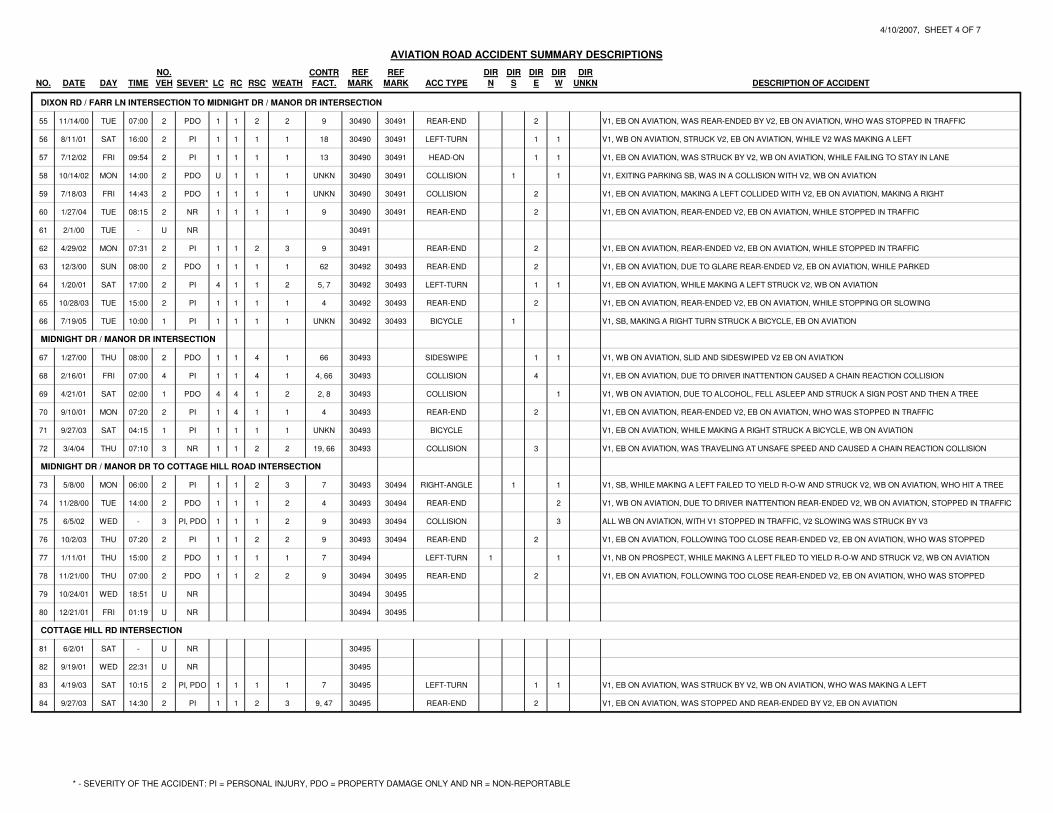
4/10/2007, SHEET 4 OF 7
NO. CONTR REF REF DIR DIR DIR DIR DIR
NO. DATE DAY TIME VEH SEVER* LC RC RSC WEATH FACT. MARK MARK ACC TYPE N S E W UNKN DESCRIPTION OF ACCIDENT
AVIATION ROAD ACCIDENT SUMMARY DESCRIPTIONS
DIXON RD / FARR LN INTERSECTION TO MIDNIGHT DR / MANOR DR INTERSECTION
55 11/14/00 TUE 07:00 2 PDO 1 1 2 2 9 30490 30491 REAR-END 2 V1, EB ON AVIATION, WAS REAR-ENDED BY V2, EB ON AVIATION, WHO WAS STOPPED IN TRAFFIC
56 8/11/01 SAT 16:00 2 PI 1 1 1 1 18 30490 30491 LEFT-TURN 1 1 V1, WB ON AVIATION, STRUCK V2, EB ON AVIATION, WHILE V2 WAS MAKING A LEFT
57 7/12/02 FRI 09:54 2 PI 1 1 1 1 13 30490 30491 HEAD-ON 1 1 V1, EB ON AVIATION, WAS STRUCK BY V2, WB ON AVIATION, WHILE FAILING TO STAY IN LANE
58 10/14/02 MON 14:00 2 PDO U 1 1 1 UNKN 30490 30491 COLLISION 1 1 V1, EXITING PARKING SB, WAS IN A COLLISION WITH V2, WB ON AVIATION
59 7/18/03 FRI 14:43 2 PDO 1 1 1 1 UNKN 30490 30491 COLLISION 2 V1, EB ON AVIATION, MAKING A LEFT COLLIDED WITH V2, EB ON AVIATION, MAKING A RIGHT
60 1/27/04 TUE 08:15 2 NR 1 1 1 1 9 30490 30491 REAR-END 2 V1, EB ON AVIATION, REAR-ENDED V2, EB ON AVIATION, WHILE STOPPED IN TRAFFIC
61 2/1/00 TUE - U NR 30491
62 4/29/02 MON 07:31 2 PI 1 1 2 3 9 30491 REAR-END 2 V1, EB ON AVIATION, REAR-ENDED V2, EB ON AVIATION, WHILE STOPPED IN TRAFFIC
63 12/3/00 SUN 08:00 2 PDO 1 1 1 1 62 30492 30493 REAR-END 2 V1, EB ON AVIATION, DUE TO GLARE REAR-ENDED V2, EB ON AVIATION, WHILE PARKED
64 1/20/01 SAT 17:00 2 PI 4 1 1 2 5, 7 30492 30493 LEFT-TURN 1 1 V1, EB ON AVIATION, WHILE MAKING A LEFT STRUCK V2, WB ON AVIATION
65 10/28/03 TUE 15:00 2 PI 1 1 1 1 4 30492 30493 REAR-END 2 V1, EB ON AVIATION, REAR-ENDED V2, EB ON AVIATION, WHILE STOPPING OR SLOWING
66 7/19/05 TUE 10:00 1 PI 1 1 1 1 UNKN 30492 30493 BICYCLE 1 V1, SB, MAKING A RIGHT TURN STRUCK A BICYCLE, EB ON AVIATION
MIDNIGHT DR / MANOR DR INTERSECTION
67 1/27/00 THU 08:00 2 PDO 1 1 4 1 66 30493 SIDESWIPE 1 1 V1, WB ON AVIATION, SLID AND SIDESWIPED V2 EB ON AVIATION
68 2/16/01 FRI 07:00 4 PI 1 1 4 1 4, 66 30493 COLLISION 4 V1, EB ON AVIATION, DUE TO DRIVER INATTENTION CAUSED A CHAIN REACTION COLLISION
69 4/21/01 SAT 02:00 1 PDO 4 4 1 2 2, 8 30493 COLLISION 1 V1, WB ON AVIATION, DUE TO ALCOHOL, FELL ASLEEP AND STRUCK A SIGN POST AND THEN A TREE
70 9/10/01 MON 07:20 2 PI 1 4 1 1 4 30493 REAR-END 2 V1, EB ON AVIATION, REAR-ENDED V2, EB ON AVIATION, WHO WAS STOPPED IN TRAFFIC
71 9/27/03 SAT 04:15 1 PI 1 1 1 1 UNKN 30493 BICYCLE V1, EB ON AVIATION, WHILE MAKING A RIGHT STRUCK A BICYCLE, WB ON AVIATION
72 3/4/04 THU 07:10 3 NR 1 1 2 2 19, 66 30493 COLLISION 3 V1, EB ON AVIATION, WAS TRAVELING AT UNSAFE SPEED AND CAUSED A CHAIN REACTION COLLISION
MIDNIGHT DR / MANOR DR TO COTTAGE HILL ROAD INTERSECTION
73 5/8/00 MON 06:00 2 PI 1 1 2 3 7 30493 30494 RIGHT-ANGLE 1 1 V1, SB, WHILE MAKING A LEFT FAILED TO YIELD R-O-W AND STRUCK V2, WB ON AVIATION, WHO HIT A TREE
74 11/28/00 TUE 14:00 2 PDO 1 1 1 2 4 30493 30494 REAR-END 2 V1, WB ON AVIATION, DUE TO DRIVER INATTENTION REAR-ENDED V2, WB ON AVIATION, STOPPED IN TRAFFIC
75 6/5/02 WED - 3 PI, PDO 1 1 1 2 9 30493 30494 COLLISION 3 ALL WB ON AVIATION, WITH V1 STOPPED IN TRAFFIC, V2 SLOWING WAS STRUCK BY V3
76 10/2/03 THU 07:20 2 PI 1 1 2 2 9 30493 30494 REAR-END 2 V1, EB ON AVIATION, FOLLOWING TOO CLOSE REAR-ENDED V2, EB ON AVIATION, WHO WAS STOPPED
77 1/11/01 THU 15:00 2 PDO 1 1 1 1 7 30494 LEFT-TURN 1 1 V1, NB ON PROSPECT, WHILE MAKING A LEFT FILED TO YIELD R-O-W AND STRUCK V2, WB ON AVIATION
78 11/21/00 THU 07:00 2 PDO 1 1 2 2 9 30494 30495 REAR-END 2 V1, EB ON AVIATION, FOLLOWING TOO CLOSE REAR-ENDED V2, EB ON AVIATION, WHO WAS STOPPED
79 10/24/01 WED 18:51 U NR 30494 30495
80 12/21/01 FRI 01:19 U NR 30494 30495
COTTAGE HILL RD INTERSECTION
81 6/2/01 SAT - U NR 30495
82 9/19/01 WED 22:31 U NR 30495
83 4/19/03 SAT 10:15 2 PI, PDO 1 1 1 1 7 30495 LEFT-TURN 1 1 V1, EB ON AVIATION, WAS STRUCK BY V2, WB ON AVIATION, WHO WAS MAKING A LEFT
84 9/27/03 SAT 14:30 2 PI 1 1 2 3 9, 47 30495 REAR-END 2 V1, EB ON AVIATION, WAS STOPPED AND REAR-ENDED BY V2, EB ON AVIATION
* - SEVERITY OF THE ACCIDENT: PI = PERSONAL INJURY, PDO = PROPERTY DAMAGE ONLY AND NR = NON-REPORTABLE
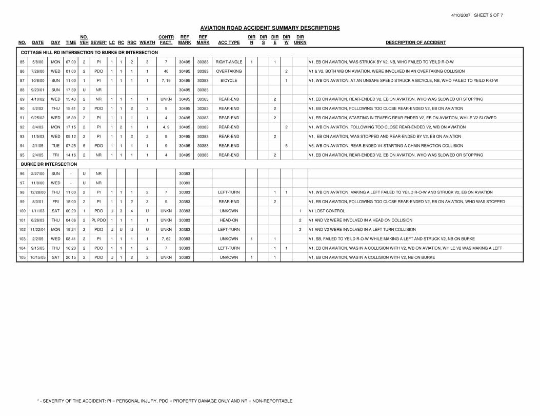
4/10/2007, SHEET 5 OF 7
NO. CONTR REF REF DIR DIR DIR DIR DIR
NO. DATE DAY TIME VEH SEVER* LC RC RSC WEATH FACT. MARK MARK ACC TYPE N S E W UNKN DESCRIPTION OF ACCIDENT
AVIATION ROAD ACCIDENT SUMMARY DESCRIPTIONS
COTTAGE HILL RD INTERSECTION TO BURKE DR INTERSECTION
85 5/8/00 MON 07:00 2 PI 1 1 2 3 7 30495 30383 RIGHT-ANGLE 1 1 V1, EB ON AVIATION, WAS STRUCK BY V2, NB, WHO FAILED TO YEILD R-O-W
86 7/26/00 WED 01:00 2 PDO 1 1 1 1 40 30495 30383 OVERTAKING 2 V1 & V2, BOTH WB ON AVIATION, WERE INVOLVED IN AN OVERTAKING COLLISION
87 10/8/00 SUN 11:00 1 PI 1 1 1 1 7, 19 30495 30383 BICYCLE 1 V1, WB ON AVIATION, AT AN UNSAFE SPEED STRUCK A BICYCLE, NB, WHO FAILED TO YEILD R-O-W
88 9/23/01 SUN 17:39 U NR 30495 30383
89 4/10/02 WED 15:43 2 NR 1 1 1 1 UNKN 30495 30383 REAR-END 2 V1, EB ON AVIATION, REAR-ENDED V2, EB ON AVIATION, WHO WAS SLOWED OR STOPPING
90 5/2/02 THU 15:41 2 PDO 1 1 2 3 9 30495 30383 REAR-END 2 V1, EB ON AVIATION, FOLLOWING TOO CLOSE REAR-ENDED V2, EB ON AVIATION
91 9/25/02 WED 15:39 2 PI 1 1 1 1 4 30495 30383 REAR-END 2 V1, EB ON AVIATION, STARTING IN TRAFFIC REAR-ENDED V2, EB ON AVIATION, WHILE V2 SLOWED
92 8/4/03 MON 17:15 2 PI 1 2 1 1 4, 9 30495 30383 REAR-END 2 V1, WB ON AVIATION, FOLLOWING TOO CLOSE REAR-ENDED V2, WB ON AVIATION
93 11/5/03 WED 09:12 2 PI 1 1 2 2 9 30495 30383 REAR-END 2 V1, EB ON AVIATION, WAS STOPPED AND REAR-ENDED BY V2, EB ON AVIATION
94 2/1/05 TUE 07:25 5 PDO 1 1 1 1 9 30495 30383 REAR-END 5 V5, WB ON AVIATION, REAR-ENDED V4 STARTING A CHAIN REACTION COLLISION
95 2/4/05 FRI 14:16 2 NR 1 1 1 1 4 30495 30383 REAR-END 2 V1, EB ON AVIATION, REAR-ENDED V2, EB ON AVIATION, WHO WAS SLOWED OR STOPPING
BURKE DR INTERSECTION
96 2/27/00 SUN - U NR 30383
97 11/8/00 WED - U NR 30383
98 12/28/00 THU 11:00 2 PI 1 1 1 2 7 30383 LEFT-TURN 1 1 V1, WB ON AVIATION, MAKING A LEFT FAILED TO YEILD R-O-W AND STRUCK V2, EB ON AVIATION
99 8/3/01 FRI 15:00 2 PI 1 1 2 3 9 30383 REAR-END 2 V1, EB ON AVIATION, FOLLOWING TOO CLOSE REAR-ENDED V2, EB ON AVIATION, WHO WAS STOPPED
100 1/11/03 SAT 00:20 1 PDO U 3 4 U UNKN 30383 UNKOWN 1 V1 LOST CONTROL
101 6/26/03 THU 04:06 2 PI, PDO 1 1 1 1 UNKN 30383 HEAD-ON 2 V1 AND V2 WERE INVOLVED IN A HEAD ON COLLISION
102 11/22/04 MON 19:24 2 PDO U U U U UNKN 30383 LEFT-TURN 2 V1 AND V2 WERE INVOLVED IN A LEFT TURN COLLISION
103 2/2/05 WED 08:41 2 PI 1 1 1 1 7, 62 30383 UNKOWN 1 1 V1, SB, FAILED TO YEILD R-O-W WHILE MAKING A LEFT AND STRUCK V2, NB ON BURKE
104 9/15/05 THU 16:20 2 PDO 1 1 1 2 7 30383 LEFT-TURN 1 1 V1, EB ON AVIATION, WAS IN A COLLISION WITH V2, WB ON AVIATION, WHILE V2 WAS MAKING A LEFT
105 10/15/05 SAT 20:15 2 PDO U 1 2 2 UNKN 30383 UNKOWN 1 1 V1, EB ON AVIATION, WAS IN A COLLISION WITH V2, NB ON BURKE
* - SEVERITY OF THE ACCIDENT: PI = PERSONAL INJURY, PDO = PROPERTY DAMAGE ONLY AND NR = NON-REPORTABLE
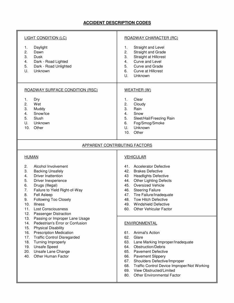
ACCIDENT DESCRIPTION CODES
LIGHT CONDITION (LC) ROADWAY CHARACTER (RC)
1. Daylight 1. Straight and Level
2. Dawn 2. Straight and Grade
3. Dusk 3. Straight at Hillcrest
4. Dark - Road Lighted 4. Curve and Level
5. Dark - Road Unlighted 5. Curve and Grade
U. Unknown 6. Curve at Hillcrest
U. Unknown
ROADWAY SURFACE CONDITION (RSC) WEATHER (W)
1. Dry 1. Clear
2. Wet 2. Cloudy
3. Muddy 3. Rain
4. Snow/Ice 4. Snow
5. Slush 5. Sleet/Hail/Freezing Rain
U. Unknown 6. Fog/Smog/Smoke
10. Other U. Unknown
10. Other
APPARENT CONTRIBUTING FACTORS
HUMAN VEHICULAR
2. Alcohol Involvement 41. Accelerator Defective
3. Backing Unsafely 42. Brakes Defective
4. Driver Inattention 43 Headlights Defective
5. Driver Inexperience 44. Other Lighting Defects
6. Drugs (Illegal) 45. Oversized Vehicle
7. Failure to Yield Right-of-Way 46. Steering Failure
8. Fell Asleep 47. Tire Failure/Inadequate
9. Following Too Closely 48. Tow Hitch Defective
10. Illness 49. Windshield Defective
11. Lost Consciousness 60. Other Vehicular Factor
12. Passenger Distraction
13. Passing or Improper Lane Usage
14. Pedestrian's Error or Confusion ENVIRONMENTAL
15. Physical Disability
16. Prescription Medication 61. Animal's Action
17. Traffic Control Disregarded 62. Glare
18. Turning Improperly 63. Lane Marking Improper/Inadequate
19. Unsafe Speed 64. Obstruction/Debris
20. Unsafe Lane Change 65. Pavement Defective
40. Other Human Factor 66. Pavement Slippery
67. Shoulders Defective/Improper
68. Traffic Control Device Improper/Not Working
69. View Obstructed/Limited
80. Other Environmental Factor

Aviation Road Accident Analysis Reference Marker Descriptions
Reference Marker Intersecting Road(s)
from to from to
30040 30530 West Mountain Rd Unknown
30532 Mountian View Lane
30532 30533 Mountian View Lane Crownwood Lane
30533 Crownwood Lane
30534 30535 Unknown Unknown
30536 30535 Sylvan Ave Unknown
30536 30537 Sylvan Ave Owen Ave
30537 Owen Ave
30538 Gilmore Ave
30538 30489 Gilmore Ave Fox Farm Rd / Potter Rd
30489 Fox Farm Rd / Potter Rd
30489 30490 Fox Farm Rd / Potter Rd Dixon Rd / Farr Ln
30490 Dixon Rd / Farr Ln
30490 30491 Dixon Rd / Farr Ln Poplar Ln
30491 Poplar Ln
30492 30493 Unknown Manor Dr / Midnight Dr
30493 Manor Dr / Midnight Dr
30493 30494 Manor Dr / Midnight Dr Prospect Dr
30494 Prospect Dr
30494 30495 Prospect Dr Cottage Hill Rd
30495 Cottage Hill Rd
30495 30383 Cottage Hill Rd Burke Dr / NY 254
30383 Burke Dr / NY 254

1 OF 5
~
AVIATION ROAD
DRIVEWAY
(TYP.)
MA
TC
H L
INE
SH
EE
T 2
OF
5
ELD
RID
GE R
OA
D
BEN
NETT R
OA
D
QU
EEN
DIA
NA
LA
NE
SH
OR
T E
ND
DR
IVE
MID
WA
Y D
RIV
E
WE
ST
MO
UN
TA
IN R
OA
D
BUTLER ROAD
SC
HO
OL
AC
CE
SS
3
5
2 ,68, 7
9
10, 11
12
1314
Aviation Rd - West Mountain Rd to Mountain View Ln
Municipality
Period
County
Years Months From To
SYMBOLS MANNER OF COLLISION
NOT TO SCALE
BM
P
5 0
X WET PAVEMENT
Moving Vehicle
Motorcycle
Backing Vehicle
Stopped Vehicle
Parked Vehicle
Pedestrian
Bicycle
Fixed Object
Personal Injury
Fatal Injury
Rear-end
Overtake
Out of control
Skidding
Overturned
Head-on
Side-swipe
Left-turn
Right-angle
ACCIDENT ANALYSIS
COLLISION DIAGRAM
Roadway
X SNOW AND ICY PAVEMENT1533 CRESCENT ROAD CLIFTON PARK, NEW YORK
M.J. ENGINEERING AND
LAND SURVEYING, P.C.
FIL
E N
AM
E =
DA
TE
/TIM
E =
U
SE
R =
DG
N$U
SE
RN
AM
E
DG
N$S
PE
C01234567890123456789012345678901234
$D
AT
E$
$T
IME
$
ACCIDENT NO. IN ATTACHED TABLEX
Town of Queensbury Warren
1/1/000 12/31/05
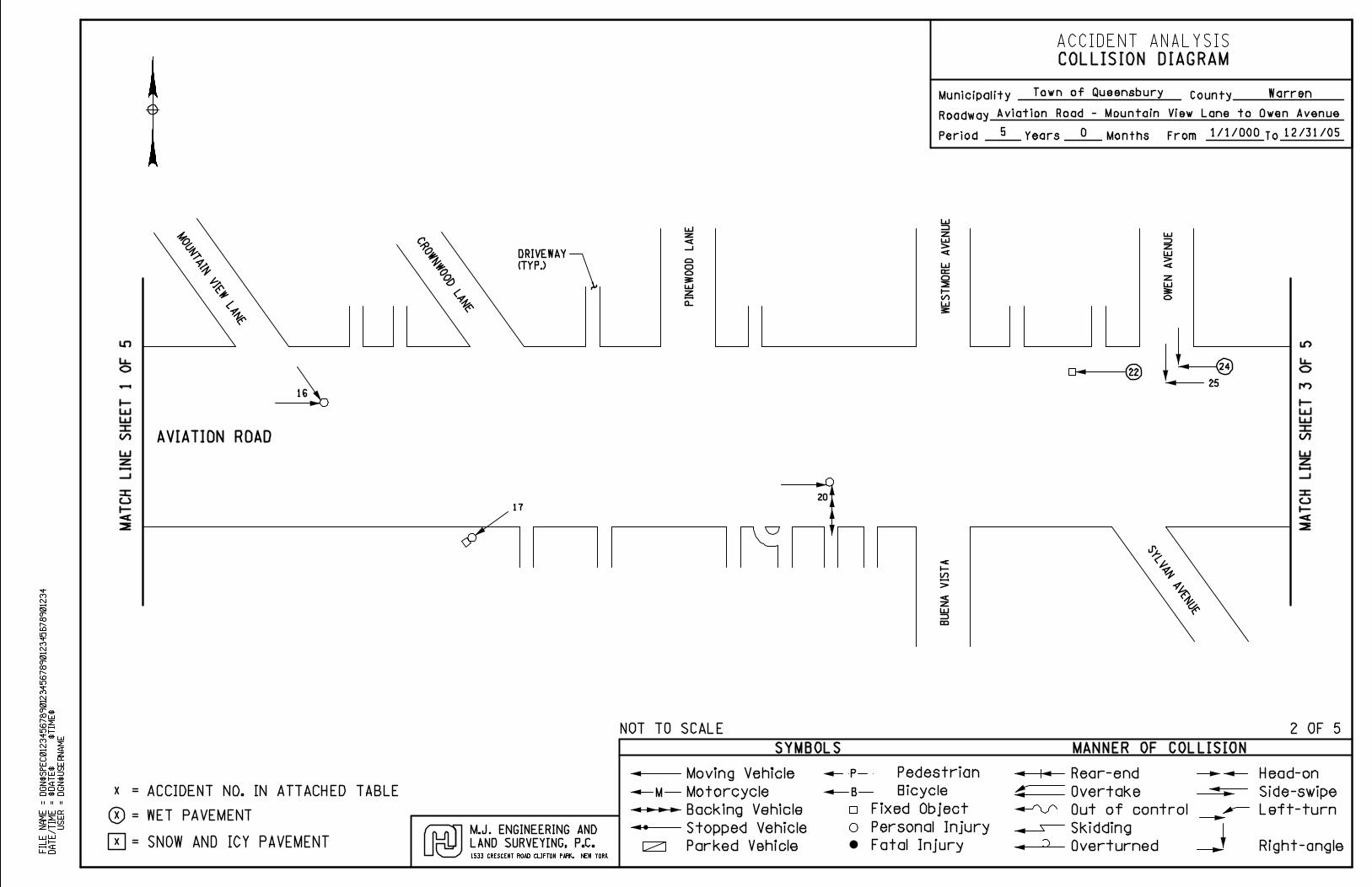
2 OF 5
~
AVIATION ROAD
MO
UN
TA
IN V
IEW
LA
NE
CR
OW
NW
OO
D L
AN
E PIN
EW
OO
D L
AN
E
WE
ST
MO
RE
AV
EN
UE
OW
EN
AV
EN
UE
SY
LV
AN
AV
EN
UE
BU
EN
A V
IST
A
DRIVEWAY
(TYP.)
16
17
20
2224
25
MA
TC
H L
INE
SH
EE
T 3
OF
5
Aviation Road - Mountain View Lane to Owen Avenue
MA
TC
H L
INE
SH
EE
T 1
OF
5
Municipality
Period
County
Years Months From To
SYMBOLS MANNER OF COLLISION
NOT TO SCALE
BM
P
5 0
X WET PAVEMENT
Moving Vehicle
Motorcycle
Backing Vehicle
Stopped Vehicle
Parked Vehicle
Pedestrian
Bicycle
Fixed Object
Personal Injury
Fatal Injury
Rear-end
Overtake
Out of control
Skidding
Overturned
Head-on
Side-swipe
Left-turn
Right-angle
ACCIDENT ANALYSIS
COLLISION DIAGRAM
Roadway
X SNOW AND ICY PAVEMENT1533 CRESCENT ROAD CLIFTON PARK, NEW YORK
M.J. ENGINEERING AND
LAND SURVEYING, P.C.
FIL
E N
AM
E =
DA
TE
/TIM
E =
U
SE
R =
DG
N$U
SE
RN
AM
E
DG
N$S
PE
C01234567890123456789012345678901234
$D
AT
E$
$T
IME
$
ACCIDENT NO. IN ATTACHED TABLEX
Town of Queensbury Warren
1/1/000 12/31/05
3 OF 5
~
AVIATION ROAD
GIL
MO
RE
AV
EN
UE
PO
TT
ER
RO
AD
DRIVEWAY
(TYP.)
MA
TC
H L
INE
SH
EE
T 4
OF
5
MA
TC
H L
INE
SH
EE
T 2
OF
5
Aviation Road - Gilmore Avenue to Poplar Lane
PO
PL
AR
LA
NE
DIX
ON
RO
AD
FO
X F
AR
M R
OA
D
FA
RR
LA
NE
2729
26
28
30
3244
34
43, 33
52
COMMERCIAL
DRIVEWAY
COMMERCIAL
DRIVEWAY
~~~
48
50
60, 59, 55
56
58
6257
51
41, 38
31
42
39
45
47
54
49
53
Municipality
Period
County
Years Months From To
SYMBOLS MANNER OF COLLISION
NOT TO SCALE
BM
P
5 0
X WET PAVEMENT
Moving Vehicle
Motorcycle
Backing Vehicle
Stopped Vehicle
Parked Vehicle
Pedestrian
Bicycle
Fixed Object
Personal Injury
Fatal Injury
Rear-end
Overtake
Out of control
Skidding
Overturned
Head-on
Side-swipe
Left-turn
Right-angle
ACCIDENT ANALYSIS
COLLISION DIAGRAM
Roadway
X SNOW AND ICY PAVEMENT1533 CRESCENT ROAD CLIFTON PARK, NEW YORK
M.J. ENGINEERING AND
LAND SURVEYING, P.C.
FIL
E N
AM
E =
DA
TE
/TIM
E =
U
SE
R =
DG
N$U
SE
RN
AM
E
DG
N$S
PE
C01234567890123456789012345678901234
$D
AT
E$
$T
IME
$
ACCIDENT NO. IN ATTACHED TABLEX
Town of Queensbury Warren
1/1/000 12/31/05
4 OF 5
~
AVIATION ROAD
DRIVEWAY
(TYP.)
MA
TC
H L
INE
SH
EE
T 5
OF
5
MA
TC
H L
INE
SH
EE
T 3
OF
5
Aviation Road - Poplar Lane to Cottage Hill Road
MA
NO
R D
RIV
EM
IDN
IGH
T D
RIV
E
PR
OS
PE
CT
DR
IVE
CO
TT
AG
E H
ILL
RO
AD
SC
HO
OL
SC
HO
OL
83
8478
77
75
AP
T’S
76
74
73
69
B66
64
6365
68
72
67
70
B71
Municipality
Period
County
Years Months From To
SYMBOLS MANNER OF COLLISION
NOT TO SCALE
BM
P
5 0
X WET PAVEMENT
Moving Vehicle
Motorcycle
Backing Vehicle
Stopped Vehicle
Parked Vehicle
Pedestrian
Bicycle
Fixed Object
Personal Injury
Fatal Injury
Rear-end
Overtake
Out of control
Skidding
Overturned
Head-on
Side-swipe
Left-turn
Right-angle
ACCIDENT ANALYSIS
COLLISION DIAGRAM
Roadway
X SNOW AND ICY PAVEMENT1533 CRESCENT ROAD CLIFTON PARK, NEW YORK
M.J. ENGINEERING AND
LAND SURVEYING, P.C.
FIL
E N
AM
E =
DA
TE
/TIM
E =
U
SE
R =
DG
N$U
SE
RN
AM
E
DG
N$S
PE
C01234567890123456789012345678901234
$D
AT
E$
$T
IME
$
ACCIDENT NO. IN ATTACHED TABLEX
Town of Queensbury Warren
1/1/000 12/31/05
5 OF 5
~
MA
TC
H L
INE
SH
EE
T 4
OF
5
Aviation Road - Cottage Hill Road to Burke Drive
SC
HO
OL
SC
HO
OL
BU
RK
E D
RIV
E
94
85
86
87
B
78
AVIATION ROAD
COMMERCIAL
DRIVEWAY
98
95, 90 ,89
93 ,91
103
102, 104
101
105
99
Municipality
Period
County
Years Months From To
SYMBOLS MANNER OF COLLISION
NOT TO SCALE
BM
P
5 0
X WET PAVEMENT
Moving Vehicle
Motorcycle
Backing Vehicle
Stopped Vehicle
Parked Vehicle
Pedestrian
Bicycle
Fixed Object
Personal Injury
Fatal Injury
Rear-end
Overtake
Out of control
Skidding
Overturned
Head-on
Side-swipe
Left-turn
Right-angle
ACCIDENT ANALYSIS
COLLISION DIAGRAM
Roadway
X SNOW AND ICY PAVEMENT1533 CRESCENT ROAD CLIFTON PARK, NEW YORK
M.J. ENGINEERING AND
LAND SURVEYING, P.C.
FIL
E N
AM
E =
DA
TE
/TIM
E =
U
SE
R =
DG
N$U
SE
RN
AM
E
DG
N$S
PE
C01234567890123456789012345678901234
$D
AT
E$
$T
IME
$
ACCIDENT NO. IN ATTACHED TABLEX
Town of Queensbury Warren
1/1/000 12/31/05

Second
Aviation Road Corridor Study September 2008
This Page Intentionally Left Blank

1
Aviation Road Corridor Study September 2008
APPENDIX B REPRESENTATIVE
CORRIDOR PHOTOS
2
Aviation Road Corridor Study September 2008
This Page Intentionally Left Blank
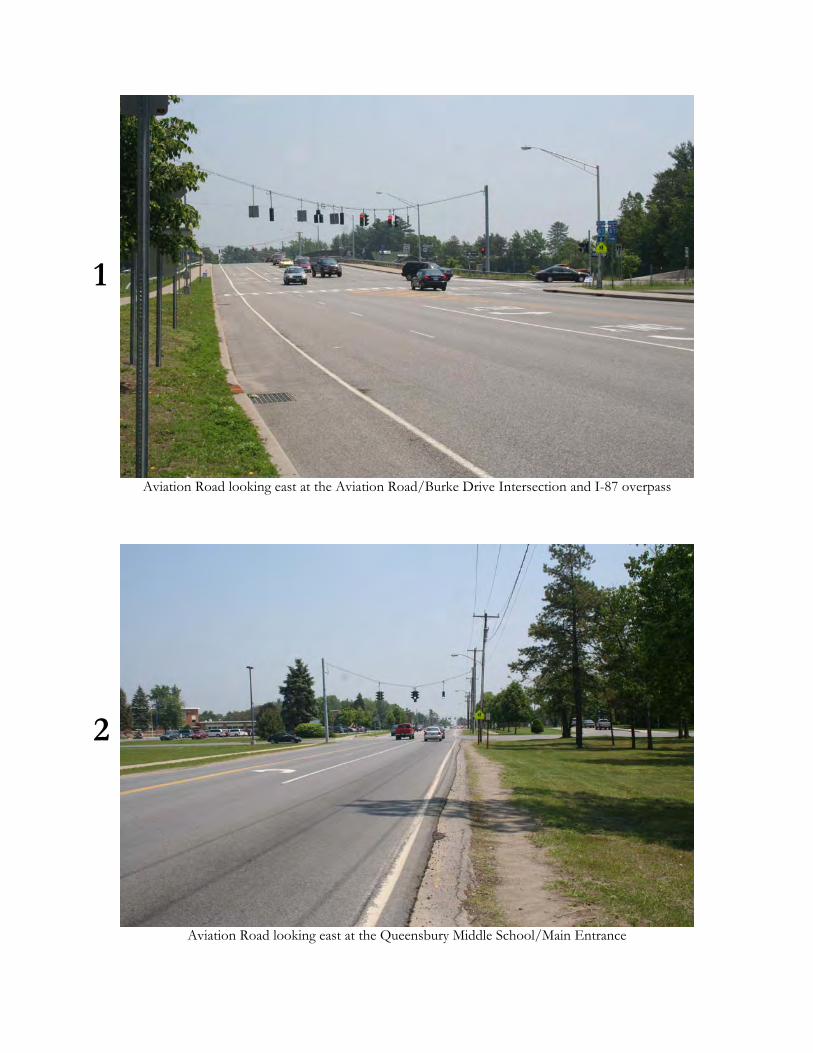
1
Aviation Road looking east at the Aviation Road/Burke Drive Intersection and I-87 overpass
2
Aviation Road looking east at the Queensbury Middle School/Main Entrance
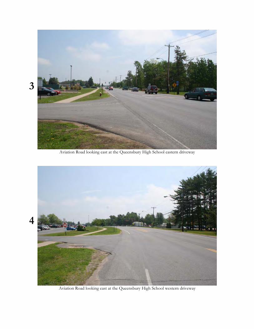
3
Aviation Road looking east at the Queensbury High School eastern driveway
4
Aviation Road looking east at the Queensbury High School western driveway

5
Aviation Road north side looking east along Commercial and Office Development east of Farr Lane
6
Aviation Road south side looking east along Commercial Development east of Dixon Road
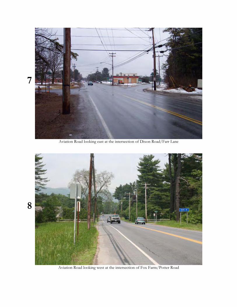
7
Aviation Road looking east at the intersection of Dixon Road/Farr Lane
8
Aviation Road looking west at the intersection of Fox Farm/Potter Road
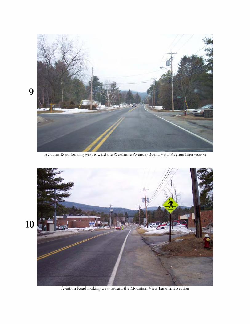
9
Aviation Road looking west toward the Westmore Avenue/Buena Vista Avenue Intersection
10
Aviation Road looking west toward the Mountain View Lane Intersection
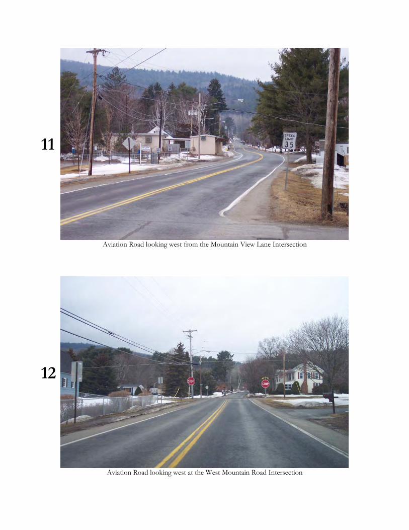
11
Aviation Road looking west from the Mountain View Lane Intersection
12
Aviation Road looking west at the West Mountain Road Intersection
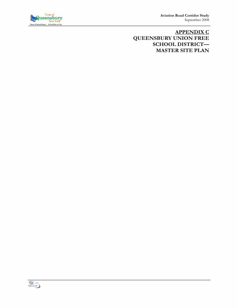
1
Aviation Road Corridor Study September 2008
APPENDIX C QUEENSBURY UNION FREE
SCHOOL DISTRICT— MASTER SITE PLAN

2
Aviation Road Corridor Study September 2008
This Page Intentionally Left Blank

This page intentionally left blank

1
Aviation Road Corridor Study September 2008
APPENDIX D ALTERNATIVES DEVELOPMENT
PROCESS SUMMARY
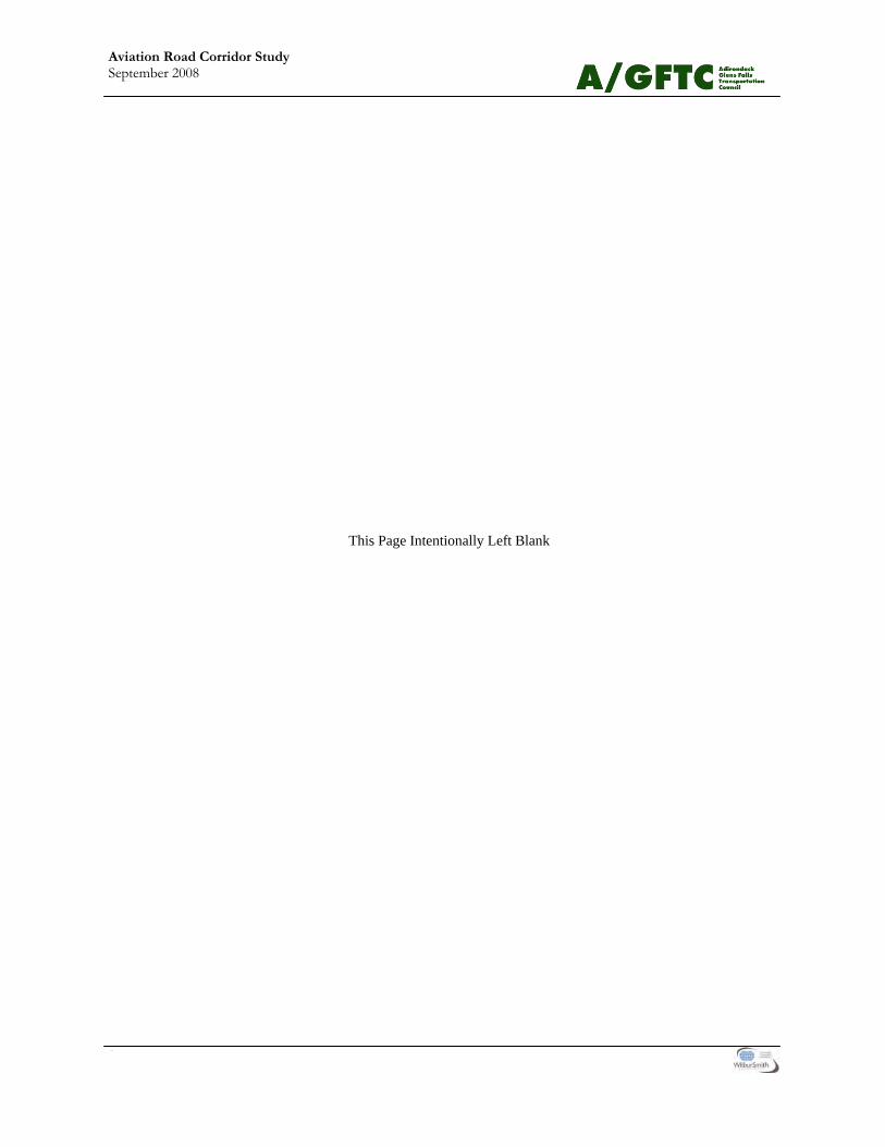
2
Aviation Road Corridor Study September 2008
This Page Intentionally Left Blank

3
Aviation Road Corridor Study September 2008
Alternatives Development Process To begin the development of possible future alterna-tives for the Aviation Road corridor, the WSA pre-pared traffic projections for the corridor for the year 2016 for both the AM and PM peak periods. Using the projections, as well as the analysis of the existing conditions and comments from the Study Advisory Committee and the public generated at the first pub-lic work session, the WSA Team developed numer-ous alternatives for the intersections and the various different segment of roadway between the intersec-tions. Table III-2 summarizes the different alterna-tives developed for the intersections and the various segments of the corridor. For the intersections, the Team examined options including roundabouts, signalization with or without additional turning lanes, additional turning lanes without signalization and doing nothing. Table III-1 presents the 2016 projected LOS for the intersec-tion signalization alternatives; Table III-3 presents the projected LOS for the intersections where roundabouts are considered. The two high accident locations were examined in more detail to determine if there were additional modifications that could be considered to address the issues that appear to be causing the majority of accidents. For the roadway corridor itself, the Team considered possible future modifications to address congestion, pedestrian and bicyclist circulation, vehicle speeds, and aesthetics. While congestion is not generally an issue in the cor-ridor, there are very short periods of time, especially in the morning as the schools are opening, that there is congestion on the roadway, especially for east-bound vehicular traffic. One of the causes of the congestion is the number of vehicles making a left turn from Aviation Road onto the school campus. The Team’s review of the issue indicated that the most appropriate way to address the issue was to limit the number of free left turns on Aviation Road, and to direct left turn traffic to more efficient inter-sections. The team therefore considered a center median as a possible alternative to address this prob-lem. For pedestrian circulation, the Team considered ei-ther alone or in some combination with each other: • A full extension of the sidewalk along the entire
corridor on both sides of the road;
• A full extension of the sidewalk along the entire corridor on one side of the road;
• A partial extension of the sidewalk along the eastern portion of the corridor on both sides of the road;
• A partial extension of the sidewalk along the eastern portion of the corridor on one sides of the road;
• Wide paved shoulders for pedestrian circulation along the western portion of the corridor,
• A 10-foot wide sidepath on one side of the cor-ridor;
• Additional intersections and mid-block cross-walks;
• Refuge islands to make it easier to cross one lane of traffic at a time; and
• Pedestrian signals at the intersections. For bicycle circulation, the Team considered: • Bicycle lanes on both sides of the roadway for
the entire corridor; • Wide paved shoulders on both sides of the
roadway for the entire corridor; • A 10-foot wide sidepath on one side of the cor-
ridor; and • Closing wide driveways to create clearer vehicu-
lar turning circulation patterns. To address the speeding issues on Aviation Road, the Team considered several traffic calming tech-niques, including: • Street trees along both sides of the roadway; • Narrower travel lanes created by restriping the
sides of the roadway; and • A center median. The various alternative that were developed for the items above also provided several good opportuni-ties to improve the overall aesthetic character of the corridor and so no additional alternatives were devel-oped solely to address aesthetic concerns. The Study Advisory Committee reviewed the infor-mation and provided input on the feasibility of the various options. After refining the alternatives, the team presented them at a second public work ses-sion, in order to gather comments and to develop a list of preferred alternatives. After the second public work session, the WSA Team, along with the Study Advisory Committee, reviewed the gathered infor-mation and made a draft recommendations of the final corridor improvement recommendations.
Second
Aviation Road Corridor Study September 2008
This Page Intentionally Left Blank