Embed Size (px)
Citation preview
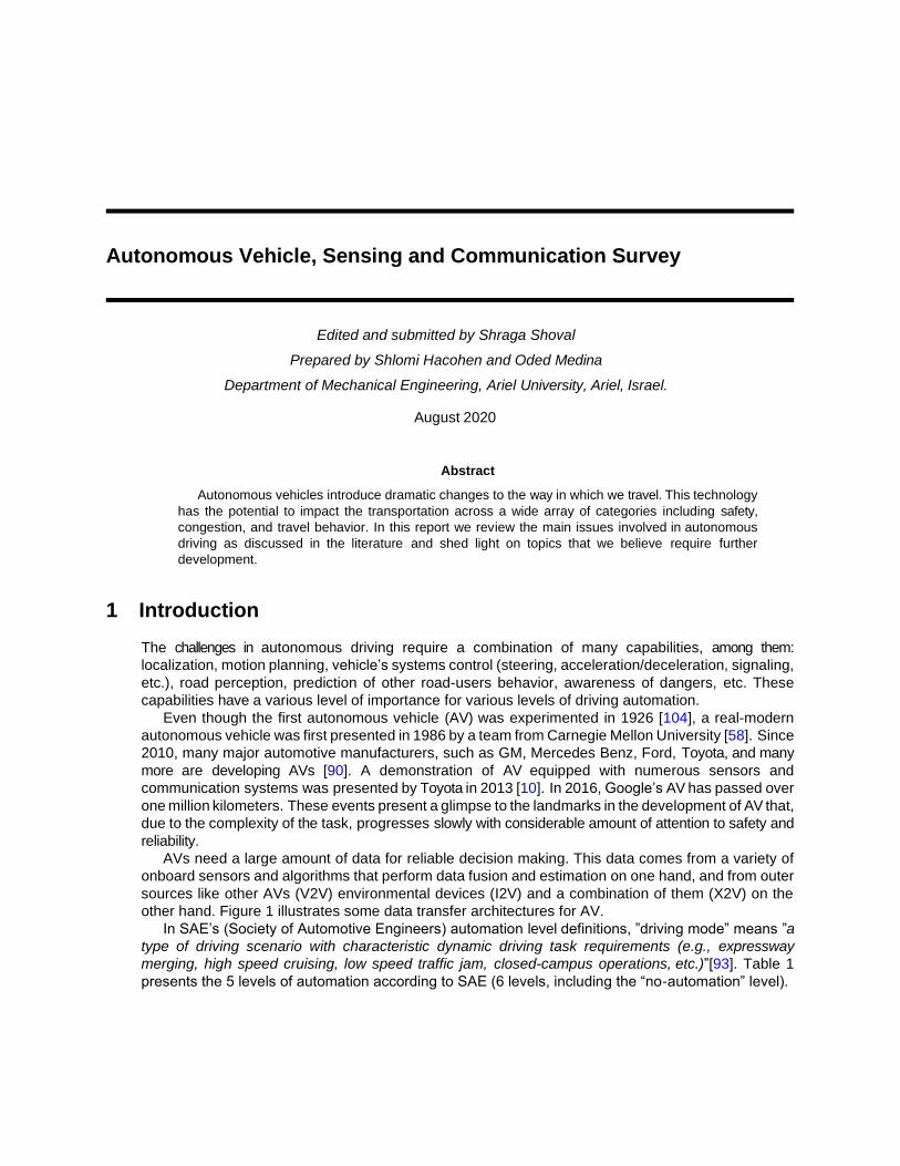
Autonomous Vehicle, Sensing and Communication Survey
Edited and submitted by Shraga Shoval
Prepared by Shlomi Hacohen and Oded Medina
Department of Mechanical Engineering, Ariel University, Ariel, Israel.
August 2020
Abstract
Autonomous vehicles introduce dramatic changes to the way in which we travel. This technology
has the potential to impact the transportation across a wide array of categories including safety,
congestion, and travel behavior. In this report we review the main issues involved in autonomous
driving as discussed in the literature and shed light on topics that we believe require further
development.
1 Introduction
The challenges in autonomous driving require a combination of many capabilities, among them:
localization, motion planning, vehicle’s systems control (steering, acceleration/deceleration, signaling,
etc.), road perception, prediction of other road-users behavior, awareness of dangers, etc. These
capabilities have a various level of importance for various levels of driving automation.
Even though the first autonomous vehicle (AV) was experimented in 1926 [104], a real-modern
autonomous vehicle was first presented in 1986 by a team from Carnegie Mellon University [58]. Since
2010, many major automotive manufacturers, such as GM, Mercedes Benz, Ford, Toyota, and many
more are developing AVs [90]. A demonstration of AV equipped with numerous sensors and
communication systems was presented by Toyota in 2013 [10]. In 2016, Google’s AV has passed over
one million kilometers. These events present a glimpse to the landmarks in the development of AV that,
due to the complexity of the task, progresses slowly with considerable amount of attention to safety and
reliability.
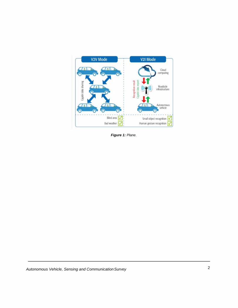
AVs need a large amount of data for reliable decision making. This data comes from a variety of
onboard sensors and algorithms that perform data fusion and estimation on one hand, and from outer
sources like other AVs (V2V) environmental devices (I2V) and a combination of them (X2V) on the
other hand. Figure 1 illustrates some data transfer architectures for AV.
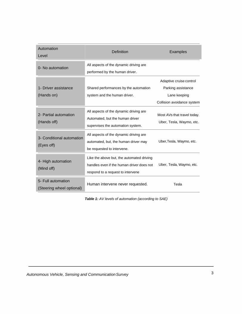
In SAE’s (Society of Automotive Engineers) automation level definitions, ”driving mode” means ”a
type of driving scenario with characteristic dynamic driving task requirements (e.g., expressway
merging, high speed cruising, low speed traffic jam, closed-campus operations, etc.)”[93]. Table 1
presents the 5 levels of automation according to SAE (6 levels, including the “no-automation” level).
2 Autonomous Vehicle, Sensing and Communication Survey
Figure 1: Plane.
3 Autonomous Vehicle, Sensing and Communication Survey
Table 1: AV levels of automation (according to SAE)
All aspects of the dynamic driving are
performed by the human driver.
Adaptive cruise control
Shared performances by the automation Parking assistance
system and the human driver. Lane keeping
Collision avoidance system
All aspects of the dynamic driving are
Automated, but the human driver
supervises the automation system.
Most AVs that travel today.
Uber, Tesla, Waymo, etc.
All aspects of the dynamic driving are
automated, but, the human driver may
be requested to intervene.
Uber,Tesla, Waymo, etc.
Like the above but, the automated driving
handles even if the human driver does not Uber, Tesla, Waymo, etc.
respond to a request to intervene
Human intervene never requested. Tesla
Examples Definition Automation
Level
5- Full automation
(Steering wheel optional)
4- High automation
(Mind off)
3- Conditional automation
(Eyes off)
2- Partial automation
(Hands off)
1- Driver assistance
(Hands on)
0- No automation
Autonomous Vehicle, Sensing and Communication Survey 6
Autonomous vehicles are believed to bring beneficial change to the way in which we travel that will
impact an array of categories such as safety, congestion, and travel behavior. Crash savings, travel
time reduction, fuel efficiency and parking benefits are believed to save thousands of dollars per year
per a single AV [35]. Although its great vision, the implementation and mass-market penetration of
AVs will most likely take time. As for today, initial costs are commonly unaffordable for the common
user.
2 Autonomous Driving
These days, the concept of AVs is based on the vision of replacing the driver with an autonomous
system that will drive in the traditional roads with other road users (other vehicles and pedestrians).
The path to this autonomous goal passes through the five levels described in Table 1. Since the
mission is to replace the driver, high-end sensors must be integrated in order to achieve a safe and
efficient drive to the target.
2.1 Lane-Detection
One of the most important qualifications for AV and advanced driver assistant systems is the lane-
detection. Lack of clarity of lane markings, poor visibility due to bad weather, illumination and light
reflection, shadows, and dense road-based instructions may cause the lane detection algorithm to
fail. Most lane detection approaches are based on analyzing the 2-D image captured from a camera
(usually mounted behind the front windshield to retrieve lane information). These vision-based
approaches can be categorized into two methods: feature-based and model-based. The model-based
method commonly uses a mathematical model with parameters to describe the lane structure
[81,131]. For example, researchers in [2] presented real-time lane marker detection in urban streets.
Their method generates a top view of the road, uses Random sample consensus (RANSAC) line
fitting for the initial assumed line model, and a fast RANSAC algorithm for Bezier Splines fitting. The
feature-based methods, though known for their robustness against noise, are difficult to implement
since they require some prior-known geometric parameters and heavy computation. The feature-
based methods analyze images and detect the gradients of pixel information or the color of patterns
to recognize the lane markings. For example, the researchers in [72] presented a robust and real-time
vision-based lane detection algorithm by reducing the image to an efficient region of interest in order
to reduce the high noise level and the calculation time. Their method also removes any false lane
markings and tracks the real lane markings using the accumulated statistical data. Their experimental
results show that the algorithm gives accurate lane estimate and fulfill the real-time operational
requirements on embedded systems with low computing power. For more examples see:
[16,109,108,30,95].
2.2 Path Planning
The path planning task for AV has been researched for the last decades. It is mostly common to divide
the path planning problem into global and local planning. The planning techniques can be classified as
(i) Graph search algorithms, such as Dijkstra [17,23,97,5] or A-star [112,36,76,83] which assume a
set of known configurations with the goal to find the path from two configurations passing through the
Autonomous Vehicle, Sensing and Communication Survey 7
known configuration set; (ii) Sampling based planners, such as RRT (Rapidly-exploring Random
Trees) [69,19,101,59] relaxes the approach of grid sampling the configuration space by sampling it in
the region of interest with the desired density. Interpolating curve planners are used for “smoothing”
the paths given by the path planners.
2.3 Motion Planning
As AV is aimed to have fully automated driving functionality available in a verity set of scenarios, it
raises the need for universally applicable environment sensing and understanding. The sensors input
is then used by the motion planning algorithms. For example, Brown et al. [20] introduce a control
framework that integrates local path planning together with path tracking using model-predictive-
control. The controller first plans a trajectory that considers the vehicle state (position and velocity)
and a desired path to the target position. Then, two safe envelopes are considered: one for stability
and the other for obstacle avoidance. Moriwaki [84] presents an optimal steering control for electric
autonomous vehicle based on H∞. The objective of the scheme chosen is to be a reference trajectory
following while keeping good damping and a certain stability margin. da Silva and de Sousa [29] use
dynamic programming for AV motion control. Their objective is following a desired path while keeping
the cross-error under some predefined threshold. Kessler et al. [60] introduced two novel approaches
for extracting a topological road-graph with possible intersection options from sensor data along with a
geometric representation of the available maneuvering space. Also, a search and optimization-based
path planning method for guiding the vehicle along a selected track in the road-graph and within the
free-space is presented. They compared the methods presented in simulation and showed results of
a test drive with a research vehicle. Their evaluations show the applicability in low speed maneuvering
scenarios and the stability of the algorithms even for low quality input data. For more schemes for
trajectory tracking and path following see [121,128,63]
The field of motion planning which simultaneously considers safety and comfort is yet to be fully
considered. Magdici et al. [79] presented a fail-safe motion planner for autonomous vehicles, which
simultaneously guarantees safety and comfort by combining an optimal trajectory with an emergency
maneuver. Solea et al. [105] presented a path-following control using sliding mode path-following
control, together with a smooth velocity planner, imposing the comfort of the human body. An
important field of study is the feeling-of-safety (sometimes considered as trusted autonomy) as in automated
vehicles while it performs trajectory tracking in urban environments. In these cases, the path must be
smoothed previously in a planning stage before the trajectory tracking task. The researchers in [71]
implemented the 4th and 5th degree Bezier curves in their path planning generation. They focused on
urban scenarios (intersections, roundabouts, and lane changing) and speed planning for comfortable
and safe behaviors. Since AVs act in human environment, ethical issues should be considered in the motion control.
The authors in [28,115] deal with such ethical realism to the framing of AVs decisions and control. The use of Machine-Learning (ML) seems to be the most attractive technique for AVs perception (see for example [103,1]). In [74] the authors present a neural network model to analyze the data captured by the sensors. Then, a decision-making system calculates suitable control signals for the vehicle based on the observations. Isele et al. [54] solve intersection problems of AVs by Deep Reinforcement Learning (DRL). The system learns active sensing behaviors and enables safe maneuvers in the case of occlusions.
The complexity and high variety scenarios of road driving make motion planning a challenging task.
Banerjee et al. [7] investigated all disengagement and accident reports obtained from public DMV

Autonomous Vehicle, Sensing and Communication Survey 8
databases between 2014-2017, and found that ML-based systems are the primary cause of 64% of
all disengagements. Koopman and Wagner [65] state in their paper that ”...there does not seem to be
a way to make ultra-dependable levels of guarantees as to how such a system will behave when it
encounters data not in the training set nor test data set”. Researchers address this challenge by
applying additional algorithms to block unsafe maneuvers. Mirchevska et al. [82] use Reinforcement
Learning for lane changing of AVs. They address the uncertainty issues by machine learning combined
with safety validations that ensures only safe actions are taken.
Figure 2: An illustration of the approximated free-space (red) and the road-graph with direction options (blue).
Based on the directional choice to go straight, a smooth path can be planned (green) [60].
2.4 Sensors
One of the first works on sensory systems for AVs was presented by Waxman [119], where the authors
use a camera for the control of the vehicle. The hardware back-days was inefficient such that the
frame-rate was smaller than that of the controller. The researchers maintained continuous motion by
what they called ’looking ahead’ and then, until they took another frame, ”driving blind” for a short
distance. The use of cameras as an input for closing the loop of AVs gained momentum at the early
90’s of the last century. Authors in [57] use an improved processor to control the vehicle. The vision
system estimates the lateral position and deviation of the vehicle relatively to the white lines in the
frame. All companies dealing with AV uses data-fusion. This enables overlap data in region of interest
directions for safty (see e.f. [25] explaining Uber reduced LiDAR array in their self-driving cars from 7
units to 1 in 2016, creating pedestrian blind spots).
2.4.1 Camera sensors
Cameras became the most common modality sensor due to its high information content, lower cost and
operating power, and the ability to integrate it with ultra-sonic sensors or radar as auxiliary sensors if
necessary. Autonomous cars often have video cameras in order to see and interpret the objects in
the road. By equipping cars with multiple cameras, the vehicles are capable of maintaining a 360◦ view
of their external environment, thereby providing a broader picture of the traffic conditions around them.
Today, 3D cameras are available and utilized for displaying highly detailed and realistic images.
Using computer vision algorithms (such as OpenCV) may automatically detect objects, classify them,
Autonomous Vehicle, Sensing and Communication Survey 7
and determine the distances between them and the vehicle. For example, the cameras can easily
identify other vehicles, pedestrians, cyclists, traffic signs and signals, road markings, bridges, and
guardrails. It should be noted that poor weather conditions such as rain, fog, or snow can prevent
cameras from clearly seeing the obstacles in the roadway. Additionally, in situations where the colors
of objects are similar to the background, or where the contrast between them is low, the detection
algorithms may fail [12,68].
The examples of the use of cameras as the main or exclusive sensor are many. Heng et al.
[48] present the AutoVision project, which aims to develop a localization and 3D scene perception
capabilities for an AVs, that based on vision sensors only. Kuramoto et al. [67] developed a scheme
for computing 3D positions of far detected vehicles based on mono-camera observations.
NODAR [92] accelerates mass-market autonomy through the development of high-performance
stereo vision systems. According to their website, whether passenger vehicles, UAVs, or fork lifts,
autonomous vehicles require high-density 3D information to understand their surroundings. These
markets are extremely price sensitive, yet require ultra-fast, highly accurate, long-range 3D sensing.
2.4.2 Radar Sensors
Radar (Radio Detection and Ranging) sensors make up a crucial contribution to the overall function
of autonomous driving by sending out radio waves that detect objects and gauge their distance and
velocity in relation to the vehicle in real time [13]. Radar is a key technology for AVs and driver
assistance systems due to its robustness to environmental variations such as inclement weather (fog,
rain ,etc.), lighting extremes and long range [37]. Due to these advantages, the radar serves as
complementary technology to the cameras.
Radar sensors may be categorized into two groups: Short rang sensors (24 GHz) are usually used
to enable blind spot monitoring, lane-keeping and parking assistance. The long-range sensors (77
GHz) are used for maintaining safe distance and brake assistance [106].
Radar sensors may be used to identify vulnerable road users. Stolz et al. [107] have researched
the ability of using radar sensor for identifying cyclists in auto emergency braking (AEB) systems.
Nabati and Qi [87] proposed the RRPN (Radar Region Proposal Network) algorithm for object
detection. Based on the radar observation they mapped objects into the image coordinates.
The impact of the pedestrian’s direction of movement, occlusion, antenna beam elevation angle,
linear vehicle movement, and other factors are investigated and discussed in [8]. Their experiments
show that although over 95% of pedestrians can be correctly detected in optimal conditions, under
real life conditions, due to insufficient Doppler frequency and spatial resolution as well as antenna
side lobe effects, radar only based pedestrian recognition will not perform the required tasks. An
emerge research work that deals with dual function radar-communications (DFRC), which enables
dual functionality to the radar as a sensor and as a communication device, is presented in [77].
2.4.3 LiDAR Sensors
LiDAR (Light Detection And Ranging) is currently the most commonly used sensor capable of
delivering the most accurate real time 3D data due to its use of laser based point cloud. The real-time
LiDAR sensor technology is being used in a variety of commercial applications including autonomous
vehicles, vehicle safety systems, 3D aerial mapping and security. Though the benefits of 3D point-
cloud data are clear, most AVs requires multiple LiDAR, which make the AV’s sensory system
expensive [44].
Autonomous Vehicle, Sensing and Communication Survey 8
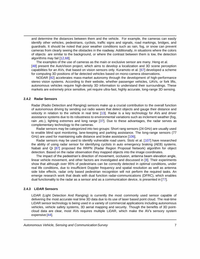
Figure 3: Velodyne LiDAR.
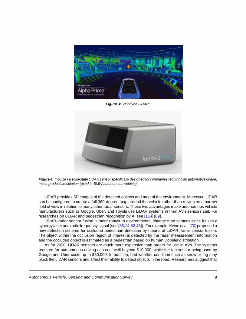
Figure 4: Inovize - a solid-state LiDAR sensor specifically designed for companies requiring an automotive-grade,
mass-producible solution (used in BMW autonomous vehicle).
LiDAR provides 3D images of the detected objects and map of the environment. Moreover, LiDAR
can be configured to create a full 360-degree map around the vehicle rather than relying on a narrow
field of view in relation to many other radar sensors. These two advantages make autonomous vehicle
manufacturers such as Google, Uber, and Toyota use LiDAR systems in their AV’s sensors suit. For
researches on LiDAR and pedestrian recognition by AI see [114] [89].
LiDAR–radar sensor fusion is more robust to environmental change than camera since it uses a
synergy laser and radio frequency signal (see [38,14,52,45]). For example, Kwon et al. [70] proposed a
new detection scheme for occluded pedestrian detection by means of LiDAR–radar sensor fusion.
The object within the occlusion region of interest is detected by the radar measurement information
and the occluded object is estimated as a pedestrian based on human Doppler distribution.
As for 2020, LiDAR sensors are much more expensive than radars for use in AVs. The systems
required for autonomous driving can cost well beyond $10,000, while the top sensor being used by
Google and Uber costs up to $80,000. In addition, bad weather condition such as snow or fog may
block the LiDAR sensors and affect their ability to detect objects in the road. Researchers suggest that
9 Autonomous Vehicle, Sensing and Communication Survey
it is possible to overcome the LiDAR’s cones by using stereoscopic camera system (see e.g. [118]). By
taking the inner workings of convolutional neural networks into consideration, researchers propose to
convert image-based depth maps to pseudo-lidar representations — essentially mimicking the LiDAR
signal.
3 Autonomous vehicles as a cooperative system
Traditionally, the term autonomous vehicle refers to the technology that enables automatic operation
of the vehicle’s control functions (e.g. steering, throttle, braking, etc.). As such, the vehicle may be
equipped with an array of sensors and actuators that is needed for the loop-closure. A complementary
approach to the operation of AVs is the concept of multi-agent-systems or cooperative autonomous
vehicles. In this approach, the control of each vehicle, apart from the environment interception, is
related to the operations of all other AVs in its vicinity [49].
Individual vehicles may benefit from information obtained from other vehicles in the vicinity,
especially information relating to traffic congestion and safety hazards. Vehicular communication
systems use vehicles and roadside units as the communicating nodes in a peer-to-peer network,
providing each other with information. As a cooperative approach, vehicular communication systems
can allow all cooperating vehicles to be more effective. According to a 2010 study by the US National
Highway Traffic Safety Administration, vehicular communication systems could help avoid up to 79% of
all traffic accidents.[88]
The cooperative operation of AVs has many significant advantages. Researchers define three critical
technologies that increase the benefits of AVs [78]: Cooperative driving, Big- Data and Autonomous-
capabilities. Hult et al. [51] discuss the safety improvement that is involved with autonomous driving
in the cooperative driving scheme. According to the ”Traffic Safety Facts Annual Report of 2017” [94]
more than 80% of the accident with known and reported factors caused by error done by drivers. For
example, at 8% of those accidents, the factor was the failure to remain in the proper lane, 12% of the
drives involved with those accidents were driving under the influence of alcohol, drugs, or medication.
We believe that autonomous driving in general, and cooperative driving in particular will significantly
increase safety.
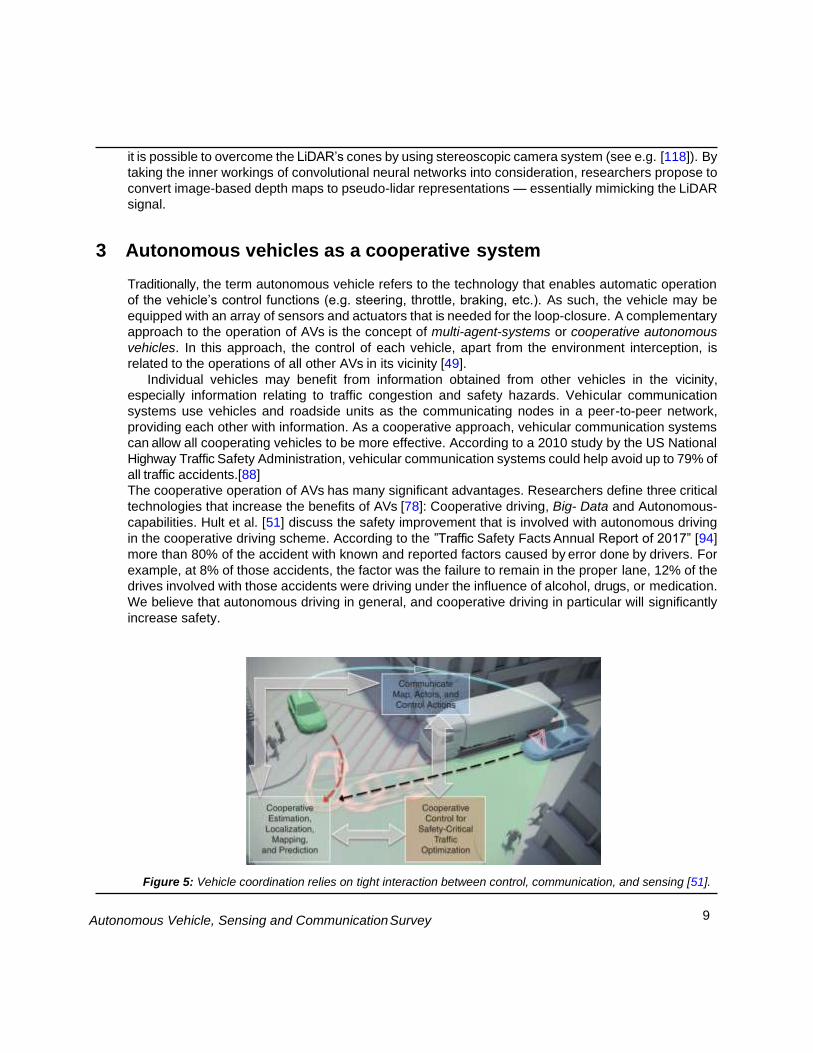
Figure 5: Vehicle coordination relies on tight interaction between control, communication, and sensing [51].
10 Autonomous Vehicle, Sensing and Communication Survey
Moreover, Zhou et al. [130] show that cooperative control may significantly improve the smooth-
ness of the vehicles’ flow and increase the road capacity in comparison to human-driven vehicles.
They formulate a control law for the vehicles’ acceleration as a response to the actions of other
vehicles in the vicinity. A discussion about ecological and fuel consumption can be found in [6]. As
part of the capacity effectiveness of cooperative AVs, the fuel consumption is reduced as well as the
air pollution (see also [4]).
The degree of centralization of the controller was discussed in the literature. The researchers in
[55] present an algorithm for the concept of planning for multi agent systems and use it for AVs control.
The authors formulate a multi-layer reservation policy to manage the interactions between vehicles.
The aim of the policies is to reduce energy consumption, increase the smoothness of the traffic flow
and increase intersection throughput. In [85] researchers present an algorithm for controlling the
speed of an AV to track a speed-profile generated for cooperative AVs. The algorithm monitors the
control messages that include the current desired speed, as well as the future speed-profile to
overcome anomalous communications. In [91] the authors present a three layers algorithm for
cooperative lane-changing decision-making. Although the vehicles share information, the main
decision making was done independently.
4 Cooperative sensing
A cooperative sensing enables information sharing by all road-users and stationary devices located in
the same environment. Such an approach enables to get observations beyond the line-of-sight and
beyond the field-of-view. However, it introduces new challenges such as how to locate all observation
in the same map, identification of vehicles, high volume of communication, privacy, etc. The authors
in [61] present a framework to deal with those challenges. They demonstrate it on a group of AVs
equipped with a single LIDAR and a single camera. The communication and control was conducted
by open source liberties of Robotics Operation System (ROS). In [62] the authors present a scheme
for cooperative sensing which apply to the vehicle see-through, lifted-seat or satellite-view. They
investigate the improvements such as the safety and smoothness of the driving. Based on the
literature review, it seems that this important subject should be further investigated.
4.1 Infrastructure to Vehicle communication (i2V)
Infrastructure to Vehicle (I2V) communication gives the ability to send and receive data from stationary
stations in the AV’s vicinity. The ability to monitor the pedestrians is essential if we desire to achieve
autonomous driving. Today, many streets are 24/7 camera-viewed for traffic monitoring and for
improving citizens’ safety. The big data from these camera network may be used as sensory data for
the AV. The most important concept in the future of AVs is safety. Today, most AVs control is based on
on-vehicle sensors alone. These are mostly important but, additional external data may be mostly
efficient for pedestrian tracking and accident avoiding. An example for using street-view cam- eras
was demonstrated by Kristoffersen et al. [66] where they used thermal cameras to overcome the
challenges due to changing lighting conditions and the complexity of scenes with many people
occluding one another. They introduced the use of a stereo thermal camera setup for pedestrian
counting and investigated the reconstruction of 3D points in a pedestrian street with two thermal
cameras. Then, they propose an algorithm for pedestrian counting based on clustering and tracking
of the 3D point clouds.
11 Autonomous Vehicle, Sensing and Communication Survey
I2V may also improve the decision making by AVs. Perumal et al. [99] present an algorithm for AVs
motion planning based on observations for localization and moving obstacles (road users) locations.
Grembek et al. [39] present an algorithm for intelligent intersection based on I2V observations that
reduce the lack in the information they need to avoid wrong decisions that may cause an accident.
4.2 Vehicle to vehicle communication (V2V)
Vehicle networking may overcome some difficulties with computer vision being able to recognize brake
lights, turn signals, etc. Vehicle to vehicle (V2V) communication is more difficult to realize due to its
decentralized structure. This feature aims at organizing the interaction among vehicles and possibly
developing collaborations among them. In vehicle networking, the decision is based on the
interchanged information between a group of vehicles in the same vicinity. This obviously requires
communication technology and protocols agreements (see CAR2CAR Consortium [27]). In this
concept, the vehicles also serve as routers and allow communication over multi-hop to distant vehicles
and roadside stations. Delays, partial measurements, safety, etc. must be considered. For example,
in [53] the authors present an approach for AVs’ collision warning system that is robust to
communication uncertainty. The communication between AVs may improve significantly its
performances, yet, it holds risks as well. Cyber security is a crucial factor in V2V. Amoozadeh et al.
[3] show by simulations that an insider attack may cause significant damage to the AV’s control and
suggest some principals to improve AVs’ security.
4.3 Communication between AVs and pedestrians
For safe autonomous driving in urban environment, communication of AVs with other road users is
required [100]. Habibovic et al. [41] state that communication between AVs and other road users that
enables negotiation is essential. They examine some external devices and negotiable schemes. Their
conclusion is that more research has to be done in order to formulate agreed standards, or language,
for such communication. Dey and Terken [33] study the importance of eye contact and gestures
between pedestrians and drivers. They found that motion patterns of the vehicle are more effective
than eye contact between drivers and pedestrians for efficient traffic negotiations. These surprising
findings open an opportunity for efficient communications between pedestrians and AVs. Researchers
also present optional devices to support such communication, for example in [32] where visual
interfaces is presented. Bazilial et al. [9] provide a survey on the external human-machine interfaces
(eHMIs). They found that textual eHMIs are clearer for a pedestrian than other methods. Moreover,
they investigate how the text color and perspective of the textual message affect the comprehension
of the message and found that egocentric eHMIs are clearer.
In addition to the sensory structure on the AV, communicating awareness and intent in autonomous
vehicle-pedestrian interaction was considered in [80]. In the paper, the researchers investigate the
usefulness of interfaces that explicitly communicate awareness and intent of autonomous vehicles to
pedestrians, focusing on crosswalk scenarios. Based on the study outcomes they found that interfaces
communicating vehicle awareness and intent can help pedestrians attempting to cross. According to
the research, the communication method should use a combination of visual, auditory, and physical
means (e.g. a phone held by a participant vibrates when it is safe to cross).
14 Autonomous Vehicle, Sensing and Communication Survey
5 Localization
The localization of autonomous vehicles is an indispensable task. Although localization schemes are
well discussed in the literature, the localization of AVs is a bit unique in terms of the required accuracy,
data availability, frequency of the environment updates etc. Some researchers even claim that AVs
localization is currently an unsolved problem [102].
The accurate position of AVs is in the base of the decision making for the path planning, safety of
movement, etc. Consequently, researchers and commercial companies developing new localization
schemes to face this challenge. Wisely plane may consider the estimation error apart from the
estimation itself. Wong et al. [120] present a scheme to estimate the localization error based on 2D
geographic information alone. They estimate the localization error with 87.4% of predictions within
5cm.
Many research papers and patents were written to improve the localization of AVs using passive
images [24,21,22]. Such sensors are low-cost and, together with smart image processing, they provide
high accuracy of the AV position. The common ground of such schemes is the use of visual
observations applied by an on-board camera to improve the localization accepted from a GNSS.
On the other hand, the use of LiDARs is becoming more and more customary for many
observations involved with the AVs operations, especially for collision avoidance. As a result, a map-
based localization may use LiDARs as favorite sensor since it has a high resolution and high accuracy.
Wang et al. [116] present three steps for map-based localization using LiDAR measurements. First,
point clouds from a single frame curbed based on the vehicle dynamic are inserted into the current
vehicle’s coordinate system. Then, a contour lines of these points is conducted. The last step is the
matching between the map and the contour lines. Mukhtar et al. [86] use sparse 3D LiDAR scan data
for map-based localization in order to reduce the sensor cost.
The control of AVs involves the use of a high number of sensors, include IMU, wheels’ odometry
measurements, GNSS, LiDAR, cameras, etc. As a result, methods for data fusion for localization are
very common. For example, DeBitetto et al. [31] use inertial sensors as well as RADAR data to
improve GPS localization of AVs. Yu et al. [125] present a localization scheme for AVs in urban area.
They used a prior point cloud of the environment, but since the environment is changed frequently, this
prior data may be irrelevant. The authors developed a novel data fusion algorithm that estimates the
reliability of each point from the prior map based on the new observations.
Because of the complexity of the programming and data mining, researchers prefer the use of
machine-learning and neural networks [126]. In [56] researchers investigate a map of nodes and
edges they call hybrid-map. The hybrid-map enables to implement different types of machine-learning
methods. The authors demonstrate this concept for an autonomous vehicle equipped with two LiDARs
as input for the scheme. In the conclusions the authors state that real applications need further
verification and improvements to ensure a robust system.
6 Non-controlled road users’ behavior
One of the biggest challenges in operating an autonomous traffic is to predict the motion of non-
controlled road users, e.g. human-driven-vehicles, pedestrians, cyclists, pets etc. Twaddle et al. [110]
focus on the increasing need for bicycle behavior models in urban areas. Yao et al. [123] proposed a
behavior model for conflicts in vehicles-bicycles mixed flow. Li et al. [75] proposes a cellular automaton
model to analyzes the behavioral characteristics of bicycles’ illegal lane-changing behavior. A resent
research dealing with AV and pedestrian safety explored the potentiaks and limits of pedestrian
15 Autonomous Vehicle, Sensing and Communication Survey
detection [26]. The research analyzed nearly 5000 pedestrian fatalities recordings in 2015 in the
Fatality Analysis Reporting System, and virtually reconstructed them under a hypothetical scenario
that replaces the involved vehicles with AV equipped with state-of-the-art technology. They concluded
that although technologies are being developed to successfully detect pedestrians, the current costs
and operating conditions substantially decrease the potential for reducing pedestrian fatalities in the
short term. The behavior of humans as crowds (see [111,64]) compared with pedestrians that cross
a busy road are different. The high heterogeneity between pedestrians and vehicles in terms of
maneuverability, speeds, field-of-view etc. makes the prediction of the pedestrian behavior much
more complicated than that of the crowd behavior. Crowd, on the other hand, is typically considered
as homogeneous, and the high density enables to assume continues interactions between individuals
([47]). So, the prediction of pedestrians requires deeper understanding of pedestrian and driver
behavior. Since psychological considerations are convoluted with the trajectory planned by the
pedestrians, researches on the pedestrian’s attitude may have high impact on the behavioral models.
For example, Zhou et al. [129] used structural equation modeling to predict pedestrian crossing
behavior. The authors present a questionnaire with a scenario involved with violating road-crossing
rules and asked pedestrians about their attitude to such violating. The results of such research may be
of importance in understanding the pedestrian’s behavior. Ye et al. [124] study the pedestrian behavior
where road-crossing is done in groups. They analyze the interactions between groups of pedestrians
and vehicles at unsignalized intersections. A model that based on the multidimensional “dirty faces”
game was used to simulate the scenarios. Pawar et al. [98] analyze and evaluate the dilemma-zone
for crossing pedestrians at mid-block crossings.
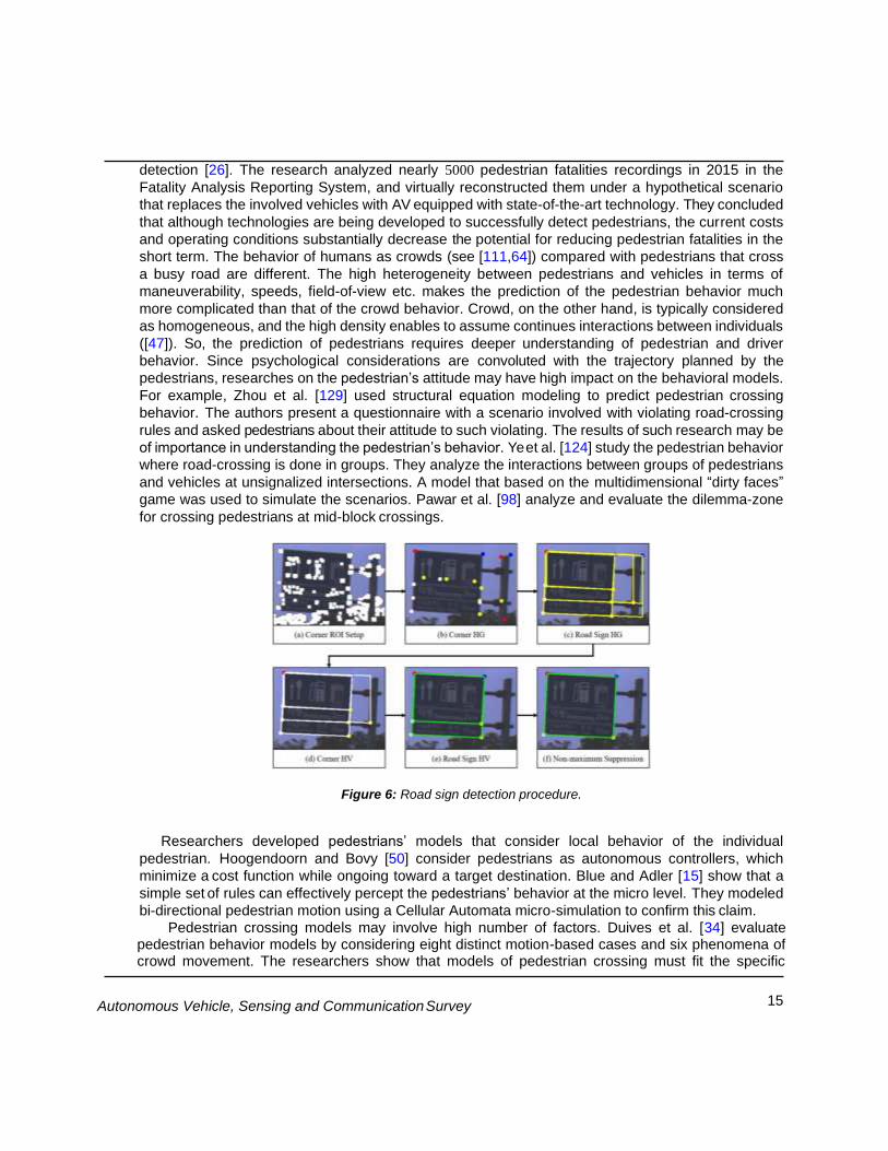
Figure 6: Road sign detection procedure.
Researchers developed pedestrians’ models that consider local behavior of the individual
pedestrian. Hoogendoorn and Bovy [50] consider pedestrians as autonomous controllers, which
minimize a cost function while ongoing toward a target destination. Blue and Adler [15] show that a
simple set of rules can effectively percept the pedestrians’ behavior at the micro level. They modeled
bi-directional pedestrian motion using a Cellular Automata micro-simulation to confirm this claim.
Pedestrian crossing models may involve high number of factors. Duives et al. [34] evaluate pedestrian behavior models by considering eight distinct motion-based cases and six phenomena of crowd movement. The researchers show that models of pedestrian crossing must fit the specific
16 Autonomous Vehicle, Sensing and Communication Survey
scenario. Even though pedestrian shares the same motivation, e.g. trying to cross the road safer and faster as possible, each pedestrian adopts his/her own target location, level of urgency, physical capabilities, etc. [96,11,47]. Guo et al. [40] confirms that the behavior of crossing pedestrians depends mainly on the waiting time. Hacohen et.al [43] present a statistical algorithm for pedestrian crossing behavior model that depends on the pedestrian urgency as a single factor to be tuned.
Due the complexity of such predictions, researchers focus their attention on specific interactions
between pedestrians and vehicles. Hashimoto et al. [46] developed a particle filter-based model of
pedestrian behavior. The authors focused on the scenario of left-turning vehicles at signalized
intersections when crossing at signalized crosswalks. Wang et al. [117] developed a pedestrian model
for scenarios of midblock crosswalks and intersections. Lee and Lam [73] presented a model which
estimates the walking speed of pedestrians at crowded crosswalks. Bonnin et al. [18] consider zebra-
crossings.
An innovative strategy for developing pedestrian models is by implementing common robotic
motion planning algorithms to construct the predicted trajectory of the pedestrians. Such methods
refer to the vehicles as obstacles that should be avoided, and the targets considered as the other
sides of the crosswalk. Zeng et al. [127] implement artificial-potential-field algorithm. Hacohen et al.
[42] use Probability-Navigation-Function to predict phenomenon of pedestrians’ crossings. Xiao et al
[122] introduced a Voronoi diagram-based algorithm for pedestrian flow model, and Van Waizman et
al. [113] developed their method based on Velocity-Obstacle.
7 Conclusions
Autonomous vehicles are the future of the transportation. The intense research of the big players in the
industry such as Google and Tesla towards this technology will make transportation safer, more
comfortable and more efficient. Nevertheless, most of the research today is focused on designing an
AV that will be able to drive in today’s roads today alongside regular vehicles. In addition to this
important development, research on cooperative sensing and driving still need to be done. According
to the cited research papers and the authors opinion, some important points are still in the development
stage and still need much more work. In this list we like to consider gaps that are unique to the AV
field and not considers by other disciplines.
1. Environmental sensors - the usage of street cameras and collecting the data to locate cars and
other road users.
2. Communication methods with pedestrians - more research need to be done in order to fully
understand the impact of AV on pedestrians during street sharing. In some places, streets are
designed to be pedestrian-friendly but still allow vehicles through, In such cases, Vehicle to
Pedestrians (V2P) communication is essential.
3. Consideration of non-controlled road users (pedestrians, cyclists, etc.) - development of
communication methods and prediction algorithms for their behavior.
4. Formulating ethics considerations for the AV decision making and data sharing. For example,
preemption, give way for emergency vehicles or for decision making in cases where an accident
is inevitable.
17 Autonomous Vehicle, Sensing and Communication Survey
Apart from the gaps in the above list, we identify some more issues that should be investigated in order
to improve and enable autonomous driving:
1. The price tag of the sensory suit for the AV is high, such that researchers point that this issue
delays the AV success. More algorithms using alternatives sensory input data to the LiDAR will
enable lowering the costs of the technology and moving forward to the solution faster. For
example, 3D observation using mono camera.
2. Sensory data fusion - these methods improve the robustness to weather or other environmental
conditions.
3. Artificial intelligence is an emerging field in many disciplines. The advantages of AI should be
considered in the operation of AVs as a tool for data analysis and decision making. AI in an
aspect of AV that requires more research.
References
[1] Marco Allodi, Alberto Broggi, Domenico Giaquinto, Marco Patander, and Antonio Prioletti. Ma-
chine learning in tracking associations with stereo vision and lidar observations for an au-
tonomous vehicle. In 2016 IEEE Intelligent Vehicles Symposium (IV), pages 648–653. IEEE,
2016.
[2] Mohamed Aly. Real time detection of lane markers in urban streets. In 2008 IEEE Intelligent
Vehicles Symposium, pages 7–12. IEEE, 2008.
[3] Mani Amoozadeh, Arun Raghuramu, Chen-Nee Chuah, Dipak Ghosal, H Michael Zhang, Jeff
Rowe, and Karl Levitt. Security vulnerabilities of connected vehicle streams and their impact on
cooperative driving. IEEE Communications Magazine, 53(6):126–132, 2015.
[4] James M Anderson, Kalra Nidhi, Karlyn D Stanley, Paul Sorensen, Constantine Samaras, and
Oluwatobi A Oluwatola. Autonomous vehicle technology: A guide for policymakers. Rand
Corporation, 2014.
[5] Sterling J Anderson, Sisir B Karumanchi, and Karl Iagnemma. Constraint-based planning and
control for safe, semi-autonomous operation of vehicles. In 2012 IEEE intelligent vehicles sym-
posium, pages 383–388. IEEE, 2012.
[6] Saeed Asadi Bagloee, Madjid Tavana, Mohsen Asadi, and Tracey Oliver. Autonomous vehicles:
challenges, opportunities, and future implications for transportation policies. Journal of modern
transportation, 24(4):284–303, 2016.
[7] Subho S Banerjee, Saurabh Jha, James Cyriac, Zbigniew T Kalbarczyk, and Ravishankar K Iyer.
Hands off the wheel in autonomous vehicles?: A systems perspective on over a million miles of
field data. In 2018 48th Annual IEEE/IFIP International Conference on Dependable Systems
and Networks (DSN), pages 586–597. IEEE, 2018.
[8]A Bartsch, F Fitzek, and RH Rasshofer. Pedestrian recognition using automotive radar sensors.
Advances in Radio Science: ARS, 10, 2012.
18 Autonomous Vehicle, Sensing and Communication Survey
[9] Pavlo Bazilinskyy, Dimitra Dodou, and Joost De Winter. Survey on ehmi concepts: The effect of
text, color, and perspective. Transportation research part F: traffic psychology and behaviour,
67:175–194, 2019.
[10] BBC. Toyota sneak previews self-drive car ahead of tech show. https://www.bbc.com/news/ technology-20910769, 2013.
[11] Nicola Bellomo, Benedetto Piccoli, and Andrea Tosin. Modeling crowd dynamics from a complex
system viewpoint. Mathematical models and methods in applied sciences,
22(supp02):1230004, 2012.
[12] Mario Bijelic, Tobias Gruber, and Werner Ritter. Benchmarking image sensors under adverse
weather conditions for autonomous driving. In 2018 IEEE Intelligent Vehicles Symposium (IV),
pages 1773–1779. IEEE, 2018.
[13] Igal Bilik, Oren Longman, Shahar Villeval, and Joseph Tabrikian. The rise of radar for au-
tonomous vehicles: Signal processing solutions and future research directions. IEEE Signal
Processing Magazine, 36(5):20–31, 2019.
[14] Christophe Blanc, Laurent Trassoudaine, and Jean Gallice. Ekf and particle filter track-to-track
fusion: A quantitative comparison from radar/lidar obstacle tracks. In 2005 7th International
Conference on Information Fusion, volume 2, pages 7–pp. IEEE, 2005.
[15] Victor J Blue and Jeffrey L Adler. Cellular automata microsimulation for modeling bi-directional
pedestrian walkways. Transportation Research Part B: Methodological, 35(3):293–312, 2001.
[16] LNP Boggavarapu, RS Vaddi, KR Anne, HD Vankayalapati, and JK Munagala. A robust multi
color lane marking detection approach for indian scenario. IJACSA Editorial, 2011.
[17] Jonathan Bohren, Tully Foote, Jim Keller, Alex Kushleyev, Daniel Lee, Alex Stewart, Paul Ver-
naza, Jason Derenick, John Spletzer, and Brian Satterfield. Little ben: The ben franklin racing
team’s entry in the 2007 darpa urban challenge. Journal of Field Robotics, 25(9):598–614,
2008.
[18] Sarah Bonnin, Thomas H Weisswange, Franz Kummert, and Jens Schmu dderich. Pedestrian
crossing prediction using multiple context-based models. In 17th International IEEE Conference
on Intelligent Transportation Systems (ITSC), pages 378–385. IEEE, 2014.
[19] Deborah Braid, Alberto Broggi, and Gary Schmiedel. The terramax autonomous vehicle. Jour-
nal of Field Robotics, 23(9):693–708, 2006.
[20] Matthew Brown, Joseph Funke, Stephen Erlien, and J Christian Gerdes. Safe driving envelopes
for path tracking in autonomous vehicles. Control Engineering Practice, 61:307–316, 2017.
[21] Brett Browning, Peter Hansen, Ethan Eade, David Prasser, David LaRose, and Robert Zlot.
Autonomous vehicle localization using passive image data, November 12 2019. US Patent
10,474,162.
[22] Brett Browning, Peter Hansen, Ethan Eade, David Prasser, David LaRose, and Robert Zlot.
Autonomous vehicle localization using image analysis and manipulation, June 9 2020. US
Patent 10,678,262.
19 Autonomous Vehicle, Sensing and Communication Survey
[23] Yi-Liang Chen, Venkataraman Sundareswaran, Craig Anderson, Alberto Broggi, Paolo Grisleri,
Pier Paolo Porta, Paolo Zani, and John Beck. TerramaxTM: Team oshkosh urban robot. Journal of Field Robotics, 25(10):841–860, 2008.
[24] Mi Jin Choi, Jae Kyu Suhr, Kyoungtaek Choi, and Ho Gi Jung. Low-cost precise vehicle local-
ization using lane endpoints and road signs for highway situations. IEEE Access, 7:149846–
149856, 2019.
[25] cleantechnica. Uber reduced LiDAR array in self-driving cars from 7 units to 1 in 2016, creating pedestrian blindspots. https://cleantechnica.com/2018/03/29/uber-reduced-lidar-array-in-self-
driving-cars-from-7-units-to-1-in-2016-creating-pedestrian, 2018.
[26] Tabitha S Combs, Laura S Sandt, Michael P Clamann, and Noreen C McDonald. Automated
vehicles and pedestrian safety: exploring the promise and limits of pedestrian detection.
American journal of preventive medicine, 56(1):1–7, 2019.
[27] CAR 2 CAR Communication Consortium. Home page. https://www.car-2-car.org/, 2020. [
[28] Martin Cunneen, Martin Mullins, Finbarr Murphy, Darren Shannon, Irini Furxhi, and Cian Ryan.
Autonomous vehicles and avoiding the trolley (dilemma): vehicle perception, classification, and
the challenges of framing decision ethics. Cybernetics and Systems, 51(1):59–80, 2020.
[29] Jorge Estrela da Silva and Joao Borges de Sousa. A dynamic programming approach for the
motion control of autonomous vehicles. In 49th IEEE Conference on Decision and Control
(CDC), pages 6660–6665. IEEE, 2010.
[30] Prema M Daigavane and Preeti R Bajaj. Road lane detection with improved canny edges using
ant colony optimization. In 2010 3rd International Conference on Emerging Trends in
Engineering and Technology, pages 76–80. IEEE, 2010.
[31] Paul DeBitetto, Matthew Graham, Troy Jones, Peter Lommel, and Jon Demerly. Autonomous
vehicle: vehicle localization, March 29 2018. US Patent App. 15/280,296.
[32] Debargha Dey, Marieke Martens, Chao Wang, Felix Ros, and Jacques Terken. Interface con-
cepts for intent communication from autonomous vehicles to vulnerable road users. In Adjunct
Proceedings of the 10th International Conference on Automotive User Interfaces and Interactive
Vehicular Applications, pages 82–86, 2018.
[33] Debargha Dey and Jacques Terken. Pedestrian interaction with vehicles: roles of explicit and
implicit communication. In Proceedings of the 9th international conference on automotive user
interfaces and interactive vehicular applications, pages 109–113, 2017.
[34] Dorine C Duives, Winnie Daamen, and Serge P Hoogendoorn. State-of-the-art crowd motion
simulation models. Transportation research part C: emerging technologies, 37:193–209, 2013.
[35] Daniel J Fagnant and Kara Kockelman. Preparing a nation for autonomous vehicles: opportuni-
ties, barriers and policy recommendations. Transportation Research Part A: Policy and Practice,
77:167–181, 2015.
20 Autonomous Vehicle, Sensing and Communication Survey
[36] Dave Ferguson, Thomas M Howard, and Maxim Likhachev. Motion planning in urban environ-
ments. Journal of Field Robotics, 25(11-12):939–960, 2008.
[37] Brian P Ginsburg, Karthik Subburaj, Sreekiran Samala, Karthik Ramasubramanian, Jasbir Singh,
Sumeer Bhatara, Sriram Murali, Dan Breen, Meysam Moallem, Krishnanshu Dandu, et al. A
multimode 76-to-81ghz automotive radar transceiver with autonomous monitoring. In 2018
IEEE International Solid-State Circuits Conference-(ISSCC), pages 158–160. IEEE, 2018.
[38] Daniel Go hring, Miao Wang, Michael Schnu rmacher, and Tinosch Ganjineh. Radar/lidar sen-
sor fusion for car-following on highways. In The 5th International Conference on Automation,
Robotics and Applications, pages 407–412. IEEE, 2011.
[39] Offer Grembek, Alex Kurzhanskiy, Aditya Medury, Pravin Varaiya, and Mengqiao Yu. Making
intersections safer with i2v communication. Transportation Research Part C: Emerging Tech-
nologies, 102:396–410, 2019.
[40] Hongwei Guo, Ziyou Gao, Xiaobao Yang, and Xiaobei Jiang. Modeling pedestrian violation
behavior at signalized crosswalks in china: A hazards-based duration approach. Traffic injury
prevention, 12(1):96–103, 2011.
[41] Azra Habibovic, Jonas Andersson, Victor Malmsten Lundgren, Maria Klingeg a rd, Cristofer En-
glund, and Sofia Larsson. External vehicle interfaces for communication with other road users?
In Road Vehicle Automation 5, pages 91–102. Springer, 2019.
[42] Shlomi Hacohen, Shraga Shoval, and Nir Shvalb. The paradox of pedestrian’s risk aversion.
Accident Analysis & Prevention, 142:105518, 2020.
[43] Shlomi Hacohen, Nir Shvalb, and Shraga Shoval. Dynamic model for pedestrian crossing in
congested traffic based on probabilistic navigation function. Transportation research part C:
emerging technologies, 86:78–96, 2018.
[44] David S Hall. High definition lidar system, June 28 2011. US Patent 7,969,558.
[45] Jaehyun Han, Dongchul Kim, Minchae Lee, and Myoungho Sunwoo. Enhanced road boundary
and obstacle detection using a downward-looking lidar sensor. IEEE Transactions on Vehicular
Technology, 61(3):971–985, 2012.
[46] Yoriyoshi Hashimoto, Yanlei Gu, Li-Ta Hsu, Miho Iryo-Asano, and Shunsuke Kamijo. A proba-
bilistic model of pedestrian crossing behavior at signalized intersections for connected vehicles.
Transportation research part C: emerging technologies, 71:164–181, 2016.
[47] Dirk Helbing and Anders Johansson. Pedestrian, crowd, and evacuation dynamics. arXiv preprint
arXiv:1309.1609, 2013.
[48] Lionel Heng, Benjamin Choi, Zhaopeng Cui, Marcel Geppert, Sixing Hu, Benson Kuan, Peidong
Liu, Rang Nguyen, Ye Chuan Yeo, Andreas Geiger, et al. Project autovision: Localization and 3d
scene perception for an autonomous vehicle with a multi-camera system. In 2019 International
Conference on Robotics and Automation (ICRA), pages 4695–4702. IEEE, 2019.
21 Autonomous Vehicle, Sensing and Communication Survey
[49] Laurens Hobert, Andreas Festag, Ignacio Llatser, Luciano Altomare, Filippo Visintainer, and
Andras Kovacs. Enhancements of v2x communication in support of cooperative autonomous
driving. IEEE communications magazine, 53(12):64–70, 2015.
[50] Serge P Hoogendoorn and Piet HL Bovy. Normative pedestrian behaviour theory and modelling.
Transportation and traffic theory in the 21st century, pages 219–245, 2002.
[51] Robert Hult, Gabriel R Campos, Erik Steinmetz, Lars Hammarstrand, Paolo Falcone, and Henk
Wymeersch. Coordination of cooperative autonomous vehicles: Toward safer and more efficient
road transportation. IEEE Signal Processing Magazine, 33(6):74–84, 2016.
[52] Eugin Hyun, Young-Seok Jin, and Jong-Hun Lee. A pedestrian detection scheme using a co-
herent phase difference method based on 2d range-doppler fmcw radar. Sensors, 16(1):124,
2016.
[53] Seyed Mehdi Iranmanesh, Ehsan Moradi-Pari, Yaser P Fallah, Sushanta Das, and Muhammad
Rizwan. Robustness of cooperative forward collision warning systems to communication uncer-
tainty. In 2016 Annual IEEE Systems Conference (SysCon), pages 1–7. IEEE, 2016.
[54] David Isele, Reza Rahimi, Akansel Cosgun, Kaushik Subramanian, and Kikuo Fujimura. Navi-
gating occluded intersections with autonomous vehicles using deep reinforcement learning. In
2018 IEEE International Conference on Robotics and Automation (ICRA), pages 2034–2039.
IEEE, 2018.
[55] Qiu Jin, Guoyuan Wu, Kanok Boriboonsomsin, and Matthew Barth. Advanced intersection
management for connected vehicles using a multi-agent systems approach. In 2012 IEEE
Intelligent Vehicles Symposium, pages 932–937. IEEE, 2012.
[56] Gustaf Johansson and Mattias Wasteby. Hybrid map for autonomous commercial vehicles-
global localization using topological mapping and machine learning. Master’s thesis, 2017.
[57] Frederic Jurie, Philippe Martinet, and Jean Gallice. A global road scene analysis system for
autonomous vehicles. In Intelligent Autonomous Vehicles 1995, pages 19–24. Elsevier, 1995.
[58] Takeo Kanade, Chuck Thorpe, and William Whittaker. Autonomous land vehicle project at cmu.
In Proceedings of the 1986 ACM fourteenth annual conference on Computer science, pages
71–80, 1986.
[59] Sertac Karaman, Matthew R Walter, Alejandro Perez, Emilio Frazzoli, and Seth Teller. Any- time
motion planning using the rrt. In 2011 IEEE International Conference on Robotics and
Automation, pages 1478–1483. IEEE, 2011.
[60] Tobias Kessler, Pascal Minnerup, Klemens Esterle, Christian Feist, Florian Mickler, Erwin Roth,
and Alois Knoll. Roadgraph generation and free-space estimation in unknown structured envi-
ronments for autonomous vehicle motion planning. In 2018 21st International Conference on
Intelligent Transportation Systems (ITSC), pages 2831–2838. IEEE, 2018.
[61] Seong-Woo Kim, Zhuang Jie Chong, Baoxing Qin, Xiaotong Shen, Zhuoqi Cheng, Wei Liu, and
Marcelo H Ang. Cooperative perception for autonomous vehicle control on the road: Motivation
and experimental results. In 2013 IEEE/RSJ International Conference on Intelligent Robots and
Systems, pages 5059–5066. IEEE, 2013.
22 Autonomous Vehicle, Sensing and Communication Survey
[62] Seong-Woo Kim, Wei Liu, Marcelo H Ang, Emilio Frazzoli, and Daniela Rus. The impact of co-
operative perception on decision making and planning of autonomous vehicles. IEEE Intelligent
Transportation Systems Magazine, 7(3):39–50, 2015.
[63] Moad Kissai, Xavier Mouton, Bruno Monsuez, Didier Martinez, and Adriana Tapus. Optimizing
vehicle motion control for generating multiple sensations. In 2018 IEEE Intelligent Vehicles
Symposium (IV), pages 928–935. IEEE, 2018.
[64] Ven Jyn Kok, Mei Kuan Lim, and Chee Seng Chan. Crowd behavior analysis: A review where
physics meets biology. Neurocomputing, 177:342–362, 2016.
[65] Philip Koopman and Michael Wagner. Autonomous vehicle safety: An interdisciplinary chal-
lenge. IEEE Intelligent Transportation Systems Magazine, 9(1):90–96, 2017.
[66] Miklas S Kristoffersen, Jacob V Dueholm, Rikke Gade, and Thomas B Moeslund. Pedestrian
counting with occlusion handling using stereo thermal cameras. Sensors, 16(1):62, 2016.
[67] Akisue Kuramoto, Mohammad A Aldibaja, Ryo Yanase, Junya Kameyama, Keisuke Yoneda, and
Naoki Suganuma. Mono-camera based 3d object tracking strategy for autonomous vehicles. In
2018 IEEE Intelligent Vehicles Symposium (IV), pages 459–464. IEEE, 2018.
[68] Matti Kutila, Pasi Pyyko nen, Werner Ritter, Oliver Sawade, and Bernd Scha ufele. Automotive
lidar sensor development scenarios for harsh weather conditions. In 2016 IEEE 19th Interna-
tional Conference on Intelligent Transportation Systems (ITSC), pages 265–270. IEEE, 2016.
[69] Yoshiaki Kuwata, Justin Teo, Gaston Fiore, Sertac Karaman, Emilio Frazzoli, and Jonathan P
How. Real-time motion planning with applications to autonomous urban driving. IEEE Transac-
tions on control systems technology, 17(5):1105–1118, 2009.
[70] Seong Kyung Kwon, Eugin Hyun, Jin-Hee Lee, Jonghun Lee, and Sang Hyuk Son. Detec- tion
scheme for a partially occluded pedestrian based on occluded depth in lidar–radar sensor
fusion. Optical Engineering, 56(11):113112, 2017.
[71] Ray Lattarulo, Leonardo Gonz alez, Enrique Martı, Jose Matute, Mauricio Marcano, and Joshue
Perez. Urban motion planning framework based on n-bezier curves considering comfort and
safety. Journal of Advanced Transportation, 2018, 2018.
[72] Chanho Lee and Ji-Hyun Moon. Robust lane detection and tracking for real-time applications.
IEEE Transactions on Intelligent Transportation Systems, 19(12):4043–4048, 2018.
[73] Jodie YS Lee and William HK Lam. Simulating pedestrian movements at signalized crosswalks
in hong kong. Transportation Research Part A: Policy and Practice, 42(10):1314–1325, 2008.
[74] Liangzhi Li, Kaoru Ota, and Mianxiong Dong. Humanlike driving: Empirical decision-making
system for autonomous vehicles. IEEE Transactions on Vehicular Technology, 67(8):6814–
6823, 2018.
[75] Yixin Li, Ying Ni, Jian Sun, and Zian Ma. Modeling the illegal lane-changing behavior of bicycles
on road segments: Considering lane-changing categories and bicycle heterogeneity. Physica
A: Statistical Mechanics and its Applications, 541:123302, 2020.
23 Autonomous Vehicle, Sensing and Communication Survey
[76] Maxim Likhachev and Dave Ferguson. Planning long dynamically feasible maneuvers for au-
tonomous vehicles. The International Journal of Robotics Research, 28(8):933–945, 2009.
[77] Dingyou Ma, Nir Shlezinger, Tianyao Huang, Yimin Liu, and Yonina C Eldar. Joint radar-
communications strategies for autonomous vehicles. arXiv preprint arXiv:1909.01729, 2019.
[78] John Maddox, Peter Sweatman, and Jim Sayer. Intelligent vehicles+ infrastructure to address
transportation problems–a strategic approach. In 24th international technical conference on the
enhanced safety of vehicles (ESV), 2015.
[79] Silvia Magdici and Matthias Althoff. Fail-safe motion planning of autonomous vehicles. In 2016
IEEE 19th International Conference on Intelligent Transportation Systems (ITSC), pages 452–
458. IEEE, 2016.
[80] Karthik Mahadevan, Sowmya Somanath, and Ehud Sharlin. Communicating awareness and in-
tent in autonomous vehicle-pedestrian interaction. In Proceedings of the 2018 CHI Conference
on Human Factors in Computing Systems, pages 1–12, 2018.
[81] Joel C McCall and Mohan M Trivedi. Video-based lane estimation and tracking for driver assis-
tance: survey, system, and evaluation. IEEE transactions on intelligent transportation systems,
7(1):20–37, 2006.
[82] Branka Mirchevska, Christian Pek, Moritz Werling, Matthias Althoff, and Joschka Boedecker.
High-level decision making for safe and reasonable autonomous lane changing using reinforce-
ment learning. In 2018 21st International Conference on Intelligent Transportation Systems
(ITSC), pages 2156–2162. IEEE, 2018.
[83] Michael Montemerlo, Jan Becker, Suhrid Bhat, Hendrik Dahlkamp, Dmitri Dolgov, Scott Ettinger,
Dirk Haehnel, Tim Hilden, Gabe Hoffmann, Burkhard Huhnke, et al. Junior: The stanford entry
in the urban challenge. Journal of field Robotics, 25(9):569–597, 2008.
[84] Katsumi Moriwaki. Autonomous steering control for electric vehicles using nonlinear state feed-
back h-infinity control. Nonlinear Analysis: Theory, Methods & Applications, 63(5-7):e2257–
e2268, 2005.
[85] Upali Priyantha Mudalige. Fail-safe speed profiles for cooperative autonomous vehicles,
March 18 2014. US Patent 8,676,466.
[86] Syed Zeeshan Ahmed Mukhtar, Vincensius Billy Saputra, Saurab Verma, Kun Zhang, and Al-
bertus Hendrawan Adiwahono. Sparse-3d lidar outdoor map-based autonomous vehicle local-
ization. 2019.
[87] Ramin Nabati and Hairong Qi. Rrpn: Radar region proposal network for object detection in
autonomous vehicles. In 2019 IEEE International Conference on Image Processing (ICIP),
pages 3093–3097. IEEE, 2019.
[88] Wassim G Najm, Jonathan Koopmann, John D Smith, John Brewer, et al. Frequency of target
crashes for intellidrive safety systems. Technical report, United States. National Highway Traffic
Safety Administration, 2010.
24 Autonomous Vehicle, Sensing and Communication Survey
[89] Pedro J Navarro, Carlos Fernandez, Raul Borraz, and Diego Alonso. A machine learning ap-
proach to pedestrian detection for autonomous vehicles using high-definition 3d range data.
Sensors, 17(1):18, 2017.
[90] Dan Neil. Who’s behind the wheel? nobody. the driverless car is coming. and we all should be
glad it is. Wall Street Journal (Online)[New York, NY] Sep, 24, 2012.
[91] Jianqiang Nie, Jian Zhang, Wanting Ding, Xia Wan, Xiaoxuan Chen, and Bin Ran. Decentralized
cooperative lane-changing decision-making for connected autonomous vehicles. IEEE Access,
4:9413–9420, 2016.
[92] Nodar. Nodar. https://www.nodarsensor.com/, 2020.
[93] International Society of Automotive Engineers. Automated driving levels of driving automation are defined in new sae international standard j3016. https://cdn.oemoffhighway.com/files/ base/acbm/ooh/document/2016/03/automated_driving.pdf, 2016.
[94] United States Department of Transportation NHTSA. Traffic safety facts annual report tables.
https://cdan.nhtsa.gov/tsftables/tsfar.htm#, 2017.
[95] Yuji Otsuka, Shoji Muramatsu, Hiroshi Takenaga, Yoshiki Kobayashi, and T Monj. Multitype lane
markers recognition using local edge direction. In Intelligent Vehicle Symposium, 2002. IEEE,
volume 2, pages 604–609. IEEE, 2002.
[96] Eleonora Papadimitriou, George Yannis, and John Golias. A critical assessment of pedestrian
behaviour models. Transportation research part F: traffic psychology and behaviour, 12(3):242–
255, 2009.
[97] Benjamin J Patz, Yiannis Papelis, Remo Pillat, Gary Stein, and Don Harper. A practical ap-
proach to robotic design for the darpa urban challenge. Journal of Field Robotics, 25(8):528–
566, 2008.
[98] Digvijay S Pawar, Vinit Kumar, Navdeep Singh, and Gopal R Patil. Analysis of dilemma zone for
pedestrians at high-speed uncontrolled midblock crossing. Transportation research part C:
emerging technologies, 70:42–52, 2016.
[99]D Ganesha Perumal, B Subathra, G Saravanakumar, and Seshadhri Srinivasan. Extended
kalman filter based path-planning algorithm for autonomous vehicles with i2v communication.
IFAC-PapersOnLine, 49(1):652–657, 2016.
[100] Amir Rasouli and John K Tsotsos. Autonomous vehicles that interact with pedestrians: A survey
of theory and practice. IEEE Transactions on Intelligent Transportation Systems, 21(3):900–918,
2019.
[101] Jee-Hwan Ryu, Dmitriy Ogay, Sergey Bulavintsev, Hyuk Kim, and Jang-Sik Park. Development
and experiences of an autonomous vehicle for high-speed navigation and obstacle avoidance.
In Frontiers of Intelligent Autonomous Systems, pages 105–116. Springer, 2013.
25 Autonomous Vehicle, Sensing and Communication Survey
[102] Torsten Sattler, Will Maddern, Carl Toft, Akihiko Torii, Lars Hammarstrand, Erik Stenborg, Daniel
Safari, Masatoshi Okutomi, Marc Pollefeys, Josef Sivic, et al. Benchmarking 6dof outdoor visual
localization in changing conditions. In Proceedings of the IEEE Conference on Computer Vision
and Pattern Recognition, pages 8601–8610, 2018.
[103] Wilko Schwarting, Javier Alonso-Mora, and Daniela Rus. Planning and decision-making for
autonomous vehicles. Annual Review of Control, Robotics, and Autonomous Systems, 2018.
[104] Milwaukee Sentinel. Phantom auto’will tour city. Milwaukee Sentin, 4, 1926.
[105] Razvan Solea and Urbano Nunes. Trajectory planning and sliding-mode control based
trajectory-tracking for cybercars. Integrated Computer-Aided Engineering, 14(1):33–47, 2007.
[106] Andrzej Stateczny, Witold Kazimierski, Daria Gronska-Sledz, and Weronika Motyl. The empir-
ical application of automotive 3d radar sensor for target detection for an autonomous surface
vehicle’s navigation. Remote Sensing, 11(10):1156, 2019.
[107] Martin Stolz, Eugen Schubert, Frank Meinl, Martin Kunert, and Wolfgang Menzel. Multi-target
reflection point model of cyclists for automotive radar. In 2017 European Radar Conference
(EURAD), pages 94–97. IEEE, 2017.
[108] Tsung-Ying Sun, Shang-Jeng Tsai, and Vincent Chan. Hsi color model based lane-marking
detection. In 2006 IEEE Intelligent Transportation Systems Conference, pages 1168–1172.
IEEE, 2006.
[109] Zhu Teng, Jeong-Hyun Kim, and Dong-Joong Kang. Real-time lane detection by using multiple
cues. In ICCAS 2010, pages 2334–2337. IEEE, 2010.
[110] Heather Twaddle, Tobias Schendzielorz, and Oliver Fakler. Bicycles in urban areas: Review of
existing methods for modeling behavior. Transportation research record, 2434(1):140–146,
2014.
[111] Mohib Ullah, Habib Ullah, Nicola Conci, and Francesco GB De Natale. Crowd behavior identifi-
cation. In 2016 IEEE International Conference on Image Processing (ICIP), pages 1195–1199.
IEEE, 2016.
[112] Chris Urmson, Joshua Anhalt, Drew Bagnell, Christopher Baker, Robert Bittner, MN Clark, John
Dolan, Dave Duggins, Tugrul Galatali, Chris Geyer, et al. Autonomous driving in urban
environments: Boss and the urban challenge. Journal of Field Robotics, 25(8):425–466, 2008.
[113] Gennady Waizman, Shraga Shoval, and Itzhak Benenson. Micro-simulation model for assess-
ing the risk of vehicle–pedestrian road accidents. Journal of Intelligent Transportation Systems,
19(1):63–77, 2015.
[114] Heng Wang, Bin Wang, Bingbing Liu, Xiaoli Meng, and Guanghong Yang. Pedestrian recogni-
tion and tracking using 3d lidar for autonomous vehicle. Robotics and Autonomous Systems,
88:71–78, 2017.
[115] Hong Wang, Yanjun Huang, Amir Khajepour, Dongpu Cao, and Chen Lv. Ethical decision-
making platform in autonomous vehicles with lexicographic optimization based model predictive
controller. IEEE Transactions on Vehicular Technology, 2020.
26 Autonomous Vehicle, Sensing and Communication Survey
[116] Liang Wang, Yihuan Zhang, and Jun Wang. Map-based localization method for autonomous
vehicles using 3d-lidar. IFAC-PapersOnLine, 50(1):276–281, 2017.
[117] Wuhong Wang, Hongwei Guo, Ziyou Gao, and Heiner Bubb. Individual differences of pedestrian
behaviour in midblock crosswalk and intersection. International Journal of Crashworthiness,
16(1):1–9, 2011.
[118] Yan Wang, Wei-Lun Chao, Divyansh Garg, Bharath Hariharan, Mark Campbell, and Kilian Q
Weinberger. Pseudo-lidar from visual depth estimation: Bridging the gap in 3d object detec- tion
for autonomous driving. In Proceedings of the IEEE Conference on Computer Vision and
Pattern Recognition, pages 8445–8453, 2019.
[119] Allen Waxman, Jacqueline LeMoigne, Larry Davis, Babu Srinivasan, Todd Kushner, Eli Liang,
and Tharakesh Siddalingaiah. A visual navigation system for autonomous land vehicles. IEEE
Journal on Robotics and Automation, 3(2):124–141, 1987.
[120] Kelvin Wong, Ehsan Javanmardi, Mahdi Javanmardi, and Shunsuke Kamijo. Estimating au-
tonomous vehicle localization error using 2d geographic information. ISPRS International Jour-
nal of Geo-Information, 8(6):288, 2019.
[121] Enric Xargay, Vladimir Dobrokhodov, Isaac Kaminer, Antonio M Pascoal, Naira Hovakimyan, and
Chengyu Cao. Time-critical cooperative control of multiple autonomous vehicles: Robust
distributed strategies for path-following control and time-coordination over dynamic communi-
cations networks. IEEE Control Systems Magazine, 32(5):49–73, 2012.
[122] Yao Xiao, Ziyou Gao, Yunchao Qu, and Xingang Li. A pedestrian flow model considering the
impact of local density: Voronoi diagram based heuristics approach. Transportation research
part C: emerging technologies, 68:566–580, 2016.
[123] Danya Yao, Yi Zhang, Li Li, Yuelong Su, Sihan Cheng, and Wenda Xu. Behavior modeling and
simulation for conflicts in vehicles-bicycles mixed flow. IEEE Intelligent Transportation Systems
Magazine, 1(2):25–30, 2009.
[124] Shunqiang Ye, Lu Wang, Kang Hao Cheong, and Nenggang Xie. Pedestrian group-crossing
behavior modeling and simulation based on multidimensional dirty faces game. Complexity,
2017, 2017.
[125] S. Yu, T. Westfechtel, R. Hamada, K. Ohno, and S. Tadokoro. Vehicle detection and local- ization
on bird’s eye view elevation images using convolutional neural network. In 2017 IEEE
International Symposium on Safety, Security and Rescue Robotics (SSRR), pages 102–109,
2017.
[126] Shang-Lin Yu, Thomas Westfechtel, Ryunosuke Hamada, Kazunori Ohno, and Satoshi Ta-
dokoro. Vehicle detection and localization on bird’s eye view elevation images using convo-
lutional neural network. In 2017 IEEE International Symposium on Safety, Security and Rescue
Robotics (SSRR), pages 102–109. IEEE, 2017.
[127] Weiliang Zeng, Peng Chen, Hideki Nakamura, and Miho Iryo-Asano. Application of social force
model to pedestrian behavior analysis at signalized crosswalk. Transportation research part C:
emerging technologies, 40:143–159, 2014.
27 Autonomous Vehicle, Sensing and Communication Survey
[128] Fang Zhang, Jon Gonzales, Shengbo Eben Li, Francesco Borrelli, and Keqiang Li. Drift control
for cornering maneuver of autonomous vehicles. Mechatronics, 54:167–174, 2018.
[129] Hongmei Zhou, Stephanie Ballon Romero, and Xiao Qin. An extension of the theory of planned
behavior to predict pedestrians’ violating crossing behavior using structural equation modeling.
Accident Analysis & Prevention, 95:417–424, 2016.
[130] Mofan Zhou, Xiaobo Qu, and Sheng Jin. On the impact of cooperative autonomous vehicles in
improving freeway merging: a modified intelligent driver model-based approach. IEEE Transac-
tions on Intelligent Transportation Systems, 18(6):1422–1428, 2016.
[131] Shengyan Zhou, Yanhua Jiang, Junqiang Xi, Jianwei Gong, Guangming Xiong, and Huiyan
Chen. A novel lane detection based on geometrical model and gabor filter. In 2010 IEEE
Intelligent Vehicles Symposium, pages 59–64. IEEE, 2010.