Embed Size (px)
Citation preview
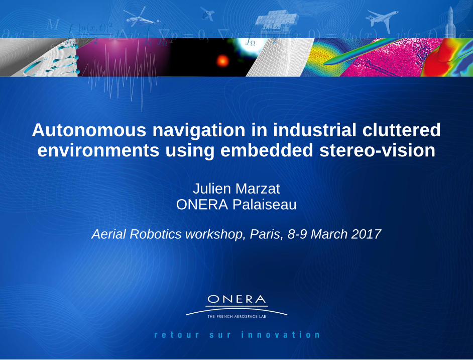
1
Autonomous navigation in industrial cluttered environments using embedded stereo-vision
Julien Marzat
ONERA Palaiseau
Aerial Robotics workshop, Paris, 8-9 March 2017
2
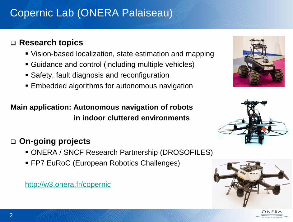
Copernic Lab (ONERA Palaiseau)
Research topics
Vision-based localization, state estimation and mapping
Guidance and control (including multiple vehicles)
Safety, fault diagnosis and reconfiguration
Embedded algorithms for autonomous navigation
Main application: Autonomous navigation of robots
in indoor cluttered environments
On-going projects
ONERA / SNCF Research Partnership (DROSOFILES)
FP7 EuRoC (European Robotics Challenges)
http://w3.onera.fr/copernic
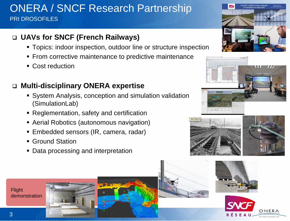
ONERA / SNCF Research Partnership PRI DROSOFILES
UAVs for SNCF (French Railways)
Topics: indoor inspection, outdoor line or structure inspection
From corrective maintenance to predictive maintenance
Cost reduction
Multi-disciplinary ONERA expertise
System Analysis, conception and simulation validation
(SimulationLab)
Reglementation, safety and certification
Aerial Robotics (autonomous navigation)
Embedded sensors (IR, camera, radar)
Ground Station
Data processing and interpretation
3
Flight
demonstration
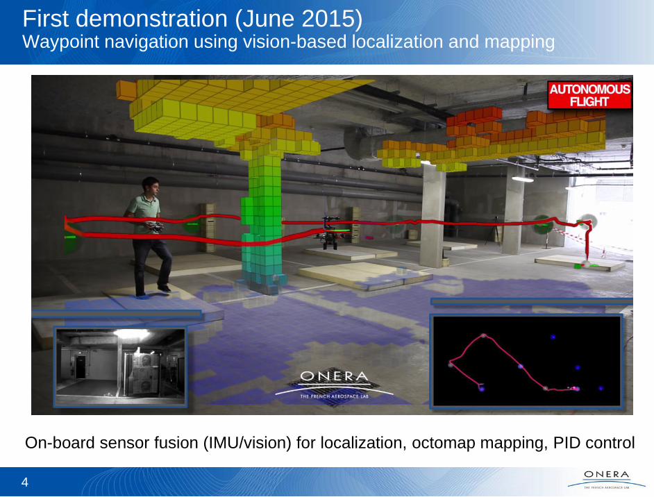
First demonstration (June 2015) Waypoint navigation using vision-based localization and mapping
4
On-board sensor fusion (IMU/vision) for localization, octomap mapping, PID control
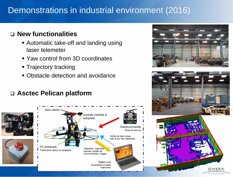
Demonstrations in industrial environment (2016)
New functionalities
Automatic take-off and landing using
laser telemeter
Yaw control from 3D coordinates
Trajectory tracking
Obstacle detection and avoidance
Asctec Pelican platform
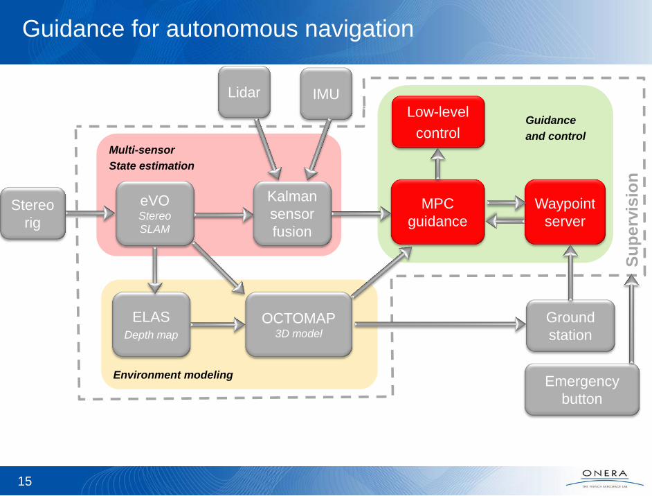
Environment modeling
Guidance
and control
Multi-sensor
State estimation
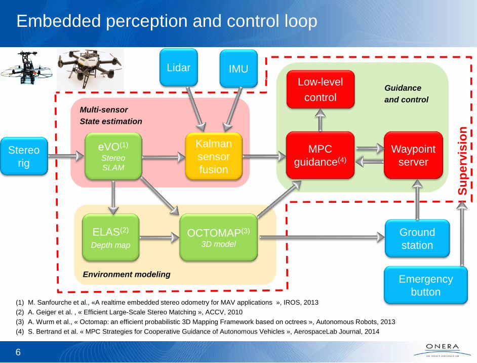
6
IMU
eVO(1) Stereo
SLAM
ELAS(2)
Depth map
OCTOMAP(3)
3D model
Kalman
sensor
fusion
MPC
guidance(4)
Low-level
control
Ground
station
Lidar
Waypoint
server
Emergency
button (1) M. Sanfourche et al., «A realtime embedded stereo odometry for MAV applications », IROS, 2013
(2) A. Geiger et al. , « Efficient Large-Scale Stereo Matching », ACCV, 2010
(3) A. Wurm et al., « Octomap: an efficient probabilistic 3D Mapping Framework based on octrees », Autonomous Robots, 2013
(4) S. Bertrand et al. « MPC Strategies for Cooperative Guidance of Autonomous Vehicles », AerospaceLab Journal, 2014
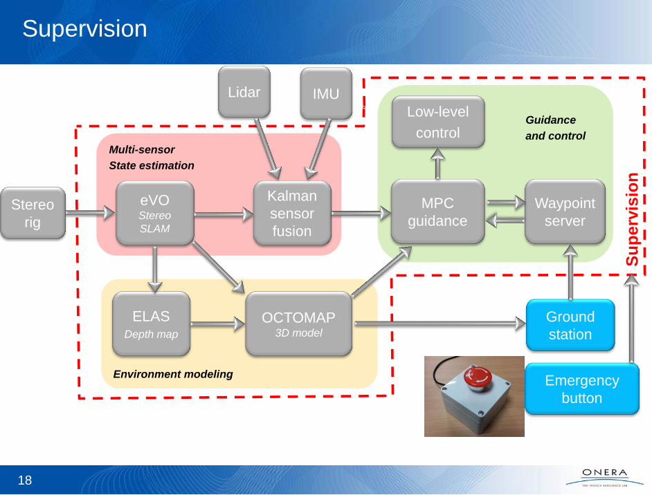
Su
pe
rvis
ion
Embedded perception and control loop
Stereo
rig
Environment modeling
Guidance
and control
Multi-sensor
State estimation
7
IMU
eVO Stereo
SLAM
ELAS
Depth map
OCTOMAP
3D model
Kalman
sensor
fusion
MPC
guidance
Low-level
control
Ground
station
Lidar
Waypoint
server
Emergency
button
Su
pe
rvis
ion
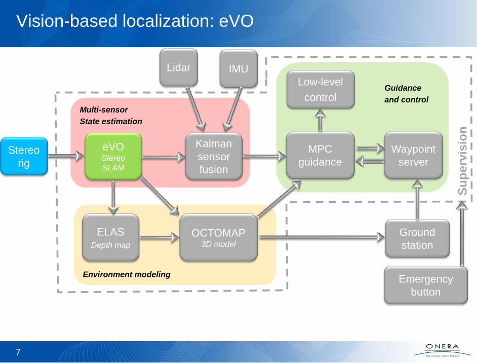
Vision-based localization: eVO
Stereo
rig

Vision-based localization: eVO
Computes position and attitude using 3D sensors (stereo rig or RGB-D)
20 Hz on a usual embedded CPU (Core2duo, i5, i7)
Many flight hours in the last 4 years
Operating principles
Map of 3D landmarks built on-line + localization in image => position and attitude
Key-frame scheme to limit complexity (update on number of visible landmarks)
8

Localization Thread
Mapping Thread
Vision-based localization: eVO
Other features
Handles large fields of view using distortion models
RANSAC management of 3D landmarks
9
KLT tracking
Outlier filtering
3-point algorithm
Robust RANSAC
Nonlinear refinement
Harris points
Homogeneous repartition
in image
Epipolar exhaustive search
Multi-scale
Outlier filtering
Environment modeling
Guidance
and control
Multi-sensor
State estimation
10
IMU
eVO Stereo
SLAM
ELAS
Depth map
OCTOMAP
3D model
Kalman
sensor
fusion
MPC
guidance
Low-level
control
Ground
station
Lidar
Waypoint
server
Emergency
button
Su
pe
rvis
ion
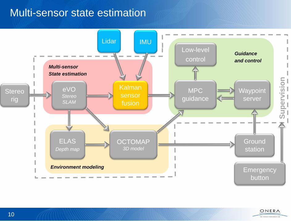
Multi-sensor state estimation
Stereo
rig
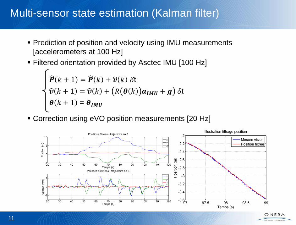
Multi-sensor state estimation (Kalman filter)
Prediction of position and velocity using IMU measurements
[accelerometers at 100 Hz]
Filtered orientation provided by Asctec IMU [100 Hz]
Correction using eVO position measurements [20 Hz]
11
𝑷 𝑘 + 1 = 𝑷 𝑘 + 𝒗 𝑘 𝛿t
𝒗 𝑘 + 1 = 𝒗 𝑘 + 𝑅 𝜽 𝑘 𝒂𝑰𝑴𝑼 + 𝒈 𝛿t
𝜽 𝑘 + 1 = 𝜽𝑰𝑴𝑼

Environment modeling
Guidance
and control
Multi-sensor
State estimation
12
IMU
eVO Stereo
SLAM
Kalman
sensor
fusion
MPC
guidance
Low-level
control
Ground
station
Lidar
Waypoint
server
Emergency
button
Su
pe
rvis
ion
Environment modeling for safe navigation
Stereo
rig
ELAS
Depth map
OCTOMAP
3D model

3D environment modeling for safe navigation
Discretized 3D voxel model (Octomap)
Integration of depth maps (vision-based or sensor-based)
in association with vehicle estimated position and attitude
Probabilistic multi-scale representation of free/occupied/unexplored cells
1-2 Hz on embedded CPU
13
3D stereo
Image
3D kinect
Long-distance indoor/outdoor 3D reconstruction
M. Sanfourche et al. 2014
(a) A. Wurm et al., « Octomap: an efficient probabilistic 3D Mapping Framework based on octrees », Autonomous Robots, 2013
3D environment modeling for safe navigation
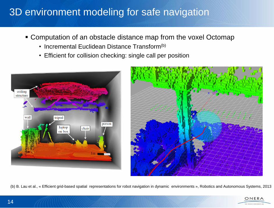
Computation of an obstacle distance map from the voxel Octomap
• Incremental Euclidean Distance Transform(b)
• Efficient for collision checking: single call per position
14
(b) B. Lau et al., « Efficient grid-based spatial representations for robot navigation in dynamic environments », Robotics and Autonomous Systems, 2013
Environment modeling
Guidance
and control
Multi-sensor
State estimation
15
IMU
eVO Stereo
SLAM
ELAS
Depth map
OCTOMAP
3D model
Kalman
sensor
fusion
MPC
guidance
Low-level
control
Ground
station
Lidar
Waypoint
server
Emergency
button
Su
pe
rvis
ion
Guidance for autonomous navigation
Stereo
rig
16
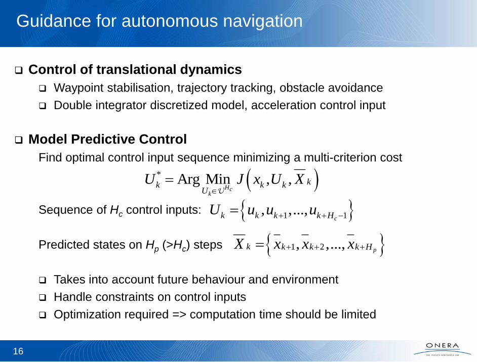
Guidance for autonomous navigation
Control of translational dynamics
Waypoint stabilisation, trajectory tracking, obstacle avoidance
Double integrator discretized model, acceleration control input
Model Predictive Control
Find optimal control input sequence minimizing a multi-criterion cost
Sequence of Hc control inputs:
Predicted states on Hp (>Hc) steps
Takes into account future behaviour and environment
Handle constraints on control inputs
Optimization required => computation time should be limited
* Arg Min , ,Hc
k
kk k kU
U J x U X
U
1 1, ,...,ck k k k HU u u u
1 2, ,...,pk k k k HX x x x
17
Guidance for autonomous navigation
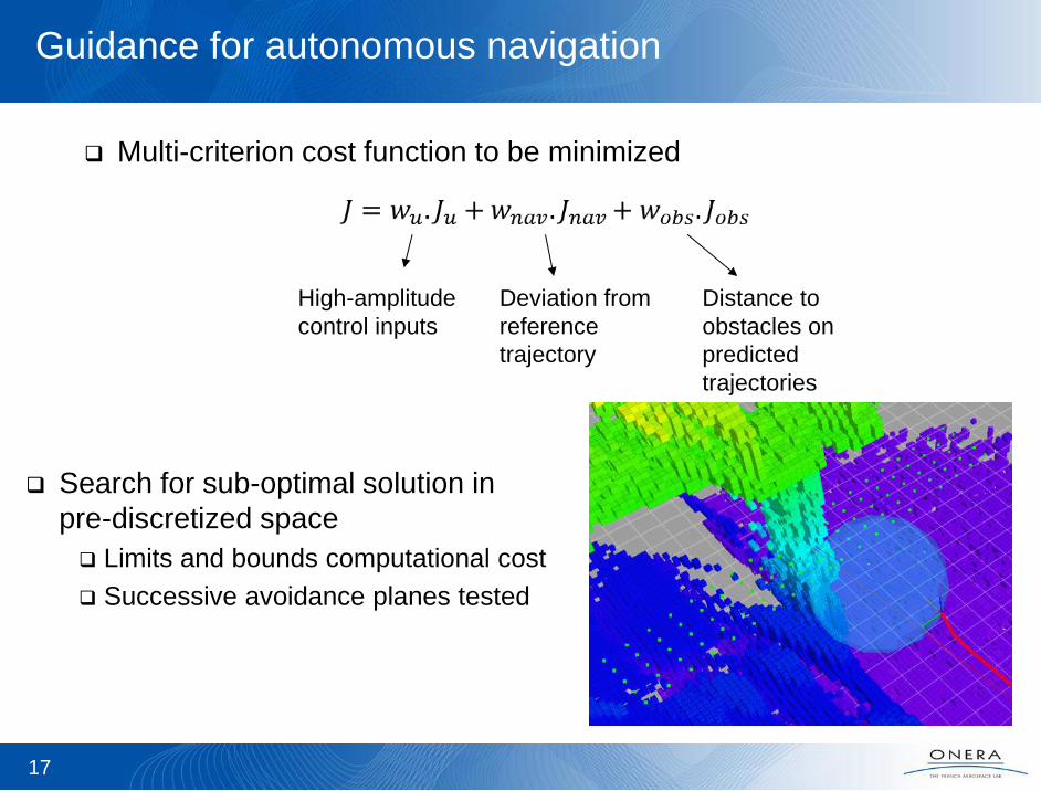
Multi-criterion cost function to be minimized
High-amplitude
control inputs
Deviation from
reference
trajectory
Distance to
obstacles on
predicted
trajectories
Search for sub-optimal solution in
pre-discretized space
Limits and bounds computational cost
Successive avoidance planes tested
Environment modeling
Guidance
and control
Multi-sensor
State estimation
18
IMU
eVO Stereo
SLAM
ELAS
Depth map
OCTOMAP
3D model
Kalman
sensor
fusion
MPC
guidance
Low-level
control
Ground
station
Lidar
Waypoint
server
Emergency
button
Su
pe
rvis
ion
Supervision
Stereo
rig
19
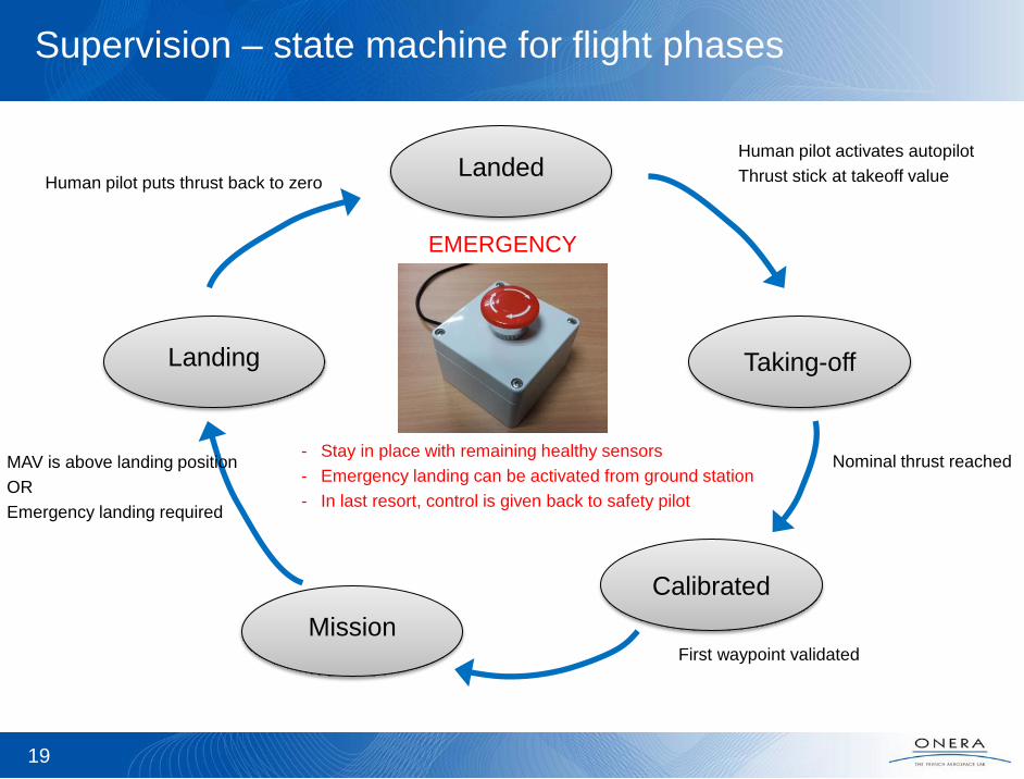
Supervision – state machine for flight phases
Taking-off Landing
Mission
Landed Human pilot activates autopilot
Thrust stick at takeoff value
First waypoint validated
MAV is above landing position
OR
Emergency landing required
Calibrated
Human pilot puts thrust back to zero
Nominal thrust reached
EMERGENCY
- Stay in place with remaining healthy sensors
- Emergency landing can be activated from ground station
- In last resort, control is given back to safety pilot
20
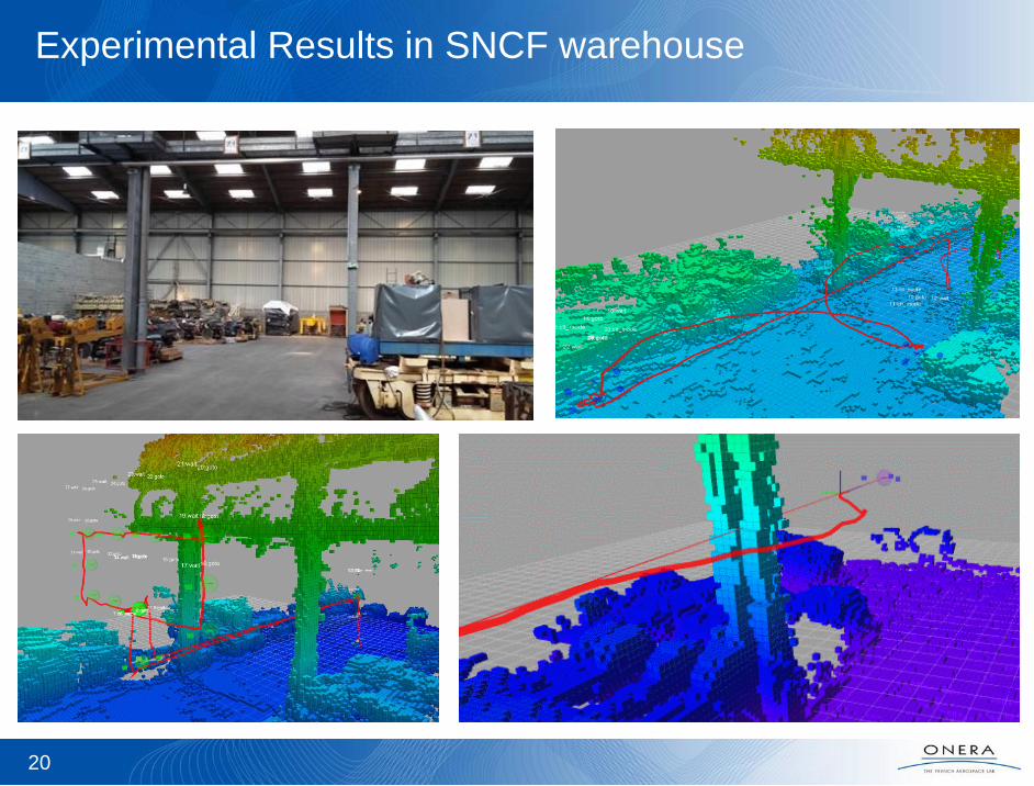
Experimental Results in SNCF warehouse

Autonomous damage inspection in power substation
Vision-based autonomous exploration and mapping
Freestyle (August 2016)
1. Autonomous exploration in GPS-denied environment
2. Dynamic non-cooperative obstacle avoidance
Showcase (March 2017)
3. Many thin, hollow and linear structures
4. Variable illumination conditions (reduced light)
FP7 EUROC – Use case overview European Robotics Challenge – www.euroc-project.eu

Autonomous
Exploration
Mobile Object
Tracking and
avoidance
FP7 EUROC – Freestyle results
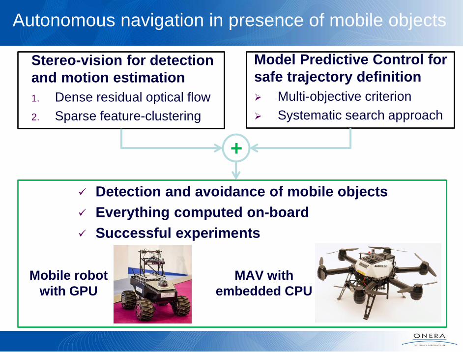
Autonomous navigation in presence of mobile objects
Detection and avoidance of mobile objects
Everything computed on-board
Successful experiments
Mobile robot
with GPU
MAV with
embedded CPU
Stereo-vision for detection
and motion estimation
1. Dense residual optical flow
2. Sparse feature-clustering
Model Predictive Control for
safe trajectory definition
Multi-objective criterion
Systematic search approach
+
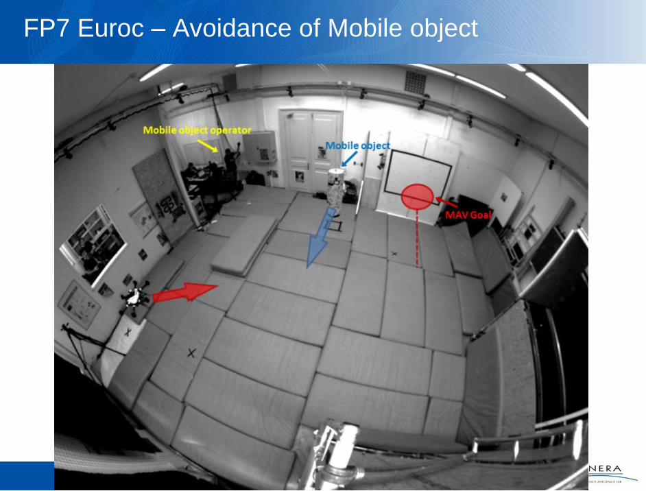
FP7 Euroc – Avoidance of Mobile object

Current and future work
New demonstrations in ONERA / SNCF partnership
Wall inspection
Mobile objects
Demonstration at IFAC WC (Toulouse) in July 2017
FP7 Euroc Showcase
Autonomous exploration (volume coverage)
in presence of thin / hollow structures
ONERA project on perception and guidance for multiple vehicles
(2017 – 2020)
25
Related publications
J. Marzat, S. Bertrand, A. Eudes, M. Sanfourche, J. Moras, Reactive MPC for autonomous
MAV navigation in indoor cluttered environments: flight experiments, IFAC WC 2017
D.K. Phung, B. Hérissé, J. Marzat, S. Bertrand, Model Predictive Control for Autonomous
Navigation Using Embedded Graphics Processing Unit, IFAC WC 2017
H. Roggeman, J. Marzat, A. Bernard-Brunel, G. Le Besnerais, Autonomous exploration with
prediction of the quality of vision-based localization, IFAC WC 2017
H. Roggeman, J. Marzat, A. Bernard-Brunel, G. Le Besnerais, Prediction of the scene quality
for stereo vision-based autonomous navigation, IFAC IAV 2016
N. Piasco, J. Marzat, M. Sanfourche, Collaborative localization and formation flying using
distributed stereo-vision, ICRA 2016
J. Marzat, J. Moras, A. Plyer, A. Eudes, P. Morin, Vision-based localization mapping and
control for autonomous MAV - EuRoC challenge results, ODAS 2015
H. Roggeman, J. Marzat, M. Sanfourche, A. Plyer, Embedded vision-based localization and
model predictive control for autonomous exploration, IROS VICOMOR 2014
S. Bertrand, J. Marzat, H. Piet-Lahanier, A. Kahn, Y. Rochefort, MPC Strategies for
Cooperative Guidance of Autonomous Vehicles, AerospaceLab Journal, 2014
M. Sanfourche, A. Plyer, A. Bernard-Brunel, G. Le Besnerais, 3DSCAN: Online ego-
localization and environment mapping for micro aerial vehicles. AerospaceLab Journal, 2014
26