Embed Size (px)
Citation preview

Automated Generation of Geometrically-Precise and Semantically-Informed Virtual Geographic Environments Populated with
Spatially-Reasoning Agents
Mehdi Mekni
DISSERTATION.COM
Boca Raton

Automated Generation of Geometrically-Precise and Semantically-Informed Virtual Geographic Environments Populated with Spatially-Reasoning Agents
Copyright © 2010 Mehdi Mekni
All rights reserved. No part of this book may be reproduced or transmitted in any form or by any means, electronic or mechanical, including photocopying, recording, or by any
information storage and retrieval system, without written permission from the publisher.
Dissertation.com Boca Raton, Florida
USA • 2010
ISBN-10: 1-59942-371-5 ISBN-13: 978-1-59942-371-5
Abstract
Multi-Agent Geo-Simulation (MAGS) is a modelling paradigm whichhas attracted a growing interest from researchers and practitioners for thestudy of various phenomena in a variety of domains such as traffic simula-tion, urban dynamics, environment monitoring, as well as changes of landuse and cover, to name a few. These phenomena usually involve a largenumber of simulated actors (implemented as software agents) evolving in,and interacting with, an explicit spatial environment representation com-monly called Virtual Geographic Environment (VGE). Since a geographicenvironment may be complex and large-scale, the creation of a VGE isdifficult and needs large quantities of geometrical data originating fromthe environment characteristics (terrain elevation, location of objects andagents, etc.) as well as semantic information that qualifies space (building,road, park, etc.).
Current MAGS approaches usually consider the environment as a mono-lithic structure, which considerably reduces the capacity to handle large-scale, real world geographic environments as well as agent’s spatial rea-soning capabilities. Moreover, the problem of path planning in MAGSinvolving complex and large-scale VGEs has to be solved in real time,often under constraints of limited memory and CPU resources. Availablepath planners provide agents with obstacle-free paths between two locatedpositions in the VGE, but take into account neither the environment’s char-acteristics (topologic and semantic) nor the agents’ types and capabilities.In addition, agents evolving in a VGE lack for mechanisms and tools thatallow them to acquire knowledge about their virtual environment in orderto make informed decisions.
In this thesis, we propose a novel approach to automatically generate asemantically-enriched and geometrically-precise representation of the ge-
3

ographic environment that we call Informed Virtual Geographic Environ-ment (IVGE). Our IVGE model efficiently organizes the geographic fea-tures, precisely captures the real world complexity, and reliably representslarge-scale geographic environments. We also provide a new hierarchicalpath planning algorithm which leverages the enriched description of theIVGE in order to support agents’ reasoning capabilities while optimisingcomputation costs and taking into account both the virtual environment’scharacteristics and the agents’ types and capabilities. Finally, we proposean environment knowledge management approach to support the agents’spatial decision making process while interacting with the IVGE.
4

Contents
Chapter 1. General Introduction 7
Part I. State of the Art
Chapter 2. Virtual Geographic Environments 23
Chapter 3. Autonomous Agents in Virtual Geographic Environ-ments 49
Chapter 4. Motion Planning and Spatial Behaviours in VirtualGeographic Environments 69
Chapter 5. Conclusion of the State of the Art 87
Part II. Contributions
Introduction 96
Chapter 6. Automated Generation of Informed Virtual GeographicEnvironments 97
Chapter 7. Abstraction of Informed Virtual Geographic Environ-ments 119
Chapter 8. Motion Planning in Informed Virtual Geographic En-vironments 155
5

Chapter 9. Informed Virtual Geographic Environments and Knowl-edge Management 173
Chapter 10. Conclusion and Perspective 205
Bibliography 211
6

Chapter 1
General Introduction
Multi-Agent Geo-Simulation (MAGS) is a modelling paradigm [BT04]which attracts a growing interest from researchers and practitioners tosimulate various phenomena in a variety of domains such as traffic simula-tion, crowd simulation, environment monitoring, and changes of land useand cover, to name a few. Such approaches are used to study various phe-nomena (i.e. car traffic, crowd behaviours, sensor web deployment, etc.)involving a large number of simulated actors (implemented as softwareagents) evolving in, and interacting with, an explicit spatial environmentrepresentation usually called Virtual Geographic Environment (VGE).
Creating a VGE populated by autonomous agents is a pretty demand-ing task which can be broken down into two main blocks: creating thevirtual environment itself, and creating the autonomous agents populatingit. On the one hand, so many challenges arise when creating a VGE: whatit looks like, how it is represented, what are the objects and agents it con-tains, etc. Recreating real environments through a computer is a complextask which is still under constant study and development, further reducingthe boundaries between virtuality and reality, as they go along.
On the other hand, creating autonomous agents for populating the en-vironment is a task which is just as difficult and complex. The autonomousagents, even though they can be considered as objects within the environ-ment, have a lot of additional properties with their own set of problems tosolve: how to represent them, how to make them move, how to make themreason, plan, and act with respect to the VGE’s characteristics, etc. Whatmakes the task even more daunting is the fact that the inner workings of
7

real humans and animals are extremely complex and still not fully under-stood. Approximations and theories are made, implementation solutionsare presented and computer programs are created trying to imitate as bestas possible the complexity and inner workings of real live creatures, bethey instinct driven animals, or conscious and reasoning humans.
Actually, creating realistic environments on one side, and plausible au-tonomous agents on the other is not enough. Another important problemstill needs to be solved: how to make the agents interact with the VGE?How can they evolve within it, perceive it, plan their actions accordingto the VGE’s characteristics? Agents should be able to interact with theVGE and with the objects it contains. Indeed, in order to create reliableMAGS, the agents immersed in the VGE should be able to perform allthe tasks their real living counterparts can: perceive their surroundings,gather information and memorize it, detect and avoid obstacles as wellas other agents as they move, and plan a path according to what they seeand what they know, interact with objects surrounding them, interact withother agents, etc. This is yet another difficult task, with its own set of prob-lems to solve, as complex and essential as the creation of the environmentand the agents themselves.
Building precise and enriched VGE and enabling agents to interactwith such environments is the problem addressed by this thesis.
1.1. Problems and Research Issues
Building MAGS using agents which can reason about space not only re-quires appropriate computation algorithms, but also an efficient descrip-tion of the spatial environment. Such a description must represent the ge-ometrical and topological information which corresponds to geographicfeatures which are provided by Geographic Information Systems (GIS).Moreover, this representation should qualify space by associating seman-tics with geographic features in order to allow spatial reasoning.
Since a geographic environment may be complex and large-scale, thecreation of a VGE is difficult and needs large quantities of geometricaldata originating from the environment characteristics (terrain elevation,location of objects and agents, etc.) as well as semantic information thatqualifies space (building, road, park, etc.). The VGE description shouldrely on an efficient structure which supports easy and optimized access
8

and query techniques. The complexity of building such a descriptionshould only depend on the geometrical complexity of the geographic en-vironment rather than on its scale.
A number of challenges arise when creating such an informed VGE,among which we mention: 1) automatically creating a precise geometricrepresentation of a 3D VGE; 2) automatically integrating several types ofsemantic information in the geometric representation; and 3) making useof this representation in spatial reasoning algorithms such as navigationand path planning which are required for MAGS.
To enable an autonomous agent to interact with its environment, wemight think of storing the entire interaction process within the agent’sknowledge model. Thus, the agent would be able to observe the worldthat surrounds it and to gather raw information from its sensors. Afterthat, it would process this raw data through a complex reasoning modulein order to try to derive high-level information and to determine the inter-action possibilities offered by the objects it is observing. This approach isextremely complex, very difficult to implement, and is rarely applicable tocomplex interaction processes. The more complex the object is, the harderit is to derive abstract information and the more complex the reasoning al-gorithm needs to be. This process can become extremely costly in termsof calculation time and resources when the complexity of the environmentand the objects contained in it increases.
Another approach takes advantage of the fact that the agents are evolv-ing in a virtual world which fully stores the entire interaction information.Such a method can ease the load on the agents since it removes the need todetermine abstract data by directly providing the agent with the requiredinteraction information. As a consequence, the computation and process-ing cost of the interaction information is reduced by creating it offline (asort of an interaction script) and applying it every time agents need it. Thismethod also has its drawbacks: every time an agent interacts with an ob-ject the interaction takes place in the exact same way without taking intoaccount its own characteristics, since the interaction process is definedonce and for all. Indeed, this technique describes interaction processes forhomogeneous agents. An object has to describe the same interaction pro-cess in as many ways as the types of agents that can interact with it, takinginto account the fact that they are humanoid or animals for example.
9

1.2. Objectives
The objective of this thesis is sixfold:
1. to propose a method and a set of tools to automate the generationof virtual geographic environments: MAGS is basically a mod-elling and simulation paradigm which frequently involves VGEsof various extents. Time and efforts spent on the generation ofthese VGEs are considerable and should be reduced through an au-tomated approach.
2. to propose a method and associated algorithms to precisely de-scribe virtual geographic environments: most of current VGE ap-proaches lack precision when dealing with complex geographicenvironments. A precise description of a VGE should take intoaccount both geometric and topologic data characterising the geo-graphic environment.
3. to propose an approach in order to semantically inform the de-scription of virtual geographic environments: since spatial reason-ing often needs to manipulate qualitative information rather thanquantitative data, a conceptualized semantic information should beassociated with geographic features. This process of qualificationaims at supporting the spatial reasoning capabilities of agents.
4. to propose an abstraction technique which uses a graph-based struc-ture in order to model large-scale and complex geographic envi-ronments: since geographic environments may be complex, large-scale, and populated with various geographic features, the descrip-tion of virtual geographic environment should be abstracted, struc-tured in order to support such geographic environments. The ab-straction of the virtual geographic environment description shouldtake into account the geometric, topologic, and semantic character-istics of geographic environments.
5. to propose an approach which allows to represent knowledge aboutthe environment and to provide it to spatial agent: spatial agentsneed to access, acquire, and reason about knowledge about the vir-tual environment in order to make decisions that take into accountits characteristics. Knowledge about the environment should berepresented using a standard formalism and spatial agents shouldbe provided with a mechanism to acquire and reason about it.
6. to populate virtual geographic environments with agents endowed
10

with spatial reasoning capabilities: MAGS usually involves a largenumber of agents of different types. Such agents should be able toevolve and interact with the VGE while taking into account bothagents’ and VGE’s characteristics.
1.3. The Proposed Approach
What we propose is a method and associated algorithms to automaticallygenerate geometrically-precise and semantically-enhanced virtual geo-graphic environments populated with spatially-reasoning agents. We pro-pose a novel approach to model virtual geographic environments whichmeets the previously mentioned objectives. First, our approach uses re-liable standard spatial data provided by Geographic Information Systems(GIS). In addition, it relies on an exact spatial decomposition techniquewhich fully preserves the geometric and topologic characteristics of ge-ographic features and thus yields a precise description of the virtual ge-ographic environment. Moreover, this description is based on a graph-based structure which allows our approach to handle large-scale geographicenvironments. This description is enriched with semantic information inorder to better qualify the geographic features. Furthermore, since ouraim is to support agents’ spatial reasoning capabilities, we propose toenhance the virtual environment’s description with conceptual semanticinformation using well-established knowledge representation techniques.Indeed, since the nature of objects is invariant during the MAGS process,and because the interaction process may vary depending on the agent’stype, the conceptual semantic information needs to be generic and inter-pretable by any type of agent. The conceptual semantic information willbe separated in two parts: the first part contains the information inherentto the object type (i.e. the car is red), and the second part contains theinformation inherent to the agent which uses the object’s information toreason and act on the environment (i.e. the agent drives the car). Sucha conceptual semantic information stored within the environment extendsthe agents’ knowledge about their environment, without being too spe-cific and detailed, and provides agents with useful information in additionto the geometric and topologic data characterizing the VGE. Path plan-ning and navigation are examples of spatial reasoning algorithms that mayleverage our geometrically-precise and semantically-enhanced model oflarge-scale virtual geographic environments.
11

1.4. Application Domains
In order to illustrate our approach, we propose the following applica-tion domains: urban simulation, radio signal propagation in virtual geo-graphic environments, and sensor webs deployment in virtual geographicenvironments.
1.4.1. Urban Simulation
We propose to use our approach to build a a three-dimensional virtual ur-ban environment populated with agents representing humans, buses, cars,etc. The main novelty of our approach is that we do not rely on repre-senting land-use and other attributes on a regular grid, but instead build ageometrically-precise simulation that uses an exact spatial decompositiontechnique. Our VGE model also enriches the virtual urban environment’sdescription with semantics in order to qualify the geographic features suchas streets of arbitrary orientation, street widths and shapes, and irregularbuilding footprints. The second novelty is the automated and fast gen-eration of such a virtual urban environment. We also provide a set ofscenarios involving agents interacting with the informed VGE. These sce-narios illustrate the agents’ capabilities to detect and avoid collisions withobstacles situated in the VGE as well as path planning, while taking intoaccount the enriched description of the VGE.
1.4.2. Radio Signal Propagation
In the real world, radio transmissions are subject to propagation effectswhich affect the received signals because of geographic and environmen-tal characteristics (foliage and vegetation, buildings, mountains and hills,etc.). Using our informed VGE, we are able to easily generate a virtual ge-ographic environment which precisely describes the geographic featuresof the real world. Then, we are able to predict the attenuation effect dueto the radio signal’s traversal through vegetation area, and buildings usinga 3D line-of-sight technique.
12

1.4.3. Sensor Web
Sensor webs can be thought of as distributed network systems composedof hundreds of resource-constrained nodes. Sensor webs are deployedin large-scale geographic environments for in-situ sensing and data ac-quisition purposes. The deployment of a large number of sensor nodesin a large-scale geographic environment is a complex task. Moreover, thesensing and communication performance of a sensor web relies on the pat-tern of its deployment within the specific environment. Using our IVGEmodel, we are able to simulate a sensor web deployment where sensornodes are modeled using software agents. These sensor agents leverageour knowledge management approach to acquire knowledge about the en-vironment and adapt their behaviors while taking into account both theIVGE’s and sensors’ characteristics.
1.5. Contributions
In a departure from the substantial literature on so-called spatial mod-elling, the first contribution of this thesis is a geometrically-precise andsemantically-enhanced model of virtual geographic environments basedon a graph structure that we call an Informed Virtual Geographic Envi-ronments (IVGE). The second contribution is a methodology for the au-tomated generation of informed virtual geographic environments basedon reliable data provided by Geographic Information Systems (GIS) andusing the Constrained Delaunay Triangulation (CDT) technique as a de-composition paradigm. The third contribution is a geometric, topologic,and semantic abstraction of informed virtual geographic environments inorder to build a Hierarchical Topologic Graph (HTG) which supportsthe representation of large-scale geographic environments. The resultingHTG uses a standard formalism (Conceptual Graphs) to express semanticcharacteristics of the virtual geographic environment. The fourth con-tribution is a Hierarchical Path Planning (HPP) algorithm coupled witha Neighborhood Graph (NG) model to provide agents with for efficientmotion planning (navigation and path planning) in informed virtual ge-ographic environments. The fifth contribution is an environment knowl-edge management approach which allows spatial agents to make decisionsthat take into account the geographic environment characteristics.
13
From an application perspective, this thesis illustrates the above men-tioned theoretical contributions in domains such as Urban Mobility, Wire-less Communications and Sensor Webs. It also provides a set of tools thatimplement the proposed models and allow users to take advantage of theenriched description of the virtual geographic environment.
1.6. Organisation of the Thesis
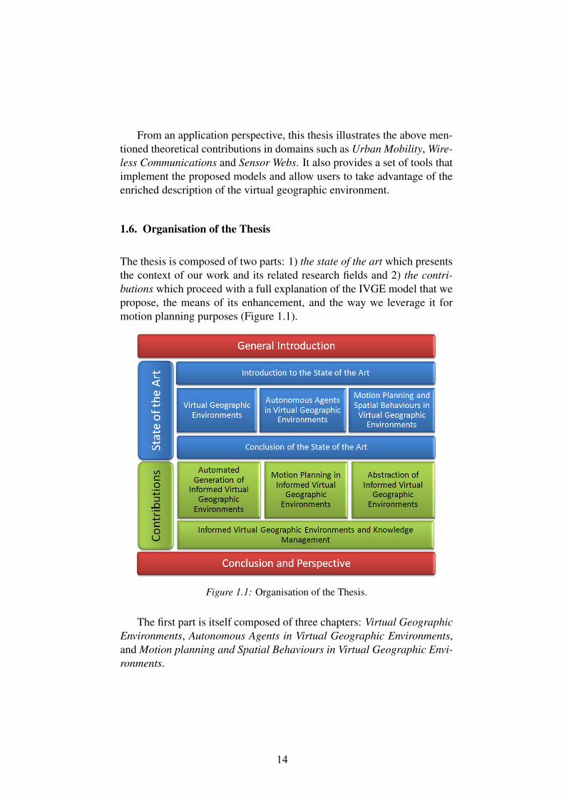
The thesis is composed of two parts: 1) the state of the art which presentsthe context of our work and its related research fields and 2) the contri-butions which proceed with a full explanation of the IVGE model that wepropose, the means of its enhancement, and the way we leverage it formotion planning purposes (Figure 1.1).
Figure 1.1: Organisation of the Thesis.
The first part is itself composed of three chapters: Virtual GeographicEnvironments, Autonomous Agents in Virtual Geographic Environments,and Motion planning and Spatial Behaviours in Virtual Geographic Envi-ronments.
14

Chapter 2 provides a survey on the representation of virtual geographicenvironments. First, it introduces Geographic Information Systems andpresents the two common spatial decomposition techniques: the exactand the approximate spatial decompositions. Then, it discusses the useof semantic information in the description of virtual geographic environ-ments. It also outlines the need for a standard formalism to represent suchsemantic information.
Chapter 3 details the concepts of situated agents and multi-agent sys-tems and focuses on the importance of the environmental characteristicsin the agent’s decision making process. It also highlights the way agentsinteract with their environments in terms of perception, reaction, decision,and action.
Chapter 4 is the last chapter of this first part and it introduces the mo-tion planning research field. First, it provides an overview of commonpath planning algorithms (Di jkstra and A∗). Then, it introduces the hier-archical path planners that deal with complex large-scale geographic en-vironments. It also presents previous works on spatial behaviours and theway that agents reason about the environment’s description and behaveaccordingly.
Finally, Chapter 5 draws conclusions from this state of the art andoutlines the limits of currents approaches.
The contributions part of this thesis is composed of four chapters: Au-tomated Generation of Informed Virtual Geographic Environments, Ab-straction of Informed Virtual Geographic Environments, Motion planningin Informed Virtual Geographic Environments, and Informed Virtual Ge-ographic Environment and Knowledge Management.
Chapter 6 presents our methodology for the automated generation ofinformed virtual geographic environments. First, it details the differentsteps which compose this methodology. Then, it introduces a scenariowhich illustrates the application of our methodology in order to addressthe issue of radio signal propagation and attenuation in informed virtualgeographic environments.
Chapter 7 presents how to abstract IVGEs in order to support large-scale and complex geographic environments. This chapter details the threeprocesses involved in the abstraction mechanism; (1) the geometric ab-straction, (2) the topologic abstraction and, (3) the semantic abstraction.
15
It also introduces a holonic approach coupled with our abstraction modelwhich are used to build the Hierarchical Topologic Graph (HTG).
Chapter 8 presents our optimised Hierarchical Path Planning (HPP)algorithm which leverages the hierarchical topologic graph resulting fromthe abstraction process. In addition, it details how we support spatialagents’ navigation and obstacle avoidance in informed virtual geographicenvironments using a Neighbour Graph (NG) approach.
Chapter 9 presents our approach to manage knowledge about the en-vironment in order to support spatial agents’ decision making. This ap-proach uses a standard formalism to express the semantic information thatcharacterises the geographic environment and involves an inference en-gine in order to allow agents to get knowledge about virtual geographicenvironments. In order to illustrate our environment knowledge manage-ment approach, we present two scenarios in the fields of urban mobilityand sensor webs.
Finally, Chapter 10 draws conclusions from our work, outlines its lim-its, and discusses avenues for future research and applications.
16

Part I
State of the Art
17

18
Introduction to the State of the Art
Multi-Agent Geo-Simulation (MAGS) is a modeling paradigm which ischaracterized by an explicit spatial environment called Virtual GeographicEnvironment (VGE) and situated agents which evolve in and interact withthis VGE [BT04]. MAGS has a great potential when it comes to ex-plaining the subtle interactions of heterogeneous actors in complex sys-tems, taking into account the geographic aspect of the simulation envi-ronment [TB05]. The characteristics of the situated agents (autonomy,proactiveness, perception, navigation, etc.) and the spatial features of thesimulation environment make MAGS an attractive approach to developsimulations of complex systems involving agents interacting with eachother and with the geographic environment [DHK+07]. In addition, thecomplexity of the simulation models and their visualization capabilities(cartographic visualization, 2D and 3D displays) make them more realis-tic and usable for decision-making purposes [AM05]. Thus, MAGS ap-proaches potentially open numerous avenues for exploratory and appliedsimulations in different fields [BT04].
There are several advantages to use a MAGS approach integratingagent-based models and GIS data in order to simulate various phenom-ena in a variety of domains such as traffic simulation, crowd simulation,environment monitoring, and changes of land use and cover, to name afew [DHK+07]. Indeed, MAGS facilitates the simulation of complex phe-nomena using either micro-simulation or macro-simulation models [TB05].Micro-simulation models operate at the level of the individual behaviouralentity, such as a person, a car, or a building. Such models simulate largerepresentative populations of these low-level entities in order to draw con-clusions that apply to higher levels of aggregation such as an entire cityor an entire country [TB05]. This type of model is distinct from macro-simulation models whose explanatory variables already represent collec-
19

tive properties of the complex phenomena. Macro-simulation modelsevaluate the complex phenomena as a whole without consideration of thecharacteristics and features of individual entities involved in such phe-nomena [TB05]. An example of such an aggregate explanatory variablemight be the national unemployment rate of a country. Certain types ofmodeling problems are best dealt with using micro-simulation whereasfor others an aggregate approach is more appropriate. However, whenit comes time to study and analyze interactions occurring between indi-vidual agents or between individual agents and their virtual geographicenvironment, macro-simulation models are inadequate since they are notable to capture interactions at the individual level [HC07].
For example, MAGS is frequently used to simulate and examine traf-fic flow and congestion and to understand the interaction of vehicles onthe roadway [Wan05]. Macro-simulation models evaluate traffic flow asa whole without consideration of the characteristics and features of indi-vidual vehicles in the traffic stream [WCC+07]. In contrast with macro-simulation approaches, micro-simulation models simulate the individualvehicles in the traffic stream and consider the features and characteris-tics of the individual vehicles and use car-following logic and algorithmsto predict and model the movement of each vehicle in the traffic stream[WCC+07].
Several research works applied the MAGS approach to simulate dy-namic and complex phenomena in geographic environments [DHK+07].These research works succeed to measure and model these phenomenaand help, for example, to understand how people move in a geographic en-vironment or in an urban setting [TB05]. However, we found few MAGS-based research studies attempting to simulate what we call Spatial Behav-iors. Spatial behaviors are basically behaviors involving the apprehensionof spatial features of the environment in large-scale and complex geo-graphic environments. The nature of the geographic environment, the spa-tial behaviors to be simulated, and the characteristics of the interactionsbetween the agents and the environment in the simulation (spatial interac-tion), make this kind of simulation a challenge. Several important featuresmust be considered when building a MAGS model at the micro-level inorder to simulate agents’ spatial behaviors, among which we mention: (1)an explicit representation of the virtual geographic environment; (2) a sit-uated agent model which is able to evolve within this virtual geographicenvironment; and (3) efficient spatial behaviours algorithms which allow
20

agents to interact with the virtual geographic environment.
In order to enable agents to interact with their virtual environment, itis important to provide an explicit representation of the geographic en-vironment in which agents evolve. In order to capture and analyze suchinteractions which occur between agents on the one hand and betweenagents and their geographic environments on the other hand, we use themicro-simulation approach. However, the micro-simulation approach re-quires a detailed description of the geographic environment as well as ofsituated agents.
On the one hand, the virtual geographic environment description shouldprovide agents with quantitative and qualitative information in order to ex-tend their knowledge about their environment and to let them reason aboutit in order to achieve their goals. Indeed, the virtual geographic environ-ment description should be geometrically-accurate in order to capture thecomplexity of the geographic environment and the geographic features itcontains. Moreover, this description should include the topological char-acteristics of the geographic environment in order to support agents’ mo-tion planning algorithms while taking into account dead-end areas, cor-ridors, and crossroads. In addition, this description should also be en-riched by semantic information which qualifies the geographic features inorder to allow agents’ spatial behaviour algorithms to take into accountthe geometric, topologic, and semantic characteristics of the geographicenvironment in which they evolve. Chapter 2 presents and discusses dif-ferent techniques to build an explicit spatial representation of geographicenvironments. It also outlines the complexity of virtual geographic envi-ronments’ generation.
On the other hand, situated agents models should take advantage ofsuch an enriched description of the virtual geographic environment in or-der to reason about it. Chapter 3 and Chapter 4 introduce the notion ofsituated agents and emphasize the need to take into account the charac-teristics of the geographic environments in order to support spatial be-haviours such as motion planning including path planning and navigationalgorithms.
In this state of the art, Chapter 2 provides a short survey of differenttechniques and models used to build virtual geographic environments. Italso discusses the use of semantic information to describe virtual envi-ronments and emphasizes the need for using a standard representation.
21

Next, Chapter 3 introduces the concept of autonomous agents evolving inand interacting with a virtual geographic environment. Finally, Chapter 4offers an overview of motion planning and spatial behaviours of agentswithin virtual geographic environments.
22
Chapter 2
Virtual Geographic Environments
A virtual environment is a computer generated scene, composed of ob-jects, in which an autonomous agent operates [Bad06]. This definition ispretty vague and leaves a very broad panel of interpretation of what thecomputer generated scene can be: it can be realistic, attempting to faith-fully copy the real world in every aspect, or imaginary and completelyinvented. The vagueness of this definition seems to be intentional, andimplies a large richness in the nature of the virtual environment. Usefuloverviews of virtual environments and their many applications are pro-vided in [FMJ06, LB09]. A virtual environment may be thought of as aspace subdivision which converts complex geometric data, made up ofa great number of polygons, in a more or less informed database. Thegeometric data may be provided by Computer Aided Geometric Design(CAGD) tools in order to design curves and figures in two-dimensional(2D) space, or surfaces and solids in three-dimensional (3D) space forcomputer animations purposes [Far01b]. Geometric data may also be pro-vided by Geographic Information Systems (GIS), evolving the concept ofVirtual Geographic Environments (VGE) which is widely used for spatialanalysis and decision support purposes [BRR+05].
Building a VGE based on reliable GIS data is a big challenge. Indeed,a geographic environment may be complex and large-scale, and its cre-ation is difficult and needs large quantities of geometrical data originatingfrom the environment characteristics as well as semantic information thatqualifies space. To be able to create a VGE, one should have an explicitrepresentation of space using space decomposition techniques.
23

This chapter aims to describe relevant components in the creation ofa VGE, as well as some current research issues. First, Section 2.1 in-troduces the concept of Geographic Information System as a fundamen-tal source of georeferenced data. It presents the different models usedto describe geographic data and discusses their advantages and disadvan-tages. Second, Section 2.2 introduces approximate space decompositionapproaches. Section 2.3 provides a short survey of exact space decom-position approaches and focuses on Delaunay Triangulation techniques.Section 2.4 introduces and discusses the topologic approach to representvirtual geographic environments. Section 2.5 presents the abstraction ofvirtual environments and Section 2.6 outlines the integration of seman-tic information in virtual environments’ descriptions. Finally, Section 2.7concludes this chapter with a synthesis of the proposed models.
2.1. Geographic Information Systems
A Geographic Information System (GIS) is a system of hardware, soft-ware and procedures to facilitate the management, manipulation, analysis,modelling, representation and display of georeferenced data to solve com-plex problems regarding planning and management of resources [Goo06].GISs have grown over the past two decades as an essential tool for urbanand resource planning and management [Chr01]. Their capacity to store,retrieve, analyse, model and map large areas with huge volumes of spa-tial data has led to an extraordinary proliferation of applications [Goo06].GISs offer two primary data models to describe a geographic environ-ment: raster and vector data representations [AZ04]. In the followingsub-sections, we first present the raster model and then the vector modelof GIS data. We then discuss the use of GIS data in agent-based modellingapproaches.
2.1.1. Raster Model
The raster representation of GIS data is a method for the storage, pro-cessing and display of continuous fields of spatial data [LGMR02,AZ04].Within the raster data model, a region of interest is divided into discreteunits, which form a regular grid of cells (Figure 2.1(a)). Each cell is typ-ically rectangular in shape, but not necessarily square [Chr01]. Each cell
24
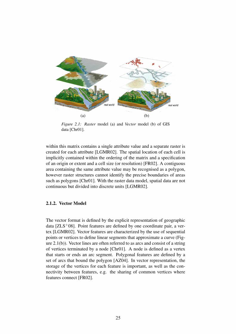
(a) (b)
Figure 2.1: Raster model (a) and Vector model (b) of GISdata [Chr01].
within this matrix contains a single attribute value and a separate raster iscreated for each attribute [LGMR02]. The spatial location of each cell isimplicitly contained within the ordering of the matrix and a specificationof an origin or extent and a cell size (or resolution) [FR02]. A contiguousarea containing the same attribute value may be recognised as a polygon,however raster structures cannot identify the precise boundaries of areassuch as polygons [Chr01]. With the raster data model, spatial data are notcontinuous but divided into discrete units [LGMR02].
2.1.2. Vector Model
The vector format is defined by the explicit representation of geographicdata [ZLS+08]. Point features are defined by one coordinate pair, a ver-tex [LGMR02]. Vector features are characterized by the use of sequentialpoints or vertices to define linear segments that approximate a curve (Fig-ure 2.1(b)). Vector lines are often referred to as arcs and consist of a stringof vertices terminated by a node [Chr01]. A node is defined as a vertexthat starts or ends an arc segment. Polygonal features are defined by aset of arcs that bound the polygon [AZ04]. In vector representation, thestorage of the vertices for each feature is important, as well as the con-nectivity between features, e.g. the sharing of common vertices wherefeatures connect [FR02].
25