Embed Size (px)
Citation preview

This article appeared in a journal published by Elsevier. The attachedcopy is furnished to the author for internal non-commercial researchand education use, including for instruction at the authors institution
and sharing with colleagues.
Other uses, including reproduction and distribution, or selling orlicensing copies, or posting to personal, institutional or third party
websites are prohibited.
In most cases authors are permitted to post their version of thearticle (e.g. in Word or Tex form) to their personal website orinstitutional repository. Authors requiring further information
regarding Elsevier’s archiving and manuscript policies areencouraged to visit:
http://www.elsevier.com/copyright
Author's personal copy
Surface uplift history of the incipient Banda arc-continent collision: Geology andsynorogenic foraminifera of Rote and Savu Islands, Indonesia
Nova Roosmawati, Ron Harris ⁎Department of Geological Sciences, Brigham Young University, Provo, Utah 84602, USA
a b s t r a c ta r t i c l e i n f o
Article history:Received 9 July 2008Received in revised form 23 March 2009Accepted 5 April 2009Available online 16 April 2009
Keywords:Banda ArcArc-continent collisionForaminiferaUplift ratesRoteSavuTimorSumbaIndonesiaIndo-Pacific Seaway
Field mapping and analysis of foraminifera from synorogenic pelagic units of Rote and Savu Islands, Indonesiareveals high rates of surface uplift of the incipient Banda arc-continent collision during the past 1.8 myr. Newgeologicalmaps of these islands document accretion to the Banda forearc of Triassic through Tertiary sedimentarycover units from the down-going Australian continental margin. Foraminifera-rich synorogenic deposits of theBatu Putih Formation unconformably overlie these accreted units.We use paleodepth versus time estimates frombenthic and planktic foraminifera's to measure long-term surface uplift rates for the accretionary wedge.Although strong currents in the region cause some problems with reworking, several distinctive species havebeen found. Synorogenic deposits in Savu and Rote yield foraminifer's of biozone Neogene (N) 18 to N22 (5.6–1.0 myr) that were deposited at estimated depths of around 3000 m. These deposits are unconfomrably overlainby uplifted coral terraces. The highest coral terraces in Savu are N300 m above sea level and perhaps as old as0.8 myr. In Rote the highest coral terrace is 200 above sea level and ~0.2 myr old.These data indicate that collision of the Australian continental marginwith the Banda Arc, which initiated muchearlier in Timor, has propagated westward towards Rote where it is in the initial stages of accretionary wedgeemergence. Collision of the Scott Plateau propagated SE from Sumba (2–3 Ma) to Savu (1.0–0.5 Ma) and then toRote (0.2Ma). Average rates of surface uplift of the Batu Putih Formationpelagic deposits during the past 2myr inRote and Savu are ~1.5 and 2.3 mm/a, respectively. The rise of these islands is clogging the Indo-Pacific seaway.
© 2009 Elsevier B.V. All rights reserved.
1. Introduction
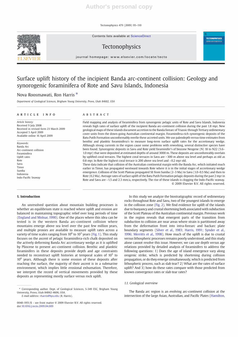
An unresolved question about mountain building processes iswhether an equilibrium state is reached where uplift and erosion arebalanced in maintaining topographic relief over long periods of time(England and Molnar, 1990). One of the places where this idea can betested is in the western Banda arc-continent collision wheremountains emerge above sea level over the past few million years,and multiple proxies are available to measure uplift rates across avariety of time scales ranging from 106 to 103 years (Fig. 1). This studyfocuses on the ascent of pelagic foraminifera-rich chalk deposited onthe actively deforming Banda Arc accretionary wedge as it is upliftedby Pliocene to present arc-continent collision. Benthic and plankticforaminifers in these deposits provide depth and age constraintsneeded to reconstruct uplift histories at temporal scales of 105 to106 years. Although there is some erosion of these deposits afterreaching the surface, the majority of their ascent is in a submarineenvironment, which implies little erosional exhumation. Therefore,we interpret the record of vertical movements provided by thesedeposits as representing mostly surface versus rock uplift.
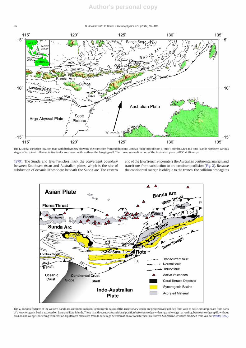
In this study we analyze the biostratigraphic record of sedimentaryrocks throughout Rote and Savu, two of the youngest islands to emergein the collision zone (Fig. 2). We find evidence for uplift of the islandsdue to buoyancyand crustal shorteningbothassociatedwith subductionof the Scott Plateau of the Australian continental margin. Previous workin the region reveals that emergent parts of the transition fromsubduction to collision are near areas where strain is partitioned awayfrom the deformation front into intra-forearc and backarc plateboundary segments (Silver et al., 1983; Harris, 1991; Synder et al.,1996; Merritts et al., 1998). How much of the uplift is due to crustalversus lithospheric processes remains poorly understood, and this studyalone cannot resolve this issue. However, we can use depth versus agerelations provided by detailed analysis of foraminifers to address thefollowing questions: 1) Does the age of island emergence vary alongorogenic strike, which is predicted by shortening during collisionpropagation, or do they emerge simultaneously, which is predicted fromlithospheric process, such as slab tear? 2) What are the rates of surfaceuplift? And 3) how do these rates compare with those predicted fromknown convergence rates or slab tear rates?
1.1. Geological overview
The Banda arc region is an evolving arc-continent collision at theintersection of the large Asian, Australian, and Pacific Plates (Hamilton,
Tectonophysics 479 (2009) 95–110
⁎ Corresponding author. Dept. of Geological Sciences, S-349 ESC, Brigham YoungUniversity, Provo, Utah 84062-4606, USA.
E-mail address: [email protected] (R. Harris).
0040-1951/$ – see front matter © 2009 Elsevier B.V. All rights reserved.doi:10.1016/j.tecto.2009.04.009
Contents lists available at ScienceDirect
Tectonophysics
j ourna l homepage: www.e lsev ie r.com/ locate / tecto
Author's personal copy
1979). The Sunda and Java Trenches mark the convergent boundarybetween Southeast Asian and Australian plates, which is the site ofsubduction of oceanic lithosphere beneath the Sunda arc. The eastern
endof the Java Trenchencounters theAustralian continentalmargin andtransitions from subduction to arc-continent collision (Fig. 2). Becausethe continental margin is oblique to the trench, the collision propagates
Fig. 1. Digital elevation location map with bathymetry showing the transition from subduction (Lombak Ridge) to collision (Timor). Sumba, Savu and Rote islands represent variousstages of incipient collision. Active faults are shown with teeth on the hangingwall. The convergence direction of the Australian plate is 015° at 70 mm/a.
Fig. 2. Tectonic features of thewestern Banda arc-continent collision. Synorogenic basins of the accretionarywedge are progressively uplifted fromwest to east. Our samples are frompartsof the synorogenic basins exposed on Savu and Rote Islands. These islands occupy a transitional position betweenwedge widening and wedge narrowing; betweenwedge uplift withouterosion andwedge shorteningwith erosion. Uplift rates calculated fromU-series age determinations of coral terraces are shown. Submarine structuremodified fromvan derWerff (1995).
96 N. Roosmawati, R. Harris / Tectonophysics 479 (2009) 95–110
Author's personal copy
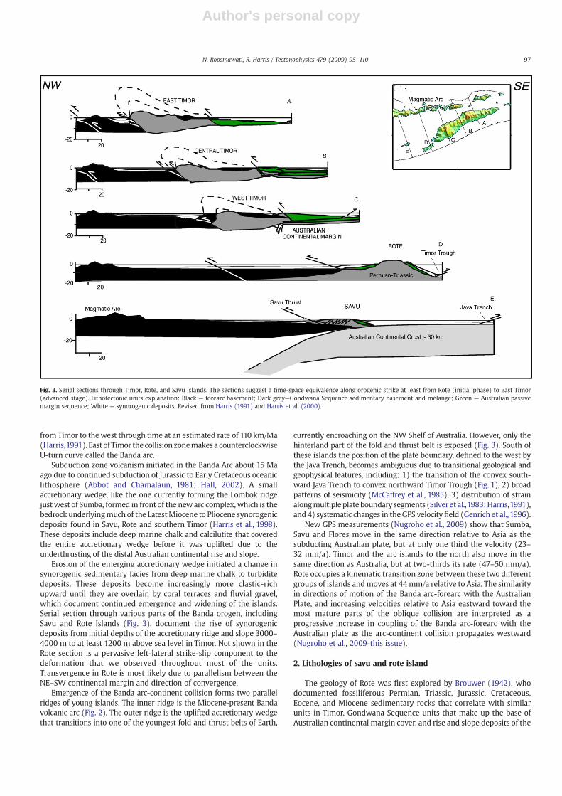
from Timor to thewest through time at an estimated rate of 110 km/Ma(Harris,1991). East of Timor the collision zonemakes a counterclockwiseU-turn curve called the Banda arc.
Subduction zone volcanism initiated in the Banda Arc about 15 Maago due to continued subduction of Jurassic to Early Cretaceous oceaniclithosphere (Abbot and Chamalaun, 1981; Hall, 2002). A smallaccretionary wedge, like the one currently forming the Lombok ridgejustwest of Sumba, formed in front of the newarc complex,which is thebedrock underlyingmuch of the LatestMiocene to Pliocene synorogenicdeposits found in Savu, Rote and southern Timor (Harris et al., 1998).These deposits include deep marine chalk and calcilutite that coveredthe entire accretionary wedge before it was uplifted due to theunderthrusting of the distal Australian continental rise and slope.
Erosion of the emerging accretionary wedge initiated a change insynorogenic sedimentary facies from deep marine chalk to turbiditedeposits. These deposits become increasingly more clastic-richupward until they are overlain by coral terraces and fluvial gravel,which document continued emergence and widening of the islands.Serial section through various parts of the Banda orogen, includingSavu and Rote Islands (Fig. 3), document the rise of synorogenicdeposits from initial depths of the accretionary ridge and slope 3000–4000 m to at least 1200 m above sea level in Timor. Not shown in theRote section is a pervasive left-lateral strike-slip component to thedeformation that we observed throughout most of the units.Transvergence in Rote is most likely due to parallelism between theNE–SW continental margin and direction of convergence.
Emergence of the Banda arc-continent collision forms two parallelridges of young islands. The inner ridge is the Miocene-present Bandavolcanic arc (Fig. 2). The outer ridge is the uplifted accretionary wedgethat transitions into one of the youngest fold and thrust belts of Earth,
currently encroaching on the NW Shelf of Australia. However, only thehinterland part of the fold and thrust belt is exposed (Fig. 3). South ofthese islands the position of the plate boundary, defined to the west bythe Java Trench, becomes ambiguous due to transitional geological andgeophysical features, including: 1) the transition of the convex south-ward Java Trench to convex northward Timor Trough (Fig. 1), 2) broadpatterns of seismicity (McCaffrey et al., 1985), 3) distribution of strainalongmultipleplate boundary segments (Silver et al.,1983;Harris,1991),and 4) systematic changes in theGPS velocity field (Genrich et al.,1996).
New GPS measurements (Nugroho et al., 2009) show that Sumba,Savu and Flores move in the same direction relative to Asia as thesubducting Australian plate, but at only one third the velocity (23–32 mm/a). Timor and the arc islands to the north also move in thesame direction as Australia, but at two-thirds its rate (47–50 mm/a).Rote occupies a kinematic transition zone between these two differentgroups of islands andmoves at 44mm/a relative to Asia. The similarityin directions of motion of the Banda arc-forearc with the AustralianPlate, and increasing velocities relative to Asia eastward toward themost mature parts of the oblique collision are interpreted as aprogressive increase in coupling of the Banda arc-forearc with theAustralian plate as the arc-continent collision propagates westward(Nugroho et al., 2009-this issue).
2. Lithologies of savu and rote island
The geology of Rote was first explored by Brouwer (1942), whodocumented fossiliferous Permian, Triassic, Jurassic, Cretaceous,Eocene, and Miocene sedimentary rocks that correlate with similarunits in Timor. Gondwana Sequence units that make up the base ofAustralian continental margin cover, and rise and slope deposits of the
Fig. 3. Serial sections through Timor, Rote, and Savu Islands. The sections suggest a time-space equivalence along orogenic strike at least from Rote (initial phase) to East Timor(advanced stage). Lithotectonic units explanation: Black — forearc basement; Dark grey—Gondwana Sequence sedimentary basement and mélange; Green — Australian passivemargin sequence; White — synorogenic deposits. Revised from Harris (1991) and Harris et al. (2000).
97N. Roosmawati, R. Harris / Tectonophysics 479 (2009) 95–110
Author's personal copy
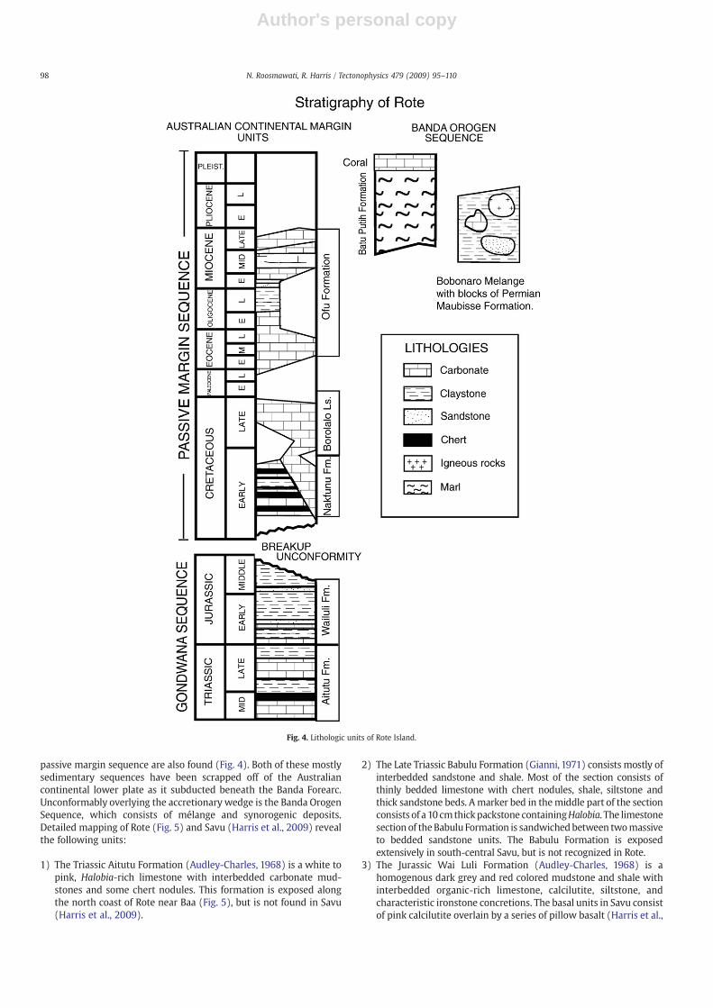
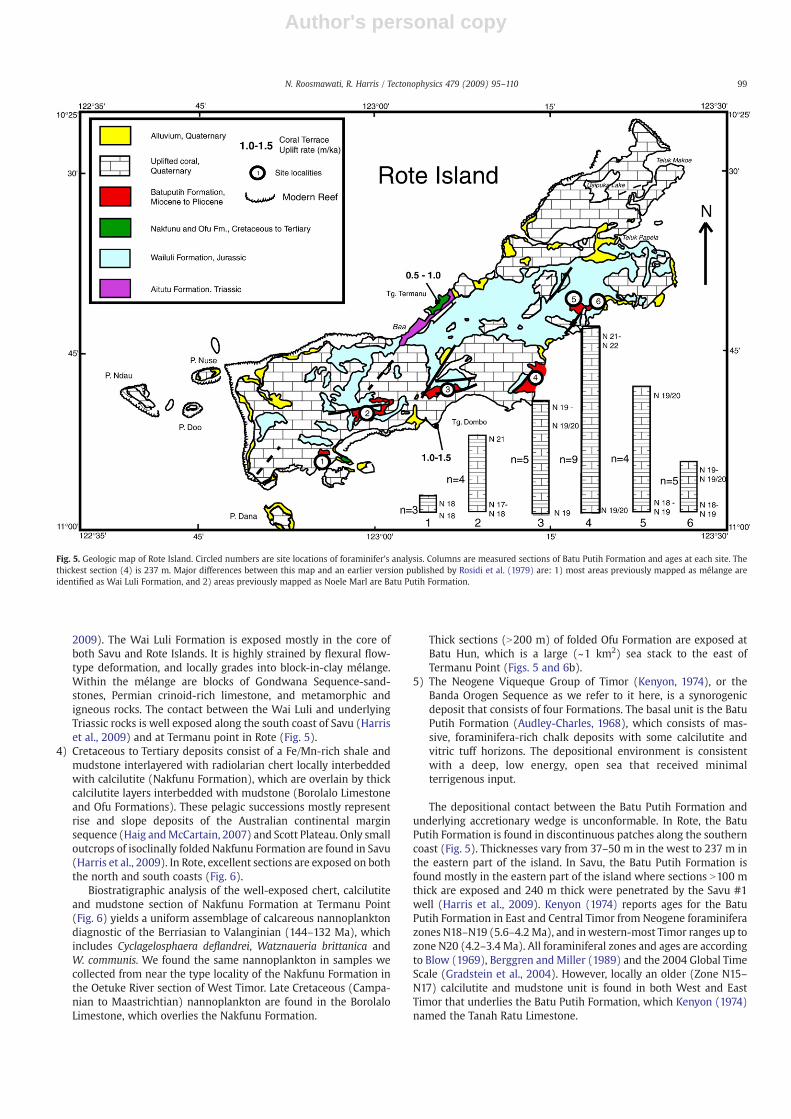
passive margin sequence are also found (Fig. 4). Both of these mostlysedimentary sequences have been scrapped off of the Australiancontinental lower plate as it subducted beneath the Banda Forearc.Unconformably overlying the accretionary wedge is the Banda OrogenSequence, which consists of mélange and synorogenic deposits.Detailed mapping of Rote (Fig. 5) and Savu (Harris et al., 2009) revealthe following units:
1) The Triassic Aitutu Formation (Audley-Charles, 1968) is a white topink, Halobia-rich limestone with interbedded carbonate mud-stones and some chert nodules. This formation is exposed alongthe north coast of Rote near Baa (Fig. 5), but is not found in Savu(Harris et al., 2009).
2) The Late Triassic Babulu Formation (Gianni, 1971) consists mostly ofinterbedded sandstone and shale. Most of the section consists ofthinly bedded limestone with chert nodules, shale, siltstone andthick sandstone beds. Amarker bed in themiddle part of the sectionconsists of a 10 cmthickpackstone containingHalobia. The limestonesection of theBabulu Formation is sandwichedbetween twomassiveto bedded sandstone units. The Babulu Formation is exposedextensively in south-central Savu, but is not recognized in Rote.
3) The Jurassic Wai Luli Formation (Audley-Charles, 1968) is ahomogenous dark grey and red colored mudstone and shale withinterbedded organic-rich limestone, calcilutite, siltstone, andcharacteristic ironstone concretions. The basal units in Savu consistof pink calcilutite overlain by a series of pillow basalt (Harris et al.,
Fig. 4. Lithologic units of Rote Island.
98 N. Roosmawati, R. Harris / Tectonophysics 479 (2009) 95–110
Author's personal copy
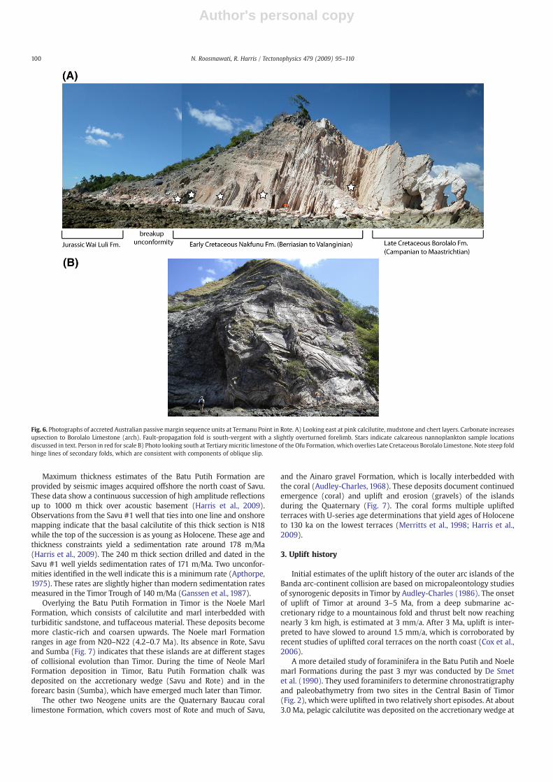
2009). The Wai Luli Formation is exposed mostly in the core ofboth Savu and Rote Islands. It is highly strained by flexural flow-type deformation, and locally grades into block-in-clay mélange.Within the mélange are blocks of Gondwana Sequence-sand-stones, Permian crinoid-rich limestone, and metamorphic andigneous rocks. The contact between the Wai Luli and underlyingTriassic rocks is well exposed along the south coast of Savu (Harriset al., 2009) and at Termanu point in Rote (Fig. 5).
4) Cretaceous to Tertiary deposits consist of a Fe/Mn-rich shale andmudstone interlayered with radiolarian chert locally interbeddedwith calcilutite (Nakfunu Formation), which are overlain by thickcalcilutite layers interbedded with mudstone (Borolalo Limestoneand Ofu Formations). These pelagic successions mostly representrise and slope deposits of the Australian continental marginsequence (Haig andMcCartain, 2007) and Scott Plateau. Only smalloutcrops of isoclinally folded Nakfunu Formation are found in Savu(Harris et al., 2009). In Rote, excellent sections are exposed on boththe north and south coasts (Fig. 6).
Biostratigraphic analysis of the well-exposed chert, calcilutiteand mudstone section of Nakfunu Formation at Termanu Point(Fig. 6) yields a uniform assemblage of calcareous nannoplanktondiagnostic of the Berriasian to Valanginian (144–132 Ma), whichincludes Cyclagelosphaera deflandrei, Watznaueria brittanica andW. communis. We found the same nannoplankton in samples wecollected from near the type locality of the Nakfunu Formation inthe Oetuke River section of West Timor. Late Cretaceous (Campa-nian to Maastrichtian) nannoplankton are found in the BorolaloLimestone, which overlies the Nakfunu Formation.
Thick sections (N200 m) of folded Ofu Formation are exposed atBatu Hun, which is a large (~1 km2) sea stack to the east ofTermanu Point (Figs. 5 and 6b).
5) The Neogene Viqueque Group of Timor (Kenyon, 1974), or theBanda Orogen Sequence as we refer to it here, is a synorogenicdeposit that consists of four Formations. The basal unit is the BatuPutih Formation (Audley-Charles, 1968), which consists of mas-sive, foraminifera-rich chalk deposits with some calcilutite andvitric tuff horizons. The depositional environment is consistentwith a deep, low energy, open sea that received minimalterrigenous input.
The depositional contact between the Batu Putih Formation andunderlying accretionary wedge is unconformable. In Rote, the BatuPutih Formation is found in discontinuous patches along the southerncoast (Fig. 5). Thicknesses vary from 37–50 m in the west to 237 m inthe eastern part of the island. In Savu, the Batu Putih Formation isfound mostly in the eastern part of the island where sections N100 mthick are exposed and 240 m thick were penetrated by the Savu #1well (Harris et al., 2009). Kenyon (1974) reports ages for the BatuPutih Formation in East and Central Timor from Neogene foraminiferazones N18–N19 (5.6–4.2 Ma), and inwestern-most Timor ranges up tozone N20 (4.2–3.4 Ma). All foraminiferal zones and ages are accordingto Blow (1969), Berggren and Miller (1989) and the 2004 Global TimeScale (Gradstein et al., 2004). However, locally an older (Zone N15–N17) calcilutite and mudstone unit is found in both West and EastTimor that underlies the Batu Putih Formation, which Kenyon (1974)named the Tanah Ratu Limestone.
Fig. 5. Geologic map of Rote Island. Circled numbers are site locations of foraminifer's analysis. Columns are measured sections of Batu Putih Formation and ages at each site. Thethickest section (4) is 237 m. Major differences between this map and an earlier version published by Rosidi et al. (1979) are: 1) most areas previously mapped as mélange areidentified as Wai Luli Formation, and 2) areas previously mapped as Noele Marl are Batu Putih Formation.
99N. Roosmawati, R. Harris / Tectonophysics 479 (2009) 95–110
Author's personal copy
Maximum thickness estimates of the Batu Putih Formation areprovided by seismic images acquired offshore the north coast of Savu.These data show a continuous succession of high amplitude reflectionsup to 1000 m thick over acoustic basement (Harris et al., 2009).Observations from the Savu #1 well that ties into one line and onshoremapping indicate that the basal calcilutite of this thick section is N18while the top of the succession is as young as Holocene. These age andthickness constraints yield a sedimentation rate around 178 m/Ma(Harris et al., 2009). The 240 m thick section drilled and dated in theSavu #1 well yields sedimentation rates of 171 m/Ma. Two unconfor-mities identified in the well indicate this is a minimum rate (Apthorpe,1975). These rates are slightly higher than modern sedimentation ratesmeasured in the Timor Trough of 140 m/Ma (Ganssen et al., 1987).
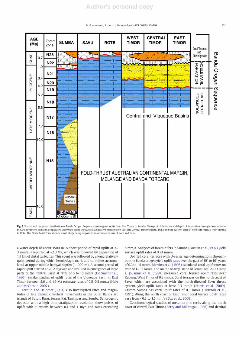
Overlying the Batu Putih Formation in Timor is the Noele MarlFormation, which consists of calcilutite and marl interbedded withturbiditic sandstone, and tuffaceous material. These deposits becomemore clastic-rich and coarsen upwards. The Noele marl Formationranges in age from N20–N22 (4.2–0.7 Ma). Its absence in Rote, Savuand Sumba (Fig. 7) indicates that these islands are at different stagesof collisional evolution than Timor. During the time of Neole MarlFormation deposition in Timor, Batu Putih Formation chalk wasdeposited on the accretionary wedge (Savu and Rote) and in theforearc basin (Sumba), which have emerged much later than Timor.
The other two Neogene units are the Quaternary Baucau corallimestone Formation, which covers most of Rote and much of Savu,
and the Ainaro gravel Formation, which is locally interbedded withthe coral (Audley-Charles, 1968). These deposits document continuedemergence (coral) and uplift and erosion (gravels) of the islandsduring the Quaternary (Fig. 7). The coral forms multiple upliftedterraces with U-series age determinations that yield ages of Holoceneto 130 ka on the lowest terraces (Merritts et al., 1998; Harris et al.,2009).
3. Uplift history
Initial estimates of the uplift history of the outer arc islands of theBanda arc-continent collision are based on micropaleontology studiesof synorogenic deposits in Timor by Audley-Charles (1986). The onsetof uplift of Timor at around 3–5 Ma, from a deep submarine ac-cretionary ridge to a mountainous fold and thrust belt now reachingnearly 3 km high, is estimated at 3 mm/a. After 3 Ma, uplift is inter-preted to have slowed to around 1.5 mm/a, which is corroborated byrecent studies of uplifted coral terraces on the north coast (Cox et al.,2006).
A more detailed study of foraminifera in the Batu Putih and Noelemarl Formations during the past 3 myr was conducted by De Smetet al. (1990). They used foraminifers to determine chronostratigraphyand paleobathymetry from two sites in the Central Basin of Timor(Fig. 2), which were uplifted in two relatively short episodes. At about3.0 Ma, pelagic calcilutite was deposited on the accretionary wedge at
Fig. 6. Photographs of accreted Australian passivemargin sequence units at Termanu Point in Rote. A) Looking east at pink calcilutite, mudstone and chert layers. Carbonate increasesupsection to Borolalo Limestone (arch). Fault-propagation fold is south-vergent with a slightly overturned forelimb. Stars indicate calcareous nannoplankton sample locationsdiscussed in text. Person in red for scale B) Photo looking south at Tertiary micritic limestone of the Ofu Formation, which overlies Late Cretaceous Borolalo Limestone. Note steep foldhinge lines of secondary folds, which are consistent with components of oblique slip.
100 N. Roosmawati, R. Harris / Tectonophysics 479 (2009) 95–110
Author's personal copy
a water depth of about 1500 m. A short period of rapid uplift at 2–3 mm/a is reported at ~2.0 Ma, which was followed by deposition of1.5 km of distal turbidites. This event was followed by a long relativelyquiet period during which hemipelagic marls and turbidites accumu-lated at upper-middle bathyal depths (~1000 m). A second period ofrapid uplift started at ~0.2 myr ago and resulted in emergence of largeparts of the Central Basin at rates of 5 to 10 mm/a (De Smet et al.,1990). Similar studies of uplift rates of the Viqueque Basin in EastTimor between 5.6 and 1.9 Ma estimate rates of 0.5–0.3 mm/a (Haigand McCartain, 2007).
Fortuin and De Smet (1991) also investigated rates and magni-tudes of late Cenozoic vertical movements in the outer Banda arcislands of Buton, Buru, Seram, Kai, Tanimbar and Sumba. Synorogenicdeposits with a high time-stratigraphic resolution show pulses ofuplift with durations between 0.1 and 1 myr, and rates exceeding
5 mm/a. Analyses of foraminifers in Sumba (Fortuin et al., 1997) yieldsurface uplift rates of 0.73 mm/a.
Uplifted coral terraces with U-series age determinations through-out the Banda orogen yield uplift rates over the past of 103 to 105 yearsof 0.3 to 1.5 mm/a. Merritts et al. (1998) calculated coral uplift rates onRote of 1–1.5mm/a, and on the nearby island of Semau of 0.2–0.3mm/a. Jouannic et al. (1988) measured coral terrace uplift rates nearKupang, West Timor of 0.3 mm/a. Coral terraces on the north coast ofSavu, which are associated with the north-directed Savu thrustsystem, yield uplift rates at least 0.3 mm/a (Harris et al., 2009).Eastern Sumba has coral uplift rates of 0.5 mm/a (Pirazzoli et al.,1991). Along the north coast of East Timor coral terrace uplift ratesvary from b0.3 to 1.5 mm/a (Cox et al., 2006).
Geochronological studies of metamorphic rocks along the northcoast of central East Timor (Berry and McDougall, 1986) and detrital
Fig. 7. Spatial and temporal distribution of Banda Orogen Sequence synorogenic units from East Timor to Sumba. Changes in lithofacies and depth of deposition through time indicatethe arc-continent collision propagatedwestward along the Australian passivemargin from East and Central Timor to Rote, and along the eastern edge of the Scott Plateau from Sumbato Rote. The Noele Marl Formation is most likely being deposited in offshore basins of Rote and Savu.
101N. Roosmawati, R. Harris / Tectonophysics 479 (2009) 95–110
Author's personal copy
apatite fission track ages from throughout Timor (Harris et al., 2000)indicate exhumation rates of 2.1–3.0 mm/a.
In summary, long-term uplift rates as high as 10 mm/a areestimated for some parts of Timor using foraminifera to determinechronostratigraphy and paleobathymetry. In Rote and Savu, uplift ratedata is only available from age determinations over the past 130 ka ofcoral terraces, which show maximum rates of 1.5 mm/a. The highestrates are near the south-directed deformation front of Rote. Lowerrates (0.3 mm/a) are found associated with north-directed thrustingat the rear of the accretionary wedge in Savu and along orogenic strikeinwesternmost Timor. This study provides age versus depth estimatesfrom detailed analysis of foraminifera in Rote and Savu where upliftrates of coral terraces and GPSmeasurements exist to help understandthe relations between uplift at a range of time scales and known plateconvergence rates.
4. Foraminiferal analysis
4.1. Methods
We mapped, measured, and sampled each occurrence of the BatuPutih Formation on both Rote (Fig. 5) and Savu (Harris et al., 2009).This includes three sites in Savu (Harris et al., 2009) and six sites inRote (Fig. 5). At each site samples were collected at the base and at 1–3 m intervals to the top of the exposure. The homogenous nature ofthe chalk with little to no bedding planes or lithologic variation, andthe paucity of outcrops provide challenges for correlation of internalunits from one site to the next. Sixty samples were collectedthroughout the massive successions of chalk on Rote and Savu. Of
these, 30 samples from Rote and 10 from Savu yield identifiableforaminifera (Table 1), which are assigned age and depth estimatesaccording to Postuma (1971), Bolli and Saunders (1985), Berggrenet al. (1995), Adisaputra (1989), van Marle (1989a,b), Cifelli (1990),Richardson (1990), Chaisson and Leckie (1993), Kennett and Sriniva-san (1983) and Berggren and Miller (1989).
Another method used to estimate paleobathymetry is the planktic(P) to benthic (B) foraminifera ratio (van Marle et al., 1987). Thisanalysis utilizes the greater abundance of benthic foraminifers inshallow water versus planktic foraminifers, which live passively(floating) and are found ubiquitously. The P/B ratio of foraminifera inevery sample is found by examining 300 random individuals andusing the formula (van Marle et al., 1987):
P = P + B × 100k
Table 1Sample location.
Sample Latitude Longitude Elevation (m)
RT-002 10.5326 122.5624 37RT-003 10.5339 122.5642 12RT-004 10.5344 122.5644 10RT-TX04 10.4853 123.11 130RT-W03 10.507 122.5925 10RT-027 10.5 122.5926 75RT-029 10.5056 122.5829 65RT-024 10.5048 122.592 27RT-X06 10.4837 123.525 177RT-X05 10.4852 123.511 225RT-X03 10.4845 123.522 20RT-X02 10.49 123.439 150RT-X01 10.4844 123.46 55RT-V08 10.474 123.1325 225RT-V09 10.472 123.1329 20RT-Y08 10.4722 123.1332 198RT-V05A 10.471 123.1331 142RT-V05C 10.471 123.1331 137RT-Y01 10.4739 123.1359 12RT-U10 10.4222 123.1725 200RT-U11 10.4139 123.1738 190RT-U08 10.413 123.1742 170RT-U12 10.4213 123.1727 50RT-U02 10.4141 123.1814 125RT-040C 10.414 123.1818 80RT-040B 10.414 123.1818 75RT-040A 10.414 123.1818 60RT-U03 10.4147 123.182 45SV-62 1 0.5222 121.9665 17SV-60 1 0.5282 121.9801 61SV-67 1 0.5034 121.9055 146SV-64 1 0.4981 121.9031 78SV-71b 10.4579 121.8865SV-71a 10.4579 121.8865 81SV-72a 10.4493 121.885 23SV-72c 10.4493 121.885
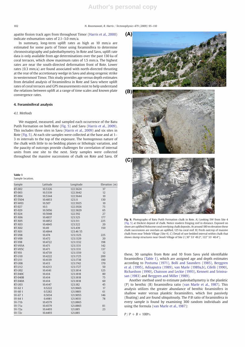
Fig. 8. Photographs of Batu Putih Formation chalk in Rote. A) Looking SW from Site 4(Fig. 5) at thickest deposit of chalk. Notice modern fringing reef in distance. Exposed onshore are upliftedHolocene coral overlying chalk deposits. At around180melevation thesechalk successions are overlain an uplifted, 125 ka coral reef. B) Fresh outcrop of massivechalk from near Tebole Village (Site 4). C) Detail of rare bedded interval within chalk thatshows slump structures near Oeseli Village of Site 2 (10° 53′ 49.2″, 122° 55′ 40.4″).
102 N. Roosmawati, R. Harris / Tectonophysics 479 (2009) 95–110
Author's personal copy
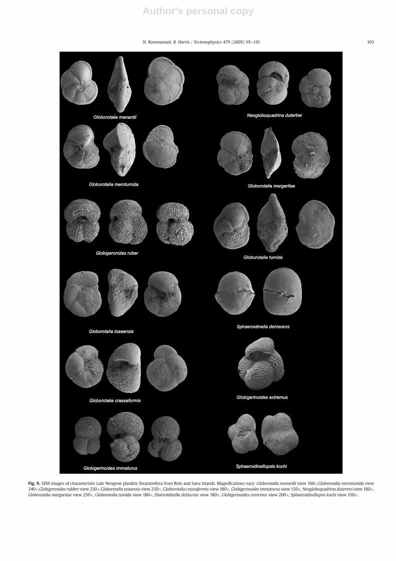
Fig. 9. SEM images of characteristic Late Neogene planktic foraminifera from Rote and Savu Islands. Magnifications vary: Globorotalia menardii view 160×,Globorotalia merotumida view340×,Globigeronides rubber view 230×,Globorotalia tosaensis view 250×, Globorotalia crassaformis view 180×, Globigerinoides immaturus view 150×, Neogloboquadrina dutertrei view 180×,Globorotalia margaritae view 250×, Globorotalia tumida view 180×, Shaeroidinella dehiscens view 180×, Globigerinoides extremus view 200×, Sphaeroidinellopsis kochi view 150×.
103N. Roosmawati, R. Harris / Tectonophysics 479 (2009) 95–110
Author's personal copy
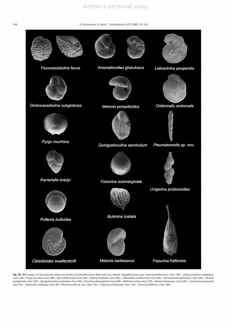
Fig. 10. SEM images of characteristic deep-sea benthic foraminifera from Rote and Savu Islands. Magnifications vary: Favocassidulina favus view 100×, Globocassidulina subglobosaview 150×, Pyrgo murrhina view 200×, Karreriella bradyi view 200×, Pullenia bulloides view 200×, Cibicidoides wuellerstorfi view 100×, Anomalinoides globulosus view 200×, Melonispompilioides view 100×, Quingueloculina seminulum view 100×, Fissurina submarginata view 200×, Bulimina rostata view 250×, Melonis barleeanus view 200×, Laticarinina pauperataview 90×, Oridorsalis umbonata view 90×, Pleurostomella sp. nov. view 130×, Uvigerina proboscidea view 130×, Fissurina foliformis view 100×.
104 N. Roosmawati, R. Harris / Tectonophysics 479 (2009) 95–110
Author's personal copy
To obtain the depth (D), the formula is transformed to:
D = e 0:061·P + 1:25ð Þ
The P/B ratio for most samples in rote and savu is 90–99% plankticforaminifers, which is consistent with water depths >2500 m (vanMarle et al., 1987).
Additional details about each site, all of the species found in eachsample and relative abundance of species are provided in Roosmawati(2005).
4.2. Occurrence
The best-exposed sections of the Batu Putih Formation are foundnear the south coast of Rote and northern and eastern Savu (Fig. 8).
They consist of cliff-forming massive chalk outcrops around 50 mhigh. The base of the Batu Putih Formation is locally exposed andcommonly overlies scaly clay mélange. The top of the unit is mostlyeroded away, but is sometimes found beneath an armor of Pleistocenecoral and gravel terrace deposits of the same age (Fig. 4).
Planktic andbenthic foraminifera arepresent inmost samples of chalkand calcilutitewe collected from the Batu Putih Formation, and generallyshow good to excellent preservation (Figs. 9 and 10). Some partiallydissolved foraminifera are also found indicating deposition depths nearthe lysocline, which is N3000 m in the region (Mohtadi et al., 2007).
4.3. Reworked fossils
In almost every sample there are abundant planktic foraminifersolder than the last appearance of oldest species and benthicforaminifers shallower than estimated depth ranges. These species
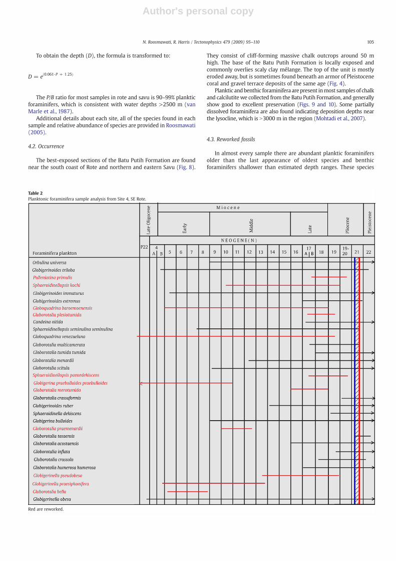
Table 2Planktonic foraminifera sample analysis from Site 4, SE Rote.
Red are reworked.
105N. Roosmawati, R. Harris / Tectonophysics 479 (2009) 95–110
Author's personal copy
are interpreted as reworked from submarine erosion of older andshallower units. Strong currents through this rapidly closing oceanicgateway between the Pacific and Indian Oceans are well documentedby the common occurrence of contourites along the sea floor (i.e. Reedet al., 1987). The presence of Globorotalia archeomenardii, Globorotaliafohsi fohsi, Globorotalia praemenardii, and Globigerinoides primordius,with short age ranges must represent reworked species.
Another test of reworking is the relative abundance of variousspecies ((van Marle et al., 1987). In most cases, suspect species onlyaccount for b5% of the individuals in random counts. The source ofreworked species is unknown, but similar foraminifers are documen-ted from the Sunda Shelf and Sumba (Effendi and Apandi, 1985).
4.4. Age determinations
The age of the Batu Putih Formation in Rote and Savu is bracketedby using the first appearance of the youngest foraminifera species andthe last appearance of older species (Table 2). The oldest units have awell-preserved dissolution resistant assemblage of Globorotaliatumida tumida and Globorotalia merotumida, which indicate a latestMiocene-earliest Pliocene age, Zone N17/18 (5.6 Ma). In East Rote, thelowest part of the section is early Pliocene, Zone N19/20 (5.2–3.4 Ma),based on the first appearance of Globorotalia crassaformis and the lastappearance of Sphaeroidinellopsis kochi. A late Pliocene age for the topof the section in Tebole is constrained by the first appearance of Glo-borotalia tosaensis and the last appearance of Sphaeroidinellopsisseminulina seminulina, Globorotalia multicamerata, and Neogloboqu-drina dutertei, which define Zone N21 (3.4–1.9 Ma).
These same species of foraminifera are also found in the Batu PutihFormation of eastern Savu (Harris et al., 2009) and near the base of theSavu #1 well (Apthorpe, 1975). Age determinations of foraminifera inunits drilled by the well indicate a disconformity at 63–70 m depthwith Zone N22/23 (Pleistocene) calcilutite intermixed with coraldebris directly overlying Zone N19 (4.2–5.2 Ma) age calcilutite. Theseyoungest sections are not found onshore.
The maximum age of the Batu Putih Formation implies that thepart of the accretionary wedge these sediments overlie formed by atleast 5.6 Ma. Older and more deformed Batu Putih Formation-likeunits underlie Zone N18 deposits near the village of Viqueque in EastTimor (Haig andMcCartain, 2007). However, the age of these depositsis not known. In Sumba, Batu Putih Formation equivalent chalkdeposits are around the same age (Zone N11) as the eastern Sundavolcanic arc (~15Ma, Abbot and Chamalaun,1981). Themuchyoungerage of the basal Batu Putih Formation in Savu, Rote and most of Timoris consistent with the location of these islands at the southern of edgeof the Sunda/Banda forearc, and provides a minimum age for theformation of accretionary wedge there.
4.5. Depth estimates
Depth of deposition estimates for the Batu Putih Formation isbased on taxonomic classification criteria of van Morkhoven et al.(1986), van Marle (1989a,b) and Jones (1994), and the depth of thelysocline in Savu Sea region. Depth range determinations are based onbenthic foraminifer species that have the deepest upper depth limit.Most foraminifers in the oldest sections of Savu are severely dissolved,which indicates depths below the lysocline. The lowest fauna diversitywith mostly only dissolution resistant species are found in the basalsections of sites 4, 5 and 6 in Rote, which may also indicate the affectsof dissolution in the lysocline. Similar conditions are found alongorogenic strike to the west on Lombak accretionary ridge, which isaround 4 km deep (Fig. 1).
Large depth ranges for most deep-water benthic species causepoor resolution for calculating uplift rates. Notwithstanding thesedifficulties, we find multiple benthic species with abyssal zone upperdepth limits (2000–3000 m). These and other deep marine species
include: Oridorsalis umbonata, Cibicidoides wuellerstorfi, Pulleniabulloides, Globocassidulina subglobosa, Melonis pompiliolides, Laticari-nina pauperata, Uvigerina proboscidea, Pleuroslomella subnodasa,Osangulatiella Umbonifera, Favocassidulina favus, Bulimina rostrata,Oolina truncata, Cibicidoides globulosus, Pleurostomella sp.nov. andAmphicoryna scalaris.
The Batu Putih Formation in Rote has abyssal zone benthicforaminifera in even the youngest sections (Zone N22) near the topof the highest ridge on the island (section 4, Fig. 5). These depositsunconformably underlie uplifted coral terraces of 120–130 ka (Mer-ritts et al., 1998).
Batu Putih Formation samples in Savu of Zone N18 to N21 age (5.6–1.9 Ma) all yield abyssal zone benthic foraminifera (Harris et al.,2009). The uppermost part of the Pliocene section is different andshows little to no dissolution and increased faunal diversity. Thischange may indicate some shallowing, perhaps due to accretionarygrowth during the Pliocene. However, along with Globorotaliatruncatulinoides, which marks the base of Zone N22 (1.8 Ma), thereare characteristic deep-water species, such as Pullenia bulloides,Oridorsalis umbonatus and Palnulina wuellerstorfi indicating abyssaldepths. Immediately overlying these deposits are late Zone N22 toN23 (1.0 to b0.7 Ma) neritic species (0–200 m depth) intermingledwith coral. These deposits are overlain by a 121,593±736 year olduplifted coral terrace on the northern most tip of Savu (Harris et al.,2009).
5. Uplift rates
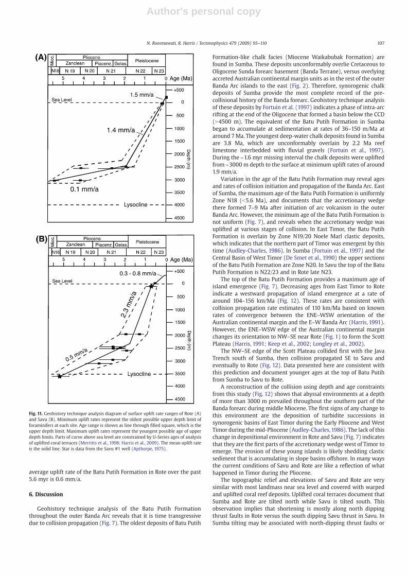
We use a geohistory technique analysis (van Hinte, 1978) toestimate long-term uplift rates for Savu and Rote Islands (Fig. 11). Thisapproach uses estimated benthic foraminifer upper depth limits andpresent elevation divided by the planktic foraminifer age. The resultsshow little to no uplift during Zone N18 to early N22 on both islandsfollowed by an abrupt pulse of Pleistocene uplift.
In Savu, Zone N22 calcilutite deposited at abyssal depths is overlainby Zone N22/23 neritic species deposited at depths of less than 200 m(Fig. 11). These age and depth relations demonstrate how Savu rose2000 m in 1 Ma (2 mm/a) and emerged near the surface by ~0.7 Ma.Upliftedandwarped coral terraces overlying thesedeposits are foundupto elevations of 388 m on the northern slope of Savu. Minimum upliftrates of 0.3 mm/a are estimated for the past 121 ka from U-series agedeterminations of one of the lowest terraces (Harris et al., 2009).However, the young ages of foraminifera-rich chalk underlying thehighest terraces requires slightly higher uplift rates of at least 0.8 mm/a,which increases the fit between coral terraces and sea level high stands(Harris et al., 2009). Before Zone N22 uplift rates were much slower asthe accretionarywedgewas upliftedmostly by addition of newmaterialto the accretionary wedge. The average uplift rate of the Batu PutihFormation over the past 5.2 myr is 0.7 mm/a.
In Rote, the youngest foraminifera in the Batu Putih Formation areNeogloboquadrina duetertrei (Zone N21) in sample RT-TX04 andGloberatalia tosaensis (Zone N22) in sample RT-V08 (Table 1). Both ofthese samples are from the tops of sites 2 and 4, respectively. Benthicforaminifer species in these samples have upper depth limits of2500 m, which include Osangulariella umbonifera and Pleurostomellasp. nov. These deposits are locally overlain by warped, 120–130 kacoral terraces as high as 170–180 m above sea level (Merritts et al.,1998). Minimum uplift rates based on the oldest possible age ofthese species are of 0.9 mm/a. Maximum rates using the youngestpossible age are 2.7 mm/a. The average uplift rate is 1.4 mm/a, whichis very similar to rates of uplift over the past 125 ka determined by U-series age analysis of uplifted coral terraces (Merritts et al., 1998).Rote emerged at sea level around 0.5myr after Savu. Slowing of upliftaround the time of emergence may be associated with northwardpropagation of the Savu Thrust system (Harris et al., 2009). The
106 N. Roosmawati, R. Harris / Tectonophysics 479 (2009) 95–110
Author's personal copy
average uplift rate of the Batu Putih Formation in Rote over the past5.6 myr is 0.6 mm/a.
6. Discussion
Geohistory technique analysis of the Batu Putih Formationthroughout the outer Banda Arc reveals that it is time transgressivedue to collision propagation (Fig. 7). The oldest deposits of Batu Putih
Formation-like chalk facies (Miocene Waikabubak Formation) arefound in Sumba. These deposits unconformably overlie Cretaceous toOligocene Sunda forearc basement (Banda Terrane), versus overlyingaccreted Australian continental margin units as in the rest of the outerBanda Arc islands to the east (Fig. 2). Therefore, synorogenic chalkdeposits of Sumba provide the most complete record of the pre-collisional history of the Banda forearc. Geohistory technique analysisof these deposits by Fortuin et al. (1997) indicates a phase of intra-arcrifting at the end of the Oligocene that formed a basin below the CCD(N4500 m). The equivalent of the Batu Putih Formation in Sumbabegan to accumulate at sedimentation at rates of 36–150 m/Ma ataround 7Ma. The youngest deep-water chalk deposits found in Sumbaare 3.8 Ma, which are unconformably overlain by 2.2 Ma reeflimestone interbedded with fluvial gravels (Fortuin et al., 1997).During the ~1.6 myr missing interval the chalk deposits were upliftedfrom ~3000 m depth to the surface at minimum uplift rates of around1.9 mm/a.
Variation in the age of the Batu Putih Formation may reveal agesand rates of collision initiation and propagation of the Banda Arc. Eastof Sumba, the maximum age of the Batu Putih Formation is uniformlyZone N18 (b5.6 Ma), and documents that the accretionary wedgethere formed 7–9 Ma after initiation of arc volcanism in the outerBanda Arc. However, the minimum age of the Batu Putih Formation isnot uniform (Fig. 7), and reveals when the accretionary wedge wasuplifted at various stages of collision. In East Timor, the Batu PutihFormation is overlain by Zone N19/20 Noele Marl clastic deposits,which indicates that the northern part of Timor was emergent by thistime (Audley-Charles, 1986). In Sumba (Fortuin et al., 1997) and theCentral Basin of West Timor (De Smet et al., 1990) the upper sectionsof the Batu Putih Formation are Zone N20. In Savu the top of the BatuPutih Formation is N22/23 and in Rote late N23.
The top of the Batu Putih Formation provides a maximum age ofisland emergence (Fig. 7). Decreasing ages from East Timor to Roteindicate a westward propagation of island emergence at a rate ofaround 104–156 km/Ma (Fig. 12). These rates are consistent withcollision propagation rate estimates of 110 km/Ma based on knownrates of convergence between the ENE–WSW orientation of theAustralian continental margin and the E–W Banda Arc (Harris, 1991).However, the ENE–WSW edge of the Australian continental marginchanges its orientation to NW–SE near Rote (Fig. 1) to form the ScottPlateau (Harris, 1991; Keep et al., 2002; Longley et al., 2002).
The NW–SE edge of the Scott Plateau collided first with the JavaTrench south of Sumba, then collision propagated SE to Savu andeventually to Rote (Fig. 12). Data presented here are consistent withthis prediction and document younger ages at the top of Batu Putihfrom Sumba to Savu to Rote.
A reconstruction of the collision using depth and age constraintsfrom this study (Fig. 12) shows that abyssal environments at a depthof more than 3000 m prevailed throughout the southern part of theBanda forearc during middle Miocene. The first signs of any change tothis environment are the deposition of turbidite successions insynorogenic basins of East Timor during the Early Pliocene and WestTimor during themid-Pliocene (Audley-Charles,1986). The lack of thischange in depositional environment in Rote and Savu (Fig. 7) indicatesthat they are the first parts of the accretionary wedgewest of Timor toemerge. The erosion of these young islands is likely shedding clasticsediment that is accumulating in slope basins offshore. In many waysthe current conditions of Savu and Rote are like a reflection of whathappened in Timor during the Pliocene.
The topographic relief and elevations of Savu and Rote are verysimilar with most landmass near sea level and covered with warpedand uplifted coral reef deposits. Uplifted coral terraces document thatSumba and Rote are tilted north while Savu is tilted south. Thisobservation implies that shortening is mostly along north dippingthrust faults in Rote versus the south dipping Savu thrust in Savu. InSumba tilting may be associated with north-dipping thrust faults or
Fig. 11. Geohistory technique analysis diagram of surface uplift rate ranges of Rote (A)and Savu (B). Minimum uplift rates represent the oldest possible upper depth limit offoraminifers at each site. Age range is shown as line through filled square, which is theupper depth limit. Maximum uplift rates represent the youngest possible age of upperdepth limits. Parts of curve above sea level are constrained by U-Series ages of analysisof uplifted coral terraces (Merritts et al., 1998; Harris et al., 2009). The mean uplift rateis the solid line. Star is data from the Savu #1 well (Apthorpe, 1975).
107N. Roosmawati, R. Harris / Tectonophysics 479 (2009) 95–110

Author's personal copy
Fig. 12. Palinspastic map of the Banda arc-continent collision using measured velocity (70 mm/a) and direction (015°) of convergence. Shortening of the Australian continentalmargin is shown by decrease in space between the two lines that represent its width. Green represents land near sea level, brown — mountains, yellow — turbidite deposition andlight grey— active volcanism. Bathymetry in ‘B’ to ‘D’ is speculative except where constrained by analysis of foraminifera. NE–SW lines in ‘D’ are approximate axes of rift basins, whichis near perpendicular to the NE transform faulted edge of the Scott Plateau. Collision of Australian passive margin initiates in the Timor region and propagates westward toward Rote.Collision of the Scott Plateau initiates in Sumba and propagates SE to Savu and Rote.
108 N. Roosmawati, R. Harris / Tectonophysics 479 (2009) 95–110
Author's personal copy
extensional collapse. It is evident that accelerated uplift (2 mm/a)above the underthrust the edge of the Scott Plateau is in northernSavu (Harris et al., 2009). Southward tilting of coral terraces in Savu isassociated with active accretion of forearc basin rocks to the north-directed front of the Savu thrust system. Passing of the Scott Plateaubeneath Rote caused an unconformity at the top of the Batu PutihFormation that is now overlain by coral terraces. We interpret NWtilting of coral terraces in Rote as an indicator of south-directedthrusting and active accretion of Australian continental margin rocks(Fig. 6) to the front of the accretionary wedge, which is only 20 km tothe SE.
Near sea-level elevations for Rote and Savu may indicate that theyhave nearly reached a dynamic equilibrium between surface processesand rock uplift. Pleistocene coral terraces found up to 600 m in bothSumba (Pirazzoli et al., 1991) and East Timor (Chappell and Veeh,1978; Cox et al., 2006) indicate that surface uplift outpaces erosion inthese regions. In the interior of central Timor coral terraces are foundup to 1200 m elevation (Rosidi et al., 1979), with several mountainousregions reaching N2000 m elevation. Many of these high regionsconsist of poorly consolidated rock types, which indicate a majorcomponent of dynamic landscape development. These areas areadjacent to the most mature parts of the collision, which ischaracterized by nearly complete closure of the forearc basin andimpingement of the accretionary wedge between the volcanic arc andunderthrust thick continental crust of the Australian shelf (Fig. 12A).This event is documented by foraminifer studies of Noele MarlFormation turbidites found in the Central Basin of West Timor thatreveal uplift rates as high as 5–10mm/a over the past 0.2 Ma (De Smetet al., 1990).
The rise of the Banda accretionary wedge plays a significant role inclosure of westward circulating surface waters through the Indo-Pacific Seaway (Linthout et al., 1997). A biogeographic barrier betweenthe two oceans is first detected in Early Pliocene Zone N19 (Srinivasanand Sinha, 1998). Restricted flow through the seaway piles up warmwater in the equatorial Pacific region, which may have cooled globalclimate over the past 5 myr (Gasperi and Kennett (1993).
7. Conclusion
The results of detailed examination of planktic and benthicforaminifers in synorogenic chalk deposits (Batu Putih Formation)of Rote and Savu, and from previous work throughout Timor, generallyindicate the uplift history of Banda accretionary ridge from itsinception at N5.6 Ma to its emergence from 4.2 to 0.5 Ma. AccretedAustralian continental margin rocks are found on both islands thatcorrelate directly with those accreted to form the island Timor.
Variation in the age of emergence of both islands documents thehistoryof obliquearc-continent collisionpropagation along the irregularshaped continental edge of NWAustralia. The age of the top of the BatuPutih Formation indicates a change in depositional environmentassociated with uplift of parts of the accretionary wedge to the surface.In Timor, Zone N19 to N20 turbidite deposits from emerging parts of theisland to the north overlie Batu Putih Formation chalk. In Savu and Rote,Pleistoceneuplifted coral terraces unconformablyoverlie chalk deposits.We infer that the offshore portions of the islands of Rote and Savu arecurrently at the same stage now as Timor was during the Early to mid-Pliocene.
These data indicate that the Banda arc-continent collision ispropagatingWSW from Timor to Rote at a rate of 104–156 km/Ma, butat the same time also propagates SE from Sumba to Savu to Rote alongthe NE edge of the Scott Plateau protrusion. The passing of thecontinental edge beneath the accretionary wedge is associated withshort intervals (b1 myr) of rapid uplift at rates of 1.4 to 2.3 mm/a.Independent measurements of surface uplift using coral terracesoverlying the emergent chalk deposits in Savu and Rote yield rates ofN0.3 to 1.5 mm/a, respectively. We explain differences in rates of early
and late Pleistocene uplift in Savu as a result of the south to northunderthrusting of the Scott Plateau edge. Similar rates of Batu PutihFormation and coral terrace emergence in Rote we ascribe to ongoingaccretion along the deformation front, which is only 20 km to thesouth.
In terms of equilibrium states of mountain building, changes indepth of Savu and Rote between 5.6 and 1.8 Ma are small, with onlythe possibility of submarine erosion. However, during the Pleistoceneboth islands experience a phase of rapid uplift, which starts first inSavu at ~1.8 Ma and in Rote at ~1.0 Ma. Savu may be in the process ofreturning to its pre-collision equilibrium state. However, Rotemaintains fairly high uplift rates (1.5 mm/a) along its south coastpossibly due to its proximity to the deformation front.
Acknowledgements
We wish to thank Hendro Nugroho for invaluable field assistance,Mike Vorkink for providing some samples from Savu Island, DavidHaig for guidance with foraminifer identification, and Anne Fortuinand R. Mark Leckie for thorough and insightful reviews of themanuscript. Funding was provided by National Science Foundationgrant EAR-0337221. We are grateful for additional support providedby an American Association of Petroleum Geologists grant to NovaRoosmawati.
References
Abbot, M.J., Chamalaun, F.H., 1981. Geochronology of some Banda Arc volcanics. TheGeology and Tectonics of Eastern Indonesia. Special Publication, vol. 2. GeologyResources and Development Central, Bandung, Indonesia, pp. 253–268.
Adisaputra, M.K., 1989. Planktonic foraminifera in recent bottom sediments of theFlores, Lombak and Savu basins, Eastern Indonesia. Netherlands Journal of SeaResearch 24, 465–475.
Apthorpe, M. (1975), Report on the BOCAL Savu No. 1 well: unpublished report, 23 p.Audley-Charles, M.G., 1968. The geology of Portuguese Timor. Memoir of the Geological
Society of London 4, 1–76.Audley-Charles, M.G., 1986. Rates of Neogene and Quaternary tectonic movements in
the Southern Banda Arc based on micropaleontology. Journal of the GeologicalSociety (London) 143, 161–175.
Berggren, W.A., Miller, K.G., 1989. Cenozoic bathyal and abyssal calcareous benthicforaminiferal zonation. Micropaleontology 35 (4), 308–320.
Berggren, W.A., Hilgen, F.J., Langereis, C.G., Kent, D.V., Obradovich, J.D., Raffi, I., Raymo,M.F., Shackleton, N.J., 1995. Late Neogene chronology: new perspectives in high-resolution stratigraphy. Geological Society of America Bulletin 107, 1272–1287.
Berry, R.F., McDougall, I., 1986. Interpretations of 40Ar/39Ar dating evidence from theAileu Formation, East Timor, Indonesia. Chemical Geology, 59, 43–58.
Blow,W.H.,1969. LateMiddle Eocene to Recent planktonic foraminifera biostratigraphy. In:Bronniman, P., Renz, H.H. (Eds.), Proceeding 1st International Conference PlanktonicMicrofossils, vol. 1. Brill, Leiden, pp. 199–421.
Bolli, H.M., Saunders, J.B., 1985. Oligocene to Holocene low latitude plankticforaminifera. In: Bolli, H.M., Saunders, J.B., Perch-Nielsen, K. (Eds.), PlanktonStratigraphy. Cambrige University Press, New York, pp. 155–262.
Brouwer, H.A., 1942. Summary of the geology results of the expedition, in geologicalExpedition of the University of Amsterdam to the Lesser Sunda Islands in the SouthEastern Part of the Netherlands East Indies 1937, vol. IV. N. V. Noord HollandscheUitgevers Maatschappij, Amsterdam, pp. 347–401.
Chaisson, W.P., Leckie, R.M., 1993. High-resolution neogene planktonic foraminiferbiostratigraphy of site 806, Ontong Java Plateau (Western Equatorial Pacific).Proceedings of the Ocean Drilling Program. Scientific Results, vol. 130, pp. 137–178.
Chappell, J.M., Veeh, H.H., 1978. Late Quaternary tectonic movement and sealevelchanges at Timor and Atauro Island. Geological Society of America Bulletin, 89,356–358.
Cifelli, R., 1990. A history of the classification of foraminifera 1826–1933. CushmanFoundation for Foraminiferal Research Special Publication 27 (Part 1). 88 pp.
Cox, N.L., Harris, R.A., Merritts, D., 2006. Quaternary Uplift of coral terraces from activeflooding and thrusting along the Northern Coast of Timor-Leste. AmericanGeophysical Union Abstract 87 (52).
De Smet, M.E.M., Fortuin, A.R., Troelstra, S.R., Van Marle, L.J., Karmini, M., Tjokrosapoe-tro, S., Hadiwasastra, S., 1990. Detection of collision-related vertical movements inthe Outer Banda Arc (Timor, Indonesia), using micropaleontology data. Journal ofSoutheast Asian Earth Sciences 4 (4), 337–356.
Effendi, A.C., Apandi, T., 1985. Laporan Geologi lembar Sumba-Nusa Tenggara Timur(1:250.000). Geological Research and Development Centre, Indonesia.
England, P., Molnar, P., 1990. Surface uplift, uplift of rocks, and exhumation of rocks.Geology 18, 1173–1177.
Fortuin, A.R., De Smet, M.E.M., 1991. Rates and magnitudes of late Cenozoic verticalmovements in the Indonesian Banda Arc and the distinction of eustatic effects.Special Publication International Association of Sedimentologist, vol. 12, pp. 79–89.
109N. Roosmawati, R. Harris / Tectonophysics 479 (2009) 95–110

Author's personal copy
Fortuin, A.R., Van der Werff, W., Wensink, H., 1997. Neogene basin history andpaleomagnetism of a rifted and inverted forearc region, on-and offshore Sumba,Eastern Indonesia. Journal of Asian Earth Sciences 15, 61–88.
Ganssen, G.M., Situmorang, S.R., Troelstra, J.W., Biekart, S., van der Kaars, S., Faber, B.,1987. Preliminary results of piston core stratigraphy on the results of the SnelliusExpedition: Jakarta, Indonesia, Nov. 1987, no. 26.
Gasperi, J.T., Kennett, J.P., 1993. Vertical thermal structure evolution of Miocene surfacewaters: western equatorial Pacific DSDP Site 289. Marine Micropaleontology 22,235–254.
Genrich, J.F., Bock, Y., McCaffrey, R., Calais, E., Stevens, C.W., Subarya, C., 1996. Accretionof the southern Banda arc to the Australian plate margin determined by GlobalPositioning System measurements. Tectonics 15, 288–295.
Gianni, L. (1971), The geology of the Belu district of Indonesian Timor, unnpub. MPhil.Thesis, University of London, 122 p.
Gradstein, F.M., Ogg, J.G., Smith, A.G. (2004), A Geologic Time Scale, Cambridge, UK;New York: Cambridge University Press.
Haig, D.W., McCartain, E., 2007. Carbonate pelagites in the post-Gondwana succession(Cretaceous–Neogene) of East Timor. Australian Journal of Earth Sciences 54,875–897.
Hall, R., 2002. Cenozoic geological and plate tectonic evolution of SE Asia and the SWPacific: computer-based reconstructions, model and animations. Journal of AsianEarth Sciences 20, 353–431.
Hamilton, W., 1979. Tectonics of the Indonesian Region. U.S. Geology Survey ProfessionalPaper 1078, pp. 1–345.
Harris, R.A., 1991. Temporal distribution of strain in the active Banda orogen: areconciliation of rival hypotheses, in Orogenesis in Action. In: Hall, R., Nichols, G.,Rangin, C. (Eds.), Spec. V. Journal of Asian Earth Science, V. 6, N0. 3/4, pp. 373–386.
Harris, R.A., Sawyer, R.K., Audley-Charles, M.G., 1998. Collisional mélange development:geologic associations of active mélange-forming processes with exhumed mélangefacies in the western Banda orogen, Indonesia. Tectonics 17 (3), 458–479.
Harris, R.A., Kaiser, J., Hurford, A.J., Carter, A., 2000. Thermal history of Australian passivemargin sequences accreted to Timor during Late Neogene arccontinent collision,Indonesia. Journal of Asian Earth Sciences 18, 47–69.
Harris, R.A., Vorkink, M.W., Prasetyadi, C., Zobell, E., Roosmawati, N., 2009. Transitionfrom subduction to arc-continent collision: geological and neotectonic evolution ofSavu, Indonesia. Geosphere 5, 1–20. doi:10.1130/GES00209.1.
Jones, R.W., 1994. The Challenger Foraminifera. Oxford University Press.Jouannic, C., Hoang, C.T., Hantoro, W.S., Delinom, R.M., 1988. Uplift rate of coral reef
terraces in the areas of Kupang, West Timor: preliminary results. Palaeogeography,Palaeoclimatology, Palaeoecology, 68, 259–272.
Keep, M., Clough, M., Langhi, L., Moss, S.J., 2002. Neogene tectonic and structuralevolution of the Timor Sea region, NWAustralia: in Sedimentary Basins of WesternAustralia. In: Keep, M., Moss, S.J. (Eds.), Proceedings of the Petroleum ExplorationSociety of Australia Symposium, 3, pp. 341–353.
Kennett, J.P., Srinivasan, M.S., 1983. Neogene Planktonic Foraminifera: A PhylogeneticAtlas: Stroudsburg, PA.
Kenyon, C.S. (1974), Stratigraphy and sedimentology of the Late Miocene to Quaternarydeposits in Timor. Dissertation, University of London.
Linthout, K., Helmers, H., Sopaheluwakan, J., 1997. LateMiocene obduction andmicroplatemigration around the southern Banda Sea and the closure of the Indonesian Seaway.Tectonophysics 281, 17–30.
Longley, I.M., Buessenschuett, C., Clydsdale, L., 2002. The NorthWest Shelf of Australia—a Woodside perspective. In: Keep, M., Moss, S. (Eds.), The Sedimentary Basins ofWestern Australia, 3. Petroleum Exploration Society of Australia, Perth, pp. 27–88.
McCaffrey, R., Molnar, P., Roecker, S., Joyodiwiryo, Y., 1985. Microearthquake seismicityand fault plane solutions related to arc-continent collision in the eastern Sunda arc,Indonesia. Journal of Geophysical Research 90, 4511–4528.
Merritts, D., Eby, R., Harris, R.A., Edwards, R.L., Chang, H., 1998. Variable rates of LateQuaternary surface uplift along the Banda Arc–Australian plate collision zone,eastern Indonesia. In: Steward, I.S., Vita-Finzi, C. (Eds.), Coastal Tectonics. SpecialPublication, vol. 146. Geological Society, London, pp. 213–224.
Mohtadi, M., Max, L., Hebbeln, D., Baumgart, A., Kruck, N., Jennerjahn, T., 2007. Modernenvironmental conditions recorded in surface sediment samples off W and SWIndonesia: Planktonic foraminifera and biogenic compounds analyses. MarineMicropaleontology 65, 96–112.
Nugroho,H.,Harris, R.A., Lestariya,A.W.,Maruf, B., 2009. Plateboundary reorganization in theBanda arc-continent collision: insights from new GPS measurements. Tectonophysics.479, 52–65 (this issue).
Pirazzoli, P.A., Radtke, U., Hantoro, W.S., Jouannic, C., Hoang, D.T., Causse, C., Borel Best, M.,1991. Quaternary raised coral-reef terraces on Sumba Island, Indonesia. Science 252,1834–1836.
Postuma, J.A., 1971. Manual of Planktonic Foraminifera. Elsevier, Amsterdam, New York.420 pp.
Reed, D.L., Meyer, A.W., Silver, E.A., Prasetyo, H., 1987. Deep current circulation as amechanism for forearc sedimentation in an intraoceanic island arc, Indonesia. MarineGeology 76, 223–241.
Richardson, S.L., 1990. A history of the classification of foraminifera 1826–1933. . SpecialPublication, 27. Cushman Foundation for Foraminiferal Research (Part 2), 88 pp.
Roosmawati, N. (2005), Long-Term Surface Uplift History of the Active Banda Arc-Continent Collision: Depth and Age Analysis of Foraminifera from Rote and SavuIslands, Indonesia, Brigham Young University, unpub. MSc. thesis, 120 p.
Rosidi, H.M.D., Tjokrosapoetro, S., Gafoer, S., Suwitodirdjo, K. (1979), Geologic map ofRote Island (1:250,000). Geological Research and Development Centre, Indonesia.
Silver, E.A., Reed, D., Mc Caffrey, R., Joyodimiro, Y.S., 1983. Back arc-thrusting in theeastern Sunda arc, Indonesia: a consequence of arc-continent collision. Journal ofGeophysic Research 88, 5429–5449.
Srinivasan, M.S., Sinha, D.K., 1998. Early Pliocene closing of the Indonesian Seaway;evidence from North-east Indian Ocean and tropical Pacific deep sea cores. Journalof Asian Earth Sciences 16, 29–44.
Synder, D.B., Prasetyo, H., Blundell, D.J., Pigram, C.J., Barber, A.J., Richardson, A.,Tjokrosapoetro, S., 1996. A dual doubly vergent orogen in the Banda arc continent-arc collision zone as observed on deep seismic reflection profiles. Tectonics 15, 34–53.
van der Werff, W., 1995. Cenozoic evolution of the Savu Basin, Indonesia: forearc basinresponse to arc/continent collision. Marine and Petroleum Geology 12, 247–262.
van Hinte, J.E., 1978. Geohistory analysis-application of micropaleontology in explora-tion geology. American Association Petroleum Geology Bulletin 62, 210–222.
van Marle, L.J., 1989a. Recent and fossil benthic foraminifera and Late Cenozoicpaleobathymetry of Seram, Eastern Indonesia. Netherlands Journal of Sea Research24, 445–457.
van Marle, L.J., 1989b. Benthic Foraminifera from the Banda Arc Region, Indonesia, andTheir Paleobathymetric Significance for Geologic Interpretations of the LateCenozoic Sedimentary Record. Free University Pres, Amsterdam. 269 pp.
van Marle, L.J., Van Hinte, J.E., Nederbragt, A.J., 1987. Plankton percentage of theforaminifera fauna in seafloor samples from the Australian-Irian Jaya continentalmargin, Eastern Indonesia. Marine Geology, 77, 151–156.
van Morkhoven, F.P.C.M., Berggren, W.A., Edwards, A.S., 1986. Cenozoic cosmopolitandeep-water benthic foraminifera. Bulletin Centres Recherches Exploration-Produc-tion, Elf-Aquitaine, Mem. 11.
110 N. Roosmawati, R. Harris / Tectonophysics 479 (2009) 95–110