Embed Size (px)
Citation preview
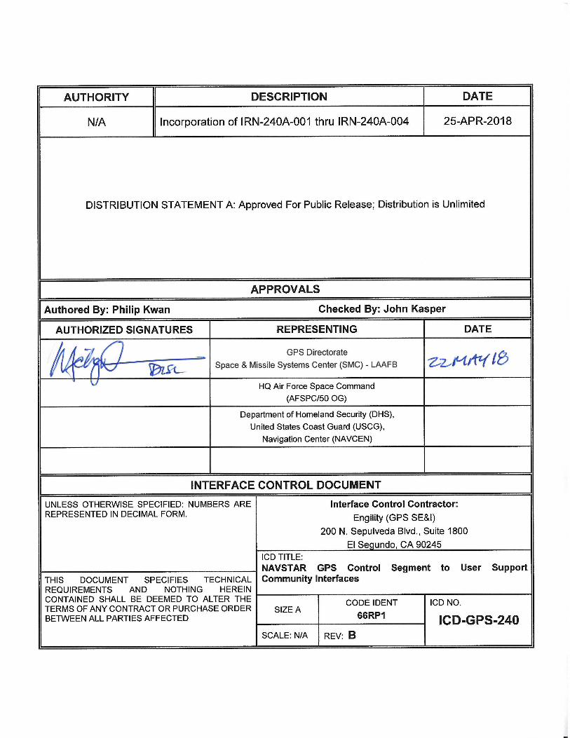
AUTHORITY DESCRIPTION DATE
N/A Incorporation of IRN-ICD-240A-001 thru IRN-ICD-240A-004 25-APR-2018
DISTRIBUTION STATEMENT A: Approved For Public Release; Distribution is Unlimited
APPROVALS
Authored By: Philip Kwan Checked By: John Kasper
AUTHORIZED SIGNATURES REPRESENTING DATE
GPS Directorate
Space & Missile Systems Center (SMC) - LAAFB
HQ Air Force Space Command
(AFSPC/50 OG)
Department of Homeland Security (DHS),
United States Coast Guard (USCG),
Navigation Center (NAVCEN)
INTERFACE CONTROL DOCUMENT
UNLESS OTHERWISE SPECIFIED: NUMBERS ARE REPRESENTED IN DECIMAL FORM.
Interface Control Contractor:
Engility (GPS SE&I)
200 N. Sepulveda Blvd., Suite 1800
El Segundo, CA 90245 ICD TITLE:
NAVSTAR GPS Control Segment to User Support Community Interfaces THIS DOCUMENT SPECIFIES TECHNICAL
REQUIREMENTS AND NOTHING HEREIN CONTAINED SHALL BE DEEMED TO ALTER THE TERMS OF ANY CONTRACT OR PURCHASE ORDER BETWEEN ALL PARTIES AFFECTED
SIZE A CODE IDENT
66RP1
ICD NO.
ICD-GPS-240 SCALE: N/A REV: B
23 May 2018

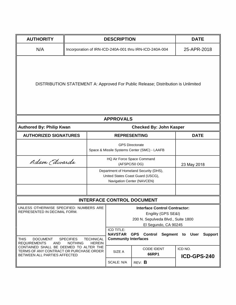
REVISION RECORD
LTR DESCRIPTION DATE APPROVED
NC Initial Release 1 Oct 2004 23 Oct 2004
A
Revision A - Bring ICD content up-to-date to
reflect as-built conditions for OCS/AEP era. Added
new NANU terms that were approved
by 2 SOPS.
27 Oct 2009 12 Jan 2010
B
IRN-ICD-240A-001 – RFC 223 – Contingency Operations Implementation
23 Jul 2015 24 Mar 2016
IRN-ICD-240A-002 – RFC 308 – Update ICD-GPS-870 and ICD-GPS-240 to align with new OCX to external agency interfaces
21 Sep 2016 13 Mar 2017
IRN-ICD-240A-003 – RFC 352 – Update ICD-GPS-240 and ICD-GPS-870 for NANU Issuance
6 Sep 2017 8 Jan 2018 IRN-ICD-240A-004 – RFC 351 – Message Updates to ICD-GPS-240 and ICD-GPS-870
Up Rev Release 25 Apr 2018 22 May 2018
ICD-GPS-240B
22 May 2018
i
TABLE OF CONTENTS
1 SCOPE ................................................................................................................................................................. 1
1.1 Scope ............................................................................................................................................................. 1
1.2 Key Dates ...................................................................................................................................................... 1
1.3 ICD Approval and Changes .......................................................................................................................... 2
2 APPLICABLE DOCUMENTS ........................................................................................................................... 3
2.1 Government Documents ............................................................................................................................... 3
2.2 Non-Government Documents ....................................................................................................................... 5
3 REQUIREMENTS ............................................................................................................................................... 6
3.1 Interface Identification .................................................................................................................................. 6
3.2 Interface Definitions ..................................................................................................................................... 7
3.2.1 Almanac Interface between the GPS CS and the GUSS Offline Tool .................................................. 7
3.2.2 Interfaces between the GPS CS and the USCG NAVCEN ................................................................... 8
3.2.2.1 NAVCEN NANU Interface ............................................................................................................ 9
3.2.2.2 NAVCEN OA Interface .................................................................................................................. 9
3.2.2.3 Satellite Outage File (SOF) ............................................................................................................. 9
3.2.2.4 NAVCEN Almanac Interface ......................................................................................................... 9
3.2.3 Interfaces between the GPS CS and the Military User Community .................................................... 10
3.2.3.1 Military User Community Internet NANU, OA, SOF and Almanac Interfaces ........................... 10
3.2.3.2 Military User Community SIPRNET NANU, OA, SOF and Almanac Interfaces ....................... 10
4 QUALITY ASSURANCE ................................................................................................................................. 11
5 PREPARATION FOR DELIVERY .................................................................................................................. 12
6 NOTES ............................................................................................................................................................... 13
6.1 Acronyms and Abbreviations ..................................................................................................................... 13
7 APPROVAL ...................................................................................................................................................... 15
10 APPENDIX 1: NANU DATA FORMATS .................................................................................................... 16
10.1 Notice Advisory to Navstar Users ............................................................................................................ 16
10.1.1 Scheduled Outages ............................................................................................................................. 16
10.1.2 Unscheduled Outages......................................................................................................................... 17
10.1.3 General NANU Messages .................................................................................................................. 17
10.1.4 Other Messages .................................................................................................................................. 18
10.2 NANU Notification Times ........................................................................................................................ 20
10.3 NANU Message Format ........................................................................................................................... 21
10.3.1 NANU Header ................................................................................................................................... 21
10.3.2 NANU Section One ........................................................................................................................... 22
10.3.2.1 NANU Message Description ...................................................................................................... 22
10.3.2.2 NANU Reference Information .................................................................................................... 22
10.3.2.3 Satellite Identification ................................................................................................................. 23
10.3.2.4 Outage Time................................................................................................................................ 23
ICD-GPS-240B
22 May 2018
ii
10.3.3 NANU Section Two ........................................................................................................................... 24
10.3.4 NANU Section Three ......................................................................................................................... 24
20 APPENDIX 2: OPERATIONAL ADVISORY .............................................................................................. 25
20.1 Operational Advisory ................................................................................................................................ 25
20.2 OA Header. ............................................................................................................................................... 26
20.3 OA Section One ........................................................................................................................................ 26
20.4 OA Section Two ....................................................................................................................................... 27
20.5 OA Section Three. .................................................................................................................................... 27
30 APPENDIX 3: SATELLITE OUTAGE FILE (SOF) ..................................................................................... 28
40 APPENDIX 4: ALMANAC DATA FILES .................................................................................................... 35
40.1 Almanac Description ................................................................................................................................ 35
40.2 SEM Almanac Parameters Definition ....................................................................................................... 35
40.3 SV Health Word ........................................................................................................................................ 35
40.4 SEM Almanac Format .............................................................................................................................. 35
40.5 YUMA Almanac ....................................................................................................................................... 39
50 APPENDIX 5: LETTERS OF EXCEPTION ................................................................................................. 40
50.1 Scope ......................................................................................................................................................... 40
50.2 Applicable Documents .............................................................................................................................. 40
50.3 Letters of Exception .................................................................................................................................. 40

ICD-GPS-240B
22 May 2018
iii
LIST OF TABLES
Table I Information Exchange Matrix ................................................................................................................... 6
Table 10-I Scheduled Outages ............................................................................................................................. 16
Table 10-II Unscheduled Outages ....................................................................................................................... 17
Table 10-III Other Types of NANU Messages .................................................................................................... 18
Table 10-IV NANU Notification Times .............................................................................................................. 20
Table 40-I Almanac Health .................................................................................................................................. 35
Table 40-II Almanac Description (Sheet 1 of 2) .................................................................................................. 37
Table 40-II Almanac Description (Sheet 2 of 2) .................................................................................................. 38
Table 50-I Letter of Exception .............................................................................................................................. 41

ICD-GPS-240B
22 May 2018
iv
LIST OF FIGURES
Figure 1 GPS CS to GUSS Interface ...................................................................................................................... 8
Figure 2 GPS CS to USCG NAVCEN Interface .................................................................................................... 8
Figure 3 GPS CS to Military User Community Interface ..................................................................................... 10
Figure 10-1 General Message Format.................................................................................................................. 18
Figure 10-2 LAUNCH NANU Message Template ............................................................................................. 19
Figure 10-3 DECOM NANU Message Template ................................................................................................ 19
Figure 10-4 NANU Message Template ............................................................................................................... 21
Figure 10-5 NANU Header Example .................................................................................................................. 22
Figure 10-6 Message Description Example .......................................................................................................... 22
Figure 10-7 Reference Information Example ....................................................................................................... 23
Figure 10-8 Satellite Identification Information Example .................................................................................... 23
Figure 10-9 Outage Time Example ....................................................................................................................... 23
Figure 10-10 NANU Section 2 Example .............................................................................................................. 24
Figure 10-11 Contact Information ........................................................................................................................ 24
Figure 20-1 Sample Operational Advisory ........................................................................................................... 25
Figure 20-2 OA Header ........................................................................................................................................ 26
Figure 20-3 OA Section One ................................................................................................................................ 26
Figure 20-4 OA Section Two ................................................................................................................................ 27
Figure 20-5 OA Section Three ............................................................................................................................. 27
Figure 40-1 SEM Data Sample ............................................................................................................................ 36
Figure 40-2 YUMA Almanac Data Sample......................................................................................................... 39
ICD-GPS-240B
22 May 2018
1
1 SCOPE
1.1 Scope
This Interface Control Document (ICD) defines the following Global Positioning System (GPS) automated
interfaces that serve the GPS user and user-support communities during the Operational Control System
(OCS)/Architecture Evolution Plan (AEP) systems era:
The functional data transfer interface between the GPS Control Segment (CS) and the GPS User Support
Software (GUSS) offline tool.
The physical data transfer interface between the GPS CS and the Schriever Air Force Base (AFB) local area
network (LAN) on which the GUSS offline tool resides.
The functional data transfer interfaces between the CS and the United States Coast Guard (USCG) Navigation
Center (NAVCEN). These interfaces support the Memorandum of Agreement (MOA) between the
Department of Defense (DoD) Joint Functional Component Command for Space (JFCC SPACE); the
Department of Homeland Security (DHS) U.S. Coast Guard Navigation Center (NAVCEN); and the
Department of Transportation (DOT) Federal Aviation Administration (FAA) National Operations Control
Center (NOCC), “Interagency Memorandum of Agreement with Respect to Support of Users of the Navstar
Global Positioning System (GPS).”
The functional data transfer interfaces between the CS and the military user community.
This ICD identifies the data transfer requirements for these interfaces. The GUSS software tool is functionally a
part of the CS, but resides on hardware that is physically outside the CS. Therefore the functional and physical
interfaces between the CS and the GUSS tool are described in this ICD at the physical boundary of the CS. The
interfaces between the GPS CS and the NAVCEN and the GPS CS and the military user community are
implemented using electronic mail (e-mail), internet and SIPRNET. These interfaces are described only at the
functional (application) level in this ICD. This ICD does not include detailed technical descriptions of the e-mail
system, internet or SIPRNET.
1.2 Key Dates
None
ICD-GPS-240B
22 May 2018
2
1.3 ICD Approval and Changes
The Interface Control Contractor (ICC), designated by the government, is responsible for the basic preparation,
approval, distribution, and retention of the ICD in accordance with the Interface Control Working Group (ICWG)
charter GP-03-001.
The following signatories must approve this ICD to make it effective.
United States Air Force (USAF), Space Command (AFSPC), GPS Wing (GPSW) Space and Missile
Systems Center (SMC)
USAF, AFSPC, 50th Space Wing (50 SW)
United States Coast Guard (USCG), Navigation Center (NAVCEN)
The Boeing Company
Initial signature approval of this ICD can be contingent upon a letter of exception delineating those items by
paragraph numbers that are not a part of the approval. Such letter of exception can be prepared by any of the
signatories and must be furnished to the ICC for inclusion in the printed distribution of the officially released
version of the ICD.
Changes to the approved version of this ICD can be initiated by any of the signatories and must be approved by
all above signatories. The ICC is responsible for the preparation of the change pages, change coordination, and
the change approval by all signatories. Designated signatories can approve proposed changes to this ICD without
any increase in the scope of a specific contract by so specifying in a letter of exception. Such letters of exception
must be furnished to the ICC for inclusion in the released version of the approved change and in the printed
distribution of the approved ICD.
Whenever all of the issues addressed by a letter of exception are resolved, the respective signatory shall so advise
the ICC in writing. When a portion of the exceptions taken by a signatory are resolved (but not all), the signatory
shall provide the ICC with an updated letter of exception. Based on such notifications -- without processing a
proposed interface revision notice (PIRN) for approval -- the ICC will omit the obsolete letter of exception from
the next revision of the ICD and will substitute the new one (if required).
The typical review cycle for a PIRN is 45 days after receipt by individual addressees unless a written request for
a waiver is submitted to the ICC.
ICD-GPS-240B
22 May 2018
3
2 APPLICABLE DOCUMENTS
2.1 Government Documents
The following documents of the issue specified contribute to the definition of the interfaces in this ICD and form
a part of this ICD to the extent specified herein.
Specifications
Federal
None
Military
None
Other Government Activity
None
Standards
Federal
None
Military
None
ICD-GPS-240B
22 May 2018
4
Other Publications
IS-GPS-200
Current Version
Navstar GPS Space Segment/Navigation User
Interface
GP-03-001
14 November 2003
GPS Interface Control Working Group (ICWG)
Charter
MOA
February 1992
Memorandum of Agreement Between the United
States Coast Guard and the United States Space
Command, “Distribution of Navstar Global
Positioning System (GPS) Status Information”
(Signatories: USCG/G-NRN and USSPC/DOO)
MOA
February 1996
Support Agreement Between the United States Coast
Guard and the United States Air Force Space
Command, “Distribution of Navstar Global
Positioning System (GPS) Status Information”
(Signatories: Commanding Officer NAVCEN and
AFSPC/DOO)
MOA
February 2010
Memorandum of Agreement between the Joint
Functional Component Command for Space; the US
Coast Guard Navigation Center and the FAA National
Operations Control Center with respect to the Support
of Users of the Navstar Global Positioning System
MOA
June 2014
Interagency Memorandum of Agreement with Respect
to Support of Users of the Navstar Global Positioning
System (GPS)
ICD-GPS-240B
22 May 2018
5
2.2 Non-Government Documents
The following documents of the issue specified contribute to the definition of the interfaces in this ICD and form
a part of this ICD to the extent specified herein.
Specifications
None
Standards
None
Other Publications
None

ICD-GPS-240B
22 May 2018
6
3 REQUIREMENTS
3.1 Interface Identification
The interfaces defined in this ICD are listed in Table I, in the form of an information exchange matrix.
Table I Information Exchange Matrix
The information distributed by the CS includes Notice Advisory to Navstar Users (NANU), Operational Advisory
(OA), Satellite Outage File (SOF) and satellite almanac. The NANU is a message that informs users of satellite
outages and other GPS issues. The OA is a descriptive summary of GPS constellation status. The SOF is a
machine readable format of GPS satellite outage information. The satellite almanac contains orbital and
performance parameters for operational GPS satellites. The primary means of data distribution include electronic
mail (e-mail) and Internet and SIPRNET websites. All data transfer described in this ICD is unclassified.
Producer Consumer Data Exchange Identification
Information Description
Nature of Transaction
Security
GPS CS GUSS Offline Software Tool
GPS Constellation Orbital and Performance Parameters
Almanac Transfer via diskette
Unclassified
GPS CS USCG NAVCEN GPS Status Information NANU Transmit via E-Mail
Unclassified
GPS CS USCG NAVCEN GPS Constellation Status Summary
OA Post to Internet Website
Unclassified
GPS CS USCG NAVCEN GPS Constellation Orbital and Performance Parameters
Almanac Post to Internet Website
Unclassified
GPS CS USCG NAVCEN GPS Status Information Satellite Outage File
Post to Internet Website
Unclassified
GPS CS Military User Community
GPS Status Information NANU Post to Internet and SIPRNET Websites
Unclassified
GPS CS Military User Community
GPS Constellation Status Summary
OA Post to Internet and SIPRNET Websites
Unclassified
GPS CS Military User Community
GPS Constellation Orbital and Performance Parameters
Almanac Post to Internet and SIPRNET Websites
Unclassified
GPS CS Military User Community
GPS Status Information Satellite Outage File
Post to Internet and SIPRNET Websites
Unclassified
ICD-GPS-240B
22 May 2018
7
3.2 Interface Definitions
The following paragraphs define the physical interface between the CS and the Schriever AFB LAN on which
the GUSS offline software tool resides. The following paragraphs also describe the functional interfaces between
the CS and the GUSS tool, USCG NAVCEN, and the military user community.
Unless otherwise specified in the paragraphs below, e-mail used for data transfer is generated and transmitted
using resources of the Schriever AFB LAN. Internet website hosting, uploads, and downloads are also
accomplished using resources of the Schriever AFB LAN. SIPRNET website hosting, uploads, and downloads
are accomplished using resources of the Peterson AFB LAN. The hardware and software interfaces of the internet
and these LAN’s are not controlled by this ICD. Therefore, these interfaces are described at the functional
(application) level only in this ICD.
The address of the 2 SOPS internet website, Constellation Status Page, referenced in the subsequent subsections
is https://gps.afspc.af.mil/gps/. The address of the GPS Operations Center (GPSOC) internet website referenced
in the subsequent subsections is http://gps.afspc.af.mil/gpsoc/. The address of the GPS Operations Center
SIPRNET website referenced in the subsequent subsections is distributed separately to authorized military users
and, therefore, not listed in this ICD.
Detailed data formats of the NANU, OA, SOF and almanac data that are referenced in the paragraphs below are
described in Appendices 1, 2, 3 and 4 of this ICD, respectively.
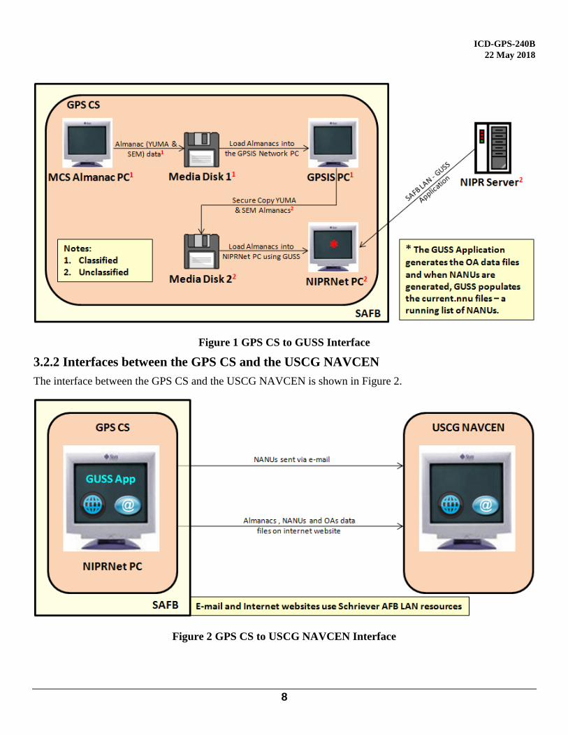
3.2.1 Almanac Interface between the GPS CS and the GUSS Offline Tool
Almanac data from the legacy CS are transferred to the GUSS via a 3.5-inch, high-density, 1.44 megabyte,
International Business Machines Corporation (IBM) personal computer (PC) format diskette. The diskette
contains one current System Effectiveness Model (SEM) format almanac and one current YUMA format almanac
downloaded from the CS Almanac computer. The files are downloaded in the Windows® PC file format.
(Windows is a registered trademark of the Microsoft Corporation.) The filename assigned to the SEM almanac
is current.al3. The filename assigned to the YUMA almanac is current.alm. The files are downloaded to the
diskette using a secure copy program to assure no classified data is transferred to the diskette. The files are
uploaded to the GUSS software tool using a Windows®-compatible computer connected to the Schriever AFB
LAN. The files are normally transferred from the CS to the GUSS once per day, prior to 1700 Zulu time (10 am
Mountain Standard Time (MST), 11 am Mountain Daylight Time (MDT)).
The interface between the GPS CS and the GUSS Offline Tool is shown in Figure 1.
ICD-GPS-240B
22 May 2018
8
Figure 1 GPS CS to GUSS Interface
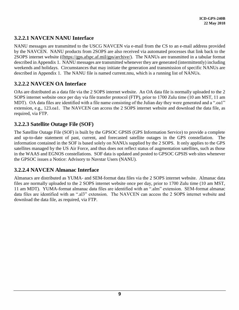
3.2.2 Interfaces between the GPS CS and the USCG NAVCEN
The interface between the GPS CS and the USCG NAVCEN is shown in Figure 2.
Figure 2 GPS CS to USCG NAVCEN Interface
ICD-GPS-240B
22 May 2018
9
3.2.2.1 NAVCEN NANU Interface
NANU messages are transmitted to the USCG NAVCEN via e-mail from the CS to an e-mail address provided
by the NAVCEN. NANU products from 2SOPS are also received via automated processes that link back to the
2SOPS internet website ((https://gps.afspc.af.mil/gps/archive/). The NANUs are transmitted in a tabular format
described in Appendix 1. NANU messages are transmitted whenever they are generated (intermittently) including
weekends and holidays. Circumstances that may initiate the generation and transmission of specific NANUs are
described in Appendix 1. The NANU file is named current.nnu, which is a running list of NANUs.
3.2.2.2 NAVCEN OA Interface
OAs are distributed as a data file via the 2 SOPS internet website. An OA data file is normally uploaded to the 2
SOPS internet website once per day via file transfer protocol (FTP), prior to 1700 Zulu time (10 am MST, 11 am
MDT). OA data files are identified with a file name consisting of the Julian day they were generated and a “.oa1”
extension, e.g., 123.oa1. The NAVCEN can access the 2 SOPS internet website and download the data file, as
required, via FTP.
3.2.2.3 Satellite Outage File (SOF)
The Satellite Outage File (SOF) is built by the GPSOC GPSIS (GPS Information Service) to provide a complete
and up-to-date statement of past, current, and forecasted satellite outages in the GPS constellation. The
information contained in the SOF is based solely on NANUs supplied by the 2 SOPS. It only applies to the GPS
satellites managed by the US Air Force, and thus does not reflect status of augmentation satellites, such as those
in the WAAS and EGNOS constellations. SOF data is updated and posted to GPSOC GPSIS web sites whenever
the GPSOC issues a Notice: Advisory to Navstar Users (NANU).
3.2.2.4 NAVCEN Almanac Interface
Almanacs are distributed as YUMA- and SEM-format data files via the 2 SOPS internet website. Almanac data
files are normally uploaded to the 2 SOPS internet website once per day, prior to 1700 Zulu time (10 am MST,
11 am MDT). YUMA-format almanac data files are identified with an “.alm” extension. SEM-format almanac
data files are identified with an “.al3” extension. The NAVCEN can access the 2 SOPS internet website and
download the data file, as required, via FTP.
ICD-GPS-240B
22 May 2018
10
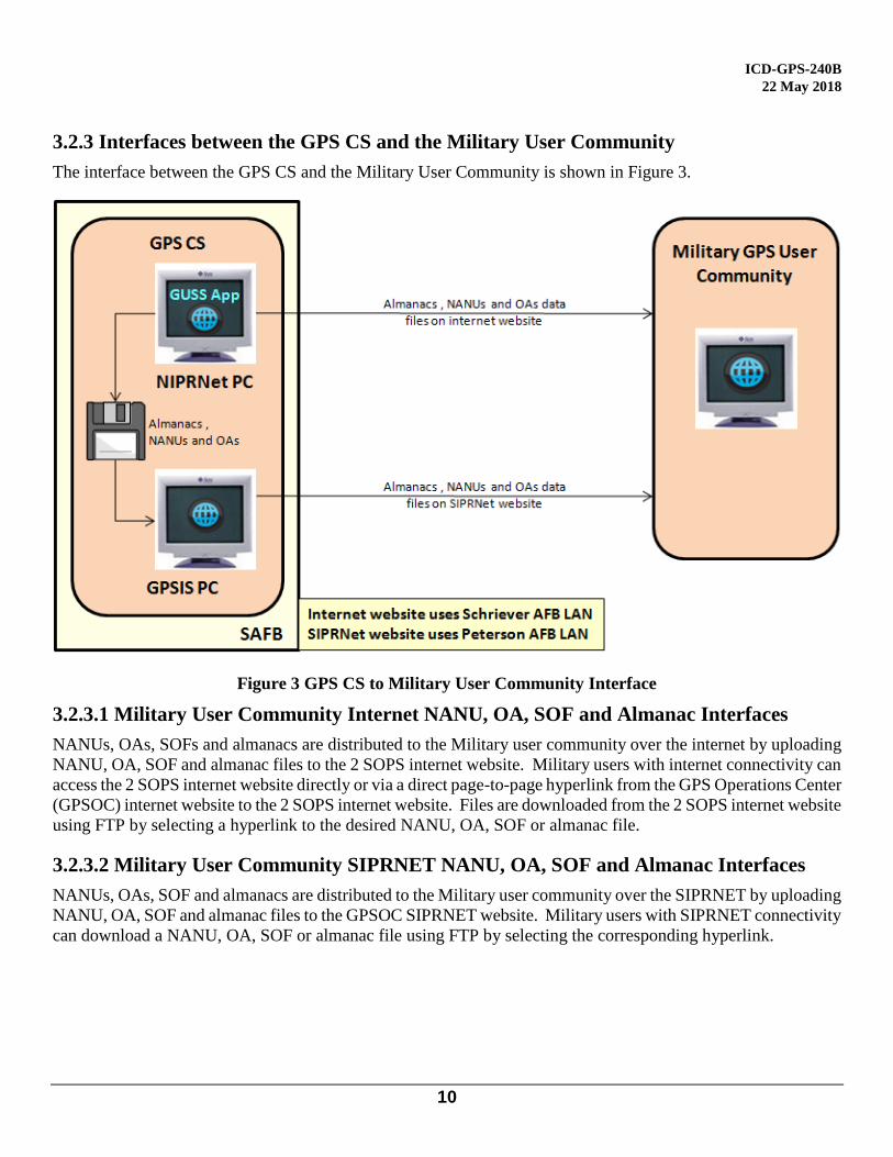
3.2.3 Interfaces between the GPS CS and the Military User Community
The interface between the GPS CS and the Military User Community is shown in Figure 3.
Figure 3 GPS CS to Military User Community Interface
3.2.3.1 Military User Community Internet NANU, OA, SOF and Almanac Interfaces
NANUs, OAs, SOFs and almanacs are distributed to the Military user community over the internet by uploading
NANU, OA, SOF and almanac files to the 2 SOPS internet website. Military users with internet connectivity can
access the 2 SOPS internet website directly or via a direct page-to-page hyperlink from the GPS Operations Center
(GPSOC) internet website to the 2 SOPS internet website. Files are downloaded from the 2 SOPS internet website
using FTP by selecting a hyperlink to the desired NANU, OA, SOF or almanac file.
3.2.3.2 Military User Community SIPRNET NANU, OA, SOF and Almanac Interfaces
NANUs, OAs, SOF and almanacs are distributed to the Military user community over the SIPRNET by uploading
NANU, OA, SOF and almanac files to the GPSOC SIPRNET website. Military users with SIPRNET connectivity
can download a NANU, OA, SOF or almanac file using FTP by selecting the corresponding hyperlink.

ICD-GPS-240B
22 May 2018
11
4 QUALITY ASSURANCE
Not Applicable

ICD-GPS-240B
22 May 2018
12
5 PREPARATION FOR DELIVERY
Not Applicable
ICD-GPS-240B
22 May 2018
13
6 NOTES
6.1 Acronyms and Abbreviations
2 SOPS 2nd Space Operations Squadron
50 SW 50th Space Wing
AEP Architecture Evolution Plan
AF Air Force
AFB Air Force Base
AFSPC Air Force Space Command
ANOM Anomaly
ASCEN Ascension
ASCII American Standard Code for Information Interchange
COMM Commercial
CS Control Segment, Cesium
DSN Defense Switched Network
DTG Day Time Group
FTP File Transfer Protocol
GPS Global Positioning System
GPSOC GPS Operations Center
GUSS GPS User Support Software
IBM International Business Machines Corporation
ICC Interface Control Contractor
ICD Interface Control Document
ICWG Interface Control Working Group
ID Identification
JDAY Julian Day of the Year
JPO Joint Program Office
LAN Local Area Network
LLC Limited Liability Company
LSB Least Significant Bit
m Meters
MDT Mountain Daylight Time
MOA Memorandum of Agreement
MSG Message
MST Mountain Standard Time
N/A Not Applicable
NANU Notice Advisory to Navstar Users
NAV Navigation
NAVCEN Navigation Center
NC No Change
OA Operational Advisory
OCS Operational Control System
PC Personal Computer
PIRN Proposed Interface Revision Notice
PRN Pseudorandom Noise (Signal Number)
POC Point Of Contact
ICD-GPS-240B
22 May 2018
14
RB Rubidium
s Seconds
SEM System Effectiveness Model
SIPRNET Secret Internet Protocol Router Network
SMC Space and Missile Systems Center
SQRT Square Root
SUBJ Subject
SV Space Vehicle
SVN Space Vehicle Number
URA User Range Accuracy
USAF United States Air Force
USCG United States Coast Guard
ICD-GPS-240B
22 May 2018
15
7 APPROVAL
The signatories have approved this ICD with or without exception as their signature block implies and a copy of
each approval sheet is included in this section.

ICD-GPS-240B
22 May 2018
16
10 APPENDIX 1: NANU DATA FORMATS
10.1 Notice Advisory to Navstar Users
NANUs are used to notify users of scheduled and unscheduled satellite outages and general GPS information.
The paragraphs that follow describe the different types of NANUs. The NANU descriptions are arranged into
four groups, as follows:
Scheduled outages
Unscheduled outages
General text message
Others
10.1.1 Scheduled Outages
NANU types in the scheduled outage group forecast outages that are planned to begin in the near future. Table
10-I identifies NANU types in the scheduled outage group. The table describes the NANU acronym used in the
message format, the name of the file and a description of the outages. NANU acronyms in this group all begin
with “FCST” for “forecast.”
Table 10-I Scheduled Outages
NANU ACRONYM
NAME DESCRIPTION
FCSTDV Forecast Delta-V Scheduled outage times for Delta-V maneuvers.
FCSTMX Forecast Maintenance
Scheduled outage times for non-Delta-V maintenance.
FCSTEXTD Forecast Extension
Extends the scheduled outage time “Until Further Notice”; references the original forecast NANU.
FCSTSUMM Forecast Summary
Exact outage times for the scheduled outage. This is sent after the maintenance is complete and the satellite is set healthy. It references the original forecast NANU. If a FCSTEXTD or a FCSTRESCD were required the FCSTSUMM will reference these.
FCSTCANC Forecast Cancellation
Cancels a scheduled outage when a new maintenance time is not yet determined. It references the original forecast NANU message. May be issued after the start time of the referenced NANU.
FCSTRESCD Forecast rescheduled
Reschedules a scheduled outage referencing the original-FCST NANU message.
FCSTUUFN Forecast Unusable Until Further Notice
Scheduled outage of indefinite duration not necessarily related to Delta-V or maintenance activities.
ICD-GPS-240B
22 May 2018
17
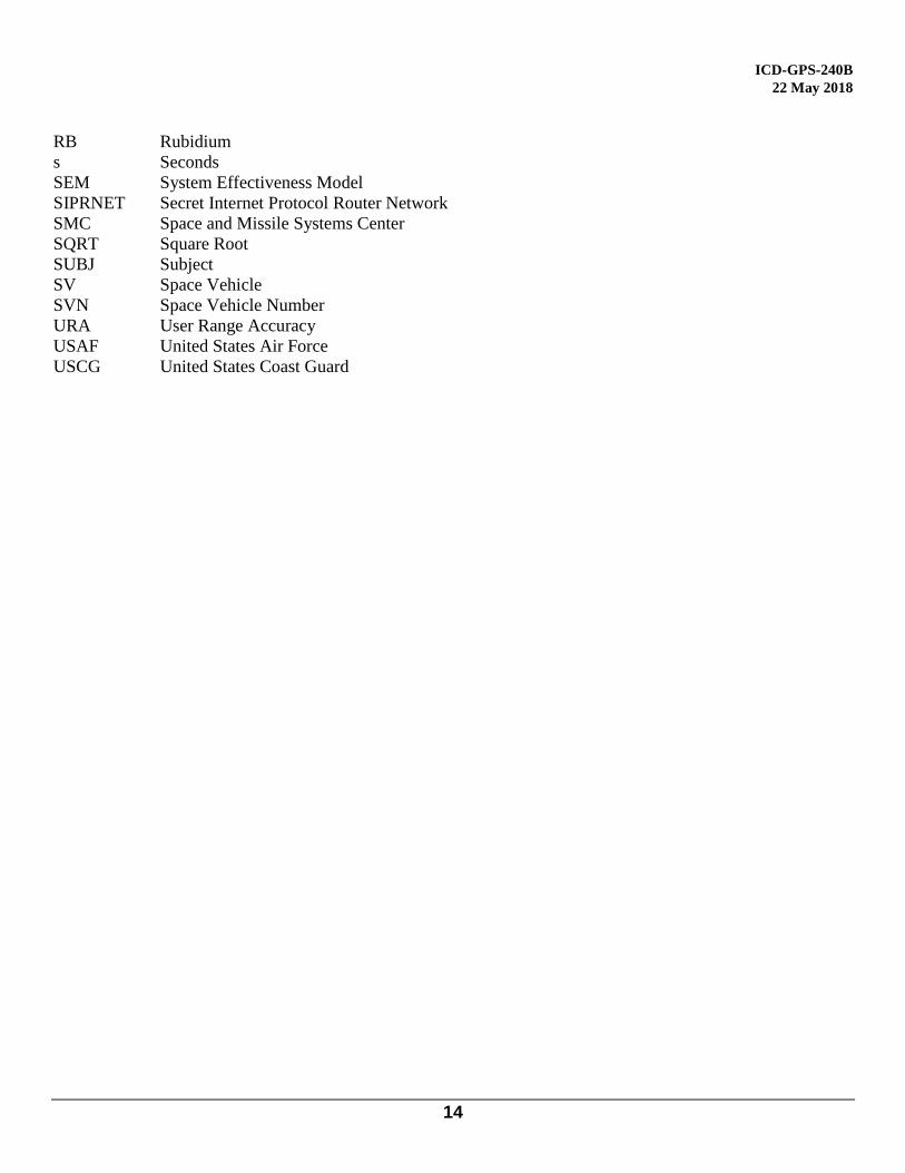
10.1.2 Unscheduled Outages
NANU types in the unscheduled outage group describe unplanned outages that are ongoing or have occurred in
the recent past. Table 10-II identifies NANU types in the unscheduled outage group. The table describes the
NANU acronym used in the message format, the name of the file and a description of the outages. NANU
acronyms in this group all begin with “UNU” or “UNUS” for “unusable.”
Table 10-II Unscheduled Outages
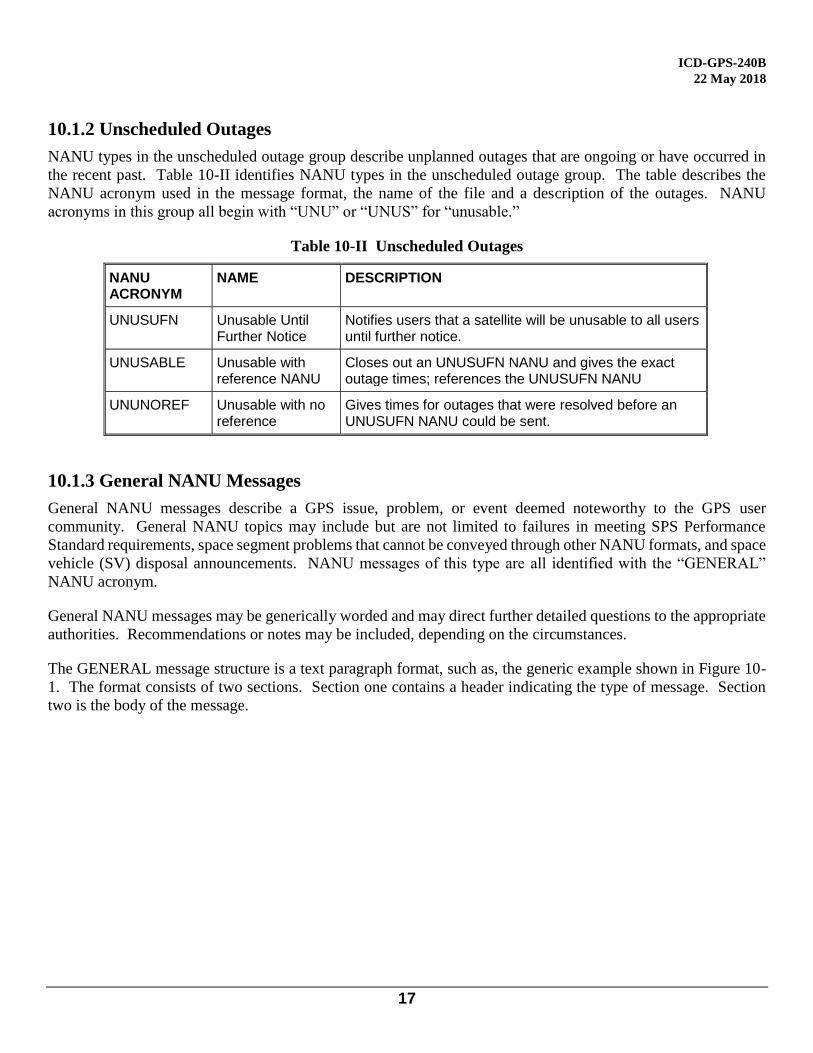
10.1.3 General NANU Messages
General NANU messages describe a GPS issue, problem, or event deemed noteworthy to the GPS user
community. General NANU topics may include but are not limited to failures in meeting SPS Performance
Standard requirements, space segment problems that cannot be conveyed through other NANU formats, and space
vehicle (SV) disposal announcements. NANU messages of this type are all identified with the “GENERAL”
NANU acronym.
General NANU messages may be generically worded and may direct further detailed questions to the appropriate
authorities. Recommendations or notes may be included, depending on the circumstances.
The GENERAL message structure is a text paragraph format, such as, the generic example shown in Figure 10-
1. The format consists of two sections. Section one contains a header indicating the type of message. Section
two is the body of the message.
NANU ACRONYM
NAME DESCRIPTION
UNUSUFN Unusable Until Further Notice
Notifies users that a satellite will be unusable to all users until further notice.
UNUSABLE Unusable with reference NANU
Closes out an UNUSUFN NANU and gives the exact outage times; references the UNUSUFN NANU
UNUNOREF Unusable with no reference
Gives times for outages that were resolved before an UNUSUFN NANU could be sent.
ICD-GPS-240B
22 May 2018
18
Figure 10-1 General Message Format
10.1.4 Other Messages
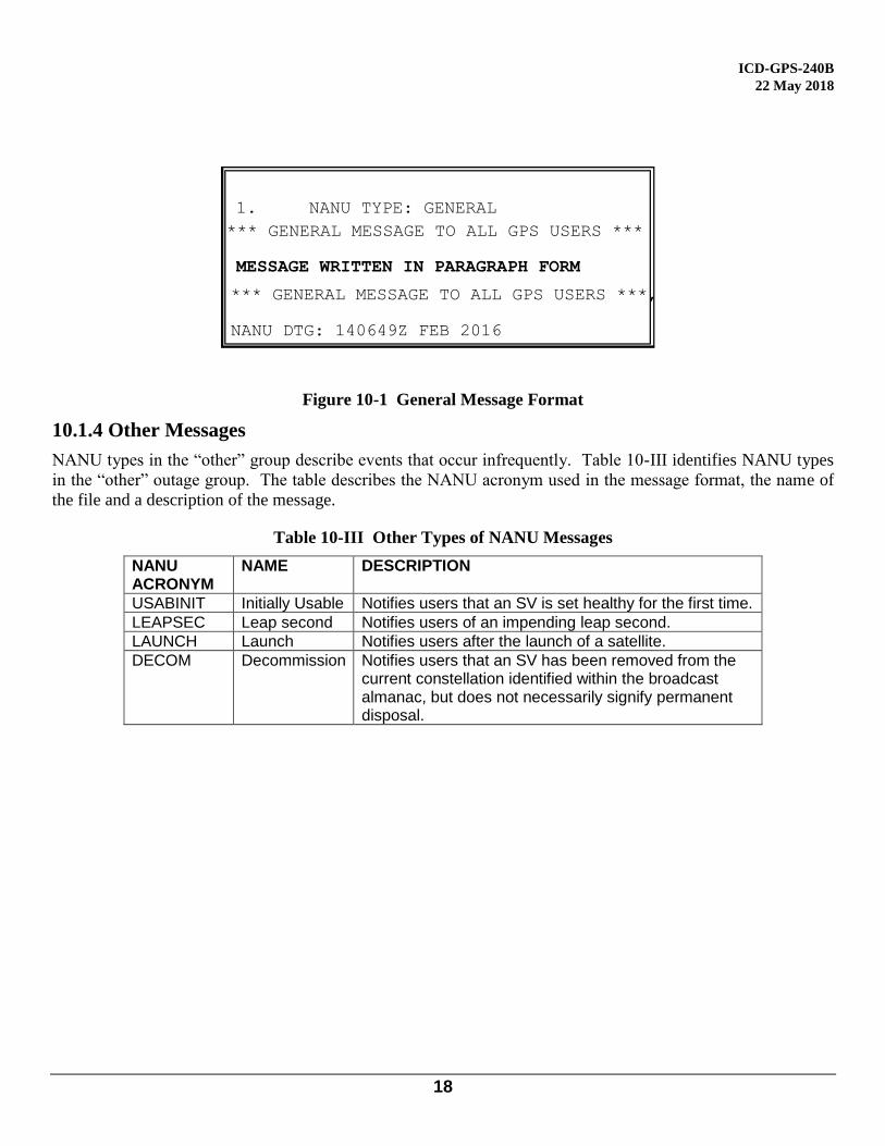
NANU types in the “other” group describe events that occur infrequently. Table 10-III identifies NANU types
in the “other” outage group. The table describes the NANU acronym used in the message format, the name of
the file and a description of the message.
Table 10-III Other Types of NANU Messages
NANU ACRONYM
NAME DESCRIPTION
USABINIT Initially Usable Notifies users that an SV is set healthy for the first time.
LEAPSEC Leap second Notifies users of an impending leap second.
LAUNCH Launch Notifies users after the launch of a satellite.
DECOM Decommission Notifies users that an SV has been removed from the current constellation identified within the broadcast almanac, but does not necessarily signify permanent disposal.
1. NANU TYPE: GENERAL
*** GENERAL MESSAGE TO ALL GPS USERS ***
MESSAGE WRITTEN IN PARAGRAPH FORM *** GENERAL MESSAGE TO ALL GPS USERS ***,
NANU DTG: 140649Z FEB 2016
ICD-GPS-240B
22 May 2018
19
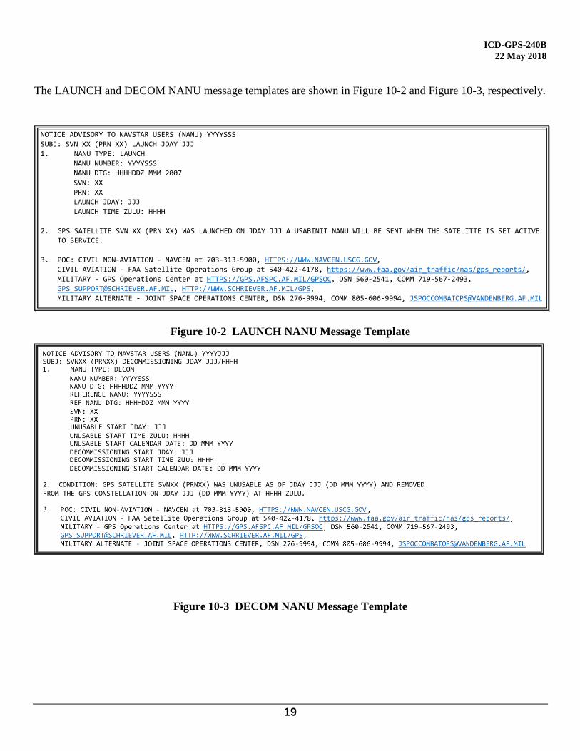
The LAUNCH and DECOM NANU message templates are shown in Figure 10-2 and Figure 10-3, respectively.
NOTICE ADVISORY TO NAVSTAR USERS (NANU) YYYYSSS
SUBJ: SVN XX (PRN XX) LAUNCH JDAY JJJ
1. NANU TYPE: LAUNCH
NANU NUMBER: YYYYSSS
NANU DTG: HHHHDDZ MMM 2007
SVN: XX
PRN: XX
LAUNCH JDAY: JJJ
LAUNCH TIME ZULU: HHHH
2. GPS SATELLITE SVN XX (PRN XX) WAS LAUNCHED ON JDAY JJJ A USABINIT NANU WILL BE SENT WHEN THE SATELITTE IS SET ACTIVE
TO SERVICE.
3. POC: CIVIL NON-AVIATION - NAVCEN at 703-313-5900, HTTPS://WWW.NAVCEN.USCG.GOV,
CIVIL AVIATION - FAA Satellite Operations Group at 540-422-4178, https://www.faa.gov/air_traffic/nas/gps_reports/,
MILITARY - GPS Operations Center at HTTPS://GPS.AFSPC.AF.MIL/GPSOC, DSN 560-2541, COMM 719-567-2493, [email protected], HTTP://WWW.SCHRIEVER.AF.MIL/GPS, MILITARY ALTERNATE - JOINT SPACE OPERATIONS CENTER, DSN 276-9994, COMM 805-606-9994, [email protected]
Figure 10-2 LAUNCH NANU Message Template
Figure 10-3 DECOM NANU Message Template
ICD-GPS-240B
22 May 2018
20
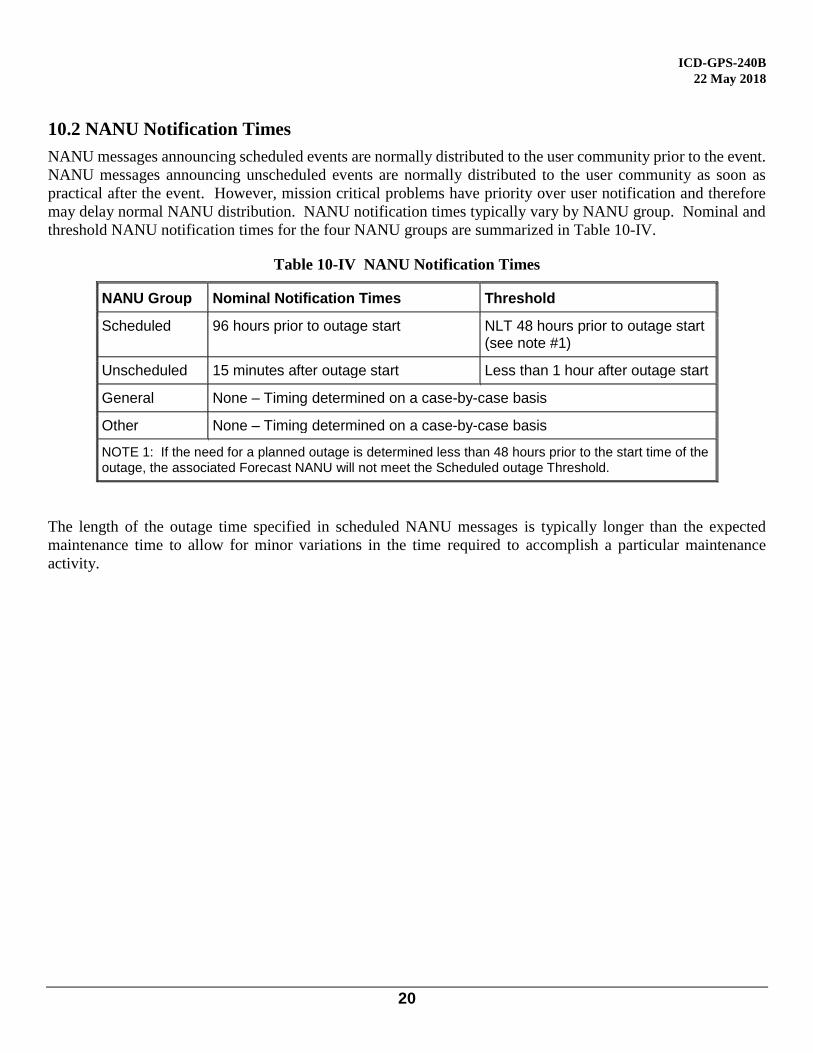
10.2 NANU Notification Times
NANU messages announcing scheduled events are normally distributed to the user community prior to the event.
NANU messages announcing unscheduled events are normally distributed to the user community as soon as
practical after the event. However, mission critical problems have priority over user notification and therefore
may delay normal NANU distribution. NANU notification times typically vary by NANU group. Nominal and
threshold NANU notification times for the four NANU groups are summarized in Table 10-IV.
Table 10-IV NANU Notification Times
NANU Group Nominal Notification Times Threshold
Scheduled 96 hours prior to outage start NLT 48 hours prior to outage start (see note #1)
Unscheduled 15 minutes after outage start Less than 1 hour after outage start
General None – Timing determined on a case-by-case basis
Other None – Timing determined on a case-by-case basis
NOTE 1: If the need for a planned outage is determined less than 48 hours prior to the start time of the outage, the associated Forecast NANU will not meet the Scheduled outage Threshold.
The length of the outage time specified in scheduled NANU messages is typically longer than the expected
maintenance time to allow for minor variations in the time required to accomplish a particular maintenance
activity.
ICD-GPS-240B
22 May 2018
21
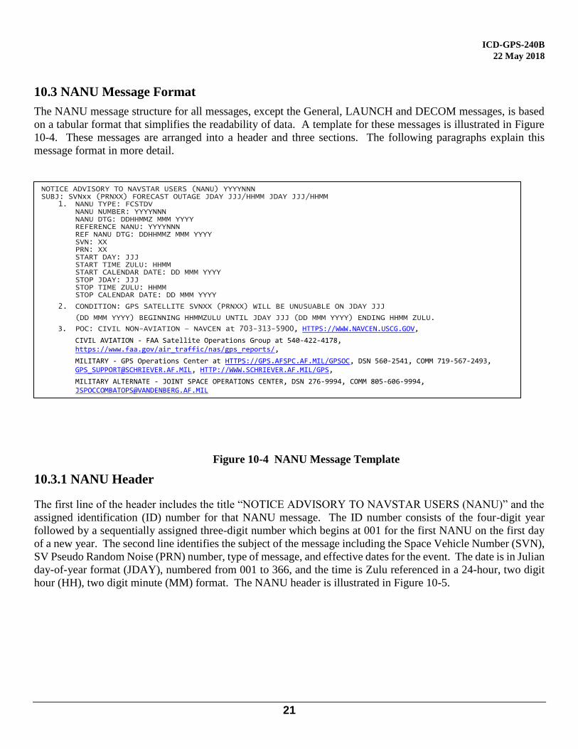
10.3 NANU Message Format
The NANU message structure for all messages, except the General, LAUNCH and DECOM messages, is based
on a tabular format that simplifies the readability of data. A template for these messages is illustrated in Figure
10-4. These messages are arranged into a header and three sections. The following paragraphs explain this
message format in more detail.
Figure 10-4 NANU Message Template
10.3.1 NANU Header
The first line of the header includes the title “NOTICE ADVISORY TO NAVSTAR USERS (NANU)” and the
assigned identification (ID) number for that NANU message. The ID number consists of the four-digit year
followed by a sequentially assigned three-digit number which begins at 001 for the first NANU on the first day
of a new year. The second line identifies the subject of the message including the Space Vehicle Number (SVN),
SV Pseudo Random Noise (PRN) number, type of message, and effective dates for the event. The date is in Julian
day-of-year format (JDAY), numbered from 001 to 366, and the time is Zulu referenced in a 24-hour, two digit
hour (HH), two digit minute (MM) format. The NANU header is illustrated in Figure 10-5.
NOTICE ADVISORY TO NAVSTAR USERS (NANU) YYYYNNN SUBJ: SVNxx (PRNXX) FORECAST OUTAGE JDAY JJJ/HHMM JDAY JJJ/HHMM
1. NANU TYPE: FCSTDV NANU NUMBER: YYYYNNN NANU DTG: DDHHMMZ MMM YYYY REFERENCE NANU: YYYYNNN REF NANU DTG: DDHHMMZ MMM YYYY SVN: XX PRN: XX START DAY: JJJ START TIME ZULU: HHMM START CALENDAR DATE: DD MMM YYYY STOP JDAY: JJJ STOP TIME ZULU: HHMM STOP CALENDAR DATE: DD MMM YYYY
2. CONDITION: GPS SATELLITE SVNXX (PRNXX) WILL BE UNUSUABLE ON JDAY JJJ
(DD MMM YYYY) BEGINNING HHMMZULU UNTIL JDAY JJJ (DD MMM YYYY) ENDING HHMM ZULU.
3. POC: CIVIL NON-AVIATION – NAVCEN at 703-313-5900, HTTPS://WWW.NAVCEN.USCG.GOV,
CIVIL AVIATION - FAA Satellite Operations Group at 540-422-4178, https://www.faa.gov/air_traffic/nas/gps_reports/,
MILITARY - GPS Operations Center at HTTPS://GPS.AFSPC.AF.MIL/GPSOC, DSN 560-2541, COMM 719-567-2493, [email protected], HTTP://WWW.SCHRIEVER.AF.MIL/GPS,
MILITARY ALTERNATE - JOINT SPACE OPERATIONS CENTER, DSN 276-9994, COMM 805-606-9994, [email protected]
ICD-GPS-240B
22 May 2018
22
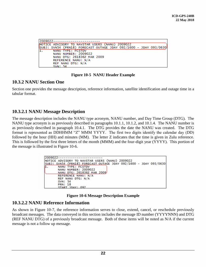
Figure 10-5 NANU Header Example
10.3.2 NANU Section One
Section one provides the message description, reference information, satellite identification and outage time in a
tabular format.
10.3.2.1 NANU Message Description
The message description includes the NANU type acronym, NANU number, and Day Time Group (DTG). The
NANU type acronym is as previously described in paragraphs 10.1.1, 10.1.2, and 10.1.4. The NANU number is
as previously described in paragraph 10.4.1. The DTG provides the date the NANU was created. The DTG
format is represented as DDHHMM “Z” MMM YYYY. The first two digits identify the calendar day (DD)
followed by the hour (HH) and minutes (MM). The letter Z indicates that the time is given in Zulu reference.
This is followed by the first three letters of the month (MMM) and the four-digit year (YYYY). This portion of
the message is illustrated in Figure 10-6.
Figure 10-6 Message Description Example
10.3.2.2 NANU Reference Information
As shown in Figure 10-7, the reference information serves to close, extend, cancel, or reschedule previously
broadcast messages. The data conveyed in this section includes the message ID number (YYYYNNN) and DTG
(REF NANU DTG) of a previously broadcast message. Both of these items will be noted as N/A if the current
message is not a follow up message.
ICD-GPS-240B
22 May 2018
23
Figure 10-7 Reference Information Example
10.3.2.3 Satellite Identification
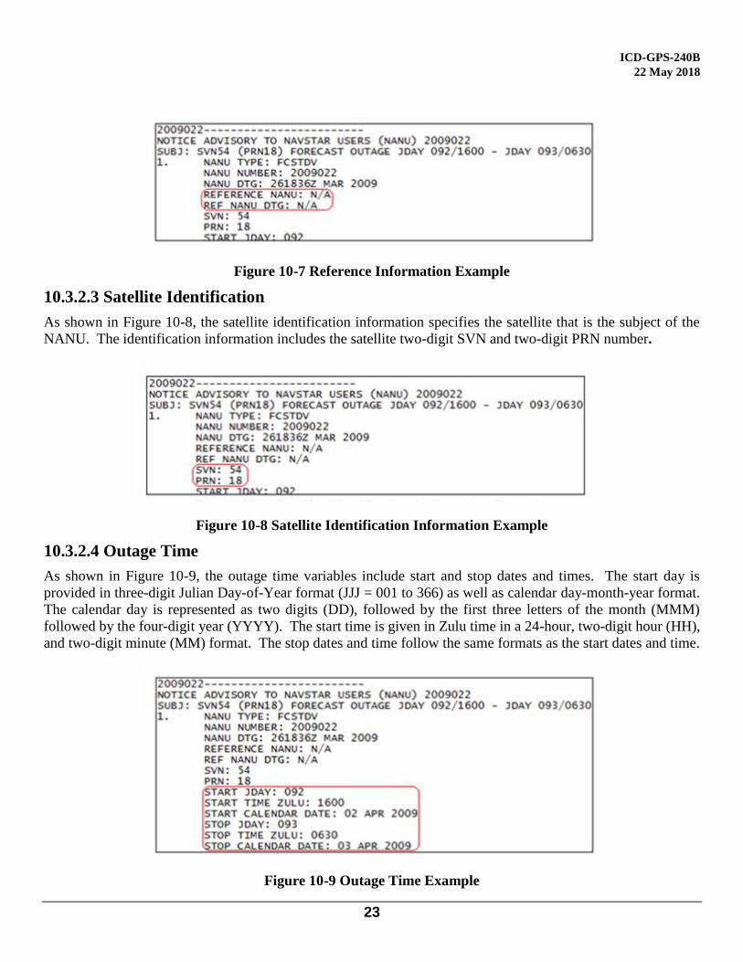
As shown in Figure 10-8, the satellite identification information specifies the satellite that is the subject of the
NANU. The identification information includes the satellite two-digit SVN and two-digit PRN number.
Figure 10-8 Satellite Identification Information Example
10.3.2.4 Outage Time
As shown in Figure 10-9, the outage time variables include start and stop dates and times. The start day is
provided in three-digit Julian Day-of-Year format (JJJ = 001 to 366) as well as calendar day-month-year format.
The calendar day is represented as two digits (DD), followed by the first three letters of the month (MMM)
followed by the four-digit year (YYYY). The start time is given in Zulu time in a 24-hour, two-digit hour (HH),
and two-digit minute (MM) format. The stop dates and time follow the same formats as the start dates and time.
Figure 10-9 Outage Time Example
ICD-GPS-240B
22 May 2018
24
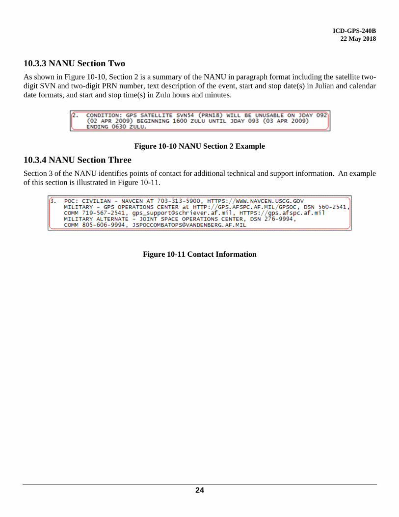
10.3.3 NANU Section Two
As shown in Figure 10-10, Section 2 is a summary of the NANU in paragraph format including the satellite two-
digit SVN and two-digit PRN number, text description of the event, start and stop date(s) in Julian and calendar
date formats, and start and stop time(s) in Zulu hours and minutes.
Figure 10-10 NANU Section 2 Example
10.3.4 NANU Section Three
Section 3 of the NANU identifies points of contact for additional technical and support information. An example
of this section is illustrated in Figure 10-11.
Figure 10-11 Contact Information
ICD-GPS-240B
22 May 2018
25
20 APPENDIX 2: OPERATIONAL ADVISORY
20.1 Operational Advisory
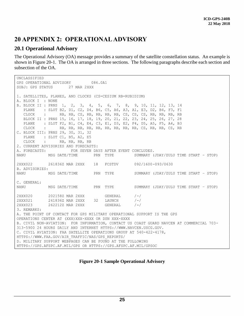
The Operational Advisory (OA) message provides a summary of the satellite constellation status. An example is
shown in Figure 20-1. The OA is arranged in three sections. The following paragraphs describe each section and
subsection of the OA.
UNCLASSIFIED
GPS OPERATIONAL ADVISORY 086.0A1
SUBJ: GPS STATUS 27 MAR 2XXX
1. SATELLITES, PLANES, AND CLOCKS (CS=CESIUM RB=RUBIDIUM)
A. BLOCK I : NONE
B. BLOCK II : PRNS 1, 2, 3, 4, 5, 6, 7, 8, 9, 10, 11, 12, 13, 14
PLANE : SLOT B2, D1, C2, D4, B6, C5, A6, A3, A1, E3, D2, B4, F3, F1
CLOCK : RB, RB, CS, RB, RB, RB, RB, CS, CS, CS, RB, RB, RB, RB
BLOCK II : PRNS 15, 16, 17, 18, 19, 20, 21, 22, 23, 24, 25, 26, 27, 28
PLANE : SLOT F2, B1, C4, E4, C3, E1, D3, E2, F4, D5, A5, F5, A4, B3
CLOCK : RB, RB, RB, RB, RB, RB, RB, RB, RB, CS, RB, RB, CS, RB
C. BLOCK III: PRNS 29, 30, 31, 32
PLANE : SLOT C1, B5, A2, E5
CLOCK : RB, RB, RB, RB
2. CURRENT ADVISORIES AND FORECASTS:
A. FORECASTS: FOR SEVEN DAYS AFTER EVENT CONCLUDES.
NANU MSG DATE/TIME PRN TYPE SUMMARY (JDAY/ZULU TIME START – STOP)
2XXX022 261836Z MAR 2XXX 18 FCSTDV 092/1600-093/0630
B. ADVISORIES:
NANU MSG DATE/TIME PRN TYPE SUMMARY (JDAY/ZULU TIME START – STOP)
C. GENERAL:
NANU MSG DATE/TIME PRN TYPE SUMMARY (JDAY/ZULU TIME START – STOP)
2XXX020 202158Z MAR 2XXX GENERAL /-/
2XXX021 241836Z MAR 2XXX 32 LAUNCH /-/
2XXX023 262212Z MAR 2XXX GENERAL /-/
3. REMARKS:
A. THE POINT OF CONTACT FOR GPS MILITARY OPERATIONAL SUPPORT IS THE GPS
OPERATIONS CENTER AT (XXX)XXX-XXXX OR DSN XXX-XXXX
B. CIVIL NON-AVIATION: FOR INFORMATION, CONTACT US COAST GUARD NAVCEN AT COMMERCIAL 703-
313-5900 24 HOURS DAILY AND INTERNET HTTPS://WWW.NAVCEN.USCG.GOV.
C. CIVIL AVIATION: FAA SATELLITE OPERATIONS GROUP AT 540-422-4178,
HTTPS://WWW.FAA.GOV/AIR_TRAFFIC/NAS/GPS_REPORTS/
D. MILITARY SUPPORT WEBPAGES CAN BE FOUND AT THE FOLLOWING
HTTPS://GPS.AFSPC.AF.MIL/GPS OR HTTPS://GPS.AFSPC.AF.MIL/GPSOC
Figure 20-1 Sample Operational Advisory
ICD-GPS-240B
22 May 2018
26
20.2 OA Header.
The header includes the title “GPS OPERATIONAL ADVISORY,” the subject “SUBJ: GPS STATUS” and the
date. The date is represented in a format that includes two-digit day (DD), the first three characters of the month
(MMM), and four-digit year (YYYY). The OA header is illustrated in Figure 20-2.
Figure 20-2 OA Header
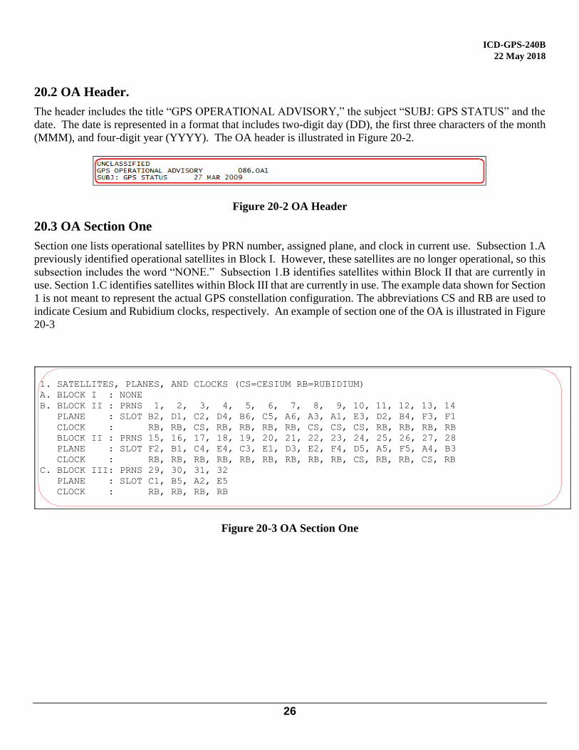
20.3 OA Section One
Section one lists operational satellites by PRN number, assigned plane, and clock in current use. Subsection 1.A
previously identified operational satellites in Block I. However, these satellites are no longer operational, so this
subsection includes the word “NONE.” Subsection 1.B identifies satellites within Block II that are currently in
use. Section 1.C identifies satellites within Block III that are currently in use. The example data shown for Section
1 is not meant to represent the actual GPS constellation configuration. The abbreviations CS and RB are used to
indicate Cesium and Rubidium clocks, respectively. An example of section one of the OA is illustrated in Figure
20-3
1. SATELLITES, PLANES, AND CLOCKS (CS=CESIUM RB=RUBIDIUM)
A. BLOCK I : NONE
B. BLOCK II : PRNS 1, 2, 3, 4, 5, 6, 7, 8, 9, 10, 11, 12, 13, 14
PLANE : SLOT B2, D1, C2, D4, B6, C5, A6, A3, A1, E3, D2, B4, F3, F1
CLOCK : RB, RB, CS, RB, RB, RB, RB, CS, CS, CS, RB, RB, RB, RB
BLOCK II : PRNS 15, 16, 17, 18, 19, 20, 21, 22, 23, 24, 25, 26, 27, 28
PLANE : SLOT F2, B1, C4, E4, C3, E1, D3, E2, F4, D5, A5, F5, A4, B3
CLOCK : RB, RB, RB, RB, RB, RB, RB, RB, RB, CS, RB, RB, CS, RB
C. BLOCK III: PRNS 29, 30, 31, 32
PLANE : SLOT C1, B5, A2, E5
CLOCK : RB, RB, RB, RB
Figure 20-3 OA Section One

ICD-GPS-240B
22 May 2018
27
20.4 OA Section Two
Section two contains a summary of current and recent advisories, forecasts, and general text messages. It is
organized into three subsections. Subsection 2A summarizes scheduled NANU messages. Subsection 2B
summarizes advisory messages (messages with prefix UNU). Section 2C summarizes general text messages. An
example of section two of the OA is illustrated in Figure 20-4.
Figure 20-4 OA Section Two
20.5 OA Section Three.
Section three identifies points of contact for additional technical and support information. It is organized into
three subsections, each in text format. An example of section three of the OA is illustrated in Figure 20-5.
Figure 20-5 OA Section Three
ICD-GPS-240B
22 May 2018
28
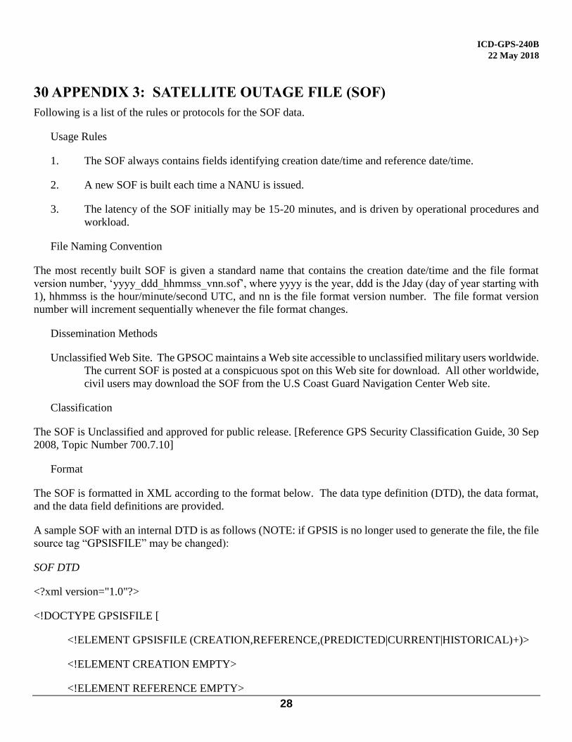
30 APPENDIX 3: SATELLITE OUTAGE FILE (SOF)
Following is a list of the rules or protocols for the SOF data.
Usage Rules
1. The SOF always contains fields identifying creation date/time and reference date/time.
2. A new SOF is built each time a NANU is issued.
3. The latency of the SOF initially may be 15-20 minutes, and is driven by operational procedures and
workload.
File Naming Convention
The most recently built SOF is given a standard name that contains the creation date/time and the file format
version number, ‘yyyy_ddd_hhmmss_vnn.sof’, where yyyy is the year, ddd is the Jday (day of year starting with
1), hhmmss is the hour/minute/second UTC, and nn is the file format version number. The file format version
number will increment sequentially whenever the file format changes.
Dissemination Methods
Unclassified Web Site. The GPSOC maintains a Web site accessible to unclassified military users worldwide.
The current SOF is posted at a conspicuous spot on this Web site for download. All other worldwide,
civil users may download the SOF from the U.S Coast Guard Navigation Center Web site.
Classification
The SOF is Unclassified and approved for public release. [Reference GPS Security Classification Guide, 30 Sep
2008, Topic Number 700.7.10]
Format
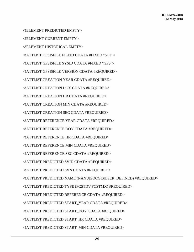
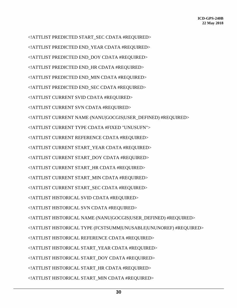
The SOF is formatted in XML according to the format below. The data type definition (DTD), the data format,
and the data field definitions are provided.
A sample SOF with an internal DTD is as follows (NOTE: if GPSIS is no longer used to generate the file, the file
source tag “GPSISFILE” may be changed):
SOF DTD
<?xml version="1.0"?>
<!DOCTYPE GPSISFILE [
<!ELEMENT GPSISFILE (CREATION,REFERENCE,(PREDICTED|CURRENT|HISTORICAL)+)>
<!ELEMENT CREATION EMPTY>
<!ELEMENT REFERENCE EMPTY>
ICD-GPS-240B
22 May 2018
29
<!ELEMENT PREDICTED EMPTY>
<!ELEMENT CURRENT EMPTY>
<!ELEMENT HISTORICAL EMPTY>
<!ATTLIST GPSISFILE FILEID CDATA #FIXED "SOF">
<!ATTLIST GPSISFILE SYSID CDATA #FIXED "GPS">
<!ATTLIST GPSISFILE VERSION CDATA #REQUIRED>
<!ATTLIST CREATION YEAR CDATA #REQUIRED>
<!ATTLIST CREATION DOY CDATA #REQUIRED>
<!ATTLIST CREATION HR CDATA #REQUIRED>
<!ATTLIST CREATION MIN CDATA #REQUIRED>
<!ATTLIST CREATION SEC CDATA #REQUIRED>
<!ATTLIST REFERENCE YEAR CDATA #REQUIRED>
<!ATTLIST REFERENCE DOY CDATA #REQUIRED>
<!ATTLIST REFERENCE HR CDATA #REQUIRED>
<!ATTLIST REFERENCE MIN CDATA #REQUIRED>
<!ATTLIST REFERENCE SEC CDATA #REQUIRED>
<!ATTLIST PREDICTED SVID CDATA #REQUIRED>
<!ATTLIST PREDICTED SVN CDATA #REQUIRED>
<!ATTLIST PREDICTED NAME (NANU|GOCGIS|USER_DEFINED) #REQUIRED>
<!ATTLIST PREDICTED TYPE (FCSTDV|FCSTMX) #REQUIRED>
<!ATTLIST PREDICTED REFERENCE CDATA #REQUIRED>
<!ATTLIST PREDICTED START_YEAR CDATA #REQUIRED>
<!ATTLIST PREDICTED START_DOY CDATA #REQUIRED>
<!ATTLIST PREDICTED START_HR CDATA #REQUIRED>
<!ATTLIST PREDICTED START_MIN CDATA #REQUIRED>
ICD-GPS-240B
22 May 2018
30
<!ATTLIST PREDICTED START_SEC CDATA #REQUIRED>
<!ATTLIST PREDICTED END_YEAR CDATA #REQUIRED>
<!ATTLIST PREDICTED END_DOY CDATA #REQUIRED>
<!ATTLIST PREDICTED END_HR CDATA #REQUIRED>
<!ATTLIST PREDICTED END_MIN CDATA #REQUIRED>
<!ATTLIST PREDICTED END_SEC CDATA #REQUIRED>
<!ATTLIST CURRENT SVID CDATA #REQUIRED>
<!ATTLIST CURRENT SVN CDATA #REQUIRED>
<!ATTLIST CURRENT NAME (NANU|GOCGIS|USER_DEFINED) #REQUIRED>
<!ATTLIST CURRENT TYPE CDATA #FIXED "UNUSUFN">
<!ATTLIST CURRENT REFERENCE CDATA #REQUIRED>
<!ATTLIST CURRENT START_YEAR CDATA #REQUIRED>
<!ATTLIST CURRENT START_DOY CDATA #REQUIRED>
<!ATTLIST CURRENT START_HR CDATA #REQUIRED>
<!ATTLIST CURRENT START_MIN CDATA #REQUIRED>
<!ATTLIST CURRENT START_SEC CDATA #REQUIRED>
<!ATTLIST HISTORICAL SVID CDATA #REQUIRED>
<!ATTLIST HISTORICAL SVN CDATA #REQUIRED>
<!ATTLIST HISTORICAL NAME (NANU|GOCGIS|USER_DEFINED) #REQUIRED>
<!ATTLIST HISTORICAL TYPE (FCSTSUMM|UNUSABLE|UNUNOREF) #REQUIRED>
<!ATTLIST HISTORICAL REFERENCE CDATA #REQUIRED>
<!ATTLIST HISTORICAL START_YEAR CDATA #REQUIRED>
<!ATTLIST HISTORICAL START_DOY CDATA #REQUIRED>
<!ATTLIST HISTORICAL START_HR CDATA #REQUIRED>
<!ATTLIST HISTORICAL START_MIN CDATA #REQUIRED>
ICD-GPS-240B
22 May 2018
31
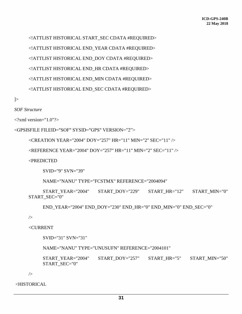
<!ATTLIST HISTORICAL START_SEC CDATA #REQUIRED>
<!ATTLIST HISTORICAL END_YEAR CDATA #REQUIRED>
<!ATTLIST HISTORICAL END_DOY CDATA #REQUIRED>
<!ATTLIST HISTORICAL END_HR CDATA #REQUIRED>
<!ATTLIST HISTORICAL END_MIN CDATA #REQUIRED>
<!ATTLIST HISTORICAL END_SEC CDATA #REQUIRED>
]>
SOF Structure
<?xml version="1.0"?>
<GPSISFILE FILEID="SOF" SYSID="GPS" VERSION=”2”>
<CREATION YEAR="2004" DOY="257" HR="11" MIN="2" SEC="11" />
<REFERENCE YEAR="2004" DOY="257" HR="11" MIN="2" SEC="11" />
<PREDICTED
SVID="9" SVN="39"
NAME="NANU" TYPE="FCSTMX" REFERENCE="2004094"
START_YEAR="2004" START_DOY="229" START_HR="12" START_MIN="0"
START_SEC="0"
END_YEAR="2004" END_DOY="230" END_HR="0" END_MIN="0" END_SEC="0"
/>
<CURRENT
SVID="31" SVN="31"
NAME="NANU" TYPE="UNUSUFN" REFERENCE="2004101"
START_YEAR="2004" START_DOY="257" START_HR="5" START_MIN="50"
START_SEC="0"
/>
<HISTORICAL
ICD-GPS-240B
22 May 2018
32
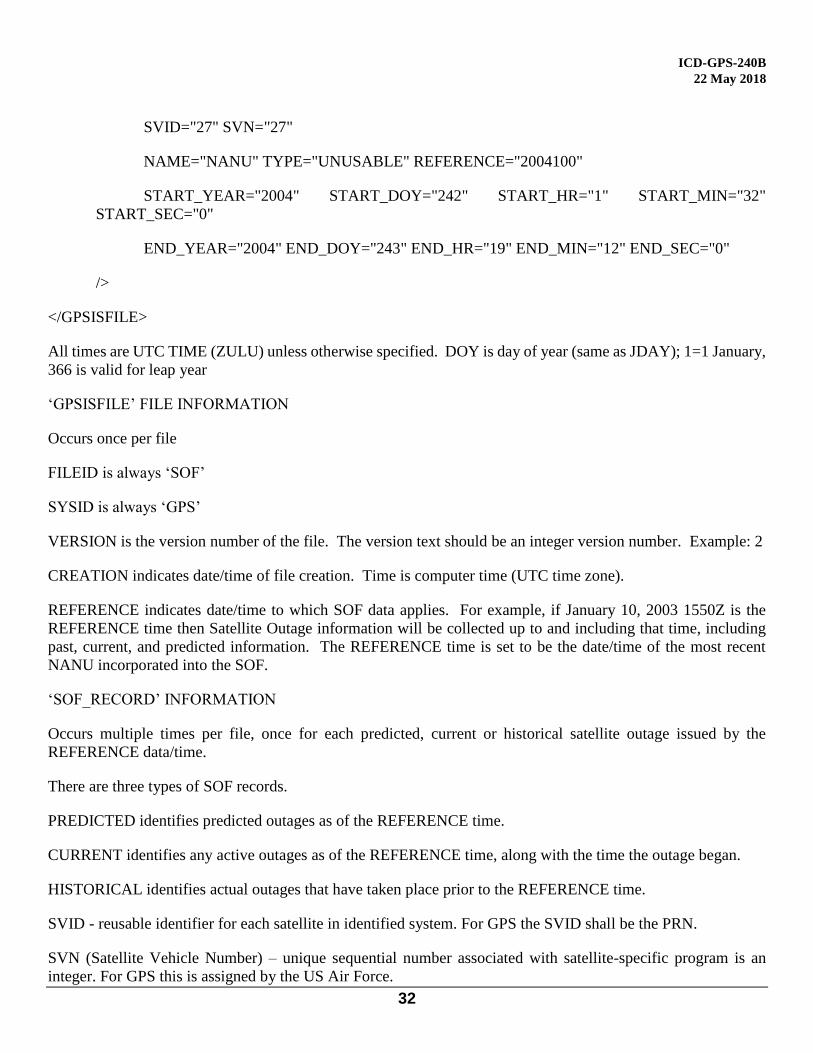
SVID="27" SVN="27"
NAME="NANU" TYPE="UNUSABLE" REFERENCE="2004100"
START_YEAR="2004" START_DOY="242" START_HR="1" START_MIN="32"
START_SEC="0"
END_YEAR="2004" END_DOY="243" END_HR="19" END_MIN="12" END_SEC="0"
/>
</GPSISFILE>
All times are UTC TIME (ZULU) unless otherwise specified. DOY is day of year (same as JDAY); 1=1 January,
366 is valid for leap year
‘GPSISFILE’ FILE INFORMATION
Occurs once per file
FILEID is always ‘SOF’
SYSID is always ‘GPS’
VERSION is the version number of the file. The version text should be an integer version number. Example: 2
CREATION indicates date/time of file creation. Time is computer time (UTC time zone).
REFERENCE indicates date/time to which SOF data applies. For example, if January 10, 2003 1550Z is the
REFERENCE time then Satellite Outage information will be collected up to and including that time, including
past, current, and predicted information. The REFERENCE time is set to be the date/time of the most recent
NANU incorporated into the SOF.
‘SOF_RECORD’ INFORMATION
Occurs multiple times per file, once for each predicted, current or historical satellite outage issued by the
REFERENCE data/time.
There are three types of SOF records.
PREDICTED identifies predicted outages as of the REFERENCE time.
CURRENT identifies any active outages as of the REFERENCE time, along with the time the outage began.
HISTORICAL identifies actual outages that have taken place prior to the REFERENCE time.
SVID - reusable identifier for each satellite in identified system. For GPS the SVID shall be the PRN.
SVN (Satellite Vehicle Number) – unique sequential number associated with satellite-specific program is an
integer. For GPS this is assigned by the US Air Force.
ICD-GPS-240B
22 May 2018
33
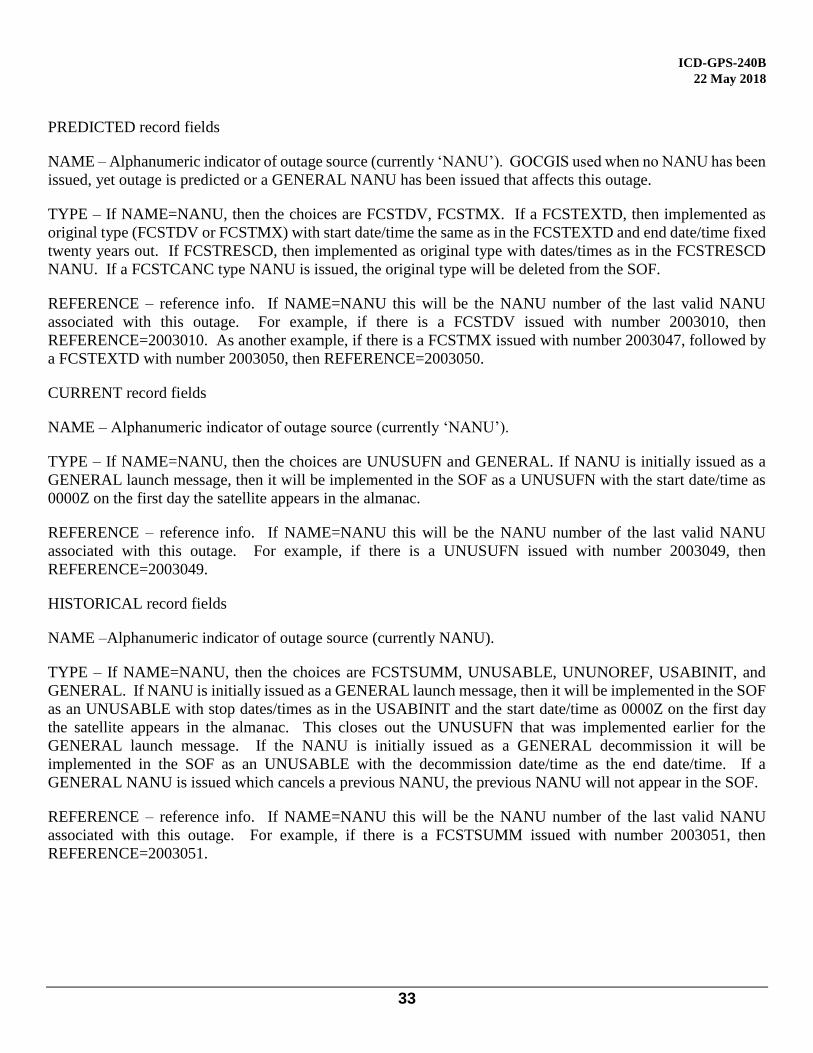
PREDICTED record fields
NAME – Alphanumeric indicator of outage source (currently ‘NANU’). GOCGIS used when no NANU has been
issued, yet outage is predicted or a GENERAL NANU has been issued that affects this outage.
TYPE – If NAME=NANU, then the choices are FCSTDV, FCSTMX. If a FCSTEXTD, then implemented as
original type (FCSTDV or FCSTMX) with start date/time the same as in the FCSTEXTD and end date/time fixed
twenty years out. If FCSTRESCD, then implemented as original type with dates/times as in the FCSTRESCD
NANU. If a FCSTCANC type NANU is issued, the original type will be deleted from the SOF.
REFERENCE – reference info. If NAME=NANU this will be the NANU number of the last valid NANU
associated with this outage. For example, if there is a FCSTDV issued with number 2003010, then
REFERENCE=2003010. As another example, if there is a FCSTMX issued with number 2003047, followed by
a FCSTEXTD with number 2003050, then REFERENCE=2003050.
CURRENT record fields
NAME – Alphanumeric indicator of outage source (currently ‘NANU’).
TYPE – If NAME=NANU, then the choices are UNUSUFN and GENERAL. If NANU is initially issued as a
GENERAL launch message, then it will be implemented in the SOF as a UNUSUFN with the start date/time as
0000Z on the first day the satellite appears in the almanac.
REFERENCE – reference info. If NAME=NANU this will be the NANU number of the last valid NANU
associated with this outage. For example, if there is a UNUSUFN issued with number 2003049, then
REFERENCE=2003049.
HISTORICAL record fields
NAME –Alphanumeric indicator of outage source (currently NANU).
TYPE – If NAME=NANU, then the choices are FCSTSUMM, UNUSABLE, UNUNOREF, USABINIT, and
GENERAL. If NANU is initially issued as a GENERAL launch message, then it will be implemented in the SOF
as an UNUSABLE with stop dates/times as in the USABINIT and the start date/time as 0000Z on the first day
the satellite appears in the almanac. This closes out the UNUSUFN that was implemented earlier for the
GENERAL launch message. If the NANU is initially issued as a GENERAL decommission it will be
implemented in the SOF as an UNUSABLE with the decommission date/time as the end date/time. If a
GENERAL NANU is issued which cancels a previous NANU, the previous NANU will not appear in the SOF.
REFERENCE – reference info. If NAME=NANU this will be the NANU number of the last valid NANU
associated with this outage. For example, if there is a FCSTSUMM issued with number 2003051, then
REFERENCE=2003051.
ICD-GPS-240B
22 May 2018
34
Format Changes
Changes to file formats are implemented as follows:
1. Files implementing a new format have the VERSION attribute of the GPSISFILE element incremented.
Version 1 files encoded the file version in the filename. For example, a file with a previous format may
have a name like 2004_202_145503_v01.sof. Later file versions encode the version both in the filename,
and the XML VERSION attribute. The filenames of the new file versions look like
2004_202_145503_v02.sof.
2. If a new file format is implemented, both the old and the new file formats will be posted to the web site
location for a transition period.
3. The old file format will be posted for six months, and then be removed. This provides time for users to
adapt to the new file format.
4. Notifications of file format changes, with samples of the new format, will be published to
http://www.GPS.gov when they are final.
ICD-GPS-240B
22 May 2018
35
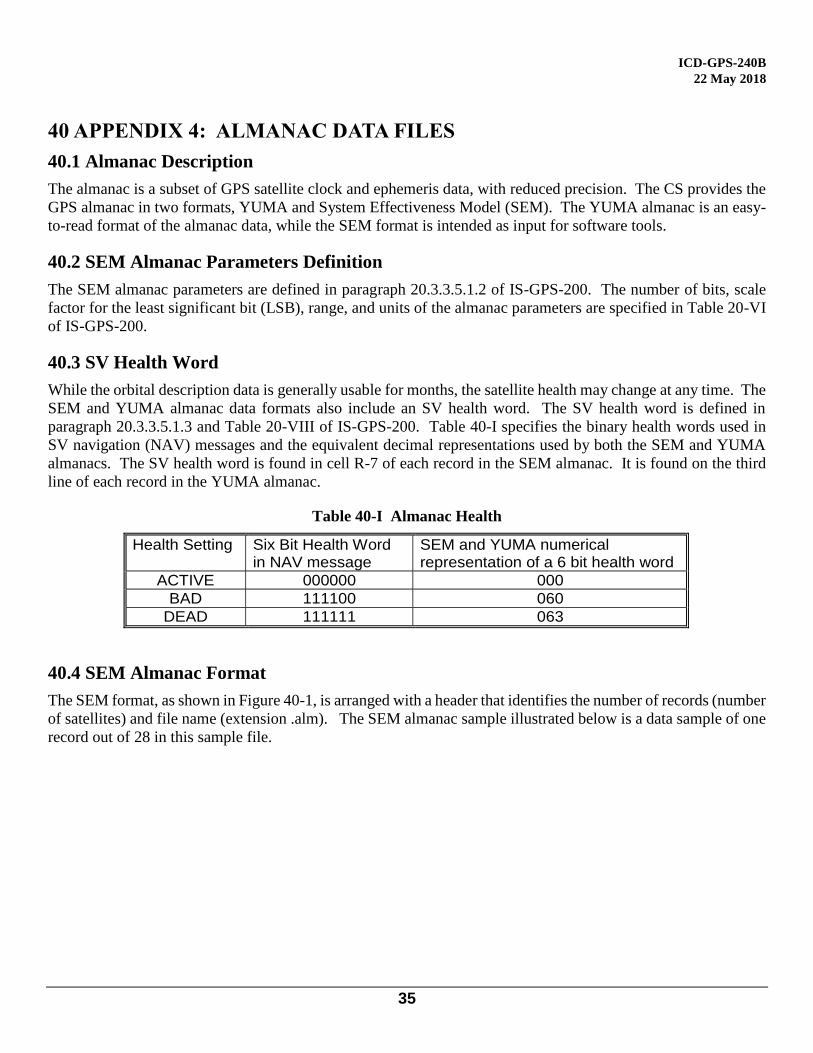
40 APPENDIX 4: ALMANAC DATA FILES
40.1 Almanac Description
The almanac is a subset of GPS satellite clock and ephemeris data, with reduced precision. The CS provides the
GPS almanac in two formats, YUMA and System Effectiveness Model (SEM). The YUMA almanac is an easy-
to-read format of the almanac data, while the SEM format is intended as input for software tools.
40.2 SEM Almanac Parameters Definition
The SEM almanac parameters are defined in paragraph 20.3.3.5.1.2 of IS-GPS-200. The number of bits, scale
factor for the least significant bit (LSB), range, and units of the almanac parameters are specified in Table 20-VI
of IS-GPS-200.
40.3 SV Health Word
While the orbital description data is generally usable for months, the satellite health may change at any time. The
SEM and YUMA almanac data formats also include an SV health word. The SV health word is defined in
paragraph 20.3.3.5.1.3 and Table 20-VIII of IS-GPS-200. Table 40-I specifies the binary health words used in
SV navigation (NAV) messages and the equivalent decimal representations used by both the SEM and YUMA
almanacs. The SV health word is found in cell R-7 of each record in the SEM almanac. It is found on the third
line of each record in the YUMA almanac.
Table 40-I Almanac Health
40.4 SEM Almanac Format
The SEM format, as shown in Figure 40-1, is arranged with a header that identifies the number of records (number
of satellites) and file name (extension .alm). The SEM almanac sample illustrated below is a data sample of one
record out of 28 in this sample file.
Health Setting Six Bit Health Word in NAV message
SEM and YUMA numerical representation of a 6 bit health word
ACTIVE 000000 000
BAD 111100 060
DEAD 111111 063

ICD-GPS-240B
22 May 2018
36
Figure 40-1 SEM Data Sample
Note: The bold letters and numbers in the rectangles are not part of the SEM format; they are used for
identification purposes in Table 40-II. Table 40-II identifies the characteristics of each parameter in the SEM
almanac.
ICD-GPS-240B
22 May 2018
37
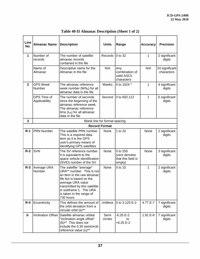
Table 40-II Almanac Description (Sheet 1 of 2)
Line No.
Almanac Name Description Units Range Accuracy Precision
1
Number of records
The number of satellite almanac records contained in the file
Records 0 to 32 1 2 significant digits
Name of Almanac
Descriptive name for the Almanac in the file
N/A Any combination of valid ASCII characters
N/A 24 significant characters
2
GPS Week Number
The almanac reference week number (WNa) for all almanac data in the file
Weeks 0 to 1024 * 1 4 significant digits
GPS Time of Applicability
The number of seconds since the beginning of the almanac reference week. The almanac reference time (toa) for all almanac data in the file
Second 0 to 602,112 1 6 significant digits
3 Blank line for format spacing
Record Format
R-1 PRN Number The satellite PRN number. This is a required data item as it is the GPS user's primary means of identifying GPS satellites
None 1 to 32 None 2 significant digits
R-2 SVN The SV reference number. It is equivalent to the space vehicle identification (SVID) number of the SV
None 0 to 255 (zero denotes that this field is empty)
None 3 significant digits
R-3 Average URA Number
The satellite "average" URA** number. This is not an item in the raw almanac file but is based on the average URA value transmitted by this satellite in subframe 1. The URA is taken in the range of 730 hours
None 0 to 15 1 2 significant digits
R-4 Eccentricity This defines the amount of the orbit deviation from a circular orbit (e)**
Unitless 0 to 3.125 E-2 4.77 E-7 7 significant digits
b Inclination Offset Satellite almanac orbital "inclination angle offset" (δi)** This does not include the 0.30 semicircle reference value (i0)**
Semi circles
-6.25 E-2 to
+6.25 E-2
1.91 E-6 7 significant digits
ICD-GPS-240B
22 May 2018
38
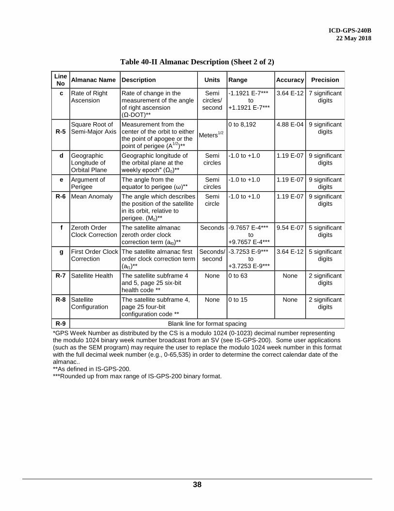
Table 40-II Almanac Description (Sheet 2 of 2)
Table 30-II Almanac Description
(Sheet 2 of 2)
Line No
Almanac Name Description Units Range Accuracy Precision
c Rate of Right Ascension
Rate of change in the measurement of the angle of right ascension (Ω-DOT)**
Semi circles/ second
-1.1921 E-7*** to
+1.1921 E-7***
3.64 E-12 7 significant digits
R-5
Square Root of Semi-Major Axis
Measurement from the center of the orbit to either the point of apogee or the point of perigee (A
1/2)**
Meters1/2
0 to 8,192 4.88 E-04 9 significant digits
d Geographic Longitude of Orbital Plane
Geographic longitude of the orbital plane at the weekly epoch" (Ω0)**
Semi circles
-1.0 to +1.0 1.19 E-07 9 significant digits
e Argument of Perigee
The angle from the equator to perigee (ω)**
Semi circles
-1.0 to +1.0 1.19 E-07 9 significant digits
R-6 Mean Anomaly The angle which describes the position of the satellite in its orbit, relative to perigee. (M0)**
Semi circle
-1.0 to +1.0 1.19 E-07 9 significant digits
f Zeroth Order Clock Correction
The satellite almanac zeroth order clock correction term (af0)**
Seconds -9.7657 E-4*** to
+9.7657 E-4***
9.54 E-07 5 significant digits
g First Order Clock Correction
The satellite almanac first order clock correction term (af1)**
Seconds/ second
-3.7253 E-9*** to
+3.7253 E-9***
3.64 E-12 5 significant digits
R-7 Satellite Health The satellite subframe 4 and 5, page 25 six-bit health code **
None 0 to 63 None 2 significant digits
R-8 Satellite Configuration
The satellite subframe 4, page 25 four-bit configuration code **
None 0 to 15 None 2 significant digits
R-9 Blank line for format spacing
*GPS Week Number as distributed by the CS is a modulo 1024 (0-1023) decimal number representing the modulo 1024 binary week number broadcast from an SV (see IS-GPS-200). Some user applications (such as the SEM program) may require the user to replace the modulo 1024 week number in this format with the full decimal week number (e.g., 0-65,535) in order to determine the correct calendar date of the almanac.. **As defined in IS-GPS-200. ***Rounded up from max range of IS-GPS-200 binary format.

ICD-GPS-240B
22 May 2018
39
40.5 YUMA Almanac
Parameters used in the YUMA format are not the same as used in the SEM format. The SEM parameters are the
same as defined in IS-GPS-200 and broadcast from an SV. The YUMA angular units are in radians whereas the
SEM angular units are in semicircles. In addition, the YUMA Orbital Inclination is a direct measure of inclination
angle (approximately 55 degrees), whereas the SEM Inclination Offset is relative to 0.30 semicircles (54 degrees).
The parameters of the YUMA almanac are identified within the message structure. Figure 40-2 illustrates one
record of 28 in a sample YUMA almanac file. Line one of each record identifies the week in which the file was
generated as well as the PRN number of the subject SV.
Figure 40-2 YUMA Almanac Data Sample
******** Week 175 almanac for PRN-01 ********
ID: 01
Health: 000
Eccentricity: 0.5404472351E-002
Time of Applicability(s): 589824.0000
Orbital Inclination(rad): -0.7931758961E-008
SQRT(A) (m 1/2): 5153.727539
Right Ascen at Week (rad): -0.4069756641E+000
Argument of Perigee(rad): -1.719371504
ICD-GPS-240B
22 May 2018
40
50 APPENDIX 5: LETTERS OF EXCEPTION
50.1 Scope
As indicated in paragraph 1.3, initial signature approval of this document, as well as approval of subsequent
changes to the document, can be contingent upon a "letter of exception". This appendix depicts such "letters of
exception" when utilized by any signatory of this document in the initial approval cycle and/or in the change
approval process. The ICC will omit such letters of exception from subsequent revisions of this document based
on written authorization by the respective signatory (without processing a proposed interface revision notice
(PIRN) for approval). When some (but not all) of the exceptions taken by a signatory are resolved, the signatory
shall provide the ICC with an updated letter of exception for inclusion in the next ICD revision (without
processing a PIRN for approval.
50.2 Applicable Documents
The documents listed in Section 2.1 shall be applicable to this appendix.
50.3 Letters of Exception
If signature approval of this document -- as affixed to the cover page -- is marked by an asterisk, it indicates that
the approval is contingent upon the exceptions taken by that signatory in a letter of exception. Any letter of
exception, which is in force for the revision of the ICD is depicted in Figure 50-1. Signatories for whom no letter
of exception is shown have approved this version of the document without exception.
ICD-GPS-240B
22 May 2018
41
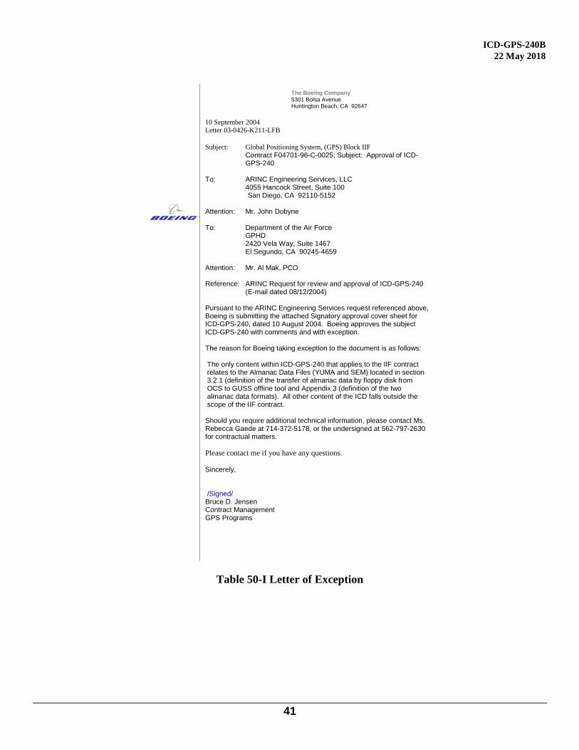
The Boeing Company
5301 Bolsa Avenue Huntington Beach, CA 92647
10 September 2004
Letter 03-0426-K211-LFB
Subject: Global Positioning System, (GPS) Block IIF
Contract F04701-96-C-0025; Subject: Approval of ICD-GPS-240
To: ARINC Engineering Services, LLC 4055 Hancock Street, Suite 100
San Diego, CA 92110-5152
Attention: Mr. John Dobyne To: Department of the Air Force GPHD
2420 Vela Way, Suite 1467 El Segundo, CA 90245-4659
Attention: Mr. Al Mak, PCO Reference: ARINC Request for review and approval of ICD-GPS-240
(E-mail dated 08/12/2004) Pursuant to the ARINC Engineering Services request referenced above, Boeing is submitting the attached Signatory approval cover sheet for ICD-GPS-240, dated 10 August 2004. Boeing approves the subject ICD-GPS-240 with comments and with exception. The reason for Boeing taking exception to the document is as follows: The only content within ICD-GPS-240 that applies to the IIF contract relates to the Almanac Data Files (YUMA and SEM) located in section 3.2.1 (definition of the transfer of almanac data by floppy disk from OCS to GUSS offline tool and Appendix 3 (definition of the two almanac data formats). All other content of the ICD falls outside the scope of the IIF contract. Should you require additional technical information, please contact Ms. Rebecca Gaede at 714-372-5178, or the undersigned at 562-797-2630 for contractual matters.
Please contact me if you have any questions. Sincerely, /Signed/ Bruce D. Jensen Contract Management GPS Programs
Table 50-I Letter of Exception