Embed Size (px)
Citation preview
Suite 10, 295 Rokeby Road, SUBIACO WA 6008 Phone: +61 8 9200 8200 Fax: +61 8 9200 8299 www.asqg.com.au
AUSTRALIAN SILICA QUARTZ GROUP LIMITED
HIGH GRADE, LOW IRON, SILICA SAND MINERAL RESOURCE
Suite 10, 295 Rokeby Road, SUBIACO WA 6008
Phone: +61 8 9200 8200 Fax: +61 8 9200 8299 www.asqg.com.au
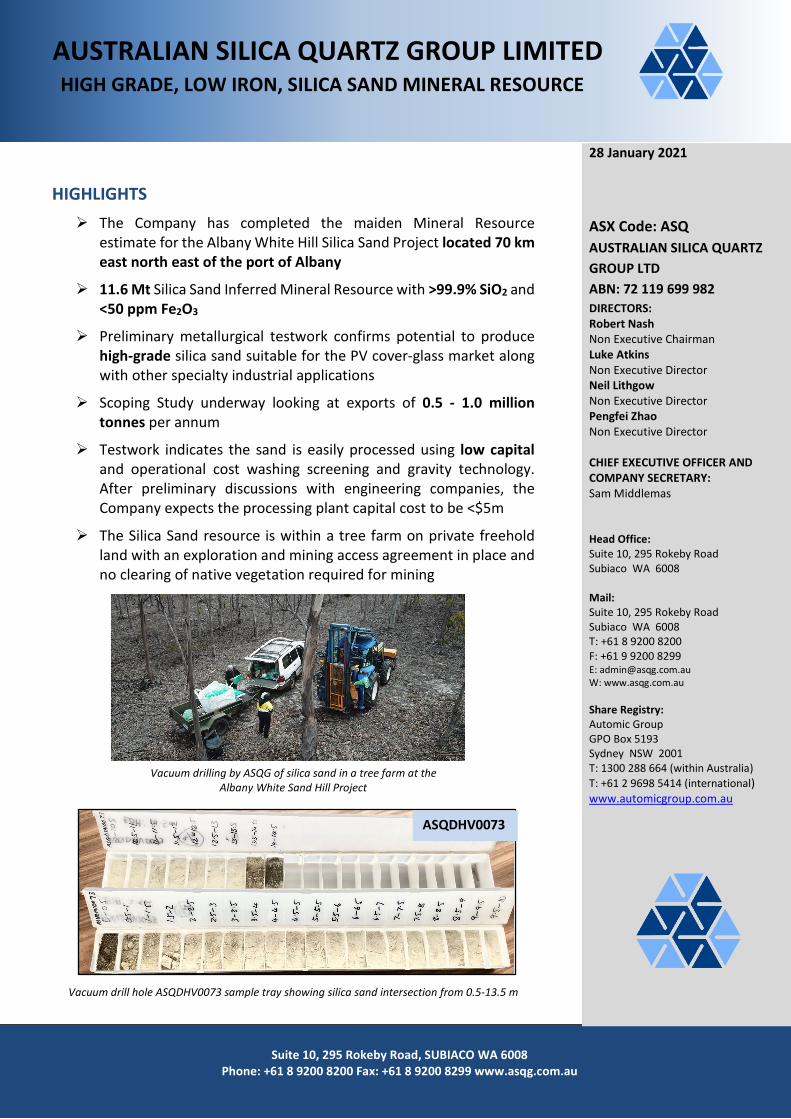
HIGHLIGHTS The Company has completed the maiden Mineral Resource
estimate for the Albany White Hill Silica Sand Project located 70 km east north east of the port of Albany
11.6 Mt Silica Sand Inferred Mineral Resource with >99.9% SiO2 and <50 ppm Fe2O3
Preliminary metallurgical testwork confirms potential to produce high-grade silica sand suitable for the PV cover-glass market along with other specialty industrial applications
Scoping Study underway looking at exports of 0.5 - 1.0 million tonnes per annum
Testwork indicates the sand is easily processed using low capital and operational cost washing screening and gravity technology. After preliminary discussions with engineering companies, the Company expects the processing plant capital cost to be <$5m
The Silica Sand resource is within a tree farm on private freehold land with an exploration and mining access agreement in place and no clearing of native vegetation required for mining
Vacuum drilling by ASQG of silica sand in a tree farm at the Albany White Sand Hill Project
Vacuum drill hole ASQDHV0073 sample tray showing silica sand intersection from 0.5-13.5 m
28 January 2021
ASX Code: ASQ AUSTRALIAN SILICA QUARTZ GROUP LTD ABN: 72 119 699 982 DIRECTORS: Robert Nash Non Executive Chairman Luke Atkins Non Executive Director Neil Lithgow Non Executive Director Pengfei Zhao Non Executive Director CHIEF EXECUTIVE OFFICER AND COMPANY SECRETARY: Sam Middlemas Head Office: Suite 10, 295 Rokeby Road Subiaco WA 6008 Mail: Suite 10, 295 Rokeby Road Subiaco WA 6008 T: +61 8 9200 8200 F: +61 9 9200 8299 E: [email protected] W: www.asqg.com.au Share Registry: Automic Group GPO Box 5193 Sydney NSW 2001 T: 1300 288 664 (within Australia) T: +61 2 9698 5414 (international) www.automicgroup.com.au
ASQDHV0073
2 Suite 10, 295 Rokeby Road, SUBIACO WA 6008
Phone: +61 8 9200 8200 Fax: +61 8 9200 8299 www.asqg.com.au
Australian Silica Quartz Group Limited (ASX:ASQ, “ASQ” or “the Company”) is pleased to announce the results of the maiden silica sand Mineral Resource estimate for the Albany White Hill Project located on exploration licence E70/5262, 70 km east north east of the port of Albany.
The independent Mineral Resource estimate was carried out by Ashmore Advisory Pty Ltd (“Ashmore”) and is based on 76 vacuum drill holes completed by the company in November 2020 (ASQ (2020). Encouraging Results from Albany Silica Sand Drilling. ASX Release 9 December 2020).
The Mineral Resource area extends over a strike length of 1,650m (from 6,159,250mN to 6,160,900mE, has a maximum width of 1,565m (from 639,975mE to 641,530mE) and was modelled from surface to a depth of approximately 14m below surface.
Metallurgical testwork completed to date indicates that the silica sand is readily processed by conventional washing and gravity separation to produce a very high grade silica sand product that is expected to be suitable for industries such as general and specialty glass making including PV panel cover glass and optical glass. Other suitable applications may include foundry and filter sands, electronics component manufacturing and engineered stone manufacturing. The sand is expected to be high yielding with little waste produced.
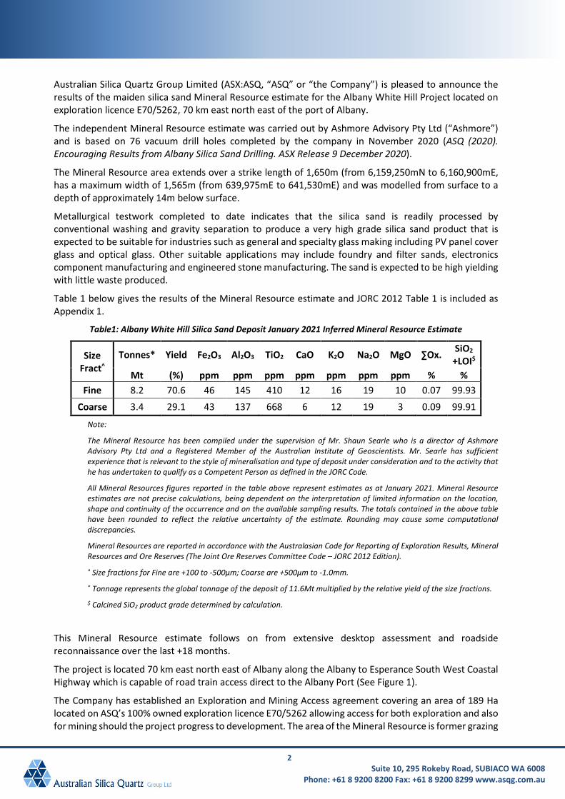
Table 1 below gives the results of the Mineral Resource estimate and JORC 2012 Table 1 is included as Appendix 1.
Table1: Albany White Hill Silica Sand Deposit January 2021 Inferred Mineral Resource Estimate
Size Fract^
Tonnes* Yield Fe2O3 Al2O3 TiO2 CaO K2O Na2O MgO ∑Ox. SiO2 +LOI$
Mt (%) ppm ppm ppm ppm ppm ppm ppm % % Fine 8.2 70.6 46 145 410 12 16 19 10 0.07 99.93
Coarse 3.4 29.1 43 137 668 6 12 19 3 0.09 99.91
Note:
The Mineral Resource has been compiled under the supervision of Mr. Shaun Searle who is a director of Ashmore Advisory Pty Ltd and a Registered Member of the Australian Institute of Geoscientists. Mr. Searle has sufficient experience that is relevant to the style of mineralisation and type of deposit under consideration and to the activity that he has undertaken to qualify as a Competent Person as defined in the JORC Code.
All Mineral Resources figures reported in the table above represent estimates as at January 2021. Mineral Resource estimates are not precise calculations, being dependent on the interpretation of limited information on the location, shape and continuity of the occurrence and on the available sampling results. The totals contained in the above table have been rounded to reflect the relative uncertainty of the estimate. Rounding may cause some computational discrepancies.
Mineral Resources are reported in accordance with the Australasian Code for Reporting of Exploration Results, Mineral Resources and Ore Reserves (The Joint Ore Reserves Committee Code – JORC 2012 Edition).
^ Size fractions for Fine are +100 to -500µm; Coarse are +500µm to -1.0mm.
* Tonnage represents the global tonnage of the deposit of 11.6Mt multiplied by the relative yield of the size fractions.
$ Calcined SiO2 product grade determined by calculation.
This Mineral Resource estimate follows on from extensive desktop assessment and roadside reconnaissance over the last +18 months.
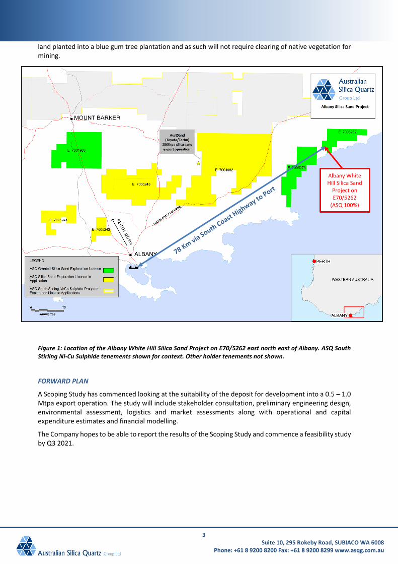
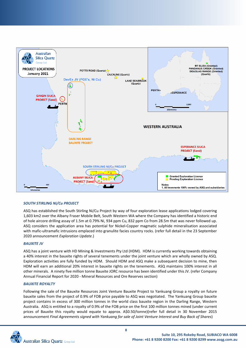
The project is located 70 km east north east of Albany along the Albany to Esperance South West Coastal Highway which is capable of road train access direct to the Albany Port (See Figure 1).
The Company has established an Exploration and Mining Access agreement covering an area of 189 Ha located on ASQ’s 100% owned exploration licence E70/5262 allowing access for both exploration and also for mining should the project progress to development. The area of the Mineral Resource is former grazing
3 Suite 10, 295 Rokeby Road, SUBIACO WA 6008
Phone: +61 8 9200 8200 Fax: +61 8 9200 8299 www.asqg.com.au
land planted into a blue gum tree plantation and as such will not require clearing of native vegetation for mining.
Figure 1: Location of the Albany White Hill Silica Sand Project on E70/5262 east north east of Albany. ASQ South Stirling Ni-Cu Sulphide tenements shown for context. Other holder tenements not shown.
FORWARD PLAN
A Scoping Study has commenced looking at the suitability of the deposit for development into a 0.5 – 1.0 Mtpa export operation. The study will include stakeholder consultation, preliminary engineering design, environmental assessment, logistics and market assessments along with operational and capital expenditure estimates and financial modelling.
The Company hopes to be able to report the results of the Scoping Study and commence a feasibility study by Q3 2021.
Albany White Hill Silica Sand
Project on E70/5262
(ASQ 100%)
4 Suite 10, 295 Rokeby Road, SUBIACO WA 6008
Phone: +61 8 9200 8200 Fax: +61 8 9200 8299 www.asqg.com.au
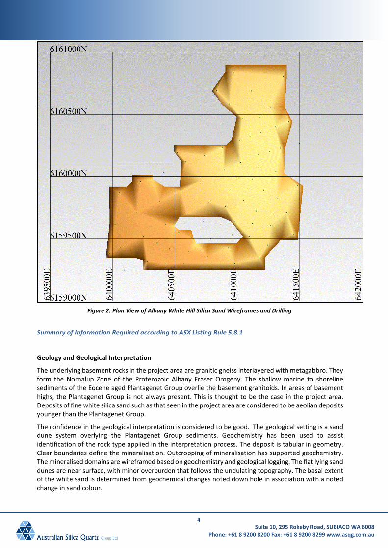
Figure 2: Plan View of Albany White Hill Silica Sand Wireframes and Drilling
Summary of Information Required according to ASX Listing Rule 5.8.1
Geology and Geological Interpretation
The underlying basement rocks in the project area are granitic gneiss interlayered with metagabbro. They form the Nornalup Zone of the Proterozoic Albany Fraser Orogeny. The shallow marine to shoreline sediments of the Eocene aged Plantagenet Group overlie the basement granitoids. In areas of basement highs, the Plantagenet Group is not always present. This is thought to be the case in the project area. Deposits of fine white silica sand such as that seen in the project area are considered to be aeolian deposits younger than the Plantagenet Group.
The confidence in the geological interpretation is considered to be good. The geological setting is a sand dune system overlying the Plantagenet Group sediments. Geochemistry has been used to assist identification of the rock type applied in the interpretation process. The deposit is tabular in geometry. Clear boundaries define the mineralisation. Outcropping of mineralisation has supported geochemistry. The mineralised domains are wireframed based on geochemistry and geological logging. The flat lying sand dunes are near surface, with minor overburden that follows the undulating topography. The basal extent of the white sand is determined from geochemical changes noted down hole in association with a noted change in sand colour.

5 Suite 10, 295 Rokeby Road, SUBIACO WA 6008
Phone: +61 8 9200 8200 Fax: +61 8 9200 8299 www.asqg.com.au
Drilling and Sampling Techniques
Drilling was undertaken using a tractor mounted vacuum drill rig. All vacuum drill spoil was collected at 0.5m intervals down hole and bagged at the drill rig. These samples have been retained for future reference and metallurgical test work.
Three composite samples were collected from three drill holes across the deposit. These drill holes were selected as they were widespread within the deposit and represented areas of significant silica sand interval thickness. Spear probe subsampling was employed to take an equal weight of sand from every second half metre sample within the silica sand intersection of each of the selected drill holes. The composite samples were manually homogenised by multiple passes through a 50:50 riffle splitter. The homogenised composite samples were dry screened to +100µm-500µm and +500µm-1.0mm size fractions by ASQ.
Sample Analysis Method
The two size fractions for each composite sample were submitted to TSW Analytical in Perth for heavy liquid separation and 4 Acid digest with analysis by ICP-OES.
Estimation Methodology
Using results derived from sizing and heavy liquid separation analysis, relative yields and composite grades were reported as a global average for each size fraction. Maximum extrapolation distance from data points was 80m, approximately half of the 150 to 200m drill hole spacing. Three dimensional mineralised wireframes were used to determine volume of sand mineralisation. The deleterious elements reported are Fe2O3, Al2O3, CaO, Na2O, MgO, K2O and TiO2.
A block model was created using Surpac software. The mineralisation was constrained by wireframes prepared using geological logging. Average heavy liquid separation grades for the two size fractions were reported as the silica sand product grades, therefore no grade interpolation was conducted. A block model was generated to report tonnages below the supplied topography to approximate the tonnage for each size fraction.
Four dry in situ bulk density measurements were conducted by Great Southern Geoscience Pty Ltd using a nuclear densometer. The results are corrected based on the measured moisture content. A bulk density of 1.52 t/m3 was assigned in the block model for the mineralisation based on an average of the four white sand measurements.
Resource Classification
The Mineral Resource estimate is reported here in compliance with the 2012 Edition of the ‘Australasian Code for Reporting of Exploration Results, Mineral Resources and Ore Reserves’ by the Joint Ore Reserves Committee (JORC). The Mineral Resource was classified as Inferred Mineral Resource based on data quality, sample spacing, and lode continuity.
Cut-off Grade
No reporting cut-off grade has been considered as it is assumed all the white sand domain can be processed to create a high purity silica product.
Mining and Metallurgical Methods and Parameters and other modifying factors
Comparison with other existing silica sand mining operations and ongoing metallurgical testwork are consistent with a reasonable view that the deposit could potentially be mined using open pit techniques. The minimal amount of overburden and shallow nature of the deposit allows mining to be carried out with surface mining equipment, but the economic viability of this approach has not been verified in this study.
6 Suite 10, 295 Rokeby Road, SUBIACO WA 6008
Phone: +61 8 9200 8200 Fax: +61 8 9200 8299 www.asqg.com.au
This Announcement has been authorised by the board.
Sam Middlemas, CEO, Australian Silica Quartz Group Ltd
28 January 2021
Competent Persons Statement
The information in this report that relates to the Mineral Resource has been compiled under the supervision of Mr. Shaun Searle, a Competent Person who is a director of Ashmore Advisory Pty Ltd and a Registered Member of the Australian Institute of Geoscientists. Mr. Searle has sufficient experience that is relevant to the style of mineralisation and type of deposit under consideration and to the activity that he has undertaken to qualify as a Competent Person under the 2012 edition of the “Australian Code for Reporting of Exploration Results, Mineral Resources and Ore Reserves”. Mr Searle consents to the inclusion of the data in the form and context in which it appears.
Forward Looking Statements
This report may include forward looking statements. Often, but not always, forward looking statements can generally be identified by the use of forward looking words such as “may”, “will”, “expect”, “intend”, “plan”, “estimate”, “anticipate”, “continue”, or other similar words and may include, without limitation, statements regarding plans, strategies, and objectives of management. Forward looking statements inherently involve known and unknown risks, uncertainties and other factors that may cause the company’s actual results, performance and achievements to differ materially from anticipated results, performance or achievements. Forward looking statements are based on the Company and its management’s good faith assumptions relating to the financial, market, regulatory and other relevant environments that will exist and affect the company’s business and operations in the future. The Company does not give any assurance that the assumptions on which forward looking statements are based will prove to be correct, or that the Company’s business or operations will not be affected in any material manner by these or other factors not foreseen or foreseeable by the Company or management or beyond the Company’s control. Accordingly, readers are cautioned not to place undue reliance on forward looking statements.
7 Suite 10, 295 Rokeby Road, SUBIACO WA 6008
Phone: +61 8 9200 8200 Fax: +61 8 9200 8299 www.asqg.com.au
About Australian Silica Quartz Group Limited
ASQ DEVEX 50/50 JV (non-dilutable at ASQ’s election)
ASQ has entered into a joint venture with DevEx Resources (“DevEx” ASX:DEV) on it’s 100% owned E70/3405 tenement located along strike from Chalice Gold Mines (“Chalice” ASX:CHN) nickel copper platinum group elements Julimar discovery in WA. The first $3M expenditure on the JV area is to be fully funded by DevEx to earn 50%. ASQ has the option to jointly fund future expenditure to maintain 50% share or opt to allow DevEx to fund the next $3M to earn a further 20% share in non-bauxite minerals. Initial geochemical and geophysical exploration work has returned positive results with the establishment of multiple drill targets. (refer full detail in the 1 June 2020 announcement ASQ reaches agreement for funding of exploration on its tenement in Julimar Region, WA, 8 October 2020 announcement Update on Geophysics Targets at ASQ/DevEx JV in Julimar Region, WA, 19 August 2020 announcement Update on ASQ/DevEx 50/50 JV in Julimar Region, WA.) and 4 December 2020 announcement DevEx Exploration Update.
SILICA
ASQ has established a range of silica sand and hardrock projects held via exploration licence applications 100% owned by ASQ’s subsidiary Australian Silica Quartz Pty Ltd. These projects now consist of 12 granted exploration licences and 8 applications covering approximately 1,500 km2 within Western Australia and Queensland.
High grade silica (99.5-99.9% SiO2) and high purity silica (>99.95% SiO2) currently have a wide range of applications. All indications suggest the high grade and high purity silica market is currently growing strongly due to greater demand from the PV Solar, TFT glass, Electronics, Flat Glass and Speciality Glass industries. This is reinforced by the level of enquiries received from qualified end user customers the Company has received primarily from China and South East Asia.
SILICA SAND
ASQ’s high grade silica sand projects are located in the regions of Albany, Gingin and Esperance in the south west of Western Australia.
In the shorter term these projects potentially present the opportunity for the Company to produce a washed DSO silica sand product with longer term potential to enter the higher value higher grade silica sand market with a niche processed product.
ASQ is currently working on a Scoping Study for the Albany White Hill Silica Sand Project. The Albany White Hill Project is located on farmland cleared of native vegetation 70 km east north east of the port of Albany.
In addition to it’s wholly owned silica exploration projects ASQ has reached an agreement with an existing local sand producer. In 2019 the Company executed a binding terms sheet with Urban Resources Pty Ltd (Urban) to jointly exploit Urban’s Silica Sand deposit located in Bullsbrook, Western Australia. Urban has operated the mine for the last six years and produced over 1Mt from the deposit in last two years. The ASQ/Urban Resources agreement presents the Company with the opportunity to potentially fast track it’s entry into the DSO silica sand export market. ASQG have completed a JORC 2012 Inferred Mineral Resource on the raw sand at Urban’s Maralla Road tenement M70/326 (refer full detail in the 7 May 2019 announcement Update on Maralla Road Silica Sand Deposit Maiden Resource and 29 January 2020 announcement Spiral and Classifier Testwork Results for the M70/326 Silica Sand Products).
HARDROCK QUARTZ R&D
The Company is undertaking an R&D program aiming to develop a high purity, high value silica quartz product. To this end the Company has secured a number of hardrock quartz tenements and is progressing with a research and development project in this area. Assays from rock chip sampling of ASQ’s hard rock tenements reported grades of up to 99.993% SiO2 with processed hard rock samples demonstrating further grade improvement (refer full detail in the 14 December 2017 announcement Silica Sand and Hardrock Quartz Project Updates).
8 Suite 10, 295 Rokeby Road, SUBIACO WA 6008
Phone: +61 8 9200 8200 Fax: +61 8 9200 8299 www.asqg.com.au
SOUTH STIRLING Ni/Cu PROJECT
ASQ has established the South Stirling Ni/Cu Project by way of four exploration lease applications lodged covering 1,603 km2 over the Albany Fraser Mobile Belt, South Western WA where the Company has identified a historic end of hole aircore drilling assay of 1.5m at 0.79% Ni, 934 ppm Cu, 832 ppm Co from 28.5m that was never followed up. ASQ considers the application area has potential for Nickel-Copper magmatic sulphide mineralisation associated with mafic-ultramafic intrusions emplaced into granulite facies country rocks. (refer full detail in the 23 September 2020 announcement Exploration Update.)
BAUXITE JV
ASQ has a joint venture with HD Mining & Investments Pty Ltd (HDM). HDM is currently working towards obtaining a 40% interest in the bauxite rights of several tenements under the joint venture which are wholly owned by ASQ. Exploration activities are fully funded by HDM. Should HDM and ASQ make a subsequent decision to mine, then HDM will earn an additional 20% interest in bauxite rights on the tenements. ASQ maintains 100% interest in all other minerals. A ninety five million tonne Bauxite JORC resource has been identified under this JV. (refer Company Annual Financial Report for 2020 - Mineral Resources and Ore Reserves section)
BAUXITE ROYALTY
Following the sale of the Bauxite Resources Joint Venture Bauxite Project to Yankuang Group a royalty on future bauxite sales from the project of 0.9% of FOB price payable to ASQ was negotiated. The Yankuang Group bauxite project contains in excess of 300 million tonnes in the world class bauxite region in the Darling Range, Western Australia. ASQ is entitled to a royalty of 0.9% of the FOB price on the first 100 million tonnes mined (under current prices of Bauxite this royalty would equate to approx. A$0.50/tonne)(refer full detail in 30 November 2015 announcement Final Agreements signed with Yankuang for sale of Joint Venture Interest and Buy Back of Shares)
9 Suite 10, 295 Rokeby Road, SUBIACO WA 6008
Phone: +61 8 9200 8200 Fax: +61 8 9200 8299 www.asqg.com.au
APPENDIX 1 – JORC 2012 Table 1
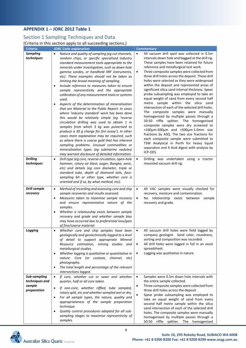
Section 1 Sampling Techniques and Data (Criteria in this section apply to all succeeding sections.)
Criteria JORC Code explanation Commentary Sampling techniques
• Nature and quality of sampling (eg cut channels, random chips, or specific specialised industry standard measurement tools appropriate to the minerals under investigation, such as down hole gamma sondes, or handheld XRF instruments, etc). These examples should not be taken as limiting the broad meaning of sampling.
• Include reference to measures taken to ensure sample representivity and the appropriate calibration of any measurement tools or systems used.
• Aspects of the determination of mineralisation that are Material to the Public Report. In cases where ‘industry standard’ work has been done this would be relatively simple (eg ‘reverse circulation drilling was used to obtain 1 m samples from which 3 kg was pulverised to produce a 30 g charge for fire assay’). In other cases more explanation may be required, such as where there is coarse gold that has inherent sampling problems. Unusual commodities or mineralisation types (eg submarine nodules) may warrant disclosure of detailed information.
• All vacuum drill spoil was collected in 0.5m intervals down hole and bagged at the drill rig. These samples have been retained for future reference and metallurgical test work.
• Three composite samples were collected from three drill holes across the deposit. These drill holes were selected as they were widespread within the deposit and represented areas of significant silica sand interval thickness. Spear probe subsampling was employed to take an equal weight of sand from every second half metre sample within the silica sand intersection of each of the selected drill holes. The composite samples were manually homogenised by multiple passes through a 50:50 riffle splitter. The homogenised composite samples were dry screened to +100µm-500µm and +500µm-1.0mm size fractions by ASQ. The two size fractions for each composite sample were submitted to TSW Analytical in Perth for heavy liquid separation and 4 Acid digest with analysis by ICP-OES.
Drilling techniques
• Drill type (eg core, reverse circulation, open-hole hammer, rotary air blast, auger, Bangka, sonic, etc) and details (eg core diameter, triple or standard tube, depth of diamond tails, face-sampling bit or other type, whether core is oriented and if so, by what method, etc).
• Drilling was undertaken using a tractor mounted vacuum drill rig.
Drill sample recovery
• Method of recording and assessing core and chip sample recoveries and results assessed.
• Measures taken to maximise sample recovery and ensure representative nature of the samples.
• Whether a relationship exists between sample recovery and grade and whether sample bias may have occurred due to preferential loss/gain of fine/coarse material.
• All VAC samples were visually checked for recovery, moisture and contamination.
• No relationship exists between sample recovery and grade.
Logging • Whether core and chip samples have been geologically and geotechnically logged to a level of detail to support appropriate Mineral Resource estimation, mining studies and metallurgical studies.
• Whether logging is qualitative or quantitative in nature. Core (or costean, channel, etc) photography.
• The total length and percentage of the relevant intersections logged.
• All vacuum drill holes were field logged by company geologist. Sand color, roundness, sorting and composition was recorded.
• All drill holes were logged in full in an excel spreadsheet.
• Logging was qualitative in nature.
Sub-sampling techniques and sample preparation
• If core, whether cut or sawn and whether quarter, half or all core taken.
• If non-core, whether riffled, tube sampled, rotary split, etc and whether sampled wet or dry.
• For all sample types, the nature, quality and appropriateness of the sample preparation technique.
• Quality control procedures adopted for all sub-sampling stages to maximise representivity of samples.
• Samples were 0.5m down hole intervals with the entire sample collected.
• Three composite samples were collected from three drill holes across the deposit.
• Spear probe subsampling was employed to take an equal weight of sand from every second half metre sample within the silica sand intersection of each of the selected drill holes. The composite samples were manually homogenised by multiple passes through a 50:50 riffle splitter. The homogenised

10 Suite 10, 295 Rokeby Road, SUBIACO WA 6008
Phone: +61 8 9200 8200 Fax: +61 8 9200 8299 www.asqg.com.au
Criteria JORC Code explanation Commentary • Measures taken to ensure that the sampling is
representative of the in situ material collected, including for instance results for field duplicate/second-half sampling.
• Whether sample sizes are appropriate to the grain size of the material being sampled.
composite samples were dry screened to +100µm-500µm and +500µm-1.0mm size fractions by ASQ.
• TSW Analytical completed heavy liquid separation on each composite sample with the -2.89kg/dm3 “float” material collected for analysis. Heavy liquid separation is an industry accepted method for approximating the inclusion of gravity separation elements such as spiral circuits in the recovery processing for a silica sand product.
• QC procedures involved the inclusion of non-certified high purity silica sand reference materials for the heavy liquid separation, acid digest and analysis carried out at TSW Analytical. Recognised laboratories have been used for analysis of samples.
• Sample sizes are considered appropriate to correctly represent the bulk tonnage mineralisation based on the style of mineralisation, the thickness and consistency of the intersections, the sampling methodology and assay value ranges for silica sand.
Quality of assay data and laboratory tests
• The nature, quality and appropriateness of the assaying and laboratory procedures used and whether the technique is considered partial or total.
• For geophysical tools, spectrometers, handheld XRF instruments, etc, the parameters used in determining the analysis including instrument make and model, reading times, calibrations factors applied and their derivation, etc.
• Nature of quality control procedures adopted (eg standards, blanks, duplicates, external laboratory checks) and whether acceptable levels of accuracy (ie lack of bias) and precision have been established.
• The composite samples were analysed at TSW Analytical in Perth. The samples were fully digested in a multi acid mix of Hydrofluoric, Nitric and Perchloric acids in Teflon beakers and analysed by Inductively Coupled Plasma Optical (Atomic) Emission Spectrometry.
• Non-certified high purity silica (99.99% SiO2) standards were included in the drill sample submissions to TSW. The high purity standard was not certified but has been previously used by the company at multiple laboratories to determine the level of contamination by the laboratory processes.
• Laboratory QAQC includes the use of internal standards using certified reference material, laboratory duplicates and pulp repeats. A full analysis of all the quality control data has been undertaken. This analysis validates the drill assay dataset and conforms with the guidelines for reporting under the JORC 2012 code.
• The QAQC results confirm the suitability of the drilling data for use in the resource estimation.
Verification of sampling and assaying
• The verification of significant intersections by either independent or alternative company personnel.
• The use of twinned holes. • Documentation of primary data, data entry
procedures, data verification, data storage (physical and electronic) protocols.
• Discuss any adjustment to assay data.
• The vacuum drill hole intersections were verified by the ASQ geologist. The ASQ logging process involves placing drill samples for each 0.5m interval into chip trays which are then retained to provide a permanent record of the down hole lithology for audit and validation purposes and reconciliation of assay results with geology. These chip trays have been inspected and independently verified by Ashmore. The ASQ geologist logged all drill samples at the rig, with a minimum logging interval of 0.5m.
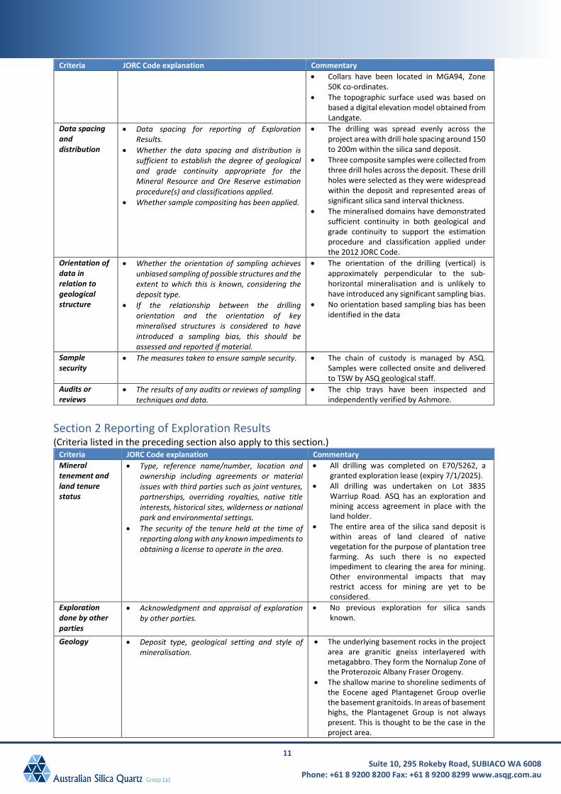
Location of data points
• Accuracy and quality of surveys used to locate drill holes (collar and down-hole surveys), trenches, mine workings and other locations used in Mineral Resource estimation.
• Specification of the grid system used. • Quality and adequacy of topographic control.
• All drill holes were located using GPS in MGA grid co-ordinates with the expected relative accuracy. Down hole surveys have not been taken as drill holes are all less than 14.5m in depth and drilled vertically through the predominantly flat lying sand deposits.
11 Suite 10, 295 Rokeby Road, SUBIACO WA 6008
Phone: +61 8 9200 8200 Fax: +61 8 9200 8299 www.asqg.com.au
Criteria JORC Code explanation Commentary • Collars have been located in MGA94, Zone
50K co-ordinates. • The topographic surface used was based on
based a digital elevation model obtained from Landgate.
Data spacing and distribution
• Data spacing for reporting of Exploration Results.
• Whether the data spacing and distribution is sufficient to establish the degree of geological and grade continuity appropriate for the Mineral Resource and Ore Reserve estimation procedure(s) and classifications applied.
• Whether sample compositing has been applied.
• The drilling was spread evenly across the project area with drill hole spacing around 150 to 200m within the silica sand deposit.
• Three composite samples were collected from three drill holes across the deposit. These drill holes were selected as they were widespread within the deposit and represented areas of significant silica sand interval thickness.
• The mineralised domains have demonstrated sufficient continuity in both geological and grade continuity to support the estimation procedure and classification applied under the 2012 JORC Code.
Orientation of data in relation to geological structure
• Whether the orientation of sampling achieves unbiased sampling of possible structures and the extent to which this is known, considering the deposit type.
• If the relationship between the drilling orientation and the orientation of key mineralised structures is considered to have introduced a sampling bias, this should be assessed and reported if material.
• The orientation of the drilling (vertical) is approximately perpendicular to the sub-horizontal mineralisation and is unlikely to have introduced any significant sampling bias.
• No orientation based sampling bias has been identified in the data
Sample security
• The measures taken to ensure sample security. • The chain of custody is managed by ASQ. Samples were collected onsite and delivered to TSW by ASQ geological staff.
Audits or reviews
• The results of any audits or reviews of sampling techniques and data.
• The chip trays have been inspected and independently verified by Ashmore.
Section 2 Reporting of Exploration Results (Criteria listed in the preceding section also apply to this section.)
Criteria JORC Code explanation Commentary Mineral tenement and land tenure status
• Type, reference name/number, location and ownership including agreements or material issues with third parties such as joint ventures, partnerships, overriding royalties, native title interests, historical sites, wilderness or national park and environmental settings.
• The security of the tenure held at the time of reporting along with any known impediments to obtaining a license to operate in the area.
• All drilling was completed on E70/5262, a granted exploration lease (expiry 7/1/2025).
• All drilling was undertaken on Lot 3835 Warriup Road. ASQ has an exploration and mining access agreement in place with the land holder.
• The entire area of the silica sand deposit is within areas of land cleared of native vegetation for the purpose of plantation tree farming. As such there is no expected impediment to clearing the area for mining. Other environmental impacts that may restrict access for mining are yet to be considered.
Exploration done by other parties
• Acknowledgment and appraisal of exploration by other parties.
• No previous exploration for silica sands known.
Geology • Deposit type, geological setting and style of mineralisation.
• The underlying basement rocks in the project area are granitic gneiss interlayered with metagabbro. They form the Nornalup Zone of the Proterozoic Albany Fraser Orogeny.
• The shallow marine to shoreline sediments of the Eocene aged Plantagenet Group overlie the basement granitoids. In areas of basement highs, the Plantagenet Group is not always present. This is thought to be the case in the project area.
12 Suite 10, 295 Rokeby Road, SUBIACO WA 6008
Phone: +61 8 9200 8200 Fax: +61 8 9200 8299 www.asqg.com.au
Criteria JORC Code explanation Commentary • Deposits of fine white silica sand such as that
seen in the project area are considered to be aeolian deposits younger than the Plantagenet Group.
Drill hole information
• A summary of all information material to the under-standing of the exploration results including a tabulation of the following information for all Material drill holes: • easting and northing of the drill hole collar • elevation or RL (Reduced Level – elevation
above sea level in metres) of the drill hole collar
• dip and azimuth of the hole • down hole length and interception depth • hole length
• If the exclusion of this information is justified on the basis that the information is not Material and this exclusion does not detract from the understanding of the report, the Competent Person should clearly explain why this is the case.
• All information has been included in the appendices. No drill hole information has been excluded.
Data aggregation methods
• In reporting Exploration Results, weighting averaging techniques, maximum and/or minimum grade truncations (e.g. cutting of high grades) and cut-off grades are usually Material and should be stated.
• Where aggregate intercepts incorporate short lengths of high grade results and longer lengths of low grade results, the procedure used for such aggregation should be stated and some typical examples of such aggregations should be shown in detail.
• The assumptions used for any reporting of metal equivalent values should be clearly stated.
• Exploration results are not being reported. • Not applicable as a Mineral Resource is being
reported. • Metal equivalent values have not been used.
Relationship between mineralisation widths and intercept lengths
• These relationships are particularly important in the reporting of Exploration Results.
• If the geometry of the mineralisation with respect to the drill hole angle is known, its nature should be reported.
• If it is not known and only the down hole lengths are reported, there should be a clear statement to this effect (e.g. ‘down hole length, true width not known’).
• All drill holes are vertical and intersect the tabular, flat lying mineralisation orthogonally, and represent close to true thickness.
Diagrams • Appropriate maps and sections (with scales) and tabulations of intercepts should be included for any significant discovery being reported. These should include, but not be limited to a plan view of drill hole collar locations and appropriate sectional views.
• Relevant diagrams have been included within the Mineral Resource report main body of text.
Balanced Reporting
• Accuracy and quality of surveys used to locate drill holes (collar and down-hole surveys), trenches, mine workings and other locations used in Mineral Resource estimation.
• Where comprehensive reporting of all Exploration Results is not practicable, representative reporting of both low and high grades and/or widths should be practiced to avoid misleading reporting of Exploration Results.
• All drill hole collars were located by GPS in MGA94 Zone 50 grid.
• Exploration results are reported in full.
Other substantive exploration data
• Other exploration data, if meaningful and material, should be reported including (but not limited to): geological observations; geophysical survey results; geochemical survey results; bulk
• No other exploration data other than vacuum drill samples have been collected at E70/5262.
13 Suite 10, 295 Rokeby Road, SUBIACO WA 6008
Phone: +61 8 9200 8200 Fax: +61 8 9200 8299 www.asqg.com.au
Criteria JORC Code explanation Commentary samples - size and method of treatment; metallurgical test results; bulk density, groundwater, geotechnical and rock characteristics; potential deleterious or contaminating substances.
Further work • The nature and scale of planned further work (e.g. tests for lateral extensions or depth extensions or large- scale step-out drilling).
• Diagrams clearly highlighting the areas of possible extensions, including the main geological interpretations and future drilling areas, provided this information is not commercially sensitive.
• Drilling completed to date indicates the presence of silica sand mineralisation only. Further drilling will be conducted to improve the confidence in the geological continuity.
• Refer to diagrams in the body of text within the Mineral Resource report.
Section 3 Estimation and Reporting of Mineral Resources (Criteria listed in the preceding section also apply to this section.)
Criteria JORC Code explanation Commentary Database integrity
• Measures taken to ensure that data has not been corrupted by, for example, transcription or keying errors, between its initial collection and its use for Mineral Resource estimation purposes.
• Data validation procedures used.
• The database is validated by ASQG geologists. All drill logs are validated digitally by the database geologist once assay results are returned from the laboratory.
• Ashmore also performed data audits in Surpac and checked collar coordinates, down hole surveys and assay data for errors. No errors were found.
Site visits • Comment on any site visits undertaken by the Competent Person and the outcome of those visits.
• If no site visits have been undertaken indicate why this is the case.
• A site visit has not been conducted by Ashmore.
• A site visit was not considered necessary due to the Albany White Sand Hill Mineral Resource classification (Inferred). In the case of classifying Indicated Mineral Resource in future, a site visit will be conducted.
Geological interpretation
• Confidence in (or conversely, the uncertainty of) the geological interpretation of the mineral deposit.
• Nature of the data used and of any assumptions made.
• The effect, if any, of alternative interpretations on Mineral Resource estimation.
• The use of geology in guiding and controlling Mineral Resource estimation.
• The factors affecting continuity both of grade and geology.
• The confidence in the geological interpretation is considered to be good. The geological setting is a sand dune system overlying the Plantagenet Group sediments
• Geochemistry has been used to assist identification of the rock type applied in the interpretation process.
• The deposit is tabular in geometry. Clear boundaries define the mineralisation.
• Outcropping of mineralisation has supported geochemistry. The mineralised domains are wireframed based on geochemistry and geological logging.
• The flat lying sand dunes are near surface, with minor overburden that follows the undulating topography. The basal extent of the white sand is determined from geochemical changes noted down hole in association with a noted change in sand colour.
Dimensions • The extent and variability of the Mineral Resource expressed as length (along strike or otherwise), plan width, and depth below surface to the upper and lower limits of the Mineral Resource.
• The Albany White Sand Hill Mineral Resource area extends over a strike length of 1,650m (from 6,159,250mN to 6,160,900mE, has a maximum width of 1,565m (from 639,975mE to 641,530mE) and was modelled from surface to a depth of approximately 14m below surface.
Estimation and modelling techniques
• The nature and appropriateness of the estimation technique(s) applied and key assumptions, including treatment of extreme grade values, domaining, interpolation
• Using results derived from sizing and heavy liquid separation analysis, relative yields and composite grades were reported as a global average for each size fraction.
14 Suite 10, 295 Rokeby Road, SUBIACO WA 6008
Phone: +61 8 9200 8200 Fax: +61 8 9200 8299 www.asqg.com.au
Criteria JORC Code explanation Commentary parameters and maximum distance of extrapolation from data points. If a computer assisted estimation method was chosen include a description of computer software and parameters used.
• The availability of check estimates, previous estimates and/or mine production records and whether the Mineral Resource estimate takes appropriate account of such data.
• The assumptions made regarding recovery of by-products.
• Estimation of deleterious elements or other non-grade variables of economic significance (eg sulphur for acid mine drainage characterisation).
• In the case of block model interpolation, the block size in relation to the average sample spacing and the search employed.
• Any assumptions behind modelling of selective mining units.
• Any assumptions about correlation between variables.
• Description of how the geological interpretation was used to control the resource estimates.
• Discussion of basis for using or not using grade cutting or capping.
• The process of validation, the checking process used, the comparison of model data to drill hole data, and use of reconciliation data if available.
• No high grade cuts were deemed necessary. • Maximum extrapolation distance from data
points was 80m, approximately half of the 150 to 200m drill hole spacing.
• Three dimensional mineralised wireframes were used to determine volume of sand mineralisation.
• It is assumed the deposit can be mined with open pit mining techniques.
• It is assumed that there will be no by-products recovered from the mining of silica.
• The deleterious elements reported are Fe2O3, Al2O3, CaO, Na2O, MgO, K2O and TiO2.
• A block model was created Surpac software. The mineralisation was constrained by wireframes prepared using geological logging. Average heavy liquid separation grades for the two size fractions were reported as the silica sand product grades, therefore no grade interpolation was conducted. A block model was generated to report tonnages below the supplied topography to approximate the tonnage for each size fraction.
Moisture • Whether the tonnages are estimated on a dry basis or with natural moisture, and the method of determination of the moisture content.
• Tonnages and grades were estimated on a dry in situ basis.
Cut-off parameters
• The basis of the adopted cut-off grade(s) or quality parameters applied.
• No reporting cut-off grade has been considered as it is assumed all the white sand domain can be processed to create a high purity silica product.
Mining factors or assumptions
• Assumptions made regarding possible mining methods, minimum mining dimensions and internal (or, if applicable, external) mining dilution. It is always necessary as part of the process of determining reasonable prospects for eventual economic extraction to consider potential mining methods, but the assumptions made regarding mining methods and parameters when estimating Mineral Resources may not always be rigorous. Where this is the case, this should be reported with an explanation of the basis of the mining assumptions made.
• Ashmore has assumed that the deposit could potentially be mined using open pit techniques. The minimal amount of overburden and shallow nature of the deposit allows mining to be carried out with surface mining equipment, but the economic viability of this approach has not been verified in this study.
Metallurgical factors or assumptions
• The basis for assumptions or predictions regarding metallurgical amenability. It is always necessary as part of the process of determining reasonable prospects for eventual economic extraction to consider potential metallurgical methods, but the assumptions regarding metallurgical treatment processes and parameters made when reporting Mineral Resources may not always be rigorous. Where this is the case, this should be reported with an explanation of the basis of the metallurgical assumptions made.
• No assumptions have been made regarding metallurgy other than the material could be upgraded to a high purity of more than 99.90% SiO2 product using heavy liquid separation, which is an industry accepted method for approximating the inclusion of gravity separation elements such as spiral circuits in the recovery processing for a silica sand product.
15 Suite 10, 295 Rokeby Road, SUBIACO WA 6008
Phone: +61 8 9200 8200 Fax: +61 8 9200 8299 www.asqg.com.au
Criteria JORC Code explanation Commentary Environmental factors or assumptions
• Assumptions made regarding possible waste and process residue disposal options. It is always necessary as part of the process of determining reasonable prospects for eventual economic extraction to consider the potential environmental impacts of the mining and processing operation. While at this stage the determination of potential environmental impacts, particularly for a greenfields project, may not always be well advanced, the status of early consideration of these potential environmental impacts should be reported. Where these aspects have not been considered this should be reported with an explanation of the environmental assumptions made.
• The Albany White Sand Hill deposit is not subject to any environmental liabilities.
Bulk density • Whether assumed or determined. If assumed, the basis for the assumptions. If determined, the method used, whether wet or dry, the frequency of the measurements, the nature, size and representativeness of the samples.
• The bulk density for bulk material must have been measured by methods that adequately account for void spaces (vugs, porosity, etc), moisture and differences between rock and alteration zones within the deposit.
• Discuss assumptions for bulk density estimates used in the evaluation process of the different materials.
• Four dry in situ bulk density measurements were conducted by Great Southern Geoscience Pty Ltd using a nuclear densometer. The results are corrected based on the measured moisture content.
• A bulk density of 1.52t/m3 was assigned in the block model for the mineralisation based on an average of the four white sand measurements.
Classification • The basis for the classification of the Mineral Resources into varying confidence categories.
• Whether appropriate account has been taken of all relevant factors (ie relative confidence in tonnage/grade estimations, reliability of input data, confidence in continuity of geology and metal values, quality, quantity and distribution of the data).
• Whether the result appropriately reflects the Competent Person’s view of the deposit.
• The Mineral Resource estimate is reported here in compliance with the 2012 Edition of the ‘Australasian Code for Reporting of Exploration Results, Mineral Resources and Ore Reserves’ by the Joint Ore Reserves Committee (JORC). The Mineral Resource was classified as Inferred Mineral Resource based on data quality, sample spacing, and lode continuity.
• The input data is comprehensive in its coverage of the mineralisation and does not favour or misrepresent in-situ mineralisation. The definition of mineralised zones is based on high level geological understanding producing a robust model of mineralised domains.
• The Mineral Resource estimate appropriately reflects the view of the Competent Person.
Audits or reviews
• The results of any audits or reviews of Mineral Resource estimates.
• Internal audits have been completed by Ashmore which verified the technical inputs, methodology, parameters and results of the estimate.


![Chemical Information Review Document for Silica Flour ... · Chemical Information Review Document for Silica Flour (Micronized α-Quartz) [CAS No. 14808-60-7] Supporting Nomination](https://img.pdfslide.us/doc/110x75/5e334e6ecf0973247562f887/chemical-information-review-document-for-silica-flour-chemical-information-review.jpg)