Embed Size (px)
Citation preview
Department of Industry Tourism and Resources
Geoscience Australia
Australian Petroleum Accumulations Report 5 – 2nd Edition
BONAPARTE BASIN
NORTHERN TERRITORY (NT) WESTERN AUSTRALIA (WA)
TERRITORY OF ASHMORE & CARTIER ISLANDS ADJACENT AREA (AC)
JOINT PETROLEUM DEVELOPMENT AREA (JPDA)
S.J.Cadman and P.R.Temple Petroleum Greenhouse Gas and Advice Group
2003
Copyright Commonwealth of Australia, 2003. This work is copyright. Apart from any fair dealing for the purpose of study, research, criticism or review, as permitted under the Copyright Act 1968, no part may be reproduced without prior written permission of the Executive Director, Geoscience Australia. ISBN 0 642 46782 X Preferred way to cite this publication : Cadman, S.J. and Temple, P.R., 2003. Bonaparte Basin, NT, WA, AC & JPDA, Australian Petroleum Accumulations Report 5, 2nd Edition, Geoscience Australia, Canberra. Other reports in the Australian Petroleum Accumulations series : 1. Amadeus Basin, Northern Territory, 1986. 2. Bass Basin, Victoria and Tasmania, 1987. 3. Gippsland Basin, Victoria, 1987. 4. Adavale Basin, Queensland, 1988. 5. Bonaparte Basin, Northern Territory and Western Australia, 1st Edition, 1989. 6. Otway Basin, Victoria and South Australia, 1990. 7. Browse Basin, Western Australia, 1991. 8. Carnarvon Basin, Western Australia, 1993. 9. Canning Basin, Western Australia, 1993. 10. Perth Basin, Western Australia, 1994. 11. Bowen and Surat Basins, Clarence-Moreton Basin, Sydney Basin, Gunnedah Basin and other minor onshore basins, Queensland, NSW and NT, 1998.

CONTENTS SECTION 1 INTRODUCTION SECTION 2 REGIONAL SUMMARY
2.1 Introduction 2.2 Basin Setting 2.3 Basin Evolution 2.4 Stratigraphy 2.5 Petroleum Systems 2.5.1 Palaeozoic Petroleum Systems 2.5.2 Mesozoic Petroleum Systems
SECTION 3 EXPLORATION HISTORY SECTION 4 ASHMORE PLATFORM
4.1 Introduction 4.2 Structural Evolution and Stratigraphy 4.3 Exploration Drilling and Hydrocarbon Occurrences 4.4 Petroleum Potential 4.4.1 Reservoirs and Seals
4.4.2 Source 4.4.3 Traps
SECTION 5 VULCAN SUB-BASIN
5.1 Introduction 5.2 Structural Evolution 5.3 Stratigraphy 5.4 Exploration Drilling and Hydrocarbon Occurrences 5.5 Petroleum Potential
5.5.1 Reservoirs 5.5.2 Seals 5.5.3 Source 5.5.4 Traps
SECTION 6 LONDONDERRY HIGH
6.1 Introduction 6.2 Stratigraphy 6.3 Exploration Drilling and Hydrocarbon Occurrences 6.4 Petroleum Potential
6.4.1 Reservoirs and Seals 6.4.2 Source 6.4.3 Traps
SECTION 7 SAHUL SYNCLINE
7.1 Introduction 7.2 Structural Evolution and Stratigraphy 7.3 Exploration Drilling and Hydrocarbon Occurrences 7.4 Petroleum Potential
7.4.1 Source 7.4.2 Reservoirs and Seals
SECTION 8 SAHUL PLATFORM (NORTHERN BONAPARTE BASIN)
8.1 Introduction 8.2 Structural Evolution 8.3 Stratigraphy
8.3.1 Laminaria High 8.3.2 Troubadour High 8.3.3 Flamingo High 8.3.4 Kelp High
8.4 History of exploration permits in the Zone of Cooperation (ZOC) and Joint Petroleum Development Area (JPDA).
8.5 Exploration Drilling and Hydrocarbon Occurrences 8.6 Petroleum Potential
8.6.1 Reservoirs 8.6.2 Source 8.6.3 Seal 8.6.4 Traps
SECTION 9 MALITA GRABEN
9.1 Introduction 9.2 Structural Evolution and Stratigraphy 9.3 Exploration Drilling and Hydrocarbon Occurrences 9.4 Petroleum Potential
9.4.1 Reservoirs 9.4.2 Seals 9.4.3 Source 9.4.4 Traps
SECTION 10 PETREL SUB-BASIN
10.1 Introduction 10.2 Structural Evolution and Stratigraphy 10.3 Exploration Drilling and Hydrocarbon Occurrences 10.4 Petroleum Potential
10.4.1 Reservoirs 10.4.2 Seals 10.4.3 Source 10.4.4 Traps
SECTION 11 PRODUCTION FACILITIES 11.1 Bayu-Undan 11.2 Buffalo 11.3 Challis / Cassini 11.4 Elang / Kakatua / Kakatua North 11.5 Jabiru 11.6 Laminaria / Corallina 11.7 Skua

SECTION 12 RESERVES
SECTION 13 REFERENCES
TABLES Table 4.1 Results of exploration drilling, Ashmore Platform. Table 4.2 Hydrocarbon shows, Ashmore Platform. Table 5.1 Results of exploration drilling, Vulcan Sub-basin. Table 5.2 Hydrocarbon shows, Vulcan Sub-basin. Table 6.1 Results of exploration drilling, Londonderry High. Table 6.2 Hydrocarbon shows, Londonderry High. Table 7.1 Results of exploration drilling, Sahul Syncline. Table 8.1 Results of exploration drilling, Sahul Platform. Table 8.2 Hydrocarbon shows, Sahul Platform. Table 9.1 Results of exploration drilling, Malita Graben. Table 9.2 Hydrocarbon shows, Malita Graben. Table 10.1 Results of exploration drilling, Petrel Sub-basin. Table 10.2 Hydrocarbon shows, Petrel Sub-basin. Table 12.1 Reserves data, Bonaparte Basin oil and gas accumulations.
FIGURES Figure 2.1 Schematic diagram of the Early Carboniferous petroleum system
(Kennard et al., 2002). Figure 2.2 Schematic diagram of the Permian petroleum system (Kennard et al.,
2002) Figure 2.3 Schematic diagram of the Mesozoic petroleum system, Vulcan Sub-
basin (Kennard et al., 2003) Figure 3.1 Exploration drilling, Bonaparte Basin, 1964 to 2002. Figure 4.1 Dry hole analysis, Ashmore Platform. Figure 5.1 Vulcan Sub-basin / Ashmore Platform / Londonderry High – tectonic
elements, bathymetry and exploration wells. Figure 5.2 Structural elements, Vulcan Sub-basin, Ashmore Platform and
Londonderry High (2003 Acreage Release CD-ROM) Figure 5.3 Vulcan Sub-basin – stratigraphy, tectonics and petroleum discoveries. Figure 5.4 Petroleum discoveries, Vulcan Sub-basin (Part 1). Figure 5.5 Petroleum discoveries, Vulcan Sub-basin (Part 2). Figure 5.6 Dry hole analysis, Vulcan Sub-basin. Figure 5.7 Interpretation of Geoscience Australia seismic line VTT-01 through
the southern Vulcan-Sub-basin (2003 Acreage Release CD-ROM). Figure 6.1 Stratigraphy, Londonderry High (2000 Acreage Release CD-ROM). Figure 6.2 Petroleum discoveries, Londonderry High. Figure 6.3 Dry hole analysis, Londonderry High. Figure 6.4 Interpreted seismic line N98R-03 through the Vulcan Sub-basin and
Londonderry High (2000 Acreage Release CD-ROM). Figure 8.1 Sahul Platform – tectonic elements, exploration wells and bathymetry. Figure 8.2 Structural elements, Northern Bonaparte Basin. (2002 Acreage Release
CD-ROM). Figure 8.3 Sahul Platform – stratigraphy, tectonics and petroleum discoveries. Figure 8.4 Petroleum discoveries, Northern Bonaparte Basin. Figure 8.5 Dry hole analysis, Northern Bonaparte Basin. Figure 8.6 Cross-section, Troubadour-1 to Heron-1 (2002 Acreage Release CD-
ROM). Figure 9.1 Structure and stratigraphy of the Malita Graben and adjacent terraces
(2003 Acreage Release CD-ROM). Figure 9.2 Porosity plot for wells in the Malita Graben (1999 Acreage Release
CD-ROM) Figure 9.3 Jacaranda-1, geohistory. Figure 9.4 Dry hole analysis, Malita Graben. Figure 10.1 Petrel Sub-basin – tectonic elements, exploration wells and
bathymetry. Figure 10.2 Petrel Sub-basin – stratigraphy, tectonics and petroleum discoveries. Figure 10.3 Petroleum discoveries, Petrel Sub-basin Figure 10.4 Dry hole analysis, Petrel Sub-basin. Figure 10.5 Geological cross-section of the southern Petrel Sub-basin (modified
after Miyazki, 1997). Figure 10.6 Play types in the southern Petrel Sub-basin (modified after Miyazaki,
1997). Figure 12.1 Initial oil and condensate reserves (cumulative), Bonaparte Basin, 1968
to 2002. Figure 12.2 Initial gas reserves (cumulative), Bonaparte Basin, 1968 to 2002. Figure 12.3 API oil gravities, Bonaparte Basin. Structure Maps Avocet Near Base Cretaceous, TWT map. Barnett Top Tanmurra Fm, TWT map. Bayu-Undan Top Callovian, depth map. Bilyara Top Montara Fm, depth map. Buller Top Elang Fm, depth map. Cassini Base Cretaceous Unconformity, depth map. Challis Base Cretaceous Unconformity, depth map. Curlew Near Base Cretaceous, depth map. Delamere Intra-Valanginian, TWT map. East Swan Base Cretaceous, TWT map. Eclipse Intra-Flamingo Group, TWT map. Eider Near Base Cretaceous, OWT map. Elang Near Break-up Unconformity, depth map. Evans Shoal Top Plover Fm, TWT map. Fishburn Near Top Hyland Bay Fm, TWT map. Flamingo Near Base Cretaceous, OWT map. Flat Top Near Top Permian, OWT map. Garimala Intra-Bonaparte Fm, depth map. Halcyon Near Base Cretaceous, depth map. Jabiru Top Reservoir, depth map. Kakatua Top Elang Fm, depth map. Kakatua North
Top Elang Fm, depth map.
Keep River Top Langfield Group, TWT map. Laminaria Top Reservoir, depth map. Lesueur Top Permian, TWT map. Leeuwin Top Montara Fm, depth map. Lorikeet Intra-Valanginian Unconformity, TWT map. Maret Intra-Valanginian Unconformity, TWT map. Montara Top Plover Fm, depth map. Oliver Callovian Unconformity, depth map. Pengana Base Cretaceous, depth map. Penguin Near Base Upper Permian, TWT map. Petrel Intra-Hyland Bay Fm, depth map. Puffin Near Top Puffin Fm, depth map. Rambler Top Plover Fm, depth map. Skua Intra-Valanginian Unconformity, depth map. Sunrise Near Base Cretaceous, depth map. Sunset Near Base Cretaceous, depth map. Swan Intra-Puffin Fm, depth map. Tahbilk Top Montara Fm, depth map. Talbot Base Cretaceous, depth map. Tern Near Top Hyland Bay Fm, depth map. Troubadour Near Base Cretaceous, depth map.

Turtle Intra-Kulshill Fm, TWT map.

PLATES
Plate 1. Tectonic elements and petroleum discoveries, Bonaparte Basin. Plate 2. Chronostratigraphy and tectonics, Bonaparte Basin.
APPENDIX 1
Accumulation Number Accumulation Summary
1 Ascalon 2 Audacious 3 Avocet 4 Barnett 5 Bay-Undan 6 Bilyara 7 Birch 8 Blacktip 9 Bluff 10 Bonaparte 11 Buffalo 12 Buller 13 Cassini 14 Challis 15 Chuditch 16 Corallina 17 Crux 18 Curlew 19 Delamere 20 East Swan 21 Eclipse 22 Eider 23 Elang 24 Evans Shoal 25 Fishburn 26 Flamingo 27 Flat Top 28 Fohn 29 Garimala 30 Halcyon 31 Jabiru 32 Jahal 33 Kakatua 34 Kakatua North 35 Keep River 36 Kelp Deep 37 Krill 38 Kuda Tasi 39 Laminaria 40 Lesueur 41 Leeuwin 42 Lorikeet 43 Loxton Shoals
44 Maple 45 Maret 46 Montara 47 Oliver 48 Padthaway 49 Pengana 50 Penguin 51 Petrel 52 Prometheus/Rubicon 53 Puffin 54 Rambler 55 Saratoga 56 Skua 57 Sunrise 58 Sunset 59 Swan 60 Tahbilk 61 Talbot 62 Tenacious 63 Tern 64 Troubadour 65 Turtle 66 Vienta 67 Waggon Creek 68 Weaber

ABBREVIATIONS oAPI degrees American Petroleum Institute. bbl(s) barrel(s) BCF billion cubic feet BCM billion cubic metres oC degrees centigrade cc cubic centimeters DIR Department of Industry and Resources, Western Australia DRD Department of Resources Development, Western Australia DST drill stem test oF degrees fahrenheit FPSO floating production, storage and offloading facility FSO floating storage and offloading facility ft feet ft3 cubic feet JPDA Joint Petroleum Development Area km kilometres km2 square kilometers kpa kilopascals LNG liquefied natural gas LPG liquefied petroleum gas m metres mm millimetres m3 cubic metres mD millidarcies MDT modular dynamic tester mKB metres below kelly bushing ml millilitres MMbbls million barrels MMscf million standard cubic feet mRT metres below rotary table MSCT multiple sidewall core tool mSS metres sub-sea NTBIRD NorthernTerritory Department of Business, Industry and Resources ppm parts per million psi pounds per square inch (absolute) psia pounds per square inch absolute psig pounds per square inch gauge RFT repeat formation test scf standard cubic feet

ABBREVIATIONS CONTINUED
ST sidetrack stb stock tank barrels TCF trillion cubic feet TVDSS true vertical depth sub-sea TVDKB true vertical depth below kelly bushing TVT true vertical thickness ZOC Zone of Cooperation

1. INTRODUCTION This report contains data on the 68 petroleum accumulations discovered in the Bonaparte Basin to December 2002. It provides summaries of the regional setting, evolution and stratigraphy of the basin and discusses the hydrocarbon habitat and development of the producing accumulations. For the purpose of this report, a discrete, measured recovery of petroleum on test from an exploration well qualifies as a ‘discovery’. Petroleum accumulations inferred from wireline log interpretations (and where petroleum has not been recovered on test) are referred to as ‘shows’. Small quantities of gas recovered on test in three wells included in this report may represent ‘solution gas’ - indicating these wells may not have intersected a petroleum pool. In this report, a petroleum accumulation is classified as a ‘producer’ if, at time of writing, petroleum production is occurring; a ‘past producer’ if the accumulation has been depleted or is currently not producing; an ‘other discovery’ if the petroleum accumulation is unlikely to be produced within the next 15 years and; a ‘possible future producer’ if the accumulation is held under Retention Lease or where a development is under consideration. Reserves data used in this report are publicly available from the West Australian Department of Minerals and Energy and Northern Territory Department of Business, Industry and Resource Development. Non-confidential (‘open file’) test results from discovery wells drilled in the Bonaparte Basin are listed in Appendix 1.
2. REGIONAL SUMMARY
2.1 Introduction The Bonaparte Basin is a large, predominantly offshore sedimentary basin that covers approximately 270,000 square kilometres of Australia’s northwest continental margin. The basin contains up to 15 kilometres of Phanerozoic, marine and fluvial, siliciclastic and carbonate sediments. The basin has undergone two phases of Palaeozoic extension, a Late Triassic compressional event and further extension in the Mesozoic. Convergence of the Australian and Eurasian plates in the Miocene to Pliocene resulted in flexural downwarp of the Timor Trough and widespread fault reactivation across the western Bonaparte Basin. At date of writing, 68 petroleum accumulations had been identified within the Bonaparte Basin in reservoirs ranging from Carboniferous to Late Cretaceous in age (Plate 1, Appendix 1). Commercial production has occurred from 11 of these discoveries. 2.2 Basin Setting The Bonaparte Basin is structurally complex and comprises a number of Palaeozoic and Mesozoic sub-basins and platform areas. The Basin adjoins the Browse Basin to the south along the southwest margins of the Ashmore Block and the Vulcan Sub-basin (Plate 1). In the northeast, beyond the limits of the Darwin Shelf, the Bonaparte Basin adjoins the Arafura and Money Shoal Basins. The northern margin of the basin is taken as the Timor Trough, where water depths exceed 3,000 metres. In the east, the northwest trending Petrel Sub-basin (referred to as the Bonaparte Basin by Gunn, 1988) underlies the Joseph Bonaparte Gulf (Figures 10.1, Plate 1). The sub-basin developed during rifting in the Late Devonian to Early Carboniferous and contains a thick evaporitic sequence, which was mobilised in a subsequent episode of salt tectonism (Gunn, 1988; Lee and Gunn, 1988). Offshore, the Petrel Sub-basin is orthogonally overprinted by a northeast and east-northeast trending, Mesozoic structural grain that resulted from rifting and the ultimate break-up of Gondwanaland in the Middle Jurassic (O’Brien et al., 1993). The Malita Graben, a major Triassic depocentre which lies between the Petrel Sub-basin and the Sahul Platform, developed at this time (Plate 1). The graben also contains a significant thickness of Cainozoic, Cretaceous and possibly, Late Jurassic sediments (Botten and Wulff, 1990; O’Brien et al., 1993)(Figure 9.1, Plate 2). The Sahul Platform, which underlies most of Joint Petroleum Development Area (JPDA), was a structural high throughout much of the Late Jurassic (Botten and Wulff, 1990). The southwest margin of both the Sahul Platform and the Malita Graben are delimited by the northwest trending, Sahul Syncline (Figure 8.1, Plate 1).
Botten and Wulff, (1990) consider the Sahul Syncline formed in the Late Triassic to Middle Jurassic, whereas others (Durrant et al., 1990), believe it developed as part of the Bonaparte rift system in the Late Devonian. The Vulcan Sub-basin, a major, northeast trending, Late Jurassic depocentre, lies southwest of the Sahul Syncline (Patillo and Nicholls, 1990). The Vulcan Sub-basin has been further sub-divided into a number of intra-sub-basin terraces and grabens (Figures 5.1 and 5.2, Plate 1). The Vulcan Sub-basin is flanked both in the east and west by Permo-Triassic ‘high’ blocks - the Londonderry High and the Ashmore Platform, respectively. 2.3 Basin Evolution The Bonaparte Basin has undergone a complex structural history. The Phanerozoic evolution of the Timor Sea area has been described by Veevers, (1971 and 1988); Gunn, (1988); Patillo and Nicholls, (1990); O’Brien et al., (1993); AGSO NW Shelf Study Group, (1994); Baillie et al., (1994); Whittam et al., (1996); O’Brien et al., (1996); Schuster et al., (1998); and Kennard et al., (2002 and 2003). Neogene tectonism (and its implications for petroleum exploration in the basin) is described by Bowin et al., (1980); McCaffery, (1998); Richardson, (1993); and Keep et al., (2002). Key tectonic events in the evolution of the Bonaparte Basin include: • A northwest-trending, Late Devonian to Early Carboniferous rift formed the
Petrel Sub-basin; • Extension in the Late Carboniferous to Early Permian overprinted the older
trend with a northeast oriented structural grain. The proto-Vulcan Sub-basin and Malita Graben developed at this time;
• A compressional event in the Late Triassic caused uplift and erosion on the Londonderry High, the Ashmore and Sahul Platforms and on the southern margins of the Petrel Sub-basin;
• In response to Mesozoic extension, the Vulcan Sub-basin, Malita Graben and Sahul Syncline became major, Jurassic depocentres;
• With the onset of thermal subsidence in the Valanginian, a thick wedge of fine grained, clastic and carbonate sediments prograded across the offshore Bonaparte Basin during the Cretaceous and Cainozoic;
• Regional compression associated with the collision of the Australian plate with the South East Asian microplates in the Miocene formed the Timor Trough and the strongly faulted northern margin of the adjacent, Sahul Platform.
2.4 Stratigraphy The regional geology and stratigraphy of the Bonaparte basin has been described by many authors over the last half century. The first regional studies were largely of the onshore sequence (Traves, 1955; studies by the Bureau of Mineral Resources, Geology and Geophysics, Australia, from 1963-71; Veevers and Roberts, 1968; Guillaume, 1966; Brady et al., 1966; and Mory and Beere, 1988). Many authors have since described the regional geology and stratigraphy of both the onshore and offshore Bonaparte Basin. The following description of the stratigraphy of the Bonaparte Basin is largely based on the work of Mory, (1991); Lavering and Ozimic, (1989); Whittam et al., (1996); Labutis et al., (1998); and Shuster et al., (1998). Technical material accompanying the Commonwealth’s annual release of offshore exploration acreage to the petroleum industry has also been used in the preparation of this report (Release of Offshore Petroleum Exploration Areas, 2001, 2002 and 2003). The Bonaparte Basin has undergone a complex tectonic history. Consequently, the stratigraphy varies considerably across the basin (Messent et al., 1994) - Palaeozoic sediments are largely restricted to the onshore and inboard portions of the Petrel Sub-basin while Mesozoic and Cainozoic sequences are largely confined to the outboard portion of the Bonaparte Basin (Plate 2). Sedimentation in the Petrel Sub-basin commenced in the Cambrian (Figure 10.2). The pre-rift sequence comprises extensive evaporite deposits, but the precise age (Ordovician, Silurian or Devonian), lateral continuity and extent of these salt bodies is uncertain. Subsequent salt tectonics (flow, diapirism, and withdrawal) has controlled the development of numerous structural and stratigraphic traps within the sub-basin (Edgerley & Crist, 1974; Durrant et al., 1990; Miyazaki, 1997; Lemon & Barnes, 1997)(Figure 10.6). Northeast-southwest rifting was initiated in the Late Devonian, when clastic and carbonate sediments were deposited in shallow marine and non-marine environments across the Petrel Sub-basin. This was followed by a thick, Carboniferous succession of marine, fluvio-deltaic and finally glacial sediments which were deposited in response to post-rift subsidence and salt withdrawal (Figure 10.5). Late Devonian to Late Carboniferous carbonate and clastic sequences are primary exploration objectives in the Petrel Sub-basin. In the Late Carboniferous to Early Permian, the Late Devonian-Carboniferous rift-sag system was orthogonally overprinted by northeast-trending rifting. The proto-Malita Graben developed at this time (O’Brien, 1993; Baxter, 1996). A succession of northwest-thickening, shallow marine to fluvio-deltaic, Permian and Triassic sediments was then deposited across the Bonaparte Basin. Several petroleum accumulations have been identified both within the Permian section in the Petrel Sub-basin (Figure 10.3), and the Triassic, fluvio-deltaic and marginal marine sandstones in the south and east of the Vulcan Sub-basin (Figures 5.4 and 5.5). Uplift in the Late Triassic caused widespread erosion on the Ashmore Platform,
Londonderry High and on the southern margin of the Petrel Sub-basin. A thick succession of fluvial and fluvio-deltaic, Jurassic sediments (Plover Formation) were then deposited in the main depocentres within the basin (Vulcan Sub-basin, Sahul Syncline and Malita Graben) and across the Sahul Platform. In the Northern Bonaparte Basin, a marine facies is developed at the top of the Plover Formation. This unit has been referred to as the Elang Formation, the Laminaria Formation or the ‘Montara beds’. Many of the petroleum accumulations identified in the Vulcan Sub-basin and on the Sahul Platform are structurally trapped in Plover and Elang/Laminaria Formation sandstones (Figure 8.4, 5.4 and 5.5, Plate 2). Plover Formation sediments are absent on the Ashmore Platform and on the crestal parts of the Londonderry High, but onlap the eastern flank of the Londonderry High from the Petrel Sub-basin. In areas south and east of the Malita Graben, however, the Plover Formation is not considered a primary exploration objective due to relatively shallow burial depths. In the Late Jurassic, the rate of subsidence in the major grabens increased and fine grained sediments of the Flamingo Group were deposited over a basin-wide, Callovian unconformity. In the Vulcan Sub-basin, sediments of the Flamingo Group (Upper and Lower Vulcan Formations) have traditionally been considered good quality source rocks. A recent oil discovery in a Tithonian sandstone within the Upper Vulcan Formation (at Tenacious-1) indicates the unit also has reservoir potential. In the Sahul Syncline area, equivalent age sandstones within the Cleia Formation are also considered exploration targets. In the offshore Petrel Sub-basin, a sandstone of Late Jurassic age at the top of the Flamingo Group (Sandpiper sandstone) is considered a secondary exploration objective in the area (Plate 2). Mesozoic extension ended in the Valanginian when a marine transgression flooded the Australian continental margin. With the onset of thermal subsidence, fine grained, clastics and carbonates of the Bathurst Island Group were deposited across the Bonaparte Basin. At the base of the group, the Echuca Shoals Formation provides a regional seal to the underlying Upper Vulcan Formation in the Vulcan Sub-basin and to the Cleia Formation in the Sahul Syncline area. The unit thins on the platform areas in the west of the Bonaparte Basin, and in the Petrel Sub-basin to the east, is equivalent in age to sediments within the lowermost Darwin Formation (Plate 2). Late Cretaceous and Cainozoic sediments typically comprise thick, prograding, platform carbonates. Lowstands sands developed in the Maastrichtian (Puffin Formation) and Eocene (Grebe sandstone), however, are considered exploration targets in the Vulcan Sub-basin. Oil has been recovered on test from the channelled, fan sands within the Puffin Formation at Puffin-1. Regional compression associated with the collision of the Australian plate with the South East Asian microplates reactivated Mesozoic faulting and breached many Middle to Late Jurassic, fault dependent structures on the Londonderry High, Sahul Platform and in the Vulcan Sub-basin - many exploration wells drilled in these areas have intersected residual oil columns within sands of the Plover and Laminaria/Elang Formations (Tables 5.1, 6.1 and 8.1, Figures 5.6, 6.3 and 8.5).
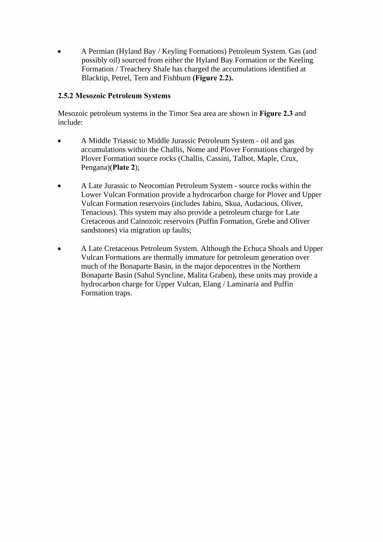
A more detailed description of the Palaeozoic stratigraphy of the Bonaparte Basin can be found in Section 10, Petrel Sub-basin. Mesozoic and Cainozoic stratigraphy is more fully described in Section 5, Vulcan Sub-basin and Section 8, Sahul Platform. 2.5 Petroleum Systems The Bonaparte Basin is a proven petroleum province. The basin contains all the prerequisites for additional discoveries with good quality reservoirs, mature source rocks and traps overlapping over a wide area of the basin. At date of writing, 68 petroleum accumulations had been identified in the Bonaparte Basin (Plates 1 and 2). The petroleum potential of the Bonaparte Basin has been summarised by numerous authors over the last decade including McConachie et al, (1996); Colwell and Kennard, (1996); and Kennard et al., (2002 and 2003). These authors discuss the use of petroleum systems as an integrated approach to basin analysis, recognising existing proven petroleum plays and presenting them as a tool for identification of further hydrocarbon opportunities. Magoon and Dow, (1991 and 1994) define a petroleum system as a mature source rock and all its generated hydrocarbon accumulations. Individual petroleum systems that share source rocks of similar age and facies can be grouped together into petroleum supersystems (Bradshaw et al., 1994). These can provide a basis for prediction of hydrocarbon occurrences in less well explored areas of a basin or basins with similar age rocks. The key features of a petroleum play (source, maturity, reservoir, seal, trapping mechanism) are used to define a petroleum system. Petroleum systems identified in the Bonaparte Basin at date of writing are summarized below. 2.5.1 Palaeozoic Petroleum Systems Colwell and Kennard, (1996) recognized three active Palaeozoic petroleum in the Petrel Sub-basin (elsewhere in the Bonaparte Basin, Palaeozoic sediments are not considered prospective for petroleum). • A Late Devonian (Ningbing Limestone / Bonaparte Formation) Petroleum
System. The gas accumulations identified within these units at Garimala and Vienta in the onshore, Petrel Sub-basin form part of this system and may have been sourced from either the Milligans Formation (Laws, 1981), or from the Bonaparte Formation (Kennard et al., 2002). Residual oil observed in a core cut in the Ningbing Limestone at Ningbing-1, may have been sourced locally from algal material within the limestone. This system appears to be restricted to the onshore and near offshore areas in the south of the Petrel Sub-basin;
• An Early Carboniferous (Milligans / Tanmurra / Kuriyippi Formations)
Petroleum System. Thermally mature, marine mudstones within the Milligans Formation, have probably provided an oil and gas charge for the petroleum accumulations identified at Turtle, Barnett, Weaber and Waggon Creek (Figure 2.1);
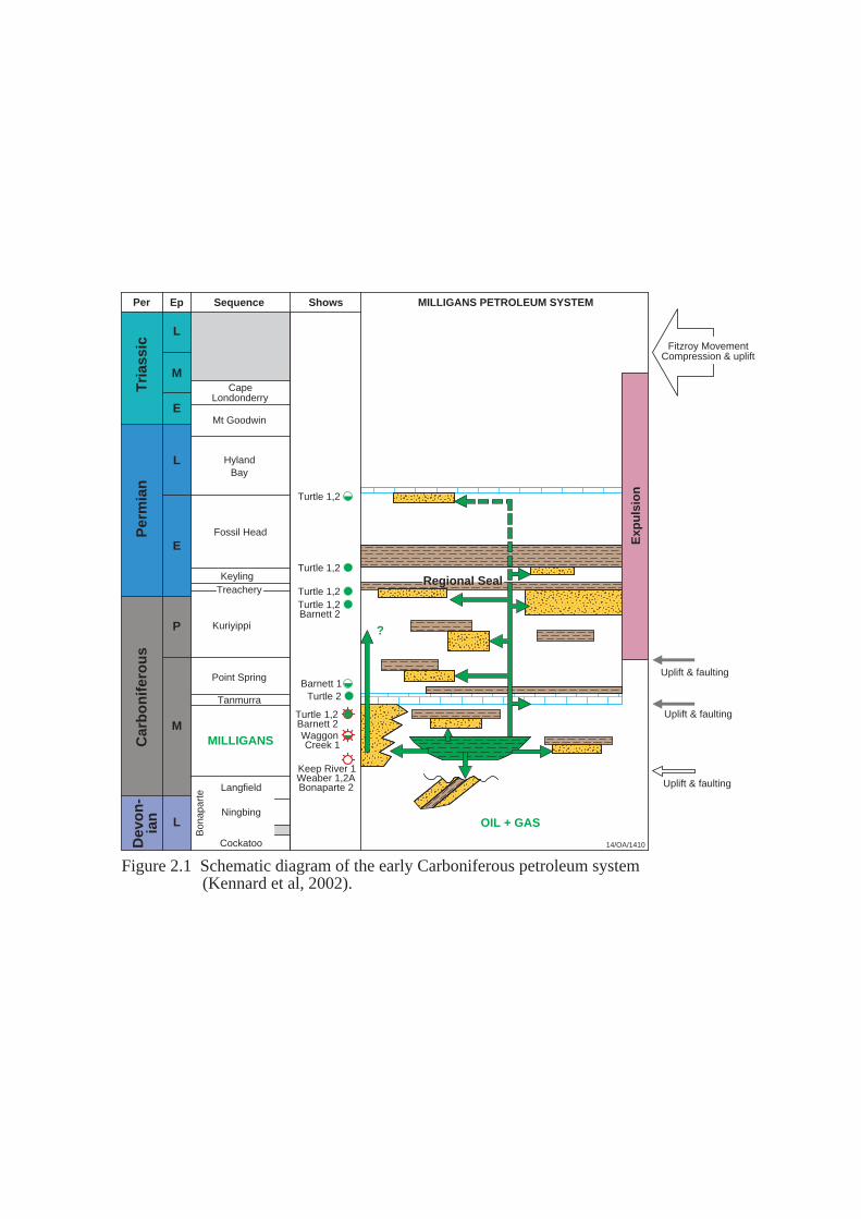
• A Permian (Hyland Bay / Keyling Formations) Petroleum System. Gas (and possibly oil) sourced from either the Hyland Bay Formation or the Keeling Formation / Treachery Shale has charged the accumulations identified at Blacktip, Petrel, Tern and Fishburn (Figure 2.2).
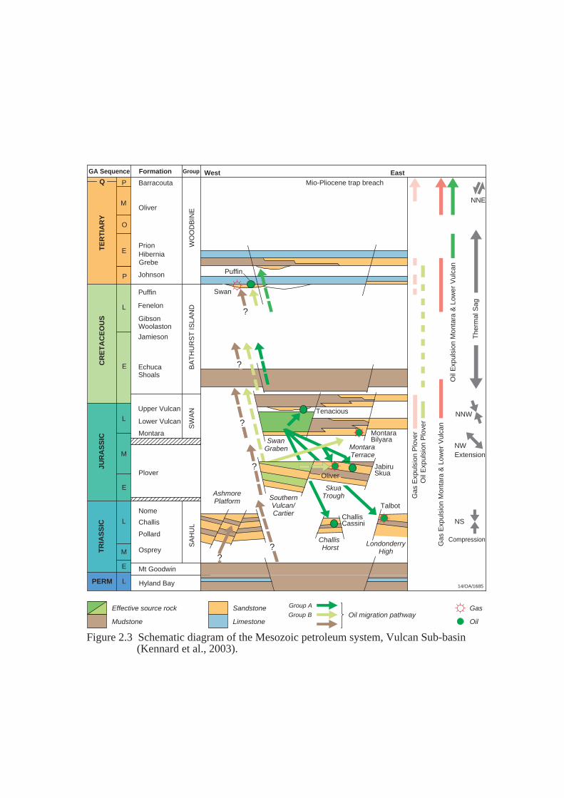
2.5.2 Mesozoic Petroleum Systems Mesozoic petroleum systems in the Timor Sea area are shown in Figure 2.3 and include: • A Middle Triassic to Middle Jurassic Petroleum System - oil and gas
accumulations within the Challis, Nome and Plover Formations charged by Plover Formation source rocks (Challis, Cassini, Talbot, Maple, Crux, Pengana)(Plate 2);
• A Late Jurassic to Neocomian Petroleum System - source rocks within the
Lower Vulcan Formation provide a hydrocarbon charge for Plover and Upper Vulcan Formation reservoirs (includes Jabiru, Skua, Audacious, Oliver, Tenacious). This system may also provide a petroleum charge for Late Cretaceous and Cainozoic reservoirs (Puffin Formation, Grebe and Oliver sandstones) via migration up faults;
• A Late Cretaceous Petroleum System. Although the Echuca Shoals and Upper
Vulcan Formations are thermally immature for petroleum generation over much of the Bonaparte Basin, in the major depocentres in the Northern Bonaparte Basin (Sahul Syncline, Malita Graben), these units may provide a hydrocarbon charge for Upper Vulcan, Elang / Laminaria and Puffin Formation traps.
MILLIGANS PETROLEUM SYSTEM
M
E
L
E
P
M
L
L
Fossil Head
KeylingTreachery
Kuriyippi
Point Spring
Tanmurra
MILLIGANS
Bon
apar
te
Regional Seal
HylandBay
Tri
assi
cP
erm
ian
Car
bo
nif
ero
us
ShowsSequence
Uplift & faulting
Uplift & faulting
Langfield
Ningbing
Cockatoo
Keep River 1Weaber 1,2ABonaparte 2
Turtle 1,2
Turtle 1,2
Turtle 1,2
Turtle 2
Uplift & faulting
?
Fitzroy MovementCompression & uplift
Dev
on
-ia
n
EpPer
CapeLondonderry
Mt Goodwin
Exp
uls
ion
14/OA/1410
WaggonCreek 1
OIL + GAS
Turtle 1,2Barnett 2
Barnett 1
Turtle 1,2Barnett 2
Figure 2.1 Schematic diagram of the early Carboniferous petroleum system (Kennard et al, 2002).

E
L
M
E
L
E
P
Treachery
Kuriyippi
KEYLING
Mt Goodwin
Plover
Malita
HYLAND BAY
Penguin 1
Tern
PetrelFishburn 1
Per
mia
nC
arb
on
-if
ero
us
Tri
assi
cJu
rass
ic
ShowsSequence
Inversion
Erosion
Fitzroy MovementCompression & uplift
Key
ling
Exp
uls
ion
EpPer
CapeLondonderry
Regional Seal
Fossil Head
Ou
ter
Pet
rel
Cen
tral
Pet
rel (
Tri
assi
c -
Cre
tace
ou
s)
Jur
- C
ret
Hyl
and
Bay
Exp
uls
ion
14/OA/1411
KEYLING & HYLAND BAYPETROLEUM SYSTEM
GAS (?OIL)
Blacktip 1
Figure 2.2 Schematic diagram of the Permian petroleum system (Kennard et al, 2002).
The
rmal
Sag
ChallisHorst
AshmorePlatform
Regional seal
SwanGraben
MontaraBilyara
Tenacious
SA
HU
L
EchucaShoals
Grebe
Puffin
Plover
Mt Goodwin
Hyland Bay
Montara
PrionHibernia
Johnson
Fenelon
GibsonWoolaston
Jamieson
Upper Vulcan
Lower Vulcan
SW
AN
BA
TH
UR
ST
ISLA
ND
WO
OD
BIN
E
CR
ET
AC
EO
US
TE
RT
IAR
Y
E
P
L
E
L
M
E
L
JUR
AS
SIC
TR
IAS
SIC
L
E
M
PERM
Osprey
Nome
Challis
Pollard
NW
NNW
NS
SkuaTrough
MontaraTerrace
O
MOliver
Barracouta
NNE
Extension
Compression
14/OA/1685
Talbot
ChallisCassini
Mio-Pliocene trap breach
LondonderryHigh
??
?
?
?
?
Formation GroupGA Sequence
Oil
Exp
ulsi
on M
onta
ra &
Low
er V
ulca
n
Gas
Exp
ulsi
on P
love
rO
il E
xpul
sion
Plo
ver
Gas
Exp
ulsi
on M
onta
ra &
Low
er V
ulca
n
Effective source rock
Mudstone
Sandstone
LimestoneOil migration pathway
Gas
Oil
EastWest
Swan
Puffin
SouthernVulcan/Cartier
Group A
Group B
JabiruSkuaOliver
Figure 2.3 Schematic diagram of the Mesozoic petroleum system, Vulcan Sub-basin (Kennard et al., 2003).
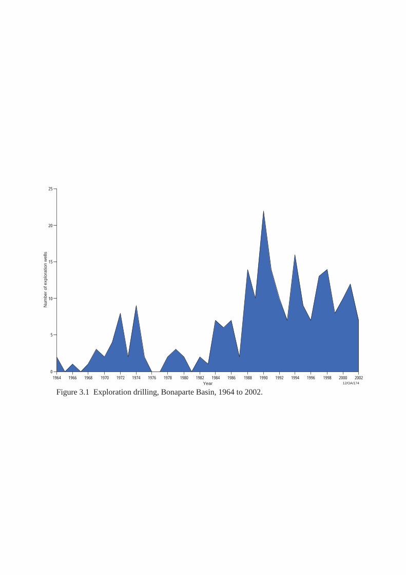
Q P
3. EXPLORATION HISTORY Initial exploration in the Bonaparte Basin commenced in the 1950’s with regional studies of the southeastern, onshore portion of the basin (Petrel Sub-basin). The first exploration well (Spirit Hill-1) was drilled in the onshore Bonaparte Basin in 1959. Initially drilled as a water well, Spirit Hill-1 identified potential petroleum source rocks within the Early Carboniferous section. Further onshore drilling adjacent to the southeastern basin margin in the 1960's, (Bonaparte-1 and -2, Kulshill-1 and -2, Moyle-1 and Keep River-1) provided additional encouragement for petroleum exploration in the area (Table 10.1, Figures 3.1). Although several of these early wells did not test valid structural closures, gas flowed on drill stem test (DST) from the Early Carboniferous, Milligans Formation in Bonaparte-2 (1964) and Keep River-1 (1968). Oil shows were also recorded in the Late Carboniferous to Early Permian section at Kulshill-1 (Table 10.2). Onshore, the first significant discovery did not occur until 1982, when Weaber-1 recovered gas on test from the Early Carboniferous, Enga Sandstone and Milligans Formation. Appraisal drilling on the Weaber feature continued over the next 16 years (Weaber-5 was drilled in 1998). Additional small, gas discoveries were made in the onshore, Petrel Sub-basin in 1995 (Gas was recovered from the Milligans Formation at Waggon Creek-1) and in 1998 (Vienta-1 identified small gas accumulations in the Devonian to Early Carboniferous Langfield Group and Ningbing reef complex). Exploration of the offshore Bonaparte Basin commenced in 1965 when regional aeromagnetic data was acquired over much of the basin. This was supplemented by regional seismic coverage between 1965 and 1974. The first offshore exploration wells were spudded by BOCAL/Woodside in the late 1960's. Located on the Ashmore Platform, Ashmore Reef-1 and Sahul Shoals-1 were drilled as stratigraphic tests. Although these wells failed to encounter hydrocarbons, they indicated the Jurassic section is either thin or absent and that Triassic sandstones form potential petroleum reservoirs over much of the Ashmore Platform. Between 1969 and 1971, Arco Australia and Australian Aquitaine drilled seven wells in the offshore Petrel Sub-basin. This drilling campaign resulted in the discovery of the Petrel and Tern gas fields. Although several appraisal wells have since been drilled on the Petrel and Tern features, these gas accumulations have yet to be developed. The discoveries at Petrel and Tern identified the Late Permian Hyland Bay Formation as a primary exploration target in the Petrel Sub-basin. In the early 1970's, exploration of the offshore Bonaparte Basin expanded beyond the limits of the Petrel Sub-basin and Ashmore Platform to include the Vulcan Sub-basin, Londonderry High and Sahul Platform. Between 1971 and 1975, twenty four wells were drilled - a further 9 in the Petrel Sub-basin, 4 on the Sahul Platform, 6 in the Vulcan Sub-basin, 2 on the Londonderry High and 2 on the Ashmore Platform. Several significant petroleum discoveries were made during this period including Puffin, Troubadour and Sunrise. In 1972, Puffin-1 was drilled to test the Mesozoic section within a horst block on the flanks of the Vulcan Sub-basin. Oil was found (interpreted from wireline logs) in
vuggy, Eocene calcarenites trapped beneath the Eocene/Miocene unconformity and recovered on test from Maastrichtian age sands (Puffin Formation). The Puffin-1 well established the existence of an active petroleum system in the Vulcan Sub-basin. Recent appraisal drilling on the Puffin structure has yet to identify a commercial resource at Puffin. In 1974, Woodside/BOCAL drilled Troubadour-1 on the Troubadour High – a large culmination on the eastern Sahul Platform (Figure 8.2). The well flowed gas on test from the Jurassic, Upper Plover Formation. In 1975, a second well (Sunrise-1) drilled approximately 20 kilometres to the north of Troubadour-1, flowed gas and condensate on test from the same reservoir. Subsequent gas discoveries on the Troubadour High (Loxton Shoals-1, 1995; Sunset-1, 1997; Sunrise-2, 1998; Sunset West-1, 1998;) identified a complex of large, elongate, east-west oriented fault blocks with gas trapped in sandstones of the Plover Formation. This complex is referred to as the Greater Sunrise gas field (or Sunrise/Troubadour field). At date of writing, commercial development of the Greater Sunrise field is under consideration. Between 1974 and 1991, a moratorium was placed on further appraisal drilling on the Sunrise/Troubadour structure until issues related to international jurisdiction and the boundary with Indonesia were resolved. A history of exploration permits in this area can be found in Section 8.4, ‘History of exploration permits in the Zone of Cooperation (ZOC) and the Joint Petroleum Development Area (JPDA)’. Elsewhere in the offshore Bonaparte Basin, relatively low levels of exploration drilling were recorded at this time (between 1975 and 1982, a total of 8 wells were drilled) (Figure 3.1). In 1983, BHP Petroleum drilled Jabiru-1A to test a fault dependent closure on an eroded and tilted Jurassic fault block, located on the Jabiru-Turnstone Horst in the Vulcan Sub-basin. The well flowed oil and gas on test from shallow marine sandstones of the Plover Formation and basal Flamingo Group. The Jabiru discovery was the first commercial oil discovery in the Bonaparte Basin. Production from the Jabiru oil field commenced in 1986. The discovery of oil at Jabiru stimulated exploration in the Bonaparte Basin and over the next three years (1984 to 1986), 21 exploration wells were drilled in the offshore Bonaparte Basin. Of these, 12 were located in the Vulcan Sub-basin or on the western flank of the Londonderry High. This phase of exploration resulted in the discovery of a further two commercial oil accumulations in the Vulcan Sub-basin (Challis and Skua fields) and two non-commercial discoveries in the offshore Petrel Sub-basin (Turtle and Barnett). After a brief downturn in 1987, levels of offshore exploration drilling in the Bonaparte Basin accelerated. Drilling activity peaked in 1990, when 22 exploration wells were drilled (Figure 3.1). Between 1988 and 1990, 31 exploration wells were drilled in the Vulcan Sub-basin. Drilling results from these wells proved disappointing. Although several small oil and

gas discoveries were made (Oliver-1, Montara-1, Bilyara-1, Talbot-1, Maple-1, and Tahbilk-1), at date of writing, none of these are in commercial production. Further to the north, on the terraced flanks of the Malita Graben, Evans Shoal-1 (1988) identified a significant gas accumulation within the Jurassic, Plover Formation. An appraisal well (Evans Shoal-2) was drilled in 1998 and at date of writing, development options for the Evans Shoal accumulation are under consideration. Resolution of the boundary between Indonesia and Australia in 1991 established the Zone of Cooperation (ZOC) and facilitated the further release of exploration acreage on the Sahul Platform. Between 1992 and 1998, the focus of exploration in the offshore Bonaparte Basin shifted to this area. Of the 73 exploration wells drilled in the offshore Bonaparte Basin during this period, 43 were located on or adjacent to the Sahul Platform. The first commercial petroleum success in the area resulting from this phase of exploration occurred in 1994 with the discovery of oil by Elang-1. The Elang structure is the crestal culmination on the 'Elang Trend' (an east-west oriented structural high, located on the northwest flank of the Flamingo High). Oil at Elang is trapped in Late Callovian to Early Oxfordian sandstones beneath the Frigate Shale. These sands have previously been regarded as a marine facies at the top of the Plover Formation, or referred to as the 'Montara beds' (Young et al., 1995). This unit is now referred to as the Elang or Laminaria Formation. In December 1994, Kakatua-1 and Kakatua North-1 were drilled to the west of Elang oil discovery. Both wells recovered oil on test from the Elang/Laminaria Formation. Commercial oil production from a joint Elang/Kakatua/Kakatua North development commenced in 1998 via sub-sea completions, tied back to an FPSO moored over the Elang field. The discovery of oil at Elang identified a new oil play on the Sahul Platform. Further commercial success in the area quickly followed. In late 1994, immediately to the west of the ZOC, Woodside Petroleum drilled Laminaria-1 on the Laminaria High, (Figure 8.2) The Laminaria-1 well tested a faulted horst complex and intersected a 102 metre gross oil column. As at Elang, the oil at Laminaria is trapped in transgressive, estuarine dominated delta sands of Callovian to Early Oxfordian age. In late 1995, Corallina -1 was drilled on a separate horst complex immediately to the north of the Laminaria discovery. Oil and gas were recovered from the same reservoir intersected by Laminaria-1. In 1999, commercial oil production commenced from a combined Laminaria/Corallina development via sub-sea completions tied back to an FPSO. In early 1995, Phillips Petroleum drilled Bayu-1 on a crestal culmination on the Flamingo High. The well intersected a 155 metre gross gas/condensate column in Late Oxfordian to Early Callovian sandstones. In mid-1995, a successful gas discovery well (Undan-1) was drilled on a separate culmination, on an extension of the same feature, in an adjacent exploration permit. Post-drill analysis and subsequent appraisal drilling indicate the Bayu-1 and Undan-1 gas/condensate discoveries comprise a single, large gas-condensate field with an areal extent of approximately
160 square kilometres (Brooks, et al., 1996). Commercial production from Bayu-Undan is expected to commence in 2004. In 1996, BHP Petroleum drilled Buffalo-1 to test the Callovian-Oxfordian section within a tilted fault block on the Laminaria High. The well flowed oil on test and commercial oil production from the Buffalo field commenced in December 1999. The field development comprises an unmanned wellhead platform, supporting three vertical wells, producing to a nearby FPSO. At date of writing, the Buffalo oil discovery remains the most recent commercial petroleum development in the Northern Bonaparte Basin. Since the discovery at Buffalo, petroleum discoveries on the Sahul Platform have been small (Bluff-1, Krill-1, Kuda Tasi-1, Jahal-1, Buller-1 and Chuditch-1) (Figure 8.4). At date of writing, however, a joint development of the Kuda Tasi and Jahal oil discoveries is under consideration. Since the discovery of the Bayu-Undan gas/condensate accumulation in 1995, no commercial gas discoveries have been made in the Northern Bonaparte Basin. The discovery of gas within the Hyland Bay Formation at Kelp Deep-1 in 1997, however, established the Permian section as a valid exploration objective on the platform, at least on the Kelp High. To the south, results of exploration drilling in the Vulcan Sub-basin since the mid-1990s have been disappointing - small oil accumulations have been identified at Tenacious-1 (1997) and Audacious-1 (2001) and a gas accumulation at Crux-1 (2000). At date of writing, commercial development of all three accumulations is under consideration. Although the Tenacious oil discovery is small, the Tenacious-1ST1 well identified a new play in the Vulcan Sub-basin – the discovery is the first in the Vulcan Sub-basin to have oil both trapped and sealed within a Tithonian, submarine fan sand in the Upper Vulcan Formation (Woods and Maxwell, 2003). In 1999, East Timor was granted independence by Indonesia. In that year, only one exploration well (Jura-1) was drilled in the former ZOC. Since that time, two wells (Coleraine-1, 2000; and Kuda Tasi-1, 2001), have been drilled within the now Joint Petroleum Development Area (JPDA). Recent exploration drilling on the northeastern flanks of the Londonderry High identified a gas accumulation at Prometheus/Rubicon (2000). At time of writing, data is confidential and no other details on this discovery are available. During 2001, two wells (Sandbar-1 and Blacktip-1), were drilled in the inshore portion of the Petrel Sub-basin. No hydrocarbons were encountered in Sandbar-1 but Blacktip-1 was completed as a gas discovery. Blacktip-1 encountered a 20 metre gross gas column within the Triassic, Mount Goodwin Formation and a 339 metre gross gas column from several high quality, stacked reservoir zones within the Early Permian, Keyling Formation. Two deeper gas columns were also intersected within the Treachery Formation (Leonard et al., 2003). Although the Blacktip gas discovery has yet to be developed, the proposed construction of a gas pipeline from the Bayu-Undan gas field to Darwin and possible development of the Greater Sunrise gas field

may provide an impetus to the development of small gas accumulations (such as Blacktip) in the southern Petrel Sub-basin.
25
1964 1966 1968 1970 1972 1974 1976 1978 1980 1982 1984 1986 1988 1990 1992 1994 1996 1998 2000 2002
Num
ber
of e
xplo
ratio
n w
ells
20
15
10
5
0
Year
Figure 3.1 Exploration drilling, Bonaparte Basin, 1964 to 2002.12/OA/174
4. ASHMORE PLATFORM 4.1 Introduction The Ashmore Platform is a large, elevated block that abuts the western margin of the Vulcan Sub-basin and the northern flank of the Browse Basin. An arcuate fault zone, concave to the west, divides the platform into two major segments - a western terrain with mainly west-dipping faults, and an eastern terrain with both east-dipping and west-dipping faults (Laws & Kraus, 1974) (Figure 5.2). At date of writing, no petroleum accumulations had been identified on the Ashmore Platform. 4.2 Structural Evolution and Stratigraphy The oldest unit intersected by drilling on the Ashmore Platform is the Triassic, Mount Goodwin Formation (Sahul Shoals-1). Undifferentiated Sahul Group sediments unconformably overly this unit over most of the platform. Interbedded sandstones and shales of the Osprey Formation (a turbidite sequence) onlap Mount Goodwin Formation shales and siltstones on the eastern margin of the Ashmore Platform, while in the west of the platform, an oolitic limestone (Benalla Formation) developed within the Sahul Group (Plate 2). Seafloor spreading to the west of Ashmore Platform commenced in the Callovian when a basin-wide unconformity developed (Veevers, 1984). Jurassic sediments have not been intersected by drilling on the Ashmore Platform and are thought to have been largely removed by erosion in the Callovian. Late Jurassic volcanism associated with this spreading event resulted in the emplacement of the Ashmore Volcanics (a series of basaltic flows and acid volcanics) on the Ashmore Platform. The basin-wide, Valanginian Unconformity (which marks the end on continental breakup and the commencement of thermal subsidence across the basin) is represented by a hiatus in the Vulcan Sub-basin. On the adjacent Ashmore Platform, however, considerable erosion took place, removing late Jurassic/Early Cretaceous sediments (Mory, 1988). A thin, greensand was deposited over the Valanginian Unconformity on the eastern margin of the Ashmore Platform (Darwin or Echuca Shoals Formation equivalent) but is absent by non-deposition or erosion in the west. The Late Cretaceous and Cainozoic succession deposited on the Ashmore Platform is typically a platform carbonate sequence punctuated by unconformities resulting from fluctuating sea levels. The Cartier Formation, an interbedded shale and sandstone sequence, was deposited during the Oligocene on the western Ashmore Platform during one of these regressions. The geological evolution of the Ashmore Platform and its environs is described by O’Brien et al., (1993 & 1996); and Shuster et al., (1998).
4.3 Exploration Drilling and Hydrocarbon Occurrences Wells drilled on the Ashmore Platform, to date, are shown on Figures 5.1 and 5.2. Table 4.1 Results of exploration drilling, Ashmore Platform.
Exploration Well
Year Operator Well Classification
Comments
Ashmore Reef-1 1968 Burmah Oil P&A (Dry) Trap formation probably post-dated main phase of petroleum migration.
Sahul Shoals-1 1970 Burmah Oil P&A (Dry) Lack of access to mature source rocks.
Brown Gannet-1
1972 Arco P&A (Dry) Lack of access to mature source rocks.
North Hibernia-1
1974 Woodside / Burmah Oil
P&A (Dry) Lack of access to mature source rocks.
Prion-1 1974 Arco P&A (Dry) Invalid structural test. Grebe-1 1979 Arco P&A (Dry) Lack of reservoir at primary
objective. Mount Ashmore-1B
1980 Woodside / Burmah Oil
P&A (Dry) Lack of access to mature source rocks / possible breached trap due to late faulting.
Pollard-1 1984 BHP P&A (Dry) Lack of competent top seal / lack of access to mature source rocks.
Rainbow-1 1985 BHP P&A (Dry) Invalid structural test – no cross-fault seal / lack of access to mature source rocks.
Delta-1 1988 Elf Aquitaine P&A (Dry) Lack of access to mature source rocks.
Cartier-1 1988 Santos P&A (Dry) Invalid structural test – no cross-fault seal.
Pascal-1 1990 BHP P&A (Dry) Lack of access to mature source rocks.
Lucas-1 1990 Santos P&A (Dry) Lack of access to mature source rocks.
Pokolbin-1 1990 TCPL P&A (Dry) Lack of access to mature source rocks.
Yarra-1 1990 TCPL P&A (Dry) Lack of access to mature source rocks.
Langhorne-1 1991 TCPL P&A (Dry) Invalid structural test – well probably drilled outside structural closure.
Warb-1A 1992 WMC P&A (Oil show) Invalid structural test – prognosed bounding fault to trap not present.
A dry hole analysis of wells drilled on the Ashmore Platform to December 2002 is shown in Figure 4.1.
Table 4.2 Hydrocarbon shows, Ashmore Platform. Exploration Well Show
Type Depth (mRT)
Formation Show Description
Warb-1A Oil 935-959 Oliver Residual oil in cuttings and swc’s. 4.4 Petroleum Potential The thick, Jurassic pre-rift and syn-rift sediments identified in the Vulcan Sub-basin to the east are largely thin or absent on the Ashmore Platform. Here, intensely faulted Triassic sediments (up to 4,500 metres thick) form an extensive, tilted fault block terrain. Peneplanation in the Late Jurassic to Early Cretaceous led to the deposition of a thick succession of Early Cretaceous-Tertiary passive margin sediments on the unconformity surface. 4.4.1 Reservoirs and Seals On the eastern flanks of the Ashmore Platform, good quality, Triassic sandstone reservoirs have been intersected at Woodbine-1 and Keeling-1. Further to the west, on the Ashmore Platform proper, Triassic fault blocks, either sealed by Early Cretaceous mudstones and shales (where present), or by Late Cretaceous and Cainozoic carbonates, may constitute exploration targets. On the Ashmore Platform, this play type has yet to be validated by a discovery of petroleum. Good quality Maastrichtian (Puffin Fm) and Eocene (Grebe Sandstone Member) sandstones have been intersected in several wells drilled in the adjacent Vulcan Sub-basin. It is possible that Maastrichtian and Eocene sands, sealed by overlying carbonates, may form potential structural and stratigraphic traps on the eastern margin of the Ashmore Platform. 4.4.2 Source Late Jurassic, oil-prone, marine source rocks and coaly fluvio-deltaic and shallow marine sediments of the Early-Middle Jurassic Plover Formation are known to constitute source rocks in the Vulcan Sub-basin to the east (Botten & Wulff, 1990; Kennard et al., 1999). However, Jurassic sediments are generally thin or absent on the Ashmore Platform (Plate 2). Consequently, hydrocarbon charge for traps lying on the Ashmore Platform depends on either long range migration from source rocks within adjacent depocentres (Swan Graben and Caswell Sub-basin), or unproven source facies within the underlying Triassic Sahul Group. It is possible, however, that good quality Jurassic source rocks may be present in remnant Triassic grabens or half-grabens on the Ashmore Platform and provide a local source of hydrocarbons. While the source potential of the Triassic section on the Ashmore Platform is unknown, elsewhere on the North West Shelf, the equivalent section is considered to have sourced several gas accumulations.
4.4.3 Traps Tilted Triassic fault blocks and Maastrichtian to Palaeocene and Eocene lowstand sands on the eastern flanks of the Ashmore Platform constitute the primary exploration objectives in the area. The critical risk factors associated with these plays are: • suitable migration pathways from adjacent/underlying mature source rocks; • trap breach due to late faulting (failure of the Discorbis-1 well, in the Browse
Basin to the south, is attributed to trap breach); • lack of a competent top seal for Palaeocene and Eocene lowstand sands. Gorter et al., (2002) postulated that the Early to Middle Miocene Oliver Formation (intersected by wells in the Vulcan Sub-basin), may be developed as patch reefs on the Ashmore Platform and have exploration potential.
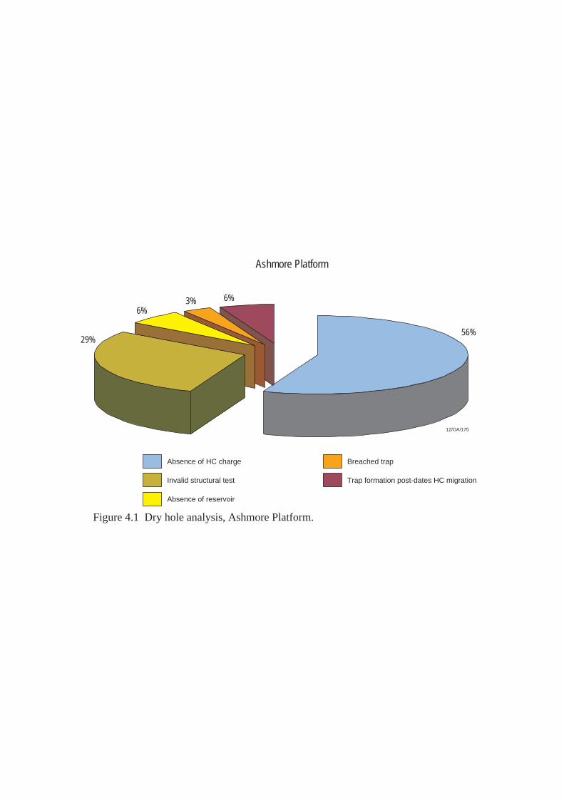
Ashmore Platform
29%
6%3% 6%
56%
Absence of HC charge
Absence of reservoir
Trap formation post-dates HC migrationInvalid structural test
Breached trap
Figure 4.1 Dry hole analysis, Ashmore Platform.
12/OA/175

5. VULCAN SUB-BASIN 5.1 Introduction The Vulcan Sub-basin is a northeast-trending, Mesozoic, extensional depocentre located in the western Bonaparte Basin. The sub-basin comprises a complex series of horsts, grabens and basin margin terraces that abut the Londonderry High to the east-southeast and the Ashmore Platform to the west-northwest. Most exploration wells drilled within the Vulcan sub-basin are sited on narrow intra-basin horst blocks or on basin margin terraces (Figure 5.2). A distinctive feature of the Ashmore-Cartier region is the presence of a thick Jurassic succession in major, graben-related sedimentary troughs such as the Vulcan Sub-basin. Thick Jurassic sequences in the Swan and Paqualin Grabens provide a petroleum charge for good quality, Jurassic age reservoirs in structural traps associated with intra-basin horst blocks and basin margin terraces. The southern boundary of the Vulcan Sub-basin with the northern Browse Basin is somewhat arbitrary (Plate 1). O’Brien et al., (1999) consider that the boundary is marked by a major northwest trending Proterozoic fracture system. At date of writing, 23 petroleum accumulations have been identified within the Vulcan Sub-basin. Commercial production has occurred from four of these discoveries (Challis, Cassini, Jabiru, Skua). At date of writing, development of a further 5 discoveries is under consideration (Tenacious, Audacious, Montara/Bilyara and Crux) (Plate 1, Figures 5.3, 5.4 and 5.5). 5.2 Structural Evolution The geological history of the Vulcan Sub-basin and environs has been describeded by Veevers, 1988; Mory, 1988; MacDaniel, 1988; Patillo and Nicholls, 1990; O’Brien et al., 1993; O’Brien and Woods, 1995; and Woods, 1994. Woods, (1994) examines a salt-detachment model for the evolution of the Vulcan Sub-basin and discusses the geological evolution of the sub-basin in a number of tectonic ‘phases’ – similar to those of Patillo and Nicholls, (1990). The regional geology of the Vulcan Sub-basin has been most recently described by Edwards et al., (2003). The key points to note from this review are: • Prior to the onset of Mesozoic rifting, the region has had a complex structural
history involving two phases of Palaeozoic extension and mild Late Triassic compression (Fitzroy Movement) (O’Brien et al., 1993; O’Brien et al., 1996; Shuster et al., 1998).
• An initial northwest-trending Late Devonian-Early Carboniferous rift system
(Petrel Sub-basin, eastern Bonaparte Basin) was overprinted in the Late Carboniferous-Early Permian to form the northeast-trending, proto-Vulcan Sub-basin and Malita Graben.

• In the Late Triassic, mild compressional reactivation resulted in partial inversion of the Palaeozoic half-graben, and the formation of large-scale anticlinal and synclinal structures.
• Mesozoic extension in the Vulcan Sub-basin commenced in the Late Callovian,
coincident with the onset of sea floor spreading in the Argo Abyssal Plain (Pattillo and Nicholls, 1990). Late Callovian-Tithonian faulting was focussed in the Swan and Paqualin Grabens, which contain up to 3 kilometres of marine, organic-rich, syn-rift sediments.
• Jurassic extension was followed by regional flooding of the northwestern
Australian continental margin in the Valanginian when post-rift, thermal subsidence became dominant throughout the region. The passive margin ramp succession deposited in the Cretaceous is dominated by fine-grained clastic and carbonate facies. Cainozoic sediments are typically carbonates, deposited on a subtropical to tropical platform.
• In the Miocene to Pliocene, the convergence of the Australian plate and Southeast
Asian microplates resulted in reactivation of the previous Jurassic extensional fault systems, and rapid subsidence of the Cartier Trough due to foreland loading. It appears this late faulting event has breached several petroleum accumulations in the Vulcan Sub-basin - many of the wells drilled in the area have intersected residual oil columns within fault dependent traps of Jurassic age (Table 5.1).
An interpreted seismic line through the southern Vulcan Sub-basin is shown in Figure 5.7. The presence of salt in the Vulcan Sub-basin was established in 1988 with the drilling of Paqualin-1. The well intersected a pre-Permian salt layer at considerable depth and indicated the Vulcan Sub-basin has an affinity with the Petrel Sub-basin to the east (Woods, 1994). Two salt diapirs have been recognised in the Vulcan Sub-basin. The Paqualin Diapir (named after Paqualin-1 well which penetrated a salt overhang within Cainozoic section) and the Swan Diapir (named after the Swan-1 and-2 wells which were drilled adjacent to the Swan diapir). The discovery of salt has implications not only for the structural evolution of the Vulcan Sub-basin but also for the hydrocarbon prospectivity of the area. Detailed structural analysis of the growth of both the Paqualin and Swan structures reveals that the salt began to move and form salt pillows in the Late Jurassic, while salt diapirism occurred towards the end of the Miocene. The timing of these two main phases of salt movement coincides with what are interpreted to be the two major tectonic events in the Timor Sea area - the breakup of the Australian Northwest continental margin and the collision between the Australian and South East Asian microplates, respectively. 5.3 Stratigraphy The stratigraphy of the Vulcan Sub-basin is shown in Figure 5.3 and Plate 2. In the Petrel Sub-basin to the east, the Permian Hyland Bay Group comprises a shallow marine carbonate and clastic sequence. Although this unit has not been

intersected by wells in the Vulcan Sub-basin, it has been encountered in wells drilled on the adjacent Londonderry High and to the north, on the Sahul Platform. The top of this sequence is recognised on seismic data as a continuous high-amplitude reflector that can be mapped over much of the Bonaparte Basin. (The overlying Triassic Mount Goodwin Formation is a transgressive unit and provides a distinct lithological / impedance contrast to the underlying sequence). A thick, Triassic section covers the Vulcan Sub-basin, the Londonderry High and the Ashmore Platform. The basal claystones of the Mount Goodwin Formation pass vertically into turbidites of the overlying Osprey Formation (Gorter et al., 1998). Succeeding the turbidites are pro-delta, delta front and delta plain sequences which may have some reservoir potential. On the northern Londonderry High, the seismic character usually associated with the Triassic sequence changes. It has been suggested that the absence of the typical seismic pattern reflects a facies change within the Osprey Formation in this area. The Osprey Formation is overlain by the Pollard Formation - a shallow marine carbonate unit that exhibits prominent seismic reflectors. Succeeding the Pollard Formation are the clastic and carbonate sediments of the Challis Formation. These are particularly well developed along the eastern margin of the Vulcan Sub-basin. The Challis Formation is a mixed carbonate and clastic shoreline sequence that exhibits complex lateral facies relationships and forms an important petroleum reservoir in the area. Wells drilled in the Challis oil field show that at this location, the sequence was deposited on the margin of a protected macrotidal estuary or bay with marine conditions to the south and a major fluvial system to the northeast. The petroleum-bearing units of the Challis Formation in the Challis oil field comprise migratory channel sequences within a broad estuary or bay. Intercalated with the channels are tidal shoals and shoreline-oriented barrier island sands. Succeeding the shoreline sequences of the Challis Formation are the major delta front to delta plain sequences of the Nome Formation (Gorter et al., 1998). This succession comprises a major prograding deltaic lobe that moved across the Vulcan Sub-basin during Norian and possibly Rhaetian times. The vertical and lateral facies changes within the sequence are consistent with a prograding delta front sequence which grades both vertically and laterally into lower delta plain deposits and a channelled upper delta plain sequence. The sandstone units within the Nome Formation comprise good quality petroleum reservoirs. The recent gas discovery at Crux was made in the Nome Formation. Late Triassic to Late Jurassic faulting and extension resulted in a change in sediment distribution as well as the development of new 'smaller scale' structural elements (Struckmeyer et al., 1998). The Jurassic, Plover Formation rests unconformably on the Triassic sequence and was deposited in response to Mesozoic extension. The sequence is typically preserved beneath a major unconformity of Late Callovian age, referred to as the ‘breakup unconformity’.

The depositional environment of the Plover Formation has been given a threefold subdivision: • Firstly, a basal sequence of braided and meandering channel fluvial systems
with associated lateral deltaic units; • secondly, a transgressive to deltaic sequence of Toarcian age; • and finally, a thick sequence of accrectionary delta front sediments. Sandstones of the Plover Formation provide some of the best quality reservoirs units in the Vulcan Sub-basin and host many of the petroleum discoveries identified within the Vulcan Sub-basin, to date (Figures 5.4 and 5.5). Above the Callovian Unconformity, sediments of the Montara and Vulcan Formation were deposited both in the Vulcan Sub-basin and on the terraced areas on the western flank of the Londonderry High. The Vulcan Formation is sub-divided into an upper and lower unit, separated by an intra-Kimmeridgian unconformity. Source rock sequences within the Vulcan Formation are thought to have sourced a significant proportion of the petroleum accumulations found in the Vulcan Sub-basin. The basal Montara Formation comprises prograding fan-delta systems which fringed the southeastern flanks of the Vulcan Sub-basin in the Oxfordian. Distal equivalents comprise low-energy, marine clays and siltstones which exhibit significant source rock potential. Elsewhere, such as on the Londonderry High, the sequence is either thin, or passes laterally into a shallow-water shoreline facies. In the southeastern Vulcan Sub-basin, the Montara Formation forms an important petroleum reservoir and hosts the accumulations identified at Montara-1, Bilyara-1, Tahbilk-1 and Padthaway-1. Transgressive, Oxfordian age sands are also important exploration targets in the northern Browse Basin to the south. Towards the end of the Oxfordian, marine conditions became widespread. As a result, fan-delta systems became inundated and replaced by marine shales and local submarine fan systems. In areas where little or no sedimentation took place (such as the Ashmore Platform, Londonderry High and intra-graben highs), exposure and local erosion shed coarse-grained clastics into adjacent lows, forming submarine fan systems. Within the grabens, a thick sequence of restricted marine sediments was deposited. Where sedimentation did cover horst and high blocks, condensed, glauconite-rich sequences were deposited. Deposition of the Upper Vulcan Formation was terminated by an intra-Valanginian unconformity. This event marks the end of continental breakup and the onset of thermal subsidence on the northwest continental margin. Overlying the intra-Valanginian unconformity is a sequence of Late Valanginian to Early Aptian glauconitic claystone and sandstone (Echuca Shoals Formation). The basal part of this sequence grades vertically into radiolarian, glauconitic and calcareous claystone. Potential reservoir quality sandstones in the Echuca Shoals Formation have been intersected in the Asterias-1 well in the northern Browse Basin, to the south, and claystones within this unit form both competent seals and good quality source rocks. Through the Aptian to Campanian, shelf to slope, fine grained, clastic and carbonate sedimentation dominated the Ashmore-Cartier region (Bathurst Island Group). Shelf
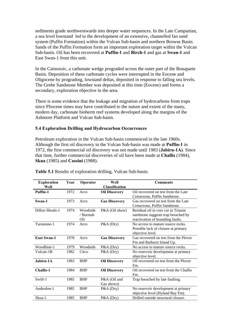
sediments grade northwestwards into deeper water sequences. In the Late Campanian, a sea level lowstand led to the development of an extensive, channelled fan sand system (Puffin Formation) within the Vulcan Sub-basin and northern Browse Basin. Sands of the Puffin Formation form an important exploration target within the Vulcan Sub-basin. Oil has been recovered at Puffin-1 and Birch-1 and gas at Swan-1 and East Swan-1 from this unit. In the Cainozoic, a carbonate wedge prograded across the outer part of the Bonaparte Basin. Deposition of these carbonate cycles were interrupted in the Eocene and Oligocene by prograding, lowstand deltas, deposited in response to falling sea levels. The Grebe Sandstone Member was deposited at this time (Eocene) and forms a secondary, exploration objective in the area. There is some evidence that the leakage and migration of hydrocarbons from traps since Pliocene times may have contributed to the nature and extent of the many, modern day, carbonate bioherm reef systems developed along the margins of the Ashmore Platform and Vulcan Sub-basin. 5.4 Exploration Drilling and Hydrocarbon Occurrences Petroleum exploration in the Vulcan Sub-basin commenced in the late 1960s. Although the first oil discovery in the Vulcan Sub-basin was made at Puffin-1 in 1972, the first commercial oil discovery was not made until 1983 (Jabiru-1A). Since that time, further commercial discoveries of oil have been made at Challis (1984), Skua (1985) and Cassini (1988). Table 5.1 Results of exploration drilling, Vulcan Sub-basin.
Exploration Well
Year Operator Well Classification
Comments
Puffin-1 1972 Arco Oil Discovery Oil recovered on test from the Late Cretaceous, Puffin Sandstone.
Swan-1 1973 Arco Gas Discovery Gas recovered on test from the Late Cretaceous, Puffin Sandstone.
Dillon Shoals-1 1974 Woodside / Burmah Oil
P&A (Oil show) Residual oil in core cut in Triassic sandstone suggests trap breached by reactivation of bounding faults.
Turnstone-1 1974 Arco P&A (Dry) No access to mature source rocks. Possible lack of closure at primary objective level.
East Swan-1 1978 Arco Gas Discovery Gas recovered on test from the Plover Fm and Bathurst Island Gp.
Woodbine-1 1979 Woodside P&A (Dry) No access to mature source rocks. Vulcan-1B 1982 Citco P&A (Dry) No reservoir development at primary
objective level. Jabiru-1A 1983 BHP Oil Discovery Oil recovered on test from the Plover
Fm. Challis-1 1984 BHP Oil Discovery Oil recovered on test from the Challis
Fm. Swift-1 1985 BHP P&A (Oil and
Gas shows) Trap breached by late faulting.
Anderdon-1 1985 BHP P&A (Dry) No reservoir development at primary objective level (Hyland Bay Fm).
Skua-1 1985 BHP P&A (Dry) Drilled outside structural closure.
Skua-2 1985 BHP Oil & Gas Discovery
Oil and gas recovered on test from the Plover Fm.
Nome-1 1986 BHP P&A (Dry) No reservoir development at primary objective level.
Eclipse-1 1986 BHP P&A (Dry) Did not test a valid closure (?) Eclipse-2 1986 BHP Oil & Gas
Discovery Recovered oil and gas on test from Flamingo Gp.
Snowmass-1 1987 BHP P&A (Oil show) Trap breached by late faulting. Oliver-1 1988 BHP Oil & Gas
Discovery Recovered oil and gas on test from the Plover Fm.
Rainier-1 1988 BHP P&A (Dry) Trap breached by reactivation of bounding faults.
Montara-1 1988 BHP Oil & Gas Discovery
Recovered oil and gas on test from the Montara Fm.
Pengana-1 1988 BHP Gas Discovery Gas recovered on test from the Sahul Gp.
Cassini-1 1988 BHP Oil Discovery Oil recovered on test from the Challis Fm.
Tancred-1 1988 BHP P&A (Oil show) Trap breached by late faulting. Bilyara-1 1988 BHP Oil & Gas
Discovery Recovered oil and gas on test from the Montara Fm.
Allaru-1 1988 BHP P&A (Oil and Gas shows)
Residual oil column indicates trap breached by late faulting.
Parry-1 1988 BHP P&A (Dry) May not have tested a valid closure. Voltaire-1 1988 BP P&A (Dry) Possible lack of seal on bounding fault
/ no access to mature source rocks. Cockell-1/ST1 1989 BHP P&A (Dry) Poor reservoir development at primary
objective (U. Jurassic). May not have tested a valid closure.
Paqualin-1 1989 BHP P&A (Dry) No reservoir development at primary objective level.
Arunta-1 1989 BHP P&A (Dry) May not have tested a valid closure. Taltarni-1 1989 BHP P&A (Dry) No reservoir development at primary
objective level. Talbot-1 1989 Santos Oil & Gas
Discovery Recovered oil and gas on test from the Challis Fm.
Rowan-1/ST1 1989 BHP P&A (Dry) No reservoir development at primary objective level.
Keeling-1 1990 Norcen P&A (Gas show) May not have tested a valid closure. Maple-1 1990 BHP Oil & Gas
Discovery Recovered oil and gas on test from the Challis Fm.
Willeroo-1 1990 BHP P&A (Oil show) Trap formation post-dated oil emplacement.
Fagin-1 1990 BHP P&A (Dry) Did not test a valid closure. Octavius-1 1990 WMC P&A (Oil show) Oil displaced by late gas migration or
trap breached by late faulting. Yering-1 1990 BHP P&A (Dry) Lack of seal on bounding fault. Birch-1 1990 BHP Oil Discovery Recovered oil on test from the Puffin
Fm. Anson-1 1990 Santos P&A (Oil show) Residual oil in swc’s indicates possible
breached trap. Delamere-1 1990 BHP Gas Discovery Recovered gas on test from the
Flamingo Gp. Casuarina-1 1990 BHP P&A (Dry) Katers-1 1990 Santos P&A (Dry) No access to mature source rocks. Champagny-1 1990 Norcen P&A (Dry) No access to mature source rocks. Kimberley-1 1990 Norcen P&A (Dry) Lack of effective top seal. Douglas-1 1990 WMC P&A (Dry) Trap breached by late faulting. Tahbilk-1 1990 BHP Gas Discovery Recovered gas on test from the Gibson
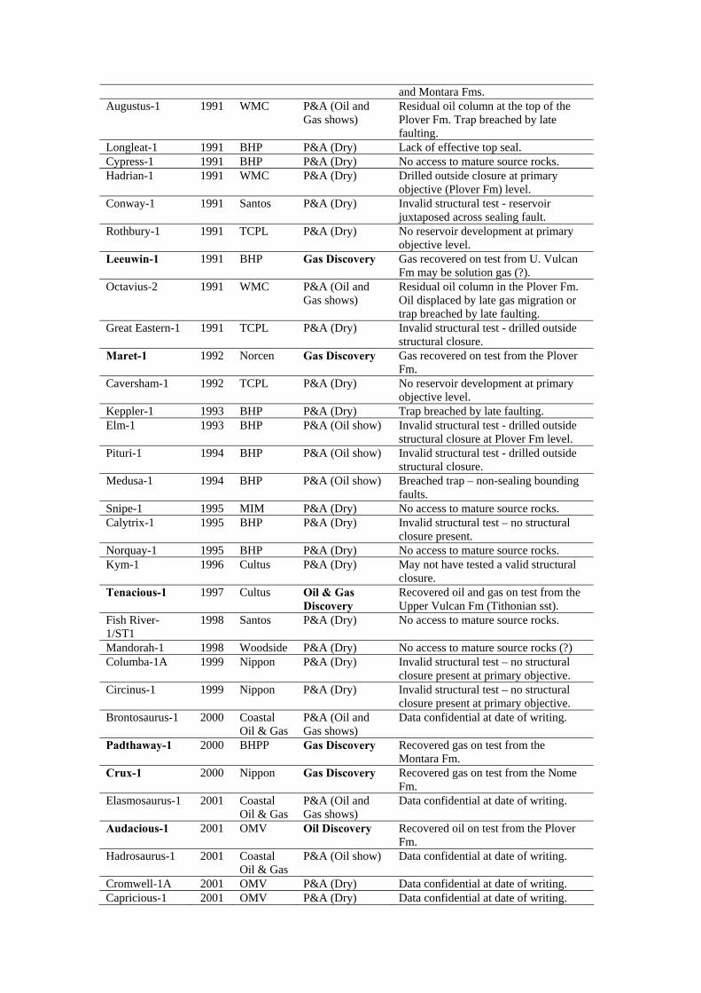
and Montara Fms. Augustus-1 1991 WMC P&A (Oil and
Gas shows) Residual oil column at the top of the Plover Fm. Trap breached by late faulting.
Longleat-1 1991 BHP P&A (Dry) Lack of effective top seal. Cypress-1 1991 BHP P&A (Dry) No access to mature source rocks. Hadrian-1 1991 WMC P&A (Dry) Drilled outside closure at primary
objective (Plover Fm) level. Conway-1 1991 Santos P&A (Dry) Invalid structural test - reservoir
juxtaposed across sealing fault. Rothbury-1 1991 TCPL P&A (Dry) No reservoir development at primary
objective level. Leeuwin-1 1991 BHP Gas Discovery Gas recovered on test from U. Vulcan
Fm may be solution gas (?). Octavius-2 1991 WMC P&A (Oil and
Gas shows) Residual oil column in the Plover Fm. Oil displaced by late gas migration or trap breached by late faulting.
Great Eastern-1 1991 TCPL P&A (Dry) Invalid structural test - drilled outside structural closure.
Maret-1 1992 Norcen Gas Discovery Gas recovered on test from the Plover Fm.
Caversham-1 1992 TCPL P&A (Dry) No reservoir development at primary objective level.
Keppler-1 1993 BHP P&A (Dry) Trap breached by late faulting. Elm-1 1993 BHP P&A (Oil show) Invalid structural test - drilled outside
structural closure at Plover Fm level. Pituri-1 1994 BHP P&A (Oil show) Invalid structural test - drilled outside
structural closure. Medusa-1 1994 BHP P&A (Oil show) Breached trap – non-sealing bounding
faults. Snipe-1 1995 MIM P&A (Dry) No access to mature source rocks. Calytrix-1 1995 BHP P&A (Dry) Invalid structural test – no structural
closure present. Norquay-1 1995 BHP P&A (Dry) No access to mature source rocks. Kym-1 1996 Cultus P&A (Dry) May not have tested a valid structural
closure. Tenacious-1 1997 Cultus Oil & Gas
Discovery Recovered oil and gas on test from the Upper Vulcan Fm (Tithonian sst).
Fish River-1/ST1
1998 Santos P&A (Dry) No access to mature source rocks.
Mandorah-1 1998 Woodside P&A (Dry) No access to mature source rocks (?) Columba-1A 1999 Nippon P&A (Dry) Invalid structural test – no structural
closure present at primary objective. Circinus-1 1999 Nippon P&A (Dry) Invalid structural test – no structural
closure present at primary objective. Brontosaurus-1 2000 Coastal
Oil & Gas P&A (Oil and Gas shows)
Data confidential at date of writing.
Padthaway-1 2000 BHPP Gas Discovery Recovered gas on test from the Montara Fm.
Crux-1 2000 Nippon Gas Discovery Recovered gas on test from the Nome Fm.
Elasmosaurus-1 2001 Coastal Oil & Gas
P&A (Oil and Gas shows)
Data confidential at date of writing.
Audacious-1 2001 OMV Oil Discovery Recovered oil on test from the Plover Fm.
Hadrosaurus-1 2001 Coastal Oil & Gas
P&A (Oil show) Data confidential at date of writing.
Cromwell-1A 2001 OMV P&A (Dry) Data confidential at date of writing. Capricious-1 2001 OMV P&A (Dry) Data confidential at date of writing.
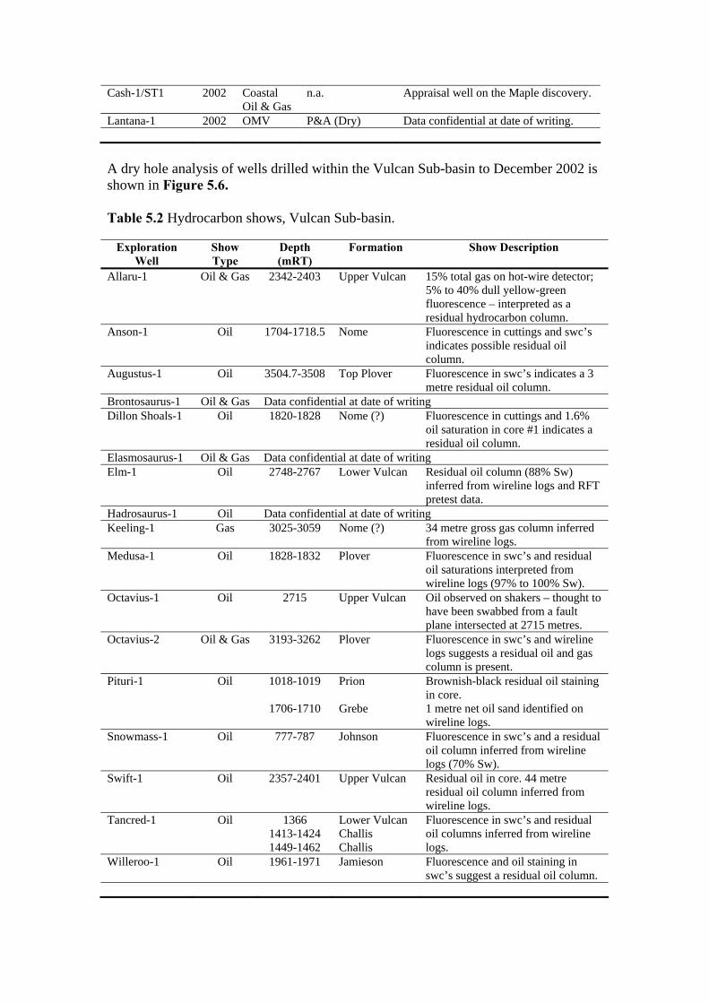
Cash-1/ST1 2002 Coastal Oil & Gas
n.a. Appraisal well on the Maple discovery.
Lantana-1 2002 OMV P&A (Dry) Data confidential at date of writing. A dry hole analysis of wells drilled within the Vulcan Sub-basin to December 2002 is shown in Figure 5.6. Table 5.2 Hydrocarbon shows, Vulcan Sub-basin.
Exploration Well
Show Type
Depth (mRT)
Formation Show Description
Allaru-1 Oil & Gas 2342-2403 Upper Vulcan 15% total gas on hot-wire detector; 5% to 40% dull yellow-green fluorescence – interpreted as a residual hydrocarbon column.
Anson-1 Oil 1704-1718.5 Nome Fluorescence in cuttings and swc’s indicates possible residual oil column.
Augustus-1 Oil 3504.7-3508 Top Plover Fluorescence in swc’s indicates a 3 metre residual oil column.
Brontosaurus-1 Oil & Gas Data confidential at date of writing Dillon Shoals-1 Oil 1820-1828 Nome (?) Fluorescence in cuttings and 1.6%
oil saturation in core #1 indicates a residual oil column.
Elasmosaurus-1 Oil & Gas Data confidential at date of writing Elm-1 Oil 2748-2767 Lower Vulcan Residual oil column (88% Sw)
inferred from wireline logs and RFT pretest data.
Hadrosaurus-1 Oil Data confidential at date of writing Keeling-1 Gas 3025-3059 Nome (?) 34 metre gross gas column inferred
from wireline logs. Medusa-1 Oil 1828-1832 Plover Fluorescence in swc’s and residual
oil saturations interpreted from wireline logs (97% to 100% Sw).
Octavius-1 Oil 2715 Upper Vulcan Oil observed on shakers – thought to have been swabbed from a fault plane intersected at 2715 metres.
Octavius-2 Oil & Gas 3193-3262 Plover Fluorescence in swc’s and wireline logs suggests a residual oil and gas column is present.
Pituri-1 Oil 1018-1019
1706-1710
Prion Grebe
Brownish-black residual oil staining in core. 1 metre net oil sand identified on wireline logs.
Snowmass-1 Oil 777-787 Johnson Fluorescence in swc’s and a residual oil column inferred from wireline logs (70% Sw).
Swift-1 Oil 2357-2401 Upper Vulcan Residual oil in core. 44 metre residual oil column inferred from wireline logs.
Tancred-1 Oil 1366 1413-1424 1449-1462
Lower Vulcan Challis Challis
Fluorescence in swc’s and residual oil columns inferred from wireline logs.
Willeroo-1 Oil 1961-1971 Jamieson Fluorescence and oil staining in swc’s suggest a residual oil column.
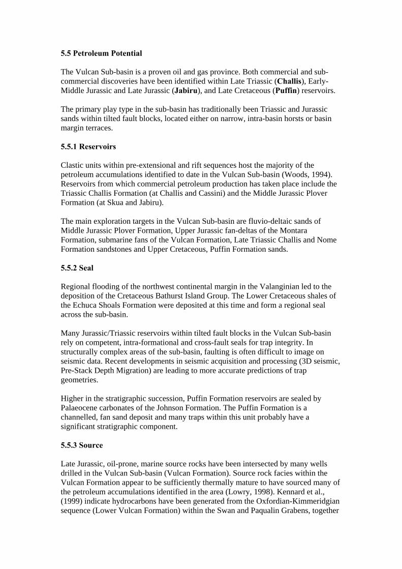
5.5 Petroleum Potential The Vulcan Sub-basin is a proven oil and gas province. Both commercial and sub-commercial discoveries have been identified within Late Triassic (Challis), Early-Middle Jurassic and Late Jurassic (Jabiru), and Late Cretaceous (Puffin) reservoirs. The primary play type in the sub-basin has traditionally been Triassic and Jurassic sands within tilted fault blocks, located either on narrow, intra-basin horsts or basin margin terraces. 5.5.1 Reservoirs Clastic units within pre-extensional and rift sequences host the majority of the petroleum accumulations identified to date in the Vulcan Sub-basin (Woods, 1994). Reservoirs from which commercial petroleum production has taken place include the Triassic Challis Formation (at Challis and Cassini) and the Middle Jurassic Plover Formation (at Skua and Jabiru). The main exploration targets in the Vulcan Sub-basin are fluvio-deltaic sands of Middle Jurassic Plover Formation, Upper Jurassic fan-deltas of the Montara Formation, submarine fans of the Vulcan Formation, Late Triassic Challis and Nome Formation sandstones and Upper Cretaceous, Puffin Formation sands. 5.5.2 Seal Regional flooding of the northwest continental margin in the Valanginian led to the deposition of the Cretaceous Bathurst Island Group. The Lower Cretaceous shales of the Echuca Shoals Formation were deposited at this time and form a regional seal across the sub-basin. Many Jurassic/Triassic reservoirs within tilted fault blocks in the Vulcan Sub-basin rely on competent, intra-formational and cross-fault seals for trap integrity. In structurally complex areas of the sub-basin, faulting is often difficult to image on seismic data. Recent developments in seismic acquisition and processing (3D seismic, Pre-Stack Depth Migration) are leading to more accurate predictions of trap geometries. Higher in the stratigraphic succession, Puffin Formation reservoirs are sealed by Palaeocene carbonates of the Johnson Formation. The Puffin Formation is a channelled, fan sand deposit and many traps within this unit probably have a significant stratigraphic component. 5.5.3 Source Late Jurassic, oil-prone, marine source rocks have been intersected by many wells drilled in the Vulcan Sub-basin (Vulcan Formation). Source rock facies within the Vulcan Formation appear to be sufficiently thermally mature to have sourced many of the petroleum accumulations identified in the area (Lowry, 1998). Kennard et al., (1999) indicate hydrocarbons have been generated from the Oxfordian-Kimmeridgian sequence (Lower Vulcan Formation) within the Swan and Paqualin Grabens, together
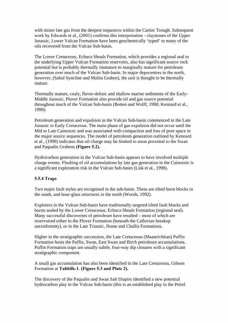
with minor late gas from the deepest sequences within the Cartier Trough. Subsequent work by Edwards et al., (2001) confirms this interpretation - claystones of the Upper Jurassic, Lower Vulcan Formation have been geochemically ‘typed’ to many of the oils recovered from the Vulcan Sub-basin. The Lower Cretaceous, Echuca Shoals Formation, which provides a regional seal to the underlying Upper Vulcan Formation reservoirs, also has significant source rock potential but is probably thermally immature to marginally mature for petroleum generation over much of the Vulcan Sub-basin. In major depocentres to the north, however, (Sahul Syncline and Malita Graben), the unit is thought to be thermally mature. Thermally mature, coaly, fluvio-deltaic and shallow marine sediments of the Early-Middle Jurassic, Plover Formation also provide oil and gas source potential throughout much of the Vulcan Sub-basin (Botten and Wulff, 1990; Kennard et al., 1999). Petroleum generation and expulsion in the Vulcan Sub-basin commenced in the Late Jurassic to Early Cretaceous. The main phase of gas expulsion did not occur until the Mid to Late Cainozoic and was associated with compaction and loss of pore space in the major source sequences. The model of petroleum generation outlined by Kennard et al., (1999) indicates that oil charge may be limited to areas proximal to the Swan and Paqualin Grabens (Figure 5.2). Hydrocarbon generation in the Vulcan Sub-basin appears to have involved multiple charge events. Flushing of oil accumulations by late gas generation in the Cainozoic is a significant exploration risk in the Vulcan Sub-basin (Lisk et al., 1998). 5.5.4 Traps Two major fault styles are recognised in the sub-basin. These are tilted horst blocks in the south, and hour-glass structures in the north (Woods, 1992). Explorers in the Vulcan Sub-basin have traditionally targeted tilted fault blocks and horsts sealed by the Lower Cretaceous, Echuca Shoals Formation (regional seal). Many successful discoveries of petroleum have resulted – most of which are reservoired either in the Plover Formation (beneath the Callovian breakup unconformity), or in the Late Triassic, Nome and Challis Formations. Higher in the stratigraphic succession, the Late Cretaceous (Maastrichtian) Puffin Formation hosts the Puffin, Swan, East Swan and Birch petroleum accumulations. Puffin Formation traps are usually subtle, four-way dip closures with a significant stratigraphic component. A small gas accumulation has also been identified in the Late Cretaceous, Gibson Formation at Tahbilk-1. (Figure 5.3 and Plate 2). The discovery of the Paqualin and Swan Salt Diapirs identified a new potential hydrocarbon play in the Vulcan Sub-basin (this is an established play in the Petrel
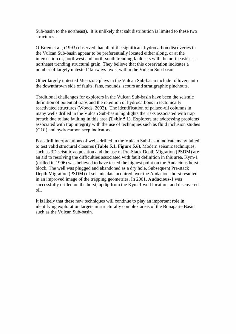
Sub-basin to the northeast). It is unlikely that salt distribution is limited to these two structures. O’Brien et al., (1993) observed that all of the significant hydrocarbon discoveries in the Vulcan Sub-basin appear to be preferentially located either along, or at the intersection of, northwest and north-south trending fault sets with the northeast/east-northeast trending structural grain. They believe that this observation indicates a number of largely untested ‘fairways’ exist within the Vulcan Sub-basin. Other largely untested Mesozoic plays in the Vulcan Sub-basin include rollovers into the downthrown side of faults, fans, mounds, scours and stratigraphic pinchouts. Traditional challenges for explorers in the Vulcan Sub-basin have been the seismic definition of potential traps and the retention of hydrocarbons in tectonically reactivated structures (Woods, 2003). The identification of palaeo-oil columns in many wells drilled in the Vulcan Sub-basin highlights the risks associated with trap breach due to late faulting in this area (Table 5.1). Explorers are addressing problems associated with trap integrity with the use of techniques such as fluid inclusion studies (GOI) and hydrocarbon seep indicators. Post-drill interpretations of wells drilled in the Vulcan Sub-basin indicate many failed to test valid structural closures (Table 5.1, Figure 5.6). Modern seismic techniques, such as 3D seismic acquisition and the use of Pre-Stack Depth Migration (PSDM) are an aid to resolving the difficulties associated with fault definition in this area. Kym-1 (drilled in 1996) was believed to have tested the highest point on the Audacious horst block. The well was plugged and abandoned as a dry hole. Subsequent Pre-stack Depth Migration (PSDM) of seismic data acquired over the Audacious horst resulted in an improved image of the trapping geometries. In 2001, Audacious-1 was successfully drilled on the horst, updip from the Kym-1 well location, and discovered oil. It is likely that these new techniques will continue to play an important role in identifying exploration targets in structurally complex areas of the Bonaparte Basin such as the Vulcan Sub-basin.
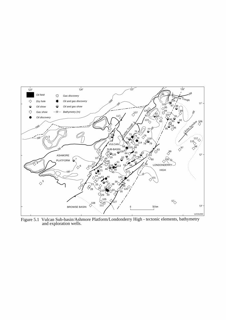
124° 125°
1000
500
1000
500
200
100
100
50
50
BROWSE BASIN
Cartie
r Tro
ugh
Echo S
yncli
ne
Nancar Trough
3
4
5
13
6
7
14
1112
89
2021
2223
24
2527
29
105
44
42
1
2
16
15
18
1917 49
47
4645
50
51
37 38
333231
3034 35
36
39 4041
5257
59
53
58
72
77
76
75
62
5455
56
60
61
101
100
9963
64 65
6667
68
69
7074
73
71
7978
97 98
818280
83
96
9293
9495
91
89
88
90
84
102
85
86
103
104
87
43
2628
4810
106
11°
12°
12/OA/200
Dry hole
Oil show
Gas show
Oil discovery
Oil field Gas discovery
Oil and gas discovery
Oil and gas show
200
100
0 50 km
50 Bathymetry (m)
13°
123° 126°
ASHMORE
PLATFORM
VULCAN
SUB-BASIN
LONDONDERRY
HIGH
107
108
109
110
111
112
113
114 115
116
117
118
119
120
121
122
123
124
125
126
127 57
Figure 5.1 Vulcan Sub-basin/Ashmore Platform/Londonderry High - tectonic elements, bathymetry and exploration wells.

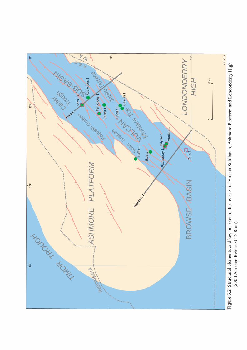
Cartier Trou
gh
Swan G
rabe
n
11°
12°
124°
125°
IND
ON
ES
IA
50 k
m0
12/O
A/1
76
123°
BR
OW
SE
B
AS
IN13
°
Paqua
lin G
rabe
n
A & CW A
Mon
tara
Tce
Jabir
u Te
rrace
Figure
Figure
Pad
thaw
ay 1
Sku
a 1
Sku
a 1
Cha
llis
1C
halli
s 1
Cas
sini
1C
assi
ni 1
Cru
x 1
Cru
x 1
Jabi
ru 1
Jabi
ru 1
Aud
acio
us 1
Ten
acio
us 1
Ten
acio
us 1
Puf
fin 1
Puf
fin 1
Oliv
er 1
Mon
tara
1
Bily
ara
1
AS
HM
OR
E
PLA
TF
OR
M
TIM
OR TR
OUGH
LON
DO
ND
ER
RY
HIG
H
VULCAN
SUB-BASIN
Figu
re 5
.2 S
truc
tura
l ele
men
ts a
nd k
ey p
etro
leum
dis
cove
ries
of
Vul
can
Sub-
basi
n, A
shm
ore
Plat
form
and
Lon
dond
erry
Hig
h
(2
003
Acr
eage
Rel
ease
CD
-Rom
).
Figu
re 5
.7
Figu
re 5
.7

AGEGROUP
FORMATION/UNIT TECTONICS DISCOVERIES
TE
RT
IAR
YC
RE
TA
CE
OU
SJU
RA
SS
ICT
RIA
SS
IC
Mio
cene
Oligo-cene
Eoc
ene
Palae-ocene
Late
Ear
lyLa
teM
iddl
eE
arly
Late
Mid
dle
Ear
ly
WO
OD
BIN
E G
RO
UP
BA
TH
UR
ST
ISLA
ND
GR
OU
PF
LAM
ING
OG
RO
UP
TR
OU
GH
TO
N G
RO
UP
SA
HU
L G
RO
UP
Barracouta Fm
Oliver Fm
Oliver Sst Mbr
Prion Fm
Hibernia FmGrebe Sst Mbr
Johnson Fm
Puffin Fm
Fenelon Fm
Gibson FmWoolaston Fm
Upper Jamieson Fm
Lower Jamieson Fm
Echuca Shoals Fm
Upper Vulcan Fm
Lower Vulcan Fm
Montara Fm
Plover Fm
Nome Fm
Challis Fm
Pollard Fm
Osprey FmMt Goodwyn Fm
PA
SS
IVE
MA
RG
INN
OR
TH
EA
ST
RIF
TIN
G PO
ST
-BR
EA
KU
P S
EQ
UE
NC
EB
RE
AK
UP
RIF
T S
EQ
UE
NC
EP
RE
-EX
TE
NS
ION
AL
PH
AS
E
Collision of Australian platewith Timor
Regional Compression
Thermal subsidence
Subsidence
Subsidence
VALANGINIANUNCONFORMITY
UNCONFORMITYCALLOVIAN
Figure 5.3 Vulcan Sub-basin - stratigraphy, tectonics and petroleum discoveries.
12/OA/177
Puffin, Birch
Swan
Tahbilk
Tenacious
Delamere, Leeuwin
Jabiru
Montara, Eclipse
Jabiru
Bilyara, Maret, Oliver, Skua
East Swan, Octavius
Talbot Challis
Maple
Challis, Cassini
Pengana, Crux
Tahbilk, Padthaway
Pliocene
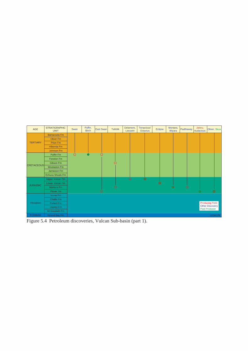
AGE
TERTIARY
CRETACEOUS
JURASSIC
TRIASSIC
PERMIAN
STRATIGRAPHICUNIT
SwanPuffin,Birch
East Swan TahbilkDelamere,Leeuwin
Tenacious/Octavius
EclipseMontara,Bilyara
PadthawayJabiru,
AudaciousOliver, Skua
Barracouta Fm
Oliver Fm
Prion Fm
Hibernia Fm
Johnson Fm
Puffin Fm
Fenelon Fm
Gibson Fm
Woolaston Fm
Jamieson Fm
Echuca Shoals Fm
Upper Vulcan Fm
Lower Vulcan Fm
Montara Fm
Plover Fm
Nome Fm
Challis Fm
Pollard Fm
Osprey Fm
Mt Goodwin Fm
Hyland Bay Fm 12/OA/178
Figure 5.4 Petroleum discoveries, Vulcan Sub-basin (part 1).
Producing FieldOther DiscoveryPast Producer
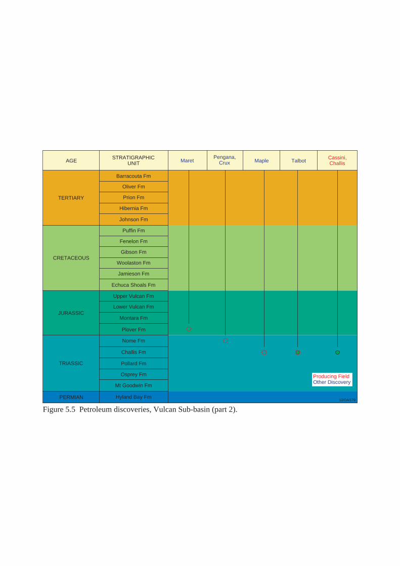
AGE
TERTIARY
CRETACEOUS
JURASSIC
TRIASSIC
PERMIAN
STRATIGRAPHICUNIT
Barracouta Fm
Oliver Fm
Prion Fm
Hibernia Fm
Johnson Fm
Puffin Fm
Fenelon Fm
Gibson Fm
Woolaston Fm
Jamieson Fm
Echuca Shoals Fm
Upper Vulcan Fm
Lower Vulcan Fm
Montara Fm
Plover Fm
Nome Fm
Challis Fm
Pollard Fm
Osprey Fm
Mt Goodwin Fm
Hyland Bay Fm
Cassini,ChallisMaret
Pengana,Crux Maple Talbot
12/OA/179
Figure 5.5 Petroleum discoveries, Vulcan Sub-basin (part 2).
Producing FieldOther Discovery

2%
12% 14%
24%
15%
33%
Vulcan Sub-basin
Absence of HC charge
Absence of reservoir
Trap formation post-dates HC migrationInvalid structural test
Breached trap
Undetermined
Figure 5.6 Dry hole analysis, Vulcan Sub-basin.
12/OA/180
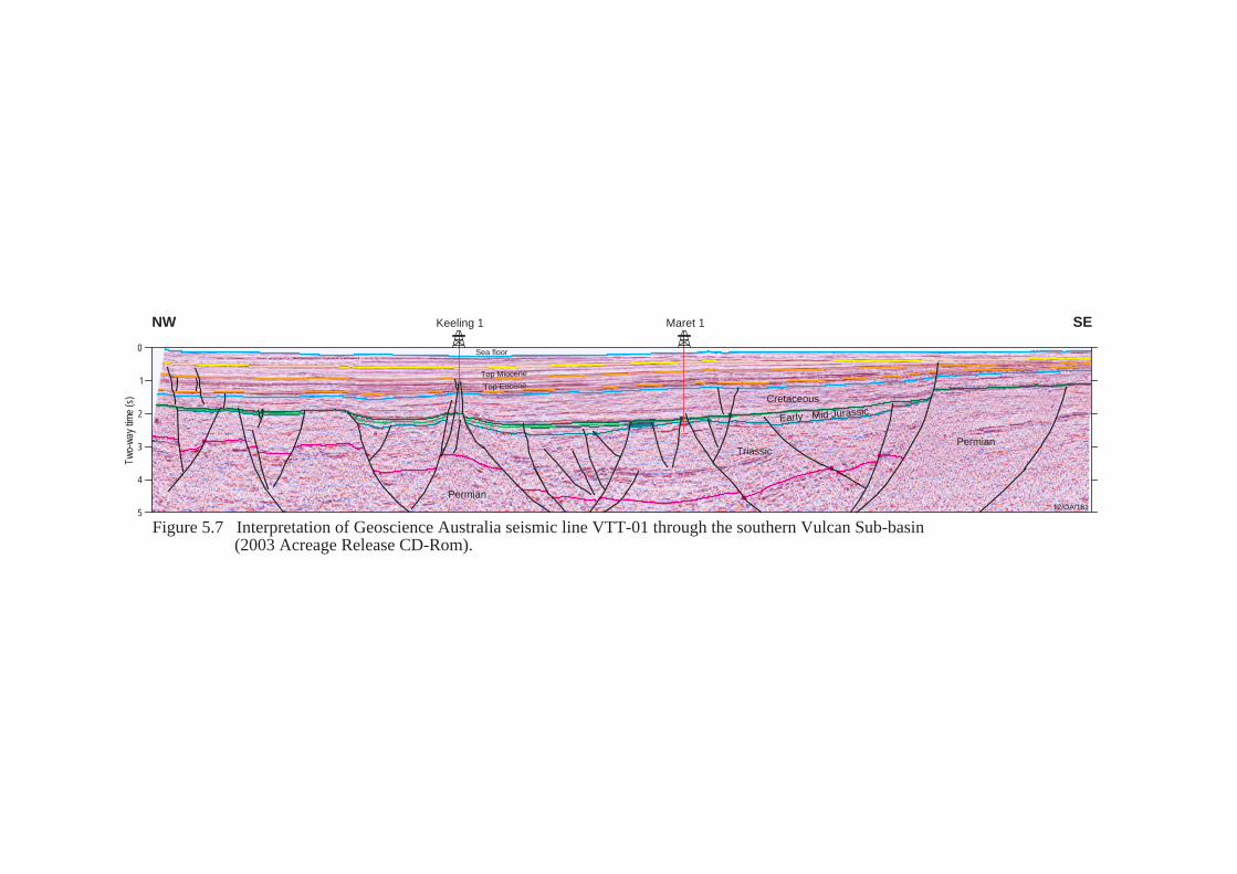
0
1
2
3
4
5
Two-
way
tim
e (s
)
Keeling 1 Maret 1NW SE
12/OA/181
Sea floor
Top Miocene
Top Eocene
Permian
TriassicPermian
Cretaceous
Early - Mid Jurassic
Figure 5.7 Interpretation of Geoscience Australia seismic line VTT-01 through the southern Vulcan Sub-basin (2003 Acreage Release CD-Rom).

6. LONDONDERRY HIGH 6.1 Introduction The Londonderry High is a Permo-Triassic horst and graben complex which acted as a major source of sediment for adjacent depocentres during Late Jurassic rifting (Whibley and Jacobsen, 1990; De Ruig, 2000). It is bounded to the northeast and east by the Sahul Syncline and the Echo Syncline respectively. The Nancar Trough, a major depocentre containing up to 8 kilometres of Mesozoic-Cainozoic sediments, lies to the north (DeRuig et al., 2000). The Cartier Trough (a northeast-southwest trending extensional feature that subsided rapidly as a result of collision of the Australian plate with the South East Asian microplates in the Neogene), bounds the western side of the northern Londonderry High (Shuster et al., 1998; Whibley and Jacobsen, 1990). (Figure 5.1 and Plate 1). At date of writing, gas had been recovered on test from 6 wells drilled in the Londonderry High area (although at Eider-1 and Lorikeet-1 the gas recoveries could constitute solution gas) (Figure 6.2). The most significant petroleum accumulation identified in the area is the Prometheus/Rubicon gas discovery, made in 2000, on the eastern flank of the Londonderry High. 6.2 Stratigraphy The Londonderry High comprises a heavily faulted sequence of Palaeozoic and Triassic sediments, overlain unconformably by a relatively unfaulted, Late Jurassic and younger succession. Although most faulting terminates at the top of the Triassic sequence, some faults show evidence of Miocene reactivation (Figure 6.4). On the crestal parts of the Londonderry High, the Triassic section is deeply eroded. To the west, a series of basin margin faults and terraces truncate the Late Triassic and Jurassic sequences of the adjacent Vulcan Sub-basin. Uplift and erosion are less pronounced on the eastern and northern flanks of the Londonderry High. Here, the Triassic unconformity is progressively sub-cropped by a Permo-Triassic succession, more typical of the Petrel Sub-basin. Although Plover Formation sediments are absent from the crest of the Londonderry High, sandstones within this unit constitute valid exploration objectives on basin margin terraces and tilted fault blocks that flank the western margin of the high. On the eastern flank, structural and stratigraphic traps both at Plover Formation level and within the Permo-Triassic succession are also exploration targets. Traps in this area rely on long distance migration of hydrocarbons from either the Sahul Syncline or Petrel Sub-basin for petroleum charge. The Vulcan Formation is considered a potential source and reservoir in the Vulcan Sub-basin to the west. On the Londonderry High, however, the unit thins and is probably thermally immature for hydrocarbon generation. Gas has been recovered on test from the Upper Vulcan Formation in several wells drilled on the Londonderry High (Table 6.1).
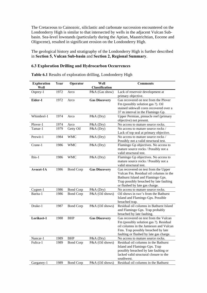
The Cretaceous to Cainozoic, siliclastic and carbonate succession encountered on the Londonderry High is similar to that intersected by wells in the adjacent Vulcan Sub-basin. Sea-level lowstands (particularly during the Aptian, Maastrichtian, Eocene and Oligocene), resulted in significant erosion on the Londonderry High. The geological history and stratigraphy of the Londonderry High is further described in Section 5, Vulcan Sub-basin and Section 2, Regional Summary. 6.3 Exploration Drilling and Hydrocarbon Occurrences Table 6.1 Results of exploration drilling, Londonderry High Exploration
Well Year Operator Well
Classification Comments
Osprey-1 1972 Arco P&A (Gas show) Lack of reservoir development at primary objective.
Eider-1 1972 Arco Gas Discovery Gas recovered on test from the Plover Fm (possibly solution gas ?). Oil stained sidewall cores recovered over a 37 m interval in the Flamingo Gp.
Whimbrel-1 1974 Arco P&A (Dry) Upper Permian, pinnacle reef (primary objective) not present.
Plover-1 1974 Arco P&A (Dry) No access to mature source rocks. Tamar-1 1979 Getty Oil P&A (Dry) No access to mature source rocks /
Lack of top seal at primary objective. Peewit-1 1984 WMC P&A (Dry) No access to mature source rocks /
Possibly not a valid structural test. Crane-1 1986 WMC P&A (Dry) Flamingo Gp objectives. No access to
mature source rocks / Possibly not a valid structural test.
Ibis-1 1986 WMC P&A (Dry) Flamingo Gp objectives. No access to mature source rocks / Possibly not a valid structural test.
Avocet-1A 1986 Bond Corp Gas Discovery Gas recovered on test from the Upper Vulcan Fm. Residual oil columns in the Bathurst Island and Flamingo Gps. Trap possibly breached by late faulting or flushed by late gas charge.
Cygnet-1 1986 Bond Corp P&A (Dry) No access to mature source rocks. Barita-1 1986 Bond Corp P&A (Oil shows) Oil shows in swc’s from the Bathurst
Island and Flamingo Gps. Possible breached trap.
Drake-1 1987 Bond Corp P&A (Oil shows) Residual oil columns in Bathurst Island and Flamingo Gps. Trap probably breached by late faulting.
Lorikeet-1 1988 BHP Gas Discovery Gas recovered on test from the Vulcan Fm (possibly solution gas ?). Residual oil columns in the Jamieson and Vulcan Fms. Trap possibly breached by late faulting or flushed by late gas charge.
Nancar-1 1989 BHP P&A (Dry) No access to mature source rocks. Fulica-1 1989 Bond Corp P&A (Oil shows) Residual oil columns in the Bathurst
Island and Flamingo Gps. Trap possibly breached by late faulting or lacked valid structural closure to the southwest.
Garganey-1 1989 Bond Corp P&A (Oil shows) Residual oil columns in the Bathurst
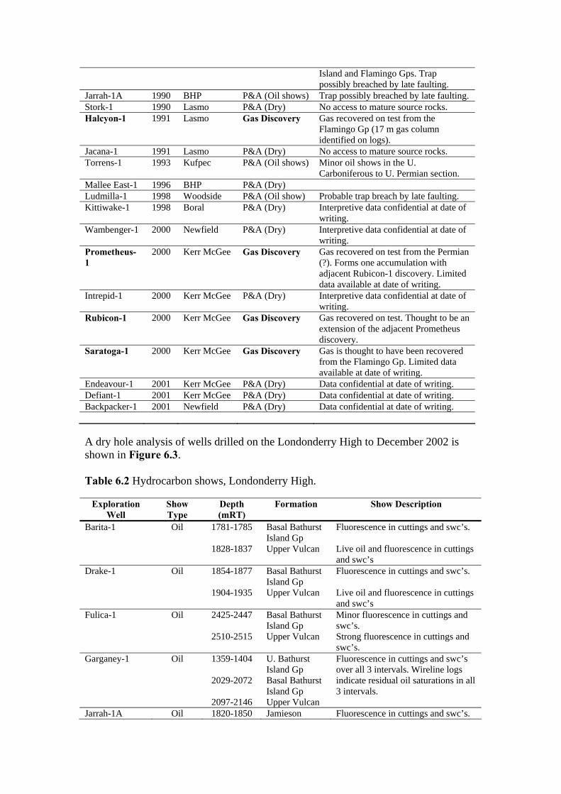
Island and Flamingo Gps. Trap possibly breached by late faulting.
Jarrah-1A 1990 BHP P&A (Oil shows) Trap possibly breached by late faulting. Stork-1 1990 Lasmo P&A (Dry) No access to mature source rocks. Halcyon-1 1991 Lasmo Gas Discovery Gas recovered on test from the
Flamingo Gp (17 m gas column identified on logs).
Jacana-1 1991 Lasmo P&A (Dry) No access to mature source rocks. Torrens-1 1993 Kufpec P&A (Oil shows) Minor oil shows in the U.
Carboniferous to U. Permian section. Mallee East-1 1996 BHP P&A (Dry) Ludmilla-1 1998 Woodside P&A (Oil show) Probable trap breach by late faulting. Kittiwake-1 1998 Boral P&A (Dry) Interpretive data confidential at date of
writing. Wambenger-1 2000 Newfield P&A (Dry) Interpretive data confidential at date of
writing. Prometheus-1
2000 Kerr McGee Gas Discovery Gas recovered on test from the Permian (?). Forms one accumulation with adjacent Rubicon-1 discovery. Limited data available at date of writing.
Intrepid-1 2000 Kerr McGee P&A (Dry) Interpretive data confidential at date of writing.
Rubicon-1 2000 Kerr McGee Gas Discovery Gas recovered on test. Thought to be an extension of the adjacent Prometheus discovery.
Saratoga-1 2000 Kerr McGee Gas Discovery Gas is thought to have been recovered from the Flamingo Gp. Limited data available at date of writing.
Endeavour-1 2001 Kerr McGee P&A (Dry) Data confidential at date of writing. Defiant-1 2001 Kerr McGee P&A (Dry) Data confidential at date of writing. Backpacker-1 2001 Newfield P&A (Dry) Data confidential at date of writing. A dry hole analysis of wells drilled on the Londonderry High to December 2002 is shown in Figure 6.3. Table 6.2 Hydrocarbon shows, Londonderry High.
Exploration Well
Show Type
Depth (mRT)
Formation Show Description
Barita-1 Oil 1781-1785
1828-1837
Basal Bathurst Island Gp Upper Vulcan
Fluorescence in cuttings and swc’s. Live oil and fluorescence in cuttings and swc’s
Drake-1 Oil 1854-1877
1904-1935
Basal Bathurst Island Gp Upper Vulcan
Fluorescence in cuttings and swc’s. Live oil and fluorescence in cuttings and swc’s
Fulica-1 Oil 2425-2447
2510-2515
Basal Bathurst Island Gp Upper Vulcan
Minor fluorescence in cuttings and swc’s. Strong fluorescence in cuttings and swc’s.
Garganey-1 Oil 1359-1404
2029-2072
2097-2146
U. Bathurst Island Gp Basal Bathurst Island Gp Upper Vulcan
Fluorescence in cuttings and swc’s over all 3 intervals. Wireline logs indicate residual oil saturations in all 3 intervals.
Jarrah-1A Oil 1820-1850 Jamieson Fluorescence in cuttings and swc’s.
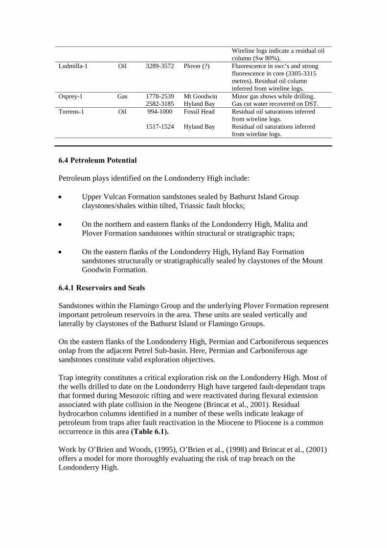
Wireline logs indicate a residual oil column (Sw 80%).
Ludmilla-1 Oil 3289-3572 Plover (?) Fluorescence in swc’s and strong fluorescence in core (3305-3315 metres). Residual oil column inferred from wireline logs.
Osprey-1 Gas 1778-2539 2582-3185
Mt Goodwin Hyland Bay
Minor gas shows while drilling. Gas cut water recovered on DST.
Torrens-1 Oil 994-1000
1517-1524
Fossil Head Hyland Bay
Residual oil saturations inferred from wireline logs. Residual oil saturations inferred from wireline logs.
6.4 Petroleum Potential Petroleum plays identified on the Londonderry High include: • Upper Vulcan Formation sandstones sealed by Bathurst Island Group
claystones/shales within tilted, Triassic fault blocks; • On the northern and eastern flanks of the Londonderry High, Malita and
Plover Formation sandstones within structural or stratigraphic traps; • On the eastern flanks of the Londonderry High, Hyland Bay Formation
sandstones structurally or stratigraphically sealed by claystones of the Mount Goodwin Formation.
6.4.1 Reservoirs and Seals Sandstones within the Flamingo Group and the underlying Plover Formation represent important petroleum reservoirs in the area. These units are sealed vertically and laterally by claystones of the Bathurst Island or Flamingo Groups. On the eastern flanks of the Londonderry High, Permian and Carboniferous sequences onlap from the adjacent Petrel Sub-basin. Here, Permian and Carboniferous age sandstones constitute valid exploration objectives. Trap integrity constitutes a critical exploration risk on the Londonderry High. Most of the wells drilled to date on the Londonderry High have targeted fault-dependant traps that formed during Mesozoic rifting and were reactivated during flexural extension associated with plate collision in the Neogene (Brincat et al., 2001). Residual hydrocarbon columns identified in a number of these wells indicate leakage of petroleum from traps after fault reactivation in the Miocene to Pliocene is a common occurrence in this area (Table 6.1). Work by O’Brien and Woods, (1995), O’Brien et al., (1998) and Brincat et al., (2001) offers a model for more thoroughly evaluating the risk of trap breach on the Londonderry High.

6.4.2 Source Most traps on the Londonderry High rely upon adjacent Sahul Syncline and Vulcan Sub-basin source kitchens for petroleum charge. On the eastern flanks of the high, however, mature source intervals within the Permo-Carboniferous succession provide a petroleum charge (via long distance migration) for accumulations in this area. The Lower Vulcan Formation (a Late Jurassic sequence of graben-fill shales) is the principal source rock in the Vulcan Sub-basin. The shales reach thicknesses in excess of 1,000 metres in the Swan Graben and are thought to be the source for the Jabiru and Challis oil fields to the west (Figure 5.2). In the Sahul Syncline, the Lower to Middle Jurassic Plover Formation becomes more marine and thermally mature towards the axis of the syncline where it is thought to constitute a good quality, mature source rock. 6.4.3 Traps Brincat et al., (2001) indicate that unbreached fault traps on the Londonderry High may be difficult to locate and conclude that stratigraphic traps may constitute an alternative play type on the northern and northeastern Londonderry High. These traps would not have inherent fault seal problems and have had, or are currently receiving, oil charge. They suggest that stratigraphic traps may be found in the Upper Jurassic turbidites of the Nancar Sandstone Member (as encountered in Ludmilla-1 and Nancar-1ST1). These sands pinch out towards the north where age-equivalent, D. jusassicum deposits, consist of a thin clay drape (Mandorah-1, Fannie Bay-1 and Lameroo-1). Other potential plays on the Londonderry High include Maastrichtian sandstones within anticlinal closures (Brincat et al., 2001) and stratigraphic pinchouts and submarine fan sandstone plays within the basal Flamingo Group (Whibley and Jacobsen, 1990). Vertical migration of liquid hydrocarbons due to fault reactivation could have charged shallower reservoirs and produced valid exploration targets. With the advent of modern 3D seismic surveys and sophisticated processing techniques, exploration for subtle four way dip closures within the Cretaceous section is now more feasible.
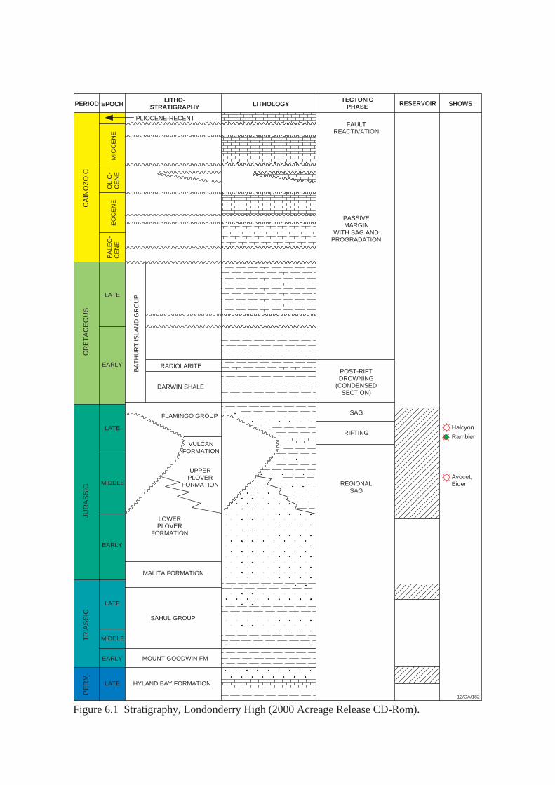
12/OA/182
LITHO-STRATIGRAPHYPERIOD EPOCH LITHOLOGY
TECTONICPHASE RESERVOIR SHOWS
EO
CE
NE
CR
ET
AC
EO
US
JUR
AS
SIC
TR
IAS
SIC
PE
RM
.
LATE
LATE
MIDDLE
EARLY
EARLY
MIDDLE
LATE
LATE
BA
TH
UR
T IS
LAN
D G
RO
UP
RADIOLARITE
DARWIN SHALE
FLAMINGO GROUP
EARLY
MOUNT GOODWIN FM
FAULTREACTIVATION
PASSIVEMARGIN
WITH SAG ANDPROGRADATION
POST-RIFTDROWNING
(CONDENSEDSECTION)
SAG
RIFTING
REGIONALSAG
Rambler
Halcyon
LOWERPLOVER
FORMATION
MALITA FORMATION
SAHUL GROUP
UPPERPLOVER
FORMATION
PLIOCENE-RECENTM
IOC
EN
E
CA
INO
ZO
IC
PA
LEO
-C
EN
EO
LIO
-C
EN
E
HYLAND BAY FORMATION
VULCANFORMATION
Avocet,Eider
Figure 6.1 Stratigraphy, Londonderry High (2000 Acreage Release CD-Rom).

AGE
TERTIARY
CRETACEOUS
JURASSIC
TRIASSIC
PERMIAN
STRATIGRAPHICUNIT
Barracouta Fm
Oliver Fm
Prion Fm
Hibernia Fm
Johnson Fm
Puffin Fm
Gibson Fm
Woolaston Fm
Jamieson Fm
Upper Vulcan Fm
Lower Vulcan Fm
Montara Fm
Plover Fm
Nome Fm
Challis Fm
Pollard Fm
Osprey Fm
Mt Goodwin Fm
Hyland Bay Fm
Fenelon Fm
Echuca Shoals Fm
Lorikeet,Halcyon Rambler Avocet Eider
Figure 6.2 Petroleum discoveries, Londonderry High.12/OA/183
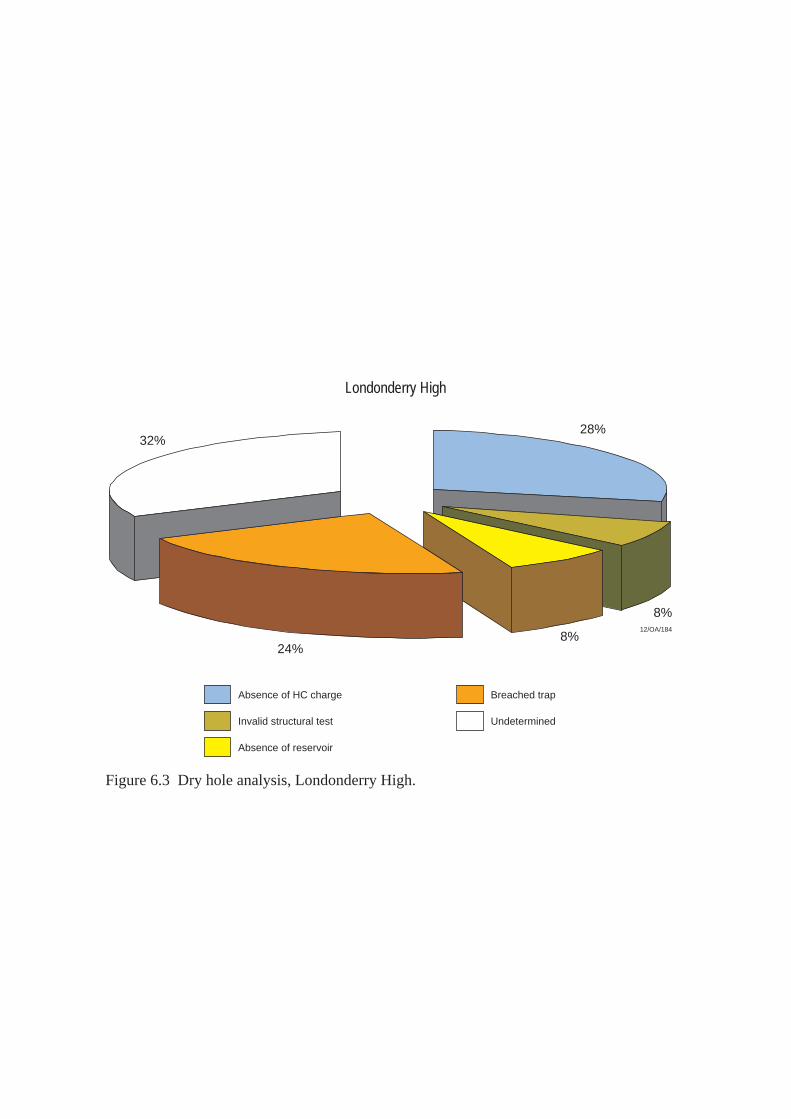
Londonderry High
32%
Absence of HC charge
Absence of reservoir
Invalid structural test
Breached trap
Undetermined
28%
8%
8%24%
Figure 6.3 Dry hole analysis, Londonderry High.
12/OA/184
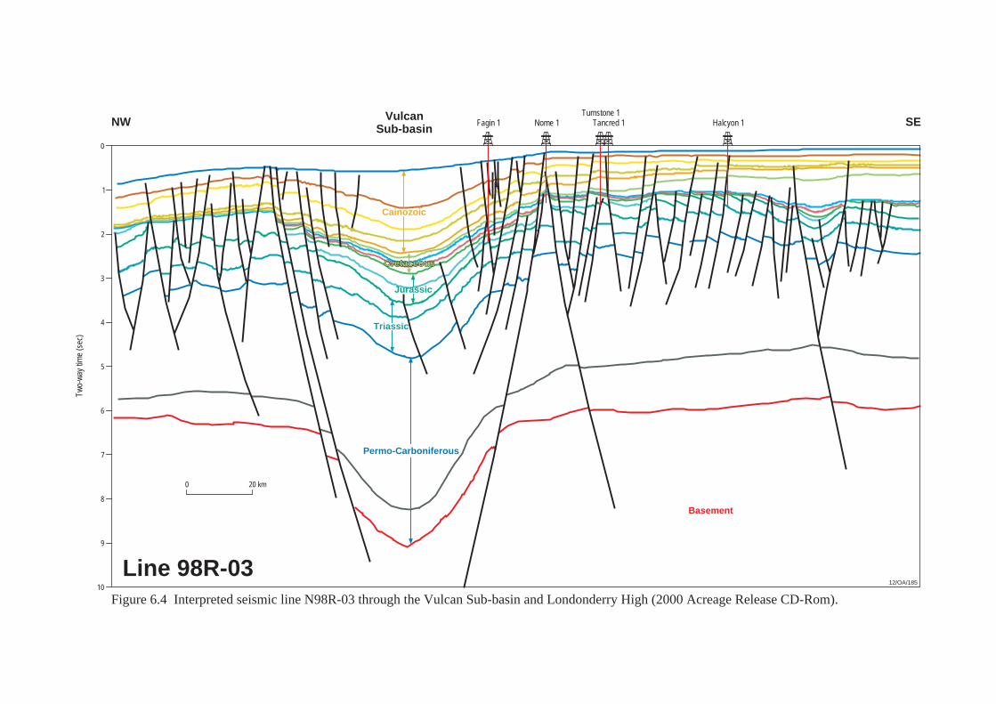
Fagin 1 Nome 1 Tancred 1Turnstone 1
Two-
way
tim
e (s
ec)
Halcyon 1
12/OA/185
NW SE
Line 98R-03
VulcanSub-basin
0
CretaceousCretaceous
0 20 km
Figure 6.4 Interpreted seismic line N98R-03 through the Vulcan Sub-basin and Londonderry High (2000 Acreage Release CD-Rom).
1
2
3
4
5
6
7
8
9
10
Basement
Permo-Carboniferous
Triassic
Jurassic
Cainozoic
7. SAHUL SYNCLINE 7.1 Introduction The Sahul Syncline is a prominent Palaeozoic to Mesozoic northwest trending trough located in the northern Bonaparte basin (Figure 8.2, Plate 1). The syncline is flanked to the north by the Sahul Platform and to the south by the northern Londonderry High. Although only one petroleum accumulation has been identified within the Sahul Syncline (Rambler-1), the syncline is considered a source kitchen for a number of petroleum accumulations identified on the adjacent Laminaria and Flamingo Highs (Plate 1, Figures 8.2 and 8.4). 7.2 Structural Evolution and Stratigraphy Botten and Wulff, (1990) consider the Sahul Syncline formed in the Late Triassic to Middle Jurassic, whereas others (Durrant et al., 1990) believe it formed as part of the Bonaparte rift system in the Devonian. The Sahul Syncline has been described as a ‘sag’ feature overlying an extension of the Bonaparte Basin margin (O’Brien et al., 1993; Robinson et al., 1994). These authors consider that Late Carboniferous to Early Permian extension reactivated pre-existing, northwest trending fault zones (such as the Sahul Syncline) as transfer faults. Subsidence in the Late Permian to Late Triassic led to the deposition of a thick, sedimentary sequence in the Sahul Syncline. Tectonic compression in the Late Triassic resulted in uplift and erosion of the adjacent structural highs and the deposition of a thick red bed sequence (Malita Formation) in the Petrel Sub-basin to the east. The Malita Formation has not been intersected by wells drilled in the Sahul Syncline, but may be present at depth. Further subsidence resulting from Mesozoic extension led to the deposition of a thick, Late Jurassic to Early Cretaceous clastic sequence (Plover Formation and Flamingo Group) in the Sahul Syncline. In axial areas of the syncline, the Plover Formation and sandstones within the Flamingo Group probably lie too deep to constitute valid exploration objectives. These units, however, form viable exploration targets on the flanks of the Sahul Syncline (in Rambler-1, oil was recovered from the Flamingo Group and a gas column was identified on wireline logs within the Plover Formation). At the conclusion of continental breakup in the Valanginian, Cretaceous and Cainozoic sediments were deposited across the Sahul Syncline. This sedimentary sequence is similar to the succession encountered in the Vulcan Sub-basin to the southwest. Further details of the stratigraphy and structural evolution of the Sahul Syncline can be found in Section 5, Vulcan Sub-basin and Section 2, Regional Summary.
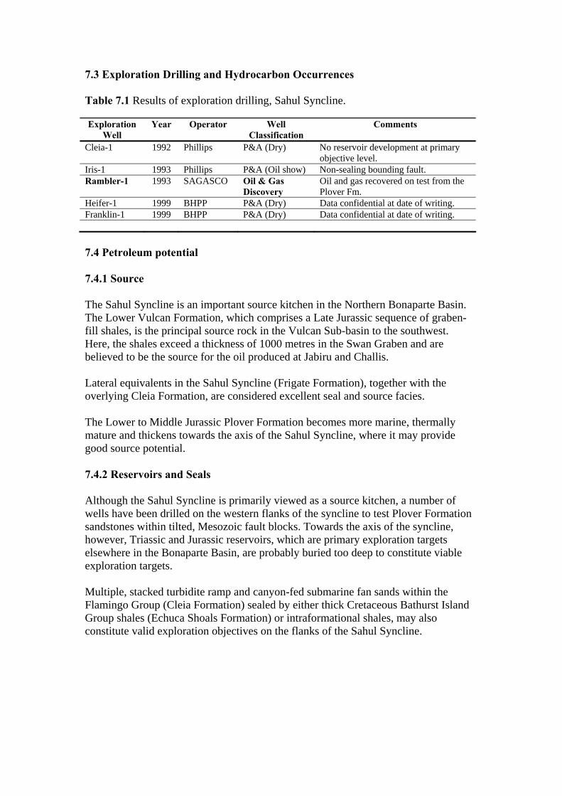
7.3 Exploration Drilling and Hydrocarbon Occurrences Table 7.1 Results of exploration drilling, Sahul Syncline. Exploration
Well Year Operator Well
Classification Comments
Cleia-1 1992 Phillips P&A (Dry) No reservoir development at primary objective level.
Iris-1 1993 Phillips P&A (Oil show) Non-sealing bounding fault. Rambler-1 1993 SAGASCO Oil & Gas
Discovery Oil and gas recovered on test from the Plover Fm.
Heifer-1 1999 BHPP P&A (Dry) Data confidential at date of writing. Franklin-1 1999 BHPP P&A (Dry) Data confidential at date of writing. 7.4 Petroleum potential 7.4.1 Source The Sahul Syncline is an important source kitchen in the Northern Bonaparte Basin. The Lower Vulcan Formation, which comprises a Late Jurassic sequence of graben-fill shales, is the principal source rock in the Vulcan Sub-basin to the southwest. Here, the shales exceed a thickness of 1000 metres in the Swan Graben and are believed to be the source for the oil produced at Jabiru and Challis. Lateral equivalents in the Sahul Syncline (Frigate Formation), together with the overlying Cleia Formation, are considered excellent seal and source facies. The Lower to Middle Jurassic Plover Formation becomes more marine, thermally mature and thickens towards the axis of the Sahul Syncline, where it may provide good source potential. 7.4.2 Reservoirs and Seals Although the Sahul Syncline is primarily viewed as a source kitchen, a number of wells have been drilled on the western flanks of the syncline to test Plover Formation sandstones within tilted, Mesozoic fault blocks. Towards the axis of the syncline, however, Triassic and Jurassic reservoirs, which are primary exploration targets elsewhere in the Bonaparte Basin, are probably buried too deep to constitute viable exploration targets. Multiple, stacked turbidite ramp and canyon-fed submarine fan sands within the Flamingo Group (Cleia Formation) sealed by either thick Cretaceous Bathurst Island Group shales (Echuca Shoals Formation) or intraformational shales, may also constitute valid exploration objectives on the flanks of the Sahul Syncline.
8. SAHUL PLATFORM (NORTHERN BONAPARTE BASIN) 8.1 Introduction The Northern Bonaparte Basin, or Sahul Platform sensu lato, is bounded by the Sahul Syncline in the west, the Malita Graben to the southeast and the Timor Trough to the north. (Figures 8.1 and 8.2). Hocking et al., (1994) defined the Northern Bonaparte Basin as an area to the northwest of the Petrel Sub-basin, containing a thick Mesozoic and Cainozoic succession. The Sahul Platform is a large northeast trending basement high comprised of tilted fault blocks and horsts. The platform plunges to the southwest. Permian, Triassic and Jurassic sediments thin over the platform to the northeast (Plate 2). The platform probably formed during Palaeozoic rifting, with later rejuvenation and uplift occurring during continental breakup in the Mesozoic and collision of the Australian plate with the South East Asian microplates in the late Cainozoic. Two major Upper Jurassic to Lower Cretaceous, depocentres are recognised in the Northern Bonaparte Basin – the Malita Graben and the Sahul Syncline (including its western extension, the Nancar Trough) (Whittam et al., 1996) (Figure 8.2, Plate 1). The Sahul Platform has been sub-divided into the following elements:
• the Troubadour High - a culmination located on the east of the Sahul Platform where depth to basement is approximately 3,000 metres;
• the Kelp High - located further to the west, where basement is interpreted to be significantly deeper;
• the Flamingo High - a major pre-Jurassic domal feature which lies between the Sahul Platform and the Londonderry High;
• the Laminaria High - a small, east-west orientated, drowned platform-remnant between the Sahul and Flamingo Synclines (Smith et al., 1996).
The Flamingo Syncline is a shallow southeast-trending, Upper Jurassic to Lower Cretaceous trough that separates the Sahul Platform from the Laminaria and Flamingo Highs. Although the Flamingo and Laminaria Highs are not sensu-stricto part of the Sahul Platform, because of similarities in their tectonostratigrapy and hydrocarbon potential they are included in this section of report. At date of writing, 20 oil, gas, and oil and gas discoveries made in the Northern Bonaparte Basin (Plates 1 and 2, Figure 8.4). Commercial production has occurred from 7 of these discoveries (Elang, Kakatua, Kakatua North, Laminaria, Corallina, Buffalo and Bayu-Undan). At date of writing, development of the Greater Sunrise gas field (which includes the Troubadour, Sunrise, Loxton Shoals and Sunset discoveries) and a joint development of the Kuda Tasi and Jahal oil discoveries are under consideration.
8.2 Structural Evolution The Phanerozoic history of the Northern Bonaparte Basin has been summarised by Veevers, (1971, 1988); Gunn, (1988); Pattillo and Nicholls, (1990); O’Brien et al., (1993); AGSO NW Shelf Study Group, (1994); Baillie et al., (1994); Whittam et al., (1996); O’Brien et al., (1996); Shuster et al., (1998); and Labutis et al., (1998). The following description draws on this work. The present day configuration of the Northern Bonaparte Basin has resulted from the intersection of two major structural trends – a Palaeozoic to Middle Jurassic northwest-southeast structural grain on which is superimposed on a northeast orientated, Late Jurassic to Holocene trend. The pre-existing Palaeozoic structural grain had considerable influence on the distribution and thickness of the Mesozoic and Cainozoic succession on the western part of the Sahul Platform (particularly during the Triassic), and is expressed in the southeast orientation of both the Sahul and Flamingo Synclines (Whittam et al., 1996). This structural grain is cross-cut by a series of Jurassic faults, the strike of which varies from northeast-southwest in the area adjacent to the Londonderry High, through north northeast-south southwest at the western end of the Malita Graben, to east-west in the area of the Flamingo and Laminaria Highs. Woods, (1992) attributes this latter east-west trend to Tithonian tectonism. Whittam et al., (1996) concluded that although the geological history of the Northern Bonaparte Basin and Vulcan Sub-basin are broadly similar (refer to Section 5, Vulcan Sub-basin), there are significant differences in the Northern Bonaparte Basin which have implications for petroleum exploration in the area. Variations in the subsidence history and timing of tectonic events between the two areas, influences the distribution and preservation of potential reservoir and source rocks. For example, it is considered unlikely that deposition of the Elang / Laminaria Formation reservoir sands would be widespread on the Sahul Platform if the Callovian extension that occurred in the Vulcan Sub-basin to the south had occurred on the western part of the Sahul Platform. Similarly, the differences in subsidence history, and in thickness of the mid-Cretaceous to Cainozoic succession had a major impact on the timing of hydrocarbon generation and on the extent to which later episodes of faulting affected the integrity of Jurassic traps. 8.3 Stratigraphy The overall stratigraphy of this area has been described by MacDaniel, (1988); Lavering and Ozimic, (1989); Mory, (1988); Patillo and Nicholls, (1990); O’Brien et al., (1993); Hocking et al., (1994); Baillie et al., (1994); AGSO, (1994); Whittam et al., (1996); Labutis et al., (1998); Shuster et al., (1998); and Seggie et al., (2000). The following description draws on the work of these authors.
The generalised stratigraphy, tectonic elements and petroleum discoveries in the Sahul Platform area are shown in Figures 8.1, 8.2, 8.3 and 8.4, Plates 1and 2. The stratigraphy of the Sahul Platform is further discussed in Sections 8.3.1, Laminaria High; 8.3.2, Troubadour High; 8.3.3. Flamingo High; and 8.3.4, Kelp High. The Permian, Hyland Bay Formation is the oldest unit intersected by drilling on the Sahul Platform to date. During the initial phase of exploration in the area, the Permo-Carboniferous succession was generally considered by explorers to be unprospective for hydrocarbons. The discovery of gas in the Hyland Bay Formation at Kelp Deep-1 in 1997, however, changed these perceptions (at least on the Kelp High). A marine transgression in the Early Triassic led to the deposition of marine claystones (Mt Goodwin Formation) over the Sahul Platform. This was followed in the Middle and Late Triassic by a regressive sequence of shallow marine to fluvio-deltaic sandstones, claystones and minor carbonates (Sahul Group). In the Late Triassic to Early Jurassic, a red bed sequence (Malita Formation) was deposited. Few exploration wells have penetrated the Triassic sequence on the Sahul Platform (the most complete Triassic sections have been encountered by the Kelp-1, Kelp Deep-1 and Troubadour-1 wells). Early to Middle Jurassic sediments (Plover Formation) were deposited in a broad, northeast-southwest trending ‘sag’ basin in non-marine to marginal marine, depositional environments. At the top of the Plover Formation, a shallow marine sandstone (Elang / Laminaria Formation) forms an important petroleum reservoir in the area. The Elang/Laminaria Formation comprises two depositional sequences and represents the youngest unit deposited below the breakup unconformity. This unit was originally considered to be a marine facies within the uppermost Plover Formation. Continental breakup in the Late Jurassic initiated the formation of the Sahul Syncline, the Malita Graben and a series of east-west trending troughs. The Sahul Platform and the Londonderry High flank these depocentres. The Flamingo Syncline is a younger feature developed in the Albian. Late Jurassic and Early Cretaceous sediments of the Flamingo Group are mainly confined to the Malita Graben and Sahul Syncline and are absent or represented by very thin condensed sequences on the flanking ‘highs’. Tithonian to Berriasian age Flamingo Group sediments are interpreted to occur within east-west trending troughs on the Sahul Platform and may constitute potential reservoirs. Wells distant from the Malita Graben and Sahul Syncline have encountered hydrocarbons, indicating that source rocks on the Sahul Platform are thermally mature and have generated and expelled significant quantities of petroleum (Figure 8.1). Labutis et al., (1998) note that the stratigraphic nomenclature on the Sahul Platform is often misleading as it is commonly based on lithostratigraphy, with some formation names unique to an area or well and others extrapolated from nearby wells. The formations are usually based on facies and rarely on biostratigraphy and are thus difficult to identify or tie with seismic data at any distance from the well or area where the lithostratigraphic unit was first defined.
Consequently, units of different ages have been assigned to the same formation. For example, the Montara Formation was first defined in the Vulcan Sub-basin to the south, in the Montara-1 well, based on the predominantly marine sandstones of the uppermost Callovian and Oxfordian age (R. aemula to W. spectabilis dinoflagellate palynozones). This same formation name is applied to the section now called the Laminaria or Elang Formation or ‘Montara Beds’ in many of the wells drilled on the Sahul Platform. The tectonostratigraphy of the Sahul Platform is further discussed in the following sections. 8.3.1 Laminaria High The Laminaria High is a small, east-west orientated, drowned platform-remnant lying between the Sahul and Flamingo Synclines (Smith et al., 1996) (Figure 8.2). On the high, Palaeozoic basement is relatively shallow and is overlain by thick Triassic to Lower Jurassic ‘sag’ phase sediments which have known equivalents in other parts of the Bonaparte Basin. The stratigraphic succession on the Laminaria High is well known from drilling on the Laminaria, Corallina and Buffalo oil fields, which are located on the high. The Laminaria and Frigate Formations were deposited in half-grabens which developed over the Laminaria High in the late Callovian to early Tithonian. Fault movement ended in the Late Kimmeridgian and faulting largely terminates near the top of the Frigate (Shale) Formation, where a significant unconformity occurs (Patillo and Nicholls, 1990; Gorter and Kirk, 1995). The upper part of the Frigate Shale is preserved on the flanks of the Laminaria High while over 20 metres of section has been removed on the crest of the feature. Flamingo Group shales rest disconformably on this surface. The crest of the Laminaria High was not covered until Late Tithonian (P. iehiense zone) times. The overlying Cretaceous and Cainozoic sequences are similar to those found elsewhere in the Bonaparte Basin. However, the Cretaceous sediments are thin compared to adjacent synclinal areas and substantial erosion / non-deposition occurred over the Laminaria High near the Cretaceous/Cainozoic boundary. In contrast, the overlying Cainozoic section is very thick, resulting from substantial flexure, rapid subsidence and extensive prograding of shelfal carbonates over the drowned Laminaria High, as the Australian Plate converged on the South East Asian microplates in the Cainozoic. The rapid deposition of a thick, Cainozoic section has resulted in rapid, thermal maturation of underlying source rock sequences that have provided the petroleum charge for accumulations on the Laminaria High. 8.3.2 Troubadour High The Troubadour High (referred to as the Sunrise High by Seggie et al., 2000), is a large culmination on the eastern Sahul Platform. The Troubadour High was a prominent feature from Permo-Triassic through to Recent times. The high is bounded

to the south by the Malita Graben, to the east by the Calder Graben, to the southwest by the Sikitan Syncline (Figure 8.2, Plate 1). The Sunrise/Troubadour/Loxton Shoals/Sunset gas field (commonly referred to as the Sunrise/Troubadour field or the Greater Sunrise field) lies on the Troubadour High. The Greater Sunrise structure is a complex of large, east-west elongated fault blocks. The main phase of structural development at Greater Sunrise occurred during the Pleistocene as a consequence of rapid subsidence of the Timor Trough (Seggie et al., 2000). The stratigraphy of the Troubadour High has been well documented from wells drilled on the Greater Sunrise field. Fuller accounts of the regional geology and stratigraphy are available in Schuster et al., (1998) and Whittam et al., (1996). Troubadour-1, drilled on the northern margin of the Sahul Platform in 1974, encountered recrystallised, Late Permian carbonates of the Hyland Bay Formation overlying granitic basement (Figure 8.6). Late Permian to Early Triassic, marine siltstones and shales of the Mount Goodwin Formation overlie the Hyland Bay Formation. Deposition of the Triassic Sahul Group (a mixed clastic-carbonate succession), followed. A Late Triassic marine regression, induced in part by regional uplift associated with the Fitzroy compressional movement, culminated in the deposition of fluvio-deltaic redbeds (Nome and Malita Formations) across the region (Figure 8.3). A transgression in the Early to Mid Jurassic deposited a thick fluvio-deltaic to marine succession (Plover Formation) over the area. These units form the petroleum reservoirs in the Greater Sunrise gas field. Marine influence within the Plover Formation increases from the southwest to the northwest across the Sahul Platform. The Plover Formation reservoir in the Greater Sunrise field is interpreted to be Bathonian in age and the most marine section encountered on the Sahul Platform to date. On the Troubadour High, the Plover Formation is para-conformably overlain by marine sandstone/shale sequences of late Callovian to early Oxfordian age (Laminaria or Elang Formation). This unit constitutes both a reservoir and source rock interval at Greater Sunrise. In other areas of the Bonaparte Basin, a period of block faulting and uplift during the Callovian resulted in an unconformity between the Plover Formation and the Laminaria / Elang Formation / Frigate Shale. On the Troubadour High, however, the main episode of faulting occurred during the Latest Jurassic. This led to the development of east-west trending horsts and grabens and a major Late Jurassic unconformity. Deposition of marine claystones and siltstones of the overlying Flamingo Group (Tithonian to Berriasian in age) is widespread in the Malita Graben. This unit onlaps the flanks of the Troubadour High. The areal distribution of the Flamingo Group and its potential as an exploration target on this part of the Sahul Platform remains uncertain as a number of hiatuses associated with continental breakup are evident in the Flamingo Group succession on the Troubadour High.
Following the onset of sea-floor spreading in the mid-Valanginian, subsidence of the Australian continental margin resulted in the widespread deposition of a condensed section of glauconitic, marine claystone (Valanginian to Early Aptian, Echuca Shoals Formation). The peak of this transgression is represented by a condensed, radiolarian chert, claystone and calcilutite (Darwin Formation, Whittam et al., 1996). The top of the radiolarite (Aptian) is a prominent seismic marker over the Troubadour High and is used to map the top of the reservoir (phantomed downwards) over the Greater Sunrise field. A thick Aptian to Maastrichtian progradational section of claystone, calcilutite and marl (Jamieson and Wangarlu Formations) overlies this condensed section and fills the accommodation space created by the rapid subsidence of the Australian margin after break-up. The Cainozoic section on the Troubadour High is similar to the succession encountered elsewhere on the northwest margin, where a thick succession of prograding, marine, shelf/slope carbonate dominated sediments was deposited. 8.3.3 Flamingo High The Flamingo High is a major pre-Jurassic domal structure lying between the adjacent Sahul Platform and the Londonderry High (Figure 8.2). The Flamingo High has long been recognised as a potential hydrocarbon objective (Brooks et al, 1996). Palinspastic reconstructions of the Permian and Triassic intervals show that prior to Late Triassic, the Flamingo High had no structural expression – the area from Sahul to Flamingo Synclines constituted one broad depocentre (McIntyre, 1995). Following the formation of the Flamingo High in the Late Triassic/Early Jurassic, localised, north-south oriented faulting occurred on the Flamingo High and western Sahul Platform. Extensional faulting initiated during the Oxfordian-Valanginian resulted in the development of east-west trending tilted fault blocks, horst and grabens across the Sahul Platform (including the Flamingo High). Contemporaneously, the Londonderry High and Sahul Platform were uplifted and sub-aerially eroded. Tilting of the Flamingo High occurred during the Aptian-Turonian, extending the areal extent of the high to the west (at the level of the Aptian Disconformity). The collision of the Australian continental plate with the South East Asian microplates in the Neogene led to increased water depths over the northern half of the Sahul Platform. Flexuring caused by thrust loading during the Late Miocene-Pliocene resulted in east-northeast trending normal faulting, erosion, and extensive channelling (Bradley and Kidd, 1991; McIntyre, 1995). The stratigraphy of the Flamingo High is well documented from the results of drilling on the Bayu-Undan gas field and the Elang / Kakatua / Kakatua North oil discoveries. A detailed stratigraphy of the Flamingo High has been compiled by Brooks et al., (1996) and Young et al., (1995).

The first well to be drilled on the Flamingo High was Flamingo-1 (1971). Since that time, three commercial oil discoveries (Elang, Kakatua and Kakatua North) and one commercial gas discovery (Bayu-Undan) have been made on the high. 8.3.4 Kelp High The Kelp High is a large culmination on the western Sahul Platform. This ‘domal’ feature was identified on regional ‘sparker’ seismic surveys acquired in the late1960s and early 1970s. The Kelp High remained a ‘geological anomaly’ for a further 25 years (partly due to the moratorium on petroleum exploration in this area between 1976 and 1992). The Sahul Platform has been a structural high since Late Jurassic times. Analysis of isochores suggests that significant structural closure did not exist on the Kelp High feature prior to the Pliocene and that the Upper Cretaceous section is thin at this locality. The Kelp High consists of a crestal, east-west trending horst block with the flanks of the feature composed of numerous tilted fault blocks. Kelp-1 was drilled in 1994 to test Jurassic and Triassic sediments in a crestal position on the Kelp High. The well encountered a stratigraphic section ranging in age from Cainozoic (Miocene or younger) to Middle to Late Triassic. No hydrocarbons were encountered. The well confirmed the presence of good quality reservoir sands in the Plover and Flamingo Formations. The secondary objective (Triassic, Sahul Group sands) exhibited poor reservoir quality at this location. In 1997, Kelp Deep-1 was drilled approximately 15 kilometres southwest of Kelp-1 on a separate fault block on the Kelp High. The well was designed to test the limestones and fluvio-deltaic sandstones of the Late Permian Hyland Bay Formation (together with sandstones of the Lower Cretaceous/Upper Jurassic Flamingo Group and Plover Formation). In Kelp Deep-1, no hydrocarbons were encountered within the Flamingo Group and Plover Formation, but gas was recovered on test from the deeper, Permian Hyland Bay Formation. Although to date, exploration drilling on the Kelp High has proved disappointing (Kelp-1, Kelp Deep-1, Hydra-1, Mandar-1 and Naga-1), the wells have established both the presence of excellent reservoirs within the Flamingo Group and Plover Formation and a new petroleum play within the Permian sequence (Table 8.1). 8.4 History of Exploration Permits in the Zone of Cooperation (ZOC) and Joint Petroleum Development Area (JPDA) Much of the Sahul Platform and environs lies in an area of the Timor Sea over which sovereignty has been disputed - initially by Indonesia and more recently by the independent nation of East Timor. Since exploration permits were first awarded over
the region in the late 1960s and early 1970s, exploration has undergone a complex history. Australian offshore permits in the Timor Sea adjacent to the, then, non-agreed seabed boundary between Australia and East Timor were suspended in the middle of 1976 (shortly after Indonesia claimed sovereignty over Portugese East Timor). The moratorium on exploration in the area was lifted in 1991 when agreement was reached between Australia and Indonesia to explore in the Zone of Cooperation (ZOC). Three zones were agreed to in a treaty signed by both parties: • ZOCC - the northern zone close to East Timor. All legal rights and
administration by Indonesia. • ZOCB - the southern zone close to Australia. All legal rights and
administration by Australia • ZOCA - a zone between ZOCC and ZOCB jointly administered and shared
legal rights between Australia and Indonesia. Administered from Jakarta with an office in Darwin.
The Joint Authority, which administered Area ‘A’ gazetted exploration areas within ZOCA in late 1991. The first permits within ZOCA were awarded in February 1992. In recognition of their expertise in exploring the area, prior holders of permits (Australian) within the boundaries of Area ‘A’ were given rights of special consideration on these permits. The terms of special consideration gave prior permit holders a right to match bids on permits of their choice. These permits, together with subsequent renewals and new permits, remained in force until East Timor was granted independence in 2002. On 20 May 2002, the date of East Timor’s independence, Australia and East Timor signed the Timor Sea Treaty. This treaty was officially ratified between the governments on 2 April 2003 for a period of 30 years. The key elements of the treaty include: • The creation of the Joint Petroleum Develoment Area (JPDA) from the former
ZOC. • A revenue split of 90% for east Timor and 10% for Australia from petroleum
activities in the JPDA; • Deferral of permanent delimitation of the seabed boundary without prejudice
to Australia’s and East Timor’s rights and entitlements; • Maintenance of contractual terms of the existing petroleum projects (Bayu-
Undan, Greater Sunrise and Elang-Kakatua); • Australian jurisdiction over pipelines from the JDPA to Australia; • Unitisation of the Greater Sunrise field (which straddles the JDPA and an area
under Australian jurisdiction) on the basis that 20.1% of the field lies within JDPA and 79.9% within Australian jurisdiction.
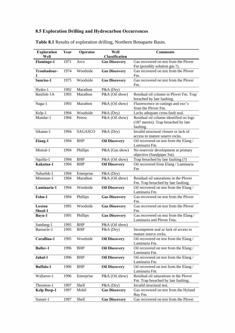
8.5 Exploration Drilling and Hydrocarbon Occurrences Table 8.1 Results of exploration drilling, Northern Bonaparte Basin. Exploration
Well Year Operator Well
Classification Comments
Flamingo-1 1971 Arco Gas Discovery Gas recovered on test from the Plover Fm (possibly solution gas ?).
Troubadour-1
1974 Woodside Gas Discovery Gas recovered on test from the Plover Fm.
Sunrise-1 1975 Woodside Gas Discovery Gas recovered on test from the Plover Fm.
Hydra-1 1992 Marathon P&A (Dry) Basilisk-1A 1993 Marathon P&A (Oil show) Residual oil column in Plover Fm. Trap
breached by late faulting. Naga-1 1993 Marathon P&A (Oil show) Fluorescence in cuttings and swc’s
from the Plover Fm. Kelp-1 1994 Woodside P&A (Dry) Lacks adequate cross-fault seal. Mandar-1 1994 Petroz P&A (Oil show) Residual oil column identified on logs
(187 metres). Trap breached by late faulting.
Sikatan-1 1994 SAGASCO P&A (Dry) Invalid structural closure or lack of access to mature source rocks.
Elang-1 1994 BHP Oil Discovery Oil recovered on test from the Elang / Laminaria Fm.
Mistral-1 1994 Phillips P&A (Gas show) No reservoir development at primary objective (Sandpiper Sst).
Squilla-1 1994 BHP P&A (Oil show) Trap breached by late faulting (?) Kakatua-1 1994 BHP Oil Discovery Oil recovered from Elang / Laminaria
Fm Nabarlek-1 1994 Enterprise P&A (Dry) Minotaur-1 1994 Marathon P&A (Oil show) Residual oil saturations in the Plover
Fm. Trap breached by late faulting. Laminaria-1 1994 Woodside Oil Discovery Oil recovered on test from the Elang /
Laminaria Fm. Fohn-1 1994 Phillips Gas Discovery Gas recovered on test from the Plover
Fm. Loxton Shoal-1
1995 Woodside Gas Discovery Gas recovered on test from the Plover Fm.
Bayu-1 1995 Phillips Gas Discovery Gas recovered on test from the Elang / Laminaria and Plover Fms.
Sandang-1 1995 BHP P&A (Oil show) Barnacle-1 1995 BHP P&A (Dry) Incompetent seal or lack of access to
mature source rocks. Corallina-1 1995 Woodside Oil Discovery Oil recovered on test from the Elang /
Laminaria Fm. Buller-1 1996 BHP Oil Discovery Oil recovered on test from the Elang /
Laminaria Fm. Jahal-1 1996 BHP Oil Discovery Oil recovered on test from the Elang /
Laminaria Fm. Buffalo-1 1996 BHP Oil Discovery Oil recovered on test from the Elang /
Laminaria Fm. Wallaroo-1 1996 Enterprise P&A (Oil show) Residual oil saturations in the Plover
Fm. Trap breached by late faulting. Thornton-1 1997 Shell P&A (Dry) Invalid structural test. Kelp Deep-1 1997 Mobil Gas Discovery Gas recovered on test from the Hyland
Bay Fm. Sunset-1 1997 Shell Gas Discovery Gas recovered on test from the Plover

Fm. Kakatua North-1
1997 BHP Oil Discovery Oil recovered on test from the Elang / Laminaria Fm.
Krill-1 1997 BHP Oil & Gas Discovery
Oil and Gas recovered on test from the Elang / Laminaria Fm.
Layang-1 1997 BHP P&A (Oil show) Trap breached by late faulting (?) Bogong-1 1997 BHP P&A (Oil show) Trap breached by late faulting (?) Alaria-1 1997 Woodside P&A (Dry) Drilled outside structural closure at
primary objective level. Buang-1 1997 BHP P&A (Oil show) Trap breached by late faulting (?) Vidalia-1 1997 Woodside P&A (Dry) Lacks adequate cross-fault seal or lacks
access to mature source rocks. Capung-1A 1998 BHP P&A (Oil and
show) Trap breached by late faulting (?)
Bluff-1 1998 BHP Oil Discovery Oil recovered on test from the Elang / Laminaria Fm.
Fannie Bay-1 1998 Woodside P&A (Oil show) Data confidential at date of writing. Tanjil-1 1998 BHP P&A (Dry) Data confidential at date of writing. Lameroo-1 1998 Woodside P&A (Oil show) Data confidential at date of writing. Conch-1 1998 Woodside P&A (Dry) Invalid structural test (drilled outside
closure at primary objective level). Bard-1 1998 Woodside P&A (Dry) Invalid structural test (well did not
reach primary objective). Chuditch-1 1998 Shell Gas Discovery Gas recovered on test from the Plover
Fm. Wowo Wiwi-1
1998 BHP P&A (Dry) Data confidential at date of writing.
Claudea-1 1999 Woodside P&A (Dry) Data confidential at date of writing. Mindil-1 1999 Woodside P&A (Dry) Data confidential at date of writing. Marrakai-1 1999 Woodside P&A (Dry) Data confidential at date of writing. Jura-1 1999 Woodside P&A (Dry) Data confidential at date of writing. Coleraine-1 2000 Phillips P&A (Oil show) Data confidential at date of writing. Kuda Tasi-1 2001 Woodside Oil Discovery Oil recovered on test from the Elang /
Laminaria Fm. Pandorina-1 2001 Woodside P&A (Dry) Data confidential at date of writing. A dry hole analysis of wells drilled in the Northern Bonaparte Basin to December 2002 is shown in Figure 8.5. Table 8.2 Hydrocarbon shows, Northern Bonaparte Basin.
Exploration Well
Show Type
Depth (mRT)
Formation Show Description
Basilisk-1A Oil 2860-2880 Plover Fluorescence in cuttings and core. Residual oil column inferred.
Bogong-1 Oil 3532.5-3596 Elang/Laminaria 63.5 metre residual oil column inferred from logs.
Buang-1 Oil Elang/Laminaria 45 metre palaeo oil column inferred from GOI studies.
Capung-1A Oil & Gas Elang/Laminaria 10 metre palaeo oil column and 80 metre palaeo gas column inferred from GOI studies.
Coleraine-1 Oil Data confidential at date of writing Fannie Bay-1 Oil Data confidential at date of writing. Lameroo-1 Oil Data confidential at date of writing. Layang-1 Oil 3204-3232 Elang/Laminaria Fluorescence in cuttings and core
indicates a residual oil column.

Mandar-1 Oil 2938-3125 Plover 187 metre residual oil column identified on wireline logs.
Minotaur-1 Oil 3317-3365 Plover Residual oil column identified on wireline logs.
Mistral-1 Gas ~3088 Plover Gas accumulation inferred from wireline logs at top of Plover Fm (10.4 metres net pay; 50% Sw).
Naga-1 Oil 3002-3033 Plover Fluorescence in cuttings and swc’s. Sandang-1 Oil 2905-2915 Jamieson Fluorescence in cuttings. Squilla-1 Oil 3348-3384 Plover (?) Fluorescence in cuttings, core and
swc’s. Possible residual oil column. Wallaroo-1 Oil 2968-2999 Plover Good oil shows (residual oil) in
core cut at top of Plover Fm. 8.6 Petroleum Potential The discovery of several commercial petroleum accumulations on the Sahul Platform (Bayu-Undan, Greater Sunrise, Laminaria / Corallina, Elang / Kakatua / Kakatua North, Buffalo) has verified the presence of an active petroleum system in the area. Construction of the Bayu-Undan gas pipeline (to Darwin) and the possible future development of the Greater Sunrise gas-condensate discovery may provide further impetus for exploration and development both on the Sahul Platform and in the Petrel Sub-basin to the southeast. 8.6.1 Reservoirs The Plover and Elang / Laminaria Formations are the primary exploration objectives on the Sahul Platform. These units are widely distributed, show little variation and are dominated by fluvial to open marine sandstones. They are absent over the Londonderry High, but are present in wells on the southwestern flank of the Sahul Syncline and thin to the north towards the Kelp High. They may either be absent or very thin in the central areas of the Sahul Platform. The porosity within the Elang and Plover Formations is fair to good (5% - 20%). Calcraft, (1997) has shown that on the southern Sahul Platform, reservoir porosities of over 15% are maintained to depths of around 3,300 metres, but are severely degraded below 3,400 metres. (Gas bearing sands intersected at Fohn-1 below 3,400 metres rarely attain porosities above 10%; reservoir porosity within the Elang / Laminaria Formation intersected by Minotaur-1 is around 10-15% between 3,300 and 3,400 metres). Gorter and Kirk, (1995) report porosities of between 17% and 20% in Elang Formation equivalent sands in Flamingo-1 at depths of around 3,400 metres. In addition, Plover Formation reservoirs have retained porosities in excess of 25% on the Kelp High at depths of between 2,000 and 3,000 metres (Kelp Deep-1). Labutis et al., (1998) has attributed this variation in porosity with depth to differences in depositional environments. Occlusion of primary porosity within the Elang / Laminaria and Plover Formations is thought to be due to development of interstitial clays in marine sandstone reservoirs and silica overgrowths in both marine and non-marine sands. Labutis et al., (1998)
consider that high heat flows may have also contributed to porosity degradation and cites data from the Elang-1 well, where logging tools failed due to high temperatures. Over most of the Sahul Platform, the Triassic to Early Jurassic section is considered too deeply buried to constitute a valid exploration target. Although this succession is within drillable depths on the Kelp High, the Triassic section intersected by Kelp-1 (and in wells drilled on the Londonderry High) comprised a low net to gross section of shales and sandstones with minor carbonates. Although gas flowed on test from the Permian, Hyland Bay Formation at Kelp Deep-1, at date of writing no information is available on the reservoir properties of the Hyland Bay Formation at this location. 8.6.2 Source Source rock intervals have been identified within the Elang / Laminaria Formation, Plover Formation, Frigate Shale and Flamingo Group (Preston and Edwards, 2000). The thickest succession of Late Jurassic to Early Cretaceous source rocks is found in the adjacent Malita Graben and Sahul Syncline. (Figure 8.2). To date, most exploration wells have either been drilled on highs adjacent to or on the flanks of these source kitchens, where source rock quality is poor to fair (Figure 8.1). No wells have been drilled in the kitchen areas, but maturation modelling indicates these units are probably mature for gas generation in the Malita Graben and Sahul Syncline. It is likely, however, that local source pods on the northern flank of the Malita Graben are oil-mature and could provide an oil charge for traps that lie within migration shadows, shielded from the main gas charge from the deeper portions of the Malita Graben. There may also be some potential for oil charge from the Sikitan Syncline to the southwest. At Troubadour-1, the Plover, Elang / Laminaria Formations and the Flamingo Group are at optimum thermal maturity for oil generation, whilst the Permian Hyland Bay Formation is gas mature. Isotopic and biomarker analysis of condensates recovered from the Greater Sunrise field suggest these accumulations represent a separate hydrocarbon family to other oils and condensates recovered from the Bonaparte Basin. A definitive condensate-source correlation has yet to be established for the Greater Sunrise field (Edwards et al., 2000). A condensed Oxfordian section is present over most of the Sahul Platform and comprises nearshore sediments with poor source potential. In the Sahul Syncline, however, Oxfordian shales (underlying the Kimmeridgian marl) are expected to be thick and organic rich. Gorter and Kirk, (1995) indicate that TOC values in the Oxfordian shales in wells on the flank of the Sahul Syncline reach 1.5% to 2%. Shales within the Darwin Formation and Flamingo Group are potential source rocks, although TOC values are generally less than 2% in these units.
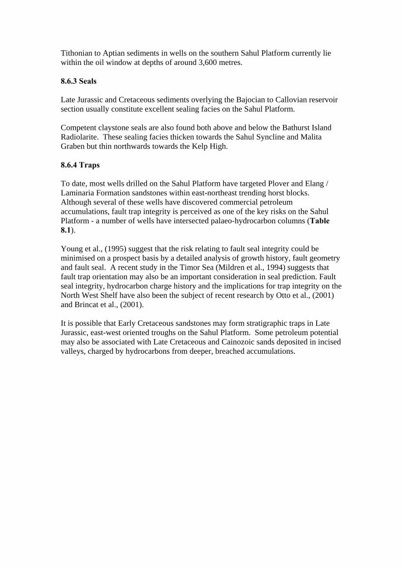
Tithonian to Aptian sediments in wells on the southern Sahul Platform currently lie within the oil window at depths of around 3,600 metres. 8.6.3 Seals Late Jurassic and Cretaceous sediments overlying the Bajocian to Callovian reservoir section usually constitute excellent sealing facies on the Sahul Platform. Competent claystone seals are also found both above and below the Bathurst Island Radiolarite. These sealing facies thicken towards the Sahul Syncline and Malita Graben but thin northwards towards the Kelp High. 8.6.4 Traps To date, most wells drilled on the Sahul Platform have targeted Plover and Elang / Laminaria Formation sandstones within east-northeast trending horst blocks. Although several of these wells have discovered commercial petroleum accumulations, fault trap integrity is perceived as one of the key risks on the Sahul Platform - a number of wells have intersected palaeo-hydrocarbon columns (Table 8.1). Young et al., (1995) suggest that the risk relating to fault seal integrity could be minimised on a prospect basis by a detailed analysis of growth history, fault geometry and fault seal. A recent study in the Timor Sea (Mildren et al., 1994) suggests that fault trap orientation may also be an important consideration in seal prediction. Fault seal integrity, hydrocarbon charge history and the implications for trap integrity on the North West Shelf have also been the subject of recent research by Otto et al., (2001) and Brincat et al., (2001). It is possible that Early Cretaceous sandstones may form stratigraphic traps in Late Jurassic, east-west oriented troughs on the Sahul Platform. Some petroleum potential may also be associated with Late Cretaceous and Cainozoic sands deposited in incised valleys, charged by hydrocarbons from deeper, breached accumulations.
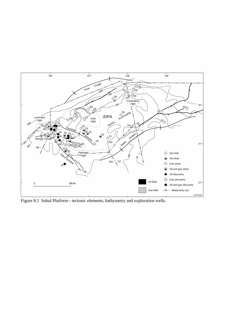
Dry hole
Oil show
Gas show
Oil and gas show
Oil discovery
Gas discovery
Oil and gas discovery
50 Bathymetry (m)
Oil field
Gas field
126° 127° 128° 129°
10°
11°
12°
50100
100
100200
500100
0
100200
1000
500
FlamingoHigh
KelpHigh
LaminariaHigh
TroubadourHigh
Nancar Trough
Sahul Syncline
12/OA/201
11
5110
501844 12
17
13
16 15
41 14
98
4749
38
4342
12
56
3943
726
40
27
2524
2322
2829
19
21
20
5331
30
32
33
52
34
35
3637
54
0 100 km
SAHULPLATFORM
TimorTrough
Malita
Graben
JDPA
55
56
Flamingo
Syncline
5758
4548
46
Figure 8.1 Sahul Platform - tectonic elements, bathymetry and exploration wells.
WA NT
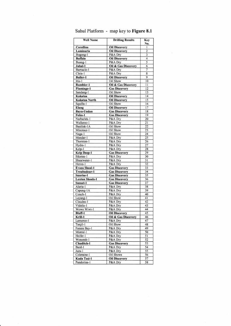

128°
INDONESIA
10°
126°
NTW
A
12°
Sahul
Syncline
Flamingo
SynclineLAMINARIAHIGH
DARWIN
SHELF
Malita
Gra
ben
TIMOR TROUGHTIMOR
SAHUL PLATFORM
TROUBADOURHIGH
KELPHIGH
LONDONDERRYHIGH
Sikatan
Syncline
100 km0
12/OA/186
FLAMINGOHIGH
NancarTrough
PetrelSub-basin
JPDA
Figure 8.2 Structural elements, northern Bonaparte Basin (2002 Acreage Release CD- Rom).
AUSTRALIA
Oliver Fm
Cartier Fm
Cartier Fm
Prion Fm
Hibernia Fm
Johnson Fm
Turnstone Fm
Fenelon FmGibson Fm
Woolaston Fm
Jamieson Fm
Darwin Fm
Echuca Shoals Fm
Plover Fm
Malita Fm
Cape
Londonderry Fm
Mt Goodwin Fm
Hyland Bay Fm
AGEGROUP
FORMATION/UNIT TECTONICS DISCOVERIES
JUR
AS
SIC
TR
IAS
SIC
PE
RM
IAN
Late
Mid
dle
Ear
lyLa
teM
iddl
eE
arly
Late
WO
OD
BIN
E G
RO
UP
BA
TH
UR
ST
ISLA
ND
GR
OU
P
PA
SS
IVE
MA
RG
INN
OR
TH
EA
ST
RIF
TIN
G
PO
ST
-BR
EA
KU
P S
EQ
UE
NC
EB
RE
AK
UP
RIF
T S
EQ
UE
NC
EP
RE
-EX
TE
NS
ION
AL
PH
AS
E
Collision of Australian platewith Timor
Fault reactivation/regionalcompression
VALANGINIAN
UNCONFORMITY
UNCONFORMITYCALLOVIAN
Buffalo, Elang, Krill
Corallina, Jahal, Laminaria, Buller
Bayu-Undan
Kakatua, Kakatua North
Flamingo
Loxton Shoals, Sunrise, Sunset,Troubadour
Kelp Deep
12/OA/187
Elang Fm
Thermal subsidence
Frigale Fm
Flamingo Gp
Figure 8.3 Sahul Platform - stratigraphy, tectonics and petroleum discoveries.
TE
RT
IAR
Y
Pliocene
Mio
cene
Oligo-cene
Eoc
ene
Palae-ocene
CR
ET
AC
EO
US
Late
Ear
ly
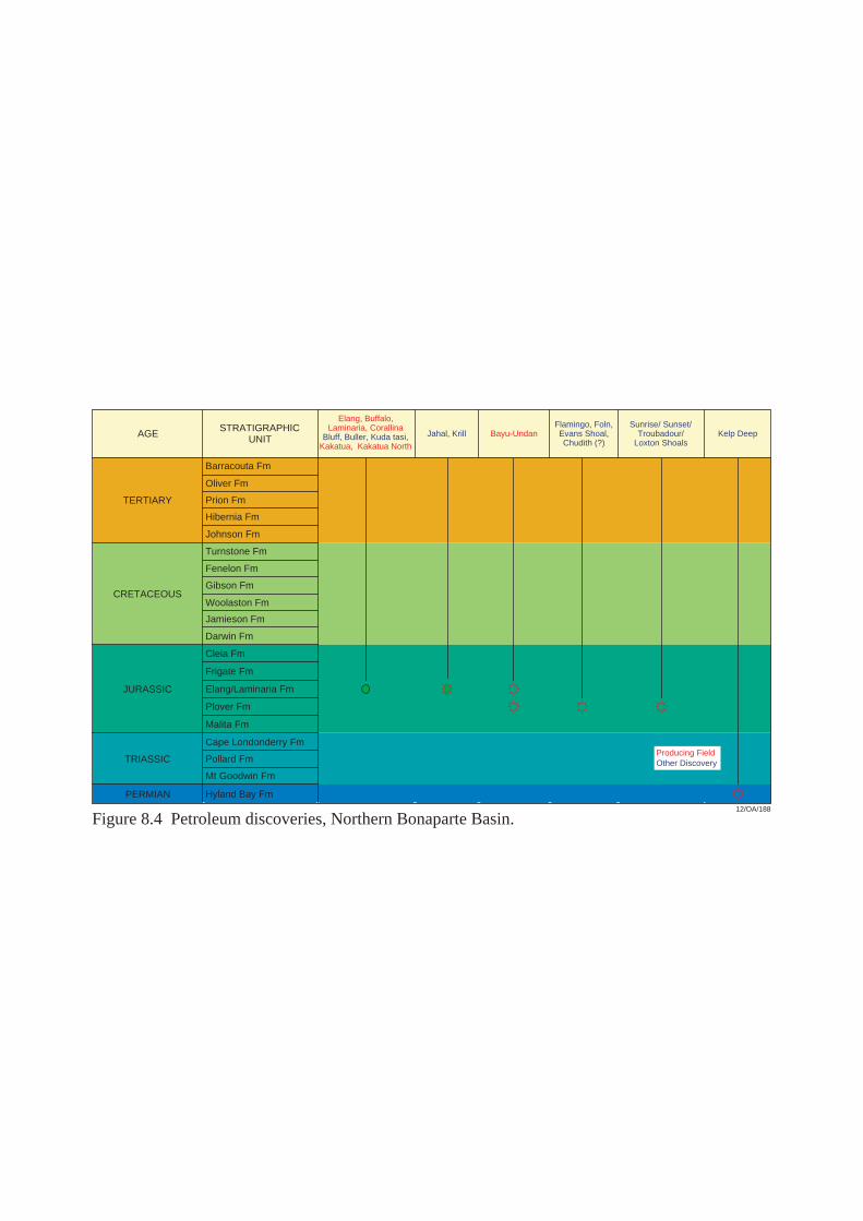
,
AGE
TERTIARY
CRETACEOUS
JURASSIC
TRIASSIC
PERMIAN
STRATIGRAPHICUNIT
Barracouta Fm
Oliver Fm
Prion Fm
Hibernia Fm
Johnson Fm
Fenelon Fm
Gibson Fm
Woolaston Fm
Plover Fm
Pollard Fm
Mt Goodwin Fm
Hyland Bay Fm
Turnstone Fm
Jamieson Fm
Darwin Fm
Cleia Fm
Frigate Fm
Elang/Laminaria Fm
Malita Fm
Cape Londonderry Fm
Bayu-Undan
Elang, Buffalo,Laminaria, Corallina
Bluff, Buller, Kuda tasi,Kakatua, Kakatua North
Jahal, KrillFlamingo, Foln,Evans Shoal,Chudith (?)
Kelp DeepSunrise/ Sunset/
Troubadour/Loxton Shoals
Figure 8.4 Petroleum discoveries, Northern Bonaparte Basin.12/OA/188
Producing FieldOther Discovery

Absence of HC charge
Absence of reservoir
Invalid structural test
Breached trap
Undetermined
41%
5%
20%
3%
Northern Bonaparte Basin
31%
Figure 8.5 Dry hole analysis, Northern Bonaparte Basin.
12/OA/189
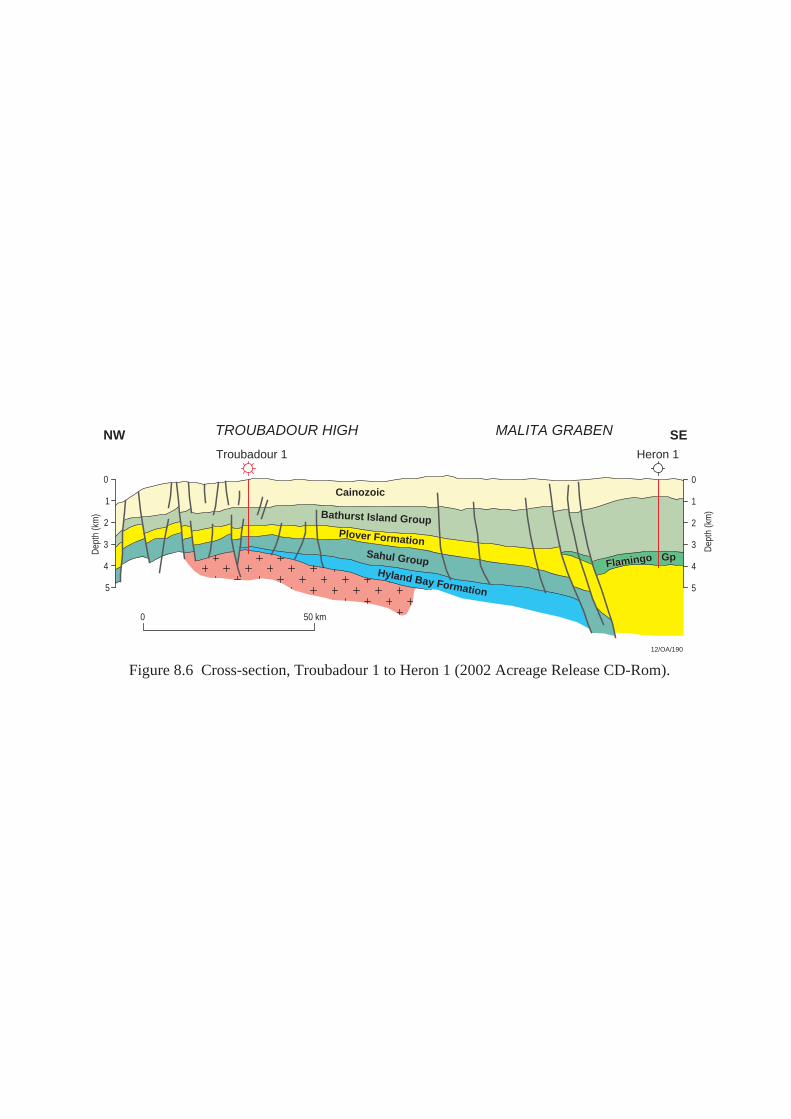
Troubadour 1 Heron 1
TROUBADOUR HIGH MALITA GRABEN
50 km
0
5
0
5
SENW
Cainozoic1
2
3
4
Dep
th (k
m)
1
2
3
4
Dep
th (k
m)
0
Bathurst Island Group
Sahul GroupHyland Bay Formation
Plover Formation
FlamingoFlamingo GpGp
12/OA/190
Figure 8.6 Cross-section, Troubadour 1 to Heron 1 (2002 Acreage Release CD-Rom).

9. MALITA GRABEN 9.1 Introduction The Malita Graben is a Triassic depocentre, bordered by the Sahul Platform to the northwest and the Darwin Shelf to the southeast. The graben is bounded by large displacement, east-northeast trending faults (Figure 9.1). An exploration well has not been drilled in the central graben but Mory, (1988) suggests a Mesozoic and Cainozoic sediment pile exceeding 10 kilometres in thickness, underlain by Precambrian basement, may be present. Of the 8 exploration wells drilled either in or on the flanks of the Malita Graben to date, only one (Evans Shoal-1) has recovered gas on test (Plate 1, Figure 8.4) 9.2 Structural Evolution and Stratigraphy The structural evolution and stratigraphy of the Malita Graben is referred to in other sections of this report (Sahul Platform and Petrel Sub-basin) and are shown in Plate 2. Key features of the stratigraphic succession deposited in the Malita Graben are: • Plover Formation sediments are expected to thicken into the graben, and
probably include good quality, Early Jurassic source rocks. • Thick, organic-rich shales of the Flamingo Group provide additional source
potential in the area. • Tithonian turbidite sands (which were intersected in Heron-1) may provide
valid exploration targets in the graben. • The Cretaceous Bathurst Island Group exceeds a thickness of 2,000 metres in
the Malita Graben. • The Echuca Shoals Formation is also thought to be relatively thick and to
provide additional source potential in the area. 9.3 Exploration Drilling and Hydrocarbon Occurrences Table 9.1 Results of exploration drilling, Malita Graben.
Exploration Well
Year Operator Well Classification
Comments
Heron-1 1972 Arco P&A (Dry) Lack of reservoir development at primary objective level.
Lynedoch-1 1973 Shell P&A (Gas show) Lack of reservoir development at primary objective level.
Shearwater-1 1974 Arco P&A (Dry) Lack of reservoir development at primary objective level.
Jacaranda-1 1984 Tricentrol P&A (Gas show) Lack of reservoir development at primary objective level.
Darwinia-1A 1985 Tricentrol P&A (Dry) Lack of access to mature source rocks / trap breached by late faulting.
Evans Shoal-1 1988 BHP Gas Discovery Gas recovered on test from the Plover Fm.
Beluga-1 1991 BHP P&A (Oil and gas shows)
Lack of reservoir development at primary objective level / incompetent

seal. Wonarah-1 1998 Shell P&A (Dry) Lack of reservoir development at
primary objective level. A dry hole analysis of wells drilled within the Malita Graben to December 2002 is shown in Figure 9.4. Table 9.2 Hydrocarbon shows, Malita Graben. Exploration
Well Show Type Depth
(mRT) Formation Show Description
Beluga-1 Oil & Gas 2571-2582 2774-2789 2933-2972
Flamingo Gp Flamingo Gp Flamingo Gp
Fluorescence in cuttings. Fluorescence in cuttings. Gas column inferred from wireline logs (Sw 70%).
Jacaranda-1 Gas 3525-3550 Flamingo Gp Gas in tight reservoir inferred from wireline logs (Sw 60%)
Lynedoch-1 Gas 3674-3715 Bathurst Island Gp
Gas column in Early Cretaceous carbonates inferred from wireline logs (Sw 50% to 80%).
9.4 Petroleum Potential Sediments in the Malita Graben have traditionally been regarded by explorers as gas-prone (tight gas in the Upper Vulcan Formation / Flamingo Group at Jacaranda-1; gas shows in the Flamingo Group at Heron-1; gas recovered on test from the Plover Formation at Evans Shoal-1). Elsewhere in the Bonaparte Basin, however, the Echuca Shoals Formation contains good quality, oil-prone source rocks. It is possible that the equivalent unit in this area (Darwin Formation) has provided an oil charge for traps in the vicinity of the Malita Graben. Flushing of oil accumulations by late gas generation, however, is a potential exploration risk in this area. 9.4.1 Reservoirs Several potential sandstone reservoirs have been identified either in or on the flanks of the Malita Graben. These include the Jurassic Plover Formation, the Laminaria / Elang Formation and sands within the Flamingo and Bathurst Island Groups (Wangarlu Formation) (Figure 10.2, Plate 2). Due to increased diagenetic alteration of sandstone reservoirs with depth, over much of the Malita Graben, the Plover Formation may lie too deep to constitute a valid exploration target - in the axial parts of the Malita Graben, it is expected to be found at depths below 5,000 metres (Figure 9.2). At these depths, it is a possible that fractures within the Plover Formation sandstones are the primary source of porosity. At some locations, however, the early emplacement of hydrocarbons into Plover Formation sands may have inhibited diagenesis and subsequent porosity occlusion. Jurassic turbidite sandstones within the Flamingo Group (shed from the Sahul Platform in the north and the Darwin Shelf in the east) and Late Cretaceous, lowstand
sands both within the Bathurst Island Group and in the overlying Palaeocene section may also provide valid exploration targets in the Malita Graben. (Where Late Cretaceous sands were intersected in the Darwinia-1/1A well, porosities ranged from 20% to 28% over a 150 metre interval). 9.4.2 Seals A massive claystone and siltstone interval at the base of the Bathurst Island Group (referred to as the Darwin Formation in the Petrel Sub-basin or, elsewhere in the Bonaparte Basin, as the Echuca Shoals Formation) forms the regional seal in the area. Several petroleum accumulations identified in the Vulcan Sub-basin and on the flanks of the Londonderry High occur immediately below this regional seal. Intra-formational shales and claystones are also form competent seals within the Flamingo Group, Plover and Wangarlu Formations. Where present in the Malita Graben, Late Cretaceous and Eocene lowstand sands are probably sealed by Cainozoic carbonate sequences. 9.4.3 Source Three potential oil prone source rock intervals exist within Malita Graben area. In the vicinity of the Malita Graben, where the Flamingo Group has been intersected by wells, shales and siltstones exhibit good to excellent source potential. At Heron-1, an average TOC value of 2.5% was recorded within the Flamingo Group (78 samples). At Jacaranda-1, TOC values average around 0.7% over both the Flamingo Group and Laminaria / Elang Formation. At Curlew-1, average TOC values within the Flamingo Group exceed 1%. The Mid to Late Cretaceous Bathurst Island Group (Wangarlu Formation) also exhibits moderately good source potential, with TOC values as high as 1.3% recorded in the Flamingo-1 well, 3.4% in the Lynedoch-1 well and 1.8% in the Heron-1 well. Poor well control in the vicinity of the Malita Graben makes thermal maturation trends difficult to establish. However, it is expected that most potential Late Jurassic / Cretaceous source rocks in the area have attained at least marginal maturity for oil generation. A possible exception is the Plover Formation, which may currently be over-mature (Figure 9.3). Maturation modelling indicates that oil explusion from the Darwin Formation probably occurred in the Late Cretaceous, with late gas generation commencing in the Early Cainozoic. Source intervals within the Laminaria / Elang and Plover Formations probably expelled oil in the Middle Cretaceous, with the onset of late gas generation from these units occurring in the Early Cainozoic (Figure 9.3). 9.4.4 Traps The predominant trap style identified to date in the Malita Graben is the Jurassic/Triassic tilted fault block, sealed either by intra-formational claystones, or by
claystones or shales of the overlying Flamingo or basal Bathurst Island Group. Hanging wall, fault dependent closures on the downthrown, faulted margins of the Malita Graben are also considered to be valid exploration objectives. Late Cretaceous (Puffin Formation equivalents) and Eocene drape closures, are secondary exploration targets in the area. These features are likely to comprise subtle, four-way dip closures with a significant stratigraphic component. Turbidite sands within the Flamingo Group may also form stratigraphic traps on the margins of the Malita Graben. On the southern flank of the Malita Graben, where the northwest trending Petrel Sub-basin intersects the northeast trending Malita Graben (Figure 10.1), structuring related to salt diapirism (Gull and Curlew diapirs) may have resulted in the formation of a number of structural and stratigraphic traps.

Eocene
Campanian to Turonian
Maastrichtian
Early to MiddleJurassic
Triassic
PermianEast Malita Graben
Troubadour Terrace
Cenomanianto Albian
Tithonian
?Kimmeridgian toOxfordian
Paleocene
Aptian
Barremian to
Berriasian
Bathurst Terrace
Heron 1
NW SE
14/OA/1596
Pliocene-Pleistocene
Miocene
Jurassic
0
1
2
3
4
Two-
way
tim
e (s
)
0 30 km
Figure 9.1 Structure and stratigraphy of the Malita Graben and adjacent terraces (2003 Acreage Release CD-Rom).

010 20 30
1
2
3
3.3
4
5
Porosity (%)
Dep
th (k
m)
12%
Flamingo Gp
Upper BathurstIsland Group
14/OA/655
Plover Fm
Figure 9.2 Porosity plot for wells in the Malita Graben (1999 Acreage Release CD-Rom).
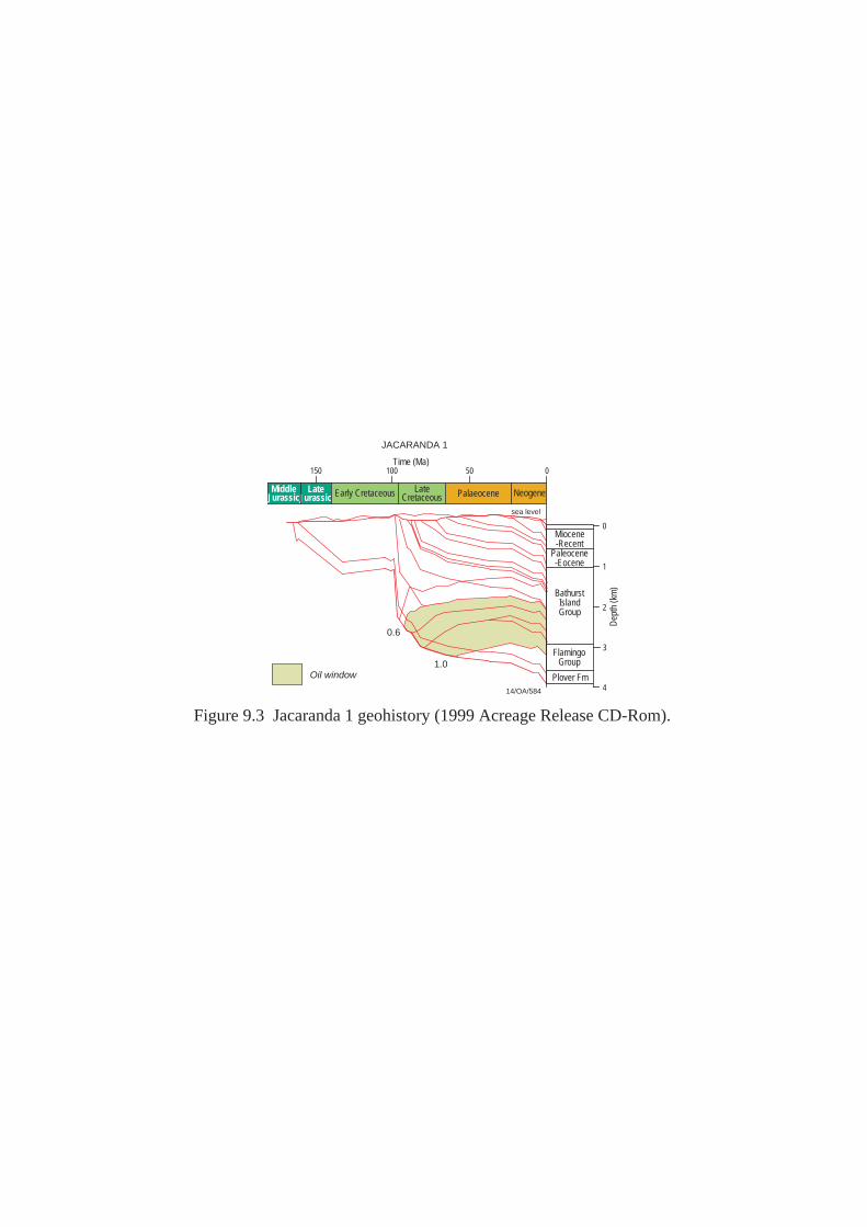
150 100 50 0
0
JACARANDA 1
Plover Fm
Paleocene-Eocene
Miocene-Recent
FlamingoGroup
BathurstIslandGroup
Dep
th (k
m)
Time (Ma)
sea level
1
2
3
4
0.6
1.0Oil window
14/OA/584
MiddleJurassic
LateJurassic Early Cretaceous Late
Cretaceous Palaeocene Neogene
Figure 9.3 Jacaranda 1 geohistory (1999 Acreage Release CD-Rom).
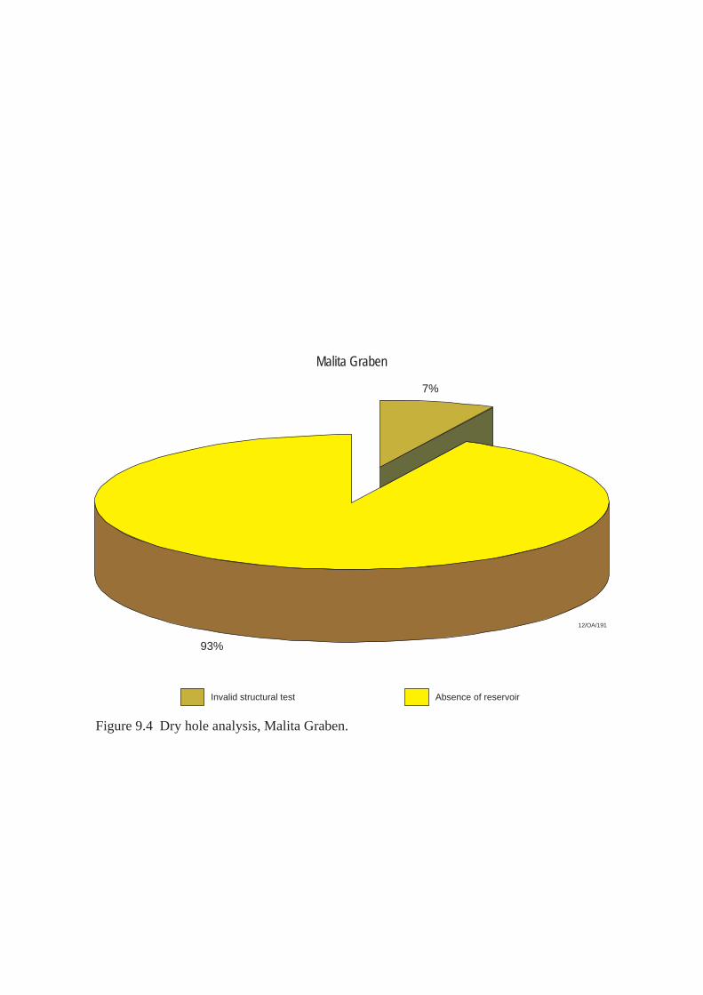
Invalid structural test Absence of reservoir
Malita Graben
93%
7%
12/OA/191
Figure 9.4 Dry hole analysis, Malita Graben.
10. PETREL SUB-BASIN 10.1 Introduction The Petrel Sub-basin is an asymmetric, northwest–southeast trending Palaeozoic rift located in the southeast portion of the Bonaparte Basin. The sub-basin underlies the Bonaparte Gulf, extends onshore to the south and contains a succession of Palaeozoic and Mesozoic sediments (Figures 10.1 and 10.2, Plates 1 and 2). The eastern and western faulted margins of the sub-basin converge onshore to form the southern boundary of the sub-basin. To the south and east of the Petrel Sub-basin, extensions of the Halls Creek-Fitzmaurice Mobile Zone separate the sub-basin from the Precambrian Victoria Basin and Pine Creek Geosyncline. Extensive basement shelves overlain by a thin cover of Phanerozoic sediments lie on the eastern, western and southern margins of the Petrel Sub-basin. To the east, the Darwin Shelf extends to the south-southwest into the Moyle Platform and Kulshill Terrace. In the south, the Berkley Platform has been sub-divided into several, smaller southeast-trending horst (Lacrosse Terrace and Turtle-Barnett High) and graben (Cambridge Trough) structures. Since petroleum exploration began in the onshore part of the sub-basin the late 1950's, a total of 19 accumulations have been discovered. (Plate 1, Figure 10.3). While none of these are commercial at date of writing, several are held under Retention Lease. At time of writing, the development of a recent gas discovery made on the southern margin of the Petrel Sub-basin (Blacktip-1) is under consideration. 10.2 Structural Evolution and Stratigraphy The generalised stratigraphy of the Petrel Sub-basin is shown in Figures 10.2 and 10.5 and Plate 2. The structural and stratigraphic setting of the Petrel Sub-basin are most recently summarised in Kennard et al., (2002). The regional geology of the sub-basin is discussed in detail by Mory, (1988 & 1991); Lee & Gunn, (1988); Gunn & Ly, (1989); McConachie et al., (1996); and Colwell & Kennard, (1996). The following description draws on the work of these authors. The Petrel Sub-basin is underlain by Proterozoic crystalline basement and sediments of the Proterozoic Kimberley Basin. The sub-basin contains a rift-dominated succession of Palaeozoic and Mesozoic sediments which dip regionally to the northwest about a northwest-plunging synclinal axis (Colwell & Kennard, 1996). Sediment thickness within the Petrel Sub-basin is estimated to be greater than 15 kilometres. The Palaeozoic succession is known from outcrop and well intersections onshore and in the inboard portion of the Petrel Sub-basin (Laws & Kraus, 1974; Laws & Brown, 1976). Here, Cambrian sediments unconformably overly Precambrian basement which comprises a sub-aerial, volcanic sequence (Antrim Plateau Volcanics) (Veevers and Roberts, 1968). A shallow marine, clastic and carbonate succession of Cambrian

to Early Ordovician age (Tarrara Formation and Carlton Group) was then deposited over the Cambrian unconformity surface. Seismic data and exploration drilling indicate that an evaporitic sequence was deposited in the Bonaparte Basin during Late Silurian and Early Devonian times, and that subsequent salt movement has formed a number of salt-induced features (Edgerley and Crist, 1974). Several wells drilled within the Petrel Sub-basin have encountered salt and in the Vulcan Sub-basin to the southwest, two salt diapers (Swan and Paqualin) have been identified. In the Petrel Sub-basin, Middle Devonian to Early Carboniferous sediments comprise: • a basinal marine sequence of shale and siltstone (Bonaparte Beds); • a clastic sequence developed on the eastern margin of the Petrel Sub-basin
(Cockatoo Formation) and; • a shelfal carbonate sequence comprising a massive algal reef with horizontally-
bedded back reef deposits (Ningbing Limestone or reef complex). Gas has been recovered on test from all three of these units in wells drilled in the onshore portion of the Petrel Sub-basin (Figure 10.3, Plate 2). During the Tournasian, a carbonate / siltstone / shale sequence (Langfield Group) was deposited along the southwestern margin of the Petrel Sub-basin. The Langfield Group conformably overlies the Ningbing reef complex and passes offshore into clastic sediments of the Bonaparte Formation. Onshore, the Early Carboniferous, Milligans Formation (a sequence of marine shales, siltstones and sandstones of Visean age), unconformably overlies the Langfield Group. Offshore, the unit rests unconformably on the Bonaparte Formation. Offshore, oil has been recovered from the Milligans Formation at Turtle and Barnett, while onshore, gas has flowed on test from this unit at Waggon Creek and Weaber. The Tanmurra Formation is a transgressive unit comprising near-shore sandstones and carbonates. The unit disconformably overlies the Milligans Formation. The top of the Tanmurra Formation is a prominent seismic reflector in the southern part of the Petrel Sub-basin and is Late Visean to Late Carboniferous in age (Veevers and Roberts, 1968). After deposition of the Tanmurra Formation, uplift and erosion on the flanks of the Petrel Sub-basin provided the sediment supply for a deltaic sequence deposited in the Late Carboniferous within the southern Petrel Sub-basin (Point Spring Sandstone and Kuriyippi Formation). These units form part of an overall regressive sequence. The regression reached a maximum in the Late Carboniferous to Early Permian when the Treachery Shale was deposited over large areas of the Petrel Sub-basin. The Treachery Shale is a lacustrine unit, has good source potential and forms a competent top seal for the underlying Kuriyippi Formation reservoirs. In the offshore Petrel Sub-basin, oil has been recovered from the Kuriyippi Formation at Turtle and Barnett.
A marine transgression in the Early Permian led to the deposition of an interbedded sandstone / shale sequence (Keyling Formation) over the Treachery Shale. The Keyling Formation is considered a fair to moderately good quality petroleum reservoir. Oil has been recovered on test from the Keyling Formation at Turtle. More recently, on the southern margin of the Petrel Sub-basin, gas flowed on test from this unit at Blacktip-1. The Fossil Head Formation is a transgressive sequence of marine siltstone and shale and conformably overlies the Keyling Formation (Laws and Brown, 1976). The unit is Early to Late Permian in age (Sakmarian to Kungurian), comprises estuarine to tidal shelf sediments and forms a competent top seal for underlying Keyling Formation reservoirs. In the Late Permian (Kazanian to Tartarian), a sandstones, shale, and carbonate sequence (Hyland Bay Formation) was conformably deposited over the Fossil Head Formation. The formation has been subdivided into three main lithological elements: • a basal sequence of limestone and shales; • a middle, tidal clastic sequence and; • an upper sequence of mudstones and sandstones, deposited as a coarsening-
upwards deltaic sequence. The Hyland Bay Formation is a primary exploration target in the Petrel Sub-basin and hosts the gas accumulations identified at Petrel and Tern. In the Early Triassic, a sequence of marine shales and siltstones (Mount Goodwin Formation) transgressed across the Bonaparte Basin. The Mount Goodwin Formation thickens towards the centre of the Petrel Sub-basin and forms a regional seal for the underlying Hyland Bay Formation. A regressive sequence of fluvial sandstones of Middle Triassic age was then deposited. Late Triassic compressional inversion related to the Fitzroy Movement produced extensive uplift and erosion along the southern margin of the Petrel Sub-basin, together with numerous fault-related inversion structures and anticlines (O’Brien et al., 1996). Erosion and collapse of these uplifted areas led to the widespread deposition of Lower to Middle Jurassic fluvio-deltaic clastics and ‘redbeds’ (Malita Formation). Crustal extension in the Late Jurassic resulted in a series of linked, northeast and southeast-trending intercontinental grabens northwest of the Petrel Sub-basin (Malita Graben, Sahul Syncline and Vulcan Sub-basin) (Patillo & Nicholls, 1990; Woods, 1992). Thick, organic-rich marine sediments accumulated within restricted marine environments in these Late Jurassic grabens. Although these facies extend into the Petrel Sub-basin, they lack sufficient thermal maturation to have sourced significant quantities of petroleum (Messent et al., 1994). Post-rift regional thermal subsidence of the northwest Australian margin commenced in the Valanginian (Baxter, 1996; Baxter et al., 1997). This resulted in the deposition of a thick Cretaceous-Cainozoic passive margin wedge, deposited in a northwest-plunging syncline across the Petrel Sub-basin. These units are absent in the southern

part of the sub-basin but thicken to the northwest toward the Malita Graben. The Cretaceous succession is dominated by fine-grained clastic facies, while the Cainozoic succession comprises shallow marine sands that grade offshore to a subtropical to tropical carbonate platform sequence. Apart from minor downwarp in the outboard and central portions of the sub-basin, the convergence of the Australian continental plate with the South East Asian microplates in the Neogene had little effect on the Petrel Sub-basin. Salt diapirism has been an important control on the occurrence of petroleum in the Petrel Sub-basin. Sourced from pre-Devonian evaporitic sediments, salt movement occurred as early as the Carboniferous and, in most instances (including the Petrel and Tern structures), was continuous until the Late Cretaceous (Lemon & Barnes, 1997). Many petroleum plays associated with salt diapirism remain untested in the Petrel Sub-basin. The Mesozoic stratigraphy of the Bonaparte Basin is further described in Section 5, Vulcan Sub-basin and Section 8, Sahul Platform. 10.3 Exploration Drilling and Hydrocarbon Occurrences In 1839, the crew of HMS Beagle found bitumen in water wells sunk on banks of the Victoria River in the southern Petrel Sub-basin. This is one of the earliest oil shows documented in Australia. Initial offshore exploration in the Petrel Sub-basin commenced in the early 1960s with extensive aeromagnetic and gravity surveys. During this period, the Bureau of Mineral Resources (BMR) conducted regional ‘sparker’ surveys in the Bonaparte Gulf. Industry commenced conventional regional marine seismic surveys in the 1960s. Since the late 1950's when petroleum exploration began in the onshore part of the sub-basin, a total of 19 oil or gas accumulations have been discovered (Figure 10.3). Table 10.1 Results of exploration drilling, Petrel Sub-basin. Exploration
Well Year Operator Well
Classification Comments
Spirit Hill-1 1960 Oil Dev. Co. P&A (Dry) Drilled outside structural closure. Bonaparte-1 1964 Alliance Oil Gas Discovery Gas recovered on test from the
Milligans Fm. Kulshill-1 1966 Australian
Aquitaine P&A (Oil and gas shows)
Breached trap (?)
Moyle-1 1966 Australian Aquitaine
P&A (Dry) Invalid structural test.
Keep River-1 1969 Australian Aquitaine
Gas Discovery Gas recovered on test from the Milligans Fm.
Lacrosse-1 1969 Arco P&A (Oil show) Poor reservoir development at primary objective, or breached trap, or invalid structural closure.
Newby-1 1969 Australian Aquitaine
P&A (Dry) Invalid structural test.
Petrel-1A 1969 Arco Gas Discovery Gas blowout to surface from the Hyland Bay Fm.
Flat Top-1 1970 Australian Gas Discovery Gas recovered on test from the Hyland
Aquitaine Bay Fm (possibly solution gas). Gull-1 1971 Arco P&A (Dry) Lack of reservoir development at
primary objective level. Sandpiper-1 1971 Arco P&A (Dry) Lack of reservoir at primary objective
level (intersected a salt diaper). Tern-1 1971 Arco Gas Discovery Gas recovered on test from the Hyland
Bay Fm. Bougainville-1
1972 Australian Aquitaine
P&A (Dry) Lack of access to mature source rocks and poor reservoir development at primary objective level.
Pelican Island-1
1972 Arco P&A (Oil show) Lack of reservoir development at primary objective and possible breached trap due to late faulting.
Penguin-1 1972 Arco Gas Discovery Gas recovered on test from the Hyland Bay Fm.
Kinmore-1 1974 Australian Aquitaine
P&A (Dry) Lack of access to mature source rocks.
Curlew-1 1975 Arco Gas Discovery Gas recovered on test from the Bathurst Island and Flamingo Gps (possibly solution gas).
Frigate-1 1978 Arco P&A (Dry) Lack of access to mature source rocks. Lesueur-1 1980 Australian
Aquitaine Gas Discovery Gas recovered on test from the
Tanmurra and Milligans Fms. Berkley-1 1982 Magnet
Minerals P&A (Dry) Lack of access to mature source rocks.
Ningbing-1 1982 Australian Aquitaine
P&A (Oil and gas shows)
Poor reservoir development at primary objective (fracture porosity within algal mound).
Cambridge-1 1984 WMC P&A (Oil shows) Breached trap. Lack of competent seal on bounding fault.
Skull-1 1984 Australian Aquitaine
P&A (Dry) Lack of reservoir development at primary objective level.
Turtle-1 1984 WMC Oil Discovery Oil recovered on test from the Keyling, Kuriyippi, Tanmurra and Milligans Fms.
Barnett-1 1985 Elf Aquitaine
P&A (Oil shows) Lack of reservoir development in Tanmurra and Milligans Fms.
Matilda-1 1985 WMC P&A (Dry) Lack of competent seal on bounding fault.
Garimala-1 1988 Santos Gas Discovery Gas recovered on test from the Bonaparte Fm.
Barnett-2 1989 Elf Aquitaine
Oil and Gas Discovery
Oil recovered on test from the Kuriyppi Fm. Oil and gas recovered on test from the U. Milligans Fm.
Kite-1 1990 WMC P&A (Dry) Lack of access to mature source rocks. Harbinger-1 1991 Kufpec P&A (Dry) Lack of access to mature source rocks. Billabong-1 1992 BHP P&A (Dry) Lack of access to mature source rocks. Billawock-1 1992 BHP P&A (Dry) Lack of access to mature source rocks. Fishburn-1 1992 BHP Gas Discovery Gas recovered on test from the Hyland
Bay Fm. Oberon-1 1992 Kufpec P&A (Dry) Lack of access to mature source rocks. Shalimar-1 1992 Kufpec P&A (Dry) Lack of access to mature source rocks
and/or trap leakage on bounding fault. Helvetius-1 1994 MIM P&A (Dry) Lack of access to mature source rocks. Kingfisher-1 1994 Teikoku P&A (Dry) Lack of access to mature source rocks
(?) Sunbird-1 1994 Teikoku P&A (Dry) Lack of access to mature source rocks
(?) Ascalon-1A 1995 Gas Discovery Gas recovered on test from the Hyland

Bay Fm. Waggon Creek-1
1995 Amity Oil Gas Discovery Gas recovered on test from the Milligans Fm.
Marsi-1 1996 MIM P&A (Dry) Ningbing-2 1996 Amity Oil P&A (Gas show) Poor reservoir development at primary
objective Pincombe-1 1996 Amity Oil P&A (Dry) Poor reservoir development and
reservoir flushed by meteoric waters. Cape Ford-1 1997 Cultus P&A (Oil show) Schilling-1 1997 Petroz P&A (Dry) Vienta-1 1998 Amity Oil Gas Discovery Gas recovered on test from the
Langfield Gp. Blacktip-1 2001 Woodside Gas Discovery Gas recovered on test from the Keyling
and Mt Goodwin Fms. Sandbar-1 2001 Woodside P&A (Dry) Data confidential at date of writing. A dry hole analysis of wells drilled in the Petrel Sub-basin to December 2002 is shown in Figure 10.4. Table 10.2 Hydrocarbon shows, Petrel Sub-basin.
Exploration Well
Show Type
Depth (mRT)
Formation Show Description
Barnett-1 Oil 834-852 1550-1555 2028-2035
Keyling Kuriyippi Tanmurra
Oil staining in core. Oil staining in core. Trace of residual oil recovered on RFT / DST.
Cambridge-1 Oil 568-650 Kulshill Gp Trace of residual oil in swc’s. Cape Ford-1 Oil 2490-2603
2768-2803 Milligans Milligans
Fluorescence in cuttings and swc’s. Fluorescence in cuttings and swc’s
Kulshill-1 Oil & Gas 1180-1455
1692-1710
2109-2114
Keyling Kuriyippi Milligans
Oil staining and fluorescence in cuttings. Oil staining and fluorescence in cuttings. Residual oil in core.
Lacrosse-1 Oil 1742-1759 Kulshill Gp Residual oil in core. Ningbing-1 Oil & Gas ~286
1019-1034 Bonaparte Ningbing Lst
Gas cut mud recovered on DST. Residual oil in core.
Ningbing-2 Gas 410-412 535-598
Ningbing Lst Ningbing Lst
Gas to surface at a RTSTM on DST. Gas to surface at a RTSTM on DST.
Pelican Island-1 Oil 162-390 Kuriyippi (?) Residual oil in cuttings and swc’s. 10.4 Petroleum potential Unlike the North West Shelf, the petroleum prospectivity of the Petrel Sub-basin is largely restricted to the Palaeozoic succession - Mesozoic and Cainozoic sediments only constitute viable exploration targets in the north of the Petrel Sub-basin, on the flanks of the Malita Graben. Several authors have discussed petroleum systems active in the Petrel Sub-basin. These include Colwell and Kennard, 1996; Edwards and Summons, 1996; McConachie et al., 1996; Edwards et al., 1997 & 2000; and Kennard et al., 1999, 2002 & 2003.
McConachie et al., (1996) described three petroleum systems operating in the Petrel Sub-basin: • a Late Devonian gas and oil system (Late Devonian-Ningbing-Bonaparte
Petroleum System) • a Carboniferous sourced oil and gas system reservoired in Carboniferous and
Permian rocks (Early Carboniferous-Milligans-Kuryippi/Milligans Petroleum System) (Figure 2.1).
• a Permian gas and condensate system (Permian-Hyland Bay /Keyling Petroleum System) (Figure 2.2).
They also speculated on the existence of petroleum systems of Cambro-Ordovician and Mesozoic age. For a more detailed discussion on petroleum systems active in the Bonaparte Basin refer to Kennard et al., (2002). 10.4.1 Reservoirs The Carboniferous Weaber Group exhibits good reservoir properties towards the basin margin (around 25% porosity and 500 md permeability). Onshore, turbidite sands within the Milligans Formation host an oil and gas accumulation at Waggon Creek-1, but the correlative shallow marine sandstones in the offshore (around the Turtle and Barnett oil accumulations) appear to have more limited reservoir potential. The overlying Tanmurra Formation and Point Spring Sandstone also have reservoir potential, but these units may only be at drillable depths in the extreme southern part of the offshore Petrel Sub-basin. In the overlying Late Carboniferous/Early Permian Kulshill Group, fluvio-glacial sands of the Kuriyippi Formation exhibit excellent reservoir potential - the first recorded recovery of oil in the Petrel Sub-basin was from Kuriyippi Formation sands at Turtle-1. Petroleum trapped within Kuriyippi Formation reservoirs has probably been sourced from the Milligans Formation and sealed by the Treachery Shale. Keyling Formation sandstones (sealed by the overlying Fossil Head Formation) also form petroleum reservoirs at Turtle and Blacktip. The Permian Hyland Bay Formation constitutes the main petroleum reservoir for accumulations identified in the central, (offshore) part of the Petrel sub-basin to date (Petrel and Tern, Figure 10.3). This unit, however, is eroded and absent in the southern inshore area (Lee & Gunn, 1988). Porosities of up to 20% have been recorded within the Hyland Bay Formation in the offshore, Petrel Sub-basin and gas has flowed on test at rates of up to 9.2 million cubic feet/day from this unit at Petrel-2. The fluvio-deltaic, Jurassic, Plover Formation is well known for its good reservoir properties elsewhere in the Bonaparte Basin - it is the main reservoir for many of the petroleum accumulations identified in the Northern Bonaparte Basin and in the Vulcan Sub-basin. At Petrel-1A, the Plover Formation exhibits porosities in excess of 20% and permeabilities of up to 600 md (at a depth of 1,970 metres).
10.4.2 Seals The Permian Fossil Head Formation and Treachery Shale provide regional seals for the underlying Keyling Formation and Kuriyippi Formation, respectively. However, shaley members within these units can also form effective, local, intraformational seals. Competent, intraformational seals are also present within the Permian Hyland Bay Formation (intraformational carbonates), the Point Spring Sandstone and the Milligans Formation. Although Hyland Bay Formation reservoirs can be sealed by intraformational carbonates, regional seal for the unit is provided by the thick, marine shales of the overlying Mount Goodwin Formation. Although the Plover Formation is probably present throughout most of the northern and western parts of the Petrel Sub-basin, the unit is probably not at sufficient depths of burial to constitute a valid exploration objective. The Plover Formation is sealed regionally by shales of the overlying Flamingo Group. Salt (associated with diapirism) is also likely to provide an effective seal to structural and stratigraphic traps in the Petrel Sub-basin. 10.4.3 Source Since Kraus and Parker’s work on the geochemical evaluation of the Bonaparte Basin in 1979, several workers have re-examined the source rock potential of the Petrel Sub-basin (Jefferies, 1988; Gunn & Ly, 1989; Durrant et al., 1990; Colwell & Kennard, 1996; Edwards & Summons, 1996; McConachie et al., 1996; Edwards et al., 1997 & 2000; Kennard et al., 1999 & 2002). These studies have resulted in the general consensus that mature and moderate-quality source rocks are present at multiple stratigraphic levels in Carboniferous and Permian Formations in the sub-basin. It is thought that the Late Devonian Ningbing-Bonaparte Petroleum System may have sourced the gas accumulations at Garimala, Vienta and Ningbing in the onshore Petrel Sub-basin. Alternatively, these accumulations may have been sourced from the Milligan’s Formation (Laws, 1981) or from underlying Bonaparte Formation sediments (Kennard et al., 2002). No offshore occurrences of petroleum can be attributed to this petroleum system (although Ningbing-Bonaparte Petroleum System is expected to extend into the inshore area of the Petrel Sub-basin). The Early Carboniferous Milligans Formation is also considered to have significant source potential. Oil/source correlations have been established between the anoxic marine shales of the Milligans Formation and the oil recovered at Barnett-1, Turtle-1 and Waggon Creek-1 (McKirdy, 1987; Edwards and Summons, 1996; Edwards et al., 1997). Maturation modeling by Kennard (1996) suggests peak generation and expulsion of hydrocarbons from the Milligans Formation in this area occurred during the Late Carboniferous. The Early Permian Keyling Formation contains delta-plain coals and marginal marine shales that have a high organic content and fair to good liquid and gas generative potential. Source rocks within this unit have been intersected in Flat Top-1 (1970) and in Kinmore-1 (1974). Burial and thermal history modeling suggests that peak expulsion from these source rocks probably occurred either in the Early Jurassic or

Middle to Late Triassic (around the time of the Fitzroy Movement phase of basin inversion). Pro-delta front shales within the Hyland Bay Formation are organic rich but are mainly gas prone. Based on isotopic and biomarker analyses, gas and condensate recovered from the Petrel and Tern accumulations are thought to have been sourced from Permian rocks, probably within the Keyling and/or Hyland Bay Formations (Colwell & Kennard, 1996; Kennard et al., 1999 & 2002). Gas recovered from the Fishburn-1 and Penguin-1 wells is also attributed to the Keyling/Hyland Bay Petroleum System. In parts of the Petrel sub-basin, Keyling Formation sediments include delta-plain coals and organic-rich marginal marine shales which exhibit moderate to very good oil and gas potential. Geohistory modelling suggests that expulsion of hydrocarbons from the Keyling Formation in the central sub-basin commenced in the Early Triassic and continued to the mid-Cretaceous (Kennard et al., 2002). On the flanks of the sub-basin, however, expulsion did not occur until the Late Cretaceous or Cainozoic. The early Permian system is prospective for gas throughout a large portion of the Petrel Sub-basin, and the occurrence of interpreted SAR oil slicks east and southeast of the Petrel gas field (Nigel Press & Associates Group, 2001) may indicate oil migration pathways/seeps sourced from local oil-prone coaly facies within this system. 10.4.4 Traps Structural and stratigraphic traps (containing both sandstone and carbonate reservoirs) have been identified at several stratigraphic levels in the southern Petrel Sub-basin (Figure 10.6). These include: • Kulshill Group rollovers on fault blocks down-thrown against the Lacrosse
Terrace; • stratigraphic plays within the Milligans Formation (lowstand basin-floor fans
and stratigraphic pinchouts against the Turtle-Barnett high); • salt diapir flank plays; • erosional truncation of uplifted Langfield Group sediments; • Tanmurra Formation carbonate mounds and associated drape plays. Salt tectonics (flow, diapirism and withdrawal) has also formed structural and stratigraphic traps within the Palaeozoic section (Figure 10.6). These features are thought to be present across most of the Petrel Sub-basin (Edgerley & Crist, 1974; Durrant et al., 1990). Salt movement may have triggered petroleum migration and influenced migration pathways throughout the development of the Petrel sub-basin. Many of the wells drilled in the Petrel Sub-basin have unsuccessfully tested traps associated with diapiric structures. Several anticlinal drape features associated with diapirs have been found to be highly faulted (Gull-1, Curlew-1 and Bougainville-1). In the offshore Petrel Sub-basin, there is evidence on seismic data for the presence of turbidites, basin-floor sands, slope-fan sands and coastal onlap of sand bodies within local depocentres over laterally migrating, salt bodies (Lemon & Barnes, 1997;
Miyazaki, 1997). These sandstones constitute primary exploration objectives when found in favourable trap geometries. The reefal facies of the Carboniferous Tanmurra Formation appears to have formed on salt-induced seafloor mounds. Leonard et al., (2003) stress that a major challenge to explorers in the Petrel Sub-basin, is the successful application of quantitative geophysical analysis (DHI, AVO analysis). Pre-drill predictions of pore fill were made at Blacktip-1 following horizon-based AVO analysis, which revealed structurally conformable anomalies at several levels. AVO modelling was conducted post-drill using fluid-substituted versions of the Blacktip-1 well logs and achieved excellent ties to the updip/downdip anomalies at several levels. The well has proved that seismic attribute analysis (a technique traditionally associated with shallow, Cainozoic reservoirs) can be successful in Palaeozoic rocks provided that reservoir quality is adequately preserved. In the Palaeozoic southern Bonaparte Basin porosity is preserved to depths of at least 3,100 metres.
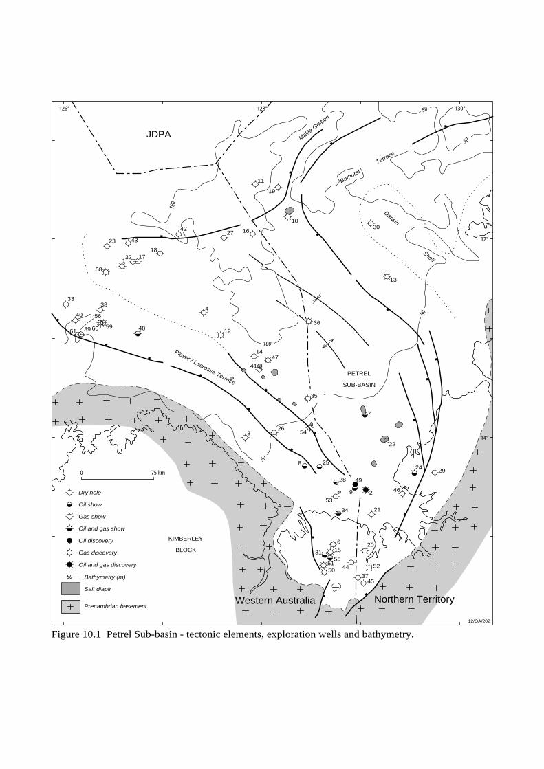
126° 128°
12°
14°
130°
50
50
50
50
100
100
4537
5244
20
5051
15
6
31
2134
2 469
4928
2582924
22
7
326
4714
35
41
12
4
36
13
4839
38
40
33
1817
4323
321
4227
10
19
11
1630
12/OA/202
Malita G
raben
Plover / Lacrosse Terrace
Dry hole
Oil show
Gas show
Oil and gas show
Oil discovery
Gas discovery
Oil and gas discovery
50 Bathymetry (m)
0 75 km
Bathurst
Terrace
Darwin
Shelf
BLOCK
PETREL
SUB-BASIN
Salt diapir
53
54
55
56
58
596061
KIMBERLEY
Precambrian basement
JDPA
Figure 10.1 Petrel Sub-basin - tectonic elements, exploration wells and bathymetry.
Northern TerritoryWestern Australia

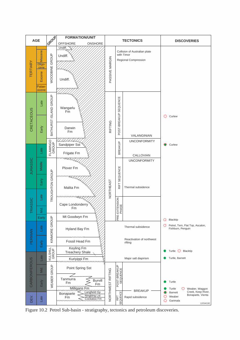
12/OA/192
AGEGROUP FORMATION/UNIT
OFFSHORE ONSHORETECTONICS DISCOVERIES
TE
RT
IAR
YC
RE
TA
CE
OU
SJU
RA
SS
ICT
RIA
SS
ICP
ER
MIA
NC
AR
BO
NIF
ER
OU
SD
EV
.
Mio
cene
Oligo-cene
Eoc
ene
Late
Ear
lyLa
teE
arly
Mid
dle
Late
Mid
.
Early
Late
Ear
lyLa
teM
id.
Ear
lyLa
te
WO
OD
BIN
E G
RO
UP
BA
TH
UR
ST
ISLA
ND
GR
OU
PF
LAM
ING
OG
RO
UP
TR
OU
GH
TO
N G
RO
UP
KIN
MO
RE
GR
OU
PK
ULS
HIL
LG
RO
UP
WE
AB
ER
GR
OU
PUndiff.
Undiff.
Undiff.
WangarluFm
DarwinFm
Sandpiper Sst
Frigate Fm
Plover Fm
Malita Fm
Cape LondonderryFm
Mt Goodwyn Fm
Hyland Bay Fm
Fossil Head Fm
Keyling FmTreachery Shale
Kuriyippi Fm
Point Spring Sst
TanmurraFm
BurvillFm
Milligans Fm
BonaparteFm
Langfield GpNingbing LstCockatoo Fm
PA
SS
IVE
MA
RG
INN
OR
TH
EA
ST
RIF
TIN
GN
OR
TH
WE
ST
RIF
TIN
G
RIF
TSE
QU
ENC
EP
OS
T-B
RE
AK
UP
SE
QU
EN
CE
PR
E-E
XT
EN
SIO
NP
HA
SE
RIF
T S
EQ
UE
NC
EB
RE
AK
UP
PO
ST
-BR
EA
KU
P S
EQ
UE
NC
E
Collision of Australian platewith Timor
Regional Compression
Thermal subsidence
Thermal subsidence
Reactivation of northwestrifting
Major salt diapirism
Rapid subsidence
BREAKUP
UNCONFORMITY
UNCONFORMITY
VALANGINIAN
CALLOVIAN
Curlew
Curlew
Petrel, Tern, Flat Top, Ascalon,Fishburn, Penguin
Turtle
Turtle, Barnett
Turtle
TurtleBarnett
Weaber
Garimala
Palae-ocene
Blacktip
Blacktip
Weaber, WaggonCreek, Keep River,Bonaparte, Vienta
Figure 10.2 Petrel Sub-basin - stratigraphy, tectonics and petroleum discoveries.
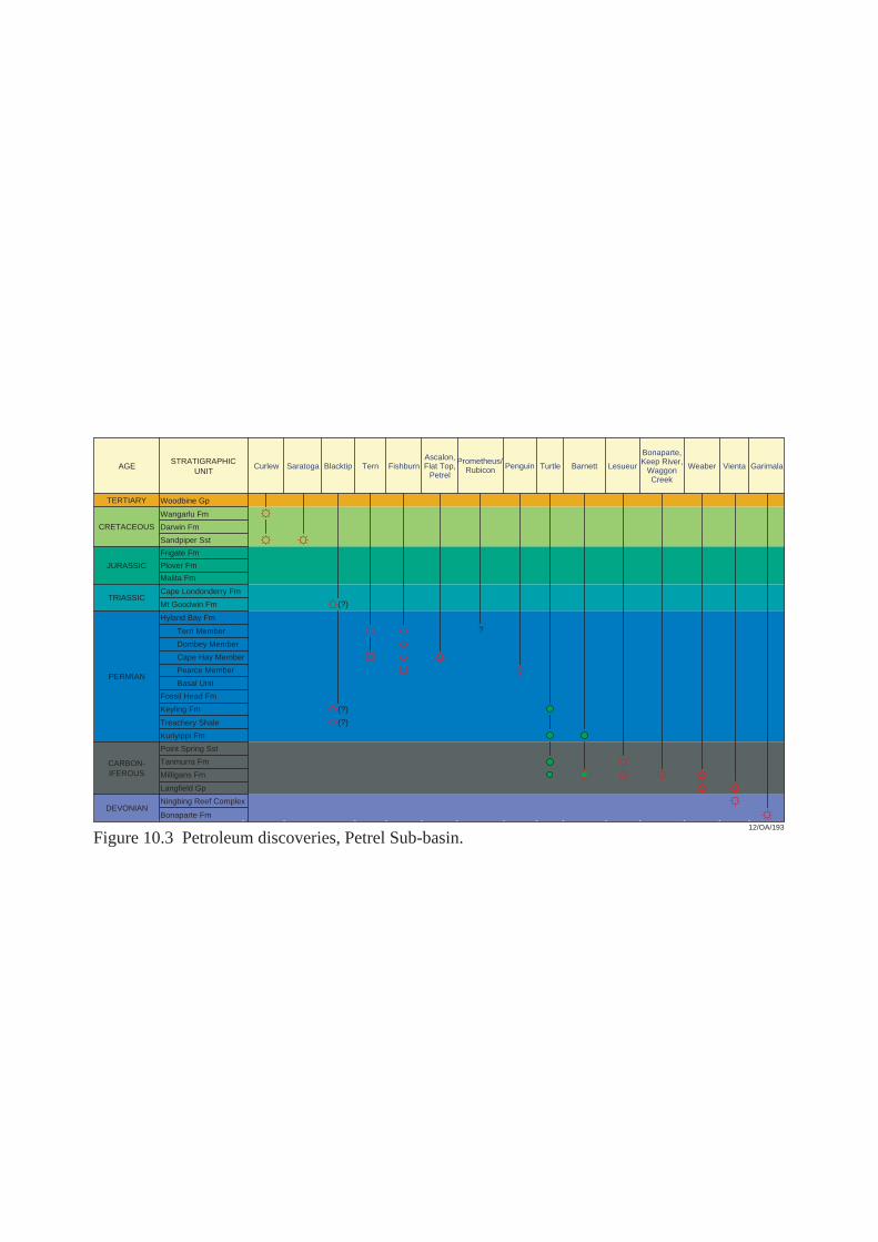
AGE
TERTIARY
CRETACEOUS
JURASSIC
TRIASSIC
PERMIAN
STRATIGRAPHICUNIT
Darwin Fm
Malita Fm
Tern Member
Cape Hay Member
Keyling Fm
(?)
(?)
(?)
?
CARBON-IFEROUS
DEVONIAN
Wangarlu Fm
Frigate Fm
Plover Fm
Cape Londonderry Fm
Mt Goodwin Fm
Hyland Bay Fm
Dombey Member
Pearce Member
Basal Unit
Fossil Head Fm
Treachery Shale
Kuriyippi Fm
Sandpiper Sst
Woodbine Gp
Point Spring Sst
Tanmurra Fm
Milligans Fm
Langfield Gp
Ningbing Reef Complex
Bonaparte Fm
Curlew Saratoga Blacktip Tern FishburnAscalon,Flat Top,
Petrel
Prometheus/Rubicon Penguin Turtle Barnett Lesueur
Bonaparte,Keep River,
WaggonCreek
Weaber Vienta Garimala
12/OA/193
Figure 10.3 Petroleum discoveries, Petrel Sub-basin.
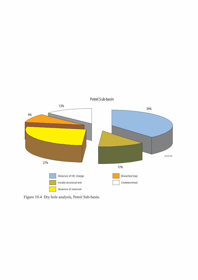
Petrel Sub-basin
13%
Absence of HC charge
Absence of reservoir
Invalid structural test
Breached trap
9%
27%12%
39%
Undetermined
12/OA/194
Figure 10.4 Dry hole analysis, Petrel Sub-basin.
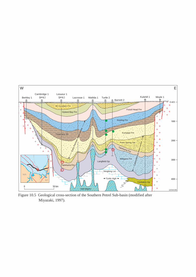
0 50 km
Hyland Bay Fm
Keyling Fm
Point Spring Sst
Tanmurra Fm
Langfield Gp
Ningbing Lst
Berkley 1Cambridge 1
(proj.)Lesueur 1
(proj.) Lacrosse 1 Matilda 1 Turtle 2Barnett 2
Kulshill 1 Moyle 1
12/OA/195
W E
Mt Goodwin Fm
Ear
ly P
erm
ian
depo
-cen
tre
Car
boni
fero
us d
epo-
cent
re
Milligans Fm
Tanmurra Fm
Kuriyippi Fm
Turtle High
0 mSS
1000
2000
3000
4000
Fossil Head Fm
Cockatoo Gp
Treachery Sh
WA
NT
Salt diapirs
Figure 10.5 Geological cross-section of the Southern Petrel Sub-basin (modified after Miyazaki, 1997).
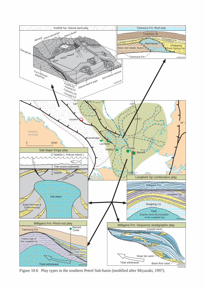
W01-1
Milligans Fm: Pinch-out play Milligans Fm: Sequence stratigraphic play
14/OA/131
Palaeo-high of the Langfield Gp
Tanmurra FmBarnettTurtle
Milligans Fm
Langfield Gp
Treachery Sh
Kuriyippi Fm
Back reef clastic facies
14/OA/134Tanmurra Fm
0 50 km
128°
Barnett
Lesueur
Turtle
129°
14°
12/OA/196
Coastal sand
Basin floor sand
Slope fan sand
?Salt withdrawal14/OA/132
Glacial shelf & slopeSub-marine channelPre-Cambrian
basement
Moraine Glacio-lacustrineGlacio-fluvial
Sub-glacial
- Kuriyippi Fm
- Keyling Fm- Treachery Sh
Kulshill Gp
14/OA/135
14/OA/133
Matilda 1, Pelican Island 1
Thin recent sediments
Matilda
Lacrosse
Cambridge
Kulshill Gp: Glacial sand play
Hyland Bay Formation
Early Permian &Carboniferous
Salt diapir fringe play
Langfield Gp combination play
Tanmurra Fm: Reef play
Reef faciesOnlapping
Point Spring Sst
WesternAustralia
Leaky Fault
Milligans FmMilligans Fm?Salt ?Salt
withdrawal basinwithdrawal basin
Salt diapir
?Salt withdrawal
?Salt(inactive since the truncation
of the Langfield Gp) 14/OA/130
Ningbing Lst
Figure 10.6 Play types in the southern Petrel Sub-basin (modified after Miyazaki, 1997).
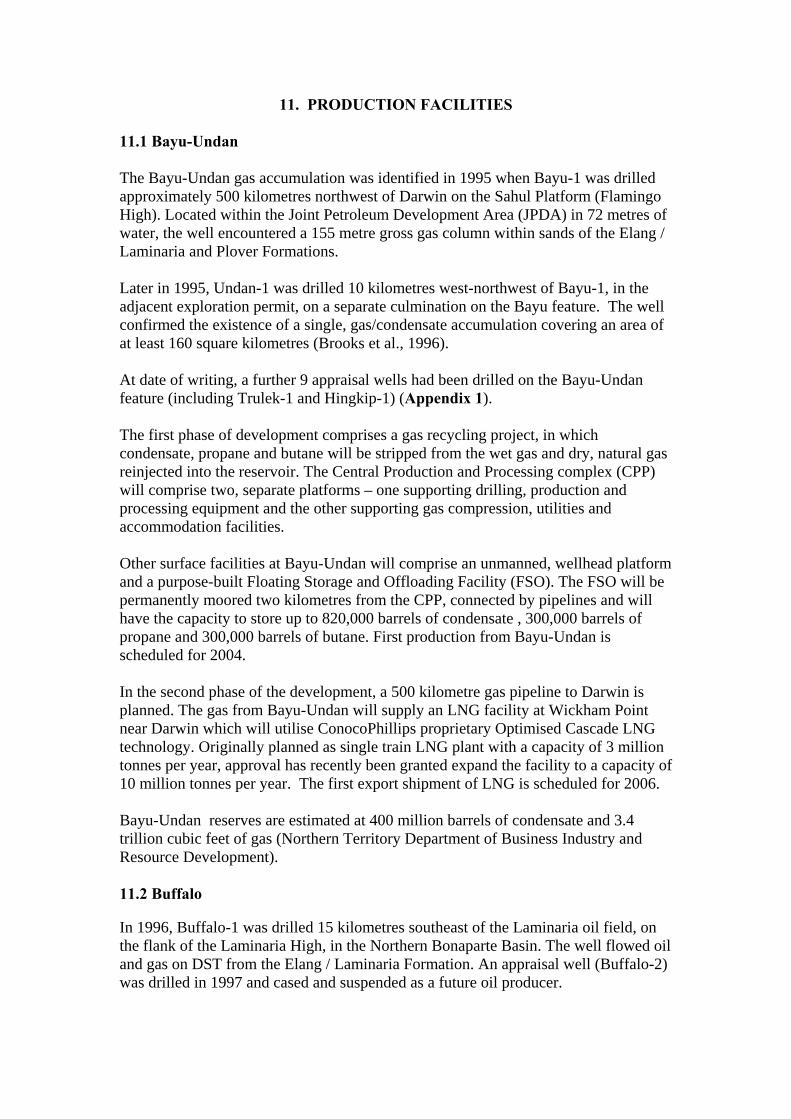
11. PRODUCTION FACILITIES 11.1 Bayu-Undan The Bayu-Undan gas accumulation was identified in 1995 when Bayu-1 was drilled approximately 500 kilometres northwest of Darwin on the Sahul Platform (Flamingo High). Located within the Joint Petroleum Development Area (JPDA) in 72 metres of water, the well encountered a 155 metre gross gas column within sands of the Elang / Laminaria and Plover Formations. Later in 1995, Undan-1 was drilled 10 kilometres west-northwest of Bayu-1, in the adjacent exploration permit, on a separate culmination on the Bayu feature. The well confirmed the existence of a single, gas/condensate accumulation covering an area of at least 160 square kilometres (Brooks et al., 1996). At date of writing, a further 9 appraisal wells had been drilled on the Bayu-Undan feature (including Trulek-1 and Hingkip-1) (Appendix 1). The first phase of development comprises a gas recycling project, in which condensate, propane and butane will be stripped from the wet gas and dry, natural gas reinjected into the reservoir. The Central Production and Processing complex (CPP) will comprise two, separate platforms – one supporting drilling, production and processing equipment and the other supporting gas compression, utilities and accommodation facilities. Other surface facilities at Bayu-Undan will comprise an unmanned, wellhead platform and a purpose-built Floating Storage and Offloading Facility (FSO). The FSO will be permanently moored two kilometres from the CPP, connected by pipelines and will have the capacity to store up to 820,000 barrels of condensate , 300,000 barrels of propane and 300,000 barrels of butane. First production from Bayu-Undan is scheduled for 2004. In the second phase of the development, a 500 kilometre gas pipeline to Darwin is planned. The gas from Bayu-Undan will supply an LNG facility at Wickham Point near Darwin which will utilise ConocoPhillips proprietary Optimised Cascade LNG technology. Originally planned as single train LNG plant with a capacity of 3 million tonnes per year, approval has recently been granted expand the facility to a capacity of 10 million tonnes per year. The first export shipment of LNG is scheduled for 2006. Bayu-Undan reserves are estimated at 400 million barrels of condensate and 3.4 trillion cubic feet of gas (Northern Territory Department of Business Industry and Resource Development). 11.2 Buffalo In 1996, Buffalo-1 was drilled 15 kilometres southeast of the Laminaria oil field, on the flank of the Laminaria High, in the Northern Bonaparte Basin. The well flowed oil and gas on DST from the Elang / Laminaria Formation. An appraisal well (Buffalo-2) was drilled in 1997 and cased and suspended as a future oil producer.
The Buffalo oil field lies in 27 metres of water beneath a high relief (approximately 300 metres) carbonate bank (Big Bank) which is approximately 12 kilometres long by 4 kilometres wide. The field development comprises a five-slot, unmanned wellhead platform connected to 2 production wells via sub-sea completions. The wellhead platform is remotely controlled from a Floating Production, Storage and Offloading facility (FPSO), the Buffalo Venture, which is permanently moored 2 kilometres away, in water depths or around 300 metres. Oil production from Buffalo commenced in December 1999. In 2001, Nexen Petroleum Australia Pty Ltd became the operator of the field and embarked on a development drilling program using the jackup drilling rig, the ‘Ocean Bounty’. Currently, there are 4 producing wells on the Buffalo field. Production rates from the field are expected to peak at between 40,000 and 50,000 barrels/day over a three year field life. Initial reserves at Buffalo field are estimated at 25 million barrels (Department of Resources Development, WA, 1998).
11.3 Challis / Cassini The Challis oil field was discovered in 1984 when Challis-1, drilled on a Triassic horst block on the Jabiru Terrace (Vulcan Sub-basin), intersected a 29 metre gross oil column within the Challis Formation. The Triassic, reservoir sands at Challis sub-crop the Valanginian unconformity and are sealed by basal claystones, marls and carbonates of the Bathurst Island Group (Wormald, 1988; Gorman, 1990). In 1988, Cassini-1 tested a separate culmination on the same structural trend five kilometres to the southwest of Challis-1. The well flowed oil and associated gas from the same reservoirs intersected by Challis-1. The oil pool intersected by Cassini-1 is separated from the Challis accumulation by a low relief saddle. The oil-water contact at Cassini is 7 metres lower than at Challis. The Challis and Cassini oil fields are located in 106 metres of water, approximately 600 kilometres west of Darwin. Following early appraisal drilling on Challis (Challis-2 through 6) and the discovery of the Cassini oil pool in 1988, the field development plan was amended and the joint development of Challis and Cassini commenced. At date of writing, 13 appraisal/development wells had been drilled on Challis and one appraisal well on Cassini. Production from Challis / Cassini commenced in December 1989. Production facilities comprise an FPSO vessel moored to a single anchor leg, rigid arm, mooring system (consisting of a mooring base on the sea floor and a mooring column connected to the FPSO by a steel yoke). A total of 80 kilometres of flow line and control umbilicals connect eleven sub-sea wells to the FPSO. The FPSO is a purpose-built, moored barge designed as a production storage and offloading facility. Initial oil reserves at Challis / Cassini have been estimated at 56.6 million barrels and, at end 2001, remaining reserves at 2.6 million barrels. (Northern Territory Department of Business, Industry and Resource Development, 2003).
11.4 Elang / Kakatua / Kakatua North The discovery of the Elang oil accumulation on the flanks of the Flamingo High in 1994 identified a new petroleum play in the Northern Bonaparte Basin. The Elang structure is an east-west oriented fault dependent closure on the Elang Trend – a prominent structural high in the area. Elang-1, drilled in 82 metres of water, intersected a 76 metre gross hydrocarbon column within the Elang / Laminaria Formation. In December 1994, Kakatua-1 tested a nearby fault dependent closure on the same structural trend and intersected a 29 metre gross oil column within the same formation. In the year approval for a joint Elang / Kakatua development was granted (1997), Kakatua North-1 recovered oil from the Elang / Laminaria Formation in a separate fault dependent structure, immediately to the north of Kakatua. Production from joint Elang/Kakatua development commenced in July 1998. Three sub-sea completions (Elang-1, Elang-2 and Kakatua-1) connect to an FPSO (the Modec Venture 1 - formerly the Skua Venture), moored over the Elang field. Export of oil is via shuttle tankers. The Kakatua North accumulation was tied in to the Elang / Kakatua development via a sub-sea completion at Kakatua North-1 and a 12 kilometre pipeline. Production from Kakatua North commenced in December 1998. Initial reserves at Kakatua North and Elang / Kakatua have are estimated at 12.2 million barrels and 17 million barrels, respectively (Department of Resources Development, WA, 1998).
11.5 Jabiru The discovery of oil in the Vulcan Sub-basin at Jabiru, was the first commercial oil discovery in the Bonaparte Basin. Drilled in 1983, Jabiru-1A intersected at 57 metre gross oil column within sands of the Upper Plover Formation and basal Flamingo Group. The Jabiru structure is an eroded, Jurassic fault block, sealed by claystones and marls of both the Flamingo and Bathurst Island Groups. At date of writing, a further 12 appraisal / development wells had been drilled, several of which were sidetracked. Five of these wells are currently producing. Located in water depths of around 119 metres, the Jabiru development consists of sub-sea completions connected via flow lines to an FPSO vessel, the Jabiru Venture - a converted oil tanker. Oil is transferred from the FPSO to a shuttle tanker moored in tandem. Commercial oil production from Jabiru commenced in 1986. Initial oil reserves at Jabiru are estimated at 107.2 million barrels. Cumulative production from Jabiru to the end of 2002 was estimated at 104.5 million barrels. Due to natural depletion, production has declined from its peak of 51,600 barrels/day at the end of 1989 to 5,200 barrels/day (Northern Territory Department of Business, Industry and Resource Development, 2003).
11.6 Laminaria / Corallina In October 1994, Laminaria-1 was drilled in exploration permit AC/P8 (subsequently converted to production license AC/L5) to test a tilted block on the Laminaria High. The well intersected a 102 metre gross oil column within the Elang / Laminaria Formation. At date of writing, a further 9 appraisal / development wells had been drilled on the Laminaria structure, including one deviated well. The Laminaria oil field was found to extend into adjacent exploration permit WA-260-P (production license WA-18-L) and a unitisation agreement was finalised between the permittees of AC/P8 and WA-260-P in 1998. In December 1995, Corallina-1 was drilled on a complex fault block, 10 kilometres northwest of Laminaria-1. The well flowed oil on test from the Elang / Laminaria Formation. Water depths increase from 300-400 metres over Laminaria, to 400-450 metres over Corallina. A joint development of the Laminaria and Corallina oil discoveries was approved and in the initial development phase, 4 subsea completions at Laminaria and 2 production wells at Corallina were tied back to an FPSO (the Northern Endeavour) via flowlines. One well has been dedicated to gas re-injection. The Northern Endeavour is permanently moored to an internal turret mooring system in a water depth of 385 metres, making it Australia’s deepest offshore oil production facility. Production from Laminaria and Corallina commenced in November 1999. Phase two of the development was designed to accelerate production and access incremental reserves in the two fields. Laminaria-7 and Laminaria-8 were drilled during this phase and the wells flowed oil on test at 20,000 barrels/day and 50,000 barrels/day, respectively. (Laminaria-7 and Laminaria-8 were originally planned as horizontal wells but after encountering drilling difficulties, the wells were re-designed as vertical producers). Production from Laminaria-7and Laminaria-8 commenced in June 2002. Initial, combined reserves of the Laminaria and Corallina oil fields have been estimated at 137.1 million barrels. The production life of the development has been estimated at 14 years (Northern Territory Department of Business, Industry and Resource Development, 2003).
11.7 Skua In 1985, Skua-1 was drilled to test a tilted horst block within the Vulcan Sub-basin. The well was drilled within structural closure, but was plugged and abandoned with minor oil shows. (Subsequent appraisal and development drilling showed Skua-1 intersected the primary objective (Plover Formation) down-dip from the oil/water contact). A follow up well (Skua-2) intersected the western bounding fault of the structure and did not penetrate a complete reservoir section. Oil was recovered on test from a Santonian age sand. This sand is juxtaposed against the Plover Formation reservoir across the western bounding fault of the Skua structure. The unit is thought to be draining oil across the fault from the Plover Formation but due to poor reservoir
quality, the Santonian sand acts as a natural choke to flow. The well was subsequently plugged and abandoned due to poor flow rates (Osborne, 1990). A further 8 appraisal / development wells were drilled on Skua. Seven reservoir units are recognized in the field - all are Early to Middle Jurassic, Plover Formation sands. These units sub-crop the Callovian Unconformity and are sealed by basal claystones and marls of the Bathurst Island Group. The Skua field covers an area of approximately 4.5 square kilometers and is interpreted to have a 28 metre gas cap and a 46.5 metre oil leg (Osborne, 1990). The Skua development consisted of three producing wells (sub-sea completions) linked to an FPSO (the Skua Venture). Oil production commenced in December 1991 and continued for a little over five years. 20.2 million barrels of oil have been produced from Skua. On 30 January 1997, the Skua field was decommissioned. At that time, oil was being produced at a rate of 1,900 barrels/day. (The maximum oil production rate of 15,000 barrels/day was achieved in August 1992; in 1996, the average oil production rate was 3,702 barrels/day. The Northern Territory Department of Business, Industry and Resource Development (2003) estimates there are approximately 2.5 million barrels of recoverable oil remaining in the Skua field.
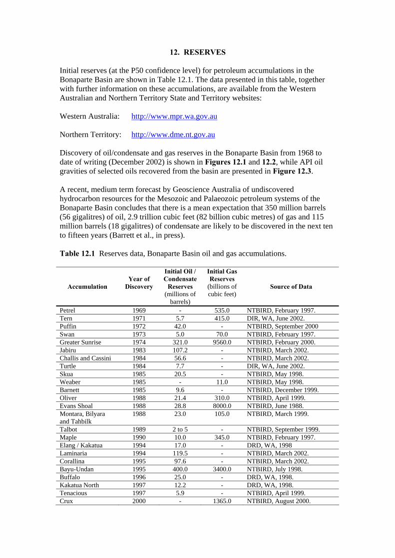
12. RESERVES
Initial reserves (at the P50 confidence level) for petroleum accumulations in the Bonaparte Basin are shown in Table 12.1. The data presented in this table, together with further information on these accumulations, are available from the Western Australian and Northern Territory State and Territory websites: Western Australia: http://www.mpr.wa.gov.au Northern Territory: http://www.dme.nt.gov.au Discovery of oil/condensate and gas reserves in the Bonaparte Basin from 1968 to date of writing (December 2002) is shown in Figures 12.1 and 12.2, while API oil gravities of selected oils recovered from the basin are presented in Figure 12.3. A recent, medium term forecast by Geoscience Australia of undiscovered hydrocarbon resources for the Mesozoic and Palaeozoic petroleum systems of the Bonaparte Basin concludes that there is a mean expectation that 350 million barrels (56 gigalitres) of oil, 2.9 trillion cubic feet (82 billion cubic metres) of gas and 115 million barrels (18 gigalitres) of condensate are likely to be discovered in the next ten to fifteen years (Barrett et al., in press). Table 12.1 Reserves data, Bonaparte Basin oil and gas accumulations.
Accumulation
Year of
Discovery
Initial Oil / Condensate
Reserves (millions of
barrels)
Initial Gas Reserves
(billions of cubic feet)
Source of Data
Petrel 1969 - 535.0 NTBIRD, February 1997. Tern 1971 5.7 415.0 DIR, WA, June 2002. Puffin 1972 42.0 - NTBIRD, September 2000 Swan 1973 5.0 70.0 NTBIRD, February 1997. Greater Sunrise 1974 321.0 9560.0 NTBIRD, February 2000. Jabiru 1983 107.2 - NTBIRD, March 2002. Challis and Cassini 1984 56.6 - NTBIRD, March 2002. Turtle 1984 7.7 - DIR, WA, June 2002. Skua 1985 20.5 - NTBIRD, May 1998. Weaber 1985 - 11.0 NTBIRD, May 1998. Barnett 1985 9.6 - NTBIRD, December 1999. Oliver 1988 21.4 310.0 NTBIRD, April 1999. Evans Shoal 1988 28.8 8000.0 NTBIRD, June 1988. Montara, Bilyara and Tahbilk
1988 23.0 105.0 NTBIRD, March 1999.
Talbot 1989 2 to 5 - NTBIRD, September 1999. Maple 1990 10.0 345.0 NTBIRD, February 1997. Elang / Kakatua 1994 17.0 - DRD, WA, 1998 Laminaria 1994 119.5 - NTBIRD, March 2002. Corallina 1995 97.6 - NTBIRD, March 2002. Bayu-Undan 1995 400.0 3400.0 NTBIRD, July 1998. Buffalo 1996 25.0 - DRD, WA, 1998. Kakatua North 1997 12.2 - DRD, WA, 1998. Tenacious 1997 5.9 - NTBIRD, April 1999. Crux 2000 - 1365.0 NTBIRD, August 2000.

Prometheus / Rubicon
2000 - 370 DIR, WA, June 2002.
Blacktip 2001 1.9 1139.0 DIR, WA, June 2002.

1968 1970 1972 1974 1976 1978 1980 1982 1984 1986 1988 1990 1992 1994 1996 1998 2000 20020
Year
Mill
ions
of b
arre
ls
100
200
300
400
500
600
700
800
900
1000
Greater Sunrise
Jabiru/Challis/Skua
Oliver/Evans Shoal/Montara/Bilyara
Laminaria/Corallina/Bayu-Undan
12/OA/197
Figure 12.1 Initial oil and condensate reserves (cumulative), Bonaparte Basin, 1968 to 2002.

01968 1970 1972 1974 1976 1978 1980 1982 1984 1986 1988 1990 1992 1994 1996 1998 2000 2002
Year
Bill
ions
of c
ubic
feet
10 000
5 000
15 000
20 000
25 000
30 000
Greater Sunrise
Evans Shoal
Bayu-Undan
Crux/Prometheus/Rubicon/Blacktip
Figure 12.2 Initial gas reserves (cumulative), Bonaparte Basin, 1968 to 2002.
12/OA/198

50
40
30
20
10
0100 150 200 250 300 350 400
AP
I Gra
vity
60
70
Reservoir Age (ma)0 50
Puffin
Birch
CorallinaLaminaria
JahalElang
Tenacious
BuffaloBuller
KrillBluff
KakatuaKakatua North
SkuaJabiru
Talbot
Montara
Maret
Oliver
Cassini/Challis Barnett
Barnett
TurtleTurtle
Turtle
Turtle
CAINOZOIC CRETACEOUS JURASSIC TRIASSIC PERMIAN DEVONIAN
Petrel Sub-basinVulcan Sub-basinNorthern Bonaparte Basin
CARB.
Figure 12.3 API oil gravities, Bonaparte Basin.12/OA/199
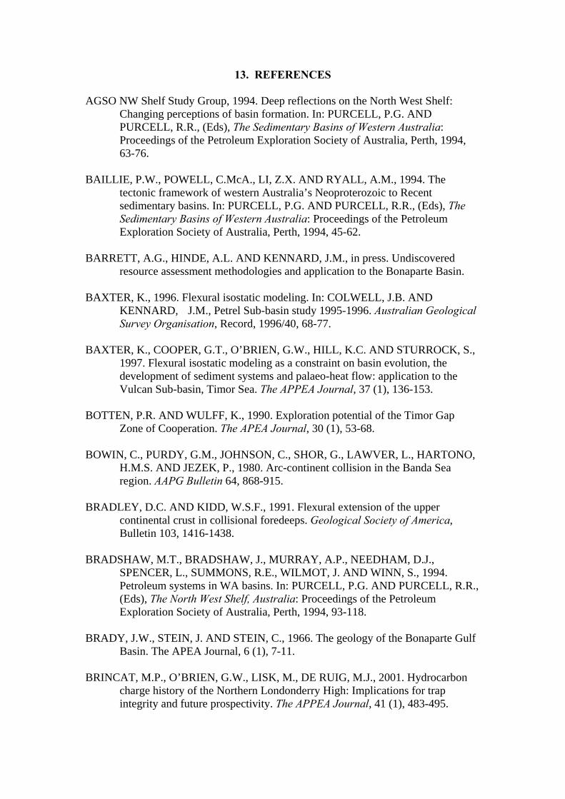
13. REFERENCES
AGSO NW Shelf Study Group, 1994. Deep reflections on the North West Shelf: Changing perceptions of basin formation. In: PURCELL, P.G. AND PURCELL, R.R., (Eds), The Sedimentary Basins of Western Australia: Proceedings of the Petroleum Exploration Society of Australia, Perth, 1994, 63-76.
BAILLIE, P.W., POWELL, C.McA., LI, Z.X. AND RYALL, A.M., 1994. The tectonic framework of western Australia’s Neoproterozoic to Recent sedimentary basins. In: PURCELL, P.G. AND PURCELL, R.R., (Eds), The Sedimentary Basins of Western Australia: Proceedings of the Petroleum Exploration Society of Australia, Perth, 1994, 45-62. BARRETT, A.G., HINDE, A.L. AND KENNARD, J.M., in press. Undiscovered resource assessment methodologies and application to the Bonaparte Basin. BAXTER, K., 1996. Flexural isostatic modeling. In: COLWELL, J.B. AND
KENNARD, J.M., Petrel Sub-basin study 1995-1996. Australian Geological Survey Organisation, Record, 1996/40, 68-77.
BAXTER, K., COOPER, G.T., O’BRIEN, G.W., HILL, K.C. AND STURROCK, S.,
1997. Flexural isostatic modeling as a constraint on basin evolution, the development of sediment systems and palaeo-heat flow: application to the Vulcan Sub-basin, Timor Sea. The APPEA Journal, 37 (1), 136-153.
BOTTEN, P.R. AND WULFF, K., 1990. Exploration potential of the Timor Gap Zone of Cooperation. The APEA Journal, 30 (1), 53-68. BOWIN, C., PURDY, G.M., JOHNSON, C., SHOR, G., LAWVER, L., HARTONO,
H.M.S. AND JEZEK, P., 1980. Arc-continent collision in the Banda Sea region. AAPG Bulletin 64, 868-915.
BRADLEY, D.C. AND KIDD, W.S.F., 1991. Flexural extension of the upper continental crust in collisional foredeeps. Geological Society of America, Bulletin 103, 1416-1438. BRADSHAW, M.T., BRADSHAW, J., MURRAY, A.P., NEEDHAM, D.J., SPENCER, L., SUMMONS, R.E., WILMOT, J. AND WINN, S., 1994. Petroleum systems in WA basins. In: PURCELL, P.G. AND PURCELL, R.R., (Eds), The North West Shelf, Australia: Proceedings of the Petroleum Exploration Society of Australia, Perth, 1994, 93-118. BRADY, J.W., STEIN, J. AND STEIN, C., 1966. The geology of the Bonaparte Gulf
Basin. The APEA Journal, 6 (1), 7-11. BRINCAT, M.P., O’BRIEN, G.W., LISK, M., DE RUIG, M.J., 2001. Hydrocarbon
charge history of the Northern Londonderry High: Implications for trap integrity and future prospectivity. The APPEA Journal, 41 (1), 483-495.
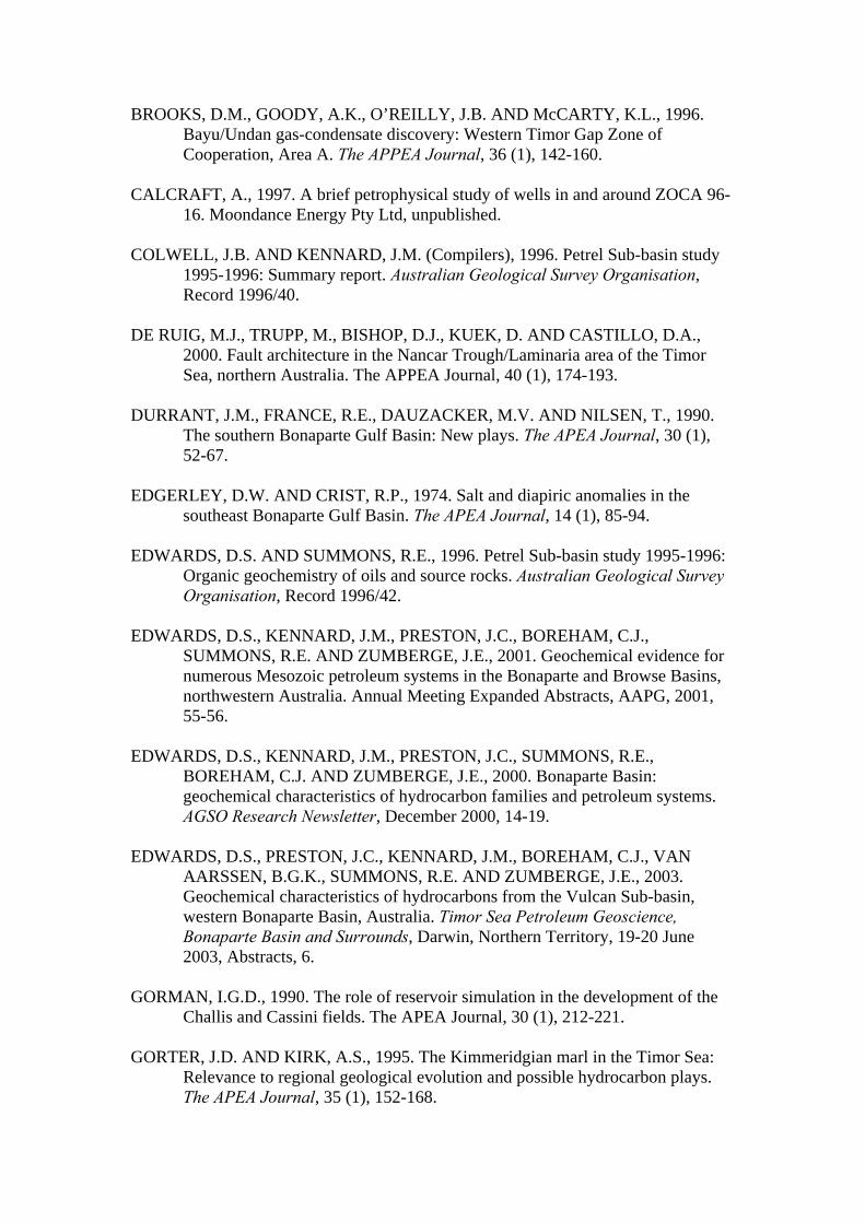
BROOKS, D.M., GOODY, A.K., O’REILLY, J.B. AND McCARTY, K.L., 1996. Bayu/Undan gas-condensate discovery: Western Timor Gap Zone of Cooperation, Area A. The APPEA Journal, 36 (1), 142-160.
CALCRAFT, A., 1997. A brief petrophysical study of wells in and around ZOCA 96- 16. Moondance Energy Pty Ltd, unpublished. COLWELL, J.B. AND KENNARD, J.M. (Compilers), 1996. Petrel Sub-basin study
1995-1996: Summary report. Australian Geological Survey Organisation, Record 1996/40.
DE RUIG, M.J., TRUPP, M., BISHOP, D.J., KUEK, D. AND CASTILLO, D.A., 2000. Fault architecture in the Nancar Trough/Laminaria area of the Timor Sea, northern Australia. The APPEA Journal, 40 (1), 174-193. DURRANT, J.M., FRANCE, R.E., DAUZACKER, M.V. AND NILSEN, T., 1990. The southern Bonaparte Gulf Basin: New plays. The APEA Journal, 30 (1), 52-67. EDGERLEY, D.W. AND CRIST, R.P., 1974. Salt and diapiric anomalies in the southeast Bonaparte Gulf Basin. The APEA Journal, 14 (1), 85-94. EDWARDS, D.S. AND SUMMONS, R.E., 1996. Petrel Sub-basin study 1995-1996:
Organic geochemistry of oils and source rocks. Australian Geological Survey Organisation, Record 1996/42.
EDWARDS, D.S., KENNARD, J.M., PRESTON, J.C., BOREHAM, C.J., SUMMONS, R.E. AND ZUMBERGE, J.E., 2001. Geochemical evidence for numerous Mesozoic petroleum systems in the Bonaparte and Browse Basins, northwestern Australia. Annual Meeting Expanded Abstracts, AAPG, 2001, 55-56. EDWARDS, D.S., KENNARD, J.M., PRESTON, J.C., SUMMONS, R.E., BOREHAM, C.J. AND ZUMBERGE, J.E., 2000. Bonaparte Basin: geochemical characteristics of hydrocarbon families and petroleum systems. AGSO Research Newsletter, December 2000, 14-19. EDWARDS, D.S., PRESTON, J.C., KENNARD, J.M., BOREHAM, C.J., VAN
AARSSEN, B.G.K., SUMMONS, R.E. AND ZUMBERGE, J.E., 2003. Geochemical characteristics of hydrocarbons from the Vulcan Sub-basin, western Bonaparte Basin, Australia. Timor Sea Petroleum Geoscience, Bonaparte Basin and Surrounds, Darwin, Northern Territory, 19-20 June 2003, Abstracts, 6.
GORMAN, I.G.D., 1990. The role of reservoir simulation in the development of the Challis and Cassini fields. The APEA Journal, 30 (1), 212-221. GORTER, J.D. AND KIRK, A.S., 1995. The Kimmeridgian marl in the Timor Sea:
Relevance to regional geological evolution and possible hydrocarbon plays. The APEA Journal, 35 (1), 152-168.
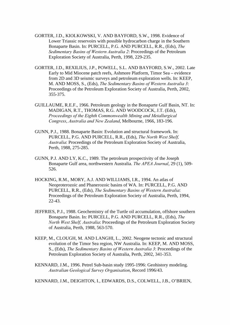
GORTER, J.D., KIOLKOWSKI, V. AND BAYFORD, S.W., 1998. Evidence of Lower Triassic reservoirs with possible hydrocarbon charge in the Southern Bonaparte Basin. In: PURCELL, P.G. AND PURCELL, R.R., (Eds), The Sedimentary Basins of Western Australia 2: Proceedings of the Petroleum Exploration Society of Australia, Perth, 1998, 229-235. GORTER, J.D., REXILIUS, J.P., POWELL, S.L. AND BAYFORD, S.W., 2002. Late
Early to Mid Miocene patch reefs, Ashmore Platform, Timor Sea – evidence from 2D and 3D seismic surveys and petroleum exploration wells. In: KEEP, M. AND MOSS, S., (Eds), The Sedimentary Basins of Western Australia 3: Proceedings of the Petroleum Exploration Society of Australia, Perth, 2002, 355-375.
GUILLAUME, R.E.F., 1966. Petroleum geology in the Bonaparte Gulf Basin, NT. In:
MADIGAN, R.T., THOMAS, R.G. AND WOODCOCK, J.T. (Eds), Proceedings of the Eighth Commonwealth Mining and Metallurgical Congress, Australia and New Zealand, Melbourne, 1966, 183-196.
GUNN, P.J., 1988. Bonaparte Basin: Evolution and structural framework. In: PURCELL, P.G. AND PURCELL, R.R., (Eds), The North West Shelf, Australia: Proceedings of the Petroleum Exploration Society of Australia, Perth, 1988, 275-285. GUNN, P.J. AND LY, K.C., 1989. The petroleum prospectivity of the Joseph Bonaparte Gulf area, northwestern Australia. The APEA Journal, 29 (1), 509- 526. HOCKING, R.M., MORY, A.J. AND WILLIAMS, I.R., 1994. An atlas of
Neoproterozoic and Phanerozoic basins of WA. In: PURCELL, P.G. AND PURCELL, R.R., (Eds), The Sedimentary Basins of Western Australia: Proceedings of the Petroleum Exploration Society of Australia, Perth, 1994, 22-43.
JEFFRIES, P.J., 1988. Geochemistry of the Turtle oil accumulation, offshore southern
Bonaparte Basin. In: PURCELL, P.G. AND PURCELL, R.R., (Eds), The North West Shelf, Australia: Proceedings of the Petroleum Exploration Society of Australia, Perth, 1988, 563-570.
KEEP, M., CLOUGH, M. AND LANGHI, L., 2002. Neogene tectonic and structural
evolution of the Timor Sea region, NW Australia. In: KEEP, M. AND MOSS, S., (Eds), The Sedimentary Basins of Western Australia 3: Proceedings of the Petroleum Exploration Society of Australia, Perth, 2002, 341-353.
KENNARD, J.M., 1996. Petrel Sub-basin study 1995-1996: Geohistory modeling.
Australian Geological Survey Organisation, Record 1996/43. KENNARD, J.M., DEIGHTON, I., EDWARDS, D.S., COLWELL, J.B., O’BRIEN,

G.W. AND BOREHAM, C.J., 1999. Thermal history modeling and transient heat pulses: new insights into hydrocarbon expulsion and ‘hot flushes’ in the Vulcan Sub-basin, Timor Sea. The APPEA Journal, 39 (1), 177-207.
KENNARD, J.M., DEIGHTON, I., EDWARDS, D.S., BOREHAM, C.J. AND
BARRETT, A.G., 2002. Subsidence and thermal history modeling: New insights into hydrocarbon expulsion from multiple petroleum systems in the Petrel Sub-basin, Bonaparte Basin. In: KEEP, M. AND MOSS, S., (Eds), The Sedimentary Basins of Western Australia 3: Proceedings of the Petroleum Exploration Society of Australia, Perth, 2002, 409-437.
KENNARD, J.M., DEIGHTON, I., RYAN, D., EDWARDS, D.S. AND BOREHAM,
C.J., 2003. Subsidence and thermal history modeling: New insights into hydrocarbon expulsion from multiple petroleum systems in the Browse Basin. Timor Sea Petroleum Geoscience, Bonaparte Basin and Surrounds, Darwin, Northern Territory, 19-20 June 2003, Abstracts, 5.
LABUTIS, V.R., RUDDOCK, A.D. AND CALCRAFT, A.P., 1998. Stratigraphy of the Southern Sahul Platform. The APPEA Journal, 38 (1), 115-136. LAVERING, I.H. AND OZIMIC, S., 1989. Bonaparte Basin, Northern Territory and Western Australia. Australian Petroleum Accumulations Report 5, Bureau of Mineral Resources, Geology and Geophysics, Canberra. LAWS, R., 1981. The petroleum geology of the onshore Bonaparte Basin. The APEA
Journal, 21 (1), 5-15. LAWS, R.A. AND KRAUS, G.P., 1974. The regional geology of the Bonaparte Gulf,
Timor Sea area. The APEA Journal, 14 (1), 77-84. LAWS, R.A. AND BROWN, R.S., 1976. Bonaparte Gulf Basin – southeastern part. In: LESLIE, R.B., EVANS, J.M. AND KNIGHT, K.L. (Eds), Economic geology of Australia and Papua New Guinea, 3, Petroleum, Australian Institute of Mining and Metallurgy, Monograph 7, 200-208. LEE, R.J. AND GUNN, P.J., 1988. Bonaparte Basin. Petroleum in Australia, The First Century: Australian Petroleum Exploration Association, 252-269. LEMON, N.M. AND BARNES, C.R., 1997. Salt migration and subtle structures:
modeling of the Petrel Sub-basin, northwest Australia. The APPEA Journal, 37 (1), 245-258.
LEONARD, A., VEAR, A., PANTING, A., DE RUIG, M., DUNNE, J. AND LEWIS, K., 2003. Blacktip-1 gas discovery, Southern Bonaparte Basin. Timor Sea Petroleum Geoscience, Bonaparte Basin and Surrounds, Darwin, Northern Territory, 19-20 June 2003, Abstracts, 9. LISK, M., BRINCAT, M.P., EADINGTON, P.J. AND O’BRIEN, G.W., 1998.
Hydrocarbon charge in the Vulcan Sub-basin. In: PURCELL, P.G. AND PURCELL, R.R., (Eds), The Sedimentary Basins of Western Australia 2:

Proceedings of the Petroleum Exploration Society of Australia, Perth, 1998, 287-303.
LOWRY, D.C., 1998. Inferring kerogen kinetics for exploration in the Timor Sea region. In: PURCELL, P.G. AND PURCELL, R.R., (Eds), The Sedimentary Basins of Western Australia 2: Proceedings of the Petroleum Exploration Society of Australia, Perth, 1998, 305-311. MACDANIEL, R.P., 1988. The geological evolution and hydrocarbon potential of the western Timor Sea region. Petroleum in Australia, the First Century. APEA publication, 270-284. MAGOON, L.B. AND DOW, W.G., 1991. The petroleum system – from source to trap. AAPG Memoir 60. MAGOON, L.B. AND DOW, W.G., 1994. The petroleum system. In: MAGOON, L.B. AND DOW, W.G., (Eds), The Petroleum System from Source to Trap: American Association of Petroleum Geologists, Memoir 60, 3-24. McCONACHIE, B.A., BRADSHAW, M.T. AND BRADSHAW, J., 1996. Petroleum
systems of the Petrel Sub-basin – an integrated approach to basin analysis and identification of hydrocarbon exploration opportunities. The APPEA Journal, 36 (1), 248-268.
McINTYRE, C.L., 1995. Northern Bonaparte Basin: A preliminary sub-Callovian
tectonostratigraphic history. BHP Petroleum Pty Ltd, unpublished. McKIRDY, D.M., 1987. Oil-source correlation study, Bonaparte Basin. AMDEL report F6773/87 for Elf Aquitaine Petroleum Australia Pty Ltd, unpublished. MESSENT, B.E.J., GOODY, A.K., COLLINS, E. AND TOBIAS, S., 1994. Sequence
stratigraphy of the Flamingo Group, Southern Bonaparte Basin. In: PURCELL, P.G. AND PURCELL, R.R., (Eds), The Sedimentary Basins of Western Australia: Proceedings of the Petroleum Exploration Society of Australia, Perth, 1994, 241-357.
MILDREN, S.D., HILLIS, R.R., FETT, T. AND ROBINSON, P.H., 1994. Contemporary stresses in the Timor Sea: Implications for fault-trap integrity. In: PURCELL, P.G. AND PURCELL, R.R., (Eds), The Sedimentary Basins of Western Australia: Proceedings of the Petroleum Exploration Society of Australia, Perth, 1994, 77-92. MIYAZAKI, S., 1997. Australia’s southeastern Bonaparte Basin has plenty of potential. Oil & Gas Journal, 95, 78-81. MORY, A.J., 1988. Regional geology of the offshore Bonaparte Basin. In PURCELL,
P.G. & PURCELL, R.R., (Eds), The North West Shelf, Australia: Proceedings of the Petroleum Exploration Society Australia, Perth, 1988, 287-309.
MORY, A.J., 1991. Geology of the offshore Bonaparte Basin northwestern Australia. Geological Survey of Western Australia, Report 29.
MORY, A.J. AND BEERE, G.M., 1988. Geology of the onshore Bonaparte and Ord
Basins in Western Australia. Geological Survey of Western Australia, Bulletin 134, 184.
NIGEL PRESS & ASSOCIATES GROUP, 2001. Offshore basin screening, Bonaparte Basin, northwest Australia, non-exclusive report, unpublished. O’BRIEN, G.W., 1993. Some ideas on the rifting history of the Timor Sea from the
integration of deep crustal seismic and other data. Petroleum Exploration Society of Australia Journal, 21, 95-113.
O’BRIEN, G.W., ETHERIDGE, M.A., WILLCOX, J.B., MORSE, M., SYMONDS, P., NORMAN, C. AND NEEDHAM, D.J., 1993. The structural architecture of the Timor Sea, north-western Australia: Implications for basin development and hydrocarbon exploration. The APEA Journal, 33 (1), 258-278. O’BRIEN, G.W. AND WOODS, E.P., 1995. Hydrocarbon-related diagenetic zones
(HRDZs) in the Vulcan Sub-basin, Timor Sea: Recognition and exploration implications. The APEA Journal, 35 (1), 220-252.
O’BRIEN, G.W., LISK, M., DUDDY, I., EADINGTON, P.J., CADMAN, S. AND
FELLOWS, M., 1996. Late Tertiary fluid migration in the Timor Sea: A key control on thermal and diagenetic histories ? The APPEA Journal, 36 (1), 399-426.
O’BRIEN, G.W., QUAIFE, P., COWLEY, R., MORSE, M., WILSON, D., FELLOWS, M. AND LISK, M., 1998. Evaluating trap integrity in the Vulcan Sub-basin, Timor Sea, Australia, using integrated remote-sensing geochemical technologies. In: PURCELL, P.G. AND PURCELL, R.R., (Eds), The Sedimentary Basins of Western Australia 2: Proceedings of the Petroleum Exploration Society of Australia, Perth, 1998, 237-253. O’BRIEN, G.W., LISK, M., DUDDY, I.R., HAMILTON, J., WOODS, P. AND
CROWLEY, R., 1999. Plate convergence, foreland development and fault reactivation: Primary controls on brine migration, thermal histories and trap breach in the Timor Sea, Australia. Marine and Petroleum Geology, 16, 533-560.
OSBORNE, M., 1990. The exploration and appraisal history of the Skua field, AC/P2 – Timor Sea. The APEA Journal, 30 (1), 197-212. OTTO, C., UNDERSCHULTZ, A.L. AND ROY, V., 2001. Hydrodynamic analysis of flow systems and fault seal integrity in the Northwest Shelf of Australia. The APPEA Journal, 41 (1), 347-365. PATILLO, J. AND NICHOLLS, P.J., 1990. A tectonostratigraphic framework for the
Vulcan Graben, Timor Sea region. The APEA Journal, 30 (1), 27-51.

PRESTON, J.C. AND EDWARDS, D.S., 2000. The petroleum geochemistry of oils and source rocks from the Northern Bonaparte Basin, offshore northern Australia. The APPEA Journal, 40 (1), 257-282. RELEASE OF OFFSHORE PETROLEUM EXPLORATION AREAS, 2001. Release Areas NT01-1 to 5 and W01-1, Petrel Sub-basin, Northern Territory; Release Area AC01-1, Vulcan Sub-basin, Territory of Ashmore and Cartier Islands. Department of Industry, Tourism and Resources, Australia, CD-ROM. RELEASE OF OFFSHORE PETROLEUM EXPLORATION AREAS, 2002. Release Area NT02-1, Sahul Platform, Bonaparte Basin, Northern Territory; Release Areas NT02-2 to 5, Petrel Sub-basin, Bonaparte Basin, Northern Territory; Release Area AC02-1, Vulcan Sub-basin, Bonaparte Basin, Territory of Ashmore and Cartier Islands. Department of Industry, Tourism and Resources, Australia, CD-ROM. RELEASE OF OFFSHORE PETROLEUM EXPLORATION AREAS, 2003. Release Areas NT03-3 to 7, Eastern Bonaparte Basin, Northern Territory; Release Areas AC03-1 to 3, Vulcan Sub-basin, Bonaparte and Northern Browse Basins, Territory of Ashmore and Cartier Islands. Department of Industry, Tourism and Resources, Australia, CD-ROM. RICHARDSON, A.N., 1993. Lithospheric structure and dynamics of the Banda Arc ,
eastern Indonesia. PhD Thesis, Royal Holloway University of London, London, UK.
ROBINSON, P.H., STEAD, H.S., O’REILLY, J.B. AND GUPPY, N.K., 1994. Meanders to fans: A sequence stratigraphic approach to Upper Jurassic – Lower Cretaceous sedimentation in the Sahul Syncline, North Bonaparte Basin. In: PURCELL, P.G. AND PURCELL, R.R., (Eds), The Sedimentary Basins of Western Australia: Proceedings of the Petroleum Exploration Society of Australia, Perth, 1994, 223-242. SEGGIE, R.J., AINSWORTH, R.B., JOHNSON, D.A., KONINX, J.P.M.,
SPAARGAREN, B. AND STEPHENSON, P.M., 2000. Awakening of a sleeping giant: Sunrise-Troubadour gas-condensate field. The APPEA Journal, 40 (1), 417-435.
SCHUSTER, M.W., EATON, S., WAKEFIELD, L.L. AND KLOOSTERMAN, H.J.,
1998. Neogene tectonics, Greater Timor Sea, offshore Australia: Implications for trap risk. The APPEA Journal, 38 (1), 351-379.
SMITH, G.C., TILBURY, L.A., CHATFIELD, A., SENYCIA, P. AND THOMPSON, N., 1996. Laminaria – a new Timor Sea discovery. The APEA Journal, 36 (1), 12-29. STRUCKMEYER, H.I.M., BLEVIN, J.E., SAYERS, J., TOTTERDELL, J.M., BAXTER, K. AND CATHRO, D.L., 1998. Structural evolution of the Browse Basin, North West Shelf: New concepts from deep-seismic data. In:
PURCELL, P.G. AND PURCELL, R.R., (Eds), The Sedimentary Basins of Western Australia 2: Proceedings of the Petroleum Exploration Society of Australia, Perth, 1998, 345-367. TRAVES, D.M., 1955. The geology of the Ord-Victoria region, northern Australia. Bureau of Mineral Resources, Geology and Geophysics, Australia, Bulletin 27. VEEVERS, J.J. AND ROBERTS, J., 1968. Upper Palaeozoic rocks, Bonaparte Gulf
Basin of northwestern Australia. Bureau of Mineral Resources, Australia, Bulletin 97.
VEEVERS, J.J., 1971. Phanerozoic history of western Australia related to continental
drift. Geological Society of Australia Journal, 18 (2), 87-96. VEEVERS, J.J. (Ed), 1984. Phanerozoic earth history of Australia, Clarendon Press,
Oxford. VEEVERS, J.J., 1988. Morphotectonics of Australia’s northwestern margin – a review. In: PURCELL, P.G. AND PURCELL, R.R. (Eds), The North West Shelf, Australia: Proceedings of the Petroleum Exploration Society of Australia Symposium, Perth, 1988, 19-27. WHIBLEY, M. AND JACOBSON, T., 1990. Exploration in the Northern Bonaparte
Basin, Timor Sea – WA-199-P. The APEA Journal, 30 (1), 7-25. WHITTAM, D.B., NORVICK, M.S. AND McINTYRE, C.L., 1996. Mesozoic and
Cainozoic tectonostratigraphy of western ZOCA and adjacent areas. The APPEA Journal, 36 (1), 209-231.
WOODS, E.P., 1992. Vulcan Sub-basin fault styles – implications for hydrocarbon
migration and entrapment. The APEA Journal, 32 (1), 138-158. WOODS, E.P., 1994. A salt-related detachment model for the development of the Vulcan Sub-basin. In: PURCELL, P.G. AND PURCELL, R.R., (Eds), The Sedimentary Basins of Western Australia: Proceedings of the Petroleum Exploration Society of Australia, Perth, 1994, 259-274. WOODS, E.P., 2003. Twenty years of Vulcan Sub-basin exploration since Jabiru – what lessons have been learnt ? Timor Sea Petroleum Geoscience, Bonaparte Basin and Surrounds, Darwin, Northern Territory, 19-20 June 2003, Abstracts, 9. WOODS, E.P. AND MAXWELL, A., 2003. The significance of the Tenacious oil discovery, Vulcan Sub-basin. Timor Sea Petroleum Geoscience, Bonaparte Basin and Surrounds, Darwin, Northern Territory, 19-20 June 2003, Abstracts, 11.

WORMALD, G.B., 1988. The geology of the Challis oilfield. In: PURCELL, P.G. AND PURCELL, R.R., (Eds), The North West Shelf, Australia: Proceedings of the Petroleum Exploration Society of Australia, Perth, 1988, 425-437. YOUNG, I.F., SCHMEDJE, T.M. AND MUIR, W.F., 1995. The Elang oil discovery
establishes new oil province in the Eastern Timor Sea (Timor Gap Zone of Cooperation). The APEA Journal, 35 (1), 44-64.
APPENDIX 1
ACCUMULATION SUMMARIES
BONAPARTE BASIN

Accumulation Number: 1 ASCALON
ORIGINAL OPERATOR: Mobil Oil Australia Ltd TYPE: Gas STATUS: Other discovery LOCATION: 465 km west of Darwin STATE: Western Australia ORIGINAL TITLE(S): WA-217-P BASIN: Bonaparte SUB-BASIN: Petrel Sub-basin DISCOVERY WELL: Ascalon-1A Longitude (E): 126.5883 Latitude (S): -12.2722 Date total depth reached: 01 SEP 95 Water Depth: 68 m Kelly bushing: 22 m Operator: Mobil Oil Australia Ltd Total Depth: 4,688 mKB NUMBER OF WELLS DRILLED: 2 STRUCTURE/TRAP: Fault dependent closure. AREAL CLOSURE: 665 km2 VERTICAL CLOSURE: 455 m PETROLEUM BEARING UNIT No.1: Cape Hay Member (6 gas bearing sands) CONTENTS: Gas FORMATION: Hyland Bay Formation AGE: Late Permian DEPOSITIONAL ENVIRONMENT: Transgressive delta plain to delta front sequence. GROSS HYDROCARBON COLUMN: 130 m (4,480 – 4,610 mRT) NET PAY: 6.1 m NET TO GROSS RATIO: 4.7% GAS/WATER CONTACT: 4,561 mRT POROSITY: 11.4% (average log porosity) PERMEABILITY: 0.06 - 0.13 mD (DST 1, test values) HYDROCARBON SATURATION: 44.2% TEST DATA FROM THE DISCOVERY WELL (Ascalon-1A): DST 1, 4,557-4,559.5m, 4,573-4,617m, Hyland Bay Formation Flowed gas at 29,490 m3/day and water at 188 m3/day through a 3/4” choke (averaged over 16 hours). Maximum gas flow of 70,800 m3/day. REMARKS: Ascalon-1 was drilled to the first casing point, plugged and abandoned and respudded 50 metres away as Ascalon-1A. The Cape Hay Member of the Hyland Bay Formation was found to be overpressured. DST 1 recorded formation pressures of 10,585 psia.

COMPOSITIONAL DATA : GAS : GAS PROPERTIES
Ascalon-1A, DST-1 (mole %)
Methane 90.14 Ethane 1.34 Propane 0.15 Isobutane 0.05 N-butane 0.02 Isopentane 0.01 N-pentane 0.00 Hexanes 0.02 Heptanes 0.03 Octanes + 0.02 Nitrogen 0.47 CO2 7.75 H2S 10-40 ppm STRATIGRAPHY (Ascalon-1A) :
AGE UNIT FORMATION TOP (mTVDSS)
TERTIARY WOODBINE Undifferentiated 68.0 GROUP Hibernia Formation 390.0 Puffin Formation 607.0
CRETACEOUS BATHURST ISLAND Wangarlu Formation 656.0 GROUP Darwin Formation 1772.0 FLAMINGO Sandpiper Sandstone 1814.0 GROUP Frigate Shale equiv. 1949.0
JURASSIC TROUGHTON Plover Formation 2113.0 GROUP Malita Formation 2589.5
TRIASSIC Cape Londonderry Fm 3239.0 Mt Goodwin Fm 3856.0 KINMORE Hyland Bay Formation 4328.0
PERMIAN GROUP Tern Member 4328.0 Dombey Member 4408.0 Cape Hay Member 4432.0
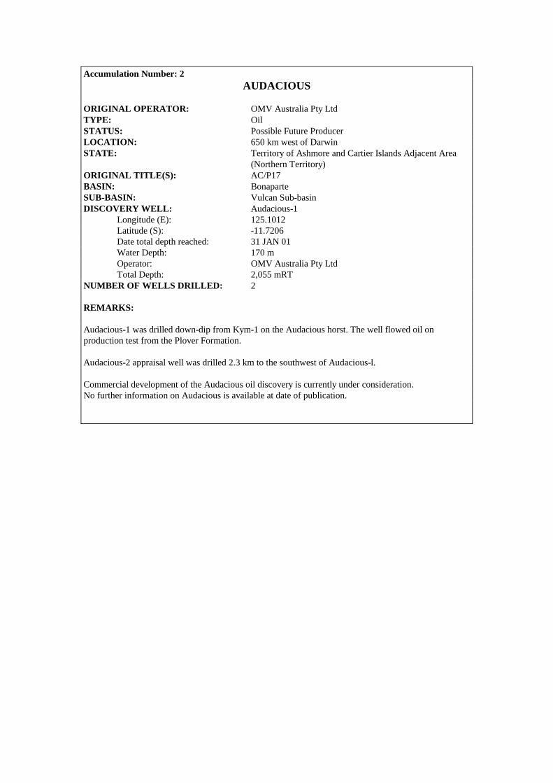
Accumulation Number: 2 AUDACIOUS
ORIGINAL OPERATOR: OMV Australia Pty Ltd TYPE: Oil STATUS: Possible Future Producer LOCATION: 650 km west of Darwin STATE: Territory of Ashmore and Cartier Islands Adjacent Area (Northern Territory) ORIGINAL TITLE(S): AC/P17 BASIN: Bonaparte SUB-BASIN: Vulcan Sub-basin DISCOVERY WELL: Audacious-1 Longitude (E): 125.1012 Latitude (S): -11.7206 Date total depth reached: 31 JAN 01 Water Depth: 170 m Operator: OMV Australia Pty Ltd Total Depth: 2,055 mRT NUMBER OF WELLS DRILLED: 2 REMARKS: Audacious-1 was drilled down-dip from Kym-1 on the Audacious horst. The well flowed oil on production test from the Plover Formation. Audacious-2 appraisal well was drilled 2.3 km to the southwest of Audacious-l. Commercial development of the Audacious oil discovery is currently under consideration. No further information on Audacious is available at date of publication.
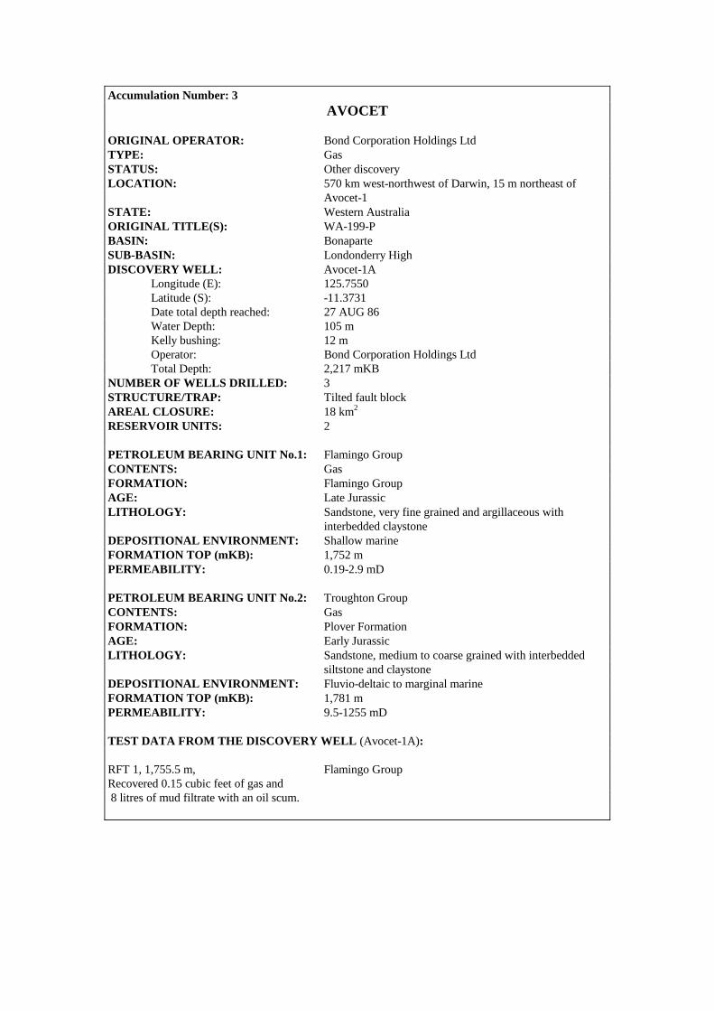
Accumulation Number: 3 AVOCET
ORIGINAL OPERATOR: Bond Corporation Holdings Ltd TYPE: Gas STATUS: Other discovery LOCATION: 570 km west-northwest of Darwin, 15 m northeast of Avocet-1 STATE: Western Australia ORIGINAL TITLE(S): WA-199-P BASIN: Bonaparte SUB-BASIN: Londonderry High DISCOVERY WELL: Avocet-1A Longitude (E): 125.7550 Latitude (S): -11.3731 Date total depth reached: 27 AUG 86 Water Depth: 105 m Kelly bushing: 12 m Operator: Bond Corporation Holdings Ltd Total Depth: 2,217 mKB NUMBER OF WELLS DRILLED: 3 STRUCTURE/TRAP: Tilted fault block AREAL CLOSURE: 18 km2 RESERVOIR UNITS: 2 PETROLEUM BEARING UNIT No.1: Flamingo Group CONTENTS: Gas FORMATION: Flamingo Group AGE: Late Jurassic LITHOLOGY: Sandstone, very fine grained and argillaceous with interbedded claystone DEPOSITIONAL ENVIRONMENT: Shallow marine FORMATION TOP (mKB): 1,752 m PERMEABILITY: 0.19-2.9 mD PETROLEUM BEARING UNIT No.2: Troughton Group CONTENTS: Gas FORMATION: Plover Formation AGE: Early Jurassic LITHOLOGY: Sandstone, medium to coarse grained with interbedded siltstone and claystone DEPOSITIONAL ENVIRONMENT: Fluvio-deltaic to marginal marine FORMATION TOP (mKB): 1,781 m PERMEABILITY: 9.5-1255 mD TEST DATA FROM THE DISCOVERY WELL (Avocet-1A): RFT 1, 1,755.5 m, Flamingo Group Recovered 0.15 cubic feet of gas and 8 litres of mud filtrate with an oil scum.
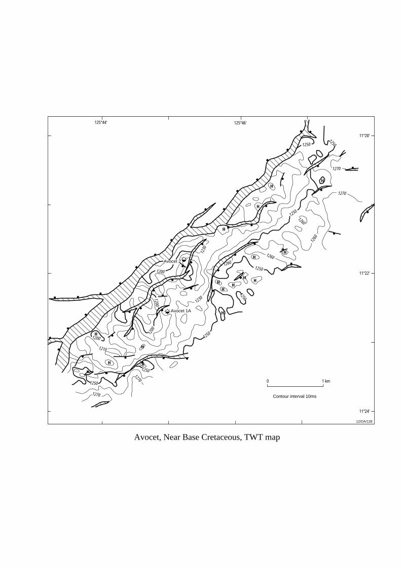
125°46'
11°22'
1 km0
1250
1250
1270
1270
Avocet, Near Base Cretaceous, TWT map
Avocet 2
Avocet 1A
1200
1200
1200
1260
1260
12/OA/128
1200
1250
H
H H
H
H
HH
HH
H
H
H
HH
1250
1270
1270
1250
1250
1250
1230
1230
1210
H
H1260
1260
1250
125°44'
11°24'
11°20'
Contour interval 10ms

RFT 2, 1,800.0 m, Plover Formation Recovered 0.27 cubic feet of gas and 10 litres of mud filtrate. APPRAISAL AND DEVELOPMENT DRILLING: Avocet-1 was abandoned at 346 mKB due to mechanical difficulties. Avocet-2, designed to test the updip potential of the Avocet structure, encountered the same residual oil zones intersected by Avocet-1A. No formation tests were undertaken in this well. REMARKS: Log analysis of Avocet-1A indicates oil saturation in low permeability sandstones between 1,701-1,722 m and 1,752-1,770 m, with a residual oil/water contact at 1,813 mKB. This suggests a palaeo-oil accumulation at Avocet may have been breached by faulting or displaced by late gas migration. STRATIGRAPHY (Avocet-1A) :
AGE UNIT FORMATION TOP (mKB)
TERTIARY WOODBINE Undifferentiated 117.5 GROUP Hibernia Formation 500.0
CRETACEOUS BATHURST ISLAND GP Undifferentiated 1133.0 JURASSIC FLAMINGO GROUP Undifferentiated 1752.0
TROUGHTON GROUP Plover Formation 1781.0
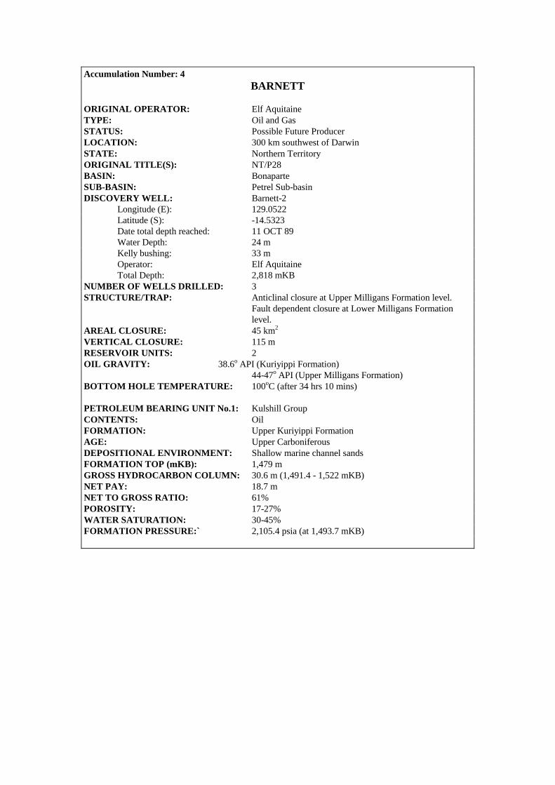
Accumulation Number: 4 BARNETT
ORIGINAL OPERATOR: Elf Aquitaine TYPE: Oil and Gas STATUS: Possible Future Producer LOCATION: 300 km southwest of Darwin STATE: Northern Territory ORIGINAL TITLE(S): NT/P28 BASIN: Bonaparte SUB-BASIN: Petrel Sub-basin DISCOVERY WELL: Barnett-2 Longitude (E): 129.0522 Latitude (S): -14.5323 Date total depth reached: 11 OCT 89 Water Depth: 24 m Kelly bushing: 33 m Operator: Elf Aquitaine Total Depth: 2,818 mKB NUMBER OF WELLS DRILLED: 3 STRUCTURE/TRAP: Anticlinal closure at Upper Milligans Formation level. Fault dependent closure at Lower Milligans Formation level. AREAL CLOSURE: 45 km2
VERTICAL CLOSURE: 115 m RESERVOIR UNITS: 2 OIL GRAVITY: 38.6o API (Kuriyippi Formation) 44-47o API (Upper Milligans Formation) BOTTOM HOLE TEMPERATURE: 100oC (after 34 hrs 10 mins) PETROLEUM BEARING UNIT No.1: Kulshill Group CONTENTS: Oil FORMATION: Upper Kuriyippi Formation AGE: Upper Carboniferous DEPOSITIONAL ENVIRONMENT: Shallow marine channel sands FORMATION TOP (mKB): 1,479 m GROSS HYDROCARBON COLUMN: 30.6 m (1,491.4 - 1,522 mKB) NET PAY: 18.7 m NET TO GROSS RATIO: 61% POROSITY: 17-27% WATER SATURATION: 30-45% FORMATION PRESSURE:` 2,105.4 psia (at 1,493.7 mKB)

Barnett 1Barnett 2
Barnett 3
14°30'
0 2 km
129°02'
Barnett, Top Tanmurra Formation, TWT map
1430
1450
1500
1540
157015
20
1500
1500
1540
12/OA/129
14°32'
14°34'
129°04' 129°06'
Contour interval 10ms
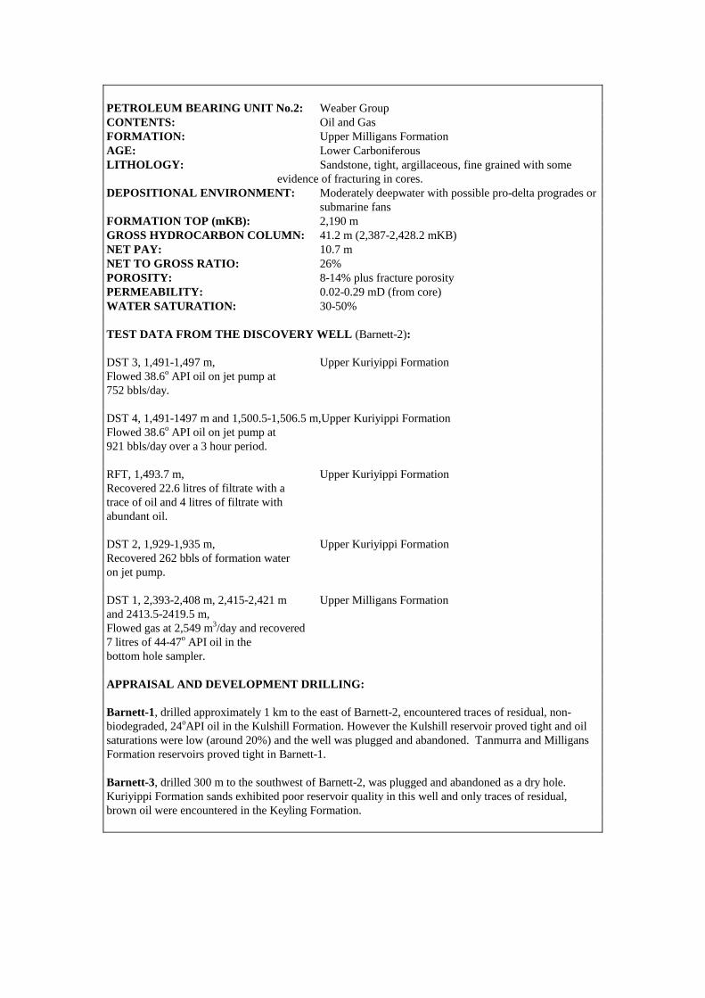
PETROLEUM BEARING UNIT No.2: Weaber Group CONTENTS: Oil and Gas FORMATION: Upper Milligans Formation AGE: Lower Carboniferous LITHOLOGY: Sandstone, tight, argillaceous, fine grained with some evidence of fracturing in cores. DEPOSITIONAL ENVIRONMENT: Moderately deepwater with possible pro-delta progrades or
submarine fans FORMATION TOP (mKB): 2,190 m GROSS HYDROCARBON COLUMN: 41.2 m (2,387-2,428.2 mKB) NET PAY: 10.7 m NET TO GROSS RATIO: 26% POROSITY: 8-14% plus fracture porosity PERMEABILITY: 0.02-0.29 mD (from core) WATER SATURATION: 30-50% TEST DATA FROM THE DISCOVERY WELL (Barnett-2): DST 3, 1,491-1,497 m, Upper Kuriyippi Formation Flowed 38.6o API oil on jet pump at 752 bbls/day. DST 4, 1,491-1497 m and 1,500.5-1,506.5 m,Upper Kuriyippi Formation Flowed 38.6o API oil on jet pump at 921 bbls/day over a 3 hour period. RFT, 1,493.7 m, Upper Kuriyippi Formation Recovered 22.6 litres of filtrate with a trace of oil and 4 litres of filtrate with abundant oil. DST 2, 1,929-1,935 m, Upper Kuriyippi Formation Recovered 262 bbls of formation water on jet pump. DST 1, 2,393-2,408 m, 2,415-2,421 m Upper Milligans Formation and 2413.5-2419.5 m, Flowed gas at 2,549 m3/day and recovered 7 litres of 44-47o API oil in the bottom hole sampler. APPRAISAL AND DEVELOPMENT DRILLING: Barnett-1, drilled approximately 1 km to the east of Barnett-2, encountered traces of residual, non-biodegraded, 24oAPI oil in the Kulshill Formation. However the Kulshill reservoir proved tight and oil saturations were low (around 20%) and the well was plugged and abandoned. Tanmurra and Milligans Formation reservoirs proved tight in Barnett-1. Barnett-3, drilled 300 m to the southwest of Barnett-2, was plugged and abandoned as a dry hole. Kuriyippi Formation sands exhibited poor reservoir quality in this well and only traces of residual, brown oil were encountered in the Keyling Formation.
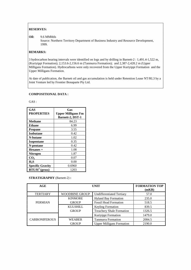
RESERVES: Oil: 9.6 MMbbls Source: Northern Territory Department of Business Industry and Resource Development, 1999. REMARKS: 3 hydrocarbon bearing intervals were identified on logs and by drilling in Barnett-2 : 1,491.4-1,522 m, (Kuriyippi Formation); 2,153.6-2,156.6 m (Tanmurra Formation); and 2,387-2,428.2 m (Upper Milligans Formation). Hydrocarbons were only recovered from the Upper Kuriyippi Formation and the Upper Milligans Formation. At date of publication, the Barnett oil and gas accumulation is held under Retention Lease NT/RL3 by a Joint Venture led by Frontier Bonaparte Pty Ltd. COMPOSITIONAL DATA : GAS : GAS PROPERTIES
Gas Upper Milligans Fm
Barnett-2, DST-1 Methane 84.23 Ethane 6.99 Propane 3.55 Isobutane 0.42 N-butane 1.02 Isopentane 0.35 N-pentane 0.42 Hexanes + 1.08 Nitrogen 1.87 CO2 0.07 H2S 0.00 Specific Gravity 0.6960 BTU/ft3 (gross) 1203 STRATIGRAPHY (Barnett-2) :
AGE UNIT FORMATION TOP (mKB)
TERTIARY WOODBINE GROUP Undifferentiated Tertiary 57.0 KINMORE Hyland Bay Formation 235.0
PERMIAN GROUP Fossil Head Formation 518.5 KULSHILL Keyling Formation 839.5 GROUP Treachery Shale Formation 1326.5 Kuriyippi Formation 1479.0
CARBONIFEROUS WEABER Tanmurra Formation 2084.5 GROUP Upper Milligans Formation 2190.0

Accumulation Number: 5 BAYU-UNDAN
ORIGINAL OPERATOR(S): Phillips Petroleum Company ZOC Ltd BHP Petroleum (ZOCA-91-12) Pty Ltd TYPE: Gas STATUS: Future Producer LOCATION: 450 km northwest of Darwin STATE: Joint Petroleum Development Area (JPDA) ORIGINAL TITLE(S): ZOCA 91-13 and ZOCA 91-12 BASIN: Bonaparte SUB-BASIN: Flamingo High. DISCOVERY WELL: Bayu-1 Longitude (E): 126.6755 Latitude (S): -11.0951 Date total depth reached: 03 FEB 95 Water Depth: 71 m Kelly bushing: 22 m Operator: Phillips Petroleum Company ZOC Ltd Total Depth: 3,205 m NUMBER OF WELLS DRILLED: 11 (Bayu-1 to 5, Undan-1 to 4, Hingkip-1 and Trulek-1) STRUCTURE/TRAP: Tilted fault block. Fault dependent with some internal four-way-dip closure. AREAL CLOSURE: > 160 km2 RESERVOIR UNITS: 1 GAS/WATER CONTACT: 3,128.5 mKB RESERVOIR TEMPERATURE: 130oC GROSS HYDROCARBON COLUMN: 155 m (Bayu-1) NET PAY: 86.1 m (Bayu-1) NET TO GROSS RATIO: 55% HYDROCARBON SATURATION: 74% (Elang Formation) 81% (Plover Formation) CONDENSATE/GAS RATIO (CGR): 60 bbl/MMscf CONDENSATE GRAVITY: 62o API PETROLEUM BEARING UNIT No.1: Elang Formation (marine facies of the Upper Plover Fm and Plover Formation). CONTENTS: Gas and Condensate FORMATION: Elang and Plover Formations AGE: Middle to Upper Jurassic LITHOLOGY: A coarsening upwards sequence of silty, clay-rich sandstones which grade upwards to clean, well sorted, medium grained sandstones at the top of the unit. DEPOSITIONAL ENVIRONMENT: Transgressive sequence, ranging from fluvial and estuarine channel sands at the base, through lower shoreface and delta slope deposits, to distributary channel and upper shoreface environments at the top of the unit. FORMATION TOP (mKB): 2,954.5 m (Elang Formation) POROSITY: 1-17% (10% average) PERMEABILITY: 0.02-2,500 mD (10 mD average)

3300
5 km0
12/OA/130
Undan 1
Undan 2
Undan 3
Bayu 2
Bayu 4
Bayu 3
Bayu 5
126°35'126°30' 126°40' 126°45'
11°05'
Undan 4
3100
3100
3000
3000
3250
3050
3250
3050
3050
320032
00
3200
3200
3050
3000
3300
3250
3150
Bayu-Undan, Top Callovian, depth map
ZOCA 91-12 ZOCA 91-13
3000
3000
Contour interval 10m
GWC3108 mss
(after Brooks et al, 1996)
Bayu 1
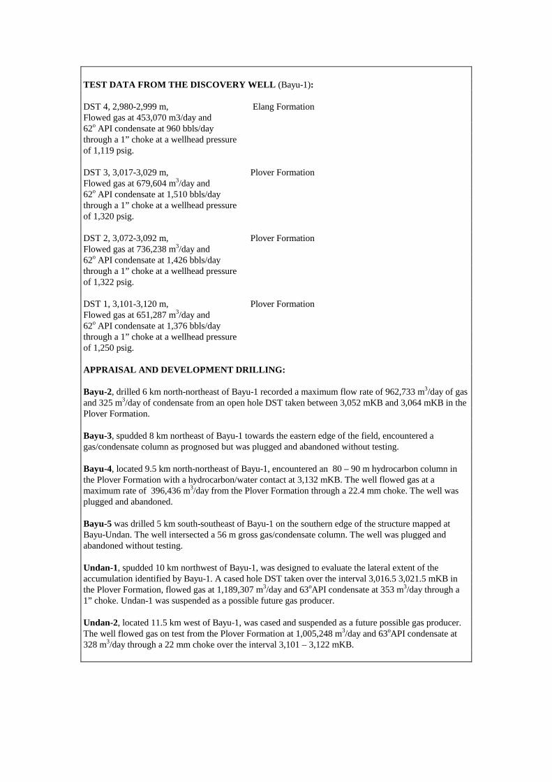
TEST DATA FROM THE DISCOVERY WELL (Bayu-1): DST 4, 2,980-2,999 m, Elang Formation Flowed gas at 453,070 m3/day and 62o API condensate at 960 bbls/day through a 1” choke at a wellhead pressure of 1,119 psig. DST 3, 3,017-3,029 m, Plover Formation Flowed gas at 679,604 m3/day and 62o API condensate at 1,510 bbls/day through a 1” choke at a wellhead pressure of 1,320 psig. DST 2, 3,072-3,092 m, Plover Formation Flowed gas at 736,238 m3/day and 62o API condensate at 1,426 bbls/day through a 1” choke at a wellhead pressure of 1,322 psig. DST 1, 3,101-3,120 m, Plover Formation Flowed gas at 651,287 m3/day and 62o API condensate at 1,376 bbls/day through a 1” choke at a wellhead pressure of 1,250 psig. APPRAISAL AND DEVELOPMENT DRILLING: Bayu-2, drilled 6 km north-northeast of Bayu-1 recorded a maximum flow rate of 962,733 m3/day of gas and 325 m3/day of condensate from an open hole DST taken between 3,052 mKB and 3,064 mKB in the Plover Formation. Bayu-3, spudded 8 km northeast of Bayu-1 towards the eastern edge of the field, encountered a gas/condensate column as prognosed but was plugged and abandoned without testing. Bayu-4, located 9.5 km north-northeast of Bayu-1, encountered an 80 – 90 m hydrocarbon column in the Plover Formation with a hydrocarbon/water contact at 3,132 mKB. The well flowed gas at a maximum rate of 396,436 m3/day from the Plover Formation through a 22.4 mm choke. The well was plugged and abandoned. Bayu-5 was drilled 5 km south-southeast of Bayu-1 on the southern edge of the structure mapped at Bayu-Undan. The well intersected a 56 m gross gas/condensate column. The well was plugged and abandoned without testing. Undan-1, spudded 10 km northwest of Bayu-1, was designed to evaluate the lateral extent of the accumulation identified by Bayu-1. A cased hole DST taken over the interval 3,016.5 3,021.5 mKB in the Plover Formation, flowed gas at 1,189,307 m3/day and 63oAPI condensate at 353 m3/day through a 1” choke. Undan-1 was suspended as a possible future gas producer. Undan-2, located 11.5 km west of Bayu-1, was cased and suspended as a future possible gas producer. The well flowed gas on test from the Plover Formation at 1,005,248 m3/day and 63oAPI condensate at 328 m3/day through a 22 mm choke over the interval 3,101 – 3,122 mKB.

Undan-3 was drilled 5 km from Undan-1, midway between Undan-1 and Bayu-1. The well was cased and suspended as a possible future gas producer after intersecting a 136 m gross gas column between 2,996 mKB and 3,132 mKB in the Plover Formation. Undan-4, drilled 4.25 km north-northwest of of Undan-2, was plugged and abandoned after intersecting a 43 m gross hydrocarbon column. The well flowed gas on test at 243,525 m3/day through a 1” choke. Hingkip-1, drilled 6.6 km north of Undan-1 in June 1997, intersected an 85 m gas column between 3,044 mKB and 3,129 mKB . The gas at Hingkip is thought to be a northerly extension of the Bayu-Undan gas/condensate field. Hingkip-1 has been suspended as a future gas producer. Trulek-1, drilled 5.2 km southeast of Undan-2 in November 1996, intersected a 63 m gross gas column. As with the Hingkip well, the gas encountered at Trulek is thought to be an extension of the Bayu-Undan gas/condensate field. Trulek-1 has been cased and suspended as a future gas producer. RESERVES : Gas : 3.4 TCF Condensate : 400 MMbbls Source: Northern Territory Department of Business Industry and Resource Development, 1998. REMARKS: Commercial production of petroleum from Bayu-Undan is scheduled for 2004. Initial development of the resource will involve a gas recycling project (the stripping of gas-liquids and reinjection of gas into the reservoir). A gas pipeline from Bayu-Undan to a LNG facility in Darwin is planned. COMPOSITIONAL DATA : GAS : GAS PROPERTIES
Gas Plover Fm,
DST-1
Gas Elang Fm,
DST-4 Methane 75.39 76.30 Ethane 7.61 7.39 Propane 4.15 3.90 Isobutane 0.89 0.84 N-butane 1.10 1.06 Isopentane 0.40 0.39 N-pentane 0.25 0.24 Hexanes + 0.49 0.46 Nitrogen 3.67 3.51 CO2 6.05 5.91 H2S 0.00 0.00 Specific Gravity 0.759 0.751 BTU/ft3 (gross) 1119 1112

STRATIGRAPHY (Bayu-1) :
AGE UNIT FORMATION TOP (mKB)
No Returns 93.0 WOODBINE Oliver Formation 727.0
TERTIARY GROUP Hibernia Formation 754.0 Grebe Sandstone 1256.0 Johnson Formation 1356.0 BATHURST Vee Formation 1842.0
CRETACEOUS ISLAND Wangarlu Formation 2366.0 GROUP Jamison Fm Radiolarite 2776.0 Darwin Formation 2861.0
JURASSIC FLAMINGO GROUP Undifferentiated 2875.0 TROUGHTON GROUP Plover Formation 2954.0
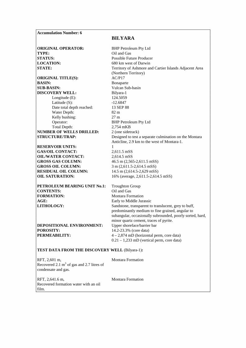
Accumulation Number: 6 BILYARA
ORIGINAL OPERATOR: BHP Petroleum Pty Ltd TYPE: Oil and Gas STATUS: Possible Future Producer LOCATION: 680 km west of Darwin STATE: Territory of Ashmore and Cartier Islands Adjacent Area (Northern Territory) ORIGINAL TITLE(S): AC/P17 BASIN: Bonaparte SUB-BASIN: Vulcan Sub-basin DISCOVERY WELL: Bilyara-1 Longitude (E): 124.5059 Latitude (S): -12.6847 Date total depth reached: 13 SEP 88 Water Depth: 82 m Kelly bushing: 27 m Operator: BHP Petroleum Pty Ltd Total Depth: 2,754 mKB NUMBER OF WELLS DRILLED: 2 (one sidetrack) STRUCTURE/TRAP: Designed to test a separate culmination on the Montara Anticline, 2.9 km to the west of Montara-1. RESERVOIR UNITS: 1 GAS/OIL CONTACT: 2,611.5 mSS OIL/WATER CONTACT: 2,614.5 mSS GROSS GAS COLUMN: 46.5 m (2,565-2,611.5 mSS) GROSS OIL COLUMN: 3 m (2,611.5-2,614.5 mSS) RESIDUAL OIL COLUMN: 14.5 m (2,614.5-2,629 mSS) OIL SATURATION: 16% (average, 2,611.5-2,614.5 mSS) PETROLEUM BEARING UNIT No.1: Troughton Group CONTENTS: Oil and Gas FORMATION: Montara Formation AGE: Early to Middle Jurassic LITHOLOGY: Sandstone, transparent to translucent, grey to buff, predominantly medium to fine grained, angular to subangular, occasionally subrounded, poorly sorted, hard, minor quartz cement, traces of pyrite. DEPOSITIONAL ENVIRONMENT: Upper shoreface/barrier bar POROSITY: 14.2-23.3% (core data) PERMEABILITY: 4 – 2,874 mD (horizontal perm, core data) 0.21 – 1,233 mD (vertical perm, core data) TEST DATA FROM THE DISCOVERY WELL (Bilyara-1): RFT, 2,601 m, Montara Formation Recovered 2.1 m3 of gas and 2.7 litres of condensate and gas. RFT, 2,641.6 m, Montara Formation Recovered formation water with an oil film.
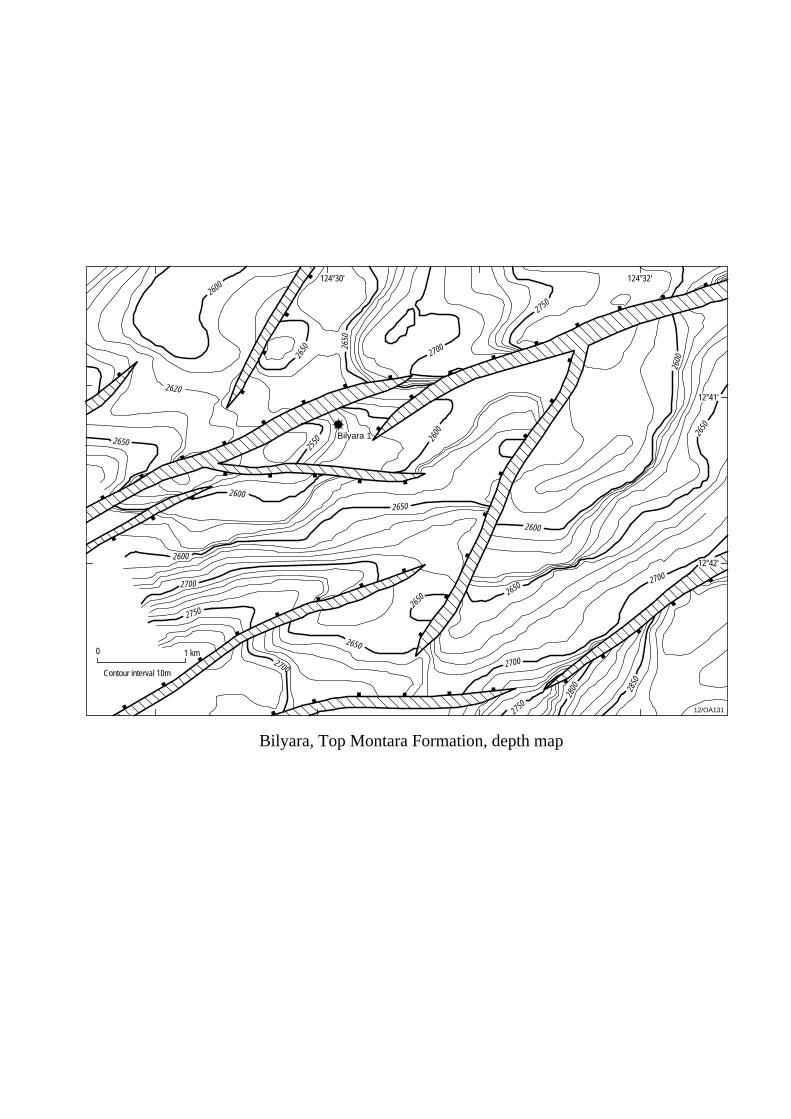
2600
2650
2700
2600
2600
2620
2650
2750
2700
2600
2650
2650
2650
2700
2750
2800 28
50
2650
2600
2700
2700
2650 26
50
2750
Bilyara 1
124°30'
12°41'
0 1 km
Bilyara, Top Montara Formation, depth map
Contour interval 10m
12/OA131
124°32'
2600
2550
12°42'
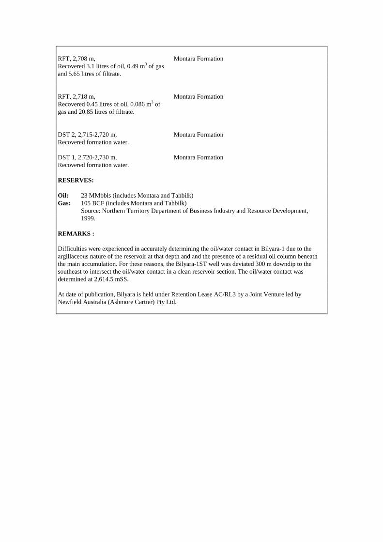
RFT, 2,708 m, Montara Formation Recovered 3.1 litres of oil, 0.49 m3 of gas and 5.65 litres of filtrate. RFT, 2,718 m, Montara Formation Recovered 0.45 litres of oil, 0.086 m3 of gas and 20.85 litres of filtrate. DST 2, 2,715-2,720 m, Montara Formation Recovered formation water. DST 1, 2,720-2,730 m, Montara Formation Recovered formation water. RESERVES: Oil: 23 MMbbls (includes Montara and Tahbilk) Gas: 105 BCF (includes Montara and Tahbilk) Source: Northern Territory Department of Business Industry and Resource Development, 1999. REMARKS : Difficulties were experienced in accurately determining the oil/water contact in Bilyara-1 due to the argillaceous nature of the reservoir at that depth and and the presence of a residual oil column beneath the main accumulation. For these reasons, the Bilyara-1ST well was deviated 300 m downdip to the southeast to intersect the oil/water contact in a clean reservoir section. The oil/water contact was determined at 2,614.5 mSS. At date of publication, Bilyara is held under Retention Lease AC/RL3 by a Joint Venture led by Newfield Australia (Ashmore Cartier) Pty Ltd.
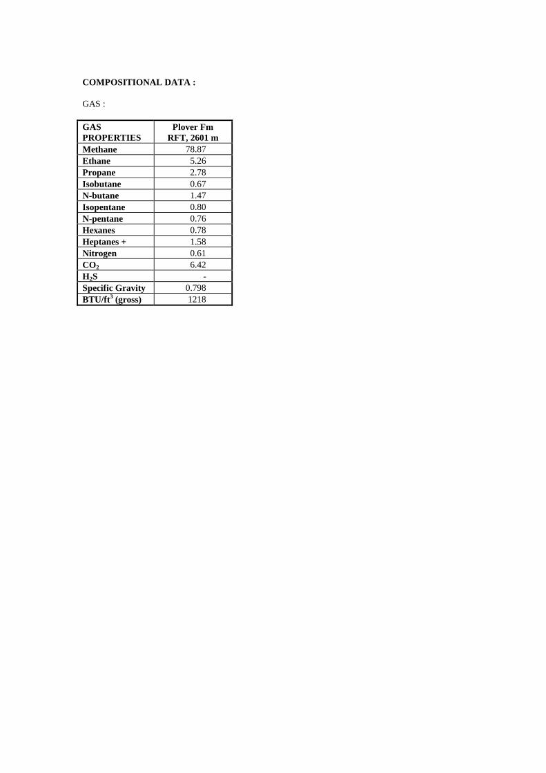
COMPOSITIONAL DATA : GAS : GAS PROPERTIES
Plover Fm RFT, 2601 m
Methane 78.87 Ethane 5.26 Propane 2.78 Isobutane 0.67 N-butane 1.47 Isopentane 0.80 N-pentane 0.76 Hexanes 0.78 Heptanes + 1.58 Nitrogen 0.61 CO2 6.42 H2S - Specific Gravity 0.798 BTU/ft3 (gross) 1218

Accumulation Number: 7 BIRCH
ORIGINAL OPERATOR: BHP Petroleum Pty Ltd TYPE: Oil STATUS: Other Discovery LOCATION: 650 km west of Darwin STATE: Territory of Ashmore and Cartier Islands Adjacent Area (Northern Territory) ORIGINAL TITLE(S): AC/P2 BASIN: Bonaparte SUB-BASIN: Vulcan Sub-basin DISCOVERY WELL: Birch-1 Longitude (E): 124.4954 Latitude (S): -12.4607 Date total depth reached: 01 AUG 90 Water Depth: 87 m Kelly bushing: 22 m Operator: BHP Petroleum Pty Ltd Total Depth: 2,822 mKB NUMBER OF WELLS DRILLED: 1 (sidetracked due to mechanical difficulties) STRUCTURE/TRAP: Tilted fault block RESERVOIR UNITS: 1 OIL GRAVITY: 43o API HYDROCARBON SATURATION: 46.1% GAS/OIL RATIO: 222 scf/stb GROSS HYDROCARBON COLUMN: 2.5 m (2039-2041.5 mKB) PETROLEUM BEARING UNIT No.1: Bathurst Island Group CONTENTS: Oil FORMATION: Puffin Formation AGE: Late Cretaceous LITHOLOGY: Sandstone, very pale orange, medium to coarse grained, well sorted, subangular to rounded, moderately calcareous with traces of pyrite and glauconite. FORMATION TOP (mKB): 1,977 m POROSITY: 18.4% (average log porosity) PERMEABILITY: 75 – 1,500 mD TEST DATA FROM THE DISCOVERY WELL (Birch-1): RFT 1, 2,040.5 m, Puffin Formation Recovered 6 litres of 43o API oil, 3.3 litres of formation water and 0.237 m3 of gas. REMARKS: Birch-1 was plugged back and sidetracked at 1,765 mKB due to mechanical problems.
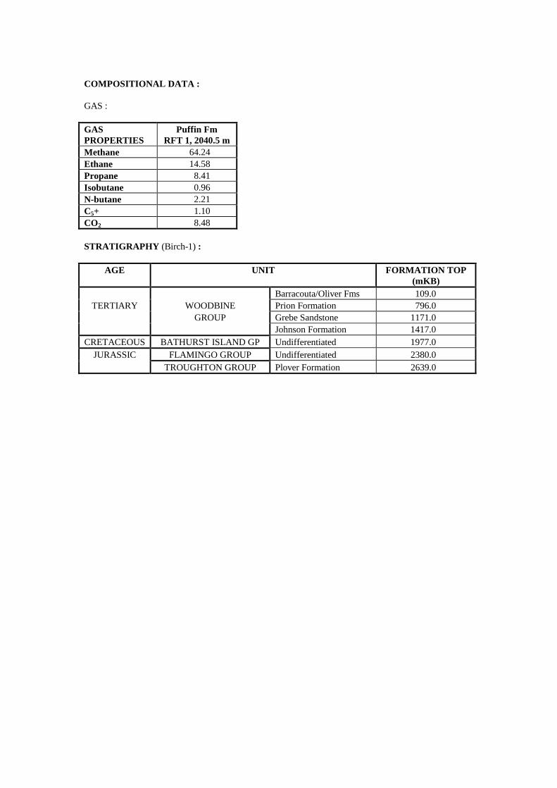
COMPOSITIONAL DATA : GAS : GAS PROPERTIES
Puffin Fm RFT 1, 2040.5 m
Methane 64.24 Ethane 14.58 Propane 8.41 Isobutane 0.96 N-butane 2.21 C5+ 1.10 CO2 8.48 STRATIGRAPHY (Birch-1) :
AGE UNIT FORMATION TOP (mKB)
Barracouta/Oliver Fms 109.0 TERTIARY WOODBINE Prion Formation 796.0
GROUP Grebe Sandstone 1171.0 Johnson Formation 1417.0
CRETACEOUS BATHURST ISLAND GP Undifferentiated 1977.0 JURASSIC FLAMINGO GROUP Undifferentiated 2380.0
TROUGHTON GROUP Plover Formation 2639.0
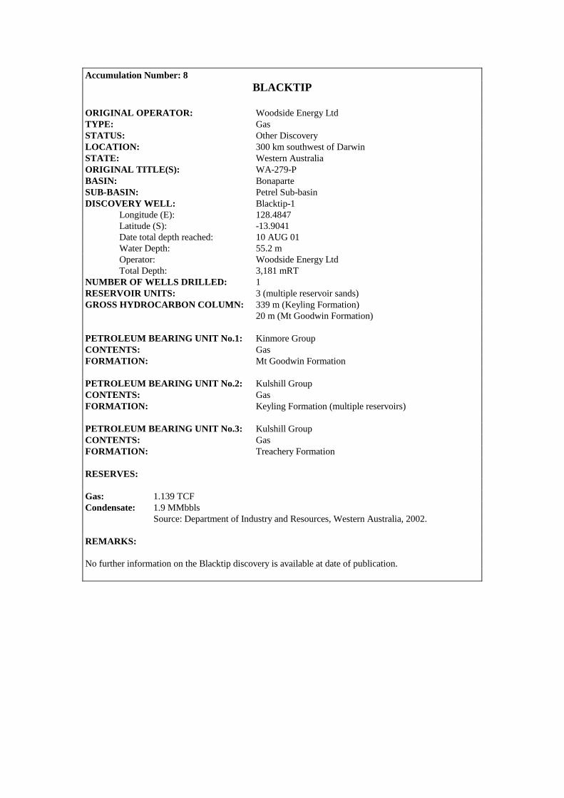
Accumulation Number: 8 BLACKTIP
ORIGINAL OPERATOR: Woodside Energy Ltd TYPE: Gas STATUS: Other Discovery LOCATION: 300 km southwest of Darwin STATE: Western Australia ORIGINAL TITLE(S): WA-279-P BASIN: Bonaparte SUB-BASIN: Petrel Sub-basin DISCOVERY WELL: Blacktip-1 Longitude (E): 128.4847 Latitude (S): -13.9041 Date total depth reached: 10 AUG 01 Water Depth: 55.2 m Operator: Woodside Energy Ltd Total Depth: 3,181 mRT NUMBER OF WELLS DRILLED: 1 RESERVOIR UNITS: 3 (multiple reservoir sands) GROSS HYDROCARBON COLUMN: 339 m (Keyling Formation) 20 m (Mt Goodwin Formation) PETROLEUM BEARING UNIT No.1: Kinmore Group CONTENTS: Gas FORMATION: Mt Goodwin Formation PETROLEUM BEARING UNIT No.2: Kulshill Group CONTENTS: Gas FORMATION: Keyling Formation (multiple reservoirs) PETROLEUM BEARING UNIT No.3: Kulshill Group CONTENTS: Gas FORMATION: Treachery Formation RESERVES: Gas: 1.139 TCF Condensate: 1.9 MMbbls Source: Department of Industry and Resources, Western Australia, 2002. REMARKS: No further information on the Blacktip discovery is available at date of publication.
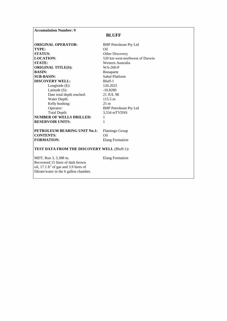
Accumulation Number: 9 BLUFF
ORIGINAL OPERATOR: BHP Petroleum Pty Ltd TYPE: Oil STATUS: Other Discovery LOCATION: 520 km west-northwest of Darwin STATE: Western Australia ORIGINAL TITLE(S): WA-260-P BASIN: Bonaparte SUB-BASIN: Sahul Platform DISCOVERY WELL: Bluff-1 Longitude (E): 126.2025 Latitude (S): -10.8280 Date total depth reached: 21 JUL 98 Water Depth: 115.5 m Kelly bushing: 25 m Operator: BHP Petroleum Pty Ltd Total Depth: 3,534 mTVDSS NUMBER OF WELLS DRILLED: 1 RESERVOIR UNITS: 1 PETROLEUM BEARING UNIT No.1: Flamingo Group CONTENTS: Oil FORMATION: Elang Formation TEST DATA FROM THE DISCOVERY WELL (Bluff-1): MDT, Run 3, 3,388 m, Elang Formation Recovered 15 litres of dark brown oil, 17.1 ft3 of gas and 3.9 litres of filtrate/water in the 6 gallon chamber.

Accumulation Number: 10 BONAPARTE
ORIGINAL OPERATOR: Alliance Oil Development Australia TYPE: Gas STATUS: Other Discovery LOCATION: 375 km southwest of Darwin STATE: Western Australia ORIGINAL TITLE(S): PE 127 H BASIN: Bonaparte SUB-BASIN: Petrel Sub-basin DISCOVERY WELL: Bonaparte-2 Longitude (E): 128.7211 Latitude (S): -15.0853 Date total depth reached: 09 OCT 64 Ground level: 117 m Kelly bushing: 5 m Operator: Alliance Oil Development Australia. Total Depth: 2,136 mKB NUMBER OF WELLS DRILLED: 2 STRUCTURE/TRAP: Northwest-southeast trending anticline AREAL CLOSURE: > 50 km2 VERTICAL CLOSURE: > 75 m RESERVOIR UNITS: 1 PETROLEUM BEARING UNIT No.1: Weaber Group CONTENTS: Gas FORMATION: Milligans Formation AGE: Early Carboniferous LITHOLOGY: Argillaceous sandstone interbedded with carbonaceous siltstone and shale. DEPOSITIONAL ENVIRONMENT: Moderately deepwater marine FORMATION TOP (mKB): 480.7 mKB (top Milligans Fm) 1,437.4 mKB (top reservoir) POROSITY: Up to 16% TEST DATA FROM THE DISCOVERY WELL (Bonaparte-2): DST 1, 460-523 m, Tanmurra Formation Recovered 55 m of slightly water cut drilling mud and 289 m of fresh water. DST 2, 524-586.9 m, Milligans Formation Recovered 6 m of watery drilling mud and 120 m of fresh water. DST 3, 1,001-1,024.9 m, Milligans Formation Recovered 1.5 m of drilling mud. DST 4, 1,067.9-1,088.9 m, Milligans Formation Recovered 58 m of drilling mud. DST 5, 1,379.9-1,389.1 m, Milligans Formation Recovered 76 m of water cut drilling mud and 870 m of salt water.
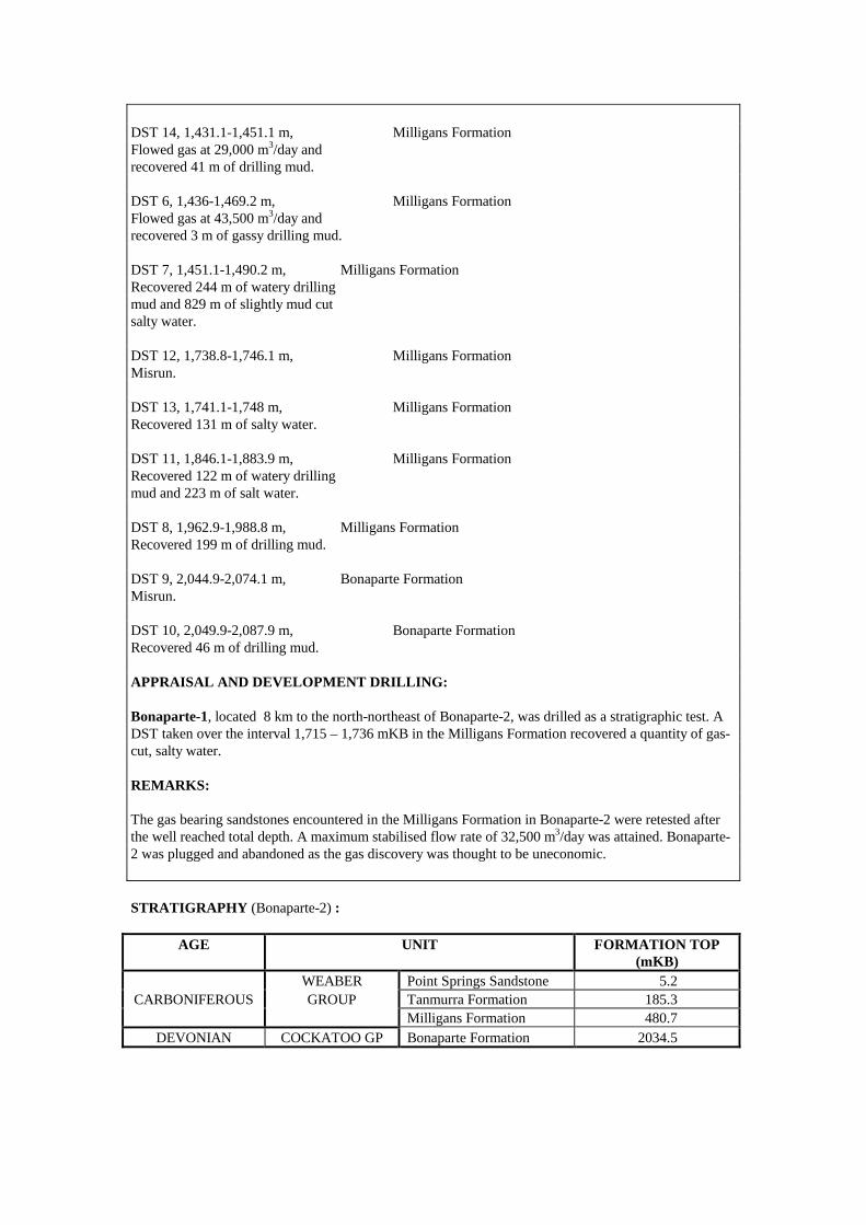
DST 14, 1,431.1-1,451.1 m, Milligans Formation Flowed gas at 29,000 m3/day and recovered 41 m of drilling mud. DST 6, 1,436-1,469.2 m, Milligans Formation Flowed gas at 43,500 m3/day and recovered 3 m of gassy drilling mud. DST 7, 1,451.1-1,490.2 m, Milligans Formation Recovered 244 m of watery drilling mud and 829 m of slightly mud cut salty water. DST 12, 1,738.8-1,746.1 m, Milligans Formation Misrun. DST 13, 1,741.1-1,748 m, Milligans Formation Recovered 131 m of salty water. DST 11, 1,846.1-1,883.9 m, Milligans Formation Recovered 122 m of watery drilling mud and 223 m of salt water. DST 8, 1,962.9-1,988.8 m, Milligans Formation Recovered 199 m of drilling mud. DST 9, 2,044.9-2,074.1 m, Bonaparte Formation Misrun. DST 10, 2,049.9-2,087.9 m, Bonaparte Formation Recovered 46 m of drilling mud. APPRAISAL AND DEVELOPMENT DRILLING: Bonaparte-1, located 8 km to the north-northeast of Bonaparte-2, was drilled as a stratigraphic test. A DST taken over the interval 1,715 – 1,736 mKB in the Milligans Formation recovered a quantity of gas-cut, salty water. REMARKS: The gas bearing sandstones encountered in the Milligans Formation in Bonaparte-2 were retested after the well reached total depth. A maximum stabilised flow rate of 32,500 m3/day was attained. Bonaparte-2 was plugged and abandoned as the gas discovery was thought to be uneconomic. STRATIGRAPHY (Bonaparte-2) :
AGE UNIT FORMATION TOP (mKB)
WEABER Point Springs Sandstone 5.2 CARBONIFEROUS GROUP Tanmurra Formation 185.3
Milligans Formation 480.7 DEVONIAN COCKATOO GP Bonaparte Formation 2034.5
Accumulation Number: 11 BUFFALO
ORIGINAL OPERATOR: BHP Petroleum (Northwest Shelf) Pty Ltd TYPE: Oil STATUS: Producer LOCATION: 550 km west-northwest of Darwin STATE: Western Australia ORIGINAL TITLE(S): WA-260-P BASIN: Bonaparte SUB-BASIN: Laminaria High, Sahul Platform DISCOVERY WELL: Buffalo-1 Longitude (E): 126.0974 Latitude (S): -10.6728 Date total depth reached: 27 SEP 96 Water Depth: 27.3 m Kelly bushing: 28.3 m Operator: BHP Petroleum (Northwest Shelf) Pty Ltd Total Depth: 3,473 mKB NUMBER OF WELLS DRILLED: 2 STRUCTURE/TRAP: Faulted horst block with some internal four-way-dip closure. RESERVOIR UNITS: 1 OIL GRAVITY: 53o API GAS TO OIL RATIO: 126 scf/stb PETROLEUM BEARING UNIT No.1: Elang Formation CONTENTS: Oil FORMATION: Elang Formation AGE: Middle Jurassic (Callovian) LITHOLOGY: Stacked sandstones, interbedded with minor argillaceous
siltstones, silty claystones and claystone. Sandstone: very light grey to yellowish grey to light olive grey, very fine to fine, medium to carse grained, well sorted, commonly unconsolidated, friable with minor pyritic matrix and weak siliceous cement.
DEPOSITIONAL ENVIRONMENT:: Stacked distributary channels deposited in an estuarine environment superposed upon a sequence of stacked mouth and transverse bars.
GROSS HYDROCARBON COLUMN: 45.1 m (3,301 – 3,346.1 mRT) NET PAY: 32 m NET TO GROSS RATIO: 72% HYDROCARBON SATURATION: 77% OIL/WATER CONTACT: 3,323.4 mTVDSS (free water level from MDT data) POROSITY: 12% (average log porosity) PERMEABILITY: 378 mD (average from core) TEST DATA FROM THE DISCOVERY WELL (Buffalo-1): DST (CASED) 1, 3,307-3,335 m, Elang Formation Flowed 53o API oil at 11,800 bbls/day and gas at 328,500 m3/day through a 20.6 mm choke.
APPRAISAL AND DEVELOPMENT DRILLING: Buffalo-2 was drilled in April 1997 and was suspended as future oil producer after encountering hydrocarbons in the Elang Formation. RESERVES : Oil : 25 MMbbls Source: Department of Resources Development, Western Australia, 1998. REMARKS: Commercial production of oil from Buffalo commenced in December 1999. Two production wells are connected to to an unmanned wellhead platform which is linked to a permanently moored FPSO (the Buffalo Venture). The Buffalo oil discovery lies in Production Licenses WA-19-L and WA-21-L.

Accumulation Number: 12 BULLER
ORIGINAL OPERATOR: BHP Petroleum (Northwest Shelf) Pty Ltd TYPE: Oil STATUS: Other Discovery LOCATION: 530 km west-northwest of Darwin STATE: Western Australia ORIGINAL TITLE(S): WA-260-P BASIN: Bonaparte SUB-BASIN: Flamingo High DISCOVERY WELL: Buller-1 Longitude (E): 126.2403 Latitude (S): -10.9077 Date total depth reached: 13 DEC 96 Water Depth: 109 m Kelly bushing: 25 m Operator: BHP Petroleum (Northwest Shelf) Pty Ltd Total Depth: 3,609 mKB NUMBER OF WELLS DRILLED: 1 STRUCTURE/TRAP: Tilted fault block. AREAL CLOSURE: 1 km2 VERTICAL CLOSURE: 180 m OIL GRAVITY: 52o API GAS/OIL RATIO: 114 scf/stb PETROLEUM BEARING UNIT No.1: Troughton Group CONTENTS: Oil FORMATION: Elang Formation FORMATION TOP: 3,421.5 mTVDSS AGE: Callovian LITHOLOGY: Stacked sandstone sequence, interbedded with silty
claystones and claystones. Sandstone: light greyish brown, very light grey to mid grey, light olive grey, rare brownish black, very fine to fine, medium to coarse grained, predominantly medium, poor to moderately well sorted, unconsolidated in part but mainly friable to firm. Common to abundant weak quartz overgrowths with traces of carbonate cement and argillaceous matrix.
DEPOSITIONAL ENVIRONMENT: Transgressive delta, comprising stacked distributory channels and upper shoreface sands.
GROSS HYDROCARBON COLUMN: 26.5 m (3,446.5 – 3,473 mRT) NET PAY: 8.56 m NET TO GROSS RATIO: 32.3% HYDROCARBON SATURATION: 83.4% OIL/WATER CONTACT: 3,448 mTVDSS (free water level) POROSITY: 11.9% (core data) 10.7% (average log) PERMEABILITY: 369.7 mD (average from core) TEST DATA FROM THE DISCOVERY WELL (Buller-1): MDT 1, 3,440.7 mTVDSS, Elang Formation Recovered 16 litres of 52o API oil and 0.15 m3 of gas.
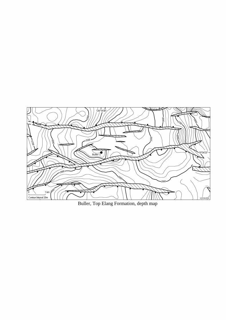
1 km03700
12/OA/205Contour Interval 20m
3600
3900
3500
3900
4000
39003900
3500
3600
3700
3800
3600
Buller 1
Buller, Top Elang Formation, depth map
10°54'23"
126°14'30"
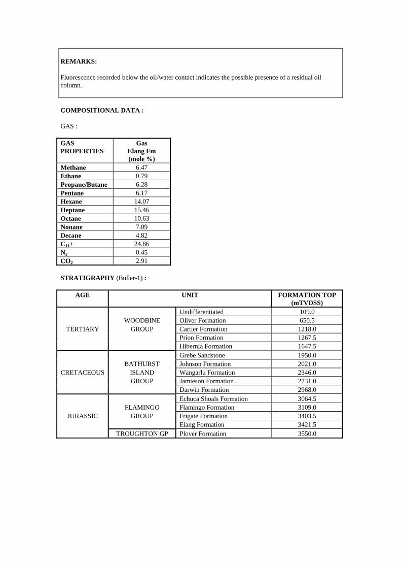
REMARKS: Fluorescence recorded below the oil/water contact indicates the possible presence of a residual oil column. COMPOSITIONAL DATA : GAS : GAS PROPERTIES
Gas Elang Fm (mole %)
Methane 6.47 Ethane 0.79 Propane/Butane 6.28 Pentane 6.17 Hexane 14.07 Heptane 15.46 Octane 10.63 Nonane 7.09 Decane 4.82 C11+ 24.86 N2 0.45 CO2 2.91 STRATIGRAPHY (Buller-1) :
AGE UNIT FORMATION TOP (mTVDSS)
Undifferentiated 109.0 WOODBINE Oliver Formation 650.5
TERTIARY GROUP Cartier Formation 1218.0 Prion Formation 1267.5 Hibernia Formation 1647.5 Grebe Sandstone 1950.0 BATHURST Johnson Formation 2021.0
CRETACEOUS ISLAND Wangarlu Formation 2346.0 GROUP Jamieson Formation 2731.0 Darwin Formation 2968.0 Echuca Shoals Formation 3064.5 FLAMINGO Flamingo Formation 3109.0
JURASSIC GROUP Frigate Formation 3403.5 Elang Formation 3421.5 TROUGHTON GP Plover Formation 3550.0
Accumulation Number: 13 CASSINI
ORIGINAL OPERATOR: BHP Petroleum Pty Ltd TYPE: Oil STATUS: Producer LOCATION: 650 km west of Darwin STATE: Territory of Ashmore and Cartier Islands Adjacent Area (Northern Territory) ORIGINAL TITLE(S): AC/L3 BASIN: Bonaparte SUB-BASIN: Vulcan Sub-basin DISCOVERY WELL: Cassini-1 (sidetracked) Longitude (E): 124.9681 Latitude (S): -12.1465 Date total depth reached: 18 JUL 88 Water Depth: 116 m Kelly bushing: 26 m Operator: BHP Petroleum Pty Ltd Total Depth: 1,724 mKB NUMBER OF WELLS DRILLED: 2 STRUCTURE/TRAP: Fault dependent closure on the southern extremity of the Cleghorn Horst, separated from the adjacent Challis accumulation by a saddle area. AREAL CLOSURE: 1.2 km2
VERTICAL CLOSURE: 15 m RESERVOIR UNITS: Multiple reservoir sands. GAS/OIL RATIO: 250 scf/stb OIL GRAVITY: 40o API DRIVE: Water drive BOTTOM HOLE TEMPERATURE: 71oC PETROLEUM BEARING UNIT No.1: Sahul Group CONTENTS: Oil FORMATION: Challis Formation AGE: Middle to Late Triassic LITHOLOGY: Quartzose and commonly feldspathic sandstones, typically 10-20 m thick, separated by 25-50 m thick claystone, siltstone and carbonate sequences with occasional thin sandstone interbeds. DEPOSITIONAL ENVIRONMENT: Upper deltaic regressive sequence at base, grading upwards to a sequence of barrier/shoreline sands which transgress lagoonal and tidal flat sediments. FORMATION TOP (mKB): 1,405 mKB POROSITY: 24-30% PERMEABILITY: Up to 10 darcies TEST DATA FROM THE DISCOVERY WELL (Cassini-1): DST 1, 1,435.3-1,437.1 m, Challis Formation Flowed 40o API oil at 7,590 bbls/day and gas at 37,520 m3/day through a 2 inch choke.
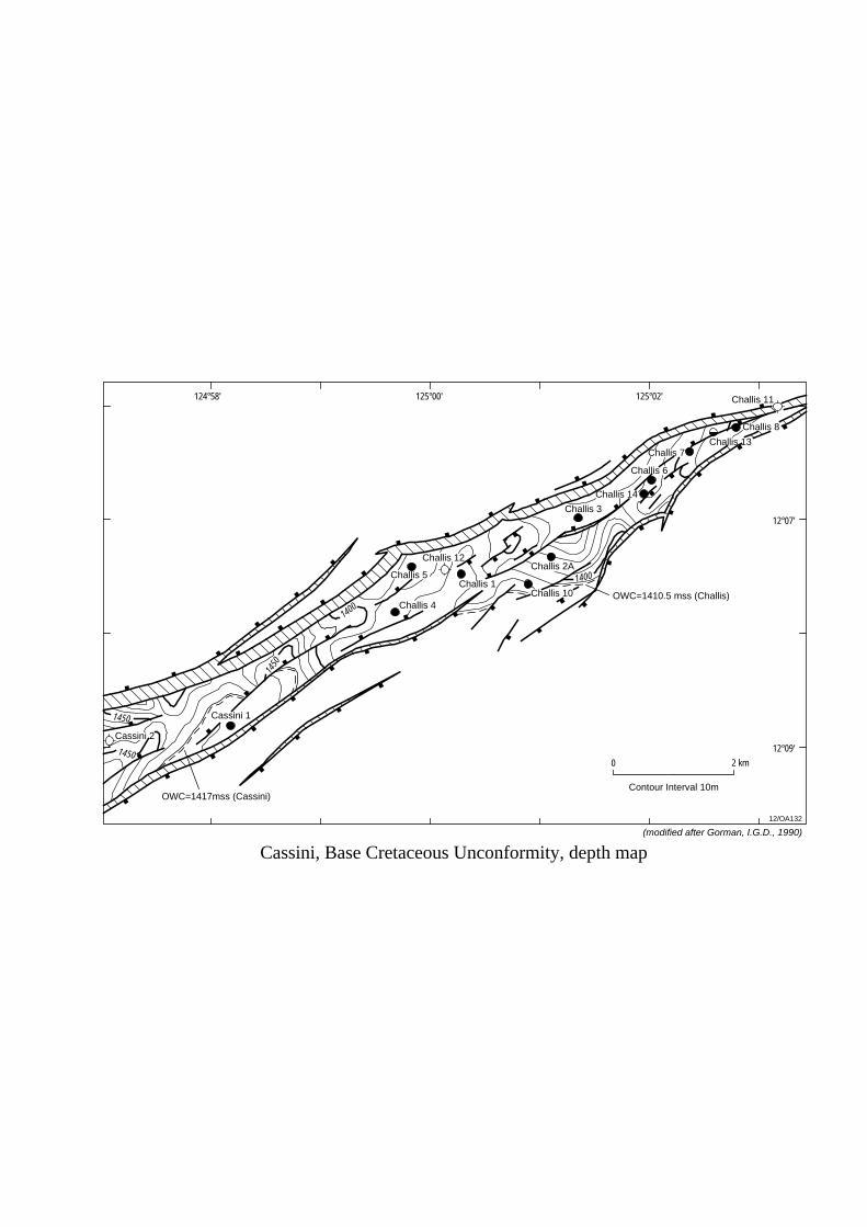
0 2 km
12/OA132
125°00'
Challis 4
Challis 5
Challis 12
Challis 1Challis 10
Challis 2A
Challis 3
Challis 14
Challis 6
Challis 7Challis 13
Challis 8
Challis 11
Cassini 1
Cassini 2
Cassini, Base Cretaceous Unconformity, depth map
1400
1450
1450
1450
1400
124°58' 125°02'
12°07'
12°09'
(modified after Gorman, I.G.D., 1990)
OWC=1417mss (Cassini)
OWC=1410.5 mss (Challis)
Contour Interval 10m
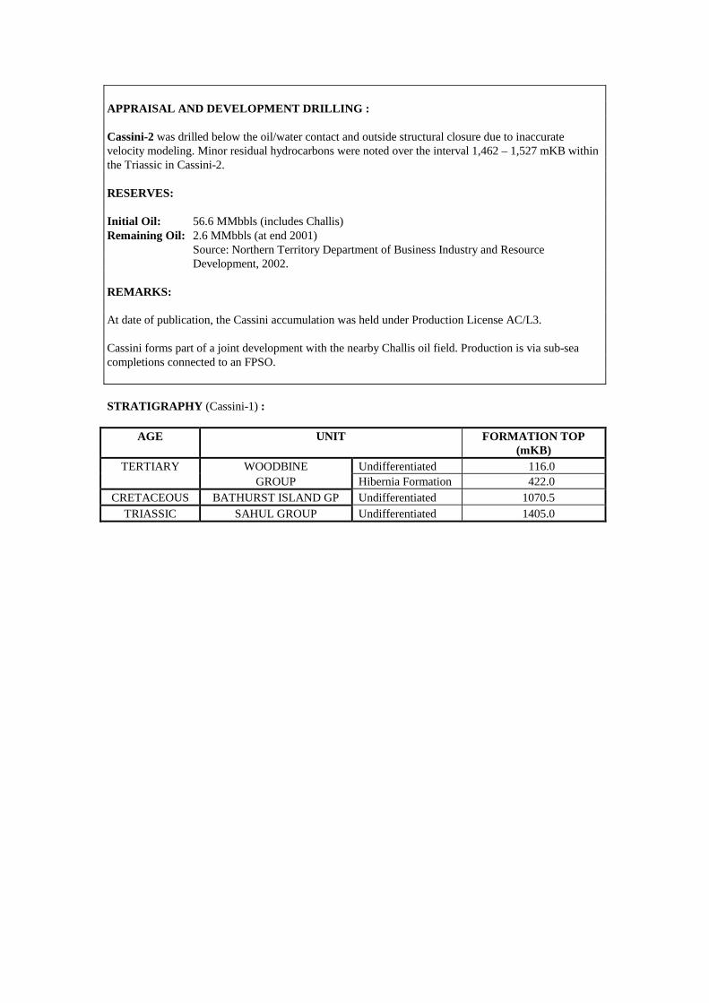
APPRAISAL AND DEVELOPMENT DRILLING : Cassini-2 was drilled below the oil/water contact and outside structural closure due to inaccurate velocity modeling. Minor residual hydrocarbons were noted over the interval 1,462 – 1,527 mKB within the Triassic in Cassini-2. RESERVES: Initial Oil: 56.6 MMbbls (includes Challis) Remaining Oil: 2.6 MMbbls (at end 2001) Source: Northern Territory Department of Business Industry and Resource Development, 2002. REMARKS: At date of publication, the Cassini accumulation was held under Production License AC/L3. Cassini forms part of a joint development with the nearby Challis oil field. Production is via sub-sea completions connected to an FPSO. STRATIGRAPHY (Cassini-1) :
AGE UNIT FORMATION TOP (mKB)
TERTIARY WOODBINE Undifferentiated 116.0 GROUP Hibernia Formation 422.0
CRETACEOUS BATHURST ISLAND GP Undifferentiated 1070.5 TRIASSIC SAHUL GROUP Undifferentiated 1405.0
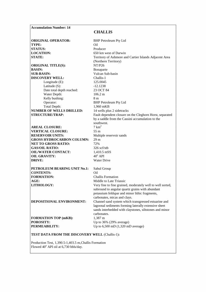
Accumulation Number: 14 CHALLIS
ORIGINAL OPERATOR: BHP Petroleum Pty Ltd TYPE: Oil STATUS: Producer LOCATION: 650 km west of Darwin STATE: Territory of Ashmore and Cartier Islands Adjacent Area (Northern Territory) ORIGINAL TITLE(S): NT/P26 BASIN: Bonaparte SUB-BASIN: Vulcan Sub-basin DISCOVERY WELL: Challis-1 Longitude (E): 125.0045 Latitude (S): -12.1238 Date total depth reached: 23 OCT 84 Water Depth: 106.2 m Kelly bushing: 8 m Operator: BHP Petroleum Pty Ltd Total Depth: 1,960 mKB NUMBER OF WELLS DRILLED: 14 wells plus 2 sidetracks STRUCTURE/TRAP: Fault dependent closure on the Cleghorn Horst, separated by a saddle from the Cassini accumulation to the southwest. AREAL CLOSURE: 7 km2
VERTICAL CLOSURE: 55 m RESERVOIR UNITS: Multiple reservoir sands GROSS HYDROCARBON COLUMN: 29 m NET TO GROSS RATIO: 72% GAS/OIL RATIO: 326 scf/stb OIL/WATER CONTACT: 1,410.5 mSS OIL GRAVITY: 40o API DRIVE: Water Drive PETROLEUM BEARING UNIT No.1: Sahul Group CONTENTS: Oil FORMATION: Challis Formation AGE: Middle to Late Triassic LITHOLOGY: Very fine to fine grained, moderately well to well sorted, subround to angular quartz grains with abundant potassium feldspar and minor lithic fragments, carbonates, micas and clays. DEPOSITIONAL ENVIRONMENT: Channel sand system which transgressed estuarine and lagoonal sediments forming laterally extensive sheet sands interbedded with claystones, siltstones and minor carbonates. FORMATION TOP (mKB): 1,387 m POROSITY: Up to 36% (29% average) PERMEABILITY: Up to 6,500 mD (1,320 mD average) TEST DATA FROM THE DISCOVERY WELL (Challis-1): Production Test, 1,390.5-1,403.5 m, Challis Formation Flowed 40o API oil at 6,730 bbls/day.
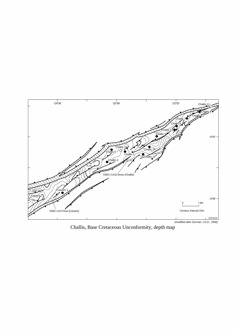
0 1 km
12/OA133
125°00'
Challis 4
Challis 5
Challis 12
Challis 1Challis 10
Challis 2A
Challis 3
Challis 14
Challis 6
Challis 7Challis 13
Challis 8
Challis 11
Cassini 1
Cassini 2
Challis, Base Cretaceous Unconformity, depth map
1400
1450
1450
124°58' 125°02'
12°07'
12°09'
(modified after Gorman, I.G.D., 1990)
Contour Interval 10m
OWC=1410.5mss (Challis)
OWC=1417mss (Cassini)
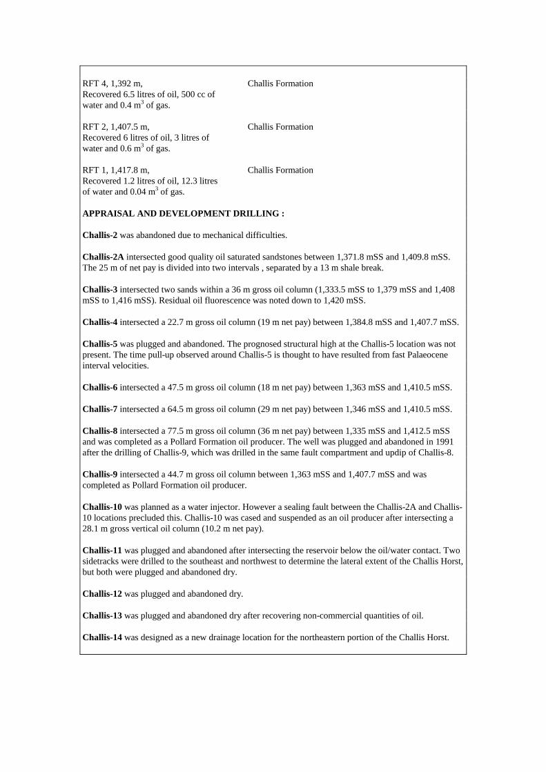
RFT 4, 1,392 m, Challis Formation Recovered 6.5 litres of oil, 500 cc of water and 0.4 m3 of gas. RFT 2, 1,407.5 m, Challis Formation Recovered 6 litres of oil, 3 litres of water and 0.6 m3 of gas. RFT 1, 1,417.8 m, Challis Formation Recovered 1.2 litres of oil, 12.3 litres of water and 0.04 m3 of gas. APPRAISAL AND DEVELOPMENT DRILLING : Challis-2 was abandoned due to mechanical difficulties. Challis-2A intersected good quality oil saturated sandstones between 1,371.8 mSS and 1,409.8 mSS. The 25 m of net pay is divided into two intervals , separated by a 13 m shale break. Challis-3 intersected two sands within a 36 m gross oil column (1,333.5 mSS to 1,379 mSS and 1,408 mSS to 1,416 mSS). Residual oil fluorescence was noted down to 1,420 mSS. Challis-4 intersected a 22.7 m gross oil column (19 m net pay) between 1,384.8 mSS and 1,407.7 mSS. Challis-5 was plugged and abandoned. The prognosed structural high at the Challis-5 location was not present. The time pull-up observed around Challis-5 is thought to have resulted from fast Palaeocene interval velocities. Challis-6 intersected a 47.5 m gross oil column (18 m net pay) between 1,363 mSS and 1,410.5 mSS. Challis-7 intersected a 64.5 m gross oil column (29 m net pay) between 1,346 mSS and 1,410.5 mSS. Challis-8 intersected a 77.5 m gross oil column (36 m net pay) between 1,335 mSS and 1,412.5 mSS and was completed as a Pollard Formation oil producer. The well was plugged and abandoned in 1991 after the drilling of Challis-9, which was drilled in the same fault compartment and updip of Challis-8. Challis-9 intersected a 44.7 m gross oil column between 1,363 mSS and 1,407.7 mSS and was completed as Pollard Formation oil producer. Challis-10 was planned as a water injector. However a sealing fault between the Challis-2A and Challis-10 locations precluded this. Challis-10 was cased and suspended as an oil producer after intersecting a 28.1 m gross vertical oil column (10.2 m net pay). Challis-11 was plugged and abandoned after intersecting the reservoir below the oil/water contact. Two sidetracks were drilled to the southeast and northwest to determine the lateral extent of the Challis Horst, but both were plugged and abandoned dry. Challis-12 was plugged and abandoned dry. Challis-13 was plugged and abandoned dry after recovering non-commercial quantities of oil. Challis-14 was designed as a new drainage location for the northeastern portion of the Challis Horst.
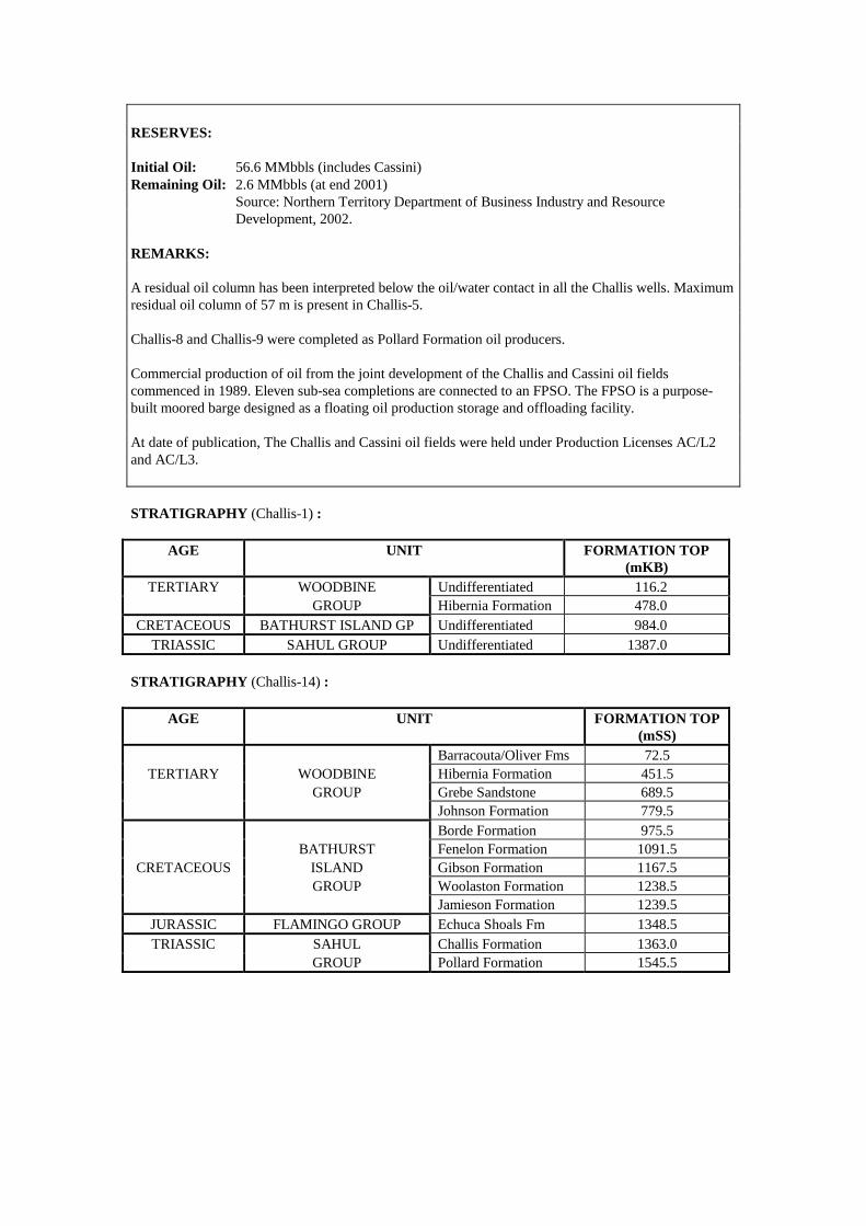
RESERVES: Initial Oil: 56.6 MMbbls (includes Cassini) Remaining Oil: 2.6 MMbbls (at end 2001) Source: Northern Territory Department of Business Industry and Resource Development, 2002. REMARKS: A residual oil column has been interpreted below the oil/water contact in all the Challis wells. Maximum residual oil column of 57 m is present in Challis-5. Challis-8 and Challis-9 were completed as Pollard Formation oil producers. Commercial production of oil from the joint development of the Challis and Cassini oil fields commenced in 1989. Eleven sub-sea completions are connected to an FPSO. The FPSO is a purpose-built moored barge designed as a floating oil production storage and offloading facility. At date of publication, The Challis and Cassini oil fields were held under Production Licenses AC/L2 and AC/L3. STRATIGRAPHY (Challis-1) :
AGE UNIT FORMATION TOP (mKB)
TERTIARY WOODBINE Undifferentiated 116.2 GROUP Hibernia Formation 478.0
CRETACEOUS BATHURST ISLAND GP Undifferentiated 984.0 TRIASSIC SAHUL GROUP Undifferentiated 1387.0
STRATIGRAPHY (Challis-14) :
AGE UNIT FORMATION TOP (mSS)
Barracouta/Oliver Fms 72.5 TERTIARY WOODBINE Hibernia Formation 451.5
GROUP Grebe Sandstone 689.5 Johnson Formation 779.5 Borde Formation 975.5 BATHURST Fenelon Formation 1091.5
CRETACEOUS ISLAND Gibson Formation 1167.5 GROUP Woolaston Formation 1238.5 Jamieson Formation 1239.5
JURASSIC FLAMINGO GROUP Echuca Shoals Fm 1348.5 TRIASSIC SAHUL Challis Formation 1363.0
GROUP Pollard Formation 1545.5

Accumulation Number: 15 CHUDITCH
ORIGINAL OPERATOR: Shell Development (PSC 9) Pty Ltd TYPE: Gas STATUS: Other Discovery LOCATION: 380 km northwest of Darwin STATE: Zone of Cooperation, Part A ORIGINAL TITLE(S): ZOCA 91-09 BASIN: Bonaparte SUB-BASIN: Sahul Platform DISCOVERY WELL: Chuditch-1 Longitude (E): 128.0985 Latitude (S): -10.5616 Date total depth reached: 1 NOV 98 Water Depth: 64 m Kelly bushing: 25 m Operator: Shell Development (PSC 9) Pty Ltd Total Depth: 3,035 mRT NUMBER OF WELLS DRILLED: 1 VERTICAL CLOSURE: 26 m (at Top Plover Formation) NET PAY: 19.6 m NET TO GROSS RATIO: 78% GAS/CONDENSATE RATIO: 0.7 bbls/MMscf PETROLEUM BEARING UNIT No.1: Troughton Group CONTENTS: Gas FORMATION: Plover Formation AGE: Middle Jurassic (Bathonian to Bajocian) LITHOLOGY: Sandstone with minor interbedded claystone and a trace of coal. Sandstone: light brownish grey to dark olive grey, clear to translucent, rare grayish yellow, very hard, massive, fine to medium grained, sub-angular, rare sub- rounded, sub-spherical, very well to moderately sorted with minor to common quartz overgrowths, common to abundant siliceous cement, rare lithics, trace of nodular pyrite, poor to fair intergranular porosity. DEPOSITIONAL ENVIRONMENT: Deltaic to shallow marine. FORMATION TOP (mTVDSS): 2,894 mTVDSS POROSITY: 6% to 18% (12.5% average), (core data). TEST DATA FROM THE DISCOVERY WELL (Chuditch-1): MDT 1, Run 3, 2,934 m Plover Formation Recovered 6.9 m3 of gas, 1.2 litres of mud filtrate from the 6 gallon chamber. Recovered 54 litres of gas from the 1 gallon chamber. MDT 2, Run 3, 3,004 m Plover Formation Recovered 6.1 litres of oily mud filtrate and mud and 2.5 litres of water from the 2.75 gallon chamber.
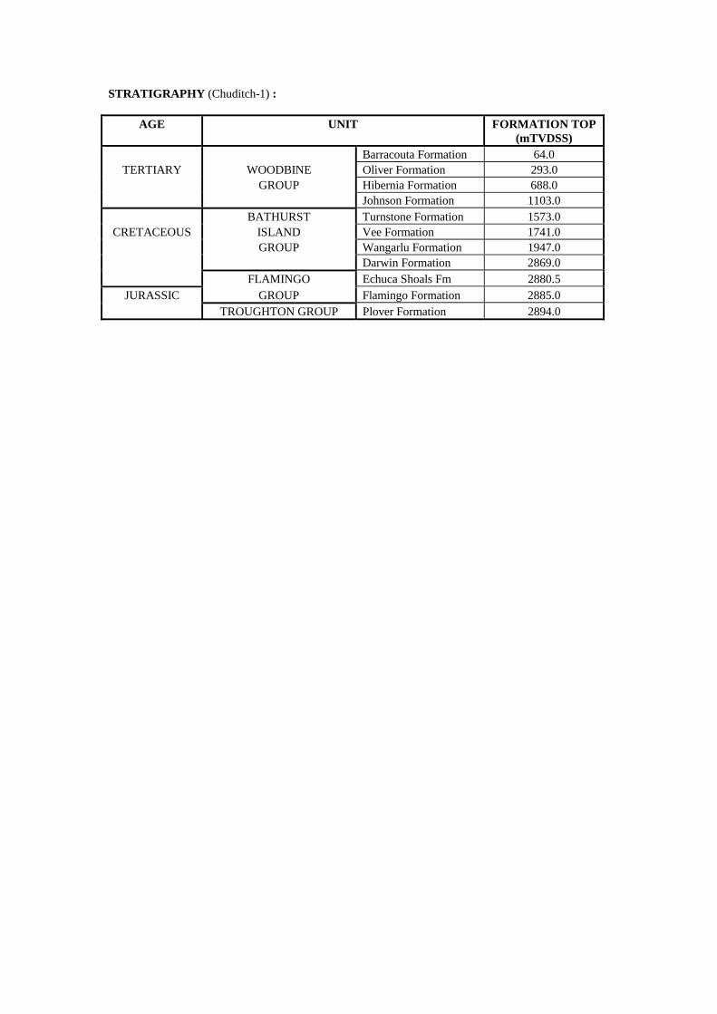
STRATIGRAPHY (Chuditch-1) :
AGE UNIT FORMATION TOP (mTVDSS)
Barracouta Formation 64.0 TERTIARY WOODBINE Oliver Formation 293.0
GROUP Hibernia Formation 688.0 Johnson Formation 1103.0 BATHURST Turnstone Formation 1573.0
CRETACEOUS ISLAND Vee Formation 1741.0 GROUP Wangarlu Formation 1947.0 Darwin Formation 2869.0 FLAMINGO Echuca Shoals Fm 2880.5
JURASSIC GROUP Flamingo Formation 2885.0 TROUGHTON GROUP Plover Formation 2894.0

Accumulation Number: 16 CORALLINA
ORIGINAL OPERATOR: Woodside Petroleum Development Pty Ltd TYPE: Oil STATUS: Producer LOCATION: 570 km northwest of Darwin STATE: Territory of Ashmore and Cartier Islands Adjacent Area (Northern Territory) ORIGINAL TITLE(S): AC/P8 BASIN: Bonaparte SUB-BASIN: Laminaria High, Sahul Platform DISCOVERY WELL: Corallina-1 Longitude (E): 125.9560 Latitude (S): -10.5917 Date total depth reached: 21 DEC 95 Water Depth: 411 m Kelly bushing: 22 m Operator: Woodside Petroleum Development Pty Ltd Total Depth: 3,340 mKB NUMBER OF WELLS DRILLED: 2 STRUCTURE/TRAP: Fault dependent closure on the Corallina Horst. AREAL CLOSURE: 11 km 2 VERTICAL CLOSURE: 140 m RESERVOIR UNITS: 1 GROSS HYDROCARBON COLUMN: 77 m NET TO GROSS RATIO: 90% HYDROCARBON SATURATION: 79% GAS/OIL RATIO: 239 scf/stb BUBBLE POINT: 350 psig at 84oF OIL GRAVITY: 60o API BOTTOM HOLE TEMPERATURE: 120oC PETROLEUM BEARING UNIT No.1: Flamingo Group CONTENTS: Oil FORMATION: Laminaria/Elang Formation (basal sand unit of the
Flamingo Group) AGE: Middle Jurassic (Callovian) LITHOLOGY: Sandstone: fine to medium grained, partly pyritic with
silica cement at the top, grading to interbedded sandstone, siltstone and claystone towards the base of the unit. The uppermost 12 m of reservoir comprises siltstone and and very fine grained, argillaceous sandstone of poor reservoir quality.
DEPOSITIONAL ENVIRONMENT: Transgressive, estuarine dominated delta. FORMATION TOP: 3,154 mKB POROSITY: 15.2% (average log porosity) 15.7% (average core porosity) PERMEABILITY: 597 mD (average from core) TEST DATA FROM THE DISCOVERY WELL (Corallina-1): Production Test, 3,186-3,196 m, Laminaria/Elang Formation Flowed 60o API oil 7,800 bbls/day and gas at 10,477 m3/day through a 16 mm choke at 870 psi and 136oF.
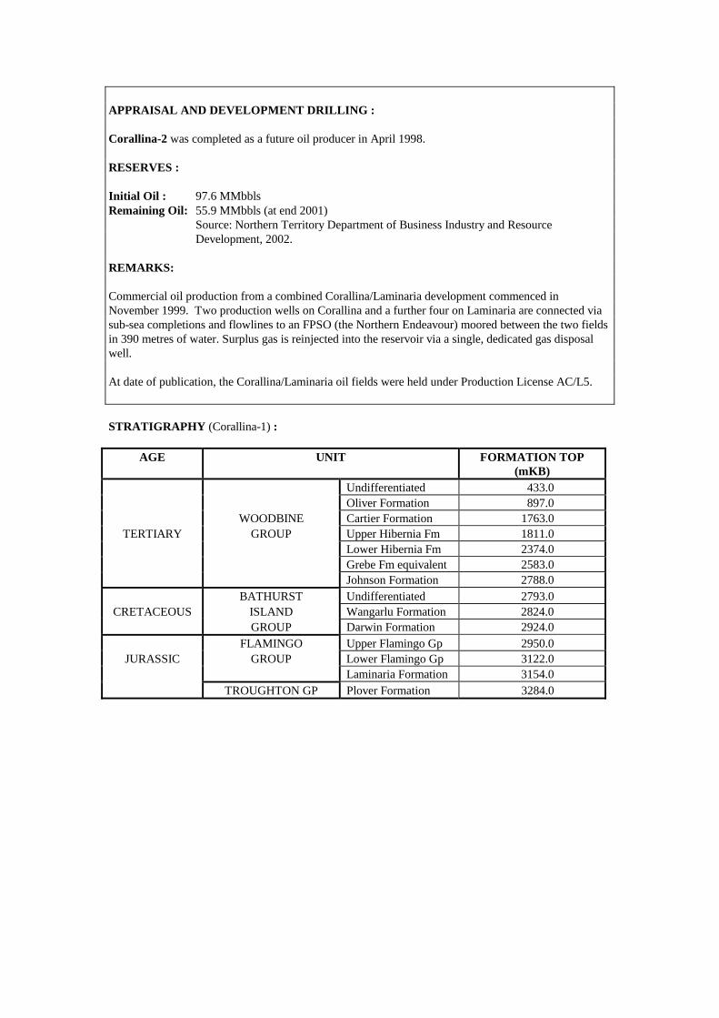
APPRAISAL AND DEVELOPMENT DRILLING : Corallina-2 was completed as a future oil producer in April 1998. RESERVES : Initial Oil : 97.6 MMbbls Remaining Oil: 55.9 MMbbls (at end 2001) Source: Northern Territory Department of Business Industry and Resource Development, 2002. REMARKS: Commercial oil production from a combined Corallina/Laminaria development commenced in November 1999. Two production wells on Corallina and a further four on Laminaria are connected via sub-sea completions and flowlines to an FPSO (the Northern Endeavour) moored between the two fields in 390 metres of water. Surplus gas is reinjected into the reservoir via a single, dedicated gas disposal well. At date of publication, the Corallina/Laminaria oil fields were held under Production License AC/L5. STRATIGRAPHY (Corallina-1) :
AGE UNIT FORMATION TOP (mKB)
Undifferentiated 433.0 Oliver Formation 897.0 WOODBINE Cartier Formation 1763.0
TERTIARY GROUP Upper Hibernia Fm 1811.0 Lower Hibernia Fm 2374.0 Grebe Fm equivalent 2583.0 Johnson Formation 2788.0 BATHURST Undifferentiated 2793.0
CRETACEOUS ISLAND Wangarlu Formation 2824.0 GROUP Darwin Formation 2924.0 FLAMINGO Upper Flamingo Gp 2950.0
JURASSIC GROUP Lower Flamingo Gp 3122.0 Laminaria Formation 3154.0 TROUGHTON GP Plover Formation 3284.0
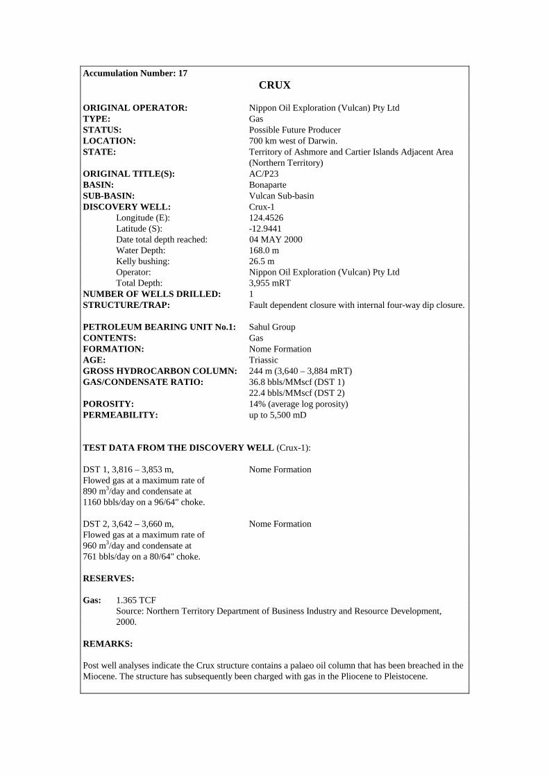
Accumulation Number: 17 CRUX
ORIGINAL OPERATOR: Nippon Oil Exploration (Vulcan) Pty Ltd TYPE: Gas STATUS: Possible Future Producer LOCATION: 700 km west of Darwin. STATE: Territory of Ashmore and Cartier Islands Adjacent Area (Northern Territory) ORIGINAL TITLE(S): AC/P23 BASIN: Bonaparte SUB-BASIN: Vulcan Sub-basin DISCOVERY WELL: Crux-1 Longitude (E): 124.4526 Latitude (S): -12.9441 Date total depth reached: 04 MAY 2000 Water Depth: 168.0 m Kelly bushing: 26.5 m Operator: Nippon Oil Exploration (Vulcan) Pty Ltd Total Depth: 3,955 mRT NUMBER OF WELLS DRILLED: 1 STRUCTURE/TRAP: Fault dependent closure with internal four-way dip closure. PETROLEUM BEARING UNIT No.1: Sahul Group CONTENTS: Gas FORMATION: Nome Formation AGE: Triassic GROSS HYDROCARBON COLUMN: 244 m (3,640 – 3,884 mRT) GAS/CONDENSATE RATIO: 36.8 bbls/MMscf (DST 1) 22.4 bbls/MMscf (DST 2) POROSITY: 14% (average log porosity) PERMEABILITY: up to 5,500 mD TEST DATA FROM THE DISCOVERY WELL (Crux-1): DST 1, 3,816 – 3,853 m, Nome Formation Flowed gas at a maximum rate of 890 m3/day and condensate at 1160 bbls/day on a 96/64" choke. DST 2, 3,642 – 3,660 m, Nome Formation Flowed gas at a maximum rate of 960 m3/day and condensate at 761 bbls/day on a 80/64" choke. RESERVES: Gas: 1.365 TCF Source: Northern Territory Department of Business Industry and Resource Development, 2000. REMARKS: Post well analyses indicate the Crux structure contains a palaeo oil column that has been breached in the Miocene. The structure has subsequently been charged with gas in the Pliocene to Pleistocene.
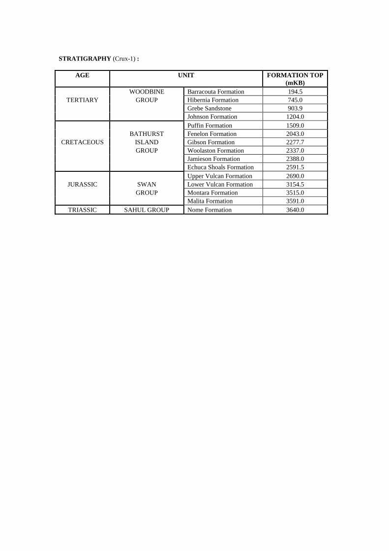
STRATIGRAPHY (Crux-1) :
AGE UNIT FORMATION TOP (mKB)
WOODBINE Barracouta Formation 194.5 TERTIARY GROUP Hibernia Formation 745.0
Grebe Sandstone 903.9 Johnson Formation 1204.0 Puffin Formation 1509.0 BATHURST Fenelon Formation 2043.0
CRETACEOUS ISLAND Gibson Formation 2277.7 GROUP Woolaston Formation 2337.0 Jamieson Formation 2388.0 Echuca Shoals Formation 2591.5 Upper Vulcan Formation 2690.0
JURASSIC SWAN Lower Vulcan Formation 3154.5 GROUP Montara Formation 3515.0 Malita Formation 3591.0
TRIASSIC SAHUL GROUP Nome Formation 3640.0
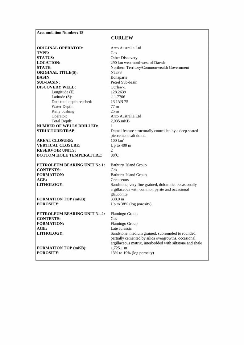
Accumulation Number: 18 CURLEW
ORIGINAL OPERATOR: Arco Australia Ltd TYPE: Gas STATUS: Other Discovery LOCATION: 290 km west-northwest of Darwin STATE: Northern Territory/Commonwealth Government ORIGINAL TITLE(S): NT/P3 BASIN: Bonaparte SUB-BASIN: Petrel Sub-basin DISCOVERY WELL: Curlew-1 Longitude (E): 128.2639 Latitude (S): -11.7706 Date total depth reached: 13 JAN 75 Water Depth: 77 m Kelly bushing: 25 m Operator: Arco Australia Ltd Total Depth: 2,035 mKB NUMBER OF WELLS DRILLED: 1 STRUCTURE/TRAP: Domal feature structurally controlled by a deep seated piercement salt dome. AREAL CLOSURE: 100 km2
VERTICAL CLOSURE: Up to 400 m RESERVOIR UNITS: 2 BOTTOM HOLE TEMPERATURE: 88oC PETROLEUM BEARING UNIT No.1: Bathurst Island Group CONTENTS: Gas FORMATION: Bathurst Island Group AGE: Cretaceous LITHOLOGY: Sandstone, very fine grained, dolomitic, occasionally argillaceous with common pyrite and occasional glauconite. FORMATION TOP (mKB): 338.9 m POROSITY: Up to 38% (log porosity) PETROLEUM BEARING UNIT No.2: Flamingo Group CONTENTS: Gas FORMATION: Flamingo Group AGE: Late Jurassic LITHOLOGY: Sandstone, medium grained, subrounded to rounded, partially cemented by silica overgrowths, occasional argillaceous matrix, interbedded with siltstone and shale FORMATION TOP (mKB): 1,725.1 m POROSITY: 13% to 19% (log porosity)
128°20'
0 5 km
12/OA/134
7000
Curlew 1
Curlew, Near Base Cretaceous, depth map
8000
8000
8000
6000
6000
11°40'
11°45'
11°50'
128°15'
Contour Interval 250 feet
TEST DATA FROM THE DISCOVERY WELL (Curlew-1): FIT 1, 595.6 m, Bathurst Island Formation Recovered 18.5 litres of water and 0.014 m3 of gas. FIT 3, 1,729.8 m, Flamingo Group Recovered 17.4 litres of filtrate and 0.009 m3 of gas. FIT 2, 1,735.8 m, Flamingo Group Recovered 0.014 m3 of gas and 20.25 litres of filtrate. DST 3, 1,731-1,740 m, Flamingo Group Recovered 113 m of water and mud and 1,559 m of salt water. DST 2, 1,731-1,740 m, Flamingo Group Recovered 122 m of water and mud and 1,560 m of salt water. FIT 4, 1,746.5 m, Flamingo Group Recovered 300 cc of oil, 0.015 m3 of gas and 20.7 litres of filtrate. FIT 6, 1,770.9 m, Flamingo Group Recovered 1 litre of mud. FIT 5, 1,772.7 m, Flamingo Group Recovered 400 cc of mud. DST 1, 1,774-1,782 m, Flamingo Group Recovered 91 m of water and mud and 1,501 m of salt water. REMARKS : Analysis of the 300 cc of ‘oil’ recovered in FIT 4 indicates that this sample is probably diesel oil contamination. It is possible that the gas recovered from the Bathurst Island and Flamingo Groups at Curlew is solution gas. STRATIGRAPHY (Curlew-1) :
AGE UNIT FORMATION TOP (mKB)
TERTIARY WOODBINE GROUP Undifferentiated 102.7 CRETACEOUS BATHURST ISLAND GP Undifferentiated 338.9
JURASSIC FLAMINGO GROUP Undifferentiated 1725.1
Accumulation Number: 19 DELAMERE
ORIGINAL OPERATOR: BHP Petroleum Ltd TYPE: Gas STATUS: Other Discovery LOCATION: 600 km west of Darwin STATE: Territory of Ashmore and Cartier Islands Adjacent Area (Northern Territory) ORIGINAL TITLE(S): AC/P4 BASIN: Bonaparte SUB-BASIN: Vulcan Sub-basin DISCOVERY WELL: Delamere-1 Longitude (E): 125.3042 Latitude (S): -12.0005 Date total depth reached: 20 AUG 90 Water Depth: 101 m Kelly bushing: 22 m Operator: BHP Petroleum Ltd Total Depth: 1,530 mKB NUMBER OF WELLS DRILLED: 1 STRUCTURE/TRAP: Fault dependent closure (tilted fault block) AREAL CLOSURE: 1 km2 VERTICAL CLOSURE: 10 m RESERVOIR UNITS: 1 GROSS GAS PAY: 9 m (1,267.5 – 1,276.6 mKB) GAS/WATER CONTACT: 1,276.6 mKB (from RFT data) NET TO GROSS RATIO: 95% HYDROCARBON SATURATION: 69% RESERVOIR PRESSURE: 1,848 psia FORMATION TEMPERATURE: 61oC (at 1,508.9 mKB, after 0.83 hours circulation, 11.33 hours post circulation) PETROLEUM BEARING UNIT No.1: Flamingo Group CONTENTS: Gas FORMATION: Flamingo Group AGE: Late Jurassic to Early Cretaceous LITHOLOGY: Sandstone, very coarse grained, subrounded to well rounded, well sorted, moderate to high sphericity, glauconitic in part, quartzose. DEPOSITIONAL ENVIRONMENT: Lower shoreface environment at base of reservoir section to a coastal plain environment at the top (high stand systems tract). FORMATION TOP (mKB): 1,267 m POROSITY: 26.6% (average log porosity) PERMEABILITY: 8.5-184 mD (core analysis) 1,700 mD (average from RFT data) TEST DATA FROM THE DISCOVERY WELL (Delamere-1): RFT 1, 1,276.9 m Flamingo Group Recovered 0.0014 m3 of gas and 3.6 litres of filtrate and water. RFT 2, 1,274 m, Flamingo Group Recovered 8.9 m3 of gas and 1.8 litres of filtrate and water with a trace of oil.

12/OA/135
1000
1000
1050
1050
1070
1070
1070
1050
990
990
980
970960
950
940
960
1070
1060
1060
Delamere 1
0 1 km
Delamere, Intra Valanginian, TWT map
Contour Interval 10ms
125°18' 125°20'
11°00'
13°00'
GWC
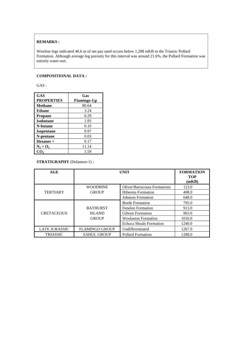
REMARKS : Wireline logs indicated 46.6 m of net pay sand occurs below 1,288 mKB in the Triassic Pollard Formation. Although average log porosity for this interval was around 21.6%, the Pollard Formation was entirely water-wet. COMPOSITIONAL DATA : GAS : GAS PROPERTIES
Gas Flamingo Gp
Methane 80.64 Ethane 3.24 Propane 0.29 Isobutane 1.83 N-butane 0.10 Isopentane 0.97 N-pentane 0.03 Hexanes + 0.17 N2 + O2 11.14 CO2 1.59 STRATIGRAPHY (Delamere-1) :
AGE UNIT FORMATION TOP
(mKB) WOODBINE Oliver/Barracouta Formations 123.0
TERTIARY GROUP Hibernia Formation 408.0 Johnson Formation 648.0 Borde Formation 795.0 BATHURST Fenelon Formation 913.0
CRETACEOUS ISLAND Gibson Formation 963.0 GROUP Woolaston Formation 1016.0 Echuca Shoals Formation 1240.0
LATE JURASSIC FLAMINGO GROUP Undifferentiated 1267.0 TRIASSIC SAHUL GROUP Pollard Formation 1288.0
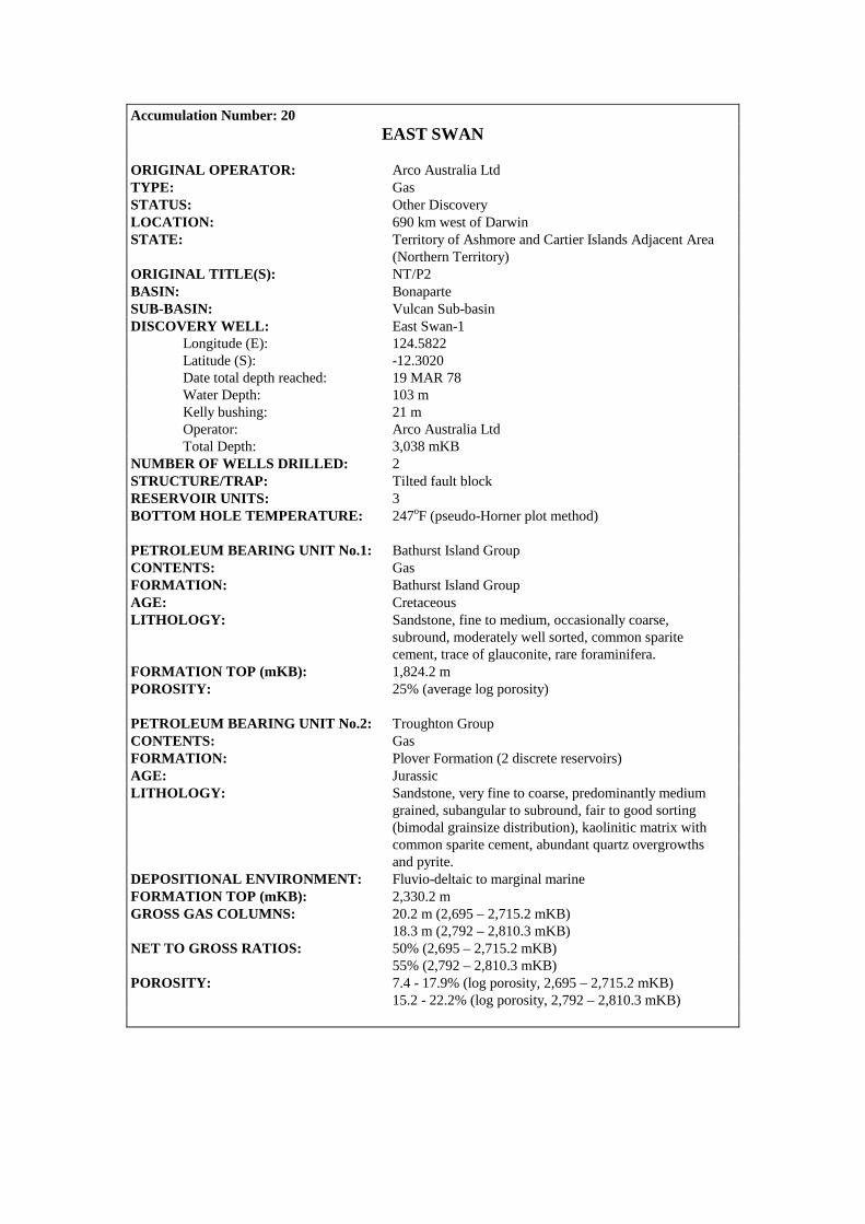
Accumulation Number: 20 EAST SWAN
ORIGINAL OPERATOR: Arco Australia Ltd TYPE: Gas STATUS: Other Discovery LOCATION: 690 km west of Darwin STATE: Territory of Ashmore and Cartier Islands Adjacent Area (Northern Territory) ORIGINAL TITLE(S): NT/P2 BASIN: Bonaparte SUB-BASIN: Vulcan Sub-basin DISCOVERY WELL: East Swan-1 Longitude (E): 124.5822 Latitude (S): -12.3020 Date total depth reached: 19 MAR 78 Water Depth: 103 m Kelly bushing: 21 m Operator: Arco Australia Ltd Total Depth: 3,038 mKB NUMBER OF WELLS DRILLED: 2 STRUCTURE/TRAP: Tilted fault block RESERVOIR UNITS: 3 BOTTOM HOLE TEMPERATURE: 247oF (pseudo-Horner plot method) PETROLEUM BEARING UNIT No.1: Bathurst Island Group CONTENTS: Gas FORMATION: Bathurst Island Group AGE: Cretaceous LITHOLOGY: Sandstone, fine to medium, occasionally coarse, subround, moderately well sorted, common sparite cement, trace of glauconite, rare foraminifera. FORMATION TOP (mKB): 1,824.2 m POROSITY: 25% (average log porosity) PETROLEUM BEARING UNIT No.2: Troughton Group CONTENTS: Gas FORMATION: Plover Formation (2 discrete reservoirs) AGE: Jurassic LITHOLOGY: Sandstone, very fine to coarse, predominantly medium grained, subangular to subround, fair to good sorting (bimodal grainsize distribution), kaolinitic matrix with common sparite cement, abundant quartz overgrowths and pyrite. DEPOSITIONAL ENVIRONMENT: Fluvio-deltaic to marginal marine FORMATION TOP (mKB): 2,330.2 m GROSS GAS COLUMNS: 20.2 m (2,695 – 2,715.2 mKB) 18.3 m (2,792 – 2,810.3 mKB) NET TO GROSS RATIOS: 50% (2,695 – 2,715.2 mKB) 55% (2,792 – 2,810.3 mKB) POROSITY: 7.4 - 17.9% (log porosity, 2,695 – 2,715.2 mKB) 15.2 - 22.2% (log porosity, 2,792 – 2,810.3 mKB)
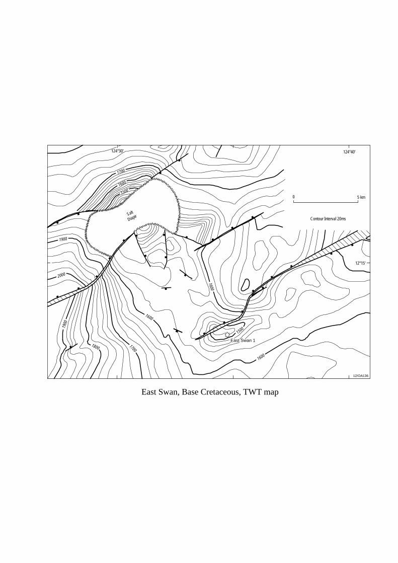
12/OA136
0 5 km
124°40'124°30'
1600
1600
1700
1800
1900
1600
1700
1600
1500
2000
1900
East Swan, Base Cretaceous, TWT map
East Swan 1
1500
Contour Interval 20ms
12°15'
Salt
Diapir
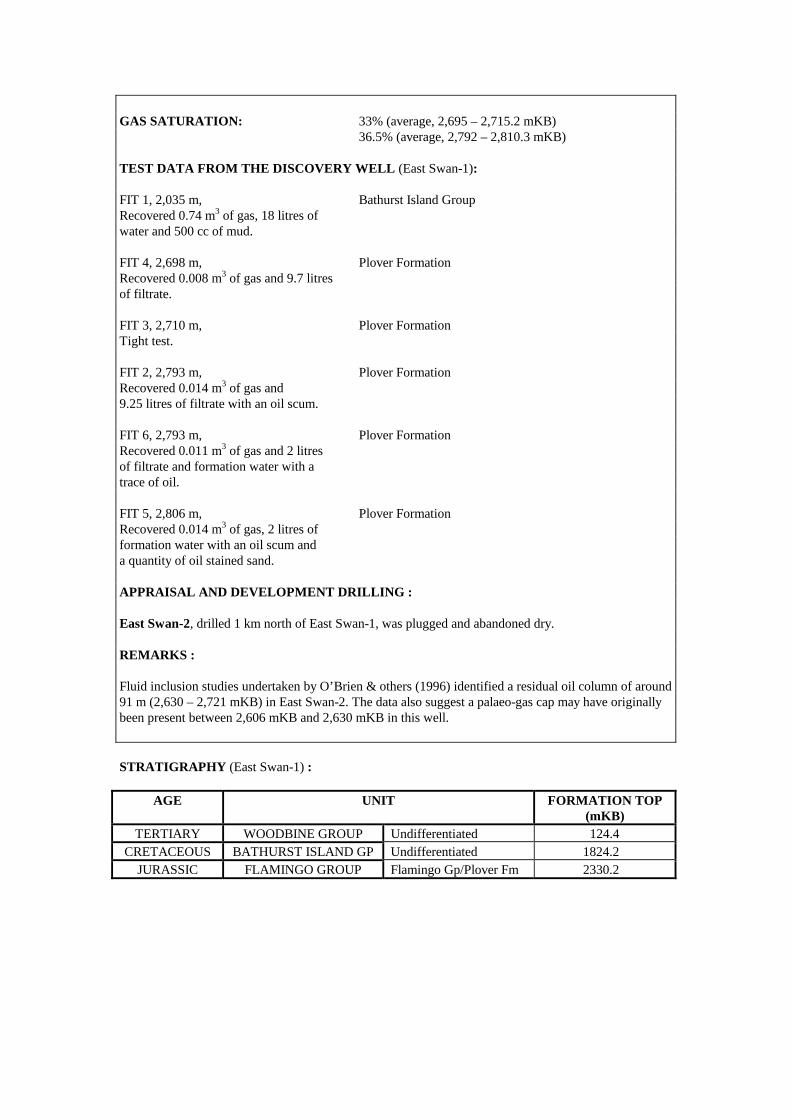
GAS SATURATION: 33% (average, 2,695 – 2,715.2 mKB) 36.5% (average, 2,792 – 2,810.3 mKB) TEST DATA FROM THE DISCOVERY WELL (East Swan-1): FIT 1, 2,035 m, Bathurst Island Group Recovered 0.74 m3 of gas, 18 litres of water and 500 cc of mud. FIT 4, 2,698 m, Plover Formation Recovered 0.008 m3 of gas and 9.7 litres of filtrate. FIT 3, 2,710 m, Plover Formation Tight test. FIT 2, 2,793 m, Plover Formation Recovered 0.014 m3 of gas and 9.25 litres of filtrate with an oil scum. FIT 6, 2,793 m, Plover Formation Recovered 0.011 m3 of gas and 2 litres of filtrate and formation water with a trace of oil. FIT 5, 2,806 m, Plover Formation Recovered 0.014 m3 of gas, 2 litres of formation water with an oil scum and a quantity of oil stained sand. APPRAISAL AND DEVELOPMENT DRILLING : East Swan-2, drilled 1 km north of East Swan-1, was plugged and abandoned dry. REMARKS : Fluid inclusion studies undertaken by O’Brien & others (1996) identified a residual oil column of around 91 m (2,630 – 2,721 mKB) in East Swan-2. The data also suggest a palaeo-gas cap may have originally been present between 2,606 mKB and 2,630 mKB in this well. STRATIGRAPHY (East Swan-1) :
AGE UNIT FORMATION TOP (mKB)
TERTIARY WOODBINE GROUP Undifferentiated 124.4 CRETACEOUS BATHURST ISLAND GP Undifferentiated 1824.2
JURASSIC FLAMINGO GROUP Flamingo Gp/Plover Fm 2330.2

Accumulation Number: 21 ECLIPSE
ORIGINAL OPERATOR: BHP Petroleum Pty Ltd TYPE: Oil and Gas STATUS: Other Discovery LOCATION: 685 km west of Darwin STATE: Territory of Ashmore and Cartier Islands Adjacent Area (Northern Territory) ORIGINAL TITLE(S): AC/P2 BASIN: Bonaparte SUB-BASIN: Vulcan Sub-basin DISCOVERY WELL: Eclipse-2 Longitude (E): 124.6436 Latitude (S): -12.2384 Date total depth reached: 03 JUL 86 Water Depth: 117 m Kelly bushing: 8.3 m Operator: BHP Petroleum Pty Ltd Total Depth: 2,930 mKB NUMBER OF WELLS DRILLED: 2 STRUCTURE/TRAP: Northeast/southwest trending anticline on the Eclipse- Skua Horst. RESERVOIR UNITS: 1 BOTTOM HOLE TEMPERATURE: 95oC GAS/OIL CONTACT: 2,459.7 mKB OIL/WATER CONTACT: 2,460.2 mKB PETROLEUM BEARING UNIT No.1: Flamingo Group CONTENTS: Oil and Gas FORMATION: Flamingo Group AGE: Late Jurassic (Oxfordian) LITHOLOGY: Hydrocarbons are reservoired in a thin sandstone encountered between 2,458.5 mKB and 2,461 mKB sealed by intraformational claystone and siltstone. FORMATION TOP (mKB): 2,438 mKB (Flamingo Group) POROSITY: 10.9% to 21.8% (17% average from core) PERMEABILITY: 516 to 746 mD (622 mD average from core) TEST DATA FROM THE DISCOVERY WELL (Eclipse-2): RFT, 2,457.5 m, Flamingo Group Recovered 1.6 m3 of gas, 550 cc of filtrate and 50 cc of oil. RFT, 2,460.7 m, Flamingo Group Recovered mud filtrate, formation water and a minor quantity of oil.

2600
2600
2700
2700
2700
2700
2700
2700
2800
2800
2800
2600
Eclipse 1
Eclipse 2
12/OA/137
0 2 km
Eclipse, Intra Flamingo Group, TWT map
Contour Interval = 20m
124°34' 124°36' 124°38'
12°14'
12°16'
12°18'
2900
2900
3000
2900
2900
APPRAISAL AND DEVELOPMENT DRILLING : Eclipse-1, (planned as an updip test of the sandstones which exhibited oil shows in East Swan-1), was plugged and abandoned as a dry hole after only minor fluorescence was observed while drilling the Jurassic section. REMARKS : In Eclipse-2, residual oil staining was noted between 2,787 mKB and 2,799 mKB. Post-drill analysis of Eclipse-2 indicated that complex faulting and poor seismic resolution had caused the well to be drilled into a ‘stair-step’ fault adjacent to the main bounding fault. COMPOSITIONAL DATA : GAS : GAS PROPERTIES
Gas (%) Flamingo Gp
Methane 90.9 Ethane 4.3 Propane 2.7 Isobutane 0.4 N-butane 0.7 STRATIGRAPHY (Eclipse-2) :
AGE UNIT FORMATION TOP (mKB)
TERTIARY WOODBINE GROUP Undifferentiated 117.0 Hibernia Formation 889.0
CRETACEOUS BATHURST ISLAND GP Undifferentiated 1935.0 JURASSIC FLAMINGO GROUP Undifferentiated 2438.0
TROUGHTON GROUP Plover Formation 2930.0

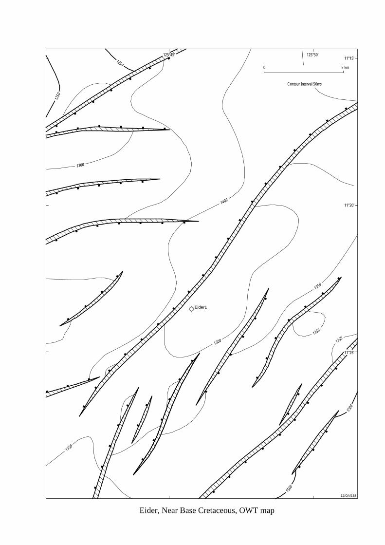
Eider1
12/OA/138
1500
1250
1250
1300
1400
1300
1350
1500
1350
1350
1350
Eider, Near Base Cretaceous, OWT map
0 5 km
Contour Interval 50ms
125°45' 125°50'
11°20'
11°15'
11°25'
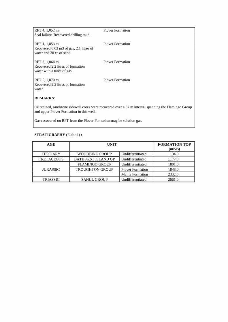
RFT 4, 1,852 m, Plover Formation Seal failure. Recovered drilling mud. RFT 1, 1,853 m, Plover Formation Recovered 0.03 m3 of gas, 2.1 litres of water and 20 cc of sand. RFT 2, 1,864 m, Plover Formation Recovered 2.2 litres of formation water with a trace of gas. RFT 5, 1,870 m, Plover Formation Recovered 2.2 litres of formation water. REMARKS: Oil stained, sandstone sidewall cores were recovered over a 37 m interval spanning the Flamingo Group and upper Plover Formation in this well. Gas recovered on RFT from the Plover Formation may be solution gas. STRATIGRAPHY (Eider-1) :
AGE UNIT FORMATION TOP (mKB)
TERTIARY WOODBINE GROUP Undifferentiated 134.0 CRETACEOUS BATHURST ISLAND GP Undifferentiated 1177.0
FLAMINGO GROUP Undifferentiated 1801.0 JURASSIC TROUGHTON GROUP Plover Formation 1848.0
Malita Formation 2332.0 TRIASSIC SAHUL GROUP Undifferentiated 2661.0
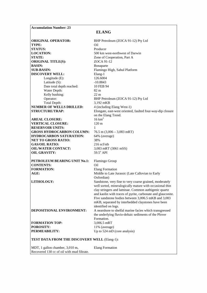
Accumulation Number: 23 ELANG
ORIGINAL OPERATOR: BHP Petroleum (ZOCA 91-12) Pty Ltd TYPE: Oil STATUS: Producer LOCATION: 500 km west-northwest of Darwin STATE: Zone of Cooperation, Part A ORIGINAL TITLE(S): ZOCA 91-12 BASIN: Bonaparte SUB-BASIN: Flamingo High, Sahul Platform DISCOVERY WELL: Elang-1 Longitude (E): 126.6004 Latitude (S): -10.8843 Date total depth reached: 10 FEB 94 Water Depth: 82 m Kelly bushing: 22 m Operator: BHP Petroleum (ZOCA 91-12) Pty Ltd Total Depth: 3,192 mKB NUMBER OF WELLS DRILLED: 4 (including Elang West-1) STRUCTURE/TRAP: Elongate, east-west oriented, faulted four-way-dip closure on the Elang Trend. AREAL CLOSURE: 16 km2 VERTICAL CLOSURE: 120 m RESERVOIR UNITS: 1 GROSS HYDROCARBON COLUMN: 76.5 m (3,006 – 3,083 mRT) HYDROCARBON SATURATION: 64% (average) NET TO GROSS RATIO: 38% GAS/OIL RATIO: 216 scf/stb OIL/WATER CONTACT: 3,083 mRT (3061 mSS) OIL GRAVITY: 59.5o API PETROLEUM BEARING UNIT No.1: Flamingo Group CONTENTS: Oil FORMATION: Elang Formation AGE: Middle to Late Jurassic (Late Callovian to Early Oxfordian) LITHOLOGY: Sandstone, very fine to very coarse grained, moderately well sorted, mineralogically mature with occasional thin clay stringers and laminae. Common authigenic quartz and kaolin with traces of pyrite, carbonate and glauconite. Five sandstone bodies between 3,006.5 mKB and 3,083 mKB, separated by interbedded claystones have been identified on logs. DEPOSITIONAL ENVIRONMENT: A nearshore to shelfal marine facies which transgressed the underlying fluvio-deltaic sediments of the Plover Formation. FORMATION TOP: 3,006.5 mRT POROSITY: 11% (average) PERMEABILITY: Up to 524 mD (core analysis) TEST DATA FROM THE DISCOVERY WELL (Elang-1): MDT, 1 gallon chamber, 3,010 m, Elang Formation Recovered 130 cc of oil with mud filtrate.

MDT, first 2.75 gallon chamber, 3,060 m, Elang Formation Recovered 2.6 litres of oil, 6.9 litres of Filtrate and 1,443 litres of gas DST (CASED) 1, 3,006.5-3,015.5 m, Elang Formation Flowed 56o API oil at 830 bbls/day through a 6 mm choke at 1,280 psi. Production Test, 3,006 – 3,115.5 m, Elang Formation Flowed 57o API oil at 5,013 bbls/day.

Elang West 1
0 2 km
12/OA/139
Elang 3Elang 1
Elang 2
3100
3000
3000
3000
3100
3100
3100
126°34' 126°36' 126°38'126°32'
10°54'
10°52'
Contour Interval 20m
Elang, Near ’Breakup Unconformity’, depth map(modified after Young et al, 1995)
DST (CASED), 3,006.5-3,068 m, Elang Formation Flowed oil at 5,800 bbls/day through a 21 mm choke. APPRAISAL AND DEVELOPMENT DRILLING : Elang-2 was drilled 1.7 km west of Elang-1 to further appraise the Elang discovery. A production test over the intervals 3,054 – 3,059 mKB and 3,062 – 3,067 mKB flow oil at a maximum stabilised rate of 6,080 bbls/day from the Elang Formation through a 16 mm choke. The oil had an API gravity of 57o and a gas/oil ratio of 400 cubic feet per barrel. The well was suspended as a possible future oil producer. Elang-3 was spudded 2 km east of Elang-1 in 1995 to appraise the northeast flank of the Elang structure. The well was plugged and abandoned after failing to encounter significant hydrocarbons in the primary objective. Elang West-1 was drilled 7 km to the west of Elang-1 in early 1995. The well flowed 40o API oil at 1,640 bbls/day through a 19 mm choke from the interval 2,822-2,983 mKB. The zone tested by Elang West-1 was stratigraphically higher than the producing zones encountered in Elang-1 and Elang-2. Elang West-1 was cased and suspended as a future oil producer. RESERVES : Oil : 17 MMbbls (includes Kakatua) Source: Department of Resources Develoment, WA, 1998. REMARKS: The Elang/Kakatua oil development commenced production in 1998. Sub-sea completions at Kakatua-1, Elang-1 and Elang-2 are connected to an FPSO (the Modec Venture 1) moored over the Elang field. STRATIGRAPHY (Elang-1) :
AGE UNIT FORMATION TOP (mKB)
Undifferentiated 104.0 TERTIARY WOODBINE Oliver Formation 476.0
GROUP Hibernia Formation 923.5 Johnson Formation 1740.5 BATHURST Upper Wangarlu Formation 2088.0 ISLAND Lower Wangarlu Formation 2488.5
CRETACEOUS GROUP ‘Radiolarite’ 2850.0 Darwin Formation 2881.5 FLAMINGO Flamingo Group 2915.o
JURASSIC GROUP Montara Formation 3006.5 TROUGHTON GROUP Plover Formation 3099.0

Accumulation Number: 24 EVANS SHOAL
ORIGINAL OPERATOR: BHP Petroleum Pty Ltd TYPE: Gas STATUS: Other Discovery LOCATION: 300 km north-northwest of Darwin STATE: Northern Territory ORIGINAL TITLE(S): NT/P40 BASIN: Bonaparte SUB-BASIN: Sahul Platform/Malita Graben DISCOVERY WELL: Evans Shoal-1 Longitude (E): 129.5320 Latitude (S): -10.0815 Date total depth reached: 18 AUG 88 Water depth: 110 m Kelly bushing: 17.7 m Operator: BHP Petroleum Pty Ltd Total Depth: 3,712 mKB NUMBER OF WELLS DRILLED: 2 STRUCTURE/TRAP: Broad, faulted anticlinal feature. Eastern flank of the structure is fault dependent. VERTICAL CLOSURE: 260 m (at top of middle Jurassic horizon) RESERVOIR UNITS: 1 BOTTOM HOLE TEMPERATURE: 170oC @ 3,700 mKB PETROLEUM BEARING UNIT No.1: Troughton Group CONTENTS: Gas FORMATION: Plover Formation AGE: Middle Jurassic (Bathonian to Callovian) LITHOLOGY: Sandstone, clear to pale grey or fawn, friable to hard, very fine to occasionally coarse grained, quartzose, common carbonaceous material and pyrite, rare glauconite, abundant quartz overgrowths, interbedded with minor dark grey to black claystone and silty claystone. DEPOSITIONAL ENVIRONMENT: Delta plain to marginal marine. FORMATION TOP (mKB): 3,453 mKB GROSS HYDROCARBON COLUMN: 169.5 m + (complete reservoir section not penetrated) NET PAY: 33.7 m NET TO GROSS RATIO: 20% GAS SATURATION: 88% POROSITY: Up to 12% (8.3% average log porosity) 1.7-2.5% from core (3,709-3,712 mKB) PERMEABILITY: 0.01-1.0 mD from core (3,709-3,712 mKB) TEST DATA FROM THE DISCOVERY WELL (Evans Shoal-1): RFT 1, 3,554 m, Plover Formation Recovered 12.9 m3 of gas and a quantity of mud filtrate with a black oil scum. RFT 7, 3,613.8 m, Plover Formation Recovered 0.07 m3 of gas and a quantity of mud filtrate with a black oil scum.
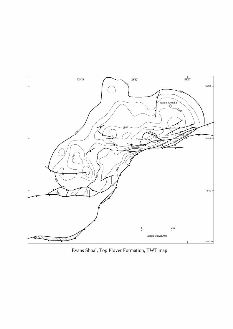
0 5 km
10°00'
10°10'
129°30'
12/OA/140
Contour Interval 20ms
Evans Shoal, Top Plover Formation, TWT map
Evans Shoal 2
Evans Shoal 1
2500
2600
2600
2600
2600
2600
2600
2600
2540
2540
2540
2660
129°35'129°25'
10°05'
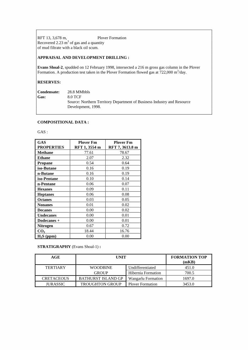
RFT 13, 3,678 m, Plover Formation Recovered 2.23 m3 of gas and a quantity of mud filtrate with a black oil scum. APPRAISAL AND DEVELOPMENT DRILLING : Evans Shoal-2, spudded on 12 February 1998, intersected a 216 m gross gas column in the Plover Formation. A production test taken in the Plover Formation flowed gas at 722,000 m3/day. RESERVES: Condensate: 28.8 MMbbls Gas: 8.0 TCF Source: Northern Territory Department of Business Industry and Resource Development, 1998. COMPOSITIONAL DATA : GAS : GAS PROPERTIES
Plover Fm RFT 1, 3554 m
Plover Fm RFT 7, 3613.8 m
Methane 77.61 78.67 Ethane 2.07 2.32 Propane 0.54 0.64 iso-Butane 0.16 0.19 n-Butane 0.16 0.19 iso-Pentane 0.10 0.14 n-Pentane 0.06 0.07 Hexanes 0.09 0.11 Heptanes 0.06 0.08 Octanes 0.03 0.05 Nonanes 0.01 0.02 Decanes 0.00 0.02 Undecanes 0.00 0.01 Dodecanes + 0.00 0.01 Nitrogen 0.67 0.72 CO2 18.44 16.76 H2S (ppm) 0.00 0.00 STRATIGRAPHY (Evans Shoal-1) :
AGE UNIT FORMATION TOP (mKB)
TERTIARY WOODBINE Undifferentiated 451.0 GROUP Hibernia Formation 700.5
CRETACEOUS BATHURST ISLAND GP Wangarlu Formation 1697.0 JURASSIC TROUGHTON GROUP Plover Formation 3453.0

Accumulation Number: 25 FISHBURN
ORIGINAL OPERATOR: BHP Petroleum Pty Ltd TYPE: Gas STATUS: Other Discovery LOCATION: 360 km west-southwest of Darwin STATE: Western Australia ORIGINAL TITLE(S): WA-218-P BASIN: Bonaparte SUB-BASIN: Petrel Sub-basin DISCOVERY WELL: Fishburn-1 Longitude (E): 127.5843 Latitude (S): -12.9680 Date total depth reached: 22 OCT 92 Water Depth: 63.6 m Kelly bushing: 30.4 m Operator: BHP Petroleum Pty Ltd Total Depth: 2,870 mKB NUMBER OF WELLS DRILLED: 1 STRUCTURE/TRAP: Tilted fault block with three-way dip closure. RESERVOIR UNITS: 1 BOTTOM HOLE TEMPERATURE: 104oC (after 1.2 hours circulation, 7.9 hours post circulation) RESERVOIR PRESSURE: 23,240 kpa (at 2,370 mKB) GROSS HYDROCARBON COLUMN: 51 m (2,319-2,370 mKB) NETT HYDROCARBON COLUMN: 27.7 m NETT TO GROSS RATIO: 54% HYDROCARBON SATURATION: 27% (average) GAS/WATER CONTACT: 2,370 mKB (from logs) PETROLEUM BEARING UNIT No.1: Tern/Dombey/Cape Hay and Pearce Members CONTENTS: Gas FORMATION: Hyland Bay Formation AGE: Late Permian (Kazanian) LITHOLOGY: Tern Member: Sandstone, off-white to pale brown, very fine, subangular, poorly sorted, argillaceous, minor siliceous cement, trace of carbonaceous material, feldspar and mica, grading to tan to dark grey silty claystone towards top of unit. Dombey Member: Calcarenite, off-white, firm to hard, brittle, commonly recrystallised (crypto- to microcrystalline), fine to medium to coarse grained, angular to subangular, elongate to slightly spherical, poorly to moderately well sorted, common off-white, micritic and argillaceous matrix, fossiliferous. Cape Hay Member: Interbedded silty and arenaceous claystone, sandstone and siltstone. Sandstone is off-white to light grey, clear to translucent quartz grains, very fine to medium, subangular to subrounded, moderately well sorted, common calcareous cement and white, argillaceous matrix, trace of glauconite and carbonaceous material.

12/OA/206
1900
Fishburn, Near Top Hyland Bay, TWT map
2 km0
Contour Interval 20m
13°00'
127°30' 127°40'2000
1900
1800
1900
1800
1700
1600
1700
1700
1800
1800
1900
2000
2000
1900
2100
1800
1700
1700
Fishburn 1
Pearce Member: Calcilutite/Calcarenite, white to off- white, fine to medium, angular to subangular, recrystallised in part, patchy off-white argillaceous matrix, trace of bryozoan and spinose fragments. DEPOSITIONAL ENVIRONMENT: Tern Member: lower to upper shoreface. Possibly a distributary mouth bar, channel or intradistributary bay deposit. Dombey Member: deltaic to shallow marine with restricted sediment supply. Cape Hay Member: regressive phase with environment of deposition shallowing from lower to upper delta plain. FORMATION TOP (mKB): 2,293.5 mKB (Tern Member) POROSITY: 15% (average log porosity) PERMEABILITY: 8.8 - 27.9 mD (MSCT data) 10.4 mD (average log permeability) TEST DATA FROM THE DISCOVERY WELL (Fishburn-1): RFT 1, 2,323 m, Hyland Bay Formation (Tern Member) Recovered 2.7 m3 of gas, 5.2 litres of filtrate with a trace of oil/condensate. RFT 2, 2,373 m, Hyland Bay Formation (Pearce Member) Recovered 0.09 m3 of gas and 46.5 litres of filtrate. REMARKS: The low hydrocarbon saturations observed in the reservoir are thought to be due to a combination of deep filtrate invasion and the presence of pyrite (seen in cuttings) making log interpretation difficult.

COMPOSITIONAL DATA : GAS : GAS PROPERTIES
Hyland Bay Fm (Tern Mbr)
RFT 1, 2323 mKB Methane 93.05 Ethane 2.09 Propane 0.52 Isobutane 0.07 N-butane 0.13 Isopentane 0.04 N-pentane 0.04 Hexanes 0.07 Heptanes 0.15 Octanes 0.09 Nonanes 0.08 C10+ 0.07 Nitrogen 0.66 CO2 2.94 O2 0.00 Specific Gravity 0.621 STRATIGRAPHY (Fishburn-1) :
AGE UNIT FORMATION TOP (mKB)
WOODBINE Recent 94.0 TERTIARY GROUP Undifferentiated 140.0
CRETACEOUS BATHURST Wangarlu Formation 391.0 ISLAND GROUP Darwin Formation 1186.6
JURASSIC FLAMINGO Sandpiper Sandstone 1193.0 GROUP Frigate Shale 1428.5 TROUGHTON Plover Formation 1566.7
TRIASSIC GROUP Malita Formation 1860.8 Mt Goodwin Formation 1904.5 Hyland Bay Formation
Tern Member 2293.5
KINMORE GROUP Dombey Member 2331.0 PERMIAN Cape Hay Member 2332.6
Pearce Member 2562.0 Basal Member 2574.0 Fossil Head Formation 2603.2
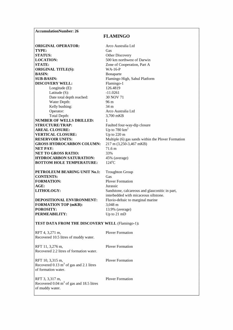
AccumulationNumber: 26 FLAMINGO
ORIGINAL OPERATOR: Arco Australia Ltd TYPE: Gas STATUS: Other Discovery LOCATION: 500 km northwest of Darwin STATE: Zone of Cooperation, Part A ORIGINAL TITLE(S): WA-16-P BASIN: Bonaparte SUB-BASIN: Flamingo High, Sahul Platform DISCOVERY WELL: Flamingo-1 Longitude (E): 126.4819 Latitude (S): -11.0261 Date total depth reached: 30 NOV 71 Water Depth: 96 m Kelly bushing: 34 m Operator: Arco Australia Ltd Total Depth: 3,700 mKB NUMBER OF WELLS DRILLED: 1 STRUCTURE/TRAP: Faulted four-way-dip closure AREAL CLOSURE: Up to 780 km2 VERTICAL CLOSURE: Up to 220 m RESERVOIR UNITS: Multiple (6) gas sands within the Plover Formation GROSS HYDROCARBON COLUMN: 217 m (3,250-3,467 mKB) NET PAY: 71.6 m NET TO GROSS RATIO: 33% HYDROCARBON SATURATION: 45% (average) BOTTOM HOLE TEMPERATURE: 124oC PETROLEUM BEARING UNIT No.1: Troughton Group CONTENTS: Gas FORMATION: Plover Formation AGE: Jurassic LITHOLOGY: Sandstone, calcareous and glauconitic in part, interbedded with micaceous siltstone. DEPOSITIONAL ENVIRONMENT: Fluvio-deltaic to marginal marine FORMATION TOP (mKB): 3,048 m POROSITY: 13.9% (average) PERMEABILITY: Up to 21 mD TEST DATA FROM THE DISCOVERY WELL (Flamingo-1): RFT 4, 3,271 m, Plover Formation Recovered 10.5 litres of muddy water. RFT 11, 3,276 m, Plover Formation Recovered 2.2 litres of formation water. RFT 10, 3,315 m, Plover Formation Recovered 0.13 m3 of gas and 2.1 litres of formation water. RFT 3, 3,317 m, Plover Formation Recovered 0.04 m3 of gas and 18.5 litres of muddy water.

0 10 km
11°00'
10°50'
11°10'
126°30' 126°40'
Flamingo 1
1000
1000
1000
1000
1000
10501050
1100
12/OA/141
Contour Interval 25ms
Flamingo, Near Base Cretaceous, OWT map

RFT 2, 3,376 m, Plover Formation Recovered 2.2 litres of muddy water. RFT 5, 3,376 m, Plover Formation Misrun. RFT 9, 3,432 m, Plover Formation Recovered 2.6 litres of formation water. RFT 1, 3,445 m, Plover Formation Recovered 245 cc of formation water. RFT 8, 3,511 m, Plover Formation Recovered 17.5 litres of water. RFT 7, 3,549 m, Plover Formation Recovered 200 cc of drilling mud. RFT 12, 3,625 m, Plover Formation Recovered 2.1 litres of formation water. RFT 6, 3,633 m, Plover Formation Recovered 2.2 litres of muddy water. REMARKS: Live oil shows were observed in core-6 (3,623.46-3,634.44 mKB, Plover Formation). It is possible that the gas recovered on RFT from the Plover Formation constitutes solution gas. COMPOSITIONAL DATA : GAS : GAS PROPERTIES
Gas Plover Fm
(3315 mKB)
Gas Plover Fm
(3317 mKB) Methane 33.9 59.4 Ethane 2.8 4.3 Propane 0.7 1.4 Isobutane 0.1 0.2 N-butane 0.2 0.3 Isopentane 0.1 0.2 N-pentane 0.1 0.1 Nitrogen 9.7 26.0 CO2 0.1 5.3 H2 2.4 2.8 Air 50.0 00.0

STRATIGRAPHY (Flamingo-1) :
AGE UNIT FORMATION TOP (mKB)
TERTIARY WOODBINE GROUP Undifferentiated 277.0 CRETACEOUS BATHURST ISLAND GP Undifferentiated 2006.0
JURASSIC FLAMINGO GROUP Undifferentiated 2925.0 TROUGHTON GROUP Plover Formation 3048.0
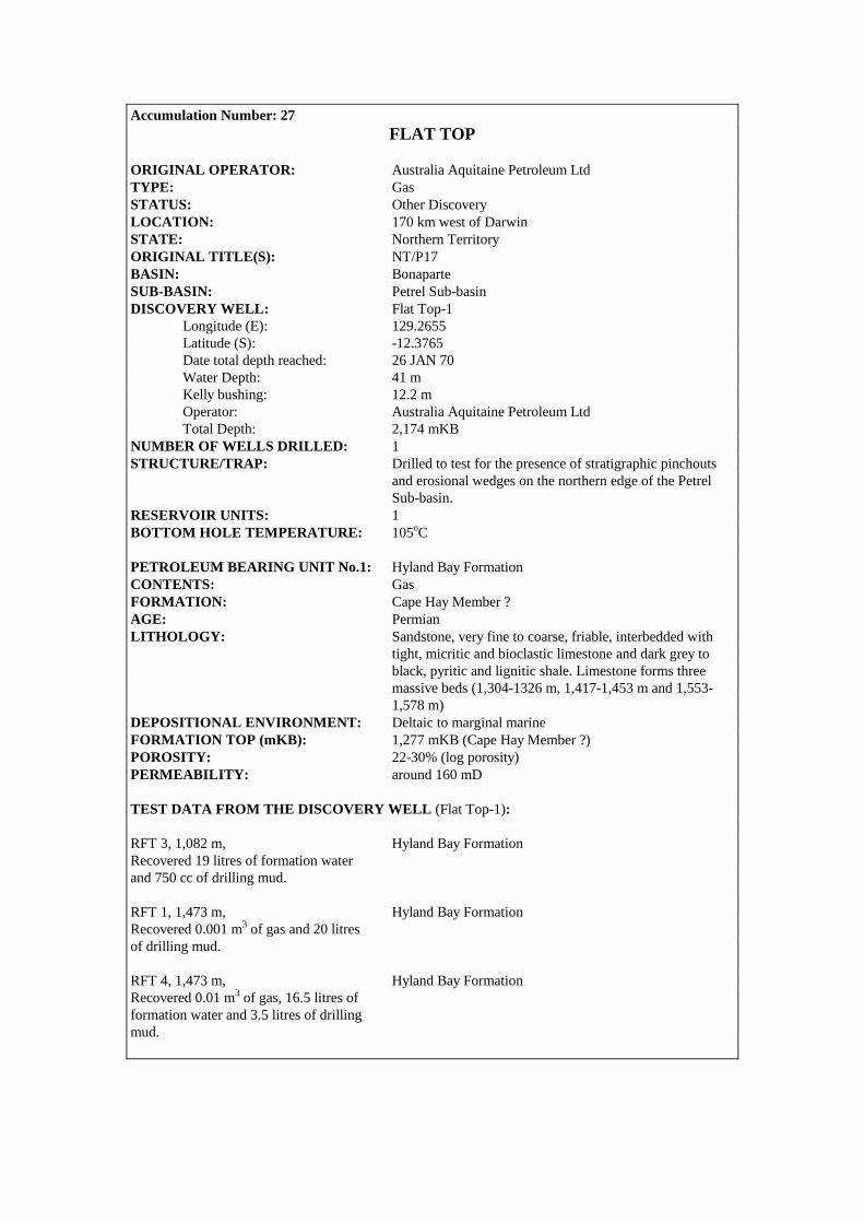
Accumulation Number: 27 FLAT TOP
ORIGINAL OPERATOR: Australia Aquitaine Petroleum Ltd TYPE: Gas STATUS: Other Discovery LOCATION: 170 km west of Darwin STATE: Northern Territory ORIGINAL TITLE(S): NT/P17 BASIN: Bonaparte SUB-BASIN: Petrel Sub-basin DISCOVERY WELL: Flat Top-1 Longitude (E): 129.2655 Latitude (S): -12.3765 Date total depth reached: 26 JAN 70 Water Depth: 41 m Kelly bushing: 12.2 m Operator: Australia Aquitaine Petroleum Ltd Total Depth: 2,174 mKB NUMBER OF WELLS DRILLED: 1 STRUCTURE/TRAP: Drilled to test for the presence of stratigraphic pinchouts and erosional wedges on the northern edge of the Petrel Sub-basin. RESERVOIR UNITS: 1 BOTTOM HOLE TEMPERATURE: 105oC PETROLEUM BEARING UNIT No.1: Hyland Bay Formation CONTENTS: Gas FORMATION: Cape Hay Member ? AGE: Permian LITHOLOGY: Sandstone, very fine to coarse, friable, interbedded with tight, micritic and bioclastic limestone and dark grey to black, pyritic and lignitic shale. Limestone forms three massive beds (1,304-1326 m, 1,417-1,453 m and 1,553- 1,578 m) DEPOSITIONAL ENVIRONMENT: Deltaic to marginal marine FORMATION TOP (mKB): 1,277 mKB (Cape Hay Member ?) POROSITY: 22-30% (log porosity) PERMEABILITY: around 160 mD TEST DATA FROM THE DISCOVERY WELL (Flat Top-1): RFT 3, 1,082 m, Hyland Bay Formation Recovered 19 litres of formation water and 750 cc of drilling mud. RFT 1, 1,473 m, Hyland Bay Formation Recovered 0.001 m3 of gas and 20 litres of drilling mud. RFT 4, 1,473 m, Hyland Bay Formation Recovered 0.01 m3 of gas, 16.5 litres of formation water and 3.5 litres of drilling mud.

0
12/OA/207
Contour Interval 20m
11°45'
129°45'
Flat Top, Near Top Permian, OWT map
10 km
600
500
1000
900
800
700
600
500
400
300
600
129°30'129°15'
12°00'
12°15'
12°30'
Erosional edge of Middle Triassic
Erosional edge of Upper Permian
Newby 1
Flat Top 1

RFT 2, 1,588 m, Hyland Bay Formation Recovered 13.5 litres of formation water and 1.2 litres of drilling mud. REMARKS: It is possible that the gas recovered from the Hyland Bay Formation by RFT constitutes solution gas. COMPOSITIONAL DATA : GAS : GAS PROPERTIES
Hyland Bay Fm RFT 4, 1473 m
Methane 10.50 Ethane 0.15 Oxygen 18.60 Nitrogen 70.30 CO2 0.45 STRATIGRAPHY (Flat Top-1) :
AGE UNIT FORMATION TOP (mKB)
TERTIARY WOODBINE GROUP Undifferentiated 55.0 CRETACEOUS BATHURST ISLAND GP Undifferentiated 189.0 JURASSIC to
TRIASSIC FLAMINGO &
TROUGHTON GROUPS Undifferentiated 730.0
KINMORE Hyland Bay Formation 978.0 PERMIAN GROUP Cape Hay Member ? 1277.0
Fossil Head Formation ? 1579.0 PROTEROZOIC BASEMENT Undifferentiated 2166.0

Accumulation Number: 28 FOHN
ORIGINAL OPERATOR: Phillips Australia Oil Company Ltd TYPE: Gas STATUS: Other Discovery LOCATION: 430 km northwest of Darwin STATE: Zone of Cooperation, Part A ORIGINAL TITLE(S): ZOCA 91-13 BASIN: Bonaparte SUB-BASIN: Flamingo Syncline DISCOVERY WELL: Fohn-1 Longitude (E): 127.1455 Latitude (S): -11.0033 Date total depth reached: 06 AUG 94 Water Depth: 83 m Kelly bushing: 22 m Operator: Phillips Australia Oil Company Ltd Total Depth: 1,440 mKB (main well) 3,814 mKB (sidetrack. Kick-off at 1,359 mKB) NUMBER OF WELLS DRILLED: 1 STRUCTURE/TRAP: Tilted fault block with some internal 4-way-dip closure. AREAL CLOSURE: 12 km2 VERTICAL CLOSURE: 160 m (At Base Valanginian) RESERVOIR UNITS: 1 GROSS HYDROCARBON COLUMN: 218 m (3,565 – 3,783 mKB) NET PAY: 82 m NET TO GROSS RATIO: 38% HYDROCARBON SATURATION: 50% PETROLEUM BEARING UNIT No.1: Troughton Group CONTENTS: Gas FORMATION: Plover Formation AGE: Jurassic LITHOLOGY: Sandstone, very light grey, very fine to medium grained,
well sorted, subangular to subrounded, 5 – 20% silica cement, interbedded with claystone and siltstone.
DEPOSITIONAL ENVIRONMENT: Fluvio-deltaic to marginal marine FORMATION TOP (mKB): 3,512.0 m POROSITY: 8% (average log porosity) PERMEABILITY: 0.01 – 0.13 mD (core data) TEST DATA FROM THE DISCOVERY WELL (Fohn-1): MDT, 3,579.5 m Plover Formation Unspecified quantity of gas recovered using MDT tool.

COMPOSITIONAL DATA : GAS : GAS PROPERTIES
Plover Fm MDT sample
3579.5 m Methane 79.44 Ethane 7.20 Propane 4.29 Isobutane 0.69 N-butane 0.86 Isopentane 0.27 N-pentane 0.16 Hexanes + 0.18 Nitrogen 6.73 CO2 0.18 Specific Gravity 0.6960 BTU/cubic ft 1115 STRATIGRAPHY (Fohn-1) :
AGE UNIT FORMATION TOP (mKB)
TERTIARY WOODBINE Hibernia Formation 706.0 GROUP Johnson Formation 1340.0 BATHURST Vee Formation 2002.0 ISLAND Wangarlu Formation 2522.0
CRETACEOUS GROUP Radiolarite Equivalent 3347.0 Darwin Formation 3404.0
FLAMINGO GROUP Undifferentiated 3469.0 JURASSIC TROUGHTON GROUP Plover Formation 3512.0
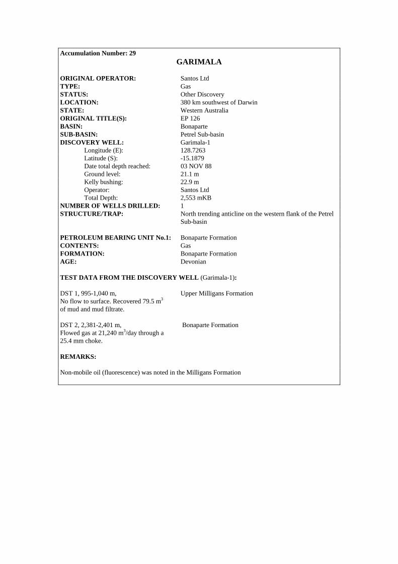
Accumulation Number: 29 GARIMALA
ORIGINAL OPERATOR: Santos Ltd TYPE: Gas STATUS: Other Discovery LOCATION: 380 km southwest of Darwin STATE: Western Australia ORIGINAL TITLE(S): EP 126 BASIN: Bonaparte SUB-BASIN: Petrel Sub-basin DISCOVERY WELL: Garimala-1 Longitude (E): 128.7263 Latitude (S): -15.1879 Date total depth reached: 03 NOV 88 Ground level: 21.1 m Kelly bushing: 22.9 m Operator: Santos Ltd Total Depth: 2,553 mKB NUMBER OF WELLS DRILLED: 1 STRUCTURE/TRAP: North trending anticline on the western flank of the Petrel Sub-basin PETROLEUM BEARING UNIT No.1: Bonaparte Formation CONTENTS: Gas FORMATION: Bonaparte Formation AGE: Devonian TEST DATA FROM THE DISCOVERY WELL (Garimala-1): DST 1, 995-1,040 m, Upper Milligans Formation No flow to surface. Recovered 79.5 m3 of mud and mud filtrate. DST 2, 2,381-2,401 m, Bonaparte Formation Flowed gas at 21,240 m3/day through a 25.4 mm choke. REMARKS: Non-mobile oil (fluorescence) was noted in the Milligans Formation

1 km0
12/OA/208
Contour Interval 20m
15°10'
2100
2100
200021
00
2000
2000
2100
210020
00
2000
2200
2100
128°45'
2100
2100
2000
2150
Garimala 1
Garimala, Intra Bonaparte Formation, depth map (pre-drill)
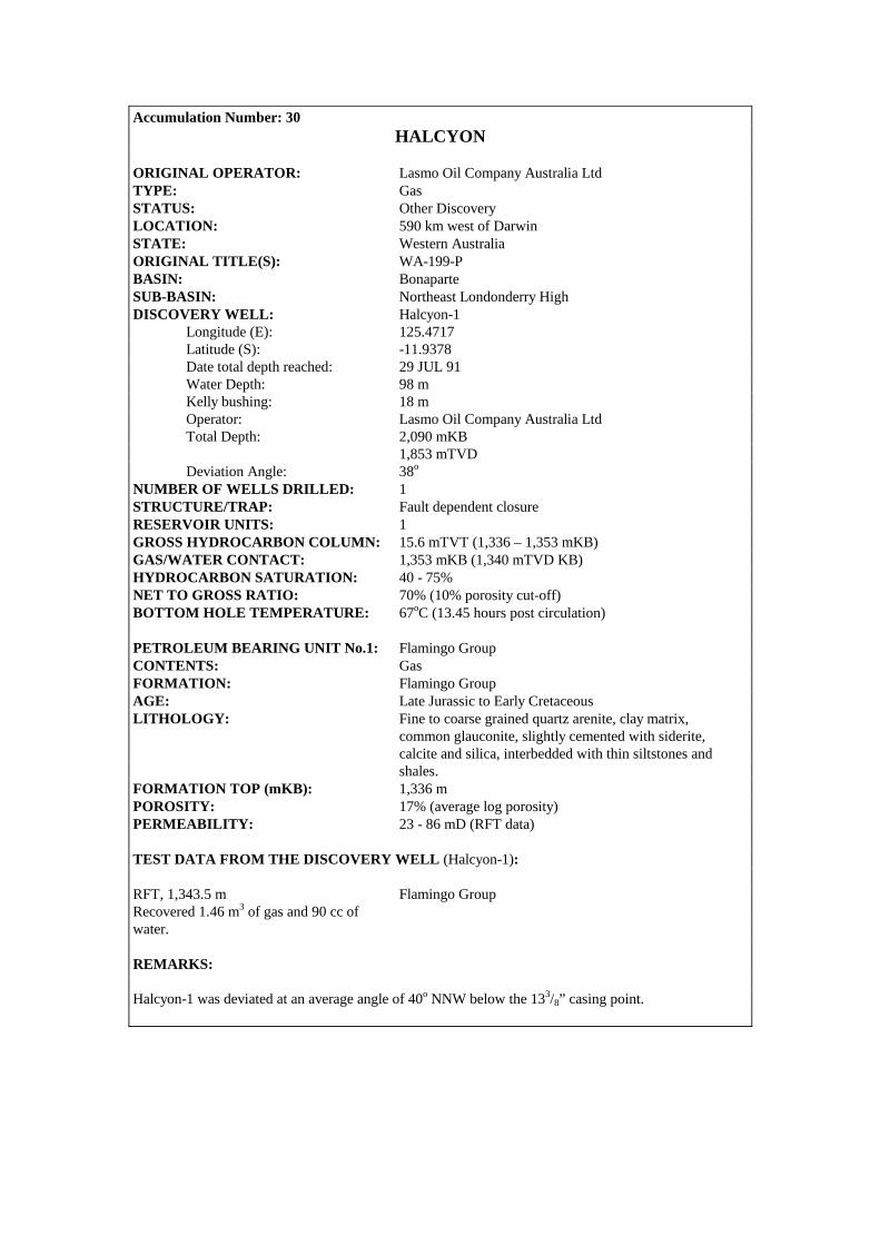
Accumulation Number: 30 HALCYON
ORIGINAL OPERATOR: Lasmo Oil Company Australia Ltd TYPE: Gas STATUS: Other Discovery LOCATION: 590 km west of Darwin STATE: Western Australia ORIGINAL TITLE(S): WA-199-P BASIN: Bonaparte SUB-BASIN: Northeast Londonderry High DISCOVERY WELL: Halcyon-1 Longitude (E): 125.4717 Latitude (S): -11.9378 Date total depth reached: 29 JUL 91 Water Depth: 98 m Kelly bushing: 18 m Operator: Lasmo Oil Company Australia Ltd Total Depth: 2,090 mKB 1,853 mTVD Deviation Angle: 38o NUMBER OF WELLS DRILLED: 1 STRUCTURE/TRAP: Fault dependent closure RESERVOIR UNITS: 1 GROSS HYDROCARBON COLUMN: 15.6 mTVT (1,336 – 1,353 mKB) GAS/WATER CONTACT: 1,353 mKB (1,340 mTVD KB) HYDROCARBON SATURATION: 40 - 75% NET TO GROSS RATIO: 70% (10% porosity cut-off) BOTTOM HOLE TEMPERATURE: 67oC (13.45 hours post circulation) PETROLEUM BEARING UNIT No.1: Flamingo Group CONTENTS: Gas FORMATION: Flamingo Group AGE: Late Jurassic to Early Cretaceous LITHOLOGY: Fine to coarse grained quartz arenite, clay matrix, common glauconite, slightly cemented with siderite, calcite and silica, interbedded with thin siltstones and shales. FORMATION TOP (mKB): 1,336 m POROSITY: 17% (average log porosity) PERMEABILITY: 23 - 86 mD (RFT data) TEST DATA FROM THE DISCOVERY WELL (Halcyon-1): RFT, 1,343.5 m Flamingo Group Recovered 1.46 m3 of gas and 90 cc of water. REMARKS: Halcyon-1 was deviated at an average angle of 40o NNW below the 133/8” casing point.

12/OA/142
0 1 km
Halcyon, Near Base Cretaceous, depth map
Halcyon 1
1400
1390
1390
1370
1360
1400
1410
1410
1340
1340
1350
1350
1350
1350
1360
1300
13201350
1360
1370
HL
L
L
L
L125°28'
11°56'
125°30'
11°58'
Contour Interval 10m
GWC

STRATIGRAPHY (Halcyon-1) :
AGE UNIT FORMATION TOP (mKB)
TERTIARY WOODBINE GROUP Undifferentiated 118.0 CRETACEOUS BATHURST ISLAND GP Undifferentiated 680.5
FLAMINGO GROUP Undifferentiated 1336.0 TRIASSIC SAHUL GROUP Undifferentiated 1374.5
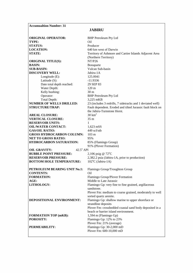
Accumualtion Number: 31 JABIRU
ORIGINAL OPERATOR: BHP Petroleum Pty Ltd TYPE: Oil STATUS: Producer LOCATION: 640 km west of Darwin STATE: Territory of Ashmore and Cartier Islands Adjacent Area (Northern Territory) ORIGINAL TITLE(S): NT/P26 BASIN: Bonaparte SUB-BASIN: Vulcan Sub-basin DISCOVERY WELL: Jabiru-1A Longitude (E): 125.0041 Latitude (S): -11.9336 Date total depth reached: 29 SEP 83 Water Depth: 120 m Kelly bushing: 30 m Operator: BHP Petroleum Pty Ltd Total Depth: 3,225 mKB NUMBER OF WELLS DRILLED: 23 (includes 3 redrills, 7 sidetracks and 1 deviated well) STRUCTURE/TRAP: Fault dependent. Eroded and tilted Jurassic fault block on the Jabiru-Turnstone Horst. AREAL CLOSURE: 30 km2 VERTICAL CLOSURE: 35 m RESERVOIR UNITS: 1 OIL/WATER CONTACT: 1,623 mSS GAS/OIL RATIO: 449 scf/stb GROSS HYDROCARBON COLUMN: 103 m NET TO GROSS RATIO: 95% HYDROCARBON SATURATION: 85% (Flamingo Group) 91% (Plover Formation) OIL GRAVITY: 42.5o API BUBBLE POINT PRESSURE: 2,106 psig @ 72oC RESERVOIR PRESSURE: 2,382.2 psia (Jabiru-1A, prior to production) BOTTOM HOLE TEMPERATURE: 102oC (Jabiru-1A) PETROLEUM BEARING UNIT No.1: Flamingo Group/Troughton Group CONTENTS: Oil FORMATION: Flamingo Group/Plover Formation AGE: Middle to Late Jurassic LITHOLOGY: Flamingo Gp: very fine to fine grained, argillaceous sandstone. Plover Fm: medium to coarse grained, moderately to well sorted quartz arenite. DEPOSITIONAL ENVIRONMENT: Flamingo Gp: shallow marine to upper shoreface or strandline deposits Plover Fm: crossbedded coastal sand body deposited in a beach or barrier island environment. FORMATION TOP (mKB): 1,594 m (Flamingo Gp) POROSITY: Flamingo Gp: 12% to 23% Plover Fm: 21% (average) PERMEABILITY: Flamingo Gp: 30-2,000 mD Plover Fm: 600-10,000 mD
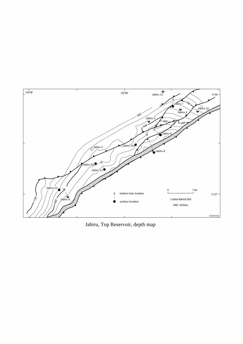
Jabiru 2
12/OA/143
Jabiru 12
11°57'
11°55'125°00'124°58'
Jabiru 5A
Jabiru 11
Jabiru, Top Reservoir, depth map
Jabiru 13
Jabiru 9
1700
1600
1600
1600
1660
Jabiru 7
Jabiru 4
Jabiru 10
Jabiru 6
Jabiru 3
Jabiru 8
Jabiru 1A
1700
1600
0 1 km
OWC 1623mss
Contour Interval 20m
bottom hole location
surface location
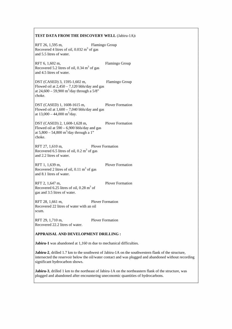
TEST DATA FROM THE DISCOVERY WELL (Jabiru-1A): RFT 26, 1,595 m, Flamingo Group Recovered 4 litres of oil, 0.032 m3 of gas and 5.5 litres of water. RFT 6, 1,602 m, Flamingo Group Recovered 5.2 litres of oil, 0.34 m3 of gas and 4.5 litres of water. DST (CASED) 3, 1595-1,602 m, Flamingo Group Flowed oil at 2,450 – 7,120 bbls/day and gas at 24,600 – 59,900 m3/day through a 5/8” choke. DST (CASED) 1, 1608-1615 m, Plover Formation Flowed oil at 1,600 – 7,040 bbls/day and gas at 13,000 – 44,000 m3/day. DST (CASED) 2, 1,608-1,628 m, Plover Formation Flowed oil at 590 – 6,900 bbls/day and gas at 5,800 – 54,800 m3/day through a 1” choke. RFT 27, 1,610 m, Plover Formation Recovered 6.5 litres of oil, 0.2 m3 of gas and 2.2 litres of water. RFT 1, 1,639 m, Plover Formation Recovered 2 litres of oil, 0.11 m3 of gas and 8.1 litres of water. RFT 2, 1,647 m, Plover Formation Recovered 6.25 litres of oil, 0.28 m3 of gas and 3.5 litres of water. RFT 28, 1,661 m, Plover Formation Recovered 22 litres of water with an oil scum. RFT 29, 1,710 m, Plover Formation Recovered 22.2 litres of water. APPRAISAL AND DEVELOPMENT DRILLING : Jabiru-1 was abandoned at 1,160 m due to mechanical difficulties. Jabiru-2, drilled 1.7 km to the southwest of Jabiru-1A on the southwestern flank of the structure, intersected the reservoir below the oil/water contact and was plugged and abandoned without recording significant hydrocarbon shows. Jabiru-3, drilled 1 km to the northeast of Jabiru-1A on the northeastern flank of the structure, was plugged and abandoned after encountering uneconomic quantities of hydrocarbons.

Jabiru-4 intersected a 32.5 m gross oil column (22.5 m net pay). However production testing resulted in an oil flow of only 90 bbls/day and the well was plugged and abandoned. Jabiru-5A was sidetracked from Jabiru-5 and intersected a 37.3 m gross oil column within the Jurassic. Oil shows were noted between 1,206 mKB and 1,220 mKB towards the base of the Palaeocene and may be evidence of oil leaked from the Jabiru structure as a result of Mio-Pliocene fault reactivation. Jabiru-6 was drilled to produce oil updip of Jabiru-3. The well intersected 60 m TVT of net oil sand and was cased and suspended as an oil producer. Jabiru-7 intersected the base of the Cretaceous on the downthrown side of the major bounding fault. The well penetrated 6.9 m of net oil sand and was sidetracked (Jabiru-7ST-1) Jabiru-7ST-1 was sidetracked 130 m to the north at an angle of 53.7o from the main vertical well (Jabiru-7). The sidetrack intersected 13.2 m TVT of net oil sand and was cased and suspended as an oil producer. Jabiru-8 was plugged and abandoned after losing the bottom hole assembly. Jabiru-8A, (planned as a redrill of Jabiru-8), was sidetracked after encountering the Cretaceous and Jurassic sections on the downthrown side of the main bounding fault. Jabiru-8AST-1 intersected a 45 m TVT net oil column after Jabiru-8 was plugged back and kicked off at 1,060 mKB. The sidetrack was subsequently cased and suspended as an oil producer. Jabiru-9 was plugged and abandoned after a fish became stuck in the hole. Jabiru-9ST-1 was sidetracked around the fish but was interpreted as having been drilled on the downthrown side of the main bounding fault. The well was plugged back to 1,369 mKB and kicked off as Jabiru-9ST-2. Jabiru-9ST-2 was plugged back to 1,423 mKB and kicked off as Jabiru-9ST-3. Jabiru-9ST-3 intersected a 24 mTVT gross oil column (22 mTVT net pay) but was plugged and abandoned. Jabiru-10 was plugged and abandoned after intersecting a 21 m gross oil column in poor quality reservoir. A residual oil/water contact was noted at 1,644 mSS. Jabiru-11 was designed as a directional hole to drain oil updip of Jabiru-5. An inability to build up the deviation angle caused the well to be plugged back 1,210 mKB and kicked off as Jabiru-11ST-1. Jabiru-11ST-1 was cased and suspended as an oil producer. Jabiru-12 was plugged and abandoned after intersecting an 11 m gross oil column (10.3 m net pay). Jabiru-13 was plugged and abandoned dry but a deviated well (Jabiru-13DW-1) drilled from the same location was cased and suspended as an oil producer.
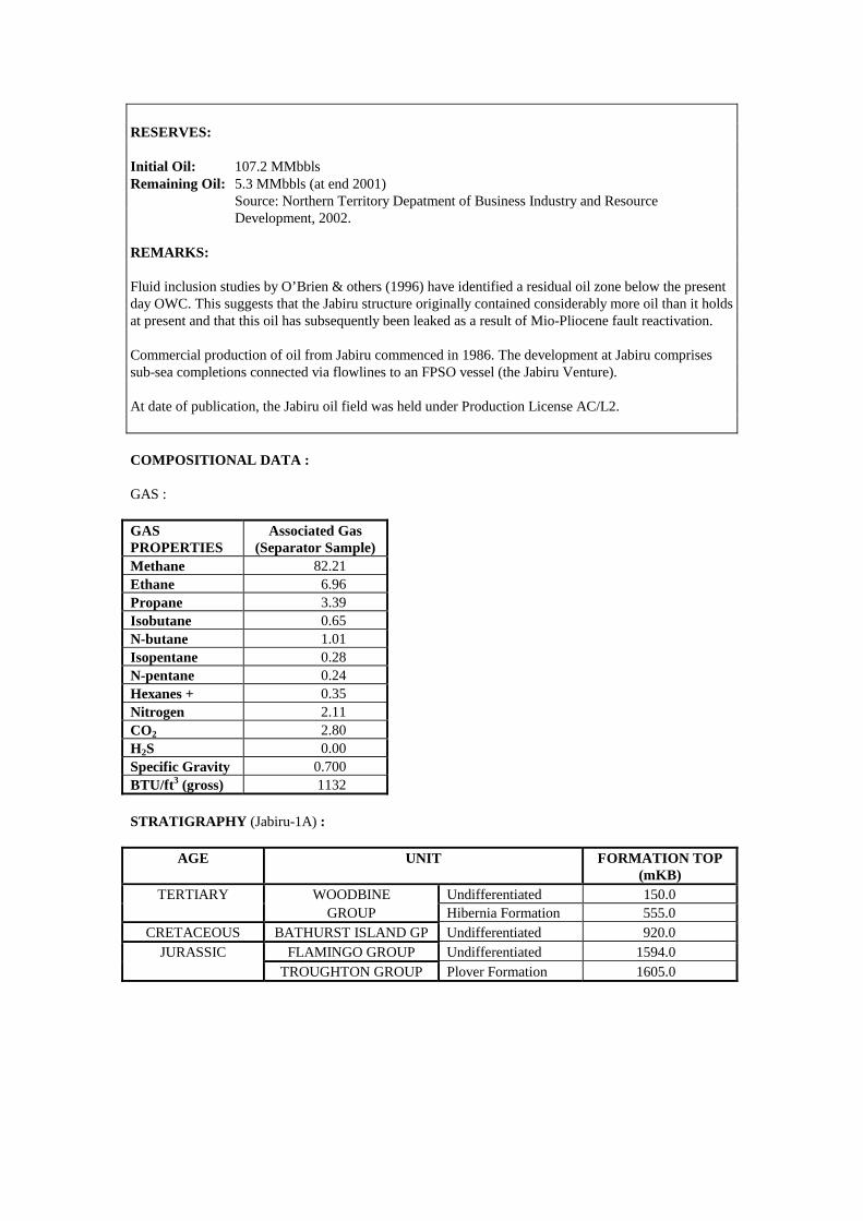
RESERVES: Initial Oil: 107.2 MMbbls Remaining Oil: 5.3 MMbbls (at end 2001) Source: Northern Territory Depatment of Business Industry and Resource Development, 2002. REMARKS: Fluid inclusion studies by O’Brien & others (1996) have identified a residual oil zone below the present day OWC. This suggests that the Jabiru structure originally contained considerably more oil than it holds at present and that this oil has subsequently been leaked as a result of Mio-Pliocene fault reactivation. Commercial production of oil from Jabiru commenced in 1986. The development at Jabiru comprises sub-sea completions connected via flowlines to an FPSO vessel (the Jabiru Venture). At date of publication, the Jabiru oil field was held under Production License AC/L2. COMPOSITIONAL DATA : GAS : GAS PROPERTIES
Associated Gas (Separator Sample)
Methane 82.21 Ethane 6.96 Propane 3.39 Isobutane 0.65 N-butane 1.01 Isopentane 0.28 N-pentane 0.24 Hexanes + 0.35 Nitrogen 2.11 CO2 2.80 H2S 0.00 Specific Gravity 0.700 BTU/ft3 (gross) 1132 STRATIGRAPHY (Jabiru-1A) :
AGE UNIT FORMATION TOP (mKB)
TERTIARY WOODBINE Undifferentiated 150.0 GROUP Hibernia Formation 555.0
CRETACEOUS BATHURST ISLAND GP Undifferentiated 920.0 JURASSIC FLAMINGO GROUP Undifferentiated 1594.0
TROUGHTON GROUP Plover Formation 1605.0
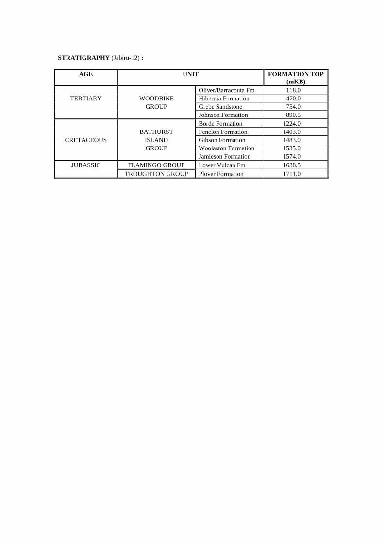
STRATIGRAPHY (Jabiru-12) :
AGE UNIT FORMATION TOP (mKB)
Oliver/Barracouta Fm 118.0 TERTIARY WOODBINE Hibernia Formation 470.0
GROUP Grebe Sandstone 754.0 Johnson Formation 890.5 Borde Formation 1224.0 BATHURST Fenelon Formation 1403.0
CRETACEOUS ISLAND Gibson Formation 1483.0 GROUP Woolaston Formation 1535.0 Jamieson Formation 1574.0
JURASSIC FLAMINGO GROUP Lower Vulcan Fm 1638.5 TROUGHTON GROUP Plover Formation 1711.0
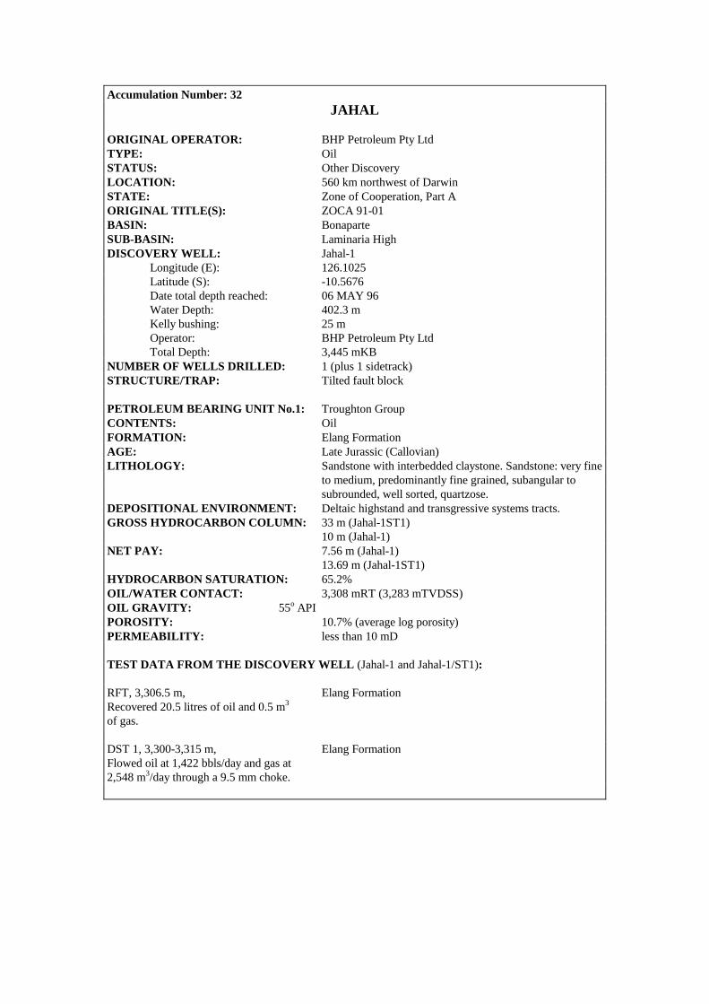
Accumulation Number: 32 JAHAL
ORIGINAL OPERATOR: BHP Petroleum Pty Ltd TYPE: Oil STATUS: Other Discovery LOCATION: 560 km northwest of Darwin STATE: Zone of Cooperation, Part A ORIGINAL TITLE(S): ZOCA 91-01 BASIN: Bonaparte SUB-BASIN: Laminaria High DISCOVERY WELL: Jahal-1 Longitude (E): 126.1025 Latitude (S): -10.5676 Date total depth reached: 06 MAY 96 Water Depth: 402.3 m Kelly bushing: 25 m Operator: BHP Petroleum Pty Ltd Total Depth: 3,445 mKB NUMBER OF WELLS DRILLED: 1 (plus 1 sidetrack) STRUCTURE/TRAP: Tilted fault block PETROLEUM BEARING UNIT No.1: Troughton Group CONTENTS: Oil FORMATION: Elang Formation AGE: Late Jurassic (Callovian) LITHOLOGY: Sandstone with interbedded claystone. Sandstone: very fine
to medium, predominantly fine grained, subangular to subrounded, well sorted, quartzose.
DEPOSITIONAL ENVIRONMENT: Deltaic highstand and transgressive systems tracts. GROSS HYDROCARBON COLUMN: 33 m (Jahal-1ST1) 10 m (Jahal-1) NET PAY: 7.56 m (Jahal-1) 13.69 m (Jahal-1ST1) HYDROCARBON SATURATION: 65.2% OIL/WATER CONTACT: 3,308 mRT (3,283 mTVDSS) OIL GRAVITY: 55o API POROSITY: 10.7% (average log porosity) PERMEABILITY: less than 10 mD TEST DATA FROM THE DISCOVERY WELL (Jahal-1 and Jahal-1/ST1): RFT, 3,306.5 m, Elang Formation Recovered 20.5 litres of oil and 0.5 m3 of gas. DST 1, 3,300-3,315 m, Elang Formation Flowed oil at 1,422 bbls/day and gas at 2,548 m3/day through a 9.5 mm choke.

REMARKS: Jahal-1 was drilled to 3,303 m before being plugged back to 2,780 m, sidetracked and drilled to 3,445 m. Water saturations in the Elang Formation are considered pessimistic due to the large percentage of pyrite (up to 27%) present throughout the reservoir interval. STRATIGRAPHY (Jahal-1) :
AGE UNIT FORMATION TOP (mRT)
Undifferentiated 427.0 Oliver Formation 1139.0 WOODBINE Cartier Formation 1845.0
TERTIARY GROUP Prion Formation 2032.0 Hibernia Formation 2517.0 Grebe Sandstone 2674.0 Johnson Formation 2741.0 Wangarlu Formation 2803.0 U. Jamison Formation 2873.0
CRETACEOUS BATHURST L. Jamison Formation 2945.0 ISLAND Darwin Formation 2995.0 GROUP Echuca Shoals Formation 3002.0 Flamingo Formation 3056.0 FLAMINGO GROUP Frigate Formation 3289.0
JURASSIC Elang Formation 3298.0 TROUGHTON GROUP Plover Formation 3378.0
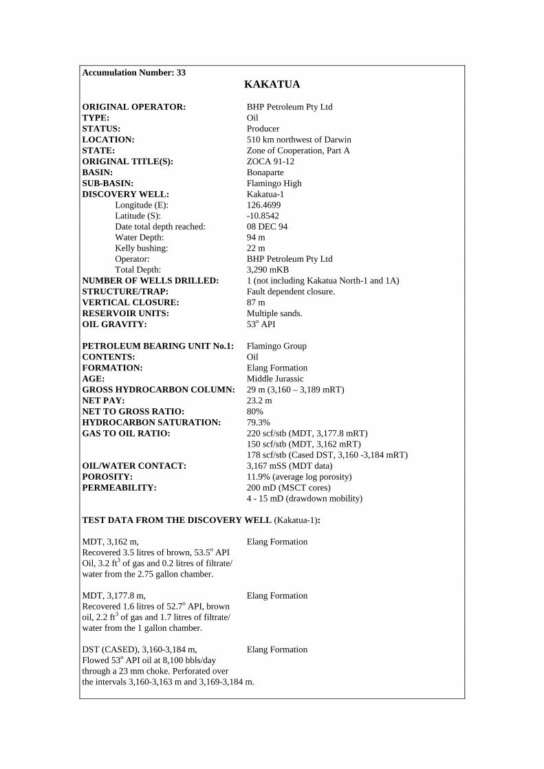
Accumulation Number: 33 KAKATUA
ORIGINAL OPERATOR: BHP Petroleum Pty Ltd TYPE: Oil STATUS: Producer LOCATION: 510 km northwest of Darwin STATE: Zone of Cooperation, Part A ORIGINAL TITLE(S): ZOCA 91-12 BASIN: Bonaparte SUB-BASIN: Flamingo High DISCOVERY WELL: Kakatua-1 Longitude (E): 126.4699 Latitude (S): -10.8542 Date total depth reached: 08 DEC 94 Water Depth: 94 m Kelly bushing: 22 m Operator: BHP Petroleum Pty Ltd Total Depth: 3,290 mKB NUMBER OF WELLS DRILLED: 1 (not including Kakatua North-1 and 1A) STRUCTURE/TRAP: Fault dependent closure. VERTICAL CLOSURE: 87 m RESERVOIR UNITS: Multiple sands. OIL GRAVITY: 53o API PETROLEUM BEARING UNIT No.1: Flamingo Group CONTENTS: Oil FORMATION: Elang Formation AGE: Middle Jurassic GROSS HYDROCARBON COLUMN: 29 m (3,160 – 3,189 mRT) NET PAY: 23.2 m NET TO GROSS RATIO: 80% HYDROCARBON SATURATION: 79.3% GAS TO OIL RATIO: 220 scf/stb (MDT, 3,177.8 mRT) 150 scf/stb (MDT, 3,162 mRT) 178 scf/stb (Cased DST, 3,160 -3,184 mRT) OIL/WATER CONTACT: 3,167 mSS (MDT data) POROSITY: 11.9% (average log porosity) PERMEABILITY: 200 mD (MSCT cores) 4 - 15 mD (drawdown mobility) TEST DATA FROM THE DISCOVERY WELL (Kakatua-1): MDT, 3,162 m, Elang Formation Recovered 3.5 litres of brown, 53.5o API Oil, 3.2 ft3 of gas and 0.2 litres of filtrate/ water from the 2.75 gallon chamber. MDT, 3,177.8 m, Elang Formation Recovered 1.6 litres of 52.7o API, brown oil, 2.2 ft3 of gas and 1.7 litres of filtrate/ water from the 1 gallon chamber. DST (CASED), 3,160-3,184 m, Elang Formation Flowed 53o API oil at 8,100 bbls/day through a 23 mm choke. Perforated over the intervals 3,160-3,163 m and 3,169-3,184 m.

0
12/OA/209
Contour Interval 10m
10°50'
126°30'
3200
1 km
Kakatua and Kakatua North, Top Elang Formation, depth map
3200
3200
3100
3200
Kakatua North 1A
Kakatua 1
126°28'
10°52'

REMARKS: A residual oil column was interpreted from logs over the interval 3,189 – 3,230 mRT. The Elang/Kakatua oil development commenced production in 1998. Sub-sea completions at Kakatua-1, Elang-1 and Elang-2 are connected to an FPSO (the Modec Venture 1) moored over the Elang field. RESERVES : Oil : 17 MMbbls (includes Elang) Source: Department of Resources Development, WA, 1998. STRATIGRAPHY (Kakatua-1) :
AGE UNIT FORMATION TOP (mTVDSS)
Oliver Formation 423.0 WOODBINE Prion Formation 1030.0
TERTIARY GROUP Hibernia Formation 1283.0 Grebe Sandstone 1884.0 Johnson Formation 1950.0 Borde Formation 2210.0 Fenelon Formation 2363.0 BATHURST Gibson Formation 2453.0
CRETACEOUS ISLAND Woolaston Formation 2573.0 GROUP Jamison Formation 2617.5 Darwin Formation 2923.0 Echuca Shoals Formation 2953.0 U. Flamingo Formation 3000.0
JURASSIC FLAMINGO GROUP Lwr Flamingo Formation 3125.0 Elang Formation 3128.0 TROUGHTON GROUP Plover Formation 3214.0

Accumulation Number: 34 KAKATUA NORTH
ORIGINAL OPERATOR: BHP Petroleum Pty Ltd TYPE: Oil STATUS: Producer LOCATION: 512 km northwest of Darwin STATE: Zone of Cooperation, Part A. ORIGINAL TITLE(S): ZOCA 91-12 BASIN: Bonaparte SUB-BASIN: Flamingo High DISCOVERY WELL: Kakatua North-1A Longitude (E): 126.4682 Latitude (S): -10.8444 Date total depth reached: 12 FEB 97 Water Depth: 94 m Kelly bushing: 25 m Operator: BHP Petroleum Pty Ltd Total Depth: 3,300 mKB NUMBER OF WELLS DRILLED: 2 (includes 1 redrill) STRUCTURE/TRAP: Separate fault dependent closure 2 km north of the Kakatua oil discovery. OIL GRAVITY: 55o API GROSS HYDROCARBON COLUMN: 69.4 m (3,131.6 – 3,201 mRT) NET PAY: 26.4 m HYDROCARBON SATURATION: 75.4% OIL/WATER CONTACT: 3,176 mSS (free-water level) PETROLEUM BEARING UNIT No.1: Flamingo Group CONTENTS: Oil FORMATION: Elang Formation AGE: Jurassic LITHOLOGY: Interbedded sandstone, siltstone and claystone. Sandstone:
fine to very fine, occasionally medium to coarse, variable siliceous cement, common quartz overgrowths, laminated and cross-bedded in part, coarsening upwards.
DEPOSITIONAL ENVIRONMENT: Interdeltaic barrier beach complex. FORMATION TOP: 3,106.5 mTVDSS POROSITY: 12.6% (average log porosity)
TEST DATA FROM THE DISCOVERY WELL (Kakatua North-1A): RFT, 3,158.5 m, Elang Formation Recovered 12.9 litres of 55o API oil and 60.8 ft3 of gas.

0
12/OA/209
Contour Interval 10m
10°50'
126°30'
3200
1 km
Kakatua and Kakatua North, Top Elang Formation, depth map
3200
3200
3100
3200
Kakatua North 1A
Kakatua 1
126°28'
10°52'
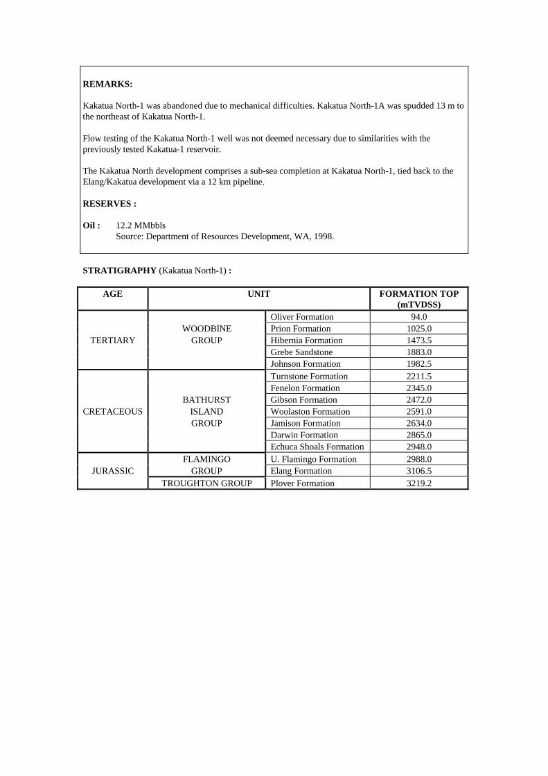
REMARKS: Kakatua North-1 was abandoned due to mechanical difficulties. Kakatua North-1A was spudded 13 m to the northeast of Kakatua North-1. Flow testing of the Kakatua North-1 well was not deemed necessary due to similarities with the previously tested Kakatua-1 reservoir. The Kakatua North development comprises a sub-sea completion at Kakatua North-1, tied back to the Elang/Kakatua development via a 12 km pipeline. RESERVES : Oil : 12.2 MMbbls Source: Department of Resources Development, WA, 1998. STRATIGRAPHY (Kakatua North-1) :
AGE UNIT FORMATION TOP (mTVDSS)
Oliver Formation 94.0 WOODBINE Prion Formation 1025.0
TERTIARY GROUP Hibernia Formation 1473.5 Grebe Sandstone 1883.0 Johnson Formation 1982.5 Turnstone Formation 2211.5 Fenelon Formation 2345.0 BATHURST Gibson Formation 2472.0
CRETACEOUS ISLAND Woolaston Formation 2591.0 GROUP Jamison Formation 2634.0 Darwin Formation 2865.0 Echuca Shoals Formation 2948.0 FLAMINGO U. Flamingo Formation 2988.0
JURASSIC GROUP Elang Formation 3106.5 TROUGHTON GROUP Plover Formation 3219.2
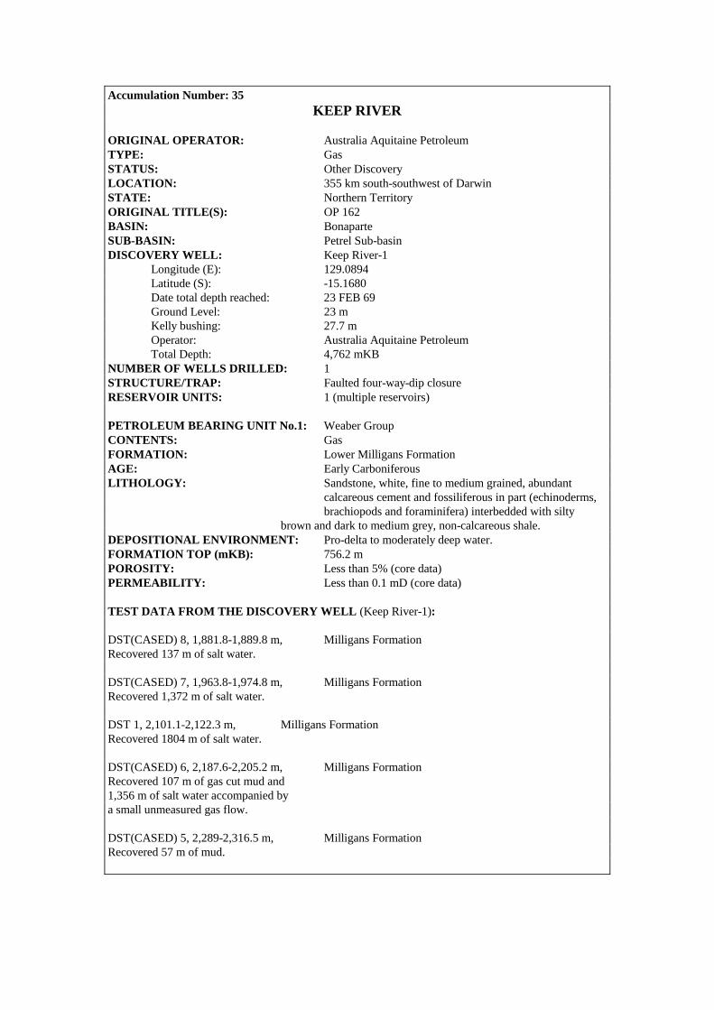
Accumulation Number: 35 KEEP RIVER
ORIGINAL OPERATOR: Australia Aquitaine Petroleum TYPE: Gas STATUS: Other Discovery LOCATION: 355 km south-southwest of Darwin STATE: Northern Territory ORIGINAL TITLE(S): OP 162 BASIN: Bonaparte SUB-BASIN: Petrel Sub-basin DISCOVERY WELL: Keep River-1 Longitude (E): 129.0894 Latitude (S): -15.1680 Date total depth reached: 23 FEB 69 Ground Level: 23 m Kelly bushing: 27.7 m Operator: Australia Aquitaine Petroleum Total Depth: 4,762 mKB NUMBER OF WELLS DRILLED: 1 STRUCTURE/TRAP: Faulted four-way-dip closure RESERVOIR UNITS: 1 (multiple reservoirs) PETROLEUM BEARING UNIT No.1: Weaber Group CONTENTS: Gas FORMATION: Lower Milligans Formation AGE: Early Carboniferous LITHOLOGY: Sandstone, white, fine to medium grained, abundant calcareous cement and fossiliferous in part (echinoderms, brachiopods and foraminifera) interbedded with silty brown and dark to medium grey, non-calcareous shale. DEPOSITIONAL ENVIRONMENT: Pro-delta to moderately deep water. FORMATION TOP (mKB): 756.2 m POROSITY: Less than 5% (core data) PERMEABILITY: Less than 0.1 mD (core data) TEST DATA FROM THE DISCOVERY WELL (Keep River-1): DST(CASED) 8, 1,881.8-1,889.8 m, Milligans Formation Recovered 137 m of salt water. DST(CASED) 7, 1,963.8-1,974.8 m, Milligans Formation Recovered 1,372 m of salt water. DST 1, 2,101.1-2,122.3 m, Milligans Formation Recovered 1804 m of salt water. DST(CASED) 6, 2,187.6-2,205.2 m, Milligans Formation Recovered 107 m of gas cut mud and 1,356 m of salt water accompanied by a small unmeasured gas flow. DST(CASED) 5, 2,289-2,316.5 m, Milligans Formation Recovered 57 m of mud.
Keep River 1
0 5 km
Contour Interval 20ms
129°10'
15°15'
129°05'
15°10'
129°00'1800
1700
1600
1500
1900
1800
1790
1500
1600
1700
1400
1500
1600
12/OA/144
Keep River, Top Langfield Group, TWT map
No Reliable Results

DST 4, 2,583.2-3,352.8 m, Milligans Formation Flowed gas at 85,000 m3/day decreasing to 5,600 m3/day over 8 hours and recovered 2,050 m of gas cut mud. DST 3, 3,871.6-3,889.3 m, ‘Ningbing Limestone’ Recovered 45.7 m of mud and salt water. DST 2, 4,039.2-4,056.9 m, ‘Ningbing Limestone’ Recovered 111.6 m of mud and salt water. COMPOSITIONAL DATA : GAS : GAS PROPERTIES
Keep River-1 DST-4
Milligans Fm
Keep River-1 DST-6
Milligans Fm Methane 93.8 97.4 Ethane 0.5 1.3 Propane trace 0.2 Nitrogen 2.7 0.7 CO2 2.9 0.3 Helium 0.1 0.1 STRATIGRAPHY (Keep River-1) :
AGE UNIT FORMATION TOP (mKB)
PERMIAN KULSHILL GP Undifferentiated 0.0 WEABER Tanmurra Formation 480.1 GROUP Milligans Formation 756.2
CARBONIFEROUS LANGFIELD Septimus Formation 2898.7 GROUP Enga Formation 3221.8 Burt Range Formation 3445.8
DEVONIAN NINGBING GROUP ‘Ningbing Limestone’ 3712.5 COCKATOO GP Undifferentiated 4736.6
Accumulation Number: 36 KELP DEEP
ORIGINAL OPERATOR: Mobil Exploration and Production Australia Pty Ltd TYPE: Gas STATUS: Other Discovery LOCATION: 490 km northwest of Darwin STATE: Zone of Cooperation, Part A ORIGINAL TITLE(S): ZOCA 95-18 BASIN: Bonaparte SUB-BASIN: Sahul Platform DISCOVERY WELL: Kelp Deep-1 Longitude (E): 127.1112 Latitude (S): -10.1682 Date total depth reached: 29 JUL 97 Water Depth: 223 m Operator: Mobil Exploration and Production Australia Pty Ltd Total Depth: 5,122 mKB NUMBER OF WELLS DRILLED: 1 PETROLEUM BEARING UNIT No.1: Pearce Member CONTENTS: Gas FORMATION: Hyland Bay Formation AGE: Late Permian
TEST DATA FROM THE DISCOVERY WELL (Kelp Deep-1): DST 5, Hyland Bay Formation (Dombey Member) No fluids to surface. DST 4, 4,393.5-4,406.5 m, Hyland Bay Formation (Dombey Member) No fluids to surface. DST 3, 4,593.9-4,581.1 m; Hyland Bay Formation (Cape Hay Member) 4,624.9-4,613 m; 4,606-4,598 m ; 4,577.5-4,569 m ; 4,550.5-4,548.5 m, No gas to surface. DST 2, Hyland Bay Formation (Pearce Member) Flowed gas at 147,250 m3/day and water at 1,503 bbls/day. DST 1, 5,088-5,100 m, Hyland Bay Formation (Pearce Member) Flowed gas at 339,800 m3/day and water at 1,500 bbls/day. REMARKS: Kelp Deep-1 was plugged back to 3,582 mRT and sidetracked (Kelp Deep-1/ST-1) to a total depth of 4,323 mRT to test the productivity of the Dombey Limestone Member.
Accumulation Number: 37 KRILL
ORIGINAL OPERATOR: BHP Petroleum Pty Ltd TYPE: Oil and Gas STATUS: Other Discovery LOCATION: 540 km northwest of Darwin STATE: Zone of Cooperation, Part A ORIGINAL TITLE(S): ZOCA 91-01 BASIN: Bonaparte SUB-BASIN: Flamingo High DISCOVERY WELL: Krill-1 Longitude (E): 126.2022 Latitude (S): -10.7513 Date total depth reached: 19 JUL 97 Water Depth: 268 m Operator: BHP Petroleum Pty Ltd Total Depth: 3,640 mKB NUMBER OF WELLS DRILLED: 1 STRUCTURE/TRAP: Tilted fault block RESERVOIR UNITS: 1 OIL GRAVITY: 56o API GAS/OIL RATIO: 229 scf/stb FREE WATER LEVEL: 3,388 mTVDSS BOTTOM HOLE TEMPERATURE: 140.5oC at 3,646 mRT (3,568 mTVDSS) PETROLEUM BEARING UNIT No.1: Troughton Group CONTENTS: Oil and Gas FORMATION: Elang Formation SEAL: Flamingo Fm silstones and claystones AGE: Late Jurassic LITHOLOGY: Sandstone with interbedded claystones. Sandstone: fine to
medium grained, angular to subrounded, well sorted, quartzose with abundant siliceous cement and quartz overgrowths. Claystone: brownish-grey, hard and blocky.
DEPOSITIONAL ENVIRONMENT: Storm and wave influenced proximal delta front sandstones.
GROSS HYDROCARBON COLUMN: 17.2 m (3,476.5 – 3,493.7 mRT) NET PAY: 4.27 m POROSITY: 9.1% PERMEABILITY: < 300 mD HYDROCARBON SATURATION: 50.6%
TEST DATA FROM THE DISCOVERY WELL (Krill-1): MDT, 3,485 m, Elang Formation Recovered 18 litres of 56o API oil and 25.9 cubic feet of gas. MDT, 3,539 m, Elang Formation Recovered 1.17 cubic feet of gas and 9.2 litres of filtrate/water.

STRATIGRAPHY (Krill-1) :
AGE UNIT FORMATION TOP (mTVDSS)
Undifferentiated 268 WOODBINE Oliver Formation 1599
TERTIARY GROUP Cartier Formation 1628 Prion Formation 1663 Hibernia Formation 2127 Grebe Sandstone 2291 BATHURST Johnson Formation 2385
CRETACEOUS ISLAND Wangarlu Formation 2613 GROUP Jamieson Formation 2927.5 Darwin Formation 3116 Echuca Shoals Formation 3144 FLAMINGO Flamingo Formation 3167
JURASSIC GROUP Frigate Formation 3349 Elang Formation 3373 TROUGHTON GP Plover Formation 3496
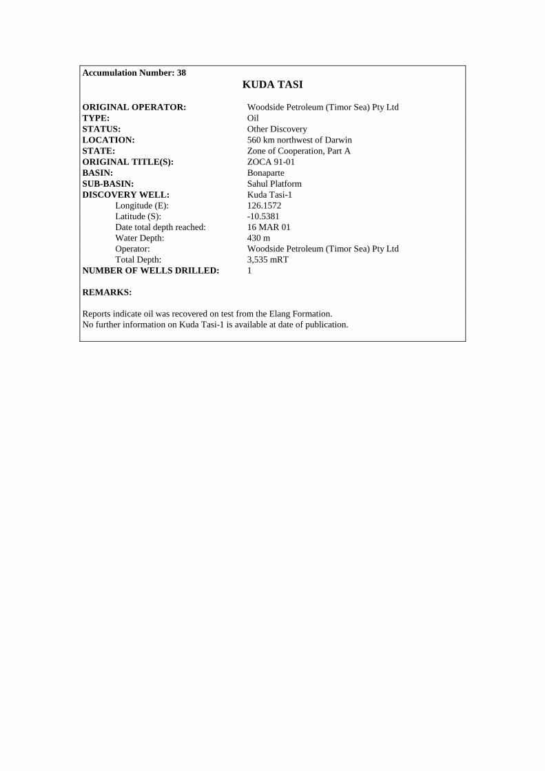
Accumulation Number: 38 KUDA TASI
ORIGINAL OPERATOR: Woodside Petroleum (Timor Sea) Pty Ltd TYPE: Oil STATUS: Other Discovery LOCATION: 560 km northwest of Darwin STATE: Zone of Cooperation, Part A ORIGINAL TITLE(S): ZOCA 91-01 BASIN: Bonaparte SUB-BASIN: Sahul Platform DISCOVERY WELL: Kuda Tasi-1 Longitude (E): 126.1572 Latitude (S): -10.5381 Date total depth reached: 16 MAR 01 Water Depth: 430 m Operator: Woodside Petroleum (Timor Sea) Pty Ltd Total Depth: 3,535 mRT NUMBER OF WELLS DRILLED: 1 REMARKS: Reports indicate oil was recovered on test from the Elang Formation. No further information on Kuda Tasi-1 is available at date of publication.
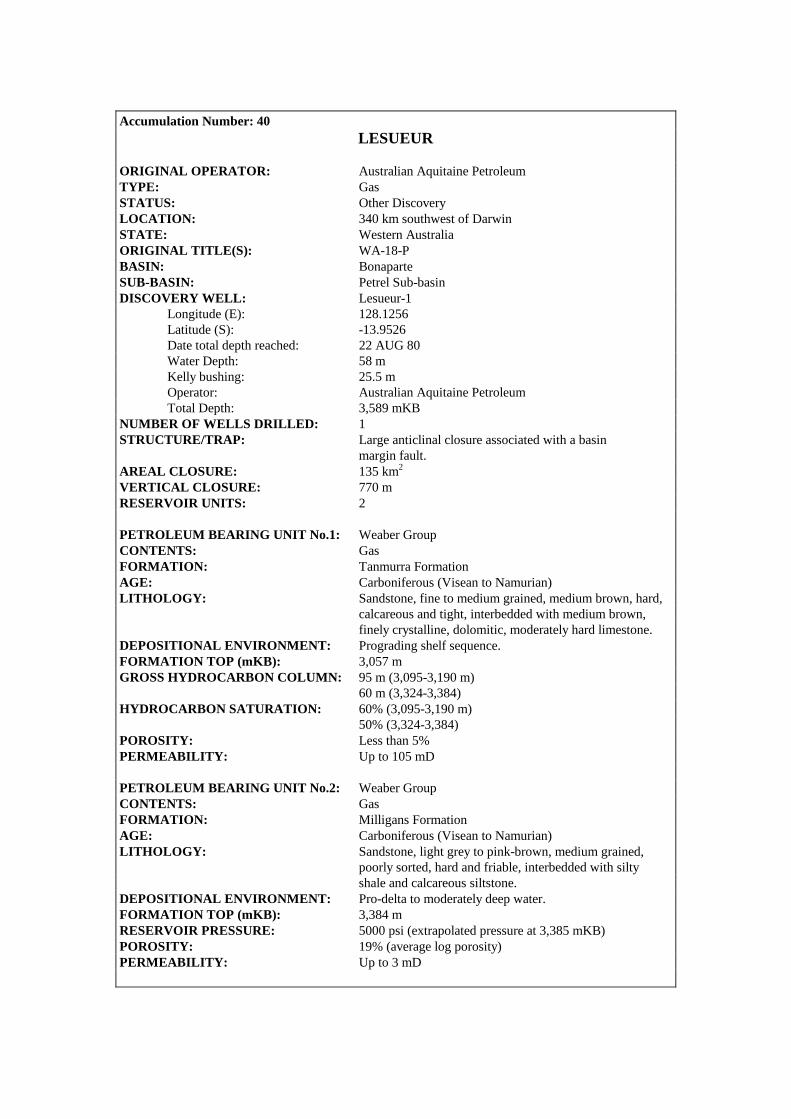
Accumulation Number: 40
LESUEUR ORIGINAL OPERATOR: Australian Aquitaine Petroleum TYPE: Gas STATUS: Other Discovery LOCATION: 340 km southwest of Darwin STATE: Western Australia ORIGINAL TITLE(S): WA-18-P BASIN: Bonaparte SUB-BASIN: Petrel Sub-basin DISCOVERY WELL: Lesueur-1 Longitude (E): 128.1256 Latitude (S): -13.9526 Date total depth reached: 22 AUG 80 Water Depth: 58 m Kelly bushing: 25.5 m Operator: Australian Aquitaine Petroleum Total Depth: 3,589 mKB NUMBER OF WELLS DRILLED: 1 STRUCTURE/TRAP: Large anticlinal closure associated with a basin margin fault. AREAL CLOSURE: 135 km2 VERTICAL CLOSURE: 770 m RESERVOIR UNITS: 2 PETROLEUM BEARING UNIT No.1: Weaber Group CONTENTS: Gas FORMATION: Tanmurra Formation AGE: Carboniferous (Visean to Namurian) LITHOLOGY: Sandstone, fine to medium grained, medium brown, hard, calcareous and tight, interbedded with medium brown, finely crystalline, dolomitic, moderately hard limestone. DEPOSITIONAL ENVIRONMENT: Prograding shelf sequence. FORMATION TOP (mKB): 3,057 m GROSS HYDROCARBON COLUMN: 95 m (3,095-3,190 m) 60 m (3,324-3,384) HYDROCARBON SATURATION: 60% (3,095-3,190 m) 50% (3,324-3,384) POROSITY: Less than 5% PERMEABILITY: Up to 105 mD PETROLEUM BEARING UNIT No.2: Weaber Group CONTENTS: Gas FORMATION: Milligans Formation AGE: Carboniferous (Visean to Namurian) LITHOLOGY: Sandstone, light grey to pink-brown, medium grained, poorly sorted, hard and friable, interbedded with silty shale and calcareous siltstone. DEPOSITIONAL ENVIRONMENT: Pro-delta to moderately deep water. FORMATION TOP (mKB): 3,384 m RESERVOIR PRESSURE: 5000 psi (extrapolated pressure at 3,385 mKB) POROSITY: 19% (average log porosity) PERMEABILITY: Up to 3 mD
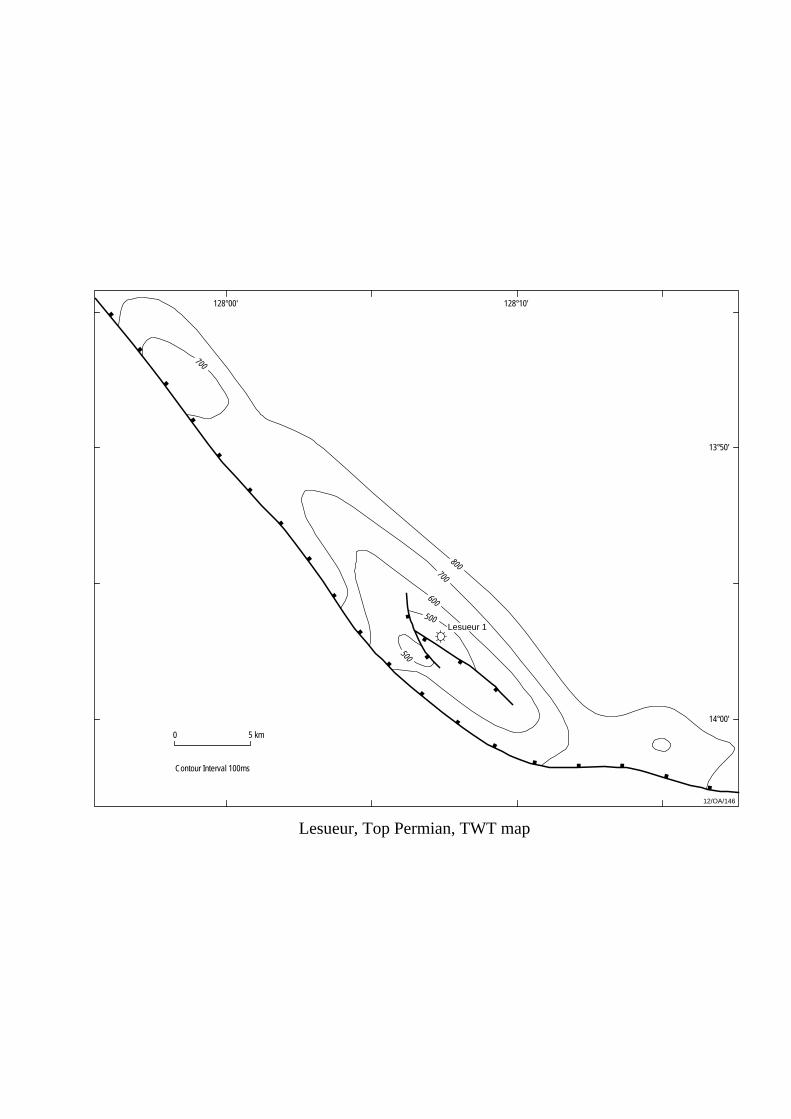
Lesueur, Top Permian, TWT map
13°50'
128°00'
0 5 km
Contour Interval 100ms
800700
700
600
500
500
12/OA/146
14°00'
128°10'
Lesueur 1
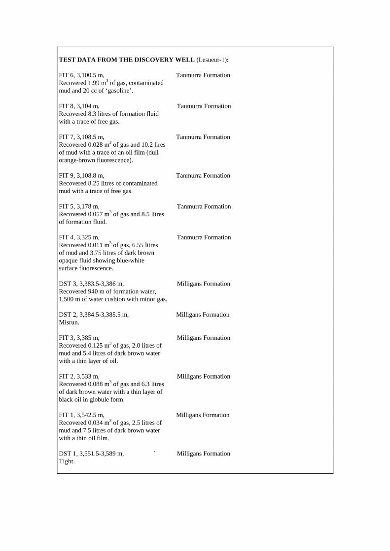
TEST DATA FROM THE DISCOVERY WELL (Lesueur-1): FIT 6, 3,100.5 m, Tanmurra Formation Recovered 1.99 m3 of gas, contaminated mud and 20 cc of ‘gasoline’. FIT 8, 3,104 m, Tanmurra Formation Recovered 8.3 litres of formation fluid with a trace of free gas. FIT 7, 3,108.5 m, Tanmurra Formation Recovered 0.028 m3 of gas and 10.2 lires of mud with a trace of an oil film (dull orange-brown fluorescence). FIT 9, 3,108.8 m, Tanmurra Formation Recovered 8.25 litres of contaminated mud with a trace of free gas. FIT 5, 3,178 m, Tanmurra Formation Recovered 0.057 m3 of gas and 8.5 litres of formation fluid. FIT 4, 3,325 m, Tanmurra Formation Recovered 0.011 m3 of gas, 6.55 litres of mud and 3.75 litres of dark brown opaque fluid showing blue-white surface fluorescence. DST 3, 3,383.5-3,386 m, Milligans Formation Recovered 940 m of formation water, 1,500 m of water cushion with minor gas. DST 2, 3,384.5-3,385.5 m, Milligans Formation Misrun. FIT 3, 3,385 m, Milligans Formation Recovered 0.125 m3 of gas, 2.0 litres of mud and 5.4 litres of dark brown water with a thin layer of oil. FIT 2, 3,533 m, Milligans Formation Recovered 0.088 m3 of gas and 6.3 litres of dark brown water with a thin layer of black oil in globule form. FIT 1, 3,542.5 m, Milligans Formation Recovered 0.034 m3 of gas, 2.5 litres of mud and 7.5 litres of dark brown water with a thin oil film. DST 1, 3,551.5-3,589 m, ` Milligans Formation Tight.

REMARKS : Log analysis and test results indicate the presence of two oil columns within the Tanmurra Formation (3,324-3,384 m ; Sw = 50% and 3,095-3,190 m ; Sw = 40%) and a gas column in the Milligans Formation (3,384-3,386.5 m. Oil may also be present below 3,479 m in the Milligans Formation where better porosity is developed. COMPOSITIONAL DATA : GAS : GAS PROPERTIES
Milligans Fm FIT 3, 3385 m
Tanmurra Fm FIT 4, 3325 m
Tanmurra Fm FIT 5, 3178 m
Methane 92.24 94.40 92.40 Ethane 4.84 3.80 5.50 Propane 2.00 1.20 1.40 Isobutane 0.13 0.12 0.10 N-butane 0.17 0.22 0.40 Pentane 0.05 - - Incombustible Gas 0.57 0.30 0.20 STRATIGRAPHY (Lesueur-1) :
AGE UNIT FORMATION TOP (mKB)
KINMORE Hyland Bay Formation 372.0 PERMIAN GROUP Fossil Head Formation 685.0
KULSHILL Keyling Formation 1044.0 GROUP Treachery Shale 1290.0
CARBONIFEROUS Kuriyippi Formation 1814.0 WEABER Tanmurra Formation 3057.0 GROUP Milligans Formation 3384.0
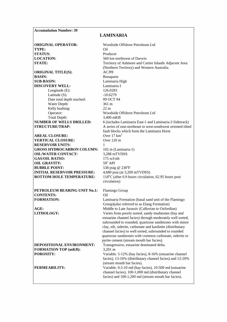
Accumulation Number: 39 LAMINARIA
ORIGINAL OPERATOR: Woodside Offshore Petroleum Ltd TYPE: Oil STATUS: Producer LOCATION: 560 km northwest of Darwin STATE: Territory of Ashmore and Cartier Islands Adjacent Area (Northern Territory) and Western Australia. ORIGINAL TITLE(S): AC/P8 BASIN: Bonaparte SUB-BASIN: Laminaria High DISCOVERY WELL: Laminaria-1 Longitude (E): 126.0283 Latitude (S): -10.6279 Date total depth reached: 09 OCT 94 Water Depth: 361 m Kelly bushing: 22 m Operator: Woodside Offshore Petroleum Ltd Total Depth: 3,400 mKB NUMBER OF WELLS DRILLED: 6 (includes Laminaria East-1 and Laminaria-3 Sidetrack) STRUCTURE/TRAP: A series of east-northeast to west-southwest oriented tilted fault blocks which form the Laminaria Horst AREAL CLOSURE: Over 17 km2 VERTICAL CLOSURE: Over 120 m RESERVOIR UNITS: 1 GROSS HYDROCARBON COLUMN: 102 m (Laminaria-1) OIL/WATER CONTACT: 3,288 mTVDSS GAS/OIL RATIO: 175 scf/stb OIL GRAVITY: 59o API BUBBLE POINT: 538 psig @ 230oF INITIAL RESERVOIR PRESSURE: 4,680 psia (at 3,200 mTVDSS) BOTTOM HOLE TEMPERATURE: 118oC (after 0.9 hours circulation, 62.95 hours post circulation) PETROLEUM BEARING UNIT No.1: Flamingo Group CONTENTS: Oil FORMATION: Laminaria Formation (basal sand unit of the Flamingo Group)(also referred to as Elang Formation) AGE: Middle to Late Jurassic (Callovian to Oxfordian) LITHOLOGY: Varies from poorly sorted, sandy mudstones (bay and estuarine channel facies) through moderately well sorted, subrounded to rounded, quartzose sandstones with minor clay, silt, siderite, carbonate and kaolinite (distributary channel facies) to well sorted, subrounded to rounded quartzose sandstones with common carbonate, siderite or pyrite cement (stream mouth bar facies). DEPOSITIONAL ENVIRONMENT: Transgressive, estuarine dominated delta. FORMATION TOP (mKB): 3,201 m POROSITY: Variable. 5-12% (bay facies), 8-16% (estuarine channel facies), 13-16% (distributary channel facies) and 12-20% (stream mouth bar facies). PERMEABILITY: Variable. 0.5-10 md (bay facies), 10-500 md (estuarine channel facies), 100-1,000 md (distributary channel facies) and 100-1,200 md (stream mouth bar facies).

2 km0
12/OA/210
Contour Interval 20m
Laminaria, Top Reservoir, depth map
3500
3400
3300
3300
3400
3300
3200
3200320
0
3300
3300
3500
Laminaria 1
Laminaria 2
Laminaria 3(sidetrack)
Laminaria 3
126°01'42"
10°37'40"
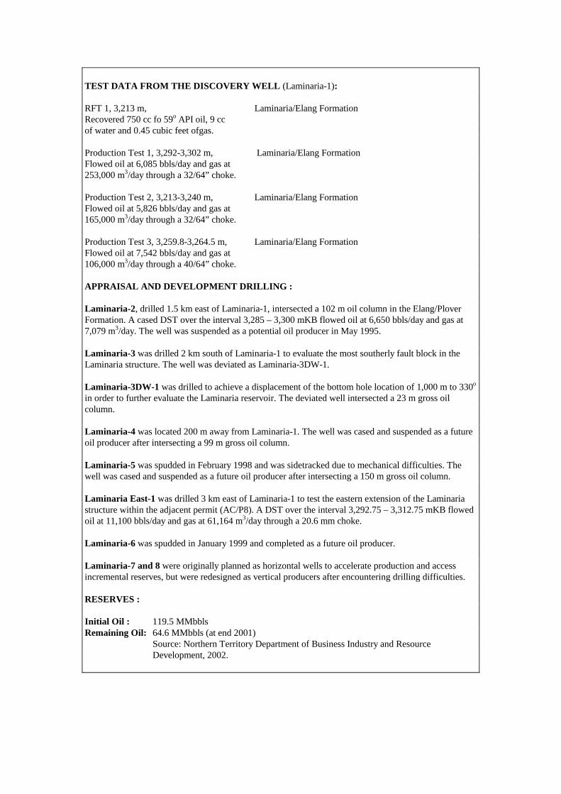
TEST DATA FROM THE DISCOVERY WELL (Laminaria-1): RFT 1, 3,213 m, Laminaria/Elang Formation Recovered 750 cc fo 59o API oil, 9 cc of water and 0.45 cubic feet ofgas. Production Test 1, 3,292-3,302 m, Laminaria/Elang Formation Flowed oil at 6,085 bbls/day and gas at 253,000 m3/day through a 32/64” choke. Production Test 2, 3,213-3,240 m, Laminaria/Elang Formation Flowed oil at 5,826 bbls/day and gas at 165,000 m3/day through a 32/64” choke. Production Test 3, 3,259.8-3,264.5 m, Laminaria/Elang Formation Flowed oil at 7,542 bbls/day and gas at 106,000 m3/day through a 40/64” choke. APPRAISAL AND DEVELOPMENT DRILLING : Laminaria-2, drilled 1.5 km east of Laminaria-1, intersected a 102 m oil column in the Elang/Plover Formation. A cased DST over the interval 3,285 – 3,300 mKB flowed oil at 6,650 bbls/day and gas at 7,079 m3/day. The well was suspended as a potential oil producer in May 1995. Laminaria-3 was drilled 2 km south of Laminaria-1 to evaluate the most southerly fault block in the Laminaria structure. The well was deviated as Laminaria-3DW-1. Laminaria-3DW-1 was drilled to achieve a displacement of the bottom hole location of 1,000 m to 330o in order to further evaluate the Laminaria reservoir. The deviated well intersected a 23 m gross oil column. Laminaria-4 was located 200 m away from Laminaria-1. The well was cased and suspended as a future oil producer after intersecting a 99 m gross oil column. Laminaria-5 was spudded in February 1998 and was sidetracked due to mechanical difficulties. The well was cased and suspended as a future oil producer after intersecting a 150 m gross oil column. Laminaria East-1 was drilled 3 km east of Laminaria-1 to test the eastern extension of the Laminaria structure within the adjacent permit (AC/P8). A DST over the interval 3,292.75 – 3,312.75 mKB flowed oil at 11,100 bbls/day and gas at 61,164 m3/day through a 20.6 mm choke. Laminaria-6 was spudded in January 1999 and completed as a future oil producer. Laminaria-7 and 8 were originally planned as horizontal wells to accelerate production and access incremental reserves, but were redesigned as vertical producers after encountering drilling difficulties. RESERVES : Initial Oil : 119.5 MMbbls Remaining Oil: 64.6 MMbbls (at end 2001) Source: Northern Territory Department of Business Industry and Resource Development, 2002.
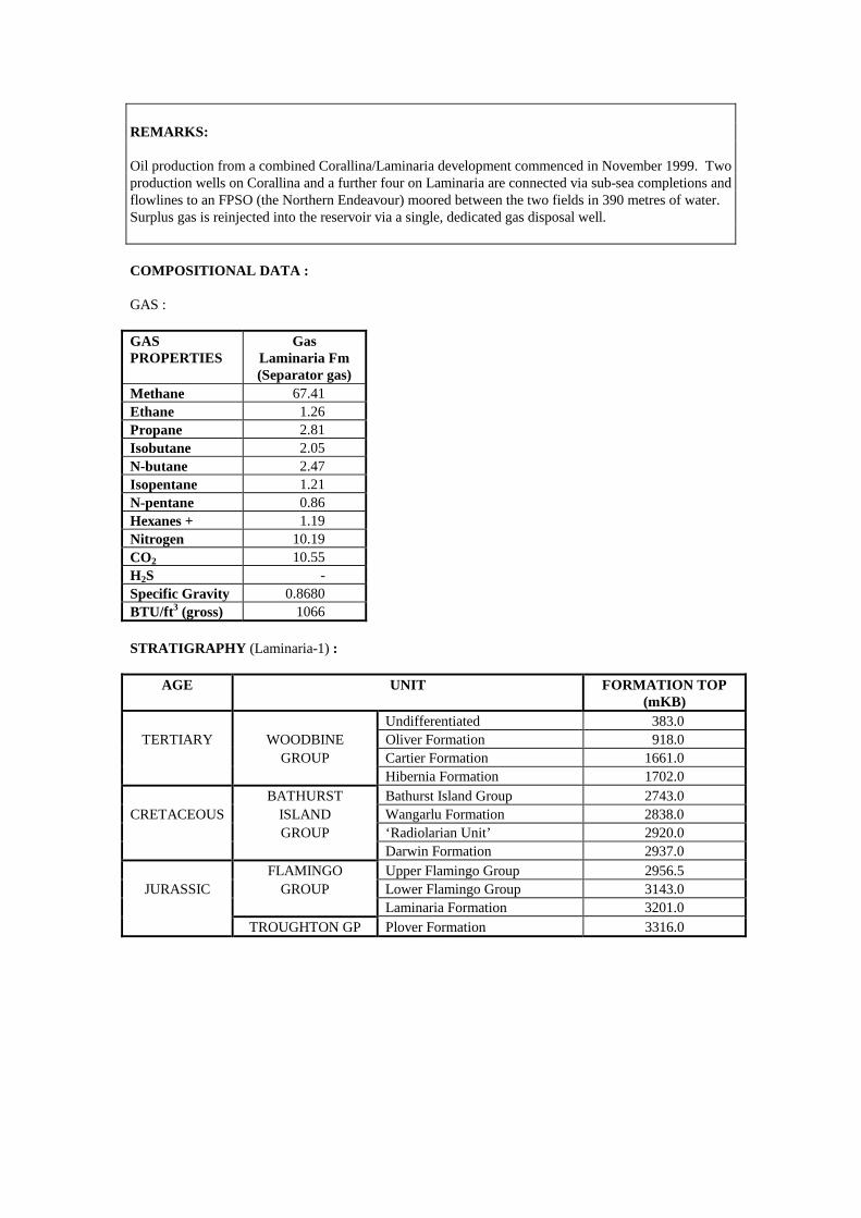
REMARKS: Oil production from a combined Corallina/Laminaria development commenced in November 1999. Two production wells on Corallina and a further four on Laminaria are connected via sub-sea completions and flowlines to an FPSO (the Northern Endeavour) moored between the two fields in 390 metres of water. Surplus gas is reinjected into the reservoir via a single, dedicated gas disposal well. COMPOSITIONAL DATA : GAS : GAS PROPERTIES
Gas Laminaria Fm (Separator gas)
Methane 67.41 Ethane 1.26 Propane 2.81 Isobutane 2.05 N-butane 2.47 Isopentane 1.21 N-pentane 0.86 Hexanes + 1.19 Nitrogen 10.19 CO2 10.55 H2S - Specific Gravity 0.8680 BTU/ft3 (gross) 1066 STRATIGRAPHY (Laminaria-1) :
AGE UNIT FORMATION TOP (mKB)
Undifferentiated 383.0 TERTIARY WOODBINE Oliver Formation 918.0
GROUP Cartier Formation 1661.0 Hibernia Formation 1702.0 BATHURST Bathurst Island Group 2743.0
CRETACEOUS ISLAND Wangarlu Formation 2838.0 GROUP ‘Radiolarian Unit’ 2920.0 Darwin Formation 2937.0 FLAMINGO Upper Flamingo Group 2956.5
JURASSIC GROUP Lower Flamingo Group 3143.0 Laminaria Formation 3201.0 TROUGHTON GP Plover Formation 3316.0

Accumulation Number: 41 LEEUWIN
ORIGINAL OPERATOR: BHP Petroleum Pty Ltd TYPE: Gas STATUS: Other Discovery LOCATION: 680 km west of Darwin STATE: Territory of Ashmore and Cartier Islands Adjacent Area (Northern Territory) ORIGINAL TITLE(S): AC/P7 BASIN: Bonaparte SUB-BASIN: Vulcan Sub-basin DISCOVERY WELL: Leeuwin-1 Longitude (E): 124.5851 Latitude (S): -12.7112 Date total depth reached: 02 DEC 91 Water Depth: 85 m Kelly bushing: 26 m Operator: BHP Petroleum Pty Ltd Total Depth: 3,376 mKB NUMBER OF WELLS DRILLED: 1 STRUCTURE/TRAP: Fault dependent closure on the eastern flank of the ‘Greater Montara’ Horst Block AREAL CLOSURE: 6.5 km2 VERTICAL CLOSURE: 75 m (at the intra-Oxfordian unconformity) RESERVOIR UNITS: 1 RESERVOIR PRESSURE: 3,568.6 psia RESERVOIR TEMPERATURE: 95oC BOTTOM HOLE TEMPERATURE: 116oC (22.6 hours post circulation) PETROLEUM BEARING UNIT No.1: Flamingo Group CONTENTS: Gas FORMATION: Upper Vulcan Formation AGE: Upper Jurassic LITHOLOGY: Sandstone, glaucontic and argillaceous, off white to light green to green-grey, fine to medium grained, well sorted,angular to subrounded with up to 50% white argillaceous matrix with common, very fine to fine, glauconite pellets. DEPOSITIONAL ENVIRONMENT: Distal portion of a prograding submarine fan. FORMATION TOP (mKB): 2,460 m POROSITY: 18% average (from logs) PERMEABILITY: 160-570 mD TEST DATA FROM THE DISCOVERY WELL (Leeuwin-1): RFT, 2,476 m, Upper Vulcan Formation Recovered 0.003 m3 of gas and 21.5 litres of filtrate and formation water. REMARKS: Gas recovered at Leeuwin may be solution gas and an indication of a hydrocarbon accumulation updip of Leeuwin-1.

1 km
124°33'
12°42'
124°35'
0
Leeuwin 1
Leeuwin, Top Montara Formation, depth map
2650
2750
2700
2800
2850
2830
32303200
3150
3200
3190
3150
12/OA/145
2900
2880
3130
3170
Contour Interval 10m 12°44'
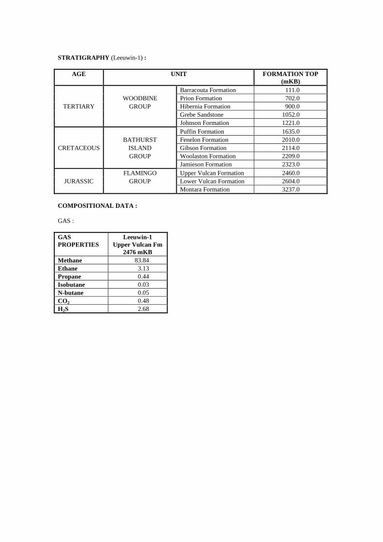
STRATIGRAPHY (Leeuwin-1) :
AGE UNIT FORMATION TOP (mKB)
Barracouta Formation 111.0 WOODBINE Prion Formation 702.0
TERTIARY GROUP Hibernia Formation 900.0 Grebe Sandstone 1052.0 Johnson Formation 1221.0 Puffin Formation 1635.0 BATHURST Fenelon Formation 2010.0
CRETACEOUS ISLAND Gibson Formation 2114.0 GROUP Woolaston Formation 2209.0 Jamieson Formation 2323.0 FLAMINGO Upper Vulcan Formation 2460.0
JURASSIC GROUP Lower Vulcan Formation 2604.0 Montara Formation 3237.0
COMPOSITIONAL DATA : GAS : GAS PROPERTIES
Leeuwin-1 Upper Vulcan Fm
2476 mKB Methane 83.84 Ethane 3.13 Propane 0.44 Isobutane 0.03 N-butane 0.05 CO2 0.48 H2S 2.68
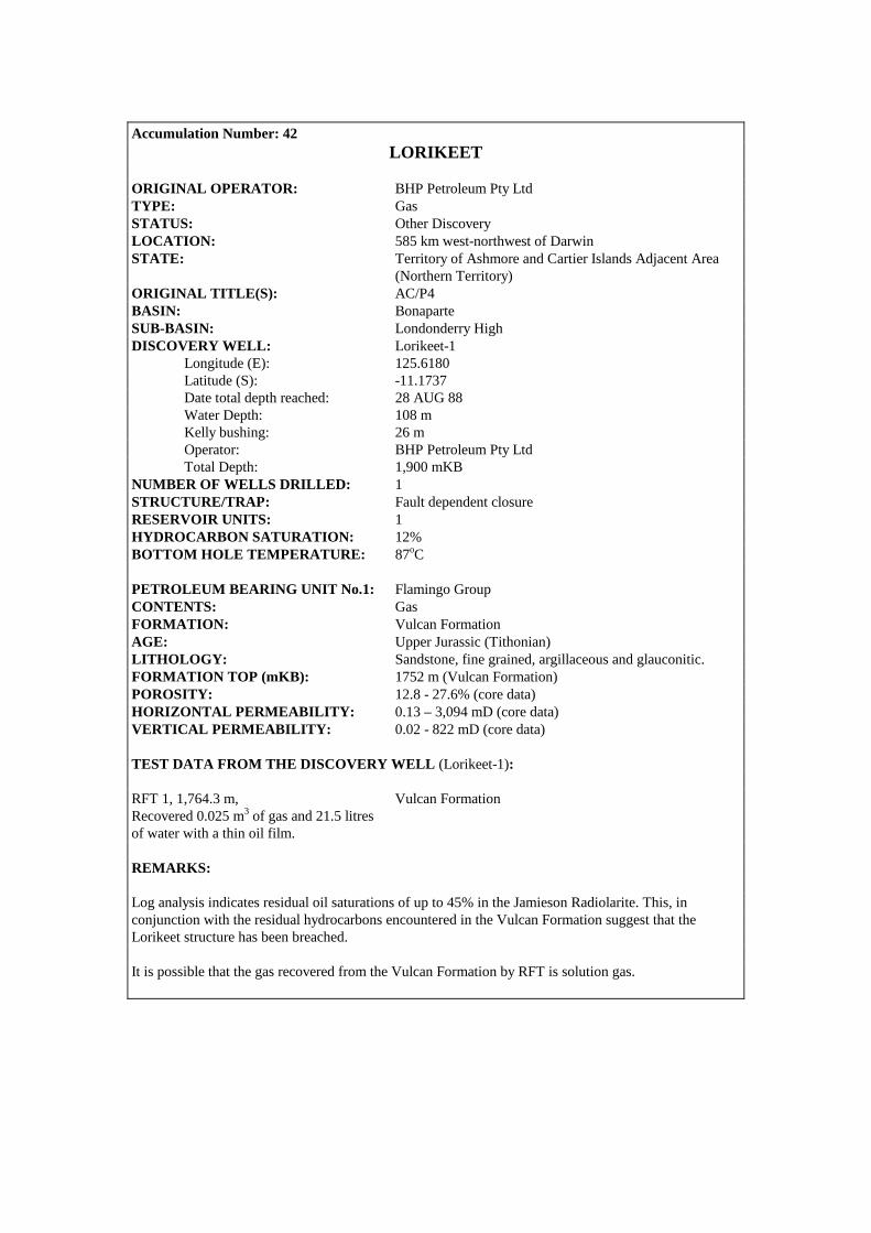
Accumulation Number: 42
LORIKEET ORIGINAL OPERATOR: BHP Petroleum Pty Ltd TYPE: Gas STATUS: Other Discovery LOCATION: 585 km west-northwest of Darwin STATE: Territory of Ashmore and Cartier Islands Adjacent Area (Northern Territory) ORIGINAL TITLE(S): AC/P4 BASIN: Bonaparte SUB-BASIN: Londonderry High DISCOVERY WELL: Lorikeet-1 Longitude (E): 125.6180 Latitude (S): -11.1737 Date total depth reached: 28 AUG 88 Water Depth: 108 m Kelly bushing: 26 m Operator: BHP Petroleum Pty Ltd Total Depth: 1,900 mKB NUMBER OF WELLS DRILLED: 1 STRUCTURE/TRAP: Fault dependent closure RESERVOIR UNITS: 1 HYDROCARBON SATURATION: 12% BOTTOM HOLE TEMPERATURE: 87oC PETROLEUM BEARING UNIT No.1: Flamingo Group CONTENTS: Gas FORMATION: Vulcan Formation AGE: Upper Jurassic (Tithonian) LITHOLOGY: Sandstone, fine grained, argillaceous and glauconitic. FORMATION TOP (mKB): 1752 m (Vulcan Formation) POROSITY: 12.8 - 27.6% (core data) HORIZONTAL PERMEABILITY: 0.13 – 3,094 mD (core data) VERTICAL PERMEABILITY: 0.02 - 822 mD (core data) TEST DATA FROM THE DISCOVERY WELL (Lorikeet-1): RFT 1, 1,764.3 m, Vulcan Formation Recovered 0.025 m3 of gas and 21.5 litres of water with a thin oil film. REMARKS: Log analysis indicates residual oil saturations of up to 45% in the Jamieson Radiolarite. This, in conjunction with the residual hydrocarbons encountered in the Vulcan Formation suggest that the Lorikeet structure has been breached. It is possible that the gas recovered from the Vulcan Formation by RFT is solution gas.
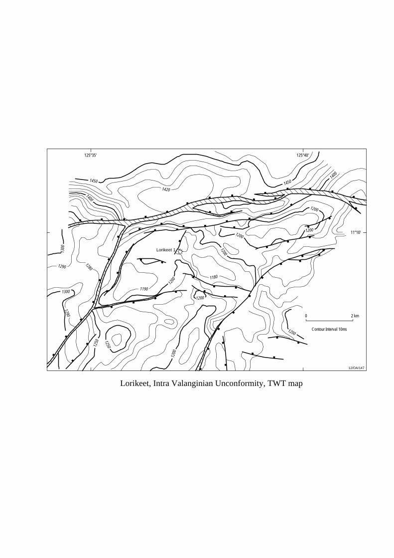
Lorikeet, Intra Valanginian Unconformity, TWT map
Lorikeet 1
125°35' 125°40'
11°10'
12/OA/147
Contour Interval 10ms
0 2 km
1450
1400
1450
1200
12001200
1200
1400
1200
1300
1300
1290
1290
1280
1190
1200
1200
1420
1200
12501250
1180
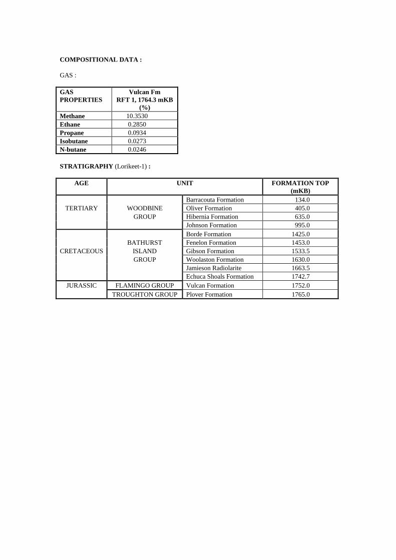
COMPOSITIONAL DATA : GAS : GAS PROPERTIES
Vulcan Fm RFT 1, 1764.3 mKB
(%) Methane 10.3530 Ethane 0.2850 Propane 0.0934 Isobutane 0.0273 N-butane 0.0246 STRATIGRAPHY (Lorikeet-1) :
AGE UNIT FORMATION TOP (mKB)
Barracouta Formation 134.0 TERTIARY WOODBINE Oliver Formation 405.0
GROUP Hibernia Formation 635.0 Johnson Formation 995.0 Borde Formation 1425.0 BATHURST Fenelon Formation 1453.0
CRETACEOUS ISLAND Gibson Formation 1533.5 GROUP Woolaston Formation 1630.0 Jamieson Radiolarite 1663.5 Echuca Shoals Formation 1742.7
JURASSIC FLAMINGO GROUP Vulcan Formation 1752.0 TROUGHTON GROUP Plover Formation 1765.0
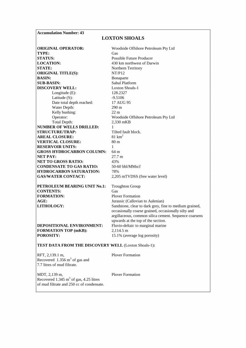
Accumulation Number: 43 LOXTON SHOALS
ORIGINAL OPERATOR: Woodside Offshore Petroleum Pty Ltd TYPE: Gas STATUS: Possible Future Producer LOCATION: 430 km northwest of Darwin STATE: Northern Territory ORIGINAL TITLE(S): NT/P12 BASIN: Bonaparte SUB-BASIN: Sahul Platform DISCOVERY WELL: Loxton Shoals-1 Longitude (E): 128.2327 Latitude (S): -9.5106 Date total depth reached: 17 AUG 95 Water Depth: 290 m Kelly bushing: 22 m Operator: Woodside Offshore Petroleum Pty Ltd Total Depth: 2,330 mKB NUMBER OF WELLS DRILLED: 1 STRUCTURE/TRAP: Tilted fault block. AREAL CLOSURE: 81 km2 VERTICAL CLOSURE: 80 m RESERVOIR UNITS: 1 GROSS HYDROCARBON COLUMN: 64 m NET PAY: 27.7 m NET TO GROSS RATIO: 43% CONDENSATE TO GAS RATIO: 50-60 bbl/MMscf HYDROCARBON SATURATION: 78% GAS/WATER CONTACT: 2,205 mTVDSS (free water level) PETROLEUM BEARING UNIT No.1: Troughton Group CONTENTS: Gas FORMATION: Plover Formation AGE: Jurassic (Callovian to Aalenian) LITHOLOGY: Sandstone, clear to dark grey, fine to medium grained, occasionally coarse grained, occasionally silty and argillaceous, common silica cement. Sequence coarsens upwards at the top of the section. DEPOSITIONAL ENVIRONMENT: Fluvio-deltaic to marginal marine FORMATION TOP (mKB): 2,114.5 m POROSITY: 15.1% (average log porosity) TEST DATA FROM THE DISCOVERY WELL (Loxton Shoals-1): RFT, 2,139.1 m, Plover Formation Recovered 1.356 m3 of gas and 7.7 litres of mud filtrate. MDT, 2,139 m, Plover Formation Recovered 1.345 m3 of gas, 4.25 litres of mud filtrate and 250 cc of condensate.

Loxton Shoals, Near Base Cretaceous, depth map
Sunset 1Sunset West 1
Sunrise 1
Sunrise 2
Loxton Shoals 1
Troubadour 1
127°45' 128°00' 128°15'
9°30'
9°45'
0 15 km
128°30'
1750
1750
1750
1750
1750
1750
1900
1900
1900
1900
1750
17501800
1700
1700
1700
Lowest closing contour
12/OA/148
Contour Interval 50m

RESERVES: Gas: 9.56 TCF (includes Sunrise/Troubadour/Sunset/Sunset West) Condensate: 321 MMbbls (includes Sunrise/Troubadour/Sunset/Sunset West) Source: Northern Territory Department of Business Industry and Resource Development, 2000. REMARKS: Loxton Shoals-1, Troubadour-1, Sunset-1, Sunset West-1, Sunrise-1 and Sunrise-2 all recovered gas on test from the Plover Formation from what are thought to be adjacent fault compartments on the greater Sunrise/Troubadour structure. Development of the Sunrise/Troubadour resource is currently under consideration. At date of publication, Loxton Shoals was held under Retention Lease NT/RL2. STRATIGRAPHY (Loxton Shoals-1) :
AGE UNIT FORMATION TOP (mKB)
WOODBINE Not sampled 315.0 TERTIARY GROUP Hibernia Formation 1305.0
Johnson Formation 1435.0 BATHURST Undifferentiated 1556.0
CRETACEOUS ISLAND Wangarlu Formation 1736.5 GROUP Jamieson Radiolarite 2074.0 FLAMINGO GROUP Darwin Fm/Flamingo Gp 2096.0
JURASSIC TROUGHTON Laminaria Fm Equivalent 2100.0 GROUP Plover Formation 2114.5

Accumulation Number: 44 MAPLE
ORIGINAL OPERATOR: BHP Petroleum Pty Ltd TYPE: Oil and Gas STATUS: Other Discovery LOCATION: 690 km west of Darwin STATE: Territory of Ashmore and Cartier Islands Adjacent Area (Northern Territory) ORIGINAL TITLE(S): AC/P2 BASIN: Bonaparte SUB-BASIN: Vulcan Sub-basin DISCOVERY WELL: Maple-1 Longitude (E): 124.5387 Latitude (S): -12.0199 Date total depth reached: 11 JAN 90 Water Depth: 125 m Kelly bushing: 22 m Operator: BHP Petroleum Pty Ltd Total Depth: 4,230 mKB NUMBER OF WELLS DRILLED: 1 STRUCTURE/TRAP: Tilted fault block adjacent to the Paqualin Graben on the northeastern extension of the Puffin Horst. RESERVOIR UNITS: 1 (multiple reservoir sands) GROSS HYDROCARBON COLUMN: 500 m + (complete reservoir section not penetrated) HYDROCARBON SATURATION: 69% (average, 3,650-3,805 mKB) NET TO GROSS RATIO: 16% (average, 3,650-3,805 mKB) BOTTOM HOLE TEMPERATURE: 130.5oC (after 3 hours circulation and 15 hours post circulation) PETROLEUM BEARING UNIT No.1: Sahul Group CONTENTS: Oil and Gas FORMATION: Challis Formation AGE: Upper Triassic (Norian to Carnian) LITHOLOGY: Sandstone, greenish-white, fine to medium grained, moderately well sorted, subangular to subround, extensively cemented with carbonate cement, thinly interbedded with light to dark grey claystones and minor oolitic limestones. DEPOSITIONAL ENVIRONMENT: Estuarine and tidal channel sand sequence. FORMATION TOP (mKB): 3,686 m POROSITY: 8.4 -16.4% (log porosity, 3,650-3,805 mKB) 13.6% average PERMEABILITY: 0.5 – 1,400 mD (RFT data) TEST DATA FROM THE DISCOVERY WELL (Maple-1): RFT 1, 3,718.3 m, Challis Formation Recovered 0.29 m3 of gas and 12.7 litres of filtrate and water with a thin oil film. RFT 6, 3,718.5 m, Challis Formation Recovered 2.66 m3 of gas, 0.3 litres of oil/condensate and 11 litres of water.
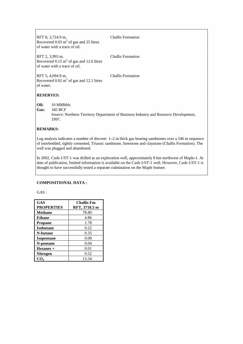
RFT 8, 3,724.9 m, Challis Formation Recovered 0.03 m3 of gas and 25 litres of water with a trace of oil. RFT 2, 3,993 m, Challis Formation Recovered 0.15 m3 of gas and 12.6 litres of water with a trace of oil. RFT 5, 4,094.9 m, Challis Formation Recovered 0.02 m3 of gas and 12.1 litres of water. RESERVES: Oil: 10 MMbbls Gas: 345 BCF Source: Northern Territory Department of Business Industry and Resource Development, 1997. REMARKS: Log analysis indicates a number of discreet 1–2 m thick gas bearing sandstones over a 546 m sequence of interbedded, tightly cemented, Triassic sandstone, limestone and claystone (Challis Formation). The well was plugged and abandoned. In 2002, Cash-1/ST-1 was drilled as an exploration well, approximately 8 km northwest of Maple-1. At date of publication, limited information is available on the Cash-1/ST-1 well. However, Cash-1/ST-1 is thought to have successfully tested a separate culmination on the Maple feature. COMPOSITIONAL DATA : GAS : GAS PROPERTIES
Challis Fm RFT, 3718.5 m
Methane 78.80 Ethane 4.86 Propane 1.78 Isobutane 0.22 N-butane 0.35 Isopentane 0.08 N-pentane 0.04 Hexanes + 0.01 Nitrogen 0.52 CO2 13.34

STRATIGRAPHY (Maple-1) :
AGE UNIT FORMATION TOP (mKB)
Oliver Formation 148.0 TERTIARY WOODBINE Hibernia Formation 1109.0
GROUP Grebe Sandstone 1608.0 Johnston Formation 2008.0 Puffin Formation 2546.0 BATHURST Fenelon Formation 2622.0
CRETACEOUS ISLAND Gibson Formation 2748.0 GROUP Woolaston Formation 2791.0 Jamieson Formation 2826.0 Echuca Shoals Formation 2835.0
JURASSIC FLAMINGO Upper Vulcan Formation 2844.0 GROUP Lower Vulcan Formation 3084.0
TRIASSIC SAHUL GROUP Challis Formation 3688.0

Accumulation Number: 45 MARET
ORIGINAL OPERATOR: Norcen International Ltd TYPE: Gas STATUS: Other Discovery LOCATION: 705 km west of Darwin STATE: Territory of Ashmore and Cartier Islands Adjacent Area (Northern Territory) ORIGINAL TITLE(S): AC/P10 BASIN: Bonaparte SUB-BASIN: Vulcan Sub-basin DISCOVERY WELL: Maret-1 Longitude (E): 124.3656 Latitude (S): -12.7651 Date total depth reached: 23 JAN 92 Water Depth: 131 m Kelly bushing: 22 m Operator: Norcen International Ltd Total Depth: 3,560 mKB NUMBER OF WELLS DRILLED: 1 STRUCTURE/TRAP: Subcrop play situated on a northeast-southwest trending horst block. The discovery well was designed to test dipping Oxfordian sandstones truncated by a Kimmeridgian unconformity. RESERVOIR UNITS: 1 GROSS HYDROCARBON COLUMN: 3.5 m NET PAY: 1.8 m NET TO GROSS RATIO: 51% CONDENSATE GRAVITY: 38o API CONDENSATE/GAS RATIO: 30.8 bbl/MMscf DEW POINT: 5,202 psig RESERVOIR PRESSURE: 4,912.1 psia (at 3,409.5 mKB) PETROLEUM BEARING UNIT No.1: Troughton Group CONTENTS: Gas FORMATION: Plover Formation AGE: Early Jurassic (Toarcian to Bathonian) LITHOLOGY: Sandstone, light to medium grey, fine to very coarse, translucent quartz grains, poorly to moderately well sorted, interbedded with thin (up to 3 m thick) siltstones, claystones and coals. DEPOSITIONAL ENVIRONMENT: Delta plain environment comprising distributary channel/bar and interdistributary bay/marsh deposits. FORMATION TOP (mKB): 3,385 m POROSITY: 9 - 13% (log analysis) TEST DATA FROM THE DISCOVERY WELL (Maret-1): RFT 24, 3,409.5 m, Plover Formation Recovered 1.24 m3 of gas, 0.4 litres of condensate and 8.3 litres of filtrate.

Maret, Intra Valanginian Unconformity, TWT map
12/OA/149
Contour Interval = 10m
0 1 km
2000
2100
2150
2100
2050
2050
2000
2150
Maret 1
124°22' 124°24'
12°46'
12°44'
2000
2050
2050
2050
2050

REMARKS: A 3.5 m gross hydrocarbon column was identified on logs between 3,407.5 mKB and 3,411 mKB. The pay sand is interbedded with siltstones, claystones and water-wet sandstones suggesting the hydrocarbons are probably trapped stratigraphically in an isolated pocket. Oil shows were recorded between 3,375 mKB and 3,420 mKB. COMPOSITIONAL DATA : GAS : GAS PROPERTIES
Plover Fm RFT 24, 3409.5 m
Methane 72.04 Ethane 9.10 Propane 5.20 Isobutane 0.86 N-butane 1.84 Isopentane 0.60 N-pentane 0.74 Hexanes 0.82 Heptanes 1.14 Octanes 1.18 Nonanes 0.51 Decanes 0.32 Undecanes 0.19 Dodecanes + 0.89 Nitrogen 0.34 CO2 4.23 H2S 0.00 STRATIGRAPHY (Maret-1) :
AGE UNIT FORMATION TOP (mKB)
Barracouta Formation 153.0 TERTIARY WOODBINE Oliver Formation 448.0
GROUP Hibernia Formation 814.0 Johnston Formation 1426.0 Puffin Formation 1726.0 BATHURST Fenelon Formation 2505.0
CRETACEOUS ISLAND Gibson Formation 2717.0 GROUP Woolaston Formation 2775.0 Jamieson Formation 2833.0 Echuca Shoals Formation 3118.0 FLAMINGO Upper Vulcan Formation 3257.0
JURASSIC GROUP Lower Vulcan Formation 3276.0 TROUGHTON GROUP Plover Formation 3385.0
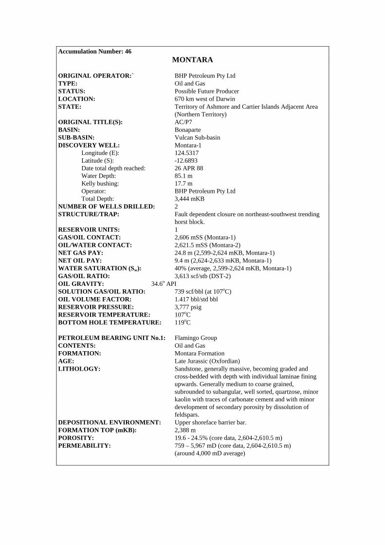
Accumulation Number: 46 MONTARA
ORIGINAL OPERATOR:` BHP Petroleum Pty Ltd TYPE: Oil and Gas STATUS: Possible Future Producer LOCATION: 670 km west of Darwin STATE: Territory of Ashmore and Cartier Islands Adjacent Area (Northern Territory) ORIGINAL TITLE(S): AC/P7 BASIN: Bonaparte SUB-BASIN: Vulcan Sub-basin DISCOVERY WELL: Montara-1 Longitude (E): 124.5317 Latitude (S): -12.6893 Date total depth reached: 26 APR 88 Water Depth: 85.1 m Kelly bushing: 17.7 m Operator: BHP Petroleum Pty Ltd Total Depth: 3,444 mKB NUMBER OF WELLS DRILLED: 2 STRUCTURE/TRAP: Fault dependent closure on northeast-southwest trending horst block. RESERVOIR UNITS: 1 GAS/OIL CONTACT: 2,606 mSS (Montara-1) OIL/WATER CONTACT: 2,621.5 mSS (Montara-2) NET GAS PAY: 24.8 m (2,599-2,624 mKB, Montara-1) NET OIL PAY: 9.4 m (2,624-2,633 mKB, Montara-1) WATER SATURATION (Sw): 40% (average, 2,599-2,624 mKB, Montara-1) GAS/OIL RATIO: 3,613 scf/stb (DST-2) OIL GRAVITY: 34.6o API SOLUTION GAS/OIL RATIO: 739 scf/bbl (at 107oC) OIL VOLUME FACTOR: 1.417 bbl/std bbl RESERVOIR PRESSURE: 3,777 psig RESERVOIR TEMPERATURE: 107oC BOTTOM HOLE TEMPERATURE: 119oC PETROLEUM BEARING UNIT No.1: Flamingo Group CONTENTS: Oil and Gas FORMATION: Montara Formation AGE: Late Jurassic (Oxfordian) LITHOLOGY: Sandstone, generally massive, becoming graded and cross-bedded with depth with individual laminae fining upwards. Generally medium to coarse grained, subrounded to subangular, well sorted, quartzose, minor kaolin with traces of carbonate cement and with minor development of secondary porosity by dissolution of feldspars. DEPOSITIONAL ENVIRONMENT: Upper shoreface barrier bar. FORMATION TOP (mKB): 2,388 m POROSITY: 19.6 - 24.5% (core data, 2,604-2,610.5 m) PERMEABILITY: 759 – 5,967 mD (core data, 2,604-2,610.5 m) (around 4,000 mD average)
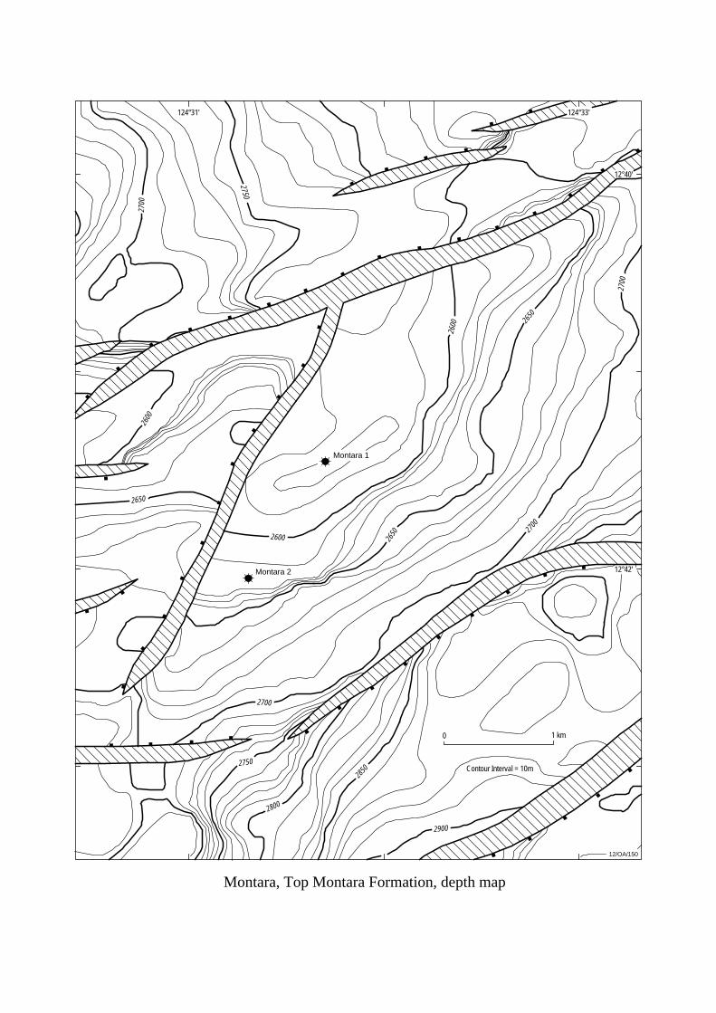
12/OA/150
124°31'
Montara 1
Montara 2
124°33'
0 1 km
Contour Interval = 10m
2700
2700
2700
2700
2650
2650
2750
2600
2600
2650
2600
2850
2800
2750
2900
12°42'
12°40'
Montara, Top Montara Formation, depth map
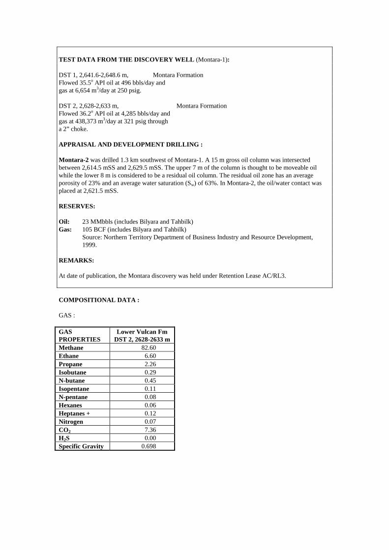
TEST DATA FROM THE DISCOVERY WELL (Montara-1): DST 1, 2,641.6-2,648.6 m, Montara Formation Flowed 35.5o API oil at 496 bbls/day and gas at 6,654 m3/day at 250 psig. DST 2, 2,628-2,633 m, Montara Formation Flowed 36.2o API oil at 4,285 bbls/day and gas at 438,373 m3/day at 321 psig through a 2” choke. APPRAISAL AND DEVELOPMENT DRILLING : Montara-2 was drilled 1.3 km southwest of Montara-1. A 15 m gross oil column was intersected between 2,614.5 mSS and 2,629.5 mSS. The upper 7 m of the column is thought to be moveable oil while the lower 8 m is considered to be a residual oil column. The residual oil zone has an average porosity of 23% and an average water saturation (Sw) of 63%. In Montara-2, the oil/water contact was placed at 2,621.5 mSS. RESERVES: Oil: 23 MMbbls (includes Bilyara and Tahbilk) Gas: 105 BCF (includes Bilyara and Tahbilk) Source: Northern Territory Department of Business Industry and Resource Development, 1999. REMARKS: At date of publication, the Montara discovery was held under Retention Lease AC/RL3. COMPOSITIONAL DATA : GAS : GAS PROPERTIES
Lower Vulcan Fm DST 2, 2628-2633 m
Methane 82.60 Ethane 6.60 Propane 2.26 Isobutane 0.29 N-butane 0.45 Isopentane 0.11 N-pentane 0.08 Hexanes 0.06 Heptanes + 0.12 Nitrogen 0.07 CO2 7.36 H2S 0.00 Specific Gravity 0.698
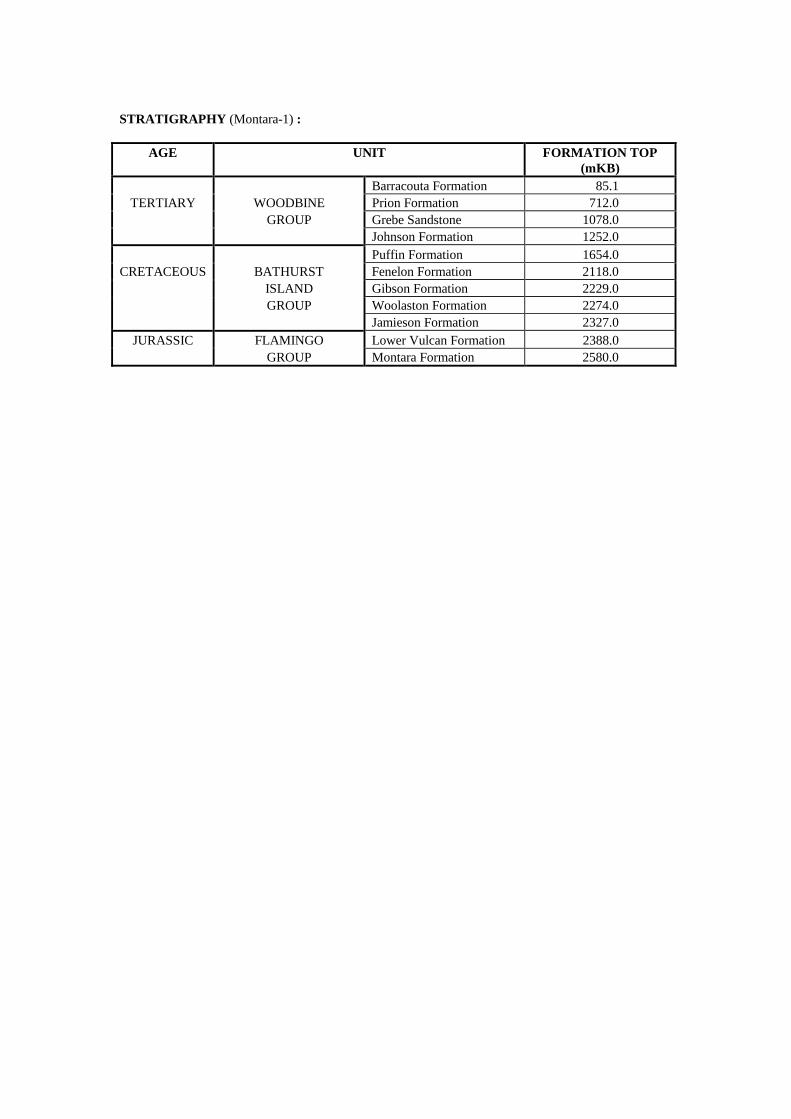
STRATIGRAPHY (Montara-1) :
AGE UNIT FORMATION TOP (mKB)
Barracouta Formation 85.1 TERTIARY WOODBINE Prion Formation 712.0
GROUP Grebe Sandstone 1078.0 Johnson Formation 1252.0 Puffin Formation 1654.0
CRETACEOUS BATHURST Fenelon Formation 2118.0 ISLAND Gibson Formation 2229.0 GROUP Woolaston Formation 2274.0 Jamieson Formation 2327.0
JURASSIC FLAMINGO Lower Vulcan Formation 2388.0 GROUP Montara Formation 2580.0
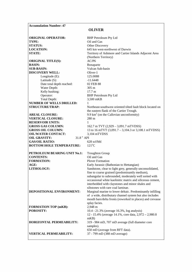
Accumulation Number: 47 OLIVER
ORIGINAL OPERATOR: BHP Petroleum Pty Ltd TYPE: Oil and Gas STATUS: Other Discovery LOCATION: 645 km west-northwest of Darwin STATE: Territory of Ashmore and Cartier Islands Adjacent Area (Northern Territory) ORIGINAL TITLE(S): AC/P6 BASIN: Bonaparte SUB-BASIN: Vulcan Sub-basin DISCOVERY WELL: Oliver-1 Longitude (E): 125.0088 Latitude (S): -11.6448 Date total depth reached: 02 FEB 88 Water Depth: 305 m Kelly bushing: 17.7 m Operator: BHP Petroleum Pty Ltd Total Depth: 3,500 mKB NUMBER OF WELLS DRILLED: 1 STRUCTURE/TRAP: Northeast-southwest oriented tilted fault block located on the eastern flank of the Cartier Trough. AREAL CLOSURE: 9.9 km2 (on the Callovian unconformity) VERTICAL CLOSURE: 280 m RESERVOIR UNITS: 1 GROSS GAS COLUMN: 162.7 m TVT (2,929 – 3,091.7 mTVDSS) GROSS OIL COLUMN: 13 to 16 mTVT (3,091.7 – 3,104.3 or 3,108.1 mTVDSS) OIL/WATER CONTACT: 3,104 mTVDSS OIL GRAVITY: 31.8 o API GAS/OIL RATIO: 628 scf/bbl BOTTOM HOLE TEMPERATURE: 121oC PETROLEUM BEARING UNIT No.1: Troughton Group CONTENTS: Oil and Gas FORMATION: Plover Formation AGE: Early Jurassic (Bathonian to Hettangian) LITHOLOGY: Sandstone, clear to light grey, generally unconsolidated, fine to coarse grained (predominantly medium), subangular to subrounded, moderately well sorted with occassional white kaolinitic matrix and siliceous cement, interbedded with claystones and minor shales and siltstones with rare coal laminae. DEPOSITIONAL ENVIRONMENT: Marginal marine to lower deltaic. Predominantly infilling of a wide, distributary channel system but also includes mouth bars/delta fronts (reworked in places) and crevasse splay facies. FORMATION TOP (mKB): 2,948 m POROSITY: 10.4 - 21.3% (average 16.3%, log analysis) 12 - 15.4% (average 14.1%, core data, 2,972 – 2,980.8 mKB) HORIZONTAL PERMEABILITY: 319 - 984 mD, 707 mD average (full diameter core
samples). 650 mD (average from RFT data). VERTICAL PERMEABILITY: 37 - 799 mD (388 mD average)

125°00' 125°05'
11°35'
11°40'
12/OA/152
0 5 km
Oliver
Oliver, Callovian Unconformity, depth map
3500
3250
3000
3000
3250
3250
3250
3500
3500
3200
3200
3400
3050
Contour Interval 50m
(after Evans et al, 1995)
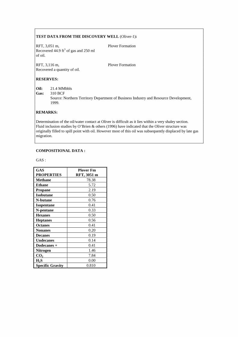
TEST DATA FROM THE DISCOVERY WELL (Oliver-1): RFT, 3,051 m, Plover Formation Recovered 44.9 ft3 of gas and 250 ml of oil. RFT, 3,116 m, Plover Formation Recovered a quantity of oil. RESERVES: Oil: 21.4 MMbbls Gas: 310 BCF Source: Northern Territory Department of Business Industry and Resource Development, 1999. REMARKS: Determination of the oil/water contact at Oliver is difficult as it lies within a very shaley section. Fluid inclusion studies by O’Brien & others (1996) have indicated that the Oliver structure was originally filled to spill point with oil. However most of this oil was subsequently displaced by late gas migration. COMPOSITIONAL DATA : GAS : GAS PROPERTIES
Plover Fm RFT, 3051 m
Methane 78.38 Ethane 5.72 Propane 2.19 Isobutane 0.50 N-butane 0.76 Isopentane 0.41 N-pentane 0.33 Hexanes 0.50 Heptanes 0.56 Octanes 0.41 Nonanes 0.20 Decanes 0.19 Undecanes 0.14 Dodecanes + 0.41 Nitrogen 1.46 CO2 7.84 H2S 0.00 Specific Gravity 0.810

STRATIGRAPHY (Oliver-1) :
AGE UNIT FORMATION TOP
(mKB) WOODBINE Undifferentiated 590.0
TERTIARY GROUP Hibernia Formation 1577.0 Woodbine Formation 2002.0
CRETACEOUS BATHURST ISLAND GP Undifferentiated 2392.5 JURASSIC FLAMINGO GROUP Undifferentiated 2698.0
TROUGHTON GROUP Plover Formation 2948.0 TRIASSIC SAHUL GROUP Undifferentiated 3365.0

Accumulation Number: 48 PADTHAWAY
ORIGINAL OPERATOR: BHP Petroleum Pty Ltd TYPE: Gas STATUS: Other Discovery LOCATION: 680 km west of Darwin STATE: Territory of Ashmore and Cartier Islands Adjacent Area (Northern Territory) ORIGINAL TITLE(S): AC/RL3 BASIN: Bonaparte SUB-BASIN: Vulcan Sub-basin DISCOVERY WELL: Padthaway-1 Longitude (E): 124.5017 Latitude (S): -12.6807 Date total depth reached: 09 APRIL 00 Water Depth: 88 m Kelly bushing: 25 m Operator: BHP Petroleum Pty Ltd Total Depth: 2,875 mRT NUMBER OF WELLS DRILLED: 1 STRUCTURE/TRAP: Tilted fault block RESERVOIR UNITS: 1 GROSS HYDROCARBON COLUMN: 9 m (2,585-2,594 mRT) GAS/WATER CONTACT: 2,569 mSS GAS/CONDENSATE RATIO: 30.1 bbl/MMscf HYDROCARBON SATURATION: 96% (average) PETROLEUM BEARING UNIT No.1: Troughton Group CONTENTS: Gas FORMATION: Montara Formation AGE: Oxfordian LITHOLOGY: Sandstone: medium grey to olive grey, firm, friable, fine to coarse grained with angular to sub-rounded, moderately spherical, poorly sorted. Minor to locally abundant silty argillaceous matrix, trace of silicieous cement, trace lithic fragments, trace of glauconite with poor to fair visual porosity. DEPOSITIONAL ENVIRONMENT: Fluvial dominated deltaic deposit. FORMATION TOP (mKB): 2,585 m POROSITY: 25% (average log porosity) PERMEABILITY: 8,000 mD (average from logs) TEST DATA FROM THE DISCOVERY WELL (Padthaway-1): MDT, Run1, 2,609 m Montara Formation Recovered 10.5 litres of formation water and filtrate from the 2.75 gallon chamber.

MDT, Run 1, 2,600.5 m Montara Formation Recovered 21 litres of formation water and mud filtrate with an oil scum from the 6 gallon chamber. Recovered 10 litres of formation water and mud filtrate from the 2.75 gallon chamber. MDT, Run 1, 2,589 m Montara Formation Recovered gas from the 1 gallon Chamber. REMARKS: A 9.5m residual oil column between 2,569 mSS and 2,578.5 mSS is inferred from wireline logs. STRATIGRAPHY (Padthaway-1) :
AGE UNIT FORMATION TOP (mKB)
Oliver Formation 412.5 TERTIARY WOODBINE Prion Formation 736.0
Hibernia Formation 993.0 GROUP Grebe Sandstone 1095.5 Johnson Formation 1297.5 Puffin Formation 1697.0
CRETACEOUS BATHURST Fenelon Formation 2166.4 ISLAND Gibson Formation 2313.8 GROUP Woolaston Formation 2367.3 Jamieson Formation 2305.3
JURASSIC FLAMINGO Lower Vulcan Formation 2457.8 GROUP Montara Formation 2585.2
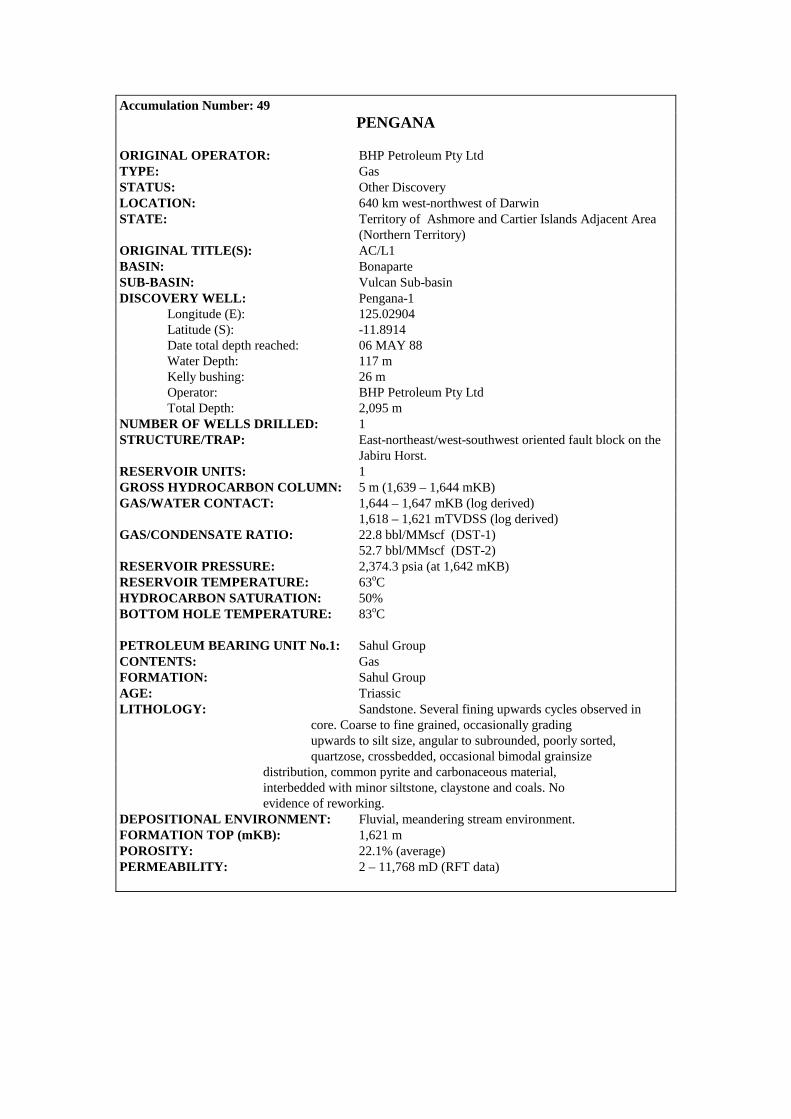
Accumulation Number: 49 PENGANA
ORIGINAL OPERATOR: BHP Petroleum Pty Ltd TYPE: Gas STATUS: Other Discovery LOCATION: 640 km west-northwest of Darwin STATE: Territory of Ashmore and Cartier Islands Adjacent Area (Northern Territory) ORIGINAL TITLE(S): AC/L1 BASIN: Bonaparte SUB-BASIN: Vulcan Sub-basin DISCOVERY WELL: Pengana-1 Longitude (E): 125.02904 Latitude (S): -11.8914 Date total depth reached: 06 MAY 88 Water Depth: 117 m Kelly bushing: 26 m Operator: BHP Petroleum Pty Ltd Total Depth: 2,095 m NUMBER OF WELLS DRILLED: 1 STRUCTURE/TRAP: East-northeast/west-southwest oriented fault block on the Jabiru Horst. RESERVOIR UNITS: 1 GROSS HYDROCARBON COLUMN: 5 m (1,639 – 1,644 mKB) GAS/WATER CONTACT: 1,644 – 1,647 mKB (log derived) 1,618 – 1,621 mTVDSS (log derived) GAS/CONDENSATE RATIO: 22.8 bbl/MMscf (DST-1) 52.7 bbl/MMscf (DST-2) RESERVOIR PRESSURE: 2,374.3 psia (at 1,642 mKB) RESERVOIR TEMPERATURE: 63oC HYDROCARBON SATURATION: 50% BOTTOM HOLE TEMPERATURE: 83oC PETROLEUM BEARING UNIT No.1: Sahul Group CONTENTS: Gas FORMATION: Sahul Group AGE: Triassic LITHOLOGY: Sandstone. Several fining upwards cycles observed in core. Coarse to fine grained, occasionally grading upwards to silt size, angular to subrounded, poorly sorted, quartzose, crossbedded, occasional bimodal grainsize distribution, common pyrite and carbonaceous material, interbedded with minor siltstone, claystone and coals. No evidence of reworking. DEPOSITIONAL ENVIRONMENT: Fluvial, meandering stream environment. FORMATION TOP (mKB): 1,621 m POROSITY: 22.1% (average) PERMEABILITY: 2 – 11,768 mD (RFT data)
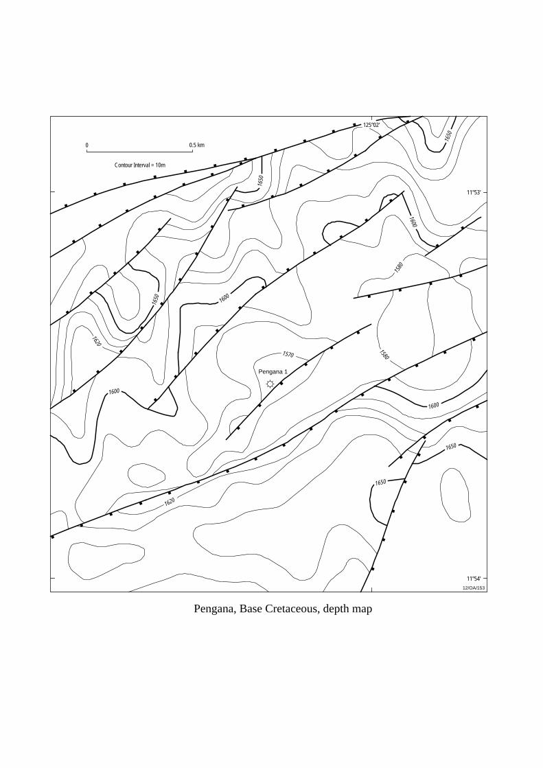
Pengana, Base Cretaceous, depth map
12/OA/153
11°53'
11°54'
125°02'
0
Contour Interval = 10m
Pengana 1
1650
1650
1650
1650
1620
1600
1600
1620
1650 160
0
1600
1570
1580
1580
0.5 km
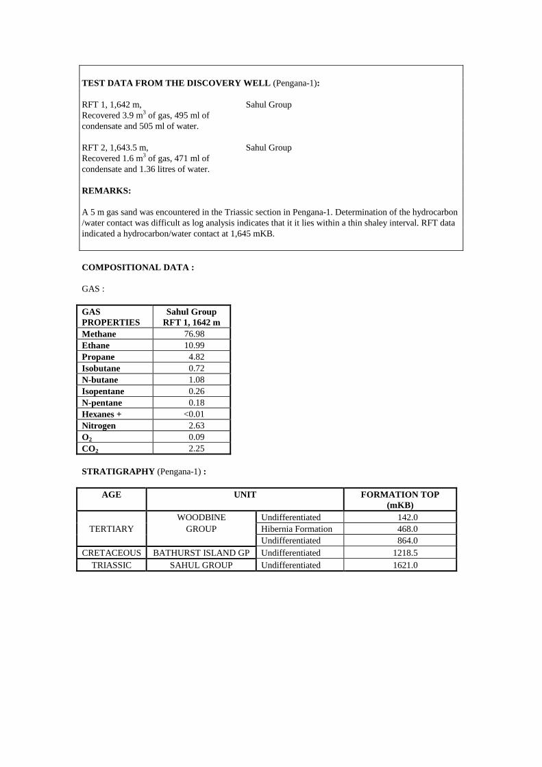
TEST DATA FROM THE DISCOVERY WELL (Pengana-1): RFT 1, 1,642 m, Sahul Group Recovered 3.9 m3 of gas, 495 ml of condensate and 505 ml of water. RFT 2, 1,643.5 m, Sahul Group Recovered 1.6 m3 of gas, 471 ml of condensate and 1.36 litres of water. REMARKS: A 5 m gas sand was encountered in the Triassic section in Pengana-1. Determination of the hydrocarbon /water contact was difficult as log analysis indicates that it it lies within a thin shaley interval. RFT data indicated a hydrocarbon/water contact at 1,645 mKB. COMPOSITIONAL DATA : GAS : GAS PROPERTIES
Sahul Group RFT 1, 1642 m
Methane 76.98 Ethane 10.99 Propane 4.82 Isobutane 0.72 N-butane 1.08 Isopentane 0.26 N-pentane 0.18 Hexanes + <0.01 Nitrogen 2.63 O2 0.09 CO2 2.25 STRATIGRAPHY (Pengana-1) :
AGE UNIT FORMATION TOP (mKB)
WOODBINE Undifferentiated 142.0 TERTIARY GROUP Hibernia Formation 468.0
Undifferentiated 864.0 CRETACEOUS BATHURST ISLAND GP Undifferentiated 1218.5
TRIASSIC SAHUL GROUP Undifferentiated 1621.0
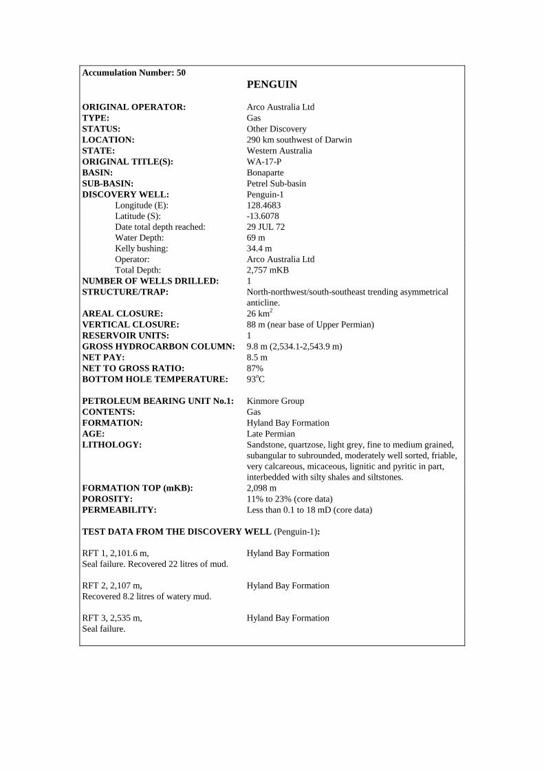
Accumulation Number: 50 PENGUIN
ORIGINAL OPERATOR: Arco Australia Ltd TYPE: Gas STATUS: Other Discovery LOCATION: 290 km southwest of Darwin STATE: Western Australia ORIGINAL TITLE(S): WA-17-P BASIN: Bonaparte SUB-BASIN: Petrel Sub-basin DISCOVERY WELL: Penguin-1 Longitude (E): 128.4683 Latitude (S): -13.6078 Date total depth reached: 29 JUL 72 Water Depth: 69 m Kelly bushing: 34.4 m Operator: Arco Australia Ltd Total Depth: 2,757 mKB NUMBER OF WELLS DRILLED: 1 STRUCTURE/TRAP: North-northwest/south-southeast trending asymmetrical anticline. AREAL CLOSURE: 26 km2 VERTICAL CLOSURE: 88 m (near base of Upper Permian) RESERVOIR UNITS: 1 GROSS HYDROCARBON COLUMN: 9.8 m (2,534.1-2,543.9 m) NET PAY: 8.5 m NET TO GROSS RATIO: 87% BOTTOM HOLE TEMPERATURE: 93oC PETROLEUM BEARING UNIT No.1: Kinmore Group CONTENTS: Gas FORMATION: Hyland Bay Formation AGE: Late Permian LITHOLOGY: Sandstone, quartzose, light grey, fine to medium grained, subangular to subrounded, moderately well sorted, friable, very calcareous, micaceous, lignitic and pyritic in part, interbedded with silty shales and siltstones. FORMATION TOP (mKB): 2,098 m POROSITY: 11% to 23% (core data) PERMEABILITY: Less than 0.1 to 18 mD (core data) TEST DATA FROM THE DISCOVERY WELL (Penguin-1): RFT 1, 2,101.6 m, Hyland Bay Formation Seal failure. Recovered 22 litres of mud. RFT 2, 2,107 m, Hyland Bay Formation Recovered 8.2 litres of watery mud. RFT 3, 2,535 m, Hyland Bay Formation Seal failure.

Penguin, Near Base of Upper Permian, TWT map
12/OA/154
128°30'
13°35'
5 km
Contour Interval = 25m
2200
2100
2000
1900
1825
1900
Penguin 1
13°40'
13°30'
0
128°25'
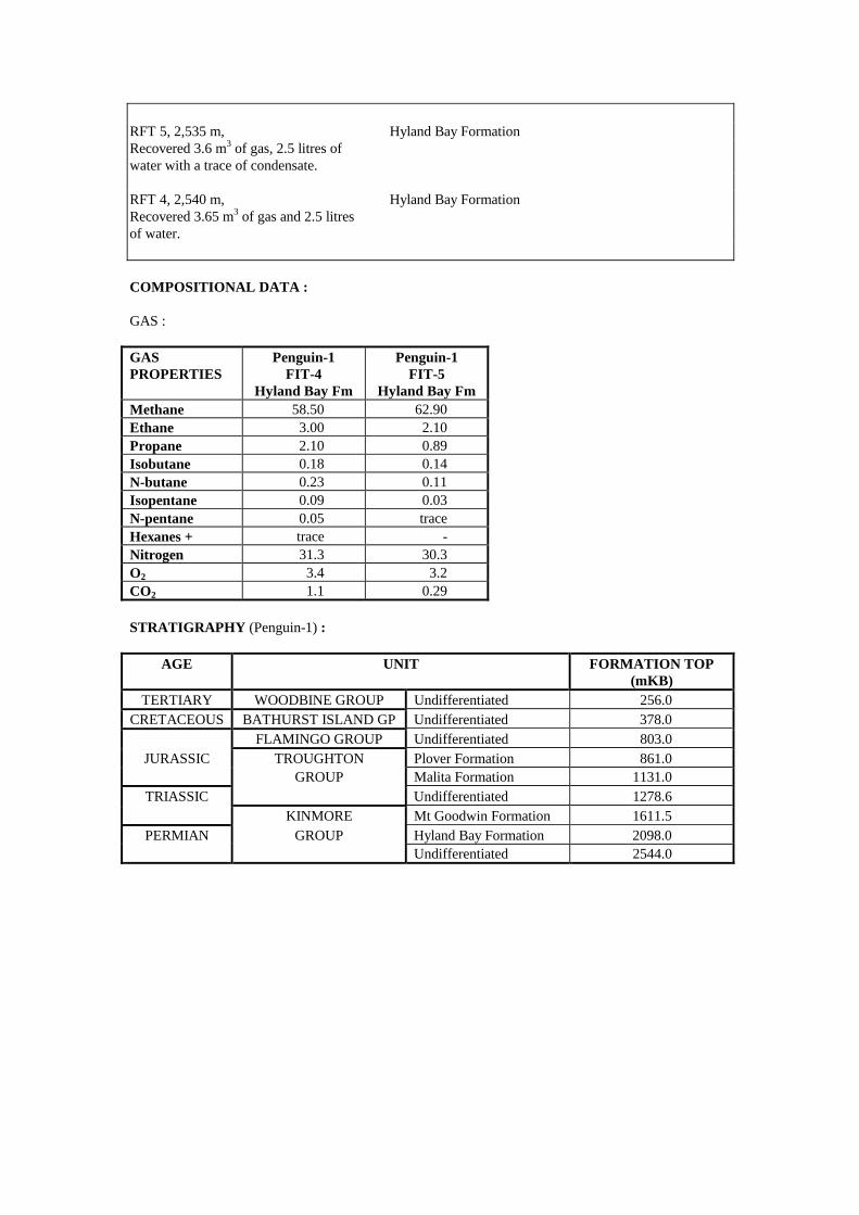
RFT 5, 2,535 m, Hyland Bay Formation Recovered 3.6 m3 of gas, 2.5 litres of water with a trace of condensate. RFT 4, 2,540 m, Hyland Bay Formation Recovered 3.65 m3 of gas and 2.5 litres of water. COMPOSITIONAL DATA : GAS : GAS PROPERTIES
Penguin-1 FIT-4
Hyland Bay Fm
Penguin-1 FIT-5
Hyland Bay Fm Methane 58.50 62.90 Ethane 3.00 2.10 Propane 2.10 0.89 Isobutane 0.18 0.14 N-butane 0.23 0.11 Isopentane 0.09 0.03 N-pentane 0.05 trace Hexanes + trace - Nitrogen 31.3 30.3 O2 3.4 3.2 CO2 1.1 0.29 STRATIGRAPHY (Penguin-1) :
AGE UNIT FORMATION TOP (mKB)
TERTIARY WOODBINE GROUP Undifferentiated 256.0 CRETACEOUS BATHURST ISLAND GP Undifferentiated 378.0
FLAMINGO GROUP Undifferentiated 803.0 JURASSIC TROUGHTON Plover Formation 861.0
GROUP Malita Formation 1131.0 TRIASSIC Undifferentiated 1278.6
KINMORE Mt Goodwin Formation 1611.5 PERMIAN GROUP Hyland Bay Formation 2098.0
Undifferentiated 2544.0
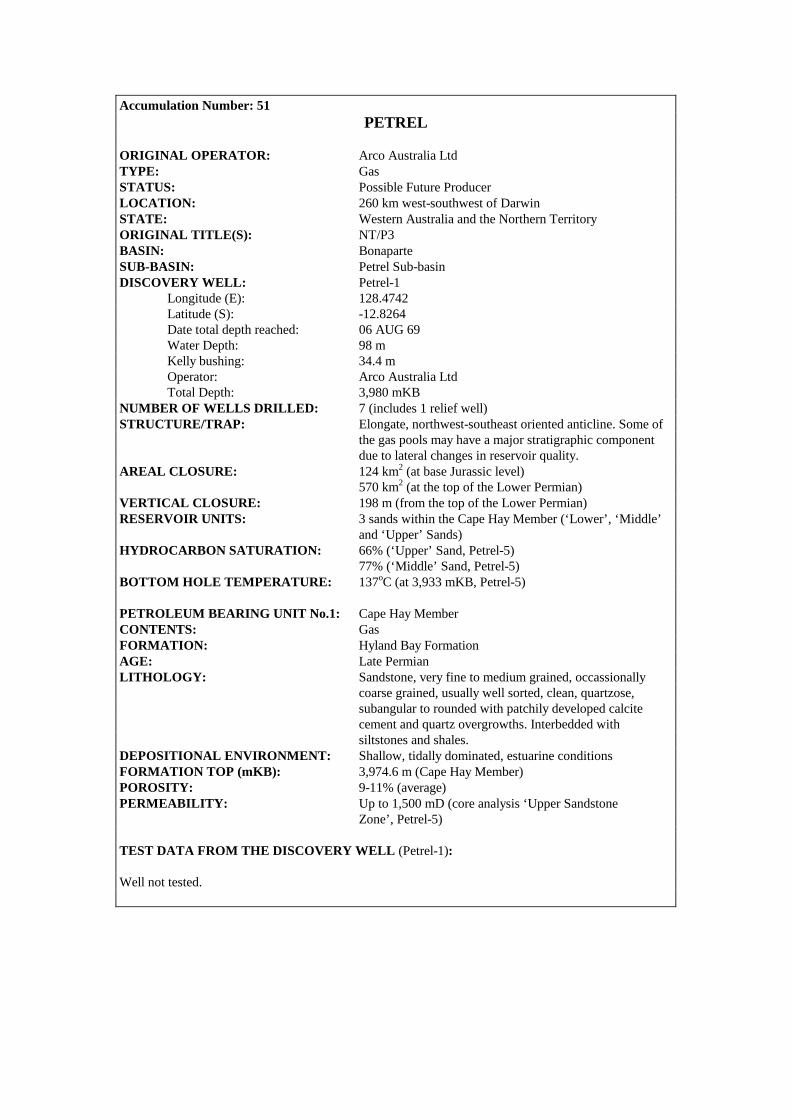
Accumulation Number: 51 PETREL
ORIGINAL OPERATOR: Arco Australia Ltd TYPE: Gas STATUS: Possible Future Producer LOCATION: 260 km west-southwest of Darwin STATE: Western Australia and the Northern Territory ORIGINAL TITLE(S): NT/P3 BASIN: Bonaparte SUB-BASIN: Petrel Sub-basin DISCOVERY WELL: Petrel-1 Longitude (E): 128.4742 Latitude (S): -12.8264 Date total depth reached: 06 AUG 69 Water Depth: 98 m Kelly bushing: 34.4 m Operator: Arco Australia Ltd Total Depth: 3,980 mKB NUMBER OF WELLS DRILLED: 7 (includes 1 relief well) STRUCTURE/TRAP: Elongate, northwest-southeast oriented anticline. Some of the gas pools may have a major stratigraphic component due to lateral changes in reservoir quality. AREAL CLOSURE: 124 km2 (at base Jurassic level) 570 km2 (at the top of the Lower Permian) VERTICAL CLOSURE: 198 m (from the top of the Lower Permian) RESERVOIR UNITS: 3 sands within the Cape Hay Member (‘Lower’, ‘Middle’ and ‘Upper’ Sands) HYDROCARBON SATURATION: 66% (‘Upper’ Sand, Petrel-5) 77% (‘Middle’ Sand, Petrel-5) BOTTOM HOLE TEMPERATURE: 137oC (at 3,933 mKB, Petrel-5) PETROLEUM BEARING UNIT No.1: Cape Hay Member CONTENTS: Gas FORMATION: Hyland Bay Formation AGE: Late Permian LITHOLOGY: Sandstone, very fine to medium grained, occassionally coarse grained, usually well sorted, clean, quartzose, subangular to rounded with patchily developed calcite cement and quartz overgrowths. Interbedded with siltstones and shales. DEPOSITIONAL ENVIRONMENT: Shallow, tidally dominated, estuarine conditions FORMATION TOP (mKB): 3,974.6 m (Cape Hay Member) POROSITY: 9-11% (average) PERMEABILITY: Up to 1,500 mD (core analysis ‘Upper Sandstone Zone’, Petrel-5) TEST DATA FROM THE DISCOVERY WELL (Petrel-1): Well not tested.
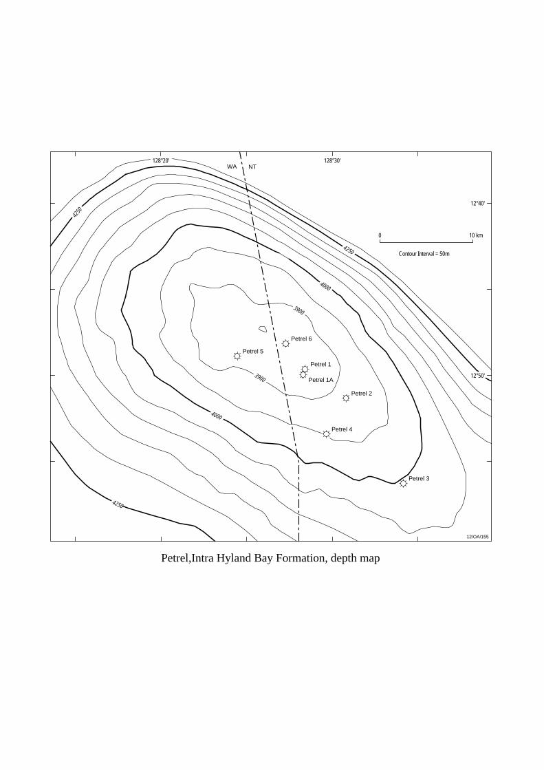
Petrel,Intra Hyland Bay Formation, depth map
12/OA/155
Petrel 6
Petrel 1
Petrel 2
Petrel 5
Petrel 1A
Petrel 4
Petrel 3
128°20' 128°30'
0 10 km
12°40'
12°50'
NTWA
4000
4000
4250
4250
4250
3900
3900
Contour Interval = 50m
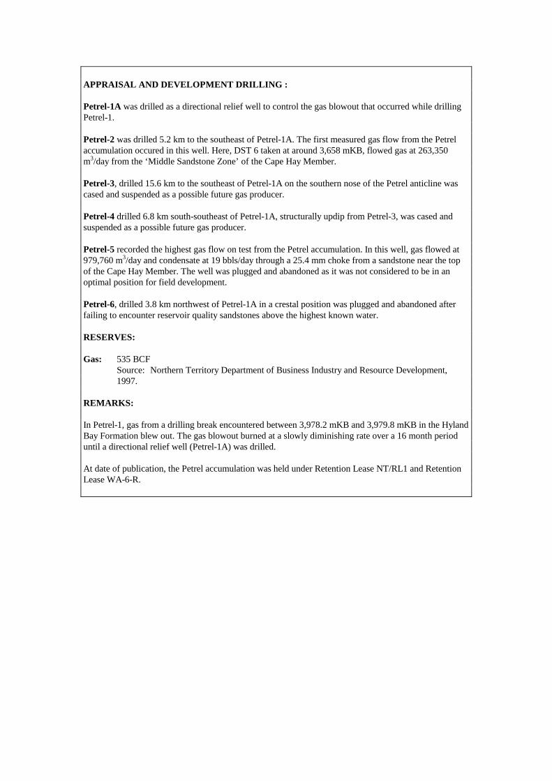
APPRAISAL AND DEVELOPMENT DRILLING : Petrel-1A was drilled as a directional relief well to control the gas blowout that occurred while drilling Petrel-1. Petrel-2 was drilled 5.2 km to the southeast of Petrel-1A. The first measured gas flow from the Petrel accumulation occured in this well. Here, DST 6 taken at around 3,658 mKB, flowed gas at 263,350 m3/day from the ‘Middle Sandstone Zone’ of the Cape Hay Member. Petrel-3, drilled 15.6 km to the southeast of Petrel-1A on the southern nose of the Petrel anticline was cased and suspended as a possible future gas producer. Petrel-4 drilled 6.8 km south-southeast of Petrel-1A, structurally updip from Petrel-3, was cased and suspended as a possible future gas producer. Petrel-5 recorded the highest gas flow on test from the Petrel accumulation. In this well, gas flowed at 979,760 m3/day and condensate at 19 bbls/day through a 25.4 mm choke from a sandstone near the top of the Cape Hay Member. The well was plugged and abandoned as it was not considered to be in an optimal position for field development. Petrel-6, drilled 3.8 km northwest of Petrel-1A in a crestal position was plugged and abandoned after failing to encounter reservoir quality sandstones above the highest known water. RESERVES: Gas: 535 BCF Source: Northern Territory Department of Business Industry and Resource Development, 1997. REMARKS: In Petrel-1, gas from a drilling break encountered between 3,978.2 mKB and 3,979.8 mKB in the Hyland Bay Formation blew out. The gas blowout burned at a slowly diminishing rate over a 16 month period until a directional relief well (Petrel-1A) was drilled. At date of publication, the Petrel accumulation was held under Retention Lease NT/RL1 and Retention Lease WA-6-R.
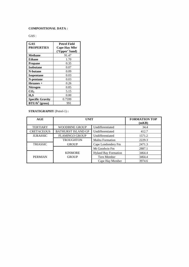
COMPOSITIONAL DATA : GAS : GAS PROPERTIES
Petrel Field Cape Hay Mbr (‘Upper’ Sand)
Methane 91.47 Ethane 1.70 Propane 0.35 Isobutane 0.07 N-butane 0.09 Isopentane 0.03 N-pentane 0.03 Hexanes + 0.26 Nitrogen 0.85 CO2 5.15 H2S 0.00 Specific Gravity 0.7599 BTU/ft3 (gross) 991 STRATIGRAPHY (Petrel-1) :
AGE UNIT FORMATION TOP (mKB)
TERTIARY WOODBINE GROUP Undifferentiated 34.4 CRETACEOUS BATHURST ISLAND GP Undifferentiated 412.7
JURASSIC FLAMINGO GROUP Undifferentiated 1571.2 TROUGHTON Malita Formation 2229.3
TRIASSIC GROUP Cape Londondery Fm 2471.3 Mt Goodwin Fm 2887.1 KINMORE Hyland Bay Formation 3464.4
PERMIAN GROUP Tern Member 3464.4 Cape Hay Member 3974.6
Accumulation Number: 52 PROMETHEUS / RUBICON
ORIGINAL OPERATOR: Kerr McGee NW Shelf Energy Australia Pty Ltd TYPE: Gas STATUS: Other Discovery LOCATION: 450 km west of Darwin STATE: Western Australia CURRENT TITLE(S): WA-278-P BASIN: Bonaparte SUB-BASIN: Petrel DISCOVERY WELL: Prometheus-1 Longitude (E): 126.3688 Latitude (S): -12.8392 Date total depth reached: 07 JUN 00 Water Depth: 69 m Operator: Kerr McGee NW Shelf Energy Australia Pty Ltd Total Depth: 2,360 mRT NUMBER OF WELLS DRILLED: 2 RESERVES: Gas: 370 BCF Source: Department of Industry and Resources, Western Australia, 2002. REMARKS: In December 2000, Rubicon-1 was drilled approximately 3 km to the east of Prometheus-1 in an adjacent fault block. Limited data is available at date of publication but the two wells are thought to have recovered gas on test from the Permian section in adjacent fault compartments on the one structure.
Accumulation Number: 53 PUFFIN
ORIGINAL OPERATOR: Arco Australia Ltd TYPE: Oil STATUS: Other Discovery LOCATION: 710 km west of Darwin STATE: Territory of Ashmore and Cartier Islands Adjacent Area (Northern Territory) ORIGINAL TITLE(S): NT/P2 BASIN: Bonaparte SUB-BASIN: Vulcan Sub-basin DISCOVERY WELL: Puffin-1 Longitude (E): 124.3336 Latitude (S): -12.3083 Date total depth reached: 08 JUN 72 Water Depth: 102 m Kelly bushing: 34 m Operator: Arco Australia Ltd Total Depth: 2,961 mKB NUMBER OF WELLS DRILLED: 4 STRUCTURE/TRAP: Northeast-southwest trending horst block. VERTICAL CLOSURE: 183 m (near base Tertiary) 366 m (near base Cretaceous) RESERVOIR UNITS: 1 GROSS HYDROCARBON COLUMN: 1.5 m (2,066 – 2,067.5 mKB) OIL/WATER CONTACT: 2,075 mSS (Puffin-4); 2,077 mSS (Puffin-3) OIL GRAVITY: 45o API BOTTOM HOLE TEMPERATURE: 90oC PETROLEUM BEARING UNIT No.1: Bathurst Island Group CONTENTS: Oil FORMATION: Puffin Formation AGE: Late Cretaceous LITHOLOGY: Sandstone, light grey, fine to coarse grained, quartzose, slightly glauconitic and friable, occasionally calcareous and argillaceous. FORMATION TOP (mKB): 1,999.5 m POROSITY: 16 - 30% (log porosity)) PERMEABILITY: 21 – 3,870 mD (RFT data, Puffin-4) TEST DATA FROM THE DISCOVERY WELL (Puffin-1): RFT 1, 2,067 m, Puffin Formation Recovered 20.15 litres of 45o API oil, 0.69 m3 of gas and 25 cc of sand. RFT 2, 2,071 m, Puffin Formation Recovered 22 litres of formation water. RFT 4, 2,162 m, Puffin Formation Recovered 22 litres of formation water. RFT 3, 2,214 m, Puffin Formation Recovered 21.5 litres of formation water.
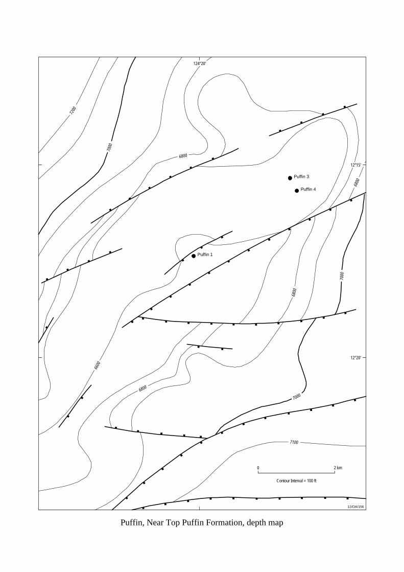
Puffin 1
Puffin 3
Puffin 4
Puffin, Near Top Puffin Formation, depth map
7000
7000
7000
6600
6800
6800
7100
6800
6800
7200
12/OA/156
12°20'
124°20'
0 2 km
Contour Interval = 100 ft
12°15'
APPRAISAL AND DEVELOPMENT DRILLING : Puffin-2, located 9 km southwest of Puffin-1, flowed oil at 4,608 bbls/day on DST over the interval 2,028-2,036 mKB in the Bathurst Island Group. Puffin-3, located 3 km northeast of Puffin-1, recovered oil on RFT from the same oil bearing interval (3 m gross pay) in the Late Cretaceous section. Puffin-4, drilled 450 m southeast of Puffin-3, intersected the same Upper Cretaceous sandstone, but wireline logs showed that only the upper 0.7 m of the reservoir (2,099.8 – 2,100.5 mKB) had significant hydrocarbon saturations (20%). RESERVES: Oil: 42 MMbbls Source: Northern Territory Department of Business Industry and Resource Development, 2000. REMARKS: Log analysis in Puffin-1 indicated a heavy, sour crude oil is trapped in vuggy calcarenites and argillaceous calcilutites of Eocene age between 1,021 mKB and 1,029 mKB. The oil is trapped at the Eocene - Miocene unconformity. COMPOSITIONAL DATA : GAS : GAS PROPERTIES
Bathurst Island Gp RFT 1, 2067 m
Methane 73.40 Ethane 4.40 Propane 1.40 Isobutane 0.26 N-butane 0.04 Isopentane trace N-pentane trace Hexanes + 0.03 Nitrogen 14.10 CO2 0.12 STRATIGRAPHY (Puffin-1) :
AGE UNIT FORMATION TOP (mKB)
TERTIARY WOODBINE GROUP Undifferentiated 136.9 CRETACEOUS BATHURST ISLAND GP Undifferentiated 1999.5
TRIASSIC SAHUL GROUP Undifferentiated 2362.2

STRATIGRAPHY (Puffin-4) : Kelly Bushing = 26 m; Total Depth = 2456 m
AGE UNIT FORMATION TOP (mKB)
Barracouta Formation 370.0 TERTIARY WOODBINE Oliver Formation 580.0
GROUP Hibernia Formation 1031.0 Johnson Formation 1788.0
CRETACEOUS BATHURST ISLAND Puffin Formation 2008.0 GROUP Fenelon Formation 2295.0
TRIASSIC SAHUL GROUP Challis Formation 2314.5
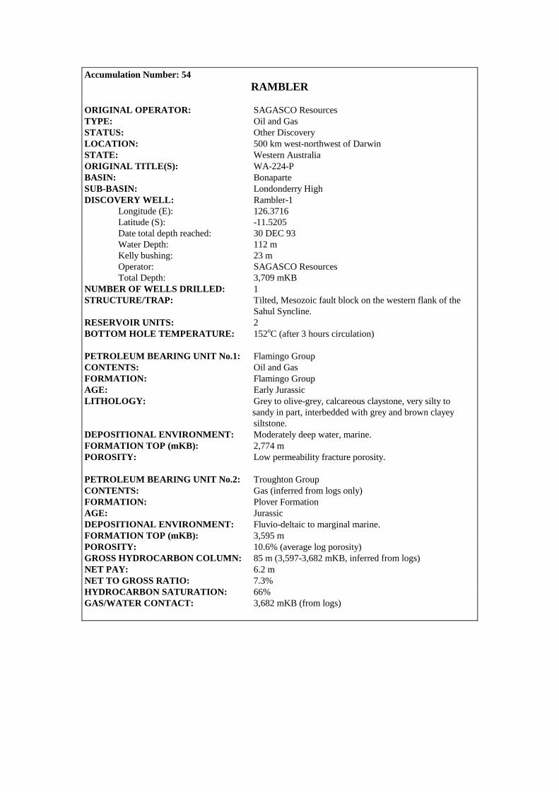
Accumulation Number: 54 RAMBLER
ORIGINAL OPERATOR: SAGASCO Resources TYPE: Oil and Gas STATUS: Other Discovery LOCATION: 500 km west-northwest of Darwin STATE: Western Australia ORIGINAL TITLE(S): WA-224-P BASIN: Bonaparte SUB-BASIN: Londonderry High DISCOVERY WELL: Rambler-1 Longitude (E): 126.3716 Latitude (S): -11.5205 Date total depth reached: 30 DEC 93 Water Depth: 112 m Kelly bushing: 23 m Operator: SAGASCO Resources Total Depth: 3,709 mKB NUMBER OF WELLS DRILLED: 1 STRUCTURE/TRAP: Tilted, Mesozoic fault block on the western flank of the Sahul Syncline. RESERVOIR UNITS: 2 BOTTOM HOLE TEMPERATURE: 152oC (after 3 hours circulation) PETROLEUM BEARING UNIT No.1: Flamingo Group CONTENTS: Oil and Gas FORMATION: Flamingo Group AGE: Early Jurassic LITHOLOGY: Grey to olive-grey, calcareous claystone, very silty to sandy in part, interbedded with grey and brown clayey siltstone. DEPOSITIONAL ENVIRONMENT: Moderately deep water, marine. FORMATION TOP (mKB): 2,774 m POROSITY: Low permeability fracture porosity. PETROLEUM BEARING UNIT No.2: Troughton Group CONTENTS: Gas (inferred from logs only) FORMATION: Plover Formation AGE: Jurassic DEPOSITIONAL ENVIRONMENT: Fluvio-deltaic to marginal marine. FORMATION TOP (mKB): 3,595 m POROSITY: 10.6% (average log porosity) GROSS HYDROCARBON COLUMN: 85 m (3,597-3,682 mKB, inferred from logs) NET PAY: 6.2 m NET TO GROSS RATIO: 7.3% HYDROCARBON SATURATION: 66% GAS/WATER CONTACT: 3,682 mKB (from logs)

1 km0
12/OA/211
Contour Interval 20m
11°30'
3800
126°20'
Rambler 1
Rambler, Top Plover Formation, depth map
126°25'
3700
3600
3600
3700
3500
3500
3500
3400
3400
3500
3600
3800
37003600 3600
3500
3600
3400
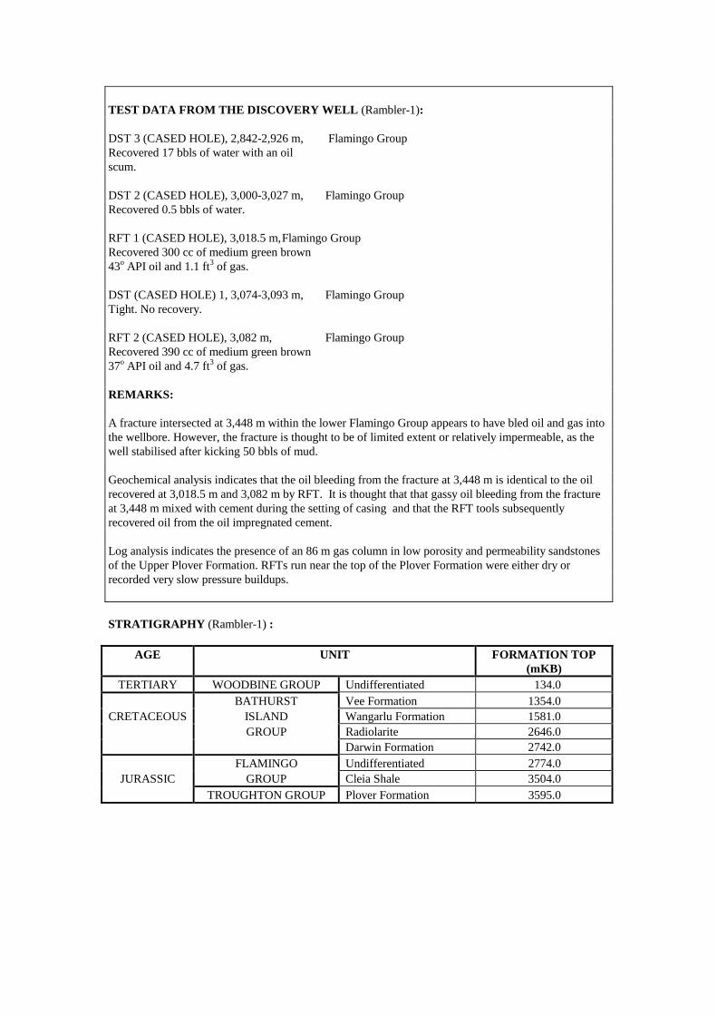
TEST DATA FROM THE DISCOVERY WELL (Rambler-1): DST 3 (CASED HOLE), 2,842-2,926 m, Flamingo Group Recovered 17 bbls of water with an oil scum. DST 2 (CASED HOLE), 3,000-3,027 m, Flamingo Group Recovered 0.5 bbls of water. RFT 1 (CASED HOLE), 3,018.5 m, Flamingo Group Recovered 300 cc of medium green brown 43o API oil and 1.1 ft3 of gas. DST (CASED HOLE) 1, 3,074-3,093 m, Flamingo Group Tight. No recovery. RFT 2 (CASED HOLE), 3,082 m, Flamingo Group Recovered 390 cc of medium green brown 37o API oil and 4.7 ft3 of gas. REMARKS: A fracture intersected at 3,448 m within the lower Flamingo Group appears to have bled oil and gas into the wellbore. However, the fracture is thought to be of limited extent or relatively impermeable, as the well stabilised after kicking 50 bbls of mud. Geochemical analysis indicates that the oil bleeding from the fracture at 3,448 m is identical to the oil recovered at 3,018.5 m and 3,082 m by RFT. It is thought that that gassy oil bleeding from the fracture at 3,448 m mixed with cement during the setting of casing and that the RFT tools subsequently recovered oil from the oil impregnated cement. Log analysis indicates the presence of an 86 m gas column in low porosity and permeability sandstones of the Upper Plover Formation. RFTs run near the top of the Plover Formation were either dry or recorded very slow pressure buildups. STRATIGRAPHY (Rambler-1) :
AGE UNIT FORMATION TOP (mKB)
TERTIARY WOODBINE GROUP Undifferentiated 134.0 BATHURST Vee Formation 1354.0
CRETACEOUS ISLAND Wangarlu Formation 1581.0 GROUP Radiolarite 2646.0 Darwin Formation 2742.0 FLAMINGO Undifferentiated 2774.0
JURASSIC GROUP Cleia Shale 3504.0 TROUGHTON GROUP Plover Formation 3595.0
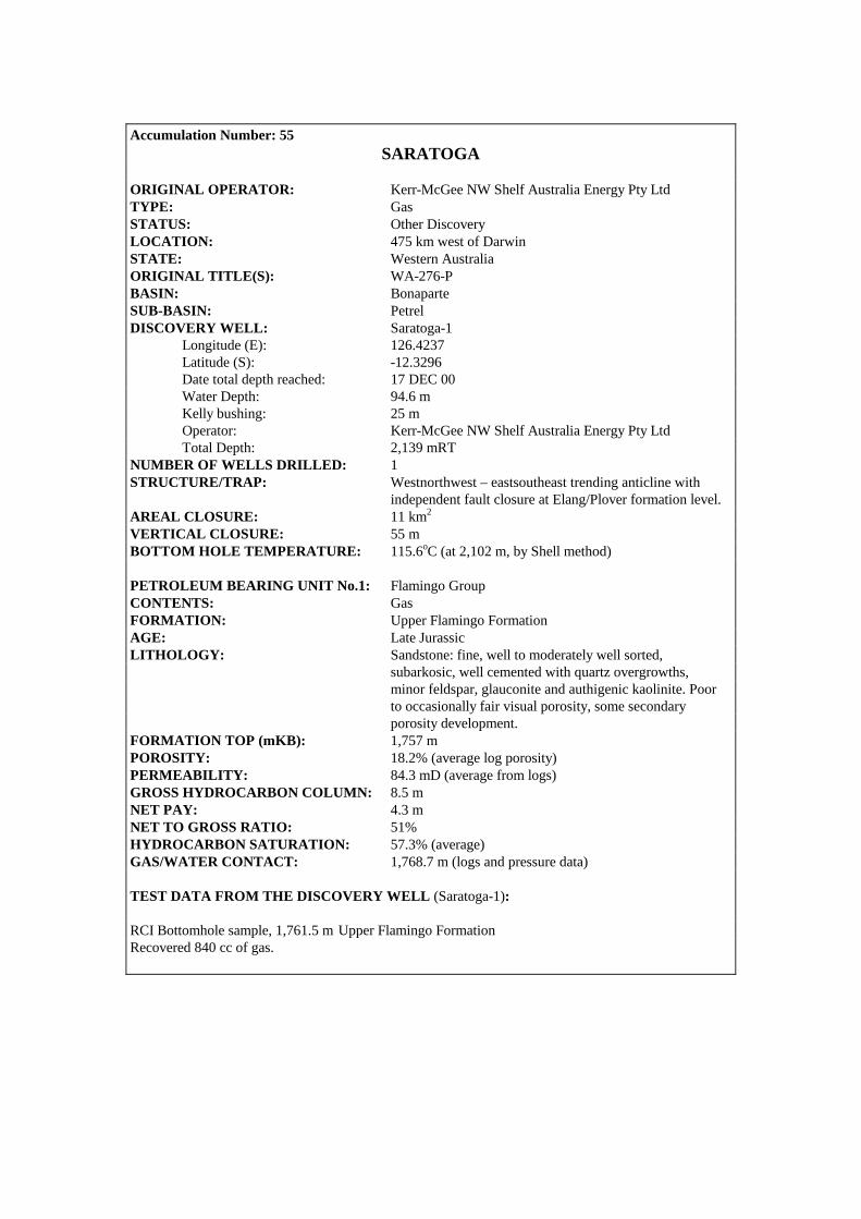
Accumulation Number: 55
SARATOGA ORIGINAL OPERATOR: Kerr-McGee NW Shelf Australia Energy Pty Ltd TYPE: Gas STATUS: Other Discovery LOCATION: 475 km west of Darwin STATE: Western Australia ORIGINAL TITLE(S): WA-276-P BASIN: Bonaparte SUB-BASIN: Petrel DISCOVERY WELL: Saratoga-1 Longitude (E): 126.4237 Latitude (S): -12.3296 Date total depth reached: 17 DEC 00 Water Depth: 94.6 m Kelly bushing: 25 m Operator: Kerr-McGee NW Shelf Australia Energy Pty Ltd Total Depth: 2,139 mRT NUMBER OF WELLS DRILLED: 1 STRUCTURE/TRAP: Westnorthwest – eastsoutheast trending anticline with independent fault closure at Elang/Plover formation level. AREAL CLOSURE: 11 km2
VERTICAL CLOSURE: 55 m BOTTOM HOLE TEMPERATURE: 115.6oC (at 2,102 m, by Shell method) PETROLEUM BEARING UNIT No.1: Flamingo Group CONTENTS: Gas FORMATION: Upper Flamingo Formation AGE: Late Jurassic LITHOLOGY: Sandstone: fine, well to moderately well sorted, subarkosic, well cemented with quartz overgrowths, minor feldspar, glauconite and authigenic kaolinite. Poor to occasionally fair visual porosity, some secondary porosity development. FORMATION TOP (mKB): 1,757 m POROSITY: 18.2% (average log porosity) PERMEABILITY: 84.3 mD (average from logs) GROSS HYDROCARBON COLUMN: 8.5 m NET PAY: 4.3 m NET TO GROSS RATIO: 51% HYDROCARBON SATURATION: 57.3% (average) GAS/WATER CONTACT: 1,768.7 m (logs and pressure data) TEST DATA FROM THE DISCOVERY WELL (Saratoga-1): RCI Bottomhole sample, 1,761.5 m Upper Flamingo Formation Recovered 840 cc of gas.
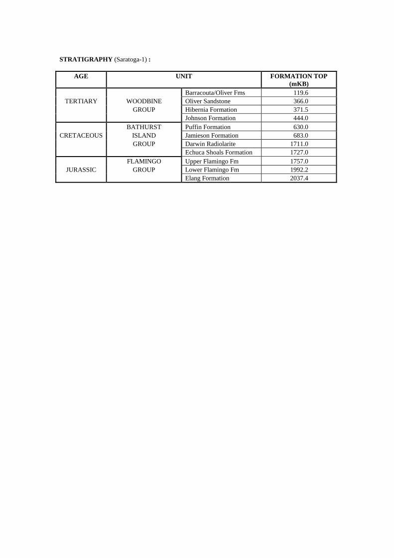
STRATIGRAPHY (Saratoga-1) :
AGE UNIT FORMATION TOP (mKB)
Barracouta/Oliver Fms 119.6 TERTIARY WOODBINE Oliver Sandstone 366.0
GROUP Hibernia Formation 371.5 Johnson Formation 444.0 BATHURST Puffin Formation 630.0
CRETACEOUS ISLAND Jamieson Formation 683.0 GROUP Darwin Radiolarite 1711.0 Echuca Shoals Formation 1727.0 FLAMINGO Upper Flamingo Fm 1757.0
JURASSIC GROUP Lower Flamingo Fm 1992.2 Elang Formation 2037.4
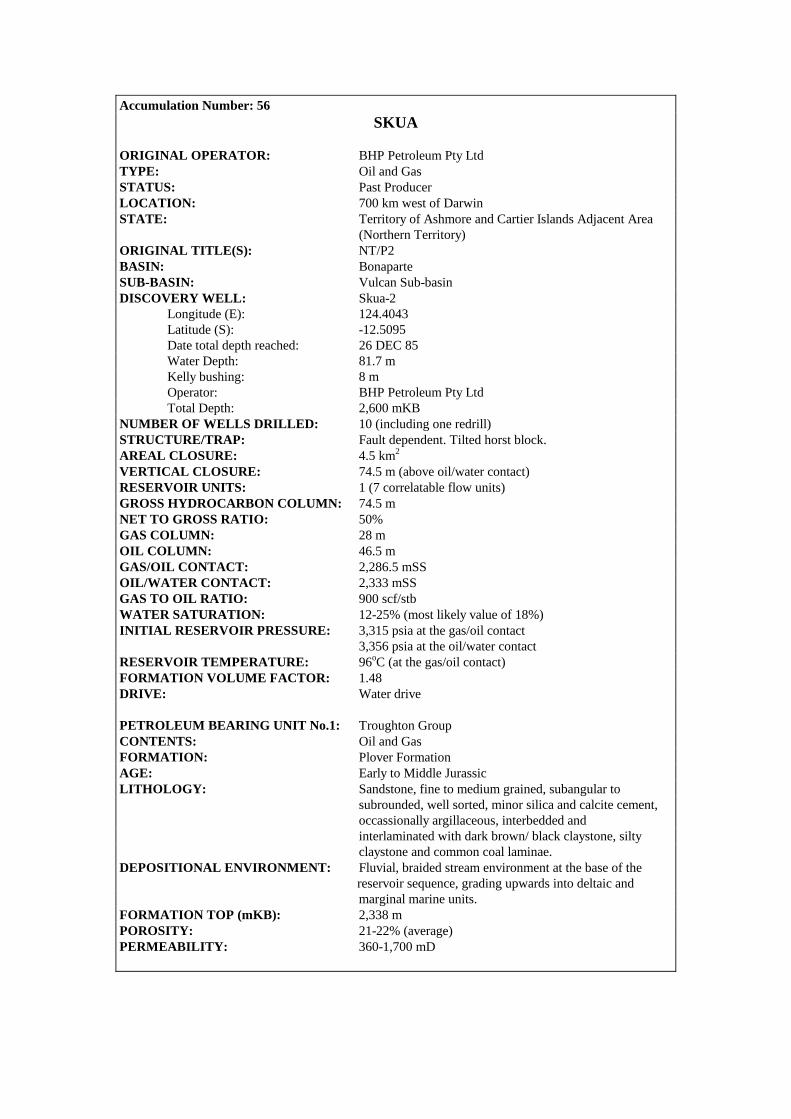
Accumulation Number: 56 SKUA
ORIGINAL OPERATOR: BHP Petroleum Pty Ltd TYPE: Oil and Gas STATUS: Past Producer LOCATION: 700 km west of Darwin STATE: Territory of Ashmore and Cartier Islands Adjacent Area (Northern Territory) ORIGINAL TITLE(S): NT/P2 BASIN: Bonaparte SUB-BASIN: Vulcan Sub-basin DISCOVERY WELL: Skua-2 Longitude (E): 124.4043 Latitude (S): -12.5095 Date total depth reached: 26 DEC 85 Water Depth: 81.7 m Kelly bushing: 8 m Operator: BHP Petroleum Pty Ltd Total Depth: 2,600 mKB NUMBER OF WELLS DRILLED: 10 (including one redrill) STRUCTURE/TRAP: Fault dependent. Tilted horst block. AREAL CLOSURE: 4.5 km2 VERTICAL CLOSURE: 74.5 m (above oil/water contact) RESERVOIR UNITS: 1 (7 correlatable flow units) GROSS HYDROCARBON COLUMN: 74.5 m NET TO GROSS RATIO: 50% GAS COLUMN: 28 m OIL COLUMN: 46.5 m GAS/OIL CONTACT: 2,286.5 mSS OIL/WATER CONTACT: 2,333 mSS GAS TO OIL RATIO: 900 scf/stb WATER SATURATION: 12-25% (most likely value of 18%) INITIAL RESERVOIR PRESSURE: 3,315 psia at the gas/oil contact 3,356 psia at the oil/water contact RESERVOIR TEMPERATURE: 96oC (at the gas/oil contact) FORMATION VOLUME FACTOR: 1.48 DRIVE: Water drive PETROLEUM BEARING UNIT No.1: Troughton Group CONTENTS: Oil and Gas FORMATION: Plover Formation AGE: Early to Middle Jurassic LITHOLOGY: Sandstone, fine to medium grained, subangular to subrounded, well sorted, minor silica and calcite cement, occassionally argillaceous, interbedded and interlaminated with dark brown/ black claystone, silty claystone and common coal laminae. DEPOSITIONAL ENVIRONMENT: Fluvial, braided stream environment at the base of the reservoir sequence, grading upwards into deltaic and marginal marine units. FORMATION TOP (mKB): 2,338 m POROSITY: 21-22% (average) PERMEABILITY: 360-1,700 mD

0 1 km
Skua 1
Skua 2
Skua 3
Skua 4
Skua 5
Skua 6
Skua 7
Skua 8
Skua 9
Skua 9ST
2350
2340
2340
2320
2320
Skua, Intra Valanginian Unconformity, depth map
12/OA/157
124°27'124°26'124°25'124°24'
12°29'
12°30'
12°31'
OWC 2333m
GOC 2338.5m
OWC 2348m
GOC 2286.5m
(modified after Chapman G.J., 1993)
Contour Interval = 20m
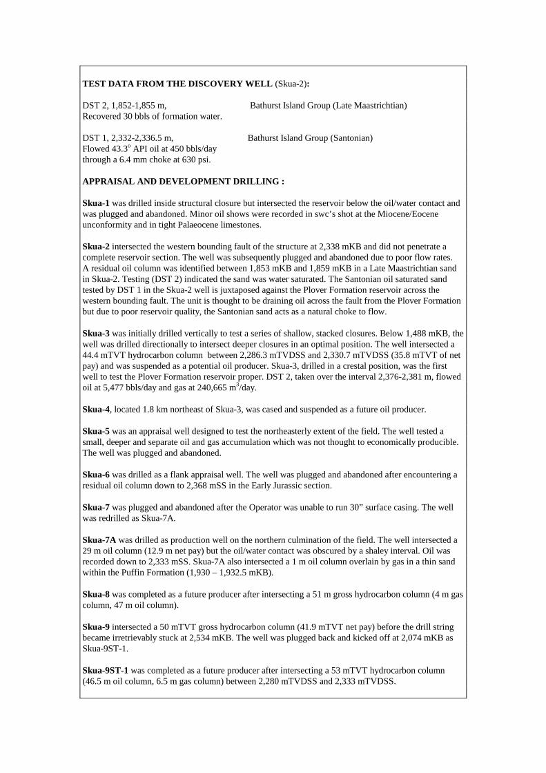
TEST DATA FROM THE DISCOVERY WELL (Skua-2): DST 2, 1,852-1,855 m, Bathurst Island Group (Late Maastrichtian) Recovered 30 bbls of formation water. DST 1, 2,332-2,336.5 m, Bathurst Island Group (Santonian) Flowed 43.3o API oil at 450 bbls/day through a 6.4 mm choke at 630 psi. APPRAISAL AND DEVELOPMENT DRILLING : Skua-1 was drilled inside structural closure but intersected the reservoir below the oil/water contact and was plugged and abandoned. Minor oil shows were recorded in swc’s shot at the Miocene/Eocene unconformity and in tight Palaeocene limestones. Skua-2 intersected the western bounding fault of the structure at 2,338 mKB and did not penetrate a complete reservoir section. The well was subsequently plugged and abandoned due to poor flow rates. A residual oil column was identified between 1,853 mKB and 1,859 mKB in a Late Maastrichtian sand in Skua-2. Testing (DST 2) indicated the sand was water saturated. The Santonian oil saturated sand tested by DST 1 in the Skua-2 well is juxtaposed against the Plover Formation reservoir across the western bounding fault. The unit is thought to be draining oil across the fault from the Plover Formation but due to poor reservoir quality, the Santonian sand acts as a natural choke to flow. Skua-3 was initially drilled vertically to test a series of shallow, stacked closures. Below 1,488 mKB, the well was drilled directionally to intersect deeper closures in an optimal position. The well intersected a 44.4 mTVT hydrocarbon column between 2,286.3 mTVDSS and 2,330.7 mTVDSS (35.8 mTVT of net pay) and was suspended as a potential oil producer. Skua-3, drilled in a crestal position, was the first well to test the Plover Formation reservoir proper. DST 2, taken over the interval 2,376-2,381 m, flowed oil at 5,477 bbls/day and gas at 240,665 m3/day. Skua-4, located 1.8 km northeast of Skua-3, was cased and suspended as a future oil producer. Skua-5 was an appraisal well designed to test the northeasterly extent of the field. The well tested a small, deeper and separate oil and gas accumulation which was not thought to economically producible. The well was plugged and abandoned. Skua-6 was drilled as a flank appraisal well. The well was plugged and abandoned after encountering a residual oil column down to 2,368 mSS in the Early Jurassic section. Skua-7 was plugged and abandoned after the Operator was unable to run 30” surface casing. The well was redrilled as Skua-7A. Skua-7A was drilled as production well on the northern culmination of the field. The well intersected a 29 m oil column (12.9 m net pay) but the oil/water contact was obscured by a shaley interval. Oil was recorded down to 2,333 mSS. Skua-7A also intersected a 1 m oil column overlain by gas in a thin sand within the Puffin Formation (1,930 – 1,932.5 mKB). Skua-8 was completed as a future producer after intersecting a 51 m gross hydrocarbon column (4 m gas column, 47 m oil column). Skua-9 intersected a 50 mTVT gross hydrocarbon column (41.9 mTVT net pay) before the drill string became irretrievably stuck at 2,534 mKB. The well was plugged back and kicked off at 2,074 mKB as Skua-9ST-1. Skua-9ST-1 was completed as a future producer after intersecting a 53 mTVT hydrocarbon column (46.5 m oil column, 6.5 m gas column) between 2,280 mTVDSS and 2,333 mTVDSS.

RESERVES: Initial Oil: 20.5 MMbbls Source: Northern Territory Department of Business Industry and Resource Development, 1998. REMARKS: Fluid inclusion studies by O’Brien & others (1996) indicates a 10 m residual oil column below the present day OWC. This suggests appreciable quantities of oil (~ 20 million barrels) have leaked from the Skua structure, probably during the reactivation of bounding faults in the Tertiary. Production from the Skua oil field commenced 1991 via sub-sea completions connected to an FPSO. The field was producing oil at a rate of 1,900 bbls/day when production was shut in and the field decommissioned in January 1997. STRATIGRAPHY (Skua-2) :
AGE UNIT FORMATION TOP (mKB)
WOODBINE Undifferentiated 89.0 TERTIARY GROUP Hibernia Formation 852.0
Woodbine Beds 1393.0 CRETACEOUS BATHURST ISLAND GP Undifferentiated 1844.0
JURASSIC TROUGHTON GROUP Plover Formation 2338.0 STRATIGRAPHY (Skua-9) :
AGE UNIT FORMATION TOP (mSS)
Barracouta/Oliver Fms 83.0 TERTIARY WOODBINE Prion/Hibernia Fms 838.5
GROUP Grebe Sandstone 1224.0 Johnson Formation 1430.0
CRETACEOUS BATHURST ISLAND GP Puffin/Fenelon Fms 1848.0 JURASSIC TROUGHTON GROUP Plover Formation 2283.0
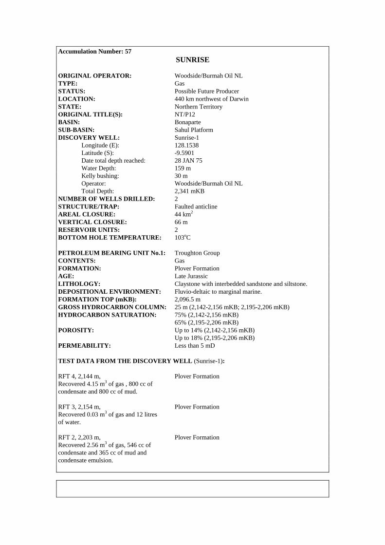
Accumulation Number: 57 SUNRISE
ORIGINAL OPERATOR: Woodside/Burmah Oil NL TYPE: Gas STATUS: Possible Future Producer LOCATION: 440 km northwest of Darwin STATE: Northern Territory ORIGINAL TITLE(S): NT/P12 BASIN: Bonaparte SUB-BASIN: Sahul Platform DISCOVERY WELL: Sunrise-1 Longitude (E): 128.1538 Latitude (S): -9.5901 Date total depth reached: 28 JAN 75 Water Depth: 159 m Kelly bushing: 30 m Operator: Woodside/Burmah Oil NL Total Depth: 2,341 mKB NUMBER OF WELLS DRILLED: 2 STRUCTURE/TRAP: Faulted anticline AREAL CLOSURE: 44 km2 VERTICAL CLOSURE: 66 m RESERVOIR UNITS: 2 BOTTOM HOLE TEMPERATURE: 103oC PETROLEUM BEARING UNIT No.1: Troughton Group CONTENTS: Gas FORMATION: Plover Formation AGE: Late Jurassic LITHOLOGY: Claystone with interbedded sandstone and siltstone. DEPOSITIONAL ENVIRONMENT: Fluvio-deltaic to marginal marine. FORMATION TOP (mKB): 2,096.5 m GROSS HYDROCARBON COLUMN: 25 m (2,142-2,156 mKB; 2,195-2,206 mKB) HYDROCARBON SATURATION: 75% (2,142-2,156 mKB) 65% (2,195-2,206 mKB) POROSITY: Up to 14% (2,142-2,156 mKB) Up to 18% (2,195-2,206 mKB) PERMEABILITY: Less than 5 mD TEST DATA FROM THE DISCOVERY WELL (Sunrise-1): RFT 4, 2,144 m, Plover Formation Recovered 4.15 m3 of gas , 800 cc of condensate and 800 cc of mud. RFT 3, 2,154 m, Plover Formation Recovered 0.03 m3 of gas and 12 litres of water. RFT 2, 2,203 m, Plover Formation Recovered 2.56 m3 of gas, 546 cc of condensate and 365 cc of mud and condensate emulsion.
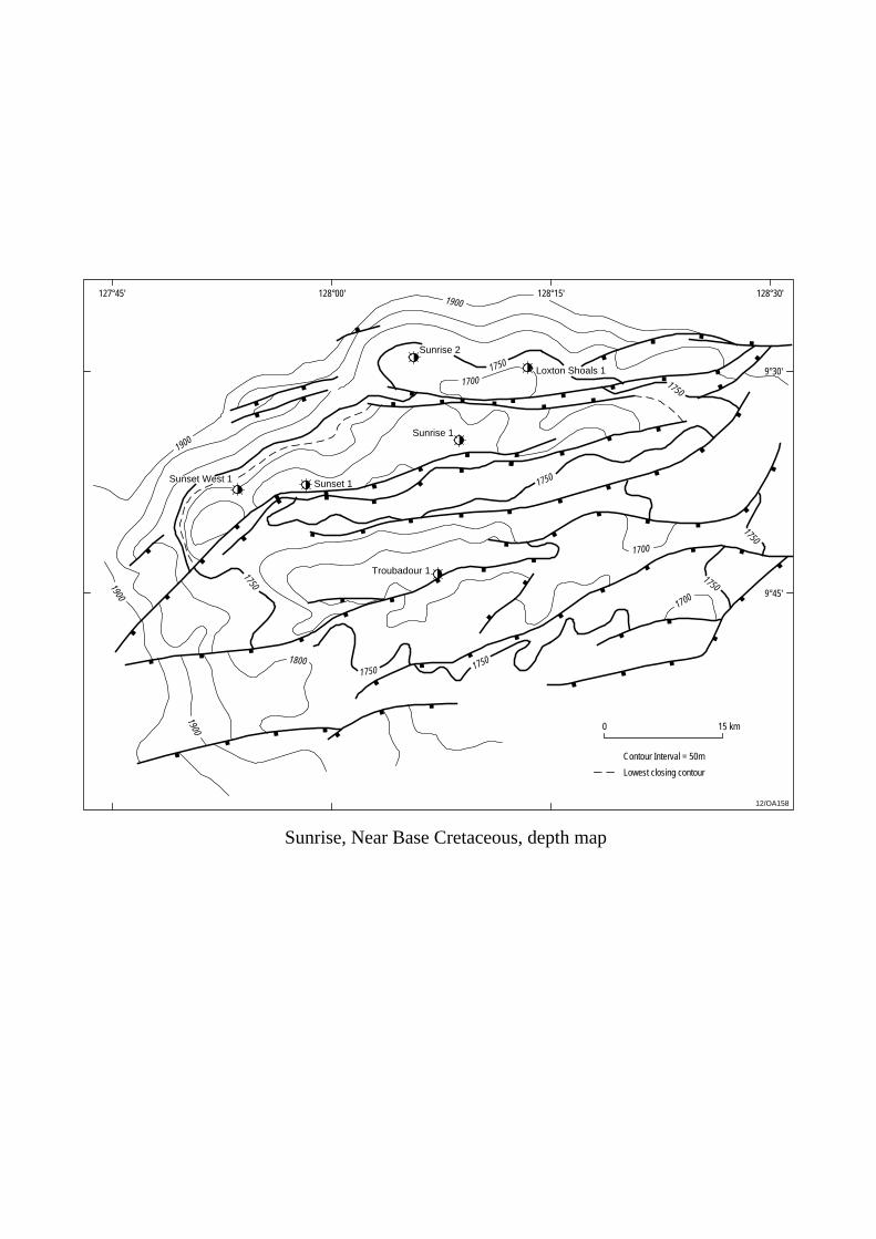
Sunset 1Sunset West 1
Sunrise 1
Sunrise 2
Loxton Shoals 1
Troubadour 1
127°45' 128°00' 128°15'
9°30'
9°45'
0 15 km
Contour Interval = 50m
12/OA158
128°30'
1750
1750
1750
1750
1750
1750
1900
1900
1900
1900
1750
17501800
1700
1700
1700
Sunrise, Near Base Cretaceous, depth map
Lowest closing contour
RFT 1, 2,301 m, Plover Formation Recovered 12.25 litres of water with a trace of mud. APPRAISAL AND DEVELOPMENT DRILLING : Sunrise-2, located 15 km north-northwest of Sunrise-1, was drilled in May 1998 to appraise the northern limit of the Sunrise gas/condensate accumulation. A 151 m gross gas column was identified on logs and a DST taken over the interval 2,112-2,124 mKB achieved a maximum flow rate of 849,500 m3/day through a 2” choke. RESERVES: Gas: 9.56 TCF (includes Loxton Shoals/Troubadour/Sunset/Sunset West) Condensate: 321 MMbbls (includes Loxton Shoals/Troubadour/Sunset/Sunset West) Source: Northern Territory Department of Business Industry and Resource Development, 2000. REMARKS: Two hydrocarbon bearing zones were identified on logs. The upper sand, (2,142-2,156 mKB) recorded water saturations of around 25% while the lower zone, (2,195-2,206 mKB) averaged 35% water saturation. Loxton Shoals-1, Troubadour-1, Sunset-1, Sunset West-1, Sunrise-1 and Sunrise-2 all recovered gas on test from the Plover Formation from what are thought to be adjacent fault compartments on the greater Sunrise/Troubadour structure. Development of the Sunrise/Troubadour resource is currently under consideration. STRATIGRAPHY (Sunrise-1) :
AGE UNIT FORMATION TOP (mKB)
QUATERNARY WOODBINE Undifferentiated 189.0 TERTIARY GROUP Undifferentiated 492.5
CRETACEOUS BATHURST ISLAND GP Undifferentiated 1472.0 JURASSIC TROUGHTON GROUP Plover Formation 2096.5

Accumulation Number: 58 SUNSET
ORIGINAL OPERATOR: Shell Development (PSC 19) Pty Ltd TYPE: Gas STATUS: Possible Future Producer LOCATION: 440 km northwest of Darwin STATE: Zone of Cooperation, Part A ORIGINAL TITLE(S): ZOCA 95-19 BASIN: Bonaparte SUB-BASIN: Sahul Platform DISCOVERY WELL: Sunset-1 Longitude (E): 127.9763 Latitude (S): -9.6434 Date total depth reached: 13 OCT 97 Water Depth: 238.5 m Kelly bushing: 25 m Operator: Shell Development (PSC 19) Pty Ltd Total Depth: 2,420 mKB NUMBER OF WELLS DRILLED: 2 STRUCTURE/TRAP: Fault dependent closure on the same horst block as the
Sunrise accumulation to the east. RESERVOIR UNITS: 1 PETROLEUM BEARING UNIT No.1: Troughton Group CONTENTS: Gas FORMATION: Plover Formation AGE: Pliensbachian to Callovian LITHOLOGY: Sandstone interbedded with shales and argillaceous
sandstones. DEPOSITIONAL ENVIRONMENT: Marginal marine to fluvio deltaic. GROSS HYDROCARBON COLUMN: 96 m NET PAY: 34.7 m NET TO GROSS RATIO: 36% HYDROCARBON SATURATION: 71% GAS/WATER CONTACT: 2,251 mRT (free water level from pressure data) POROSITY: 16-17% (average log porosity) PERMEABILITY: variable (2-207 mD)
TEST DATA FROM THE DISCOVERY WELL (Sunset-1): DST, Plover Formation Flowed gas at 673,900 m3/day and condensate at 750 bbls/day through a 15.9 mm choke. DST 2, 2,195.5-2,155 m, Plover Formation Flowed gas at 906,100 m3/day and condensate at 28 bbls/day through a 28.5 mm choke. DST 1, 2,223-2,241 m, Plover Formation Flowed gas at 124,940 m3/day and condensate at 1,500 bbls/day through a 31.8 mm choke.

Sunset 1Sunset West 1
Sunrise 1
Sunrise 2
Loxton Shoals 1
Troubadour 1
127°45' 128°00' 128°15'
9°30'
9°45'
0 15 km
Contour Interval = 50m
12/OA159
128°30'
1750
1750
1750
1750
1750
1750
1900
1900
1900
1900
1750
17501800
1700
1700
1700
Sunset, Near Base Cretaceous, depth map
Lowest closing contour
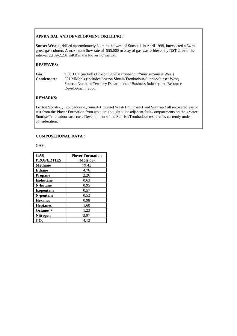
APPRAISAL AND DEVELOPMENT DRILLING : Sunset West-1, drilled approximately 8 km to the west of Sunset-1 in April 1998, intersected a 64 m gross gas column. A maximum flow rate of 555,000 m3/day of gas was achieved by DST 2, over the interval 2,189-2,231 mKB in the Plover Formation. RESERVES: Gas: 9.56 TCF (includes Loxton Shoals/Troubadour/Sunrise/Sunset West) Condensate: 321 MMbbls (includes Loxton Shoals/Troubadour/Sunrise/Sunset West) Source: Northern Territory Department of Business Industry and Resource Development, 2000. REMARKS: Loxton Shoals-1, Troubadour-1, Sunset-1, Sunset West-1, Sunrise-1 and Sunrise-2 all recovered gas on test from the Plover Formation from what are thought to be adjacent fault compartments on the greater Sunrise/Troubadour structure. Development of the Sunrise/Troubadour resource is currently under consideration. COMPOSITIONAL DATA : GAS : GAS PROPERTIES
Plover Formation (Mole %)
Methane 79.41 Ethane 4.76 Propane 2.26 Isobutane 0.63 N-butane 0.95 Isopentane 0.57 N-pentane 0.52 Hexanes 0.98 Heptanes 1.60 Octanes + 1.23 Nitrogen 2.97 CO2 4.12

STRATIGRAPHY (Sunset-1) :
AGE UNIT FORMATION TOP (mTVDSS)
Oliver Formation 498.0 WOODBINE Cartier Formation 992.0
TERTIARY GROUP Hibernia Formation 1119.0 Johnson Formation 1418.0 BATHURST Vee Formation 1496.0
CRETACEOUS ISLAND Wangarlu Formation 1731.0 GROUP Darwin Formation 2066.0 Echuca Shoals Formation 2097.0
JURASSIC FLAMINGO GROUP Elang Formation 2105.0 TROUGHTON GROUP Plover Formation 2130.0
Accumulation Number: 59 SWAN
ORIGINAL OPERATOR: Arco Australia Ltd TYPE: Gas STATUS: Other Discovery LOCATION: 700 km west of Darwin STATE: Territory of Ashmore and Cartier Islands Adjacent Area (Northern Territory) ORIGINAL TITLE(S): NT/P2 BASIN: Bonaparte SUB-BASIN: Vulcan Sub-basin DISCOVERY WELL: Swan-1 Longitude (E): 124.4928 Latitude (S): -12.1882 Date total depth reached: 30 JAN 73 Water Depth: 109 m Kelly bushing: 34 m Operator: Arco Australia Ltd Total Depth: 3,284 mKB NUMBER OF WELLS DRILLED: 4 (including 1 sidetrack) STRUCTURE/TRAP: Northeast-southwest trending horst block with updip closure dependent on fault seal against a salt diapir. AREAL CLOSURE: 6 km2 VERTICAL CLOSURE: 270 m RESERVOIR UNITS: Several, thin gas bearing sands identified on logs in the Late Cretaceous section (informally named the P1, P2, P3 and P4 reservoir sands). NET PAY: 11.25 m (Swan-1, P1 and P2 sands) 22.1 m (Swan-2, P1, P2 and P3 sands) 19.4 m (Swan-3, P1 and P2 sands) 32.7 m (Swan-3/ST1, P1, P2 and P3 sands) NET TO GROSS RATIO: 75% (Swan-3, 2,306-2,332 mKB, P1 and P2 sands) 55% (Swan-3/ST1, 2,342-2,375 mKB, P1 and P2 sands) 93% (Swan-3/ST1, 2,445-2,461 mKB, P3 sand). HYDROCARBON SATURATION: 57% (Swan-1, P1 and P2 sands) 82% (Swan-2, P1, P2 and P3 sands) 32% (Swan-3, P1 and P2 sands) 75% (Swan-3/ST1, P1, P2 and P3 sands) BOTTOM HOLE TEMPERATURE: 100oC PETROLEUM BEARING UNIT No.1: Bathurst Island Group CONTENTS: Gas FORMATION: Puffin Formation AGE: Late Cretaceous LITHOLOGY: Sandstone, clean, fine to medium grained, subangular, well sorted, excellent visual porosity. Fluid escape structures, dish structures, flame structures and water escape pipes are observed in cores. DEPOSITIONAL ENVIRONMENT: Stacked, submarine fan sandstone sequence. FORMATION TOP (mKB): 2,152.8 m (Bathurst Island Group) POROSITY: 18.9% (average log porosity, Swan-1, P1 and P2 sands) 23% (average log porosity, Swan-3, P1 and P2 sands) 20% (average log porosity, Swan-3/ST1, P1, P2 and P3 sands).
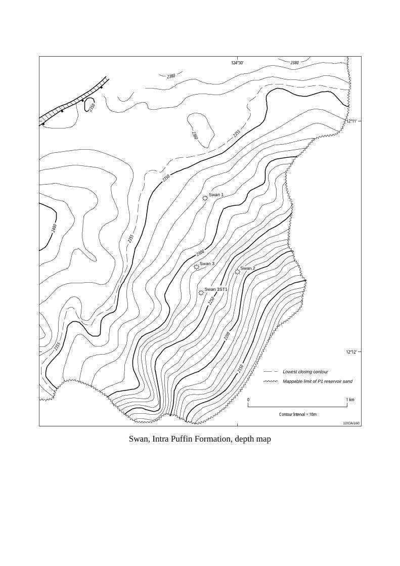
0 1 km
2300
2250
2200
2150
2350
2350
2380
2380
2360 2355
2355
2355
2400
Swan 1
Swan 2Swan 3
Swan 3ST1
Swan, Intra Puffin Formation, depth map
12/OA/160
124°30'
12°11'
12°12'
Contour Interval = 10m
Lowest closing contour
Mappable limit of P1 reservoir sand
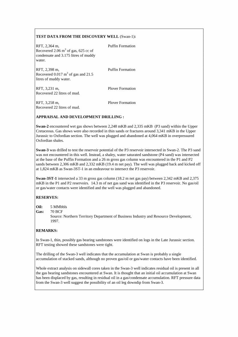
TEST DATA FROM THE DISCOVERY WELL (Swan-1): RFT, 2,364 m, Puffin Formation Recovered 2.06 m3 of gas, 625 cc of condensate and 3.175 litres of muddy water. RFT, 2,398 m, Puffin Formation Recovered 0.017 m3 of gas and 21.5 litres of muddy water. RFT, 3,231 m, Plover Formation Recovered 22 litres of mud. RFT, 3,258 m, Plover Formation Recovered 22 litres of mud. APPRAISAL AND DEVELOPMENT DRILLING : Swan-2 encountered wet gas shows between 2,248 mKB and 2,335 mKB (P3 sand) within the Upper Cretaceous. Gas shows were also recorded in thin sands or fractures around 3,341 mKB in the Upper Jurassic to Oxfordian section. The well was plugged and abandoned at 4,064 mKB in overpressured Oxfordian shales. Swan-3 was drilled to test the reservoir potential of the P3 reservoir intersected in Swan-2. The P3 sand was not encountered in this well. Instead, a shaley, water saturated sandstone (P4 sand) was intersected at the base of the Puffin Formation and a 26 m gross gas column was encountered in the P1 and P2 sands between 2,306 mKB and 2,332 mKB (19.4 m net pay). The well was plugged back and kicked off at 1,824 mKB as Swan-3ST-1 in an endeavour to intersect the P3 reservoir. Swan-3ST-1 intersected a 33 m gross gas column (18.2 m net gas pay) between 2,342 mKB and 2,375 mKB in the P1 and P2 reservoirs. 14.3 m of net gas sand was identified in the P3 reservoir. No gas/oil or gas/water contacts were identified and the well was plugged and abandoned. RESERVES: Oil: 5 MMbbls Gas: 70 BCF Source: Northern Territory Department of Business Industry and Resource Development, 1997. REMARKS: In Swan-1, thin, possibly gas bearing sandstones were identified on logs in the Late Jurassic section. RFT testing showed these sandstones were tight. The drilling of the Swan-3 well indicates that the accumulation at Swan is probably a single accumulation of stacked sands, although no proven gas/oil or gas/water contacts have been identified. Whole extract analysis on sidewall cores taken in the Swan-3 well indicates residual oil is present in all the gas bearing sandstones encountered at Swan. It is thought that an initial oil accumulation at Swan has been displaced by gas, resulting in residual oil in a gas/condensate accumulation. RFT pressure data from the Swan-3 well suggest the possibility of an oil leg downdip from Swan-3.
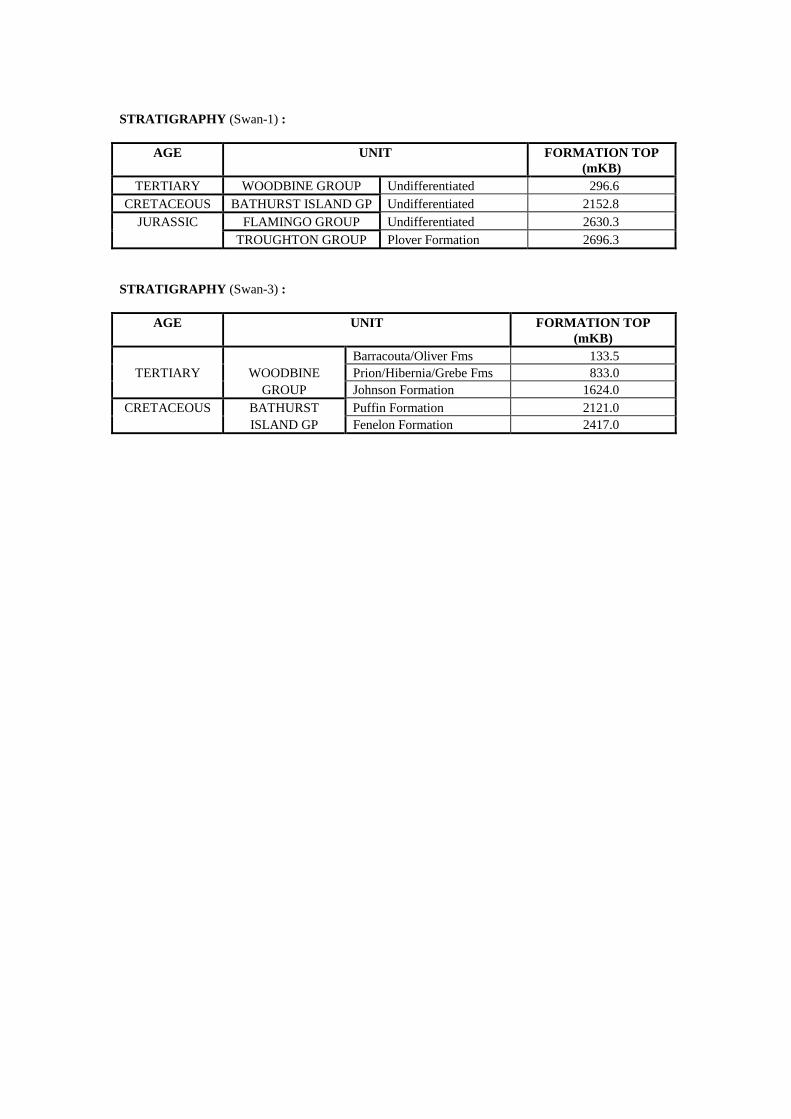
STRATIGRAPHY (Swan-1) :
AGE UNIT FORMATION TOP (mKB)
TERTIARY WOODBINE GROUP Undifferentiated 296.6 CRETACEOUS BATHURST ISLAND GP Undifferentiated 2152.8
JURASSIC FLAMINGO GROUP Undifferentiated 2630.3 TROUGHTON GROUP Plover Formation 2696.3
STRATIGRAPHY (Swan-3) :
AGE UNIT FORMATION TOP (mKB)
Barracouta/Oliver Fms 133.5 TERTIARY WOODBINE Prion/Hibernia/Grebe Fms 833.0
GROUP Johnson Formation 1624.0 CRETACEOUS BATHURST Puffin Formation 2121.0
ISLAND GP Fenelon Formation 2417.0
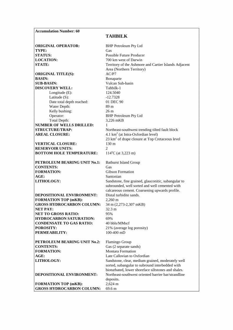
Accumulation Number: 60 TAHBILK
ORIGINAL OPERATOR: BHP Petroleum Pty Ltd TYPE: Gas STATUS: Possible Future Producer LOCATION: 700 km west of Darwin STATE: Territory of the Ashmore and Cartier Islands Adjacent Area (Northern Territory) ORIGINAL TITLE(S): AC/P7 BASIN: Bonaparte SUB-BASIN: Vulcan Sub-basin DISCOVERY WELL: Tahbilk-1 Longitude (E): 124.5040 Latitude (S): -12.7328 Date total depth reached: 01 DEC 90 Water Depth: 89 m Kelly bushing: 26 m Operator: BHP Petroleum Pty Ltd Total Depth: 3,226 mKB NUMBER OF WELLS DRILLED: 1 STRUCTURE/TRAP: Northeast-southwest trending tilted fault block AREAL CLOSURE: 4.1 km2 (at Intra-Oxfordian level) 23 km2 of drape closure at Top Cretaceous level VERTICAL CLOSURE: 130 m RESERVOIR UNITS: 2 BOTTOM HOLE TEMPERATURE: 114oC (at 3,223 m) PETROLEUM BEARING UNIT No.1: Bathurst Island Group CONTENTS: Gas FORMATION: Gibson Formation AGE: Santonian LITHOLOGY: Sandstone, fine grained, glauconitic, subangular to subrounded, well sorted and well cemented with calcareous cement. Coarsening upwards profile. DEPOSITIONAL ENVIRONMENT: Distal turbidite sands. FORMATION TOP (mKB): 2,260 m GROSS HYDROCARBON COLUMN: 34 m (2,273-2,307 mKB) NET PAY: 32.3 m NET TO GROSS RATIO: 95% HYDROCARBON SATURATION: 69% CONDENSATE TO GAS RATIO: 40 bbls/MMscf POROSITY: 21% (average log porosity) PERMEABILITY: 100-400 mD PETROLEUM BEARING UNIT No.2: Flamingo Group CONTENTS: Gas (2 separate sands) FORMATION: Montara Formation AGE: Late Callovian to Oxfordian LITHOLOGY: Sandstone, clear, medium grained, moderately well sorted, subangular to subround interbedded with bioturbated, lower shoreface siltstones and shales. DEPOSITIONAL ENVIRONMENT: Northeast-southwest oriented barrier bar/strandline deposits. FORMATION TOP (mKB): 2,624 m GROSS HYDROCARBON COLUMN: 69.6 m
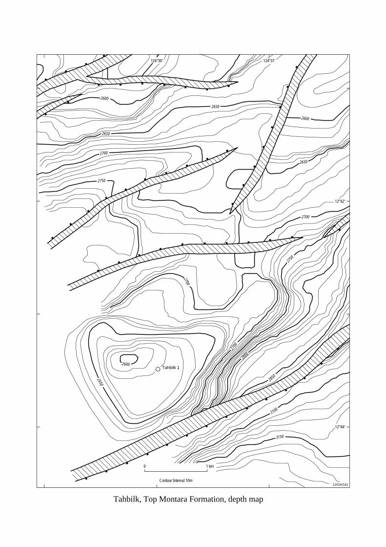
Tahbilk 1
12/OA/161
Tahbilk, Top Montara Formation, depth map
124°31'
12°42'
0 1 km
2700
2750
2650
2600
2700
2700
2850
2800
3100
3150
2650
2600
2650
2700
2650
2600
2750
Contour Interval 10m
124°30'
12°44'

NET PAY: 60.7 m NET TO GROSS RATIO: 87% HYDROCARBON SATURATION: 89% GAS/WATER CONTACT: 2,691 mKB POROSITY: 22% (average log porosity) PERMEABILITY: 175-4,460 mD (2,353 mD average) TEST DATA FROM THE DISCOVERY WELL (Tahbilk-1): RFT 3, 2,305 m, Gibson Formation Recovered 3.369 m3 of gas, 750 ml of olive-yellow condensate and 4 litres of water. RFT 2, 2,314.3 m, Gibson Formation Recovered 0.191 m3 of gas and 21 litres of water. RFT 1, 2,631.8 m, Montara Formation Recovered 1.081 m3 of gas, 215 ml of olive-yellow condensate and 280 ml of water. RESERVES: Oil: 23 MMbbls (includes Montara and Bilyara) Gas: 105 BCF (includes Montara and Bilyara) Source: Northern Territory Department of Business Industry Development, 1999. REMARKS: Tahbilk-1 was suspended for possible future evaluation. At date of publication, the Tahbilk discovery was held under Retention Lease AC/RL3. STRATIGRAPHY (Tahbilk-1) :
AGE UNIT FORMATION TOP (mKB)
Oliver/Barracouta Fms 87.0 WOODBINE Prion Formation 731.0
TERTIARY GROUP Hibernia Formation 938.0 Grebe Sandstone 1081.0 Johnson Formation 1263.0 Puffin Formation 1608.0 BATHURST Fenelon Formation 2167.0
CRETACEOUS ISLAND Gibson Formation 2260.0 GROUP Woolaston Formation 2315.0 Jamieson Formation 2347.0 FLAMINGO Lower Vulcan Formation 2463.0
JURASSIC GROUP Montara Formation 2600.0 TROUGHTON GROUP Plover Formation 3080.0
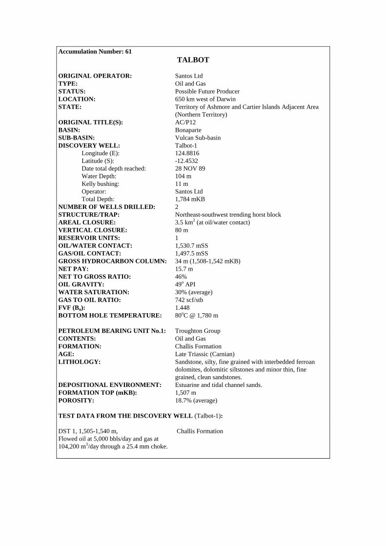
Accumulation Number: 61 TALBOT
ORIGINAL OPERATOR: Santos Ltd TYPE: Oil and Gas STATUS: Possible Future Producer LOCATION: 650 km west of Darwin STATE: Territory of Ashmore and Cartier Islands Adjacent Area (Northern Territory) ORIGINAL TITLE(S): AC/P12 BASIN: Bonaparte SUB-BASIN: Vulcan Sub-basin DISCOVERY WELL: Talbot-1 Longitude (E): 124.8816 Latitude (S): -12.4532 Date total depth reached: 28 NOV 89 Water Depth: 104 m Kelly bushing: 11 m Operator: Santos Ltd Total Depth: 1,784 mKB NUMBER OF WELLS DRILLED: 2 STRUCTURE/TRAP: Northeast-southwest trending horst block AREAL CLOSURE: 3.5 km2 (at oil/water contact) VERTICAL CLOSURE: 80 m RESERVOIR UNITS: 1 OIL/WATER CONTACT: 1,530.7 mSS GAS/OIL CONTACT: 1,497.5 mSS GROSS HYDROCARBON COLUMN: 34 m (1,508-1,542 mKB) NET PAY: 15.7 m NET TO GROSS RATIO: 46% OIL GRAVITY: 49o API WATER SATURATION: 30% (average) GAS TO OIL RATIO: 742 scf/stb FVF (Bo): 1.448 BOTTOM HOLE TEMPERATURE: 80oC @ 1,780 m PETROLEUM BEARING UNIT No.1: Troughton Group CONTENTS: Oil and Gas FORMATION: Challis Formation AGE: Late Triassic (Carnian) LITHOLOGY: Sandstone, silty, fine grained with interbedded ferroan dolomites, dolomitic siltstones and minor thin, fine grained, clean sandstones. DEPOSITIONAL ENVIRONMENT: Estuarine and tidal channel sands. FORMATION TOP (mKB): 1,507 m POROSITY: 18.7% (average) TEST DATA FROM THE DISCOVERY WELL (Talbot-1): DST 1, 1,505-1,540 m, Challis Formation Flowed oil at 5,000 bbls/day and gas at 104,200 m3/day through a 25.4 mm choke.
Talbot, Base Cretaceous, depth map
12/OA/162
12°30'
12°28'
124°54'124°52'124°52'
0 2 km
Contour Interval 10m
1600
1600
1600
1600
1600
1600
1600
1600
1650
1560
1700
1750 1700
Talbot 1
Talbot 2
OWC 1530.3mSS
(after Bourne and Faehrmann, 1991)
Production Test, Challis Formation Perforated between 1,506-1,530 m and 1,533-1,540 m. Flowed oil at maximum rate of 4,981 bbls/day and gas at 104,770 m3/day, declining to 4,123 bbls/day and 108,170 m3/day, respectively, at 560 psig. RFT 1, 1,522.5 m, Challis Formation Recovered 7.8 litres of gassy, 51.2o API oil, 0.93 m3 of gas and 11.7 litres of water. RFT 2, 1,539 m, Challis Formation Recovered 13.5 litres of oil, 0.77 m3 of gas and 5 litres of water. APPRAISAL AND DEVELOPMENT DRILLING : Talbot-2, located 1.3 km west-southwest of Talbot-1, was drilled to determine reservoir quality, delineate reserves and provide a possible drainage point for the field. A 39.5 m gross hydrocarbon column (16.9 m net pay) was intersected at the top of the Challis Formation. This zone flowed oil on test at rates of up to 4,992 bbls/day. The well was cased and suspended as a possible future producer. RESERVES: Oil: 2 to 5 MMbbls Source: Northern Territory Department of Business Industry and Resource Development, 1999. REMARKS : Geochemical analysis indicates that the hydrocarbons reservoired at Talbot have probably not been sourced in situ but have migrated from the Skua Trough over distances of up to 20 km. At date of publication, the Talbot discovery was held under Retention Lease AC/RL1. COMPOSITIONAL DATA : OIL : FLUID PROPERTIES
Oil Challis Fm
RFT-1 API Gravity @ 60°F 49.0 Asphaltenes (wt%) 0.02 Wax content (wt%) 0.00 Pour Point (oC) -9 Cloud Point (oC) -16 Flash Point (oC) -18 Specific Gravity 0.7477 Viscosity (cp@100°F) 0.975

COMPOSITIONAL DATA CONTD : GAS : GAS PROPERTIES
Gas Challis Fm
Methane 83.90 Ethane 6.55 Propane 3.84 Isobutane 0.71 N-butane 0.98 Isopentane 0.30 N-pentane 0.22 Hexanes + 0.48 N2 + O2 2.40 CO2 0.62 H2S 0.00 Specific Gravity 0.688 STRATIGRAPHY (Talbot-1) :
AGE UNIT
FORMATION TOP (mKB)
WOODBINE Undifferentiated 115.0 TERTIARY GROUP Hibernia Formation 498.0
Undifferentiated 832.0 CRETACEOUS BATHURST ISLAND GP Undifferentiated 1098.0
TRIASSIC TROUGHTON GROUP Challis Formation 1507.0

Accumulation Number: 62 TENACIOUS
ORIGINAL OPERATOR: Cultus Timor Sea Ltd TYPE: Oil and Gas STATUS: Possible Future Producer LOCATION: 650 km west-northwest of Darwin, 560 m northwest of Octavius-2. STATE: Territory of Ashmore and Cartier Islands Adjacent Area ORIGINAL TITLE(S): AC/P17 BASIN: Bonaparte SUB-BASIN: Vulcan Sub-basin DISCOVERY WELL: Tenacious-1 Longitude (E): 124.9012 Latitude (S): -11.8595 Date total depth reached: 21 JUN 97 Water Depth: 157 m Operator: Cultus Timor Sea Ltd Total Depth: 3,205 mKB NUMBER OF WELLS DRILLED: 2 (includes 1 deviated well, Tenacious-1 ST1) STRUCTURE/TRAP: Tilted fault block PETROLEUM BEARING UNIT No.1: Flamingo Group CONTENTS: Oil and Gas FORMATION: Upper Vulcan Formation (Tithonian Sandstone Member) AGE: Jurassic (Tithonian) LITHOLOGY: Sandstone with interbedded shales. Sandstone: fine grained
to pebbly, clean, quarzose, poorly sorted with minor detrital feldspar and traces of clay.
DEPOSITIONAL ENVIRONMENT: Low stand slope fan deposited as proximal submarine facies adjacent to newly emergent fault blocks.
GROSS HYDROCARBON COLUMN: 28.7 m (Tenacious-1 ST1) NET PAY: 22.9 m (Tenacious-1 ST1) 5.4 m (Tenacious-1) NET TO GROSS RATIO: 57% (2,798.2 – 2,937 mRT, Tenacious-1) HYDROCARBON SATURATION: 44% (Tenacious-1) 67.6% (Tenacious-1 ST1) OIL/WATER CONTACT: 2,764.8 mSS to 2,775.2 mSS OIL GRAVITY: 48 - 49o API GAS TO OIL RATIO: 520 scf/stb BUBBLE POINT: 2,000 psia RESERVOIR PRESSURE: >4,000 psia POROSITY: 18% (average log porosity, 2,798.2 – 2,803.6 mRT) PERMEABILITY: 798 - 861 mD (DST data, Tenacious-1 ST1) TEST DATA FROM THE DISCOVERY WELL (Tenacious-1): RFT 1, 2,799.5 m, Upper Vulcan Formation (Tithonian Sandstone Member) Recovered 6.1 litres of 50.8o API oil and 0.977 m3 of gas. RFT 2, 2,802 m, Upper Vulcan Formation (Tithonian Sandstone Member) Recovered 1.9 litres of oil, 0.26 m3 of gas and 17.3 litres of mud filtrate.
APPRAISAL AND DEVELOPMENT DRILLING : Octavius-1. 37.5o API oil was detected over the shale shakers while drilling the interval 2,715 – 2,825 mKB. Tight hole problems encountered at this time suggested the oil was being swabbed from a fault plane intersected at 2,715 mKB. Octavius-1 was plugged back and sidetracked at 2,150 mKB (Octavius-1ST-1). Octavius-1ST-1. The drill string became stuck at 3,015 mKB and the well was plugged back and sidetracked at 2,778 mKB (Octavius-1ST-2). Octavius-1ST-2. The drill string became stuck at 3,151 mKB and the well was plugged back and sidetracked at 3,013 mKB (Octavius-1ST-3). Octavius-1ST-3. The drill string became stuck at 3,204 mKB and the well was plugged back and sidetracked at 3,100 mKB (Octavius-1ST-4). Octavius-1ST-4 was abandoned at 3,142 mKB due to a stuck drill string. Octavius-2 was drilled 2 km southwest of Octavius-1. Oil was detected in the drilling mud at the shale shakers at 2,933 mKB and 3,040 mKB and was associated with gas peaks of 253 and 159 units respectively. A residual oil column was interpreted to be present in the Plover Formation (white, streaming cut fluorescence and brown oil staining in sidewall cores over the interval 3,193 – 3,262 mKB). The oil is thought to have been subsequently displaced by late gas migration. Octavius-2 was plugged and abandoned due to poor reservoir quality in the Plover Formation. In 1998, Tenacious West-1 was drilled in adjacent exploration permit AC/P4(R1) to appraise the southwestern extension of the Tenacious/Octavius discovery. Tenacious West-1 was plugged back to 1,958 mRT from 2,150 mRT and sidetracked. Tenacious West-1/ST-1 kicked off at 2,102 mRT and was drilled to a measured depth of 3,030 mRT (2,913 mTVDRT). RESERVES: Oil: 5.9 MMbbls Source: Northern Territory Department of Business Industry and Resource Development, 1999. REMARKS: A deviated well, Tenacious-1 ST1, was kicked off at 2,030 mKB and drilled to a depth of 3,020 mKB to test the updip potential of the Tenacious feature. A DST over the intervals 2,806-2,817 m and 2,822-2,834 m flowed oil at 7,667 bbls/day and gas at 113,834 m3/day. In 1990, Western Mining Corporation Ltd drilled Octavius-1 (including four sidetracks) and encountered oil shows in the Plover Formation. In the following year, an appraisal well (Octavius-2, drilled 560 m southeast of Tenacious-1) recovered gas on RFT from the Plover Formation. It is thought that Octavius-2 intersected the same hydrocarbon accumulation tested by Tenacious-1.

STRATIGRAPHY (Tenacious-1) :
AGE UNIT FORMATION TOP
(mTVDSS) TERTIARY WOODBINE Barracouta Formation 153.0
GROUP Hibernia Formation 937.0 Grebe Sandstone 1140.0 Johnson Formation 1306.0 Borde Formation 1816.0 BATHURST Fenelon Formation 1921.0
CRETACEOUS ISLAND Gibson Formation 1961.5 GROUP Woolaston Formation 2134.0 Jamieson Formation 2188.0 Echuca Shoals Formation 2412.0 Upper Vulcan Formation 2481.5 FLAMINGO ‘Tithonian Sandstone’ Mbr 2769.7
JURASSIC GROUP Basal Claystone 2908.0 Lower Vulcan Formation 2958.5 Lwr Vulcan Claystone 2972.0

Accumulation Number: 63 TERN
ORIGINAL OPERATOR: Arco Australia Ltd TYPE: Gas STATUS: Other Discovery LOCATION: 310 km west-southwest of Darwin STATE: Western Australia ORIGINAL TITLE(S): WA-18-P BASIN: Bonaparte SUB-BASIN: Petrel Sub-basin DISCOVERY WELL: Tern-1 (Tern Member gas pool) Longitude (E): 128.0647 Latitude (S): -13.2208 Date total depth reached: 04 JUL 71 Water Depth: 92 m Kelly bushing: 11.9 m Operator: Arco Australia Ltd Total Depth: 4,352 mKB DISCOVERY WELL: Tern-4 (Cape Hay Member gas pool) Longitude (E): 128.1059 Latitude (S): -13.2298 Date total depth reached: 13 NOV 94 Water Depth: 91.8 m Kelly bushing: 22.5 m Operator: Santos Ltd Total Depth: 2,700 mKB NUMBER OF WELLS DRILLED: 5 STRUCTURE/TRAP: Northwest-southeast oriented anticline resulting from salt withdrawal from the flanks of the structure. AREAL CLOSURE: 54 km2 (near top of the Late Permian) VERTICAL CLOSURE: 76 m (at Late Permian level) RESERVOIR UNITS: 2 CONDENSATE GRAVITY: 50.5o API LOWEST KNOWN GAS: 2,567.8 mSS (Tern Member Pool, Tern-2) PETROLEUM BEARING UNIT No.1: Tern Member (Tern-1) CONTENTS: Gas FORMATION: Hyland Bay Formation AGE: Late Permian LITHOLOGY: Coarsening upwards sequence. Fine to medium grained, bioturbated sandstone at the base, overlain by ‘shelly’ coarse grained sandstones. DEPOSITIONAL ENVIRONMENT: Barrier bar. FORMATION TOP (mKB): 2,542 m (Tern-4) GROSS HYDROCARBON COLUMN: 31.5 m (2,543.5-2,575 mKB, Tern-4) NET PAY: 5.9 m (Tern-4) NET TO GROSS RATIO: 19% HYDROCARBON SATURATION: 51% RESERVOIR PRESSURE: 3,668 psia (2,573 mKB, Tern-4) RESERVOIR TEMPERATURE: 95oC (2,573 mKB, Tern-4) POROSITY: Up to 26%. The best porosity is preserved in the basal sandstone where silicification of the reservoir is less extensive.
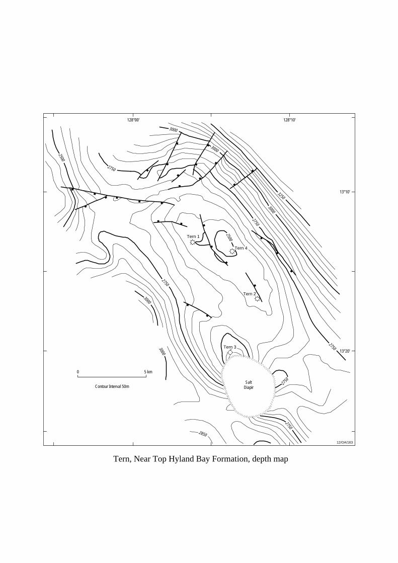
0 5 km
Tern 3
Tern 2
Tern 4
Tern 1
12/OA/163
Tern, Near Top Hyland Bay Formation, depth map
SaltDiapirContour Interval 50m
2850
3000
3000
2750
2750
2750
3000
30003000
3250
2750
2500
128°00' 128°10'
13°10'
13°20'
2500
2750
2750
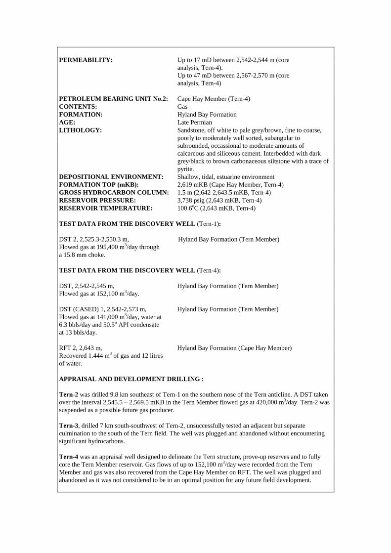
PERMEABILITY: Up to 17 mD between 2,542-2,544 m (core analysis, Tern-4). Up to 47 mD between 2,567-2,570 m (core analysis, Tern-4) PETROLEUM BEARING UNIT No.2: Cape Hay Member (Tern-4) CONTENTS: Gas FORMATION: Hyland Bay Formation AGE: Late Permian LITHOLOGY: Sandstone, off white to pale grey/brown, fine to coarse, poorly to moderately well sorted, subangular to subrounded, occassional to moderate amounts of calcareous and siliceous cement. Interbedded with dark grey/black to brown carbonaceous siltstone with a trace of pyrite. DEPOSITIONAL ENVIRONMENT: Shallow, tidal, estuarine environment FORMATION TOP (mKB): 2,619 mKB (Cape Hay Member, Tern-4) GROSS HYDROCARBON COLUMN: 1.5 m (2,642-2,643.5 mKB, Tern-4) RESERVOIR PRESSURE: 3,738 psig (2,643 mKB, Tern-4) RESERVOIR TEMPERATURE: 100.6oC (2,643 mKB, Tern-4) TEST DATA FROM THE DISCOVERY WELL (Tern-1): DST 2, 2,525.3-2,550.3 m, Hyland Bay Formation (Tern Member) Flowed gas at 195,400 m3/day through a 15.8 mm choke. TEST DATA FROM THE DISCOVERY WELL (Tern-4): DST, 2,542-2,545 m, Hyland Bay Formation (Tern Member) Flowed gas at 152,100 m3/day. DST (CASED) 1, 2,542-2,573 m, Hyland Bay Formation (Tern Member) Flowed gas at 141,000 m3/day, water at 6.3 bbls/day and 50.5o API condensate at 13 bbls/day. RFT 2, 2,643 m, Hyland Bay Formation (Cape Hay Member) Recovered 1.444 m3 of gas and 12 litres of water. APPRAISAL AND DEVELOPMENT DRILLING : Tern-2 was drilled 9.8 km southeast of Tern-1 on the southern nose of the Tern anticline. A DST taken over the interval 2,545.5 – 2,569.5 mKB in the Tern Member flowed gas at 420,000 m3/day. Tern-2 was suspended as a possible future gas producer. Tern-3, drilled 7 km south-southwest of Tern-2, unsuccessfully tested an adjacent but separate culmination to the south of the Tern field. The well was plugged and abandoned without encountering significant hydrocarbons. Tern-4 was an appraisal well designed to delineate the Tern structure, prove-up reserves and to fully core the Tern Member reservoir. Gas flows of up to 152,100 m3/day were recorded from the Tern Member and gas was also recovered from the Cape Hay Member on RFT. The well was plugged and abandoned as it was not considered to be in an optimal position for any future field development.
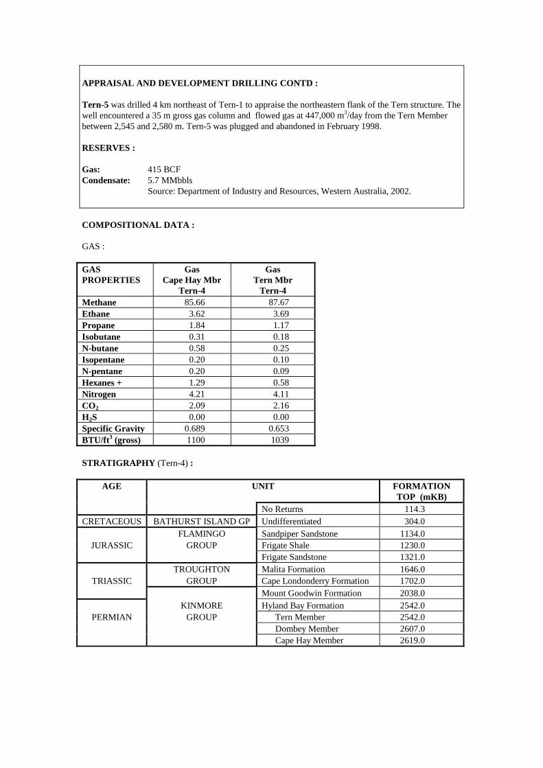
APPRAISAL AND DEVELOPMENT DRILLING CONTD : Tern-5 was drilled 4 km northeast of Tern-1 to appraise the northeastern flank of the Tern structure. The well encountered a 35 m gross gas column and flowed gas at 447,000 m3/day from the Tern Member between 2,545 and 2,580 m. Tern-5 was plugged and abandoned in February 1998. RESERVES : Gas: 415 BCF Condensate: 5.7 MMbbls Source: Department of Industry and Resources, Western Australia, 2002. COMPOSITIONAL DATA : GAS : GAS PROPERTIES
Gas Cape Hay Mbr
Tern-4
Gas Tern Mbr
Tern-4 Methane 85.66 87.67 Ethane 3.62 3.69 Propane 1.84 1.17 Isobutane 0.31 0.18 N-butane 0.58 0.25 Isopentane 0.20 0.10 N-pentane 0.20 0.09 Hexanes + 1.29 0.58 Nitrogen 4.21 4.11 CO2 2.09 2.16 H2S 0.00 0.00 Specific Gravity 0.689 0.653 BTU/ft3 (gross) 1100 1039 STRATIGRAPHY (Tern-4) :
AGE UNIT FORMATION TOP (mKB)
No Returns 114.3 CRETACEOUS BATHURST ISLAND GP Undifferentiated 304.0
FLAMINGO Sandpiper Sandstone 1134.0 JURASSIC GROUP Frigate Shale 1230.0
Frigate Sandstone 1321.0 TROUGHTON Malita Formation 1646.0
TRIASSIC GROUP Cape Londonderry Formation 1702.0 Mount Goodwin Formation 2038.0 KINMORE Hyland Bay Formation 2542.0
PERMIAN GROUP Tern Member 2542.0 Dombey Member 2607.0 Cape Hay Member 2619.0

Accumulation Number: 64 TROUBADOUR
ORIGINAL OPERATOR: Woodside/Burmah Oil NL TYPE: Gas STATUS: Possible Future Producer LOCATION: 430 km northwest of Darwin STATE: Northern Territory ORIGINAL TITLE(S): NT/P12 BASIN: Bonaparte SUB-BASIN: Sahul Platform DISCOVERY WELL: Troubadour-1 Longitude (E): 128.1237 Latitude (S): -9.7344 Date total depth reached: 15 AUG 74 Water Depth: 96 m Kelly bushing: 12 m Operator: Woodside/Burmah Oil NL Total Depth: 3,459 mKB NUMBER OF WELLS DRILLED: 1 STRUCTURE/TRAP: Faulted drape anticline AREAL CLOSURE: 17.5 km2 VERTICAL CLOSURE: 41 m RESERVOIR UNITS: 1 (‘Upper’ and ‘Lower’ unit differentiated) BOTTOM HOLE TEMPERATURE: 151oC PETROLEUM BEARING UNIT No.1: Troughton Group CONTENTS: Gas FORMATION: Plover Formation AGE: Jurassic LITHOLOGY: Interbedded sandstones, siltstones and claystones. Sandstones are commonly well cemented with silica. DEPOSITIONAL ENVIRONMENT: Intermediate marine environment. FORMATION TOP (mKB): 2,159.5 mKB POROSITY: 9.5 - 14.9% (core data, ‘Upper’ unit) PERMEABILITY: <0.01 - 1.2 mD (core data, ‘Upper’ unit) GROSS HYDROCARBON COLUMN: 25 m (2,201.5-2,226.5 mKB) (‘Upper’ unit) 20.5 m (2,226.5-2,247 mKB)(‘Lower’ unit) HYDROCARBON SATURATION: 50% (‘Upper’ unit, log data) 55% (‘Lower’ unit, log data) GAS / WATER CONTACT: 2,285 mKB (?) (The interval 2,247-2,295 mKB is considered to be predominantly gas saturated but of very low porosity) TEST DATA FROM THE DISCOVERY WELL (Troubadour-1): DST 3, 2,206-2,211 m, Plover Formation Flowed gas at 41,500 m3/day, condensate at 13 bbls/day and water at 17.6 bbls/day. DST 2, 2,228-2,244 m, 2,238-2,244 m, Plover Formation Flowed gas at 279,000 m3/day and condensate at 245 bbls/day.
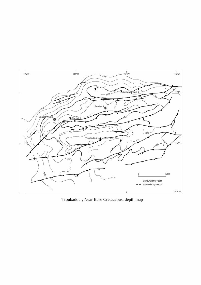
Sunset 1Sunset West 1
Sunrise 1
Sunrise 2
Loxton Shoals 1
Troubadour 1
127°45' 128°00' 128°15'
9°30'
9°45'
0 15 km
Contour Interval = 50m
12/OA164
128°30'
1750
1750
1750
1750
1750
1750
1900
1900
1900
1900
1750
17501800
1700
1700
1700
Lowest closing contour
Troubadour, Near Base Cretaceous, depth map
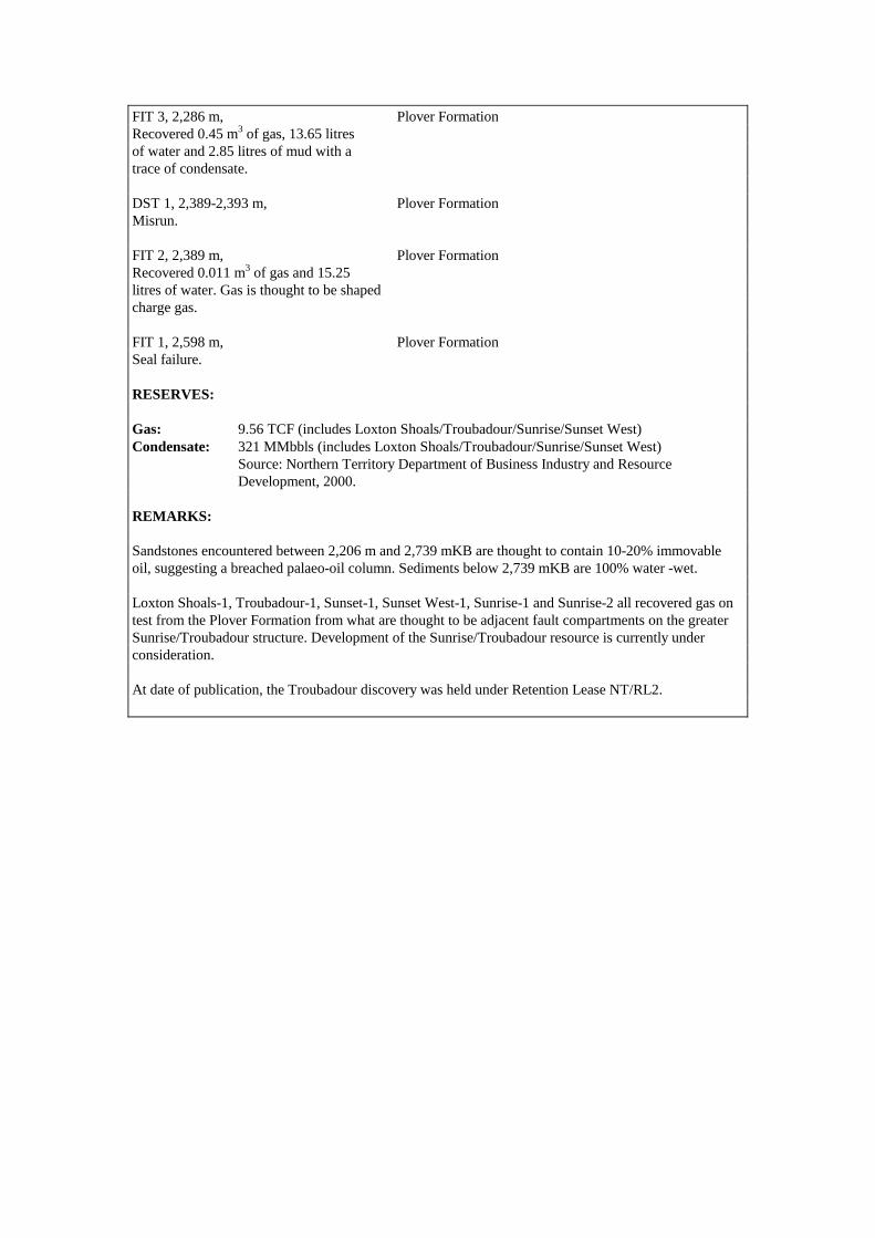
FIT 3, 2,286 m, Plover Formation Recovered 0.45 m3 of gas, 13.65 litres of water and 2.85 litres of mud with a trace of condensate. DST 1, 2,389-2,393 m, Plover Formation Misrun. FIT 2, 2,389 m, Plover Formation Recovered 0.011 m3 of gas and 15.25 litres of water. Gas is thought to be shaped charge gas. FIT 1, 2,598 m, Plover Formation Seal failure. RESERVES: Gas: 9.56 TCF (includes Loxton Shoals/Troubadour/Sunrise/Sunset West) Condensate: 321 MMbbls (includes Loxton Shoals/Troubadour/Sunrise/Sunset West) Source: Northern Territory Department of Business Industry and Resource Development, 2000. REMARKS: Sandstones encountered between 2,206 m and 2,739 mKB are thought to contain 10-20% immovable oil, suggesting a breached palaeo-oil column. Sediments below 2,739 mKB are 100% water -wet. Loxton Shoals-1, Troubadour-1, Sunset-1, Sunset West-1, Sunrise-1 and Sunrise-2 all recovered gas on test from the Plover Formation from what are thought to be adjacent fault compartments on the greater Sunrise/Troubadour structure. Development of the Sunrise/Troubadour resource is currently under consideration. At date of publication, the Troubadour discovery was held under Retention Lease NT/RL2.
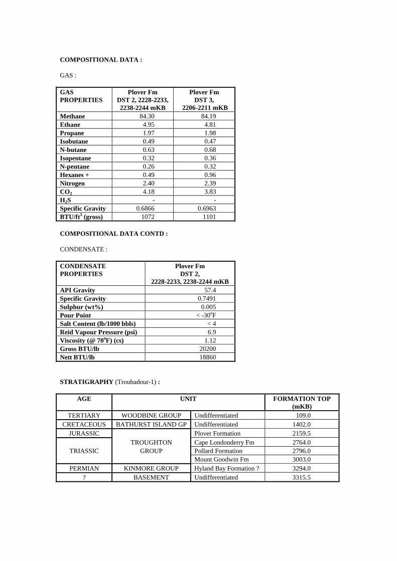
COMPOSITIONAL DATA : GAS : GAS PROPERTIES
Plover Fm DST 2, 2228-2233, 2238-2244 mKB
Plover Fm DST 3,
2206-2211 mKB Methane 84.30 84.19 Ethane 4.95 4.81 Propane 1.97 1.98 Isobutane 0.49 0.47 N-butane 0.63 0.68 Isopentane 0.32 0.36 N-pentane 0.26 0.32 Hexanes + 0.49 0.96 Nitrogen 2.40 2.39 CO2 4.18 3.83 H2S - - Specific Gravity 0.6866 0.6963 BTU/ft3 (gross) 1072 1101 COMPOSITIONAL DATA CONTD : CONDENSATE : CONDENSATE PROPERTIES
Plover Fm DST 2,
2228-2233, 2238-2244 mKB API Gravity 57.4 Specific Gravity 0.7491 Sulphur (wt%) 0.005 Pour Point < -30oF Salt Content (lb/1000 bbls) < 4 Reid Vapour Pressure (psi) 6.9 Viscosity (@ 70oF) (cs) 1.12 Gross BTU/lb 20200 Nett BTU/lb 18860 STRATIGRAPHY (Troubadour-1) :
AGE UNIT FORMATION TOP (mKB)
TERTIARY WOODBINE GROUP Undifferentiated 109.0 CRETACEOUS BATHURST ISLAND GP Undifferentiated 1402.0
JURASSIC Plover Formation 2159.5 TROUGHTON Cape Londonderry Fm 2764.0
TRIASSIC GROUP Pollard Formation 2796.0 Mount Goodwin Fm 3003.0
PERMIAN KINMORE GROUP Hyland Bay Formation ? 3294.0 ? BASEMENT Undifferentiated 3315.5

Accumulation Number: 65 TURTLE
ORIGINAL OPERATOR: Western Mining Corporation Ltd TYPE: Oil STATUS: Possible Future Producer LOCATION: 300 km southwest of Darwin STATE: Western Australia ORIGINAL TITLE(S): WA-128-P BASIN: Bonaparte SUB-BASIN: Petrel Sub-basin DISCOVERY WELL: Turtle-1 (Kuriyippi Formation oil pool) Longitude (E): 128.9448 Latitude (S): -14.4766 Date total depth reached: 10 FEB 84 Water Depth: 24 m Kelly bushing: 33 m Operator: Western Mining Corporation Ltd Total Depth: 2,700 mKB DISCOVERY WELL: Turtle-2 (Keyling, Tanmurra and Milligans Fm oil pools) Longitude (E): 128.9458 Latitude (S): -14.5059 Date total depth reached: 30 APR 89 Water Depth: 24.6 m Kelly bushing: 35.8 m Operator: Western Mining Corporation Ltd Total Depth: 2,760 mKB NUMBER OF WELLS DRILLED: 2 STRUCTURE/TRAP: Northwest-southeast trending drape anticline. AREAL CLOSURE: 12 km2
VERTICAL CLOSURE: 40 milliseconds twt RESERVOIR UNITS: 4 OIL GRAVITY: 15o API (Keyling Formation) 33.4o API (Kuriyippi Formation) 33o API (Tanmurra Formation) 34.5o API (Milligans Formation) BOTTOM HOLE TEMPERATURE: 97oC PETROLEUM BEARING UNIT No.1: Kulshill Group CONTENTS: Oil FORMATION: Keyling Formation (Turtle-2) AGE: Early Permian (Sakmarian) LITHOLOGY: Sandstone, white to light grey, fine to medium grained (rarely coarse grained), moderately to well sorted, up to 10% kaolinitic cement, up to 30% calcite cement in some thin beds. Interbedded with minor, medium grey siltstone and rare dark grey claystone. DEPOSITIONAL ENVIRONMENT: Delta plain/fluvial environment FORMATION TOP (mKB): 915 m (Turtle-2) GROSS OIL COLUMN: 13.3 m (915-928.3 m, Turtle-2) OIL/WATER CONTACT: 928.3 mKB (Turtle-2) POROSITY: 12.2-30.9% (core data, Turtle-2) PERMEABILITY: 22-3,053 mD (core data, Turtle-2)

12/OA/165
129°00'
14°30'
0 5 km
Turtle 1
Turtle 2
Turtle, Intra Kulshill Formation, TWT map
1250
1250
1000
1500
1250
Contour Interval 50ms
128°55'
14°35'
14°25'
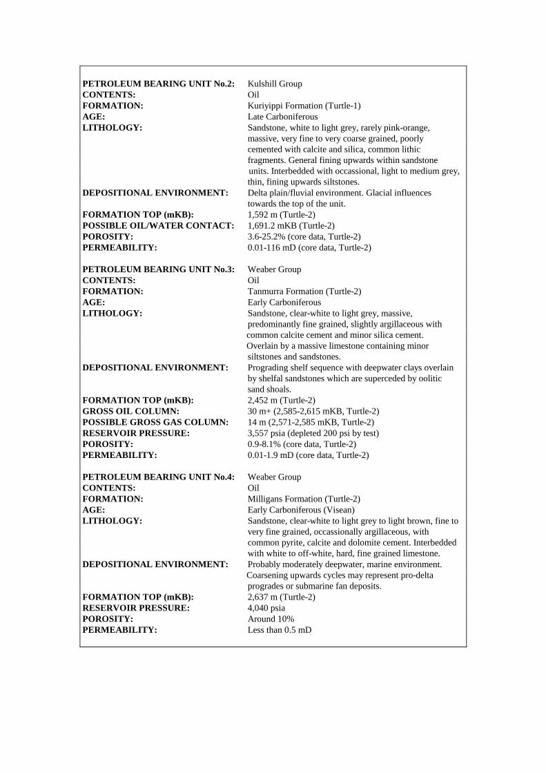
PETROLEUM BEARING UNIT No.2: Kulshill Group CONTENTS: Oil FORMATION: Kuriyippi Formation (Turtle-1) AGE: Late Carboniferous LITHOLOGY: Sandstone, white to light grey, rarely pink-orange, massive, very fine to very coarse grained, poorly cemented with calcite and silica, common lithic fragments. General fining upwards within sandstone units. Interbedded with occassional, light to medium grey, thin, fining upwards siltstones. DEPOSITIONAL ENVIRONMENT: Delta plain/fluvial environment. Glacial influences towards the top of the unit. FORMATION TOP (mKB): 1,592 m (Turtle-2) POSSIBLE OIL/WATER CONTACT: 1,691.2 mKB (Turtle-2) POROSITY: 3.6-25.2% (core data, Turtle-2) PERMEABILITY: 0.01-116 mD (core data, Turtle-2) PETROLEUM BEARING UNIT No.3: Weaber Group CONTENTS: Oil FORMATION: Tanmurra Formation (Turtle-2) AGE: Early Carboniferous LITHOLOGY: Sandstone, clear-white to light grey, massive, predominantly fine grained, slightly argillaceous with common calcite cement and minor silica cement. Overlain by a massive limestone containing minor siltstones and sandstones. DEPOSITIONAL ENVIRONMENT: Prograding shelf sequence with deepwater clays overlain by shelfal sandstones which are superceded by oolitic sand shoals. FORMATION TOP (mKB): 2,452 m (Turtle-2) GROSS OIL COLUMN: 30 m+ (2,585-2,615 mKB, Turtle-2) POSSIBLE GROSS GAS COLUMN: 14 m (2,571-2,585 mKB, Turtle-2) RESERVOIR PRESSURE: 3,557 psia (depleted 200 psi by test) POROSITY: 0.9-8.1% (core data, Turtle-2) PERMEABILITY: 0.01-1.9 mD (core data, Turtle-2) PETROLEUM BEARING UNIT No.4: Weaber Group CONTENTS: Oil FORMATION: Milligans Formation (Turtle-2) AGE: Early Carboniferous (Visean) LITHOLOGY: Sandstone, clear-white to light grey to light brown, fine to very fine grained, occassionally argillaceous, with common pyrite, calcite and dolomite cement. Interbedded with white to off-white, hard, fine grained limestone. DEPOSITIONAL ENVIRONMENT: Probably moderately deepwater, marine environment. Coarsening upwards cycles may represent pro-delta progrades or submarine fan deposits. FORMATION TOP (mKB): 2,637 m (Turtle-2) RESERVOIR PRESSURE: 4,040 psia POROSITY: Around 10% PERMEABILITY: Less than 0.5 mD
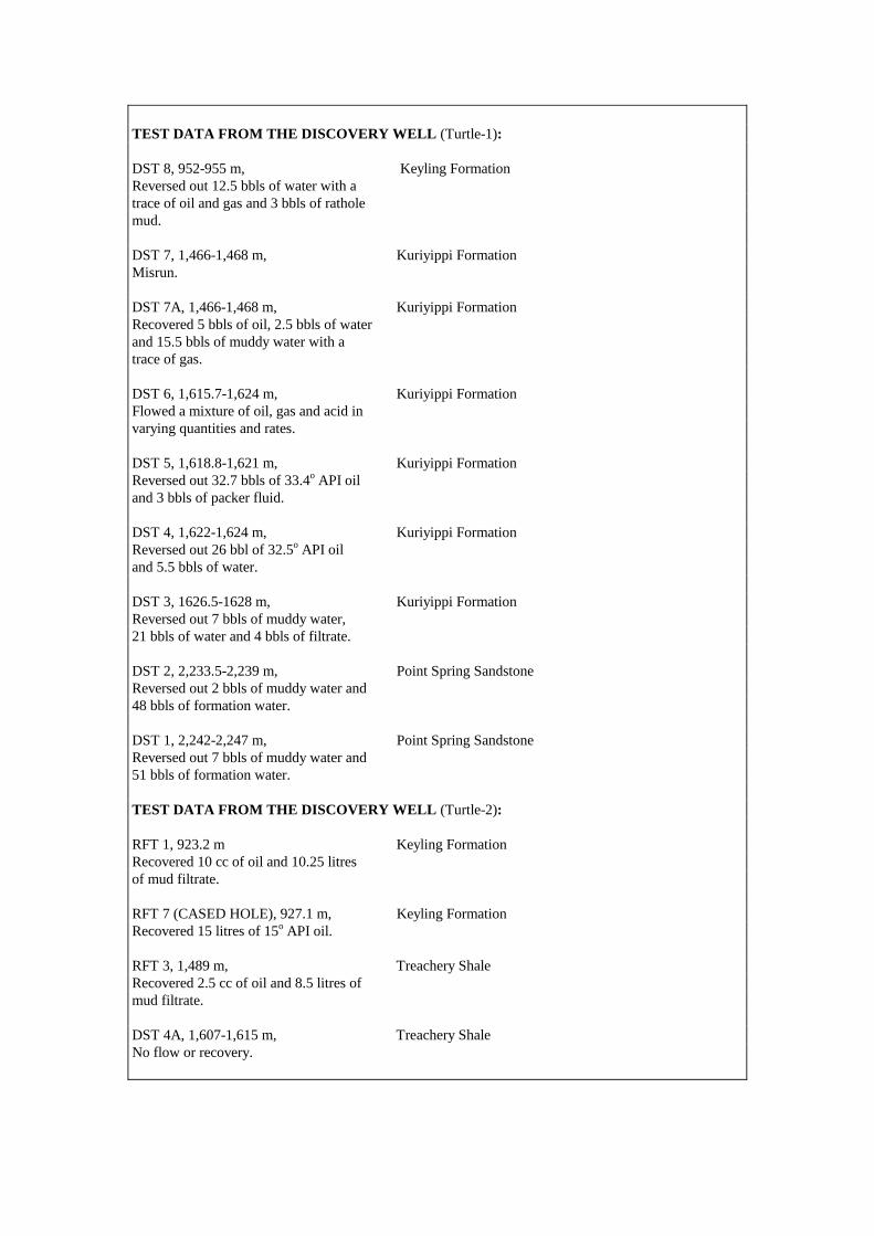
TEST DATA FROM THE DISCOVERY WELL (Turtle-1): DST 8, 952-955 m, Keyling Formation Reversed out 12.5 bbls of water with a trace of oil and gas and 3 bbls of rathole mud. DST 7, 1,466-1,468 m, Kuriyippi Formation Misrun. DST 7A, 1,466-1,468 m, Kuriyippi Formation Recovered 5 bbls of oil, 2.5 bbls of water and 15.5 bbls of muddy water with a trace of gas. DST 6, 1,615.7-1,624 m, Kuriyippi Formation Flowed a mixture of oil, gas and acid in varying quantities and rates. DST 5, 1,618.8-1,621 m, Kuriyippi Formation Reversed out 32.7 bbls of 33.4o API oil and 3 bbls of packer fluid. DST 4, 1,622-1,624 m, Kuriyippi Formation Reversed out 26 bbl of 32.5o API oil and 5.5 bbls of water. DST 3, 1626.5-1628 m, Kuriyippi Formation Reversed out 7 bbls of muddy water, 21 bbls of water and 4 bbls of filtrate. DST 2, 2,233.5-2,239 m, Point Spring Sandstone Reversed out 2 bbls of muddy water and 48 bbls of formation water. DST 1, 2,242-2,247 m, Point Spring Sandstone Reversed out 7 bbls of muddy water and 51 bbls of formation water. TEST DATA FROM THE DISCOVERY WELL (Turtle-2): RFT 1, 923.2 m Keyling Formation Recovered 10 cc of oil and 10.25 litres of mud filtrate. RFT 7 (CASED HOLE), 927.1 m, Keyling Formation Recovered 15 litres of 15o API oil. RFT 3, 1,489 m, Treachery Shale Recovered 2.5 cc of oil and 8.5 litres of mud filtrate. DST 4A, 1,607-1,615 m, Treachery Shale No flow or recovery.

RFT 4, 1,624.6 m, Treachery Shale Recovered 1-2 cc of oil and 400 cc of mud filtrate and formation water. RFT 2, 1,673 m, Kuriyippi Formation Recovered 5 cc of oil and 70 cc of mud filtrate. RFT 5, 1,690 m, Kuriyippi Formation Recovered 5 cc of oil and 9.9 litres of mud filtrate. DST 3, 2,420-2,447 m, Kuriyppi Formation (Point Spring Sandstone) Recovered 23 bbls of formation water on jet pump after acid washing. Tight formation. DST 2, 2,571-2,632 m, Tanmurra Formation Recovered 25 bbls of 33o API oil and 1,320 bbls of formation water on jet pump. DST 1A, 2,632-2,721 m, Milligans Formation Recovered 22 bbls of 34.5o API oil and 658 bbls of formation water on jet pump after acid washing. APPRAISAL AND DEVELOPMENT DRILLING : Turtle-2 was drilled as an updip test of Turtle-1, 3.5 km to the south. A 5 m oil column (1,450-1,444 mKB, Turtle-2) was identified near the top of theTreachery Shale, but this interval was not tested. RESERVES: Oil: 7.7 MMbbls Source: Department of Industry and Resources, Western Australia, 2002. REMARKS: At date of publication, the Turtle discovery was held under Retention Lease WA-13-R.
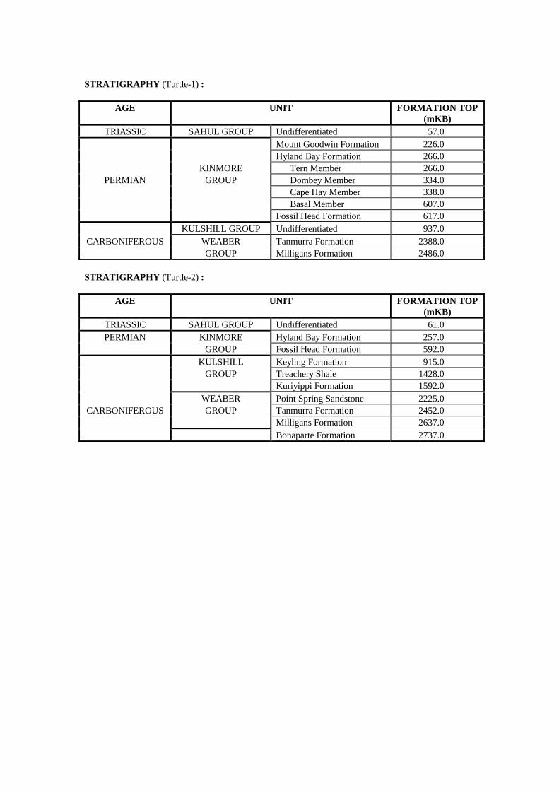
STRATIGRAPHY (Turtle-1) :
AGE UNIT FORMATION TOP (mKB)
TRIASSIC SAHUL GROUP Undifferentiated 57.0 Mount Goodwin Formation 226.0 Hyland Bay Formation 266.0 KINMORE Tern Member 266.0
PERMIAN GROUP Dombey Member 334.0 Cape Hay Member 338.0 Basal Member 607.0 Fossil Head Formation 617.0 KULSHILL GROUP Undifferentiated 937.0
CARBONIFEROUS WEABER Tanmurra Formation 2388.0 GROUP Milligans Formation 2486.0
STRATIGRAPHY (Turtle-2) :
AGE UNIT FORMATION TOP (mKB)
TRIASSIC SAHUL GROUP Undifferentiated 61.0 PERMIAN KINMORE Hyland Bay Formation 257.0
GROUP Fossil Head Formation 592.0 KULSHILL Keyling Formation 915.0 GROUP Treachery Shale 1428.0 Kuriyippi Formation 1592.0 WEABER Point Spring Sandstone 2225.0
CARBONIFEROUS GROUP Tanmurra Formation 2452.0 Milligans Formation 2637.0 Bonaparte Formation 2737.0
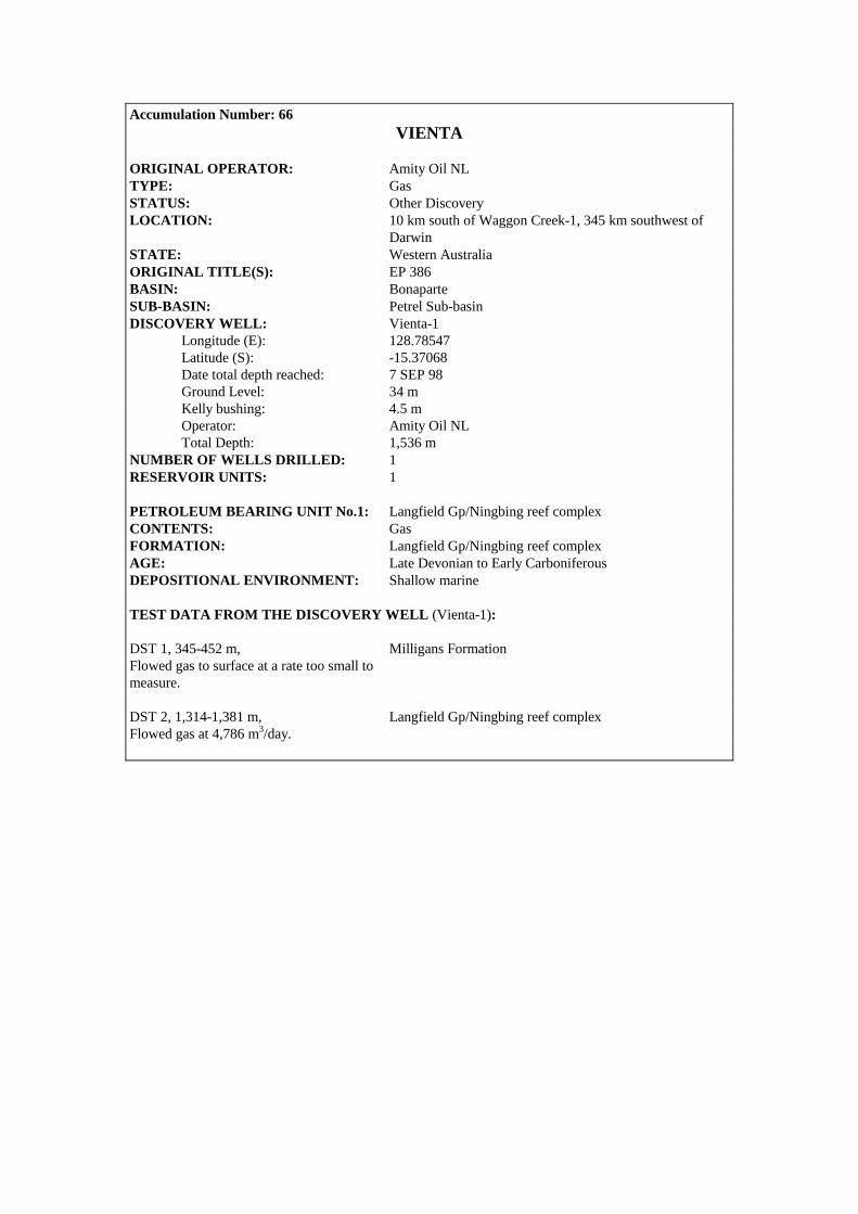
Accumulation Number: 66 VIENTA
ORIGINAL OPERATOR: Amity Oil NL TYPE: Gas STATUS: Other Discovery LOCATION: 10 km south of Waggon Creek-1, 345 km southwest of
Darwin STATE: Western Australia ORIGINAL TITLE(S): EP 386 BASIN: Bonaparte SUB-BASIN: Petrel Sub-basin DISCOVERY WELL: Vienta-1 Longitude (E): 128.78547 Latitude (S): -15.37068 Date total depth reached: 7 SEP 98 Ground Level: 34 m Kelly bushing: 4.5 m Operator: Amity Oil NL Total Depth: 1,536 m NUMBER OF WELLS DRILLED: 1 RESERVOIR UNITS: 1 PETROLEUM BEARING UNIT No.1: Langfield Gp/Ningbing reef complex CONTENTS: Gas FORMATION: Langfield Gp/Ningbing reef complex AGE: Late Devonian to Early Carboniferous DEPOSITIONAL ENVIRONMENT: Shallow marine TEST DATA FROM THE DISCOVERY WELL (Vienta-1): DST 1, 345-452 m, Milligans Formation Flowed gas to surface at a rate too small to measure. DST 2, 1,314-1,381 m, Langfield Gp/Ningbing reef complex Flowed gas at 4,786 m3/day.

Accumulation Number: 67 WAGGON CREEK
ORIGINAL OPERATOR: Amity Oil NL TYPE: Gas STATUS: Other Discovery LOCATION: 400 km southwest of Darwin STATE: Western Australia ORIGINAL TITLE(S): EP 386 BASIN: Bonaparte SUB-BASIN: Petrel Sub-basin DISCOVERY WELL: Waggon Creek-1 Longitude (E): 128.7105 Latitude (S): -15.3238 Date total depth reached: 14 NOV 95 Ground Level: 45 m Kelly bushing: 47 m Operator: Amity Oil NL Total Depth: 700 m NUMBER OF WELLS DRILLED: 2 STRUCTURE/TRAP: Large structural/stratigraphic trap on the western basin margin. RESERVOIR UNITS: 1 (multiple sands) PETROLEUM BEARING UNIT No.1: Weaber Group CONTENTS: Gas FORMATION: Milligans Formation AGE: Early Carboniferous TEST DATA FROM THE DISCOVERY WELL (Waggon Creek-1): DST 1, 352.6-415 m, Milligans Formation Flowed gas at 36,800 m3/day with condensate through a 12.7 mm choke. Flow Test, 386.3 m, Milligans Formation Flowed gas at 37,950 m3/day through a 13 mm choke at a flowing pressure of 260 psi. DST 3, 586-601.2 m, Milligans Formation Flowed gas at 28,300 m3/day at 280 psi through a 9.5 mm choke with an estimated 3% condensate and salt water.
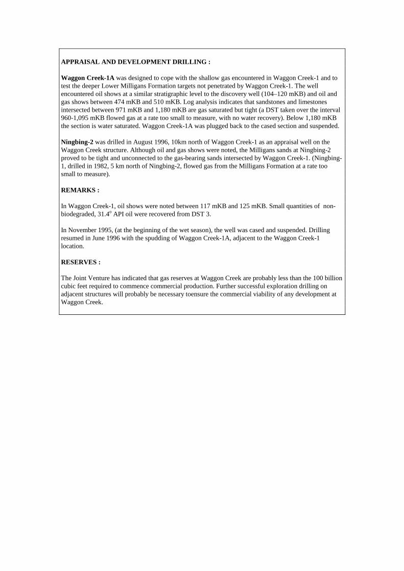
APPRAISAL AND DEVELOPMENT DRILLING : Waggon Creek-1A was designed to cope with the shallow gas encountered in Waggon Creek-1 and to test the deeper Lower Milligans Formation targets not penetrated by Waggon Creek-1. The well encountered oil shows at a similar stratigraphic level to the discovery well (104–120 mKB) and oil and gas shows between 474 mKB and 510 mKB. Log analysis indicates that sandstones and limestones intersected between 971 mKB and 1,180 mKB are gas saturated but tight (a DST taken over the interval 960-1,095 mKB flowed gas at a rate too small to measure, with no water recovery). Below 1,180 mKB the section is water saturated. Waggon Creek-1A was plugged back to the cased section and suspended. Ningbing-2 was drilled in August 1996, 10km north of Waggon Creek-1 as an appraisal well on the Waggon Creek structure. Although oil and gas shows were noted, the Milligans sands at Ningbing-2 proved to be tight and unconnected to the gas-bearing sands intersected by Waggon Creek-1. (Ningbing-1, drilled in 1982, 5 km north of Ningbing-2, flowed gas from the Milligans Formation at a rate too small to measure). REMARKS : In Waggon Creek-1, oil shows were noted between 117 mKB and 125 mKB. Small quantities of non-biodegraded, 31.4o API oil were recovered from DST 3. In November 1995, (at the beginning of the wet season), the well was cased and suspended. Drilling resumed in June 1996 with the spudding of Waggon Creek-1A, adjacent to the Waggon Creek-1 location. RESERVES : The Joint Venture has indicated that gas reserves at Waggon Creek are probably less than the 100 billion cubic feet required to commence commercial production. Further successful exploration drilling on adjacent structures will probably be necessary toensure the commercial viability of any development at Waggon Creek.
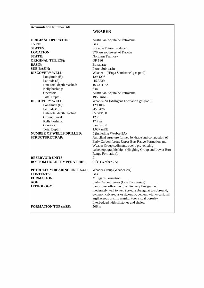
Accumulation Number: 68 WEABER
ORIGINAL OPERATOR: Australian Aquitaine Petroleum TYPE: Gas STATUS: Possible Future Producer LOCATION: 370 km southwest of Darwin STATE: Northern Territory ORIGINAL TITLE(S): OP 186 BASIN: Bonaparte SUB-BASIN: Petrel Sub-basin DISCOVERY WELL: Weaber-1 (‘Enga Sandstone’ gas pool) Longitude (E): 129.1296 Latitude (S): -15.3539 Date total depth reached: 16 OCT 82 Kelly bushing: 6 m Operator: Australian Aquitaine Petroleum Total Depth: 1950 mKB DISCOVERY WELL: Weaber-2A (Milligans Formation gas pool) Longitude (E): 129.1082 Latitude (S): -15.3476 Date total depth reached: 05 SEP 88 Ground Level: 12 m Kelly bushing: 17.7 m Operator: Santos Ltd Total Depth: 1,657 mKB NUMBER OF WELLS DRILLED: 5 (including Weaber-2A) STRUCTURE/TRAP: Anticlinal structure formed by drape and compaction of Early Carboniferous Upper Burt Range Formation and Weaber Group sediments over a pre-existing palaeotopographic high (Ningbing Group and Lower Burt Range Formation). RESERVOIR UNITS: 2 BOTTOM HOLE TEMPERATURE: 91oC (Weaber-2A) PETROLEUM BEARING UNIT No.1: Weaber Group (Weaber-2A) CONTENTS: Gas FORMATION: Milligans Formation AGE: Early Carboniferous (Late Tournasian) LITHOLOGY: Sandstone, off-white to white, very fine grained, moderately well to well sorted, subangular to subround, common calcareous or dolomitic cement with occasional argillaceous or silty matrix. Poor visual porosity. Interbedded with siltstones and shales. FORMATION TOP (mSS): 506 m
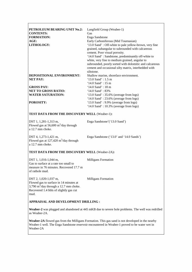
PETROLEUM BEARING UNIT No.2: Langfield Group (Weaber-1) CONTENTS: Gas FORMATION: Enga Sandstone AGE: Early Carboniferous (Mid Tournasian) LITHOLOGY: ‘13.0 Sand’ : Off-white to pale yellow-brown, very fine grained, subangular to subrounded with calcareous cement. Poor visual porosity. ‘14.0 Sand’ : Sandstone, predominantly off-white to white, very fine to medium grained, angular to subrounded, poorly sorted with dolomitic and calcareous cement and occasional silty matrix, interbedded with siltstone. DEPOSITIONAL ENVIRONMENT: Shallow marine, shoreface environment. NET PAY: ‘13.0 Sand’ : 1.5 m ‘14.0 Sand’ : 15 m GROSS PAY: ‘14.0 Sand’ : 18 m NET TO GROSS RATIO: ‘14.0 Sand’ : 83% WATER SATURATION: ‘13.0 Sand’ : 35.6% (average from logs) ‘14.0 Sand’ : 23.6% (average from logs) POROSITY: ‘13.0 Sand’ : 9.9% (average from logs) ‘14.0 Sand’ : 10.3% (average from logs) TEST DATA FROM THE DISCOVERY WELL (Weaber-1): DST 1, 1,281-1,313 m, Enga Sandstone’(‘13.0 Sand’) Flowed gas at 56,600 m3/day through a 12.7 mm choke. DST 4, 1,273-1,421 m, Enga Sandstone (‘13.0’ and ‘14.0 Sands’) Flowed gas at 127,420 m3/day through a 12.7 mm choke. TEST DATA FROM THE DISCOVERY WELL (Weaber-2A): DST 1, 1,016-1,044 m, Milligans Formation Gas to surface at a rate too small to measure in 76 minutes. Recovered 17.7 m of rathole mud. DST 2, 1,020-1,037 m, Milligans Formation Flowed gas to surface in 14 minutes at 3,790 m3/day through a 12.7 mm choke. Recovered 1.4 bbls of slightly gas cut mud. APPRAISAL AND DEVELOPMENT DRILLING : Weaber-2 was plugged and abandoned at 445 mKB due to severe hole problems. The well was redrilled as Weaber-2A. Weaber-2A flowed gas from the Milligans Formation. This gas sand is not developed in the nearby Weaber-1 well. The Enga Sandstone reservoir encountered in Weaber-1 proved to be water wet in Weaber-2A

Weaber-3, drilled 1.5 km north of Weaber-1, was suspended pending further evaluation. Weaber-4 flowed gas at 116,100 m3/day on production test and completed as a future gas producer. RESERVES: Gas: 11 BCF Source: Northern Territory Department of Business Industry and Resource Development, 1998. REMARKS: Weaber-1 was originally plugged and abandoned without testing. The well was later found to be leaking gas at the surface and was subsequently re-entered and tested. Test results suggested formation damage had occurred and that flow rates of up to 480,000 m3/day may be possible from the Enga Sandstone. The Weaber gas discovery is currently held under Retention Lease RL 1. COMPOSITIONAL DATA : GAS : GAS PROPERTIES
Gas Milligans Fm Weaber-2A
(DST-1) Methane 89.09 Ethane 5.45 Propane 1.16 Isobutane 0.10 N-butane 0.15 Isopentane 0.03 N-pentane 0.01 Hexanes + 0.20 Nitrogen 3.42 CO2 0.51 H2S - Specific Gravity 0.617 BTU/ft3 (gross) 1042 STRATIGRAPHY (Weaber-2A) :
AGE UNIT FORMATION TOP (mKB)
WEABER Tanmurra Formation 227.0 GROUP Milligans Formation 525.0
EARLY Enga Sandstone 1372.0 CARBONIFEROUS LANGFIELD 13-0 Sand 1372.0
GROUP 14-0 Sand 1468.0 Burt Range Formation 1489.0

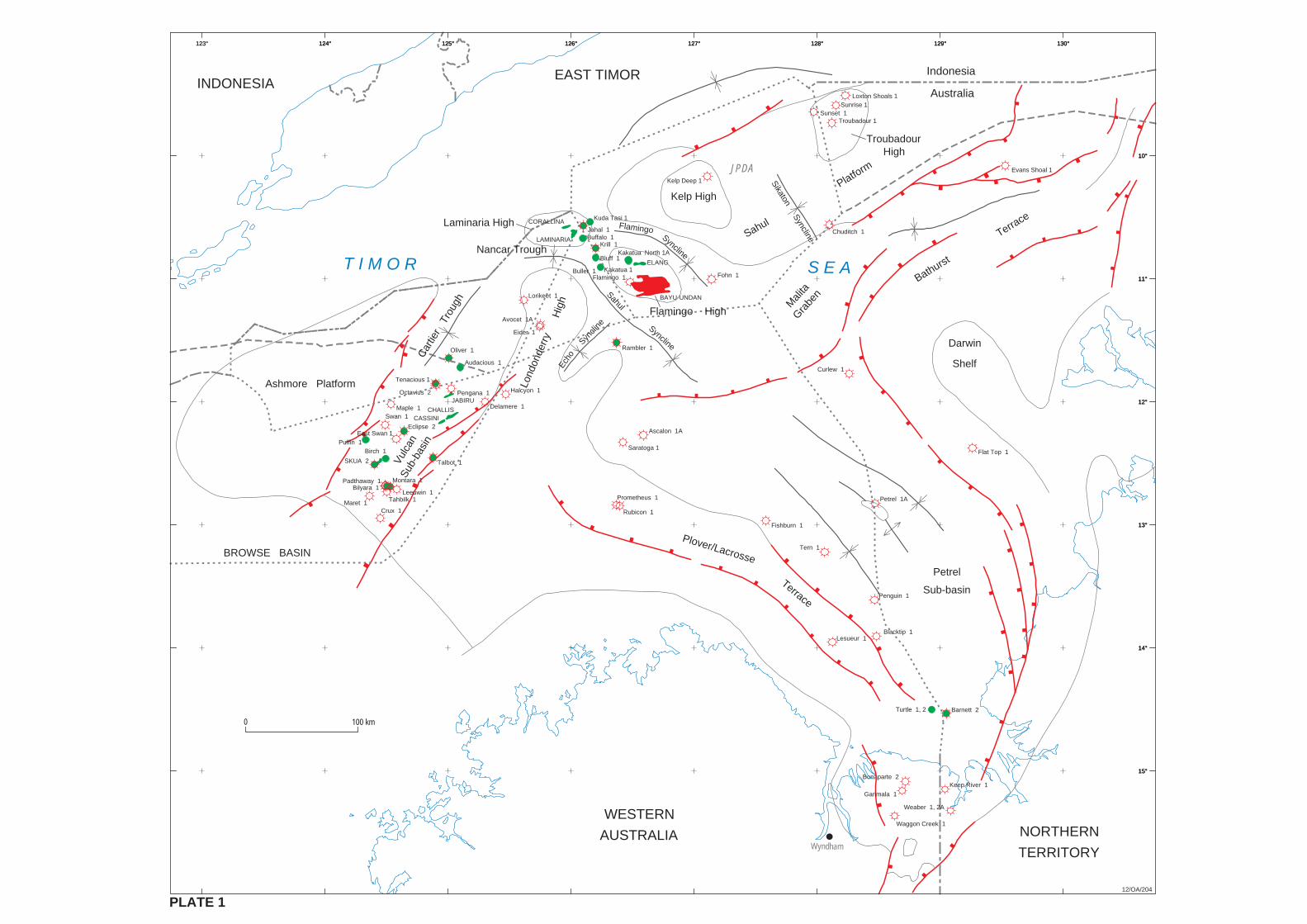
Ascalon 1A
Avocet 1A
Barnett 2
Bilyara 1
Birch 1
Bonaparte 2
Buffalo 1
Curlew 1
Delamere 1
Eclipse 2
Eider 1
Evans Shoal 1
Fishburn 1
Flamingo 1
Flat Top 1
Fohn 1
Halcyon 1
Jahal 1
Kakatua 1
Kakatua North 1A
Kelp Deep 1
Lesueur 1
Lorikeet 1
Loxton Shoals 1
Maple 1
Maret 1
Octavius 2
Oliver 1
Padthaway 1
Pengana 1
Penguin 1
Petrel 1APrometheus 1
Rambler 1
Sunrise 1
Swan 1
Talbot 1
Tern 1
Puffin 1
Tenacious 1
Blacktip 1
ELANG
BAYU-UNDAN
JABIRU
CASSINICHALLIS
Turtle 1, 2
T I M O R
Wyndham
123° 124° 125° 126° 127° 128° 129° 130°
10°
11°
12°
13°
14°
15°
INDONESIAEAST TIMOR
S E A
JPDA
SKUA 2
Saratoga 1
Audacious 1
Rubicon 1
Kuda Tasi 1
WESTERN
AUSTRALIA NORTHERN
TERRITORY
Chuditch 1
Krill 1
Keep River 1
Weaber 1, 2A
Garimala 1
Waggon Creek 1
Sunset 1
123° 124° 125° 126° 127° 128° 129° 130°
10°
11°
12°
13°
14°
15°
124° 125° 126° 127° 128° 129° 130°
10°
11°
12°
13°
14°
15°
Sikaton Syncline
BROWSE BASIN
Ashmore Platform
Laminaria High
Car
tier
Tro
ugh
Kelp High
TroubadourHigh
Mali
taGra
ben
Darwin
Shelf
Syncline
Flamingo
Flamingo HighSyncline
Sahul
Petrel
Sub-basin
Plover/Lacrosse
Terrace
Troubadour 1
LAMINARIA
Bluff 1
Buller 1
Montara 1
Leeuwin 1Tahbilk 1
Crux 1
12/OA/204
Lond
onde
rry
Hig
h
Syncli
ne
Echo
East Swan 1
Vulc
anSu
b-ba
sin
Sahul
Platform
Bathurst
Terrace
Indonesia
Australia
0 100 km
PLATE 1
Nancar Trough
CORALLINA
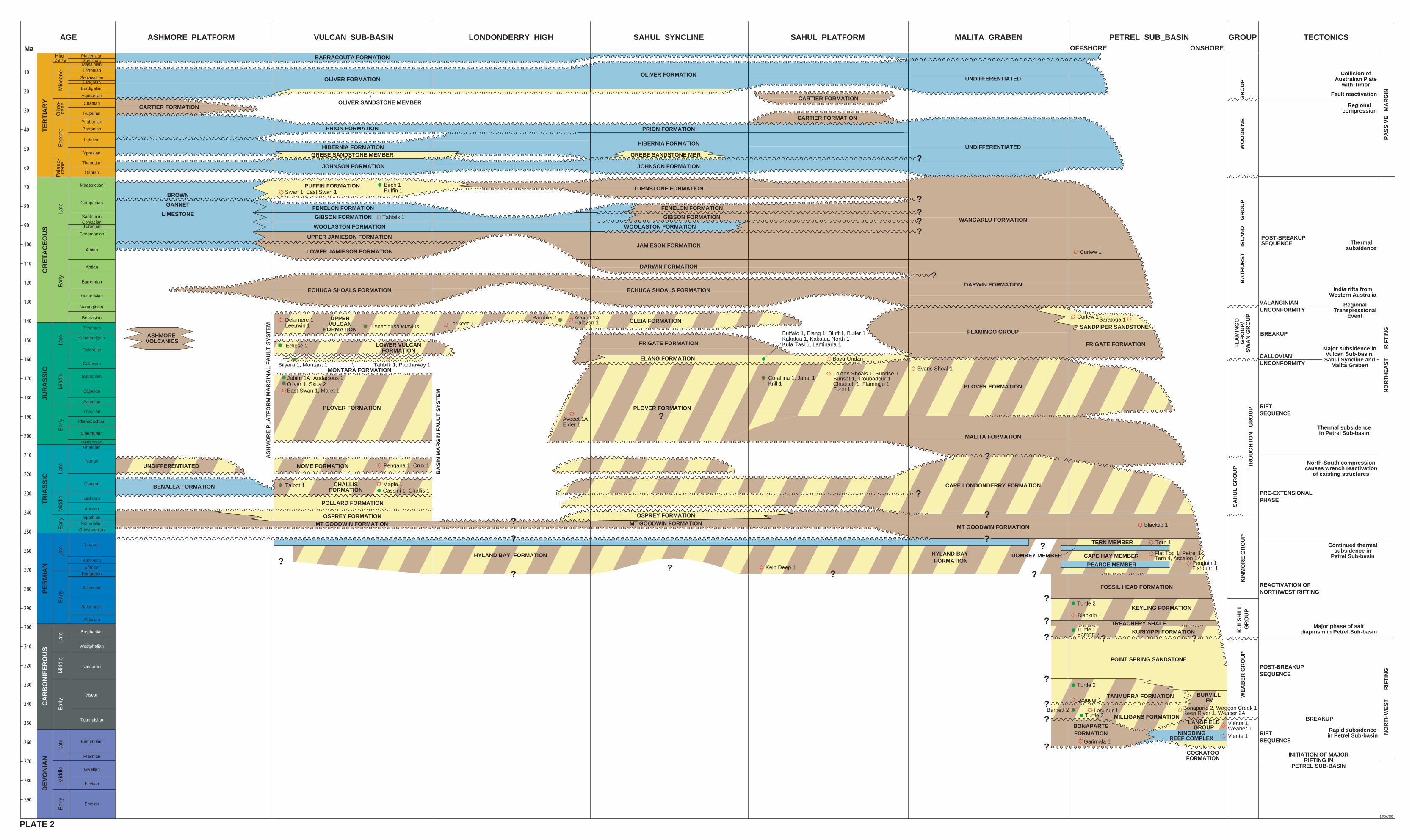
ASHMORE PLATFORM VULCAN SUB-BASIN LONDONDERRY HIGH SAHUL SYNCLINE SAHUL PLATFORM MALITA GRABEN PETREL SUB_BASIN GROUP TECTONICS
OLIVER SANDSTONE MEMBER
AS
HM
OR
E P
LA
TF
OR
M M
AR
GIN
AL
FA
UL
T S
YS
TE
M
BA
SIN
MA
RG
IN F
AU
LT
SY
ST
EM
LOWER VULCANFORMATION
PLOVER FORMATION
NOME FORMATION
HYLAND BAY FORMATION
ECHUCA SHOALS FORMATION
PLOVER FORMATION
PLOVER FORMATION
CAPE LONDONDERRY FORMATION
OFFSHORE ONSHORE
PEARCE MEMBER
HYLAND BAY FORMATION
KEYLING FORMATION
KURIYIPPI FORMATION
POINT SPRING SANDSTONE
BURVILL FM
BONAPARTEFORMATION
COCKATOOFORMATION
KU
LS
HIL
LG
RO
UP
FL
AM
ING
OG
RO
UP
/S
WA
N G
RO
UP
WO
OD
BIN
E
G
RO
UP
BA
TH
UR
ST
IS
LA
ND
G
RO
UP
TR
OU
GH
TO
N
GR
OU
P
SA
HU
L G
RO
UP
KIN
MO
RE
GR
OU
PW
EA
BE
R G
RO
UP
PA
SS
IVE
M
AR
GIN
NO
RT
HE
AS
T
R
IFT
ING
NO
RT
HW
ES
T
R
IFT
ING
Collision ofAustralian Plate
with Timor
Fault reactivation
Regionalcompression
Thermalsubsidence
POST-BREAKUPSEQUENCE
India rifts fromWestern Australia
VALANGINIANUNCONFORMITY
BREAKUP
CALLOVIANUNCONFORMITY
RegionalTranspressional
Event
Major subsidence inVulcan Sub-basin,Sahul Syncline and
Malita Graben
RIFTSEQUENCE
Thermal subsidencein Petrel Sub-basin
PRE-EXTENSIONALPHASE
North-South compressioncauses wrench reactivation
of existing structures
REACTIVATION OFNORTHWEST RIFTING
Continued thermalsubsidence in
Petrel Sub-basin
POST-BREAKUPSEQUENCE
Major phase of saltdiapirism in Petrel Sub-basin
BREAKUP
RIFTSEQUENCE
INITIATION OF MAJORRIFTING IN
PETREL SUB-BASIN
Rapid subsidencein Petrel Sub-basin
Eclipse 2
Tahbilk 1, Padthaway 1MONTARA FORMATION
Bilyara 1, Montara 1
Jabiru 1A, Audacious 1Oliver 1, Skua 2East Swan 1, Maret 1
Pengana 1, Crux 1
Avocet 1AEider 1
Evans Shoal 1
Kelp Deep 1
Flat Top 1, Petrel 1Tern 4, Ascalon 1A
Turtle 2
Penguin 1Fishburn 1
Turtle 1Barnett 2
Turtle 2
Turtle 2Barnett 2
Garimala 1
Bonaparte 2, Waggon Creek 1Keep River 1, Weaber 2A
Vienta 1
Blacktip 1
TANMURRA FORMATIONLesueur 1
Lesueur 1MILLIGANS FORMATION
??
?
?
?
?
?
?
?
?
?
??
Vienta 1,Weaber 1
BARRACOUTA FORMATION
PRION FORMATION
HIBERNIA FORMATION
JOHNSON FORMATION
UNDIFFERENTIATED
?HIBERNIA FORMATION
JOHNSON FORMATION
CARTIER FORMATION
CARTIER FORMATION
BROWN
GANNET
LIMESTONE
GREBE SANDSTONE MEMBER
PUFFIN FORMATION Birch 1Puffin 1 TURNSTONE FORMATION
Tahbilk 1
Swan 1, East Swan 1
GIBSON FORMATION
FENELON FORMATION
JAMIESON FORMATION
FENELON FORMATION
GIBSON FORMATION
WOOLASTON FORMATION WOOLASTON FORMATION
UPPER JAMIESON FORMATION
LOWER JAMIESON FORMATION
ASHMORE VOLCANICS
BENALLA FORMATION CHALLISFORMATION
Talbot 1 Maple 1Cassini 1, Challis 1
MT GOODWIN FORMATION
CARTIER FORMATION
FOSSIL HEAD FORMATION
WANGARLU FORMATION
?
???
Curlew 1
ECHUCA SHOALS FORMATION
DARWIN FORMATION
DARWIN FORMATION?
SANDPIPER SANDSTONE
Curlew 1Saratoga 1
OSPREY FORMATIONMT GOODWIN FORMATION
TREACHERY SHALE
OLIVER FORMATION
PRION FORMATION
OLIVER FORMATIONUNDIFFERENTIATED
FRIGATE FORMATION
POLLARD FORMATION
OSPREY FORMATION
MT GOODWIN FORMATION
CAPE HAY MEMBER
TERN MEMBER
DOMBEY MEMBER
Blacktip 1
Tern 1?
LANGFIELDGROUP
NINGBINGREEF COMPLEX
UNDIFFERENTIATED
GREBE SANDSTONE MBR
UPPERVULCAN
FORMATION
CLEIA FORMATIONDelamere 1Leeuwin 1 Tenacious/Octavius Lorikeet 1
Avocet 1AHalcyon 1
Rambler 1
FRIGATE FORMATION
ELANG FORMATION Bayu-Undan
?
?
?
FLAMINGO GROUP
MALITA FORMATION
?
?
?
?
Corallina 1, Jahal 1Krill 1
Loxton Shoals 1, Sunrise 1Sunset 1, Troubadour 1Chuditch 1, Flamingo 1Fohn 1
?
Buffalo 1, Elang 1, Bluff 1, Buller 1Kakatua 1, Kakatua North 1Kula Tasi 1, Laminaria 1
Maastrictian
Campanian
SantonianConiacianTuronian
Cenomanian
Albian
Aptian
Barremian
Hauterivian
Valanginian
Berriasian
Tithonian
Kimmeridgian
Oxfordian
Callovian
Bathonian
Bajocian
Aalenian
Toarcian
Pliensbachian
Sinemurian
HettangianRhaetian
Norian
Carnian
Ladinian
Anisian
SpathianNammalian
Griesbachian
Tatarian
Kazanian
Ufimian
Kungurian
Artinskian
Sakmarian
Asselian
Stephanian
Westphalian
Namurian
Visean
Tournaisian
Famennian
Frasnian
Givetian
Eifelian
Emsian
10
20
30
40
50
60
70
80
90
100
110
120
130
140
150
160
170
180
190
200
220
210
230
240
250
260
270
280
290
300
310
320
330
340
350
360
370
380
390
AGEMa
JUR
AS
SIC
TR
IAS
SIC
PE
RM
IAN
CA
RB
ON
IFE
RO
US
DE
VO
NIA
NC
RE
TA
CE
OU
S
Pal
aeo-
cene
Late
Ear
lyLa
teE
arly
Mid
dle
Late
Mid
dle
Ear
lyLa
teE
arly
Late
Mid
dle
Ear
lyLa
teM
iddl
eE
arly
PiacenzianZancleanMessinianTortonian
SerravallianLanghian
Burdigalian
Aquitanian
Chattian
Rupelian
Priabonian
Bartonian
Lutetian
Ypresian
Thanetian
Danian
TE
RT
IAR
Y
Mio
cene
Plio-cene
Eoc
ene
Olig
o-ce
ne
12/OA/203
PLATE 2