Embed Size (px)
Citation preview
PGS Aurora MC3D Marine Seismic Survey Page 1
Environment Plan Public Summary Rev 2
AURORA MC3D MARINE SEISMIC SURVEY
ENVIRONMENT PLAN: PUBLIC SUMMARY
This summary of the Environment Plan for the PGS Aurora MC3D marine seismic survey, which will be
acquired within the southern Browse Basin offshore from Western Australia (WA), has been submitted to the WA Department of Mines and Petroleum (DMP), to comply with sub-regulations 11(7) and 11(8) of the
Offshore Petroleum and Greenhouse Gas Storage (Environment) Regulations 2009.
INTRODUCTION
Petroleum Geo-Services (PGS) proposes to undertake a multi-client, three-dimensional (3D) marine seismic survey (Aurora MC3D MSS), within the southern Browse Basin offshore from Western Australia (WA)
(Figure 1). The Aurora MC3D MSS will be comprised of a maximum of 7,600 square kilometres (km2) of 3D seismic acquisition in a total of 11 Exploration Permit Areas, and one Retention Lease Area in the southern
Browse Basin.
COORDINATES OF THE PROPOSED ACTIVITY
The Aurora MC3D MSS will cover parts of Exploration Permits WA-281-P, WA-285-P, WA-332-P, WA-411-P, WA-413-P, WA-414-P, WA-424-P, WA-425-P, WA-429-P, WA-431-P, WA-432-P, and Retention Lease WA-37-
R. Seismic acquisition will take place in an operational area that covers approximately 18,850 km2 overlapping these exploration permits and retention lease (Figure 1). Seismic acquisition within the
operational area will be comprised of approximately 7,600 km2 within a core survey area, the exact location
of which is still to be determined. Boundary coordinates for the operational area are provided in Table 1 below.
Table 1: Aurora MC3D MSS operational area - boundary coordinates
Latitude (S) Longitude (E)
Degrees Minutes Seconds Degrees Minutes Seconds
14 14 12.93 123 29 05.53
13 53 51.00 123 29 05.53
13 53 51.00 122 44 04.56
14 11 39.48 122 25 23.07
15 10 51.63 122 25 17.20
15 10 51.63 122 39 57.95
15 00 32.14 122 51 07.32
15 00 26.45 123 40 03.17
14 38 13.72 124 03 21.51
14 38 57.21 124 04 01.76
14 34 58.09 124 08 19.99
14 31 24.14 124 04 59.49
14 14 18.62 124 04 54.57
Datum: GDA94
The Aurora MC3D operational area is situated a minimum distance of approximately 95 km from the
mainland coastline of the west Kimberley, at High Bluff in Brunswick Bay (to the south-east). The operational area is located in Commonwealth waters, approximately 50 km due north of Adele Island, and 47 km east of
South Scott Reef, as depicted in Figure 1. At the closest point, the north-eastern boundary of the operational area is located approximately 5.5 km (three nautical miles) west of Browse Island. No seismic
acquisition or vessel movements will take place in WA State waters surrounding Browse Island, as the
PGS Aurora MC3D Marine Seismic Survey Page 2
Environment Plan Public Summary Rev 2
survey lines will be orientated north-south within the operational area.
The eastern edge of the operational area is located approximately 95 km from the core humpback whale
calving area in Camden Sound, to the south. In respect of the newly-declared marine reserves in WA State waters off the Kimberley coast, at the closest point the operational area is located approximately 60 km
north-west of the north-west boundary of the Camden Sound Marine Park, and approximately 50 km north-
west of the boundary of the North Kimberley Marine Park.
Water depths in the operational area range from approximately 50-410 m, with shallowest water depths situated in the south-east part of the polygon, and the deepest areas in the north-west (Figure 2).

PGS Aurora MC3D Marine Seismic Survey Page 3
Environment Plan Public Summary Rev 2
Figure 1: Aurora MC3D MSS – location map

PGS Aurora MC3D Marine Seismic Survey Page 4
Environment Plan Public Summary Rev 2
Figure 2: Aurora MC3D MSS operational area – bathymetry

PGS Aurora MC3D Marine Seismic Survey Page 5
Environment Plan Public Summary Rev 2
DESCRIPTION OF THE PROPOSED ACTIVITY
The Aurora MC3D MSS survey is scheduled to occur in the period between late December 2010 and the end of July 2011, and is expected to be of approximately seven months duration. Line orientation within the
7,600 km2 core survey area will be north-south. Seismic acquisition will commence in the eastern part of the
survey area and progress in a westerly direction. No acquisition will be conducted after the 31st July 2011.
Timing of commencement is dependent on fair sea state conditions suitable for marine seismic acquisition, the availability of the survey vessel for conducting the survey, and granting of approvals from the
appropriate government bodies.
During the proposed activities, the survey vessel will traverse a series of pre-determined sail lines within the
operational area at a speed of approximately 8-9 km/hr. As the vessel travels along the survey lines, a series of noise pulses (every 8-10 seconds) will be directed down through the water column and seabed. The
released sound is attenuated and reflected at geological boundaries and the reflected signals are detected using sensitive microphones arranged along a number of hydrophone cables (streamers) towed behind the
survey vessel. The reflected sound is then processed to provide information about the structure and
composition of geological formations below the seabed in an attempt to identify hydrocarbon reservoirs.
The seismic array will comprise of a maximum of ten solid streamers (PGS‘s GeoStreamer technology, with pressure and velocity sensors), with a maximum length of 6 km. Streamer spacing will be 100 m, and line
spacing will be 500 m. The source (airgun array) tow depth will be 6 m (+/- 1 m) and the streamer tow
depth will be 15 m (+/- 1 m). The operating pressure for the airgun array will be approximately 2,000 psi. The airgun array will consist of two sub-arrays, each with a maximum volume of 4,130 cui. These sub-arrays
will be fired alternately, with a shotpoint interval of 25.0 m vertical distance, and will produce source (i.e. within a few metres of the airguns) sound exposure levels (SELs) of approximately 210-220 dB re 1µPa2.s at
frequencies extending up to approximately 210 Hz.
PGS proposes to conduct the Aurora MC3D MSS using the purpose-built seismic survey vessel Ramform Explorer, which has a complement of approximately 57 crew. The Ramform Explorer is owned by Oslo Explorer plc and operated by Wilhelmsen Ship Management AS. The vessel has all necessary
certification/registration and is fully compliant with all relevant MARPOL and SOLAS convention requirements for a vessel of this size and purpose. The Ramform Explorer has a Shipboard Oil Pollution Emergency Plan
(SOPEP) in place, in accordance with Regulation 26 of Annex I of MARPOL 73/78.
PGS is planning to use an additional seismic survey vessel to acquire 3D data within an area over the
Gwydion-1 well, to the east of the Aurora MC3D operational area (Figure 3). The use of an additional vessel, which will be used simultaneously with the Ramform Explorer, is intended to speed up acquisition
and ensure completion of the survey by the end of July 2011. Acquisition on the Aurora MC3D survey
commenced on the eastern side of the operational area and is progressively moving to the west—hence, the Ramform Explorer would be a minimum distance of 80 km away from a second vessel and able to continue
safe operations unaffected by the activity of this additional vessel.
PGS currently has two other 3D seismic survey vessels, Pacific Explorer and Ramform Sterling, in the Australasian region and the intention is to mobilise one of these vessels to the Aurora MC3D survey in April
2011, pending approval from the Regulatory Authorities. It is most likely that the Pacific Explorer will be the
vessel that will be mobilised to the area, but availability may change. The additional survey vessel would be utilized for a maximum period of two weeks.
The survey vessels will travel within the survey area at an average speed of 4.5 knots (approximately 8.3 km
per hour).
A support vessel will accompany the survey vessels to maintain a safe distance between the towed array and
other vessels, and to manage interactions with shipping and fishing activities, if required. The support vessel will also re-supply the survey vessels with fuel and other logistical supplies. The support vessel will have a
crew of approximately 15 personnel.

PGS Aurora MC3D Marine Seismic Survey Page 6
Environment Plan Public Summary Rev 2
During the survey, it is likely that the survey vessels will be refuelled at sea using the support vessel, either within or immediately adjacent to the operational area. At sea refuelling of the survey vessels will only take
place during daylight hours, and will not take place within a distance of 25 km from Scott Reef, Browse
Island, Adele Island or Beagle Reef.
Figure 3: Aurora MC3D MSS – area where 2nd survey vessel will be utilised
DESCRIPTION OF THE RECEIVING ENVIRONMENT
The proposed Aurora MC3D survey area lies entirely in Commonwealth marine waters in the Kimberley sub-system of the North-west Marine Region (NWMR), which extends from the southern boundary west of
Broome to the northern edge of the Exmouth Plateau.
Physical Environment
South-east trade winds are prevalent from April to September, and are usually associated with fine dry weather. They produce a large swell that affects the southern side of most reefs in the area, producing
consolidated crustose coralline algae and limestone substrates on the reef slope to depths characteristic of
outer reefs or oceanic atolls. During April to September, the predominant direction of the ocean current is west-southwest. In the monsoon season (December to March), when winds come from the north-west or
west, the direction of the ocean current reverses, becoming east-northeast. The NWMR‘s large-scale surface currents are subject to strong seasonal variations, largely due to annual variation in the alongshore pressure
gradient that is the main driver of the Region‘s surface currents. The South Equatorial Current and Eastern Gyral Current intensify during July-September. Similarly, the Leeuwin Current is strongest in autumn, and
diminishes during the North-west Monsoon (December–March).
The Kimberley system is also subject to episodic offshore cyclonic activity in the period December to April.
Cyclones tend to generate offshore and move south, rarely crossing the coast until they reach the Pilbara region. They can contribute to mixing of water layers as well as play an important role in the dispersal of
Area where 2nd vessel will be used
in April 2011

PGS Aurora MC3D Marine Seismic Survey Page 7
Environment Plan Public Summary Rev 2
sediments and species
The seafloor across the NWMR is distinguished by a range of topographic features such as canyons,
plateaux, terraces, ridges, reefs, and banks and shoals. The slope is relatively flat, but includes a number of
large canyon heads that were probably excavated during and after continental break-up by sediment and water movements. The slope is relatively flat, but includes a number of large canyon heads that were
excavated probably during and after continental break-up by sediment and water movements. There a number of reefs and islands in the Kimberley system of the NWMR adjacent to the Aurora MC3D survey area
including:
Scott Reef and Seringapatam Reef, located approximately 50 km west and 80 km WNW of the
operational area, respectively. These reefs occur on the upper continental slope in water depths of
500–1,500 m. Adele Island, located approximately 50 km south of the operational area. Adele Island is built on a
coralline platform reef, and extensive coral reefs surround the island. It is also an important seabird
nesting and roosting location. Browse Island, located approximately 5.5 km east of the north-east boundary of the operational
area. Browse Island is an important green turtle and seabird nesting site. It is surrounded by
extensive coral reefs. The island is a WA Class ‗C‘ Nature Reserve (No. 22697) vested with the
Conservation Commission and managed by the WA Department of Environment and Conservation (DEC), and an IUCN Category 1A protected area.
Biological Environment
Overall, this sub-system is thought to have low productivity, largely due to the influence of the ITF and
hence the chlorophyll maximum is too deep to facilitate high primary production on a regular basis. Productivity would be associated with ephemeral events, such as topographically induced water movement
around geomorphic features (i.e. coral reefs, canyon heads), therefore causing some mixing of the water column. It was suggested that eddies may form on the inshore side of the emergent reefs and islands in this
sub-system and therefore could be an important mechanism for mixing the water column and thereby stimulating primary production.
Repeating patterns of swirling vortices caused by the unsteady separation of flow around islands (referred to as Van Karman vortex streets) are thought to occur around the islands (on their leeward sides) of this sub-
system, and may result in enhanced horizontal and vertical mixing of waters around the islands. These ephemeral but repeating events may support large populations of pelagic fish and seabirds. The islands and
reefs are a key biodiversity focal point in this subregion. Associated pelagic communities provide a constant
food source for cetaceans, dogtooth tuna, Spanish mackerel and pelagic sharks.
Browse Island, located approximately 5.5 km east of the north-east boundary of the operational area, is an important site for bird and turtle communities as well as a site of upwelling. Upwelling around the island is
believed to be associated with increased concentrations of tropical krill. These tropical krill aggregations may be important as there have been possible, but unconfirmed, sightings of humpback whales feeding around
Browse Island.
Benthic Habitats Generally, the granitic substrate throughout the Kimberley sub-system is hard and rough due to its erosion resistance and provides a diversity of habitats for benthic flora and fauna. Much of the outer mid-shelf is
covered by a relatively featureless, sandy-mud seabed with a sparse covering of sessile organisms
dominated by filter-feeding heterotrophs such as gorgonians, sponges, soft corals, echinoderms and detritus-feeding crabs and echinoderms. This is especially true of the non-trawled areas in the deeper water,
and the soft-bottomed rises. However, the many limestone banks are likely to be a key ecological feature of this region. They have a harder substrate and are likely to support a more diverse range of sessile benthos
such as hard and soft corals, gorgonians, encrusting sponges and macroalgae; and consequently, a more
reef-associated fish and elasmobranch fauna. The mid-shelf banks of the NWMR are poorly understood. However, they are likely to support a unique and diverse invertebrate and fish fauna, with communities that
change significantly with depth along their slopes.

PGS Aurora MC3D Marine Seismic Survey Page 8
Environment Plan Public Summary Rev 2
Protected Marine Fauna A review of the Environment Protection and Biodiversity Conservation Act 1999 (EPBC Act) database
(Protected Matters search tool) held by the Department of Sustainability, Environment, Water, Population
and Communities (DSEWPaC) was conducted for the operational area polygon described by the boundary coordinates provided in Table 1, with the application of a 20 km buffer zone.
The 10 listed Threatened species that may occur, or relate to, the operational area are:
1. the blue whale; 2. the humpback whale;
3. the loggerhead turtle; 4. the green turtle;
5. the leatherback turtle; 6. the hawksbill turtle;
7. the olive ridley turtle;
8. the flatback turtle; 9. the green sawfish; and
10. the whale shark.
Whales and Dolphins
A number of whale species occur in and/or migrate through the NWMR, including the short-finned pilot whale, false killer whale, tropical Bryde‘s whale, Antarctic minke whale, killer whale, blue whale, sperm
whale and humpback whale. The EPBC Act database lists 22 cetacean species that may occur in, and adjacent to, the operational area of the Aurora MC3D MSS, all of which are protected under the Act; one of
which is also classified as Endangered, one as Vulnerable and seven as Migratory species.
The humpback whale is the most commonly sighted whale in northern Western Australian waters. The
species has been observed seasonally to complete their northern migration in the Camden Sound area of the west Kimberley, approximately 95 km south-east of the operational area, after feeding in Antarctic waters
during the summer months. It is likely that the whales follow a predictable migratory path and migrate both north and south within the continental shelf boundary (200 m bathymetry). However, on the southbound
migration it is likely that most individuals, and particularly cow/calf pairs, will stay closer to the coast than
the northern migratory path.
In the Kimberley, humpback whales are seen regularly in coastal waters and out to 50 km offshore from Camden Sound to Joseph Bonaparte Gulf during winter months. As the Group IV humpback whale
population continues to recover from whaling, the core calving grounds in the Kimberley (Beagle Bay to
Adele Island to Kuri Bay to Montgomery Reef to Cape Leveque - high density areas for calving humpback whales during July-November – Figure 4) will continue to expand as animals seek other areas for calving
and breeding. The area from Kuri Bay to Cape Londonderry is a recent extension of this core area. At the closest point, the southern boundary of the Aurora MC3D MSS operational area is located approximately 50
km from Adele Island, along the northern edge of the core calving ground area identified in Figure 4.
Upwelling around Browse Island, located adjacent to the northern boundary of the operational area, is
believed to be associated with increased concentrations of tropical krill. These tropical krill aggregations may be important as there have been possible, but unconfirmed, sightings of humpback whales feeding in waters
around the island. The breaking of internal waves on the shelf edge and around significant breaks in slope (e.g. west of Browse Island and around submerged cliffs – see Figure 2) may play an important role in
nutrient generation and thus enhanced productivity. Waters around Browse Island are believed to support
the highest diversity of cetacean species in Western Australia, including large numbers of oceanic dolphins.

PGS Aurora MC3D Marine Seismic Survey Page 9
Environment Plan Public Summary Rev 2
Figure 4: Positions of the Group IV humpback whale calving grounds and migratory routes leading to and from the area
Notes: Circled areas have the highest concentrations of whales.
The operational area is located at a minimum distance of 50 km from the nominal boundary of the humpback whale calving grounds off the west Kimberley coast (at Adele Island), and at least 95 km from
areas within the calving grounds that have the highest concentrations of whales (Camden Sound, Frost and
Tasmanian Shoals—see Figure 4).
The Aurora MC3D MSS survey is scheduled to occur in the period between late December 2010 and the end of July 2011, and is expected to be of approximately seven months duration. Line orientation within the
7,600 km2 core survey area will be north-south. Seismic acquisition will commence in the eastern part of the
survey area and progress in a westerly direction.
Therefore, the end of the survey will overlap the period when numbers of humpback whales will start arriving and congregating in the core calving area of Camden Sound and Frost and Tasmanian Shoals, as
well as in other locations within the calving grounds.
The blue whale may be present in the operational area and surrounding waters. The blue whale is rarely
present in large numbers outside recognised aggregation areas. Blue whales are believed to calve in tropical waters in winter and births peak in May to June, however the exact breeding grounds of this species are
unknown. The operational area and adjacent waters does not include any known blue whale feeding, breeding or resting areas. In the NWMR pygmy blue whales migrate along the 500 m to 1,000 m depth
contour on the edge of the slope, and are likely to be feeding on ephemeral krill aggregations. The
northward component of this migration takes place from May to mid-August, with a peak in July-August, and the southward component occurs from late October to November-December, with a few isolated individuals
moving south in January. The migration appears to be centred on the 500 m depth contour.
It is also possible that blue whales may be encountered in the survey area, given that the survey timing
overlaps the peak of the northern migration period for blue whales in the NWMR (July to August). However,

PGS Aurora MC3D Marine Seismic Survey Page 10
Environment Plan Public Summary Rev 2
large numbers of blue whales are not expected, as the survey area is located in water depths of 100-150 m,
well inshore of the 500 m isobath that is believed to be the centre of the migration corridor.
Other species whose broad distributions cover the region include whales that are infrequently observed
usually restricted to cooler or deeper waters (e.g. killer and Bryde‘s whales) and are unlikely to be encountered in the area during the survey in significant numbers. There are no known breeding, calving or
feeding grounds for any listed threatened or migratory whale species within, or in the immediate vicinity of the survey area.
By applying comprehensive cetacean interaction management procedures (including the use of ‗Standard Management Measures‘: soft starts, a 2 km low-power zone and 500 m shut down zone, plus the additional
mitigation measure of a dedicated Marine Mammal Observer [MMO]), direct adverse physiological effects on any whales that may be encountered during the survey are extremely unlikely and any potential disturbance
would be minimised.
The MMO will be aboard the survey vessel for the period of seismic acquisition that overlaps the beginning of
the humpback whale migration season in the Kimberley region to the end of the survey (i.e. from 1st May to 31st July 2011).
Marine Reptiles
Six marine turtle species may occur in the operational area - green turtle, leatherback turtle, hawksbill turtle,
loggerhead, flatback turtle, and olive ridley turtle. Scott Reef is an important breeding site for two species of marine turtle listed under the EPBC Act. These include a small, genetically distinct, population of the
Vulnerable and Migratory green turtle and a population of the Vulnerable and Migratory hawksbill turtle. Adult and juvenile green turtles and hawksbill turtles are also likely to feed in this region.
Browse Island, located approximately 5.5 km from the north-east boundary of the operational area (Figure
2), is a major rookery for green turtles and flatback turtles also nest on the island.
Green turtles feed on macroalgae and are by far the most common turtle seen in nearshore waters.
Loggerhead turtles are carnivorous, feeding mainly on molluscs and crustaceans. Hawksbill turtles feed mainly on sponges and are more often found in deeper waters of the NWMR. Green, flatback and
loggerhead turtles all breed from September to March, while the hawksbill turtle breeds from July to March.
The reefal habitats in the photic zone are key feeding habitats for green and hawksbill turtles. The pinnacle habitats on the mid-shelf may be very important habitats along the migration paths for these species in the
sub-region. The leatherback turtle is a pelagic feeder, found in tropical, subtropical and temperate waters throughout the world. Nesting is mainly confined to tropical beaches although some nesting occurs on
subtropical beaches. No major nesting has been recorded in Australia, although scattered isolated nesting
(1-3 nests per annum) occurs in southern Queensland and the Northern Territory.
It is unlikely that marine turtles will be encountered during the seismic acquisition throughout most of the operational area, given the water depths and lack of shallow submerged features. However, there is a
possibility that green turtles particularly may be encountered in the vicinity of Browse Island, given the fact that there is a major rookery for this species on the island. The main nesting season for green turtles in the
region is likely to be December to February. No seismic acquisition will be undertaken within 20 km of
Browse Island between 1st December 2010 and 31st January 2011 to minimise potential impacts to green turtles.
Other EPBC Act protected marine species that may be present in the operational area include sea snakes.
Sea snakes are frequently observed in and around offshore islands and the waters of the shelf generally.
There is no information on their frequency of occurrence in deeper offshore waters (except for Scott Reef), though individuals are often observed at the surface. The Kimberley coastline has long been recognised as
an important area for saltwater crocodiles. Although crocodiles may occur along the coast, they are expected to be very uncommon further offshore.

PGS Aurora MC3D Marine Seismic Survey Page 11
Environment Plan Public Summary Rev 2
Sharks and Ray-finned Fishes The whale shark is listed as Vulnerable and Migratory under the EPBC Act. Although there are no records of
the whale shark‘s presence in the operational area there have been sightings in the region, and they are
known to occur in both tropical and temperate waters and are normally oceanic and cosmopolitan in their distribution. It is possible that they may be encountered during the proposed survey. Other EPBC Act
protected marine species that may occur within the operational area include various species of pipefishes and seahorses (Family Syngnathidae).
The green sawfish is listed as Vulnerable under the EPBC Act. Very little information is available concerning the distribution, abundance, feeding and movement patterns of this species in Kimberley coastal waters. It is
believed to occur mainly in inshore coastal waters and riverine environments, including mangroves and mudflats.
Seabirds and Shorebirds
Two species of the streaked shearwater are listed under the migratory provision of the EPBC Act, and it is
possible that this species may fly over the operational area.
The operational area is located approximately 95 km from the nearest coastline and there is no information concerning the populations of seabirds utilising the waters of these waters. However, the distributions of
many common seabirds overlap the southern Browse Basin and are expected to occur in the operational
area. These include ten species of tern (family Laridae), three species of booby, and the lesser frigatebird.
Browse Island and Adele Island are important seabird nesting sites. Adele Island (located 50 km south of the southern boundary of the operational area) has significant rookeries of the lesser frigatebird, brown booby,
red-footed booby, and masked booby.
Migratory shorebirds are likely to be present in the region between July and October and again between
March and April as the operational area is located within the East Asian-Australasian Flyway. Migratory shorebirds are listed as Migratory and Marine species under the EPBC Act and all are also listed under the
Convention on Migratory Species (CMS). Additionally, some species are listed on the China-Australia Migratory Bird Agreement (CAMBA), the Japan-Australia Migratory Bird Agreement (JAMBA), or the Republic
Of Korea Australia Migratory Bird Agreement (ROKAMBA).
Socio-Economic Environment
Heritage Values The nearest marine reserve to the operational area is the Mermaid Reef Marine National Nature Reserve,
which is located approximately 368 km southwest of the southwest corner the Aurora MC3D operational
area. The operational area is encompassed within an Area for Further Assessment under the NWMR Bioregional Planning Process (Kimberley). These areas have been identified for the development of a
Commonwealth Marine Reserves Network in the NWMR. There are no listed World Heritage Properties within, or adjacent to, the proposed operational area.
―Scott Reef and Surrounds‖ is a Listed Place on the Commonwealth Heritage List. This comprises the
emergent reefs, the partially enclosed lagoons and the surrounding oceanic waters extending to the 50 m bathymetric contour. Scott Reef and Surrounds are also listed on the Register of National Estate. South Scott
Reef is located approximately 47 km west of the western boundary of the Aurora MC3D operational area. ―Adele Island and Reefs‖ are listed on the Register of the National Estate. Adele Island is located
approximately 50 km south of the operational area.
Consequently, no impacts are expected to occur to either of these two listed National Heritage Places from
the proposed activities of the Aurora MC3D MSS, due to the fact that their locations are well away from the area where seismic acquisition will occur.
There are no listed Ramsar wetlands within, or adjacent to, the proposed Aurora MC3D operational area.
PGS Aurora MC3D Marine Seismic Survey Page 12
Environment Plan Public Summary Rev 2
The nearest listed Ramsar site is Roebuck Bay, which is located approximately 320 km south from the
southern boundary of the operational area.
There are no known shipwrecks within the operational area. A search of the National Shipwrecks Database
indicates that there are a large number of listed historic shipwrecks in the region, located mainly around Browse Island and South Scott Reef. There are nine listed historic shipwrecks around Browse Island,
including one which is listed on the Register of the National Estate (Browse Island (East) Wreck.
Cultural Values It is considered highly unlikely that any items of Aboriginal cultural significance are located in the proposed Aurora MC3D MSS operational area. There are no known indigenous cultural heritage values or issues for the
waters and seafloor within and immediately adjacent to the operational area. Similarly, there are no Native Title claims or issues covering the waters and seafloor within and immediately adjacent to the Aurora MC3D
MSS operational area.
Commercial Fisheries The principal commercial fisheries in the NWMR focus on tropical fin fish, particularly the high-value emperors, snappers and cods which are taken by the Northern Demersal trap fisheries. The typical catch is
in the order of 3,000 tonnes annually, making these fisheries, at an estimated annual value of around $12 million, the most valuable fin fish sector in the state. The NWMR has a number of small, limited-entry trawl
fisheries for prawns, producing about 700 tonnes annually, valued at around $10 million. There are also
significant fisheries for Spanish mackerel, barramundi/threadfin salmon and shark, and a developing fishery for blue swimmer crabs. However, the bioregion is increasingly coming under threat from international
poaching, particularly for sharks. A number of fin fish activities, including offshore demersal line fishing and near-shore beach seining and gillnetting, also occur in the region.
Commercial fisheries that can operate in the region include:
the Northern Demersal Scalefish Managed Fishery (NDSF);
the Northern Shark Fishery;
the North West Slope Trawl Fishery;
the Western Skipjack Fishery;
the Southern Bluefin Tuna Fishery; and
the Western Tuna and Billfish Fishery.
These are generally small, non-intensive fisheries that have very limited activity in the southern Browse
Basin and are unlikely to be impacted by the proposed survey, with the exception of the NDSF.
The NDSF divided into two fishing areas, an inshore sector (Area 1) and an offshore sector (Area 2). Under a
voluntary industry agreement, the offshore sector (Area 2) has been further divided into three zones – A, B and C. Zone B comprises the area of historical fishing activity and exploitation, while Zone A is an inshore
developmental area and Zone C is an offshore deep-slope developmental area representing waters deeper than 200 m. Access to the offshore sector (Area 2) of the NDSF is currently limited to 11 licences under an
individually transferable effort system. During 2008, seven vessels (trap fishing only) collectively held and
operated the effort individually assigned to the 11 licences.
The NDSF principally targets red emperor and goldband snapper, with a number of species of snappers (Lutjanidae), cods (Serranidae) and emperors (Lethrinidae) comprising the remainder of the catch. It is
possible that some vessels active in this fishery within Zones A and B will target areas in and around the Aurora MC3D MSS operational area. The eastern edge of the operational area is located within Zone A of the
offshore sector (Area 2). At present, the majority of the activity (and consequently catch levels of key target
species) in the NDSF occurs in Zone B of the offshore sector, which is located further offshore. Acquisition within the eastern portion of the operational area during the Aurora MC3D survey is not expected to increase
the likelihood of detrimental impacts on the NDSF to any great extent, primarily because most catch effort in the fishery is expended in Zone B rather than Zone A.
PGS Aurora MC3D Marine Seismic Survey Page 13
Environment Plan Public Summary Rev 2
Traditional Fisheries Indonesian fishermen have visited the north-western Australian coast and around the islands and reefs of this coastline for almost three centuries, focusing their fishing effort on a range of species, including:
beche-de-mer (trepang or sea cucumber);
various molluscs, particularly trochus shell and clams;
seabirds (particularly frigate birds) and eggs;
sharks; and
marine turtles.
In November 1974, traditional Indonesian fishing practices - referring exclusively to non-motorised sailing
craft, were permitted in the region and formalised under a Memorandum of Understanding (MOU) between the Governments of Australia and Indonesia. This MOU covers Scott Reef, Seringapatam Reef, Browse
Island, Ashmore Reef and Cartier Island (the MOU 74 Box).
The northern part of the operational area for the proposed Aurora MC3D MSS (see Figure 1), extends into
the south-eastern corner of the MOU 74 Box, to the west of Browse Island.
The MOU 74 Box is an area of approximately 50,000 km2 within the Australian Fishing Zone where Indonesian traditional fishermen are allowed to fish under the provision of the MOU that recognised the long
history of traditional Indonesian fishers, enabling them to continue their customary practices and target
species such as trepang, trochus, abalone and sponges. As a result, Indonesian fishing vessels may move through waters adjacent to the operational area, although traditional fishing is predominantly around the
shoals. Fishing effort is difficult to estimate.
Commercial Shipping No defined commercial shipping lanes exist in the operational area for the Aurora MC3D MSS, or in adjacent waters. The major commercial shipping route through the region passes well to the west of Scott Reef.
Oil and Gas Industry The southern Browse Basin has been the target of significant petroleum exploration activity stretching back over the past 40 years. There have been a large number of both 2D and 3D seismic surveys conducted in
the region, plus the drilling of both exploration and appraisal wells. At least 12 exploration wells have
previously been drilled within the Aurora MC3D operational area (Figure 2).
At present, there are no petroleum production facilities located within or adjacent to the operational area, but the area overlaps a number of previously-discovered gas and oil fields (see Figure 2).
Defence Activities Exploration Permits WA-425-P, WA-429-P, WA-431-P and WA-432-P lie within a military exercise area, the
RAAF Curtin Air-to-Air Weapons Range R811. When activated by a Notice to Airmen (NOTAM), the restricted airspace can operate down to sea level.
MAJOR ENVIRONMENTAL HAZARDS AND CONTROLS
All aspects of the Aurora MC3D MSS have been subjected to risk analysis, which has been used to evaluate
the potential environmental risks and effects, and characterize risk likelihood and severity. Table 2 summarises the risk analysis for the key aspects of the survey.
Given the management requirements that will be implemented for all environmental aspects of the survey,
the risk of significant adverse environmental effects from the proposed Aurora MC3D MSS has been assessed
as low for all aspects, apart from acoustic disturbance to cetaceans, interference with commercial fishing activities, and fuel and oil spills, which have been assessed as medium. The implementation of specific whale
monitoring and encounter procedures will be used to minimise the potential for any adverse effects to whales. These procedures comply fully with the Australian Commonwealth Government Guidelines: EPBC Act Policy Statement 2.1 – Interaction between offshore seismic exploration and whales (September 2008).

PGS Aurora MC3D Marine Seismic Survey Page 14
Environment Plan Public Summary Rev 2
A dedicated, expert Marine Mammal Observer (MMO) will be aboard the survey vessel for the period of seismic acquisition that overlaps the beginning of the humpback whale migration season in the Kimberley
region to the end of the survey (i.e. from 1st May to 31st July 2011). The key role of the MMO will be to
visually monitor the waters around the survey vessel for the presence of cetaceans during daylight hours. The MMO will be responsible for recording any cetacean sightings during the survey on the appropriate
sightings forms, using the 'Cetacean Sightings Application' software provided by the Australian Marine Mammal Centre (AMMC) at the Australian Antarctic Division. Sighting records will be sent to the PGS
Environmental Adviser by the Client Site Representative, and also reported to the AMMC. The MMO will also be responsible for ensuring that the interaction procedures are implemented and followed correctly during
survey activities.
The survey will be conducted in water depths of 50-410 m away from any shallow water habitat areas that
may be important for dugong or turtle feeding. The operational area is located at least 5.5 km away from any beaches and adjacent shallow waters on Browse Island that are important for green turtle nesting,
hatching and breeding. No seismic acquisition will be undertaken within 20 km of Browse Island between 1st
December 2010 and 31st January 2011 to minimise potential impacts to green turtles.
Additionally, the operational area is located at least 50 km from any locations important for seabird breeding (Adele Island), or shorebird feeding.
The survey is unlikely to have any significant effects on benthic communities due to the water depths across
the operational area (50-410 m). Anchoring of the survey or support vessel will only occur in emergency
circumstances and both vessels are fitted with highly sophisticated position fixing equipment.
At sea refuelling of the survey vessels will only take place during daylight hours. Additionally, at sea refuelling will not be undertaken within a distance of 25 km from Scott Reef, Browse Island, Adele Island or
Beagle Reef.
MANAGEMENT APPROACH
The environmental management approaches relevant to key aspects of the Aurora MC3D MSS are summarised in Table 2. The survey will be conducted in accordance with all legislative and regulatory
requirements, to the satisfaction of the Designated Authority (DMP). The design and execution of the
proposed Aurora MC3D MSS will be conducted under the framework of the PGS Health, Safety, Environment & Quality Management System and the survey vessel operator HSE Management System.
PGS and its contractor will apply a tiered approach to optimising the environmental performance of the
project and ensuring that PGS‘s environmental objectives and management standards are achieved. The approach involves identification of local and regional environmental sensitivities, prioritisation of risks,
determination of appropriate practices and procedures to reduce those risks, and clear designation of roles
and responsibilities for implementation.

PGS Aurora MC3D Marine Seismic Survey Page 15
Environment Plan Public Summary Rev 2
Table 3: Summary of Environmental Risks and Management Approach for Key Aspects of the Aurora MC3D MSS
Hazard/ Incident Potential Hazard Consequence Risk and Management Approach
Disturbance to marine fauna
Cetaceans - behavioural reactions (avoidance, diving, increased dive times).
Disturbance to marine turtles. Disturbance to fish communities. Disturbance to benthic invertebrates.
Low (benthic invertebrates, fish, turtles), medium (cetaceans) risk.
Interaction procedures in place and adhered to
Observation zone of 3 km radius, low power zone of 2 km radius, shut-down zone of 500 m radius
‗Soft start‘ procedures
Use of a dedicated marine Mammal Observer (MMO) for the period of seismic acquisition that overlaps the beginning of the humpback whale migration season in the Kimberley region to the end of the survey (i.e. from 1st May to 31st July 2011)
Sighting reports completed and returned to PGS and to the Australian Marine Mammal Centre at the Australian Antarctic Division, using the 'Cetacean Sightings Application' software
Application of vessel-whale interaction procedures for non-acoustic energy source operations
No seismic acquisition will be undertaken within 20 km of Browse Island between 1st December 2010 and 31st January 2011 to minimise potential impacts to green turtles
Disturbance to benthic habitats
Small localised disturbance to epibiota in event of loss of equipment
Low risk.
The survey will be conducted in water depths of 50-410 m away from any shallow water areas
No anchoring of the either the survey vessels or support vessel will take place during the survey unless in an emergency
All reasonable efforts taken to retrieve lost equipment
Recording and reporting of all items lost overboard
Interference with commercial fisheries
Interference to commercial fishing vessels operating within or near the survey area and surrounding waters.
Potential direct and indirect noise impacts on target species.
Restriction of access to fishing grounds, loss or damage to fishing gear.
Medium risk.
Consultation with fisheries management agencies, fishing industry bodies and individual companies prior to survey commencing, to inform them about the location of the survey area and timing of operations, and to ascertain if proposed operations overlaps any key fishing grounds
Additional consultation with DoF, WAFIC and NDSF fishermen
Use of a support vessel to mange vessel interactions
Compliance with AMSA administered marine safety regulations and marine notification requirements
Fishermen and other mariners alerted of vessels presence and extent of towed array
Display of appropriate navigational beacons and lights, radar watch
Recording of sightings of fishing vessels
Consultation with fishermen at sea, if necessary

PGS Aurora MC3D Marine Seismic Survey Page 16
Environment Plan Public Summary Rev 2
Hazard/ Incident Potential Hazard Consequence Risk and Management Approach
Interference with shipping activities
Interference to commercial shipping operating within or near the survey area and surrounding waters.
Low risk.
Use of a support vessel to mange vessel interactions
Compliance with AMSA administered marine safety regulations and marine notification requirements
Mariners alerted of presence of survey vessel and extent of towed array
Issuance of Notice to Mariners
Display of appropriate navigational beacons and lights, radar watch
Radio warnings to shipping, as required
Waste disposal Localised temporary decrease in ambient water quality from discharge of sewage, grey water, putrescible waste, chemicals and solid and
hazardous wastes.
Low risk.
Survey and support vessels will have certified approved sewage treatment plants, under Marine Orders,
Part 96 (Marine Pollution Prevention – Sewage)
Treat in accordance with MARPOL 73/78 Annex IV prior to discharge
No discharge of treated sewage within 4 nm of land
Sewage treatment systems operational and includes maceration and disinfection; and relevant discharge
requirements are adhered to
Quantities of treated sewage and putrescible wastes discharged overboard are recorded on the vessel‘s Waste Log Forms
Procedures comply with requirements of Marine Orders, Part 95 (Marine Pollution Prevention – Garbage)
and Marine Orders, Part 94 (Marine Pollution Prevention - Harmful Substances in Packaged Forms)
Correct segregation of solid and hazardous wastes
Vessel Waste Log Form details quantities of wastes transported ashore
Fuel and oil spills Acute toxicity effects on marine fauna such as marine turtles, fishes and seabirds.
Medium risk.
Seismic and support vessels will maintain a Shipboard Oil Pollution Emergency Plan (SOPEP) in
accordance with requirements of MARPOL 73/78 Annex I
All vessel operations will be conducted in compliance with the Australian Offshore Support Vessel Code of
Safe Working Practice (e.g. radar monitoring, vessel communications etc.)
MARPOL Oil Record Book kept up to date
Fuel spill contingency procedures are in place and operational
At sea refuelling will not be undertaken within a distance of 25 km from Scott Reef, Browse Island, Adele Island or Beagle Reef
PGS Aurora MC3D Marine Seismic Survey Page 17
Environment Plan Public Summary Rev 2
Hazard/ Incident Potential Hazard Consequence Risk and Management Approach
At sea refuelling during daylight hours only
Designated containment areas onboard the vessel for storage of oils and greases
Sufficient spill response equipment on board to respond to foreseeable spill events
Any significant spills (>80 L) are reported to the relevant sections within WA DMP
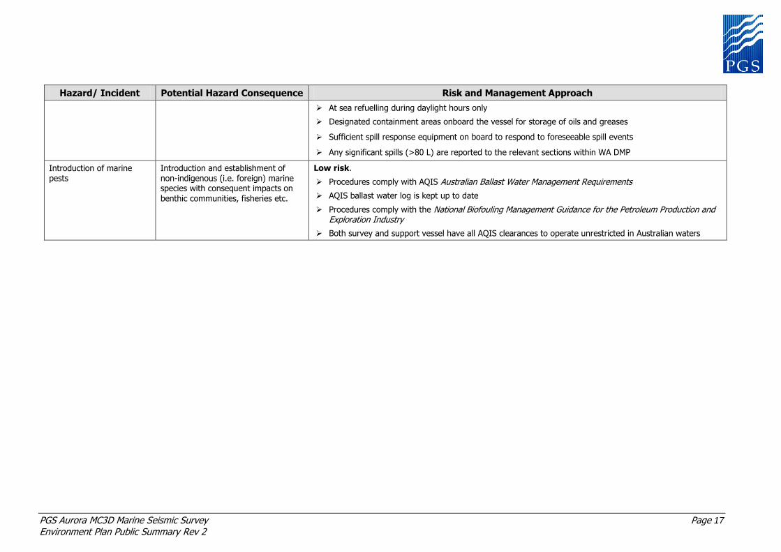
Introduction of marine pests
Introduction and establishment of non-indigenous (i.e. foreign) marine species with consequent impacts on benthic communities, fisheries etc.
Low risk.
Procedures comply with AQIS Australian Ballast Water Management Requirements
AQIS ballast water log is kept up to date
Procedures comply with the National Biofouling Management Guidance for the Petroleum Production and Exploration Industry
Both survey and support vessel have all AQIS clearances to operate unrestricted in Australian waters

PGS Aurora MC3D Marine Seismic Survey Page 18
Environment Plan Public Summary Rev 2
CONSULTATIONS
Consultation regarding the proposed Aurora MC3D MSS has been undertaken with stakeholder groups, including a number within the commercial fishing industry, in Western Australia. The following organisations
have been contacted and informed of the proposed operations:
A Raptis and Sons
Austral Fisheries Pty Ltd
Australian Fisheries Management Authority (AFMA)
Australian Hydrographic Office (AHO)
Australian Maritime Safety Authority (AMSA)
Border Protection Command (BPC)
Centre for Whale Research (CWR)
Coastwatch
Commonwealth Fisheries Association (CFA)
Department of Defence
Kimberley Professional Fishermen‘s Association (KPFA)
Northern Fishing Companies Association (NFCA)
TunaWest
Western Australian Department of Fisheries
Western Australian Fishing Industry Council (WAFIC)
Western Australian Northern Trawl Owners Association (WANTOA)
Additional consultation has been undertaken with the WA Department of Fisheries, WAFIC and licence holders in the Northern Demersal Scalefish Managed Fishery (NDSF) to minimise the potential for negative
interactions between the survey and support vessels and vessels fishing in Zones A and B of the NDSF during the period when the Aurora survey will be taking place.
Consultation with all of the stakeholders listed above, plus any others identified during the consultation process, will continue during and after the survey, if necessary.
FURTHER DETAILS
For further information about the proposed PGS Aurora MC3D MSS within southern Browse Basin offshore
from Western Australia, please contact:
Terry Visser MultiClient Manager – Asia Pacific
Petroleum Geo-Services
Tel: +61 (0) 8 9320 9000
Email: [email protected]