Embed Size (px)
Citation preview
Longview Dr.
AUGUSTIN BERNALCOMMUNITY PARK
Golden EagleWay
Staging Areaand Parking
North
I-680
Castlewood Dr.
EntranceGate
Bernal Ave.
Foot
hill R
d.
�
T R A I L M A P
Augustin BernAl
Community PArk
PARK RULES
• Theparkisopenduringdaylighthours.• Dogsmustbeleashedatalltimesinanypicnicarea, gatheringsite,parkinglotorpavedroadwayofthepark.• Dogsmaybeoffleashinundevelopedareasofthepark, providedthedogisunderthecontroloftheperson responsibleforthedog.• Nofires,fireworks,firearmsorotherweaponsare permittedinthepark.• Noalcoholicbeveragesarepermittedinthepark.• Donotremoveordamageanytree,plant,orothernatural materialsfoundinthepark.• Donotremoveorharmanybirdoranimal,eitherwildor domesticated,inthepark.• Noovernightcampingisallowedinthepark,unless speciallypermittedbytheCommunityServicesDirector.
Youareresponsibleforobeyingallparkrules.ForacompletecopyoftheCityofPleasantonMunicipalCode,Chapter13.08,ParksandRecreationFacilities,contacttheCommunityServicesDepartmentat(925)931-5340orgotowww.ci.pleasanton.ca.us.
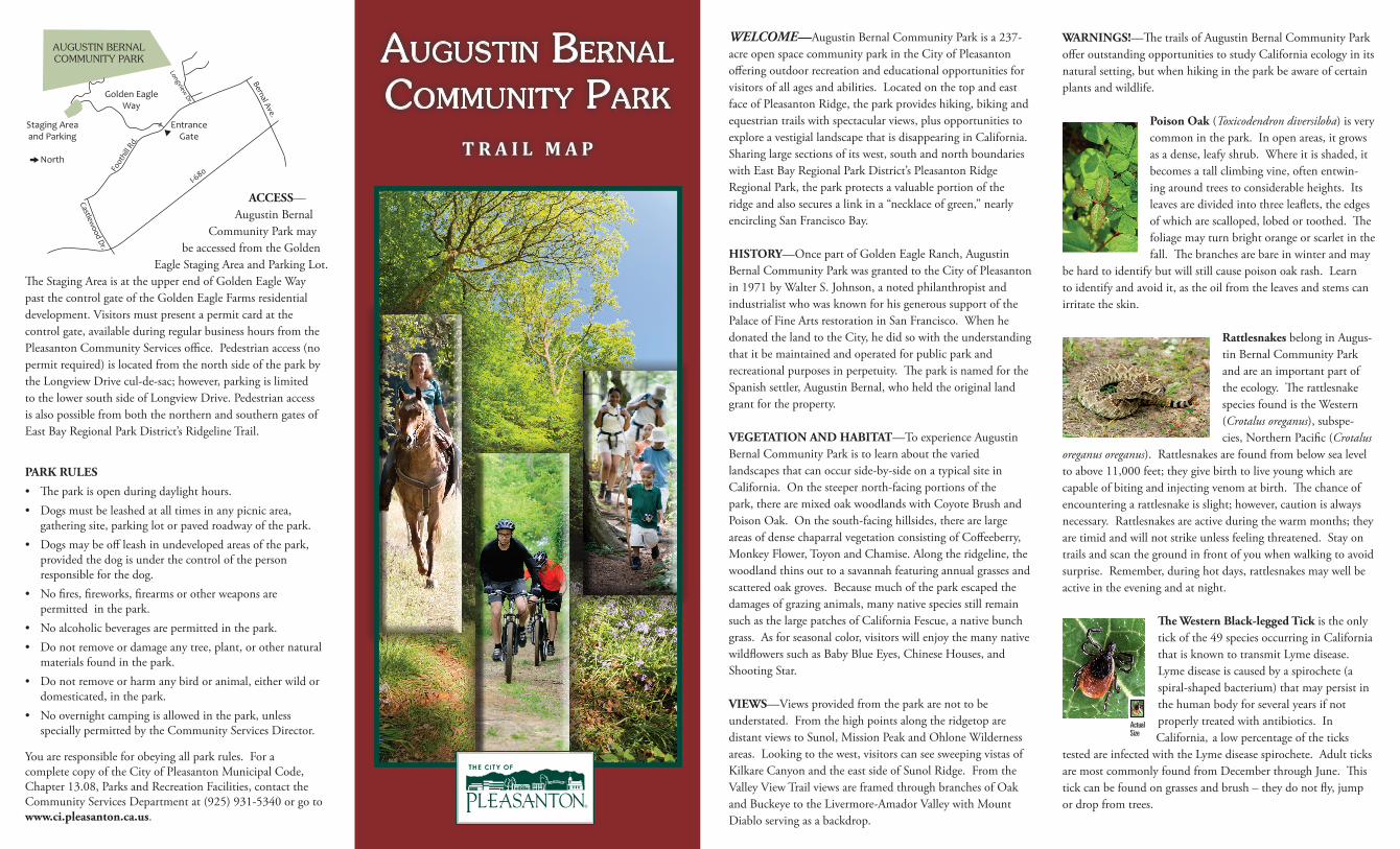
WELCOME—AugustinBernalCommunityParkisa237-acreopenspacecommunityparkintheCityofPleasantonofferingoutdoorrecreationandeducationalopportunitiesforvisitorsofallagesandabilities.LocatedonthetopandeastfaceofPleasantonRidge,theparkprovideshiking,bikingandequestriantrailswithspectacularviews,plusopportunitiestoexploreavestigiallandscapethatisdisappearinginCalifornia.Sharinglargesectionsofitswest,southandnorthboundarieswithEastBayRegionalParkDistrict’sPleasantonRidgeRegionalPark,theparkprotectsavaluableportionoftheridgeandalsosecuresalinkina“necklaceofgreen,”nearlyencirclingSanFranciscoBay.
HISTORY—OncepartofGoldenEagleRanch,AugustinBernalCommunityParkwasgrantedtotheCityofPleasantonin1971byWalterS.Johnson,anotedphilanthropistandindustrialistwhowasknownforhisgeneroussupportofthePalaceofFineArtsrestorationinSanFrancisco.WhenhedonatedthelandtotheCity,hedidsowiththeunderstandingthatitbemaintainedandoperatedforpublicparkandrecreationalpurposesinperpetuity.TheparkisnamedfortheSpanishsettler,AugustinBernal,whoheldtheoriginallandgrantfortheproperty.
VEGETATION AND HABITAT—ToexperienceAugustinBernalCommunityParkistolearnaboutthevariedlandscapesthatcanoccurside-by-sideonatypicalsiteinCalifornia.Onthesteepernorth-facingportionsofthepark,therearemixedoakwoodlandswithCoyoteBrushandPoisonOak.Onthesouth-facinghillsides,therearelargeareasofdensechaparralvegetationconsistingofCoffeeberry,MonkeyFlower,ToyonandChamise.Alongtheridgeline,thewoodlandthinsouttoasavannahfeaturingannualgrassesandscatteredoakgroves.Becausemuchoftheparkescapedthedamagesofgrazinganimals,manynativespeciesstillremainsuchasthelargepatchesofCaliforniaFescue,anativebunchgrass.Asforseasonalcolor,visitorswillenjoythemanynativewildflowerssuchasBabyBlueEyes,ChineseHouses,andShootingStar.
VIEWS—Viewsprovidedfromtheparkarenottobeunderstated.FromthehighpointsalongtheridgetoparedistantviewstoSunol,MissionPeakandOhloneWildernessareas.Lookingtothewest,visitorscanseesweepingvistasofKilkareCanyonandtheeastsideofSunolRidge.FromtheValleyViewTrailviewsareframedthroughbranchesofOakandBuckeyetotheLivermore-AmadorValleywithMountDiabloservingasabackdrop.
WARNINGS!—ThetrailsofAugustinBernalCommunityParkofferoutstandingopportunitiestostudyCaliforniaecologyinitsnaturalsetting,butwhenhikingintheparkbeawareofcertainplantsandwildlife.
Poison Oak(Toxicodendron diversiloba)isverycommoninthepark.Inopenareas,itgrowsasadense,leafyshrub.Whereitisshaded,itbecomesatallclimbingvine,oftenentwin-ingaroundtreestoconsiderableheights.Itsleavesaredividedintothreeleaflets,theedgesofwhicharescalloped,lobedortoothed.Thefoliagemayturnbrightorangeorscarletinthefall.Thebranchesarebareinwinterandmay
behardtoidentifybutwillstillcausepoisonoakrash.Learntoidentifyandavoidit,astheoilfromtheleavesandstemscanirritatetheskin.
RattlesnakesbelonginAugus-tinBernalCommunityParkandareanimportantpartoftheecology.TherattlesnakespeciesfoundistheWestern(Crotalus oreganus),subspe-cies,NorthernPacific(Crotalus
oreganus oreganus).Rattlesnakesarefoundfrombelowsealeveltoabove11,000feet;theygivebirthtoliveyoungwhicharecapableofbitingandinjectingvenomatbirth.Thechanceofencounteringarattlesnakeisslight;however,cautionisalwaysnecessary.Rattlesnakesareactiveduringthewarmmonths;theyaretimidandwillnotstrikeunlessfeelingthreatened.Stayontrailsandscanthegroundinfrontofyouwhenwalkingtoavoidsurprise.Remember,duringhotdays,rattlesnakesmaywellbeactiveintheeveningandatnight.
The Western Black-legged Tickistheonlytickofthe49speciesoccurringinCaliforniathatisknowntotransmitLymedisease.Lymediseaseiscausedbyaspirochete(aspiral-shapedbacterium)thatmaypersistinthehumanbodyforseveralyearsifnotproperlytreatedwithantibiotics.In
California,alowpercentageofthetickstestedareinfectedwiththeLymediseasespirochete.AdultticksaremostcommonlyfoundfromDecemberthroughJune.Thistickcanbefoundongrassesandbrush–theydonotfly,jumpordropfromtrees.
ACCESS—AugustinBernal
CommunityParkmaybeaccessedfromtheGolden
EagleStagingAreaandParkingLot.TheStagingAreaisattheupperendofGoldenEagleWaypastthecontrolgateoftheGoldenEagleFarmsresidentialdevelopment.Visitorsmustpresentapermitcardatthecontrolgate,availableduringregularbusinesshoursfromthePleasantonCommunityServicesoffice.Pedestrianaccess(nopermitrequired)islocatedfromthenorthsideoftheparkbytheLongviewDrivecul-de-sac;however,parkingislimitedtothelowersouthsideofLongviewDrive.PedestrianaccessisalsopossiblefromboththenorthernandsoutherngatesofEastBayRegionalParkDistrict’sRidgelineTrail.
Actual Size
1500
1400
1300
1200
1100
900
800
700
1500
1500
1500
1300
1200
1100
1000
1500
1400
1300
1200
11001500
1400
1300
1500
1000
StagingArea
800
GO
LDEN EAGLE WAY
To Pleasanton Ridge Park / East Bay Regional Park
To P
leas
anto
n R
idge
Par
k / E
ast B
ay R
egio
nal P
ark
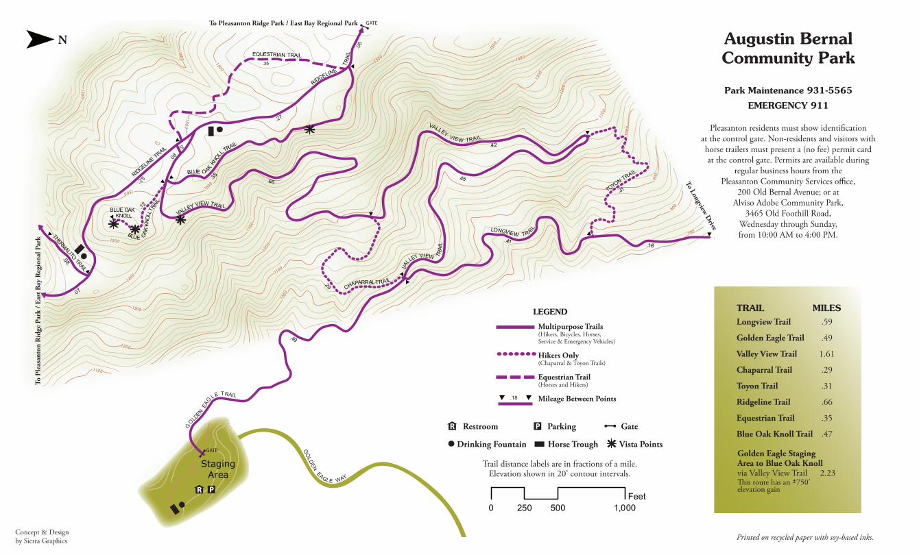
Augustin BernalCommunity Park
Park Maintenance 931-5565
EMERGENCY 911
TRAIL MILESLongview Trail .59
Golden Eagle Trail .49 Valley View Trail 1.61
Chaparral Trail .29
Toyon Trail .31
Ridgeline Trail .66
Equestrian Trail .35
Blue Oak Knoll Trail .47
0 500 1, 00 0250Feet
Drinking Fountain Horse Trough Vista Points
Trail distance labels are in fractions of a mile.Elevation shown in 20’ contour intervals.
Golden Eagle Staging Area to Blue Oak Knoll via Valley View Trail 2.23 �is route has an ±750’ elevation gain
LEGEND
Multipurpose Trails(Hikers, Bicycles, Horses, Service & Emergency Vehicles)
Hikers Only(Chaparral & Toyon Trails)
Equestrian Trail (Horses and Hikers)
Mileage Between Points
To Longview Drive
PR Restroom Parking Gate
R P
.18
Pleasanton residents must show identi�cationat the control gate. Non-residents and visitors withhorse trailers must present a (no fee) permit cardat the control gate. Permits are available during
regular business hours from thePleasanton Community Services o�ce,
200 Old Bernal Avenue; or atAlviso Adobe Community Park,
3465 Old Foothill Road,Wednesday through Sunday,from 10:00 AM to 4:00 PM.
N
GOLD
EN EAG
LE TRAIL
RIDGELINE TRAIL
BLUE OAKKNOLL
.12.35
L
BLUE OAKKN
OL
TRAIL
BLUE O
AK K
NOLL
TRAIL
VALLEY VIEW TRAIL
CHAPARRAL TRAIL
TOYON TRAIL
THERMALITOTRAIL
LONGVIEW TRAIL
VALLEY VIEW TR
AIL
EQUESTRIAN TRAIL
RIDGELINE
TRA I
L
VALLEY VIEW TRAIL
.08
.35
.66
.42
.45
.31
.18.41
.29
.49
GATE
.25
.27
GATE
.08
.06
.01
.07
Printed on recycled paper with soy-based inks.Concept&DesignbySierraGraphics